patricia mining corp, - geologyontario.mndmf.gov.on.ca
TRANSCRIPT

42C08SE2007 2.20150 RIGGS 010
1999 TRENCHING AND SAMPLING PROGRAM HAROLD SHOWING
Little Brothers Creek Property November 1999
Riggs Township
for
PATRICIA MINING CORP,
RECEIVEDMAR 2 O 2000
GEOSCIFNCF ASSESSMENT
31 January 2000 By: M. J. Perkins

CONTENTS
1.0 INTRODUCTION
2.0 PROPERTY LOCATION AND ACCESS
3.0 PREVIOUS EXPLORATION 4 2co8SE2 oo7 2.20150 RIGGS 0 10C3.1 Emily Bay Mine Property u u3.2 Area Outside Emily Bay Mine Property3.3 Previous Government Geological Investigations
4.0 GEOLOGY4.1 Regional Geology4.2 General Property Geology
5.0 1999 TRENCHING AND SAMPLING5.1 Work Completed5.2 Geology5.3 Trench 99-la5.4 Trench 99-1 b5.5 Trench 99-lc
6.0 CONCLUSIONS
7.0 RECOMMENDATIONS
8.0 FIGURESFigure l Ontario Location MapFigure 2 Claim Map l Trench LocationFigure 3 Regional GeologyFigure 4 Trenches 99-la, Ib, and leFigure 5 Sample Locations Trench 99-laFigure 6 Geology Trench 99-laFigure 7 Sample Locations Trench 99-1 b and cFigure 8 Geology Trench 99-lb and c
9.0 STATEMENT OF QUALIFICATIONS
10.0 BIBLIOGRAPHY
APPENDICIES
Appendix I 1999 Sample Descriptions and Results Appendix H Assay Certificates
Patricia Mining Corp. - 1999 Trench and Sampling Program

1.0 INTRODUCTION
During November 1999 Patricia Mining Corp completed trenching and sampling on the Harold Showing, Little Brothers Creek Property, in south-west Riggs Township.
The Harold Showing was discovered following initial prospecting work that located visible gold mineralization in float that assayed up to 1140 g/t Au during the 1998 field season. In 1998 the area surrounding the discovery was prospected and two small hand excavated trench completed. During the current field program mechanical trenching was completed over three areas adjacent to the initial discovery. Grab, chip and channel sampling was completed, controlled by geology and exposure. Geology and structures uncovered indicate a strong 3 207-75W shear structure in mafic pillow flows and gabbros with associated quartz iron carbonate veining containing up to 2007o pyrite and occasional visible gold. Grab samples of vein material assayed up to 166.61 g/t Au. Chip samples assayed 22.29 g/t Au over 2.0 metres.
Further stripping, washing and sampling, and a local soil sampling survey is recommended.
2.0 PROPERTY LOCATION AND ACCESS
The Harold Showing is located on the Little Brothers Creek Property (LBC) in south-west Riggs Township (claim map # G-2814, NTS 42C/8) in the Sault Ste Marie Mining Division. Comprised of six contiguous unpatented mining claims (SSM1201154, 1213453, 1214053, 1213106, 1227902, 1227905) totalling forty-three 16Ha units (Figures l ft 2) the LBC property is currently 10007o owned by Patricia Mining Corp. (Dr. Richard Sutcliffe, President), 100 Adelaide St. W., Suite 405, Toronto, Ontario, M5H 1S3, Tel. (416) 214-4900, Fax (416) 864-0620.
The LBC property can be accessed from the Goudreau-Lochalsh Road by the #48 Road, a logging road that extends through Jacobson and Riggs Townships, south of the Edwards Mine site. By road, the property is located 13 kms south-east of the Patricia Mining Corp. Kremzar mill site, and approximately 36 kms south of Dubreuilville, Ontario.
3.0 PREVIOUS EXPLORATION
Riggs Township and the surrounding township areas, sometimes referred to as the "Lochalsh-Missinaibi Area", have been explored extensively for gold, base metals and iron deposits for many years. Unfortunately, there is very little public domain documentation outlining the nature of the work and when it was done. The most reliable source of data showing concentrated exploration efforts, appears to be township claim maps dating back 1968.
The Ontario Department of Mines, Map No.44c (Burwash, 1935), is one of the earliest maps available showing the locations of various mining claims. In the area of interest the Burwash map identified three (3) claims east of Old Cabin Lake, which would extend onto Patricia Mining Corp. claim SSM-1201154.
One of the earliest discoveries of gold in the area was made in 1896 by John Halliday or Peter McVeigh at what was to become the Emily Bay Mine. A group of mining claims, are located at the
D**4-**is**n TV/TJ******-* /"""^vwnr* 7HOO TVrtm-iZ* svistsJ CVr****-i7*M*-r T)**s\m*sw** O

McVeigh at what was to become the Emily Bay Mine. A group of mining claims, are located at the south end of Albert Lake and the Emily Bay gold occurrences. Patricia Mining Corp. holds the western portions of that group, including the four patented claims that form the Emily Bay Property. Most historical exploration efforts appear to have been concentrated around the former Emiry Bay Mine.
Some of the earliest work in the area has been recorded by Arthur B. Willmott; for "The Bureau of Mines", who in 1897 made a geological examination of the Michipicoten Mining Division to investigate and document the apparent discoveries of gold, copper and iron.
3.1 Emily Bay Mine Property
A brief history of the Emily Bay Mine Property, has in part been described in a Canamax Resources Report (Yule, 1984).
The property was staked by A. Piuze, L. Laferriere, and Elise Godon in 1900, after numerous quartz boulders carrying fine gold were discovered. Considerable stripping is believed to have taken place prior to the main vein being discovered. The Algoma Commercial Co, a subsidiary of the Lake Superior Corporation, acquired the property shortly after. The company started to sink a shaft (Emily Gold Mine), which failed due to flooding. The company later hand-drilled three diamond drill holes, which successfully encountered the target vein and supposedly reported high gold values. A second shaft was sunk on a knoll to a depth of 17.06 meters (56 feet) and in 1901 the company shipped off two bulk samples of "ore" for metallurgical testing. In 1915 a report describing the finding of field examinations and sampling program was completed. In 1945 Algoma Ore Properties Limited, put down 38 diamond drill holes concentrating on the "Godon" vein. No further work was reported until 1981 when Algoma Steel Corporation carried out some limited groundwork over the property. In 1983 Canamax Resources Inc. joint ventured the property and carried out extensive ground geological and geophysical surveys over the property.
3.2 Area Outside Emily Bay Mine Property
In 1927 Victory Gold Mines completed minor work on mining claims SSM-2015 A SSM- 2016, now the eastern part of Patricia Mining Corp. claim SSM-1213106. In 1944 Bankfield Consolidated Mines Limited completed several old trenches and an adit on what is now the southeast corner of the Patricia Mining Corp. claim SSM-1213106. Little work was reported until 1966 but several old, and some large, undocumented trenches have been discovered in the western and north- central parts of Patricia Mines Inc. claim SSM-1214053.
In 1966 Canadian Aero Mineral Survey Limited conducted an airborne electromagnetic and magnetometer survey over the property area. On the portion of the property now held by Patricia Mines Inc., 6 magnetic trends were identified. Four of the responses have a northwesterly trend and may correspond with known northwest structures. Two of the responses trend northeasterly and may correlate to the northeast-trending LBC fault zone. The Ontario Geological Survey, flew a AEM in 1987 identifying several weak, EM anomalies on the LBC Property.
Reconnaissance prospecting work for Patricia Mining Corp. in 1997-98 discovered a number of surface showings of rusty sulphide bearing quartz carbonate veins associated with a structurally controlled iron carbonate altered schist zones. One showing was named the "Mother's Day Showing". . The Mother's Day Showing was mechanically stripped and sampled. Several samples were collected
Patricia Mining Corp. - 1999 Trench and Sampling Program 3

and assayed for gold and several other elements. The gold values reported were quite variable, ranging from 0.03 to 3.70 g/t Au. Silver assays ranged from 0.90 g/t Ag to 17.2 s/t Ag
3.3 Previous Government Geological Investigations
Alexander Murray of the Geological Survey of Canada, in 1846-1847 may have been one of the first of the government geologists to venture into the area, studying the geology along the Michipicoten River. In 1875-1876 Robert Bell of the GSC, studied the geology along the Michipicoten River en-route from James Bay to Lake Superior. In 1880 to 1882 Robert Bell returned to the area to study and map the geology of the Michipicoten River, Dog, Oba and Magpie Lakes.
In 1898 A.P. Coleman of the Ontario Bureau of Mines examined the geology and described the country rocks and mode of occurrence of the gold mineralization at Emily Bay. In 1918 W.H. Collins of the GSC worked in the Dog lake area. In 1921 Ellis Thomson of the GSC, had investigated some gold properties in the Goudreau area, and may have ventured as far east as Dog Lake. George. W. MacLeod reported on the Goudreau Gold Area, which included the Emily Bay Mine in the Canadian Mining Journal in 1923. In 1925 or 1926 Ellis Thomson, with W.H. Collins and T.T. Quirke ventured into the region to study and describe the geology and mineral occurrences in the Dog Lake area. In 1927 T.L. Gledhill of the Ontario Department of Mines, described the various gold occurrences in the area, including the Emily Bay Mine.
In 1934 E.M. Burwash of the Ontario Department of Mines studied and mapped the Lochalsh- Missinaibi area. In 1943 H.C. Horwood of the Ontario Department of Mines, examined several new gold discoveries in the area. In 1945 E.L. Bruce of the Ontario Department of Mines, studied the gold occurrences in the area, and is believed to have presented one of the most detailed accounts of the geology and mineral occurrences up to that time period.
In 1966 R.K. Wanless of the Geological Survey of Canada performed some age dating work along the western shore of Dog Lake.
In 1973 P. Srivastava and G. Bennett of the Ontario Geological Survey, mapped out the geology and mineral occurrences of Riggs and West Townships; their report "GR 174" was published in 1978.
4.0 GEOLOGY
4.1 Regional Geology
The brief generalised geology of Riggs and West Township area, which includes the LBC Property, may be best summarised by Srivastava and Bennett (1978) (Figure 3).
"Isoclinally folded metavolcanics with subordinate amounts of metasediments, intruded by small stocks and pods of gabbro-diorite underlie approximately three- quarters of the map area. This metavolcanic sequence is part of a large northeast trending Michipicoten greenstone belt. Mafic to intermediate metavolcanics, primarily basalt flows and pyroclastic rocks predominate in Riggs Township and western parts of West Township. Bands and lenses 30 to 600 meters (100 to 2000Jeet
Patricia Mining Corp. - 1999 Trench and Sampling Program 4

thick) of felsic to intermediate metavolcanic flows and pyroclastic rocks occur north and south of Lochalsh Bay in Riggs Township and in the northeastern part of West Township. Locally derived metasediments occur north of Lochalsh Bay in Riggs Township. Many sills, dykes, and small stocks of feldspar and quartz-feldspar porphyry occur within the metavolcanics. The metavolcanic belt is bounded in the northwest by a syntectonic trondhjemite and in the southeast by a younger trondhjemite pluton. Small posttectonic granodiorite and syenite stocks associated with lamprophyre occur within the mafic metavolcanic belt. All of these rocks are of Early Precambrian (Archean) age. Subsequently the whole area was intruded by diabase and basaltic dyke swarms and an olivine gabbro stock of the Middle to Late Precambrian age, which occurs southwest of Lochalsh Bay.
There are two major faults enid a few small faults along the northern boundary of the map area. The faults are marked topographically by deep linear valleys, and dissected hills. Movement on the larger faults has prodiiced some shearing, carbonization and iron staining. The bedrock is covered by unconsolidated Pleistocene sediments. "
4.2 General Property Geology
The LBC property essentially occurs only a short distance from the eastern extremity of the Michipicoten greenstone belt, and is for the most part located on the south flank of an isoclinally folded sequence of Archean-aged metavolcanic and metasedimentary sequences.
The majority of the property is underlain by mafic to intermediate metavolcanic rocks of greenschist grade showing significant carbonate alteration (Figure 3). The rocks are generally massive and/or pillowed flows with plagioclase porphyritic varieties occurring locally. Interbanded with the fine-grained to aphanitic flows are coarser-grained extrusive rocks which are difficult to distinguish from coarser-brained mafic intrusive rocks. Foliations in the metavolcanic rocks are rare on the LBC property but generally trend east to southeast. In the vicinity of the Emily Bay Fault to the east, foliations parallel the northeast orientation of the fault. Pillow structures indicate a north-facing sequence of volcanic rocks.
At the eastern edge of the LBC property, the mafic extrusive rocks are intruded by a massive, medium- to coarse-grained metagabbroic/dioritic sickle-shaped stock. Amphibole is the dominant mafic phase within the intrusion although relict pyroxene occurs locally near the contact with the Albert Lake stock.
Further east the mafic intrusive rocks are intruded by a massive, medium-grained, biotite trondhjemite to granodiorite body known as the Albert Lake Stock. The stock is approximately 2 km in diameter and is centred on Albert Lake at the eastern edge of the LBC property. Quartz-feldspar porphyry forms the border phase of the Albert Lake trondhjemite.
5.0 1999 TRENCHING AND SAMPLING_________________________
The Harold Showing was discovered in 1998 following initial prospecting work that located visible gold mineralization in boulders beside the #48 Road. The immediate discovery area was
Patricia Mining Corp. - 1999 Trench and Sampling Program 5

prospected and small hand excavated trenching and sampling completed. Analysis results of up to 16.6 g/t Au from outcrop and 1140 jj/t Au from float prompted the 1999j)rqgram.
5.1 Work Completed
From 15-28 November 1999 Patricia Mining Corp completed trenching and sampling on the Harold Showing, Little Brothers Creek Property (LBC), in Riggs Township. Michael Perkins, a consulting geotechnologist, supervised the excavation of the trenches using a Hitachi EX300LC excavator owned by Maray Construction, Dubreuilville, Ontario. Three trenches (99-1 a, 99-1 b, and 99-1 c from north to south respectively) totalling 2160m2 were excavated over a 150m north-south distance while attempting to discover, and trace the mineralized shear that hosted the original auriferous float. 30hrs machine time @ SllO/hr were required to excavate the three trenches. A simplified grid with a Baseline oriented 3600, with the 0,0 point at UTM 1605183E, 535125IN, and flag and compass lines normal to the baseline as required, was used for control. 45 Grab, chip and channel samples were taken, however poor exposure, as weather conditions prevented outcrop washing, meant that only a preliminary mapping and sampling program was possible at this time.
Grab samples consisted of samples, generally l O-15cm in size, taken from onejjoint of veining, shear material or country rocks. Chip samples were composed of l-2cm chips taken with a hammer and chisel, over intervals up to 1.0m in length. Due to irregularities in exposure and sample availability, several sample lengths were obtained by sampling oblique to strike to get representative material across a true thickness. Channel sampling was done using a rock saw to cut 3cm X 10cm deep channels. Channeling was restricted due to weather, dirt cover, and equipment availability. Samples were forwarded to Swastika Laboratories, PO Box 10, Swastika, Ontario, POT l TO, where they were analysed with standard fire assay/atomic absorption techniques.
5.2 Geology
Quartz iron-carbonate veining up to 25 cm wide and over 80m in length in a 0.75 to 5m carbonatized serialized silicified shear zone with associated ~^~2007o pyrite was discovered in mafic pillow flows andgabbro/meta-gabbro. The structure trends 3207-55"W to vertical, across Trench 99- la and Ib, and was found to contain visible gold (Figure 4).
Massive and pillowed mafic metavolcanic rocks are the dominant lithology in the area around the Harold Showing. Where the rocks are massive, medium-grained gabbro, they have been interpreted as subvolcanic intrusive rocks in the east, although cross-cutting relationships were not observed. Rusty iron carbonate alteration occurs in mafic rocks but is concentrated in the shear zone with quartz veining and disseminated pyrite mineralization. Locally, large (metre-scale) areas of iron carbonate alteration are easily visible as rusty weathered surfaces on outcrop. Pyrite is a common mineralization phase of these altered zones.
Shear zones are characterised by quartz-veining and highly deformed rocks with chlorite- carbonate-sericite alteration. Sulphide mineralization is generally pyrite, disseminated to weakly banded on the millimetre scale, with rare pyrrhotite and associated with the quartz veining and highly altered shear zone as S-5% finegrained, anhedral to euhedral grains,.
Two phases of quartz veining are recognised: a phase consisting of white subvitreous quartz and another phase of "sugary"-textured, white quartz-iron carbonate. Pyrite associated with veining appears to have two phases as well: the standard brassy form described above, and an aphanitic, grey,
Patricia Mining Corp. - 1999 Trench and Sampling Program 6

l-3cm semi-massive form at or near contacts with the vitreous quartz veining.Visible gold was located at the south end of 99-1 a in a quartz-iron carbonate-pyrite vein that
assayed 166.61 g/t Au (average of three assays). Chip samples taken in this area also assayed 41.44 g/t Au (average of four assays) over 1.0 metre, or 22.29 g/t Au over 2.0m. The structure appears to continue south under a logging road into Trench 99-1 b where chip and channel sampling analysis indicates 3.02^/t Au over 1.9m.
Trench 99-1 c was excavated 30m south of Trench 99-1 b in an attempt to intersect the mineralized shear zone. The eastern portion of the trench was covered by 3.0m of glacial overburden and a logging road. A quick investigation before the east end of the trench was submerged by flooding uncovered a hard smooth, glacially polished, black, very fine grained mafic volcanic similar to those adjacent to the west edge of the shear zone in Trench le.
5.3 Trench 99-1 a
Trench 99-1 a was excavated first at the location of the 1998 discovery boulder containing visible gold (l 140 g/t Au) and a 1998 hand excavated trench (Figure 4, 5, 6). Mafic pillow flows and massive to poorly foliated gabbroic rocks underlie the area. A shear zone from 0.75m up to 5.0m in width trends approximately 3207-75^ to vertical with carbonatization sericitization and silicification of the host. The shear appears to pinch and swell along its length, and also weakly step west as it progresses south. Part of its boudinage appearance maybe due to the quartz-iron carbonate veins that appear to be sub-parallel but slightly oblique to the shear at 3100 to 3307-70^.
The shearing appears most intense at the central point of the trench, 0+001^0+35E, where it thickens out to 5.0m and assays up to 3.47 g/t Au over 3.75m chips (results from grab sampling were up to 7.27 g/t Au). This coincidentally is the location of the 1998 hand excavated trench that returned assays from grabs up to 16.6 g/t Au. The outcrop in this location drops off rapidly to the east forming a small 2.0-3.Om cliff. It is possible that the apparent thickening of the shear in this area is due to slumping of the cliff face.
Mineralization appears to split in the north as a shear, and the north-west as a quartz vein. The shear, with associated veining appears to continue from the central point at 330/-66W, with minor quartz-iron carbonate stringers, which generally assay between 1.61 to 2.40 g/t Au across its 1.0-1.5m width. The vein is a 20-30cm quartz vein with minor iron carbonate and pyrite oriented 310/-75W that continues through the gabbro about l Om west of the shear. The vein returned results as high as 2.67 g/t Au from jrab samples. The northern strike of the vein and shear are open and overburden covered.
South of the central point the vein and shear are coincident with abundant quartz stringers and pyrite present. The shear with associated quartz stringers appears to weakly boudinage and step to the west while the main quartz vein appears to move along the southern contact. Just before disappearing under the logging road at the southern end of the trench the shear thickens to ~2.5m and contains visible gold, returning assays up to 166.61 g/t Au (average of three assays). Chip samples of the shear and veining taken in this area also assayed 41.44 g/t Au (average of four assays) over 1.0 metre, or 22.29 g/t Au over 2.0m. The adjacent mafic volcanic host in this area is dark green to black, very fine grained with up to 3*^o pyrite disseminated throughout and displays moderate foliation and blocky jointing parallel to shearing for 2.0m from the contact. The regional fabric and texture of the mafic volcanics becomes gradationally prevalent.
Patricia Mining Corp. - 1999 Trench and Sampling Program l

The shear structure and alteration appears to continue south under a logging road until it appears in Trench 99-1 b.
5.4 Trench 99-lb
Trench 99-lb was the last trench excavated due to the failure of Trench 99-1 c to located the continuation of the shear zone in the south. Located 15.0m south of Trench 99-la much of Trench 99-lb remains obscured with overburden. Small areas hand trenched along outcrop edges and high points indicate that the shear structure located at the southern end of Trench 99-la continues through Trench 99-lb (Figure 7, 8). The shear zone appears to widen to 3.5m, containing numerous narrow quartz stringers, and up to 20*^o disseminated pyrite locally. Chip and channel samples over the shear returned assays as high as 4.73 g/t Au with a weighted average of 3.02 g/t over 1.9m confirming the continuation of the auriferous mineralization from Trench 99-la.
Geological contacts were generally obscured by the remaining overburden and water but the presence of either splays or lenses of mineralization were located west of the main shear. Mafic flows to the north are altered into dark green to black, very fine to fine grained blocky rocks similar to those in Trench 99-la.
5.5 Trench 99-1 c
Trench 99-1 c was excavated after Trench 99-la. Located 25 metres south of Trench 99-lb the trench was sited at the location of auriferous float and a small 1998 hand trench that failed to reach bedrock but discovered anomalous gold values in overburden (Figure 4, 7, 8). Deep glacial overburden, flooding and a logging road truncate the east end of the trench, directly over the presumed location of the mineralized zone extension.
While underlain primarily by mafic pillow flows and gabbro a quick investigation before the east end of the trench was submerged by flooding uncovered a hard smooth, glacially polished, black, very fine grained mafic volcanic similar to those adjacent to the west edge of the shear zone in Trench 99-la and b. Presumably the shear continues to the south under the road.
Several 1.0 X 1.0 X 1.0m boulders located near the middle of the trench were identical to the shear zone uncovered in the previous trenches and typical mineralized material was uncovered directly below them. Due to mud and overburden the accurate orientation on these new zones was indeterminable, and they may represent either splays of the previously uncovered shear, or new structures not uncovered by the trenches to the north. These lenses returned assays up to 3.50 g/t Au over 0.75m, or an average of 3.19 g/t Au over 1.5m.
6.0 CONCLUSIONS
Geology and structures uncovered by Trenches 99-la to c, indicate a strong north-west trending auriferous shear structure in mafic volcanics containing abundant quartz-iron carbonate veining. Grab samples of vein material assayed up to 166.61 j/t Au ,with chips assaying 41.44 g/t Au over 1.0 metres. The shear appears continuous, has been defined for at least 80.0m with a width of 0.75 to 5.0m, is open along strike to the north and south, and contains significant gold values along its
Patricia Mining Corp. - 1999 Trench and Sampling Program 8

entire length (Figure 4, 8).Zones located in Trenches 99-1 b, c indicate that several new mineralized structures may be
located to the west of the main shear that also contain ̂ old grades up to 3.50 g/t Au.
7.0 RECOMMENDATIONS
With much of the trenching completed covered with 5-20cm of soil, trench washing is strongly recommended as the next stage of work, with detailed mapping, and channel sampling as a follow-up. Trench 99-1 a should be extended north to determine the strike extent of the shearing and veining. Depending on results uncovered by washing in Trench 99-1 c, an attempt should be made to see if any parallel shear structures exist to the west of the main shear. The southern location, and extent of the shear should also be determined, possibly by a soil geochemistry survey or trenching if topography allows.
Drilling follow-up should not take place until the orientation of the structure hosting the gold mineralization is further delineated.
lichael Perkins 31 January 2000
Patricia Mining Corp. - 1999 Trench and Sampling Program

8.0 FIGURES
Patricia Mining Corp. - 1999 Trench and Sampling Program 10

Manitoba X
ONTARIOKenora
dig Geraldton9
V—. ^ Thunder Bay
\
Timmins n
Kirkland Lake
Quebec
:;i^ Sault Sudbury \ Ste. Marie m 'v^ Montreal
\
U.S.A.
N
A
|f Torontojy#.Ill
Lake Ontario
100 200 300 400 kilometres
Figure 1
Patricia Mines Inc.
Wawa, Ontario
Location Map

1218073 PLAN
G-2814TOWNSHIP
: 11637-55
-l -r *! Q c: o^ i C/ w Q O fL
218094
.T.-i? U,t t^i vi J i livei; A /der t Loire
A I2I8T82
!2i8095
BRUYERE WNSHi
M*tr*(
840 I4'70 Figure: 2 840 I2'
ZONE 16

BRUYERE TOWNSHIP
LEGEND
CENOZOIC*
QUATERNARY
RECENT5*wrw, frwn, Md M* rftpoiftr
PLEISTOCENE
GteW * W. bouMert. e'*"t tnd unrf.
UNCONFORMITY
PRECAMBRIAN*MIDDLE TO LATE PRECAMBRIAN
(PROTEROZOIC)
MANITOU MOUNTAIN STOCK
m tOt OIMne gtbbro (rim, pyroxtnt >
tOb OIMne atbbro (con. otMne * py- rnnnt),
INTRUBIVC CONTACT
MAFIC INTRUSIVE ROCKS
mmm -\ 9 umundwtded.Ha -l S* O/atase, porphyritic Mtaw.•VL^uJ Mi QtMnf ditto**.
9C Qvtrlt diitxoe.9d Alttmtt rftetew . outrf f tf'w/fe.
INTRUtlVK CONTACT
EARLY PRECAMBRIAN (AR
PCLSIC INTRUSIVE ROCKS
POST TECTONIC PtUTONS
6* Syenite di*?*.M lamprophyre dikes.fc Syenite ttmpnfttyrt intiuslve brrc-
. Jt Porphyritic hornblende grtnajio-
tilt. 76 Equigranyltr hornbtentft ffrtflo-
rJfofHf lo Quarlt montanite. 7c Biolite trondhjemite le frtnodicrife, W Hornhlerxi* kMttt
. tt Porphyritic tntt fquigt tniiltr botn-
7f HybfM Outfit rfwrff. .
r porphyry tnd ftttlti.
INTRUtlVC CONTACT
SYNTECTONIC PL U TONS
n M Bfoillf trorxthferrtHt. H ffr HornblerMle-blotlte trondhjemite lo
. tc Miamitlle tml Hybrid nctit.
INTHUSIVK CONTACT
MAFIC INTRUSIVE ROCKS
INTRUSIVE CONTACT
METAMORPHOSED FELSIC INTRUSIVE ROCKS
4 UnsuttdlvMed.4t Quarlr feMsfHir porphyry,4b FeMsfMt porphyry.4c Ftlsilf.
INTRUSIVE CONTACT
META VOLCANICS AND METASEDIMENTS*
DETRITAL METASEDIMENTS
3 UnauMivMett.3* Conglomerite,3b Greywuelie, qutrtt sandstone.3c Argittite.sMe.M StrMfiKf tuff or sediment.
FELSIC TO INTERMEDIATE METAVOLCANICS
rrn t UnsubdfoHrd.j*" l ft MMI/IW flows.tail tb Sericite schist.
fc Tuff, crystal luff. Pd lapilli Mf, ft Tuff breed*. If Porphyritic flows.
MAFIC TO INTERMEDIATE METAVOLCANICS
UnsubdMrftd.9 Missive flows.b Chlorite schist,r Pillowed flows.d Coarse prnined [tow or Intrusive.e Porphyritic fhwS.O Tuff, crysM luff.h tnpitliluff.l Tuff breccia.k Amphlbolile.m Gneissic tmphttnlitt,
JL Iron formation.

Location of haXl trench90m
Patricia Mining Corpt,
Harold ShowingTrenches
99-1a, 1 handle
Figure: 4

11o+eow Clear Cut
SSM1214053
O+SCW
0+4WV
(H3OW
N23140fr 1.12
N231406 1.37
N231407 0.72
N231404 0.86
NZ31403
N231402 43.37J
NZ31408 173.7*
N23140S 5.52
*20W
0+10W
N2314J1 OJ4
"231432 015
1*33 0.61
N231434 O.M
OJN231460 2.4
N2314S*
N2314S8 1.61
N231457 1.S8
N2314561422
N231420 3.43
N231419 3.57
K23K18 3.0*
N231417 3.77
N231421 (.1
N231411 0.04
N231412 0.03
o+aow
T Chip/Channel Sample
V Grab SampleSample* Augft
X N2314S7 2.88
X N231488 3.5
Scale
II
Patricia Mining Corp.
Trench 99-1 a
Sample Locations
Harold Showing
Figure: 5

o+eowC tear Cut
SSM1214053
o+sow
2.9m (VeAugA AugA/m2.88 "l3.5 I3.1W1.5
o*aow
0+50W
X Grab Sample
1 Chip/Channel Location
AugA 25* 35 X1WU
Patricia Mining Corp.
Trench 99-1 a
Geology
Harold Showing
Figure: 6

Undifferentiated . . . Mafic Ftows
O+1CMV
X Grab Sample
[ Chip/Channel ' Location
Augit Augd/m X 2.M"
X
Patricia Mining Corp.
Trench 99-1 b and c Geology
Harold Showing
Figure: 7

N2S1472 0.61N231471 2.61N231470 1.67N231469 082
0+20W
0+10W
N231479 4.73
N231478 4.47
N231477 189
N23147B 186
N23147S 3.07
N231474 0.22
N231473 1.54
1.0*1.*
X Grab SampleJ Chip/Channel Sample
xy-
Smpte* Au0tN231487 2 ttN2314M 3.8
AUBK/mn fuyt
Patricia Mining porp:
Trench 99-1 b and c
Sample Locations
Harold Showing
Figure: 8

9.0 STATEMENT OF QUALIFICATIONS
I, Michael James Perkins, graduated from Sir Sandford Fleming College in the Minerals Exploration Technologist program in 1983, and have worked as a exploration technologist and geologist since that time. I have also completed 3 years towards a Geology degree at the University of Toronto.
I was present at all times and supervised the work covered by this report.
I have no interest or shares in Patricia Mining Corp.
I currently reside at 981 North Bay Drive, PO Box 42, Coboconk, Ontario, KOM 1KO, tele: 705-454-3587, fax: 2797.
Michael Perkins 31 Jan 2000
Patricia Mining Corp. - 1999 Trench and Sampling Program

10.0 BIBLIOGRAPHY
Bell, R. 1875-76. Report of Progress; Geological Survey of Canada. p294-342.
Bruce, E.L. 1940. Geology of the Goudreau-Lochalsh Area; Ontario Department of Mines, Vol 49.
Burwash, KM. 1935. Map No. 44c Lochalsh - Missinabi Area; Ontario Department of Mines Annual Report, Vol. XLIV, Part 8.
Collins, W.H. cfc Quirke, T. T. 1926. Michipicoten Iron Ranges; Geological Survey of Canada Memoir 147.
Gledhill, T.L. 1927. Michipicoten Gold Area, District of Algoma, Ontario Department of Mines 36th Annual Report, part l, p. 1-49.
Horwood, H.G, 1943. Preliminary Report on Recent Developments in Missinabi Area; Ontario Department of Mines, Annual Report.
MacLeod, G. W. 1923. The Goudreau Gold Area; Canadian Mining Journal, Vol. 44.
Roussain, R, J. 1991. Goudreau Gold Project, Exploration History and Potential, Canamax Resources Inc., Internal Report.
Srivastava, P. and Bennett, G. 1978. Geology of Riggs and West Townships, District of Algoma. Ontario Geological Survey. Report 174.
Thomson, E. 1921. Goudreau Gold Area, Michipicoten District, Ontario; Geological Report 1921, part D, p. 17d-26d.
Tracanelli, H. 1998. Geology and Trenching, Mothers Day Showing, Patricia Mines, Internal Report.
Wanless, R.K., Stevens, R.D., Lachance, G.R. and Rimsaite, J.Y.H. 1966. Age Determinations and Geological Studies, K- Ar Isotopic Ages, Report 6; Geological Survey of Canada, Paper 65-17.
Yule, G. J984. Geological Report Goudreau Project, Emily Bay Group Project. Vol. 061-01.
Patricia Mining Corp. - 1999 Trench and Sampling Program

APPENDIX I 1999 SAMPLE DESCRIPTIONS AND RESULTS
Patricia Mining Corp. - 1999 Trench and Sampling Program

Appendix l: Sample Results
TrenchTrench 99- la
Trench 99- la
Trench 99- la
Trench 99- la
Trench 99- la
Trench 99- la
Trench 99- la
Trench 99- la
Trench 99- la
Trench 99- la
Trench 99- la
Trench 99- la
Trench 99- la
Trench 99- la
Trench 99- la
Trench 99- la
Trench 99- la
Trench 99- la
Trench 99- la
Trench 99- la
Trench 99- la
Trench 99- la
SAMPLESN231402
N231403
N231404
N231405
N231406
N231407
N231408
N231409
N231410
N231411
N231412
N231413
N231417
N231418
N231419
N231420
N231421
N231422
N231431
N231432
N231433
N231434
Location
North20 S
20 S
20 S
20 S
20 S
20 S
20 S
20 S
17 S
16 S
16 S
18 S
3h
31s
3 IS
31S
41s
41s
11 is
11 IS
101s
10 is
West29 W
SOW
31 W
29 W
29.3 W
30.5 W
30.6 W
29.5 W
28.5 W
30 W
29 W
31 W
37 W
38 W
39 W
40 W
38 W
43 W
50 W
50 W
48.5 W
48.7 W
Description1m chip, fgr cryptocrystalline QV
with S-10% diss, sub, py1m chip, 4Q07o fgr cryptocrystalline QV, 6007o mafic vole with 5-1007o
diss, sub, py0.5m chip Black aphanitic mafic
volcanic, rare blue quartz eyes, *3S"7opy
Mafic volcanic, cb alt'n, 507o py
20 cm QV -with visible gold
QV with 3 07o py
lO^o py in shear altn
1 507o py in shear altn
QV, cryptocrystalline with diss py, possible VG
0.5m chip of mafic volcanic
1m chip of mafic vole
as per 408
1m chip, shear zone, 507o py, numerous qtz stringers
As per 417, incr py and schistosity
As per 418, oxidized, incr QV
0.75m chip, as per 419
2cm QVs in sheared altd mafic
As per 420, 507o py
QV, 10cm, ^07o py, -sl007oFeCb
Mafic volcanic, black, fgr
Qtz flooded, 2007o QV, ^007o py
As per 433
Au
g/tonne43.37
1.2
0.86
5.52
173.76
0.72
1.37
1.12
8.16
0.04
0.03
0.64
3.77
3.09
3.57
3.43
6.1
7.27
0.34
0.15
0.61
0.88
Au Check g/tonne40.11
5.86
168.69
-
-
-
-
-
-
-
-
3.05
-
-
5.69
7.41
-
-
-
-
Au 2nd
g/tonne41.01
-
157.37
-
~
-
-
-
-
-
-
3.22
-
-
-
7.68
-
-
-
-
Au Check
g/tonne41.28
-
~
~
-
-
-
-
-
-
-
-
-
-
-
-
-
-
-
-
Patricia Mining Corp. - 7999 Trench and Sampling Program
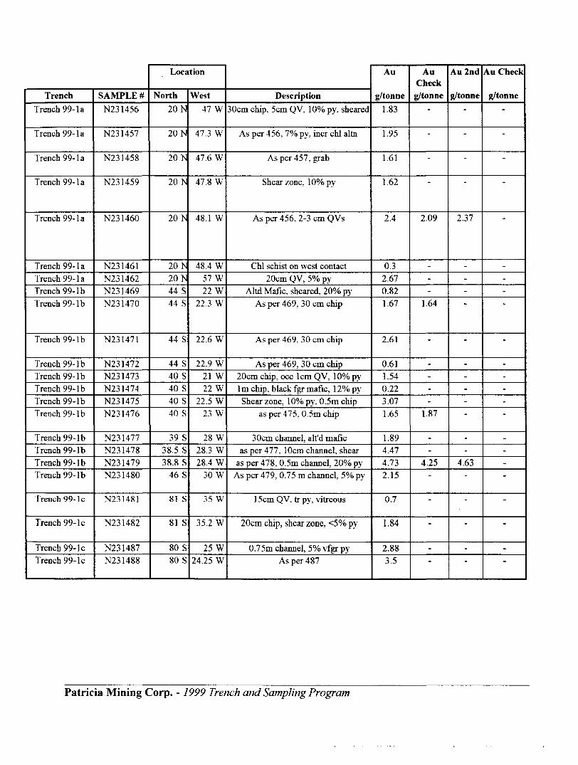
TrenchTrench 99- la
Trench 99- la
Trench 99- la
Trench 99- la
Trench 99- la
Trench 99- laTrench 99- laTrench 99- IbTrench 99-1 b
Trench 99-1 b
Trench 99-1 bTrench 99-1 bTrench 99-1 bTrench 99-1 bTrench 99-1 b
Trench 99- IbTrench 99-1 bTrench 99-1 bTrench 99-1 b
Trench 99- le
Trench 99- le
Trench 99- leTrench 99- le
SAMPLE #N231456
N231457
N231458
N231459
N231460
N231461N231462N231469N231470
N231471
N231472N231473N231474N231475N231476
N231477N231478N231479N231480
N231481
N231482
N231487N231488
Location
North20 N
20 N
20 N
20 N
20 N
20 Is20 Is44 S44 S
44 S
44 S40 S40 S40 S40 S
39 S38.5 S38.8 S
46 S
81 S
81 S
80 S80 S
West47 W
47.3 W
47.6 W
47.8 W
48.1 W
48.4 W57 W22 W
22.3 W
22.6 W
22.9 W21 W22 W
22.5 W23 W
28 W28.3 W28.4 W
30 W
35 W
35.2 W
25 W24.25 W
Description30cm chip. 5cm QV, 1007o py, sheared
As per 456. I07o py, incr chl alto
As per 457. grab
Shear zone, lOVopy
As per 456, 2-3 cm QVs
Chl schist on west contact20cm QV, 507o py
Altd Mafac. sheared, 20"^ pyAs per 469. 30 cm chip
As per 469. 30 cm chip
As per 469, 30 cm chip20cm chip, occ lcm QV, lO^o py1m chip, black fgr mafic, 12^o pyShear zone. 1007o py, 0.5m chip
as per 475. 0.5m chip
30cm channel, alt'd maficas per 477, 10cm channel, shear
as per 478, 0.5m channel 2007o pyAs per 479. 0.75 m channel, 507o py
1 5cm QV, tr py, vitreous
20cm chip, shear zone, ^"/o py
0.75m channel, 5^o vfgr pyAs per 487
Au
g/tonne1.83
1.95
1.61
1.62
2.4
0.32.670.821.67
2.61
0.611.540.223.071.65
1.894.474.732.15
0.7
1.84
2.883.5
Au Check g/tonne
-
-
-
2.09
---
1.64
-
----
1.87
--
4.25-
-
-
-
"
Au 2nd
g/tonne-
-
-
2.37
---
-
-----
--
4.63-
-
-
--
Au Check
g/tonne-
-
-
---
-
-----
----
-
-
--
Patricia Mining Corp. - J999 Trench and Sampling Program

APPENDIX n ASSAY CERTIFICATES
Patricia Mining Corp. - 1999 Trench and Sampling Program

Established 1928
Assay Certificate
Swastika LaboratoriesA Division of Assayers Corporation Ltd.
Assaying - Consulting - Representation
DEC 9 l
Company: PATRICIA MINES INCProject: Kremzar Attn: M. Perkins
We hereby certify the following Assay of 70 Rock samples submitted DEC-05-99 by .
Page l of 3
9W-3917-RA1
Date: DEC-13-99
Sanpl e NumberN 230902 N 230903 N 230904 N 230905 N 230906
N 230907 N 230908 N 230909 N 230910 N 230911
N 230912 N 230913 N 230914 N 230915 N 230916N 230917 N 230918 N 230919 N 230920 N 230921
N 230922 N 230923 N 230924 N 230925 N 230926
N 231402 N 231403 Blank STD-TT-19 STD-SW-22
Au Au Check g/tonne g/tonne
0.10 0.10 0.02 0.04 0.01 0.010.01 0.01 0.09 0.03 0.07 0.080.11 0.04 0.19 0.29 0.45 0.520.09 0.17 0.01 Nil 0.100.01 0.22 0.02 0.08 0.03
43.37 40.11 1.20 0.01 0.75 3.39
Au 2nd Au Check g/tonne g/tonne
-
-
-
-
-
41.01 41.28
One assay ton portion used.
Certified by
l Cameron Ave., P.O. Box 10, Swastika, Ontario POK l TO Telephone (705)642-3244 Fax (705)642-3300

Swastika LaboratoriesA Division of Assayers Corporation Ltd.
Assaying - Consulting - RepresentationEstablished 1928
Assay CertificateCompany: PATRICIA MINES INCProject: Kremzar Ann: M. Parkins
We hereby certify the following Assay of 70 Rock samples submitted DEC-05-99 by .
Page 2 of 3
9W-3917-RA1
Date: DEC-13-99
Sample Number
N 231404 N 231405 N 231406 N 231407 N 231408
N 231409 N 231410 N 231411 N 231412 N 231413N 231417 N 231418 N 231419 N 231420 N 231421
N 231422 N 231431 N 231432 N 231433 N 231434N 231456 N 231457 N 231458 N 231459 N 231460
N 231461 N 231462 Blank STD-TT-19 STD-SW-22
Au g/ tonne
0.86 5.52
173.76 0.72 1.37
1.12 8.16, 0.04 0.03 0.643.77 3.09 3.57 3.43 6.107.27 0.34 0.15 0.61 0.881.83 1.95 1.61 1.62 2.40
0.30 2.67 Nil 0.76 3.43
Au Check g/tonne
5.86 168.69
-
3.05
5.697.41
2.09
-
Au 2nd Au Check g/tonne g/tonne
157.37
-
3.22
7.68
2.37
-
One assay ton portion used.
Certified by-
l Cameron Ave., P.O. Box 10, Swastika, Ontario POK l TO Telephone (705)642-3244 Fax (705)642-3300

Established 1928
Assay Certificate
Swastika LaboratoriesA Division of Assayers Corporation Ltd.
Assaying - Consulting - Representation
Company: PATRICIA MINES INCProject: Kremzar Attn: M. Parkins
We hereby certify the following Assay of 70 Rock samples submitted DEC-05-99 by .
Page 3 of 3
9W-3917-RA1
Date: DEC-13-99
Sample NumberN 231469 N 231470 N 231471 N 231472 N 231473
N 231474 N 231475 N 231476 N 231477 N 231478N 231479 N 231480 N 231481 N 231482 N 231487N 231488
Au g/tonne
0.82 1.67 2.61 0.611.54
0.22 3.07 1.65 1.89 4.474.73 2.15 0.70 1.84 2.883.50
Au Check g/tonne
1.64
1.87
4.25
-
Au 2nd Au Check g/tonne g/tonne
-
-
4.63
.
One assay ton portion used.
Certified by
l Cameron Ave., P.O. Box 10, Swastika, Ontario POK if O Telephone (705)642-3244 Fax (705)642-3300

and MinesDeclaration of Assessment Work Performed on Mining Land
Mining Act, Subsection 66(2) and 66(3). R.S.O.1990
Transaction Number (office use)'
Assessment Files Research Imaging
Motions 65(2) and 66(3) of the Mining Act. Under section 8 of the Mining Act, this it work and correspond with the mining land holder. Questions about this coflecUon (rt and Mines, 3rd Floor, 933 Ramsey Lake Road, Sudbury. Ontario, P3E 6B5.
42C08SE2007 2.20150 RIGGS 900Instructions: - For work performed on Crown Lands before recording a claim, use form 0240.
- Please type or print in ink.
1. Recorded holders) (Attach a list if necessary)Name
Address Telephone Number
Fax Number
Name Client Number
Address Telephone Number
Fax Number
2. Type of work performed: Check (*Q and report on only ONE of the following groups for this declaration.
D Geotechnical: prospecting, surveys, assays and work under section 18 (regs)
n/Physical: drilling stripping.U* trenching and associated assays D Rehabilitation
Work Type
//^/?c*ffss?a l \f
Dale. Wort From /g* // 99 To J g X/ ?? Performed Day 1 l*"*1 1 Year Day 1 Month l Vrar
Global Portioning System Data (if available) Township/Area J^/^- *- -- ,— y— N*^3 St r&TCr^ f C*-Jr
M or G-Plan Number x
Office UseCommodity \Total S Value of M ^ ̂ Work Claimed if 750,^-7NTS Reference
x/Mining Division (^Xl^t^^^&i,- Jfe^uL;
Resident Geologist^ District //V^fecv**-o .
Please remember to: - obtain a work permit from the Ministry of Natural Resources as required;- provide proper notice to surface rights holders before starting work;- complete and attach a Statement of Costs, form 0212;- provide a map showing contiguous mining lands that are linked for assigning work;- include two copies of your technical report.
3. Person or companies who prepared the technical report (Attach a list if necessary)Name Telephone Number
Address Set*'
Fax Number
Name Telephone Number
Address Fax Number
Name Telephone Number
Address Fax Number
4. Certification by Recorded Holder or Agent l, , do hereby certify that l have persona! knowledge of the facts set forth in
(Print Nam*)
this Declaration of Assessment Work having caused the work to be performed or witnessed the same during or after its completion and, to the best of my knowledge, the annexed report is true.Signature of Recorded Holder or Agentj*,
Agent's Address Telephone Number Fax Number
0241 (03W7)
RECEIVEDMAR 2 O 2000
s j: tGEOSCIENCE ASSESSMENT
. ____ OFFICE

5. Work to be recorded and distributed. Work can only be assigned to claims that are contiguous (adjoining) to the mining land where work was performed, at the time work was performed. A map showing the contiguous link must accompany this
Mining Claim Number. Or if work was done on other eligible mining land, show in this
column the location number indicated on the claim map.
eg
eg
eg
1
2
^,
4
5
6
7
8
9
10
11
12
13
14
15
TB 7827
1234567
1234568
/A/t/oSZ
SAO//^'''/ *
/3/31&3 ./3/3/0& "V
Column Totals
Number of Claim Units. For other mining land, list hectares.
16 ha
12
2
/fr
88*r
37
Value of work performed on this claim or other mining land.
126.825
0
j, S 8,892
0337.4?t
0
0
.04^f
:j\'
B3^7
Value of work applied to this claim.
N/A
S24,000
S 4,000
r 64*00C)
(?
^/9J7
;,,".,' ,-i.
#3-27
Value of work assigned to other mining claims.
S24,000
0
0
^/9J7c?
0C?
- :. , U
/. e?'P"?
Bank. Value of work to be distributed at a future date
S2,825
0
S4.892
^
G
C?
^
CD
, IP 'A -S X/ l ^* s&W&Lst Or ff r , do hereby certify that the above work credits are eligible under(Print Full Name)
subsection 7 (1) of the Assessment Work Regulation 6/96 for assignment to contiguous claims or for application to the claim where the work was done.Signature of Re l in Writing Date
6. Instructions for cutting back credits that are not approved.
Some of the credits claimed in this declaration may be cut back. Please check (S) in the boxes below to show how you wish to prioritize the deletion of credits:
D l. Credits are to be cut back from the Bank first, followed by option 2 or 3 or 4 as indicated.M 2. Credits are to be cut back starting with the claims listed last, working backwards; orD 3. Credits are to be cut back equally over all claims listed in this declaration; orD 4. Credits are to be put back as prioritized orv the-attached appendix or as follows(describe)? -n™-:~^™ ^~
" 'r Ac?bbaosvitr : i 'YUnK
Note: If you have not indicated how your credits are to be deleted, credits will be cut back from the Bank first, followed by option number 2 if necessary.
For Office Use Only-—^-——.—^—.-———————Received Stamp
0241
Deemed Approved Date
Date Approved
Date Notification Sent
Total Value of Credit Approved
Approved for Recording by Mining Recorder (Signature)
HHCEIVESMAR 2 O 20C3
GEOSCIENCMSSFSSMEWT

Ontario Ministry ofNorthern Developmentand Mines
Statement of Costs for Assessment Credit
Transaction Number (office use)
Personal information collected on this form is obtained under the authority of subsection 6(1) of the Assessment Work Regulation 6/96. Under section 8 of the Mining Act, the information is a public record. This information will be used to review the assessment work and correspond with the mining land holder. Questions about this collection should be directed to the Chief Mining Recorder, Ministry of Northern Development and Mines, 6th Floor, 933 Ramsey Lake Road, Sudbury, Ontario, P3E 6B5.
Work TypeUnits of Work
Depending on the type of work, list the number of hours/days worked, metres of drilling, kilo metres of grid line, number of samples, etc.
Cost Per Unit of work
Total Cost
Associated Costs (e.g. supplies, mobilization and demobilization).
Transportation Costs
Food and Lodging Costs
Total Value of Assessment Work
Calculations of Filing Discounts:
1. Work filed within two years of performance is claimed at lOO'ft of the above Total Value of Assessment Work.2. If work is filed after two years and up to five years after performance, it can only be claimed at 500A of the Total
Value of Assessment Work. If this situation applies to your claims, use the calculation below:TOTAL VALUE OF ASSESSMENT WORK Total 9 value of worked claimed.
Note:- Work older than 5 years is not eligible for credit.- A recorded holder may be required to verify expenditures claimed in this statement of costs within 45 days of a request for verification and/or correction/clarification. If verification and/or correction/clarification is not made, the Minister may reject all or part of the assessment work submitted.
Certification verifying costs:
l, , do hereby certify, that the amounts shown are as accurate as may(please print fufl name)
reasonably be determined and the costs were incurred while conducting assessment work on the lands indicated on
the accompanying Declaration
to make this certification.MAR 2 O 2000
?MCIWCE ASSESSMENT'fire
(older, agent, or state company position with signing authority)l am authorized
0212(02/96)
Signature Date

Ministry of Ministere duNorthern Development Developpement du Nordand Mines et des Mines Ontario
Geoscience Assessment Office 933 Ramsey Lake Road
March 31, 2000 6th FloorSudbury, Ontario
Richard Sutcliffe P3E 6B5PATRICIA MINING CORP.100 ADELAIDE STREET WEST, SUITE 405 Telephone: (888) 415-9845TORONTO, ON Fax: (877)670-1555M5H-1S3
Visit our website at: www.gov.on.ca/MNDM/MINES/LANDS/mlsmnpge.htm
Dear Sir or Madam: Submission Number: 2.20150
Status Subject: Transaction Number(s): W0050.00022 Approval
We have reviewed your Assessment Work submission with the above noted Transaction Number(s). The attached summary page(s) indicate the results of the review. WE RECOMMEND YOU READ THIS SUMMARY FOR THE DETAILS PERTAINING TO YOUR ASSESSMENT WORK.
If the status for a transaction is a 45 Day Notice, the summary will outline the reasons for the notice, and any steps you can take to remedy deficiencies. The 90-day deemed approval provision, subsection 6(7) of the Assessment Work Regulation, will no longer be in effect for assessment work which has received a 45 Day Notice. Allowable changes to your credit distribution can be made by contacting the Geoscience Assessment Office within this 45 Day period, otherwise assessment credit will be cut back and distributed as outlined in Section #6 of the Declaration of Assessment work form.
Please note any revisions must be submitted in DUPLICATE to the Geoscience Assessment Office, by the response date on the summary.
If you have any questions regarding this correspondence, please contact STEVE BENETEAU by e-mail at [email protected] or by telephone at (705) 670-5855.
Yours sincerely,
ORIGINAL SIGNED BYBlair KiteSupervisor, Geoscience Assessment OfficeMining Lands Section
Correspondence ID: 14743
Copy for: Assessment Library

Work Report Assessment Results
Submission Number: 2.20150
Date Correspondence Sent: March 31, 2000 Assessor:STEVE BENETEAU
Transaction First Claim Number Number
W0050.00022 1214053
Section:10 Physical PTRNCH
Township(s) l Area(s)
RIGGS
Status
Approval
Approval Date
March 31,2000
Correspondence to:Resident Geologist Sault Ste. Marie, ON
Assessment Files Library Sudbury, ON
Recorded Holder(s) and/or Agent(s):Richard Sutcliffe PATRICIA MINING CORP. TORONTO, ON
Page: 1Correspondence ID: 14743

^1-1GLASGOW^!
f J
/.J .'' •••' ~ ft; t, ' 7 -'
.v? ? 4 *; 7 A-' 122457V* L "'J'' .- ,." *^'"^ ^ **;["^-""
' '.'"' ft
's jf r i-i , vz .. j." "' --l- v ' //
.,,,- ' iMM-y ^ i^
SSM
1164269* ' '- J -— —— i-Mi 0--r-"~~."..."l*"*"*'^1 ^--**'****?*"*?^^!";/ "**"" i .^^
, ,l- 827111 827110 - 1229124H'64274-
^ 1229123 j
l -^.u. iHiiM-il "' T '"L"Y."I'——-—- fXTi^ss !"*r l'l /SSM.
I7 j^^4, SSM//V .;.'"MM 15^^:-\ ̂ ^j!.?^0926 j 970927 1^229^7 JT--^ ^•1V,\ ^ ~---^'^: /-^';xi: rf Xx ^' '
\X ^-^^"^1 -i'^**i^'^-"'||'r /^jVCr /" r' t—'L.U---— i——^"-"" ——— -f—- —~ —— ~ - - — —'yjlif^^-^ — *- — —^f-4-
.'''/QQK/l * _ *^SSWI m ^~/*\ Ai 7'' - ^ ... li4?5p6Vj
Vf 1*'""'rr
j. _^—,-—\*i*-—T
1163852 '
8142'
I2I8094
I2|8Q05
TI2C00 "i"M* IO'
•B 01
Ministry ofNaturalResources
Ministry ofNorthern Developmentand Mine*
Ontario
INDEX TO LAND DISPOSITION
PIAH
G-2814TOWNSHIP
RIGGS
M.H R, ADMINISTfWTTW
WAWANHNWO DIVISION
SAULT STE. MARIEUNO TITUS/ffEfllSTfir DIVISION
ALGOMA
1:20000
Hdm
7Mt M*0 MH HIM
Contour Interval 10 M*tm
AREAS WITHDRAWN FROM DISPOSITIONMM* MiningHkghtsC^yHKO* Surf ac0 Rights OnlyM * ft- Mining and Surtaca Right*
SYMBOLSBoundary
Town*Wp, Haw line. ,
lurvsyed shoreline ...
SEC.35W-LL-C1527/99 ONT MAY 11^99 M*S
Sec. 35 W-SSM^99 M*S 1999/11/05 195150
railway utility.. ,
Clitf.Pii.Pile.,.....,.,.
Contour . . . . . .
Approxlmwa . . . . Deprwaitxi
Contrcri palm Jhorutonml)
Flooded land. .... . . .
Mina fm*d frame . . . . . . .
Pipeline (above ground}
NOTESTO THE 1I4Z' COMTOy* ON UAKl. Fit E
Road; hiDh**y, county, townafvp4M *IMRV*TIQN AUDNI THIE DF*LL L*K(*
trail bush . ., .....
jarlginal), . . . . , , . , , . .
F.O. FILED ONLY
DBPOSmON OF CHOWN UNDS
Surface A Mining Right* Surf MA RigtnsQnly Mining Right* ONy . . , , .
t*BM
Surf ac* A Mining flight* Surfao* Right* Only . , , ,
o o
Licipnc* of Occupation
.y
.....w
....ac
,. ©
wg
THE IffjSMWNETIC JCARIH* APPftOX, ^* li li
AMNUAL CHANBC .'
o o r* H t/i ea o
THE INPOPMATION THAT APPEARS ON TH(S MAP HAS BEEN COMPILED FROM VARIOUS SOURCES, AND ACCURACY IS MOT QUARANTeeO. THOSE WISHING TO STAKE MIN ING CLAIMS SHOULD CON- SUIT WITH THE MINING RECOflDeR, MINISTRY OF NORTHERN DEVELOP MENT ANO MINES, TOR AD DITIONAL INFORMATION ON THE STATUS OP THE LAN03 SHOWN HEW EON.
Map baa* •rv) land dwptu two drariinfl by Burvttyl And Mtoplng Branch, Mirtiairy ol Natural FtMOurOM
diapcMltian ol IWKJ, lacn||on cf tat fabric and pared bojndariti cm ihH Index wa* oompiltd for •dmintanftivtpurpatai only.