peer reviewed title: tantala, michael - placesjournal.org flooding resulting from severe...
TRANSCRIPT

eScholarship provides open access, scholarly publishingservices to the University of California and delivers a dynamicresearch platform to scholars worldwide.
Peer Reviewed
Title:Envisioning Radical Futures -- On the Water: The New York - New Jersey Upper Bay
Journal Issue:Places, 20(2)
Author:Nordenson, GuyCassell, StephenKoch, MarianneSeavitt, CatherineSmith, JamesTantala, MichaelYarinsky, Adam
Publication Date:2008
Publication Info:Places
Permalink:http://escholarship.org/uc/item/1sb5d6c7
Acknowledgements:This article was originally produced in Places Journal. To subscribe, visit www.places-journal.org.For reprint information, contact [email protected].
Keywords:places, placemaking, architecture, environment, landscape, urban design, public realm, planning,design, envisioning, radical, futures, water
Copyright Information:All rights reserved unless otherwise indicated. Contact the author or original publisher for anynecessary permissions. eScholarship is not the copyright owner for deposited works. Learn moreat http://www.escholarship.org/help_copyright.html#reuse

8 Nordenson, Cassell, Koch, Seavitt, Smith, Tantala, Yarinsky / On the Water
On The Water: The New York—New Jersey Upper Bay
Guy Nordenson, Stephen Cassell, Marianne Koch, Catherine Seavitt, James Smith, Michael Tantala, Adam Yarinsky
At the end of a hundred leagues we found a very agreeable location situated within two prominent hills, in the midst of which flowed to the sea a very great river, which was deep at the mouth.
—Giovanni da Verrazano, 1524
Sea level rise will affect infrastructures, environments, and coastal communities around the world. The New York-New Jersey metropolitan region is no exception. With twenty million people living within a fifty-mile radius of
its central harbor, the region is an economic powerhouse, and the harbor itself is home to a rich but fragile estuarine ecosystem. Both the built and the natural elements of this tenuous relationship will be radically affected by global climate change and its consequences.
By 2050, it is likely that the mean sea level in the New York-New Jersey area will rise by between six inches and two feet as a result of warming oceans. And given the potential widespread melting of the Greenland and Ant-arctic ice caps, it is quite possible that the relative sea level in the New York-New Jersey area could rise by three feet by 2080.1
Sea level rise is merely the static part of warming’s impact. The dynamic aspect is the flooding produced by storm surges. Because of higher water levels, it is likely that flooding resulting from severe storms—hurricanes
Above: GIS-generated image of the New York-New Jersey Upper Bay, with
merged bathymetric and topographic datasets. The vertical scale is exaggerated by a
factor of ten.

Places 20.2 9
and Nor’easters—will increase dramatically. What is cur-rently considered the one-hundred-year storm flood will recur every nineteen to sixty-eight years, and the five-hundred-year storm flood may recur closer to every one hundred years.2 Furthermore, higher ocean temperatures could increase the frequency and severity of hurricanes, thus heightening the likelihood of extreme storm surges.3 Storm surge levels could reach twenty-four feet in the New York area with a Category 3 hurricane.4
The hazards posed by climate change, sea level rise, and severe storm surges make this the time to transform our coastal cities through adaptive design. The conventional response to flooding, in recent history, has been hard engineering—fortifying the coastal infrastructure with seawalls and bulkheads to protect real estate at the expense of natural tidal wetlands and ecosystems. This approach has been proven environmentally damaging, unsustain-able, and often ineffective. The failure of levees and other coastal protection structures facing Hurricane Katrina in 2005 is a dramatic example of infrastructural inadequacy. The unexpected ecological effects of the Eastern Scheldt Storm Surge Barrier in the Netherlands also indicate the risky nature of such systems.
Significant research into the risks of climate change in the New York-New Jersey area has led to several proposed solu-tions—in particular, a system of four storm surge barriers.5
But the shortcomings of such conventional systems should provoke a comprehensive reconsideration of coastal plan-ning. It is time to invent a new approach that can not only be sustainable from environmental, technical, and economic standpoints, but also improve the quality of urban life.
The Proposal“On the Water,” is a project funded by the Latrobe
Prize, the American Institute of Architects’ College of Fellows biannual research grant. It reflects the initiative of a group of engineers, architects, landscape architects, and planners, working collaboratively to imagine the transfor-mation of the New York-New Jersey Upper Bay in the face of certain climate change.
The project’s study area is the Upper Bay of New York Harbor, framed by the Bayonne Bridge at the western edge of the Kill van Kull, the Holland Tunnel and the Manhat-tan Bridge at the north, and the Verrazano Narrows Bridge at the south. The surface area of the Upper Bay is approxi-mately twenty square miles, and it measures almost four
Left: NASA World Wind pseudo-color satellite image of the New York-New Jersey
Upper and Lower Bay and the greater estuarine complex.
Right: GIS-generated image of the New York-New Jersey area’s high-intensity
landcover. Dataset by the U.S. Environmental Protection Agency.
Climate Change and Place: Envisioning Radical Futures

10
miles across at its widest point. The Upper Bay has been chosen as the site for our proposal because of its potential to create a unified regional place for New York and New Jersey, a body of water with shared ecological and physical boundaries rather than one divided by arbitrary lines of political districting.
We propose three adaptive strategies to transform the Upper Bay, to reduce flood risk from both sea level rise and storm surge, and to challenge current functional rela-tionships among water, land, and shelter.
Create an archipelago of islands, shoals, and reefs in the Upper Bay to both reduce the impact of storm-induced wave energy and improve the ecology of the estuarine envi-ronment. The bathymetrics of the bay will be modified, but current shipping channels will be maintained.6
Create a soft but resilient coastal edge, combining tidal marshes, public parks, and finger piers and slips for recre-
ation and possible development, and determine where to selectively place protective seawalls.
Create flexible and democratic zoning formulae for coastal development that evolve in response to climate change and storm events to increase community welfare and resilience to natural disasters.
Together, these three strategies—on the water, on the coast, and in coastal communities—form a radical pro-posal for transforming the Upper Bay into the region’s central open space. The Upper Bay can become an eco-logically sound archipelago “park,” a place that will be for the New York-New Jersey region in the twenty-first century what Central Park was for Manhattan in the late nineteenth century.
The RationaleThe role of the upper New York-New Jersey harbor
as a site of distributed, conventional maritime use was gradually lost as the shipping industry shifted to the more concentrated container-based ports of Elizabeth, Newark, and Bayonne in the 1960s. This led to the near total demolition of the piers that once lined Manhattan, Brooklyn, and Staten Island. The subsequent “clean-up” of the disused waterfront opened the way for recreational, residential, and commercial use and gave the impression of progress, renewal, and redevelopment.
Left: GIS-generated inundation analysis of one-hundred- and five-hundred-year
floodplains. The one-hundred-year floodplain is indicated in yellow, and the five-
hundred-year floodplain indicated in red. Dataset by FEMA.
Right: GIS-generated inundation analysis of the SLOSH (Sea, Lake, and Overland
Surges from Hurricanes) zones. Category 1 hurricanes are indicated in dark green,
Category 2 in light green, Category 3 in orange, and Category 4 in red. Dataset by
the National Hurricane Center.
Nordenson, Cassell, Koch, Seavitt, Smith, Tantala, Yarinsky / On the Water
Places 20.2 11
Yet, in fact, this conversion led to the degradation of existing coastal habitats and, in some areas, an increased vulnerability to flooding. Because it most often resulted in a hard sea-walled edge, any ecosystems that may have gathered around or in the shadow of the piers were dis-placed or destroyed, and any sense of tidal variation was lost. Any protective advantage of the piers in the event of storms was also eliminated. At the same time, valuable real estate was pushed to the waterfront, often privatizing access to the water.
A principal hypothesis of this research is that a softer shoreline—a more gradual transition from land to water—provides a more resilient edge, better able to contend with sea level rise and increased storm surge flooding. A “fingered” edge like the repetitive piers of the former working waterfront would offer a buffer zone of breakwaters and relieving structures in case of flood events. These pier structures could also be adapted to create a graded edge of tidal wetland terraces or other sloped surfaces, rather than a hard vertical edge. In con-trast to the hard edge of the waterfront “clean-up,” a softer shoreline and broader edge zone are likely to prove more sustainable and resilient.
This thinking extends to the water of the Upper Bay itself. In addition to the establishment of a hard waterfront edge, the shift to container shipping led to the dredging of
deep channels providing ship access to Bayonne and Red Hook, through the Kill van Kull, and up the Hudson River. This dredging continues today in order to accommodate ever heavier container traffic around the Upper Bay, even though some of these channels may no longer be necessary, and might in fact funnel storm surges.
We propose filling in some of the channels and recov-ering the bay’s original shoals, anchorages, and oyster beds, particularly the Jersey City and Red Hook shores. These changes would not only enrich the bay ecology but also serve as breakwaters to diminish wave action and thus the extent of storm surge flooding. Our scheme for a matrix-like field of caisson islands—an archipelago of shoals, oyster beds, artificial barrier reefs, and low islands—would transform the bathymetrics of the Upper Bay into a nature preserve on the water, enhancing its ecology and improving storm protection for the region.
The transformation of the Upper Bay will be studied both as an urban landscape design strategy and as a plan
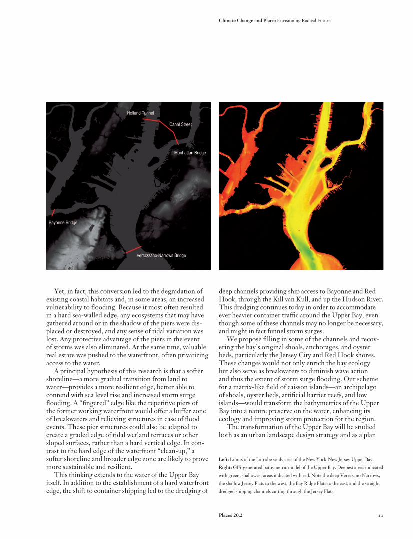
Left: Limits of the Latrobe study area of the New York-New Jersey Upper Bay.
Right: GIS-generated bathymetric model of the Upper Bay. Deepest areas indicated
with green, shallowest areas indicated with red. Note the deep Verrazano Narrows,
the shallow Jersey Flats to the west, the Bay Ridge Flats to the east, and the straight
dredged shipping channels cutting through the Jersey Flats.
Climate Change and Place: Envisioning Radical Futures

12
for flood protection. We will test its design elements using computational fluid dynamic models to evalu-ate their effectiveness as storm breaks and barriers. The extent of flooding predicted by these models will then be used in GIS-based economic analyses to determine damage and cost consequences.
We propose to implement this transformation using the most cost-efficient and environmentally sound methods possible. One potential strategy for achieving the desired bathymetric changes is the use of clean dredge spoils from dredging projects. The Harbor Deepen-ing Project—the largest such undertaking for the Port of New York and New Jersey—will make available an estimated forty million cubic yards of dredged material. Habitat restoration and environmental improvement in conjunction with dredging—authorized under federal law and a major goal of the Army Corps of Engineers’ Dredged Material Management Plan—are mutually ben-eficial endeavors.7
Costs and feasibility for the use of dredged material in the creation of caisson island fill, mudflats, dredged-rock reefs, and the restoration of oyster reefs are promising.8 Likewise, the use of “recycled” materials such as out-of-commission “retired” subway cars to create artificial reefs has proven economical and successful on other water-fronts.9 Other possibilities for fill material include clean garbage and construction debris, as well as the enormous volume of earth and rock that will be removed for the Metropolitan Transportation Authority’s Second Avenue subway project. Given the economic and environmental costs of traditional flood protection methods, unconven-tional ones like these may in fact be the most sustainable.
The ChallengeThis proposal seeks not merely to protect the New
York-New Jersey region from sea level rise and storm surge flooding, but also to reconceptualize the relation-ship between adaptive infrastructure and ecology in the twenty-first-century waterfront city. With looming climate change as catalyst, we aspire to develop a new and versatile system of coastal planning, to enrich ecology and the health of the urban estuary, and to create a vital urban place on the water.
Notes
1. Vivien Gornitz, Stephen Couch, and Ellen K. Hartig, “Impacts of Sea Level Rise in
the New York City Metropolitan Area,” Global and Planetary Change, 32 (2002), p. 72.
2. Ibid., p. 85.
3. The Intergovernmental Panel on Climate Change establishes that it is “likely”
that tropical cyclones will be more intense. See Climate Change 2007: Synthesis
Report, Contribution of Working Groups I, II and III to the Fourth Assessment Report of
the Intergovernmental Panel on Climate Change, R. K. Pachauri and A. Reisinger, eds.
(Geneva, Switzerland: IPCC, 2007), p. 47.
4. Gornitz et al., “Impacts of Sea Level Rise,” p. 66.
5. Malcolm J. Bowman et al., Hydrologic Feasibility of Storm Surge Barriers to Protect
the Metropolitan New York-New Jersey Region: Final Report to HydroQual, Inc., Marine
Sciences Research Center, State University of New York, Stony Brook, NY (March
2005). Also see M. J. Bowman and D. Hill, “Bracing for Super-Floyd: How Storm
Surge Barriers Could Protect the New York Region,” Briefing for the New York
Academy of Sciences, www.nyas.org/ebriefreps/splash.asp?intebriefID=415.
6. Bathymetrics are the relative depths of large bodies of water.
7. David J. Yozzo, Pace Wilber, and Robert J. Will, “Beneficial Use of Dredged
Material for Habitat Creation, Enhancement, and Restoration in New York-New
Jersey Harbor,” Journal of Environmental Management, 73 (2004), pp. 39-52.
8. Ibid., pp. 39-52.
9. Ian Urbina, “Growing Pains for a Deep-Sea Home Built of Subway Cars,” New
York Times, April 8, 2008.
Above: Tracings of a century of coastline transformations. Edges, flats, shoals, and
anchorages from a series of National Oceanic and Atmospheric Administration
historical nautical maps and charts.
Opposite: Preliminary design strategies for an adaptive intervention of wetlands,
windmills, reefs, oyster beds, island fields, extended piers, detached piers, and
extracted slips.
Nordenson, Cassell, Koch, Seavitt, Smith, Tantala, Yarinsky / On the Water

Places 20.2 13
Climate Change and Place: Envisioning Radical Futures