phase 1a planning rationale
TRANSCRIPT

PHASE 1APLANNING RATIONALESTAGE II SITE PLAN CONTROLAUGUST 26, 2015

PLANNING RATIONALE 223 McLeod Street Ottawa, ON K2P 0Z8 613.730.5709 fotenn.com
PLANNING DESIGN LANDSCAPE ARCHITECTURE
TABLE OF CONTENTS
1.0 Introduction ......................................................................................................................................................... 1
1.1 Project History ............................................................................................................................................... 1
2.0 Proposed Development .................................................................................................................................. 1
3.0 Conformity with the Master Plan ............................................................................................................... 3
4.0 Subject Property and Surrounding Area ................................................................................................4
4.1 Subject Property ..........................................................................................................................................4
4.2 Surrounding Area ........................................................................................................................................ 5
5.0 Policy and Regulatory Framework ........................................................................................................... 5
5.1 City of Ottawa Official Plan ..................................................................................................................... 5
5.2 City of Ottawa Official Plan Amendment No. 150 ......................................................................... 8
5.3 Central Area Secondary Plan .................................................................................................................. 9
5.3.1 Official Plan Amendment No. 143 .................................................................................................... 9
5.4 Zoning By-law (2008-250) ................................................................................................................... 14
6.0 Conclusion ......................................................................................................................................................... 18

PLANNING RATIONALE ZIBI ONTARIO: PHASE 1 AUGUST 26, 2015 1
1.0 Introduction
FOTENN Consultants Inc., acting as agents for Windmill Green Fund LPV, is pleased to submit the following Stage 2 Site Plan Control Application for the first phase of development in ZIBI, the redevelopment of lands located on Chaudière and Albert Islands.
1.1 Project History
Development applications in support of the proposed redevelopment of Chaudière and Albert Islands in the City of Ottawa were originally submitted in April 2014. These included a Zoning By-law Amendment (D02-02-14-0040) and Stage 1 Site Plan Control application (D07-12-14-0075). The City also initiated a concurrent Official Plan Amendment (File D01-01-14-0008) to update the Central Area Secondary Plan to include policies relating to the two (2) islands. Previously, no policies specific to the islands were included in the Secondary Plan.
The Official Plan and Zoning By-law amendments were adopted by Ottawa City Council on October 8, 2014 as by-laws 2014-396 (OPA 143) and 2014-395, respectively. The islands were designated as “Mixed Use” under the Central Area Secondary Plan, with specific policies relating to their redevelopment. The Zoning By-law Amendment changed the zoning of the subject property from Parks and Open Space Zone, Subzone L, Special Exception 329, Holding (O1L[329]-h)” to Mixed-Use Downtown Zone, Subzone 5, Special Exception 2172, Schedule 332, Holding (MD5[2172] S332-h) and Major Leisure Facility Zone (L2). Both amendments served to implement the vision presented in the Master Plan prepared by Windmill for the Domtar Lands.
Both Amendments were appealed to the Ontario Municipal Board (OMB) and are currently working their way through that process. All appeals are related to the aboriginal heritage of the lands and the desire of some to see the lands returned to a natural state. Resolution of the appeals is expected in late 2015.
The Stage 1 Site Plan Control application functions as a ‘Master Plan’ for Chaudière and Albert Islands. Minor issues remain outstanding for Stage 1 approval. No Stage 1 or 2 approvals may be issued prior to a resolution of the appeals at the OMB.
2.0 Proposed Development
The first phase of the redevelopment is located on the west side of Chaudière Island, within a portion of the Chaudière West district. Chaudière West is a residential neighbourhood with a mix of some commercial and retail centred on Head Street Square. The Square will function as the village square at the heart of the district, positioned to capture maximum sun and protect from prevailing winds, while maintaining views in all directions.
Phase 1 includes a residential building (Block 205A) on the south side the Square, an interconnected underground parking garage beneath Block 205A, the Square, and future blocks 206 and 207, and the creation of Head Street Square itself.
Building 205a is a six (6) storey mixed-use building, with ground floor retail uses activating the Square to the north and five (5) storeys of residential units above (61 units total). On the south side, fronting onto the Buchanan Channel, are residential units with private terraces along the channel. The building features a two storey podium clad in red brick. At the third storey, the upper floors step back 2.7 metres on the south side and 2.3 metres on the north side. The materiality also changes to a lighter mix of concrete and metal cladding. At the sixth storey, an additional 2.9 metre step back is incorporated on the south side. The top of the building includes rooftop terraces overlooking the Square to the north and the City of Ottawa to the south. Access to upper floor units is provided via a common entrance located in the

PLANNING RATIONALE ZIBI ONTARIO: PHASE 1 AUGUST 26, 2015 2
centre of the building which provides access from the Square to the north and from the south.
FIGURE 1: PROPOSED NORTH ELEVATION OF BLOCK 205A
Head Street Square will be the feature public gathering space in the Chaudière West district. As originally envisioned in the Master Plan, the square creates an exciting and flexible space for events, featuring perimeter planters around a stage/gathering place. The centre of the Square is highlighted by a rail bench system – utilizing repurposed rails from the industrial buildings and creating moveable benches that slide along the rail system, creating benches, tables, or stages. The versatile structure will play host to varied programming, making the Head Street Square a dynamic and vibrant public space. The rails are framed on the north and south edges by repurposed columns, again from the industrial buildings on site, which provide catenary lighting crossing the square and opportunities for feature lighting of the stage and performance areas. Finally, flush-mounted water jets provide a feature element to the west end of the rails adding another layer of interest depending on the use of the square at any given time. The four edges of the square will ultimately be activated by retail spaces with patios and display areas spilling out into the square.
The square utilizes a variety of pavers to create interesting patterns and add interest to the space. Flush tree plantings make the square feel open while slight roll curbs at the west end help to delineate the pedestrian only area within the square, and the woonerf where vehicles may be permitted. Knock-down bollards prevent vehicles from entering the square.
The themes of the square carry along pedestrian paths to the east and south in Phase 1 (with future connections envisioned in future phases). The path between Block 205A and the retained Block 208 provides a connection to the Buchannan Channel and access front door access for the south-facing townhouse residences. The alley will utilize a mix of wood pavers and plantings to create an excellent pedestrian environment. At the south end, the pathway will terminate in a wood deck, projecting over the water and offering excellent views to the south, east and west.
The primary pedestrian access to the Square, and to the Chaudière West District, is at the east end of the square. The square slopes down towards Booth Street, providing an accessible access and creating a feature entry into the site. Paving materials are continued down from the square, and plantings border the edges of two retained buildings – Blocks 208 and 207 (508). Overhead beams mark the entry into the square and into the development.
Automobile access to the site is provided via the main vehicle-oriented street (“Perley Street”) at the north edge of the Windmill land holdings. The street provides access to both the Chaudière West District, and to the lands further north, owned by Energy Ottawa (a

PLANNING RATIONALE ZIBI ONTARIO: PHASE 1 AUGUST 26, 2015 3
subsidiary of Hydro Ottawa). The street is located on both properties and is proposed as a single inbound lane with two lanes outbound including a dedicated left-out. The intersection at Booth Street will be signalized and will ultimately also provide the full movement access into the Chaudière East district. The asphalt street will continue to just west of the underground parking garage ramp, where it will transition into a one-way woonerf that loops around the site. This transition will be marked by a change in paving materials (from asphalt to pavers), a narrowing of the right-of-way, and removal of the standard curbs and sidewalks (as pedestrians and cyclists will operate in mixed travel lanes with vehicles). The woonerfs are not intended to handle large volumes of traffic.
Entering the site from Booth Street, Perley Street will feature a concrete sidewalk on the south side (adjacent to Blocks 206 and 207, and a 3 metre wide mixed-use pathway on the north side.
In Phase 1A, the parking garage entrance will be provided from the temporary access road, through the future Block 204A. The garage will provide access to 97 parking spaces under Head Street Square and Block 205A. Future knock-out panels will provide access to a future garage under Blocks 206. Block 206 will also include what will ultimately be the primary access to the parking garage, direct from Perley Street. There are 29 parking spaces dedicated for Block 205A, while the remaining 68 spaces are for the retail and commercial uses.
3.0 Conformity with the Master Plan
The proposed Phase 1A development is generally consistent with the vision put forth in the 2014 Master Plan for the Isles (now Zibi). The Master Plan is a high-level concept that was always intended to see minor adjustments and changes as the detailed design for each phase advanced.
In preparing the Phase 1A site plan materials, several challenges were looked at and best solutions put forth. The result is a plan which maintains the integrity of the Master Plan. A revised Master Plan for both islands has been prepared, implementing the changes noted in Phase 1A. The minor changes include:
- Woonerf street sections, originally envisioned with 12 metre rights-of-way, were enlarged to 13 metres to accommodate the necessary underground infrastructure. District Energy and purple pipe systems are being implemented in phases and necessary spacing of varying utilities dictated a wider right-of-way. The proposed solution adds only 1 metre to either side of the right-of-way allowing for a functional solution underground, tree plantings on one side, and the ability to service and load buildings from ground level as needed, while continuing to provide the necessary fire route through the site.
- The depth of Block 205A was revisited to allow for functional retail spaces and to account for the change in grades. The Block 205A building is also proposed at six (6) storeys as opposed to four (4).
- A 10 metre surface access easement at the north edge of the property necessitated a shift of Blocks 206 and 207 to accommodate Perley Street. Temporary hydro infrastructure on the south side of the Energy Ottawa building is in place until 2017 and cannot be moved before that time.

PLANNING RATIONALE ZIBI ONTARIO: PHASE 1 AUGUST 26, 2015 4
- Block 205 was split into two (2) blocks providing increased permeability to the water and access for pedestrians. A future pedestrian bridge is envisioned across the channel to provide egress routes for the building on Albert Island.
- A water feature within Head Street square has been replaced with water jets and linear trench drains that provide stormwater drainage of the square.
4.0 Subject Property and Surrounding Area
4.1 Subject Property
The subject property has most recently been used as an industrial site. Existing buildings on the site include a major mill and several outbuildings. As mentioned, the subject property consists of two (2) islands within the Ottawa River. Phase 1A of the development is situated on the most northerly Chaudière Island. The island is bisected by Booth Street creating two development areas – Chaudière East and West. Phase 1A of the development is within the Chaudière West district, located directly adjacent to Booth Street.
The extent of Phase 1A is shown on the Site Plan (Drawing A003 prepared by Barry J. Hobin and Associates Architects). It extends from Booth Street to just west of Block 205A and includes Perley Street, Head Street Square and underground parking garage works. A future Phase 1B will add the lands within Blocks 206, 207 and 208. The total area of Phase 1 is 8,742 square metres.
FIGURE 2: ZIBI ONTARIO LANDS
Booth Street is currently a four lane arterial adjacent to the subject property. It acts as one of five (5) bridge connections between Ontario and Quebec. To the north Booth becomes Eddy Street and provides access into the downtown core of the City of Gatineau. To the south,

PLANNING RATIONALE ZIBI ONTARIO: PHASE 1 AUGUST 26, 2015 5
Booth Street intersects Wellington Street and continues through LeBreton Flats to Carling Avenue.
4.2 Surrounding Area
North: Directly north of the subject property is a hydroelectric generating station owned by Energy Ottawa. The station is currently undergoing an expansion which will add significant capacity to the existing station and power additional homes in the City of Ottawa. Further north, in the City of Gatineau, is a Hydro Quebec hydroelectric generating station, additional Zibi lands, and the south edge of the downtown core of Gatineau. This edge is dominated by the Terrace de la Chaudière federal government office complex located on the west side of Eddy Street. Low-profile retail uses with second and third floor residential and office uses characterize the Promenade du Portage mainstreet, all functioning as the downtown core of the Hull Sector. Alexandre-Taché Boulevard/Laurier Street is an east-west arterial road running parallel to the Ottawa River which accommodates a number of public and institutional uses, including l’Université du Québec en Outaouais, la Maison du Citoyen and the Canadian Museum of History.
East: Immediately east of the subject property are additional Zibi lands, within the Chaudière East district. These lands will form parts of future development phases. South east of the subject property is Victoria Island, which is owned and managed by the National Capital Commission (NCC).
South: South of the site is Albert Island, also part of a future phase of the Zibi development. Former administrative buildings on the site are to be retained and repurposed for retail and commercial uses. Further south, on the south shore of the Ottawa River is the Canadian War Museum, on the west side of Booth Street.
West: Immediately to the west is the Chaudière Falls Ring Dam which controls water flows through the hydroelectric channels.
5.0 Policy and Regulatory Framework
5.1 City of Ottawa Official Plan
The Subject Property is located within the Central Area land use designation on Schedule B of the City of Ottawa Official Plan (2003, as amended). The Central Area is the economic and cultural heart of the city and the symbolic heart of the nation, based on its unique combination of employment, government, retail, housing, entertainment and cultural activities.
Policies for the Central Area promote its vital role in the city, its distinct identity and heritage character, as well as the primacy of the Parliament Buildings and other national symbols. The policies aim to enhance the diversity and attractiveness of the Central Area by encouraging a broad range of land uses and day/night, year-round activities while protecting existing residential neighbourhoods in and near the Central Area.
In accordance with the Official Plan policies regarding the Central Area, the City will:
Support the Central Area’s role as the economic and cultural heart of the city by:
Implementing the Central Area Secondary Plan, discussed below;
Implementing the Downtown Ottawa Urban Design Strategy (DOUDS), discussed below;

PLANNING RATIONALE ZIBI ONTARIO: PHASE 1 AUGUST 26, 2015 6
Protecting the visual integrity and symbolic primacy of the Parliament Buildings and other national symbols.
Promote the Central Area as a vital and active place by:
Encouraging a range of day/night and year-round activities;
Supporting stakeholder initiatives that maintain and develop tourism and convention attractions, facilities, activities, and programming;
Enhance the appearance and liveability of the Central Area and the surrounding residential neighbourhoods by:
Ensuring that all development has regard for the compatibility criteria in Section 2.5.1, discussed below;
Designating heritage buildings and streetscapes and working with owners to restore and maintain heritage buildings;
Improve and enhance the pedestrian environment in the Central Area;
Recognize Booth Street as a distinctive street with unique pedestrian characteristics; and,
Give walking, cycling and public transit priority in the Central Area.
The Subject Property is located in an area of Foreground Height Control as per Annex 8A – Central Area Key View and View Sequences of the Parliament Buildings and other National Symbols. This annex is applied in conjunction with the Central Area land use policies to protect the visual integrity and symbolic primacy of the Parliament Buildings and other national symbols. As such, buildings constructed in areas of foreground height control must not rise above the ridgeline of the roof of the Centre Block, cannot visually mar the silhouette or dominate the Parliament Buildings and other national symbols (3.6.6(e)(i)).
Phase 1A is the first phase in what will be a vibrant, sustainable, mixed-use community in proximity to the City’s current downtown, the City of Gatineau’s downtown, the future urban development on LeBreton Flats, and the Confederation LRT line. This liveable destination in the City will support day and night, year-round activity within the Central Area of the City and will contribute to the Central Area’s vitality and activity with a mix of uses in a complete community.
References to the site’s history will be prominent throughout the development – particularly within Head Street Square and along the woonerfs. A Heritage Interpretive Plan is being prepared in support of the redevelopment and will establish a framework for the recognition of the site’s aboriginal and industrial history.
The Master Plan presented at Stage 1 of the Site Plan Control Application provides a detailed discussion on the preservation of views from specified locations throughout the City. These viewplanes have informed the Master Concept Plan for the ultimate development of the lands and ensures that none of the specified views are impacted.
The purpose of compatibility and community design policies is to help the City manage growth in a way that enhances a community. Section 2.5.1 of the Official Plan contains broad design objectives with accompanying principles. The Official Plan emphasizes that these objectives are qualitative statements and are meant to influence building design, without sterilizing it. Objective criteria in Section 4.11 of the OP provide a comprehensive means by which to assess the compatibility of infill development.
The Planning Rationale prepared in support of the Stage 1 Site Plan Application (dated April
PLANNING RATIONALE ZIBI ONTARIO: PHASE 1 AUGUST 26, 2015 7
2014) provides a detailed discussion of compatibility and community design policies from section 2.5.1 of the Official Plan.
As noted in the Stage 1 Planning Rationale, the proposed development focuses on creating a unique sense of place, rather than integrating into the urban fabric of the adjacent development areas. This is largely as a result of its separation from any established urban fabric. As such, the criteria set forth in section 4.11 are most appropriately used to determine the compatibility of buildings within the development area itself. In this case, Phase 1A only includes a single building (Block 205A) and is therefore difficult to test for compatibility. A discussion of the criteria is below:
Traffic: The traffic impact for Phase 1A has been evaluated by Parsons in their Transportation Impact Study. The traffic flows are consistent with those proposed in the 2014 Multi-Modal Transportation Study and subsequent Addendum No. 1 which accounted for traffic from both sides of the Ottawa River.
Vehicular Access: Vehicles will access the site using the new Perley Street which will provide a new, full movement intersection at Booth Street. Vehicles will enter the underground parking garage through an interim access within Block 204 until Block 206 is constructed and the ultimate parking garage access is constructed. The intent is to move cars below grade as soon as possible after they have entered the site.
Parking Requirements:
The approved zoning for the property requires no minimum parking but sets maximum parking rates. The proposed underground garage in Phase 1A includes 98 total parking spaces – 47 for the residential units of Block 205A, and 51 reserved for future residents and visitors of Block 206/207.
A temporary surface parking area containing ten (10) spaces is proposed at the west end of Phase 1A to provide five (5) spaces to support the retail uses that will be constructed as part of the first phase and five (5) car sharing spaces. Parking for these uses will ultimately move underground into garages on both the east and west sides of Chaudière Island, consistent with the Master Plan, but in the interim, limited surface parking is provided.
Bicycle parking is provided in the parking garage below Block 205A for residents at a rate of 1 space per unit. Additional spaces to serve the retail within Block 205A are provided at-grade, within Head Street Square.
Outdoor Amenity Areas:
Given the location of the site and that it is the first building within the redevelopment, there are no impacts on adjacent outdoor amenity areas as a result of the development.
Loading & Service Areas and Outdoor Storage:
Phase 1A will include retail units at the base of Block 205A which will be front-loaded. It is anticipated that loading and service to these retailers will only occur at off-peak times to avoid conflicts with activities in Head Street Square. Woonerf streets within the development provide sufficient width for surface loading on one side while maintaining the required fire route and drive lane.

PLANNING RATIONALE ZIBI ONTARIO: PHASE 1 AUGUST 26, 2015 8
No outdoor storage is proposed.
Lighting: Lighting within Head Street Square, along woonerfs and pedestrian streets, and on buildings has been designed to minimize light pollution and avoid conflicts with future blocks.
Noise and Air Quality:
A noise study has been prepared to examine potential impacts from the adjacent arterial (Booth Street), and from the hydroelectric station to the north. Recommendations for mitigation of noise sources will be implemented through detailed building design.
Sunlight: As demonstrated in the provided sun-shadow study, Block 205A will cast minimal shadows into Head Street Square in June and September. In December, the Square will be in shadow for much of the day. The sun shadow impacts are consistent with those contemplated in the Master Plan.
Microclimate: A Wind Analysis will be completed for high-rise buildings as part of Phase 1B.
Supporting Neighbourhood Services:
The proposed development represents the first phase of a mixed-use complete community that will offer residents with places to live, work and play. The urban community will ultimately include public spaces in the form of urban squares, woonerf streets, and parks at both the east and west end of Chaudière Island.
The site is in proximity to the National Capital Commission’s Ottawa River pathway system which provides connections for cyclists to the east, west, north and south. The site is also located in proximity to Vimy Place Park (adjacent to the Canadian War Museum, Bronson Park, Tom Brown Arena, Primrose Park, and the Dalhousie Community Centre.
5.2 City of Ottawa Official Plan Amendment No. 150
In 2013, the City of Ottawa reviewed its Official Plan which resulted in numerous changes to policy references and to land use designations. Ottawa Council adopted Official Plan Amendment (OPA) 150 to implement the changes in December 2013 and was approved by the Ministry of Municipal Affairs and Housing (MMAH) on April 24, 2014. Appeals have been received and are currently with the Ontario Municipal Board 1for decision.
For the purposes of this Planning Rationale, the current policies of the City of Ottawa Official Plan (2003, Consolidated May 2013) remain in full force and effect and have been reviewed and analysed for the proposed development. In addition, although OPA 150 is not yet in full force and effect, the new policies relevant to the proposed development have been taken into consideration as the intended direction of City Council and are described below.
The OPA does not change the land use designation of the site and does not include any significant changes to the policies for the Central Area. Additional policies were added, however which change how the City assigns building heights to areas. Furthermore, significant changes were proposed to Section 4.11 (Urban Design and Compatible Development) in an effort to set the stage for high quality urban design in all parts of the City and excellence within designated Design Priority Areas.
PLANNING RATIONALE ZIBI ONTARIO: PHASE 1 AUGUST 26, 2015 9
The proposed development under Phase 1A complies with the general intent of Official Plan Amendment No. 150 and offers high quality urban design that is well integrated within the existing heritage buildings and consistent with the Master Plan direction.
The Planning Rationale prepared in support of the Stage 1 Site Plan Application (dated April 2014) provides a detailed discussion of the policies in OPA 150 that are applicable to the subject lands.
5.3 Central Area Secondary Plan
The site is located within the boundaries of the Central Area Secondary Plan, which constitutes a more detailed policy direction beyond the Official Plan for select areas within the Central Area. The Central Area Secondary Plan defines area-specific visions, objectives, and policies for identified “character areas” and “theme streets”.
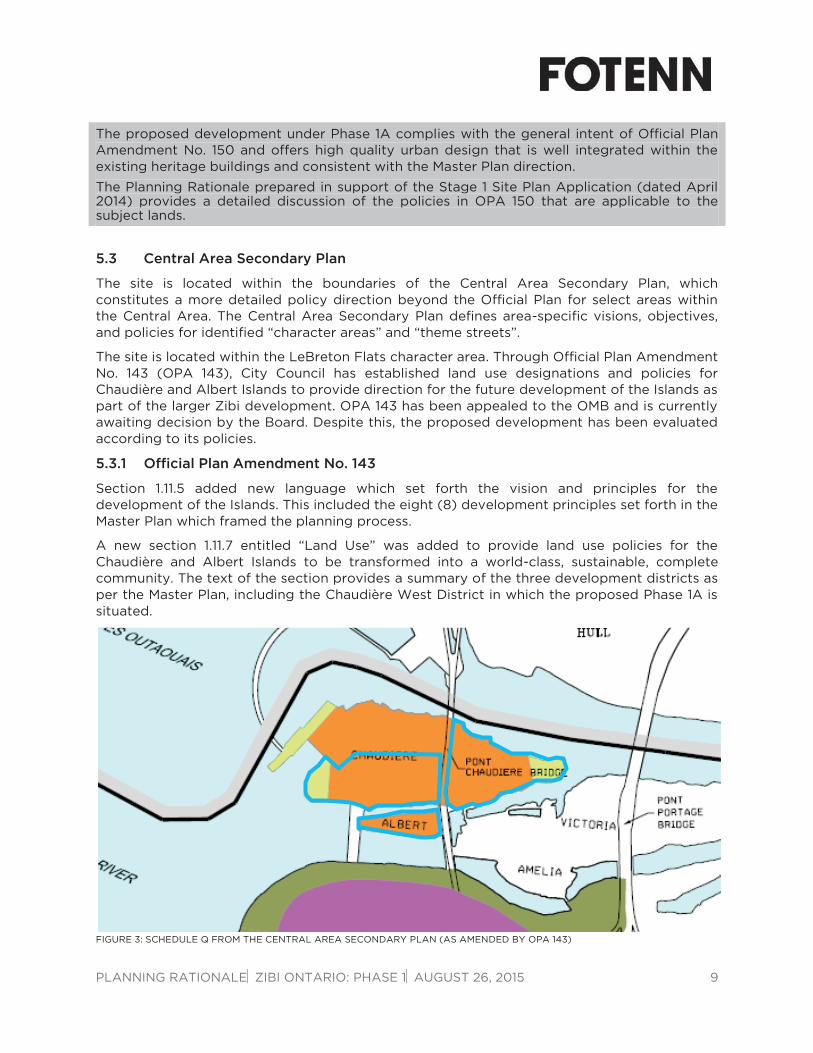
The site is located within the LeBreton Flats character area. Through Official Plan Amendment No. 143 (OPA 143), City Council has established land use designations and policies for Chaudière and Albert Islands to provide direction for the future development of the Islands as part of the larger Zibi development. OPA 143 has been appealed to the OMB and is currently awaiting decision by the Board. Despite this, the proposed development has been evaluated according to its policies.
5.3.1 Official Plan Amendment No. 143
Section 1.11.5 added new language which set forth the vision and principles for the development of the Islands. This included the eight (8) development principles set forth in the Master Plan which framed the planning process.
A new section 1.11.7 entitled “Land Use” was added to provide land use policies for the Chaudière and Albert Islands to be transformed into a world-class, sustainable, complete community. The text of the section provides a summary of the three development districts as per the Master Plan, including the Chaudière West District in which the proposed Phase 1A is situated.
FIGURE 3: SCHEDULE Q FROM THE CENTRAL AREA SECONDARY PLAN (AS AMENDED BY OPA 143)

PLANNING RATIONALE ZIBI ONTARIO: PHASE 1 AUGUST 26, 2015 10
The subject lands are within the Mixed Use designation, as identified in Schedule Q of the Central Area Secondary Plan. The Mixed Use designation provides for a dynamic, mixed-use community. All three districts (West Chaudière, East Chaudière and Albert Island) are to achieve a targeted total gross floor area (GFA) of approximately 100,000 square metres. The total GFA is to be generally distributed as follows:
70-80% for residential uses;
5-10% for retail type uses;
10-15% employment type uses; and
5-10% other commercial, community, cultural related uses.
Retail, office, entertainment, cultural, institutional, and recreational uses are permitted within the district as are low, medium and high-rise apartment dwellings and townhomes. Within the Chaudière West district, the primary uses are to be residential and office, with retail uses typically located on the ground floor to contribute to public realm animation and activity.
Phase 1A respects the Mixed Use designation by providing residential and retail uses in Block 205A, contributing to the animation of Head Street Square. The total GFA of the proposed development under Phase 1A is 6,809 m2, representing 6.8% of the targeted GFA for development on the two Islands.
The secondary plan speaks to parks at both the east and west ends of Chaudière Island. Both parks will be constructed in future phases.
A new section on Heritage is added to section 1.11.8 of the Secondary Plan which included policies on the heritage resources on site. Per the policies, a Heritage Interpretive Plan is to be prepared that will include historic themes of First Nations, early settlement, the wood industry, the fire of 1900 and subsequent reconstruction, the pulp and paper industry, labour history, and others that may emerge as a result of further study. The writing of the HIP is in progress and will be on an ongoing basis.
New streets are encouraged to be located in historical rights-of-way to establish the history and importance of the site. New additions or construction in the vicinity of a place of heritage significance are to be in harmony with the existing structure but also identifiable as a new building or structure. These new additions or construction are to include high quality design elements and materials. The design of new buildings will include transitional elements and considerations to proportion, scale and rhythm in order to respond to the character and scale of existing heritage buildings.
The Subject Site complies with the applicable heritage provisions of the Secondary Plan. Phase 1A of the development does not include any adaptive reuse of heritage buildings on the site, but will create Head Street Square, located in the former right-of-way of the historical “Head Street”. Landscape elements proposed for the site speaks to its heritage as an industrial site critical to the wood trade, and to the aboriginal history.
Demolition to occur on the site prior to the construction of Phase 1A will leave blocks 501 and 508 as buildings for potential adaptive reuse in the future. The new Block 205a is designed with high quality design features and materials and is scaled appropriately in relation to the adjacent heritage elements. The red brick exterior treatment at the base complements the heritage elements at the street level, while the light coloured treatment and glazing on the upper floors contribute to the building’s distinct modern style.

PLANNING RATIONALE ZIBI ONTARIO: PHASE 1 AUGUST 26, 2015 11
Schedule B of OPA 143 (Map 5 of the Central Area Secondary Plan) permits building heights up to nine (9) storeys within the Phase 1A area. The proposed Block 205A, at six (6) storeys, is within the permitted heights. The building height is greater than the conceptual building heights shown in Annex 1 of the OPA, but the impacts on Head Street Square and future development surrounding are insignificant. The provided sun-shadow study for Block 205A demonstrates that the sun-shadow impacts are the same as were intended in the Master Plan.
FIGURE 4: MAP 5 FROM THE CENTRAL AREA SECONDARY PLAN (AS AMENDED BY OPA 143) WITH APPROXIMATE LIMITS OF
PHASE 1A
The following guidelines are identified for medium-rise buildings:
Five to nine-storey buildings will be used to create the primary character of the urban fabric for the Islands.
To create a family-friendly and pedestrian focused environment, buildings should convey a sense of activity and bring building life to the pedestrian level and into the public realm. This can be achieved by encouraging multiple building entries, a high degree of transparency at the ground floor, direct physical connections to public amenity areas and a comfortable buffer between the street and the interior of residential units.
Generous common spaces including roof top amenity areas are encouraged. Facades should be enlivened with balconies, decks and architectural articulations.
Buildings should be articulated into smaller massing with breaks in the façade and roof line.
Through block connections are encouraged to provide alternative pedestrian routes.
1-9 storeys
10-15 Storeys

PLANNING RATIONALE ZIBI ONTARIO: PHASE 1 AUGUST 26, 2015 12
The proposed Phase 1A development conforms to the built form and medium-rise building design requirements of the Secondary Plan. The proposed six (6) storey Block 205A provides a ground floor that will encourage activity and bring life to the pedestrian level, also contributing to a vibrant Head Street Square. A combination of glazing, balconies, and rooftop terraces create visual interest in the upper floors of the building and will provide generous common spaces within the building.
The proposed height of six (6) storeys for Block 205A is greater than the conceptual heights shown in Annex 1, but is consistent with the height permitted by Map 5 of the Secondary Plan (Schedule B of OPA 143) where a maximum of nine (9) storeys are permitted. As noted above, the additional storeys do not create greater shadow impacts on Head Street Square than were envisioned in the Master Plan for the Islands. This is as a result of lower floor to ceiling heights.
The Central Area Secondary Plan outlines policies designed to protect and showcase significant views. These include placing buildings and open spaces in a manner that allows for maximum public viewing opportunities of the national symbols (Parliament Buildings, Supreme Court, etc.) and of the Chaudière Falls.
The proposed building and open space placement is consistent with the Master Plan and enhances views of national symbols. Through the continued development of the Islands, these views will be framed and enhanced further through new buildings and public spaces.
Head Street Square is envisioned in the Secondary Plan as a unique square that is designed to function as the village square for the Chaudière West district. The square is to incorporate such features as a stage for special events, seating to frame the square, featured plantings and paving, a water feature, and a wide perimeter for commercial animation.
The proposed landscape plan for Head Street Square creates an exciting, flexible, and dynamic public square, capable of hosting large and small events or of simply being a place for visitors and residents to spend time. The square features large wood benches affixed to reclaimed rails that can function as either separate benches, tables, or together as a stage for performances and events. Reclaimed columns provide opportunities for seasonal and event lighting and create a space that is very versatile. Water fountains at the west end provide a water feature while plantings around the edge of the square will provide shade and greenery.
A wide perimeter around the square allows for animation from the ground floor uses of the surrounding buildings which may include outdoor patios, displays, etc. Feature plantings and overhead beams mark the entrance from Booth Street and signify the entrance to not only the square, but to the Chaudière West district.
The transportation strategy envisioned for the redevelopment of the Chaudière and Albert Islands will be focused on creating a highly walkable site that is connected to the multi-use pathway and cycling networks and that is well serviced by transit. Non-vehicular transportation will be prioritized by way of a transportation demand management (TDM) program and appropriate infrastructure and initiatives to support use of sustainable transportation. A green transport plan will form part of the transportation strategy to monitor carbon emissions reduction targets.

PLANNING RATIONALE ZIBI ONTARIO: PHASE 1 AUGUST 26, 2015 13
Transportation policies are split into three major sections: Active Transportation and Transit Infrastructure, Transportation Demand Management, and Internal Street Network and Design. These policies are discussed below.
Active Transportation and Transit Infrastructure
Streets are to be designed as complete streets which provide suitable facilities for pedestrians and cyclists.
The Booth-Eddy street corridor is to be improved with pedestrian, cycling and transit facilities and infrastructure in both travel directions.
A pathway connection is to be provided from the existing NCC pathways along the south shore of the Ottawa River to the western tip of Albert Island and western edge of West Chaudière District.
The right-of-ways for internal streets are to be landscaped with street trees and pedestrian and cycling amenities such as bike racks and seating.
Existing bus lines will service the site with two new stops, one located along Eddy Street in Gatineau and the other along Booth Street in Ottawa. As development proceeds, the City will provide additional transit service to meet transit ridership needs and targets.
Transportation Demand Management
The developer will create a TDM program acceptable to the City that includes a transportation strategy, implementation plan, and monitoring program, which sets out the methods and initiatives to achieve the modal share targets noted above.
Future employers, employees, and residents will be targeted through the TDM program with incentive and educational programs implemented in the early phases of the development.
Parking for residents, visitors, and other users should meet and not exceed the City’s minimum parking requirements. A parking rate maximum should be applied to the site.
Parking is encouraged in underground parking garages with limited surface parking to increase available space for other uses including public realm and private amenity areas.
Car sharing and bike programs are to be made available on-site.
Internal Street Network and Design
The street network on the Islands will be designed to include dedicated bicycle lanes, a minimum of 3-metre pedestrian zone on either side of the street, designed with plantings and street furnishings.
Streets that are to be pedestrian priority zones such as around public squares and key pedestrian linkages will be designed as woonerfs (narrow curbless streets shared by all users), which assigns priority to pedestrians and cyclists.
North-south streets should be oriented and designed to increase the amount of sun that reaches the public realm throughout the year.
Streets should provide direct access to the riverfront.

PLANNING RATIONALE ZIBI ONTARIO: PHASE 1 AUGUST 26, 2015 14
Streets that are oriented east-west should be staggered to buffer the public realm against prevailing west winds. The staggering also helps to establish a pedestrian scale, meandering urban character.
The streets of Phase 1A will include Perley Street along the north edge of the site and the internal woonerf street. On Perley Street, constraints due to property ownership and infrastructure have caused a revision to the cross-section originally conceived in the Master Plan. The street will now feature a 2 metre concrete sidewalk on the south side, and a 3 metre wide multi-use pathway (MUP) on the north side. The MUP will provide connectivity with a future MUP that will bring pedestrians and cyclists around the island, connecting with the NCC paths on the shore of the Ottawa River. The sidewalk will continue until the woonerf loop begins, where the street will change into a flush woonerf street where pedestrians, cyclists and cars all operate in a shared space and where pedestrians and cyclists are given priority.
The woonerf will feature street trees, alternating with street furniture and infrastructure (i.e. fire hydrants, etc.). A six (6) metre wide drive lane will be maintained throughout with 3.5 metres left on either side for loading spaces, and to allow ground floor uses to spill out into the streets.
Bus service will not enter the site, but a stop will be improved on Booth Street, adjacent to the primary pedestrian entrance into Head Street Square. New shelters will provide comfortable waiting areas for transit users.
It is also proposed that Booth Street be enhanced to provide a single lane of traffic in either direction, cycle tracks on either side, and sidewalks on both side. The intent is to create a complete street within the corridor, from the Chaudière Bridge in the north to the War Museum in the south.
As part of the Stage 1 Site Plan Approval, a Transportation Demand Management (TDM) program has been requested by the City. The TDM is to include a transportation strategy, implementation plan, and monitoring program. The TDM forms part of the Transportation Study submitted in support of the Phase 1A Stage II Site Plan Application.
Parking is provided in the communal underground parking garage and a temporary surface parking area provides additional spaces on an interim basis. Future development phases will extend the parking garage to add additional spaces and other districts will provide a greater supply of parking to support the commercial and retail uses. Ultimately, all parking will be located underground.
The phasing plan set forth in the Secondary Plan has been revisited and adjusted to suit the needs of the development. The current application, which includes Head Street Square, Block 205A, demolition of several structures, and the underground parking garage – constitutes Phase 1A of the development.
5.4 Zoning By-law (2008-250)
The Council-approved Zoning By-law Amendment (By-law No. 2014-395) is currently before the Ontario Municipal Board (OMB). For the purposes of this Rationale, the proposed Phase 1A Site Plan has been evaluated against the proposed “Mixed Use Downtown” zoning. Phase 1A is located within Area A on Attachment 1 to the By-law and is therefore zoned “Mixed-Use Downtown Zone, Subzone 5, Exception 2172, Schedule 332, Holding (MD5[2172] S332-h).
Prior to the Council-approved MD5[2172] S332-h, subject to the resolution of the OMB appeals, the Subject Site is currently zoned “Parks and Open Space, Subzone L, Exception
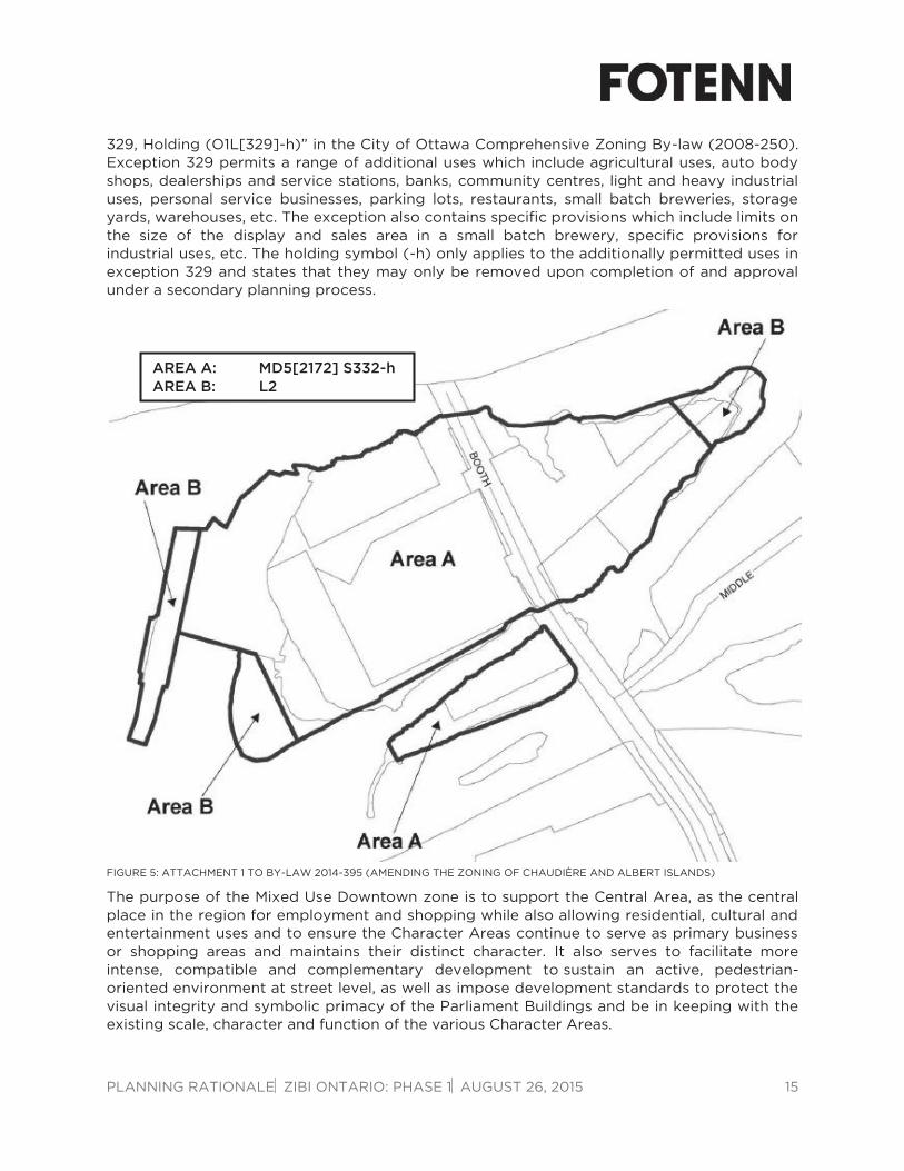
PLANNING RATIONALE ZIBI ONTARIO: PHASE 1 AUGUST 26, 2015 15
329, Holding (O1L[329]-h)” in the City of Ottawa Comprehensive Zoning By-law (2008-250). Exception 329 permits a range of additional uses which include agricultural uses, auto body shops, dealerships and service stations, banks, community centres, light and heavy industrial uses, personal service businesses, parking lots, restaurants, small batch breweries, storage yards, warehouses, etc. The exception also contains specific provisions which include limits on the size of the display and sales area in a small batch brewery, specific provisions for industrial uses, etc. The holding symbol (-h) only applies to the additionally permitted uses in exception 329 and states that they may only be removed upon completion of and approval under a secondary planning process.
FIGURE 5: ATTACHMENT 1 TO BY-LAW 2014-395 (AMENDING THE ZONING OF CHAUDIÈRE AND ALBERT ISLANDS)
The purpose of the Mixed Use Downtown zone is to support the Central Area, as the central place in the region for employment and shopping while also allowing residential, cultural and entertainment uses and to ensure the Character Areas continue to serve as primary business or shopping areas and maintains their distinct character. It also serves to facilitate more intense, compatible and complementary development to sustain an active, pedestrian-oriented environment at street level, as well as impose development standards to protect the visual integrity and symbolic primacy of the Parliament Buildings and be in keeping with the existing scale, character and function of the various Character Areas.
AREA A: MD5[2172] S332-h AREA B: L2

PLANNING RATIONALE ZIBI ONTARIO: PHASE 1 AUGUST 26, 2015 16
The Zoning By-Law Amendment introduces a new subzone, Subzone 5 which contains the following provisions applicable to the proposed development:
Area A as shown on Schedule 332 is to be considered as one lot for zoning purposes;
Required parking may be located on any lot within the MD5 subzone;
The maximum building heights are prescribed as per Schedule 332;
The maximum number of buildings over nine (9) storeys for Area A as shown on Schedule 332 is four (4);
The maximum total floor area, with no exclusions, for each portion of the building over the ninth-storey is 700 square metres.
Subzone 5 of the MD zone contains several provisions for buildings over nine (9) storeys which are not applicable to Phase 1A as Block 205A will only have a height of six (6) storeys. The proposed Phase 1A development is consistent with the provisions of the MD5 subzone.
Phase 1A is located within Area A on Schedule 332 which permits maximum heights up to 73 metres. The MD5 subzone limits the number of buildings over nine (9) storeys within Area A to four (4).
The proposed Block 205A is consistent with the Council-approved building heights for the Chaudière West District.
Exception 2172 provides for additional permitted land uses (post secondary educational institution, marine facility, parking lot and parking garage) and prohibits all uses, except existing uses, until the holding symbol (-h) is removed.
There are a number of additional provisions to the exception, including:
Parking lots are only permitted to provide accessory parking to permitted uses.
Parking garages are only permitted if at least 75% of parking spaces are located below grade and provides accessory parking to permitted uses.
Section 193(2) (requiring non-residential uses to occupy at least 50% of the ground floor) does not apply to residential buildings.
The site is subject to the maximum number of parking spaces permitted in Table 103.
At least 50% of the provided parking is to be provided below grade.
The holding symbol may be removed in whole or in part for phased development only when the following conditions have been met:
Completion of a Phase 2 ESA in accordance with the O. Reg. 153/04 and acknowledged by the Ministry of Environment;
Completion of the necessary studies, reports and designs to the satisfaction of the General Manager of Planning and Growth Management, to determine environmental remediation required, adequate sanitary and potable water capacity and satisfactory fire protection requirements;

PLANNING RATIONALE ZIBI ONTARIO: PHASE 1 AUGUST 26, 2015 17
Submission of a Stage 2 Archaeological Assessment approved by the Ministry of Tourism and Culture;
Submission of an approved transportation strategy and Transportation Demand Management (TDM) Plan including an implementation plan identifying pedestrian, cycling, transit and road capacity requirements and improvements to accommodate the development and any improvements required to be completed by the developer to provide for this development. The approved strategy and TDM Plan may include phasing conditions tied to Stage 2 site plan applications setting out modal share performance measures to be achieved and means and methods for attaining the performance measures including a monitoring program;
Update to the flood plain mapping in the Zoning By-law;
Submission of a One Planet Communities endorsement, or by a similar sustainability program, to the overall project;
Submission of an approved Stage 1 Site Plan Control application, which reflects the OPA directions for the overall development concept and building heights including:
- Off-site improvements/modifications to required transportation and infrastructure to accommodate development;
- Approval from federal, NCC and other agencies with respect to servicing crossing their lands or connecting to their infrastructure;
- Fire protection requirements which meet the Fire Underwriters Survey requirements;
- Watermain design for redundancy that is acceptable to the City of Ottawa; and
- Approval of detailed Design Guidelines to guide development on Chaudière and Albert Islands.
Partial removal of the “h” may be considered to provide for phased development. The submission and approval of an application to lift the holding provisions on a phased basis may be considered provided the requirements for that development phase satisfy the requirements for the lifting of the holding zone specified above and that demonstrates how the phased development is consistent with and will advance achieving the overall development concept as set out in the Secondary Plan and as detailed within the Stage 1 Site Plan Control approval.
All of the above items are at varying stages of completion and will be completed for, in some cases, only the Phase 1A area at this time. This will allow for the holding symbol to be removed for the Phase 1A area immediately, while it may only be removed from other areas as the development progresses over the next several years.

PLANNING RATIONALE ZIBI ONTARIO: PHASE 1 AUGUST 26, 2015 18
The following provisions are applicable to the subject site given its zoning, location within the City, and surrounding land uses:
ZONING MECHANISM REQUIRED PROPOSED
Minimum Setbacks
(All sides) No minimum Varies
Maximum Building Height 73 metres 18.5 metres
Amenity Areas 366m2 total area
183m2 communal area
887m2 including
223m2 communal area
Parking Minimum Residential: None required
Visitor: None required
Retail: None required
Residential + Visitor parking: Block 205a: 47 spaces Block 206/207: 51 spaces
Retail: 5 spaces
Car Sharing: 5 spaces
Total = 108 spaces
Maximum Residential + Visitor parking:
1.75/unit (107 spaces)
Retail: 1.0/100m2 (8 spaces)
Total = 115 spaces
Bicycle Parking 0.5/dwelling unit (31 spaces)
1/250m2 of GFA (5 spaces)
Residential: 61 spaces
Retail: 5 spaces
The proposed development complies with the relevant zoning provisions.
6.0 Conclusion
The proposed development has been considered and evaluated against the applicable policy framework. The following is a summary based on this review:
The proposed development conforms to the Official Plan policies for the Central Area and creates a world-class, sustainable, mixed-use community on a previously underutilized property within the central area of the City;
The proposed Phase 1A development conforms to the City’s compatibility criteria established in Section 2.5.1 and 4.11 of the Official Plan;
The proposed development conforms to the Secondary Plan policies for the subject property adopted by Council in October 2014 including provisions regarding building height, the creation of public open spaces, and transportation;
The proposal implements the vision of the Master Plan, prepared by the Owner, for the redevelopment of the Domtar Lands (i.e. Chaudière and Albert Islands). The Phase 1A plan has been adjusted to accommodate infrastructure, loading and servicing requirements, but maintains the intent of the Plan;
The proposed development complies with the Council-approved zoning for the islands, including building height, parking, and amenity space; and,
The proposed development is supported by technical studies submitted as part of this application.

PLANNING RATIONALE ZIBI ONTARIO: PHASE 1 AUGUST 26, 2015 19
Based on the above analysis, the proposed Phase 1A development represents, in our professional planning opinion, good planning and is in the public interest.
Miguel Tremblay, MCIP RPP Paul Black, MCIP RPP Director, Planning and Development Planner FOTENN Consultants Inc. FOTENN Consultants Inc.
