phase 2 national vegetation classification survey of …dubwathsilvermeadows.org.uk/download/dubwath...
TRANSCRIPT

1
PHASE 2 NATIONAL VEGETATION CLASSIFICATION
SURVEY OF DUBWATH SILVER MEADOWS
MAY 2009
Mark Tilzey
Rural Land Management Consultancy
Riggs Farm
Routenbeck
Cockermouth
CA13 9YN

2
List of Contents Page
Executive Summary 3
1. Purpose of Survey 4
2. Site – Location, Size, Status 4
3. Survey Methodology 5
4. Survey Results and Determination of Plant Community Types 6
5. Nature Conservation Status and Management 9
6. Future Survey and Monitoring 11
7. References 12
Appendices 13

3
Executive Summary
The Bassenthwaite Reflections Project commissioned a Phase 2 National Vegetation Classification survey
of Dubwath Silver Meadows in order to determine the ecological status, distribution and nature
conservation value of the plant communities found on the site. The survey is also intended to provide
baseline data so that future vegetational change on the site, related particularly to recently introduced
biodiversity management using grazing animals, can be assessed.
The survey revealed the site to comprise a number of plant community types, all of significant nature
conservation value, being made up of meadowland, mire, swamp, carr and woodland. There are three
main plant community types: neutral grassland (comprising black knapweed-crested dog’s tail, meadow
vetchling sub-community, together with a smaller, previously undetected area of the heath-grass sub-
community); purple moor grass – tormentil mire, cross-leaved heath sub-community; and
meadowsweet – angelica mire, common valerian – sorrel and soft rush – Yorkshire fog sub-
communities. In addition to several other plant communities occupying smaller areas, the survey
revealed a significant number of plant species apparently previously unrecorded for the site and of
considerable nature conservation interest. These include great burnet (meadowland and mire), bog
asphodel (mire), marsh valerian (mire), heath milkwort (mire), carnation sedge (mire), bogbean (mire),
bladder sedge (swamp), and marsh hawk’s-beard (mire and woodland).
The site is considered to be of consistently high nature conservation value. It is unusual, over such a
relatively small area, to encounter largely intact semi-natural plant communities ranging from swamp
and mire, through meadowland and carr, to mature hedgerows and woodland. It is recommended that
key elements of the NVC survey methodology be undertaken annually in the three main plant
communities as part of an ongoing programme of vegetation monitoring.

4
1 Purpose of Survey
1.1 The purpose of the survey was to undertake a Phase 2 or National Vegetation Classification
(NVC) survey in order to determine the ecological status, distribution and nature conservation
value of the plant communities (habitat types) on the site known as Dubwath Silver Meadows.
The results of the survey are also designed to provide baseline data so that future vegetational
changes on the site can be measured and assessed and, as a result, can be used to inform
management decisions appropriate to the maintenance and enhancement of the biodiversity
interest.
2 Site – Location, Size, Status
2.1 Dubwath Silver Meadows is located at the northern end of Bassenthwaite Lake, immediately
south of the A66 between the settlement of Dubwath and The Pheasant public house (GR
NY198308). The site is approximately 28ha (70 acres) in area and occupies predominantly level
ground at nearly 80m above sea level. The site is located within the Lake District National Park
and is in close proximity to Bassenthwaite Lake Site of Special Scientific Interest (SSSI) which
includes Bassenthwaite Lake National Nature Reserve (NNR). The site itself is not designated a
SSSI. Dubwath Silver Meadows falls within the ownership of the Inglewood Estate and is
managed by a tenant farmer.
2.2 The area occupied by the site was once part of Bassenthwaite Lake itself but there has been a
progressive build up of sediments and peat over the centuries, resulting in the present mosaic of
wetland habitats such as mire, swamp and willow carr. Smaller areas of drier habitat, dominated
by meadowland, characterise the perimeter of the site. The site lies below the mediaeval
enclosure line and would have formed part of the manorial ‘waste’, grazed in the summer
months by commoners’ livestock and used as a valuable source of fuel, game and other
resources by the local people. This usage would have prevented colonisation of the wetland by
trees, shrubs and coarser vegetation, allowing a diverse flora and associated fauna to develop.
2.3 In recent years, the wetland had fallen into disuse, allowing such colonisation to begin and
threaten the biodiversity of the site. Fortunately, the site has recently been entered into the
Higher Level Environmental Stewardship Scheme by Natural England with the objective of
maintaining and enhancing the biodiversity of the site. Light grazing by sheep and cattle has now
been re-introduced allowing flora and fauna of greater nature conservation interest to thrive
again. With the involvement of the Heritage Lottery funded Bassenthwaite Reflections
programme the site has also been recently opened to the general public for enjoyment as an
informal (non-statutory) nature reserve so that Dubwath Silver Meadows is now one of the best
sites in Cumbria in which the public can see wetland flora and fauna. It additionally plays a
useful role in protecting the quality of Bassenthwaite Lake by offering natural flood water
storage and improving water quality by depositing silt and nutrients before the water enters the
lake.

5
3 Survey Methodology
3.1 The purpose of the survey is to provide a detailed description of the vegetation and vegetation
communities present in Dubwath Silver Meadows using the methodology of Phase 2 Habitat or
National Vegetation Classification Survey (Phase 1 Habitat Survey methodology is designed to
provide a relatively rapid system for recording wildlife habitats and semi-natural vegetation over
large areas of countryside). The NVC is designed to provide a comprehensive and systematic
catalogue and description of the plant communities of Britain. It is now widely accepted as
providing a much-needed common language in which the character and value of the vegetation
of Britain can be understood. Crucially, it also helps gain understanding of how vegetation
works, how particular plant communities are related to climate, soil and human impacts, what
their internal dynamics are and how they change from place to place and through time. The NVC
is therefore widely used now as a framework for scientific research into the relationships
between plant communities and the environmental factors which influence their composition
and distribution. Consequently, the NVC can also be employed to help devise programmes for
managing vegetation types or indeed individual plant species under threat.
3.2 NVC Survey methodology entails, firstly, the identification of stands of vegetation within a site
(in this case Dubwath Silver Meadows) judged by eye to be homogeneous in floristics (i.e. the
plant species making up the stand) and structure. Secondly, it entails recording all vascular
plants found within a sample of quadrats (in this case 2x2m quadrats) located randomly within
each stand of vegetation. Plant species found in each quadrat are then accorded a Domin value
of cover/abundance (cover/abundance of plants is a measure of the vertical projection onto the
ground of the extent of living parts of a species). Each species is then assigned a frequency
value. The term frequency is used to describe how often a species is encountered in different
samples of a vegetation type, irrespective of how much of that species is present in each
sample. It is summarised in the floristic tables (see Appendix A) using the Roman numerals I-V.
(I=scarce, II-occasional, III=frequent, IV=constant, V=constant.) This methodology was employed
for the three plant community types which occupy the great majority of the site, support the
primary nature conservation interest of the site, and which are being managed to further
enhance their interest. For the plant communities occupying smaller areas of the site, no
quadrat samples were taken. Rather, species lists were compiled and Domin values estimated.
These lists are not presented in the report but summary descriptions of the plant communities
and the most significant species are provided.
3.3 The survey was undertaken in May (26, 28 and 29 May, 2009), lying notionally within the
optimal time of year for botanical surveys. However, given the relative lateness of spring,
certain species may have been overlooked or under-recorded during the survey.

6
4 Survey Results and Determination of Plant Community Types
4.1 The survey revealed the site to comprise a number of plant community types, all of nature
conservation value, being made up of a mosaic of mire, swamp, woodland, carr and
meadowland. The main community types are as follows:
• Neutral grassland (meadowland) designated in the NVC as mesotrophic grassland (MG)
5a, together with a fragment of apparently previously undetected MG5c;
• Mire communities dominated by two large areas of NVC mire (M) 25a (Molinia caerulea
– Potentilla erecta, Erica tetralix sub-community) and M27c (Filipendula ulmaria –
Angelica sylvestris, Juncus effusus sub-community);
• Swamp communities characterised by smaller areas of NVC swamp (S) 11 (Carex
vesicaria), S27 (Carex rostrata – Potentilla palustris tall herb fen), and S28 (Phalaris
arundinacea tall herb fen), the latter along the main water courses;
• Woodland communities comprising NVC woodland (W) 1 (Salix cinerea – Galium
palustre carr), W7 (Alnus glutinosa-Fraxinus excelsior-Lysimachia nemorum woodland),
and W22 (Prunus spinosa – Rubus fruticosus scrub).
4.2 The first plant community type (see Appendices for floristic tables and distribution map) is the
MG5a lowland meadow (Cynosurus cristatus – Centaurea nigra, Lathyrus pratensis sub-
community). This occupies the slightly elevated ground at the eastern and northern ends of the
site and is characterised by crested dogs tail (Cynosurus cristatus), black knapweed (Centaurea
nigra), meadow vetchling (Lathyrus pratensis), oxeye daisy (Leucanthemum vulgare), meadow
buttercup (Ranunculus acris), birds foot trefoil (Lotus corniculatus), and yellow rattle
(Rhinanthus minor). A slightly damper area in the western and central area of the eastern hay
meadow is characterised by soft rush (Juncus effusus), meadowsweet (Filipendula ulmaria),
ragged robin (Lychnis flos-cuculi) and black sedge (Carex nigra). This is the most widespread of
the MG5 sub-communities in England and occurs, inter alia, on superficial sediments of low
calcium content. Its presence here, rather than the more acid-loving MG5c sub-community, is
probably attributable to relatively recent colonisation of spoil deposited during construction of
the adjacent railway line in the 19th
century and, more recently, the new A66.
4.3 The fragment of the MG5c (Danthonia decumbens ) sub-community is located south of the
boardwalk, to the south of the eastern hay-meadow. This area of grassland does not occur on
spoil and is the sub-community that would normally be expected to occur on this site in the
absence of spoil. This sub-community is more calcifugous (acid-loving) than MG5 and includes
herb species such as tormentil (Potentilla erecta), devil’s bit scabious (Succisa pratensis), betony
(Stachys betonica), great burnet (Sanguisorba officinalis)(previously unrecorded for the site) and
cowslip (Primula veris). Grasses include sweet vernal grass (Anthoxanthum odoratum), common
bent (Agrostis capillaris), red fescue (Festuca rubra), smooth meadow-grass (Poa pratensis) and
rough meadow-grass (P. trivialis). This sub-community is typical of the upland margins of
northern England where oligotrophic (nutrient poor) and calcium deficient brown earths have
been bulked up by traditional manuring with dung.
4.4 The Cynosurus – Centaurea grassland characterising these two sub-communities is the typical
grassland of grazed hay-meadows treated in the traditional fashion on brown earth soils
throughout the lowlands and upland margins of Britain. Species-rich neutral grassland of this

7
type has become increasingly rare as a result of agricultural improvement (that is, ploughing,
reseeding and the application of artificial fertiliser). Traditional management of this kind of
grassland comprised grazing, the taking of a hay crop and the light application of organic
manures. Traditionally stock may have been left outside to graze overwinter until the end of
April, when the fields would have been shut up for hay and lightly dressed, traditionally with
farmyard manure. The hay was mown in July (or August in a bad year) and the stock turned out
again to graze the aftermath.
4.5 The next group of plant communities comprises the mires, occupying the areas described in the
Dubwath Siilver Meadows leaflet (produced by Bassenthwaite Reflections) as ‘wet heath’ and
‘snipe bog’ (the latter as ‘reed canary grass swamp’ in a 2003 Natural England survey). Mires are
plant communities occupying ground where the water table is rarely if ever above the substrate
surface, though rarely far below. The first plant community type, occupying the area of ‘wet
heath’ may be classified as M25a in the NVC – Molinia caerulea – Potentilla erecta mire, Erica
tetralix sub-community. This area, based on acid peat, is dominated by purple moor grass
tussocks (Molinia caerulea) and characterised by other species such as cross-leaved heath (Erica
tetralix), tormentil (Potentilla erecta), devil’s bit scabious (Succisa pratensis), marsh violet (Viola
palustris), pennywort (Hydrocotyle vulgaris) and occasionally heather (Calluna vulgaris). Species
previously unrecorded for the site and characterising this area include bog asphodel
(Narthecium ossifragum), heath milkwort (Polygala serpyllifolia), carnation sedge (Carex
panicea) and heath wood-rush (Luzula multiflora). This mire is a plant community of moist, but
well-aerated, acid peats in the cool western lowlands and upland fringes of Britain. It occurs
over gently sloping ground marking out seepage zones and flushed margins of sluggish streams
and topogenous (valley bottom) mires such as characterise Dubwath Silver Meadows. This
community grades into a wetter, but still nutrient poor, mire habitat to the north of the ‘wet
heath’ area characterised by broad-leaved cotton grass (Eriophorum angustifolium), marsh
cinquefoil (Potentilla palustris), the previously unrecorded great burnet (Sanguisorba officinalis),
carnation and black sedges (Carex panacea and nigra), and in particularly wet areas, bottle and
bladder sedges (Carex rostrata and vesicaria), the latter previously unrecorded for the site.
4.6 The area referred to as ‘snipe bog’ and as ‘Phalaris swamp’ in the 2003 Natural England survey,
together with smaller areas on the west side of the ‘wet heath’ area and the south end of the
eastern meadow, are dominated by Filipendula ulmaria – Angelica sylvestris (M27) mire. These
areas appear to form a mosaic of M27a (Valeriana officinalis – Rumex acetosa) and M27c
(Juncus effusus – Holcus lanatus) sub-communities, with the re-introduction of grazing by cattle
perhaps favouring the gradual spread of the latter at the expense of the former (Filipendula
ulmaria is sensitive to grazing and may be outcompeted by rushes and grasses under these
conditions, favouring the spread of MG27c). In these sub-communities meadowsweet
(Filipendula ulmaria) is abundant and dominant and in the ‘snipe bog’ shares this dominance
with soft rush (Juncus effusus). Other characteristic species in this tall herb vegetation are
common valerian (Valeriana officinalis), sorrel (Rumex acetosa), marsh bedstraw (Galium
palustre) and greater birds foot trefoil (Lotus uliginosus). Grasses include tufted hair grass
(Deschampsia cespitosa), purple moor grass (Molinia caerulea) and Yorkshire fog (Holcus
lanatus), with reed canary grass (Phalaris arundinacea) having low cover values throughout. The
mosaic of these two sub-communities appears to represent a transition between the two, with
the Valeriana-Rumex type being more typical of the cooler, northern parts of Britain, and the
Juncus-Holcus type being commoner in the wetter and milder parts nearer the west coast.

8
The ‘snipe bog’ grades to the south and south west into a wetter variant of this community with
species such as flag iris (Iris pseudacorus), purple loosestrife (Lythrum salicaria), marsh
cinquefoil (Potentilla palustris), marsh marigold (Caltha palustris), water mint (Mentha
aquatica), greater spearwort (Ranunculus lingua) and the previously unrecorded bogbean
(Menyanthes trifoliata) becoming more abundant. Black sedge (Carex nigra) occurs occasionally
throughout while water horsetail (Equisetum fluviatilis) occasionally forms dense stands with
meadowsweet, as in the southern end of the eastern meadow.
4.7 The Filipendula - Angelica mire community is found typically where moist, reasonably rich
neutral to slightly acid soils occur in situations either protected from grazing or subject only to
light grazing. It can be found in topogenous mires, as at Dubwath Silver Meadows, and is
especially typical of the silted margins of slow moving streams subject to winter flooding, as in
this site, amongst other situations.
4.8 The ‘snipe bog’ also includes small areas of another plant community type, the bladder sedge
swamp (S11 Carex vesicaria swamp). This community appears to occur in slightly lower areas
than the surrounding mire and may occupy areas of former streambed. In these small areas the
bladder sedge achieves high cover values and is accompanied by few other species. These areas
seem to be favoured by cattle for grazing.
4.9 Certain open areas in the willow carr lying between the ‘wet heath’ and the ‘snipe bog’ support
small areas of an additional plant community – the S27 Carex rostrata – Potentilla palustris
swamp. Stands of this community type occupy sides of the ditch immediately to the north of the
central boardwalk and extend into the carr in the more open and wetter areas. This community
appears to occupy an intermediate position between the nutrient poor ‘wet heath’ and the
more nutrient rich Filipendula – Angelica mire. It is a community most characteristic of the north
and west of Britain.
4.10 The final swamp community to be found on the site is the S28 Phalaris arundinacea tall-herb
fen. This is a species poor community dominated overwhelmingly by reed canary grass (Phalaris
arundinacea) and is to be found growing along the course of most of the main water ways of the
site, both running and standing. It tends to grade into Filipendula ulmaria – Angelica sylvestris
mire away from the main flowing watercourses.
4.11 The woodland communities of the site comprise W1 Salix cinerea – Galium palustre willow carr,
W7 Alnus glutinosa – Fraxinus excelsior – Lysimachia nemorum woodland, and W22 Prunus
spinosa – Rubus fruticosus scrub.
4.12 The Salix cinerea – Galium palustre scrub occupies the central part of the site running broadly
adjacent to the central boardwalk. Over time, and in the absence of grazing, much of the mire
and swamp communities of the site would succeed to this type of community, prior to
developing into Alder woodland. The willow has colonised the site since the cessation of grazing.
The recent re-introduction of grazing is intended to halt the further spread of willow carr
because such spread would damage the ground flora of the mire communities. Much of the
ground flora beneath the willow carr thus comprises Molinia and Deschampsia tussocks but with
a general absence of the more shade intolerant species characteristic of the ‘wet heath’.
However, a notable species found within the shade of the carr and growing amongst Molinia
tussocks is the previously unrecorded marsh valerian (Valeriana dioica).

9
4.13 To the south of the southern extremity of the boardwalk, beyond a boundary bank but
apparently below the old enclosure wall, lies an area of alder woodland (W7 Urtica dioca and
Carex remota – Cirsium palustre sub-communities). The boundary bank running parallel to the
boardwalk (by the Viking Hide) supports bird cherry (Prunus padus), ash (Fraxinus excelsior),
hazel (Corylus avellana), honeysuckle (Lonicera periclymenum) in addition to alder (Alnus
glutinosa). The western part of the woodland beyond the boundary bank comprises almost pure
alder and to the east becomes inter-mixed with sallow (Salix cinerea). The westernmost and
better drained parts of this is characterised by a herb layer of dogs mercury (Mercurialis
perennis) grading downwards to areas dominated by greater stitchwort (Stellaria holostea). The
wetter parts adjacent to watercourses support opposite-leaved golden saxifrage
(Chrysosplenium oppositifolium), remote sedge (Carex remota), and the characteristically
northern marsh hawk’s-beard (Crepis paludosa). Intermediate areas support bugle (Ajuga
reptans), meadowsweet (Filipendula ulmaria) and stinging nettle (Urtica dioica) while tussocks
of tufted hair-grass (Deschampsia cespitosa are also frequent. This area of alder woodland is
bounded to the south and west by an old enclosure wall topped by an ancient hedgerow
comprising hazel, bird cherry and ash.
4.14 Finally, there is an area of W22 Prunus spinosa- Rubus fruticosus (blackthorn and bramble) scrub
in the south-west corner of the site between the boardwalk and the old enclosure wall. This
area is dominated by thick blackthorn scrub beneath an open canopy of ash, with occasional
pockets of alder in the damper areas. This area has been recently colonised by blackthorn
following cessation of grazing and occupies slightly drier soils above the areas dominated by
purple moor grass. If allowed to develop it would gradually change into mature woodland
dominated by ash, hazel and bird cherry.
5 Nature Conservation Status and Management
5.1 Dubwath Silver Meadows is of consistently high nature conservation value, its plant
communities individually, and particularly in combination, making up an invaluable mosaic of
semi-natural habitats that have become increasingly scarce during the past fifty years of
agricultural improvement and drainage. Over such a relatively small area it is unusual to
encounter largely intact semi-natural plant communities ranging from swamp, through mire, to
unimproved neutral grassland and thence to damp and finally to drier woodland. The site has
the additional advantage of being buffered to the south and west by further mire and grassland
habitats which are also largely unimproved and fall, moreover, within the same land
management unit. This confers on the site still greater value and integrity.
5.2 The biodiversity of these semi-natural habitats is largely the legacy of traditional management
by local people before the age of agricultural intensification. In the absence of such
management, the site would have been colonised rapidly by scrub and then by mature
woodland, leading to a virtual habitat monoculture with the loss of much biodiversity. This
process of scrub invasion and habitat degradation had indeed begun over the last century or so,
with the whole site under threat of reversion to woodland. The meadows were becoming
increasingly rank and dominated by grasses which were suppressing many of the flowers

10
dependent on sympathetic grazing and cutting regimes associated with traditional farming
practice. The ‘wet heath’ area was becoming increasingly dominated by large tussocks of purple
moor grass, suppressing some of the less competitive and more interesting plants of this
community such as bog asphodel, marsh violet, heath milkwort and devil’s bit scabious.
Meanwhile, the snipe bog was becoming increasingly rank with soft rush and meadowsweet and
beginning to suffer invasion by willow scrub.
5.3 Fortunately, the site has now been entered into the Higher Level Stewardship Scheme (HLS)(an
agri-environmental scheme which funds management sympathetic to nature conservation
through ‘Pillar 2’ of the Common Agricultural Policy). This has enabled the site to be grazed at a
low density by stock (cattle and sheep) adapted to semi-natural pastureland. Management is
now directed towards conserving and enhancing the diversity of plant communities and their
associated fauna. Such management under HLS is supplemented by conservation and
interpretative activities by a group of local volunteers, supported by funds from the
Bassenthwaite Reflections project.
5.4 For the neutral grassland areas, the intention is to manage as traditional hay meadow,
decreasing the cover of grasses to the benefit of wildflower species. This will be achieved by
taking a crop of hay in July or August, followed by aftermath grazing by cattle and sheep.
Grazing by cattle creates small areas of open ground which breaks up the closed sward and
enables species such as yellow rattle (Rhinathus minor) to colonise. Since this plant parasitizes
grasses, it further reduces the vigour of the latter, enabling enhanced colonisation by
characteristic wildflower species.
5.5 The small area of previously undetected neutral grassland, to the south of the eastern meadow,
is more typical of local hay-meadows, having developed on natural substrate rather than spoil. It
is characterised by slightly more acid loving plants than the grassland that has developed over
spoil. This area has not been managed for some time and is suffering gradual invasion by more
robust vegetation such as meadowsweet and false oat-grass (Arrhenatherum elatius). In order
to inhibit this process of invasion, this area would benefit from being cut in July or August
annually and the cuttings removed. Since the area is small and accessible only by foot, the
cutting should be done by hand and is a task that could readily be undertaken by the volunteers
group. This area supports species absent from the larger grassland areas, such as great burnet
and devil’s bit scabious, and it will therefore be very important to conserve the botanical
interest of this neutral grassland fragment.
5.6 Light grazing has now been re-introduced to the ‘wet heath’ area with the intention of breaking
up the dense growth of purple moor grass. The grazing and ‘poaching’ by cattle will expand the
area of niches where low growing plants such as heath milkwort, marsh violet, cross-leaved
heath and bog asphodel can thrive, thus conserving and enhancing the botanical diversity. This
management will also enable devil’s bit scabious to increase in quantity, in turn helping the
marsh fritillary butterfly whose larvae feed on the plant. Additionally, the larvae of the small
pearl-bordered fritillary butterfly feed on the marsh violet so this species will similarly benefit
from light grazing management.
5.7 Light grazing has likewise been re-introduced to the ‘snipe bog’ area, dominated by
meadowsweet and angelica mire. This area was threatened by willow encroachment and grazing
will not only halt this process but also break up the tall herb vegetation, allowing a more diverse

11
flora to develop. While the area is currently suitable for breeding species such as sedge warbler,
grasshopper warbler and reed bunting together with wintering birds, notably snipe, the opening
up of the vegetation should make this area more attractive to ground nesting wading birds such
as lapwing, redshank and possibly snipe itself.
5.8 The spread of willow carr has now more or less been contained by selective removal and grazing
and the remaining areas of carr on the reserve should be retained for their value in lending
structural diversity, shelter and privacy to the site. They are also of value for the range of
passerines on the site including willow warbler, which is particularly characteristic of the carr
areas.
5.9 The remaining areas of woodland on the southern perimeter of the site, comprising alder carr
and the area of blackthorn scrub, have now been fenced off from livestock and require little or
no management. The denser areas of the alder carr, characterised by sallow under-storey, are
particularly attractive to garden warblers and blackcaps. This area is also home to red squirrels
with the mature hazels of the medieval enclosure hedge providing a good supply of nuts in the
autumn. The area of scrub may be left to mature and gradually succeed to ash and hazel
woodland.
6 Future Survey and Monitoring
6.1 The current Phase 2 NVC survey is intended to provide a detailed picture of the vegetation
communities, their nature and distribution on the site at the present time. This is not only of
intrinsic interest in terms of our ability to describe in detail the plant ecology of the site, but it
can also be used to inform biodiversity management decisions and to monitor the effectiveness
of those decisions. Monitoring entails survey over a period of time in order to assess change in
the cover/abundance and frequency of species comprising a plant community. Monitoring is
particularly important where a certain form of land management has been put in place to
achieve certain defined biodiversity objectives, as in the case of Dubwath Silver Meadows. The
current NVC survey may be seen as a baseline against which future change in vegetation may be
monitored and assessed. Against this baseline it should therefore be possible to monitor the
degree to which biodiversity management decisions have been successful. Future monitoring
may entail a repetition of certain key elements of the methodology employed in the current
NVC survey, that is: assessment of cover/abundance and frequency of species within a plant
community through recording of all species occurring in a number (not less than five) of
randomly placed quadrats (2mx2m). This may be supplemented by making a record of all
additional species within the plant community not recorded within the quadrats, making an
estimate of their distribution and abundance throughout the plant community in question. In
those plant communities subject to grazing management monitoring should ideally be
conducted on an annual basis. In those plant communities subject to non-intervention (that is,
the fenced woodlands) monitoring may be undertaken far less frequently.

12
7 References
Bassenthwaite Reflections (2009) Dubwath Silver Meadows Wetland Nature Reserve Leaflet
Natural England (2003) Survey of HLS Access Land at Dubwath
Rodwell, JS (1991) British Plant Communities Volume 1: Woodlands and Scrub. Cambridge:
Cambridge University Press.
Rodwell, JS (1991) British Plant Communities Volume 2: Mires and Heaths. Cambridge:
Cambridge University Press.
Rodwell, JS (1992) British Plant Communities Volume 3: Grasslands and Montane
Communities. Cambridge: Cambridge University Press.
Rodwell, JS (1995) British Plant Communities Volume 4: Aquatic Communities, Swamps and
Tall-herb Fens. Cambridge: Cambridge University Press.
Rodwell, JS (2006) National Vegetation Classification: Users’ Handbook. Peterborough: Joint
Nature Conservation Committee.

13
APPENDIX A
FLORISTIC TABLES
MG5a Cynosurus cristatus – Centaurea nigra grassland Lathyrus pratensis sub-community
Species Domin Scale Frequency
Poa pratensis (6-8) V
Trifolium repens (4-9) V
Centaurea nigra (5-8) V
Anthoxanthum odoratum (4-8) V
Festuca rubra (4-8) V
Dactylis glomerata (4-6) V
Plantago lanceolata (4-5) V
Ranunculus acris (4-5) V
Bromus hordeaceus (1-5) V
Cynosurus cristatus (4-6) IV
Lolium perenne (1-5) IV
Cerastium fontanum (3-4) IV
Leucanthemum vulgare (4-5) III
Lathyrus pratensis (3-4) III
Taraxacum officinalis (3-4) III
Rhinanthus minor (4-5) II
Rumex crispus (3-4) II
Odontites verna (2-4) II
Trifolium pratense (2-4) II
Heracleum sphondylium (1-4) II
Myosotis arvensis (1-4) II
Geranium dissectum (1-4) II
Veronica chamaedrys (1-2) II
Tragopogon pratensis (4) I
Vicia cracca (4) I
Primula veris (2) I
Cirsium arvense (1) I
Festuca pratensis (1) I
Galium palustre (1) I
Rumex acetosa (1) I
Senecio jacobaea (1) I
14
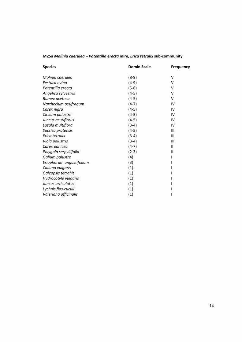
M25a Molinia caerulea – Potentilla erecta mire, Erica tetralix sub-community
Species Domin Scale Frequency
Molinia caerulea (8-9) V
Festuca ovina (4-9) V
Potentilla erecta (5-6) V
Angelica sylvestris (4-5) V
Rumex acetosa (4-5) V
Narthecium ossifragum (4-7) IV
Carex nigra (4-5) IV
Cirsium palustre (4-5) IV
Juncus acutiflorus (4-5) IV
Luzula multiflora (3-4) IV
Succisa pratensis (4-5) III
Erica tetralix (3-4) III
Viola palustris (3-4) III
Carex panicea (4-7) II
Polygala serpyllifolia (2-3) II
Galium palustre (4) I
Eriophorum angustifolium (3) I
Calluna vulgaris (1) I
Galeopsis tetrahit (1) I
Hydrocotyle vulgaris (1) I
Juncus articulatus (1) I
Lychnis flos-cuculi (1) I
Valeriana officinalis (1) I

15
M27 Filipendula ulmaria – Angelica sylvestris mire, Valeriana officinalis – Rumex acetosa and Juncus
effusus – Holcus lanatus sub-communities
Species Domin Scale Frequency
Juncus effusus (6-9) V
Filipendula ulmaria (5-8) V
Rumex acetosa (4-5) V
Valeriana officinalis (4-5) V
Deschampsia cespitosa (5-7) IV
Carex vesicaria (4-8) IV
Phalaris arundinacea (4-5) IV
Juncus acutiflorus (4-5) III
Potentilla palustris (1-5) II
Equisetum fluviatile (3-4) II
Holcus lanatus (3-4) II
Molinea caerulea (3-4) II
Carex nigra (5) I
Lotus uliginosus (4) I
Galium palustre (3) I
Lythrum salicaria (3) I
Viola palustris (3) I
Cardamine pratensis (1) I

16
APPENDIX B
Distribution Map of Plant Communities, Dubwath Silver Meadows