photogrammetric documentation and visualization …
TRANSCRIPT
PHOTOGRAMMETRIC DOCUMENTATION AND VISUALIZATION OF CHOLI
MINARET AND GREAT CITADEL IN ERBIL/IRAQ
K. Pavelka*, J. Svatušková , V. Králová
Lab.of Laboratory of Photogrammetry, Tel.:+420224354951, Fax:+420224310774, E-mail: [email protected]
Czech Technical University in Prague, Faculty of Civil Engineering,
Dept. Mapping and Cartography, Thákurova 7, 166 29, Prague 6, Czech Republic
Commission V, WG V/2
KEY WORDS: photogrammetry, documentation, visualization, cultural heritage, satellite image
ABSTRACT:
In 2006, two Czech expeditions were dispatched to Erbil with the aim of basic monument documentation, archaeological
investigation and finding appropriate technology for the restoration of these structures. The first step was the photogrammetric and
geodetic measurement of the Great Citadel and the Choli minaret in Erbil. The Citadel spreads out over more than ten hectares of
land (300m-350m in diameter). The Choli minaret was documented by terrestrial digital photogrammetry by using a calibrated
digital camera Canon 20d and RolleiMetric system. Photomodeler and AutoCAD software were used along with classical geodetic
measurement to create a 3D model and texture it with the images. In case of the Citadel, a set of terrestrial digital images were taken
(over 250 of the outer side of the Citadel and 200 of the inside); next approximately 70 images were taken from a US Army
helicopter flying at the approximate height of 50-150 meters. In Iraq there are currently no photogrammetric aerial images available;
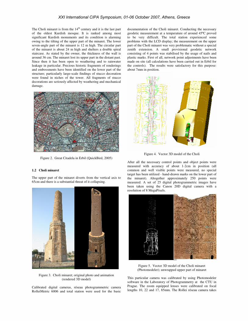
in this case a satellite image from the QuickBird satellite, with a resolution of 65cm, was used for the ground plan of the Citadel. A
provisory geodetic network in the Citadel area was built and over 600 object points were geodetically measured. Next, 16 control
points for aerial imaging were signalised and measured, mainly on the roofs. Nowadays, we are working on creating a vector plan of
the Citadel. We are also working on processing photogrammetrical images onto virtual 3D models of the Citadel fortification and of
the valuable objects inside. The last part of this project consists of creating an information system for the Citadel, which will be used
for the storage of all of his information.
1. MONUMENTS IN IRAQ/ERBIL
1.1 Documentation of historical monuments
In Iraq, there are a lot of very valuable historical monuments. A
great deal of monuments is in a very poor condition. An urgent
need for preservation of the most important architectural
monuments arose in conjunction with the post-war
reconstruction of Iraqi culture. Architectural monuments were
often damaged by the war and today even simple preservation is
nearly impossible.
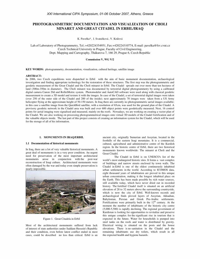
Figure 1. Great Citadela in Erbil
Most of the architectural monuments suffered from lack
of interest of state authorities under Saddam Hussein's Republic
and their condition, even before latest conflict ended in most
cases, could be described no less than critical. Erbil is an
ancient city, originally Sumerian and Assyrian, located in the
foothills of the eastern Iraqi mountains. It is a commercial,
cultural, agricultural and administrative centre of the Kurdish
region. In the historic centre of Erbil, there are two historical
monuments known worldwide: The minaret at Choli and the
Great Citadel.
The Citadel in Erbil is on UNESCO's list of the
world’s most endangered historic sites. It forms a vast complex
of buildings and narrow streets enclosed by town walls. The
Citadel in Erbil is one of the oldest continuously inhabited
urban settlements in the world. According to ICOMOS data,
eight thousand years of inhabitation are proved in this unique
urban concentration, making it the longest inhabited place on
the Earth. This has been made possible by rich water sources,
still available today, which have never dried out in recorded
history. The fortified Citadel itself is situated on an artificial
elevation of 28 to 32 meters above the surrounding countryside,
which is now the city of Erbil. Well-known records and
archaeological finds proved layers of Assyrian, Akkadian,
Babylonian, Persian and Greek Pre-Arabic settlements.
Fortifications were primarily built in the 12th century. At the
moment the number of inhabitants of the historic city centre
(5,000-5,500) is rapidly declining. The regional government of
Kurdistan is looking for opportunities to revitalize and preserve
this unique complex for the significant rise in tourism that is
expected in the future. Water for households is pumped into
steel tanks on the roofs and water is distributed by gravity.
Electrical wiring is situated on the posts and the house
elevations. There is no sanitation in the Citadel and the
remaining inhabitants use dry toilets, which result in all
the expected health and hygiene hazards.
XXI International CIPA Symposium, 01-06 October 2007, Athens, Greece
The Choli minaret is from the 14th century and it is the last part
of the oldest Kurdish mosque. It is ranked among most
significant Kurdish monuments and its condition is alarming
owing to the tilting of the upper part of the minaret. The lower
seven-angle part of the minaret is 12 m high. The circular part
of the minaret is about 24 m high and shelters a double spiral
staircase. As stated by the owner, the thickness of the wall is
around 36 cm. The minaret lost its upper part in the distant past.
Since then it has been open to weathering and to rainwater
leakage in particular. Precious historic fragments of renderings
and embossments have been identified on the lower part of the
structure; particularly large-scale findings of stucco decoration
were found in niches of the tower. All fragments of stucco
decorations are seriously affected by weathering and mechanical
damage.
Figure 2. Great Citadela in Erbil (QuickBird, 2005)
1.2 Choli minaret
The upper part of the minaret diverts from the vertical axis to
65cm and there is a substantial threat of it collapsing.
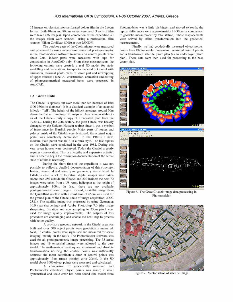
Figure 3. Choli minaret; original photo and animation
(rendered 3D model)
Calibrated digital cameras, réseau photogrammetric camera
RolleiMetric 6006 and total station were used for the basic
documentation of the Choli minaret. Conducting the necessary
geodetic measurement at a temperature of around 45ºC proved
to be very difficult. The total station experienced some
problems with the LCD display; the measurement on the upper
part of the Choli minaret was very problematic without a special
zenith extension. A small provisional geodetic network
consisting of 4 points was stabilised by the usage of nails and
plastic marks. First of all, network point adjustments have been
made on site (all calculations have been carried out in Erbil for
the controls). The results were satisfactory for this purpose:
about 7mm in position.
Figure 4. Vector 3D model of the Choli
After all the necessary control points and object points were
measured with accuracy of about 1-2cm in position (all
common and well visible points were measured, no special
target has been utilized - hand-drawn marks on the lower part of
the minaret). Altogether approximately 250 points were
measured. A set of 25 digital photogrammetric images have
been taken using the Canon 20D digital camera with a
resolution of 8 MegaPixels.
Figure 5. Vector 3D model of the Choli minaret
(Photomodeler); unwrapped upper part of minaret
This particular camera was calibrated by using Photomodeler
software in the Laboratory of Photogrammetry at the CTU in
Prague. The zoom equipped lenses were calibrated on focal
lengths 10, 22 and 17, 85mm. The Rollei réseau camera takes
XXI International CIPA Symposium, 01-06 October 2007, Athens, Greece
12 images on classical non-perforated colour film in the 6x6cm
format. Both 40mm and 80mm lenses were used, 3 rolls of film
were taken (36 images). Upon completion of the expedition all
the images taken were scanned using a professional film
scanner (Nikon CoolScan 8000) at true 2500DPI.
The outdoor parts of the Choli minaret were measured
and processed by using intersection terrestrial photogrammetry
in the Photomodeler software (residuals on control points were
about 2cm, indoor parts were measured with tape for
construction in AutoCAD only. From these measurements the
following outputs were created: a real 3D model for static
modelling and calculations, true-photo rendered 3D model with
animation, classical photo plans of lower part and unwrapping
of upper minaret’s tube. All construction, animation and editing
of photogrammetrical measured items were processed in
AutoCAD.
1.3 Great Citadel
The Citadel is spreads out over more than ten hectares of land
(300-350m in diameter). It is a classical example of an adapted
hillock - “tell”. The height of the hillock averages around 30m
above the flat surroundings. No maps or plans were available to
us of the Citadel– only a copy of a cadastral plan from the
1920’s… During the 20th century, the great Citadel was heavily
damaged by the Saddam Hussein regime since it was a symbol
of importance for Kurdish people. Major parts of houses and
palaces inside of the Citadel were destroyed; the original major
portal was completely demolished. In the 1980’s a new,
modern, main portal was built in a retro style. The last repairs
on the Citadel were conducted in the year 1982. During this
year seven houses were conserved. Today the Citadel urgently
requires conservation. This is a lengthy and expensive activity;
and in order to begin the restoration documentation of the actual
state of affairs is necessary.
During the short time of the expedition it was not
possible to collect a detailed documentation of this structure.
Instead, terrestrial and aerial photogrammetry was utilized. In
Citadel’s case, a set of terrestrial digital images were taken
(more than 250 outside the Citadel and 200 inside); the next 70
images were taken from a US Army helicopter at the height of
approximately 100m. In Iraq, there are no available
photogrammetric aerial images; instead, a satellite image from
the QuickBird satellite with a resolution of 65cm was used for
the ground plan of the Citadel (date of image acquisition: 2005,
23.8.). The satellite image was processed by using Geomatica
10.0 (pan-sharpening) and Adobe Photoshop 7.0 (the image
sharpening, filtration and new sampling to 25cm pixel were
used for image quality improvements). The outputs of this
procedure are encouraging and enable the next step to process
with better quality.
A provisory geodetic network in the Citadel area was
built and over 600 object points were geodetically measured.
Next, 16 control points were signalised and measured for aerial
imaging, mainly on the roofs. The Photomodeler software was
used for all photogrammetric image processing. The 33 aerial
images and 19 terrestrial images were adjusted to the base
model. The mathematical least square adjustment and absolute
transformation utilizing the control points was sufficiently
accurate: the mean coordinate’s error of control points was
approximately 15cm (mean position error 20cm). In the 3D
model about 1000 object points were measured and calculated.
A comparison of geodetically measured and
Photomodeler calculated object points was made; a small
systematical and scale error has been found (the model from
Photomodeler was a little bit bigger and moved to south; the
typical differences were approximately 15-30cm in comparison
to geodetic measurement by total station). These displacements
were solved by affine transformation into the geodetical
measurements.
Finally, we had geodetically measured object points,
points from Photomodeler processing, measured control points
and a transformed satellite photo plan (as an under layer photo
plan). These data were then used for processing to the base
vector plan.
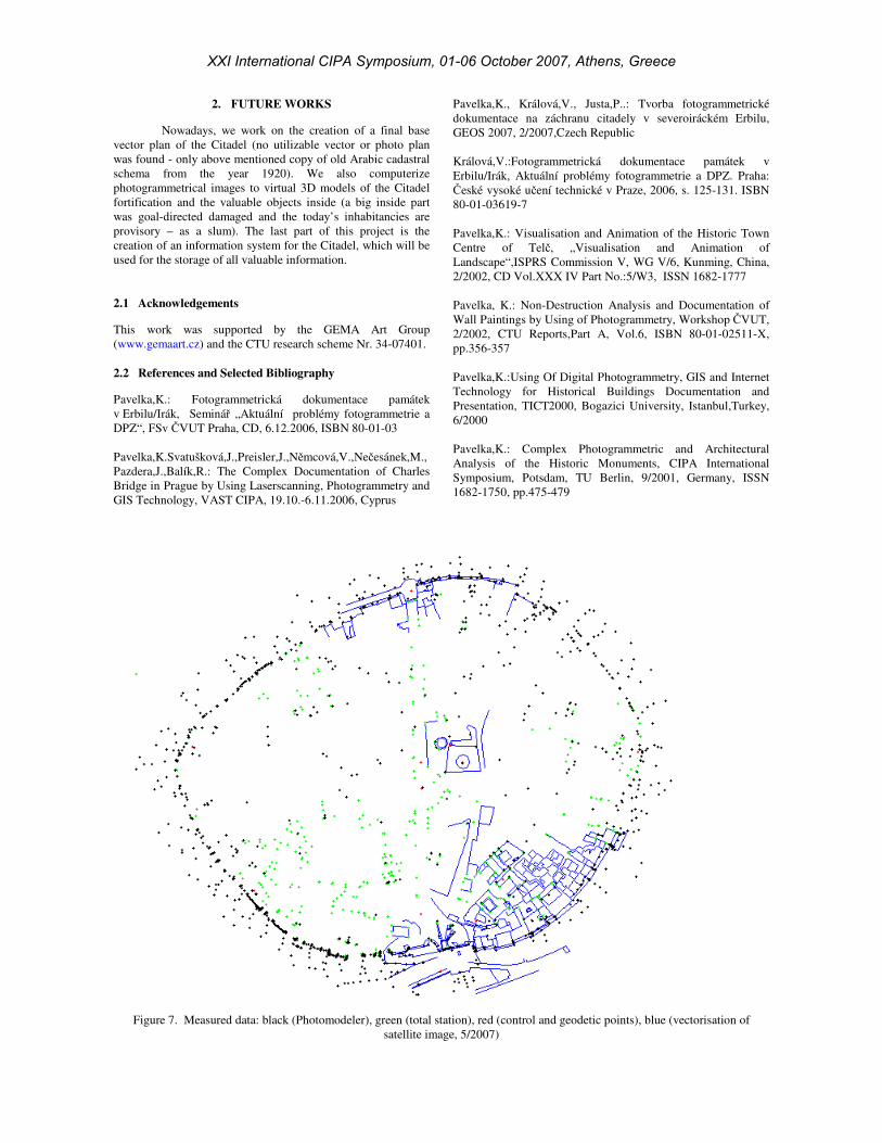
Figure 6. The Great Citadel: image data processing in
Photomodeler
Figure 7. Vectorisation of satellite image
XXI International CIPA Symposium, 01-06 October 2007, Athens, Greece
2. FUTURE WORKS
Nowadays, we work on the creation of a final base
vector plan of the Citadel (no utilizable vector or photo plan
was found - only above mentioned copy of old Arabic cadastral
schema from the year 1920). We also computerize
photogrammetrical images to virtual 3D models of the Citadel
fortification and the valuable objects inside (a big inside part
was goal-directed damaged and the today’s inhabitancies are
provisory – as a slum). The last part of this project is the
creation of an information system for the Citadel, which will be
used for the storage of all valuable information.
2.1 Acknowledgements
This work was supported by the GEMA Art Group
(www.gemaart.cz) and the CTU research scheme Nr. 34-07401.
2.2 References and Selected Bibliography
Pavelka,K.: Fotogrammetrická dokumentace památek
v Erbilu/Irák, Seminář „Aktuální problémy fotogrammetrie a
DPZ“, FSv ČVUT Praha, CD, 6.12.2006, ISBN 80-01-03
Pavelka,K.Svatušková,J.,Preisler,J.,Němcová,V.,Nečesánek,M.,
Pazdera,J.,Balík,R.: The Complex Documentation of Charles
Bridge in Prague by Using Laserscanning, Photogrammetry and
GIS Technology, VAST CIPA, 19.10.-6.11.2006, Cyprus
Pavelka,K., Králová,V., Justa,P..: Tvorba fotogrammetrické
dokumentace na záchranu citadely v severoiráckém Erbilu,
GEOS 2007, 2/2007,Czech Republic
Králová,V.:Fotogrammetrická dokumentace památek v
Erbilu/Irák, Aktuální problémy fotogrammetrie a DPZ. Praha:
České vysoké učení technické v Praze, 2006, s. 125-131. ISBN
80-01-03619-7
Pavelka,K.: Visualisation and Animation of the Historic Town
Centre of Telč, „Visualisation and Animation of
Landscape“,ISPRS Commission V, WG V/6, Kunming, China,
2/2002, CD Vol.XXX IV Part No.:5/W3, ISSN 1682-1777
Pavelka, K.: Non-Destruction Analysis and Documentation of
Wall Paintings by Using of Photogrammetry, Workshop ČVUT,
2/2002, CTU Reports,Part A, Vol.6, ISBN 80-01-02511-X,
pp.356-357
Pavelka,K.:Using Of Digital Photogrammetry, GIS and Internet
Technology for Historical Buildings Documentation and
Presentation, TICT2000, Bogazici University, Istanbul,Turkey,
6/2000
Pavelka,K.: Complex Photogrammetric and Architectural
Analysis of the Historic Monuments, CIPA International
Symposium, Potsdam, TU Berlin, 9/2001, Germany, ISSN
1682-1750, pp.475-479
Figure 7. Measured data: black (Photomodeler), green (total station), red (control and geodetic points), blue (vectorisation of
satellite image, 5/2007)
XXI International CIPA Symposium, 01-06 October 2007, Athens, Greece
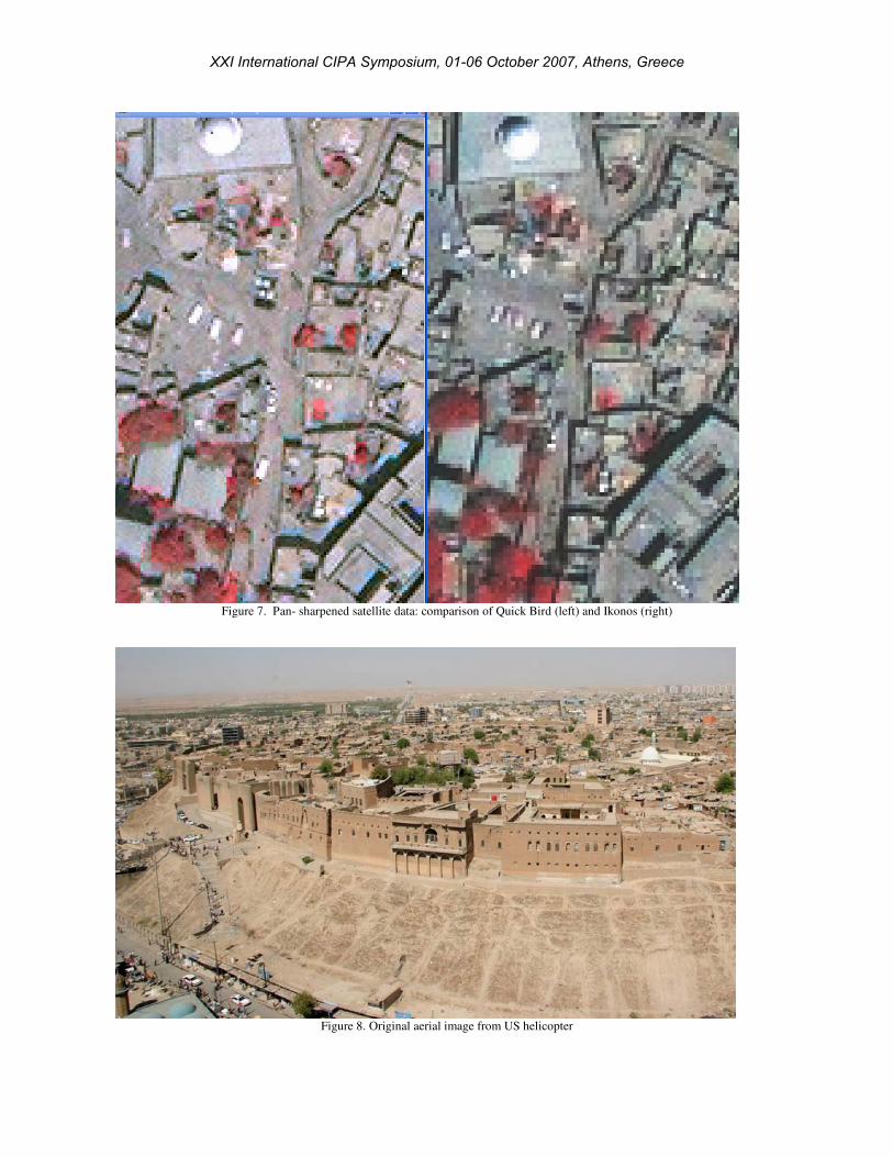
Figure 7. Pan- sharpened satellite data: comparison of Quick Bird (left) and Ikonos (right)
Figure 8. Original aerial image from US helicopter
XXI International CIPA Symposium, 01-06 October 2007, Athens, Greece
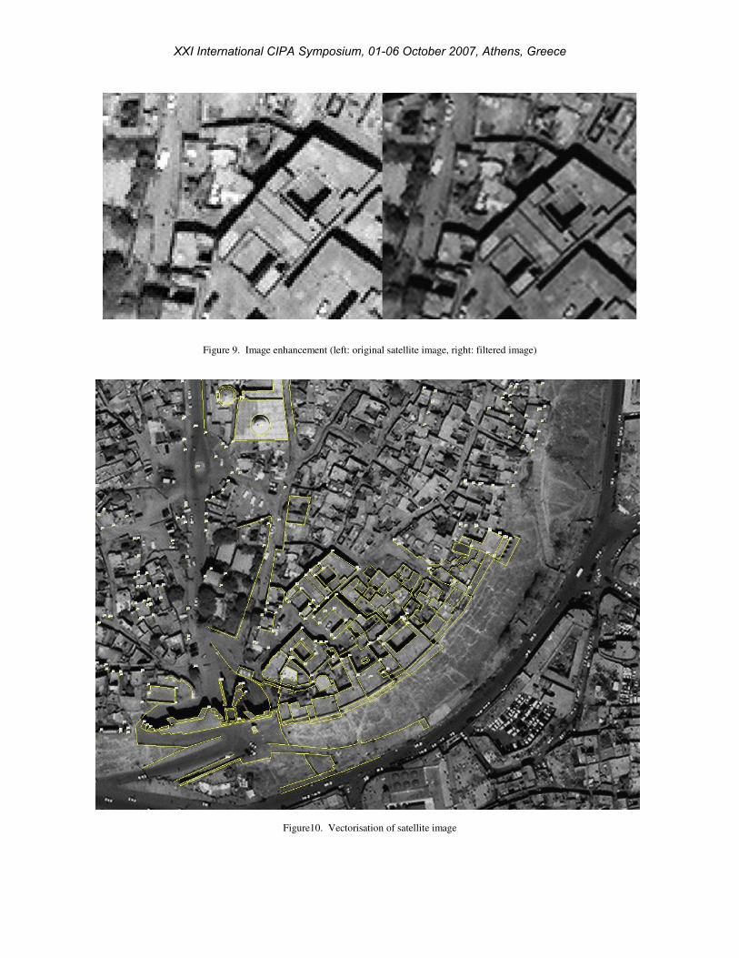
Figure 9. Image enhancement (left: original satellite image, right: filtered image)
Figure10. Vectorisation of satellite image
XXI International CIPA Symposium, 01-06 October 2007, Athens, Greece