photo/illustration credits · show where different features, such as roads or rivers, are located....
TRANSCRIPT

Photo/Illustration Credits: Cover: Daniel Pangbourne/Getty; pp. 2–3, 6–9, 11: Argosy Publishing; p. 12: Corbis.
Possession of this publication in print format does not entitle users to convert this publication, or any portion of it, into electronic format.
If you have received these materials as examination copies free of charge, Harcourt School Publishers retains title to the materials and they may not be resold. Resale of examination copies is strictly prohibited and is illegal.

by Janette Schuster
Copyright © by Harcourt, Inc.
All rights reserved. No part of this publication may be reproduced or transmitted in
any form or by any means, electronic or mechanical, including photocopy, recording,
or any information storage and retrieval system, without permission in writing from the
publisher.
Requests for permission to make copies of any part of the work should be addressed to
School Permissions and Copyrights, Harcourt, Inc., 6277 Sea Harbor Drive, Orlando,
Florida 32887-6777. Fax: 407-345-2418.
HARCOURT and the Harcourt Logo are trademarks of Harcourt, Inc., registered in the
United States of America and/or other jurisdictions.
Printed in the United States of America
ISBN-13: 978-0-15-362454-4
ISBN-10: 0-15-362454-X
1 2 3 4 5 6 7 8 9 10 175 10 09 08 07
Visit The Learning Site!www.harcourtschool.com


90
290
90
59
59
45
10
10
610
610
610
610
610
45288
249
288

90
0 225
134
10
225


1 1 mile
one inch = 2,000 feet
01/5
Secondary highwayLight-duty road:Trail:
Topographic MapEnsign Peak, State Capitol Building
Salt Lake, Utah
Topographic symbols:Index contour:Other contour:
Ensign Peak
5000
4668
5474
State Capitol


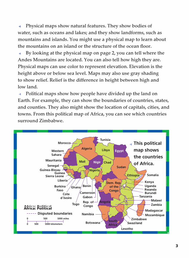
Think and Respond 1. How does color help you read the map on page 2?
2. What type of map uses contour lines?
3. Narrative Writing Tell a story about a time when you have used a map.
Hands-On Activity Home Maps Make a map of your classroom or home. Use symbols
to show where the furniture, doors, and windows are. Be sure to include a title, a scale, and a key.
School-Home Connection Hometown Map With your parent or guardian, look at a map of
your hometown. Locate features you have seen. Then, find the latitude and longitude of your town. If necessary, use another map.
>
ISBN 978-0-15-362454-4ISBN 0-15-362454-X