planning committee 04 february 2016
TRANSCRIPT

Birmingham City Council
Planning Committee 04 February 2016 I submit for your consideration the attached reports for the East team. Recommendation Report No. Application No / Location / Proposal Approve - Conditions 8 2015/06750/PA
Clifton Mosque 17 Clifton Road Balsall Heath Birmingham B12 8SX
Extensive demolition and redevelopment works to provide 3-storey building for community/prayer purposes, new mosque building, funeral facilities with caretaker's flat above, reception building, connecting canopies and boundary screen to Clifton Road, in addition it is proposed to provide new mezzanine floor to adjoining premises, new sports hall at Moseley Road/Runcorn Road, new retail shop, restaurant and 13 x 1-2 bed apartments at Moseley Road/Clifton Road, together with car parking provision including a new multi-storey car park at Prospect Place
Approve - Conditions 9 2015/09502/PA
Land to the south of Meadway incorporating the Kent's Moat Recreation Ground, site of former high rise flats and existing flats to the south of the Poolway Shopping Centre. Birmingham
Outline planning application to include up to 136 residential dwellings (C3), district centre to include retail uses (A1, A2, A3, A5) and/or community/leisure Uses (D1, D2) up to 2,730sqm (Gross Internal Area), new roundabout access from Meadway, access from Broadstone Road, enhancements to retained public open space, landscaping, provision of new playing fields, new multi-use games area, new toddler play area, new teenage play area, drainage works, ancillary works and demolition of existing buildings
Page 1 of 2 Director of Planning and Regeneration

Approve - Conditions 10 2015/07209/PA
1-29 Copeley Hill Erdington Birmingham B23 7PH
Erection of 14 no. three bed residential dwellings with associated infrastructure works
Page 2 of 2 Director of Planning and Regeneration

Page 1 of 19
Committee Date: 04/02/2016 Application Number: 2015/06750/PA
Accepted: 17/11/2015 Application Type: Full Planning
Target Date: 16/02/2016
Ward: Sparkbrook
Clifton Mosque, 17 Clifton Road, Balsall Heath, Birmingham, B12 8SX
Extensive demolition and redevelopment works to provide 3-storey building for community/prayer purposes, new mosque building, funeral facilities with caretaker's flat above, reception building, connecting canopies and boundary screen to Clifton Road, in addition it is proposed to provide new mezzanine floor to adjoining premises, new sports hall at Moseley Road/Runcorn Road, new retail shop, restaurant and 13 x 1-2 bed apartments at Moseley Road/Clifton Road, together with car parking provision including a new multi-storey car park at Prospect Place Applicant: KSIMC
Clifton Mosque, 17 Clifton Road, Balsall Heath, Birmingham, B12 8SX
Agent: PJ Planning 5 St Paul's Terrace, 82 Northwood Street, Birmingham, B3 1TH
Recommendation Approve Subject To Conditions 1. Proposal 1.1. Consent is sought for extensive demolition and redevelopment works to provide a 3-
storey building for community/prayer purposes (Imambara – worship halls), new mosque building, funeral facilities with caretaker's flat above, reception building, connecting canopies and boundary screen to Clifton Road. In addition, it is proposed to provide a new mezzanine floor to adjoining school premises, new sports hall at Moseley Road/Runcorn Road, new retail shop and 14 x 1-2 bed apartments at Moseley Road/Clifton Road, together with car parking provision including a new multi-storey car park at Prospect Place.
1.2. Essentially, the proposed development would comprise four key elements: redevelopment of the existing community use / place of worship site (including new feature screen to boundary), demolition of adjoining industrial units at Prospect Place to provide a 4-storey car park, redevelopment of former garage on the corner of Moseley Road / Runcorn Road to provide a sport hall and ancillary café and redevelopment of vacant site on the opposite side of Clifton Road to provide retail premises with flats above / to the rear.
1.3. Redevelopment of existing site – The existing site comprises an Imambara (2-
storey) and mosque (tall single storey); together with unaffected nursery / education premises and residential accommodation located to the west / rear of premises fronting Moseley Road. The existing Imambara (main worship hall) and mosque

Page 2 of 19
premises would be predominantly cleared and re-built. The Imambara would be re-built in two phases; initially 2–storeys, with a second floor added at a later stage.
1.4. The Imambara would comprise; ground floor - entrance areas, main hall (390 sq.m
proposed, currently 370 sq.m) - 193 prayer mats and 76 seats indicated, w.c’s / wash areas, parent room, kitchen, stores and lifts / stairs. First floor - entrance areas, female hall (390 sq.m proposed, currently 370 sq.m) - 188 prayer mats and 72 seats indicated, w.c’s / wash areas, parent rooms, serving kitchen, stores and lifts / stairs. Second floor - entrance areas, flexible youth hall (422 sq.m proposed, currently 302 sq.m), flexible lecture theatre (162 retractable seats indicated), w.c’s / wash areas, parent room, bridal rooms, serving kitchen, stores and lifts / stairs.
1.5. The Imambara has been designed with optimum flexibility and can be used in a
number of different configurations. The able bodied would usually sit on the floor, with seating provided for the elderly and disabled. Acoustic sliding screens enable spaces to be subdivided into different configurations when necessary.
1.6. The Imambara would be a rectangular block, with the front elevation facing Clifton
Road comprising a feature screen. The feature screen would comprise a powder coated metal frame, with patterned infill powder coated / aluminium sections. Between the sections, double glazing panels (clear glazing to ground floor and translucent glazing to first floor) would be provided. The remaining elevations would predominantly comprise brickwork with traditional glazing and infill panels.
1.7. The proposed new mosque building would comprise; ground floor - entrance lobby,
treasurer room and prayer room (135 prayer mats indicated). First floor - lobby, treasurer room, wash room and prayer room with dividing screen (135 prayer mats indicated).
1.8. The proposed mosque would be square in shape and would be a predominately
brick building. Internally, it would have a plaster domed ceiling at ground and first floor using stepped sections. On top of the mosque, a new gold finished dome with lozenge shape openings would be provided to allow light to pass into the building. The proposed dome would be 14.6m max. above ground level. Adjoining the dome, a new gold finished minaret with beacon light and illuminated collar and false balcony would be provided. The proposed minaret would be 20.7m max. above ground level. The summit of the minaret would resemble an abstract hand holding an egg-shaped illuminated beacon in its palm.
1.9. Feature Entrance Screen - Along Clifton Road, a feature entrance screen would
create a continuous street frontage. This would be 8.8m high and 65m long. It would enclose the site and would be similar in design and materials to the front elevation of the Imambara. The screen would comprise a powder coated metal frame, with patterned infill powder coated / aluminium sections. Between the sections, double glazing / opaque insulated panels would be provided. The glazing would be a variety of clear for transparency, etched/sandblasted for translucency or solid for opacity. The treatment of the glazing would be dependent upon the location within the screen. Behind the new feature screen, a new reception building and funeral parlour / caretakers flat would be provided. As well as screening two buildings, the screen would incorporate two pedestrian entrances (male and female), vehicular entrance and egress points and an entrance/exit to/from the hearse garage.
1.10. The reception building would comprise; ground floor - security office, services, unit
space, w.c, covered entrance for vehicles and stairs. The first floor would comprise; 2 meeting rooms / offices, w.c, external terrace and stairs.

Page 3 of 19
1.11. The funeral home (Ghusi Kafan) / caretakers flat would comprise; ground floor – hearse garage, mortuary / coffin store, family room, wet room, dry room, office and shower room / w.c. At the rear, a bin store and enclosed garden would be provided. The first floor would comprise open plan lounge / dining room, kitchen, 2 bedrooms – 1 en-suite (15sq.m and 14sq.m), bathroom, stairs and outside terrace (52sq.m). Within the wet room, bodies of the deceased are ceremonially washed prior to entering the dry room, where drying and wrapping occurs prior to burial.
1.12. The proposed new Imambara, mosque, reception building and funeral building /
caretakers flat would be linked by a double height canopy (around 8m above ground level) with triangular shaped roof lights. As well as linking elements together, the canopy would provide a shelter where community members can congregate.
1.13. Demolition of Prospect Place Industrial Estate – Prospect Place currently
comprises 10 single storey industrial units. They were constructed in the 1980’s and are poor in appearance. They are currently owned by the City Council and are leased on a short term basis by a number of occupiers. Around 3 of the units are currently vacant and the applicants rent 2 units. The applicant is currently negotiating the purchase of Prospect Place. They propose to demolish the units and to provide a 4-storey (split levels) car park containing 239 spaces. The ground floor / first floor deck would provide 113 car parking spaces (including 6 disabled spaces). The proposed second / third floor decks would provide a further 123 car parking spaces. On the adjoining mosque site, a further 16 spaces would be provided (including 6 disabled spaces).
1.14. The proposed multi-storey car park would comprise a brick plinth (up to 1.4m high) and brick stair tower to Clifton Road. Above the brick plinth, powder coated metal columns (2.3m apart) would be infilled with a steel frame and steel mesh panels (4.2m high).
1.15. Other car parking - In addition to the 4-storey car park, 3 other sites would provide
surface level car parking. A vacant site, at the corner of Mosely Road / Clifton Road, owned by the applicants and currently used for overflow car parking, would accommodate a retail unit with residential above / to the rear (see details below). To the rear of the proposed new building, 48 car parking spaces (including 3 disabled) would be provided, with access from Clifton Road. A site at the rear of 486-500 Moseley Road (Moseley Muslim Community Association) and a site adjoining 51 Runcorn Road (West Midlands Special Needs Transport (WMSNT)), would be leased by the applicant to provide additional overflow car parking (13 and 35 spaces respectively). In total, 351 car parking spaces would be provided across the 4 sites. The applicant has stated that through marshalling of the car parks, cars could be packed together providing a far higher level of off-street car parking spaces.
1.16. Redevelopment of former garage (538-540 Mosley Road) – It is proposed to
demolish a former garage (Mr Clutch) and to provide a sports hall and ancillary café. The sports facilities would be built to Sport England standards. The garage building is a 1970’s style 1-2 storey high building. It is poor in appearance and out of character with Moseley Road. The ground floor would comprise main entrance off Moseley Road, secondary accesses from adjoining mosque site and Runcorn Road, reception, café area (30 covers), w.c’s / wash areas and sports hall (with five-a-side football pitch, 2 badminton courts and a volleyball court marked out) and lift / stairs. The applicants have advised that the space could also occasionally be used as additional prayer space. The café would be located immediately adjoining the street and would provide refreshments to passers-by and to those using the sports facility. The first floor would accommodate a void area over the sports hall and a youth area

Page 4 of 19
(with 3 pool tables), gym, staff room, manager’s room, showers / changing rooms and lift / stairs. The second floor would accommodate a void area over the sports hall and 3 meeting rooms, open plan office, kitchen, w.c’s and lift / stairs.
1.17. The proposed sports hall would be modern in appearance and would comprise
curtain walling, with simple graphics to Moseley Road. The graphics would help to control solar gain and would provide and element of privacy for those using the building. The side elevation, to Runcorn Road, would be predominantly brickwork (to match the adjoining school building), with reconstituted stone frames and infill panels. The relief and detailing would help to break up the otherwise solid façade.
1.18. Internal works are proposed to an adjoining Victorian school building fronting
Runcorn Road which would comprise provision of a mezzanine floor, to provide a new library and resource centre at ground floor and a new hall, flexible hall and office at first floor. No external alterations are proposed to the school building.
1.19. Redevelopment of CAVE site, 508-518 Moseley Road - The former Community
and Village Entertainment (CAVE) art centre site is located on the corner of Moseley Road / Clifton Road. The former CAVE building was demolished many years ago and the site is now vacant. It is proposed to erect a 2–storey retail unit, with 14 apartments provided to the rear / above. Access to the apartments would be gained via Moseley Road and off a rear car park. The accesses would connect to a 3-storey high atrium in the centre of the proposed building. The ground floor would accommodate 4 apartments (3 x 2-bed and 1 x 1-bed), amenity deck (approx. 85sq.m), bike store (14 bikes), bins and lift / stairs. The first floor would accommodate 4 apartments (2 x 1-bed and 2 x 2 bed), partial amenity deck (approx. 50sq.m), 2 additional bedrooms linked to a second floor apartment, staff room, w.c’s and lift / stairs. The second floor would accommodate 6 apartments (3 x 1-bed and 3 x 2 beds), partial amenity deck (approx. 50sq.m), 2 roof terraces (36sq.m in total) and lift / stairs. The roof would include glazing above the amenity deck and a plant room. Each apartment would comprise entrance hall, kitchen / dining / living room, 1-2 bedroom(s), bathroom and stores. The 2 - bed apartments generally include an en-suite bedroom. All ground / first floor apartments have 2-3 balconies adjoining Clifton Road. Apartments range in size from approx. 46sq.m to 80sq.m and bedroom sizes range from 13.5sq.m to 15.8sq.m (first bedroom) and from 11.1sq.m to 14.2sq.m (second bedroom).
1.20. The proposed retail / residential building would be modern in appearance. The retail
element, at ground and first floor, would accord with the building line along Moseley Road. The second floor residential accommodation would be set back from Moseley Road by 3.2m to reinforce the existing roof line of the adjoining building. Along Runcorn Road, the second floor would be set back by up to 1.6m to reduce the perceived scale and mass of the building. The proposed building would comprise a 2-storey red brick facade, with large windows to the retail unit and apartments. All ground and first floor apartments would have balconies, with glass balustrades. The second floor, which would be set back, would comprise a powder coated walling system with integrated windows and lightweight panels.
1.21. Phasing
1.22. The proposed development would be carried out in phases to allow existing functions to continue whilst the proposed works are implemented. Phase 1 - The first phase would be the installation of a new mezzanine floor in the existing school hall. This would be followed by the replacement of the Imambara and the Mosque and also the funeral building and new reception building, along with the associated

Page 5 of 19
screen to Clifton Road. All of these elements would be linked by the integrated double height canopy.
1.23. Phase 2 – would be the replacement of the former Mr Clutch building with a new
sports hall and ancillary café. As well as providing modern sporting facilities, the hall could be used for occasional prayers.
1.24. Phase 3 – would be the new retail and residential building on the former CAVE site.
The applicants have requested that, as a charity, the multi-storey car park be provided towards the end of the development. However, Transportation Development have expressed concerns that should the community space / place of worship be occupied prior to provision of the multi-storey car park, on-street parking/highway problems would be likely to arise (see para 4.5 below).
1.25. Occupancy
1.26. The existing Imambara is 430sqm and the mosque 110sq.m. The applicants have
advised that based on 0.75sq.m per person sitting and 1.1sq.m praying, the existing facilities cater for a maximum of 720 people sitting or 490 people praying. Based on their own analysis, this means that the existing facility generally caters for most events and daily prayers. Generally, up to 100 people attend daily prayers, with a maximum of 200 attending Thursday night prayers (main prayer time). But for events such as Muharram (first month of Islamic calendar), up to 1800 people attend (over 4 days) and for Ramadhan, up to 1000-1200 people attend. Occasionally, a temporary marquee is erected to help cater for these events. Events which exceed the centres capacity can in theory occur up to 81 days per year. This puts a great strain on the existing facilities, but according to the applicants, as most of the activities occur in the evenings outside peak times for the local centre and therefore causes little detrimental impact. The new facilities would cater for both the existing population, together with future needs of the community based on a projected population growth.
1.27. A Transport Assessment and addendum, Design and Access Statement, Planning Statement, SUDS Information and Loss of Industrial Land to Alternative Uses report have been submitted in support of the application. Link to Documents
2. Site & Surroundings 2.1. The existing Imambara and mosque, comprises of predominately modern 1-3 storey
premises accessed off Clifton Road. To the north, on the opposite side of Clifton Road is a vacant site (former CAVE premises), which is currently used for overflow car parking by visitors to the Imambara and mosque. This site is to be used for retail / residential purposes. Beyond this site (north), and adjoining the existing Imambara and mosque premises (west) are a variety of retail, commercial and a mosque, all located within the Balsall Heath Neighbourhood Centre. To the east, is a small industrial estate, known as Prospect Place. This comprises of 10 single storey industrial units, which are to be demolished as part of these proposals to enable the erection of a 4-storey car park. Beyond Prospect Place, is a railway embankment. The railway line is used by freight trains only. Beyond the railway embankment is City Farm and terraced dwellings. To the south of the existing Imambara and mosque, on the corner of Moseley Road and Runcorn Road, is a former repair garage (Mr Clutch). The premises are proposed to be demolished and a sports hall and ancillary café provided. Adjoining is an existing school and nursery within the

Page 6 of 19
applicant’s ownership (built 1838). This would be kept and a new mezzanine floor provided. Beyond this, along Runcorn Road are commercial, industrial and residential premises and along Moseley Road (A435), are further retail / residential premises.
2.2. The surrounding area is predominantly retail in character, being largely located within the Balsall Heath Neighbourhood Centre; with the adjoining sites to the south and west being within the Primary Shopping Area. Outside of the Neighbourhood Centre, to the south and west, the area is largely commercial / industrial in character. Although there are some flats above premises on Moseley Road and a small apartment block on Runcorn Road (former Victoria P.H), the nearest dwellinghouses are located over 50m to the west, on Clifton Road, beyond the railway line.
Site Location Plan
3. Planning History 3.1. Imambara and Mosque
3.2. 22.06.78 – 48094000 – Erection of Mosque and car park - Approved, subject to
conditions.
3.3. 02.08.79 – 48094001 – Proposed single storey mosque / community centre as well as two storey 2 no. flats ancillary to mosque / community centre - Approved, subject to conditions.
3.4. 27.11.80 – 48094003 – Erection of mosque/community centre, construction of car
park and footpath crossing - Approved, subject to conditions.
3.5. 12.03.81 – 48094004 – Erection of mosque with minaret - Approved, subject to conditions.
3.6. 10.12.81 – 48094005 - Erection of mosque and minaret - Approved, subject to conditions.
3.7. 21.01.82 – 48094006 – Erection of first floor extension to community centre to form two separate living units and study room - Approved, subject to conditions.
3.8. 11.03.82 – 48094007 – Erection of mosque, washroom and minaret - Approved, subject to conditions.
3.9. 23.06.86 – 48094010 – Extension to form nursery/classroom, WC and porch to side of existing building - Approved, subject to conditions.
3.10. 05.02.87 – 48094011 – Proposed first floor extension to community centre to form 2 no. self-contained dwelling units - Approved, subject to conditions.
3.11. 25.02.02 - 2001/03756/PA - Erection of detached two storey pitch roof building to comprise deceased person’s body and coffin store, washing facilities and hearse garage at ground floor with ancillary facilities at first floor level - Approved, subject to conditions.
3.12. 22.12.03 - 2003/05429/PA – Conversion of part existing shop premises into 5, 1 person flats and erection of building at rear to provide 3 further 1 person flats,

Page 7 of 19
ancillary to main use of premises as mosque and community centre - Approved, subject to conditions.
3.13. 15.07.14 - 2013/09470/PA – Extensive demolition works and redevelopment of premises to provide extensions/alterations to the existing mosque/prayer hall, new funeral building with caretaker's flat above, new retail (Use Class A1) and restaurant (Use Class A3) with office/meeting rooms above, connecting canopies and change of use to provide a multi-purpose hall, together with new car park - Withdrawn.
3.14. Prospect Place
3.15. 02.02.84 – 34461002 – Construction of 10 general industrial buildings (Class IV)
with rear yards, together with access, parking and boundary treatments - Approved, subject to conditions.
3.16. ‘CAVE’ Site - 508-518 Moseley Road
3.17. 08.11.84 – 66092000 – Change of use from existing cinema to community arts theatre – Approved, subject to conditions.
3.18. Former ‘Mr Clutch’ Garage – 538-540 Mosley Road
3.19. 23.11.83 – 07543012 – Cladding to side wall – Approved.
3.20. 17.05.84 – Erection of first floor office extension and fire escape – Approved.
3.21. 14.01.88 – 07543014 – Change of use to motorcar, clutch and gear box installation
centre - Approved, subject to conditions.
3.22. 31.03.09 - 2008/05857/PA – Erection of mixed use building comprising 2 no. retail units (A1), 5 no. offices (B1) & 9 no. apartments - Approved, subject to conditions.
3.23. 16.12.09 – 2012/02009/PA – Application to extend the time of extant planning
application 2008/05857/PA for the erection of mixed use building comprising 2 no. retail units (A1), 5 no. offices (B1) & 9 no. apartments - Approved, subject to conditions.
3.24. Other Proposed Car Park Sites
3.25. Lime Grove
3.26. 22.03.84 – 25158001 – Change of use to social and cultural centre including
educational activities, youth activities, library facilities – Approved.
3.27. Runcorn Road
3.28. 29.09.05 – 2005/04918/PA – Change of use from industrial unit to mini bus depot for special needs transport - Approved, subject to conditions.
4. Consultation/PP Responses 4.1. Ward Councillors, Roger Godsiff M.P, Residents Associations and local occupiers
notified. 49 responses received - 29 objections, 10 in support, 3 no objections and 7 responses with inappropriate comments. 1 petition against (106 signatures) received. Petition against submitted by adjoining mosque at 526-528 Moseley Road

Page 8 of 19
on grounds that the height and scale of the new building would result in the loss of light at ground and first floor.
4.2. 29 Objections on grounds of:
• Detrimental impact on local businesses and City Farm, • Increased traffic and congestion, • Increased health and safety issues for children/disabled/pedestrians due to
high volumes of traffic, particularly when attending funerals, • Increased noise levels, • Insufficient car parking, • Increased car parking demand, • Increased parking on pavements, • A sustainable transport plan should be encouraged, including cycle storage
provision, • Looks like a prison and will deteriorate, • Dome will dominate the skyline, • Inappropriate design for the minaret, • Out of scale/character, eyesore and over dominant, • Against Council policy in terms of promoting local distinctiveness and
heritage, • Insular development, • Loss of trees and shrubs, • Lack of landscaping, • Loss of sunlight, • Already library in area, • No fire assembly point indicated, • No refuse storage indicated, • Increased litter, • Loss of industry, • Acute housing shortage, • May impede plans for a future railway station in the area, • Detrimental effect on residential amenity, • Not required, enough existing religious and sporting facilities in the area.
4.3. 10 Responses in support:
• A larger prayer hall is required to cater for all the visitors, especially at Ramadhan.
• In accordance with the aspirations of the Balsall Heath Neighbourhood Plan, • Good concept, • Well designed, • Would upgrade the image of the area, • Would support local businesses, • health benefits, • Would provide new jobs, • New library supported, • Family orientated development, • Private area to be developed, • Additional car parking welcomed, • Diverse range of facilities proposed,
Page 9 of 19
• Would keep youth engaged.
4.4. Transportation Development – The following conditions are recommended to reduce
the likely impact of the proposals upon the adjacent highway networks; Construction Method Statement / Management Plan, Community Access Agreement (to relate to usage of decked parking facilities); Phasing Plan; Masterplan; Siting / Design of Means of Access; Entry and Exit Sign Details; Parking Management Strategy; Commercial Travel Plan (to include regular monitoring reports and reviews of effectiveness); Details of Parking Facilities; ‘Temporary Phasing’ of parking facilities for construction stage(s); Worship facilities are not to be occupied until multi-decked car park on Clifton Road is completed and available for use; Cycle Store Details; Pedestrian Visibility Splays; Car Park Management Plan and S278/TRO Agreement to secure a package of highway measures on Clifton Road.
4.5. It is acknowledged that positive efforts have been made to acquire additional land holdings and to provide an improved level of off-street parking. A desirable ‘target’ parking provision of 350 spaces has previously been agreed with the applicant/agent. It is considered critical towards achieving an acceptable highway impact that the proposed decked car parking at Prospect Place be delivered prior to the occupation of new / expanded worship facilities. It is noted that the applicant (KSIMC) is a charitable institution and that they would wish to delay the construction of the multi-storey car park to a later phase in order to allow further time to investigate funding mechanisms. However, it has been made clear throughout discussions that this is not considered appropriate as the majority of development parking would be provided by the multi-decked car park. Should main worship / community space phases be implemented prior to this and Prospect Place used as a surface car park, there would be an issue where the majority of all site parking would be removed during the construction phase from surface car park to multi-decked car park. Additional highway / public realm improvement works would also be considered necessary on Clifton Road, between Moseley Rd / railway bridge, in order to facilitate proposed access alterations and to deliver an improved environment for pedestrians in the vicinity of the site. There is also a requirement for a robust Travel Plan to be provided, which should be subject to ongoing monitoring, with regular reviews of measures to be provided in order to influence modal shift and encourage the uptake of sustainable modes of travel by users of the facility.
4.6. Regulatory Services – Clarification requested regarding the nature of the use,
increase in numbers in attendance, height and location of proposed flue and hours of use – additional information provided. Awaiting a further response.
4.7. Local Lead Flooding Authority - Conditions requested requiring the prior submission of a Sustainable Drainage Assessment and Sustainable Drainage Operation and Maintenance Plan.
4.8. Severn Trent – No objections, subject to a drainage condition.
4.9. Network Rail – No objections, subject to a condition requiring details of appropriate
vehicle safety protection measures along the boundary with the railway in order to prevent any impact on the adjacent railway by accidental vehicle incursion.
4.10. West Midlands Fire Service – No objections.
4.11. West Midlands Police – No objections.
Page 10 of 19
5. Policy Context 5.1. NPPF (2012), Adopted UDP (2005), Draft Birmingham Development Plan (2013),
Places for All SPG (2001), Places for Living SPG (2001), Places of Worship and Faith Related Community and Education Uses SPD (2011), Shopping and Local Centres SPD (2012), Shop Front Design Guide SPG (1995), Car Parking Guidelines SPD (2012), Loss of Industrial Land to Alternative Uses SPD (2006), DCLG Technical Housing Standards – Nationally Described Space Standard (March 2015) and Balsall Heath Neighbourhood Development Plan (2015).
6. Planning Considerations 6.1. The main considerations when assessing this application are the principle of the
uses, planning policy, loss of industrial units, impact on residential amenity, design / impact on visual amenity and highway safety.
6.2. Principle of Uses
6.3. The proposals essentially comprise replacement / enhancement of existing
community / prayer facilities at Clifton Road and provision of a retail unit and apartments at Clifton Road / Moseley Road and sports hall with ancillary café at Runcorn Road / Moseley Road. The Kojha Shia Itna Asheri Community of Birmingham (KSIAC) group have been based at Clifton Road since 1980. Therefore, the community / prayer facilities are considered to be a longstanding use. Likewise, the retail unit would be located on the site of a former cinema / community arts facilities and the sports hall / café would replace a former repair garage. Therefore, the principle of the uses have been long established /approved.
6.4. Over recent years, the community has grown and the proposed development would
meet the current and future needs of the community group. Five sites were considered and a referendum of the whole community took place, with the majority voting to remain on the current site.
6.5. Planning Policy
6.6. The application site (apart from Prospect Place Industrial Estate) is located within
Balsall Heath Neighbourhood Centre, with the proposed retail unit / apartments and sports hall / café being located within the Primary Shopping Area, as defined by the Shopping and Local Centres SPD (20112).
6.7. The NPPF seeks to ensure the provision of sustainable development, of good
quality, in appropriate locations and sets out principles for developing sustainable communities and focusing development in locations that are sustainable and can make the fullest use of public transport, walking and cycling. Therefore in terms of location, the proposed uses would be in accordance with the above SPD and the NPPF.
6.8. The NPPF promotes high quality design and a good standard of amenity for all
existing and future occupants of land and buildings. It also advises that permission should be refused for development of poor design that fails to take the opportunities available for improving the character and quality of an area and the way it functions.
6.9. The adopted Birmingham Unitary Development Plan (UDP) resists proposals that
would have an adverse effect on the quality of the built environment and emphasises that improving the quality of the built environment is one of the most
Page 11 of 19
important of the plan’s objectives. The adopted UDP encourages a high standard of design and policy 3.14D sets out good urban design principles.
6.10. UDP, Para 8.32 – “In the case of premises which are intended to serve a wide catchment area and /or likely to be used for festivals and ceremonies attracting substantial numbers of people, sites should be of sufficient size and located so as not to cause loss of amenity to occupiers of nearby residential accommodation through undue noise and disturbance nuisance. Sites which may be particularly appropriate are those which adjoin roads and/or are on the fringe of commercial areas.”
6.11. Loss of Prospect Place Industrial Estate
6.12. Loss of Industrial Land to Alternative Uses SPD (2006) states – “It is recognised that
there are occasions where it can be demonstrated that there are good planning grounds to depart from the general presumption against the loss of industrial land. This could include proposals, such as educational uses, where the particular site size requirements make it difficult to find sites which do not involve the loss of industrial land. Such proposals will need to demonstrate that alternative sites are not available which do not involve the loss of industrial land and the proposals will need to accord with other policies in the UDP” (para 5.9).
6.13. Prospect Place Industrial Estate comprises of 10 single storey units, 3 of which are
currently vacant and 2 currently rented by the applicant. It is proposed to demolish the industrial units and to provide a multi-storey car park. In support of the application, a report justifying the loss of Prospect Place has been submitted by the applicants. Background information outlines that the proposed development, including the new Imambara and mosque, sports hall, retail shop and residential accommodation, would provide significant benefits for the local community as well as contributing towards the regeneration of the wider area. In order to facilitate the development, it is necessary to provide a significant amount of car parking. A number of local sites for car parking have been considered. The amount of available sites in this location are limited. Prospect Place has been identified as the most suitable site due to its location adjacent to the main site. In order to provide the required amount of car parking, a multi-storey car park is proposed. The Prospect Place site is therefore fundamental to the proposals and without this site, it is unlikely that the development could proceed. The industrial estate is poor in appearance. It includes a number of vacant units, a car repair garage and car dismantling workshop. It is considered that the units provide a poor setting and unattractive environment, which detrimentally impacts on the adjoining Balsall Heath Neighbourhood Centre to the north and family housing only 50m to the south. Therefore, on balance, the loss of the industrial units is supported. It is considered that the significant benefits would outweigh any harm caused and it is noted that the adjoining Clifton Road Industrial Estate, which comprises around 15 industrial units, would be retained in industrial use. Therefore, in this case, the loss of Prospect Place Industrial Estate is supported.
6.14. The Balsall Heath Neighbourhood Development Plan identifies Moseley Road as the Local Centre of the community and the proposed development would contribute towards providing a vibrant hub for the Balsall Heath economy. The Plan seeks to cultivate and expand on the existing assets in the area and therefore the wider community of Balsall Heath would benefit from the redevelopment of the site by the proposed new mix of uses, as well as the improved street frontages along Clifton Road and Runcorn Road.

Page 12 of 19
6.15. The aims of the Balsall Heath Neighbourhood Plan are: Promoting a sustainable and healthy community in Balsall Heath which satisfies the social and economic needs of the population while protecting and enhancing the environment; creating a ‘heart’ for the community in the form of a physical focus for community activities and social interaction; Protecting and enhancing the range of commercial and social uses within the local centre of Moseley Road; Enhancing the physical environment of the area; and Promoting walking, cycling and public over cars.
6.16. Impact on residential amenity
6.17. The Imambara and mosque, which are to be largely re-built and extended, currently
operate 24 hours per day. I consider that the new facilities would be unlikely to have any greater impact than existing facilities in terms of noise and disturbance and therefore I do not consider it appropriate or necessary to attach an opening hours condition. The nearest dwellings are located over 50m from the application site, beyond a raised railway embankment. The railway is currently used by freight trains only. As the proposed retail unit / apartments and sports hall / café would be located within the Primary Shopping Area of Balsall Heath Neighbourhood Centre, again I do not consider it reasonable or necessary to attach an opening hours condition. There are flats located above premises fronting Moseley Road, some of which are within the applicants control. Ambient noise levels are high and I do not consider that the amenity of local residential occupiers would be adversely affected. Although I am awaiting detailed comments from Regulatory Services, I consider it appropriate to attach conditions restricting the use of amplification equipment and details of extract and odour control equipment.
6.18. In terms of loss of light and outlook, the industrial premises to the south on Runcorn Road, would be unaffected by the proposals. The west boundary of the application site abuts the rear boundary of properties fronting Moseley Road. The majority of this boundary is screened by an existing 3-storey building which is to be retained. I note that a petition (106 signatures) has been received from an adjoining mosque at 526 / 528 Moseley Road on the grounds of loss of light. I note that the existing mosque has recently been extended at the rear and has 1 small window on the ground floor and 3 windows at first floor level to a prayer / community hall. However, these windows are 20.5m from the site boundary. The new mosque building and canopy would adjoin the site boundary and would be around 8m high. I consider that there would be some additional overshadowing, loss of view and possible loss of light, however I do not consider that it would be significant enough to justify refusal of the current proposals, particularly taking into account the nature of the use (i.e. non–residential).
6.19. In terms of the proposed 1-2 bed apartments above / rear of the proposed retail unit
located on the corner of Mosley Road / Clifton Road, I can confirm that all bedroom sizes would exceed the minimum requirements and internal layouts are satisfactory and meet standards as set out within ‘Places for Living’ SPG and Technical Housing Standards – Nationally Described Space Standard by DCLG.
6.20. Design / impact on visual amenity
6.21. There have been extensive discussions with the agents during both the pre
application / planning application process regarding the design of the proposals. The scheme now proposed would be high quality and would greatly contribute to the enhancement of the area. The new Imambara, mosque, multi-storey car park, retail / apartments and new sports hall would be appropriate in terms of scale and mass.

Page 13 of 19
6.22. Currently, the Clifton Road frontage is poor in appearance, comprising palisade fencing along the Clifton Road site boundary. It is proposed to provide an entrance feature screen, with geometric panels, along Clifton Road, which would be designed to allow views into the site / buildings where appropriate. The screen would provide a distinctive continuous street frontage and would provide a unifying structure along Clifton Road. The architectural language has been carefully designed to reflect the characteristics of the area and the community it serves. Behind the screen, the front elevation of the Imambara would also comprise a feature screen. The remaining elevations would predominantly comprise brickwork with traditional glazing and infill panels, to reflect the character of the surrounding area.
6.23. The proposed new mosque would be square in shape and would also be a
predominately brick building. On top of the mosque, a new gold finished dome with lozenge shape openings would be provided to allow light to pass into the building. The dome and minaret are modern interpretations of more traditional forms. The proposed dome would be 14.6m max. above ground level. Adjoining the dome, a new gold finished minaret with beacon light and illuminated collar would be provided. The proposed minaret would be 20.7m max. above ground level. The new dome and minaret would be more visible than the existing and would provide a landmark for the centre.
6.24. The proposed multi-storey car park has been designed to be subservient to the
adjoining screen, being 5.6m high (max). It would have a brick plinth and stairs to Clifton Road to compliment the predominant material in the area. Also, it would have a steel frame / mesh panels above the brickwork, to compliment the adjoining feature screen.
6.25. The CAVE site, corner Clifton Road / Moseley Road, is currently vacant. It is used
for overflow car parking by the existing community centre / mosque. The proposed new building would be 3-storeys high. There would be a 2-storey high retail shop with apartment above / to the rear. The new development would be modern in appearance. The retail element, at ground and first floor, would accord with the building line along Moseley Road. The second floor residential accommodation would be set back from Moseley Road to reinforce the existing roof line of the adjoining building. Along Runcorn Road, the second floor would also be set back to reduce the perceived scale and mass of the building. The proposed building would comprise a 2-storey red brick rhythmic facade, with large windows to the retail unit and apartments. All ground and first floor apartments would have balconies, with glass balustrades. This would create a defensible space to Clifton Road. The second floor, which would be set back, would comprise a powder coated walling system with integrated windows and lightweight panels. The proposed development has been sympathetically designed to complement the appearance and character of the adjoining buildings.
6.26. The redevelopment of former garage on the corner of Moseley Road / Runcorn Road is supported. The existing 1970’s style building is run down and poor in appearance. The new sports hall and ancillary café would provide sports facilities to Sport England standards. The building would be modern in appearance and would comprise curtain walling, with simple graphics to Moseley Road. The curtain walling would allow views into the building from Moseley Road, whilst the graphics would help to control solar gain and would provide and an element of privacy for those using the building. The side elevation, to Runcorn Road, would be predominantly brickwork (to match the adjoining school building), with reconstituted stone frames and infill panels. The relief and detailing would help to break up the otherwise solid

Page 14 of 19
façade. It is considered that the new building would make a significant contribution to upgrading the appearance of Moseley Road.
6.27. Impact on Highway Safety
6.28. The application premises have been used as a community centre / mosque for many
years. Concern has been expressed that the proposed development would lead to increased traffic and congestion. A Transport Assessment and addendum have been submitted in support of the proposals. Transportation Development have assessed the proposals and a ‘target’ parking provision of 350 spaces have been agreed. The applicants are proposing 351 spaces across 4 sites, including 239 spaces within a multi-storey car park at Prospect Place. The applicants have requested that due to the large financial outlay of such a proposal, this is left until a later phase of the development. Transportation Development however consider that it is critical towards achieving an acceptable highway impact that the proposed decked car parking at Prospect Place be delivered prior to the occupation of new / expanded worship facilities. Should main worship / community space phases be implemented prior to this and Prospect Place used as a surface car park, there would be an issue where the majority of all site parking would be removed during the construction phase from surface car park to multi-decked car park. Therefore, in order to avoid significant detrimental impacts on parking/highway safety, it is necessary that the multi-story car park be provided at an early stage. I concur with this view and attach a satisfactory safeguarding condition. In addition, Transportation Development have requested a number of other conditions to reduce the impact of the proposals on the adjoining highway network, such as Siting / Design of Means of Access; Entry and Exit Sign Details; Parking Management Strategy; Commercial Travel Plan; Cycle Store Details; Pedestrian Visibility Splays; Car Park Management Plan and S278/TRO Agreement to secure a package of highway measures on Clifton Road. I consider that subject to the attached conditions, the proposed development would be unlikely to have a detrimental impact on highway safety or free flow of traffic in the adjoining highway. The area has good links to the City Centre and surrounding residential roads. The development would be well served by public transport, with bus stops on Moseley Road.
7. Conclusion 7.1. The proposed development would provide a focal point for the local community. The
proposals would build upon existing facilities in a neighbourhood centre location. As well as providing larger, improved and better quality facilities for the local community, the proposed new developments would support the local centre and would help to regenerate the surrounding area.
7.2. The proposals are considered acceptable and would be unlikely to detrimentally impact on local occupiers in terms of noise, disturbance or loss of light. The proposals have been designed to enhance the character and appearance of the area. It is also unlikely that there would be any detrimental impact on the free flow of traffic or highway safety, subject to satisfactory safeguarding conditions outlined above. The proposals are therefore recommended for the approval, subject to conditions.
8. Recommendation 8.1. Approve subject to conditions

Page 15 of 19
1 Requires the prior submission of contamination remediation scheme on a phased
basis
2 Requires the prior submission of a contaminated land verification report
3 Shop Front Design
4 Prevents food to be sold for off site consumption
5 Requires the prior submission of litter bins
6 Requires the prior submission of a drainage scheme
7 Requires the prior submission of a Sustainable Drainage Assessment and Sustainable Drainage Operation and Maintenance Plan
8 Requires the prior submission of extraction and odour control details
9 Limits the noise levels for Plant and Machinery
10 Prevents the use of amplification equipment
11 Requires the prior submission of hard and/or soft landscape details
12 Requires the prior submission of hard surfacing materials
13 Requires the prior submission of earthworks details
14 Requires the prior submission of boundary treatment details
15 Requires the prior submission of a landscape management plan
16 Requires the prior submission of a lighting scheme
17 Requires the prior submission of a construction method statement/management plan
18 Requires the prior submission of sample materials in a phased manner
19 Requires the prior submission level details on a phased manner
20 Requires the scheme to be in accordance with the listed approved plans
21 Requires the prior submission of a phasing plan
22 Requires the prior submission of details of parking for construction stages
23 Details of appropriate vehicle safety protection measures
24 Requires the prior submission of details of the feature screen to Clifton Road
25 Requires details of a Community Access Agreement for the multi-storey car park
26 Requires the prior submission of a masterplan

Page 16 of 19
27 Requires the prior submission of details of refuse storage
28 The proposed Imambara or mosque shall not be occupied until multi-decked car park
provided
29 Requires the prior approval of the siting/design of the access
30 Requires the prior submission of entry and exit sign details
31 Requires the prior submission of a parking management strategy
32 Requires the prior submission of a commercial travel plan
33 Requires the prior submission of details of parking
34 Requires the prior submission of cycle storage details
35 Requires pedestrian visibility splays to be provided
36 Requires the prior submission of a car park management plan for disabled spaces
37 Requires the prior submission and completion of works for the S278/TRO Agreement
38 Limits the approval to 3 years (Full) Case Officer: Tony White

Page 17 of 19
Photo(s)
Figure 1: Clifton Road Frontage
Figure 2: Prospect Place

Page 18 of 19
Figure 3: CAVE Site
Figure 4: Clifton Road / Runcorn Road

Page 19 of 19
Location Plan
This map is reproduced from the Ordnance Survey Material with the permission of Ordnance Survey on behalf of the Controller of Her Majesty's Stationery Office © Crown Copyright. Unauthorised reproduction infringes Crown Copyright and may lead to prosecution or civil proceedings. Birmingham City Council. Licence No.100021326, 2010

Page 1 of 13
Committee Date: 04/02/2016 Application Number: 2015/09502/PA
Accepted: 16/11/2015 Application Type: Outline
Target Date: 15/02/2016
Ward: Stechford and Yardley North
Land to the south of Meadway incorporating the Kent's Moat Recreation Ground, site of former high rise flats and existing flats to the south of the Poolway Shopping Centre, Stechford, Birmingham
Outline planning application to include up to 136 residential dwellings (C3), district centre to include retail uses (A1, A2, A3, A5) and/or community/leisure Uses (D1, D2) up to 2,730sqm (Gross Internal Area), new roundabout access from Meadway, access from Broadstone Road, enhancements to retained public open space, landscaping, provision of new playing fields, new multi-use games area, new toddler play area, new teenage play area, drainage works, ancillary works and demolition of existing buildings Applicant: Birmingham Municipal Housing Trust
1 Lancaster Circus, Queensway, Birmingham, B4 7DJ, Agent: Amec Foster Wheeler
Gables House, Kenilworth Road, Leamington Spa, Warwickshire, CV32 6JX
Recommendation Approve Subject To Conditions 1. Proposal 1.1. Outline application with all matters reserved with the exception of access, for the first
of the 2 phase comprehensive redevelopment of the Poolway shopping Centre, site of former Meadway high rise flats and Kent’s Moat Recreation Ground. The proposal by BMHT is to create a high quality neighbourhood to meet identified housing needs, as well as a new district centre and improved public open space. Phase 1 includes the following elements:
• Up to 136 new dwellings (50% affordable for rent and 50% open market sale) to broadly consist of 53no. 2-bed houses (including 14 bungalows), 42no. 3-bed houses, 27no. 4-bed houses and 14no. 5-bed houses.
• Up to 2,730sqm (GIA) for a new district centre including retail and community uses.
• Extensive improvements to the recreation area including new playing pitches, a multi-use games area, teenager area, toddler play area and significant landscaping and new planting, as well as new footpath links across the site.
• A new roundabout site access off Meadway and a new access off Broadstone Road.

Page 2 of 13
1.2. The submission includes an indicative layout with illustrative details and broad parameters. This layout defines four distinct area, all served by a new main street running in a north/south and east/west direction and allowing two way access onto both Meadway and Sheldon Heath Road. These four areas consist of:
• A new district centre (to replace the Poolway Shopping Centre). • A new area of housing to the east of the new main street extending the
existing housing fronting Meadway and wrapping around it, to overlook the Kent’s Moat Recreation Ground.
• Enhanced Kent’s Moat Recreation Ground. • A new area of housing between the existing housing on Sheldon Heath Road,
the new main street running east/west and Kent’s Moat Recreation Ground.
1.3. The retail units to the new district centre would be at least 6m in height plus roof whilst the scale of the new houses would be predominantly 2-storeys though single storey and larger 3-storey houses have been provided to add visual interest as well as provide a greater range of dwelling types to cater for local housing needs. Approximate heights for the housing would be 6m and 9m to the eaves and ridge respectively for 2-storey housing, and adding or subtracting 3m for the single storey and 3-storey units. Appearance would be modern reflecting other BMHT schemes. The net residential density is around 31 dwellings per hectare.
1.4. Phase 1 contain the site of the former high-rise residential tower blocks (total of 222 flats demolished in 2009-2010) that fronted Meadway, Kent’s Moat Recreation Ground and the southern section of the Poolway Shopping Centre, consisting of retail floorspace and residential accommodation. The current proposal would see a 33% reduction in the overall size of the Kent’s Moat Recreation Ground. Phase 2 consists of the remainder of the Poolway Shopping Centre and the extent of the additional retail provision, with the potential for further residential, for this phase is still to be determined though the principles of the first phase master planning and design would be carried through to ensure a cohesive development.
1.5. It is anticipated that the development would commence in late-2016, likely to be on
the eastern part of the site, with around 45 dwellings built each year until 2019. The retail element is also anticipated to start in 2017, at the same time as the open space improvements. Furthermore, the main access roundabout and new main street would be constructed early on in the programme.
1.6. The application has been accompanied by the following supporting documentation: Planning Statement, Design & Access Statement, Transport Assessment, Public Open Space and Playing Fields Assessment, Sustainable Drainage Assessment, Tree Survey, Noise Impact Assessment, Viability Statement, Air Quality Assessment, Ecology Assessment and Land Contamination Study.
1.7. The proposals have been screened under the provisions of the Town and Country
Planning (Environmental Impact Assessment) (Amendment) Regulations 2015 and there is no requirement for an Environmental Assessment
1.8. Link to Documents 2. Site & Surroundings 2.1. The application site is some 15ha and Meadway runs along its northern boundary
with housing beyond that. To the south, the site is bounded by houses to the northern side of Blakenhale Road, to the east it is bounded by houses on the
Page 3 of 13
western side of Outmore Road and to the west by the Poolway Shopping Centre and houses on the northern side of Sheldon Heath Road. Poolway Shopping Centre was built in the late 1950s, comprises largely of groundfloor retail shops with residential units above and is inward facing with very poor visibility and outlook onto Meadway and the recreation ground. Kent’s Moat Recreational Ground is an expansive area of public open space which slopes down (some 8-10m) towards its eastern and southern boundaries. It sits relatively level with the Poolway Shopping Centre and Meadway. The northern section of the application site is cleared land which previously contained a number of high-rise residential towers which accommodated a total of 222 flats and were demolished in 2009-2010.
2.2. Site location 3. Planning History 3.1. 04/07/2008 – 2008/02855/PA. Demolition of 5 no. residential buildings and
associated outbuildings and bin stores. No prior approval required. 4. Consultation/PP Responses 4.1. Transportation Development – No objection subject to conditions relating to the
siting, design and form of the accesses, highway works, phasing plan, travel plan, and construction management plan.
4.2. Regulatory Services – No objection subject to conditions relating to contamination, construction method statement, extraction and odour control, noise levels for plant and machinery, delivery code of best practice, delivery times, opening hours, low emission vehicle parking, noise insulation, vehicle charging points and lighting.
4.3. Lead Local Drainage Authority – No objection subject to drainage conditions.
4.4. Leisure Services – No objection to the rationalised and improved open space.
4.5. West Midlands Fire Service – No objection.
4.6. Environment Agency – Recommend conditions relating to contamination.
4.7. Neighbouring residential and commercial premises and local residents associations,
Councillors and MP consulted, with site and press notices posted.
4.8. Representation received from Councillor Neil Eustace requesting, at the Council’s expense, a replacement library and community centre.
4.9. Representation from Meadway Community Centre advising that the community
building needs to keep its nursery.
4.10. 3 objections from local residents have been received raising the following issues: • There would be fewer shops. • The Post Office needs to be in the new shops. • Need to police the new playing fields and multi-use games area. • There is a by-law preventing the park being built-on. • Inadequate consultation. • Proposals have changed since the consultations. • Loss of park.

Page 4 of 13
• Devalue property. • Proposal is for profit. • Worsen highway safety with the amount of 2-way traffic being pushed down the
Meadway. • Light pollution from cars at the district centre shining into properties.
5. Policy Context 5.1. Birmingham UDP, Draft Birmingham Development Plan, Places for All SPG, Places
for Living SPG, Shopping and Local Centres SPD, Car Parking Guidelines SPD, Affordable Housing SPG, Public Open Space in New Residential Development SPD and the NPPF.
6. Planning Considerations 6.1. Principle:
6.2. The NPPF advises that the purpose of the planning system is to contribute to the
achievement of sustainable development. There are three dimensions to sustainable development: economic, social and environmental. Pursuing sustainable development involves seeking positive improvements in the quality of the built, natural and historic environment, as well as in people’s quality of life. This includes, amongst others, widening the choice of high quality homes, improving the conditions in which people live, work, travel and take leisure, replacing poor design with better design and achieving net gains for nature.
6.3. The Draft Birmingham Development Plan, which is an advanced state, plans for the
spatial delivery of growth and supporting sustainable growth in housing, retail and employment development to meet the needs of its growing population. The Plan identifies a number of key areas, which will make a significant contribution towards delivering this growth. One of these areas is the ‘Eastern Triangle’, consisting of the regeneration and growth of around 1,000 new homes and improvements to local centres focused on Meadway, Stechford and Shard End. The Plan seeks to improve the scale and range of retail, service and community facilities at the Poolway Shopping Centre and create a new focus for the surrounding community. Emphasis is given to creating a more attractive local centre that addresses current design and access issues, whether in the form of remodelling or more comprehensive restructuring. The Plan also requires improvements to the public realm and the adjacent Kent’s Moat Recreation Ground, by means of reconfiguration and enhancements as part of the development opportunity.
6.4. The current proposal represents Phase 1 of the comprehensive redevelopment of
this site, which accords with the policy objectives of the Draft Birmingham Development Plan and the NPPF and as such no objection is raised in principle.
6.5. Loss of public open space and improved facilities within Kent’s Moat Recreation
Ground:
6.6. In policy terms, the critical element in the determination of this application is the loss of 33% (just over 4ha) of the existing Kent’s Moat Recreational Ground. The NPPF highlights that access to high quality open spaces and opportunities for sport and recreation can make an important contribution to the health and well-being of communities. It adds that existing open space, sports and recreational buildings and land, including playing fields, should not be built on unless:

Page 5 of 13
• An assessment has been undertaken which has clearly shown the open space, buildings or land to be surplus to requirements; or
• The loss resulting from the proposed development would be replaced by equivalent or better provision in terms of quantity and quality in a suitable location; or
• The development is for alternative sports and recreational provision, the needs for which clearly outweigh the loss.
6.7. Policy 3.52a of the UDP advises that proposals which would result in the loss of open space will only be permitted in exceptional circumstances, taking into account the availability of public open space nearby, its quality and how well it meets local needs. It adds that exceptional circumstances are unlikely to be demonstrated where existing public open space provision falls below the standard of 2.0ha per 1000 population and/or there would be a loss of land from the open space network. Where exceptional circumstances can be justified an appropriate recreational community benefit of equal value, in terms of access, size usefulness, attractiveness and quality, to compensate for the open space loss shall be sought.
6.8. Policy 3.53 informs that the standard 2ha of public open space per 1000 population will be used to assess the adequacy of existing public open space provision across the City. It encourages the provision of new public open space in areas of existing deficiency where opportunities arise, such as part of new residential development.
6.9. The Draft Birmingham Development follows-on from the current UDP policies in
relation to the 2ha per 1000 population and any replacement. Furthermore, it adds that where an area of open space is underused, as it has inherent problems such as poor site surveillance, physical quality or layout, which cannot be realistically dealt with, then proposal that would result in the loss of a small part of a larger area of open space will be considered if compensation measures would result in significant improvements to the quality and recreational value of the remaining area.
6.10. Kent’s Moat Recreation Ground is an expansive area (11.58ha) of public open
space containing a limited number of footpaths as well as a children’s play area, multi-use games area and youth shelter to the south western corner. There is no natural surveillance of the recreation ground and suffers from anti-social behaviour. It is evident that whilst it is substantial in size, it is relatively poor quality and significant areas are underused. The application site falls within Stechford and Yardley North Ward which has a public open space provision of 1.67ha per 1000 population compared to the Council’s standard of 2.0ha per 1000 population.
6.11. The current proposal would see the loss of around 3.85ha of the recreation ground
however the retained area would undergo significant improvements including a full size football pitch and junior football pitch, multi-use games area, toddler play area, teenage area, fitness trail with fitness stations, and landscaping including tree planting. Furthermore, the creation of new housing facing the recreation ground to the north and west would provide some natural surveillance and security to assist in reducing anti-social behaviour and make the area feel safer and more user-friendly.
6.12. The proposal would reduce the overall area of public open space (1.67ha per 1000
population) within the ward and thereby worsen the existing under-provision, with 7.73ha being retained. This loss needs to be considered within the context of the existing problems associated with the recreation ground, the quality and extensive range of the improvements to the facilities (including new playing fields) and the environment of the retained area of public open space as well as the benefits

Page 6 of 13
associated with the wider regeneration project (discussed in greater detail elsewhere in this report). Applying the planning balance test as detailed in the NPPF, it is considered that the harm identified with the loss of public open space does not significantly and demonstrably outweigh the benefits of the current proposal and as such it is considered that the application is in accordance with the NPPF and UDP as well as the advanced Draft Birmingham Development Plan. The Planning Strategy raises no objection to the proposal.
6.13. New District Centre:
6.14. The existing Poolway Shopping Centre is referred to as the Meadway District Centre
in the Shopping and Local Centres SPD. The comprehensive redevelopment seeks to rebuild this centre and Phase 1 subject to the current application would provide up to 2,790sqm on a parcel of land to the immediate east of the existing Poolway Shopping Centre, fronting Meadway. This would be outside the current boundary of the District Centre. The indicative layout shows a single large retail unit of 1740sqm, which could for example be occupied by an anchor convenience food store, and 6no small units of 165sqm. Customer parking spaces are shown to the front and side of these units with a separate service yard to the rear. Phase 2, which consists of the majority of the existing Poolway Shopping Centre and not subject to this planning application is earmarked for further retail development, and the potential to incorporate some additional housing is also a potential option. The Draft Birmingham Development Plan identifies the Meadway District Centre as an area of growth to provide an improved local centre. The existing Poolway Shopping Centre has fundamental design flaws and this application represents the first phase of the overall transformation of this District Centre.
6.15. New housing:
6.16. The proposal consists of the creation of the up to 136 new houses and it is noted that the former Meadway high rise residential flats, which were demolished in 2009-2010 contained some 222 flats. It is proposed that 50% of the new housing would be affordable for rent whilst the remaining 50% would be for sale on the open market. The affordable housing would be in small groups, pepper-potted throughout the development and in terms of appearance would be designed so that they are ‘tenure blind’. This element of the proposal is also in accordance with the Draft Birmingham Development Plan which identifies Meadway as an area for growth with the provision of new homes.
6.17. Conditions are recommending that no less than 55% and no more than 10% of the
new commercial ground floor units and/or total ground floor space shall be used for retail and hot food takeaway respectively. This is to ensure that the replacement Meadway District Centre is in accordance with the Council’s Shopping and Local Centres SPD.
6.18. Design/layout:
6.19. The illustrative master plan shows how the different elements of the scheme could
be built-out, which meet good urban design principle by providing strong perimeter blocks with a much-improved level of natural surveillance and security of the enhanced park. It demonstrates generous public and private spaces, retention of many of the existing trees as well as concept design visions for the primary and secondary roads. The new houses would be predominantly 2-storey though a number would be single storey and 3-storey in height. The commercial buildings would be of a similar height and compatible with the character of the wider area.

Page 7 of 13
The appearance of the buildings would be modern from a palette of materials that would provide a cohesive approach. These shall inform the specific detailed designs that will form separate a reserved matters application(s).
6.20. Neighbour Amenity:
6.21. A noise assessment submitted with the application identified that noise levels were
highest on the northern and western boundaries of the site where noise from surrounding roads were dominant. It added that where road noise was not as loud, aircraft noise was more dominant. The assessment concluded that the development along Meadway would screen road noise from other parts of the development, but the dwellings on the northern and western parts of the site would need sound insulation measures. Regulatory Services raise no objection subject to a number of safeguarding conditions including a Construction Method Statement, noise insulation, extraction and odour control, noise levels for plant and machinery, delivery code of best practice, and restrictions on opening hours and delivery hours.
6.22. Highway Safety:
6.23. The application includes the creation of a new roundabout access on Meadway at the junction with Holbeach Road as well as improvements to the junctions of Broadstone Road and Sheldon Heath Road. The submitted Transport Assessment considered the impact of the proposal in the local network, including assessments of a number of junctions in the area. The assessment concludes that the anticipated impact of traffic associated with the development on the local road network would be modest. It is noted that the site is in a sustainable location with frequent bus services on Meadway and Sheldon Heath Road. Lea Hall Railway Station is some 450m to the north and the planned Metro extension to the airport would run along Meadway to the immediate north of the application site.
6.24. The illustrative layout shows parking for the new District Centre to the front and side
of the new commercial units, in a manner that is convenient and well overlooked. For residential parking, generally two bed houses would have 1 parking space and three plus bed houses would have 2 parking spaces.
6.25. Transportation Development raises no objection subject to a number of conditions.
This includes the siting, design and form of the accesses, and in particular the access off Sheldon Heath Road. The application includes a slightly offset crossroads on Sheldon Heath Road and it is recommended that a mini/small roundabout should be considered instead in this location, which could be accommodated within the application site.
6.26. Other Matters:
6.27. UDP Policy and Affordable Housing SPG seek residential developments of 15 units or more to provide an element of affordable housing. The application indicates that 50% of the new units would be affordable, exceeding the 35% UDP policy and SPG requirement. As the applicant is the City Council (BMHT) is not however legally possible for a Section 106 agreement to be secured as it would mean the Council entering into an agreement with itself. It is therefore recommended that the provision of the affordable homes is secured through condition.
6.28. Likewise, UDP policy and ‘Public Open Space in New Residential Development’
SPD also seeks residential developments of 20 units or more to provide new public open space and play areas. It is important to consider the number of properties

Page 8 of 13
being built (up to 136) compared to the number of flats lost through the demolition of the Meadway residential high rise towers (222), as well as the qualitative improvements to Kent’s Moat Recreation Ground against the loss of existing public open space (33%) and the new housing exceed the 20 unit threshold. In light of this, it is considered that the benefits associated with the overall package clearly out weighs the harm. Furthermore, the applicant has confirmed that the cost of the improvements to the public open space and associated commuted sums for 15 years has been secured.
6.29. The Tree survey accompanying the application identifies that there are a number of
A and B category trees to the site, most noticeably along the frontage to Meadway. The new access would see the removal of 2no. A category trees, whilst the vast majority would be retained with appropriate thinning and canopy lifting. The indicative layout illustrates that the development could respond to the existing mature trees that are of a high amenity value as well as complement these with new tree planting throughout the development. My Tree Officer raises no objection to the application subject to safeguarding conditions.
6.30. An ecological assessment submitted with the application highlights that Kent’s Moat
Recreation Ground offers restricted habitat diversity and there is no evidence that any of the of the buildings are being used by roosting bats. Overall, whilst the site has low intrinsic ecological value, the site provides useful habitat resources for local wildlife. The assessment recognises that the proposal provides a significant opportunity to enhance the site’s biodiversity value and suitable enhancements are recommended. The Council Ecologist endorses this approach subject to appropriate conditions.
6.31. A Drainage Strategy identifies that Sustainable Drainage Systems can be introduced
to control and manage the discharge of water from the site, including retention ponds, attenuation tanks and a permeable paving system. The Lead Local Drainage Authority raises no objection to this strategy.
6.32. It is noted that a number of representations have been received in relation to the re-
provision of the library and community building within the new district centre. The applicant has advised that the use classes sought for the new district centre include community uses (D1 and D2), which could accommodate those uses lost through the comprehensive redevelopment of the Poolway Shopping Centre. The applicant adds that whilst this scheme would construct the buildings associated with the new district centre, it would be the responsibility of the relevant Council Department / Organisation to fund the necessary running costs of these services.
7. Conclusion 7.1. The application represents the first phase of the comprehensive redevelopment of
Kent’s Moat Recreation Ground, former Meadway residential high-rise towers and Poolway Shopping Centre. The site is identified in the Draft Birmingham Development Plan for an area of growth with new houses and an enhanced district centre. The new houses would, in part, go towards replacing the flats lost with the demolition of the Meadway tower blocks but at a lower density and in a manner to meet identified housing needs. The replacement district centre would provide modern retail/commercial premises with convenient parking. The final form of Phase 2 is still be determine but could be retail (an extension of the new district centre), and incorporating some residential is also being considered.

Page 9 of 13
7.2. The proposal would see the loss of some 33% of the total area of the existing Kent’s Moat Recreation Ground, which is acknowledged as having some inherent problems. The proposal seeks to address these by enhancing the quality of the space, making it more accessible, provide more opportunities for recreational uses including new playing fields, and safer to use with both environmental and ecological improvements. Despite the current shortfall of the standard of 2.0ha per 1000 population of public open space, considering the overall package it is considered that the benefits associated with the application far exceeds the harm.
7.3. The new access off Meadway and altered access off Sheldon Heath Road would
improve permeability across the site and to the wider area with no adverse impact on highway safety. Furthermore, the illustrative master plan and the design principle contained within the Design and Access Statement demonstrates that the proposals would dramatically improve the character and appearance of the locality as well as safeguard existing neighbour amenity.
7.4. As such, the application is in accordance with relevant policy and guidance and
planning permission should be granted. 8. Recommendation 8.1. Approve subject to conditions. 1 Requires the prior submission of a phasing plan
2 Requires the prior submission of a construction method statement/management plan
3 Tree Survey and Arboricultural Implication Assessment
4 Requires the prior submission of contamination remediation scheme on a phased
basis
5 Requires the prior submission of a contaminated land verification report in a phased manner
6 Requires the prior submission of a sustainable drainage scheme
7 Requires the submission prior to occupation of the properties of a Sustainable Drainage Assessment and Sustainable Drainage Operation and Maintenance Plan
8 Requires the implementation of the ecological mitigation measures for bats and breeding birds
9 Requires the prior submission of a scheme for ecological/biodiversity/enhancement measures on a phased basis
10 Requires the prior submission of a habitat/nature conservation management plan
11 Requires the prior submission of hard surfacing materials in a phased manner
12 Requires the prior submission of boundary treatment details in a phased manner
13 Requires the prior submission of a lighting scheme in a phased manner

Page 10 of 13
14 Requires the prior submission level details on a phased manner
15 Requires the prior submission of sample materials in a phased manner
16 Requires the prior approval of the siting,design and form of the access
17 Requires the prior submission and completion of works for the S278/TRO Agreement
18 Requires the prior submission of cycle storage details in a phased manner
19 Requires the prior submission of a residential travel plan
20 Requires the prior submission of public open space details
21 Requires no less than 55% of all the ground floor commercial units and / or total
commercial ground floors space shall be used for retail
22 Requires no more than 10% of all the ground floor commercial units and / or total commercial ground floors space shall be used for hot food takeaway
23 Limits the hours of use of the commercial units (0600-2200 hours on any day)
24 Limits delivery time of goods to or from the commercial units (0600-2200 hours on any day)
25 Requires the prior submission of a goods delivery strategy for the commercial units
26 Requires the prior submission of any extraction and odour control details at the commercial units
27 Limits the noise levels for Plant and Machinery from the commercial units
28 Requires the prior submission of details of refuse storage to the commercial buildings
29 Requires the prior submission a noise insulation scheme to the dwellinghouses
30 Requires the provision of a minimum 35% affordable housing units
31 Requires the planning permission to be implemented by Birmingham City Council
32 Requires the scheme to be in accordance with the listed approved plans
33 Requires the scheme to be in accordance design and access statement
34 Requires the submission of reserved matter details following an outline approval
35 Limits the approval to 3 years (outline) Case Officer: Peter Barton

Page 11 of 13
Photo(s)
Figure 1 – Meadway frontage and location of new access
Figure 2 – Access off Sheldon Heath Road

Page 12 of 13
Figure 3 - Kent’s Moat Recreation Ground looking towards Poolway Shopping Centre
Figure 4 – Kent’s Moat Recreation Ground looking towards the southern boundary

Page 13 of 13
Location Plan
This map is reproduced from the Ordnance Survey Material with the permission of Ordnance Survey on behalf of the Controller of Her Majesty's Stationery Office © Crown Copyright. Unauthorised reproduction infringes Crown Copyright and may lead to prosecution or civil proceedings. Birmingham City Council. Licence No.100021326, 2010

Page 1 of 15
Committee Date: 04/02/2016 Application Number: 2015/07209/PA
Accepted: 13/11/2015 Application Type: Full Planning
Target Date: 12/02/2016
Ward: Stockland Green
1-29 Copeley Hill, Erdington, Birmingham, B23 7PH
Erection of 14 no. three bed residential dwellings with associated infrastructure works Applicant: Mr Ramesh Parmar
c/o Agent Agent: Neil Boddison Associates
Pool House, 30 Dam Street, Lichfield, Staffs, WS13 6AA
Recommendation Approve Subject To Conditions 1. Proposal 1.1. This application proposal relates to the erection of 14 no. 3 and 4 bedroom two
storey detached, semi-detached and terraced houses, alongside car parking, and associated works to the site, including access arrangements, hard and soft landscaping and drainage.
1.2. The application site measures 0.37 hectares, and equates to a density of 39 dwellings per hectare. The site is currently vacant and overgrown. The proposal would result clearance of the site for proposed residential development.
1.3. The dwellings are proposed to be presented in an inward facing courtyard design, with car parking proposed to the front and side of the houses. The detached houses are proposed to be dual aspect that would overlook on to the private drive and the courtyard parking, achieving a degree of natural surveillance in this location.
1.4. The design of the dwellings across the site would be built from a red brick and render elements above with a slate roof, with generous sized grey double glazed windows which would have cedar cladding surrounds.
1.5. The proposed breakdown of accommodation mix is:
• 2no. detached 4 bedroom houses (117m² average size); • 6no. semi-detached 3 bedroom houses (85m² average size); and • 6no. terraced 3 bedroom houses (85.5m² average size).
1.6. Accommodation within the units varies, but generally comprises:
• 4 bed units - large kitchen/dining room with separate living room, utility and
WC at ground floor. 4 no. bedrooms (one with en-suite) and bathroom at first floor level.

Page 2 of 15
• 3 bed units – kitchen/dining room, living room, and WC at ground floor, with 3 no. bedrooms (one with en-suite) and bathroom above.
1.7. All bedroom sizes largely comply with the guidelines in DCLG’s Technical Housing
Standards Nationally Described Spacing Standards which requires minimum of 11.5 sq. metres for double bedrooms and 7.5 metres for single-bedrooms. Each of the master bedrooms benefit from an en suite bathroom. Internal built in storage is provided in the dwellings under the stairs and at the top of the stairs.
1.8. Private amenity area sizes are generally well in excess of the minimum
recommended in ‘Places for Living’ (ranging from 71 sq. metres to 117 sq. metres). Plots 12-14 benefits from some rear garden space and additional side garden space which will be separated by 1.2m high hoop top railings.
1.9. The site is proposed to be accessed off Copeley Hill with improvements proposed to
the existing access driveway, leading to a private drive to access the proposed dwellings. The dwellings would have 200% car parking provision (2 spaces per dwelling), alongside 2 visitor spaces, totalling 30 car parking spaces within the curtilage of the site.
1.10. Existing trees are proposed to be retained on site with additional trees proposed to
be planted along the eastern and western site boundaries to increase privacy and reduce overlooking between the proposed dwellings and the rear of existing dwellings located on Slade Road and Copeley Hill. Additional landscaping incorporating trees and planting beds is proposed within the parking courtyard which is intended to break up the hardstanding area and secure a degree of visual interest to the shared public spaces.
1.11. The following documents have been submitted in support of the proposal:
• Design and Access Statement; • Phase I and II Geo-Environmental Land Contamination Assessment; • Drainage Strategy; • Transport Statement; • Noise Assessment Report; and • Visualisations
1.12. Link to Documents 2. Site & Surroundings 2.1. The application site is vacant overgrown rectangular site located off Copeley Hill,
overlooking Gravelly Hill interchange, measuring approximately 0.37 hectares. The site contains a number of trees along the southern boundary which are proposed to be retained. An electricity substation is located to the east of the application site.
2.2. The application site has varying levels, where it slopes down to the south and to the east. The site has been cleared of overgrowth and debris by the applicant in advance of the submission of the planning application.
2.3. The application site is bounded by residential properties to the west on Copeley Hill, to the east on Slade Road, and to the north on Emery Close. The application site is overlooked on all sides from existing residential properties.

Page 3 of 15
2.4. Copeley Hill is a single lane carriageway accessed off Slade Road, providing access to Salford Circus and onwards to the A38M, M6 northbound and eastbound, Erdington and Birmingham City Centre.
2.5. The application site is located approximately 0.6 miles south Gravelly Hill rail station, providing regular local services to Birmingham and Sutton Coldfield. Slade Road Neighbourhood Centre and Erdington District Centre are located approximately 0.4 miles and 1.2 miles north of the application site respectively which provides access to a range of facilities and local amenities. Slade Primary School is located 0.3 miles to the north of the application site.
2.6. Site Location 3. Planning History 3.1. 11.09.1969 - 30976000 – Residential development and garages. Approve.
3.2. 12.05.1983 – 30976002 – Erection of mosque and Islamic community centre.
Refused. 4. Consultation/PP Responses 4.1. Transportation Development – no objection subject to conditions to secure a
Construction Management Plan, Siting / design of access, an amended parking layout, cycle storage details, vehicle parking and turning details, lighting Scheme Details and a Section 278 Agreement to secure a package of measures to include formation of bellmouth access, including provision of street lighting within the access to adoptable specification to be carried out at the applicants expense to Birmingham City Council specification.
4.2. Regulatory Services – no objection subject to conditions to include details of a scheme of noise insulation to support the recommendations made in the Impact Acoustics report reference IMP4488-5 of August 2015 submitted in support of the application.
4.3. Highways Agency – no objection.
4.4. Local Lead Flood Authority – no objection subject to conditions to secure the
following: evidence to demonstrate that Sustainable Urban Drainage Systems have been considered for the site; plan of proposed finished floor levels; and Operation and Management Plan.
4.5. Ecology – no objection subject to conditions to secure bird boxes and a scheme to
secure ecological enhancement on the site.
4.6. West Midlands Police – no objection subject to compliance with secured by design principles.
4.7. Ward Members and neighbours notified. Site notices posted. Four objections
received raising the following concerns:
• Overlooking from the site into existing residential gardens; • Impact on daylight / sunlight to neighbouring properties;

Page 4 of 15
• Traffic congestion on Copeley Hill and impact of the proposals on highway safety;
• Impact of the proposals on crime and security; and • Concerns regarding presence of affordable housing on the site.
5. Policy Context 5.1. National Planning Policy Framework (2012); Nationally Described Space Standards
(2015); Birmingham Unitary Development Plan (2005); Places for Living SPG (2001); Car Parking Standards SPD (2012); Draft Birmingham Development Plan (2013).
6. Planning Considerations 6.1. The main considerations in the determination of this application are:
Planning Policy
6.2. National Planning Policy Framework (NPPF) sets out that the purpose of the planning system is to contribute towards achieving sustainable development and that the heart of the NPPF is a presumption in favour of sustainable development. Paragraph 17 supports sustainable economic development to deliver new homes and encourages the use of brownfield land. Paragraph 19 states that significant weight is placed on economic growth within the planning system, with paragraph 50 highlighting that residential development should reflect local demand and create mixed and balanced communities.
6.3. On environmental concerns, the NPPF is unequivocal in its view that local planning
authorities should focus on whether the development itself is an acceptable use of the land, and the impact of the proposed use as specified under paragraph 122, with paragraph 123 stating that developments should mitigate and reduce other adverse impacts on health and quality of life, including through the use of conditions.
6.4. The adopted UDP seeks in paragraphs 5.20-5.20A and 5.25 to provide appropriate environment and identify sites for allocation using a sequential approach with the re-use of previously developed land and buildings. One of the ways this will be achieved is through a variety of housing to meet the full range of needs throughout the City. A suitable housing density and mix (paragraph 5.40) and encourages a full range of housing types and sizes.
6.5. Within the Draft Birmingham Development Plan policy TP27 states that the location
of new housing should be accessible to jobs, shops and services by other modes of transport, be sympathetic to historic, cultural and natural assets and not conflict with other development policies in relation to employment land, green belt and open space. The Draft Plan also identifies that within the urban area there is capacity for some 45,000 homes including bringing vacant property into active uses and utilising industrial land that no longer performs its original function. Policy TP29 of the Draft BDP and Policy 5.38 of UDP identifies that densities of at least 50 dwellings per hectare will be expected in local centres and corridors well served by public transport with 40 dwellings per hectare elsewhere.

Page 5 of 15
6.6. The application site is identified as a site for housing in the Strategic Housing Strategic Housing Land Availability Assessment (2014) produced in connection with the draft BDP. This document states that proposals for new housing should seek to deliver a range of dwellings to meet local needs and support the creation of mixed, balanced and sustainable neighbourhoods.
6.7. The application proposals are considered to accord with the relevant planning
policies in terms of the principle of the development and the overall drive to deliver housing to address the growing population and housing needs of Birmingham. Principle of Use and Density
6.8. The application site lies within an established residential area, close to transport corridors that have good public transport links and Slade Road shopping parade and Erdington District Centre are in close proximity to the site. Consequently, it is considered that the use of this site for residential development is acceptable in principle.
6.9. The application proposals comprise the erection of 14 dwellings on a site area of 0.37 hectares. This results in an equivalent of 39 dwellings per hectare. This would comply with the UDP and Draft BDP recommendations which require at least 40 dwellings per hectare.
6.10. The site is a constrained site within a predominantly residential area. The close
proximity to Gravelly Hill Interchange further constrains potential uses on the site and I consider that the proposed layout, use and density would secure the best re-use of a currently vacant site in a well-established, built up residential area.
6.11. The proposed scheme is considered to achieve a satisfactory density of houses, whilst providing rear garden space, amenity space and suitable separation space between properties.
6.12. The application proposals are considered to comply with adopted planning policy
and will make a contribution to Birmingham’s established housing requirements whilst regenerating a disused and vacant site in an established residential area. Design and Impact on Visual Amenity
6.13. Paragraph 56 of NPPF attaches great importance to the design of the built
environment as this is a key aspect of sustainable development. Paragraph 60 notes that policies and decisions should not impose architectural styles or tastes, should not stifle innovation or originality, but should reinforce local distinctiveness. Paragraphs 3.14D and 3.14E of the UDP identify that new housing development should be designed in accordance with good urban design principles.
6.14. Places for Living SPG supports the creation of safe places, with clear definition
between public and private spaces, active frontages, convenient routes, balance the needs of cars and pedestrians and provide schemes which reflect local context.
6.15. The application proposals have been subject to detailed comments in the pre-
application process, with feedback provided on the proposed development layout and the impact that the development would have upon neighbouring sites. Feedback on materials and building design was also provided and I consider that the current proposals achieve an aesthetic which respects the character of the mix of street scenes visible in close proximity to the application site whilst delivering a high quality

Page 6 of 15
level of design and visual amenity within the context of the proposed development. The proposed development would therefore be appropriate in this location and I consider that there are significant benefits to the reuse of this vacant site.
6.16. The proposed buildings are generally contemporary in nature and incorporate a
largely consistent house style delivering terraced, semi-detached and detached properties. The proposed materials include brick, render, cedar cladding and doors, and tiled roof. The application site is proposed to be accessed off Copeley Hill leading to residential properties located on the perimeter of the site with landscaped car parking located to the front of the proposed houses.
6.17. The proposed layout follows the principles as laid out within paragraph 3.16 of the
UDP and SPG “Places for Living” which promotes the creation of a safe residential environment and the proposal by redevelopment of vacant site would improve security and surveillance of the area. From a safety and security perspective, I consider that there are considerable benefits to the application site being development as it has previously been a disused, overgrown and vacant site to the rear and side of existing properties which I understand has posed some security concerns in the past. I consider that the presence of residential accommodation at this location will improve natural surveillance in the area and will contribute towards active uses in the area deterring criminal activity. West Midlands Police have raised no objections.
6.18. The application proposals largely achieve the minimum separation distances as set
out within Places for Living SPG between the new residential development and the existing residential properties located on Copeley Hill, Slade Road and Emery Close. There is one instance in which minimum separation distances are not achieved at the proposed development, between plot 1 in the west of the site to the side of 31 Copeley Hill, which achieves a distance of 11m from the rear of the proposed house to the flank wall of the existing building. I consider that the minor shortfall in separation distances would not have an adverse impact on neighbouring properties due to the orientation of the proposed dwellings and the opportunity for vegetation alongside this boundary, which would be subject to a landscaping condition.
6.19. The rear private amenity areas would be separated from frontage areas, creating
distinction between public and private spaces. The private amenity areas of all dwellings would comply with the guidelines as set out in “Places for Living” SPG. A condition would be attached removing permitted development rights for extensions and outbuildings to all plots preventing the loss of rear garden space.
6.20. With regard to the impact that the proposed development may have upon the
conservation asset located to the east of the application site on Slade Road, which is a category B Locally Listed building. My Conservation Officer has raised no objections and I consider that the proposals would not have an adverse impact on the character or setting of the heritage asset.
6.21. Based on the above, it is my view that the proposed development would not have an
adverse impact on visual amenity and is acceptable in respect of design and layout. Impact on Residential Amenity
6.22. The application proposals have been assessed in respect of the impact that the scheme may have upon residential amenity for existing neighbouring residents and future residents of the scheme.
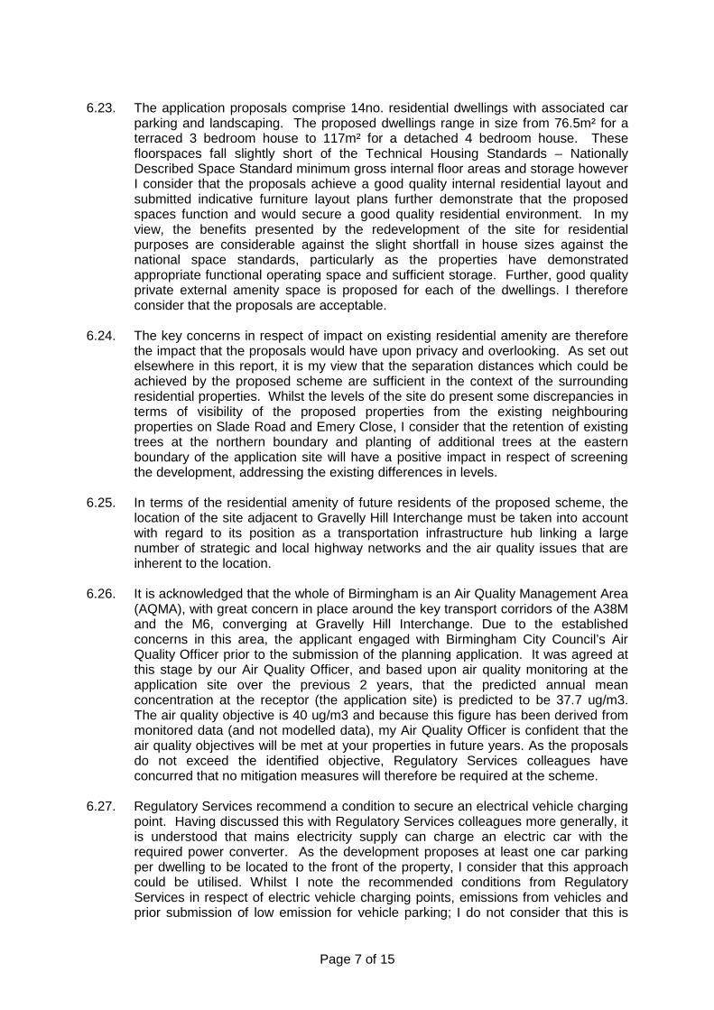
Page 7 of 15
6.23. The application proposals comprise 14no. residential dwellings with associated car
parking and landscaping. The proposed dwellings range in size from 76.5m² for a terraced 3 bedroom house to 117m² for a detached 4 bedroom house. These floorspaces fall slightly short of the Technical Housing Standards – Nationally Described Space Standard minimum gross internal floor areas and storage however I consider that the proposals achieve a good quality internal residential layout and submitted indicative furniture layout plans further demonstrate that the proposed spaces function and would secure a good quality residential environment. In my view, the benefits presented by the redevelopment of the site for residential purposes are considerable against the slight shortfall in house sizes against the national space standards, particularly as the properties have demonstrated appropriate functional operating space and sufficient storage. Further, good quality private external amenity space is proposed for each of the dwellings. I therefore consider that the proposals are acceptable.
6.24. The key concerns in respect of impact on existing residential amenity are therefore
the impact that the proposals would have upon privacy and overlooking. As set out elsewhere in this report, it is my view that the separation distances which could be achieved by the proposed scheme are sufficient in the context of the surrounding residential properties. Whilst the levels of the site do present some discrepancies in terms of visibility of the proposed properties from the existing neighbouring properties on Slade Road and Emery Close, I consider that the retention of existing trees at the northern boundary and planting of additional trees at the eastern boundary of the application site will have a positive impact in respect of screening the development, addressing the existing differences in levels.
6.25. In terms of the residential amenity of future residents of the proposed scheme, the
location of the site adjacent to Gravelly Hill Interchange must be taken into account with regard to its position as a transportation infrastructure hub linking a large number of strategic and local highway networks and the air quality issues that are inherent to the location.
6.26. It is acknowledged that the whole of Birmingham is an Air Quality Management Area
(AQMA), with great concern in place around the key transport corridors of the A38M and the M6, converging at Gravelly Hill Interchange. Due to the established concerns in this area, the applicant engaged with Birmingham City Council’s Air Quality Officer prior to the submission of the planning application. It was agreed at this stage by our Air Quality Officer, and based upon air quality monitoring at the application site over the previous 2 years, that the predicted annual mean concentration at the receptor (the application site) is predicted to be 37.7 ug/m3. The air quality objective is 40 ug/m3 and because this figure has been derived from monitored data (and not modelled data), my Air Quality Officer is confident that the air quality objectives will be met at your properties in future years. As the proposals do not exceed the identified objective, Regulatory Services colleagues have concurred that no mitigation measures will therefore be required at the scheme.
6.27. Regulatory Services recommend a condition to secure an electrical vehicle charging
point. Having discussed this with Regulatory Services colleagues more generally, it is understood that mains electricity supply can charge an electric car with the required power converter. As the development proposes at least one car parking per dwelling to be located to the front of the property, I consider that this approach could be utilised. Whilst I note the recommended conditions from Regulatory Services in respect of electric vehicle charging points, emissions from vehicles and prior submission of low emission for vehicle parking; I do not consider that this is

Page 8 of 15
justified in this case, bearing in mind that there is no specific policy requirement for such provision and the proposal is for a small scale residential development. Emerging planning policy however will address this aspect in future, in the context of Planning Management’s role in air quality control. I therefore consider that this condition is not necessary.
6.28. With regard to the location of the site adjacent to Gravelly Hill Interchange, noise is a
concern for future residents of the scheme. Regulatory Services colleagues however raise no objection subject to recommending a condition to secure the noise insulation to the development to be installed as specified in sections 6.3 to 6.6 of the Impact Acoustics report submitted in support of the application which would mitigate the noise generated by the site location.
6.29. In terms of the proposed use and noise generation, I do not consider that the
proposed residential properties will generate excessive noise which would disturb existing residences.
6.30. I consider that the application proposals would not have an adverse impact on
residential amenity and appropriate mitigation measures are proposed to be secured by condition to address that good levels of residential amenity for existing and future residents in the area will be maintained.
Impact on Highway safety
6.31. The application site is proposed to be accessed via the single lane carriageway at Copeley Hill, which in itself is a cul-de-sac, which leads on to Slade Road, providing access to Salford Circus and the A38M, M6 and other local and regional strategic road networks. A Transport Statement has been prepared by the Applicant in support of the development proposals which sets out that the application proposals would result in an additional 7 movements from the application site during peak travel hours, with the majority of vehicles likely to turn left on Slade Road.
6.32. Initially, Transportation Development raised concerns in respect of the impact that the development would have upon the capacity of Salford Circus and the number of additional vehicles turning right from Slade Road on to Salford Circus, identifying safety concerns in terms of the frequency that cars will turn right and become stranded in the left hand lane of Slade Road, particularly during peak travel hours. The applicant undertook some additional surveys during peak travel hours of vehicles travelling from Copeley Hill. On review of the additional surveys, Transportation Development concluded that the application proposals would not have an adverse impact on the function of Slade Road on to Salford Circus.
6.33. The application proposals incorporate the provision of 30 car parking spaces (28 resident + 2 visitor). Based on the proposed number of dwellings, the car parking provision is policy compliant. The layout of the car park is considered to be appropriate and functional and adequate turning circles and vehicle passing widths are proposed to enter and leave the application site for the residents of the proposed scheme. Transportation Development are of the view that the application site could be accessed by refuse lorries to collect refuse from within the site and a slight amendment would be required to the car parking layout to accommodate this. Further, this amended car parking layout would provide the opportunity to secure a turning head on Copeley Hill which would be of benefit to the future residents of the scheme and the existing residents living on Copeley Hill. This may require the reduction in the level of car parking by 2 spaces to a total of 28 car parking spaces. Transportation Development has raised no concerns regarding this. I concur with

Page 9 of 15
the views expressed and consider it reasonable to attach conditions to secure an amended car parking layout, vehicle parking and turning details and a Section 278 agreement to secure the formation of bellmouth access, including provision of street lighting within the access to adoptable specification.
6.34. Concerns were raised regarding the pedestrian environment that would result from the proposed layout of the scheme, which does not secure the minimum pavement widths as advocated in Manual for Streets. Transportation Development consider it difficult to achieve a satisfactory level of footway width throughout the site without impacting upon the practicality of the parking and manoeuvring areas in their current configuration, or the siting of dwellings, and have suggested a shared surface arrangement to overcome this likely conflict. I consider that there is a need to resolve these issues at condition stage and have therefore attached appropriate conditions to secure these alterations.
6.35. The construction period may however result in short term noise and disturbance, and have highway implications. I therefore consider it appropriate to attach a planning condition to secure a Construction Management Plan.
6.36. The application site is located in a sustainable location, with good access to public
transport and local facilities and amenities. The application site is considered to be within reasonable walking distance of bus services between Birmingham and Short Heath, Gravelly Hill rail station providing access between Birmingham and Lichfield, and Slade Road Neighbourhood Centre. Beyond this, Erdington District Centre is located 1.2 miles north of the application site.
6.37. I consider that the application proposals are acceptable in terms of highway safety,
subject to the abovementioned conditions to be attached to any grant of planning permission. Impact on Drainage
6.38. The application proposals seek to implement drainage to accommodate the residential development. The proposed discharge rate of 5l/s for all return periods up to the 1 in 100 year plus climate change event, is considered acceptable. Further, the proposed attenuation volume of 55 cu.m is acceptable as proposed on the site. Proposed finished floor levels should be designed to mitigate risk of flooding to people and property.
6.39. The Council as Local Lead Flooding Authority has advised that this site has the potential to explore further SuDS opportunities, for example within the hard and soft landscaping areas (rain gardens, permeable paving etc) and evidence is required to demonstrate that these been considered. I consider that this would be acceptable to secure by condition on the grounds that an Operation and Maintenance Plan is also required to be secured by condition.
6.40. I consider that the proposals are acceptable in terms of impact on drainage, subject
to the conditions referred to above. Impact on Landscape and Trees
6.41. The proposals incorporate landscaped communal parking areas which are considered to soften the expanse of car parking and provide focal points within the development for both the pedestrian and the motorist entering the private drive. My Landscaping Officer has raised no objection subject to conditions to include

Page 10 of 15
landscaping, site levels, boundary treatment and surfacing that would ensure that the proposal makes a substantial contribution to the site and overall area in amenity and biodiversity terms.
6.42. The existing trees on the southern and northern boundaries of the site are proposed to be retained. I consider that the proposed retention of mature trees deliver considerable benefits in terms of established and existing screening to the site. The maturity of the trees also secures ecological benefits for local wildlife found in the immediate vicinity. Additional trees are proposed on the eastern boundary to improve screening and reduce any opportunities for overlooking between the proposed dwellings and the existing dwellings on Slade Road. My Tree Officer has raised no objections to the proposal subject to the buffer of trees to the northeast of the site being retained, which would not be affected as they are outside the application site.
6.43. I consider that the landscaping proposals and impact of the development on trees
would be acceptable, subject to relevant conditions referred to above. Impact on Ecology
6.44. The retention of trees is welcomed in terms of ecological value and the potential for ecological enhancement, and presents opportunity for improvements to biodiversity in the immediate area.
6.45. City ecologist sets out that the proposed trees along the eastern boundary should be tree species that are beneficial to pollinator insects and birds such as flowering and seed / berry bearing forms. Further, the retained trees along the Copeley Road frontage and a selection of the proposed houses could be a good opportunity to provide suitable nesting boxes for a range of bird species.
6.46. I consider that these suggestions could deliver significant biodiversity enhancements
and conditions will therefore be attached to secure these elements.
7. Conclusion 7.1. This planning application seeks to secure the delivery of a residential development
of 14no. 3 and 4 bedroom dwellings, associated car parking and landscaping. The application site is a sustainable location with good access to public transport and local facilities and amenities. The application site is a vacant, disused site and is in an established built up area, set in the context of other residential properties. The development of the site would be likely to deliver improved natural surveillance which is considered to be a benefit for the immediately surrounding existing residential properties. The proposals are therefore acceptable in terms of the delivery of a sustainable development, re-using an existing vacant site and seeking to introduce active residential use.
7.2. The application proposals are considered to comply with adopted planning policy and will make a contribution to Birmingham’s established housing requirements whilst regenerating a disused and vacant site in an established residential area.
7.3. For the reasons set out above, I recommend that the application be approved
subject to conditions.

Page 11 of 15
8. Recommendation 8.1. Approve subject to conditions: 1 Requires the prior submission of level details
2 Requires the prior submission of a contamination remediation scheme
3 Requires the prior submission of a contaminated land verification report
4 Requires the prior submission of a Sustainable Drainage Assessment and Sustainable
Drainage Operation and Maintenance Plan
5 Requires the prior submission of a construction method statement/management plan
6 Requires the prior submission of sample materials
7 Requires the prior submission of details of bird/bat boxes
8 Requires the prior submission of a scheme for ecological/biodiversity/enhancement measures
9 Tree Survey and Arboricultural Implication Assessment
10 Requires the prior submission of hard and/or soft landscape details
11 Requires the prior submission of hard surfacing materials
12 Requires the prior submission of boundary treatment details
13 Requires the prior submission of a landscape management plan
14 Requires the prior submission of a lighting scheme
15 Requires the prior approval of an amended car park layout
16 Requires the prior approval of the siting/design of the access
17 Requires the prior submission of vehicle parking and turning details
18 Requires the parking area to be laid out prior to use
19 Prevents occupation until the turning and parking area has been constructed
20 Requires the prior submission of cycle storage details
21 Requires pedestrian visibility splays to be provided
22 Requires the prior submission and completion of works for the S278/TRO Agreement
23 Noise Insulation Mitigation
24 Removes PD rights for new windows

Page 12 of 15
25 Removes PD rights for extensions
26 Requires the scheme to be in accordance with the listed approved plans
27 Limits the approval to 3 years (Full) Case Officer: Claudia Clemente

Page 13 of 15
Photo(s)
Figure 1: Application Site from Copeley Hill to the north
Figure 2: Application site from Copeley Hill to the east
Page 14 of 15
Figure 3: Application Site Boundary - Copeley Hill

Page 15 of 15
Location Plan
This map is reproduced from the Ordnance Survey Material with the permission of Ordnance Survey on behalf of the Controller of Her Majesty's Stationery Office © Crown Copyright. Unauthorised reproduction infringes Crown Copyright and may lead to prosecution or civil proceedings. Birmingham City Council. Licence No.100021326, 2010

Birmingham City Council
Planning Committee 04 February 2016 I submit for your consideration the attached reports for the North West team. Recommendation Report No. Application No / Location / Proposal Approve – Conditions 11 2015/08160/PA 54 Philip Victor Road
Handsworth Birmingham B20 2QD Change of use from residential (Use Class C3) to children's care home (Use Class C2)
Defer – Informal Approval 12 2015/10151/PA
50 Livingstone Road Handsworth Birmingham B20 3LL Erection of first and second floors above the existing ground floor to accommodate 36 no. en-suite rooms with kitchen facilities to be used as HMO (House in Multiple Occupation) with amendments to car parking provision, in association with change of use of existing building under planning approval 2014/06388/PA for conversion to a HMO and associated shared facilities.
Approve – Conditions 13 2015/05918/PA
88 Albert Road Handsworth Birmingham B21 9JY Change of use from residential dwelling (C3) use to educational use (D1)
Approve – Temporary 14 2015/10377/PA
Icknield Street by Pitsford Street Birmingham Installation of double-sided digital advertising totem
Page 1 of 1 Director of Planning and Regeneration

Page 1 of 11
Committee Date: 04/02/2016 Application Number: 2015/08160/PA
Accepted: 15/10/2015 Application Type: Full Planning
Target Date: 10/12/2015
Ward: Lozells and East Handsworth
54 Philip Victor Road, Handsworth, Birmingham, B20 2QD
Change of use from residential (Use Class C3) to children's care home (Use Class C2) Applicant: Meadows Care Ltd
Egerton House, Wardle Road, Rochdale, OL12 9EN Agent: Cavendish Tate
32 The Inhedge, Dudley, West Midlands, DY1 1RR
Recommendation Approve Subject To Conditions 1. Proposal
1.1. Planning permission is sought to change the use of an eight bedroom detached
house (Use Class C3) to a residential institution (Use Class C2), serving as a care home. The site includes provision for five off-street car parking spaces.
1.2. The care home would be occupied by maximum of four young people at any one time, aged between 10 and 18 years, with up to four carers providing around the clock care. The young people residing in the care home would attend local schools and clubs.
1.3. The premises would be operated by the applicant Meadows Care Limited. Meadows
Care Limited is a specialist provider of care, therapy and education operating nineteen small homes housing three to four children and their care staff. They state that their aim is to “provide outstanding domestic settings to provide excellent homes for all our young people”. The care home would be registered and regulated by Ofsted.
1.4. Each proposed admission to the home would be subject to a risk assessment which
takes account of the environment and local community. Any young person placed in the home would have a plan of integration which seeks to cause minimal disruption to the local community.
1.5. The facility would be staffed 24 hours a day by a team equivalent to nine full time
members of staff. The staff team would consist of a Registered Manager, a Deputy Manager and Senior and Residential Care Workers. The Registered Manager would be available on a daily basis and other staff would work as a team on a rota system, with three care workers available in the daytime and evening and two staff overnight.
1.6. No internal or external alterations are proposed, with only two of the existing rooms
to the ground and second floors proposed to change from bedrooms to offices. The ground floor would accommodate four reception rooms, a kitchen/diner and a

Page 2 of 11
shower room; the first floor would accommodate three young persons’ bedrooms, one staff bedroom, one office and one bathroom; the second floor would accommodate one young person’s bedroom, one staff bedroom and one shower room; to the rear is a garden measuring 104m².
1.7. The Application Form states that four parking spaces would be provided; however,
five have been identified on the Site Plan.
1.8. The applicant has submitted a management plan which sets out the way in which the care home would be operated and how Meadows Care Ltd would engage with the local community. The management plan acknowledges the concerns and anxieties that neighbouring residents may have about a care home being located within their community and seeks to address these concerns. The management plan includes details of how the care home would be registered and regulated by Ofsted and would operate within the policies and procedures of Birmingham City Council. It also includes how the resident young people would be supervised and supported, depending upon their individual requirements and risk assessments; how the resident young people would be involved with the local community; how the potential impact of the care home on neighbouring occupiers would be minimised and how Meadows Care Ltd propose to liaise with the local community both prior to the care home opening and if in operation.
1.9. Site area: 0.0539 ha
1.10. Link to Documents 2. Site & Surroundings 2.1. The application site is a large three storey house located on the corner of Philip
Victor Road and Grove Lane. To the front of the property is a small landscaped front garden, with a blocked paved drive to accommodate one car. An additional enclosed car park is located to the side which has provision for four to five car parking spaces. To the rear of the house is a garden and outbuilding.
2.2. The surrounding area is residential in character comprising of mainly large single family dwelling houses with off-street car parking. Philip Victor Road and Grove Lane are characterised by large two-storey detached and semi-detached houses in similar styles to the application property. The site is located in close proximity to local schools, shops, public transport links and other amenities.
2.3. Link to Site Location Plan
3. Planning History 3.1. 30 November 1950 – 08535000: Planning permission approved for use of garage for
taxi use and use of builders office for car hire office
3.2. 30 September 1982 – 08535003: Planning permission refused for retention of 6ft high brick wall and formation of vehicular access
3.3. 14 August 1979 – 08535002: Application withdrawn for construction of new utility
room incorporating existing toilet

Page 3 of 11
4. Consultation/PP Responses 4.1. Transportation Development: No objection – Car Parking Guidelines for C2
residential uses states one space per two units plus one space per warden unit. Therefore, for five to six spaces is suggested for the proposed use. There is specific warden accommodation. Assuming the worst case of both arriving by car, overall demand could be assumed at up to five to six spaces. It is not anticipated traffic and parking demand generated as a result of this change would significantly impact on the local network. Unrestricted on-street parking is typically available within close walking distance and there are very good public transport links at this location.
4.2. Regulatory Services: No objection.
4.3. West Midlands Police: It is reasonable to expect that this proposal may generate a level of crime. The use of the property as a home for young people introduces a diverse element that by reason of use may result in noise, disturbance and nuisance to the detriment of neighbours’ residential amenity. Incidents of Anti-Social Behaviour are high in this locality. Historically, residential care homes for young people create a demand for Police service, especially when young people are reported as absent/missing. Request that temporary permission is granted to allow any impact to be assessed. Subject to planning approval, recommend conditions to mitigate crime and anti-social behaviour including: CCTV, an access control system via key fob/swipe card is installed and anti-barricade doors are fitted to residents’ bedrooms.
4.4. Neighbouring occupiers, Ward Members and the West Handsworth Neighbourhood
Forum were notified. One representation in support of the application was received from a former objector who felt that the management plan submitted by the applicant had addressed his/her concerns and that the proposal would benefit the lives of young people. Twenty one individual objections have been received from residents of Philip Victor Road and Grove Lane, which are summarised as follows:
Proposal will cause noise and disturbance Safeguarding and security issues have not been identified by the applicant Potential for dangerous people searching for residents The proposal would increase burglaries, robberies and crime in the area There would be an increase in anti-social behaviour and possible vandalism There would be people coming and going at all hours which will degrade the
surrounding area The area will become run down very quickly The application has not been publicised widely enough The public consultation period was very short No site notice was displayed The area has become a targeted refuge for people who are going through
personal difficulties due to social and economic issues The proposed use is unsuitable in this residential area Over-concentration of use in the area The area is characterised by single family dwellings, this use is not in keeping The design of the development, its scale and use, is such that it appears to be
out of character with its surroundings Other areas of Birmingham would be better suited to such a proposal Nothing in the application establishes that there is a need for this institution in
this area Potential for negative impact on school children by residents of care home
Page 4 of 11
Residents will be people who have been chased out of Manchester The area will be devalued along with property values The children living in the application property would have a bad influence on
children already living in the area Do not want own children exposed to children with behavioural problems It is unfair to subject residents to disruptive, violent and lawless behaviour and
would destroy our peace of mind The proposal would have a serious impact on existing residents’ quality of life Increase in vehicles parked up on Grove Lane and Philip Victor Road and on
the corner of where the roads meet Too close to a main road The development will have a significant impact on road safety The proposal would increase the amount of traffic on the road There will be a negative impact on the level of on-street car parking Concerned that a quiet road will become a noisy one Concerns that the applicant’s headquarters not based locally and so they have
little experience of the application site and wider are and so do not fully understand the effect the proposal would have on existing residents
The proposed use would go against the long terms aims for children that are currently in foster care in the area
Do not know if the proposed operators will run the home appropriately and provide the number of staff as stated
How much is known of the applicant’s experience and reputation in the field of children with behavioural difficulties?
Insufficient information provided by the applicant Potential for negative impact on school children by residents of care home Residents will be people who have been chased out of Manchester The area will be devalued along with property values The children living in the application property would have a bad influence on
children already living in the area Do not want own children exposed to children with behavioural problems It is unfair to subject residents to disruptive, violent and lawless behaviour and
would destroy our peace of mind The proposal would have a serious impact on existing residents’ quality of life
5. Policy Context 5.1. Birmingham's Unitary Development Plan 2005; Draft Birmingham Development
Plan; Car Parking Guidelines SPD Specific Needs Residential Uses SPG and the National Planning Policy Framework (NPPF).
6. Planning Considerations
Background
6.1. On 1st June 2015, the City Council awarded a contract to Meadows Care Limited to provide 19 Children's Residential Home places (equivalent to 5 houses) within Birmingham. The first of these, located in Sutton Coldfield received planning consent on 17th September 2015 (reference 2015/06080/PA) and a second, located in Billesley, received planning consent on 21st January 2016 (reference 2015/09538/PA).

Page 5 of 11
6.2. The Council has a duty to safeguard and promote the welfare of looked after children, including the provision of sufficient accommodation capable of meeting children's needs in the city.
Policy context
6.3. The NPPF confirms there is a presumption in favour of sustainable development. The core planning principles set out at Paragraph 17 state that planning should (amongst other things) always seek a good standard of amenity for all existing and future occupants of land buildings. In addition, Paragraphs 58 and 69 state planning decisions should aim to promote and create safe and accessible environments where crime and disorder, and the fear of crime, do not undermine the quality of life or community cohesion.
6.4. The UDP (2005) aims to ensure that there is a variety of housing to meet the full range of needs throughout the City (Paragraph 5.7). It also seeks to maintain and protect the existing housing stock and advises that the loss of housing in good condition to other uses would normally be resisted (paragraph 5.19A). Furthermore, paragraph 5.19B advises that some residential areas contain properties which have been converted into "institutional" uses such as hotels, hostels, day nurseries or nursing homes, subdivided into flats or are in multiple occupation. Although these are normally appropriate in residential areas, concentrations of such uses can have an adverse effect upon the essential residential character of a particular street or area.
6.5. Specific Needs Residential Uses SPG and paragraphs 8.28 and 8.29 of the adopted
UDP apply to residential care homes as defined by Class C2 (Residential Institutions). The SPG and policy 8.29 of the adopted UDP state that proposals should not cause demonstrable harm to the residential amenity of occupiers of nearby properties by reason of noise and disturbance nuisance. Residential care homes are normally most appropriately located in large detached properties set in their own grounds. Furthermore, they state that in areas which already contain premises in similar use, and/or houses in multiple paying occupation and/or properties converted into self-contained flats, account will be taken of the cumulative effect of such uses upon the residential character and appearance of the area. Finally, proposals should not prejudice the safety and free flow of traffic in the adjoining highways and adequate outdoor amenity space (minimum 16m² of space per resident) should be provided to ensure a satisfactory living environment for residents.
6.6. The main issues for consideration of this proposal are therefore whether the
principle of the proposed use is acceptable in this location and the potential impact on the amenity of existing occupants and on highway safety and parking.
Principle
6.7. The site is located within a residential area with good accessibility to local shops, schools and bus services. Young people living at the care home would benefit from local services and have the opportunity to participate in community, leisure, sporting and cultural activities. This would allow the residents to feel part of the local community and encourage social inclusion.
6.8. The application property is a large detached dwelling set within its own grounds.
This is considered to be the most appropriate type of house for use as a care home as defined by the Specific Needs Residential Uses SPG and policy 8.29 of the

Page 6 of 11
adopted UDP 2005. The existing front drive and car parking are to the side would provide at least five parking spaces for staff members. The rear garden would provide 17.3m² of outdoor amenity space per resident, which exceeds the 16m² minimum required by the SPG. There would be no cumulative effect of such a use on the residential character and appearance of the area. I therefore consider the application site is a suitable location for a young person’s care home in principle.
Impact on amenity of existing occupiers
6.9. In terms of noise and disturbance, Regulatory Services raise no objection to the proposal and the proposed use is not considered to generate a higher level of noise and disturbance than that of the existing eight bedroom dwellinghouse, which could be occupied by more than four young people. A management plan has been provided by the applicant in support of the application and this sets out the supervision and support provided to the residents and the measures which will be taken to minimise any impacts on the local community. I recommend that a condition is imposed to require the use to operate in accordance with the management plan. In addition, I also recommend a condition is imposed to limit the number of people living at the property to four. I am therefore satisfied that the proposed use would not result in a significantly greater impact on the amenities of adjoining residents in terms of noise and disturbance than that of a large family dwellinghouse.
Impact on community safety
6.10. The application site is located within a residential area and a number of objections have been received from neighbouring residents regarding the potential for increased anti-social behaviour and crime, as well as a fear of crime and personal safety.
6.11. West Midlands Police have raised concerns about the proposal and consider it may generate a level of crime and introduce the potential for noise, disturbance and nuisance to neighbours. They advise that residential care homes can create a demand for police service; however, they have not objected to the proposed change of use in principle. In order to limit the potential for crime, noise, disturbance and nuisance they have recommended conditions be imposed to any approval requiring CCTV, secure control access system and anti-barricade doors to bedrooms. However, such conditions are considered unreasonably onerous. The applicant has met with West Midlands Police to discuss their concerns and whilst the Police have not amended their comments following the meeting, the applicant has advised that the planning conditions sought by the Police are regulated and controlled through the Ofsted registration process. As such, I therefore consider it would be inappropriate to require these measures be imposed by planning condition.
6.12. With appropriate management and supervision by staff and a condition limiting the
number of young people occupying the property to four, I do not consider that the proposed care home would, as a matter of course, lead to an increase in anti-social behaviour and crime to the detriment of the area nearby residents, nor necessarily place additional pressure on police resources. I am not aware of any other existing care homes in this area that have resulted in an increase in anti-social behaviour and/or crime that could be used as reliable evidence to suggest that this application would result in increased crime and anti-social behaviour. I therefore consider that there is insufficient evidence to justify refusal for this reason.
Highway Safety and Parking

Page 7 of 11
6.13. The Car Parking Guidelines SPD requires one parking space per two units, plus one per warden unit, which equates to five parking spaces. This can be provided within the site as there is one space on the front drive and at least four spaces on the side car parking area. I also note that on-street parking within the immediate area is unrestricted and does not appear to be over utilised. In addition, Transportation Development raise no objection to the proposal.
6.14. I note the concerns of neighbouring residents regarding an increase in traffic in the area. However, given that the property would only have a maximum of five members of staff working there at any one time and residents being too young and not in a position to own a vehicle, I consider that the proposed use would not have a materially greater impact on highway safety and parking than if the property remained in use as a large eight bedroom dwellinghouse.
Other issues
6.15. A number of objectors state that this planning application was not publicised widely enough and the time period to submit comments was too short. The consultation arrangements for this planning application have accorded with the Council’s publicised practices. In addition, further public consultation was undertaken upon receipt of the management plan submitted by the applicant.
6.16. Concerns are also raised about the impact the proposed use may have on the value
of property; however, property values are not a material planning consideration.
6.17. Finally, concerns have been raised about the Applicant’s qualification to operate a care home. This is a matter beyond the scope of the planning process and is likely to be a matter for Ofsted with which the care home would be registered with and regulated by.
7. Conclusion 7.1. The proposed young person’s care home would meet a need to provide residential
places in Birmingham and would support social inclusion. I consider the proposed care home would be suitably located in a residential area with good access to local services and amenities. I acknowledge the level of local opposition and the concerns raised by West Midlands Police, but note that no evidence has been provided that the proposed use in this location would result in an increase in anti-social behaviour crime. I do not consider the proposed use would have a significantly greater impact on the amenities of existing residents and on highway safety than the existing use of the property as a large eight bedroom house. As such, I consider the proposal constitutes sustainable development and is therefore recommended for approval.
8. Recommendation 8.1. Approve subject to conditions.
1 Requires the scheme to be in accordance with the listed approved plans
2 Limits the number of children living at the property to a maximum of 4.

Page 8 of 11
3 Prevents the use from changing within the use class
4 Prevents the parking area and garage from being used for any purpose other than parking, loading and unloading of vehicles.
5 Requires the scheme to operate in accordance with the the management plan
6 Limits the approval to 3 years (Full) Case Officer: Faizal Jasat

Page 9 of 11
Photo(s)
Application site viewed from Philip Victor Road

Page 10 of 11
Application site viewed from Grove Lane

Page 11 of 11
Location Plan
This map is reproduced from the Ordnance Survey Material with the permission of Ordnance Survey on behalf of the Controller of Her Majesty's Stationery Office © Crown Copyright. Unauthorised reproduction infringes Crown Copyright and may lead to prosecution or civil proceedings. Birmingham City Council. Licence No.100021326, 2010
1
26
38
PHILIP VICTOR ROAD
DrainFB
72
5
32
24
7
30
166
42
2
22
10
3
4
GOLDEN CROFT
131.4m
192
2018
03
12
213
1
2
37
14
1318
25
225
22
215
131.4m
Ward Bdy
Tennis Courts
220
2638
64
26a
2a
4a
245
54
49
44
251
57
210
3034
214
35
200
255
18
Page 1 of 8
Committee Date: 04/02/2016 Application Number: 2015/10151/PA
Accepted: 18/12/2015 Application Type: Full Planning
Target Date: 12/02/2016
Ward: Lozells and East Handsworth
50 Livingstone Road, Handsworth, Birmingham, B20 3LL
Erection of first and second floors above the existing ground floor to accommodate 36 no. en-suite rooms with kitchen facilities to be used as HMO (House in Multiple Occupation) with amendments to car parking provision, in association with change of use of existing building under planning approval 2014/06388/PA for conversion to a HMO and associated shared facilities. Applicant: Aronex Development Ltd
1-1A James Yard, Larkshall Road, London, E4 9UA Agent: Architorium Limited
113 Cranbrook Road, Ilford, Essex, IG1 4PU
Recommendation Approve Subject To A Section 106 Legal Agreement 1. Proposal 1.1. In February last year, planning consent was granted to change the use of the
existing building from a residential school and day nursery to a house in multiple occupation (HMO) containing 61 single bedrooms, 2 studios and associated shared facilities. This was subject to a section 106 agreement that secured the provision of term time travelcards for all residents that are full time students within their first year of study and first year of occupation (ie Freshers) up to a total value of £25,000.
1.2. This application is an amendment to the previously approved scheme which seeks consent to extend the building at the rear above the existing single storey section of the building to provide a further two floors of accommodation providing a further 36 bedrooms within an additional 928 square metres of floorspace. Each unit would also contain a small kitchenette, en-suite bathroom and space for a study desk. Occupiers would also have access to the previously approved communal spaces which include a library/computer room, living room/games room, shared kitchen/dining rooms, laundry, gym, swimming pool, cycle storage and car parking areas.
1.3. The design of the proposed extension would reflect the existing building having a
mix of brick and render walls and a flat roof. An additional area of car parking is proposed increasing the parking provision from 20 spaces to 27 spaces overall.
1.4. The developers target market is proposed to be students, graduates and young
professionals.

Page 2 of 8
1.5. The applicant proposes a proportional increase in the size of the section 106 contribution, increasing the travel card sum to £40,000, which is proposed to be secured through a deed of variation.
1.6. Link to Documents 2. Site & Surroundings 2.1. The site is an existing former residential school which comprises of classrooms,
seminar halls, main hall, kitchen, laundry rooms, stores, w/c’s at ground floor with dormitory bedrooms, kitchen/dining rooms, bathrooms and w’c’s above. The ground floor of the building is arranged in a square footprint with a central enclosed courtyard garden, with the three upper floors situated above the northernmost part of the building. The building is predominantly faced in a dark brown brick with a flat roof and is set within an established landscaped plot of grassed areas interspersed with individual and groups of trees.
2.2. The site is situated adjacent to land to the east being redeveloped for new housing by Birmingham Municipal Housing Trust (BMHT). Broadway Dance Centre adjoins the western boundary. The surrounding area to the west is predominantly residential in character with a mix of housing types and styles. There is an area of allotments to the north west.
2.3. The site adjoins the edge of Perry Barr District Centre with Perry Barr station
approximately 5 minutes walk from the site to the north. The site is also accessible via bus services on the A38 into and out of the City Centre.
2.4. Site location and street view 3. Planning History 3.1. 03/02/2015 – 2014/06388/PA – Change of use from residential school/day nursery
(Class C2/D1) to house in multiple occupation (HMO) (Sui Generis) for 61 single bedrooms, 2 studios with associated gym, media room, library and offices, room for Council (local community) use, proposed single storey swimming pool extension and external alterations to render parts of the building – Approved subject to conditions, and completed s106 agreement.
4. Consultation/PP Responses 4.1. Site notices erected. MP, ward members, residents associations and neighbouring
residents notified. No objections received. Birchfield Residents Action Group have written to seek clarification regarding the relationship of this application to the previously approved scheme and whether the developer still intends the accommodation to be for students or young professionals.
4.2. Transportation Development – No objection subject to amendments and conditions. Recommends amendments to the parking layout and access arrangement to incorporate a visibility splay, that any amendments to the footway crossings to be carried out at the applicants expense, pedestrian visibility splay to be incorporated into the access, travel plan condition, advertisement of the travelcard scheme, marking out of parking spaces, secure cycle storage and appropriate signage.
Page 3 of 8
4.3. Regulatory Services – No objections.
4.4. Lead Local Flood Authority – No surface water information has been submitted. The
LLPA actively promote and encourage the implementation of SUD’s on all developments and recommend the use of permeable paving in the car park area, inner courtyard, and recreational areas to the west and north, and the use of filter drains, swales and rain gardens in the landscaped areas to achieve water quality improvements and enhance bio-diversity and amenity value in this development. Recommends a sustainable drainage condition.
4.5. Police – Makes detailed comments in respect of meeting Secured by Design, car
parking, CCTV and lighting. 5. Policy Context 5.1. Adopted UDP 2005, Draft Birmingham Development Plan, Aston, Newtown and
Lozells AAP, Places for All SPD, Car parking guidelines SPD, Special Needs Residential Uses SPG : Houses in Multiple Occupation, Hostels and Residential care and Nursing Homes and bedroom sizes for student accommodation, NPPF.
6. Planning Considerations 6.1. Paragraph 8.24 of the adopted UDP sets out that in determining applications for
HMO’s the following criteria will be considered : the effect of the proposal on the amenities of the surrounding area, and on adjoining premises, the size and character of the property, floorspace standards of the accommodation, the facilities for car parking and the amount of provision in the locality. Paragraph 8.25 states that generally the use of small terraced or small semi-detached houses will be resisted. The impact of such uses will be dependent on the use of adjoining properties and the ambient noise level in the immediate area.
6.2. The Special Needs Residential Uses SPG repeats these criteria and also sets out
that the cumulative effect of clusters of such uses on the residential character of an area will also be considered. In an area of housing restraint such uses may be resisted on ground of the impact on the character of the area. The guidance also sets out details of minimum bedrooms sizes for student accommodation to be 6.5 square metres for a single bedroom and 12.5 square metres for a double bedroom.
6.3. The Aston, Newtown and Lozells AAP includes provision for housing regeneration
proposals at Birchfield adjoining the application site. The AAP also encourages high-quality residential accommodation above the ground floor as part of mixed-use developments within Perry Barr/Birchfield District Centre. Policy H2 sets out that proposals for new housing should take account of the Strategic Housing Market Assessment and detailed local housing market assessments (where they are available), in particular the need for larger family accommodation. Proposals should assist in the creation of mixed, balanced and sustainable communities.
6.4. The draft Birmingham Development Plan includes a policy for the assessment of
proposals for student accommodation. This sets out that proposals for purpose built student accommodation provided on campus will be supported in principle subject to satisfying design and amenity considerations. Proposals for off campus provision will be considered favourably where:

Page 4 of 8
• There is a demonstrated need for the development, • The proposed development is very well located in relation to the educational
establishment that it is to serve and to the local facilities which will serve it, by means of walking, cycling and public transport.
• The proposed development will not have an unacceptable impact on the local neighbourhood and residential amenity.
• The scale, massing and architecture of the development is appropriate for the location.
• The design and layout of the accommodation together with the associated facilities provided will create a positive living experience.
6.5. Consent has been granted to convert the existing building into a HMO, and this
proposal would provide additional HMO accommodation and so the proposed use of the extension is acceptable in principle. There is a need for additional accommodation for students in the City. The proposed development would also serve to provide HMO accommodation for non-students within a predominantly residential area. The nature and layout of the existing building can appropriately accommodate the proposed extension. The site is not located within an area of housing restraint and the submitted plans demonstrate that the study bedrooms would meet minimum guidelines with sufficient space for a study desk etc.
6.6. The design of the proposed extension would complement the existing building with matching materials and with a similar design and external appearance. I have recommended conditions to agree the materials samples. The proposed extension would be 14.5 metres from the boundary of the site with the adjoining garden for the dwelling at 33 Bridgelands Way. Places for Living advocates a minimum separation distance 5 metres per storey and so the proposal would fall marginally short of this guideline, but would nevertheless result in an acceptable relationship to the adjoining dwelling.
6.7. The site is well-situated to public transport facilities being within a few minutes walk of local bus services into the City and Perry Barr train station. However, the site is less accessible for students to walk to campus. With this in mind, the applicant proposes to increase the provision of term-time travelcards for students in their first year of study (ie.freshers) from £25,000 to £40,000 so that these can be offered to student residents in the proposed extension. It is proposed that a deed of variation to the existing section 106 agreement is completed to secure this provision with a requirement for an annual monitoring report to be provided to demonstrate delivery.
6.8. It is unlikely that occupation of the HMO by students would generate a need for
parking. However, as the development will not be exclusively for students, some parking may be required for other occupants and for the on-site manager. The approved scheme proposed 20 car parking spaces. An additional car parking area is now proposed to the rear which would increase the parking to 27 spaces. I consider that the car parking spaces proposed would be adequate for this purpose, taking into account the accessibility of the site and the type of accommodation proposed.
6.9. The creation of the additional car parking area results in the removal of two category
C trees. A landscape scheme has been submitted to discharge the landscape condition attached to the existing approval, which includes provision for suitable replacements.
Page 5 of 8
6.10. In respect of the comments from the Lead Local Flood Authority, as this is a minor category application they are not a statutory consultee which is significant in respect of the consideration of sustainable drainage matters. The approved consent for conversion of the existing building did not generate a requirement for sustainable drainage and there is no requirement for such a scheme as part of that consent. Sustainable drainage measures are encouraged in all developments and the comments from the LLFA have been provided to the applicant for their consideration to encourage them to adopt some of the sustainable drainage measures that have been recommended. I do not consider that it would be appropriate to include the recommended sustainable drainage condition in this instance.
6.11. A package of security measures including CCTV and security lighting have been
approved as part of the planning conditions attached to the original consent. The comments from the Police have been provided to the applicant for their information in respect of extending these measures to the proposed extension.
7. Conclusion 7.1. The proposed extension accords with the relevant policies in respect of its design
and its use as part of the recently approved HMO development and is acceptable subject to the completion of the deed of variation.
8. Recommendation 8.1. That consideration of planning application 2015/10151/PA be deferred pending the
completion of a suitable deed of variation to the existing section 106 legal agreement in respect of planning approval 2014/06388/PA to secure the following :
a) Provision of term time travelcards for all residents that are full time students
within their first year of study and first year of occupation (ie. Freshers) up to a total value of £40,000, and the submission of an annual monitoring report on the first anniversary of first occupation, and subsequently every 12 months thereafter until such time as the total contribution has been provided to demonstrate provision of the travelcards.
8.2 That payment of a monitoring and administration fee associated with the legal
agreement of £1500 be secured, 8.3 That the City Solicitor be authorised to prepare, seal and complete the appropriate
agreement, 8.4 That in the event of the Deed of Variation not being completed to the satisfaction of
the Local Planning Authority on or before 11th February 2015, that planning permission be refused for the following reason :
In the absence of any suitable planning obligation to secure the provision of term time travelcards for full time students resident within the development, that the proposed HMO accommodation for students would not be suitably accessible to any University campus within Birmingham, contrary to paragraphs 3.8, 3.10 and 8.50-8.54 of the adopted UDP, policy TP32 of the Draft Birmingham Development Plan and the NPPF.

Page 6 of 8
8.2. That in the event of the above Deed of Variation being completed to the satisfaction of the Local Planning Authority on or before 11th February 2015 that favourable consideration be given to the application 2015/10151/PA subject to the conditions listed below :
1 Requires the prior submission of sample materials
2 Requires the parking area to be laid out prior to use
3 Requires the provision of cycle parking prior to occupation
4 Requires the scheme to be in accordance with the listed approved plans
5 Limits the approval to 3 years (Full) Case Officer: Stuart Morgans
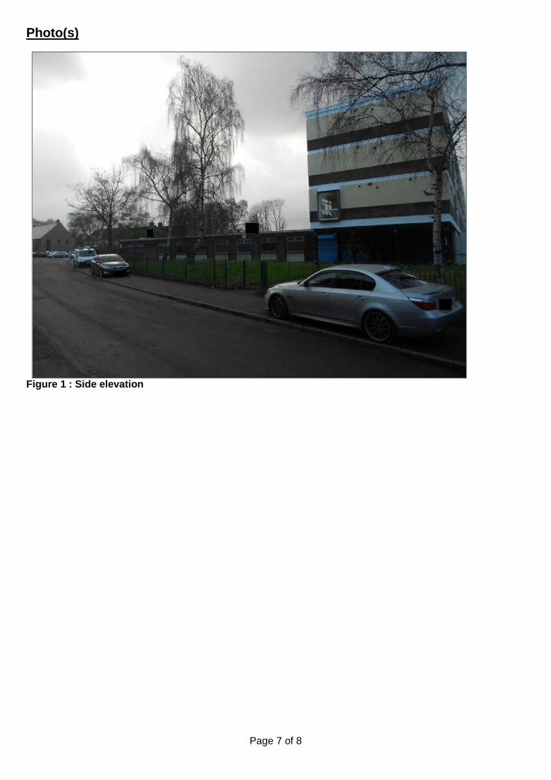
Page 7 of 8
Photo(s)
Figure 1 : Side elevation

Page 8 of 8
Location Plan
This map is reproduced from the Ordnance Survey Material with the permission of Ordnance Survey on behalf of the Controller of Her Majesty's Stationery Office © Crown Copyright. Unauthorised reproduction infringes Crown Copyright and may lead to prosecution or civil proceedings. Birmingham City Council. Licence No.100021326, 2010
14 to 91
TowerBirchfield
1 to 12
79
33
Livingstone House(Home for the aged)
43
3018
24
42
4436
38
El Sub Sta
3440
101
10
97 99
2022
73
83
Shelter
107.0m
GP
Subway
1216
8
14
4 210
BR
IDG
ELA
ND
S W
AY
LIVINGSTONE ROAD
26 46 BU
RT
6
20
4232
45
95
93
LIV
ING
STO
NE
RO
AD
107.9m
2
24
18
28
39
33
41
37
41a
43

Page 1 of 6
Committee Date: 04/02/2016 Application Number: 2015/05918/PA
Accepted: 02/12/2015 Application Type: Full Planning
Target Date: 27/01/2016
Ward: Lozells and East Handsworth
88 Albert Road, Handsworth, Birmingham, B21 9JY
Change of use from residential dwelling (C3) use to educational use (D1) Applicant: Mr Muhammad Shafique
88 Albert Road, Handsworth, Birmingham, B21 9JY Agent: Mr Hanif Ghumra
733 Walsall Road, Great Barr, Birmingham, B42 1EN
Recommendation Approve Subject To Conditions 1. Proposal 1.1. This application is for the proposed change of use of the ground floor of a residential
terraced dwelling in to an Islamic educational use for teaching up to thirty children. The ground floor would consist of a girls classroom, boys classroom, shoe area, wash/ shower area, garden area and a garage. The children would range from six to fifteen years of age and teaching times indicated on the application form would be from 16:00 hours to 19:00 hours Monday to Friday.
1.2. Supporting information identifies that the education would be in relation to the Quran, the prophet and to develop community minded individuals that promote positive behavioural values.
1.3. The first and second floor would be occupied as a single flat for a teacher of the school. First floor provisions would include a bedroom (12m2), shower, kitchen and living room. The second floor would be converted in to a second bedroom (16.2m2).
1.4. The applicants own the adjoining property (86 Albert Road), which would be
occupied by staff associated with the proposed educational use. 1.5. Link to Documents 2. Site & Surroundings 2.1. The application site refers to a terraced dwelling which is located on the corner of
Albert Road and Brunswick Road. The ground and first floor are occupied as a single residential dwelling, with vacant roof space above. Albert Road is one way traffic with the junction with Brunswick Road.
2.2. Site Location and Street View 3. Planning History

Page 2 of 6
3.1. None relevant. 4. Consultation/PP Responses 4.1. Neighbours, local Councillor’s and residents associations consulted. Site notice
displayed. 1 letter in support of the proposal and 9 objections received (summarised): insufficient parking, highway safety issues, noise, changing character of area, there are no shortage of educational uses within this area.
4.2. Regulatory Services – No objection subject to conditions: (1) agree details of noise insulation between adjoining residential properties, (2) restrict the number of children to a maximum of 30, (3) restrict hours of operation from 16:00 hours to 19:00 hours.
4.3. West Midlands Fire Service – No objection.
4.4. West Midlands Police – Raise no objection and recommend the installation of an
alarm system and CCTV.
4.5. Transportation Development – No objection subject to conditions – (1) to restrict the number of children to a maximum of 30, (2) no prayer facilities.
4.6. Education – No objection and the educational use would need to be registered with
Ofsted. 5. Policy Context 5.1. Birmingham Unitary Development Plan (2005), Places For Worship and Faith
Related Educational Uses (SPD), Draft Birmingham Development Plan, National Planning Policy Framework (2012), Car Parking Guidelines (SPD).
6. Planning Policy 6.1. Paragraph 72 of the NPPF states that the Government attaches great importance to
ensuring that a sufficient choice of school places is available to meet the needs of existing and new communities. Local planning authorities should take a proactive, positive and collaborative approach to meeting this requirement, and to development that will widen choice in education.
6.2. The emerging Birmingham Development Plan contains the draft Education Development Plan (EDP). This policy addresses Birmingham City Council’s key priority to provide sufficient, suitable education places to meet increased demand, both in Early Years and School-age education settings.
6.3. Paragraph 3.8 of the adopted Unitary Development Plan states that the City's environmental strategy is based on the need to protect and enhance what is good in the City's environment and to improve what is less good. The keynote is on quality and paragraph 3.10 of the UDP states that proposals which would have an adverse effect on the quality of the built environment will not normally be allowed.
6.4. Paragraph 5.19A of the UDP states that the loss of family accommodation to other
uses can be a material consideration.
Page 3 of 6
6.5. Paragraph 8.33 of the UDP acknowledges that the use of end terraced houses for educational purposes will normally be acceptable where a priest or other religious body occupies the adjoining house.
6.6. Policy 8.35 refers to social, cultural and educational facilities and the impact
educational facilities can have in relation to noise, hours of operation and traffic generation.
6.7. Places of Worship and Faith-Related Community and Educational Uses (SPD)
identifies that the needs of faith communities in Birmingham need to be adequately met, and that planning policies reflect the changing needs and demands of the City’s growing population.
6.8. Planning considerations
6.9. This proposal would involve changing the use of the ground floor only in to an
Islamic educational facility. The first and second floor would be retained for residential purposes. Supporting information has identified that the adjoining dwelling would be occupied by the two teachers associated with this use.
6.10. Policy 5.2.1 of Places of Worship and Faith Related Community and Educational
Uses (SPD) identifies the importance of finding the right location for such uses. Policy states that if suitable sites cannot be found within designated centres then a site within easy walking distance of a centre, and on the fringe of residential areas, should be identified. In this instance the site is outside of a centre (approximately 380 metres away from Rookery Road Neighbourhood Centre). However, its location within a residential area which is within easy walking distance of a Rookery Road Neighbourhood Centre means that this use would be acceptable development in principle. I am satisfied that the retention of the residential element would ensure no loss in housing stock and that the educational use is this location would comply with UDP policy and Places of Worship (SPD).
6.11. Impact on amenity
6.12. The application premises are located within a predominantly residential area.
Adopted policy and guidance identifies that the impact of such uses on surrounding amenity, including numbers of people attending the site, hours of use and traffic should also be duly considered. Regulatory Services have assessed the proposal and raise no objection subject to conditions being imposed to ensure satisfactory noise insulation between adjoining residential uses, to restrict the number of children to a maximum of 30 and to restrict operating times from 16:00 hours to 19:00 hours. In addition, I recommend that a further condition should be imposed to ensure that the use is restricted for educational purposes only and for no other use within the D1 use class. Subject to these conditions being imposed, I am satisfied that the proposal would not harm residential amenity.
6.13. Highway safety issues
6.14. Transportation Development raise no objection, subject to conditions being imposed
to restrict the number of children to a maximum of 30 and to restrict operating times from 16:00 hours to 19:00 hours. It is noted that Brunswick Road is also one way and there are no TRO’s around the application site. The Car Parking Guidelines (SPD) specifies a standard 1 space per 8 children and this development will generate parking demand for 3-4 vehicles. However, it is likely that the children are more likely to be local and would walk to and from site. The site is also served well

Page 4 of 6
by public transport, with frequent bus services available along Rookery Road. This proposal is not expected to prejudice highway or public safety and is acceptable.
7. Conclusion 7.1. Subject to conditions being imposed, the proposed Islamic educational facility would
not adversely affect neighbouring occupiers, surrounding amenity or highway safety and would comply with national and local planning policy.
8. Recommendation 8.1. Approve with conditions. 1 Limits the hours of use from 16:00 hours to 19:00 hours Monday to Friday
2 Prevents the use from changing within the D1 use class
3 Limits the number of children to a maximum of 30
4 Requires the prior submission of noise insulation (variable)
5 Requires the scheme to be in accordance with the listed approved plans
6 Limits the approval to 3 years (Full) Case Officer: Daniel Ilott

Page 5 of 6
Photo(s)
Figure 1 Front of site

Page 6 of 6
Location Plan
Figure 2 Location Plan
This map is reproduced from the Ordnance Survey Material with the permission of Ordnance Survey on behalf of the Controller of Her Majesty's Stationery Office © Crown Copyright. Unauthorised reproduction infringes Crown Copyright and may lead to prosecution or civil proceedings. Birmingham City Council. Licence No.100021326, 2010

Page 1 of 5
Committee Date: 04/02/2016 Application Number: 2015/10377/PA
Accepted: 24/12/2015 Application Type: Advertisement
Target Date: 18/02/2016
Ward: Soho
Icknield Street by Pitsford Street, Hockley, Birmingham
Installation of double-sided digital advertising totem Applicant: Birmingham City Council
Commercial Development, Room 237, Council House, Victoria Square, Birmingham, B1 1BB
Agent:
Recommendation Approve Temporary 1. Proposal 1.1. This application proposes the installation of a freestanding double sided static digital
advertisement unit to be located on the footpath on the southeast facing corner of Icknield Street and Pitsford Street. This would be a new advertisement unit in this location.
1.2. The advertisement unit would measure 2.6m (h) x 1.2m (w) x 0.3m (d). The
advertisement area would be 1.8m (h) x 1.1 (w). The stainless steel unit would contain a static digital screen that would be internally illuminated at 300cd/m2. The design of the advertisement is the same as the Interconnect totems that are displayed within the City Centre.
1.3. The proposed advert unit is part of a contract within the City.
1.4. Link to Documents
2. Site & Surroundings 2.1. The advertisement would be located on a corner facing traffic travelling northbound
on Icknield Street, which forms part of the A4540 dual carriageway and ring road. The site also falls within a commercial area.
2.2. Link to Site Location 3. Planning History 3.1. No planning history.

Page 2 of 5
4. Consultation/PP Responses 4.1. Transportation Development: No objection subject to conditions to restrict the
interval between successive displays, to restrict the display of any special visual effects, to prohibit message sequencing, to prevent the emission of noise, sound, smoke, smell or odours; to include a default mechanism that would freeze the sign in one position if a malfunction occurs; to prevent the display of interactive messages or advertisements; to include controls to monitor ambient light conditions and adjust sign brightness accordingly including a maximum luminance limit. A Grampian condition has also been requested for the relevant highway agreements to be in place prior to the unit being installed.
5. Policy Context 5.1. National Planning Policy Framework, Birmingham Unitary Development Plan (2005),
Draft Birmingham Development Plan (2031). 6. Planning Considerations 6.1. In accordance with paragraph 67 of the NPPF advertisements should be subject to
control only in the interests of amenity and public safety, taking account of cumulative impacts.
Amenity
6.2 There is no existing highway signage within the vicinity of the site and the proposed advertisement would be a new advert in this location. The proposed advertisement would be modestly proportioned with a slender contemporary design. It would not appear as a dominant feature on this section of the public footpath. It is therefore considered that the proposed advertisement would not have an impact upon visual amenity. The proposed advert would not impact on trees close to the site.
Public Safety
6.3 Transportation Development have advised that the proposed replacement advertisement would raise no issues in terms of footway width or visibility requirements and no objections are raised to the proposal on the grounds of public safety, subject to conditions to restrict animated displays in the interests of highway safety. However, the requested condition for the relevant highway agreements to be in place prior to the unit being installed would not be reasonable and will not be applied.
7. Conclusion 7.1. The proposed advert is considered acceptable in terms of the impact upon the visual
amenity of the area and public safety.
8. Recommendation 8.1. Approve subject to conditions.

Page 3 of 5
1 Requires the scheme to be in accordance with the listed approved plans
2 Limits the use of the advert
3 Limits the length of the display of advert
4 Limits the intensity of the approved illumination
5 Limits the approval to 5 years (advert) Case Officer: Faizal Jasat
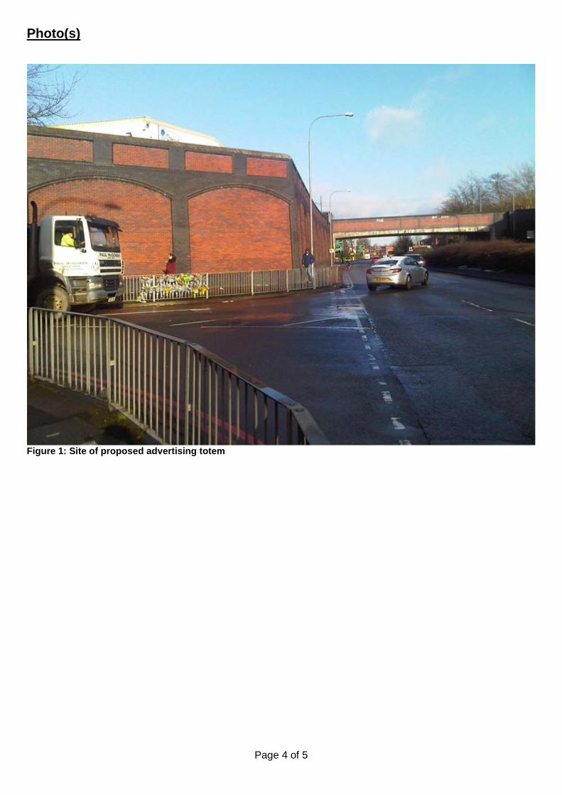
Page 4 of 5
Photo(s)
Figure 1: Site of proposed advertising totem

Page 5 of 5
Location Plan
This map is reproduced from the Ordnance Survey Material with the permission of Ordnance Survey on behalf of the Controller of Her Majesty's Stationery Office © Crown Copyright. Unauthorised reproduction infringes Crown Copyright and may lead to prosecution or civil proceedings. Birmingham City Council. Licence No.100021326, 2010

Birmingham City Council
Planning Committee 04 February 2016 I submit for your consideration the attached reports for the City Centre team. Recommendation Report No. Application No / Location / Proposal Approve - Conditions 15 2015/09506/PA
Land at Venture Way Nechells Birmingham B7 Construction of part single storey part three storey building for use as a National College for High Speed Rail (Use Class D1) with associated cafe (Use Class A3), access, parking and landscaping
Approve - Conditions 16 2015/09331/PA
Land adjacent to All-Weather Pitch Aston University Aston Street Birmingham B4 7EE Erection of two storey student union building to include office, coffee shop, bar, prayer facilities, activity hall and meeting rooms
Page 1 of 1 Director of Planning and Regeneration

Page 1 of 14
Committee Date: 04/02/2016 Application Number: 2015/09506/PA
Accepted: 16/11/2015 Application Type: Full Planning
Target Date: 15/02/2016
Ward: Nechells
Land at Venture Way, Nechells, Birmingham, B7
Construction of part single storey part three storey building for use as a National College for High Speed Rail (Use Class D1) with associated cafe (Use Class A3), access, parking and landscaping Applicant: Birmingham City Council
Assistant Director of Employment, Economy Directorate, PO Box 17048, Birmingham, B2 2ED
Agent: Bond Bryan Architects Ltd The Church Studio, Springvale Road, Sheffield, South Yorkshire, S10 1LP
Recommendation Approve Subject To Conditions 1. Proposal
1.1 In September 2014 the Government announced Birmingham and Doncaster as the selected locations for the future National College for High Speed Rail (NCHSR). The College, split between the two locations will provide specialist vocational training to the next generation of engineers working on the High Speed 2 project. It is intended that the project will bring all of the relevant skills for the rail industry into one college and it will offer up to 2000 apprenticeship opportunities to undertake higher level technical skills. Birmingham would act as the college headquarters and offer training in signalling, advanced construction, logistics and sustainability and digital systems.
1.2 The application site has an approximate area of 0.97 hectares and has boundaries to Lister Street to the north, the A4540 Dartmouth Middleway to the east, Heneage Street West to the south and the Digbeth Branch Canal and towpath to the west. The site lies within Aston Science Park, with the Aston University Engineering Academy building (AUEA) located to the north on the opposite side of Lister Street.
1.3 The proposed development comprises a single building with the main pedestrian entrance located to the north west end of the building accessed from Lister Street and Dartmouth Middleway. The site would also be accessible by foot and by bicycle from the canal towpath that abuts the site. A new pedestrian access through the application site to the canal would also be achieved by the introduction of steps down from Lister Street close to where it crosses the canal.
1.4 The proposed vehicular access would be from Heneage Street West although a vehicle drop off point is also proposed off Lister Street where there would also be a civic space in front the building. A car park with a total of 35 parking bays is

Page 2 of 14
proposed together with 45 covered cycle parking spaces and an area for motorcycle parking.
1.5 The site and building is orientated north west to south east with the site offering frontages of approximately 150m to Dartmouth Middleway and the Canal. In response to this orientation the building would have highly glazed facades to these two long frontages to maximise views and natural daylight into the building. The building would adopt a simple form, comprising of two blocks intersecting each other. The dominant materials would be metallic bronze effect aluminium panels, translucent polycarbonate walling and double glazed curtain walling on top of a dark grey engineering brick plinth.
1.6 The proposed building would comprise a three storey formal teaching and ICT block and a large scale single storey workshop area at ground floor that would accommodate machinery and scale model of a train sited along the frontage to Dartmouth Middleway. To the rear of the workshop there would also be an external project area that would accommodate approximately 60m length of track. At ground floor within the main building there would also be a café open to the public with views and an outdoor seating area overlooking the Canal.
1.7 The proposed gross internal floorspace would total 5,703 square metres spread over three floors. It is anticipated that the number of people on the site at any one time as a result of the proposed development would be 842 based on a student population of 705.
1.8 At present the site accommodates a total of 66 individual and 6 groups of trees. Only 6 trees are proposed to be retained, however none of the existing trees are protected or have been defined as high quality category A trees and only 22 are moderate quality category B trees. The remainder are all category C low quality trees. A total of 33 new trees are proposed to align Dartmouth Middleway and the canal side and a number of raised planters within the civic space and again along the frontage to the canal where students are likely to assemble.
1.9 The application is supported by the following reports:
• Design and Access Statement;
• Transport Assessment and Travel Plan;
• Noise Impact Assessment;
• Ground Investigation Report;
• Topographical Survey;
• Utility and Drainage Survey;
• Tree Survey;
• Phase 1 Habitat Survey;
• Air Quality;
• Archaeological Report;

Page 3 of 14
• Flood Risk Assessment.
1.10 Link to Documents
2. Site & Surroundings
2.1. The site for the NCHSR is located to the east of the city centre within the Aston Science Park. Immediately adjacent to the site on its western boundary is the Digbeth Branch canal and its associated tow path. To the east the site has a boundary of approximately 150m with the dual carriageway known as Dartmouth Middleway whilst the northern edge is defined by Lister Street where the site faces the recently completed Aston University Engineering Academy on the opposite side of the street.
2.2. Lister Street provides vehicular access over the canal whilst to the south of the site there is a pedestrian bridge across the canal leading from Heneage Street West.
2.3. At present the site has the character of a business park. It previously accommodated two commercial buildings constructed during the 1980’s one of which was demolished in 2011 and its floor slab used to provide a large surface level car park. Whilst not protected by a preservation order, there is a belt of mature Hornbeam, Cherry and Pine trees along the frontage to Dartmouth Middleway.
3. Planning History
3.1. 2015/06713/PA (5-8 Ventura Way) - Application for Prior Notification of proposed demolition of existing two storey detached glass clad and steel frame building - No Prior Approval Required. 09/09/2015
3.2. 2010/06612/PA – (1-4 Venture Way) - Change of use to a temporary contractors car park to create 46 new parking spaces in addition to existing 33 parking spaces. Approved temporary 01/02/2011
3.3. 2010/03025/PA (5-8 Ventura Way) - Change of use of part of ground and first floors from light industrial (B1) to nursery facility (D1). Approved Temporary 27/08/2010
3.4. 1996/04259/PA (5-8 Ventura Way) - Erection of extension to existing materials handling/despatch area. Approved 10/01/1997
4. Consultation/PP Responses
4.1 West Midlands Police – The following is recommended:
• The work around the scholastic element of the building be carried out to the standards laid out in the Secured by Design ‘New Schools 2014’ guide;
• There should be a boundary treatment in place to reduce the opportunities for offenders to commit anti-social behaviour and crime as a result of open pedestrian access from the Digbeth Branch Canal. Some building owners have felt it necessary to install retrospective security measures that would impact heavily on the aesthetic view of the canal;
• The accessible areas of the building should be treated with anti-graffiti coating. Consideration should be given to the use of scratch resistant glazing / film to reduce the possibility of similar damage being caused to any window;

Page 4 of 14
• The site should be the subject of a full CCTV scheme that provides images of the car parking area, external views of the shell of the building, all publicly accessible areas, all entrances, the café, all locker banks, the main communal internal areas and all IT rich rooms.
• A lighting plan for the site should be produced following the 'Lighting Against Crime' guide;
• There is concern that the application has no gates to control pedestrian access into the building and I am not aware of any access control proposed to control the flow of pedestrians within the building. Therefore there could be no method of controlling unauthorised access by offenders into the building. I strongly recommend that the proposals for open, uncontrolled access, be reassessed and the barriers be installed;
• Any IT equipment installed on the site should be the subject of robust property marking and, where possible, secured to the fabric of the building or, if not possible, in stand-alone cages;
• the building should be alarmed to a police response standard and there should be the installation of a scheme around the building to provide Hostile Vehicle Mitigation;
4.2 Canal & River Trust - Any works that may be required to construct the building, parking area and waterside area must comply with the “Code of Practice for Works Affecting Canal & River Trust”.
• The proposed building has been set back from the edge of the canal reducing the bulk of it from the canal corridor. The built form of the building itself creates an active frontage to the canal and is of a scale and character appropriate for the developing corridor here;
• The proposed area of public realm at the waterside is consistent with the existing arrangement of the site. The proposed openness and shared surfacing between the college threshold and the towpath will make the canal corridor feel very much like part of the college setting, which is a positive attribute;
• The proposed landscaping scheme is attractive and would encourage interaction with the waterside. Additional litter bins are requested to prevent windblown litter from entering the canal as is further planting within the landscape buffer between the car park and the canal edge, additional wildflowers included within the proposed turf and nesting features within the building for priority species such as redstart, house sparrow, starling and swift;
• Exterior lighting of the building should be carefully designed to avoid light spillage onto the canal. No bat surveys have been carried out and there is no data on whether any bat species could be negatively affected and therefore keeping light to a minimal. This could be achieved via a condition;
• Any discharge of surface water to the canal would require the agreement of the trust;
• Potential contamination of the waterway and ground water from wind blow, seepage or spillage should be avoided;
• Informatives are requested regarding the necessary consents.
4.3 Local Lead Flood Authority –

Page 5 of 14
• All development (greenfield & brownfield) should limit surface water discharge to the equivalent site-specific greenfield runoff rate for all return periods up to the 1 in 100 year plus climate change event, unless it can be demonstrated to be unviable. The proposed discharge rate of 67.7l/s is unacceptable to the LLFA. Evidence should be provided to ensure that the surface water flood risk associated with exceedance events has been mitigated on- and off-site.
• Additional information is required regarding the proposed attenuation areas, flow control structure, discharge locations, levels, cross-sections, areas of permeable pavements and FFLs with accompanying calculations.
• An operation and maintenance plan is required.
• It may be appropriate to object to this application as the information provided does not meet the requirements for Sustainable Drainage, alternatively a condition could be imposed to require the necessary information prior to the commencement of development
4.4 BCC Regulatory Services – No objections subject to conditions to:
• require details of extract ventilation and odour control equipment;
• require a contamination remediation scheme;
• require a contaminated land verification report;
• require the provision of a vehicle charging point;
• limit the noise levels of plant and machinery.
4.5 BCC Ecology - The results of the a phase one ecology survey indicate that although the site and its landscaping contribute to the canal corridor they are of low value for wildlife outside of limited bird nesting and offered no opportunities for bat roosting. Whilst the conclusions are broadly agreed, some of the benefits that the current landscape give to the overall connectivity of the canal corridor have been overlooked as the wider context appears not to have been considered fully. It is considered that there is less green infrastructure available for wildlife than is currently available and much of the benefits that the mature vegetation provides would be lost. It is suggested that there is room for improvement in order to mitigate against this loss by way of biodiverse roofing or green walling or pre planted coir rolls at the canal edge to continue and improve the connectivity within this corridor. In summary it is recommended that the vegetation is cleared outside the main bird nesting season unless there is a pre clearance check by a qualified ecologist and a condition is attached to require details of ecological mitigation.
4.6 BCC Transportation Development - No objection subject to conditions requiring:
• details of a package of measures to complete alterations to the site access on Lister Street, the drop off entrance and exit provision with associated lighting and footway alterations, any necessary alterations to the access off Heneage Street West with associated footway and lighting improvements;
• the applicants to affiliate to BCC Travelwise;

Page 6 of 14
• to progress the submitted draft Travel Plan, recommended that it be produced in conjunction with other educational establishments that have developed their plans (Matthew Boulton. Aston University, AUEA, Ormiston Acadaemy and BCU campus);
• The provision of a pedestrian visibility splay at the car park access;
• the implementation of the secure cycle parking as as shown on site layout plan before the first occupation of the building;
• a car park management plan confirming a management strategy for the use of spaces with measures to prevent parking that may occur by non-users of the site and use of disabled parking spaces;
• a construction management plan prior to commencement of development;
• that the rear service yard area be kept clear for the circulation of service/delivery vehicles as shown on plans i.e. with no external storage or other uses in this area;
• the provision of additional/amended signage (both for pedestrians and vehicles) in both the local vicinity and in strategic locations around the City Centre for this facility with details developed in conjunction with the Traffic Management Services Highways team.
4.7 Birmingham City Centre Management, Local Action Groups, Community and Neighbourhood Forums, Birmingham Civic Society, Employment Access Team, Local Councillors, the MP and Severn Trent Water have been consulted but no responses received.
4.8 No responses have been received with respect to the neighbour notification procedure, site notice and press notice.
5. Policy Context
5.1. The Birmingham Plan 2005, The Birmingham Development Plan 2031, Curzon Masterplan (2014), Places for All (2001).
6. Planning Considerations
Principle of Proposed Use
6.1 The application site lies within the Curzon Masterplan boundary. The Masterplan sets out the Council’s ambitions to provide 51,100 new homes, 270,000 sq.m of additional retail floorspace, 745,000 sq.m of office space and a number of major employment sites with an area covering 141 hectares to the east of the City’s ring road, and within this significant redevelopment area opportunities are sought to support the opening of HS2. The application site is specifically identified within the Masterplan for new development. Furthermore it is also a City Centre Enterprise Zone (EZ) site which in itself is a commitment to realise growth and to promote the redevelopment of the site. This EZ designation supports the aspirations of the Masterplan.
6.2 The site also lies within part of the Masterplan boundary defined as a ‘Learning and Research’ zone where, due to the proximity to Aston Science Park and the BCU campus, businesses based on research, technology and education are promoted.

Page 7 of 14
6.3 The site is also identified within the emerging Birmingham Plan 2031 as a Core Employment Area. Relevant Policy TP18 seeks to ensure that such identified sites should only be redeveloped for B1b (research and development), B1c (light industrial), B2 (general industrial) and B8 (warehousing and distribution) uses. The Policy does however advise that applications for uses outside of these categories will be permitted if exceptional justification exists.
6.4 Therefore whilst the proposed educational and café uses are not strictly business or industrial uses, combined they would provide over 130 jobs and support the overall aspirations of the Masterplan to redevelop the area in a way that would support the operation of HS2 and enhance skill levels for the future. It is also considered that the proposed use would be entirely appropriate based on its proximity to existing educational establishments and its location within the Aston Science Park, and there are exceptional circumstances to justify the proposed national college.
Proposed Design and Layout Considerations
6.5 The proposed layout of the site and the design of the building respond to the history of the railway industry with a simple linear form to reflect a large railway shed that is able to accommodate tracks and a train. It is the applicants intention to provide a simple building comprising of two blocks intersecting each other. A sense of arrival would be created by a strong entrance and a civic space to the foreground. The layout also seeks to make the most of the canal setting whilst also accommodating a workshop together with the required 60m length of external rail track, parking and servicing arrangements. The main entrance for pedestrians would be from Lister Street although a vehicle drop off point is also proposed on this frontage. The primary entrance for vehicles would be to the south via Heneage Street West.
6.6 The building would offer a contemporary bold entrance with a significant amount of curtain walling that would open up views into and through the building. The proposed three storey entrance would be defined by an eye catching cantilevered second floor providing a canopy and a civic space in front of the building. This main part of the building would accommodate the teaching elements and a café at ground floor.
6.7 The single storey workshop space to the side fronting Dartmouth Middleway would, through the use of translucent polycarbonate panels, promote and literally expose the practical teaching element of the rail industry. The height of the workshop at approximately 8.5m is necessary to accommodate part of a train for teaching purposes, giving the building an identity and a shop window to Dartmouth Middleway. To the rear of the workshop element lies the external project area that would measure approximately 41m by 7m that would accommodate 60m of high speed track and a section of overhead line. This would be enclosed by a 2.5m high bronze effect vertical fin security screen to the Dartmouth Middleway frontage.
6.8 The layout and incorporation of the café at the ground floor facing the canal seek to create a strong relationship with the adjacent waterway enhanced by an outdoor seating area for customers. This element of the scheme is supported by the Canal and Rivers Trust and it would provide an area for customers of the café and students to congregate and socialise. The provision of active frontages to the canal and the adjoining highway are highlighted within the Curzon Masterplan.
6.9 Designated walkways alongside the canal towpath would also provide a safe pedestrian route between the entrance to the building and the car parking area to the rear. Parking and servicing areas are located to minimise their visual impact and to provide separation between people and vehicles as much as possible.

Page 8 of 14
6.10 The materials for the proposed building seek to achieve a sense of movement when passing the site, particularly the elevation to Dartmouth Middleway. Notably the bronze effect aluminium cladding would be divided into numerous 500mm wide vertical panels that would be either solid or contain light or medium perforations creating a sense of movement, particularly when combined with the vertical fin security screen to the external teaching area. The sense of movement would also be achieved via the use of external bronze fins providing solar protection to the canalside elevation.
6.11 The railway theme is echoed through the proposed hard and soft landscape arrangement. The proposed paving banding to the civic space to the front of the building would be of a standard gauge railway track width whilst a range of sculptured landforms, raised planters and raised lawn areas, again to the civic space and canalside walkway represent railway cuttings and embankments.
6.12 The architects brief has been to have common themes between the proposed Birmingham and Doncaster colleges in terms of signage and branding, landscaping, internal finishes and lighting. It is however considered that the proposed layout of the site and design of the building positively address the attributes of this particular site and would provide a building of a scale that reflects a railway building in a striking and contemporary way. The proposed main entrance to the building and workshop would, by virtue of their design and materials provide the site with a notable identity whilst the proposed civic space and canal walkway would create an attractive place for students to gather.
Highways
6.13 The site was formerly occupied by offices as part of Aston Science Park. It is proposed to provide 33 staff car parking spaces with 2 additional spaces for disabled users. The submitted Transport Assessment advises that no student parking is provided as it is expected students would travel by public transport or park in local public car park facilities. The site would also provide 45 cycle spaces in a covered facility with associated shower and changing provision in the building.
6.14 The BCC adopted car parking guidelines SPD advises that there should be a maximum requirement of 64 car parking spaces for staff and students, and a minimum of 9 cycle parking spaces are required. However the submitted Transport Assessment suggests that the location of the site is adjacent to the City centre being highly accessible to all public transport provision and major services/facilities. Both Moor Street and New Street train stations are approximately 1.3km away, a distance that BCC Transportation consider to be an acceptable walking distance. The site is also close to a number of public car park facilities at Millennium Point and within City Centre where there are also a number of private car parks. As such BCC Transportation Development raise no objections to the amount of car parking provision being sought which is slightly below the maximum guidelines given the City centre location, on-street car parking controls and car parking facilities in close proximity to the site.
6.15 The site would retain a vehicle access in from Dartmouth Middleway and BCC Transportation advise that it may need to be modified to enable HS2 trains to be delivered to the site, however this would be infrequent (once every couple of years) and should be able to take place from Dartmouth Middleway on a Sunday morning outside of other peak events. A management plan is attached as a proposed condition to pre-arrange such deliveries as are conditions regarding the vehicular access off Dartmouth Middleway, affiliation to BCC Travelwise, production of a draft

Page 9 of 14
Travel Plan, secure cycle parking and a construction management plan. The final suggested condition requests the provision of additional and/or amended signage both for pedestrians and vehicles within the local vicinity and in strategic locations around the City Centre. As such locations would be beyond the application site and outside of land within the applicants control such a condition is not considered to be reasonable.
Environmental Matters
6.16 A review of air quality information has been undertaken and it has been found that the application site lies within the Birmingham AQMA. However the site is located within a predominantly commercial area with no heavy industry within close proximity and the building would be set back from the main road and away from potential sources of poor air quality. The submitted Air Quality Assessment therefore suggests that the proposed development is suitable for education purposes whilst potential impacts during the construction and operational phases are considered to be negligible.
6.17 The submitted noise impact assessment has identified that the primary source of noise is from traffic using both Dartmouth Middleway and Lister Street, and therefore it suggests the use of trickle vents in preference to opening windows. In response the agent has advised that the provision of fresh air to each space would be achieved through mechanical ventilation and therefore the use of trickle vents is not necessary.
6.18 The site lies within Flood Zone 1 and there are no historical records of the application site flooding. Whilst the proposed development is defined as a more vulnerable use within the NPPF the application site is considered to be at a low risk of flooding. However, low permeability rates preclude shallow traditional SuDS infiltration techniques for groundwater drainage and therefore the preliminary approach is to provide on site attenuation via below ground cellular storage tanks located within the northern car parking area, with the outflow controlled by means of a hydrobrake. It is proposed to attach a condition to require a detailed drainage scheme to fully resolve this matter.
6.19 It is known that the application site previously accommodated the former Victoria Glassworks and a canal basin, however the submitted Archaeological Assessment suggests that the Glassworks was demolished and the basin infilled to make way for the Delta New Metal Works, constructed in the 1930’s. As a result of this and later redevelopment it is suggested that there is limited potential for surviving unrecorded buried archaeological remains, however the Assessment recommends a targeted archaeological watching brief of post demolition groundworks, and the requirement for such a brief is attached as a condition.
6.20 Whilst the site borders a Site of Local Importance for Nature Conservation (SLINC) the submitted Phase 1 Habitat Survey advises that the proposed development would be unlikely to have an adverse impact upon ecology. Comments from BCC Ecology report that there would be less green infrastructure available for wildlife than is currently available, that much of the benefits that the existing mature vegetation offers would be lost and that the opportunity to incorporate green walling into the development has been missed. In response, amended landscape plans have been received showing the retention of six of the existing trees plus additional wildflowers within the planting beds to provide some mitigation, and a condition is proposed to be attached to require details of further ecological enhancements.

Page 10 of 14
6.21 A preliminary ground contamination report has been submitted that suggests, due to the industrial history of the site, that the site has the potential for contamination and it advises a further intrusive report. Colleagues in Regulatory Services have recommended conditions to require such a report, a remediation scheme and a verification report, and these are attached.
Other Matters
6.22 The Police have suggested that there should be a boundary treatment in place along the canal side to reduce the opportunities for offenders to commit anti-social behaviour and crime as a result of the open pedestrian access from the Digbeth Branch Canal. Whilst this has been considered it is felt that natural surveillance from the canalside elevation of the building, particularly the café at ground floor, the large amount of communal space along this frontage and the open character of the layout would satisfactorily address this concern.
6.23 A subsequent concern has been raised, again by the Police, regarding the lack of gates or barrier control inside the building, in order to control the flow of pedestrians and to prevent unauthorised access. This is however a management issue for the College and not something which is considered reasonable to control via a planning condition. In response the agent reports that the position of the reception desk together with the management and attendance of employees would provide a reasonable means of deterrent to unauthorised access.
7. Conclusion
7.1. Birmingham has been chosen by the Government as one of the two locations for a national vocational training college for HS2, a decision that is fully endorsed by the City. It is a previously developed site within an area identified for regeneration within the Curzon Masterplan, a plan that promotes economic growth that supports HS2. Its location within the Aston Science Park and close to existing educational establishments would maintain a research and learning presence in this part of the city. The investment in this site and the opportunities to enhance the skills required for HS2 are to be welcomed.
8. Recommendation
8.1 Approve subject to conditions. 1 Requires the scheme to be in accordance with the listed approved plans
2 Requires the prior submission of sample materials
3 Implementation of approved Boundary treatment only and removal of permitted
development rights for additional boundary treatment
4 Requires the implementation of the approved hard and soft landscape details
5 Requirements within pre-defined tree protection areas
6 Requires the prior submission of a programme of archaeological work
7 Clearance outside of bird nesting season

Page 11 of 14
8 Prior submission of lighting and CCTV scheme
9 Requires the prior submission of a scheme for ecological/biodiversity/enhancement measures
10 Requires the prior submission of a Sustainable Drainage Assessment and Sustainable Drainage Operation and Maintenance Plan
11 Prior approval of smoking area, secure cycle store and refuse / recycling facilities
12 Requires the prior submission of extraction and odour control details
13 Requires the prior submission of a contamination remediation scheme
14 Requires the prior submission of a contaminated land verification report
15 Requires the provision of a vehicle charging point
16 Limits the noise levels for Plant and Machinery
17 Requires the prior submission and completion of works for the S278/TRO Agreement
18 Requires pedestrian visibility splays to be provided
19 Requires the prior submission of a parking management strategy
20 Laying out of parking area to be kept free from obstruction
21 Requires the prior submission of a commercial travel plan
22 Requires the applicants to join Travelwise
23 Limits the approval to 3 years (Full) Case Officer: Julia Summerfield
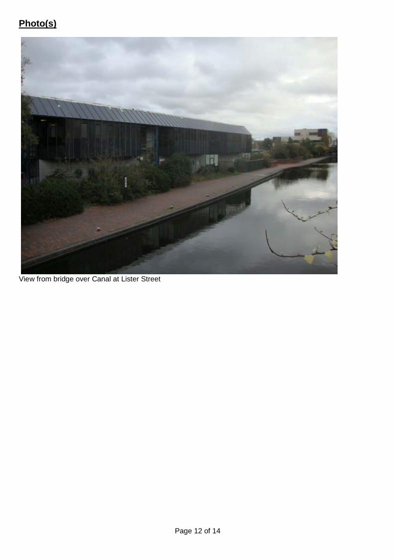
Page 12 of 14
Photo(s)
View from bridge over Canal at Lister Street

Page 13 of 14
View from pedestrian bridge looking north

Page 14 of 14
Location Plan
This map is reproduced from the Ordnance Survey Material with the permission of Ordnance Survey on behalf of the Controller of Her Majesty's Stationery Office © Crown Copyright. Unauthorised reproduction infringes Crown Copyright and may lead to prosecution or civil proceedings. Birmingham City Council. Licence No.100021326, 2010

Page 1 of 10
Committee Date: 04/02/2016 Application Number: 2015/09331/pa
Accepted: 11/11/2015 Application Type: Full Planning
Target Date: 10/02/2016
Ward: Nechells
Land adjacent to All-Weather Pitch, Aston University, Aston Street, Aston, Birmingham, B4 7EE
Erection of two storey student union building to include office, coffee shop, bar, prayer facilities, activity hall and meeting rooms Applicant: Aston University
Estates, Development and Facilities, Aston Street, Birmingham, B4 7EE
Agent: Robothams Architects The Old Library, 12 Church Street, Warwick, CV34 4AB
Recommendation Approve Subject To Conditions 1. Proposal 1.1. Consent is sought to erect a part single, part two storey building to form a students’
union which would include offices, coffee shop, bar/restaurant, prayer facilities and activity hall and would be located centrally within the campus between the all-weather pitch and the lake on a surface level car park. The existing students’ union located to the north of the campus no longer meets demand and will be demolished in 2017/18. Proposed Building Layout
1.2. The building would be accessed through a fully glazed portal framed entrance which would be north western facing towards Aston Student Villages. Upon entry there would be a double height atrium space and the ground floor would be made up of a Student Union shop, the necessary student union services including finance, job shop and student activities a social study/coffee lounge with associated kitchen and serving area. The double height entry space would contain a living tree. The ground floor layout would then continue through to two separate prayer facilities with capacity for 70 male and 70 females. Associated separate washing facilities are also included. Finally there is a double height activity hall proposed at the end of the ground floor which has been designed as a multi-function space with associated storage.
1.3. The first floor would be accessed via a centrally located steel staircase. The first
floor would be made up of a social study/games room and a social study/evening bar area which can be fully shuttered off as well as toilets. Towards the back of the building there are 5 meeting rooms of varying sizes and at the end there is the double height activity hall space from ground floor level. There is a first floor terrace

Page 2 of 10
proposed on the side elevation facing the lake which would provide shelter to the ground floor outdoor area.
1.4. A separate entrance is proposed allowing the ground floor service area to be locked
off at night allowing 24hour access to the prayer facility, hall and rooms above if required.
1.5. Plant rooms are proposed within the single storey element of the building with other
back of house functions. Further plant would be located on part of the single storey roof. There is an external bin storage area proposed on the south eastern (rear) elevation which would be screened by the two storey element of the building.
Design and Materials
1.6. The two storey building would be of a modern design, have a pitched roof and both
the roof and most of the elevations would be constructed of Rheinzink ‘Colour Line’ graphite grey standing seam cladding utilising 3 no. standard roll widths. The main building would be accessed through an almost fully glazed portal framed entrance with a Rheinzink strip located centrally on this principal elevation. An overhang feature is proposed with inset lighting and the underside material is to be confirmed. A revolving entrance door and polyester powder coated curtain walling with toughened glazing are proposed.
1.7. The single storey element of the building which is proposed between the two storey building and the all-weather pitch would have a flat roof and would be rendered in cream/off white with polyester powder coated windows with toughened glazing.
1.8. The side elevation facing the park would be pivoted centrally at 15.5 degrees and would be glazed almost entirely on both the ground and first floors. The windows would have a 115mm reveal and two of the windows would have feature surrounds. The windows would be polyester powder coated with toughened glazing in graphite grey. The external terrace would be made from silver finish external steel frame with structural glass balustrading. Half of the roof on this elevation would be used for solar panels. Inset guttering within the Rheinzink cladding is proposed with internal downpipes to this elevation.
1.9. The gable elevation facing Jennens Road would be constructed in Rheinzink and
would also contain a polyester powder coated door. A 2.7m high close boarded fence is proposed to the refuse and roof plant.
1.10. The rear elevation facing the all-weather pitch contains three ventilation turrets
within the roof which would not exceed the ridge height of the building.
Landscaping and external works
1.11. The tarmac paths would be extended at the building frontage and secondary entrance to join up with existing. Large concrete slabs are proposed for the external terrace which will be grassed between and a remodel of the existing mounded area is proposed. Adjacent to the hall the mound would also be remodelled to create a flat marquee zone (9m wide x 15m long) to be used when required. 5 new trees are proposed as well as shrub planting.
1.12. Deliveries and services are proposed at the back of the building and this area would act as a rear service yard.

Page 3 of 10
1.13. There are currently 12 full time and 8 part time members of staff and these numbers would remain unchanged.
1.14. The proposed hours of operation for the shop are 08:00 to 18:00 hours Monday to Friday and 10:00 to 17:00 hours Saturdays and Sundays, the restaurant 08:00-18:00 hours Monday to Friday, 10:00 to 17:00 hours Saturdays and Sundays and the pub 08:00 to midnight Monday to Friday, 08:00 to 03:00 Saturdays and Sundays. The assembly hall (use class D2) would operate 08:00 to 23:00 hours Monday to Friday and 10:00 to 17:00 hours Saturdays and Sundays.
1.15. The proposal would result in the loss of 78 car parking spaces (14 of which are disabled spaces). No car parking spaces are proposed. 5 cycle stands are proposed on the side elevation facing the park.
1.16. The internal floorspace created would be 2410sqm.
Link to Documents
2. Site & Surroundings 2.1. The application site is currently used as a surface level car park and is located
between and directly adjacent to the all-weather sports pitch and the pond within the Aston University campus. To the north east and west there are several university buildings as well as recently constructed student accommodation buildings on Aston Street and turning the corner onto James Watt Queensway. To the south Jennens Road is located.
2.2. Adjacent to the application site there is an extensively landscaped area with a network of paths linking the student accommodation to the educational buildings. The grade II listed Fire Station is located approximately 150m to the north west on Aston Street which also falls within the Steelhouse Conservation Area.
2.3. Location Plan 3. Planning History 3.1. No planning history relating to the application site however several applications
relating to developments within the Aston University Campus. 4. Consultation/PP Responses 4.1. Transportation Development – No objections.
4.2. Regulatory Services – No objections subject to conditions in relation to extraction
and odour control, land contamination, noise levels for plant and machinery and hours of operation.
4.3. West Midlands Police – Recommends that the works are carried out in compliance
with guidance contained within Secured by Design ‘Commercial 2015’, installation of CCTV, alarm and lighting and IT equipment secured to the fabric of the building where possible.
4.4. West Midlands Fire Service – No objections.
Page 4 of 10
4.5. Local Services – Object to the loss of 250sqm of Public Open Space (POS) and require a contribution of £10,000 which would be spent on the provision, improvement and or maintenance of Barrack Street POS in the Nechells Ward.
4.6. Lead Drainage Authority – No objections subject to condition in relation to
sustainable drainage assessment and maintenance plan.
4.7. Neighbours, Councillors, MP, Residents’ Associations consulted. Site and Press Notices posted. No comments received.
5. Policy Context 5.1. Birmingham UDP 2005; Submission Document of Birmingham Development Plan;
Places for All SPG 2001; Car Park Guidelines SPD 2012; Places for Worship SPD 2011; National Planning Policy Framework 2012.
6. Planning Considerations 6.1. One of the principles outlined in paragraph 3.8 of the UDP states that there is a
need to protect and enhance what is good in the City’s environment and to improve what is less good. Paragraph 3.10 of the UDP states that proposals that would have an adverse effect on the quality of the built environment will not normally be allowed.
6.2. Paragraph 56 of the NPPF states that the government attaches great importance to the design of the built environment and that good design is a key aspect of sustainable development, is indivisible from good planning, and should contribute positively to making places better for people.
6.3. Policy 3.51 of the UDP state that in the city centre open spaces make a particularly valuable contribution to the quality of the urban environment. Policy 3.52A states that proposals which would result in the loss of open space will only be permitted in exceptional circumstances and it is unlikely developers will be able to demonstrate that exceptional circumstance exist where the existing open space provision falls below the standard 2.0 ha per 1000 population and/or there would be a loss of land from the open space network.
6.4. Policy 74 of the NPPF states that existing open space should not be built on unless an assessment has been undertaken which has clearly shows the open space, buildings or land to be surplus to requirements; the loss resulting from the proposed development would be replaced by equivalent or better provision in terms of quality and quantity in a suitable location; the development is for alternative sports and recreational provision, the needs for which clearly outweigh the loss.
6.5. The Places of Worship SPD states that the preferential location for such facilities is
within designated centres, followed by the fringe of residential areas/on the fringe of a centre. The size of the facility is identified as an important factor in determining whether a location is appropriate (the SPD then goes on to split facilities into those serving local, constituency and city-wide needs).
6.6. The planning considerations relevant to the proposal are the principle, impact on
visual amenity and surrounding area and parking/highway safety. Principle - Loss of Open Space

Page 5 of 10
6.7. Both local and national policy clearly states that special circumstances should be demonstrated before the loss of public open space (POS) is considered. Local services have raised an objection to the loss of 250sqm of POS and require a contribution of £10,000 which would be spent on the provision, improvement and or maintenance of Barrack Street POS in the Nechells Ward. However it is noted that the area is not designated public/private open space and it is not heavily used by students or the general public. Furthermore the loss of 250sqm within a much wider area of open space is considered negligible in this instance. I also note that Barrack Street is totally unrelated to the application site therefore this would not comply with CIL requirements. On this basis I consider the principle of the loss of undesignated open space is justified and that no financial compensation is required. Principle - Place of Worship
6.8. The Places for Worship SPD supports religious uses in sustainable designated
centres within walking distance to the City Centre core. The site is not designated as industrial land and is currently used as a car park. Therefore the principle of a replacement place of worship is acceptable in this sustainable City Centre location. Design
6.9. The proposed siting of the building is located in the heart of the campus surrounded
by student accommodation and has clear visual links with key entry points from the city to the Aston campus and to the main building. The proposed scale and massing of the building is acceptable and responds to the surrounding context.
6.10. The proposed contemporary design would use predominantly Rheinzink cladding and polyester powder coated toughened glazing which are considered acceptable. The majority of the park frontage across the two floors would be glazed to maximise views in and out. The window articulation and feature surrounds (proposed on two of the windows facing the park) would add interest. Since the application’s submission the principal elevation containing the entrance has been simplified to remove external ATMs and digital signage which would detract from the architectural appearance of the building.
6.11. The proposed material for the underside of the overhang on the principal elevation
(yellow polyester powder panels) as proposed (with inset lighting) is not acceptable. A condition is recommended to secure a better quality contrasting material for the underside of the overhang. The proposed inset lighting is welcomed. Sample materials as a whole will be safeguarded by condition.
6.12. The proposed landscaping works and replacement trees are welcomed and further
details will be secured by condition. My tree officer raises no objection to the proposal. Overall I consider the proposed design, scale and massing to be acceptable. I therefore raise no design-based objections subject to suitable safeguarding conditions to ensure that design quality is maintained.
Impact on Surrounding Properties 6.13. The proposal would be located approximately 90m from Mary Sturge Halls of
Residences. There is a bar proposed at first floor level of the students union which would be open 08:00 to midnight Monday to Friday and 08:00 to 03:00 Saturdays and Sundays and I note there is an external terraced area. The main hall has been designed as a multi-function space and although this space is without a direct link to the bar, it could host a bottle bar when required. It also would have a link to the

Page 6 of 10
formal bar at first floor level. Externally a zone has been provided for a marquee and the intention is that this area could be linked to the multi-function space if required. On a day to day basis, other than specialist events the student’s union would be an alcohol free zone at ground floor level.
6.14. Regulatory Services raise no objections to the development subject to safeguarding conditions in relation to extraction and odour control, noise levels for plant and machinery and hours of operation. I do not consider noise and disturbance would be an issue as both the student union and halls of residence are within the same ownership and it would be in the management’s interest to ensure the students are safeguarded from any disturbance. I therefore consider the proposal would have no material adverse impact on surroundings properties in terms of noise and disturbance.
6.15. The prayer facility is unlikely to cause any noise and disturbance issues as the majority of comings and goings will be on foot and is a replacement facility.
6.16. The proposal would not cause any overlooking, loss of light or 45 degree code
issues. Prayer Facility
6.17. The existing daily prayer facility has provision for 45 males and 31 females. Friday prayers for females are restricted to 31 spaces and the main hall is used for a maximum of 334 no. males. Currently access is intended for students only, but there is no security or policing policy in place.
6.18. The new proposal would create integrated prayer and ablution facilities and a separate access is proposed which would allow 24 hour access to the facilities even when the main body of the building is closed. There would be provision for 45 females and 65 males for daily prayers. For Friday prayers the facility has been designed to be openable via a central wall to allow 110 females and the main hall would be used for 252 males. Access would be controlled via swipe card access.
Impact on highway safety
6.19. The proposed uses would not generate any additional car parking as the users of the student union/prayer facility would be students who either live or study within the campus. On this basis I consider the trips generated for the proposed uses would be linked and therefore would have no significant impact on parking or highway safety.
6.20. Drawings have been submitted to show that delivery vehicles would have sufficient space to enter, turn and egress on the site without conflicting with any pedestrian or vehicular movements.
6.21. Turning to the loss of car parking spaces the proposed building would be built on an
existing car park resulting in the loss of 78 car parking spaces, however 154 car parking spaces would be retained underneath the all-weather pitch. The car park which would be removed is used by visitors and key times for University parking are for open days (limited times of the year) and graduation (twice a year and mostly out of term time). Transportation Development raise no objection to the proposal and note that overall the campus has a wide level of car parking provision (660 spaces). I am therefore satisfied that the displaced parking can be adequately accommodated elsewhere on the University campus and I recommend a condition requiring details of displaced disabled car parking spaces.

Page 7 of 10
7. Conclusion 7.1. The proposed development would provide a new student union for Aston University
in the heart of the campus which is acceptable in principle, in terms of design and would have an acceptable impact on the surrounding area and highway safety subject to safeguarding conditions.
8. Recommendation 8.1. Approve subject to the following conditions: 1 Requires the prior submission of a Sustainable Drainage Assessment and Sustainable
Drainage Operation and Maintenance Plan
2 Extraction and Odour Control Details
3 Requires the prior submission of a contamination remediation scheme
4 Requires the prior submission of a contaminated land verification report
5 Limits the noise levels for Plant and Machinery
6 Requires the prior submission of sample materials
7 Requires details of the material to underside of the overhang
8 Requires the prior submission of hard and/or soft landscape details
9 Requires the prior submission of a CCTV scheme
10 Requires the scheme to be in accordance with the listed approved plans
11 Requires the prior submission of disabled car parking strategy
12 Limits the approval to 3 years (Full) Case Officer: Joanne McCallion

Page 8 of 10
Photo(s)
Figure 1 View towards Jennens Road
Figure 2 View towards student accommodation

Page 9 of 10
Figure 3 View towards all weather pitch

Page 10 of 10
Location Plan
This map is reproduced from the Ordnance Survey Material with the permission of Ordnance Survey on behalf of the Controller of Her Majesty's Stationery Office © Crown Copyright. Unauthorised reproduction infringes Crown Copyright and may lead to prosecution or civil proceedings. Birmingham City Council. Licence No.100021326, 2010

REPORT OF THE DIRECTOR OF PLANNING AND REGENERATION
PLANNING COMMITTEE 4 FEBRUARY 2016
GBSLEP – Delivering a more effective and consistent planning system
Introduction
The purpose of the report is to comment on suggestions put forward by the Greater Birmingham and Solihull Local Enterprise Partnership (GBSLEP).
Background and context
The Greater Birmingham and Solihull Local Enterprise Partnership (GBSLEP) have a working party comprising officers and Members of the member councils, and representatives from government bodies and the private sector who have discussed ways in which the LPA’s across the LEP could deliver a planning process which afforded a greater level of consistency of approach in delivering a more effective system.
Background Papers
Planning Guidance Note – Planning Conditions Planning Guidance Note – Member Involvement in the Planning Application Process Planning Guidance Note – The Pre-Application Process Planning Guidance Note – Planning Obligations Issues
The guidance note papers have been produced by sub groups within the development management working party of the GBSLEP, each with input from a range of the interested parties. This work has been shared with Lord Taylor of Goss Moor, who chaired the group that led to the introduction of the on-line National Planning Practice Guidance, who was supportive of the approach and commented that: “These guidance notes are an innovative collaboration between local authorities and the LEP to support better, quicker planning. ‘Joined up thinking’ is easy to say but too often not delivered in practice – but this approach helps deliver just that, with a best practice agenda in which both planners and developers are signing up to play their part. I thoroughly commend it.” It was hoped that this work could then be taken to the member councils for agreement and adoption. Whilst it is agreed that the general principles are sound, and well intentioned, I have some concerns over specific details, as follows: Planning Conditions The note sets out the statutory test for conditions, and the guidance on the proper use of planning conditions. It also advocates working with the applicant to minimise the number of required conditions through a robust initial submission, and setting an order of conditions. These are all sensible points, although the specific ordering of conditions on a decision document may be difficult to achieve in all

instances due to constraints of IT systems/automated standard condition numbering. I would therefore endorse this note, subject to noting that ordering of conditions could be challenging. Member Involvement in the Planning Process This is the paper that raises most issues for the City Council, as it departs from our normal practice which has evolved over many years to deliver the speed and efficiency that we currently deliver. The note refers to effective Member involvement helping them to better represent their constituents and enrich local democratic debate, but also advocates that Members should be involved in pre-application discussions. Whilst there are occasions when it is entirely appropriate for Members to be involved at this stage, we have taken a different view around involvement of Planning Committee Members and issues of pre-determination. Ward Members are notified of submitted planning applications, and appropriate lines of communication are maintained, and I would not, therefore, agree wholly with point 1. The note also advocates at least 4 training sessions per year for all Planning Committee members, and that these should ideally be facilitated by an outside body. In Birmingham, we have a Member code of conduct, supplemented by an additional planning code of conduct, which requires a minimum of 1 annual training session. This is a structured session covering essential matters, general context, specific requirements of Members and Officers and an update on policy and legislative changes. We also have bespoke additional subject specific training sessions (such as the viability training), and regular policy updates delivered at scheduled committee meetings. This delivers at least 4 sessions that could be described as training, and deals with emerging issues. In reality, it is likely to be more than 4 per year, usually delivered by in-house expertise, though not exclusively. Given the frequency of meetings (fortnightly), I believe that this is adequate, and that it would not be practical, effective or necessary to require more. I would not, therefore, agree wholly with point 2. Point 3 suggest that it would be appropriate for Members to undertake site visits to permitted developments to see their impact and use the knowledge to inform future decisions. This is agreed. Point 4 suggests that committees should consider introducing a “right to reply” whereby committee members have the ability to question the applicant or objector/supporter to clarify points they have raised. It is suggested that this can help to reduce the need to defer an application or avoid determinations based on a misunderstanding. I consider that the committee procedure in Birmingham has evolved into a streamlined process that successfully balances the proper debate around proposals with the need for timely efficient decision making, and would therefore not support this proposal. The paper also suggests that Members should be informed of updates to legislation, policy or case law. This is agreed, and forms part of our current procedures. Finally, this paper advocates that for larger schemes, applicants should engage with local Members prior to submitting a planning application. Whilst this may be appropriate, our current procedure for very significant schemes is to produce an early Issues Report, which ensures that committee Members are aware of the proposal and that they have an opportunity to comment prior to the application coming before them for determination. This ensures a consistent Member view from elected Members with an understanding of the planning considerations, and is a valuable input to the overall assessment of such proposals. I would endorse maintaining this current process. The Pre-Application Process This note sets out the benefits of early engagement, setting out the potential to improve the efficiency and effectiveness of the planning application system for all parties, and the likelihood of achieving improved outcomes. The paper is welcomed and agreed. Planning Obligations The note sets out when it is appropriate to enter in to a legal agreement, and that it is best to seek early agreement on Heads of Terms, and to simplify such agreements as much as possible. It also suggests that LPA’s within the LEP should consider some joint working to produce and maintain a
library of “standard” draft planning obligations. I welcome the note, and have no objection to “shared” practice provided that it met with the approval and agreement of our legal advisors. Recommendation
That this report be agreed, and the comment reported back to the GBSLEP working party
Financial Considerations
This would not result in work other than that already contained within the service area budget.
Other Considerations
None
Contact Officer
Richard Goulborn Head of Planning Management, Planning and Regeneration [email protected]
_______________________________
Waheed Nazir, Director of Planning and Regeneration

Planning Guidance Note
Planning Conditions
Policy Overview Government guidance on the use of planning conditions is contained within the National Planning Policy Framework (NPPF) and the Planning Practice Guidance. Paragraph 206 of the NPPF states planning conditions should only be imposed where they meet the following six tests:
1. necessary; 2. relevant to planning and; 3. to the development to be permitted; 4. enforceable; 5. precise and; 6. reasonable in all other respects.
The Benefits of Effective Planning Conditions If used properly, conditions can enhance the quality of development and enable development proposals to proceed where it would otherwise have been necessary to refuse planning permission, by mitigating the adverse effects of the development. Key Tasks for the Local Planning Authority to Ensure the Use of Effective Conditions
1. The following six tests are taken directly from the Government’s on-line Planning
Practice Guidance (www.planningguidance.communities.gov.uk/) and must be applied by the Local Authority in drawing up/approving conditions:
a. A condition must not be imposed unless there is a definite planning reason for it, i.e. it is needed to make the development acceptable in planning terms. If a condition is wider in scope than is necessary to achieve the desired objective it will fail the test of necessity.
b. A condition must not be used to control matters that are subject to specific
control elsewhere in planning legislation (for example, advertisement control, listed building consents, or tree preservation). Specific controls outside planning legislation may provide an alternative means of managing certain matters (for example, works on public highways often require highways’ consent).
c. It is not sufficient that a condition is related to planning objectives: it must also
be justified by the nature/impact of the development. A condition cannot be imposed to remedy a pre-existing problem or issue not created by the proposed development.

d. Unenforceable conditions include those for which it would, in practice, be impossible to detect a contravention or remedy any breach of the condition, or those concerned with matters over which the applicant has no control.
e. A condition should be written in a way that makes it clear to the applicant and others what must be done to comply with it. Poorly worded conditions are those that do not clearly state what is required and when, must not be used.
f. Conditions which place unjustifiable and disproportionate burdens on an applicant will fail the test of reasonableness. Unreasonable conditions cannot be used to make development that is unacceptable in planning terms acceptable.
2. Planning Officers should similarly question consultee requirements against the six tests
- and if they do not meet the tests they should be omitted or reworded.
3. At the pre-application stage there should be clear guidance regarding what information is required to ensure that the development can be implemented quickly and with the minimum of conditions.
4. Conditions that require the resubmission and approval of details that have already been
submitted as a part of the planning application are unlikely to pass the test of necessity and should not be applied. Prescriptive or compliance conditions should be preferred to restrictive conditions that require the submission and approval of further details.
5. The format, content and structure of conditions should be discussed during the
Application process and prior to the decision being made to minimise or avoid the use of restrictive and other conditions.
6. For clarity, the Decision Notice should set out conditions in the following order:-
I. Pre-commencement of development (thus allowing works, demolition etc.)
Contamination could be dealt with in this way. However, the condition may be structured for large schemes to enable development to be implemented in phases.
II. Pre-Commencement of Principal Supporting Infrastructure Details of drainage or highway works may typically fall within this section.
III. Pre-Commencement of Buildings and other Structures This could include details such as landscaping and external materials.
IV. Pre-Occupation of Building Details such as BREEAM compliance, travel plans etc.
V. Compliance Conditions, Post Completion This may include conditions that place restrictions on the occupancy of a building or the hours of use.

Planning Guidance Note
Member Involvement in the Planning Application Process
Policy/ Legislative Overview The 2011 Localism Act makes it clear that it is proper for councillors to play an active part in local discussions, and that they should not be liable to legal challenge as a result. The Benefits of Effective Member Involvement in the Planning Application Process The effective involvement of members in the planning application process helps them better represent their constituents and enrich local democratic debate. People can therefore elect their councillor confident in the knowledge that they will be able to act on the issues they care about and have campaigned on. With regard to pre-application discussions, Members bring their local knowledge and expertise, along with an understanding of community views. Involving councillors can therefore help identify issues early on and reduce the likelihood that issues come to light for the first time at committee that may slow down the determination of an application or lead to its refusal. The following key principles can help maximise the contribution that members can make to the planning application process Key Tasks for Local Planning Authorities 1. Planning Committee Members and the relevant ward members should be involved in
pre-application discussions for any proposal that is likely to be presented to the Planning Committee for determination. The level of involvement should ensure that members are fully aware of any such proposals and their comments can be taken into account when the application is being prepared.
2. There should be at least four training sessions per year for all planning committee
members to ensure that they are conversant with all relevant planning legislation, policies, case law and other relevant information. Training Sessions should ideally be facilitated by an outside body to ensure a fresh perspective is given on planning matters. This would also help ensure that interpretations of planning legislation and practice that are no longer up to date do not become entrenched. New members must receive training before they are able to sit on the planning committee. Such training could be organised on a regional wide basis to share costs and resources between the local planning authorities and ensure a level of consistency with the advice given.

3. Regular (for example, on an annual basis) site visits to recently permitted developments should be arranged for Planning Committee members and Officers to enable them to see first-hand their impact and then use this knowledge to inform future decisions. Such site visits do not necessarily need to be within their own particular authority area, particularly if there are examples of good, innovative development outside their area.
4. Planning Committees should consider introducing a ‘right to reply’ whereby
committee members have the ability to question the applicant or objector/ supporter to clarify points of fact that they have raised. This can help reduce the need to defer an application or avoid it being determined on the basis of a misunderstanding that could lead to future challenges or unnecessary appeals.
5. Planning Committee members should be issued with regular papers that update
them on any relevant changes in legislation, policy or case law. Again, this could be done on a region wide basis to share costs and resources between the local planning authorities and ensure consistent advice given.
Key Task for Applicants 1. When appropriate, for example on larger schemes or schemes that will be
determined by the Planning Committee, applicants should engage properly with local members prior to submitting a planning application. This will ensure that when the application is determined members are fully aware of the proposal and their comments have been taken into account when the application was prepared.
Planning Guidance Note
The Pre-Application Process
Policy Overview
Government policy within the National Planning Policy Framework (NPPF) states that Local Planning Authorities (LPA) should approach decision-making in a positive way, they should look for solutions and not problems and that they should encourage applicants to engage with them through voluntary pre-application discussions. This obligation also extends to statutory planning consultees.
What are the Benefits of an Effective Pre-Application Process?
Paragraph 188 of the NPPF states that:-
“Early engagement has significant potential to improve the efficiency and effectiveness of the planning application system for all parties. Good quality pre-application discussion enables better coordination between public and private resources and improved outcomes for the community.”
For the applicant / developer pre-application advice should enable the following:
1. To obtain as much information as possible about likely LPA requests such as technical requirements or Section 106 expectations and community issues. This is especially helpful in revealing potential costs and local concerns
2. To obtain an indication re whether a proposal is likely to be favourably received or not or whether there are extremely significant challenges to overcome. This is useful in aiding a developer to decide whether or not to continue to incur further costs on more supporting work and agent/ specialist fees. However the purpose of the Pre app process is not to (and cannot) pre judge an application
3. To establish a positive working relationship with the Local Planning Authority. 4. To help smaller builders/ developers avoid and resolve issues without the need for
access to specialist professional expertise.
For the LPA it has the following benefits:
1. It identifies issues early on in the process which the developer can then address to enable the formal application process to be a more positive and a simpler / quicker process.
2. It can help avoid conflict further down the line with applications which really should not have been pursued or could have been presented in a more acceptable form.
3. It can provide the LPA with an indication of the scale and type of developer interest in a particular site.

Key Tasks
In order to ensure that the pre-application process works as effectively as possible, applicants and the Local Planning Authority should adopt the following principles:-
Key Tasks for the Local Planning Authority
1. The planning application process should adopt a strong customer focus, where the client can expect a quality service. It should be welcoming – with an ‘open for business’ approach.
2. The pre-application procedure should form an essential and integral part of the ‘end to
end’ planning application ‘pipeline’ designed to save time and cut red tape.
3. Larger and more complex applications should have access to an Application Panel comprising consultees and specialist staff where the progress towards submitting an application is steered by the case officer. This could either be a bespoke session for a specific project or a monthly ‘speed dating’ (surgery type) session where developers are able to meet the panel, by appointment, to discuss their schemes.
4. LPA’s should encourage the use of Design Review Panels for sensitive schemes which
can improve the output of planning applications, raise standards and add value.
5. Planning Officers should be clear about the positive approach to pre-application engagement and be fully aware of the protocol for achieving a customer focus, with terms of reference to explain the purpose of a pre-application advice and what to expect.
6. LPA’s should provide a simple ‘information service’ on-line to provide easily accessible
help on procedures; and contact points for key consultees, local authority departments and Planning Aid.
Key Tasks for the Applicant
7. Applicants should make use of the pre-application process if they wish to expedite the decision making process, particularly for more complex planning applications.
8. Applicants should ensure that the maximum amount of information is submitted at the pre-application stage in order to ensure that the LPA can offer well informed advice.
9. Applicants should ensure that all advice given at the pre-application stage is reflected in
the resultant planning application and all necessary information is submitted to ensure that it can be validated and determined without the need for further information.

Planning Guidance Note
Planning Obligations
Policy Overview The National Planning Policy Framework states that planning obligations should only be used when it is not possible to address unacceptable impacts through a planning condition and they should only be used when all the following tests are met:-
• It is necessary to make the development acceptable in planning terms; • It is directly related to the development; and • It is fairly and reasonably related in scale and kind to the development.
The Benefits of Effective Planning Obligations A simple and effective approach to delivering planning obligations ensures that the momentum created by improving the front end of the planning application process is maintained through to the end of the process when the decision notice is issued. The following key principles help to ensure that this can be achieved. Key Tasks for the Local Planning Authority 1. Pre-application discussions should identify likely areas of contribution that will be
required, and explore the possibility of avoiding the need for a planning obligation by the use of compliance Conditions.
2. Following the conclusion of the 21 day consultation period or an agreed timescale and assuming there are no in-principle objections to the application, the planning officer should begin negotiations to agree the form and contents of the planning obligation in accordance with an agreed programme which includes a deadline for engrossment.
3. To reduce delays tripartite S106 Agreements should be avoided where possible. Instead,
the planning obligation should either be between the applicant and the local planning authority or completed by the applicant alone (a unilateral undertaking).
4. Local Planning Authorities within the Greater Birmingham and Solihull LEP should
consider working together to produce and maintain a library of ‘standard’ draft planning obligations. This should speed up the decision making process, ensure a consistent approach and save resources currently spent preparing new planning obligations for each individual planning application.
Key Tasks for the Applicant
1. The applicant should submit a draft planning obligation with the planning application or at the least detailed Heads of Terms identifying anticipated parties, contributions in name if not actual figures and trigger dates for payments together with an agreement that commits the applicant to paying the costs of preparing the obligation.