planning proposal 8 - cgrc.nsw.gov.au · this proposal seeks to introduce a new zone to the...
TRANSCRIPT
May 2018
Planning Proposal 8: Cootamundra Local Environmental Plan 2013 (Amendment No. 7)

2
3
Table of Contents Background ............................................................................................................................................. 4
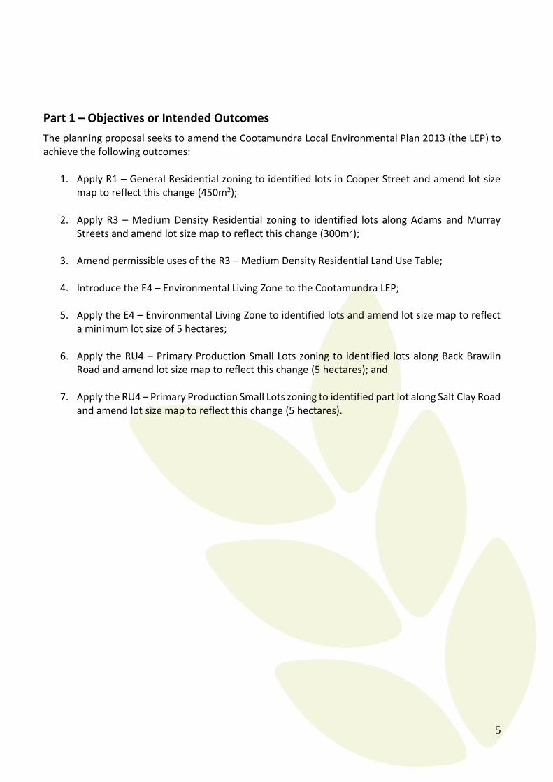
Part 1 – Objectives or Intended Outcomes .............................................................................................. 5
Part 2 – Explanations of Provisions ........................................................................................................ 6
Part 3 – Justification ................................................................................................................................ 9
Section A – Need for the Planning Proposal ....................................................................................... 9
Section B – Relationship to Strategic Planning Framework ............................................................. 15
Section C - Environmental, Social and Economic Impact ................................................................ 25
Section D - State and Commonwealth Interests ................................................................................ 25
Part 4 – Mapping ................................................................................................................................... 26
Part 5 – Community Consultation ......................................................................................................... 27
Part 6 – Project Timeline ....................................................................................................................... 27
Appendix A ........................................................................................................................................... 28
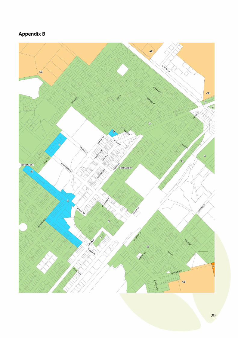
Appendix B ............................................................................................................................................ 29
Appendix C ............................................................................................................................................ 30
Appendix D ........................................................................................................................................... 31
Appendix E ............................................................................................................................................ 32
Appendix F ............................................................................................................................................ 33
Appendix G ........................................................................................................................................... 34
Appendix H ........................................................................................................................................... 35
Appendix I ............................................................................................................................................. 36
Appendix J ............................................................................................................................................. 37
Appendix K ........................................................................................................................................... 38
Table of Figures Figure 1: Map of CGRC. ........................................................................................................................................................ 4
Figure 2: Proposed area to be rezoned .................................................................................................................................... 6
Figure 3: Proposed area to be rezoned .................................................................................................................................... 6
Figure 4: Proposed area to be rezoned .................................................................................................................................... 7
Figure 5: Proposed area to be rezoned .................................................................................................................................... 8
Figure 6: Proposed area to be rezoned .................................................................................................................................... 8
Figure 7: Old Mitre 10 Site ................................................................................................................................................... 12
Figure 8: Corridor 37 is an example of a backdoor cafe in the R3 Zone currently operating in Cootamundra. ................... 13

4
Background
Former Cootamundra and Gundagai Shire Council merged to become Cootamundra-Gundagai Regional Council on 12 May 2016. The Council is required to create a single Local Environmental Plan (LEP) covering both former shires, however significant strategic planning work needs to be undertaken to ensure that the resulting LEP is measured and does not disadvantage areas. This is being addressed through strategic work Council is undertaking in the form of a Villages Strategy and a Rural Lands Strategy.
The Rural Lands Strategy in particular is a large and involved process which Council hopes to have finalised in early 2019. Once this work is finalised a new Cootamundra-Gundagai LEP will be created with the gazettal hopefully occurring no later than early 2020. As a new LEP is not likely to be endorsed for 24 months; Council is proposing a final, broad, planning proposal to address some long standing planning concerns and inconsistencies in the existing Cootamundra LEP.
Figure 1: Map of CGRC.
5
Part 1 – Objectives or Intended Outcomes
The planning proposal seeks to amend the Cootamundra Local Environmental Plan 2013 (the LEP) to achieve the following outcomes:
1. Apply R1 – General Residential zoning to identified lots in Cooper Street and amend lot size map to reflect this change (450m2);
2. Apply R3 – Medium Density Residential zoning to identified lots along Adams and Murray Streets and amend lot size map to reflect this change (300m2);
3. Amend permissible uses of the R3 – Medium Density Residential Land Use Table;
4. Introduce the E4 – Environmental Living Zone to the Cootamundra LEP;
5. Apply the E4 – Environmental Living Zone to identified lots and amend lot size map to reflect
a minimum lot size of 5 hectares;
6. Apply the RU4 – Primary Production Small Lots zoning to identified lots along Back Brawlin Road and amend lot size map to reflect this change (5 hectares); and
7. Apply the RU4 – Primary Production Small Lots zoning to identified part lot along Salt Clay Road
and amend lot size map to reflect this change (5 hectares).
6
Part 2 – Explanations of Provisions
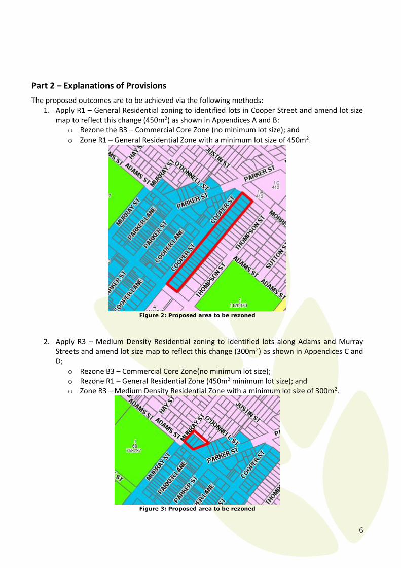
The proposed outcomes are to be achieved via the following methods: 1. Apply R1 – General Residential zoning to identified lots in Cooper Street and amend lot size
map to reflect this change (450m2) as shown in Appendices A and B: o Rezone the B3 – Commercial Core Zone (no minimum lot size); and o Zone R1 – General Residential Zone with a minimum lot size of 450m2.
Figure 2: Proposed area to be rezoned
2. Apply R3 – Medium Density Residential zoning to identified lots along Adams and Murray
Streets and amend lot size map to reflect this change (300m2) as shown in Appendices C and D;
o Rezone B3 – Commercial Core Zone(no minimum lot size); o Rezone R1 – General Residential Zone (450m2 minimum lot size); and o Zone R3 – Medium Density Residential Zone with a minimum lot size of 300m2.
Figure 3: Proposed area to be rezoned
7
3. Amend permissible uses of the R3 – Medium Density Residential Land Use Table as shown in
Appendix E: o Specify “restaurant or café” and “takeaway food and drink premises” under item 3
“Permitted with consent” in the R3 – Medium Density Residential Land Use Table.
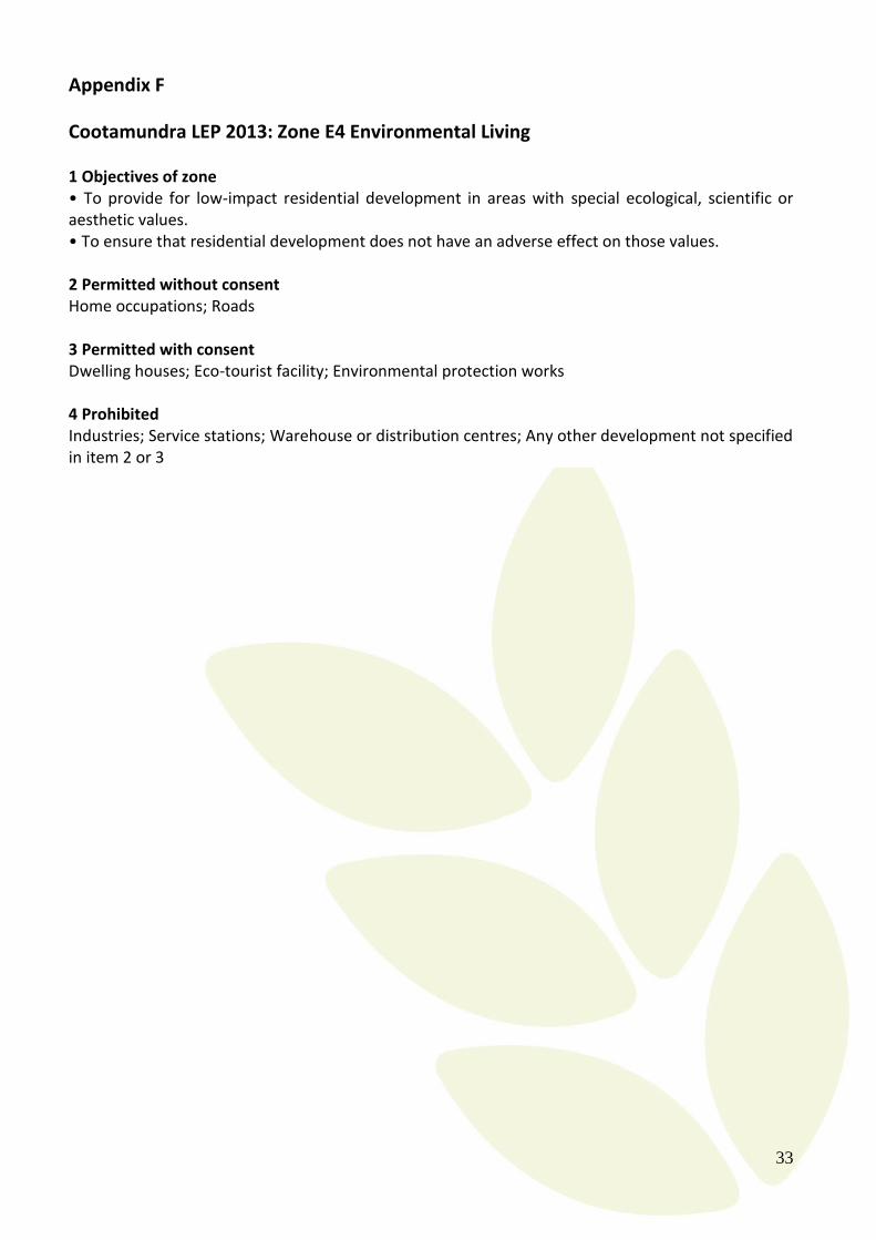
4. Introduce the E4 – Environmental Living Zone to the Cootamundra LEP as shown in Appendix F:
o Create and add the land use table for E4 – Environmental Living to the Cootamundra LEP.
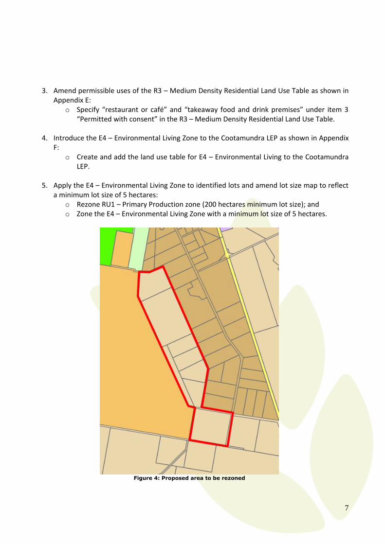
5. Apply the E4 – Environmental Living Zone to identified lots and amend lot size map to reflect a minimum lot size of 5 hectares:
o Rezone RU1 – Primary Production zone (200 hectares minimum lot size); and o Zone the E4 – Environmental Living Zone with a minimum lot size of 5 hectares.
Figure 4: Proposed area to be rezoned

8
6. Apply the RU4 – Primary Production Small Lots zoning to identified lots along Back Brawlin Road and amend lot size map to reflect this change (5 hectares).
o Rezone RU1 – Primary Production zone (200 hectares minimum lot size); and o Zone the RU4 – Primary Production Small Lots zone with a minimum lot size of 5
hectares.
Figure 5: Proposed area to be rezoned
7. Apply the RU4 – Primary Production Small Lots zoning to identified part lot along Salt Clay Road
and amend lot size map to reflect this change (5 hectares). o Rezone RU1 – Primary Production zone (200 hectares minimum lot size); and o Zone the RU4 – Primary Production Small Lots zone with a minimum lot size of 5
hectares.
Figure 6: Proposed area to be rezoned

9
Part 3 – Justification
Section A – Need for the Planning Proposal
Is the planning proposal the result of any strategic study or report?
This planning proposal has seven distinct objectives which result from varying circumstances:
1. Apply R1 – General Residential zoning to identified lots in Cooper Street and amend lot size map to reflect this change (450m2) This proposal results from a need to correct the extent of the Central Business District of Cootamundra. While the main street (Parker Street) serves the general retail and commercial needs of the Cootamundra Township, parallel streets such as Murray and Cooper Streets have been serving as a mixture of historic homes and professional offices. When the Cootamundra LEP was first investigated and adopted in 2013, Council was optimistic that professional offices were an expanding land use of Cootamundra. This has not eventuated and Council has been under significant pressure in recent years to allow for residential development (which is prohibited in the B3 – Commercial Core Zone) to occur, particularly along the eastern side of Cooper Street. Reducing the overall size of the central business district of Cootamundra is supported by the findings in the Planning & Environment’s Planning for the Future of Retail discussion paper April 2018, which found that clustered areas of commercial activity tend to generate higher returns and support the development of other new businesses and thereby reducing vacancy rates. Having a compact retail and commercial core in regional areas is particularly important with the changing face of retail from bricks and mortar premises to a more online marketplace. As this area is identified under the Cootamundra Heritage Conservation Area, R1 – General Residential Zone is assessed as being the best fit for this area. Existing land uses which include professional offices (of which there are less than five) would continue under existing use rights.
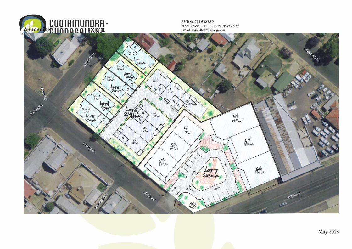
2. Apply R3 – Medium Density Residential zoning to identified lots along Adams and Murray Streets and amend lot size map to reflect this change (300m2) This proposal results from a specific development proposal which seeks to redevelop a disused centrally located site known colloquially as the “Old Mitre 10 Site.” A concept for redevelopment can be found in Appendix K. This proposal includes medium density housing, which is prohibited in the B3 - Commercial Core Zone. It is the intention of the developer to provide accessible housing within close proximity to services and amenities. Noting that a number of State Environmental Planning Policies such as the SEPP (Affordable Rental Housing) 2009 and SEPP (Housing for Seniors or People with a Disability) 2004 cannot be applied in Cootamundra, Council wishes to support the intent of these sorts of development whenever possible.
10
3. Amend permissible uses of the R3 – Medium Density Residential Land Use Table This proposal results from the adaptive reuse of a former nursing residence, located in the R3 – Medium Density Residential zone in Cootamundra. Current owners of the site have redeveloped the building as accommodation with an ancillary café. Noting that this is a flexible interpretation of “ancillary” (noting also that “ancillary” is not defined in the Standard Instrument) and the current objectives of the R3 Zone includes “To enable other land uses that provide facilities or services to meet the day to day needs of residents,” Council believe that it is a natural fit that “restaurant or café” and “takeaway food and drink premises” be permitted in the R3 Zone. “Restaurant or café” and “takeaway food and drink premises” are currently prohibited as “Commercial premises” are listed as a prohibited land use. This amendment would seek to leave “Commercial premises” as prohibited, but would take “restaurant or café” and “takeaway food and drink premises” and list specifically as permitted with consent.
4. Introduce the E4 – Environmental Living Zone to the Cootamundra LEP; This proposal seeks to introduce a new zone to the Cootamundra LEP 2013, being the E4 – Environmental Living zone. This zone is assessed as being required and appropriate particularly as a buffer between rural living areas and other environmentally sensitive areas. It is not the result of a report or strategic study. The Rural Lands Strategy which is currently being investigated by Council does not cover environmental zones. At the moment the E4 Zone would only be applied in accordance with the next item of this planning proposal.
5. Apply the E4 – Environmental Living Zone to identified lots and amend lot size map to reflect a minimum lot size of 5 hectares. The area identified is fragmented RU1 Land which does not adhere to the minimum lot size of 200 hectares and due to being land locked by other zones, will never be able to achieve the minimum lot size. This site was left as RU1 to provide a buffer between the emerging “rural living” precinct of Cootamundra and the E3 – Environmental Management area of Pioneer Park. This buffer has been problematic however as it has become essentially worthless agricultural land (multiple owners, none can achieve the minimum lot size) which is poorly managed and a haven for weeds and other pests. When assessing further subdivision of RU4 zoned land along Back Brawlin Road (rural living precinct) it became necessary to consider the future potential use of this identified area. Through discussions with land holders of the identified site and land managers for Pioneer Park, it became apparent that the best use of this land would be to have people take ownership of the site as a “home” rather than agricultural land which can produce no viable income. Additionally, acreage lots are much sought after in Cootamundra, however, there are limited areas which would encourage or allow people to undertake environmental protection works and have a dwelling. Because of this, E4 zoning has been assessed as being an appropriate method of better improvement land management in this area, providing additional housing blocks and providing variety of dwelling options for the Cootamundra community.
11
Access had been assured to this site through the existing unformed road reserves as well as creation of a road between Back Brawlin Road and this site through Lot 2 DP 583945 which has development consent for a 10 lot subdivision (DA2017/17).
6. Apply the RU4 – Primary Production Small Lots zoning to identified lots along Back Brawlin Road and amend lot size map to reflect this change (5 hectares).
In order to “clean up” and clearly define the boundary of “Cootamundra” it is proposed that the RU4 zone be extended to this site as the lots are already fragmented and below the minimum lot size, in separate ownership and they are configured in such a way which would form a logical end to what is becoming a sprawling rural living precinct. This proposal is not the result of a strategic study, it is the result of these specific land owners seeking a zone more appropriate to their intended and current use of the site. As previously stated, these lots are already below the minimum lot size of 200 hectares and the land uses pursued by the existing land holders are primarily lifestyle living or “rural living” and horse training. Encouragement of the horse training and agistment industry in Cootamundra is supported by Council whenever possible noting that the existing race course facilities are suffering from declining membership. The value of the horse training industry and associated facilities has been highlighted this year, with Cootamundra forfeiting the hosting of a number of races which have had to instead be held in Junee. The loss of the harness track facility has very much impacted the community. This loss compounds the loss of a number of other facilities such as the abattoirs last year and the downsizing of Cootamundra Oil Seeds late last year. Because of this, it is evaluated that this matter cannot be delayed until a new LEP can be implemented as it risks forgoing the establishment of private horse training facilities (as indicated by the land owners).
7. Apply the RU4 – Primary Production Small Lots zoning to identified part lot along Salt Clay
Road and amend lot size map to reflect this change (5 hectares).
Salt Clay Road is another “rural living” precinct on the periphery of Cootamundra. There is no intention to enlarge or augment this precinct, however an existing land holder wishes to consolidate their property with a neighbouring small parcel. The neighbouring parcel is a lot in two parts. The northern part, which is proposed to be isolated is zoned RU4 and achieves the minimum lots size of 5 hectares, however the southern part is zoned RU1, which has a minimum lot size of 200 hectares. This southern portion is approximately 7 hectares. Despite the intention to enlarge this southern portion, by consolidating with lot 3 DP259221, restrictions under SEPP (Rural Lands) 2008 mean that this is not possible due to the fact that the new lot would have a dwelling (on the existing RU4 parcel lot 3 DP 259221) and would not adhere to the minimum lot size (200 hectares). Subdivision is defined and applied under the SEPP (Rural Lands) 2008 to include not just creation of addition lot/s, but also boundary realignments and consolidation. This means that even actions which would create a better land use outcome such as a consolidation is not possible unless the consolidated lot achieved the minimum lot size.

12
Council has limited concern regarding the agricultural viability of the proposed part lot to be rezoned as it is marginal terrain which is steep, rocky and has shallow soils. Management of the site is better undertaken by onsite land holders to ensure that weeds and other pests to not germinate on this site and spread to other areas. This proposal would essentially “clean up” the dual zoning of this lot and allow for the increased size of a rural living holding.
Is the planning proposal the best means of achieving the objectives or intended outcomes, or is there a better way?
This planning proposal affords Council the opportunity to support local business growth and to clean up some anomalies in the LEP.
1. Apply R1 – General Residential zoning to identified lots in Cooper Street and amend lot size map to reflect this change (450m2) This proposed rezoning is the best means of allowing for greater flexibility of land use in this area. Currently, Cootamundra has a deficit of residential housing lots and an oversupply of commercial space. The proposed rezoning better reflects the existing land uses and will respect the heritage conservation value of the area.
2. Apply R3 – Medium Density Residential zoning to identified lots along Adams and Murray Streets and amend lot size map to reflect this change (300m2) This proposed rezoning is the result of a development concept to reuse and renew the former Mitre 10 Site (figure 7). This site has been vacant for a number of years and is located in the centre of Cootamundra. Often the site is overgrown and untidy, with Council receiving regular complaints about maintenance of the site. A development concept to turn the area of the site which faces Parker Street into an “urban square” with a visitor information centre, Services NSW office and other specialty stores has been proposed (see Appendix K). The rear of the site facing Murray Street is proposed to be a residential precinct catering for smaller units which would be accessible and designed for aging in place. The proposed rezoning to R3 – Medium Density Residential is the only way to achieve this residential precinct as residential accommodation (aside from shop top housing) is prohibited in the B3 – Commercial Core Zone.
Figure 7: Old Mitre 10 Site

13
3. Amend permissible uses of the R3 – Medium Density Residential Land Use Table This proposal is borne from the need to have a more inclusive and flexible R3 – Medium Density zone which allows for innovation and adaptive land use. This is particularly problematic when neighbouring shires allow for certain land uses and prospective residents and business owners decide to start up elsewhere. The proposal to include “restaurant or café” and “takeaway food and drink premises” in the R3 Zone is logical, with existing enterprises operating in Cootamundra already (see figure 8), either through existing use rights or liberal application of “ancillary use” provisions. Amending the land use table is the only method of allowing for “restaurant or café” and “takeaway food and drink premises” uses to occur in a clear legal manner in the residential area.
Figure 8: Corridor 37 is an example of a backdoor cafe in the R3 Zone currently operating in Cootamundra.
4. Introduce the E4 – Environmental Living Zone to the Cootamundra LEP The Cootamundra LEP currently uses the E3 – Environmental Management Zone in not only situations of conservation management, but also for existing rural living lots with scenic values in line with the objective “To protect, manage and restore areas with special ecological, scientific, cultural or aesthetic values.” With a minimum lot size of 200 hectares the E3 – Environmental Management Zone cannot be used to zone smaller parcels of land which require onsite management with a dwelling nor is it appropriate to apply it to marginal areas which would serve as a buffer between residential

14
development and E3 – Environmental Management land. The next item of this planning proposal outlines the need for the E4 – Environmental Living Zone to facilitate a transition from environmental land and residential land but also to serve as a buffer zone which would manage pests such as weeds and animals from either side. The only method of achieving this, is by introducing the E4 – Environmental Living Zone to the Cootamundra LEP.
5. Apply the E4 – Environmental Living Zone to identified lots and amend lot size map to reflect a minimum lot size of 5 hectares The proposed area to be rezoned is approximately 85 hectares, which is below the minimum lot size for the RU1 – Primary Production Zone (being 200 hectares). To further complicate the matter, this area is held by multiple owners and has become derelict land which is poorly maintained. To improve the situation, improve land quality, alleviate pressure for smaller lots close to town with a focus on amenity it is proposed that the E4 – Environmental Living Zone be applied to this site to improve land management and add variety to the housing market of Cootamundra (currently in deficit for housing lots). Rezoning now will allow for the subdivision process to commence rather than waiting until a new LEP is completed in 2020. Further to this, environmental land is not addressed in the Rural Lands Strategy and a specific outcome for this site would rely on a Cootamundra Town Strategic Plan/Strategy which is not likely to occur until 2021/22.
6. Apply the RU4 – Primary Production Small Lots zoning to identified lots along Back Brawlin Road and amend lot size map to reflect this change (5 hectares). This proposed rezoning results from specific application by the owners of this land to have a zone which better reflects the land uses they currently undertake and those which they wish to pursue. While Council is undertaking a Rural Lands Strategy, it is assessed that this rezoning is minor in nature and appropriately reflects the Cootamundra Interim Development Order’s boundaries which were not accurately applied to the Cootamundra LEP. This detrimentally affected some land holders. It is assessed that this rezoning is the best method of correcting this as well as demonstrating that Council is responsive to community input in the planning system, provided rational argument is put forward.
7. Apply the RU4 – Primary Production Small Lots zoning to identified part lot along Salt Clay Road and amend lot size map to reflect this change (5 hectares). This proposed rezoning is the result of a development proposal which seeks to consolidate an existing RU4 parcel and a part lot which is zoned RU1. This is assessed as a good land use outcome as the area currently zoned RU1 would actually increase in size. Despite this, not achieving the minimum lot size of the RU1 Zone of 200 hectares, means that SEPP (Rural Lands) 2008 would make this subdivision not permissible. Rezoning to RU4 Zone and applying a smaller minimum lot size is the only way for this lot to be consolidated.
15
Section B – Relationship to Strategic Planning Framework
Is the planning proposal consistent with the objectives and actions contained within the applicable regional or sub-regional strategy?
The regional Strategy for Cootamundra-Gundagai Regional Council is The Riverina-Murray Regional Plan 2036. This planning proposal directly supports a number of directions and priority actions identified in the Plan.
1. Apply R1 – General Residential zoning to identified lots in Cooper Street and amend lot size map to reflect this change (450m2). No specific directions are applicable to this proposal in the Riverina-Murray Regional Plan.
2. Apply R3 – Medium Density Residential zoning to identified lots along Adams and Murray Streets and amend lot size map to reflect this change (300m2). 25.2. Facilitate increased housing choice, including townhouses, villas and apartments in regional cities and locations close to existing services and jobs. The proposed redevelopment of the former Mitre 10 Site seeks to increase housing choice and availability particularly for those in Cootamundra requiring closer physical access to services and employment either due to mobility or life choice.
3. Amend permissible uses of the R3 – Medium Density Residential Land Use Table. No specific directions are applicable to this proposal in the Riverina-Murray Regional Plan.
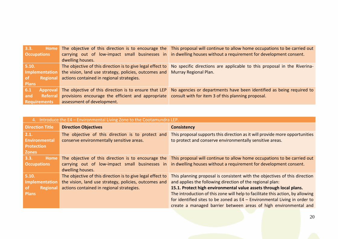
4. Introduce the E4 – Environmental Living Zone to the Cootamundra LEP. 15.1. Protect high environmental value assets through local plans. The introduction of this zone will help to facilitate this action, by allowing for identified sites to be zoned as E4 – Environmental Living in order to create a managed barrier between areas of high environmental and scenic value and residential or rural areas.
5. Apply the E4 – Environmental Living Zone to identified lots and amend lot size map to reflect a minimum lot size of 5 hectares. 15.1. Protect high environmental value assets through local plans. Applying the E4 – Environmental Living Zone in the proposed location between Pioneer Park and the rural living subdivision along Back Brawlin Road seeks to improve the amenity and environmental value of Pioneer Park which is not only an environmental reserve, but a popular walking spot for tourist and locals. 27.3. Manage land use conflict that can result from cumulative impacts of successive development decisions. This proposal would better manage the conflict between environmental and residential land.
16
6. Apply the RU4 – Primary Production Small Lots zoning to identified lots along Back Brawlin Road and amend lot size map to reflect this change (5 hectares). 27.3. Manage land use conflict that can result from cumulative impacts of successive development decisions. Development decisions and strategic thought applied under the Cootamundra Interim Development Order with regards to this land were not accurately applied when converted to the Cootamundra LEP. There is no subsequent strategic work which justifies this and as it only applies to this area, it is assessed by staff that this is an error. This proposal seeks to rectify this and is in keeping with this action from the regional plan.
7. Apply the RU4 – Primary Production Small Lots zoning to identified part lot along Salt Clay Road and amend lot size map to reflect this change (5 hectares). 27.3. Manage land use conflict that can result from cumulative impacts of successive development decisions. The subdivision of Salt Clay Road occurred in two phases. The first phase in the early 2000s saw a number of small lots (2 hectares or less) produced in a high amenity location. With the millennium drought, water supply was rethought and in this interim period (from development consent to subdivision certificate) this area was not able to be supplied with a water connection. As this development proposal seeks to consolidate allotments and increase size of a rural living lot, this can be viewed as helping to manage or correct development decisions which have become problematic due to changing conditions.
Is the planning proposal consistent with the local council’s local strategy, or other local strategic plan? For the most part, none of the proposed amendments to the Cootamundra LEP are the result of a strategic plan, but are the result of observed trends, corrections or development opportunities. As this proposal seeks to facilitate short term development, Council is supportive as it enhances the reputation of Cootamundra-Gundagai Regional Council as a Council which is responsive to the needs of the community, which facilitates and supports development whenever possible.
Is the planning proposal consistent with the applicable state environmental planning policies? The proposal has been assessed as being consistent with all applicable State Environmental Planning Policies in particular the State Environmental Planning Policy (Rural Lands) 2008, particularly clause 10 – matters to be considered in determining development applications for rural subdivisions or rural dwellings, for items 5-7 of this planning proposal.
May 2018
Is the planning proposal consistent with applicable Ministerial Directions (s117 directions)?
Relevant s117 directions that impact or are applicable to this planning proposal are listed below. The planning proposal is generally consistent with the relevant s117 directions.
1. Apply R1 – General Residential zoning to identified lots in Cooper Street and amend lot size map to reflect this change (450m2).
Direction Title Direction Objectives Consistency
1.1. Business & Industrial Zones
The objectives of this direction are to: (a) encourage employment growth in suitable locations, (b) protect employment land in business and industrial zones, and (c) support the viability of identified centres.
This proposal seeks to diminish the extent of the B3 Zone in Cootamundra. This is due to a high vacancy rate in the commercial core of Cootamundra and the need for more residential lots. As discussed above, creating a more compact CBD will improve the function and viability of existing businesses. In this way the objectives of this direction are supported.
2.3. Heritage Conservation
The objective of this direction is to conserve items, areas, objects and places of environmental heritage significance and indigenous heritage significance.
This proposal does not seek to remove or alter the HCA of Cootamundra, rather it seeks the best land use outcome to support the heritage values of the area whilst still encouraging development. Applying the R1 – General Residential Zone has been assessed as the best method of meeting the objectives of this direction.
3.1. Residential Zones
The objectives of this direction are: (a) to encourage a variety and choice of housing types to provide for existing and future housing needs, (b) to make efficient use of existing infrastructure and services and ensure that new housing has appropriate access to infrastructure and services, and (c) to minimise the impact of residential development on the environment and resource lands
This proposal is consistent with this direction as it seeks to broaden housing availability, utilising existing infrastructure and resources. All land is serviced and of a residential character. There are anticipated to be minimal land use conflicts with neighbouring zones (B3 Zone) should this rezoning occur.
3.3. Home Occupations
The objective of this direction is to encourage the carrying out of low-impact small businesses in
This proposal will allow home occupations to be carried out in dwelling houses without a requirement for development consent.

18
dwelling houses.
5.10. Implementation of Regional Plans
The objective of this direction is to give legal effect to the vision, land use strategy, policies, outcomes and actions contained in regional strategies.
No specific directions are applicable to this proposal in the Riverina-Murray Regional Plan.
6.1 Approval and Referral Requirements
The objective of this direction is to ensure that LEP provisions encourage the efficient and appropriate assessment of development.
The planning proposal is consistent with this direction. It is anticipated that should a Gateway Determination be issued in relation to item 1 of this proposal that a condition will be imposed to consult with:
Office of Environment & Heritage
2. Apply R3 – Medium Density Residential zoning to identified lots along Adams and Murray Streets and amend lot size map to reflect this change (300m2).
Direction Title Direction Objectives Consistency
1.1. Business & Industrial Zones
The objectives of this direction are to: (a) encourage employment growth in suitable locations, (b) protect employment land in business and industrial zones, and (c) support the viability of identified centres.
This proposal will diminish the existing extent of the B3 Zone in Cootamundra, however the site is vacant and has not been used for commercial purposes for a number of years. It is anticipated that allowing for residential development will actually support the viability and growth of the Cootamundra CBD.
3.1. Residential Zones
The objectives of this direction are: (a) to encourage a variety and choice of housing types to provide for existing and future housing needs, (b) to make efficient use of existing infrastructure and services and ensure that new housing has appropriate access to infrastructure and services, and (c) to minimise the impact of residential development on the environment and resource lands
This proposal is consistent with this direction as it seeks to broaden housing availability, utilising existing infrastructure and resources. All land is serviced and of a residential context. This proposal, being the result of a development concept can demonstrate that it seeks to provide a wider range of housing options and choices for Cootamundra – specifically affordable and accessible dwellings. There are anticipated to be minimal land use conflicts with neighbouring zones (B3 Zone) should this rezoning occur.

19
3.3. Home Occupations
The objective of this direction is to encourage the carrying out of low-impact small businesses in dwelling houses.
This proposal will allow home occupations to be carried out in dwelling houses without a requirement for development consent.
5.10. Implementation of Regional Plans
The objective of this direction is to give legal effect to the vision, land use strategy, policies, outcomes and actions contained in regional strategies.
This planning proposal is consistent with the objectives of this direction and applies the following direction of the regional plan: 25.2. Facilitate increased housing choice, including townhouses, villas and apartments in regional cities and locations close to existing services and jobs. The proposed redevelopment of the former Mitre 10 Site seeks to increase housing choice and availability particularly for those in Cootamundra requiring closer physical access to services and employment either due to mobility or life choice.
6.1 Approval and Referral Requirements
The objective of this direction is to ensure that LEP provisions encourage the efficient and appropriate assessment of development.
No agencies or departments have been identified as being required to consult with for item 2 of this planning proposal.
3. Amend permissible uses of the R3 – Medium Density Residential Land Use Table.
Direction Title Direction Objectives Consistency
3.1. Residential Zones
The objectives of this direction are: (a) to encourage a variety and choice of housing types to provide for existing and future housing needs, (b) to make efficient use of existing infrastructure and services and ensure that new housing has appropriate access to infrastructure and services, and (c) to minimise the impact of residential development on the environment and resource lands
This proposal seeks to support the amenity and function of the R3 Zone, by providing opportunities for development which compliments medium density living Overall, this proposal is consistent with the objectives of this direction or will not impact the function and application of these objectives.
20
3.3. Home Occupations
The objective of this direction is to encourage the carrying out of low-impact small businesses in dwelling houses.
This proposal will continue to allow home occupations to be carried out in dwelling houses without a requirement for development consent.
5.10. Implementation of Regional Plans
The objective of this direction is to give legal effect to the vision, land use strategy, policies, outcomes and actions contained in regional strategies.
No specific directions are applicable to this proposal in the Riverina-Murray Regional Plan.
6.1 Approval and Referral Requirements
The objective of this direction is to ensure that LEP provisions encourage the efficient and appropriate assessment of development.
No agencies or departments have been identified as being required to consult with for item 3 of this planning proposal.
4. Introduce the E4 – Environmental Living Zone to the Cootamundra LEP.
Direction Title Direction Objectives Consistency
2.1. Environmental Protection Zones
The objective of this direction is to protect and conserve environmentally sensitive areas.
This proposal supports this direction as it will provide more opportunities to protect and conserve environmentally sensitive areas.
3.3. Home Occupations
The objective of this direction is to encourage the carrying out of low-impact small businesses in dwelling houses.
This proposal will continue to allow home occupations to be carried out in dwelling houses without a requirement for development consent.
5.10. Implementation of Regional Plans
The objective of this direction is to give legal effect to the vision, land use strategy, policies, outcomes and actions contained in regional strategies.
This planning proposal is consistent with the objectives of this direction and applies the following direction of the regional plan: 15.1. Protect high environmental value assets through local plans. The introduction of this zone will help to facilitate this action, by allowing for identified sites to be zoned as E4 – Environmental Living in order to create a managed barrier between areas of high environmental and
21
scenic value and residential or rural areas.
6.1 Approval and Referral Requirements
The objective of this direction is to ensure that LEP provisions encourage the efficient and appropriate assessment of development.
No agencies or departments have been identified as being required to consult with for item 4 of this planning proposal.
5. Apply the E4 – Environmental Living Zone to identified lots and amend lot size map to reflect a minimum lot size of 5 hectares.
Direction Title Direction Objectives Consistency
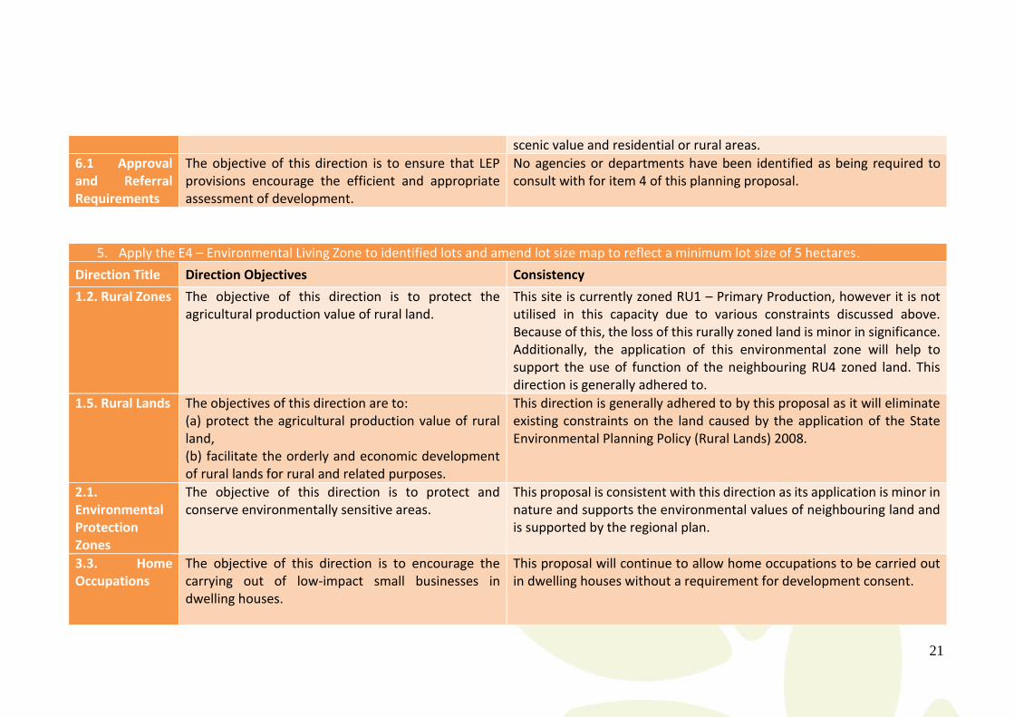
1.2. Rural Zones The objective of this direction is to protect the agricultural production value of rural land.
This site is currently zoned RU1 – Primary Production, however it is not utilised in this capacity due to various constraints discussed above. Because of this, the loss of this rurally zoned land is minor in significance. Additionally, the application of this environmental zone will help to support the use of function of the neighbouring RU4 zoned land. This direction is generally adhered to.
1.5. Rural Lands The objectives of this direction are to: (a) protect the agricultural production value of rural land, (b) facilitate the orderly and economic development of rural lands for rural and related purposes.
This direction is generally adhered to by this proposal as it will eliminate existing constraints on the land caused by the application of the State Environmental Planning Policy (Rural Lands) 2008.
2.1. Environmental Protection Zones
The objective of this direction is to protect and conserve environmentally sensitive areas.
This proposal is consistent with this direction as its application is minor in nature and supports the environmental values of neighbouring land and is supported by the regional plan.
3.3. Home Occupations
The objective of this direction is to encourage the carrying out of low-impact small businesses in dwelling houses.
This proposal will continue to allow home occupations to be carried out in dwelling houses without a requirement for development consent.

22
5.10. Implementation of Regional Plans
The objective of this direction is to give legal effect to the vision, land use strategy, policies, outcomes and actions contained in regional strategies.
This planning proposal is consistent with the objectives of this direction and applies the following directions of the regional plan: 15.1. Protect high environmental value assets through local plans. Applying the E4 – Environmental Living Zone in the proposed location between Pioneer Park and the rural living subdivision along Back Brawlin Road seeks to improve the amenity and environmental value of Pioneer Park which is not only an environmental reserve, but a popular walking spot for tourist and locals. 27.3. Manage land use conflict that can result from cumulative impacts of successive development decisions. This proposal would better manage the conflict between environmental and residential land.
6.1 Approval and Referral Requirements
The objective of this direction is to ensure that LEP provisions encourage the efficient and appropriate assessment of development.
The planning proposal is consistent with this direction. It is anticipated that should a Gateway Determination be issued in relation to item 5 of this proposal that a condition will be imposed to consult with:
Department of Primary Industries – Agriculture
6. Apply the RU4 – Primary Production Small Lots zoning to identified lots along Back Brawlin Road and amend lot size map to reflect this change (5 hectares).
Direction Title Direction Objectives Consistency
1.2. Rural Zones The objective of this direction is to protect the agricultural production value of rural land.
The rezoning of this site is considered constant with this direction as it is minor in significance and will be retaining the rural character of the area. Essentially it is changing one rural zone to another.
1.5. Rural Lands The objectives of this direction are to: (a) protect the agricultural production value of rural land,
This direction is generally adhered to by this proposal as it will eliminate existing constraints on the land caused by the application of the State Environmental Planning Policy (Rural Lands) 2008.
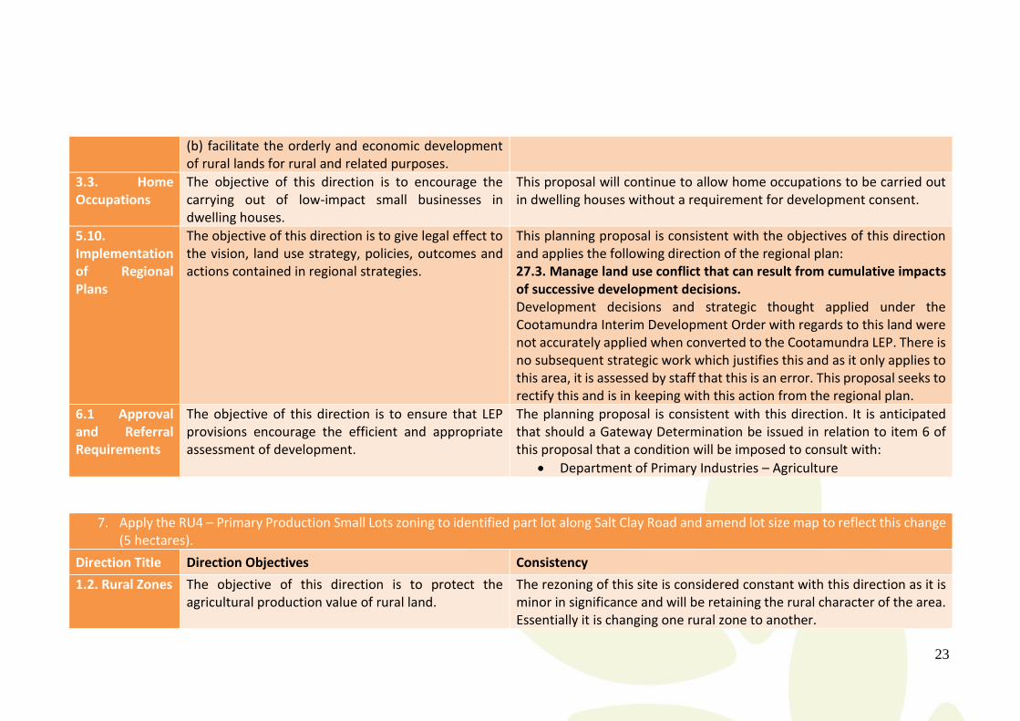
23
(b) facilitate the orderly and economic development of rural lands for rural and related purposes.
3.3. Home Occupations
The objective of this direction is to encourage the carrying out of low-impact small businesses in dwelling houses.
This proposal will continue to allow home occupations to be carried out in dwelling houses without a requirement for development consent.
5.10. Implementation of Regional Plans
The objective of this direction is to give legal effect to the vision, land use strategy, policies, outcomes and actions contained in regional strategies.
This planning proposal is consistent with the objectives of this direction and applies the following direction of the regional plan: 27.3. Manage land use conflict that can result from cumulative impacts of successive development decisions. Development decisions and strategic thought applied under the Cootamundra Interim Development Order with regards to this land were not accurately applied when converted to the Cootamundra LEP. There is no subsequent strategic work which justifies this and as it only applies to this area, it is assessed by staff that this is an error. This proposal seeks to rectify this and is in keeping with this action from the regional plan.
6.1 Approval and Referral Requirements
The objective of this direction is to ensure that LEP provisions encourage the efficient and appropriate assessment of development.
The planning proposal is consistent with this direction. It is anticipated that should a Gateway Determination be issued in relation to item 6 of this proposal that a condition will be imposed to consult with:
Department of Primary Industries – Agriculture
7. Apply the RU4 – Primary Production Small Lots zoning to identified part lot along Salt Clay Road and amend lot size map to reflect this change (5 hectares).
Direction Title Direction Objectives Consistency
1.2. Rural Zones The objective of this direction is to protect the agricultural production value of rural land.
The rezoning of this site is considered constant with this direction as it is minor in significance and will be retaining the rural character of the area. Essentially it is changing one rural zone to another.

24
1.5. Rural Lands This direction is generally adhered to by this proposal as it will eliminate existing constraints on the land caused by the application of the State Environmental Planning Policy (Rural Lands) 2008.
3.3. Home Occupations
The objective of this direction is to encourage the carrying out of low-impact small businesses in dwelling houses.
This proposal will continue to allow home occupations to be carried out in dwelling houses without a requirement for development consent.
5.10. Implementation of Regional Plans
The objective of this direction is to give legal effect to the vision, land use strategy, policies, outcomes and actions contained in regional strategies.
This planning proposal is consistent with the objectives of this direction and applies the following direction of the regional plan: 27.3. Manage land use conflict that can result from cumulative impacts of successive development decisions. The subdivision of Salt Clay Road occurred in two phases. The first phase in the early 2000s saw a number of small lots (2 hectares or less) produced in a high amenity location. With the millennium drought, water supply was rethought and in this interim period (from development consent to subdivision certificate) this area was not able to be supplied with a water connection. As this development proposal seeks to consolidate allotments and increase size of a rural living lot, this can be viewed as helping to manage or correct development decisions which have become problematic due to changing conditions.
6.1 Approval and Referral Requirements
The objective of this direction is to ensure that LEP provisions encourage the efficient and appropriate assessment of development.
The planning proposal is consistent with this direction. It is anticipated that should a Gateway Determination be issued in relation to item 7 of this proposal that a condition will be imposed to consult with:
Department of Primary Industries – Agriculture

May 2018
Section C - Environmental, Social and Economic Impact Is there any likelihood that critical habitat or threatened species, populations or ecological communities, or their habitats, will be adversely affected as a result of the proposal? No critical habitat or threatened species, populations or ecological communities, or their habitats have been identified at the sites of this planning proposal and it is expected that the impact of any development in line with this planning proposal will have a negligible impact on flora and fauna of these areas. Additionally any development would be subject to assessment and would address critical habitat or threatened species, populations or ecological communities, or their habitats.
Are there any other likely environmental effects as a result of the planning proposal and how are they proposed to be managed?
The planning proposal is largely administrative to improve the functionality and use of the Cootamundra LEP in the interim period before a combined Cootamundra-Gundagai LEP is created.
Zoning changes proposed are likely to have a negligible impact on existing environmental conditions as they are largely reflective of existing land uses and built form.
How has the planning proposal adequately addressed and social and economic effects?
The proposal will likely have a net positive impact and benefit to the economic and social aspects of the community of former Cootamundra Shire as it will clarify and simplify the application of certain aspects of the LEP and allows for greater flexibility and land use in Cootamundra in particular.
Section D - State and Commonwealth Interests Is there adequate public infrastructure for the planning proposal? There is adequate public infrastructure available to accommodate this planning proposal, in particular item 2 being the application of the R3 – Medium Density Residential zone.
What are the views of State and Commonwealth Public Authorities consulted in accordance with the gateway determination, and have they resulted in any variations to the planning proposal? No other consultation has been conducted with any other relevant State or Commonwealth Public Authorities. It is expected that should a Gateway Determination be issued for this proposal that authorities as outlined under Part 3, Section B of this document will be listed as authorities to refer and liaise with regarding this planning proposal.

26
Part 4 – Mapping
The Gundagai Local Environment Plan 2011 will need to be amended and expanded to incorporate the range of mapping changes proposed with this planning proposal. For ease of reference these mapping changes are grouped and addressed as per the intended outcomes of this planning proposal:
1. Apply R1 – General Residential zoning to identified lots in Cooper Street and amend lot size map to reflect this change (450m2)
o This requires amendment of the zoning map 5A (shown in appendix A) o This requires amendment of the lot size map 5A (shown in appendix B)
2. Apply R3 – Medium Density Residential zoning to identified lots along Adams and Murray Streets and amend lot size map to reflect this change (300m2)
o This requires amendment if the zoning map 5A (shown in appendix C) o This requires amendment of the lot size map 5A (shown in appendix D)
3. Amend permissible uses of the R3 – Medium Density Residential Land Use Table o No mapping required
4. Introduce the E4 – Environmental Living Zone to the Cootamundra LEP o No mapping required
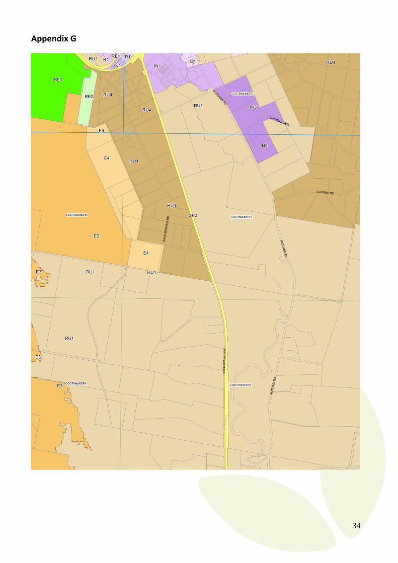
5. Apply the E4 – Environmental Living Zone to identified lots and amend lot size map to reflect a minimum lot size of 5 hectares
o This requires amendment if the zoning map 2A, 2 & 5 (appendix G) o This requires amendment of the lot size map 2A, 2 & 5 (appendix H)
6. Apply the RU4 – Primary Production Small Lots zoning to identified lots along Back Brawlin Road and amend lot size map to reflect this change (5 hectares)
o This requires amendment if the zoning map 5 (appendix G) o This requires amendment of the lot size map 5 (appendix H)
7. Apply the RU4 – Primary Production Small Lots zoning to identified part lot along Salt Clay Road and amend lot size map to reflect this change (5 hectares)
o This requires amendment if the zoning map 2A (appendix I) o This requires amendment of the lot size map 2A (appendix J)
In summary encompassing all changes proposed by this planning proposal the following maps will need to be amended in the Cootamundra LEP:
Land Zoning Map 2,
Land Zoning Map 2A,
Land Zoning Map 5,
Land Zoning Map 5A,
Lot Size Map 2,
Lot Size Map 2A,
Lot Size Map 5, and
Lot Size Map 5A.
27
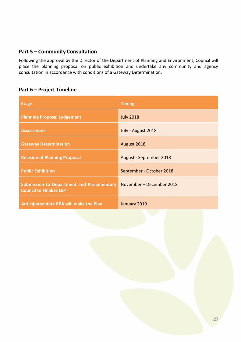
Part 5 – Community Consultation
Following the approval by the Director of the Department of Planning and Environment, Council will place the planning proposal on public exhibition and undertake any community and agency consultation in accordance with conditions of a Gateway Determination.
Part 6 – Project Timeline
Stage Timing
Planning Proposal Lodgement July 2018
Assessment July - August 2018
Gateway Determination August 2018
Revision of Planning Proposal August - September 2018
Public Exhibition September - October 2018
Submission to Department and Parliamentary Council to Finalise LEP
November – December 2018
Anticipated date RPA will make the Plan January 2019

May 2018
Appendix A
29
Appendix B

30
Appendix C

31
Appendix D

32
Appendix E
Cootamundra LEP 2013: Zone R3 Medium Density Residential 1 Objectives of zone • To provide for the housing needs of the community within a medium density residential environment. • To provide a variety of housing types within a medium density residential environment. • To enable other land uses that provide facilities or services to meet the day to day needs of residents. 2 Permitted without consent Home occupations 3 Permitted with consent Attached dwellings; Boarding houses; Business identification signs; Centre-based child care facilities; Community facilities; Group homes; Multi dwelling housing; Neighbourhood shops; Places of public worship; Respite day care centres; Restaurant or café; Roads; Seniors housing; Takeaway food and drink premises; Any other development not specified in item 2 or 4 4 Prohibited Agriculture; Air transport facilities; Airstrips; Amusement centres; Animal boarding or training establishments; Backpackers’ accommodation; Biosolids treatment facilities; Boat building and repair facilities; Boat launching ramps; Boat sheds; Camping grounds; Car parks; Caravan parks; Cemeteries; Charter and tourism boating facilities; Commercial premises; Correctional centres; Crematoria; Depots; Eco-tourist facilities; Emergency services facilities; Entertainment facilities; Environmental facilities; Exhibition villages; Extractive industries; Farm buildings; Farm stay accommodation; Forestry; Freight transport facilities; Function centres; Heavy industrial storage establishments; Helipads; Highway service centres; Home occupations (sex services); Hostels; Industrial retail outlets; Industrial training facilities; Industries; Information and education facilities; Jetties; Marinas; Mooring pens; Moorings; Mortuaries; Open cut mining; Passenger transport facilities; Public administration buildings; Recreation facilities (indoor); Recreation facilities (major); Recreation facilities (outdoor); Registered clubs; Research stations; Resource recovery facilities; Restricted premises; Rural industries; Rural workers’ dwellings; Service stations; Serviced apartments; Sewage treatment plants; Sex services premises; Signage; Storage premises; Truck depots; Vehicle body repair workshops; Vehicle repair stations; Veterinary hospitals; Warehouse or distribution centres; Waste disposal facilities; Water recreation structures; Water recycling facilities; Water supply systems; Wharf or boating facilities; Wholesale supplies
33
Appendix F
Cootamundra LEP 2013: Zone E4 Environmental Living 1 Objectives of zone • To provide for low-impact residential development in areas with special ecological, scientific or aesthetic values. • To ensure that residential development does not have an adverse effect on those values. 2 Permitted without consent Home occupations; Roads 3 Permitted with consent Dwelling houses; Eco-tourist facility; Environmental protection works 4 Prohibited Industries; Service stations; Warehouse or distribution centres; Any other development not specified in item 2 or 3
34
Appendix G

35
Appendix H

36
Appendix I

37
Appendix J
May 2018
Appendix K