planning scheme - dublin...planning scheme has placed emphasis on the achievement of a sustainable...
TRANSCRIPT

2012
Environmental Impacts and Mitigation Measures
50m0 N
“The Fields”Building Plots External Building Lines Protected Structures
Urban Form date: 120619
North Circular Road
Rathdown Road
Gra
ngeg
orm
an L
ower
Grangegorman Upper
Chur
ch S
tree
t C
onst
itut
ion
Hill
Broadstone
King’sInn
Phib
sborou
gh
Road
Western Way
Dominick Street
Manor Street
Morning Star Ave.
Fingal P
lace
Prussia Street
Manor Place
5 m
3 m
10 m
Innovative Urban Quarter | Contemporary Healthcare Facilities | Modern Education Hub | Accessible Public Spaces
9Planning Scheme Grangegorman

Chapter 9 | Page 2 Grangegorman Planning Scheme
9Environmental Impacts and Mitigation Measures
2012
50m
0
N
Protected Stru
ctures
Serpentin
e Walk
St. Brendan’s W
ay
Gateways
Two Hearts
Quadrangles
Sports Fields
Ha-Ha Level
Bus Connectio
n
Luas Connectio
n
Connections
Green Fingers
Key Elements
date: 101004
Chapter 9:Environmental Impacts and Mitigation Measures
Purpose and Layout of this ChapterThis Chapter summarises the environmental impacts of the Grangegorman Planning Scheme and proposed mitigation measures. The accompanying Environmental Report describes the Strategic Environmental Assessment (SEA) process carried out of the Planning Scheme. This Chapter summarises key findings of the Environmental Report in relation to environmental impacts and mitigation measures.
Contents
9.1 Impact of Grangegorman Planning Scheme on the Environment
9.1.1 Biodiversity, Flora and Fauna
9.1.2 Population and Human Health
9.1.3 Landscape
9.1.4 Air Quality
9.1.5 Climatic Factors
9.1.6 Cultural Heritage – Architecture
9.1.7 Cultural Heritage - Archaeological Heritage
9.1.8 Material Assets - Infrastructure
9.2 Mitigation Measures
9.2.1 Biodiversity, Flora and Fauna
9.2.2 Population and Human Health
9.2.3 Landscape
9.2.4 Air Quality
9.2.5 Climatic Factors
9.2.6 Cultural Heritage – Architecture
9.2.7 Cultural Heritage - Archaeological Heritage
9.2.8 Material Assets - Infrastructure
Table 9.1 Summary of Environmental Assessment of the Grangegorman Planning Scheme

Chapter 9 | Page 3 Grangegorman Planning Scheme
9Environmental Impacts and Mitigation Measures
2012
9.1 Impact of Grangegorman Planning Scheme on the EnvironmentThe critical elements of the environment, or environmental receptors, of particular importance for the redevelopment of the Grangegorman site are as follows: biodiversity, flora and fauna; population and human health; landscape; air quality; climatic factors; cultural heritage -architecture; cultural Heritage – archaeology; and material assets - infrastructure.
A description of how each of the environmental receptors will be impacted by the policies contained in the Grangegorman Planning Scheme is provided below.
9.1.1 Biodiversity, Flora and Fauna
The Grangegorman Planning Scheme will have an overall neutral to positive impact on biodiversity, flora and fauna in the Grangegorman SDZ site. In particular the removal of the invasive plant species identified on site, the appropriate disposal of the removed plant material and the high quality added landscape features will have a positive impact. The new urban Quarter will incorporate a variety of landscaped gardens with an emphasis on the use of native species which will also have positive impacts on the biodiversity, flora and fauna on site.
Grangegorman Development Agency has carried out a comprehensive bat survey. Despite the site’s apparent favourability for bats, only a single species, pipistrelle Pipistrellus pipistrellus, was observed within the study area and this was in low numbers.
As all bat species in Ireland are protected under both national legislation – (Wildlife Act, 1976, as amended in 2000) and European legislation – (Habitats Directive (92/43/EEC)) and should time elapse from the bat survey undertaken to construction commencing on site, the GDA consider it important that further assessment of impacted buildings identified as having potential to harbour bats will be undertaken immediately prior to works. This is to safeguard any animals which may colonise structures in the interim.
9.1.2 Population and Human Health
The Grangegorman Planning Scheme provides for the redevelopment and opening up of the Grangegorman site. It will also result in a significant regeneration of the surrounding area which will provide a substantial boost to the socio-economic status and quality of life for the local residents. The regeneration provides for an unprecedented volume of health and educational facilities to service a local, regional, national and international population. There will also be significant community facilities, sports facilities, public open space, a library and a school which will improve the overall quality of life for the local residents as well as the future student population. As a result the Grangegorman Planning Scheme will have an overall positive impact on population and human health.
9.1.3 Landscape
The Grangegorman Planning Scheme will have an overall neutral to positive impact on the natural and historic landscape features within Grangegorman. It will result in the transformation of Grangegorman’s closed compound into a new urban quarter which will form an integral part of the City. The project provides an opportunity to maximise the existing natural and architectural landscape features into a new urban landscape and this has been utilised within the Grangegorman Planning Scheme with proposals to provide the highest standards in urban design and landscaping. Included are proposals to articulate the historical, social, urban and architectural values of Grangegorman and to ensure that they are suitably incorporated into the overall development. There will be a transitory negative impact during the construction and initial operation phase which will be short-lived as the urban quarter emerges.
9.1.4 Air Quality
The main impact on air quality as a result of the implementation of the Grangegorman Planning Scheme relates to transport and the Planning Scheme will have an overall neutral to positive impact on air. The Grangegorman Planning Scheme has placed emphasis on the achievement of a sustainable transport system. The implementation of the Planning Scheme will inevitably result in emissions to air in the local area as a result of developing a medium density scheme at a location which is currently occupied at an extremely low density. However the Planning Scheme contains proposals which support the use of public transport,
together with facilitating and promoting walking and cycling. In addition, the opening (and potential opening) of new entrances in the perimeter wall will facilitate pedestrian movements traversing the site which would previously have required the use of a motor vehicle to travel around the site. The level of car parking to be provided on site will be curtailed to ensure that it does not encourage a reliance on the private car by certain individuals using the site.
9.1.5 Climatic Factors
The Grangegorman Planning Scheme places a strong emphasis on sustainability and in particular sustainable energy production within the Grangegorman quarter. This will have an overall neutral to positive impact on climatic factors as much of the energy to be required is currently being consumed in a less efficient manner on the current DIT and HSE sites spread across the city. The provision of public transport should also result in positive impacts with respect to climatic factors.
9.1.6 Cultural Heritage – Architecture
It is expected that the project will have an overall neutral to positive impact on the architectural heritage of Grangegorman. While there will be a requirement to demolish some structures on site to facilitate the development, this will be limited to structures which have not been designated for protection.
Structures to be removed fall into two broad categories, i.e. those that have some architectural merit or historical significance (but are not on the record of Protected Structures) and all the remaining structures (not protected) that do not have such merit and are relatively commonplace and undistinguished. Guidelines on matters such as drawn or photographic recording, and possible reuse of elements of materials are set out where appropriate.
Many of the important structures on site have fallen into a poor state of repair and would deteriorate further should the current situation continue. The Grangegorman Planning Scheme will result in the preservation and reuse of these buildings and the restoration of architecturally important features.

Chapter 9 | Page 4 Grangegorman Planning Scheme
9Environmental Impacts and Mitigation Measures
2012
While the overall impact is likely to be neutral to positive there exists an element of uncertainty with respect to the impact of buildings which have yet to be designed, on the architectural heritage of protected structures. For example the Planning Scheme contains proposals for most buildings to be between 4-6.5 stories, suited for their intended use, and a number of taller (‘mid-rise’) buildings are proposed in line with the provisions of the Dublin City Development Plan 2011-2017.
Although individual buildings have not yet been designed, their external building lines and maximum and minimum heights have been determined in this Planning Scheme. Careful attention has been paid to building height in the vicinity of protected structures. Any new development will be guided by principles set out in the Planning Scheme.
9.1.7 Cultural Heritage - Archaeological Heritage
The redevelopment of a historical site such as Grangegorman, which has been relatively undisturbed in recent times, is likely to result in some impacts on any previously undiscovered archaeological remains that may be on site. However the Grangegorman Planning Scheme contains policy to establish and articulate the historical, social, urban and architectural values of Grangegorman and this will require that all archaeological remains found on the site during the redevelopment will be appropriately dealt with.
The overall impact of the development on any potential archaeology on site will be generally neutral. Notwithstanding the carrying out of exploratory investigations, knowledge of the archaeology on site will only be evident when works commence.
9.1.8 Material Assets - Infrastructure
The Grangegorman Planning Scheme supports the provision of infrastructure which will support development in this area of the city. The provision of a separate storm water sewer as originally proposed in the Strategic Plan, and now the Planning Scheme, will be of particular significance as it will result in the removal of a substantial volume of surface water from the sewer network reducing pressure on wastewater treatment facilities for the city area. Conservation of water is a strong theme through the scheme encouraging the reuse, recycling and conservation of water.

Chapter 9 | Page 5 Grangegorman Planning Scheme
9Environmental Impacts and Mitigation Measures
2012
9.2 Mitigation MeasuresThe following mitigation measures will be carried out as part of the Grangegorman Development Agency Planning Scheme:
9.2.1 Biodiversity, Flora and Fauna
Re-surveys of habitats, flora and fauna shall be undertaken, as considered necessary, prior to redevelopment works, possibly at the planning application stage, in order to ensure that an up-to-date record of the ecological environment is maintained.
Implementation of the Grangegorman Planning Scheme will result in the removal of invasive plant species including Giant Hogweed and Japanese Knotweed. These highly invasive alien species are of no ecological value. The plant material removed will be disposed of in such a manner so as to ensure that these species are not spread to other locations.
The baseline study on Biodiversity, Flora and Fauna identified the need for information on bats located in the Grangegorman site. Despite the site’s apparent favourability for bats, a comprehensive bat survey undertaken in July 2009 identified only a single species, pipistrelle Pipistrellus pipistrellus, which was observed within the study area in low numbers. The GDA will undertake annual surveys of the SDZ lands to identify habitats of protected species and in particular bats, and minimise interference with these habitats. For key buildings that are particularly suitable for bat roosting, applications for works to these will include a recent bat survey. The results of these surveys will be included in the annual monitoring report as part of the implementation of the SEA.
However, should time elapse from the bat survey undertaken to construction commencing on site, the Grangegorman Development Agency considers it important that further assessment of impacted buildings identified as having potential to harbour bats will be undertaken immediately prior to works. This is to safeguard any animals which may colonise structures in the interim.
As part of the statutory planning process, the Grangegorman Development Agency will cooperate with Dublin City Council in the implementation of their Biodiversity Action Plan 2008-2012.
The landscaping plan will provide planting, predominantly with native plant species which would in turn attract a variety of native bird and animal species. Landscape materials will be based on retaining existing significant plantings where possible, augmented by the use of native species. Many of the mature trees on the site are to be retained, with the exception of those which must be removed to facilitate key structuring principles and urban form or which are physically unsound. Existing parkland with playing pitches will be substantially retained and enhanced, to become the main green lung of the new quarter.
On a site as sparsely developed as Grangegorman, any development will have impact on the existing biodiversity. The overall development benefit is however considered to be a net positive impact as a result of the implementation of the Planning Scheme. The Grangegorman Planning Scheme contains specific proposals for the retention of existing significant plantings where possible, augmented by the use of native species.
y The existing parkland with playing pitches will be substantially retained and enhanced, to become the main green lung of the new quarter, characterised by a park-like feel, rather than a simple collection of playing pitches;
y The overall Green Fingers landscape will link the site with the immediate community, as well as Dublin’s greater urban context, planted with native species and existing large trees will be integrated into them;
y The eastern portion of Serpentine Walk will be a heavily planted, tree-lined route between mixed use and student residential development to allow for privacy of those living and working along this portion of the route;
y Lighting will strive to deliver the following key objectives:
y Create a district that is lively and well used both day and night;
y Provide a safe, secure and accessible environment for pedestrians and other users;
y Avoid disruptive glare, sky glow and lighting overspill;
y The lighting design will be closely integrated with the design of the landscape and urban spaces to create a clear and legible hierarchy of light levels and effects;
y Energy efficient fittings will be utilised.

Chapter 9 | Page 6 Grangegorman Planning Scheme
9Environmental Impacts and Mitigation Measures
2012
y Secondary pedestrian routes such as the Green Fingers and other connecting paths will require adequate lighting for safety, but no strong pattern of lights is desired; and
y Carefully designed focused lighting, including flood lighting, will be required to support outdoor sports activities.
9.2.2 Population and Human Health
Any negative impacts on population and human health identified in the baseline study relate primarily to the rapid influx of a large number of students to a previously, almost vacant site. However there are predominant positive impacts associated with the development of the education, health, commercial and community facilities on the Grangegorman Quarter which significantly improves both the socio-economic standing and the quality of life for the local population and for the wider national community. As such it is considered that these are sufficient to mitigate any negative impacts on the local population as a result of the increase in activity in the general Grangegorman Area.
The Grangegorman Planning Scheme contains a broad range of proposals which will improve population and human health indicators in the area. These include proposals to provide for a primary school, public library, open access to parks and public open spaces, access to DIT indoor and outdoor sports facilities, access to education and health services as well as opportunities for complementary commercial businesses and employment opportunities.
In order to mitigate any potential negative impacts on the local population, consultation will continue throughout the lifetime of the redevelopment process and will result in the identification and mitigation of any negative impacts on the local population as issues arise.
9.2.3 Landscape
The baseline study identified the threats to the landscape as those which would be typically associated with any new development within a historic landscape. The key concerns relate to the visual impact, overshadowing, loss of character, impact on scenic amenity, loss of existing structures and sections of the boundary wall.
The Grangegorman Planning Scheme contains a number of proposals providing for the conservation of the historical landscape of the Quarter including the following:
y A limit on development quantum (regardless of the theoretical capacity of any enhanced transportation infrastructure), with the remainder of development quantum dependent on access and public transport upgrades;
y Only sports/recreational buildings of single storey pavillion design will be allowed in the Fields;
y Protected Structures will be retained and integrated within the overall development of the site;
y View corridors through the site to connect the site to the surrounding natural and urban environment and focus views on prominent surrounding landmarks and natural features (the corridors also help to break down the scale of the overall development and to integrate the site into the existing urban fabric);
y Materials will be inspired by precedents of historical buildings in the City, being durable, of good appearance over time and which will contribute to the general appearance of the campus;
y To plan and design for the multitude of streetscape elements, including signage, public art, furniture, receptacles and other such devices used by people in their everyday lives, and to organise and locate these items in a clear, coherent and rational way that will facilitate an appropriate level of public access throughout the site (Dublin City Council’s pedestrian wayfinding system, current Development Plan policies on culture, consultation with Dublin City Council’s Arts Office);
y To integrate the historic structures of significance within the Grangegorman Development Agency Planning Scheme in a manner which ensures that they contribute to the generation of spaces and places-both in terms of physical layout and character;
y To identify opportunities where history in-built and memory-form can influence design in a way which enhances sense of place and, in so doing, enables distinctiveness of place and identity; and
y A Landscape and Visual Appraisal has been prepared as part of Grangegorman Planning Scheme In keeping with the Landscape and Visual Appraisal, a set of criteria has been developed in the Planning Scheme to mitigate against serious negative visual impacts. These may include
y Setback floors
y Rooftop plant may be inappropriate;
y Particular attention may be required to building articulation and surface material selection;
y Particular attention may be required to placement and orientation of windows to mitigate against overlooking;
y Particular attention may be required to landscaping measures.
9.2.4 Air Quality
The impact on air quality arising from the Grangegorman Planning Scheme relates to transport and the potential increased traffic generation as a result of the implementation of the Planning Scheme. The Planning Scheme facilitates sustainable transport modes and the use of walking, cycling and public transport for trips to and from the site and internally within the Grangegorman site.
The Grangegorman Planning Scheme makes provision for a limited volume of car parking within the site (1,150 No. car parking) provided mainly underground/undercroft (with limited provision for surface parking). In order to minimise any negative impacts as a result of an increase in traffic in the area the Grangegorman Development Agency has limit the development quantum as follows:
y c. 238,000 sq m of core HSE, DIT, community and ancillary elements can be supported by the existing transport infrastructure (subject to improved access and some upgrades to existing transport infrastructure as outlined in the Planning Scheme); and
y c. 380,000 sq m is the quantum consistent with the design philosophy of the Planning Scheme and is developable as additional public transport capacity becomes available. This figure is regardless of whether a higher theoretical quantum could be sustained by additional public transport capacity. This proposed staging allows for development of the most critical elements initially, while providing for appropriate expansion in due course, so that the overall development can capitalise on its strategic location in terms of proximity to the city and proposed public transport investments.
A public transport facility will be permitted at Broadstone Gate. With the introduction of Luas onto the Broadstone Station site, some displacement of existing adjoining bus

Chapter 9 | Page 7 Grangegorman Planning Scheme
9Environmental Impacts and Mitigation Measures
2012
operations may be necessary, in particular bus parking/servicing and bus turning. In addition, the Grangegorman Planning Scheme undertakes to promote the provision of and access to sustainable modes of transport including public transport. These proposals include inter-alia the following:
y The opportunity to create a gateway through Broadstone, opening up the new quarter to this part of the community and linking with the City Centre;
y Grangegorman Upper and Lower bisecting the site will be the only available through-route for external traffic, traffic-calmed by means of a shared surface sections and landscaped.
y Service access to the site will be controlled by means of control points with service vehicles to be allowed to transit from one side of the site to the other during restricted service access hours, depending on internal and external traffic conditions.
9.2.5 Climatic Factors
Heat and energy demands are expected to be the primary sources of greenhouse gas emissions associated with the implementation of the Grangegorman Planning Scheme and the redevelopment of the Grangegorman Quarter. In order to minimise electrical energy associated with lighting and give building users sufficient access to daylight in order to enhance their experience, the design of the building footprints, heights and layouts will be developed to allow maximum daylight to enter buildings, minimise overshadowing of each other, of existing neighbouring buildings, and of landscaped areas, as well as to ameliorate existing wind conditions on site. In addition, the use of sustainable energy will be promoted and the built environment will be used as a key learning tool to promote sustainable objectives.
The following proposals are highlighted:
y Important social gathering spaces are orientated to take advantage of southern light and warmth, generally open to the south to prevent the overshadowing of exterior landscaped space by buildings;
y Buildings will be principally located on the northern portion of the site, positioned to take advantage of natural daylight thereby reducing the need for artificial light and allowing the
existing open space to the south to remain an appropriate landscaped space;
y Building widths will be predominantly narrow to assist the penetration of natural light into the interior spaces;
y The Grangegorman Development Agency has introduced specific proposals with the objective of reducing the emissions associated with energy production and include the following:
y Buildings will be predominately naturally ventilated (unless activity requirements of the building dictate otherwise) and will incorporate the flexibility for future conversion of air-conditioned/mechanically ventilated buildings to a natural ventilation strategy;
y Building will be designed to ensure that both NOx emissions are minimised and flue/ exhausts effectively dissipated.
y Materials associated with the construction process will have a low embodied carbon content and will be obtained from sustainable sources, with efforts to secure locally to minimise transportation impacts.
y Buildings will be designed to minimise the CO2 emissions associated with their operational energy consumption over their lifetime, with a view to moving towards carbon neutral status.

Chapter 9 | Page 8 Grangegorman Planning Scheme
9Environmental Impacts and Mitigation Measures
2012
9.2.6 Cultural Heritage – Architecture
The Grangegorman Development Agency is to establish strategies for repair, intervention, adaption and extension to the protected structures and this shall include a detailed conservation plan or strategy. These will include both general and specific strategies and will also include approaches and objectives for upgrading of protected structures for increased thermal efficiency and other initiatives to achieve objectives for greater energy efficiency and sustainable development. It will further provide proposals for the retention, restoration and enhancement of features of architectural merit within the new quarter at Grangegorman.
Implementing the Grangegorman Planning Scheme will require the demolition of some structures within the Grangegorman site; this will however be limited to structures which have not been designated for protection within the Dublin City Council Development Plan 2011-17. Negative impact on the architectural heritage will be compensated for by the positive impacts on the remaining structures. Design Briefs for all building projects within the Planning Scheme area will direct design teams to have regard to existing architectural heritage assessment and research.
The Grangegorman Planning Scheme incorporates proposals which will promote the conservation and restoration of the architectural heritage on the site. These proposals will also include a requirement for the appropriate reuse of these structures and include the following:
y A condition survey of the existing structure should accompany any planning application for the re-use and development of the buildings to be retained.
y Submitted design drawings should include an appropriate level of detail to allow for a full and proper assessment of proposals and clearly show the existing situation and details and describe in drawing and text formats the rationale behind the proposal, how any new works relate to or are informed by the existing architecture, and relation to conservation strategies and general and specific guidelines.
y Where material alterations are proposed to protected structures or where it is proposed to demolish an existing structure, the structure should be fully recorded in photographic and drawing format prior to alteration or demolition.
9.2.7 Cultural Heritage - Archaeological Heritage
Exploratory archaeological investigations have been already carried out throughout the site. Archaeological remains have not been found on the site in any investigations to date.
The redevelopment of a historical site such as Grangegorman, which has been relatively undisturbed in recent times, is likely to result in some impacts on any previously undiscovered archaeological remains that may be on site. However, to mitigate this, archaeological monitoring during the excavation and construction stage of development on the Grangegorman site will be undertaken by a suitable qualified and licensed archaeologist and any artefacts found will be dealt with in an appropriate manner.
The overall impact of the development on any potential archaeology on site will be generally neutral. Notwithstanding the carrying out of exploratory investigations, knowledge of the archaeology on site will only be evident when works commence.
In addition, to ensure the appropriate strategy is followed, the Grangegorman Development Agency will ensure that pre-development archaeological testing, surveying monitoring and recording is carried out as appropriate, at planning application stage.

Chapter 9 | Page 9 Grangegorman Planning Scheme
9Environmental Impacts and Mitigation Measures
2012
9.2.8 Material Assets - Infrastructure
The proposed development of the Grangegorman site will significantly improve the provision of infrastructure in the area and in particular the provision of storm water, sewerage and potable water infrastructure.
The Flood Risk Assessment carried out for the site in March 2011 concludes that the redevelopment of the site will present no significant increase in risk of flooding either within the site or downstream of the site. The site has no historic flooding issues, lies within an area of low flood risk, and, with the implementation of appropriate on-site sustainable drainage and flood management systems, will likely pose minimal risk to the catchment downstream of the site.
Currently the area around Grangegorman is serviced by a combined sewerage system. The redevelopment proposes to separate the foul and surface water lines and create two new separate systems that will connect independently into Dublin City Council’s surrounding drainage system. This will necessitate the provision of a storm water drain connecting the Grangegorman site to the Dublin City Council network.
The provision of this separate system will result in the removal of a substantial volume of surface water from Dublin City Council’s waste water treatment system. This removal will mitigate the impact of the redevelopment on this treatment system. The Grangegorman Development Agency has included the following proposals in order to reduce any negative impacts of the Planning Scheme on the storm water and wastewater infrastructure, with a subsequent “net gain” effect on Dublin City Council’s waste water treatment system:
y Drainage from the proposed development shall be completely separated; and
y Separate foul and surface water drains to be designed from each building before connection to separate foul and surface water sewers in the existing or new internal access roads throughout the redevelopment.
In relation to the demand for drinking water as a result of the implementation of the Planning Scheme, the following proposals are outlined:
y A new trunk watermain between the North Circular Road and Brunswick Street North or Constitution Hill is envisaged to allow the Water Division to locally balance the supply to the North Inner City area;
y Alternative route options for a new trunk watermain are presented and offer opportunities for linking the existing high pressure 800mm watermain on Brunswick Street North to the existing 450mm high pressure watermain on North Circular Road; and
y A new distribution watermain network is to be constructed within the Grangegorman site.
y Sustainability proposals for reducing water consumption for the overall development will be promoted by the Grangegorman Development Agency and include:
y Exploring the feasibility of rainwater harvesting for any irrigation systems proposed for use associated with the playing fields, gardens and landscape areas including any fountains and water features etc.; and
y Grey water recycling and re-use for cleaning and maintenance will be investigated with a view to reducing the overall mains water demand.
9.2.9 Monitoring
A monitoring programme to be implemented by the Grangegorman Development Agency in conjunction with the implementation of the Grangegorman Planning Scheme. The GDA will be responsible for collating the monitoring data and will be responsible for preparing a Monitoring Report and implementing any corrective measures where required. A non-technical annual report summarising the results of the monitoring undertaken as part of the SEA will be prepared and published by the GDA and made available to the public.
Chapter 9 | Page 10 Grangegorman Planning Scheme
9Environmental Impacts and Mitigation Measures
2012
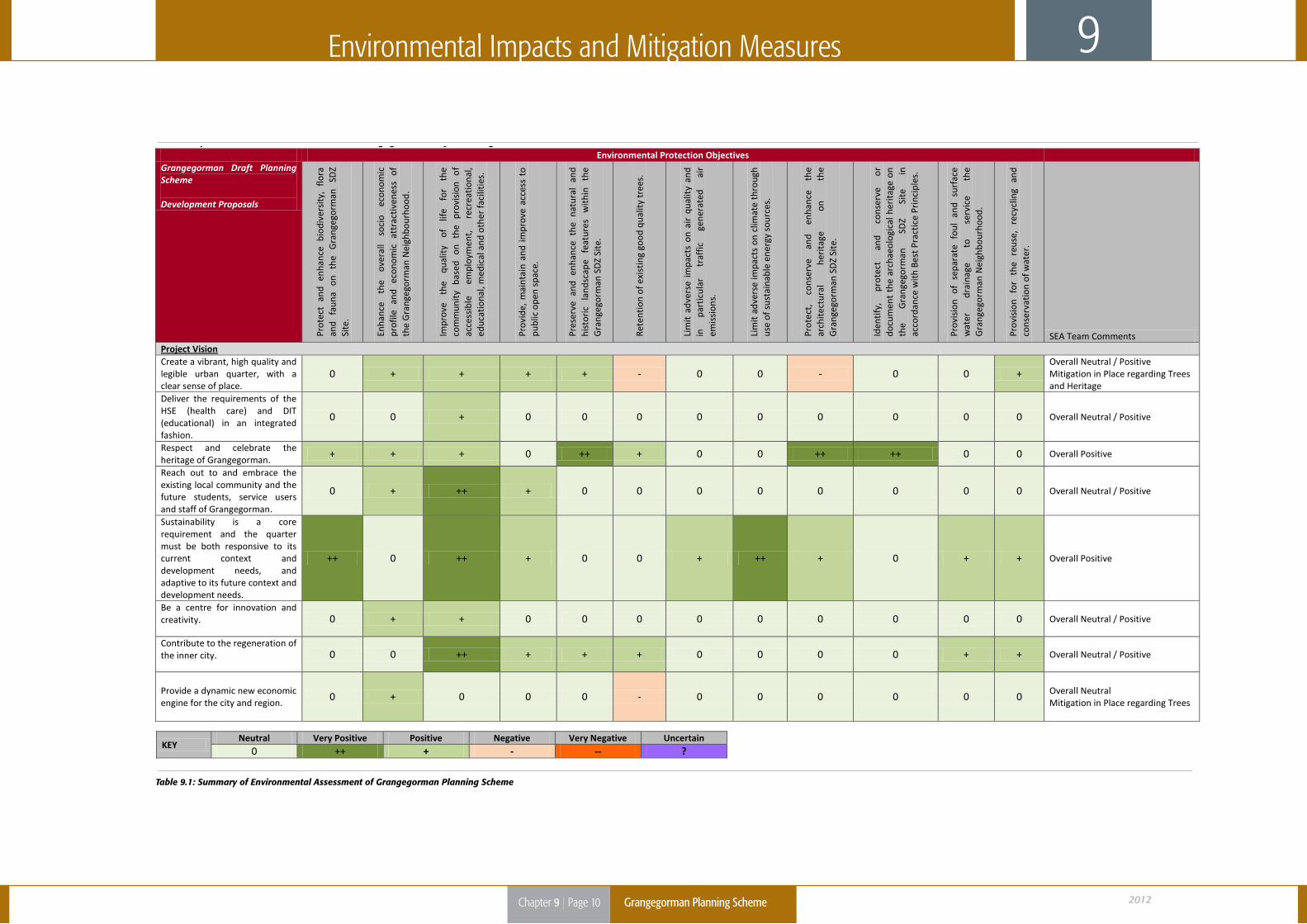
Table 9.1: Summary of Environmental Assessment of Grangegorman Planning Scheme
Summary of Environmental Assessment of Grangegorman Draft Planning Scheme Environmental Protection Objectives Grangegorman Draft Planning Scheme Development Proposals
Prot
ect
and
enha
nce
biod
iver
sity
, flo
ra
and
faun
a on
th
e G
rang
egor
man
SD
Z Si
te.
Enha
nce
the
over
all
soci
o ec
onom
ic
prof
ile
and
econ
omic
at
trac
tiven
ess
of
the
Gra
ngeg
orm
an N
eigh
bour
hood
.
Impr
ove
the
qual
ity
of
life
for
the
com
mun
ity
base
d on
th
e pr
ovis
ion
of
acce
ssib
le
empl
oym
ent,
re
crea
tiona
l, ed
ucat
iona
l, m
edic
al a
nd o
ther
faci
litie
s.
Prov
ide,
mai
ntai
n an
d im
prov
e ac
cess
to
publ
ic o
pen
spac
e.
Pres
erve
and
enh
ance
the
nat
ural
and
hi
stor
ic
land
scap
e fe
atur
es
with
in
the
Gra
ngeg
orm
an S
DZ
Site
.
Rete
ntio
n of
exi
stin
g go
od q
ualit
y tr
ees.
Lim
it ad
vers
e im
pact
s on
air
qua
lity
and
in
part
icul
ar
traf
fic
gene
rate
d ai
r em
issi
ons.
Lim
it ad
vers
e im
pact
s on
clim
ate
thro
ugh
use
of s
usta
inab
le e
nerg
y so
urce
s.
Prot
ect,
co
nser
ve
and
enha
nce
the
arch
itect
ural
he
rita
ge
on
the
Gra
ngeg
orm
an S
DZ
Site
.
Iden
tify,
pr
otec
t an
d co
nser
ve
or
docu
men
t th
e ar
chae
olog
ical
her
itage
on
the
Gra
ngeg
orm
an
SDZ
Site
in
ac
cord
ance
with
Bes
t Pra
ctic
e Pr
inci
ples
.
Prov
isio
n of
sep
arat
e fo
ul a
nd s
urfa
ce
wat
er
drai
nage
to
se
rvic
e th
e G
rang
egor
man
Nei
ghbo
urho
od.
Prov
isio
n fo
r th
e re
use,
re
cycl
ing
and
cons
erva
tion
of w
ater
.
SEA Team Comments Project Vision Create a vibrant, high quality and legible urban quarter, with a clear sense of place.
0 + + + + - 0 0 - 0 0 + Overall Neutral / Positive Mitigation in Place regarding Trees and Heritage
Deliver the requirements of the HSE (health care) and DIT (educational) in an integrated fashion.
0 0 + 0 0 0 0 0 0 0 0 0 Overall Neutral / Positive
Respect and celebrate the heritage of Grangegorman.
+ + + 0 ++ + 0 0 ++ ++ 0 0 Overall Positive
Reach out to and embrace the existing local community and the future students, service users and staff of Grangegorman.
0 + ++ + 0 0 0 0 0 0 0 0 Overall Neutral / Positive
Sustainability is a core requirement and the quarter must be both responsive to its current context and development needs, and adaptive to its future context and development needs.
++ 0 ++ + 0 0 + ++ + 0 + + Overall Positive
Be a centre for innovation and creativity. 0 + + 0 0 0 0 0 0 0 0 0 Overall Neutral / Positive
Contribute to the regeneration of the inner city. 0 0 ++ + + + 0 0 0 0 + + Overall Neutral / Positive
Provide a dynamic new economic engine for the city and region.
0 + 0 0 0 - 0 0 0 0 0 0 Overall Neutral Mitigation in Place regarding Trees
KEY Neutral Very Positive Positive Negative Very Negative Uncertain
0 ++ + - -- ?