sullivans cove planning scheme 1997 - city of hobart cove planning scheme 1997 this planning scheme...
TRANSCRIPT


Sullivans Cove Planning Scheme 1997
This Planning Scheme was approved by the Resource Planning and Development Commission on
15 December 1998 and came into operation on 21 December 1998.

This consolidated edition incorporates all approved amendments up until the 18th November 2016.

This Planning Scheme was approved by the Resource Planning and Development Commission on 15 December 1998 and came into operation on 21 December 1998.
The following amendments have been made to this Scheme:
Amendment Number Date of Approval
Summary of Amendment
SP–1 28/02/1997 Application of State Coastal Policy 1996
13/01/98 and 25/09/97
Application of State Policy on Water Quality Management 1997
SP–2 28/04/1999 Application of State Policy on the Protection of Agricultural Land 1998
1/99–1 to 1/99–14 14/03/2001 Various amendments to correct errors or to clarify wording.
1/2001-9 14/12/2001 Schedule 9 - Telecommunications Infrastructure
1/2001 – 1 to 1/2001 – 18
14/12/2001 Various amendments to Clause 22
2/2001 – 1 to 4 26/03/2002 Various amendments to Clause 16
3/2001 – 1 to 11 11/06/2002 Various amendments to Clause 15
1/2002 – 1 to 3c 11/12/2002 New Signs Schedule
2/2002 – 1 to 8 2/09/2002 Various amendments to Clauses 15,22,31
2/2003 – 1 to 2 4/11/2003 Amendments to Schedule 4 - Signage and definitions
3/2002 – 1 to 2 28/01/2004 Amendments to Schedule 1 – ‘Places of Archaeological Significance’
3/2003 – 1 to 2 9/03/2004 Amendment to signage provisions Clauses 15.5.13C & 25.3.1
1/2003 – 1 to 14 17/03/2004 Various amendments – Clauses 16, 18, 22, 23, 24, 27 & 31 Gateway and Port Access
1/2004 16/03/2005 Clause 7.3 Crime prevention principle
1–2006 11/09/2006 Various minor amendments to correct errors, anomalies and inconsistencies
2–2006 22/05/2007 Various amendments to Schedule 3 – Public Urban Space and definitions
1–2007 5/06/2008 Replacement of existing Schedule 4 – Signage with revised version and associated changes within the Scheme.
1–2008 15/07/2008 Amendment to Schedule 3 – Public Urban Space to incorporate Footpath & Road Median Material Types Plan.
2–2008 8/12/2008 Minor amendment to Schedule 4 – Signs to correct minor errors and remove anomalies.
1–2010 17/02/2011 Amendments to Schedule 4 – Signs primarily to the provisions for umbrella, screen and portable signs and minor editorial changes to improve clarity.
1-2011 26/09/2011 Amendments to Schedule 4 – Signs to allow more than one temporary sign for community and cultural events, and to remove restrictions on the content of these signs.
2-2011 26/02/2012 Various amendments to correct inconsistencies in the scheme due to the Hobart City Council taking over planning

authority from the Sullivans Cove Waterfront Authority.
2/2012 07/03/2012 Amendment to definition of ‘General Industry’ to make it clear that it does not include a retail or self service laundry.
3/2012 19/02/2013 Amendment to definition of ‘sign area’ so that the area of all signs (not just wall signs) that are composed of individual lettering is considered to be the encompassed area within the perimeter enclosing the lettering.
1/2013 28/05/2013 Amendments to allow for consideration of change of use from Residential Accommodation to Visitor Accommodation or Bed and Breakfast Establishment where dwellings in a strata complex have separate ground level pedestrian access to a road.
2/2013 12/03/2014 Amendment to Clause 25.11 ‘Signs on Places of Cultural Significance’, to change the status of internally illuminated signs on, adjacent to or within heritage listed places from prohibited to discretionary, except where they are attached to a building of cultural significance (excluding contemporary buildings and extensions on a place of cultural significance that are not themselves of cultural significance).
1/2014 22/04/2015 Amendment to Sullivans Cove Planning Scheme 1997, Activity Area 3 – Macquarie Point. Amendments include changes to the following Clauses; Clause 6.1, 18, 22, 23, 26, 27 and 28 as well as including the Royal Engineers Building in Activity Area 3 instead of Activity Area 2. In addition Figures 2, 4 and 11 will be amended.
1/2015 15/09/2015 Amendment corrects a clause reference in clause 15.5.13B Wapping Sign Standard, and amends Schedule 4 clauses 25.10 and 25.14 Table 25.1 in relation to signs above first floor level in the ‘Cove Floor’ and wall and banner signs.
2/2015 18/11/2016 Amendments insert a Macquarie Point Site Development Plan within Part F – Key Sites and amend various clauses of the scheme to delete existing transitional provisions relating to the Macquarie Point area, and to refer to the provisions of the new Site Development Plan. Figure 4 - Activity Areas is amended to increase the area of Activity Area 3.0, and designate this area as being subject to the Macquarie Point Site Development Plan provisions. Two new Places of Cultural Significance are added to Schedule 1, and Figure 5 - Places of Cultural Significance is amended to include them.

TABLE OF CONTENTS
State Policy Considerations ................................................................... 1
A.1 Implementation of State Coastal Policy .................................................................... 1
A.2 Implementation of State Policy on Water Quality Management ............................... 1
PART A - PRELIMINARY ........................................................................ 3
1 Basis of the Scheme .......................................................................................... 3
2 Contents of this Planning Scheme ....................................................................... 3
3 The Approach Underlying this Scheme ................................................................. 4
3.1 Background - The Existing Strategic Planning Basis .................................................. 4
3.2 Resource Management Planning ................................................................................. 4
3.3 Performance Based Planning ...................................................................................... 5
PART B - SULLIVANS COVE STRATEGIC FRAMEWORK .................................. 7
4 Preamble ........................................................................................................ 7
5 The Values and Strengths of the Cove .................................................................. 7
6 A Preferred Future for the Cove .......................................................................... 8
6.1 An Economic Base for the Future ................................................................................ 8
6.2 Designing the Future Urban Form ............................................................................... 8
6.3 An Ecologically Sustainable Future .............................................................................. 9
6.4 Creating a Place for People ......................................................................................... 9
6.5 Arts/Culture/Education/Recreation ............................................................................. 10
6.6 Identification of ‘Key Sites’ ......................................................................................... 10
7 Planning Principles for Management of Activities in the Cove ............................... 10
7.1 Sullivans Cove Resources and Resource Values ...................................................... 10
7.2 Intent of The Scheme ................................................................................................. 10
7.3 Strategic Planning Principles ...................................................................................... 10
PART C - APPLICATION OF THE SCHEME ................................................. 17
8 Consideration of Applications .......................................................................... 17
8.1 Compliance with the Sullivans Cove Planning Scheme ............................................ 17
8.2 Existing Uses .............................................................................................................. 17
8.3 Non-Conforming Uses ............................................................................................... 17
8.4 Exemptions from Planning Approval .......................................................................... 17
8.5 Temporary Permits ..................................................................................................... 18
8.6 Time Limits on Permits ............................................................................................... 18
9 Application Requirements for all Planning Applications within the Sullivans Cove Planning Area .............................................................................................. 18
9.1 Use of Land ................................................................................................................ 18
9.2 Development of Land ................................................................................................. 18

10 Decisions ....................................................................................................... 19
11 Planning Enforcement ..................................................................................... 20
11.1 Powers of the Planning Authority ............................................................................... 20
12 Referral of Planning Applications ..................................................................... 20
PART D - ACTIVITY AREA CONTROLS ...................................................... 21
13 Introduction. .................................................................................................. 21
14 Use Classes. ................................................................................................... 22
15 Activity Area 1.0 Inner City Residential (Wapping) .............................................. 24
15.1 General Characteristics of the Activity Area .............................................................. 24
15.2 Objectives of the Activity Area ................................................................................... 24
15.3 Use of Land ................................................................................................................ 25
15.4 Development of Land ................................................................................................ 27
15.5 Wapping Local Area Plan .......................................................................................... 27
15.5.1 Planning Area ..................................................................................................... 27
15.5.2 Effect of Wapping Local Area Plan .................................................................... 27
15.5.3 Statement of Desired Future Character ............................................................ 29
15.5.4 Control of Use and Development ...................................................................... 29
15.5.5 Subdivision ......................................................................................................... 30
15.5.6 Matters to be Considered .................................................................................. 30
15.5.7 Use Tables ......................................................................................................... 30
15.5.8 Density ............................................................................................................... 32
15.5.9 Height ................................................................................................................. 32
15.5.10 Siting and Landscaping ..................................................................................... 34
15.5.11 Traffic, Access and Parking ............................................................................... 35
15.5.12 Heritage .............................................................................................................. 38
15.5.13 Signs .................................................................................................................. 41
15.5.13A ‘Exempt’ Sign Provisions ................................................................................... 41
15.5.13B ‘Discretionary’ Sign Provisions .......................................................................... 41
15.5.14 Other Exemptions .............................................................................................. 41
16 Activity Area 2.0 Sullivans Cove ‘Mixed Use’ ...................................................... 42
16.1 General Characteristics of the Activity Area .............................................................. 42
16.2 Objectives and Performance Criteria for Activities .................................................... 42
16.3 Use of Land ................................................................................................................ 45
16.4 Development of Land ................................................................................................ 47
17 Activity Area 2.1 ‘Domain Open Space’ .............................................................. 48
17.1 General Characteristics of the Activity Area .............................................................. 48
17.2 Objectives and Performance Criteria for Activities .................................................... 48
17.3 Use of Land ................................................................................................................ 49
17.4 Development of Land ................................................................................................ 49

18 Activity Area 3.0 Sullivans Cove ‘Gateway’ ........................................................ 50 18.1 General Characteristics of the Activity Area ............................................................... 50 18.2 Objectives and Performance Criteria for Activities .................................................... 50 18.3 Use of Land ................................................................................................................ 51 18.4 Development of Land ................................................................................................. 52
19 Activity Area 4.1 ‘Macquarie Point Wharf’ ........................................................ 53 19.1 General Characteristics of the Activity Area ............................................................... 53 19.2 Objectives and Performance Criteria for Activities .................................................... 53 19.3 Use of Land ................................................................................................................ 54 19.4 Development of Land ................................................................................................. 55
20 Activity Area 4.2 ‘Regatta Point’ ...................................................................... 56 20.1 General Characteristics of the Activity Area ............................................................... 56 20.2 Objectives and Performance Criteria for Activities .................................................... 55 20.3 Use of Land ................................................................................................................ 58 20.4 Development of Land ................................................................................................. 59
21 Activity Area 4.3 Sullivans Cove ‘Working Port’ ................................................. 60 21.1 General Characteristics of the Activity Area ............................................................... 60 21.2 Objectives and Performance Criteria for Activities .................................................... 60 21.3 Use of Land ................................................................................................................ 61 21.4 Development of Land ................................................................................................. 62
PART E - SCHEDULES ......................................................................... 67 22 Schedule 1 - Conservation of Cultural Heritage Values ........................................ 67
22.1 Introduction ................................................................................................................. 67 22.2 Objectives ................................................................................................................... 67 22.3 Definitions ................................................................................................................... 67 22.4 Conservation of Places of Cultural Significance ........................................................ 68
22.4.1 Scope ................................................................................................................. 69 22.4.2 Exemptions ......................................................................................................... 69 22.4.3 Submission Requirements ................................................................................. 69 22.4.4 ‘Permitted’ ‘Building or Works’ ........................................................................... 69 22.4.5 ‘Discretionary’ ‘Building or Works’ ..................................................................... 69
22.5 ‘Building or Works’ on Land Not Included in Table 1 ................................................ 69 22.5.1 Scope ................................................................................................................. 69 22.5.2 Exemptions ......................................................................................................... 69 22.5.3 Submission Requirements ................................................................................. 70 22.5.4 ‘Permitted’ ‘Building or Works’ ........................................................................... 70 22.5.5 ‘Discretionary’ ‘Building or Works’ ..................................................................... 70
22.6 Places of Archaeological Sensitivity ........................................................................... 71 22.6.1 Scope ................................................................................................................. 71 22.6.2 Exemptions ......................................................................................................... 71 22.6.3 Submission Requirements ................................................................................. 71 22.6.4 ‘Permitted’ ‘Building or Works’ ........................................................................... 71 22.6.5 ‘Discretionary’ ‘Building or Works’ ..................................................................... 71
23 Schedule 2 - Urban Form ................................................................................. 85 23.1 Introduction ................................................................................................................. 85 23.2 Objectives ................................................................................................................... 85 23.3 Scope.......................................................................................................................... 86 23.4 Exemptions ................................................................................................................. 86
23.4.1 Site Specific Variation ......................................................................................... 86
23.5 Definitions .................................................................................................................. 86 23.6 Building Form ............................................................................................................. 87
23.6.1 ‘Permitted’ Buildings .......................................................................................... 87 23.6.1.A New Buildings .................................................................................................... 87 23.6.1.B Extensions to Existing Buildings ........................................................................ 88 23.6.2 ‘Discretionary’ Buildings .................................................................................... 88
23.7 Building Surfaces ....................................................................................................... 89 23.7.1 ‘Permitted’ Buildings .......................................................................................... 89 23.7.2 ‘Discretionary’ Buildings .................................................................................... 89
23.8 Development in Activity Area 2.0 Sullivans Cove ‘Mixed use’ north of Brooker Avenue ....................................................................................................................... 90
23.8.1 Building or works ............................................................................................... 90 24 Schedule 3 - Public Urban Space ..................................................................... 105
24.1 Introduction .............................................................................................................. 105 24.2 Objectives ................................................................................................................ 105 24.3 Public Urban Space Types ...................................................................................... 106 24.4 Part A - Civic Works and Public Street Furniture ..................................................... 106
24.4.1 Scope of Control .............................................................................................. 106 24.4.2 Requirements for Planning Approval ............................................................... 106 24.4.3 ‘Exempt’ Buildings or Works ............................................................................ 107 24.4.4 ‘As of Right’ Buildings or Works ...................................................................... 107 24.4.5 ‘Permitted’ Buildings or Works ........................................................................ 108 24.4.6 ‘Discretionary’ Buildings or Works ................................................................... 108 24.4.7 ‘Prohibited’ Buildings or Works ....................................................................... 108 24.4.8 ‘Civic Works and Public Street Furniture’ Guidelines ...................................... 108 24.4.9 Requirement for a Civic Works and Public Street Furniture Concept Plan ..... 110 24.4.10 Function of Public Urban Space Types ........................................................... 110
24.5 Part B - Commercial and Community Furniture ...................................................... 111 24.5.1 Scope ............................................................................................................... 111 24.5.2 Requirements for Planning Approval ............................................................... 112 24.5.2A ‘Exempt’ Commercial and Community Furniture ............................................ 112 24.5.2B ‘Discretionary’ Commercial and Community Furniture ................................... 112
24.6 Definitions ................................................................................................................ 113 25 Schedule 4 - Signs ........................................................................................ 125
25.1 Introduction .............................................................................................................. 125 25.2 Objectives ................................................................................................................ 125 25.3 Scope ....................................................................................................................... 125 25.4 Information to be Submitted .................................................................................... 125 25.5 Categorising Signs .................................................................................................. 125 25.6 Definitions ................................................................................................................ 125 25.7 Exemptions .............................................................................................................. 134 25.8 Permitted Signs ........................................................................................................ 136 25.9 Discretionary Signs .................................................................................................. 136 25.10 Prohibited Signs ....................................................................................................... 136 25.11 Signs on Places of Cultural Significance ................................................................. 136 25.12 Signs - Product ....................................................................................................... 137 25.13 Matters to be Considered ........................................................................................ 138 25.14 Requirements for Signs ........................................................................................... 139
26 Schedule 5 - Traffic, Access And Parking .......................................................... 143 26.1 Introduction .............................................................................................................. 143 26.2 Principles .................................................................................................................. 143
26.3 Objectives for Traffic, Access and Parking in Activity Areas ................................... 144 26.4 Guidelines for Development Control ........................................................................ 145
26.4.1 Traffic Generation ............................................................................................. 145 26.4.2 Access Requirements ...................................................................................... 145 26.4.3 Parking Standards ............................................................................................ 146 26.4.4 Nature of Parking .............................................................................................. 146
26.5 Matters to be Considered......................................................................................... 146 26.6 Applications Involving Only the Use of Land ........................................................... 147
27 Schedule 6 - Subdivision ................................................................................ 149 27.1 Introduction ............................................................................................................... 149 27.2 Principles .................................................................................................................. 149 27.3 Scope........................................................................................................................ 149 27.4 Subdivision Requirements........................................................................................ 149 27.5 Subdivision - Submission Requirements ................................................................. 150
28 Schedule 7 - Demolition ................................................................................. 151 28.1 Introduction ............................................................................................................... 151 28.2 Objectives ................................................................................................................. 151 28.3 Scope........................................................................................................................ 151 28.4 Exemptions ............................................................................................................... 151 28.5 Guidelines for Development Control ........................................................................ 151 28.6 Matters to be Considered......................................................................................... 152 28.7 Demolition - Submission Requirements................................................................... 152 28.8 Demolition on a Place of Cultural Significance ........................................................ 152
29 Schedule 8 - Environmental Management ......................................................... 153 29.1 Introduction ............................................................................................................... 153 29.2 Objectives ................................................................................................................. 153 29.3 Scope of Control....................................................................................................... 153 29.4 Definitions ................................................................................................................. 153 29.5 Environmental Objectives ......................................................................................... 154 29.6 Referral Requirements .............................................................................................. 155
30 Schedule 9 - Telecommunications Infrastructure ................................................ 157 30.1 Principles .................................................................................................................. 157 30.2 Use or Development ................................................................................................. 157
30.2.1 Relationship to The Scheme ............................................................................ 157 30.2.2 Matters for Consideration ................................................................................. 157 30.2.3 Definitions ......................................................................................................... 157
30.3 Exemptions ............................................................................................................... 158 30.4 Information Required ................................................................................................ 158
30.4.1 Application Requirements ................................................................................ 158 30.4.2 Plans to Accompany Applications ................................................................... 159
PART F - KEY SITES ........................................................................ 165 31.1 Introduction ............................................................................................................... 165 31.2 Scope........................................................................................................................ 165 31.3 Definitions ................................................................................................................. 165 31.4 Site Development Plan - Performance ..................................................................... 165 31.5 Submission Requirements ....................................................................................... 165 31.6 Schedule of Key Sites .............................................................................................. 166
PART G - DEFINITIONS .................................................................... 169


LIST OF FIGURES
Page
Figure 1 Approach to Using the Scheme ........................................................................... 6
Figure 2 Strategic Directions ............................................................................................ 15
Figure 3a Wapping Local Area Plan - The Planning Area .................................................. 28
Figure 3b Wapping Local Area Plan - Height Control Diagram ......................................... 33
Figure 3c Wapping Local Area Plan - Parking Provision Exempt Buildings ...................... 36
Figure 3d Wapping Local Area Plan - Heritage Guidelines ............................................... 40
Figure 4 Activity Areas ...................................................................................................... 65
Figure 5 Places of Cultural Significance ........................................................................... 81
Figure 5a Places of Archaeological Sensitivity ................................................................... 83
Figure 6 The Wall of Sullivans Cove ................................................................................. 97
Figure 7 Primary and Secondary Spaces ........................................................................ 99
Figure 8 ‘Deemed to Comply Heights’ ........................................................................... 101
Figure 8a Site Plan ............................................................................................................ 103
Figure 9 Public Urban Space Types ............................................................................... 117
Figure 9a Area where ‘Road’ is ‘Permitted’ ...................................................................... 119
Figure 9b Footpath and Road Median Material Types .................................................... 121
Figure 10 Commercial & Community Use of Public Space ............................................. 123
Figure 11 Key Sites ........................................................................................................... 167

Sullivans Cove Planning Scheme 1997 (as amended at 17 February 2011)
=
1
STATE POLICY CONSIDERATIONS
A.1 IMPLEMENTATION OF STATE COASTAL POLICY
Where the Planning Authority determines that a proposed use or development would be inconsistent with the State Coastal Policy, that use or development is, unless prohibited by this scheme and notwithstanding any other provision of the scheme, a use or development which the Planning Authority has discretion to refuse or permit.
A.2 IMPLEMENTATION OF STATE POLICY ON WATER QUALITY MANAGEMENT
An application for a permit for the use or development of land shall be accompanied by sufficient information to demonstrate that it will not result in the transport of sediments into surface waters such that environmental harm might be caused either during the carrying out of works, or the subsequent use of the land.
The Planning Authority shall consider the information supplied with the application and determine whether:
(a) The capability of the land is sufficient to support the use or development without giving rise to sediment transport; and
(b) If there is a risk of sediment transport into surface waters, the measures proposed to reduce such a risk are adequate.
The Planning Authority may impose conditions on any permit to minimise the potential for erosion or water quality degradation.
For the purpose of this clause:
“surface waters” means all waters on the land surface, including both fresh and marine waters e.g. streams, lakes, estuaries and coastal waters (State Policy on Water Quality Management 1997).
“environmental harm” means any adverse effect on the environment (of whatever degree or duration) and includes an environmental nuisance (Environmental Management and Pollution Control Act 1994).
“capability of the land” means the capability of the land as determined by the geological stability and slope of the land, erodibility of the soil and extent and type of vegetation cover, to sustain use or development.

Sullivans Cove Planning Scheme 1997 (as amended at 17 February 2011) 2

3
PART A – PRELIMINARY
1 BASIS OF THE SCHEME
1.1 The Sullivans Cove Planning Scheme has been prepared in accordance with the provisions of the Land Use Planning and Approvals Act 1993.
1.2 The Scheme applies to all land and water within the Scheme Boundary on “Figure 4” of the Sullivans Cove Planning Scheme 1997, referred to in this Scheme as ‘The Planning Area’.
1.3 The requirements of the Scheme are:
1. The Scheme should recognise that Sullivans Cove:
(a) Contains the principal port in Southern Tasmania which should continue to operate as a port with all necessary port facilities and infrastructure including viable transport access; and
(b) Contains buildings, monuments, structures and spaces reflecting the history and development of Tasmania and establishing a unique precinct which must be developed, enhanced or preserved in a manner consistent with its historical character; and
(c) Should provide recreational and commercial opportunities for the Tasmanian community and visitors to Hobart which should be maintained, enhanced or developed.
2. The Scheme must have regard to existing use rights as defined by s.20(3) of the Land Use Planning and Approvals Act 1993 and in particular rights relating to port activities under s.20(10) and s.20(11) of the Land Use Planning and Approvals Act 1993.
3. The Planning Scheme must:
(a) Have regard to the different requirements of each Zone; and
(b) Have regard to the objectives and principles of:
(i) The Sullivans Cove Planning Review published in 1991 by the Sullivans Cove Development Authority as existing before the commencement of this Act; and
(ii) The Wapping Outline Development Plan published in 1993 by that Authority; and
(iii) The Sullivans Cove Traffic and Parking Management Strategy published in 1995 by that Authority.
2 CONTENTS OF THIS PLANNING SCHEME
2.1 This Scheme comprises Parts A – G and consists of the following:
A strategic framework which includes a statement of preferred futures for Sullivans Cove, a Strategy Plan and a series of planning principles for guiding future use and development within Sullivans Cove.

4
Planning Scheme provisions which provide guidelines for the sound and proper use and development of land within the Planning Area.
A series of figures (plans) identifying the Activity Areas within the Planning Area, as well as a range of specific controls affecting use and development in Sullivans Cove.
2.2 The overall strategic planning direction for the sustainable development of the Sullivans Cove Planning Area is derived from a number of sources.
2.3 This Scheme may be supported by any local planning policies, Outline Development Plans, Site Development Plans, Management Plans and Local Area Plans approved by the Planning Authority from time to time by resolution.
2.4 From time to time the Planning Authority may seek to incorporate by amendment to the Scheme, Local Area Plans, Site Development Plans, or Management Plans.
3 THE APPROACH UNDERLYING THIS SCHEME
3.1 Background – The Existing Strategic Planning Basis
The objectives and principles of this Scheme are derived from a broad range of existing Planning strategies, management plans and studies prepared for the Sullivans Cove. In particular, the following documents are of primary relevance to the approach taken in this Scheme:
The Sullivans Cove Planning Review (1991).
The Wapping Outline Development Plan (1993).
The Sullivans Cove Traffic and Parking Management Study (1994).
The Sullivans Cove Traffic and Parking Implementation Study (1995).
Queens Domain Management Plan (1996).
Australian Model Code for Residential Development AMCORD (1995).
The Conservation Plan, J.S. Kerr National Trust 1996.
Burra Charter: The Charter for the Conservation of Places of Cultural Significance (including Guidelines) as adopted by the Australian National Committee of the International Council on Monuments and Sites (Australia ICOMOS) on 23 April 1988.
3.2 Resource Management Planning
The emerging directions of Tasmania’s Resource Management and Planning System also significantly influenced the approach to management of activities in Sullivans Cove. The approach of the Scheme in respect to resource management in the Cove is shown in Figure 1.
The approach taken in the preparation of the Scheme involved the following steps:
(i) Assessment of the State, regional and local strategic planning context.
(ii) Definition of the resource base for Sullivans Cove (Air, Water, Land, Biota, Structure and Infrastructure).
(iii) Definition of the values derived from the resource base.
(iv) Preparation of a strategic planning framework for the management of activities in the Cove.

5
(v) Preparation of a set of land use controls which support the strategic principles for resource management in the Cove (‘The Scheme’).
3.3 Performance Based Planning
This Scheme is based in part on a ‘performance’ approach to development control. This approach recognises that there are in many cases a number of ways in which land use and development can satisfy desired environmental, social and economic standards. In this approach, presenting what desired standards need to be met is considered as important as prescribing how such standards must be met.
In some cases use and development is ‘permitted’ subject to specific ‘deemed to comply’ provisions being satisfied.
Performance criteria are established to provide a means by which the objectives of the scheme may be satisfactorily met.
A number of development controls in the Scheme are prescriptive in nature. Prescriptive controls are used where the development or use being regulated is best managed through the application of a more rigid set of controls. Examples include controls covering signs and commercial and community use of roads and other public spaces.

6
Figure 1: Approach to using The Scheme

7
PART B – SULLIVANS COVE STRATEGIC FRAMEWORK
4 PREAMBLE
The purpose of this strategic framework is to:
Identify the values and strengths of the Cove which the Scheme aims to protect, and;
Define a preferred future for the Cove, and;
Define the planning principles which underlie the land use and development controls contained within this Planning Scheme.
This strategic framework must be used in the consideration and assessment of all applications for use and development in the Sullivans Cove Planning Area.
5 THE VALUES AND STRENGTHS OF THE COVE
Sullivans Cove is recognised as a special place by the people of Tasmania. Set against the dramatic backdrop of Mount Wellington, with Hobart City Centre in the foreground and opening out to the Derwent Estuary, Sullivans Cove is one of the world’s finest city landscape settings. This unique urban and landscape form is what makes Sullivans Cove so special.
Not only is Sullivans Cove Australia’s most intact historic waterfront - it also remains a true dynamic and evolving working port. The operation of cargo vessels remains a key economic activity of the City, as well as defining the unique character of Sullivans Cove.
The working port extends beyond cargo ships, and includes a broad range of other maritime activities, including commercial fishing boats, cruise ships, Antarctic resupply vessels, CSIRO marine research vessels, visiting Naval vessels, ferries, yachts, etc. The diverse marine activity in the Cove presents an ever-changing environment to residents and visitors alike.
The Cove is a place for people - its historic buildings, formal parks, roads and other public spaces have largely retained the pedestrian scale that existed during the early settlement of Hobart.
Sullivans Cove is a cultural, artistic and festive focus for the City, and its public spaces are frequently used for market and other public events. Pedestrian access to the water’s edge is a unique feature of the Cove.
The Cove also offers a diverse range of activities for residents and tourists alike. A broad range of recreational and social activity options exist - from restaurants and bars to ferries, fishing off the pier and boating with its associated facilities.
The Cove contains a thriving artistic and education base, including the University of Tasmania, CSIRO and a range of artist studios and galleries.
With the residential redevelopment of a number of sites across the Cove, its permanent and temporary population has risen in recent years. A number of significant developments, most notably the redevelopment of Wapping and the Salamanca Quarry for residential accommodation has, and will continue to inject a
new population in to the city centre. These developments will ensure that the Cove develops as an active and vibrant place, 24 hours a day.
The Cove’s location adjoining Central Hobart, and with excellent transport infrastructure links (road, rail and the ports) provides potential for the further economic development.
The Cove is the centre of Government for the State, as it contains Parliament House, Hobart Town Hall and a number of other significant administrative functions. It is also home to a number of major financial institutions.
6 A PREFERRED FUTURE FOR THE COVE
The following statements and supporting strategy plan express the preferred future urban character and activity directions that this Planning Scheme aims to facilitate. These must be taken into consideration in the assessment of all applications for use and development.
6.1 An Economic Base for the Future
The port operations will continue to be a significant economic activity in the Cove. The further development of cargo handling and related shipping activities will be encouraged in designated locations, particularly along the eastern face of Macquarie Wharf. Adequate access arrangements for the port will be maintained.
The integration of port and transport activities with emerging technology based industries will be fostered and supported.
Maritime activities will be encouraged in the Central Cove area, with the emphasis being on retaining a healthy and diverse maritime industry in the Cove.
The future development of educational, artistic and cultural activities and facilities within the Cove also presents potential for economic growth. The ‘seeds’ of such facilities already exist in the Cove, but should be harnessed to market the Cove, and Hobart generally, as having a distinct, world class, artistic and educational community. The economic benefits of developing such an identity extend beyond tourism.
A range of other economic activities will be promoted in the Cove, including tourism, retail and other commercial development, Civic and administration activities, research and development, arts and craft, and technology based industries.
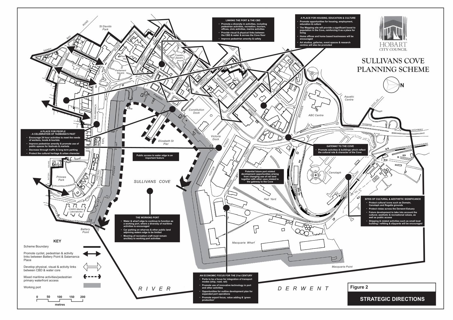
A range of activity ‘themes’ are emerging within the Cove, and these are illustrated on the Strategic Directions Figure 2.
6.2 Designing the Future Urban Form
The built and spatial qualities of Sullivans Cove are a product of its unique historic cultural heritage. This heritage should be retained, for once lost, it cannot be recreated.
This means more than retaining buildings of historic value. The future urban form of the Cove should respond to the quality of spaces and buildings which exist within the Cove.
8

9
The conservation of this heritage in the built and spatial form of the Cove is important not only in a cultural sense, but also in an economic sense, for the Cove is an important attraction to tourists and other visitors to the State.
Future developments within the Cove should respect the scale of the Cove’s built form - new buildings should not be out of scale with neighbouring buildings, or the general character of the Cove.
The spatial characteristics of the Cove are as important to the character of the Cove as the buildings which frame these spaces. The future urban form of the Cove should therefore respect these spaces. This applies to not only buildings but to new works and urban detail (street furniture, road works, etc.).
Development within Sullivans Cove will respect the natural amphitheatre created by the water and mountainous backdrop.
Also, views and vistas within and beyond the Cove will be protected and restored where opportunities arise.
6.3 An Ecologically Sustainable Future
The Cove forms part of a wider ecosystem, comprising the air, water, land and the natural biota. All of the activities which take place in the Cove involve energy transfers. It is intended that the key elements of the Cove environment be measured and regularly monitored as part of the Council’s commitment to measuring the state of Hobart’s environment. Strategies for improving the environmental health of the Cove and the surrounding areas will form part of this reporting.
All use and development which takes place in the Cove will be expected to demonstrate its environmental performance against the backdrop of this environmental reporting.
6.4 Creating a Place for People
The Cove currently has many excellent qualities which make it attractive to visitors and residents. However, there are many aspects to the function and form of the Cove which need to be addressed in order to enhance the pedestrian experience in the Cove.
Access to, and circulation within the Cove will be improved. Creation of better physical and visual links to the water from the City Centre, Battery Point and greater Hobart will ensure that the Cove is more accessible. Obstacles to access and circulation, including traffic and car parking will be managed.
Pedestrian amenity in key areas within the Cove will also be addressed - protection against air pollution, loss of sunlight, and wind, as well as provision of public amenities, etc.
The Cove will continue to function as a space for cultural and festive events such as the Salamanca Market, and Sydney-Hobart Yacht Race, as well as provide for a broad range of tourist facilities and attractions.
The successful preservation and interpretation of the Cove’s cultural heritage will continue to make the Cove an attractive and interesting place to visit.
The ambience created by the working port, and public accessibility to the water’s edge will be retained as a feature within the central Cove area.
The Cove will continue to be promoted as a place for living - a wide range of accommodation choices, from permanent residences to short term tourist accommodation, will be encouraged within and around the Cove.
10
6.5 Arts/Culture/Education/Recreation
Sullivans Cove will be the heart of Hobart’s artistic, recreational and intellectual community. New activities and facilities such as concert halls, visual arts centres, multimedia centres and a host of other opportunities exist in the Cove.
6.6 Identification of ‘Key Sites’
There is a range of sites within the Cove which have the potential to further develop the economic base, pedestrian environment and cultural/recreational and educational profile of the Cove.
7 PLANNING PRINCIPLES FOR MANAGEMENT OF ACTIVITIES IN THE COVE
7.1 Sullivans Cove Resources and Resource Values
The resource base of Sullivans Cove comprises both natural and created resources, from which a range of values are derived. The basic resources of the Cove are the air, water, land and biota. The ‘created’ resources include buildings and infrastructure.
A range of values are derived from this resource stock, including:
Cultural resource values,
Natural resource (life sustaining) values,
Economic development values,
Efficiency values, and
Pedestrian values.
7.2 Intent of the Scheme
The management of use and development in this Scheme is concerned with the protection and promotion of the Cove’s resource stock and the values derived from this resource stock.
It is the intent of this Scheme to ensure that all activities (including use, development and other resource consuming activities) in the Planning Area contribute to the ‘Preferred Future’ for the Cove and are sustainable in accordance with the objectives of the Resource Management and Planning System as set out in Schedule 1 of the Land Use Planning and Approvals Act 1993.
7.3 Strategic Planning Principles
The following strategic planning principles relate to the protection and management of activities to protect and enhance the Cove’s resources and resource values. The principles are shown as indicated on Figure 2.
These principles must be taken into account in the consideration of all future use and development of land in the Cove:
7.3.1 Guiding Principles
Sullivans Cove shall continue as a dynamic and evolving working port, also as a fishing and yachting harbour, cultural centre, recreation and entertainment district, centre of government and a place for commerce and living.
11
It shall continue to cater for public activities in streets and in buildings at street level.
It shall display its history, and have a life beyond ‘nine-to-five’ hours.
The activities in the Cove should positively contribute to the character of the Cove and not detract from the operations of a working port. Activities and associated development should not adversely impact on pedestrian and other forms of movement through the Cove, access to the water edge, views, and the human scale environment.
The water environment of the Cove shall continue to fulfil a significant role in the cultural life of the City, and shall continue to cater for community events such as boat races and festivals.
The Cove should be promoted as Hobart’s centre for cultural and recreational activities. Such activities shall be encouraged across the Cove, with an emphasis on cultural activities in the main Cove, including between Hunter Street and Salamanca Place and the Theatre Royal, Museum and Art Gallery.
7.3.2 Cultural Resource Principles
Cultural Heritage
To facilitate use and development which is compatible with conservation of the Cove’s cultural heritage values.
To encourage the recycling of existing buildings through the promotion of new uses, particularly in buildings of identified cultural heritage value.
The recognisable historic character of Sullivans Cove is not to be compromised by new development which overwhelms the historic spaces and buildings, or, by new development which reduces the apparent authenticity of the historic places by mimicking historic forms
Urban Character
Changes to urban character will be consistent with conservation of cultural significance and maritime and historic character of Sullivans Cove.
No new development or part of a development is to be individually prominent particularly when viewed from Sullivans Cove or the River Derwent. Exceptions include cranes and similar development relating to the essential operating requirements of the Tasmanian Ports Corporation.
The distinctive urban form of Sullivans Cove is to be reinforced in development areas.
Civic details are to be complementary to the existing different characters of the parts of Sullivans Cove.
The commercial and community use of the footpaths is to be encouraged where it can safely be provided and in locations suitable for outdoor uses.
The aggregate number of signs in the Cove is to be kept to a minimum.

12
7.3.3 Natural Resource Values
The ecologically sustainable development of the Cove’s natural and physical resources and the maintenance of ecological processes and genetic diversity shall be an integral part of the management of human activities within the Cove.
7.3.4 Efficiency Principles
The promotion of pedestrian and cycle movement, amenity and safety is the primary planning objective for movement within the Cove.
The pavements, carriageways and parks of the Cove shall be improved to increase pedestrian circulation and safety, enhance the pedestrian’s experience of the historic character, reduce pedestrian/vehicular conflict, yet maintain vehicular access (including parking and the movement of freight) to serve the diverse activities within the Cove.
The operational requirements for safe and efficient vehicle movement related to the activities of the working port shall be facilitated.
Parking supply within the Cove should be designed and administered to facilitate visitor access, rather than CBD commuters and other long-term parking space users. Long term commuter parking within the Cove should be discouraged.
The visual dominance of car parking throughout the Cove should be reduced, particularly in the Central Cove area.
7.3.5 Economic Development Principles
The future economic development potential of the Cove is recognised as being closely tied to the protection and development of the Cove’s unique character –its cultural heritage, pedestrian amenity, community focus, accessibility and aesthetics.
The State and National economic significance of the port is recognised and supported.
Integration between land and water based cargo handling and transport nodes is supported.
The Cove shall continue as a government, administrative, financial and judicial focus for the State.
A mix of retail activities, catering for the needs of tourists, visitors, workers and local residents is encouraged.
7.3.6 People in the Cove
The Cove is to be promoted and developed as an attractive pedestrian environment.
The further development of the residential and visitor accommodation in the Cove is encouraged in locations where the residential amenity will not constrain the economic functionality of the ports and other preferred industrial and commercial uses.
New use and development should ensure that pedestrian amenity and safety is not unreasonably compromised (having regard to the nature of the surrounding land uses). In particular the enhancement of pedestrian amenity and safety along the central pedestrian spine (Hunter Street to Salamanca Place) and along routes which connect the Cove to the CBD should be promoted.
Pedestrian access to the waters edge should be facilitated and pedestrian and vehicle spaces should be more clearly delineated in this part of the Cove. Such

13
activities need to be managed with the operational, security and public safety requirements of the port in mind.
Developments which incorporate convenience facilities, retailing, recreational activity, pedestrian amenity and visual interest will be encouraged at street level. Activities such as offices, residential accommodation and studios on major pedestrian routes through the Cove should be located at first floor or above.
A range of public transport options within the Cove will be supported, including tramways and light rail facilities.
In its consideration of all applications for use or development the Planning Authority must be satisfied that the use or development:
- Reduces opportunities for crime to occur;
- Provides safe, well designed and maintains buildings, facilities and public spaces;
- minimises the potential for vandalism and anti-social behaviour; and
- Promotes safety on neighbouring public and private land.

SITES OF CULTURAL & AESTHETIC SIGNIFICANCE
Protect cultural icons such as Domain,Cenotaph and Regatta grounds
Protect vistas across the Derwent Estuary
Future development to take into account thecultural, aesthetic & recreational values, aswell as public access
Shipping & related activities such as small boatbuilding / refitting & slipyards will be encouraged
•
•
•
•
SULLIVANS COVE
PLANNING SCHEME
500 100 200150
metres
Elizabeth StPier
PrincesPark
A
MACQ
UARIE
STR
EET
Macquarie Point
DAV
EY
STR
EET
Franklin
Wharf
Rail Yard
Cenotaph
VictoriaDock
ConstitutionDock
St DavidsPark
BatteryPoint
SULLIVANS COVE
Pri
nce
sW
ha
rfABC Centre
R I V E R
SANDY
BAY
RO
AD
KN
OP
WO
OD
ST
KIR
KS
WA
YP
LA
CE
SA
LA
MA
NC
A
PLA
CE
CA
ST
RA
Y
ES
PL
.
BA
TT
ER
YS
QU
AR
E
RUNNYMEDE ST
MU
RR
AY
ST
ELIZ
AB
ETH
ST
RE
ET
ARG
YLE
ST
STR
EET
LIVERPO
OL
ST
BR
OO
KE
RA
VE
NU
E
TASMAN
HIGHWAY
ST
HU
NT
ER
ST
RE
ET
EVA
NS
ST
RE
ET
MARKET
PLA
CE
SUN
ST
SACKVILLE
ST
MIS
TR
AL
PL
.
DESPARD
ST
BR
OO
KE
ST
MORRISON
ST
ParliamentSquare
CSIRO MarineLaboratories
ParliamentHouse
FranklinSquare
DAV
IES
AVE
CEN
OTA
PH
AVEN
UE
CAM
PBELL
N
AquaticCentre
D E R W E N T
STRATEGIC DIRECTIONS
Figure 2
Macquarie Wharf
DUNN
PLA
CE
TownHall
THE WORKING PORT
Water & wharf edge to continue to function asa working port, where a diversity of maritimeactivities is encouraged
Car parking on wharves & other public landadjoining waters edge to be limited
Mooring of recreation craft must remainancillary to working port activities
•
•
•
AN ECONOMIC FOCUS FOR THE 21st CENTURY
Ports to be a focus for integration of transportmodes (ship, road, rail)
Promote use of innovative technology in portand other activities
Opportunities for outline development plan forexpanded port operations
Promote export focus, value adding & ‘greenproduction’
•
•
•
•
LINKING THE PORT & THE CBD
Promote a diversity in activities, includingpedestrian activities, recreation, tourism,offices, civic activities, marine activities
Provide visual & physical links betweenthe CBD & water & across the Cove floor
Improve pedestrian amenity & safety
•
•
•
A PLACE FOR PEOPLE- A CELEBRATION OF TASMANIA’S PAST
Encourage 24 hour activities to meet the needsof workers, locals & tourists
Improve pedestrian amenity & promote use ofpublic spaces for festivals & markets
Decrease through traffic & long term parking
Protect the cultural heritage & urban character
•
•
•
•
Potential future port relateddevelopment opportunities arising
from changing use of rail landtogether with other uses related to
the gateway to the Cove
Public access to water edge is animportant feature
GATEWAY TO THE COVE
Promote activities & buildings which reflectthe cultural role & character of the Cove
•
MONTPELIERRETREAT
GLADSTONE
ST
A PLACE FOR HOUSING, EDUCATION & CULTURE
Promote opportunities for housing, employment,education & culture
The Wapping site will provide a significant boost topopulation in the Cove, reinforcing it as a place forliving
Home offices and home based businesses will beencouraged
Art studios, galleries, event spaces & researchcentres will also be promoted
•
•
•
•
THE WORKING PORT
Water & wharf edge to continue to function asa working port, where a diversity of maritimeactivities is encouraged
Car parking on wharves & other public landadjoining waters edge to be limited
Mooring of recreation craft must remainancillary to working port activities
•
•
•
Potential future port relateddevelopment opportunities arising
from changing use of rail landtogether with other uses related to
the gateway to the Cove
Public access to water edge is animportant feature
GATEWAY TO TH
Promote activities & buithe cultural role & chara
•
Scheme Boundary
Promote cyclist, pedestrian & activitylinks between Battery Point & SalamancaPlace
Develop physical, visual & activity linksbetween CBD & water core
Mixed maritime activities/pedestrianprimary waterfront access
Working port
KEY
CO
LLIN
S


17
PART C – APPLICATION OF THE SCHEME
8 CONSIDERATION OF APPLICATIONS
8.1 Compliance with the Sullivans Cove Planning Scheme
No person or authority, shall undertake any use or development of land within the Planning Area, other than in accordance with the Land Use Planning and Approvals Act 1993 and the requirements of this Scheme.
8.2 Existing Uses
Existing use or development is protected within the parameters of s.20 of the Land Use Planning and Approvals Act 1993.
8.3 Non-Conforming Uses
8.3.1 The Planning Authority will encourage the gradual phasing out of non-conforming uses which do not accord with the strategic framework of the Scheme or the objectives of the Activity Area. Whilst doing so, a permit may be granted to use the land for a similar class of use (i.e. ‘prohibited’), or one deemed by the Planning Authority to be of a lesser impact to the local environs.
8.3.2 A permit may be granted for the rebuilding, renovation or repair of the non-conforming use subject to the general development provisions of the Scheme and of the Activity Area being satisfied. In exceptional circumstances, a permit may be granted for the extension or expansion of the use.
8.3.3 In deciding to grant a permit for the extension or substitution of a non-conforming use, the Planning Authority must consider whether the use or development will impair the orderly development of the Activity Area or substantially damage the amenity of the immediate environs, by way of traffic movements, noise, loss of amenity of nearby residential areas or by other means considered inappropriate by the Planning Authority. The development must accord with the provisions of the Scheme.
8.4 Exemptions from Planning Approval
The following uses and development are ‘exempt’ from a permit under this Scheme:
The painting of buildings, and structures not listed in the Conservation of Cultural Heritage Values Schedule, but excluding unpainted brick and stone external walls and structures.
Maintenance of buildings or works not requiring external alteration of the appearance of the building or structure.
The erection and maintenance of side and rear fences less than 2.1 metres in height on properties not listed in the Conservation of Cultural Heritage Values Schedule (this exemption does not apply on land between the building and front property boundaries).
These exemptions apply to all land within the Planning Area.

18
Other specific exemptions may apply, these are referred to in Parts D and E and clause 32 under Part F of the Scheme.
8.5 Temporary Permits
The Planning Authority will not issue temporary permits for ‘prohibited’ uses.
8.6 Time Limits on Permits
8.6.1 The Planning Authority may attach a condition to a permit which specifies the period for which the permit is valid. This does not apply to development which is ‘prohibited’, except where such ‘prohibited’ development is approved under Clause 8.4 of this Scheme. Such permits may only be renewed by the submission of a new application.
8.6.2 Pursuant to s.53(5) of the Land Use Planning and Approvals Act 1993, a permit will lapse after a period of two years from the date on which it was granted if the use or development in respect of which it was granted is not substantially commenced within that period.
9 APPLICATION REQUIREMENTS FOR ALL PLANNING APPLICATIONS WITHIN THE SULLIVANS COVE PLANNING AREA
9.1 Use of Land
All applications for the development of land must be accompanied by the following information, as appropriate:
The purpose of the use and the types of activities which will be carried out.
The likely effects, if any, on adjoining land, including noise levels, traffic, thehours of delivery and dispatch of goods or materials, hours of operation andlight spill, solar access and glare.
The means of maintaining areas not required for immediate use.
9.2 Development of Land
All applications for the development of land must be accompanied by the following information, as appropriate:
Mandatory – all applications
A plan drawn to scale which shows:
- The boundaries and dimensions of the site.
- The layout of existing and proposed buildings or works on the site.
- The footprint of buildings on adjacent blocks 5m into each boundary.
- Relevant ground levels.
- All driveway, car parking and loading areas.
- Proposed landscape areas.
- All external storage and waste treatment areas.
- Areas not required for immediate use.
- Adjoining roads.

19
Elevation drawing to scale showing the colour and materials of all proposed building or woks, samples of materials may also be requested.
Plot ratio calculation.
Details on existing and/or any proposed use of the land.
Supplementary – applications where the extent of the building ot works involves any or all of the following:
Buildings having a frontage to a primary or secondary space - full plans, elevations and representative sections drawn to scale showing a significant part of adjacent buildings.
Buildings fronting primary spaces - through section drawn to scale showing the height relationship to the width of the space and buildings opposite.
Night-light illumination - accurate elevation drawn to scale and details of means of illumination and the throw of proposed lights.
Access and Parking - construction details of all drainage works, driveways, vehicle parking and loading areas.
Landscaping - a plan drawn to scale of the landscape layout showing the tree and shrub specimens to be retained or planted and the details of soft or hard landscaping patterns and materials.
Subdivision -information as required under the provisions of clause 27.5.
Key Sites - information as required under the provisions of clause 31.5.
Conservation of Places of Cultural Significance - information as required under the provisions of clause 22.4.3.
‘Building or Works’ on land not included in Table 1 - information as required under the provisions of clause 22.5.3.
10 DECISIONS
Before determining any application to use or develop land, the Planning Authority must consider, as appropriate:
The strategic policies of Parts A and B.
The objectives for the Activity Area.
The effect that adjoining and nearby existing uses may have on the proposed use.
The impacts of the proposed use or development on the heritage, urban and spatial character of the Activity Area.
The impact of the proposed use or development on the port and port operations.
The effect of traffic to be generated on local roads.
The need for off street parking.
The availability of, and connection to, services.
The interim use of those parts of land not required for the proposed use.

20
11 PLANNING ENFORCEMENT
11.1 Powers of the Planning Authority
In accordance with, s.48 of the Land Use Planning and Approvals Act 1993, the Council must, within the ambit of its power, observe, and enforce the observance of this Planning Scheme in respect to all use and development undertaken within the planning area, whether by the authority or by any other persons.
12 REFERRAL OF PLANNING APPLICATIONS
The Planning Authority may, in its consideration of an application for a permit, consult with or obtain the advice, opinion or recommendation of any person.

21
PART D - ACTIVITY AREA CONTROLS
13 INTRODUCTION
The Planning Area is divided into ‘Activity Areas’ as shown on Figure 4.
13.1 Applicants for use or development in an Activity area must demonstrate that:
(a) The proposed use is one indicated as allowed to take place in that Activity Area, and;
(b) It is able to be performed in accordance with the standards applicable in that Activity Area.
13.2 The provisions of each Activity Area include a description of its purpose and the requirements that apply regarding the use of land within the zone. Provisions relating to the development of land are generally contained within the schedules to this Scheme.
13.3 The provisions or each Activity Area lists land uses into the following categories.
(i) ‘Exempt’ Uses
Those uses which do not require a permit. These are uses which will contribute to a particular functional character of the Cove without the need for review and approval by the Planning Authority.
(ii) ‘Permitted’ (s.58 of the Land Use Planning and Approvals Act 1993) Uses
Those uses for which a permit must be granted for the use. ‘Deemed to comply’ provisions may be included for specific uses. These provisions must be met in order for the use to be ‘permitted’ under this Scheme. These are uses which will contribute to the particular functional character of the Cove. Conditions may be placed on the planning approval of these uses.
(iii) ‘Discretionary’ (s.57 of the Land Use Planning and Approvals Act 1993) Uses
Those uses for which a permit may be granted. These are uses which do not clearly contribute to nor detract from the particular functional character of the Activity Area and therefore require more detailed assessment. They include those uses which do not meet the ‘deemed to comply’ provisions for ‘permitted’ Uses. These uses shall only be granted a permit when they are ancillary to, and can be shown to support the ‘permitted’ uses. Such uses must not change the overriding functional character of an area or unduly compromise the lands future use for a ‘permitted’ use.
(iv) ‘Prohibited’ Uses
Those uses which are not ‘exempt’, ‘permitted’, or ‘discretionary’ within the Activity Area. These are uses which will detract from or erode a particular functional character of an Activity Area. An application for a ‘prohibited’ use must be refused.
Note: The above use categories relate to the use of land only. Development of land is dealt with separately, and in instances where a use is described as being ‘permitted’, any associated development may still be ‘discretionary’ including buildings, works, demolition and subdivision.
22
13.4 For all ‘discretionary’ use applicants must demonstrate that the use proposed satisfies the following:
The strategic planning principles established for the Cove (Part B of this Scheme);
The performance objectives and criteria for the appropriate Activity Area (Part D of this Scheme); and
All relevant performance criteria and controls contained within the relevant Schedule (Part E of this Scheme).
14 USE CLASSES
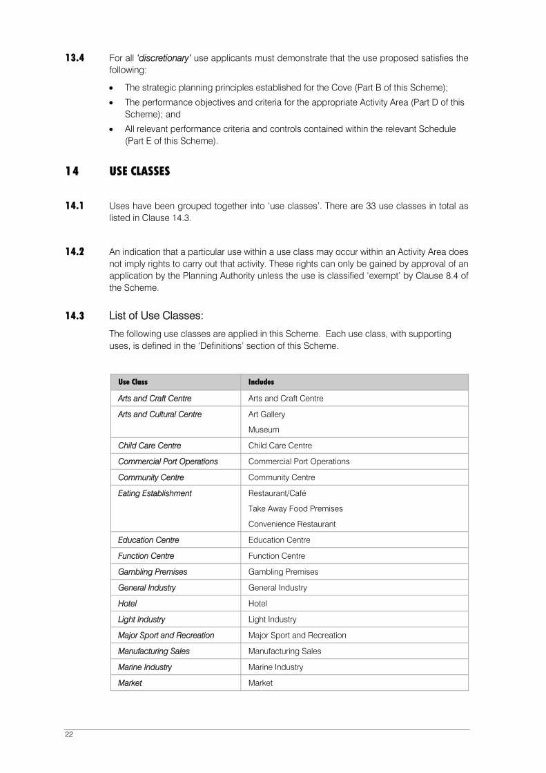
14.1 Uses have been grouped together into ‘use classes’. There are 33 use classes in total as listed in Clause 14.3.
14.2 An indication that a particular use within a use class may occur within an Activity Area does not imply rights to carry out that activity. These rights can only be gained by approval of an application by the Planning Authority unless the use is classified ‘exempt’ by Clause 8.4 of the Scheme.
14.3 List of Use Classes:
The following use classes are applied in this Scheme. Each use class, with supporting uses, is defined in the ‘Definitions’ section of this Scheme.
Use Class Includes
Arts and Craft Centre Arts and Craft Centre
Arts and Cultural Centre Art Gallery
Museum
Child Care Centre Child Care Centre
Commercial Port Operations Commercial Port Operations
Community Centre Community Centre
Eating Establishment Restaurant/Café
Take Away Food Premises
Convenience Restaurant
Education Centre Education Centre
Function Centre Function Centre
Gambling Premises Gambling Premises
General Industry General Industry
Hotel Hotel
Light Industry Light Industry
Major Sport and Recreation Major Sport and Recreation
Manufacturing Sales Manufacturing Sales
Marine Industry Marine Industry
Market Market
23
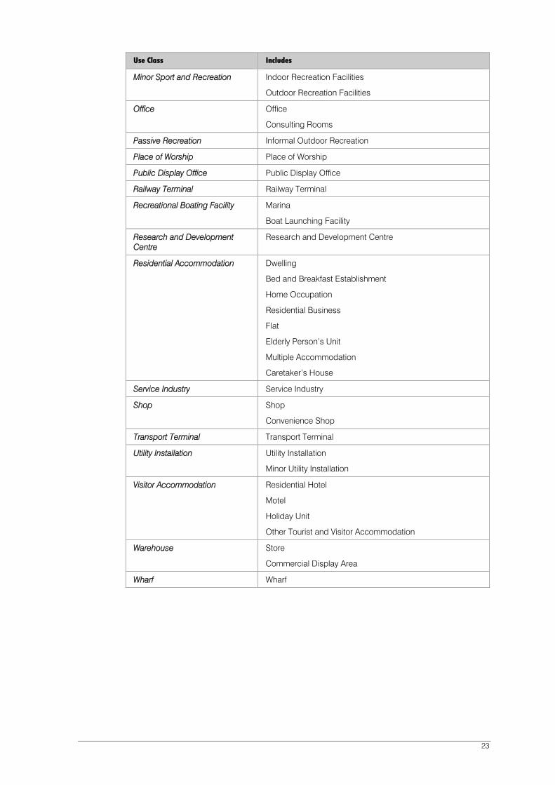
Use Class Includes
Minor Sport and Recreation Indoor Recreation Facilities
Outdoor Recreation Facilities
Office Office
Consulting Rooms
Passive Recreation Informal Outdoor Recreation
Place of Worship Place of Worship
Public Display Office Public Display Office
Railway Terminal Railway Terminal
Recreational Boating Facility Marina
Boat Launching Facility
Research and Development Centre
Research and Development Centre
Residential Accommodation Dwelling
Bed and Breakfast Establishment
Home Occupation
Residential Business
Flat
Elderly Person’s Unit
Multiple Accommodation
Caretaker’s House
Service Industry Service Industry
Shop Shop
Convenience Shop
Transport Terminal Transport Terminal
Utility Installation Utility Installation
Minor Utility Installation
Visitor Accommodation Residential Hotel
Motel
Holiday Unit
Other Tourist and Visitor Accommodation
Warehouse Store
Commercial Display Area
Wharf Wharf

24
15 ACTIVITY AREA 1.0 INNER CITY RESIDENTIAL (WAPPING)
15.1 General Characteristics of the Activity Area
The Wapping Activity Area has been earmarked for significant redevelopment for residential purposes in the early 1990s as part of the Commonwealth Government’s Better Cities Program.
Once a residential and industrial area of small cottages and various industries, and more recently used as a bus depot, Wapping has remained under-utilised for a number of years. Little survives that is recognisably ‘historic’. Exceptions to this include St David’s Church, Theatre Royal Hotel, Theatre Royal and the Woolstore tourist apartments (formerly known as the Roberts building) which have recently been recycled as tourist apartments.
An Outline Development Plan and Local Area Plan were prepared for the major part of the Activity Area focussing on facilitating residential development behind and above a commercial frontage to Collins Street. Although a number of new residential developments have taken place since the Scheme’s inception, significant key sites remain undeveloped.
Areas to the north and west of the main Wapping area are used for a range of activities. These are areas where residential amenity is not high because of noise, privacy and overshadowing issues, and some non-residential uses which are compatible with inner city residential development should be encouraged to locate here. Similarly some of the sites abutting the city CBD along Campbell Street might also be suitable for non-residential development where they capitalise on possible synergies with neighbouring land uses such as the hospital, or Theatre Royal or where they complement commercial activity along Collins Street.
It is important to achieve the commercial viability of new uses in Collins Street that there is a transition from the city CBD commercial character rather than clear separation of it from Wapping. This transition needs to be expressed in both the urban form and massing of buildings as well as the type and location of uses.
The Local Area Plan is incorporated into this Scheme and will form the basis for use and development control over a large section of this Activity Area.
Areas to the north and west of the main Wapping residential development are used for a range of activities. In addition to promoting residential use of these sites, a range of non-residential uses, which are generally compatible with inner city residential development, will be encouraged.
Use and development controls for the Activity Area are outlined within this Scheme.
15.2 Objectives of the Activity Area
To provide for the development of an inner city residential neighbourhood providing quality urban housing for a range of household types and income groups.
To ensure that residential development is the primary focus throughout the Activity Area but allow non-residential uses to be developed on a flexible performance approach based on the amenity and characteristics of specific sites.
To retain and restore where appropriate buildings of cultural significance.
To ensure that building masses and facades appropriately relate to the spaces they form. Streets within the Zone be considered as spaces in their own right.
To encourage architecture of the highest quality which is modern in approach but at the same time incorporate some interpretation of the history of the area as appropriate.

25
To ensure that new development incorporate historic cues, whilst not relying on historical mimicry.
To facilitate the transition from the CBD by allowing substantial commercial uses on key sites on the main connecting streets (Campbell and Collins Streets) or in places where reasonable residential amenity is unachievable because of existing traffic or environmental impacts. These commercial uses must not themselves diminish the amenity of or the potential for adjacent residential development.
To encourage frontages of commercial activity only on the ground floor of buildings abutting streets.
To encourage commercial activity in existing buildings where this is required to assist in their conservation.
To encourage a mix of uses on the sites in the west and north-west of the Activity Area and fronting Campbell Street.
15.3 Use of Land
15.3.1 Land within the Wapping Local Area Plan
For land located within the ‘Wapping Local Area Plan’ Precinct’ (shown as shaded on Figure 3a), the relevant use controls are contained within the incorporated Wapping Local Area Plan.
15.3.2 Land outside the Wapping Local Area Plan
For land located outside the Wapping Local Area Plan Precinct, the following table of uses applies:
15.3.3 ‘Permitted’ Uses
The following are ‘permitted’ (s.58 of the Land Use Planning and Approvals Act 1993) uses:
Use ‘Deemed to Comply’ Provision
Residential Accommodation (excepting a Residential Business or Bed and Breakfast Establishment)
Visitor Accommodation
Child Care Centre
Office
Arts and Craft Centre
Education Centre
The change of use from Residential Accommodation to Visitor Accommodation is ‘permitted’ only where the application:
(a) relates to a dwelling that is not part of a complex of dwellings that is subject to a registered strata plan or capable of such registration; or
(b) relates to all of the dwellings in a complex that is subject to a registered strata plan or capable or such registration.
Otherwise ‘prohibited’.
Shop ‘Permitted’ if maximum gross leasable floor space is les than 100 square metres (existing buildings) or 500 square metres (new buildings). Otherwise ‘discretionary’.
Eating Establishment ‘Permitted’ if maximum gross leasable floor area is less than 300 square metres. Otherwise ‘discretionary’.
All ‘permitted’ uses For any building that is subject to a registered strata plan involving Residential Accommodation, the use of land for any other use in this table, other than Visitors Accommodation, is only ‘permitted’ at the ground floor. Otherwise the use is ‘prohibited’.

26
15.3.4 ‘Discretionary’ Uses
The following are ‘discretionary’ (s.57 of the Land Use Planning and Approvals Act 1993) uses:
Use Condition
All ‘discretionary’ uses, except Residential Business, Bed and Breakfast Establishment
Hotel
Market
Arts and Cultural Centre
Manufacturing Sales
Function Centre
Place of Worship
Car Park
All other uses not specified in Clauses 15.3.3 or 15.3.5
Must meet the objectives and performance criteria of the Activity Area to the satisfaction of the Planning Authority. Otherwise ‘prohibited’.
For any building providing Residential Accommodation that is subject to a registered strata plan, the use of land for any other use in this table is only ‘discretionary’ at the ground floor with frontage to a road, otherwise the use is ‘prohibited’.
Bed and Breakfast Establishment An application for a Bed and Breakfast Establishment will be approved only where the application:
(a) relates to a dwelling that is not part of a complex of dwellings that is subject to a registered strata plan or capable of such registration; or
(b) relates to all of the dwellings in a complex that is subject to a registered strata plan or capable of such registration. Otherwise ‘prohibited’.
15.3.5 ‘Prohibited’ Uses
The following uses are ‘prohibited:
General Industry
Light Industry
Service Industry
Warehouse
15.3.6 Effect on amenity of the Wapping Local Area Plan Precinct
Any use of land within the Activity Area but not within the Wapping Local Area Plan Precinct must not detrimental affect the amenity of the Precinct through the:
Transport of material, goods or commodities to or from the land.
Appearance of any building, works or materials.
Emission of noise, artificial light, vibrations, smell, fumes, smoke, vapour, steam, soot, ash, dust, waste water, waste products, grit or oil.

27
15.4 Development of Land
15.4.1 Permit Requirements
Unless specifically ‘exempt’ by Clause 8.4, or the Schedules to this Scheme, a permit is required to construct a building or undertake development on the land outside the ‘Wapping Local Area Plan’ Precinct.
15.4.2 All development of land must satisfy the relevant provisions contained within the schedules of this Scheme.
15.5 Wapping Local Area Plan
15.5.1 Planning Area
The planning area to which this Local Area Plan applies is delineated in Figure 3a. The planning area is divided into six Parcels shown in Figure 3a.
15.5.2 Effect of Wapping Local Area Plan
Control over ‘use’ and ‘development’ shall be exercised in accordance with the provisions in the Wapping Local Area Plan and the schedule controls of the Scheme. In the event of any inconsistency with any provision or other requirement of the Scheme the provisions of this Local Area Plan take precedence.
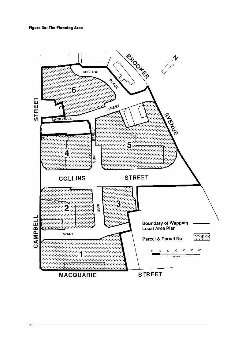
28
Figure 3a: The Planning Area

29
15.5.3 Statement of Desired Future Character
The Wapping area should evolve as a mixed inner city residential, cultural and commercial neighbourhood providing quality urban housing for a range of household types and income groups and some commercial, educational or cultural developments if they are compatible with or are ancillary to the primary residential use.
Dwellings and other buildings should be innovative, cost-effective, energy efficient and ecologically sound in terms of materials utilised. A high level of acoustic privacy should be provided commensurate with an inner city lifestyle and the mixed use area.
The architecture of buildings should be of the highest quality and modern in approach, but at the same time incorporate some interpretation of the history of the area as appropriate.
New development should incorporate historical cues, however historical mimicry should be avoided. Existing structures, structural elements and sites identified in this Plan as having historical and archaeological interest shall be managed so as to conserve their cultural significance in accordance with the guidelines wherever practicable.
Collins Street has been earmarked as the cultural and commercial spine of the area and commercial uses are encouraged on the ground floor. Parcels 2 and 4 have important roles in forming a gateway and linking Collins Street to the more commercial uses and urban form of the CBD. Additionally some commercial uses may be allowed in existing heritage buildings where this is required to assist in their conservation. Generally though significant commercial activity will only be appropriate at the edges of the Wapping area where high levels of traffic and neighbouring land uses reduce the potential for successful residential development or where they provide a buffer to traffic noise. This may result in a development on Parcel 4 which does not provide any residential component.
Consequently commercial activity in other (minor) streets is discouraged but allowable at ground floor level if in the same ownership as an appurtenant dwelling (eg 'shop top' flat) and is limited in floor area. However, such activity must have no material impact on the residential amenity of that or any other property.
Holiday Units are discouraged in the area except on half of Parcel 1 adjacent to the Woolstore development or on Parcel 4.
Holiday Units are discouraged in the area except where specifically designated by this Plan.
Commensurate with the objectives of sustainable development, good design and visual amenity to cater for an inner city lifestyle, the level of parking provision should be minimal and located and accessed in a manner that does not diminish the amenity of the streetspaces.
15.5.4 Control of Use and Development
The Planning Authority is bound to grant a permit for applications for ‘use’ and ‘development’ designated as 'permitted' in all of the relevant provisions of this Local Area Plan, but may impose conditions.
The Planning Authority has a discretion to refuse or permit applications for ‘use’ and ‘development’ designated as 'discretionary' in any of the relevant provisions this Local Area Plan and may impose conditions.
All other ‘uses’ and ‘development’ are ‘prohibited’.

30
15.5.5 Subdivision
‘Permitted’ Subdivision
The Planning Authority is bound to grant a permit for any application for subdivision which is required to create the boundaries of the six parcels shown in Figure 3a, or minor adjustments to such boundaries. The Planning Authority is also bound to grant a permit for any application for the subdivision of the Parcels into lots for the purpose of any use or development that has obtained a permit, in accordance with the Wapping Local Area Plan including an approved site development plan where demolition of an existing building has already been approved without a replacement building being approved simultaneously.
‘Discretionary’ Subdivision
All other applications for subdivision are ‘discretionary’.
15.5.6 Matters to be Considered
In considering applications and any conditions to be imposed on ‘use’ and ‘development’ the Planning Authority must consider:
A site development plan for a parcel or part of a parcel approved as part of a permit to demolish an existing building or buildings;
The Statement of Desired Future Character; and
The Guidelines in this Local Area Plan.
The Planning Authority may also consider relevant documents relating to the area including:
The Australian Model Code for Residential Development (AMCORD), 1995, and AMCORD URBAN;
The Sullivans Cove Planning Review, 1991;
The Wapping Neighbourhood Outline Development Plan, 1993 (the ODP);
The Street Space Character Addendum to the ODP, 1996; and
The Wapping Local Area Plan Review – Parcels 4 & 5, December 2001.
15.5.7 Use Tables
Different uses are deemed to be either ‘Permitted’ or ‘Discretionary’ depending on the particular location and subject to specific conditions. Consequently some uses appear in both tables below. To ascertain the status of a use on a specific piece of land or level of a building, both tables need to be read in conjunction.
(a) Permitted uses
The following uses are ‘permitted (s.58 of the Land Use Planning and Approvals Act 1993) uses:
Use ‘Deemed to Comply’ Provision
Dwelling, Flat, Elderly Persons’ Unit
In any location except on the ground floor fronting Collins Street where they are ‘Discretionary’
Home Occupation None
Office, Arts and Craft Centre, Shop, Retail Premises, Convenience Shop, Restaurant /Café, Take-Away Food Premises
Only if located on the ground floor fronting Collins Street.

31
(b) Discretionary uses
The following are ‘discretionary’ (s.57 of the Land Use Planning and Approvals Act 1993) uses:
Use Condition
Dwelling, Flat, Elderly Persons’ Unit
On the ground floor fronting Collins Street otherwise Permitted
Bed & Breakfast Establishment
Multiple Accommodation
Residential Business
Consulting Rooms
Community Centre
Place of Worship
Indoor Recreation Facilities
Informal Outdoor Recreation
Hotel
None
Education Centre
Research and Development Centre
Only on Parcel 5 and on Parcel 4 where it can demonstrate a need to be closely linked to the Royal Hobart Hospital for educational and functional synergies and where it also provides for ancillary facilities for the Theatre Royal.
Office
Convenience Shop
Take-Away Food Premises
Restaurant / Café
Shop
Retail premises
On the ground floor of any building with a street frontage and on any part of Parcel 4. However in Mistral Place, Sackville Street, Terminus Street and Cresswells Row they will be limited to 40 sq m in size and must be appurtenant to a dwelling in the same ownership.
Arts and Craft Centre
Arts and Cultural Centre
On Parcel 4 fronting Campbell Street where it includes ancillary facilities for the Theatre Royal or in any building listed in Clause 15.5.12 (Heritage) where it assists in the conservation of that building in line with the Principles in Clause 15.5.12.
Holiday Units (i) on Parcel 4 and 50 percent of Parcel 1 abutting the Red Lion Hotel (provided the units are clustered and contiguous and not interspersed with ‘permitted’ uses), or
(ii) when they are used for no more than 4 months of the year in conjunction with a hostel for students, falling within the use multiple accommodation, or
(iii) where they are used for a period not exceeding two years in situations where dwellings constructed during the initial phase of development in accordance with this Local Area Plan cannot be sold for a market value accepted by the Planning Authority within six months of their coming onto the market.
Service Industry Only on the ground floor of Collins Street and where they occupy no more than 100 sq m of floor space and provide a service which relates to the needs of local residents.
Unlisted uses i.e. Any use not listed in Clause 14.3 of the Scheme.
As deemed appropriate by the Planning Authority.
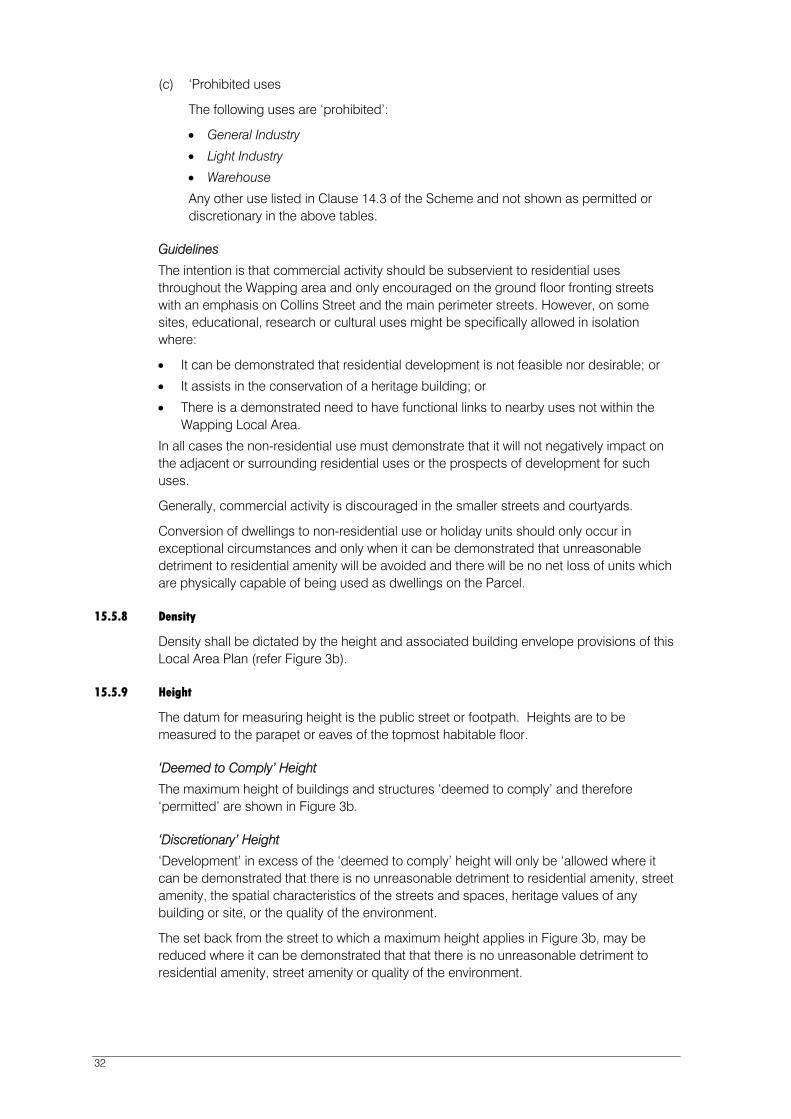
32
(c) ‘Prohibited uses
The following uses are ‘prohibited’:
General Industry
Light Industry
Warehouse
Any other use listed in Clause 14.3 of the Scheme and not shown as permitted or discretionary in the above tables.
Guidelines
The intention is that commercial activity should be subservient to residential uses throughout the Wapping area and only encouraged on the ground floor fronting streets with an emphasis on Collins Street and the main perimeter streets. However, on some sites, educational, research or cultural uses might be specifically allowed in isolation where:
It can be demonstrated that residential development is not feasible nor desirable; or
It assists in the conservation of a heritage building; or
There is a demonstrated need to have functional links to nearby uses not within the Wapping Local Area.
In all cases the non-residential use must demonstrate that it will not negatively impact on the adjacent or surrounding residential uses or the prospects of development for such uses.
Generally, commercial activity is discouraged in the smaller streets and courtyards.
Conversion of dwellings to non-residential use or holiday units should only occur in exceptional circumstances and only when it can be demonstrated that unreasonable detriment to residential amenity will be avoided and there will be no net loss of units which are physically capable of being used as dwellings on the Parcel.
15.5.8 Density
Density shall be dictated by the height and associated building envelope provisions of this Local Area Plan (refer Figure 3b).
15.5.9 Height
The datum for measuring height is the public street or footpath. Heights are to be measured to the parapet or eaves of the topmost habitable floor.
‘Deemed to Comply’ Height
The maximum height of buildings and structures ‘deemed to comply’ and therefore ‘permitted’ are shown in Figure 3b.
‘Discretionary’ Height
‘Development’ in excess of the ‘deemed to comply’ height will only be ‘allowed where it can be demonstrated that there is no unreasonable detriment to residential amenity, street amenity, the spatial characteristics of the streets and spaces, heritage values of any building or site, or the quality of the environment.
The set back from the street to which a maximum height applies in Figure 3b, may be reduced where it can be demonstrated that that there is no unreasonable detriment to residential amenity, street amenity or quality of the environment.

33
Figure 3b: Height Control Diagram

34
Guideline
In considering the merit and performance of any ‘development’ proposal that exceeds the ‘Deemed to Comply’ height the following will be taken into consideration:
bulk (size and form);
massing (relationship of solid walls to doors, window openings and overall elevational treatment);
privacy;
solar access;
wind effects;
view; and
skyline.
Particular attention should be given to the ODP including the Wapping Local Area Plan Review – Parcels 4 & 5, December 2001, and the Street Space Character Addendum to the ODP (1996).
The incorporation of features such as lift over-runs, machinery and architectural features that protrude above the eaves or parapet will be expected to reflect the design objectives of this Local Area Plan.
The Planning Authority may also impose conditions relating to the appearance of developments, privacy, solar access and any aspect of construction relevant to the liveability of dwellings.
15.5.10 Siting and Landscaping
The Planning Authority may impose conditions of approval requiring a setback to the street of up to two metres and to require fencing and landscaping to its satisfaction. The Planning Authority may also impose conditions relating to the appearance of developments, privacy, solar access and any aspect of construction relevant to the liveability of dwellings.
Guideline
The Wapping area is well located for residential use, being equally close to the city's shopping and commercial centre, the open spaces and recreation opportunities of the Domain and the renowned attractions of Sullivans Cove. Some parts of the area have potential for attractive outlooks to the Cenotaph, Domain, Mt Wellington and the docks. Most parts have good solar access.
The design and siting of new development should consider the shading effects of both existing and new buildings, and appropriate orientation to allow optimal solar access to all dwellings.
The Wapping area should provide a high quality and stimulating residential environment; and enjoyable, secure, safe and convenient routes for cars, pedestrians and cyclists.
The area should develop as a lively 'people place' centred on Collins Street and sheltered or buffered on the high traffic edges. Use of the sunny southern or docks side of Collins Street is encouraged.
Traffic flow is essential for informal surveillance and a sense of safety at night.
Houses in streets off Collins Street should present a 'front face' to the street allowing good surveillance.
Historic elements such as streets, property boundaries, walls and precincts should be retained wherever appropriate.

35
In general a modest setback of dwellings from the street should be provided for landscaping. Front fences should be of a transparent picket type except on heavily trafficked streets and should be of sturdy construction to prevent noise from the operation of gates.
Car access to the front of dwellings is discouraged but may be provided in limited circumstances where a satisfactory streetscape can be achieved.
15.5.11 Traffic, Access and Parking
Required Parking Spaces
The minimum parking requirement is as set out in the Table of Parking Requirements below. The parking provision in the Table does not apply to buildings shown as parking provision exempt buildings in Figure 3c.
Table of Parking Requirements
Use Requirement
Residential Development
Holiday Unit
Dwelling, Flat, Multiple Accommodation
1 bedroom or with a floor area not exceeding 80m2
2 bedrooms or with a floor area not exceeding 120m2
3 bedrooms or with a floor area not exceeding 140m2
any other number of bedrooms or floor area
1 space
1.1 spaces
1.3 spaces
1.5 spaces
as determined by the Planning Authority
Non-Residential Development
Consulting Rooms
Community Centre
Place of Worship
Education Centre
Office
Shop
Take-Away Food Premises
Retail Premises
Hotel
Restaurant/ Cafe
Convenience Shop
or any other non-residential use
3 spaces per 100m2 of floor area except for any floor area provided appurtenant to and in the same occupancy as any dwelling where there is no requirement for the first 40m2 of floor area.

36
Figure 3c: Parking Provision Exempt Buildings
37
Other Development
All other ‘development’ - No spaces are required or will generally be approved unless they can be demonstrated to not conflict with the amenity and convenience of the residents of the area.
Visitor Parking
There are no requirements for additional visitor parking, though spaces from the total provided may be required to be reserved for such purposes as part of any change of use or development.
‘Discretionary’ Parking Provisions
Provided that the Planning Authority is satisfied that obstruction of roads or pedestrian ways in the area will not be increased, the parking provisions may be reduced for environmental, streetscape or safety reasons and the Planning Authority may require or accept a cash payment in lieu of the on-site provision of any or all required parking spaces.
The number of required parking spaces for any use or development set out in the above “Table of Parking Requirements” should be used by the Planning Authority in calculating a cash-in-lieu payment.
Guideline
The Wapping area should provide a high quality and stimulating residential environment and enjoyable, secure, safe and convenient routes for cars, pedestrians and cyclists. Traffic flow is essential for informal surveillance and a sense of safety at night.
The area should develop as a lively 'people place' centred on Collins Street and sheltered or buffered on the high traffic edges.
It is recognised that streets in the central area of Hobart are the subject of parking management measures in response to the fact that demand exceeds supply. Significant areas of central Hobart have no parking requirements.
Encouraging inner city living is a primary objective of this Local Area Plan, therefore parking requirements should not be rigidly applied. In instances where site or building configuration makes redevelopment for residential uses difficult or the provision of the required number of parking spaces would result in substantial detriment to residential amenity those requirements should be waived in whole or part.
Vehicle access to the Parcels and the provision of pedestrian access through them should take into account the recommendations of the Wapping Neighbourhood Outline Development Plan, 1993, the Wapping Local Area Plan Review - Parcels 4 & 5, December 2001 and the requirements of relevant transport authorities.
Car parking spaces may be located off-site to the Planning Authority’s satisfaction through an agreement reached under Part 5 of the Land Use Planning and Approvals Act 1993. When the provision yields less than a whole number the provision shall be rounded downwards.
The Planning Authority may place conditions on approvals relating to traffic and access requirements.
‘Uses’ and/or ‘developments’ involving the retention and recycling of the buildings shown in Figure 3c shall be ‘exempt’ from any requirement to provide car parking either on or off site.

38
15.5.12 Heritage
‘Permitted’ Heritage Provisions
‘Building or Works’ on sites listed in Table 1 of Schedule 1 or shown on Figure 3d of this Local Area Plan must comply with Clause 22.4.4 of the Scheme to be ‘permitted’.
‘Building or Works’ on sites adjacent to sites listed in Table 1 of Schedule 1 or identified in Figure 3d are deemed to satisfy the provisions of Clause 22.5.4 of Schedule 1 of the Scheme in respect of height and setback, where they are within the ‘deemed to comply’ controls set out in Figure 3b of this Local Area Plan. The Planning Authority, however, may impose conditions on development on land adjacent to the buildings identified in figure 3d to ensure that the provisions and guidelines of the Local Area Plan are not compromised.
‘Discretionary’ Heritage Provisions
For ‘Building or Works’ on sites listed in Table 1 of Schedule 1 or shown on Figure 3d of this Local Area Plan which cannot meet the ‘deemed to comply’ provisions, the height and setback controls set out in Figure 3b and compliance with the following Principles are taken as meeting the criteria for ‘Discretionary’ building or works listed in Clause 22.4.5 of Schedule 1.
Any ‘Building or Works’ on sites adjacent to a place listed in Table 1 to Schedule 1 of the Scheme and/or referred to below which cannot meet the ‘permitted’ requirements of Clause 22.5.4 or the ‘deemed to comply’ height and setback for that site, shall be considered on the basis of compliance with the following principles and the provisions of Clause 22.5.5 in Schedule 1.
(A) Metropolitan Transport Trust Offices (Parcel 1 and known as 55, Macquarie Street)
This building contributes to the urban context of Campbell and Macquarie Streets and as such should be in large part retained. Remnant original fittings should be conserved in redevelopment.
(B) St David’s Mission Church (Parcel 2 and known as 9 Campbell Street)
Must be retained and managed as per Conservation Plan dated June 1995. No alterations to the basic form and height will be allowed unless they are clearly consistent with that Conservation Plan and heritage values.
(C) Barnett Bros. Building (Parcel 2 and known as 36 Collins Street)
The building is associated with the industrialisation of Wapping and is an important contributor to the urban streetscape of Collins Street. It should be retained.
(D) City Motors Garage façade and wall (Parcel 3 and known as 18-26 Collins Street)
This element contributes to the urban streetscape of Collins Street. It should be retained and where possible functionally integrated into a new development. Some modification of the wall may be acceptable.
(E) Hedberg Bros. Garage (Parcel 4 and known as 19 Collins Street)
The building is an early and uncommon example of a motor garage, part of the industrialisation of Wapping. It also contributes to the urban streetscape of Collins Street visually and by setting a datum for building alignment. It should be retained but where this is not a feasible proposition and where it limits the achievement of the other intents of this Local Area Plan it may be in part demolished as long as any portion retained is integrated into the new development with integrity and dignity. If any part of this building is to be demolished the building should be recorded in full prior to demolition.
(F) Transport Commission Building (Parcel 5 and known as 1 Collins Street)

39
This building is an example of Post World War II town planning and architectural design. Theoretically it offers an opportunity to be recycled for residential uses such as student accommodation, but a detailed engineering assessment has determined that the building is in very poor condition and demolition may be the most feasible option.
If it is to be demolished separately from any redevelopment proposal, a detailed site development plan should be prepared beforehand and approved as part of any development application including demolition. That site development plan should cover all of that part of Parcel 5 not so far redeveloped, and be consistent with the Wapping Local Area Plan Review - Parcels 4 & 5, December 2001.
(G) Tasmanian Fur Traders Building (Parcel 5 and known as 16 Sackville Street)
This building was part of the industrialisation period of Wapping and contributes to the urban context of Sackville Street. The street facing section of the building should be retained. If any other part of the building is to be demolished then the entire building should be recorded prior to demolition.
(H) Walls off Sackville Street (Parcel 6)
The walls reveal the early subdivision pattern and skewed property alignments of Wapping. They should be retained if they can be meaningfully integrated into the proposed redevelopment.

40
Figure 3d: Heritage Guidelines
41
15.5.13 Signs
15.5.13A ‘Exempt’ Sign Provisions
The following signs are exempt from requiring a permit where it can be demonstrated that the following ‘deemed to comply’ provisions have been satisfied:
Name Plates
The plates identify occupants of a property used for professional offices or consulting rooms, attached flush to the wall provided;
The plates are not placed on a building listed in Figure 3d; In all cases do not exceed three (3) in number (any additional plates in excess of
three will require approval); The area of the name plates combined does not exceed 0.5 square metres and they
are placed on a building or site which has a related land use ‘exempt’ or ‘permitted’
under the Planning Scheme. Open/Closed Signs
Signs must not protrude beyond the building frontage. Real Estate Signs
Must be less than 1m² in area. Street Number
One only per land title, not individual strata titles No greater than vertical dimension of 100mm X horizontal dimension 100mm Must be attached above and central to the principal doorway/entrance to the
property and centrally positioned unless incorporated within another sign on the building face.
15.5.13B ‘Discretionary’ Sign Provisions
The construction, putting up for display or erection and the continuous display of all other signs is a discretionary development or use and is required to satisfy the provisions of Clause 25.11 of Schedule 4 of the Scheme as if all buildings are buildings listed in Figure 3d. They should meet the following performance criteria:
Signs should relate to a business operating from the site in question. The appearance of the sign should be in keeping with the urban design theme and
architecture of buildings in the vicinity. Specifically, signs based on historic themes with little association with the area are
discouraged.
15.5.14 Other Exemptions
Notwithstanding Clause 8.4 of the Scheme or the exemption provisions of Parts D & E, within the planning area of the Local Area Plan the ‘use’ and/or ‘development’ of land
for the following shall also be ‘exempt’ from requiring a permit:
Pergolas, garden arches, trellises, and frames for vines and climbing plants, and similar structures, if the frame is covered, apart from the vegetation only by trellis work, wire netting, or similar open work;

42
16 ACTIVITY AREA 2.0 SULLIVANS COVE ‘MIXED USE’
16.1 General Characteristics of the Activity Area
The ‘Sullivans Cove Mixed Use’ Activity Area comprises the land stretching from Battery Point across the central Cove area to the north side of Hunter Street, and beyond to the Liverpool Street extension.
This Activity Area is Hobart’s major tourist destination and has a readily identifiable image as a focus for cultural activities and supports a wide range of other uses which contribute to its character and vitality.
This Activity Area includes a great diversity in architectural style and spatial characteristics.
There are many buildings, objects and spaces of cultural heritage in this Activity Area, including the Salamanca Place buildings, Parliament House and other governmental and institutional buildings. The area accommodates a range of mid and late 20th century buildings as well, from the ‘silos’, to the Grand Chancellor Hotel, HEC Building and the Antarctic Centre.
A number of important pedestrian spaces in the Cove are located in this Activity Area. The road network currently carries high levels of through traffic - most notably along the Macquarie - Davey Street Couplet, and along Brooker Avenue and the Tasman Highway.
Land within this Activity Area acts as a transition space between the CBD and waters edge, as well as between Hunter Street and Salamanca Place, and in the area across Brooker Avenue between the CBD and the Domain.
16.2 Objectives and Performance Criteria for Activities
The following objectives and performance criteria apply to all use and development in this Activity Area.
Objectives Performance Criteria
(a) To ensure that activities within the Cove respect the cultural heritage and character of the Activity Area.
All use and development within the Activity Area must demonstrably contribute to, and enhance the cultural heritage, built form (bulk, height, volume, urban detail) and spatial characteristics of the activity area.
Activities requiring large, undifferentiated floor areas shall be discouraged in the activity area, except where such activities can be accommodated within existing buildings.
New development north of Brooker Avenue must be designed in a manner which protects the cultural heritage and landscape qualities of the Domain including the setting of the Cenotaph.
(b) To ensure that the amenity, character and cultural heritage values of the Cove’s roads and other public spaces are conserved and enhanced.
Use and development on road reserves, public parks and other public spaces within the activity area shall only be ‘permitted’ where they do not detract from the space’s amenity or heritage value.

43
Objectives Performance Criteria
(c) To encourage use and development which generate pedestrian movement through the activity area.
Outdoor dining and other outdoor pedestrian activities are encouraged in appropriate locations.
Activities which generate pedestrian traffic are to be encouraged particularly along Salamanca Place, Hunter Street, the western side of Morrison Street and the block bounded by Davey, Elizabeth, Morrison and Argyle Streets.
All use and development shall facilitate pedestrian access, circulation, amenity and safety within the Cove.
All use and development must facilitate access for the disabled and other pedestrians with restricted mobility.
Parking and vehicle movement within public urban spaces intended primarily to facilitate pedestrian movement shall be discouraged where it conflicts with pedestrian movement and safety.
(d) To encourage the further development of the Activity Area as a tourist destination.
The existing mix of tourist-oriented uses and facilities, including shops, restaurants and hotels shall continue to be encouraged.
(e) To promote the use of the roads, other public spaces and buildings within the area for festivals and other public gatherings.
Markets and Cultural and Community Events shall be encouraged in spaces designated as having a primarily ‘pedestrian’ function.
(f) To ensure that the Activity Area’s primary function as a place for a range of arts, cultural, civic, recreational and entertainment activities, is strengthened together with its role as a shop window for quality Tasmanian produced goods.
Arts and Cultural Activities:
Arts and Cultural activities, including small ‘in-shop’ artist workshops, shall be promoted throughout the Activity Area. In particular, such activities will be encouraged along primary pedestrian routes in the Cove.
Retail Activities:
A diverse, but balanced, mix of retail activities including art and craft centres, shops and eating establishments shall be promoted, especially in the Salamanca area, to reinforce the role of the Cove as the City’s ‘cultural precinct’.
(g) To encourage offices, administrative and smaller scale activities in locations where they reinforce rather than conflict with more active uses that characterise the attractiveness to visitors walking around this part of the Cove.
Office and Educational Activities:
Office uses, including financial institutions, consulting suites and other administrative activities shall be encouraged to locate in existing buildings within the Cove.
Office uses and smaller education activities proposed in retail areas of the Cove shall be encouraged to locate within existing buildings on the first floor or above.
Large non retail or visitor related activities such as offices will be encouraged to locate within existing office buildings, particularly in the Macquarie Street - Davey Street area.
Any education centre activity of a significant scale should focus on the existing Centre of arts or other locations where they would not replace uses that contribute to a more active street frontage.
Public display offices shall be discouraged from locating in the centre of retail areas.
44
Objectives Performance Criteria
(h) To facilitate residential development in appropriate locations as a secondary use to support the Activity Area’s businesses and other activities essential to its role as a key visitor destination.
Residential Activities:
Residential and visitor accommodation shall be encouraged in buildings fronting secondary spaces, on first floor level or above, and in other locations which will not adversely impact on the economic vitality of retailing.
Residential and visitor accommodation shall be encouraged in buildings fronting secondary spaces, on first floor level or above, and in other locations which will complement and not adversely impact on the economic vitality of arts, cultural and related retailing activities.
Environmental and Amenity Impacts:
Industrial activities, manufacturing and transport terminals shall be encouraged to locate in areas which do not create local traffic, parking, pedestrian or residential amenity impacts, or impacts on the social, cultural and recreational uses of the area.
(i) To minimise the use of public land resources of the activity area for commuter and other long term parking.
Public car parking within the Cove shall be provided primarily to meet the short term parking needs of tourists and other visitors to the Cove.
(j) To ensure sound environmental planning and management for all activities.
All use and development to demonstrate the minimisation of on and off site energy requirements resulting from the proposed activity.
All use and development must minimise direct and indirect environmental risk or effects and where possible provide a new environmental gain for the wider environment.
(k) Promote use and development in the transition area between the CBD and the Domain and the Cove and the Domain which contributes to the ‘gateway’ function of that area.
The development of land addressing Liverpool Street, Brooker Avenue and the Tasman Highway, shall be responsive to the ‘gateway’ function of the land facing those roads.
Activities which facilitate pedestrian movement between the city and the Domain and the Cove and Domain will be encouraged.
(l) To encourage a new road access linking Activity Area 3.0 and Brooker Avenue.
A new access road servicing Activity Area 3.0 and with the potential to also service Activity Area 4.1 shall be encouraged at the location shown in figure 9a. It must be constructed to best practice engineering standards and designed to respond appropriately to the Cove-Domain ‘gateway’ function of the site.
45
16.3 Use of Land 16.3.1 ‘Permitted’ Uses
The following are ‘permitted’ (s.58 of the Land Use Planning and Approvals Act 1993) uses:
Use ‘Deemed to Comply’ Provision
Residential Accommodation (excepting a Residential Business or Bed and Breakfast Establishment)¹
Visitor Accommodation¹
‘Permitted’ if not located at ground level on Salamanca Place, Morrison Street or Hunter Street (discrete entrances excepted). Otherwise ‘discretionary’. The change of use from Residential Accommodation to Visitor Accommodation is ‘permitted’ only where the application: (a) relates to a dwelling that is not part of a complex of
dwellings that is subject to a registered strata plan or capable or such registration; or
(b) relates to all of the dwellings in a complex that is subject to a registered strata plan or capable of such registration; or
(c) relates to an individual dwelling in a complex of dwellings that is subject to a registered strata plan or capable of such registration, and which has a separate ground level pedestrian access to a road.
Otherwise ‘prohibited’.
Office
Public Display Office
‘Permitted’ if: (i) located within the first floor or above of existing
buildings; or (ii) located in ground floors of existing buildings:
(a) Fronting: secondary spaces, except Salamanca Square and Salamanca Mews; or,
(b) Not fronting Salamanca Place, Hunter Street, the western side of Morrison Street, and the block bounded by Davey, Elizabeth, Morrison and Argyle Streets.
(iii) For a new building that does not propose on site parking that is visible to a primary or secondary space.
Otherwise ‘discretionary’.
Shop¹
Eating Establishment¹
‘Permitted’ if: (i) maximum gross leasable floor space is less than
100 square metres (existing buildings) or 300 square metres (new buildings). Otherwise ‘discretionary’.
(ii) they do not replace an Arts and Cultural Centre or Arts and Craft Centre. Otherwise ‘discretionary’.
Market¹ Nil
Arts and Cultural Centre Nil
Arts and Craft Centre¹ ‘Permitted’ if maximum gross leasable floor space is less than 300 square metres. Otherwise ‘discretionary’.
Education Centre ‘Permitted’ if use is accommodated within the floor area of an existing building used primarily for that purpose or at first floor level of any other building. Otherwise ‘discretionary’.
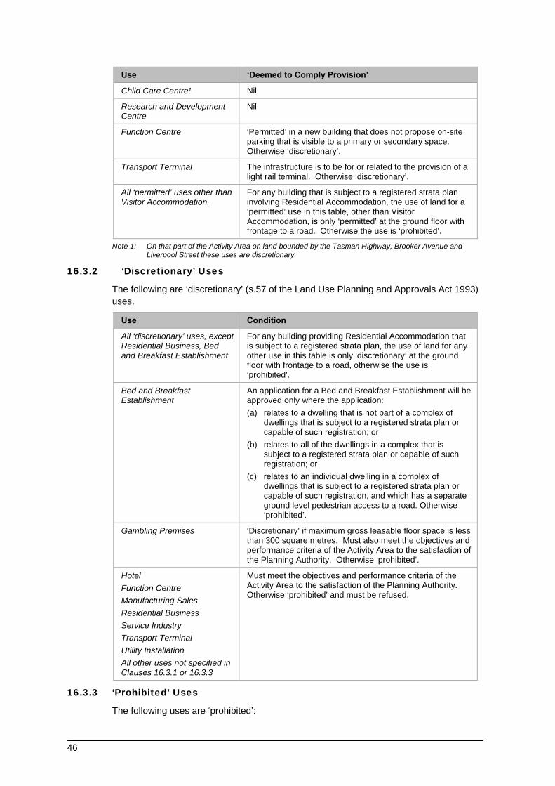
46
Use ‘Deemed to Comply Provision’
Child Care Centre¹ Nil
Research and Development Centre
Nil
Function Centre ‘Permitted’ in a new building that does not propose on-site parking that is visible to a primary or secondary space. Otherwise ‘discretionary’.
Transport Terminal The infrastructure is to be for or related to the provision of a light rail terminal. Otherwise ‘discretionary’.
All ‘permitted’ uses other than Visitor Accommodation.
For any building that is subject to a registered strata plan involving Residential Accommodation, the use of land for a ‘permitted’ use in this table, other than Visitor Accommodation, is only ‘permitted’ at the ground floor with frontage to a road. Otherwise the use is ‘prohibited’.
Note 1: On that part of the Activity Area on land bounded by the Tasman Highway, Brooker Avenue and Liverpool Street these uses are discretionary.
16.3.2 ‘Discretionary’ Uses
The following are ‘discretionary’ (s.57 of the Land Use Planning and Approvals Act 1993) uses.
Use Condition
All ‘discretionary’ uses, except Residential Business, Bed and Breakfast Establishment
For any building providing Residential Accommodation that is subject to a registered strata plan, the use of land for any other use in this table is only ‘discretionary’ at the ground floor with frontage to a road, otherwise the use is ‘prohibited’.
Bed and Breakfast Establishment
An application for a Bed and Breakfast Establishment will be approved only where the application: (a) relates to a dwelling that is not part of a complex of
dwellings that is subject to a registered strata plan or capable of such registration; or
(b) relates to all of the dwellings in a complex that is subject to a registered strata plan or capable of such registration; or
(c) relates to an individual dwelling in a complex of dwellings that is subject to a registered strata plan or capable of such registration, and which has a separate ground level pedestrian access to a road. Otherwise ‘prohibited’.
Gambling Premises ‘Discretionary’ if maximum gross leasable floor space is less than 300 square metres. Must also meet the objectives and performance criteria of the Activity Area to the satisfaction of the Planning Authority. Otherwise ‘prohibited’.
Hotel
Function Centre
Manufacturing Sales
Residential Business
Service Industry
Transport Terminal
Utility Installation
All other uses not specified in Clauses 16.3.1 or 16.3.3
Must meet the objectives and performance criteria of the Activity Area to the satisfaction of the Planning Authority. Otherwise ‘prohibited’ and must be refused.
16.3.3 ‘Prohibited’ Uses
The following uses are ‘prohibited’:

47
General Industry
16.4 Development of Land
16.4.1 Permit Requirement
Unless specifically ‘exempt’ under Clause 8.4, or the Schedules to this Scheme, a permit is required to undertake any development of land.
16.4.2 All development of land must satisfy the relevant provisions contained within the schedules of this Scheme.
48
17 ACTIVITY AREA 2.1 ‘DOMAIN OPEN SPACE’
17.1 General Characteristics of the Activity Area
The Domain is a highly significant cultural landscape to Tasmania’s community. This significance is based on the importance of the memorial sites, the range and nature of historic sites and the contribution it makes to the sense of place of Hobart.
This area contains important community symbols, including the Cenotaph, Boer War memorial and the Domain Park. Aside from its cultural significance, the Domain presents a grand sense of entry to the City and is a significant public recreation asset. This area, as one of the City’s principal open spaces, is a significant recreational and tourism venue both for informal and structured uses.
In 1996 the ‘Queens Domain Management Plan’ was prepared, and adopted by the Planning Authority. This management plan established the following visions statement for the Domain:
“The Queens Domain shall be a park of the people which celebrates and protects its significant natural landscape and rich cultural history whilst providing for the education, recreation, health and enjoyment of its visitors.”
Whilst this plan related to the entire Queens Domain Area (extending beyond the boundaries of the Activity Area), it is an important management tool for activities. This management plan will be used as the basis for management of activities within this Activity Area.
17.2 Objectives and Performance Criteria for Activities
The following objectives and performance criteria apply to use and development in this Activity Area.
Objectives Performance Criteria
(a) To protect and enhance the intrinsic and cultural values of the Domain.
Activities must not adversely impact on the cultural heritage and aesthetic values of the area.
Activities must be compatible with these values, and where possible reinforce and enhance these values.
(b) To maintain and encourage informal recreation and tourism uses related to the area’s intrinsic and cultural value,
Use and development with the potential to adversely impact on the area’s intrinsic and cultural values, and the related informal recreation and tourism uses (as identified in the 1996 Queens Domain Management Plan) will be discouraged.
(c) To consolidate and contain existing structured recreation, tourism and play activities.
Activities which are compatible with the type and intensity of existing structured recreation, tourism and play uses of the Domain (as identified in the 1996 Queens Domain Management Plan) are encouraged.
(d) To protect and improve views to and from the Activity Area.
Use and development of land must not adversely impact upon the views to and from the Activity Area.
(e) To increase pedestrian and cyclist accessibility to the Domain from the Cove and the CBD.
Use and development must not negatively impact upon, and where possible, must facilitate, pedestrian and cyclist access and circulation.
(f) To minimise the impacts of vehicle traffic and parking on the special qualities of the area.
Management of traffic and parking must be in accordance with the recommendations of the 1996 Queens Domain Management Plan.
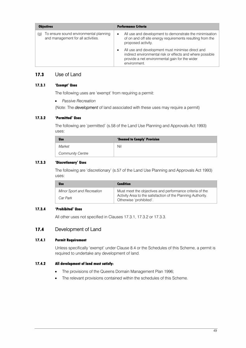
49
Objectives Performance Criteria
(g) To ensure sound environmental planning and management for all activities.
All use and development to demonstrate the minimisation of on and off site energy requirements resulting from the proposed activity.
All use and development must minimise direct and indirect environmental risk or effects and where possible provide a net environmental gain for the wider environment.
17.3 Use of Land
17.3.1 ‘Exempt’ Uses
The following uses are ‘exempt’ from requiring a permit:
Passive Recreation
(Note: The development of land associated with these uses may require a permit)
17.3.2 ‘Permitted’ Uses
The following are ‘permitted’ (s.58 of the Land Use Planning and Approvals Act 1993) uses:
Use ‘Deemed to Comply’ Provision
Market
Community Centre
Nil
17.3.3 ‘Discretionary’ Uses
The following are ‘discretionary’ (s.57 of the Land Use Planning and Approvals Act 1993) uses:
Use Condition
Minor Sport and Recreation
Car Park
Must meet the objectives and performance criteria of the Activity Area to the satisfaction of the Planning Authority. Otherwise ‘prohibited’.
17.3.4 ‘Prohibited’ Uses
All other uses not specified in Clauses 17.3.1, 17.3.2 or 17.3.3.
17.4 Development of Land
17.4.1 Permit Requirement
Unless specifically ‘exempt’ under Clause 8.4 or the Schedules of this Scheme, a permit is required to undertake any development of land.
17.4.2 All development of land must satisfy:
The provisions of the Queens Domain Management Plan 1996;
The relevant provisions contained within the schedules of this Scheme.
18 ACTIVITY AREA 3.0 SULLIVANS COVE ‘GATEWAY’
18.1 General Characteristics of the Activity Area
Activity Area 3.0 includes the recently vacated Railway Goods Yard and land previously used by a range of industrial and warehousing operations including cold storage.
The Macquarie Point Development Corporation has responsibility for the remediation and redevelopment of most of the land within this Activity Area. Under the Macquarie Point Development Corporation Act 2012 the Corporation is required to plan, facilitate and manage the redevelopment of the site so as to ensure that it:
(i) is redeveloped as a vibrant and active area, with a mix of uses, that connects with and
complements adjacent areas within Hobart;
(ii) encourages inner-city living;
(iii) is redeveloped so as to deliver sustainable social and economic benefits to Hobart; and
(iv) is redeveloped in accordance with sound planning, urban design and environmental
principles;
All future development of land within this Activity Area must also have regard to the potential contamination of soil, the product of many years of industrial activities in the area.
18.2 Objectives for Activities
The objectives for use and development in Activity Area 3.0 are represented as Desired Future Character Statements in clause 32.3 of the 'Macquarie Point Site Development Plan' under Part F of the Scheme.
50

18.3 Use and Development of Land
18.3.1
Description
All land within Activity Area 3.0 is located within the 'Macquarie Point Site Development Plan' (shown on Figure 4) and the relevant controls on use and development are contained within that Site Development Plan in clause 32 under Part F of the Scheme.
51

52

53
19 ACTIVITY AREA 4.1 ‘MACQUARIE POINT WHARF’
19.1 General Characteristics of the Activity Area
The Port of Hobart is a natural deep water port which offers safe all weather access, served by both road and rail linkages. It is a significant economic asset to both Hobart and Tasmania. The development and protection of this asset is a primary planning objective of this Scheme.
The Tasmanian Ports Corporation aims to be Tasmania’s premier facilitator for all trade and transport services. The Macquarie Wharf port complex will play an integral part in the Board’s fulfilment of this vision.
The Tasmanian Ports Corporation has identified the Port as having a competitive advantage in the integration of transport nodes and acting as a ‘trade facilitator’. Increasing utilisation of rail facilities, together with upgrading of technology and infrastructure also form part of the Board’s business development strategy.
The Port of Hobart is also a significant cultural and community icon in Tasmania. The ‘working port’ is an attraction to Tasmanians and tourists alike. The character of the Port is constantly changing as Navy ships, cruise liners, cargo ships and the Antarctic supply ship, Aurora Australis come and go. Additionally, the Port is a base for a number of fishing fleet and a range of other maritime activities.
The ability to observe port operations, as well as public access to sections of the port facilities are unique features of the Port of Hobart.
19.2 Objectives and Performance Criteria for Activities
The following objectives and performance criteria apply to use and development in this Activity Area:
Objectives Performance Criteria
(a) To support the continued operation of the Hobart Port as a major cargo handling and distribution centre.
Use and development must relate to the transport and handling of cargo, and associated support activities.
Use and development must facilitate where possible, the increased integration of land and water based transport modes.
Reasonable levels of use and development associated with commercial port operations shall be allowed to occur without the need for permit.
The development and incorporation of an ‘Outline Development Plan’ for port operations is encouraged as a means to allow greater flexibility in fulfilling the strategic land use directions of the Tasmanian Ports Corporation.
Activities which are ancillary to, and support commercial port activities, shall be encouraged.
(b) To allow a range of activities which complement the continued and effective operation of the port.
Use and development which support commercial port operations will be encouraged.
Development for the purposes of commercial activities not directly related to commercial port activities, except where they serve the daily convenience needs of the local work-force, is discouraged.

54
Objectives Performance Criteria
(c) To encourage development of, and accommodate innovation in the sources of economic growth of the ports.
New industries which involve processing/value adding and export focussed activities and incorporate transport interchange technology which interfaces with the activities of the port will be encouraged.
Activities must incorporate innovative transportation and goods handling technology.
(d) To enhance and improve the physical environment of the port by minimising disturbance caused by air pollutants, water pollutants, noise pollutants and other pollutants.
Encourage ‘world’s best environmental practice’ standards to the operation of cargo handling and transportation. Use and development within the ports must apply best environmental management practice. Commercial port operations will be encouraged to reduce and minimise off-site environmental and amenity impacts of activities.
This criterion will be implemented in the context of the need for 24 hour port operations, 365 days a year, and the potential for such operations to impose amenity impacts on nearby land.
19.3 Use of Land
19.3.1 ‘Exempt’ Uses
The following uses are ‘exempt’ from requiring a permit:
Use ‘Deemed to Comply’ Provisions
Commercial Port Operations Nil
Car Park Parking facilities to cater for vehicle parking demand generated by staff and site visitors only.
(Note: The development of land associated with these uses may require a permit.).
19.3.2 ‘Permitted’ Uses
The following are ‘permitted’ (s.58 of the Land Use Planning and Approvals Act 1993) uses:
Use ‘Deemed to Comply’ Provisions
Marine Industry
Light Industry
Minor Utility Installation
Wharf
Service Industry
Research and Development Centre
Nil
General Industry
Warehouse
Must be for users wholly or primarily dependent on shipping for either their ‘inwards delivery of goods’ and/or their ‘outward dispatch of goods’.
Otherwise ‘discretionary’.

55
19.3.3 ‘Discretionary’ Uses
The following are ‘discretionary’ (s.57 of the Land Use Planning and Approvals Act 1993) uses:
Use Condition
Recreational Boating Facility
Marine Industry Office
Market
Manufacturing Sales
Arts and Cultural Centre
Education Centre
All uses not specified in Clauses 19.3.1, 19.3.2 or 19.3.4.
Must meet the objectives and performance criteria of the Activity Area to the satisfaction of the Planning Authority. Otherwise ‘prohibited’.
19.3.4 ‘Prohibited’ Uses
Residential Accommodation
Visitor Accommodation
Shop
19.4 Development of Land
19.4.1 Permit Required
Unless specifically exempted by Clause 8.4 or the Schedule to this Scheme, a permit is required to undertake any development of land.
19.4.2 All development of land within this Activity Area must satisfy the relevant provisions contained within the schedules of this Scheme.

56
20 ACTIVITY AREA 4.2 ‘REGATTA POINT’
20.1 General Characteristics of the Activity Area
This Activity Area includes the HMAS Huon site, slip-yards and the Regatta Grounds. This area is highly visible across the Derwent Estuary and is the main gateway to Sullivans Cove and Central Hobart.
The area is a highly significant cultural landscape based on its importance to the Tasmanian community’s continuing maintenance, the historic buildings of HMAS Huon and the cultural significance of the Regatta Grounds.
In 1996 the ‘Queens Domain Management Plan’ was prepared, and adopted by the Planning Authority. Regatta Point Activity Area forms part of the area covered by this management plan.
This management plan established the following visions statement for the Domain:
“The Queens Domain shall be a park of the people which celebrates and protects its significant natural landscape and rich cultural history whilst providing for the education, recreation health and enjoyment of its visitors.”
Whilst this plan related to the entire Queens Domain Area (extending beyond the boundaries of the Activity Area), it must be taken into account when making decision on activities within this area.
20.2 Objectives and Performance Criteria for Activities
The following objectives and performance criteria apply to use and development in this Activity Area.
Objectives Performance Criteria
Primary Objective:
To provide for port facilities for ships, shipping and incidental uses taking into account the cultural and visual aspects of the areas as a main road entry to the City of Hobart, the need to accommodate appropriate public access, water-based activities and Regattas.
The use and development of the area for ships, shipping and incidental uses may be supported only if the use and development, including the development of structures (wharves, piers, moorings etc) is in keeping with the existing character, scale and context of the existing built and spatial form of the area.
Such use and development must also demonstrate its compatibility with the following:
- Cultural heritage of the area.
- Landscape and aesthetic values of the area.
- Visual identity of the area, as viewed from other parts of the Cove Planning Area, and across the Derwent Estuary.
- Existing and potential water based activities.
- The need to maintain public access to land and water.
- Other activities, including recreation and Regatta Day and other festivals.
- ‘Best practice’ environmental design and environmental management.
- The management objectives of vehicle movement and access.
- The provisions of any Outline Development Plan for the Activity Area that may be considered necessary to resolve potential land use and management issues.

57
Objectives Performance Criteria
The objectives and recommendations of the Queens Domain Management Plan (1996) must also be taken into consideration in determining the appropriateness of such use.
Supporting Objectives
(a) To protect the aesthetic and landscape values of the area, particularly as viewed from the Derwent Estuary.
All use and development must be consistent with, and where possible, enhance the character of the area, including the character and form of existing buildings and structures, topography and landscape features, particularly as viewed from across the Derwent Estuary and Regatta Grounds.
Development must be compatible with the scale of existing built form (height, bulk and volume).
Development must retain any buildings, structures, spaces or landscape features of identified significance.
Development must not significantly alter the topography of the area.
(b) To conserve and enhance the cultural heritage values of the area, including building, spaces, cultural events (eg. Regatta Day) and archaeological heritage.
All use and development must be compatible with, conserve, and where possible, enhance the cultural heritage of the area.
Where possible, use and development must incorporate appropriate interpretation of such heritage.
Activities in the area must not restrict or adversely impact upon culturally important events in the area.
(c) To maintain and improve public access to the area, particularly the Regatta grounds and water’s edge.
Activities must not restrict public access to the area, particularly to the water and the Regatta Grounds.
Activities must incorporate features to facilitate public access to, and use of, the area.
Activities which will promote public access to the area are encouraged.
Commercial activities such as restaurants and function centres will generally only be supported where it is clearly demonstrated that such use will allow, and encourage unrestricted public use of the area.
(d) To encourage a range of cultural and community activities, including festivals and Civic functions.
Cultural and community uses will be encouraged in the area.
(e) To encourage small scale maritime activities and compatible port facilities.
Enhancement of port facilities and use of the area for maritime activities which do not adversely impact upon public access, amenity, cultural heritage and other identified values are encouraged. Such uses might include slip-yards, boat repair and other small scale maritime industries, and limited mooring of recreational and commercial fishing craft.
(f) To ensure sound environmental planning and management for all activities.
All use and development to demonstrate the minimisation of on and off site energy requirements resulting from the proposed activity.
All use and development must minimise direct and indirect environmental risk or effects, and where possible, provide a net environmental gain for the wider environment.
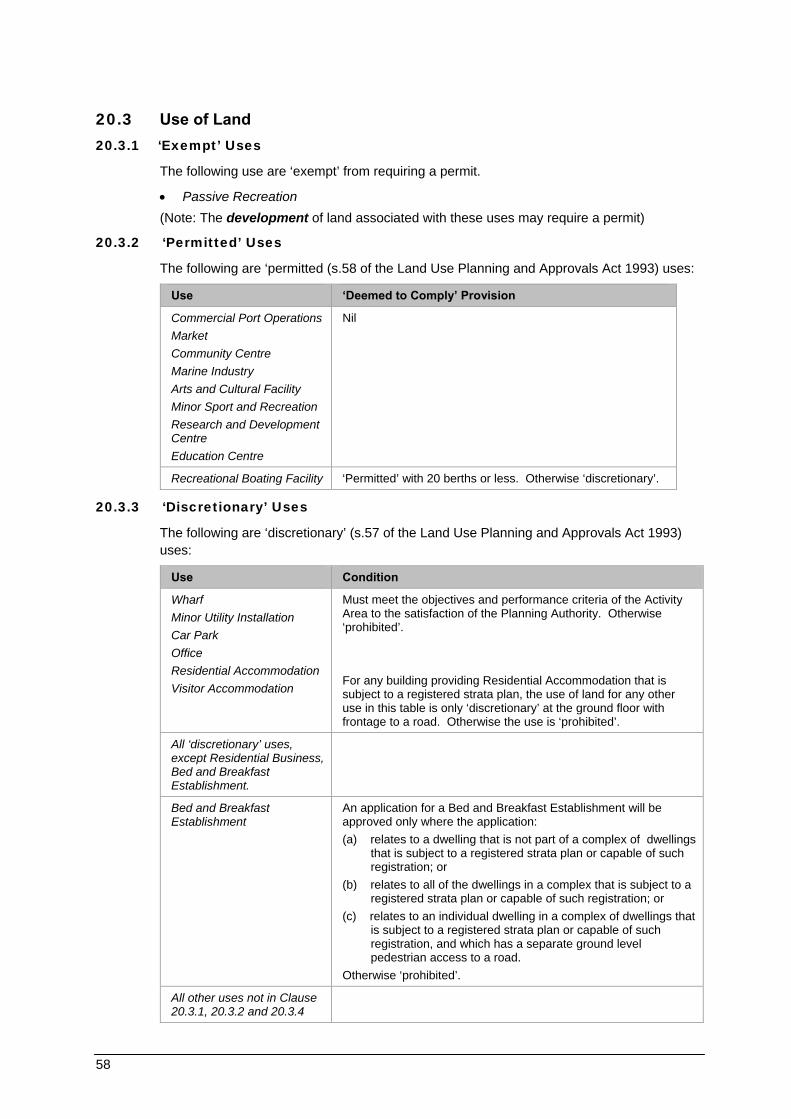
58
20.3 Use of Land 20.3.1 ‘Exempt’ Uses
The following use are ‘exempt’ from requiring a permit.
Passive Recreation
(Note: The development of land associated with these uses may require a permit)
20.3.2 ‘Permitted’ Uses
The following are ‘permitted (s.58 of the Land Use Planning and Approvals Act 1993) uses:
Use ‘Deemed to Comply’ Provision
Commercial Port Operations
Market
Community Centre
Marine Industry
Arts and Cultural Facility
Minor Sport and Recreation
Research and Development Centre
Education Centre
Nil
Recreational Boating Facility ‘Permitted’ with 20 berths or less. Otherwise ‘discretionary’.
20.3.3 ‘Discretionary’ Uses
The following are ‘discretionary’ (s.57 of the Land Use Planning and Approvals Act 1993) uses:
Use Condition
Wharf
Minor Utility Installation
Car Park
Office
Residential Accommodation
Visitor Accommodation
Must meet the objectives and performance criteria of the Activity Area to the satisfaction of the Planning Authority. Otherwise ‘prohibited’. For any building providing Residential Accommodation that is subject to a registered strata plan, the use of land for any other use in this table is only ‘discretionary’ at the ground floor with frontage to a road. Otherwise the use is ‘prohibited’.
All ‘discretionary’ uses, except Residential Business, Bed and Breakfast Establishment.
Bed and Breakfast Establishment
An application for a Bed and Breakfast Establishment will be approved only where the application: (a) relates to a dwelling that is not part of a complex of dwellings
that is subject to a registered strata plan or capable of such registration; or
(b) relates to all of the dwellings in a complex that is subject to a registered strata plan or capable of such registration; or
(c) relates to an individual dwelling in a complex of dwellings that is subject to a registered strata plan or capable of such registration, and which has a separate ground level pedestrian access to a road.
Otherwise ‘prohibited’.
All other uses not in Clause 20.3.1, 20.3.2 and 20.3.4

59
Use Condition
Shop
Restaurant
Maximum gross leasable floor area of 200 square metres.
20.3.4 ‘Prohibited’ Uses
General Industry
Warehouse
20.4 Development of Land
20.4.1 Permit Requirement
Unless specifically exempted under Clause 8.4 or the Schedules to this Scheme, a permit is required to undertake any development of land.
20.4.2 All development of land within this Activity Area must satisfy the relevant provisions contained within the schedules of this Scheme.

60
21 ACTIVITY AREA 4.3 SULLIVANS COVE ‘WORKING PORT’
21.1 General Characteristics of the Activity Area
This area contains the operational port of Hobart with cargo handling, fishing industry, cruise liners, ferries, recreational boating, world class yachting events and other maritime activities.
21.2 Objectives and Performance Criteria for Activities
The following objectives and performance criteria apply to use and development in this Activity Area:
Objectives Performance Criteria
(a) To protect and promote public awareness of Sullivans Cove as a unique example of an historic Australian waterfront.
New use and development must demonstrate that it will provide a positive contribution to the character and vitality of the Cove’s historic waterfront environs.
New activities must relate to, or at least be complementary to the traditional waterfront port activities of the Cove.
(b) To promote the continued use of Sullivans Cove as a port for shipping, transport and other industries, as well as facilities for fishing, yachting and harbour facilities.
New uses and developments within the Cove must not adversely impact the use of the Cove as a port for cargo handling.
New uses in the Cove must preferably be associated with commercial port activities, including cargo handling, passenger ferries, Antarctic research activities, commercial fishing, maritime industries, recreational boating, and a range of other maritime related industries.
The activities associated with the commercial port facility shall receive preference over recreational maritime activities.
A ferry terminal to service trans-Derwent and other passengers seeking to travel to and from the Cove and the Hobart CBD for work, as well as for recreation and other purposes, should be retained in the Activity Area as part of any waterfront development or redevelopment.
New development related to the road network should have regard to the potential impact on the opportunity for providing a tram or other light railway through the Cove.
(c) To encourage the use and development of a range of cultural, recreational, leisure and entertainment facilities.
Land based activities must demonstrate the ability to further enhance the image of the Cove as a centre for cultural, recreational, leisure and entertainment activities.
Such activities must be located in proximity to similar emerging activity precincts in adjoining Activity Areas.
(For example, cultural activities centred around the emerging arts and education precinct along Hunter Street, and recreational and leisure activities adjoining the Central Cove area and Salamanca Place)
Activities which promote large public gatherings in the Cove (markets, festivals etc) will be encouraged.
(d) To facilitate the further development of retail, tourist and commercial activities.
New retail and other commercial activities must offer goods and services which cater for the needs and interest of tourists, visitors, residents and workers in the Cove area.

61
Objectives Performance Criteria
(e) To ensure that the area is further developed as an attractive, comfortable and interesting place for pedestrians.
All use and development of land must incorporate features which enhance pedestrian amenity, safety, comfort and movement across the Cove floor.
Use of land for car parking and vehicle movement must only be encouraged in a manner and form which does not adversely affect pedestrian activities as well as the visual and cultural experience of the Cove.
New uses and development must provide additional opportunities for pedestrian access and views to the water’s edge. (However, public access to the water edge in certain sections of the Cove, and at certain times may be restricted due to the operation requirements of the Port).
(f) To ensure that development in the area respects the cultural heritage and built form of the Cove Floor.
All new development must be sympathetic to the low-scale bulk and height characteristics of the Cove Floor.
All new development must respect the cultural heritage of buildings, structures and spaces in the Cove.
(g) To ensure sound environmental planning and management for all activities.
All use and development to demonstrate the minimisation of on and off site energy requirements resulting from the proposed activity.
All use and development must minimise direct and indirect environmental risk or effects, and where possible provide, a net environmental gain for the wider environment.
21.3 Use of Land
21.3.1 ‘Exempt’ Uses
The following use is ‘exempt’ from requiring a permit:
Commercial Port Operations
(Note: The development of land associated with these uses may require a permit).
21.3.2 ‘Permitted’ Uses
The following are ‘permitted’ (s.58 of the Land Use Planning and Approvals Act 1993) uses:
Use ‘Deemed to Comply’ Provision
Marine Industry
Market
Community Centre
Arts and Cultural Centre
Light Industry
Minor Utility Installation
Wharf
Nil
Shop Where the use is ancillary to an existing ferry terminal and occupies not more than 30m² of the floor area.
Research and Development Centre
Education Centre
Must be within an existing building

62
21.3.3 ‘Discretionary’ Uses
The following are ‘discretionary’ (s.57 of the Land Use Planning and Approvals Act 1993) uses:
Use Condition
Bed and Breakfast Establishment
An application for a Bed and Breakfast Establishment will be approved only where the application:
(a) relates to a dwelling that is not part of a complex of dwellings that is subject to a registered strata plan or capable of such registration; or
(b) relates to all of the dwellings in a complex that is subject to a registered strata plan or capable of such registration; or
(c) relates to an individual dwelling in a complex of dwellings that is subject to a registered strata plan or capable of such registration, and which has a separate ground level pedestrian access to a road. Otherwise ‘prohibited’.
Residential Accommodation For any building providing Residential Accommodation that is subject to a registered strata plan, the use of land for any other use in this table is only ‘discretionary’ at the ground floor with frontage to a road, otherwise the use is ‘prohibited’.
Visitor Accommodation
Recreational Boating Facility
Eating Establishment
Office
Shop
Function Centre
Service Industry
Utility Installation
All uses not specified in Clauses 21.3.1, 21.3.2 or 21.3.4.
21.3.4 ‘Prohibited’ Uses
General Industry
21.3.4 Development of Land 21.4.1 Permit Requirement
Unless specifically exempted by Clause 8.4 or the Schedule to this Scheme, a permit is required to undertake all development of land.
21.4.2 All development of land within this Activity Area must satisfy the relevant provisions contained within the schedules of this Scheme.

63

64

SULLIVANS COVE
PLANNING SCHEME
Elizabeth StPier
PrincesPark
A
MACQ
UARIE
STR
EET
Macquarie Point
DAV
EY
STREET
Franklin
Wharf
Rail Yard
Cenotaph
VictoriaDock
ConstitutionDock
St DavidsPark
BatteryPoint
SULLIVANS COVE
Pri
nce
sW
ha
rf
ABC Centre
R I V E R D E R W E N T
SANDY
BAY
RO
AD
GLADSTONE
ST
MONTPELIER
RETREAT
KN
OP
WO
OD
ST
KIR
KS
WA
YP
LA
CE
SA
LA
MA
NC
A
PLA
CE
CA
ST
RA
Y
ES
PL
.
BA
TT
ER
YS
QU
AR
E
RUNNYMEDE ST
MU
RR
AY
ST
ELIZ
AB
ETH
ST
RE
ET
AR
GYLE
STR
EET
CAM
PBELL
STR
EET
LIVER
PO
OL
ST
BR
OO
KE
RA
VE
NU
E
TASMAN
HIGHWAY
CO
LLIN
S
ST
HU
NT
ER
ST
RE
ET
EVA
NS
ST
RE
ET
MARKET
PLA
CE
SUN
ST
SACKVILLE
ST
MIS
TR
AL
PL
.
DESPARD
ST
BR
OO
KE
ST
MORRISON
ST
ParliamentSquare
CSIRO MarineLaboratories
ParliamentHouse
FranklinSquare
DAV
IES
AVE
CEN
OTA
PH
AVEN
UE
N
500 100 200150
Metres
ACTIVITY AREAS
Figure 4
Macquarie Wharf
AquaticCentre
DUNN
PLA
CE
TownHall
1.0
2.0
2.0
Extent of WappingLocal Area Plan
4.3
3.0
4.1
4.2
2.1
Scheme Boundary
Inner City Residential (Wapping)
Sullivans Cove ‘Mixed Use’
Sullivans Cove ‘Gateway & Transport’
‘Macquarie Point Wharf’
‘Regatta Point’
(Inside edge of line is actual boundary)
(Hobart Inner City Residential Zone (Wapping))
(Sullivans Cove Infill Zone)
(Macquarie Point Mixed Use Zone)
(Macquarie Point Wharf & River Zone A)
(Macquarie Point Wharf & River Zone B)
‘Domain Open Space’
Sullivans Cove ‘Working Port’
(Sullivans Cove Infill Zone)
(Sullivans Cove Heritage Wharf & River Zone)
Note:Sullivans Cove Planning Act zone titles shown in brackets
KEY
1.0
2.0
4.3
4.2
4.1
3.0
2.1
KELLY ST
RUNNYMEDE ST
McG
RE
GO
RS
T
SA
LA
MA
NC
AP
LA
CE
INSET(Boundary Alignment)


67
PART E - SCHEDULES
22 SCHEDULE 1 – CONSERVATION OF CULTURAL HERITAGE VALUES
22.1 Introduction
Conservation of the cultural heritage values of Sullivans Cove is the primary objective of the Scheme. Where there is an apparent conflict with other objectives, the conservation of cultural heritage values takes precedence.
This schedule applies to conservation of the cultural heritage values of identified places of cultural significance, including spaces, buildings and objects, and conservation of patterns of continuing or historic use. It also applies to the conservation of archaeologically sensitive sites and the conservation of a recognisable historic character in the areas where authentic historic fabric and spaces remain.
22.2 Objectives
To provide the mechanisms to allow the conservation of heritage values.
To provide an incentive for ‘building or works’ to be carried out in a manner which is compatible with conservation of cultural heritage values.
To ensure that the recognisable historic character of Sullivans Cove is not compromised by new development which overwhelms the places of cultural significance, or, by new development which reduces the apparent authenticity of the historic places by mimicking historic forms.
To encourage new development to be recognisable as new, but not individually prominent. Such development must reflect a “good neighbour” relationship to places of identified cultural value.
22.3 Definitions
Adjacent In relation to proposed development means sites alongside, behind or diagonally behind a place of identified cultural significance or on the opposite side of the street.
Archaeological Sensitivity Report
A report accepted by the Planning Authority that is prepared by a qualified archaeologist or other suitably qualified professional that may be required to be submitted as part of any applications to undertake works, and which includes the following:
Investigation of documentary evidence on the application site history.
Sampling program which includes timing and method of sampling, and procedures to be followed where items of archaeological value are discovered.
Details of archaeological ‘watching brief’ procedures to be implemented during the completion of works.

68
‘Building or Works’ For the purpose of this schedule means the carrying out of building construction, alteration or decoration or works.
Burra Charter The Australia ICOMOS Charter for Places of Cultural Significance 1999 (including guidelines), adopted by the Australian National Committee of the International Council on Monuments and Sites (Australia ICOMOS Inc.) on 26 November 1999.
Conservation Conservation means all the processes of looking after a place so as to retain its cultural significance. It includes maintenance and may according to circumstance include preservation, restoration, reconstruction and adaptation, as defined in the Burra Charter.
Conservation Plan A Conservation Plan accepted by the Planning Authority and prepared in accordance with the guidelines provided by J. S. Kerr’s (“The Conservation Plan”). The conservation plan includes
Documentation of the cultural significance of a place.
Documentation of proposed measures to be undertaken to retain cultural significance.
An assessment of how proposed ‘building or works’ comply with the conservation strategy proposed in the Conservation Plan and a Statement of Impact regarding the impact of the proposed ‘building or works’ on the conservation of cultural significance.
Cultural Significance Cultural significance is defined as historic, scientific,
aesthetic or social value for past, present and future generations. It may include archaeological values, architectural values and values as a record of various aspects of history. It is synonymous with the term heritage value.
Height In respect of buildings (other than structures), that maximum vertical distance measured between the natural surface level and the eaves or parapet at any point of any part of a building.
Place Place means site, area, building or work, group of buildings or works with associated contents and surroundings.
22.4 Conservation of Places of Cultural Significance
22.4.1 Scope
The controls of this clause apply to the carrying out of ‘building or works’ on places of cultural significance identified in Table 1 to this Schedule, and on Figure 5 ‘Places of Cultural Significance’. The status afforded to the places identified shall apply to all of the land within the title boundary, except where this is specifically indicated in Table 1 as not being the case.

69
22.4.2 Exemptions
The following are ‘exempt’ from the provisions of this clause:
Development ‘exempt’ from requiring approval under 8.4 of the Scheme.
22.4.3 Submission Requirements
All applications for ‘building or works’ must satisfy the relevant submission requirements of clause 9.2 of the Scheme. In addition, pursuant to s.54 of the Land Use Planning and Approvals Act 1993, the following information may be required:
A Conservation Plan as defined in Clause 22.3.
Street elevations or ‘true perspectives’ to show the scale and impact of ‘building or works’ on places of cultural significance.
22.4.4 ‘Permitted’ ‘Building or Works’
‘Building or works’ on places of cultural significance is ‘permitted’ in respect to this Schedule where it can be demonstrated that the following ‘deemed to comply’ provisions have been satisfied:
The ‘building or works’ are related to the conservation of a place of cultural significance and are to be undertaken in accordance with a Conservation Plan accepted by the Planning Authority as satisfying the submission requirements for an application.
22.4.5 ‘Discretionary’ ‘Building or Works’
‘Building or works’ on places of cultural significance which cannot satisfy the ‘deemed to comply’ provisions of Clause 22.4.4 may be approved at the discretion of the Planning Authority.
The following criteria must be taken into consideration in the assessment of all proposals to undertake ‘building or works’ on places of cultural significance:
‘Building or works’ must complement and contribute to the cultural significance, character and appearance of the place and its setting;
‘Building or works’ must be in compliance with the conservation strategy of an approved Conservation Plan, where required and/or provided;
The location, bulk and appearance of ‘building or works’ must not adversely affect the heritage values of any place of cultural significance;
‘Building or works’ must not reduce the apparent authenticity of places of cultural significance by mimicking historic forms;
‘Building or works’ may be recognisable as new but must not be individually prominent;
The painting of previously unpainted surfaces is discouraged.
22.5 ‘Building or Works’ on Land Not Included in Table 1
22.5.1 Scope
The controls of this clause apply to ‘building or works’ on all land within the Planning Area, excepting places of cultural significance under Clause 22.4.
22.5.2 Exemptions
The following are ‘exempt from the provisions of this clause:

• Development ‘exempt’ from requiring approval under clause 8.4 of the Scheme.
• Any works exempted under s.31 of the Historic Cultural Heritage Act 1995 from requiring approval under that Act.
• Development on land within the Macquarie Point Wharf, Activity Area 4.1 and Sullivans Cove Gateway – Activity Area 3.0.
22.5.3 Submission Requirements
All applications for ‘building or works’ under this clause must satisfy the relevant submission requirements of clause 9.2 of the Scheme. In addition, pursuant to s.54 of the Land Use Planning and Approvals Act 1993, the following information may be required:
• A report identifying that the building does not have cultural significance;
• Street elevations or ‘true perspectives’ to show the scale and impact of ‘building or works’ on places of cultural significance.
22.5.4 ‘Permitted’ ‘Building or Works’
‘Building or works’ on other land within the planning area is ‘permitted’ in respect to this Schedule where it can be demonstrated that the following ‘deemed to comply’ standards can be met:
For ‘building or works’ on sites adjacent (as defined in clause 22.3) to a place of cultural significance:
• The height of ‘building or works’ adjacent to places of cultural significance must not exceed that of any building on the place, at a distance of less than 10 (horizontal) metres from the building; and
• The area of the facade of any new ‘building or works’ must not exceed that of the facade of an adjacent place of cultural significance by a factor of 2.
22.5.5 ‘Discretionary’ ‘Building or Works’
‘Building or works’ on land which cannot satisfy the ‘deemed to comply’ provisions of Clause 22.5.4 may be approved at the discretion of the Planning Authority. The following criteria must be taken into consideration in the assessment of all proposals for ‘building or works’:
• ‘Building or works’ adjacent to a place of cultural significance must not dominate that place when viewed from the street or any other public space, or be more prominent in the street than the adjacent place of cultural significance.
• The area of a facade of any new building may be permitted to exceed that of the building on an adjacent place of cultural significance where the Planning Authority is satisfied that the visual impact of the apparent disparity of scale is not significant or that historic precedent warrants the scale disparity.
• ‘Building or works’ must complement and contribute to the specific character and appearance of adjacent places of cultural significance and the historic character of the Cove generally.
• The location, bulk and appearance of ‘building or works’ must not adversely affect the heritage values of any adjacent or nearby place of cultural significance.
• ‘Building or works’ must not reduce the heritage value of any adjacent places of cultural significance by mimicking historic forms.
70
71
22.6 Places of Archaeological Sensitivity
22.6.1 Scope
The controls of this clause apply to ‘building or works’ which involve the excavation of land within the planning area.
22.6.2 Exemptions
The following are ‘exempt’ from the provisions of this clause:
The carrying out of ‘building or works’ which involve the excavation on the following land:
All land within the Macquarie Point Wharf Activity Area
22.6.3 Submission Requirements
In addition to the information required to satisfy the relevant submission requirements of Clause 9.2 of the Scheme, the following information is required for any place identified in Table 2 in this Schedule:
An Archaeological Sensitivity Report;
or
A statement by a qualified archaeologist that either the site has been surveyed previously and found not to be of archaeological significance or that the nature of the ‘building or works’ will not result in destruction of any aspects items of archaeological significance.
Pursuant to s.54 of the Land Use Planning and Approvals Act 1993 the above information may also be required in respect of an application relating to a site that is considered likely to be of archaeological interest or significance.
22.6.4 ‘Permitted’ ‘Building or Works’
Those works which constitute the excavation of land on any place of cultural significance (as identified in Table 1), including those identified in Table 2, are ‘permitted’ where a statement is provided by a qualified archaeologist that either the site has been surveyed previously and found not to be of archaeological significance or that the nature of the ‘building or works’ will not result in destruction of any aspects of items of archaeological significance.
22.6.5 ‘Discretionary’ ‘Building or Works’
Having regard to the contents and recommendations of an Archaeological Sensitivity Report accepted by the Planning Authority pursuant to Clause 22.6.3 the following criteria must be taken into consideration in the assessment of all proposals to develop places of cultural significance listed in Table 2 or that are considered likely to be of archaeological interest or significance:
The likelihood of the proposed ‘building or works’ resulting in the removal or destruction of items of archaeological significance.
The cultural significance of the site.
Evidence of an adequate archaeological reconnaissance and site sampling prior to the approval or carrying out of works.

72
The need to reasonably protect potential archaeological significance during the design, and carrying out of works.
The need to undertake an archaeological ‘watching brief’ to be required during the carrying out of works.
Table 1: Places of Cultural Significance
Street No. Street Other Information Ref. No
Argyle Street
5 Argyle Street Tasmanian Museum & Art Gallery – refer also Davey and Macquarie Streets
1
10 Argyle Street 2
12-14 Argyle Street Former Chesterman Building – refer 10-14 Davey Street 3
16 Argyle Street Carnegie Building/Former Public Library 29
Brooke Street
8 Brooke Street Former Mill (Gibson’s) - refer Morrison Street 5
Brooker Avenue
Brooker Avenue Former Hobart Railway Station (ABC Complex) – refer Liverpool Street
6
Campbell Street
9 Campbell Street Former St. David’s Mission Church 7
29 Campbell Street Theatre Royal 8
37-49 Campbell Street Walls off Sackville St. (‘Parcel 6’) 9
Castray Esplanade
Castray Esplanade Princes Wharf Sheds Nos. 1, 2 and 3 80
Castray Esplanade Sydney-Hobart Yacht Race Finishing Box (within CSIRO site) 10
Castray Esplanade Plantanus x “Hispanica” (Plane Trees) – avenue of 15 trees 11
13–17* Castray Esplanade Former Ordnance Store (Supply & Tender) 12
Castray Esplanade Former Signal Station (Princes Park) 16
Castray Esplanade Princes Park 17
19 - 21 Castray Esplanade Former Ordnance Store 13
25 Castray Esplanade Tide House 14
27 Castray Esplanade Harbour Masters House 15
Cenotaph Avenue
Cenotaph Avenue Martin’s Hot Shot Oven 18
Cenotaph Avenue Queen’s Battery 19
Collins Street
18 – 26 Collins Street Former HCC / City Motors Garage – façade 22
19 Collins Street Former Hedberg Bros. Garage 21
36 Collins Street Former Barnet Bros. Building 23
Davey Street
2 Davey Street Royal Engineers Building and Stone Post 26
Davey Street Victoria Dock 27
Davey Street Constitutions Dock (incl. Bridge & Crane) 28

73
Street No. Street Other Information Ref. No
19 - 21 Davey Street Former Customs House and Bond Store 24
Davey Street Private Secretary’s Cottage – refer also 40 Macquarie Street 25
10 – 14 Davey Street Former Chesterman Building 3
16 – 20 Davey Street Former Piesse & Co. Building 30
32 Davey Street Treasury Chambers 31
34 Davey Street Former Public Works Offices 32
36 Davey Street Former St Mary’s Hospital, cnr. Salamanca Place 33
Despard Street
Despard Street Former Mill (Gibson’s) – refer Morrison Street 5
Elizabeth Street
2 Elizabeth Street Former Union Steamship Co. Offices – refer also 5-9 Franklin Wharf 35
7 Elizabeth Street Refer 16-20 Davey Street 30
16 Elizabeth Street Hobart Council Centre (former HEC/Hydro Building) 36
Elizabeth Street Franklin Square 37
Evans Street
Evans Street Former Jones & Co. Buildings – refer Hunter Street 39
10 Evans Street Goods Shed 125
10 Evans Street Red Shed 126
Franklin Wharf
4 Franklin Wharf Elizabeth Street Pier 124
5 Franklin Wharf Former Union Steamship Co. Offices – refer also 2 Elizabeth Street 35
7 Franklin Wharf Former Burgess Bros. Offices / Marine Board Building 41
9 Franklin Wharf Former Marine Board Building 42
11 - 13 Franklin Wharf Former Government Offices (including Water Police) 43
Hunter Street
19 - 21 Hunter Street Warehouses / Drunken Admiral (part of former Jones & Co. Complex) 44
23 - 25 Hunter Street Warehouses (part of former Jones & Co. Complex) 44
37 – 41 Hunter Street University Centre for the Arts (part of former Jones & Co. Complex) 39
Kelly Street
Kelly Street Kelly’s Steps 47
Kirksway Place
23 Kirksway Place Cottage 48
25 Kirksway Place Cottage 49
27 Kirksway Place Cottage 50
29 Kirksway Place Cottage 51
Liverpool Street
0 Liverpool Street Former Hobart Railway Station Building (part of the ABC Complex – see Figure 5 for extent of listing)
6
Macquarie Street
2 Macquarie Street Former Hobart Gas Works complex (incl. chimney) 58

74
Street No. Street Other Information Ref. No
7 Macquarie Street Old Woolstore (former Roberts Stewart & Co. Limited buildings)
52
40 Macquarie Street Tasmanian Museum & Art Gallery: including all Museum buildings and former Commissariat Store – refer also Argyle and Davey Streets
59
50 Macquarie Street Town Hall 60
55 Macquarie Street Former MTT Offices 53
57 - 63 Macquarie Street City Hall 54
65 – 67 Macquarie Street Hope and Anchor Hotel 55
71 Macquarie Street 56
80 Macquarie Street Public Buildings adjacent to Franklin Square 61
87 Macquarie Street Montgomery’s (former Maloney’s) Hobart Hotel 57
Montpelier Retreat
2 Montpelier Retreat 63
3 Montpelier Retreat 62
4 Montpelier Retreat 64
Morrison Street
5 Morrison Street Former Holyman’s Building 66
11 – 17 Morrison Street City Mill (Gibson’s) 5
29 Morrison Street Harbour Lights Café 65
35 Morrison Street Former Rex & Son Warehouse 67
Murray Street
Murray Street Tilia x europaea L. (Common Lime) (19 Trees in Parliament Square, in front of Parliament House)
73
Murray Street Quercus robus L. (English Oak) (4 Trees in Parliament Square, in front of Parliament House)
74
Murray Street Parliament House and Square 72
1 – 5 Murray Street Customs House Hotel 69
7 Murray Street Alstergren Building 70
9 – 11 Murray Street Roche’s (former Federal Coffee Palace) 71
10 Murray Street State Government Office 75
12 Murray Street Former HEC Office 76
17 Murray Street Aurora (former HEC) Sub-Station (cnr. Davey Street) 68
19 – 21 Murray Street Public Buildings (Franklin Square); Treasury; Trees; Lamps – refer to 80 Macquarie Street
61
20 Murray Street Waterloo House 77
Runnymede Street
20 Runnymede Street Lenna 78
Sackville Street
10 - 16 Sackville Street Former Tasmanian Fur Traders Building 79
Salamanca Place
1 Salamanca Place Supreme Law Courts 81

75
Street No. Street Other Information Ref. No
Salamanca Place Plantanus x “hispancia” (Plane Tree) (27 Trees along Salamanca Place)
82
2 Salamanca Place Printing Authority of Tasmania (former State Government Printing Office)
83
21 Salamanca Place 84
23 Salamanca Place 85
25 Salamanca Place 86
27 Salamanca Place 87
29 Salamanca Place 88
31 Salamanca Place 89
33 Salamanca Place 90
35 Salamanca Place 91
39 Salamanca Place 92
41 Salamanca Place 93
45 – 47 Salamanca Place 94
49 Salamanca Place 95
51 Salamanca Place 96
53 Salamanca Place 97
55 Salamanca Place 98
57 Salamanca Place 99
59 Salamanca Place 100
61 Salamanca Place 101
63 Salamanca Place 102
65 Salamanca Place (includes 65C Salamanca Place) 103
67 Salamanca Place 104
69 Salamanca Place 105
71 Salamanca Place 106
73 Salamanca Place 107
75 Salamanca Place 108
77 Salamanca Place 109
Salamanca Place Kelly’s Passage 110
79 Salamanca Place 111
81 Salamanca Place 112
83 Salamanca Place 113
85 Salamanca Place 114
87 Salamanca Place 115
89 Salamanca Place 116
100 Salamanca Place 117
102 Salamanca Place 118
104 Salamanca Place 119
106 Salamanca Place 120

76
Street No. Street Other Information Ref. No
Tasman Highway
Tasman Highway Cenotaph and Cenotaph Avenue 121
Tasman Highway Former HMAS Huon Naval Depot 122
*Following changes to the ‘planning area’ arising from the statutory scheme preparation processes, the properties (places) reference numbered 4, 46 and 123 are not included in the approved version of the Sullivans Cove Planning Scheme.

77
Table 2: Places of Archaeological Sensitivity
Street No. Street or Other Location Description
Existing Archaeological Report
Other Information Ref. No.
3 Argyle Street SCAZP* Dockside offices 1
10 – 14 Argyle Street SCAZP Chesterman’s 2
- Castray Esplanade SCAZP Princes Park 3
13 – 23 Castray Esplanade SCAZP Ordnance Stores 4
27 Castray Esplanade SCAZP Harbour Masters House 5
- Cenotaph Avenue SCAZP The Cenotaph 6
2 Collins Street SCAZP Roberts store and offices 7
52 Collins Street SCAZP 8
- Constitution and Victoria Docks (area between)
SCAZP 9
- Davey Street SCAZP Davey Street Step/Cove Escarpment
10
1 Davey Street SCAZP Hotel Grand Chancellor 11
2 Davey Street SCAZP Royal Engineers Headquarters and Kings Yard
12
3 Davey Street SCAZP Dunn Place 13
16 – 20 Davey Street SCAZP 14
32 Davey Street SCAZP Treasury Chambers 15
34 Davey Street SCAZP St. Mary’s Hospital 16
- Elizabeth Street between Davey and Macquarie Streets
SCAZP Elizabeth Street 17
5 Elizabeth Street SCAZP Former Nettlefold’s Garage 18
- Franklin Square SCAZP Franklin Square 19
2 – 4 Gladstone Street SCAZP 20
- Hunter Street SCAZP Hunter Street Roadway 21
- Hunter Street SCAZP Macquarie No.1 Shed 22
15 Hunter Street SCAZP Former Dockside Fitness 23
17 – 19 Hunter Street SCAZP The Drunken Admiral 24
17 – 19 Hunter Street SCAZP Designer Makers Building 25
19 - 35 Hunter Street SCAZP Hewitt Warehouse 26
19 - 35 Hunter Street SCAZP Bunster House 27
19 - 35 Hunter Street SCAZP The Ice House 28
19A–35A Hunter Street SCAZP Courtyard 29
21 Hunter Street SCAZP (part of 19A-35 Hunter) 30
23 Hunter Street SCAZP (part of 19A-35 Hunter) 31
25 Hunter Street SCAZP (part of 19A-35 Hunter) 32
29 Hunter Street SCAZP (part of 19A-35 Hunter) 33
2 Macquarie Street SCAZP Gasworks Village 35

78
Street No. Street or Other Location Description
Existing Archaeological Report
Other Information Ref. No.
7 Macquarie Street SCAZP Woolstore Tavern 36
7 Macquarie Street SCAZP Former Millers Soap Factory 37
7 Macquarie Street SCAZP The Old Woolstore Apartments 38
40 Macquarie Street SCAZP Tasmanian Museum and Art Gallery
39
50 Macquarie Street SCAZP Town Hall 40
57 - 63 Macquarie Street SCAZP City Hall 41
65 Macquarie Street SCAZP Hope and Anchor Tavern 42
67 – 69 Macquarie Street SCAZP 43
71 Macquarie Street SCAZP 44
85A – 87 Macquarie Street SCAZP Hobart Hotel 45
1 – 3 Market Place SCAZP 46
6 – 8 Market Place SCAZP Albion Foundry 47
- Mawson Place (grassed area)
SCAZP Howard’s Hotel Site 48
1 Montpelier Retreat SCAZP 49
2 – 4 Montpelier Retreat SCAZP 50
3 – 5 Montpelier Retreat SCAZP 51
11 – 27 Montpelier Retreat SCAZP Montpelier Retreat Car Park 34
- Morrison Street (backing onto No 5)
SCAZP Franklin Hotel Site 53
- Morrison Street between Brooke Street and Elizabeth Street
SCAZP Morrison Street 54
3 Morrison Street SCAZP 55
19 Morrison Street SCAZP Telegraph Hotel 56
29 Morrison Street SCAZP The Harbour Lights Café 57
31 – 33 Morrison Street SCAZP Part of 31-35 Morrison Street 58
35 Morrison Street SCAZP Part of 31-35 Morrison Street 59
- Murray Street SCAZP Parliament House 60
1 – 3 Murray Street SCAZP Customs House Tavern 61
5 Murray Street SCAZP Marine Hotel 62
6 – 10 Murray Street SCAZP State Offices 63
7 Murray Street SCAZP New Constitution Hotel 64
12 – 14 Murray Street SCAZP Former Hydro Building 65
21 Murray Street SCAZP Public Offices 66
Cnr Salamanca and Morrison Streets
SCAZP Parliament Square 67
- Salamanca Place SCAZP The Squares 68
21 – 23 Salamanca Place SCAZP 69
25 Salamanca Place SCAZP 70
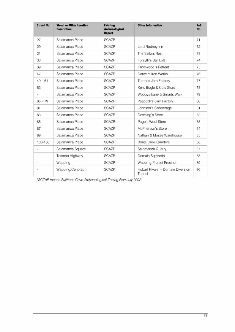
79
Street No. Street or Other Location Description
Existing Archaeological Report
Other Information Ref. No.
27 Salamanca Place SCAZP 71
29 Salamanca Place SCAZP Lord Rodney Inn 72
31 Salamanca Place SCAZP The Sailors Rest 73
33 Salamanca Place SCAZP Forsyth’s Sail Loft 74
39 Salamanca Place SCAZP Knopwood’s Retreat 75
47 Salamanca Place SCAZP Derwent Iron Works 76
49 – 61 Salamanca Place SCAZP Turner’s Jam Factory 77
63 Salamanca Place SCAZP Kerr, Bogle & Co’s Store 78
- Salamanca Place SCAZP Woobys Lane & Smarts Walk 79
65 – 79 Salamanca Place SCAZP Peacock’s Jam Factory 80
81 Salamanca Place SCAZP Johnson’s Cooperage 81
83 Salamanca Place SCAZP Downing’s Store 82
85 Salamanca Place SCAZP Page’s Wool Store 83
87 Salamanca Place SCAZP McPherson’s Store 84
89 Salamanca Place SCAZP Nathan & Moses Warehouse 85
100-106 Salamanca Place SCAZP Boats Crew Quarters 86
- Salamanca Square SCAZP Salamanca Quarry 87
- Tasman Highway SCAZP Domain Slipyards 88
- Wapping SCAZP Wapping Project Precinct 89
- Wapping/Cenotaph SCAZP Hobart Rivulet – Domain Diversion Tunnel
90
*SCZAP means Sullivans Cove Archaeological Zoning Plan July 2002.

Sullivans Cove Planning Scheme 1997 (as amended at 17 February 2011) 80
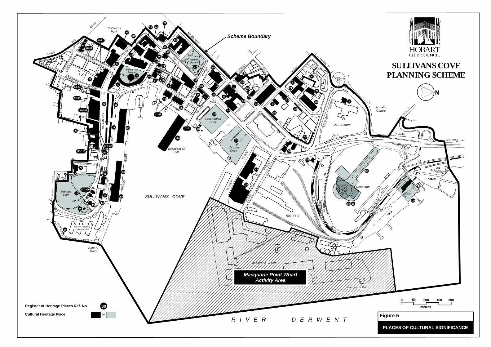
29
500 100 200150
metres
SULLIVANS COVEPLANNING SCHEME
Elizabeth StPier
PrincesPark
A
Macquarie Point
Rail Yard
Cenotaph
VictoriaDock
ConstitutionDock
St DavidsPark
BatteryPoint
SULLIVANS COVE
ABC Centre
R I V E R D E R W E N T
ParliamentSquare
CSIRO MarineLaboratories
FranklinSquare
AquaticCentre
PLACES OF CULTURAL SIGNIFICANCE
Macquarie Wharf
TownHall
VictoriaDock
ConstitutionDock
FranklinSquare
ParliamentSquare
PrincesPark
80
104-109
80
124
121
19
620
79
9
6
8
21
23
26
53
52
754
58
22
44
39
27
28
2-3
55
56
57
59
24
25
1
60
66
36
37
5
43
35
41-42
6567
69
70
76
31
61
77
33
75
71
83
72
81
74
73
81
84-91
48-51
62
63-64
92-93
94-102
111-116
4780
82 11
11
117-120
110
78
17
10
1615
14
13
12
Macquarie Point WharfActivity Area
122
30
68
32
Register of Heritage Places Ref. No.
Cultural Heritage Place
80
or
Scheme Boundary
28
Figure 5
18

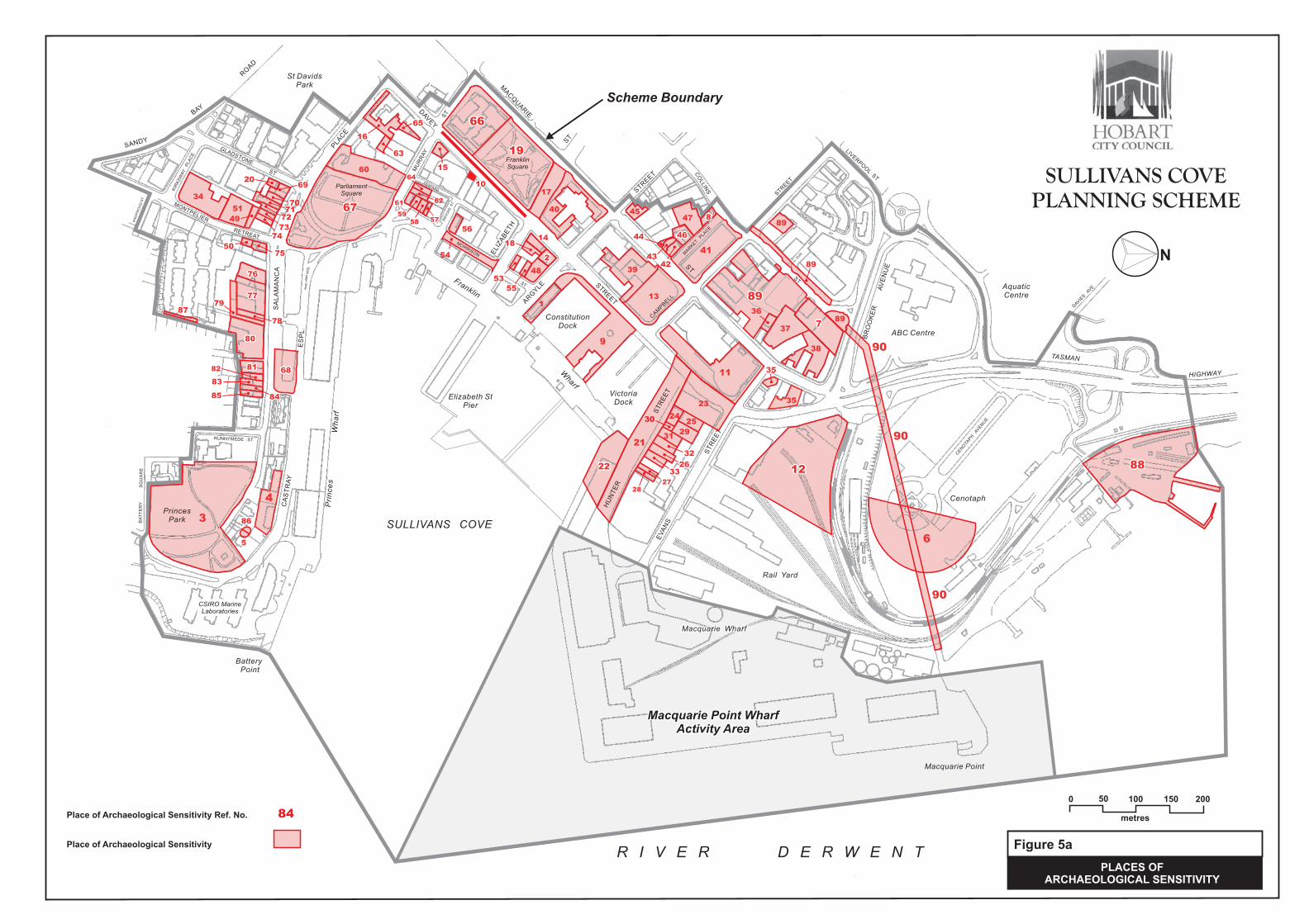
500 100 200150
metres
N
Elizabeth StPier
PrincesPark
A
MACQ
UARIE
ST
Macquarie Point
DAV
EY
STR
EET
Franklin
Wharf
Rail Yard
Cenotaph
VictoriaDock
ConstitutionDock
St DavidsPark
BatteryPoint
SULLIVANS COVE
Pri
nce
sW
ha
rfABC Centre
R I V E R D E R W E N T
SANDY
BAY
RO
AD
GLADSTONE
ST
MONTPELIER
RETREAT
KN
OP
WO
OD
ST
KIR
KS
WA
YP
LA
CE
SA
LA
MA
NC
A
PLA
CE
CA
ST
RA
Y
ES
PL
.
BA
TT
ER
YS
QU
AR
E
RUNNYMEDE ST
MU
RR
AY
ST
ELIZ
AB
ETH
ST
AR
GYLE
STR
EET
CAM
PBELL
STR
EET
LIVER
PO
OL
ST
BR
OO
KE
RA
VE
NU
E
TASMAN
HIGHWAY
CO
LLIN
S
ST
HU
NT
ER
ST
RE
ET
EVA
NS
ST
RE
ET
MARKET
PLA
CE
SUN
ST
SACKVILLE
ST
MIS
TR
AL
PL
.
DESPARD
ST
BR
OO
KE
ST
MORRISON
ST
ParliamentSquare
CSIRO MarineLaboratories
FranklinSquare
DAV
IES
AVE
CEN
OTA
PH
AVEN
UE
AquaticCentre
SULLIVANS COVE
PLANNING SCHEME
PLACES OFARCHAEOLOGICAL SENSITIVITY
Macquarie Wharf
6
Place of Archaeological Sensitivity Ref. No.
Place of Archaeological Sensitivity
Scheme Boundary
Figure 5a
84
Macquarie Point WharfActivity Area
1
2
3
56
7
8
9
10
11
12
13
14
15
16
17
18
19
20
21
22
23
2425
31
32
26
29
34
36
37
38
39
40
41
42
43
44
45
46
47
48
50
51
53
54
55
56
5758
59
60
61 62
63
64
65 66
67
68
69
7071
72
73
74
75
76
77
78
80
8182
83
8485
86
87
89
28
27
33
89
89
89
88
4
30
35
35
49
79
90
90
90

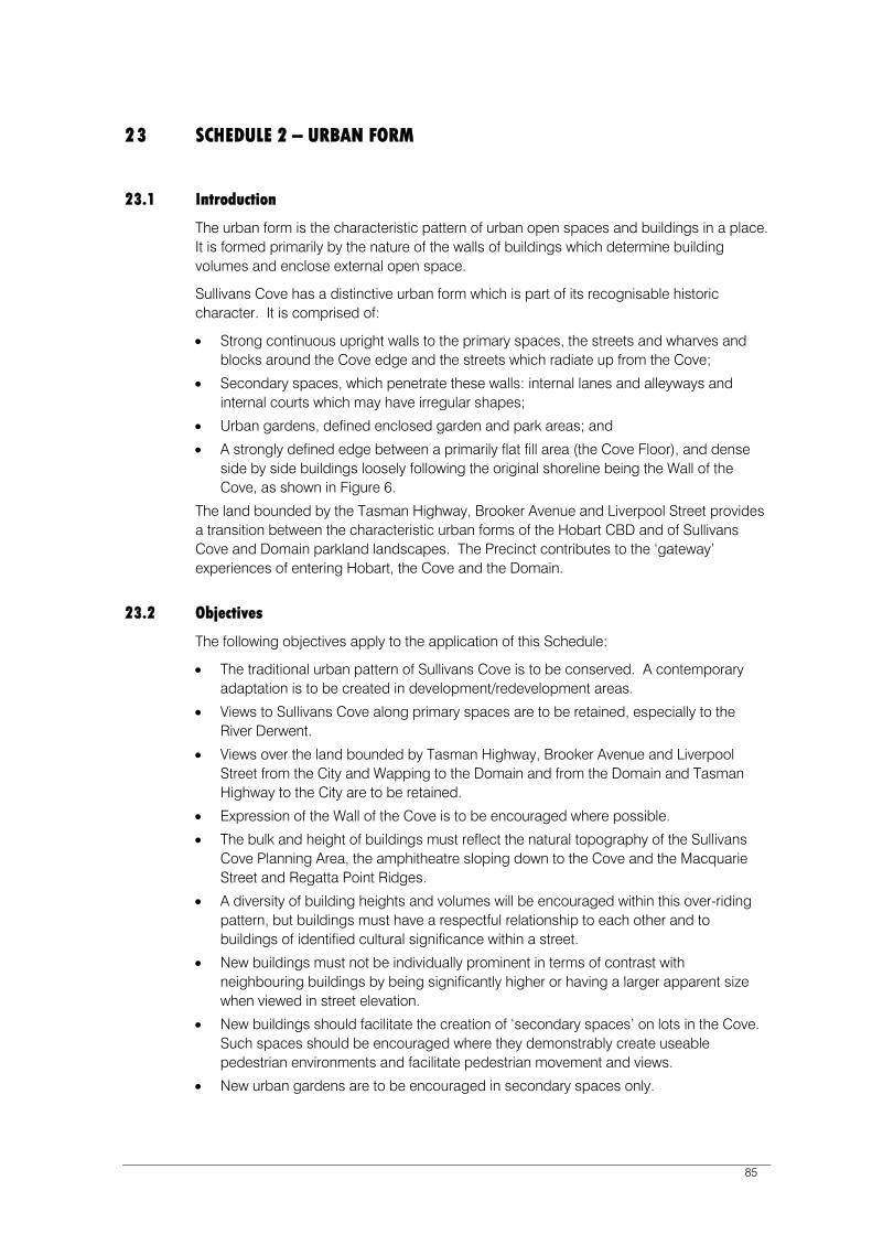
85
23 SCHEDULE 2 – URBAN FORM
23.1 Introduction
The urban form is the characteristic pattern of urban open spaces and buildings in a place. It is formed primarily by the nature of the walls of buildings which determine building volumes and enclose external open space.
Sullivans Cove has a distinctive urban form which is part of its recognisable historic character. It is comprised of:
Strong continuous upright walls to the primary spaces, the streets and wharves and blocks around the Cove edge and the streets which radiate up from the Cove;
Secondary spaces, which penetrate these walls: internal lanes and alleyways and internal courts which may have irregular shapes;
Urban gardens, defined enclosed garden and park areas; and
A strongly defined edge between a primarily flat fill area (the Cove Floor), and dense side by side buildings loosely following the original shoreline being the Wall of the Cove, as shown in Figure 6.
The land bounded by the Tasman Highway, Brooker Avenue and Liverpool Street provides a transition between the characteristic urban forms of the Hobart CBD and of Sullivans Cove and Domain parkland landscapes. The Precinct contributes to the ‘gateway’ experiences of entering Hobart, the Cove and the Domain.
23.2 Objectives
The following objectives apply to the application of this Schedule:
The traditional urban pattern of Sullivans Cove is to be conserved. A contemporary adaptation is to be created in development/redevelopment areas.
Views to Sullivans Cove along primary spaces are to be retained, especially to the River Derwent.
Views over the land bounded by Tasman Highway, Brooker Avenue and Liverpool Street from the City and Wapping to the Domain and from the Domain and Tasman Highway to the City are to be retained.
Expression of the Wall of the Cove is to be encouraged where possible.
The bulk and height of buildings must reflect the natural topography of the Sullivans Cove Planning Area, the amphitheatre sloping down to the Cove and the Macquarie Street and Regatta Point Ridges.
A diversity of building heights and volumes will be encouraged within this over-riding pattern, but buildings must have a respectful relationship to each other and to buildings of identified cultural significance within a street.
New buildings must not be individually prominent in terms of contrast with neighbouring buildings by being significantly higher or having a larger apparent size when viewed in street elevation.
New buildings should facilitate the creation of ‘secondary spaces’ on lots in the Cove. Such spaces should be encouraged where they demonstrably create useable pedestrian environments and facilitate pedestrian movement and views.
New urban gardens are to be encouraged in secondary spaces only.

• On the land bounded by the Tasman Highway, Brooker Avenue and Liverpool Streetthe landscaping should reflect the variety of garden areas and parkland styles thatexist in the immediate surrounding area and that mark the transition to the Domain.
23.3 Scope
This schedule applies to all new buildings and extension to existing buildings in the Sullivans Cove Planning Area.
The provisions of Schedule 1 - Conservation of Cultural Heritage Values, take precedence over provisions of this Schedule. Height and scale of detailing of development adjacent to Places of Cultural Significance must be such that the place is not compromised by height discrepancies, scale discrepancies or a superficially “historic” or similar appearance.
23.4 Exemptions
The following buildings are ‘exempt’ from this schedule:
i. Buildings within Activity Area 4.1 Macquarie Point Wharf subject to all new buildingsand extensions to existing buildings being less than 15 metres in height.
23.4.1 Site Specific Variation
The construction of buildings on the Dunn Place site may be ‘permitted’ to depart from the ‘Cove Wall’ building alignment objectives of this Schedule where such variation facilitates the creation of a major civic space on this site.
23.5 Definitions
Apparent Size ‘Size’ of development when viewed in elevation. It is the length of wall and the area of a wall of a building relative to the width of any abutting street or public space.
Floors Area Means the total actual area of each floor of a building (including mezzanines) measured at its greatest point of internal dimension from external walls but excluding lift shafts and stairwells, rooms or areas, set aside for the accommodation of mechanical and electrical plant, open balconies or verandahs, and (excepting where a development includes car parking which is additional to that car parking which is required pursuant to this Scheme or which is approved as ancillary to that development) areas for the parking, garaging, loading, unloading and circulation of motor vehicles.
Height In respect of buildings (other than structures), that maximum vertical distance measured between the natural surface level and the eaves or parapet at any point of any part of a building.
In respect of structures (other than buildings), that maximum vertical distance measured between the natural surface level and the highest point of the structure.
86
ii. Crane Structures in association with port activities.
iii. Buildings within the 'Macquarie Point Site Development Plan' in clause 32 under Part Fof the Scheme.

87
Plot Ratio Means the ratio between floor area or areas of a building or buildings and the site area upon which such or development is proposed.
Primary Elevations The side (or sides) of a building presented as the primary street frontage. Primary elevations are distinguished by prominent entrances, signs naming the building or business, a high quality of materials or surfaces or a formal relatively upright building or wall.
Primary Spaces Roads and spaces shown on Figure 7 as primary spaces.
Secondary Elevations The sides of a building presented as frontages to the secondary spaces of Sullivans Cove. Secondary elevations generally are those which have less prestigious materials and finishes on walls, may be stepped in elevation and have a ‘service’ or ‘utility’ function.
Secondary Spaces Smaller roads, lanes, alleys and ad hoc courts running off the primary spaces shown on Figure 7 as secondary spaces
Site Means the total area of a lot or two more contiguous lots which is the subject of the same planning application for the use or development of land.
Void An Architectural feature incorporated into the design for a building façade. These features include opening doors, windows and shutters, reflective surfaces and glass elements.
Wall of the Cove The concept of a continuous built wall comprised of a number of building facades, which mark the edge of the Cove Basin with the flat fill surface of Sullivans Cove. The concept has its strongest expression at Salamanca Place and Hunter Street (Refer to Schedule 2, Figure 6).
23.6 Building Form
23.6.1 ‘Permitted’ Buildings
Development is ‘permitted’ where it can be demonstrated that the following ‘deemed to comply’ provisions have been satisfied:
23.6.1A New Buildings
Height:
Buildings to the maximum height for the area shown on Figure 8. Parts of buildings above building eaves or parapets must reinforce the Objectives of this Schedule.
88
Alignment – Primary Space:
Buildings must be built to the street line of all primary street frontages, with walls located on the front property boundary and extending across no less than 90% of the primary street frontage.
Where a new building is located on a corner with two primary street frontages, this requirement must be satisfied for each frontage.
New buildings must not step back adjacent to a Primary Space. The only permissible exceptions to this is in situations where the stepping back is less than 1:20 relative to the height of the wall on the property boundary and where there is a wall to the boundary at least 12m high.
Alignment – Secondary Space:
Where applicable, buildings must also be built to, or align with, the secondary street frontage.
Plot Ratio:
Buildings must comply with the plot ratio standards referred to in Table A to this Schedule.
Apparent Size:
The length of buildings in street edge elevation must not be more than twice the width of the abutting street.
Urban Gardens:
Where the construction of a building results in the creation of secondary spaces with public access. These spaces must be fenced at street frontage, landscaped and include facilities for pedestrians as appropriate, such as seating.
23.6.1B Extensions to Existing Buildings
The provisions of Clause 23.6.1.A also apply to the extension of existing buildings. The provisions in respect to Alignment-Primary Space, Alignment-Secondary Space and Apparent Size only apply where extensions are proposed on or near a lot boundary which abuts a street or other public space.
Table A: Height and Plot Ratio
Permissible Height of Building in Metres Applicable Plot Ratio
Less than 8m 1.5
8m to less than 12m 2.0
12m to less than 15m 2.5
15m to less than 18m 3.0
18m to less than 21m 4.0
21m and above 5.0
23.6.2 ‘Discretionary’ Buildings
Development which cannot satisfy the ‘deemed to comply’ provisions’ of Clause 23.6.1 may be approved at the discretion of the Planning Authority taking into consideration the Objectives in Clause 23.2. Such development includes:
89
Any new buildings or works adjacent to a Place of Cultural Significance and which are not more prominent in the streetscape by strong contrast of scale, height, colour and tone with the buildings constructed on the place, and, which are not detailed in a manner which is similar to buildings of cultural significance or which adopts an “historic” appearance.
Works undertaken in accordance with a Conservation Plan approved by the Planning Authority where required and/or provided.
23.7 Building Surfaces
23.7.1 ‘Permitted’ Buildings
Development is ‘permitted’ where it can be demonstrated that the following ‘deemed to comply’ provisions have been satisfied:
Building Surfaces ‘Deemed to Comply’ Provision
Building Façade to a Primary Space
Surfaces must be primarily masonry.
A maximum allowable void of 50 percent is permissible in all street frontage elevations.
Surfaces of facades to primary space must comprise high quality finishes that reinforce the status as a primary building frontage.
Building Façade to a Secondary Space
Surface must be finished so as to be presented in a less detailed and ornate manner than the surface of the building to a primary space, or the surfaces of adjacent buildings to primary spaces.
Night-Lighting Must accentuate the wall of the building when illuminated, and where appropriate also highlight the landscaping.
Building Surfaces to Brooker Avenue and Tasman Highway in Activity Area 2.0
Surfaces should contribute to buildings having a minimal visual presence through materials which provide a complex patterning.
Surfaces must comprise high quality materials and finishes suitable for viewing as part of the ‘gateway’ into the Cove.
Surfaces adjacent to nectar bearing native flora (Tasmanian and exotic eucalyptus, etc).
The configuration of buildings and any adjacent nectar bearing native flora must be designed to prevent bird collisions caused by the reflection of such vegetation or sky in glazing and/or unobstructed views through a surface to an outdoor space. Glazing must be consistent with the DPIWE Threatened Species Unit publication “Prevent window collisions: Save our native birds”, or achieve comparable performance.
23.7.2 ‘Discretionary’ Buildings
Development which cannot satisfy the ‘deemed to comply’ provisions of Clause 23.7.1 may be approved at the discretion of the Planning Authority.
The objectives of this Schedule must be taken into consideration in the assessment of all ‘discretionary’ development.

90
23.8 Development in Activity Area 2.0 Sullivans Cove ‘Mixed Use’ North of Brooker Avenue
This clause applies to the land in Activity Area 2.0 bounded by the Tasman Highway, Brooker Avenue and Liverpool Street outside the boundaries of the ABC site (Refer Figure 8a). Development that cannot satisfy the requirements of clause 23.8.1 may still be approved at the discretion of the Planning Authority taking into consideration the objectives of this Schedule and ‘guidelines’ to that clause.
23.8.1 Building or works
Development is ‘permitted’ where it can be demonstrated that the following ‘Deemed to Comply’ provisions have also been satisfied:
Building Category ‘Deemed to Comply’ Provision
All new buildings • The maximum height and footprint of buildings shall be in accordance with the Buildings Envelopes shown in Figure 8a.
Buildings and walls visible from the Tasman Highway, Brooker Avenue or Liverpool Street extension.
• Will be 25% screened by trees on completion of construction in accordance with diagram LA1 in Clause 23.8.3 and 50% screened within 5 years of the completion of construction in accordance with diagram LA2.
• At least 1 tree per 15m of frontage will obtain a height of 6m within 3 years of planting and at least 15m at maturity.
• All trees species and specimens to be planted as part of a landscape plan must be certified by a suitably qualified person as having a height least 6 metres three years after planting and approximately 15 metres at maturity, provided that tress growing to a height above the building envelopes set out in Figure 8A are deciduous to minimise the impact on key views.
• Any trees and other vegetation relied on to comply with these condition must be specified in terms of size to be planted, growing conditions (depth of topsoil, drainage irrigation), maintenance and monitoring regime and certified by a suitably qualified person as likely to provide the anticipated growth in those conditions.
Guidelines: Buildings in the Landscape Buildings should not for a ‘gateway’ but be subservient and recessed in landscaping. Activities should not encourage pedestrian movement where there is conflict with road safety, in particular between the ‘ABC’ site west of the Tasman Highway and the Cenotaph.
The distinctive and varied garden character of this land and the surrounding area which includes the plane tree shaded car park of the ABC complex is to be retained, and strengthened along Liverpool Street and the Tasman Highway.
Buildings should not be visually prominent from the Tasman Highway and Brooker Avenue, i.e. while the building may be partially visible it should not be individually prominent. The only exception that might be made is if a building is recognised by the Planning Authority as having a landmark quality which contributes to the ‘transition’ character of the precinct or which complements adjacent Domain or Wapping areas.
Building bulk and vegetation bulk should significantly diminish the views over the land from Tasman Highway.
Buildings complying with the setback from Liverpool Street and Tasman Highway shown in Figure 8a will require the creation in the setback space a ‘garden’ or landscaped grounds appropriate to the carried character of this transitional area. Where the design of building and grounds will provide the readily viewable appearance of a development garden on completion of works the Planning Authority may approve a lesser setback.
The appearance of a developed garden required widely spaced large trees and a primarily green floor (lawn or groundcover) as the significant components of any landscape treatment.
Fencing to the boundary may be appropriate for safety or security reasons, but must be largely visually transparent, (but of a construction that does not cause bird strike issue), utilise simple detailing and not be individually prominent. It should not be provided with landscaping in a manner that creates an environment that invites criminal activity including the risk of personal assault, Landscape and fencing adjacent to the Railway Station to be consistent with any conservation plan for this site approved by the Planning Authority.
Guidelines: Interruptions of Key Views
The Planning Authority may approve some interruption of a key view when it is assessed as relatively minor, such as:
• Only the foreground is primarily interrupted so that views of Mount Wellington, Mount Nelson, the Domain, or other natural hill face or skyline areas are relatively unaffected.
• Element(s) interrupting the view are not wide and easily seen past, particularly elements protruding outside or above the building envelopes provided in Figure 8a.
• Proposed interruption of a key view is ephemeral, eg. flags or deciduous and relatively transparent foliage.
91

Note: Page numbers 93-96 are not used in this Planning Scheme.
92
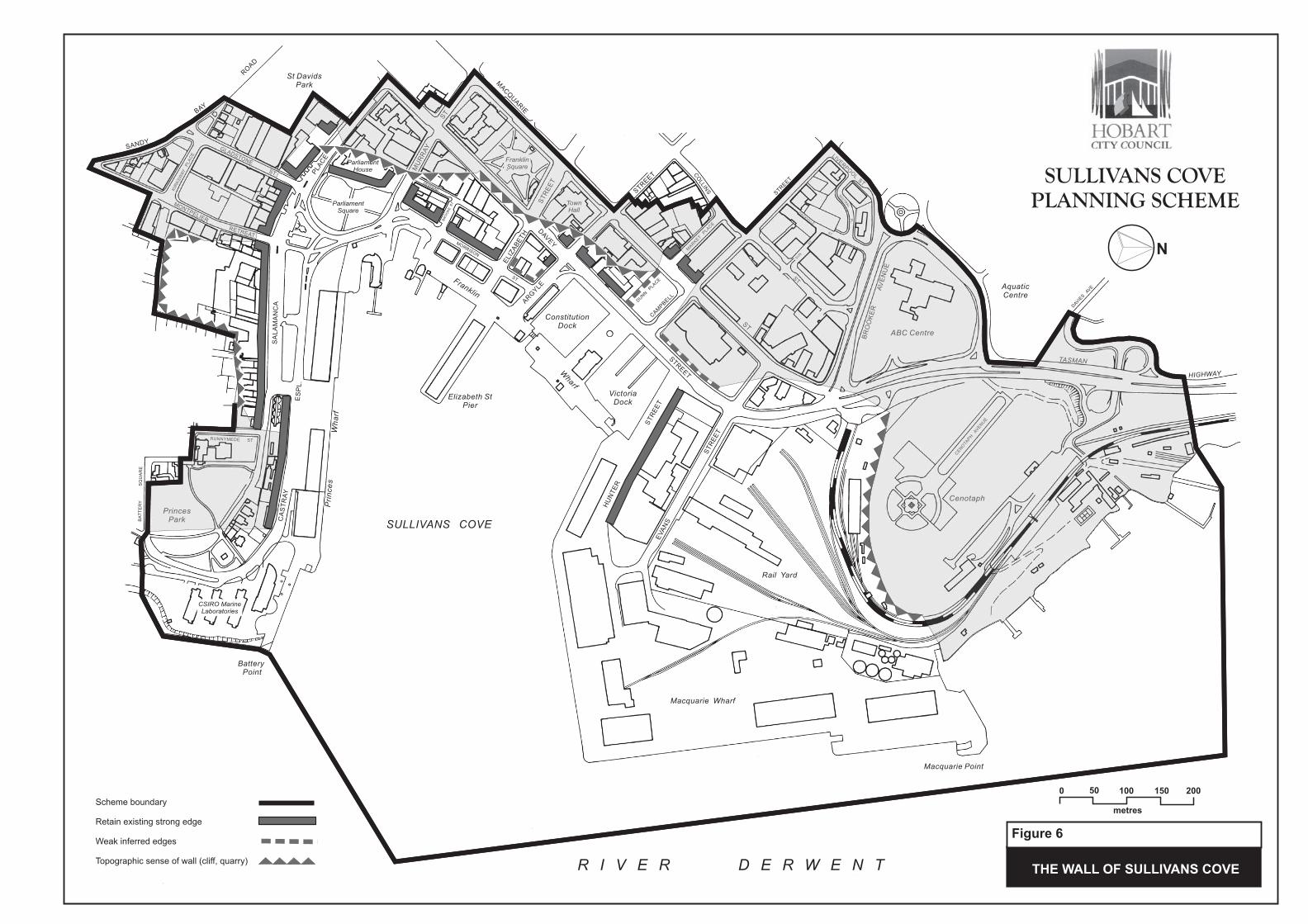
THE WALL OF SULLIVANS COVE
SULLIVANS COVE
PLANNING SCHEME
N
500 100 200150
metres
Elizabeth StPier
PrincesPark
A
MACQ
UARIE
ST
Macquarie PointDAV
EY
STR
EET
Franklin
Wharf
Rail Yard
Cenotaph
VictoriaDock
ConstitutionDock
St DavidsPark
BatteryPoint
SULLIVANS COVE
Pri
nce
sW
ha
rfABC Centre
R I V E R D E R W E N T
SANDY
BAY
RO
AD
GLADSTONE
ST
MONTPELIER
RETREAT
KN
OP
WO
OD
ST
KIR
KS
WA
YP
LA
CE
SA
LA
MA
NC
A
PLA
CE
CA
ST
RA
Y
ES
PL
.
BA
TT
ER
YS
QU
AR
E
RUNNYMEDE ST
MU
RR
AY
ST
ELIZ
AB
ETH
ST
RE
ET
AR
GYLE
STR
EET
CAM
PBELL
STR
EET
LIVER
PO
OL
ST
BR
OO
KE
RA
VE
NU
E
TASMAN
HIGHWAY
CO
LLIN
S
ST
HU
NT
ER
ST
RE
ET
EVA
NS
ST
RE
ET
MARKET
PLA
CE
SUN
ST
SACKVILLE
ST
MIS
TR
AL
PL
.
DESPARD
ST
BR
OO
KE
ST
MORRISON
ST
ParliamentSquare
CSIRO MarineLaboratories
ParliamentHouse
FranklinSquare
DAV
IES
AVE
CEN
OTA
PH
AVEN
UE
Macquarie Wharf
AquaticCentre
DUNN
PLA
CE
TownHall
Figure 6
Scheme boundary
Retain existing strong edge
Weak inferred edges
Topographic sense of wall (cliff, quarry)
SULLIVANS COV
PLANNING SCHE


PRIMARY & SECONDARY SPACES
SULLIVANS COVE
PLANNING SCHEME
N
500 100 200150
metres
Elizabeth StPier
PrincesPark
A
MACQ
UARIE
ST
Macquarie Point
DAV
EY
STR
EET
Franklin
Wharf
Rail Yard
Cenotaph
VictoriaDock
ConstitutionDock
St DavidsPark
BatteryPoint
SULLIVANS COVE
Pri
nce
sW
ha
rfABC Centre
R I V E R D E R W E N T
SANDY
BAY
RO
AD
GLADSTONE
ST
MONTPELIER
RETREAT
KN
OP
WO
OD
ST
KIR
KS
WA
YP
LA
CE
SA
LA
MA
NC
A
PLA
CE
CA
ST
RA
Y
ES
PL
.
BA
TT
ER
YS
QU
AR
E
RUNNYMEDE ST
MU
RR
AY
ST
ELIZ
AB
ETH
ST
RE
ET
AR
GYLE
STR
EET
CAM
PBELL
STR
EET
LIVERPO
OL
ST
BR
OO
KE
RA
VE
NU
E
TASMAN
HIGHWAY
CO
LLIN
S
ST
HU
NT
ER
ST
RE
ET
EVA
NS
ST
RE
ET
MARKET
PLA
CE
SUN
ST
SACKVILLE
ST
MIS
TR
AL
PL
.
DESPARD
ST
BR
OO
KE
ST
MORRISON
ST
ParliamentSquare
CSIRO MarineLaboratories
ParliamentHouse
FranklinSquare
DAV
IES
AVE
CEN
OTA
PH
AVEN
UE
Macquarie Wharf
AquaticCentre
DUNN
PLA
CE
TownHall
Figure 7
Scheme boundary
Primary spaces
Secondary spaces


Heights as perWapping Local Area Plan
SULLIVANS COVE
PLANNING SCHEME
N
500 100 200150
metres
Elizabeth StPier
PrincesPark
A
MACQ
UARIE
STR
EET
Macquarie Point
DAV
EY
STR
EET
Franklin
Wharf
Rail Yard
Cenotaph
VictoriaDock
ConstitutionDock
St DavidsPark
BatteryPoint
SULLIVANS COVEPri
nce
sW
ha
rfABC Centre
R I V E R D E R W E N T
SANDY
BAY
RO
AD
GLADSTONE
ST
MONTPELIER
RETREAT
KN
OP
WO
OD
ST
KIR
KS
WA
YP
LA
CE
SA
LA
MA
NC
A
PLA
CE
CA
ST
RA
Y
ES
PL
.
BA
TT
ER
YS
QU
AR
E
RUNNYMEDE ST
MU
RR
AY
ST
ELIZ
AB
ETH
ST
RE
ET
AR
GYLE
STR
EET
CAM
PBELL
STR
EET
LIVERPO
OL
ST
BR
OO
KE
R
AV
EN
UE
TASMAN
HIGHWAY
CO
LLIN
S
ST
HU
NT
ER
ST
RE
ET
EVA
NS
ST
RE
ET
MARKET
PLA
CE
SUN
ST
SACKVILLE
ST
MIS
TR
AL
PL
.
DESPARD
ST
BR
OO
KE
ST
MORRISON
ST
ParliamentSquare
ParliamentHouse
FranklinSquare
DAV
IES
AVE
CEN
OTA
PH
AVEN
UE
Macquarie Wharf
AquaticCentre
DUNN
PLA
CE
TownHall
DEEMED TO COMPLY HEIGHTS
Figure 8
NOTES
1. Plot ratio is determined by reference to maximum height - refer Schedule
2. Height and bulk are also determined by reference to Places of Cultural Significance - inSchedule 1 - Conservation of Cultural Heritage Values.
3. For places listed in Table 1, Schedule 1 - Conservation of Cultural Heritage Values, themaximum permitted height shall be that of the principal building.
4. Development for a use in Tables 19.3.1 & 19.3.2 except car park. Height for thedevelopment of a car park and any other use is discretionary.
CSIRO MarineLaboratories
Scheme Boundary
8 metres
9 metres
12 metres
15 metres
18 metres
15 metres
Height discretionary
4
Deemed to Comply Heights


103

Sullivans Cove Planning Scheme 1997 (as amended at 17 February 2011) 104

105
24 SCHEDULE 3 – PUBLIC URBAN SPACE
24.1 Introduction
The streets and other public spaces of the Cove are an essential part of the Cove’s character. A very broad range of human activities are played out in these public spaces, from festivals and markets, walking and cycling, recreation in parks and on streets, to the movement of goods and cargo and the movement and parking of vehicles.
The purpose of this Schedule is to manage the construction of buildings and the carrying out of works in streets and other public spaces within an urban design framework.
The Schedule is concerned with managing fixed and ephemeral building or works in the public spaces of the Cove, including;
Civic Works (road and pavement works, traffic calming installations, pier and wharfmodifications, landscaping, public transport facilities, other works)
Public Street Furniture (fixed street furniture including benches, bins, bollards)
Commercial and Community Furniture (outdoor dining furniture and display of goods)
Controls over the construction of buildings or works are intended to create a built form which is consistent with the preferred function and character of the streets and other public spaces.
Streets and other public spaces are categorised in this schedule based on the character of the urban form. The Schedule also requires the relevant type of development to be assessed against the function of the space (pedestrian spaces, vehicle movement, parks, etc).
24.2 Objectives
The construction of roads and footpaths, public street furniture, street trees and otherbuildings or works within designated roads and other public spaces must beundertaken in a manner which reinforces the primary urban character and function ofsuch spaces.
Buildings or works established in roads and other public spaces must be designedand located in a manner which facilitates the preferred use of the space includingpedestrian access to the waterfront.
Buildings or works within roads and other public spaces for the purposes of publictransport, or pedestrian and cycle access is encouraged.
The selection and positioning of fixed streetscape furniture and the detail of civic worksmust strengthen the different characters of individual parts of Sullivans Cove.
The utilitarian character of details other than in urban gardens and enclosing ridges isto be retained.
Positioning and selection of civic works and public street furniture must provide goodsight lines for pedestrians and traffic and for informal surveillance of areas at night.
The use of footpaths and other public spaces for commercial and community furnitureis encouraged where:
- Footpaths or other public spaces are wide and flat;
- Areas are not adjacent to roads which carry high traffic volumes and
- The microclimate is comfortable.
- Pedestrian access by the public to the waterfront is not impeded.

106
Where this is not the case, any proposed commercial and community furniture in theroad reservation or other public spaces must demonstrate that a level of amenity forpedestrians and users, comparable to that in more suitable locations can be achieved.
24.2A Exemptions
All buildings and works within the ‘Macquarie Point Site Development Plan’ standards in clause 32 under Part F of the Scheme are ‘exempt’ from this schedule.
24.3 Public Urban Space Types
24.3.1 The primary public urban space types are identified on the ‘Public Urban Space Types’ plan (Figure 9), and are described as follows:
The Cove Floor
The flat fill areas of the wharves, docks and associated areas.
The Cove Slopes
The surrounding slopes where radiating streets lead down to the Cove.
Enclosing Urban Ridges
Including the prominent ridges of the Domain Parkland, Franklin Square area and Sandy Bay Road area.
The Rear of the Cove
An urban area in transition, including the area surrounding Wapping, Collins Street and Market Place.
The Derwent Shore
Including Regatta Point & HMAS Huon.
24.4 Part A – Civic Works and Public Street Furniture
24.4.1 Scope This control applies to the construction, exterior alteration or exterior decoration of any building or the construction or carrying out of any works within the public urban spaces identified in the ‘Public Urban Space Types’ plan. In relation to new public urban space created the provisions of the schedule for the relevant public urban space type immediately adjacent the relevant street frontage(s) shall apply.
This includes, but is not limited to the following:
Construction of buildings.
Road works.
Resurfacing of pavements and footpaths.
Extensions and modifications to Wharf and pier edges.
Landscaping works, including planting of street trees.
Construction of fixed street furniture.
24.4.2 Requirements for Planning Approval
The following requirements apply to the construction, exterior alteration or exterior decoration of any building or the construction or carrying out of any works within the area shown on the ‘Public Urban Space Types’ plan (Figure 9).
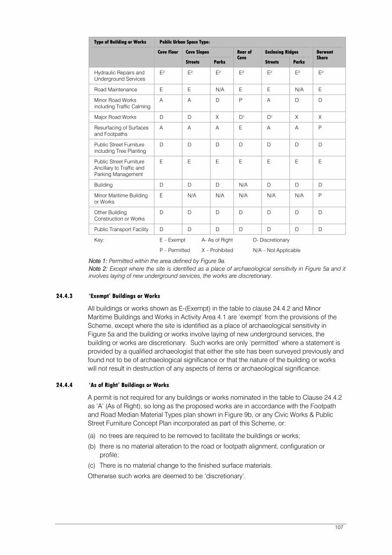
107
Type of Building or Works Public Urban Space Type:
Cove Floor Cove Slopes Rear of Cove
Enclosing Ridges Derwent Shore
Streets Parks Streets Parks
Hydraulic Repairs and Underground Services
E² E² E² E² E² E² E²
Road Maintenance E E N/A E E N/A E
Minor Road Works including Traffic Calming
A A D P A D D
Major Road Works D D X D¹ D¹ X X
Resurfacing of Surfaces and Footpaths
A A A E A A P
Public Street Furniture including Tree Planting
D D D D D D D
Public Street Furniture Ancillary to Traffic and Parking Management
E E E E E E E
Building D D D N/A D D D
Minor Maritime Building or Works
E N/A N/A N/A N/A N/A P
Other Building Construction or Works
D D D D D D D
Public Transport Facility D D D D D D D
Key: E – Exempt A- As of Right D- Discretionary
P – Permitted X – Prohibited N/A – Not Applicable
Note 1: Permitted within the area defined by Figure 9a. Note 2: Except where the site is identified as a place of archaeological sensitivity in Figure 5a and it involves laying of new underground services, the works are discretionary.
24.4.3 ‘Exempt’ Buildings or Works
All buildings or works shown as E-(Exempt) in the table to clause 24.4.2 and Minor Maritime Buildings and Works in Activity Area 4.1 are ‘exempt’ from the provisions of the Scheme, except where the site is identified as a place of archaeological sensitivity in Figure 5a and the building or works involve laying of new underground services, the building or works are discretionary. Such works are only ‘permitted’ where a statement is provided by a qualified archaeologist that either the site has been surveyed previously and found not to be of archaeological significance or that the nature of the building or works will not result in destruction of any aspects of items or archaeological significance.
24.4.4 ‘As of Right’ Buildings or Works
A permit is not required for any buildings or works nominated in the table to Clause 24.4.2 as ‘A’ (As of Right), so long as the proposed works are in accordance with the Footpath and Road Median Material Types plan shown in Figure 9b, or any Civic Works & Public Street Furniture Concept Plan incorporated as part of this Scheme, or:
(a) no trees are required to be removed to facilitate the buildings or works;
(b) there is no material alteration to the road or footpath alignment, configuration or profile;
(c) There is no material change to the finished surface materials.
Otherwise such works are deemed to be ‘discretionary’.
108
24.4.5 ‘Permitted’ Buildings or Works
The Planning Authority is bound to grant a permit subject to conditions for all buildings or works nominated in the table to Clause 24.4.2 as ‘P’ (Permitted).
24.4.6 ‘Discretionary’ Buildings or Works
All buildings or works nominated in the table to Clause 24.4.2 as ‘D’ (Discretionary) require a permit, except where the site is within the area identified by Figure 9a, the building or works are ‘permitted’. The Planning Authority may exercise its discretion to approve, approve with conditions, or refuse any application.
In considering such applications, the Planning Authority must satisfy itself that the proposed buildings or works are compatible with the following:
The ‘Civic Works and Public Street Furniture’ Guidelines outlined in Clause 24.4.8.
The function of the Public Urban Space as described in Clause 24.4.10.
The provisions of clause 24.4.9 apply where appropriate.
24.4.7 ‘Prohibited’ Buildings or Works
All buildings or woks nominated in the table to Clause 24.4.2 as ‘X’ (Prohibited) are ‘prohibited’.
24.4.8 ‘Civic Works and Public Street Furniture’ Guidelines
24.4.8A These guidelines apply to the assessment of all ‘discretionary’ buildings or works as outlined in Clause 24.4.6 and should be read in conjunction with the following:
‘Public Urban Space Types’ Plan (Figure 9).
Section 2.4 of the Sullivans Cove Planning Review (1991), pp. 50-62.
24.4.8B The design of civic works and public street furniture is required to respond to the following guidelines:
Positioning of Civic Works and Public Street Furniture in Primary Spaces
Public street furniture must strengthen spaces by standing apart from and not softening, the junction of walls and pavement and by running parallel to the dominant lines in a space. Civic works must run parallel to the dominant walls of a space, building walls or edges of docks or wharves.
Repeated elements, such as seats and trees must run parallel to the dominant lines of the buildings and streets.
Where different elements occur in proximity, their co-location must reflect a ‘squared up’ relationship and they must be grouped into small clusters to minimise their impact on the space.
Minor landscape works are discouraged within primary spaces.
Positioning of Civic Works and Public Street Furniture in Secondary Spaces
The following guidelines are to be applied to Secondary Spaces in all Public Urban Space Type Areas.
Civic Works and Public Street Furniture are to create an irregular patterning while still being ‘squared up’ to the walls of spaces and are not required to run parallel to the dominant lines of the space.
Minor landscape works are encouraged.

109
Amenity and Safety
Positioning civic works must allow for convenient pedestrian movement (minimum 2.5 m wide clearance) in designated ‘Mixed’, ‘Pedestrian Movement’ or ‘Open Space’ under Clause 24.4.10.
Sight lines should be provided between pedestrians and drivers and levels of night lighting are to be to the satisfaction of the Planning Authority.
Specific Precinct Guidelines
Context Preferred Design Response
Public Urban Space Types
Spatial & Urban Character Civic Works & Public Street Furniture Character
Positioning Criteria
Cove Floor Hard, flat fill surface floor of the Cove.
Utilitarian character on wharves and docks, with characteristic robust maritime details including metal, concrete surfaces and large-section unfinished wood.
On the wharves and dock edges; hard, robust and utilitarian, maritime (retention of Salamanca Lawns an exemption).
Secondary spaces off the Cove Floor including Montague Lane, Despard Street, Brooke Street: modest, irregular utilitarian character is encouraged.
Civic works and public street furniture should be sited parallel or square to dominant edges of spaces.
Regular spacing of elements is encouraged to place emphasis on the spaces rather than individual buildings or building entrances.
The flat fill character must not be compromised by kerbs, mounds etc.
Cove Slopes
Narrow sloping streets. Hard surfaces, modest utilitarian character.
Views down sloping streets to Sullivans Cove must be respected.
Works and furniture should be sited parallel to the direction of views.
Enclosing Ridges
A. Macquarie Street-Davey Street ridge- includes Franklin Square.
Civic works and public street furniture to respond to known history of the site and precinct.
Civic works and public street furniture to reflect the historic character, in accordance with any approved Civic Works and Public Street Furniture Concept Plans.
Enclosing Ridges
B. Sandy Bay Road ridge-includes Gladstone Street gateways.
Sandy Bay Road-street trees, soft edges.
Kirksway Place, irregular character, requires historic investigation.
Civic works and public street furniture to focus on the alignment of Sandy Bay Road.
Enclosing Ridges
C. Domain Parkland. The Cenotaph ridge is a strong formal 1920’s civic landmark imposed in counterpoint to picturesque cedar walks with formal memorial avenue, through to an irregular eucalypt grassy woodland.
Civic works and public street furniture should be in compliance with the Queens Domain Management Plan
(1996).
Civic works and public street furniture should be in compliance with the Queens Domain Management Plan (1996).
An Integrated Conservation Plan and Civic Design Concept is required for significant works in this area.
Rear of Cove
Urban area in transition. Historically these areas were irregular, urban and gritty with a failed 1920’s grand vision laid over them.
Contemporary hard, sparse utilitarian character.
Secondary spaces more irregular, except Market Place.
Regular placing of street furniture, parallel to dominant lines of space. Minor irregularity in secondary spaces.

110
Context Preferred Design Response
Public Urban Space Types
Spatial & Urban Character Civic Works & Public Street Furniture Character
Positioning Criteria
Derwent Shore
Regatta Point
HMAS Huon and Shipyards.
(none specified) Irregular alignment of civic works and public street furniture to the water’s edge.
24.4.9 Requirement for a Civic Works and Public Street Furniture Concept Plan
Approval of the following types of ‘discretionary’ building or works will require preparation and approval of a Civic Works and Public Street Furniture Concept Plan;
Newly created public urban spaces resulting from redevelopment.
Streets undergoing substantial infrastructure replacement.
Public urban spaces resulting from the redevelopment of Dunn Street car park.
Road closures.
Before introduction of interpretation or public street furniture other than as replacement.
24.4.10 Function of Public Urban Space Types
24.4.10A The function of the public urban space type must be taken into account in the assessment of all ‘discretionary’ buildings or works as outlined in Clause 24.4.2.
The following functional characteristics of Public Urban Space in the Cove have been identified:
Public Urban Space Function 1 – Vehicle Movement Applicable Streets/ Other Public Spaces
The primary function of this public urban space type is to facilitate major motor vehicle traffic movement. These spaces generally function as primary and secondary arterial roads and they serve a metropolitan transport movement function.
The movement of motor vehicles is assigned priority over pedestrian and other movement in these areas. However, the design and layout of these roads must provide for a safe and comfortable environment for pedestrians and cyclists.
Macquarie Street, Davey Street, Campbell Street, Brooker Avenue, Liverpool
Public Urban Space Function 2 - Mixed Applicable Street/ Other Public Spaces
The function of this urban space type is to facilitate a mix of vehicle, pedestrian and cycle movement. These spaces are often classed as ‘collector roads’. In the Sullivans Cove context, movement of motor vehicles on these roads is regarded as being of equal importance to cycle and pedestrian activities and movements.
The future use and development of these roads needs to recognise the spatial and design demands of each type of movement. Installation of pedestrian crossings, footpath widening, outdoor dining facilities and traffic calming facilities are all consistent with the designation of this road type.
Castray Esplanade, Princes Wharf, Morrison Street, Elizabeth Street, Market Place, Collins Street, Sackville Street, Mistral Place, Montpelier Street, Gladstone Street, Salamanca Place (west of Gladstone Street), Argyle Street, Runnymede Street, Murray Street, Regatta Point Road.

111
Public Urban Space Function 3 – Pedestrian Movement Applicable Streets/ Other Public Spaces
The function of this public urban space type is to primarily facilitate pedestrian movement. Other movements, including public transport, private vehicles and cyclists will not be precluded from these spaces. Nor will vehicle parking. However, priority will be given to the use and development of these roads to improve the safe and efficient movement of pedestrians, and to the creation of a comfortable and aesthetically pleasing pedestrian environment.
At certain times, the exclusion of motor vehicles for street festivals, markets, etc is considered appropriate. Vehicle speed in these areas must be restricted to a speed compatible with mixing motor vehicles, cyclists and pedestrians. The total number, siting and design of vehicle parking areas must only be developed after considering their impact on the pedestrian environment.
Salamanca Place, Salamanca Square, Battery Point (east edge), Franklin Wharf, Elizabeth Street Pier, Hunter Street, Brooke Street, Despard Street, Constitution Dock and Victoria Dock edges.
Public Urban Space Function 4 – Open Space Applicable Open Spaces
The function of this public urban space type is to facilitate outdoor recreation activities. These spaces are set aside for pedestrian activities, and form an important component of the character and functionality of the Cove. The amenity of these spaces if of utmost importance. Such spaces must be protected from the impacts of overshadowing, traffic noise and other disturbances. Such spaces must also be well connected to other pedestrian oriented spaces in the Cove.
Princes Park, Parliament Square, Franklin Square, Salamanca Lawns, Domain Park, Regatta Point.
24.5 Part B – Commercial and Community Furniture
Public urban spaces in the Cove are used for a range of commercial activities, including outdoor dining facilities, and external display of wares. Such uses add vitality and interest to the Cove.
However, without appropriate controls they can also create clutter, becoming an obstruction to the free movement of pedestrians. Poorly located seating and outdoor displays can create safety hazards if inappropriately sited or designed. Too many tables and chairs, and other commercial furniture can also create visual clutter, resulting in unattractive street spaces.
The Planning Scheme supports the continued use of public urban spaces for commercial activities. However, such activities must be appropriately regulated to protect pedestrian amenity, efficiency and safety.
The regulation of the number, location and design of such facilities is important to ensure that the Cove remains an attractive, comfortable and safe place for pedestrians.
24.5.1 Scope
This control applies to the use of roads and other public spaces within the ‘Commercial and Community Use of Public Space’ plan (Figure 10) for commercial and community furniture. This control regulates the siting and design of all ephemeral furniture.
112
Note:
1. Both the Tasmanian Ports Corporation and the Council have a ‘landlord’ function over public urban spaces in the Cove. A license is required from these authorities for the use or development or to undertake works in roads and other public spaces. This licensing arrangement is separate to the requirements of this Scheme.
The controls of this Schedule are designed to minimise the need for a permit, for the commercial uses of roads and other public spaces. These controls identify locations, siting and design requirements for outdoor dining furniture. Where these requirements can be satisfied, no permit is required for such facilities.
2. The landowner is required to be notified in accordance with the Land Use Planning and Approvals Act 1993.
24.5.2 Requirements for Planning Approval
The following requirements apply to the use of land for Commercial and Community Furniture.
24.5.2A ‘Exempt’ Commercial and Community Furniture A permit is not required for Outdoor Dining Furniture, subject to satisfying the following ‘deemed to comply’ provisions:
Must be within a location identified on Figure 10 as being ‘exempt’; and
Must provide for free unobstructed pedestrian carriage as determined by the Hobart City Council as Highway Authority.
24.5.2B ‘Discretionary’ Commercial and Community Furniture
A permit is required for commercial and community furniture in public urban spaces located anywhere other than the locations specified in Figure 10.
An application for a permit under this clause may be approved or refused. Any application must provide for free unobstructed pedestrian carriage as determined by the Council as Highway Authority.

113
24.6 Definitions
Civic Works and Public Street Furniture Concept Plans
A plan showing the full extent of intended Civic Works, including provision of essential services infrastructure, paving, planting, location of all fixed street furniture including trees and ground covers, artworks, free standing signs, lights and lighting concept.
Civic Works Works undertaken in roads and other public spaces by public authorities, including the Council and the Tasmanian Ports Corporation Pty Ltd, or by individuals. It does not include buildings in the public space.
Commercial and Community Furniture
All ephemeral furniture (furniture which is regularly removed, being removed at least every three months or not otherwise fixed to the ground, building or structure) associated with a commercial or community activity. It includes Outdoor Dining Furniture.
Hard Character Primarily hard constructed surfaces, no landscape works.
Hydraulic Repairs and Underground Services
The laying, replacement or repair of any water, sewerage or stormwater main or any other piping or ducting required for mains services, electrical supply, communications or other underground activities required to service a public utility installation.
Major Road Works Means within the existing road reservation or other public space, all road works required for the construction of additional traffic lanes and vehicle under and overpasses.
Minor Landscape Works Works involving installation of vegetation (planter boxes, etc.) excluding street trees.
Minor Maritime Building or Works
Means minor building or works essential to the safe operation of the Port of Hobart and includes those related to general wharf maintenance, statutory signs, essential services to vessels (power and water), lighting for navigational and ship servicing purposes and the replacement of fenders, dolphins, camel dolphins and bollards.
114
Minor Road Works Means within the existing road or other public space, all road works involved in the sealing or resealing, upgrading or minor widening of an existing carriageway, including the introduction of kerbs, gutters, footpaths, road signs, traffic-control devices, street lighting, traffic calming measures, alterations to the layout and means of traffic control at existing junctions and intersections, and the like, together with pedestrian under and overpasses, but does not involve the construction of any new or additional carriageway or traffic lane and includes all other works not included under Major Road Works.
It includes the formation, widening, improvement or alteration of any existing vehicular access by, or on behalf of, the road authority.
Other Public Spaces Land which is generally available for access by the general public, but not including a road.
Outdoor Dining Furniture Means the placement or use of tables, chairs, benches, umbrellas and the like used for the purpose of extending the services of premises whose main function is the provision of food and beverages to the public.
Primary Spaces Roads and spaces shown on Figure 7 as primary spaces.
Public Street Furniture Street furniture permanently located in roads or other public spaces, or furniture which is possible to remove but is removed no more than once every 3 months. Includes but not limited to: street furniture and large landscape items including street trees.
Public Street Furniture Ancillary to Traffic and Parking Management
Street furniture that is permanently located in roads or other public spaces or furniture which is possible to remove but is not removed once every 3 months and that is necessary for the management by the Council of traffic and parking.
Public Transport Facility Means any building, structure, activity or area used or intended to be used in association with the transport of people by bus, train, or light rail.
Road Means a road or street, including a public space, over which the general public has permanent right of passage in a motor vehicle, including all land between the boundaries of the road and its reservation and all bridges over which such a road passes, being a road which is the responsibility of the Minister administering the Roads and Jetties Act 1935 or, if a Council road, being a road for which the Council has accepted responsibility under its seal or a road shown on the municipal map.
115
Road Layout Plan Means a plan(s) and any accompanying text of the road alignment, including the position and width of carriageway(s), the location and layout of junctions and intersections, the siting and height of major cuttings and embankments and any such further relevant information as may be required by the Planning Authority.
Road Maintenance Means the repair and/or replacement of any part of an existing road and its associated infrastructure, and includes carriageway resealing, replacement and/or upgrading of line markings, road signs, other traffic control devices, street lighting together with all road works required to maintain the road in a safe and satisfactory operational condition. Also included are any emergency works required for public safety due to an immediate danger to the public and to preserve the integrity of the road and the surrounding area.
Road Works Means all work undertaken in, on, under or over the carriageway(s), road shoulders, medians, bridges, culverts, footpaths and verges including all works necessary to install and maintain road signs, traffic control devices, infrastructure, landscaping, planting and tree removal required to ensure amenity and the safe, efficient and convenient use of a road by private and public transport.
Secondary Spaces Smaller roads, lanes, alleys and ad hoc courts running off the primary spaces shown on Figure 7 as secondary spaces.
Traffic Calming Means the institution of a variety of traffic management measures required to adapt the volume, speed and behaviour of traffic to the primary functions of the areas through which it passes.

116

Derwent Shore
Enclosing Ridge
Rear of Cove
Cove Slopes
Cove Floor
PUBLIC URBAN SPACE TYPES
PUBLIC URBAN SPACE TYPES
N
SULLIVANS COVE
PLANNING SCHEME
Elizabeth StPier
PrincesPark
A
MACQ
UARIE
ST
Macquarie Point
DAV
EY
STR
EET
Franklin
Wharf
Rail Yard
Cenotaph
VictoriaDock
ConstitutionDock
St DavidsPark
BatteryPoint
SULLIVANS COVE
Pri
nce
sW
ha
rfABC Centre
R I V E R D E R W E N T
SANDY
BAY
RO
AD
GLADSTONEST
MONTPELIERRETREATK
NO
PW
OO
DS
T
KIR
KS
WA
Y
PLA
CE
SA
LA
MA
NC
A
PL.
CA
ST
RA
YE
SP
L.
BA
TT
ER
YS
QU
AR
E
RUNNYMEDE ST
MU
RR
AY
ST
ELIZ
AB
ETH
ST
AR
GYLE
ST
CAM
PBELL
STR
EET
LIVER
PO
OL
ST
BR
OO
KE
RA
VE
NU
E
TASMAN
HIGHWAY
CO
LLIN
S
ST
HU
NT
ER
ST
RE
ET
EVA
NS
ST
RE
ET
MARKET
PLA
CE
SUN
ST
SACKVILLE
ST
MIS
TR
AL
PL
.
DESPARD
ST
BR
OO
KE
ST
MORRISON
ST
ParliamentSquare
CSIRO MarineLaboratories
ParliamentHouse
FranklinSquare
DAV
IES
AVE
CEN
OTA
PH
AVEN
UE
Macquarie Wharf
AquaticCentre
DUNN
PLA
CE
TownHall
500 100 200150
metres
Figure 9
Scheme Boundary

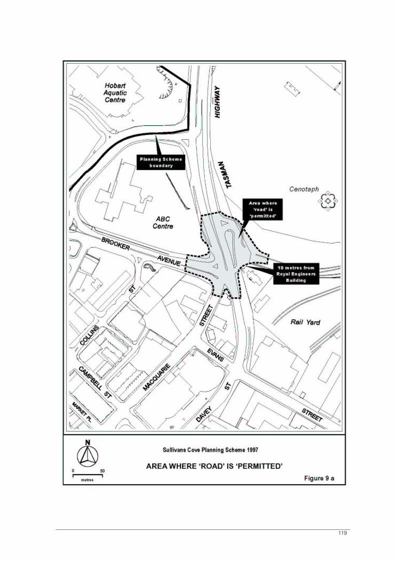
119

Sullivans Cove Planning Scheme 1997 (as amended at 17 February 2011) 120
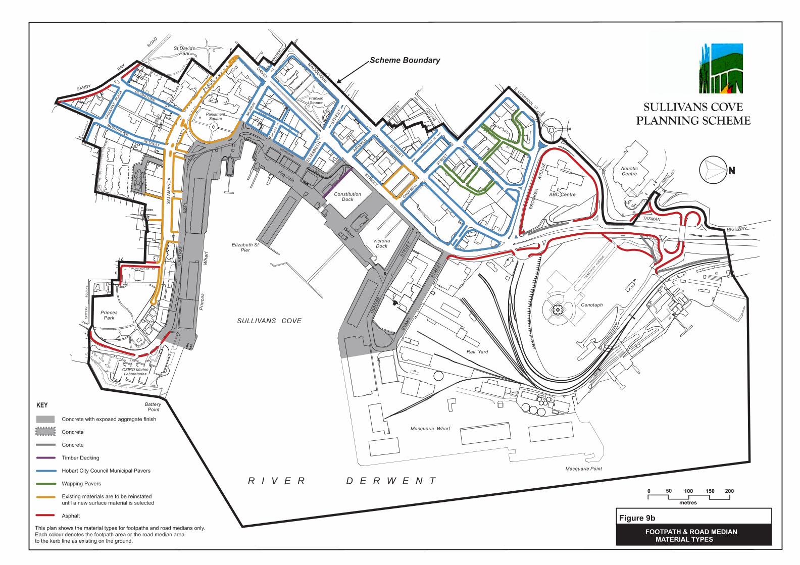
FOOTPATH & ROAD MEDIAN MATERIAL TYPES
SULLIVANS COVE PLANNING SCHEME
Figure 9b
NNN
Elizabeth StPier
PrincesPark
MACQUARIE
STREET
Macquarie Point
DAVEY
STREET
Franklin
Wharf
Rail Yard
Cenotaph
VictoriaDock
ConstitutionDock
St DavidsPark
Battery Point
SULLIVANS COVE
Prin
ces
Wha
rf
ABC Centre
R I V E R D E R W E N T
SANDY
BAY
ROAD
GLADSTONE
ST
MONTPELIER
RETREAT
KNO
PWO
OD
ST
KIR
KSW
AYPL
ACE
SA
LAM
AN
CA
PLACE
CA
STR
AYE
SP
L.
BAT
TE
RY
SQ
UA
RE
RUNNYMEDE ST
MU
RR
AY
ST
ELIZ
ABET
H
STRE
ET
ARGYLE
STREET
CAMPBELL
STREET
LIVERPOOLST
BR
OO
KE
RAV
EN
UE
TASMAN
HIGHWAY
COLLINS
ST
HU
NTE
R
STRE
ETEV
ANS
STRE
ET
SUN
ST
SACKVILLE
ST
MISTRAL
PL.
DESPARD
ST
BRO
OKE
ST
MORRISON
ST
ParliamentSquare
CSIRO MarineLaboratories
FranklinSquare
DAVIES
AVE
CENOTAPH
AVENUE
AquaticCentre
Macquarie Wharf
500 100 200150
metres
MARKETPL.
Scheme Boundary
KEY
This plan shows the material types for footpaths and road medians only. Each colour denotes the footpath area or the road median area to the kerb line as existing on the ground.
Concrete with exposed aggregate finish
Concrete
Concrete
Timber Decking
Hobart City Council Municipal Pavers
Wapping Pavers
Existing materials are to be reinstateduntil a new surface material is selected
Asphalt


COMMERCIAL & COMMUNITY USEOF PUBLIC SPACE
SULLIVANS COVE
PLANNING SCHEME
N
500 100 200150
metres
Elizabeth StPier
PrincesPark
A
MACQ
UARIE
ST
Macquarie Point
DAV
EY
STR
EET
Franklin
Wharf
Rail Yard
Cenotaph
VictoriaDock
ConstitutionDock
St DavidsPark
BatteryPoint
SULLIVANS COVE
Pri
nce
sW
ha
rfABC Centre
R I V E R D E R W E N T
SANDY
BAY
RO
AD
GLADSTONE
ST
MONTPELIER
RETREAT
KN
OP
WO
OD
ST
KIR
KS
WA
YP
LA
CE
SA
LA
MA
NC
A
PLA
CE
CA
ST
RA
Y
ES
PL
.
BA
TT
ER
YS
QU
AR
E
RUNNYMEDE ST
MU
RR
AY
ST
ELIZ
AB
ETH
STR
EE
T
AR
GYLE
ST
CAM
PBELL
STR
EET
LIVERPO
OL
ST
BR
OO
KE
RA
VE
NU
E
TASMAN
HIGHWAY
CO
LLIN
S
ST
HU
NT
ER
ST
RE
ET
EVA
NS
ST
RE
ET
MARKET
PLA
CE
SUN
ST
SACKVILLE
ST
MIS
TR
AL
PL
.
DESPARD
ST
BR
OO
KE
ST
MORRISON
ST
ParliamentSquare
CSIRO MarineLaboratories
ParliamentHouse
FranklinSquare
DAV
IES
AVE
CEN
OTA
PH
AVEN
UE
Macquarie Wharf
AquaticCentre
DUNN
PLA
CE
TownHall
Figure 10
Use of public urban space foroutdoor dining furniture exempt.
Scheme Boundary

125
25 SCHEDULE 4 – SIGNS
25.1 Introduction
The key issue regarding provision of signs in Sullivans Cove is the need to provide reasonable scope for advertising and information signs in a manner which does not overwhelm or compromise the historic character of the Cove.
This Schedule identifies whether particular sign types require planning approval, the requirements that apply for signs that do require approval, and clarifies the range and extent of signs that are allowable.
Because of the special character of Sullivans Cove, particular emphasis is placed on a coordinated approach to signs – specifically multiple signs on building facades and signs in the ‘Cove Floor’ (see Figure 9).
25.2 Objectives
The objectives of this Schedule are:
To maintain a balance between the established built form and historic character of the Cove and commercial need to advertise goods and services.
To ensure that signs do not intrude into and detrimentally affect the visual amenity of the area.
To ensure that signs are complementary to the overall character of Sullivans Cove, and complement the historic character of the building on which they are mounted.
To prevent visual clutter through the proliferation of signs by encouraging fewer more effective signs.
To ensure that signs do not disrupt or compromise safety and efficiency of vehicular or pedestrian movement.
To ensure signs on places of cultural significance are responsive to the cultural heritage values and the significance of the building or place, both in terms of impact and by means of attachment, by protecting and enhancing those values.
To prevent multiple signs on a single building, unless the cumulative effect of existing and proposed signs will not adversely affect the character and/or cultural heritage values of the building.
25.3 Scope
This Schedule applies to the construction, putting up for display or erection (development) and the continuous display (use) of all signs in the Sullivans Cove Planning Area.
This Schedule also outlines controls over signs on all places of cultural significance identified in Schedule 1.
Particular controls apply to the ‘Cove Floor’ (see Figure 9) as it is recognised as having specific qualities and characteristics which require a finer grain of detailed consideration to take place. Provisions for the ‘Cove Floor’ take precedence over the general provisions.
Where street furniture, public telephones, vending machines, automatic teller machines and the like include signs they must be classified within one of the sign types and dealt with accordingly. The placement and design of such items is determined within Schedule 3.

126
This Schedule does not apply to signs on vehicles primarily used for transporting people or freight.
Where there is an inconsistency between this Schedule and any other provision of this planning scheme, the provisions of the Schedule prevail.
25.4 Information to be Submitted
The following information must be submitted with all applications for signs:
A comprehensive plan of the location, measurements and method of attachment of all existing and proposed sign types for an entire building or face of a building or site.
Graphic content of the sign or a graphics concept, showing the colours, finishes, materials, lettering style and logos;
Method of lighting (if applicable).
25.5 Categorising Signs
Each sign must be categorised into one of the definitions listed and described below.
If a sign fits a definition of more than one defined sign, the most specific defined sign applies.
If a sign does not readily fit any defined sign, it must be categorised as the most similar defined sign.
25.6 Definitions
In this Schedule, unless the contrary intention appears:
area means, for a sign, the entire area within a regular, geometric form or combination of regular, geometric forms comprising all the display area of the sign and including all of the elements of the matter displayed. In the case of those messages composed of individual letters the area shall be calculated by measuring the perimeter enclosing the letters and the encompassed area shall be considered the total sign area. Structural members not being advertising matter shall not be included in computation of surface area.
sign means any graphic, pictorial or written display, including any structure or material, when viewed from a road or other public space.
For the purposes of this Schedule, different sign types are defined as follows:
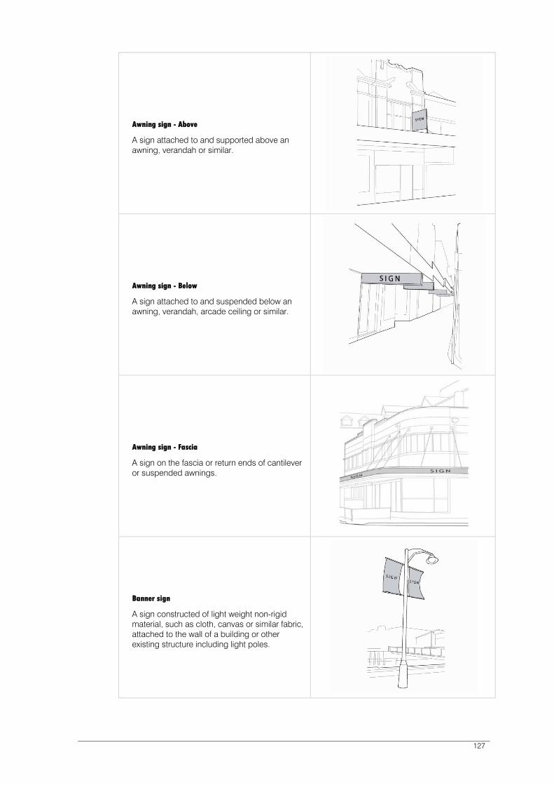
127
Awning sign - Above
A sign attached to and supported above an awning, verandah or similar.
Awning sign - Below
A sign attached to and suspended below an awning, verandah, arcade ceiling or similar.
Awning sign - Fascia
A sign on the fascia or return ends of cantilever or suspended awnings.
Banner sign
A sign constructed of light weight non-rigid material, such as cloth, canvas or similar fabric, attached to the wall of a building or other existing structure including light poles.

128
Blade sign
A sign with a large display surface, which is either permanently attached to the ground or on its own supportive structure. It is not designed or used as a poster panel (billboard), and excludes business directory, or public event and cultural directory signs.
Bunting
A string of small flags, or streamers strung in a line from or otherwise attached to a building or other structure.
Business directory
A sign for a building in multiple tenancies which identifies the name of the business and its location within the building and does not contain any product or other advertising.
Cabinet sign
A cabinet with a transparent face attached to the wall of a building or structure for the display of information within (e.g. menus).

129
Canopy sign
A sign incorporated into the fabric or structure of a sun blind or canopy situated over a door or window.
Construction site sign
A temporary sign indicating that construction works are occurring on a property.
Flag
A sign constructed of light weight, non-rigid material attached by one edge to a pole or rope.
Horizontal projecting wall sign
A sign projecting from the wall of a building with a horizontal dimension greater than its vertical dimension.

130
Internal display sign
A sign located greater than 150mm from the glass surface of a window or door.
Interpretive sign
A sign providing information for visitors, plans, historic information, location of services, features and businesses, includes artworks which convey meaning. This type of sign can be private (i.e. placed by and for the benefit of a private business) or public (i.e. placed by a public agency in the public interest).
Mobile trader sign
A sign attached to a mobile vehicle from which a product or service is being sold (e.g. mobile food van, ice-cream vendor, mobile flower sellers).
Name plate sign
A single sign identifying one of the occupants of a property used for professional rooms, attached flush to the wall of a building (e.g. a traditional doctor’s or lawyer’s brass plate).

131
Pole sign
A sign erected on top of one or more vertical supports or suspended from a horizontal support held up by one or more vertical supports, and which is independent of any building or other structure.
Portable sign
A sign not on a road or a public reservation and not permanently attached to the ground or to a building or other structure. (NB Portable Signs on a on a road or a public reservation are controlled under the Council’s By-Laws)
Poster panel sign (bill board)
A structure either freestanding or attached to a building designed to accommodate standard poster panels, the message of which may be changeable and variable.
Public event and cultural directory sign
A structure permanently attached to the ground, designed to accommodate small bill posters and public notices, the messages of which may be changeable and variable. This type of sign may also fulfil the dual function of an item of public artwork.

132
Real estate sign
A temporary sign erected for purposes of selling/leasing of real estate for the duration of the period the real estate is on the market, which may be more than five days and which is not separately affixed by bolt, nail or screw to masonry, brickwork or other face building material.
Roof/sky sign
A sign erected on the roof or parapet of a building.
Screen sign
Messages or product logos or other graphics printed or displayed on screens used in association with outdoor dining.
Statutory sign
A sign required or specified by statute; and a sign relating to safety of pedestrians, traffic and shipping. Examples are a hazard sign; hazchem sign; traffic control sign; maritime purposes sign; international/national signposting conventions for service provisions, toilets and street numbers.

133
Transom sign
A sign attached to the transom of a doorway or display window of a building.
Umbrella sign
Messages or product logos or other graphics printed or displayed on umbrellas used in association with outdoor dining furniture.
Vertical projecting wall sign
A sign projecting from the wall of a building with a vertical dimension greater than its horizontal dimension.
Wall sign
A sign painted on or attached parallel to the wall or door of a building.
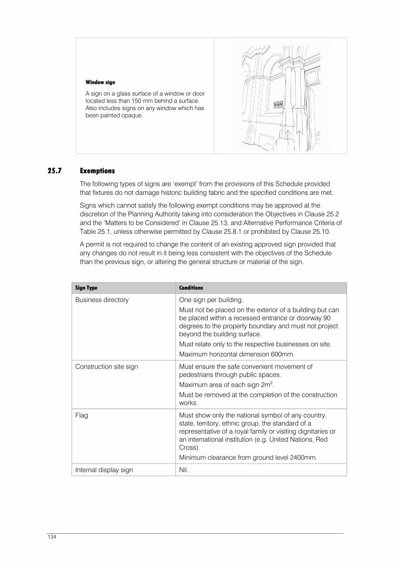
134
Window sign
A sign on a glass surface of a window or door located less than 150 mm behind a surface. Also includes signs on any window which has been painted opaque.
25.7 Exemptions
The following types of signs are ‘exempt’ from the provisions of this Schedule provided that fixtures do not damage historic building fabric and the specified conditions are met.
Signs which cannot satisfy the following exempt conditions may be approved at the discretion of the Planning Authority taking into consideration the Objectives in Clause 25.2 and the ‘Matters to be Considered’ in Clause 25.13, and Alternative Performance Criteria of Table 25.1, unless otherwise permitted by Clause 25.8.1 or prohibited by Clause 25.10.
A permit is not required to change the content of an existing approved sign provided that any changes do not result in it being less consistent with the objectives of the Schedule than the previous sign, or altering the general structure or material of the sign.
Sign Type Conditions
Business directory One sign per building.
Must not be placed on the exterior of a building but can be placed within a recessed entrance or doorway 90 degrees to the property boundary and must not project beyond the building surface.
Must relate only to the respective businesses on site.
Maximum horizontal dimension 600mm.
Construction site sign Must ensure the safe convenient movement of pedestrians through public spaces.
Maximum area of each sign 2m2.
Must be removed at the completion of the construction works.
Flag Must show only the national symbol of any country, state, territory, ethnic group, the standard of a representative of a royal family or visiting dignitaries or an international institution (e.g. United Nations, Red Cross). Minimum clearance from ground level 2400mm.
Internal display sign Nil.

135
Sign Type Conditions
Mobile trader sign Must be less than 2m2 in area.
Must not contain any lighting or have any moving or spinning parts. Must not contain fluorescent or iridescent colours or finishes.
Portable sign Single sign per occupancy of building or site. A single sign may indicate multiple occupants.
Maximum dimensions 1000mm high x 600mm width.
Must directly align with the front of the building or premises and maintain a minimum 2000mm setback from the building.
Must not contain any lighting or have moving or spinning parts.
Must be stabilised.
Real estate sign Must ensure the safe and convenient movement of pedestrians through public spaces. Maximum area of 1m2.
Must not contain fluorescent or iridescent colours or finishes.
Must be removed within 7 days of the sale being finalised.
Screen sign Maximum 10% surface coverage for each side of screen.
Signs must be business name only and not contain product content.
Statutory sign Nil.
Umbrella signs Maximum 10% surface coverage for each side of umbrella.
Signs must be business name only and not contain product content.
Wall sign If only to indicate whether a business is open or closed.
Maximum vertical dimensions of 75mm and horizontal dimension of 300mm.
Window sign If only to indicate whether a business is open or closed.
Maximum vertical dimensions of 75mm and horizontal dimension of 300mm.
25.7.1 The display of a sign(s) of a temporary nature which advertises a community event of a religious, educational, cultural, political, social or recreational character is ‘exempt’ from the provisions of this schedule provided that the following conditions are met:
Must be displayed for no longer than 30 days before the event; and
Must be removed within 7 days after the event; and
Must not disrupt the safe movement of pedestrians or vehicles; and
Must not cause damage to historic building fabric; and
Must not be attached to any vegetation.
136
25.8 ‘Permitted’ Signs
25.8.1 A sign is ‘permitted’ if it meets all acceptable solutions for all applicable standards under
table 25.1 of this schedule.
A sign is not permitted if any other provision of this schedule provides that it is discretionary or prohibited.
25.9 ‘Discretionary’ Signs
A sign is ‘Discretionary’ if:
It is listed in Table 25.1 and does not comply with one or more acceptable solutions for all applicable standards; or
It is part of a proposal for the erection of multiple signs; or
It is illuminated, either internally or externally; or
Any other provision of this schedule provides that it is discretionary.
A sign is not discretionary if any other provision of this schedule provides that it is permitted or prohibited.
25.10 ‘Prohibited’ Signs
The following signs are prohibited:
Any sign displaying or containing electronic or video graphics or mechanically moving figures or graphics that is primarily for commercial purposes;
Any sign displaying or containing fluorescent or iridescent colours or finishes;
Any sign displaying or containing flashing and moving lights;
Awning sign - Above;
Bunting;
Poster panel signs;
Sky/roof sign;
Portable sign, Screen sign or Umbrella sign that does not meet the exemption conditions in Clause 25.7;
Any sign in Table 25.1 which does not meet the relevant Acceptable Solutions and no Alternative Performance Criteria are specified;
Any sign located above the first floor level on the facade of a building in or adjacent to the ‘Cove Floor’ (see Figure 9), excluding contemporary buildings, and extensions
on a place of cultural significance that are not themselves of cultural significance, except for a window sign meeting the ‘Acceptable Solutions’ in Table 25.1; and
Any exempt sign that does not meet the conditions in clause 25.7 and for which there is no Alternative Performance Criteria specified in Table 25.1.
25.11 Signs on Places of Cultural Significance
Notwithstanding any Acceptable Solutions or Alternative Performance Criteria allowed for elsewhere in this Schedule, the following provisions apply to the erection of any signs on, adjacent to or within a place of cultural significance (as listed in Table 1 of Schedule 1 of this Scheme):

137
A sign on or adjacent to or within a place of cultural significance (as listed in Table 1 of Schedule 1 of this planning scheme) is ‘Discretionary’.
A sign in the Cove area must not either by its size, design or content detract from the character and heritage value of buildings both individually and collectively including those groups or buildings comprising some which may not be of particular heritage value.
For modern standardised trademark or propriety logo advertising, corporate image requirements such as specific colours must be adapted to suit the individual location and building.
A sign to be affixed to any place of cultural significance included in Schedule 1 of the Planning Scheme must maintain or reinstate and not detract from its original architecture, heritage value or character.
Signs must be placed to allow the architectural details of the building to remain prominent.
Signs must be placed in locations on the building or item that would traditionally have been used as advertising areas. Historical documentation may be required to justify the placement of any new signs.
No signs shall dominate or obscure any other signs and in particular an historic sign forming an integral part either of a building’s architectural treatment of detailing, or its heritage.
Fixtures must not damage historic building fabric, including but not restricted to attachments to masonry and wood. All signs and related fittings are to be fixed using appropriate non-corrosive fixings inserted in mortar joints.
Signs that break an historic parapet or roof line will be prohibited.
Use of side-walls to locate signs is prohibited if the wall does not form a street-frontage, or has not historically been used for signs.
Strings of light bulbs are prohibited.
Internally illuminated signs attached to a building of cultural significance (excluding contemporary buildings and extensions on a place of cultural significance that are not themselves of cultural significance) are prohibited.
25.12 Signs – Product
This control applies to the display of written material or a graphic or logo associated with a particular product on any sign type, but excludes advertising on flags, posters, umbrellas and screens (which is dealt with separately within this Schedule).
Signs with product content may be considered in accordance with the particular sign type requirements in Table 25.1, subject to satisfying the following conditions:
Must not be located above ceiling or awning level of ground floor occupancies.
Maximum proportion of any one sign devoted to product logo or graphics is 25%.
Must relate directly to a product provided in the respective occupancy.
Signs which cannot satisfy the above conditions of Clause 25.12 are prohibited.

138
25.13 Matters to be Considered
In addition to meeting the relevant Alternative Performance Criteria in Table 25.1 of clause 25.14 of this Schedule, the following matters must be taken into account when considering an application:
The individual or cumulative effect of the sign or signs on the amenity of the area including the need to avoid visual disorder or clutter of signs.
The individual or cumulative effect of the sign or signs on the building and/or surrounding area, considering its effect and means of attachment on places of cultural significance.
The cumulative effect of the sign or signs on existing or approved signs, including signs on buildings and outdoor uses that constitute a sign.
The size and likely impact of the sign having regard to the size of the premises on which it is to be displayed and the scale of surrounding buildings.
The effect of the sign on the safety and security of premises and the area.
The effect of the sign on the appearance, efficiency and safety of a road, railway, waterway or other public way, having particular regard to the sign’s colour, brightness and location.
The effect of the sign on pedestrian movement and safety.
Compliance with objectives of this Schedule.

139
25.14 Requirements for Signs
Table 25.1: Acceptable Solutions and Alternative Performance Criteria
Sign Type Acceptable Solution (Permitted) Alternative Performance Criteria (Discretionary)
Awning sign - Below
Maximum vertical dimension 150mm.
Maximum depth 300mm. Minimum 2400mm clearance
above ground level.
Maximum vertical dimension 500mm. Maximum depth 300mm. Minimum clearance from ground level 2400mm. Maximum horizontal dimension 2700mm or not
project beyond the awning, whichever is less. Minimum 1200mm distance from side boundary of
the lot or site.
Awning sign - Fascia
No Acceptable Solution. Must not project beyond the fascia line of an approved or existing awning.
Must not project above or below the fascia of the awning.
Maximum height of sign lettering or graphical content 250mm.
Banner sign No Acceptable Solution. May be placed on the face of the building at street level providing it can be demonstrated that it meets the requirements specified under clause 25.11.
Must not project beyond the building surface. Maximum vertical dimension1800mm. Maximum horizontal dimension 900mm. or On a contemporary building, or an extension on a
place of cultural significance that is not itself of cultural significance, a maximum area of all wall, window and banner signs of 7% of the area of the façade.
Blade sign No Acceptable Solution. Maximum height above ground 2400mm. Maximum area of each side of sign 1.5m2. The sign must not encroach on any road or other
public reservation.
Business directory
No Acceptable Solution. Must relate only to respective businesses on site. Maximum surface area 0.3m2
. May be triangular in section (maximum width
500mm); or square/rectangular in section (maximum width 500mm); or a column/bollard (maximum diameter 500mm).
Must not be illuminated or contain any reflective colours or finishes.
Must be capable of forming an integral part of the streetscape, without appearing dominant.
Cabinet sign No Acceptable Solution. Maximum projection from face of wall 40mm. Maximum dimensions 400mm vertical x 400mm
horizontal. May be internally illuminated.
Canopy sign No Acceptable Solution. Minimum clearance above ground level 2400mm. Must not project beyond a point within 450mm of
the kerb alignment.

140
Sign Type Acceptable Solution (Permitted) Alternative Performance Criteria (Discretionary)
Construction site sign
No Acceptable Solution Proportional to the building(s) on the site The builders, designers or owners name or logo
must be subordinate to the message Not disrupt the safe movement of pedestrians or
vehicles Removed within 7 days of the completion of the
construction works
Flag sign No Acceptable Solution. Signs must be business name only and not contain product content
Maximum dimensions of each flag 1600mm x 900mm
Minimum clearance from ground level 2400mm
Horizontal projecting wall sign
No Acceptable Solution. Maximum vertical dimension 500mm. Maximum depth 300mm. Maximum projection from face of supporting wall or
structure 1500mm. Attached at a height equivalent to the floor of the
first storey. Minimum clearance from ground level 2400mm. Not to be located on the same site as a vertical
projecting wall sign.
Interpretive sign No Acceptable Solution. Must be capable of forming an integral part of the streetscape without appearing dominant.
Must not detract from the cultural or architectural significance or amenity of a place or building.
Name plate One sign per building Maximum horizontal dimension
600mm x maximum vertical dimension 400mm.
Not where a business directory sign is provided on the building surface.
No Alternative Performance Criteria.
Pole sign No Acceptable Solution. One sign per building. Must be located within the site boundary. Must not be more than 2700mm above the ground
to the highest point of the sign Maximum area of each side of sign 1m2 Minimum clearance from ground level 2400mm.
Public event & cultural directory sign
Must be provided sparingly and only at activity and information nodes.
Maximum height 2000mm. May be triangular in section
(Maximum horizontal dimension 500mm); or a column/ bollard (Maximum diameter 500mm); or a vertical panel or square/rectangular section (Maximum horizontal dimension 500mm).
May only be embellished with mosaics or tile artwork.
Must not be illuminated or contain any reflective colours or finishes.
Must be capable of forming an integral part of streetscape without being dominant.
Must not detract from the character of the surrounding space.
Must reinforce the spatial pattern and geometry of the spaces in the Cove.
Must be robust and resistant to vandalism whilst ensuring pedestrian and vehicle safety is not compromised
Must be of simple design that provides a substantial piece of furniture without detracting from its overall function.
Art work or embellishment must be secondary to and not detract from the function of the structure.
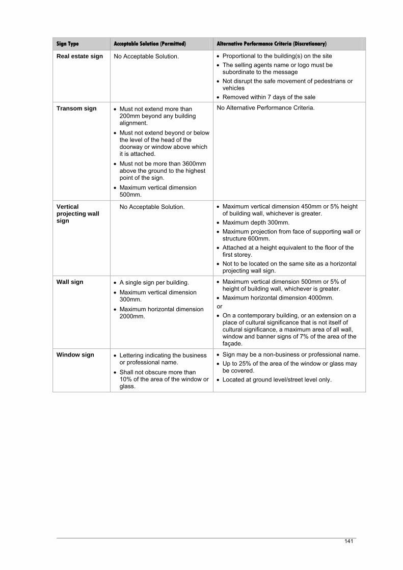
141
Sign Type Acceptable Solution (Permitted) Alternative Performance Criteria (Discretionary)
Real estate sign No Acceptable Solution. Proportional to the building(s) on the site The selling agents name or logo must be
subordinate to the message Not disrupt the safe movement of pedestrians or
vehicles Removed within 7 days of the sale
Transom sign Must not extend more than 200mm beyond any building alignment.
Must not extend beyond or below the level of the head of the doorway or window above which it is attached.
Must not be more than 3600mm above the ground to the highest point of the sign.
Maximum vertical dimension 500mm.
No Alternative Performance Criteria.
Vertical projecting wall sign
No Acceptable Solution. Maximum vertical dimension 450mm or 5% height of building wall, whichever is greater.
Maximum depth 300mm. Maximum projection from face of supporting wall or
structure 600mm. Attached at a height equivalent to the floor of the
first storey. Not to be located on the same site as a horizontal
projecting wall sign.
Wall sign A single sign per building. Maximum vertical dimension
300mm. Maximum horizontal dimension
2000mm.
Maximum vertical dimension 500mm or 5% of height of building wall, whichever is greater.
Maximum horizontal dimension 4000mm. or On a contemporary building, or an extension on a
place of cultural significance that is not itself of cultural significance, a maximum area of all wall, window and banner signs of 7% of the area of the façade.
Window sign Lettering indicating the business or professional name.
Shall not obscure more than 10% of the area of the window or glass.
Sign may be a non-business or professional name. Up to 25% of the area of the window or glass may
be covered. Located at ground level/street level only.

Sullivans Cove Planning Scheme 1997 (as amended at 17 February 2011) 142

143
26 SCHEDULE 5 – TRAFFIC, ACCESS AND PARKING
26.1 Introduction
It is recognised that requiring car parking to be provided for activities in the Cove is likely to be detrimental to the Cove’s urban character and heritage. Consequently, in general, car parking will not be required to be provided on-site for any use or development.
Any development involving the provision of on site car parking will have to demonstrate that the impact of that provision - either physically or operationally will not adversely impact on the character and heritage values of the Cove, on pedestrian movement and amenity.
Alternatively, car parking may be provided on nearby land that may be designated or proposed for public car parking. In the case of major redevelopment the Planning Authority may be prepared to enter into an agreement under Part 5 of the Land Use Planning and Approvals Act 1993 with relevant landowners or prospective landowners to secure the provision of car parking adequate to service the needs of a specific development and/or a particular area of the Cove.
For developments likely to generate a significant demand for the ‘dropping off’ of passengers, either from private, public or tourist transport, specific provision for such a facility may be needed.
26.2 Principles
The following Principles of development control shall apply to the assessment of traffic, access and parking within Sullivans Cove: Development will not be granted a permit unless:
(a ) It will facilitate the mutual compatibility of public and private transport; (b ) It can demonstrate either: (c ) that it will not create traffic flows and movements that are detrimental to safety or
amenity; or (d ) that any such flows or movements can be accommodated through engineering
works or traffic management arrangements – on or off site – that are satisfactory to the Planning Authority;
(e ) It can make adequate provisions for the direction, access, turning and parking of all vehicular traffic;
( f ) It can provide for pedestrian movement, in accordance with the requirements of the Planning Authority.
Unless particularly specified as a policy objective or requirement for all or part of an Activity Area, or approved as part of the guidelines for the redevelopment of a Key Site, developments will not be expected to incorporate on-site vehicle parking and it will only be approved to the extent that the car parking does not direct the design of the development and does not have a detrimental effect on the form and character of Sullivans Cove or on its pedestrian amenity and activity. Any development necessitating an exercise of discretion under the Scheme in relation to height to facilitate the provision of on site parking would not be considered to be in keeping with the planning principles for the Cove.
Any provision for parking will aim to: (g ) Encourage pedestrian and cycle access, amenity and safety; and (h ) Address the essential and short term parking demands of customers/visitors in the
Cove; and ( i ) Discourage long term commuter parking within the Cove.
26.3 Objectives for Traffic, Access and Parking in Activity Areas
The following parking policy objectives apply to land within each of the following Activity Areas: Inner City Residential (Wapping) Activity Area 1.0
Refer to the Wapping Local Area Plan.
Sullivans Cove ‘Mixed Use’ Activity Area 2.0

144
The provision of short term public car parking stations on appropriate sites in this Activity Area will be promoted. Such stations would be expected to serve a range of users for all days of the week and for 24 hours a day.
The Planning Authority will seek the joint involvement of private developers in the construction of such car parking facilities where this is seen as desirable to further the objectives of the Scheme overall.
Any car parking approved as part of the redevelopment of land for a single or mixed use development will be encouraged or required to be made available for public use and not restricted to traffic generated by the particular development.
Public transport, services and facilities which serve metropolitan Hobart will be encouraged in this Activity Area. Pedestrian safety is an important consideration in the location and design of access.
‘Domain Open Space’ Activity Area 2.1
The provision of parking in this Activity Area will be kept to a minimum. Such parking must be kept free for the short term parking needs of visitors, and not used for commuter parking.
Sullivans Cove ‘Gateway’ Activity Area 3.0
Activity Area 3.0 will balance a prioritisation of pedestrian and cycling access to the Macquarie Point site with the need to provide for efficient private vehicle access and the requirement to maintain heavy vehicle access to the port.
The Macquarie Point Site will be reconnected to its surrounds through the introduction of a number of pedestrian and cycle links. The Escarpment Park will connect the city to the Regatta Grounds and beyond, and similarly the Water to Water Promenade will connect Sullivans Cove to the Regatta Grounds. It will be possible to move from these pathways through the network of shared streets and lanes to the Key Public Space to the north of the Goods Shed at the heart of the site shown on Figure 32.3 Macquarie Point Development Framework Plan.
The network of shared streets and lanes is scaled at a width that allows a number of configurations; they can be open to one or two-way traffic, or closed to traffic altogether over the course of a single day. Access by emergency and service vehicles will be possible through removable bollards. A series of public open spaces or pocket parks will sit within this pedestrian-oriented network.
The Evans Street frontage offers a convenient arrival point to the Macquarie Point site. Some on-street car parking will be provided along this edge; however, access for vehicular traffic into the site will be limited. Cars will generally be limited to the access links identified in the Development Framework of the Macquarie Point Site Development Plan, with car parking structures located immediately behind the buildings on Evans Street. Only a small amount of on-street car parking will be provided within the Macquarie Point site. Development including new on-site car parking must demonstrate that the associated traffic movements can be accommodated within the surrounding road network.
A pedestrian and cycle link to connect the city to the Regatta Grounds and beyond will be positioned where the Tasman Highway enters Davey Street. Commuter bicycle parking and change facilities will be provided at this location.
A public car park is proposed adjacent to the escarpment, with access from the Tasman Highway.
Future transportation corridors will be preserved for the movement of public transport and heavy vehicles.
‘Macquarie Point Wharf’ Activity Area 4.1
This Activity Area is characterised by high volumes of transport activity associated with the transport interchange functions of the Port. Parking shall be provided in this Activity Area to cater for the parking demands of employees, visitors and other wharf related transport activities. Land within this Activity Area must not be used to provide car parking for commuters or other activities unrelated to the operations of the port or other permissible activities within the Activity Area.

145
‘Regatta Point’ Activity Area 4.2
This Activity Area is characterised by low volumes of traffic. Parking shall be provided in this Activity Area to cater for the parking demands of employees, visitors and other maritime related activities. Land within this Activity Area will not be used for the parking demands of activities outside the Activity Area.
Sullivans Cove ‘Working Port’ Activity Area 4.3
Land within this Activity Area must be kept free for pedestrian access and the free movement of port vehicles (cargo handling, loading/unloading of goods, passengers, etc). Car parking in this Activity Area shall be limited to meet the short term parking demands of visitors to the Cove, and only be located in restricted areas throughout the Activity Area. The retention of a public ferry facility is appropriate in this Activity Area.
26.4 Guidelines for Development Control
26.4.1 Traffic Generation
Where a development (including subdivision) is approved that involves the provision of on site car parking, servicing or emergency access facilities that will result in a material increase in the volume of vehicular traffic entering or leaving a public road, then provision shall be made to accommodate such additional vehicles and their movement to the satisfaction of the Planning Authority, having regard to traffic safety or amenity as appropriate. Similar provision shall be made for pedestrians.
Any development needing or expected to generate a demand for the delivery of people to the site in relatively significant volumes, will be expected to make appropriate provision for accommodating the associated vehicular movement - whether generated by private, public or tourist transport, in a manner consistent with the principles of this schedule.
The location and form of any proposed access to an existing public road shall ensure that adequate sight distance in relation to the speed of through traffic is available.
The Planning Authority may require certain measures to be carried out at the developer’s expense in order to accommodate additional vehicles or pedestrians resulting from an approved development.
All access, parking and traffic management works shall be constructed to the Planning Authority’s current standards and in accordance with plans approved by the Planning Authority.
26.4.2 Access Requirements
Unless existing buildings, topography, the requirements of the Disabilities Discrimination Act 1995 or heritage considerations dictate otherwise the maximum vehicle access widths and minimum footway widths shall be as set out below:
Number of Parking Spaces to be Provided on Site
Maximum Allowable Vehicular Access Width
Minimum Number & Width of Footways
1-5 inclusive One 3.0m lane One 0.6m
6-20 inclusive Two 2.5m lanes One 1.0m
21 and over Two 3.0m lanes Two 1.5m
The Planning Authority, in pursuance of the intent of the Planning Scheme, and in particular Clause 26.1 and the Principles of this schedule (Clause 26.2), may for any development require:
The deletion of any vehicular access or otherwise limit or accept a reduction in the number of accesses or require different dimensions of access widths; and
146
The provision or deletion of any-footway and/or a variation in their dimensions.
Where appropriate, access and parking areas shall enable vehicles to enter and leave the site in a forward direction.
26.4.3 Parking Standards
The number of parking spaces which can be accommodated in a car parking area and the aisle widths within it, shall comply with the relevant Australian Standard, unless otherwise determined by the Planning Authority having regard to the impact on the site and its environs.
26.4.4 Nature of Parking
The Planning Authority may require the parking spaces approved as part of any development to be of a particular size, type, proportion and location to be suited to the likely nature of demand including turnover of use, type of use and user or visitor vehicles to be accommodated, and servicing needs. This will be determined by the Planning Authority after taking into consideration matters such as:
Location of the site;
The nature of the site;
The nature of the surrounding area;
Existing traffic and parking patters;
The nature of the operation and future growth plans or opportunities;
Existing on street restrictions;
Future on street or off street public parking proposals.
The Planning Authority may require specific parking spaces to be reserved for exclusive use by visitors to the development or for people with disabilities.
Any car parking spaces sought to be provided on site will only be approved if located in a manner appropriate to the character and appearance of development in the vicinity and/or with the Principles of this Schedule and the parking and other Objectives for the relevant Activity Area. The siting of parking spaces between the building line and the street boundary line shall generally not be ‘permitted’.
26.5 Matters to be Considered
The Planning Authority shall ensure that proposed development:
Will not interrupt the efficient passage of port related vehicular movements;
Will not generate vehicular traffic which is detrimental to other vehicle movements in Sullivans Cove;
Will not utilise a key site identified in Part F, or other land considered appropriate, in a manner that would prevent its use for the provision of public parking purposes. The Planning Authority shall ensure the scope for the provision of significant public parking generated by the development - whether on-site or off-site is explored and evaluated, including the use of part Five Agreements;
Minimises footpath crossovers and disruption to footpath movements;
Providing parking, shall do so in accordance with requirements for the design and location of spaces and access as specified in this schedule;
Providing parking, is designed to complement the form and detail of adjacent buildings and have a continuity of street level activity and/or visual interest;
Providing parking, the vehicle access shall be discrete and where possible located so as to not disrupt traffic flows along streets through queuing; and

147
Incorporates through-site and cross-block pedestrian links and access to the waterfront unless it can be demonstrated that there is no benefit to the enhancement of pedestrian movement and/or amenity in the Cove.
26.6 Applications Involving Only the Use of Land
Where an application is submitted that involves only the use of land and not development the Planning Authority is nevertheless able to apply the provisions of this Schedule.

Sullivans Cove Planning Scheme 1997 (as amended at 17 February 2011) 148

149
27 SCHEDULE 6 – SUBDIVISION
27.1 Introduction
The subdivision pattern of the Cove is one means of interpreting its history. This pattern has evolved over time, resulting in the creation of primary and secondary spaces, and public and private land.
The need for subdivision and consolidation of land to facilitate a range of activities is recognised. However, where possible the historic subdivision patterns must be interpreted and occasionally recreated.
27.2 Principles
The importance of retention and recreation of the historic spatial and subdivision character of the Cove shall be given weight when considering any proposal to subdivide and consolidate land within the Cove.
The subdivision of land shall not be ‘permitted’ unless it can be demonstrated that it is in conformity with the strategic framework of the Scheme and the objectives outlined for the relevant Activity Area.
The subdivision of land containing existing buildings must not adversely impact on the heritage values of buildings and places.
27.3 Scope
27.3.1 A permit is required for all subdivision in the Cove. All such subdivision is ‘discretionary’ under this Scheme unless it complies with the ‘permitted’ standards under the ‘Macquarie Point Site Development Plan’ in clause 32 under Part F of the Scheme.
27.3.2 Subdivision within the ‘Macquarie Point Site Development Plan’ in clause 32 under Part F of the Scheme is ‘exempt’ from this schedule.
27.4 Subdivision Requirements
A proposed subdivision must satisfy the following requirements:
A subdivision must reinforce the pattern of land use, activity and development sought by the provisions of the Scheme.
A subdivision should allow for interpretation of significant historic subdivision patterns of the site and surrounding land.
All lots must provide suitable service infrastructure to the satisfaction of the Planning Authority.
The layout and design of all subdivision must be in a manner to maximise energy efficiency and minimise impact on the environment.
The size and shape of lots must preferably be compatible with the existing subdivision characteristics of the Activity Area.
Proposals to consolidate land must be considered in light of the need to discourage the development and use of buildings with large, undifferentiated floor areas.

150
The impact of the proposed subdivision on access, traffic movements and volumes must be considered in accordance with the provisions of Schedule 5.
In the planning area there will be no minimum lot requirement.
27.5 Subdivision – Submission Requirements
27.5.1 An application for development to subdivide land shall satisfy the requirements of Clause 9.2. In addition applications involving subdivision are to provide sufficient information to enable the boundaries of proposed lots and their potential impact when developed to be assessed. Such information includes:
lot boundary delineation and dimensions
lot areas
the location of existing and/or proposed easements and other encumbrances
27.5.2 A proposal for subdivision will only be approved as part of an application for the use of development (other than subdivision) of the land in question, unless it is a boundary adjustment or is in accordance with a site development plan under Clause 31.4.
27.5.3 Subdivision of a site may also be approved subsequent to the issue of a permit for use or other development of land.
28 SCHEDULE 7 – DEMOLITION
28.1 Introduction
‘Demolition’ refers to the demolition or partial demolition of any building, or works on land.
It is important that buildings, and works on land within the Cove are not demolished without due assessment of the implications of such demolition on the cultural heritage and urban character of the Cove.
Additionally, it is important that prior to approval being granted for demolition of buildings within the Cove, approval is granted for the construction of replacement buildings. This approach will avoid the creation of additional ‘lost space’ within the Cove.
28.2 Objectives
The protection and promotion of the Cultural Heritage and Urban Character of the Cove is of primary concern in the consideration of proposals to demolish the built fabric of the Cove.
28.3 Scope
28.3.1 A permit is required for all demolition in the Cove. All such demolition is ‘discretionary’.
28.4 Exemptions
28.4.1 The following types of demolition are ‘exempt’:
• Demolition within the ‘Macquarie Point Wharf’ Activity Area 4.1; and
• Demolition of buildings or works existing prior to the implementation of a Site Development Plan, within the Sullivans Cove Gateway Activity Area 3.0 except for the Royal Engineers Building (Ref No 26 Schedule 1) and the Toll Goods and LCL Sheds at 14 Evans Street.
28.5 Guidelines for Development Control
The demolition of any building, or works on land shall not be ‘permitted’ unless; a replacement development has been approved, or such demolition is required by statutory order or is authorised by the Building Surveyor as essential to public safety.
Any application for demolition:
(a ) Shall be refused if the building is included as a cultural heritage place in Table 1 of the Conservation of Cultural Heritage Values Schedule of this Scheme, unless;
(i) The demolition is approved as part of a Conservation Plan approved by the Planning Authority or otherwise in its discretion under the Conservation of Cultural Heritage Values Schedule of this Scheme;
(ii) The building clearly detracts from the cultural values or significance of the place; or
151
(iii) There are overriding environmental, economic considerations in terms of the building or practical considerations for its removal, either wholly or in part.
(b) May be refused if in the opinion of the Planning Authority the building contributes to the cultural heritage or urban character of the Activity Area and the building is capable of continued beneficial use.
28.6 Matters to be Considered
In considering any proposal for demolition, the Planning Authority shall give regard to the following matters:
• The impact of the proposed demolition on the character of the Activity Area;
• The impact of the proposed demolition on the cultural heritage values of the Cove;
• The need to avoid creation of vacant sites and ‘lost space’ in the Cove.
28.7 Demolition – Submission Requirements
An application for the demolition of a building shall satisfy the requirements of Clause 9.2 for the development proposed as a replacement.
28.8 Demolition on a Place of Cultural Significance
28.8.1 Where the application involves the demolition of a building on a Place included in Table 1 of Schedule 1 – Conservation of Cultural Heritage Values then the application must satisfy the following:
• The requirement of Clause 22.4.3 for the submission of a Conservation Plan, and
• The provision of street elevations or ‘true perspectives’ to show the scale and impact of the demolition on places of cultural significance and the streetscape.
28.8.2 Where the application involves the demolition of any other building then the application must satisfy the following:
• The requirement of Clause 22.5.3 for the submission of a report identifying that the building does not have heritage value, and
• The provision of street elevations or ‘true perspectives’ to show the scale and impact of the demolition on places of cultural significance and the streetscape.
28.8.3 Where the proposed demolition is required by statutory order or is authorised by the Building Surveyor as essential to public safety, and no replacement building is proposed, a plan shall be submitted showing how the site is to be landscaped and fenced for public urban space in a manner consistent with the intent of the Scheme, pending the granting of a permit for a new building.
152

153
29 SCHEDULE 8 – ENVIRONMENTAL MANAGEMENT
29.1 Introduction
The ecologically sustainable development of the Cove’s natural and physical resources is a primary planning principle of this Scheme.
Whilst the protection and enhancement of the total natural resource stock of the Cove is important, there are a number of specific environmental issues to be addressed in the future planning for the Cove. These include protection of water quality in the Cove, minimisation of air pollution, assessment and management of land contamination on all land, waste minimisation and control of noise pollution and vibration.
This schedule outlines matters which must be considered when assessing applications for activities, and outlines the linkages of the Planning Scheme to the Environment Management & Pollution Control Act 1994.
29.2 Objectives
To ensure that activities are managed in a way which facilitates the ecologically sustainable development of the Cove’s natural and physical resources and the maintenance of ecological processes and genetic diversity.
To ensure that activities are managed in a way which will not cause environmental nuisance or material or serious environmental harm.
29.3 Scope of Control
This control applies to the assessment of all permissible ‘Level 1’ and ‘Level 2’ activities in the Sullivans Cove Planning Area.
29.4 Definitions
Best Practice Environmental Management
Means the management of an activity to achieve an ongoing minimisation of the activities environmental harm through cost effective measures assessed against the current international and national standards applicable to the activity. In determining the best practice environmental management of an activity, regard must be had to the following:
(a) strategic planning by the person carrying out, or proposing to carry out the activity;
(b) administrative systems implemented by the person, including staff training;
(c) public consultation carried out by the person;
(d) product and process design;
(e) waste prevention, treatment and design.
154
Contaminated Site A site at which hazardous substances occur at concentrations above background levels and where assessment indicates that it poses, or is likely to pose, an immediate or long term hazard to human health or the environment.
‘Environmental Harm’ Means ‘environmental harm’ as described in s.5 of the Environment Management and Pollution Control Act 1994.
‘Level 1’ Activity Means as defined in the Environmental Management and Pollution Control Act 1994.
‘Level 2’ Activity Means an activity specified in Schedule 2 of the Environment Management and Pollution Control Act 1994.
‘Level 3’ Activity Means an activity which is a Project of State Significance under the State Policies and Projects Act 1993.
Permissible Activity Means an activity in respect of which a Planning Authority has the discretion to refuse a permit or is bound to grant a permit either unconditionally or subject to conditions.
Waste Management A plan which details a strategy to systematically reduce waste generation. It includes the assessment of waste, options for eliminating or reducing waste, and actions and associated time-frames for the implementation of waste minimisation measures.
29.5 Environmental Objectives
Where an activity constitutes either a Permissible ‘Level 1’ activity or a Permissible ‘Level 2’ activity within the relevant Activity Area, the following environmental objectives must be satisfied in determining such an application.
Air Quality
Activities shall demonstrate ‘Best Practice Environmental Management’ in respect to the minimisation and mitigation of all discharges to the atmosphere.
Energy Efficiency
Use and development must demonstrate measures undertaken to improve energy efficiency in the design, layout and use of new and existing buildings.
Flora and Fauna
Flora and fauna of significance within the Sullivans Cove Planning Area must be protected. In particular, the habitats of the Derwent Estuary and Sullivans Cove water environment must be protected from the adverse environmental impacts of activities.
Hazard and Risk
Land within the Cove must be used and developed in a manner which provides a safe working and living environment. In doing so, best practices must be employed in respect to the handling of dangerous goods and all relevant dangerous goods and environmental laws complied with.

155
Land Contamination
New activities which are proposed on land with a known history of industrial or other use where potential for contamination exists shall be accompanied by an environmental audit including an assessment of site condition.
Contaminated land shall be managed in a manner which is compatible with the intended future use of the area. New activities on known contaminated sites must only be ‘permitted’ to occur after appropriate clean-up of the site, or where it is clearly demonstrated that the proposed activity will not result in an immediate or likely long term hazard to human health or the environment.
Land Reclamation
Land forming and reclamation activities, where required, shall be carried out in a manner which minimises adverse environmental consequences.
Noise
Buildings shall be sited and designed having regard to current noise levels in the area as well as their intended use.
Where activities with the potential to generate significant noise are proposed in proximity to residential accommodation and other ‘noise sensitive’ activities, appropriate measures to mitigate and minimise noise emissions must be undertaken.
New ‘noise sensitive’ activities such as residential accommodation shall be located and where necessary incorporate acoustic measures to minimise the potentially adverse impacts of existing or likely future activities on nearby land.
Waste Minimisation
Activities must demonstrate how the practices and process associated with the activity will reduce as much as possible the amount of waste generated or the amount which requires subsequent treatment, storage or disposal. Activities must address waste minimisation from the source (source reduction) and recycling.
Where appropriate, applications for new activities must include a waste management plan.
Activities within roads and other public spaces must incorporate where relevant suitable waste and litter management facilities.
Water Quality
Activities shall demonstrate ‘Best Practice Environmental Management’ in respect to water use and management. Water use and disposal shall be managed in a manner which seeks to minimise off site disposal and which seeks to protect and, where possible, improve ambient water quality. The principles of minimising water sewage and waste water generation and the re-use, recycling and pre-treatment of waste water prior to disposal must be encouraged.
29.6 Referral Requirements
29.6.1 The Planning Authority may refer any ‘Level 1’ activity to the Director of Environmental Management for consultation.
29.6.2 The Planning Authority must refer any ‘Level 1’ activity to the Board of Environmental Management and Pollution Control where required under s.24 of the Environmental Management and Pollution Control Act 1995.

156
29.6.3 The Planning Authority must refer all ‘Level 2’ activities to the Board of Environmental Management and Pollution Control pursuant to s.25 of the Environmental Management and Pollution Control Act 1995.

157
30 SCHEDULE 9 – TELECOMMUNICATIONS INFRASTRUCTURE
30.1 Principles
To accommodate the provision of telecommunications infrastructure to allow equitable access by all residents, whilst minimising the impact of such infrastructure on community values in accordance with the objectives of the Resource Management and Planning System.
To encourage co-location and sharing of facilities, where such capacity exists, and where doing so will not compromise the objectives as stated in Table 1.
To ensure proposals for the installation of telecommunications infrastructure form part of a local or regional network plan to enable consideration of the proposal on a broader and potentially regional basis.
30.2 Use or Development
Any development in compliance with Clause 30.3 of this Schedule is deemed to be exempt and does not require planning approval.
All other development requires planning approval and is required to demonstrate compliance with the objectives as specified in Table 1 of this Schedule and to which the provisions of section 57 of the Land Use Planning & Approvals Act 1993 apply.
30.2.1 Relationship To The Scheme
To the extent that any statement contained in this Schedule is inconsistent with any other provision of this Scheme the provisions of the Schedule shall apply in relation to telecommunications infrastructure.
30.2.2 Matters For Consideration
In determining any application for issue of a planning permit, Planning Authority must be satisfied the proposal has demonstrated that the objectives and performance criteria in Table 1 will be achieved during the installation and operation of the proposed telecommunications infrastructure.
30.2.3 Definitions
Areas of environmental significance are as defined in the Telecommunications (Low-impact Facilities) Determination 1997.
Line means a wire, cable, optical fibre, tube, conduit, waveguide or other physical medium used, or for use, as a continuous artificial guide for, or in connection with, carrying communications by means of guided electromagnetic energy. (This adopts the Telecommunications Act 1997 definition).
Low Impact Facilities
(i) A facility described in Clause 30.3 and the Schedule of the Telecommunications (Low-impact Facilities) Determination 1997, is a low-impact facility only if it is installed, or to be installed, in the areas described in Part 2 of the Telecommunications (Low-impact Facilities) Determination 1997.
(ii) However, the facility is not a low-impact facility if the area is also an area of environmental significance.

158
Performance criteria are statements identifying the means or achieving the stated objectives.
Telecommunications infrastructure means any part of the infrastructure of a telecommunications network and includes any line, equipment, apparatus, tower, antenna, tunnel, duct, hole, pit or other structure used, or for use, in or in connection with a telecommunications network.
Telecommunications network means a system, or series of systems, that carries or is capable of carrying communications by means of guided and/or unguided electromagnetic energy. (This adopts the Telecommunications Act 1997 definition).
Tower means a tower, pole, mast or similar structure used to supply a carriage service by means of Telecommunication.
To assist clarification of definitions arising from the implementation of this Schedule, reference is also to be made to the following Commonwealth Government documents:
Getting the Message: Guidelines for the Management of Telecommunications Infrastructure June 1997
Telecommunications Code of Practice 1997
Telecommunications (Low-impact Facilities) Determination 1997.
30.3 Exemptions
The following development is exempt from requiring a planning permit:
the installation and development of low-impact facilities;
works involved in the inspection of land by a carrier to identify suitability for its purposes;
the installation and development of a facility granted a facility installation permit by the Australian Communication Authority;
works involved in the maintenance of telecommunication facilities;
works meeting the transitional arrangements defined in Part 2 of Schedule 3 of the Telecommunications Act 1997; and
the connection of a telecommunications line forming part of a telecommunications network to a building, structure, caravan or mobile home.
30.4 Information Required
30.4.1 Application Requirements
An application for a permit must be submitted to the Planning Authority. The application shall include the following:
(a) a completed application for development in a form prescribed by the Planning Authority;
(b) sufficient information to demonstrate to the satisfaction of the Planning Authority that the objectives and performance criteria in Appendix 1 will be achieved during the installation and operation of the proposed telecommunications infrastructure;
(c) a complete copy of the certificate of title of the land on which the development is proposed;
(d) where the applicant is not the owner, the application must be signed by the owner or be accompanied by an authorisation in writing from the owner for submission of the application;

159
(e) details of the proposed telecommunications network proposed within the local area and its relationship to the proposed development;
(f) any plans or other information prescribed for development in 30.4.2; and
(g) any fees prescribed by the Planning Authority.
30.4.2 Plans to Accompany Applications
30.4.2A A site plan for the proposed development at a scale of not less than 1:200, which includes a north point and shows:
(a) the boundaries and dimensions of the site or the area affected by the development;
(b) the location of any existing buildings on the site indicating those to be retained or demolished;
(c) location of any proposed buildings on the site, and their relationship to buildings on adjacent sites, streets and accessways;
(d) the use of adjoining properties;
(e) Australian Height Datum Levels;
(f) natural drainage lines, watercourses, coastal dunes, beach systems and wetlands; and
(g) any proposals for the rehabilitation of the land on which the development is to occur.
30.4.2B A detailed layout plan with dimensions at a scale of not less than 1:100 showing:
(a) plans and elevations of proposed and existing buildings showing the materials to be used on external walls and roofs;
(b) trees and vegetation to be retained and removed;
(c) the dimensions, layout and surfacing materials of all access roads, turning areas and parking areas;
(d) the relationship of the elevations to natural ground level, showing any proposed cut or fill;
(e) the location and capacity of any existing services or easements on the site or connected to the site; and
(f) a plan of the proposed landscaping of the site.
30.4.2C Where the Planning Authority is satisfied that any of the above information is not relevant to the assessment of the proposal, that information may be omitted from the application.
30.4.2D In accordance with section 54 of the Act, the Planning Authority may require the applicant to provide additional information including an Environmental Impact Report prepared in accordance with Table 2 of this Schedule, before it considers the application.

160
Table 1: Objectives and Performance Criteria
Objectives Performance Criteria
Visual Amenity
To minimise any detrimental impact upon the visual amenity of a locality by reducing prominence of telecommunications infrastructure.
The location of infrastructure is within existing utility corridors and sites and uses existing infrastructure, unless a need to do otherwise is demonstrated.
Aerial telecommunication lines or additional supporting structures are erected and operated in residential and commercial areas only where overhead cables operated by other utilities are in existence.
Best practice methods are used to reduce the visual impact of infrastructure or to conceal infrastructure within the surrounding natural or built environment.
Clearing for infrastructure corridors and facilities is minimised to limit visible prominence while responding to functional and safety requirements.
Infrastructure:
avoids skyline positions (i.e.. where a structure would be seen in silhouette);
crosses hills diagonal to the principal slope or crosses at the low point of a saddle between hills; or
is located around the base of hills or along the edge of existing clearings.
Unless a need to do otherwise is demonstrated.
Equipment housing and other visually intrusive infrastructure is screened or concealed from public areas.
The height of freestanding aerials, towers and masts is within the following limits:
industrial areas 45 metres commercial areas 40 metres residential areas 20 metres
Telecommunications infrastructure may only exceed specified height limits if:
a pattern of infrastructure or vegetation above the specified height limit exists in a particular location; and
it has no adverse impact on heritage or ecological values or visual amenity.
To protect important public views such as vistas to significant public buildings, streetscapes and heritage areas.
Telecommunications infrastructure does not intrude into identified important public views or measures are taken to minimise intrusion.
To avoid obstruction of private views from the building line/principal windows by telecommunication lines.
Placement of telecommunication lines avoids or minimises obstruction of private views.
Residential Amenity
To protect residential amenity. Infrastructure servicing a network (facilities not requiring installation on an individual street basis) is not located in residential areas unless a need to do otherwise is demonstrated.
Environmental values
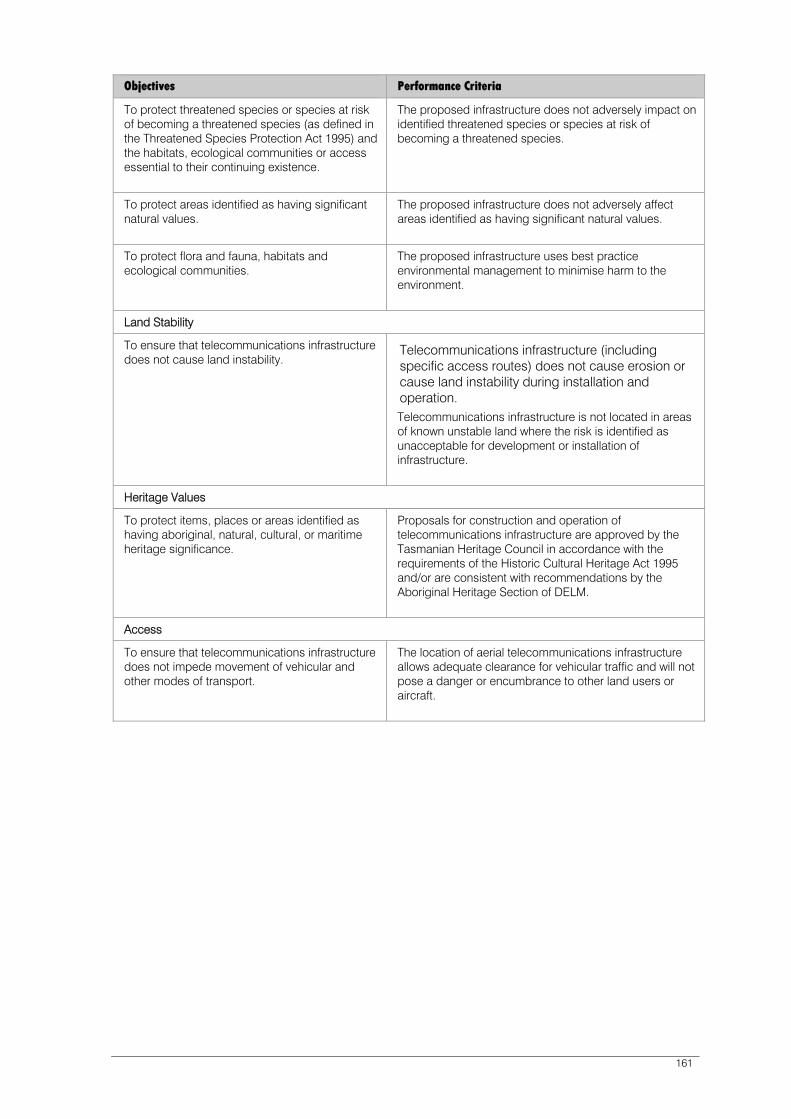
161
Objectives Performance Criteria
To protect threatened species or species at risk of becoming a threatened species (as defined in the Threatened Species Protection Act 1995) and the habitats, ecological communities or access essential to their continuing existence.
The proposed infrastructure does not adversely impact on identified threatened species or species at risk of becoming a threatened species.
To protect areas identified as having significant natural values.
The proposed infrastructure does not adversely affect areas identified as having significant natural values.
To protect flora and fauna, habitats and ecological communities.
The proposed infrastructure uses best practice environmental management to minimise harm to the environment.
Land Stability
To ensure that telecommunications infrastructure does not cause land instability.
Telecommunications infrastructure (including specific access routes) does not cause erosion or cause land instability during installation and operation. Telecommunications infrastructure is not located in areas of known unstable land where the risk is identified as unacceptable for development or installation of infrastructure.
Heritage Values
To protect items, places or areas identified as having aboriginal, natural, cultural, or maritime heritage significance.
Proposals for construction and operation of telecommunications infrastructure are approved by the Tasmanian Heritage Council in accordance with the requirements of the Historic Cultural Heritage Act 1995 and/or are consistent with recommendations by the Aboriginal Heritage Section of DELM.
Access
To ensure that telecommunications infrastructure does not impede movement of vehicular and other modes of transport.
The location of aerial telecommunications infrastructure allows adequate clearance for vehicular traffic and will not pose a danger or encumbrance to other land users or aircraft.
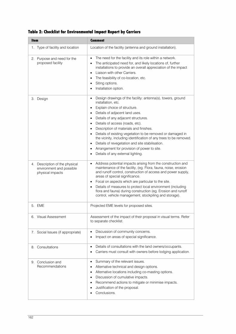
162
Table 2: Checklist for Environmental Impact Report by Carriers
Item Comment
1. Type of facility and location Location of the facility (antenna and ground installation).
2. Purpose and need for the proposed facility
The need for the facility and its role within a network. The anticipated need for, and likely locations of, further
installations to provide an overall appreciation of the impact Liaison with other Carriers. The feasibility of co-location, etc. Siting options. Installation option.
3. Design Design drawings of the facility: antenna(s), towers, ground installation, etc.
Explain choice of structure. Details of adjacent land uses. Details of any adjacent structures. Details of access (roads, etc). Description of materials and finishes. Details of existing vegetation to be removed or damaged in
the vicinity, including identification of any trees to be removed. Details of revegetation and site stabilisation. Arrangement for provision of power to site. Details of any external lighting.
4. Description of the physical environment and possible physical impacts
Address potential impacts arising from the construction and maintenance of the facility, (eg. Flora, fauna, noise, erosion and runoff control, construction of access and power supply, areas of special significance.
Focal on aspects which are particular to the site. Details of measures to protect local environment (including
flora and fauna) during construction (eg. Erosion and runoff control, vehicle management, stockpiling and storage).
5. EME Projected EME levels for proposed sites.
6. Visual Assessment Assessment of the impact of their proposal in visual terms. Refer to separate checklist.
7. Social Issues (if appropriate) Discussion of community concerns. Impact on areas of special significance.
8. Consultations Details of consultations with the land owners/occupants. Carriers must consult with owners before lodging application.
9. Conclusion and Recommendations
Summary of the relevant issues. Alternative technical and design options. Alternative locations including co-masting options. Discussion of cumulative impacts. Recommend actions to mitigate or minimise impacts. Justification of the proposal. Conclusions.

163
Item Comment
10. Plans Location Plan. Site Plan/Landscape Plan. Design of facility (plan and elevations of antenna and ground
installation).

164
Table 3: Visual Assessment Checklist
Context The visual catchment of the site (and installation). The elements that go to make up the landscape or townscape
context, including slope, cover, colour, vegetation or built environment, and major features.
The physical scale of the proposed telecommunication infrastructure. Presence of other antennas and vertical elements. Any special landscape value of the site. Cumulative impact of this and further antennas. Relationship to existing vegetation and the potential intrusiveness of
the installation. Relationship to buildings/structures.
Siting Height of the antenna in relation to the surrounding landform. Topographical features and natural vegetation. Impact on skyline or treeline. Distance from sensitive receptors.
Appearance Materials (particularly relevant for ground installations). Colour. Reflectivity. Design. Height. Antenna type and bulk. Plant and room. Proposed landscape work.
Plans and Photos A plan is to be prepared indicating the view shed of the antenna, the location of any key viewing points. The scale of the plan will depend on the extent of visual impact.

165
PART F - KEY SITES
31.1 Introduction
A ‘Key Site’ is a site which has the potential to accommodate activities which will further the ‘preferred future’ and strategic principles contained within the Scheme.
These are sites which the Planning Authority has identified as having the potential to be used or developed to achieve a range of strategic planning objectives. It is intended this section of the Scheme facilitate the identified preferred future through promotion of appropriate use and development on strategically important and presently under-utilised sites within the Cove.
31.2 Scope
This part relates to sites which are identified on the ‘Key Sites’ plan (Figure 11).
The Planning Authority may add or remove ‘Key Sites’ from this schedule by a process of amendment to the Scheme.
31.3 Definitions
Key Site A site which is regarded as under utilised and having the potential, through development or redevelopment, to be used for activity which will reinforce the strategic framework of the Scheme and objectives of the Activity Area.
Site Development Plan A plan which outlines the frameworks for the future use or development of a site.
31.4 Site Development Plan – Performance
Prior to any significant development of a Key Site a ‘Site Development Plan’ must be prepared.
A Site Development Plan may be incorporated into the Scheme by amendment pursuant to the Land Use Planning and Approvals Act 1993.
All Site Development Plans prepared for Key Sites must reflect the provisions of the Strategic Framework (Part B) and the Objectives and Performance Criteria of the relevant Activity Area (Part D) and satisfy the Objectives and provisions of the Schedules (Part E) of the Scheme.
31.5 Submission Requirements
An application for development on a Key Site must satisfy the relevant submission requirements of clause 9.2 of the Scheme.
Applications for the significant development of a Key Site must be in accordance with the requirements set out in clause 9.2 and a Site Development Plan submitted as an integral part of the planning application or incorporated into the Scheme in accordance with clause 31.4.
166
The Planning Authority may require a Site Development Plan to include a ‘Sullivans Cove Impact Statement’ that addresses, but is not restricted to, any or all of the following:
traffic, access and parking provision and impact
impact on pedestrian movement and amenity
impact on the working port and transportation links
visual impact on the streetscape and townscape of the Cove through the provision of any or all of the following:
- building envelope plans
- photo montages
- a coloured model that will fit into the model of Sullivans Cove
overshadowing of public urban spaces
infrastructure impact and augmentation
allocation of open space
measures for environment protection and enhancement.
In addition to the requirements for a Key Site applying under the Scheme, any Site Development Plan prepared for Key Site 13 (Boral Site) is required to address:
The visual contribution to any new access road servicing Activity Area 3 and with the potential to also service Activity Area 4.1 (though application for the road itself is not ‘discretionary’ under the Scheme and does not require the preparation of a Site Development Plan).
The visual contribution to the Tasman Highway ‘gateway’ into the Cove.
The complementary relationship to the Royal Engineers Building, i.e. any development should be less visually prominent than the Royal Engineers’ Building grounds or as part of the setting of the Royal Engineers Building.
The view down Macquarie Street to the Cenotaph.
31.6 Schedule of Key Sites
Sites shown on the Figure 11 ‘Key Sites’ plan are regarded as key sites within the Planning Area.

KEY SITES
SULLIVANS COVE
PLANNING SCHEME
N
500 100 200150
metres
Elizabeth StPier
PrincesPark
A
MACQ
UARIE
STR
EET
Macquarie Point
DAV
EY
STR
EET
Franklin
Wharf
Rail Yard
Cenotaph
VictoriaDock
ConstitutionDock
St DavidsPark
BatteryPoint
SULLIVANS COVE
Pri
nce
sW
ha
rf
ABC Centre
R I V E R D E R W E N T
SANDY
BAY
RO
AD
GLADSTONE
ST
MONTPELIER
RETREAT
KN
OP
WO
OD
ST
KIR
KS
WA
YP
LA
CE
SA
LA
MA
NC
A
PLA
CE
CA
ST
RA
YE
SP
L.
BA
TT
ER
YS
QU
AR
E
RUNNYMEDE ST
MU
RR
AY
ST
ELIZ
AB
ETH
ST
RE
ET
AR
GYLE
STR
EET
CAM
PBELL
STR
EET
LIVER
PO
OL
ST
BR
OO
KE
RA
VE
NU
E
TASMAN
HIGHWAY
CO
LLIN
S
ST
HU
NT
ER
ST
RE
ET
EVA
NS
ST
RE
ET
MARKET
PLA
CE
SUN
ST
SACKVILLE
ST
MIS
TR
AL
PL
.
DESPARD
ST
BR
OO
KE
ST
MORRISON
ST
ParliamentSquare
CSIRO MarineLaboratories
ParliamentHouse
FranklinSquare
DAV
IES
AVE
CEN
OTA
PH
AVEN
UE
Macquarie Wharf
AquaticCentre
DUNN
PLA
CE
Figure 11
1. ABC Site
2. Dockside
3. City Hall
4. Dunn Place
5. Elizabeth/Argyle Block
6. Town Hall Site
7A. Princes No. 1 Shed
7B. Princes No. 2 Shed
8. Silos
9. RHH Car Park
10. Elizabeth St Pier
11A. HCC Car Park
11B. HCC Car Park
12. Macquarie No.1 Shed
13. Boral Site
14. HMAS Huon
15. HCC Dockside Building
16. Hotel Grand Chancellor Car Park
17. Former Supply & Tender Buildings
18. Former Jones & Co Buildings
TownHall
1
2
3
4
5
6
7A
7B
8
10
12
13
15
16
14
13
1712
18
9
11A11B
Scheme Boundary


169
32.0 Macquarie Point Site Development Plan
32.1 Purpose of the Site Development Plan
32.1.1 To implement the Macquarie Point Strategic Framework and Masterplan 2015-2030.
32.1.2 To ensure that Macquarie Point is redeveloped:
(a) as a vibrant and active area, with a mix of uses, that connects with and complements adjacent areas within Hobart;
(b) to encourage inner city living;
(c) to deliver sustainable social and economic benefits to Hobart;
(d) in accordance with sound planning, urban design and environmental principles; and
(e) to protect the operation of the Port of Hobart for the benefit of the local, regional, state and national economy.
32.2 Application of the Site Development Plan
32.2.1 Planning Area
This Site Development Plan applies to the area of land designated as ‘Macquarie Point Site Development Plan’ on Figure 4 of this Scheme.
32.2.2 Control of Use and Development
Subject to the other relevant requirements of this Scheme, the Planning Authority is bound to grant a permit for applications for ‘use’ and ‘development’ designated as ‘permitted’ in all of the relevant provisions of this Site Development Plan, but may impose conditions.
The Planning Authority has a discretion to refuse or permit applications for ‘use’ and ‘development’ designated as ‘discretionary’ in any of the relevant provisions of this Site Development Plan and may impose conditions.
All other ‘uses’ and ‘development’ are ‘prohibited’.
32.2.3 Exempt Development
The following development is exempt from requiring a permit:
(a) Works associated with the investigation of land contamination;
(b) Public art;
(c) Maintenance and repair by or on behalf of the State Government, a Council, a statutory authority, or a corporation all the shares of which are held by or on behalf of the State or by a statutory authority, of:
i. Electricity, gas, sewerage, stormwater and water reticulation to individual streets, lots or buildings;
ii. Infrastructure such as roads, rail lines, footpaths, cycle paths, drains, sewers, power lines and pipelines; and
iii. Minor infrastructure such as footpaths and cycle paths, playground equipment, seating and shelters, telephone booths, post boxes, bike racks, fire hydrants, drinking fountains, rubbish bins, public art, traffic control devices and markings, and the like on public land.
32.2.4 Land decontamination
The undertaking of works to remediate land are permitted.

170
32.2.5 Definitions
Activity Centre Network Means the Activity Centre Network in Table 1 of the Southern Tasmania Regional Land Use Strategy 2010 - 2035.
Cove Floor The reclaimed areas of Macquarie Point shown as all areas other than the Escarpment Park shown on Figure 32.3.
Environmental Audit Means a report prepared by a Suitably Qualified Person (Site Contamination) on the nature, extent and levels of existing contamination and the actual or potential risk to human health or the environment, on or off the site, resulting from that contamination, prepared in accordance with the National Environment Protection (Assessment of Site Contamination) Measure 1999, as amended 16 May 2013.
Environmental Harm Means ‘environmental harm’ as described in section 5 of the Environmental Management and Pollution Control Act 1994 and includes an environmental nuisance.
Environmental Nuisance Means an ‘environmental nuisance’ as described in section 3 of the Environmental Management and Pollution Control Act 1994.
Height For development inside the areas shown on Figure 32.4 means the uppermost part of a building excluding minor protrusions such as aerials, antennae, solar panels, chimneys and vents measured in Australian Height Datum (AHD).
For development outside the areas shown on Figure 32.4, the vertical distance from existing ground level at any point to the uppermost part of a building directly above that point, excluding minor protrusions such as aerials, antennae, solar panels, chimneys and vents.
Primary Space Key Public Spaces, Escarpment Park, Water to Water Promenade and Access Links shown on Figure 32.3, and Evans Street.
Secondary Space Smaller roads, lanes, alleys and ad hoc courts shown as Important Pedestrian Links shown on Figure 32.3.
Sensitive Use Means a residential use or a use involving the presence of people for extended periods of time, except in the course of their employment, such as a caravan park, childcare centre, dwelling, hospital or school.
Site-Specific Report Means an environmental impact assessment carried out by a Suitably Qualified Person (Emissions), which meets the technical components of section 74 of the Environmental Management and Pollution Control Act 1994 and includes the impact of building design, layout and construction of the development to eliminate, mitigate or manage effects of emissions to ensure that a proposed use will not be unreasonably impacted by environmental harm caused by the operations of the Macquarie Point Wastewater Treatment Plant.
Suitably Qualified Person (Emissions)
Means a person who, in the opinion of the planning authority, can demonstrate that a proposed use will not be unreasonably impacted by environmental harm caused by the operations of the Macquarie Point Wastewater Treatment Plant.
Suitably Qualified Person (Site Contamination)
Means a person appointed as an accredited environmental auditor in accordance with section 39F of the Macquarie Point Development Corporation Act 2012.
171
32.3 Desired Future Character Statements
Desired Future Character Statements Implementation Strategy
Development of Activity Area 3.0 will:
32.3.1 Re-engage with its history by revealing layers of the changing nature of Macquarie Point over time through expression of the topography, natural shoreline, Round House, Goods Shed, Royal Engineers Building and Red Shed.
32.3.2 Ensure that development respects the setting and appreciation of the cultural heritage significance of the Royal Engineers Building.
32.3.3 Ensure that development does not adversely impact on the cultural heritage and reverential ambience of the Hobart Cenotaph and its surrounds.
32.3.4 Include a new Round House building as shown on Figure 32.3 and the associated Table 32.3 to mark the footprint of the former railway Round House and act as a landmark entry to Macquarie Point, particularly from Davey Street.
32.3.5 Protect the operation of the Port of Hobart for the benefit of the local, regional, state and national economy by:
Providing a buffer of non-sensitive uses in the buildings along the port interface to avoid constraints on the working port;
Ensuring that sensitive uses are separated and treated so as not to be vulnerable to noise, air, vibration and lighting impacts;
Incorporating appropriate design responses to avoid conflict between mixed-use, pedestrian and industrial vehicular traffic associated with the Port of Hobart along Evans Street;
Ensuring compliance with relevant safety and hazard distances as specified in relevant Australian standards; and
Preserving the opportunity for a future connection to the Port of Hobart from the north via the Regatta Grounds.
32.3.6 Provide for recreation and associated uses in designated open spaces as
Use and Development Standards and clause 32.4.

172
Desired Future Character Statements Implementation Strategy
shown on Figure 32.3 and the associated Table 32.3.
32.3.7 Ensure that the bulk, siting and height of buildings are sympathetic to the natural topography of the headland, amphitheatre and escarpment surrounding the Cenotaph and reinforce the natural shoreline.
32.3.8 Not unreasonably impact on important views, including the following shown on Figure 32.2:
From the Cenotaph toward the mouth of the Derwent River, including the flat river plane that extends to the horizon;
From the Cenotaph to the horizon of the natural amphitheatre, including the Wellington Range descending to the Mount Nelson ridge, then to Porter Hill and down to the water plane at Long Point, Lower Sandy Bay;
From the Cenotaph to St George’s Church;
From the Cenotaph to the Parliament House forecourt along Morrison Street;
The views across the Cove toward the Cenotaph, including from Macquarie Street, the forecourt of the Princes Wharf No. 1 Shed; the Paddock between Princes Wharf No. 1 Shed and the Institute for Marine and Antarctic Studies (IMAS), Runnymede Street and the open space at the eastern end of the IMAS building.
The view of the sunrise from the grounds of the Cenotaph on Anzac Day; and
Along the Water to Water Promenade.
32.3.9 Ensure that the design and appearance of roofs provide interest when viewed from the elevated areas of the Cenotaph and Domain through measures that may include incorporation of articulated roof forms that reference the industrial saw tooth or serve a purpose such as daylighting of internal areas.

173
Desired Future Character Statements Implementation Strategy
32.3.10 Establish and reinforce a well-defined built edge to Evans Street, set back to highlight the Goods Shed as a public entry point to the site.
32.3.11 Include a network of connections through and around the site as shown on Figure 32.3 and the associated Table 32.3, including a series of:
Primary shared street spaces extending north from Evans Street towards the centre of the site; and
Smaller and more intimate secondary spaces that run east-west and provide permeability across the site. Their position can be adjusted to suit the preferred lot size/s.
32.4 Matters to be Considered
In considering applications and any conditions to be imposed on ‘use’ and ‘development’, the Planning Authority must consider:
The Desired Future Character Statements in clause 32.3;
The preferred treatment of robust, self-pigmented external materials and finishes to primary and secondary spaces;
The suitability of proposed development to achieve satisfactory levels of safety and amenity of occupants including the avoidance of vulnerability to noise, air, vibration and lighting impacts from the Port of Hobart;
The impact on the operation of the Port of Hobart;
The height of buildings within Activity Area 3.0, and on adjoining and adjacent lots;
The bulk and form of existing and proposed buildings;
The spatial characteristics of the streets and spaces and the quality of the environment;
Protection of water quality and water sensitive urban design principles;
Protection of public infrastructure and the environment;
Impacts from land decontamination works, and the need for uses not to commence until relevant areas of the site have been appropriately remediated;
The quality of the architectural design;
The adequacy and capacity of existing infrastructure and services including roads, footpaths, water, sewerage and power to cater for the proposed development; and
The key drivers outlined in Section 3 and principles outlined in Section 12: From Shared Vision to Masterplan in New Territory from Old Ground: Macquarie Point Strategic Framework and Masterplan 2015-2030.

174
32.5 Use Table
The ‘Macquarie Point Site Development Plan’ area is divided into three use area types as shown on Figure 32.1.
32.5.1 Uses within Use Area 1: Commercial and Institutional Area
Use Class Condition
Exempt
Occasional sporting, social and cultural events
Permitted
Art and Craft Centre
Arts and Cultural Centre
Car Park Except if on ground floor level and within 8 metres of the front of a building that faces a primary or secondary space.
Community Centre
Eating Establishment
Education Centre Except for secondary or primary school
Function Centre
Market
Office
Public Display Office
Public Transport Facility
Research and Development Centre
Shop
Utility Installation
Discretionary
Gambling Premises
Hospital Services
Hotel Except for accommodation
Manufacturing Sales
Place of Worship
Passive Recreation
Railway Terminal
Recreational Boating Facility
175
Transport Terminal
Warehouse
Prohibited
All other uses
32.5.2 Uses within Use Area 2: Mixed Use Area
Use Class Condition
Exempt
Occasional sporting, social and cultural events
Permitted
Art and Craft Centre
Arts and Cultural Centre
Car Park Except if on ground floor level and within 8 metres of the front of a building that faces a primary or secondary space.
Community Centre
Eating Establishment
Education Centre
Function Centre
Hospital Services
Hotel Only if above ground floor level where fronting Evans Street.
Market
Office
Passive Recreation
Place of Worship
Public Display Office
Public Transport Terminal
Research and Development Centre
Residential Accommodation Except if on ground floor level and within 8 metres of the front of a building that faces a primary or secondary space.
Shop
Utility Installation

176
Visitor Accommodation Except if on ground floor level and within 8 metres of the front of a building that faces a primary or secondary space.
Discretionary
Child Care Centre
Gambling Premises
Major Sport and Recreation
Manufacturing Sales
Minor Sports and Recreation
Recreational Boating Facility
Transport Terminal
Prohibited
All other uses
32.5.3 Uses within Use Area 3: Open Space Area
Use Class Condition
Exempt
Passive Recreation
Occasional sporting, social and cultural events
Permitted
Car Park Only in the Escarpment Park, Art School car park (47 Hunter Street) or associated with the use of the Royal Engineers Building.
Community Centre
Market
Office Only in the Royal Engineers Building.
Public Transport Facility
Discretionary
Art and Craft Centre
Arts and Cultural Centre
Child Care Centre
Eating Establishment

177
Minor Sports and Recreation
Railway Terminal Only in the Escarpment Park.
Recreational Boating Facility
Shop
Transport Terminal
Utility Installation
Prohibited
All other uses

178
32.6 Use Standards
32.6.1 Mixed Use
Objective: To ensure that Activity Area 3.0 is developed with a mix of uses.
Deemed to Comply (Permitted) Performance Criteria (Discretionary)
A1
The total combined floor area of the following uses does not exceed:
(a) Shop: 10,000 m2
(b) Research and Development Centre and Education Centre: 15,000 m2
(c) Office: 60,000 m2
(d) Residential Accommodation: 50,000 m2
(e) Hotel and Visitor Accommodation: 20,000 m2
P1
Uses must contribute to the interest and activity of Macquarie Point as a mixed use area having regard to the following:
(a) Provide for a diversity of uses at densities responsive to the character of streetscapes and public spaces;
(b) Encourage use at street level that generates activity and pedestrian movement through the area;
(c) Ensure that shop and office uses are consistent with the Activity Centre Network and do not have an unacceptable impact on the Hobart CBD.
32.6.2 Residential and Visitor Accommodation Uses Fronting Evans Street
Objective: (a) Ensure appropriate levels of safety and amenity for residential and visitor accommodation developments directly fronting Evans Street; and
(b) Protect the operation of the Port of Hobart for the benefit of the local, regional, state and national economy.
Deemed to Comply (Permitted) Performance Criteria (Discretionary)
A1
Residential or Visitor Accommodation development within 50 metres of Evans Street must demonstrate that design elements are able to achieve internal noise levels in accordance with relevant Australian Standards for acoustics control (including AS3671:1989 – Road Traffic Noise Intrusion (Building Siting and Construction) and AS2107:2000 – Acoustics (Recommended Design Sound Levels and Reverberation Times for Building Interiors)).
P1
Residential or Visitor Accommodation development is adequately protected from transport/operational port noise to safeguard occupants’ health and amenity.
32.6.3 Car Parking
Objective: To ensure that traffic movements associated with car parking use can be accommodated safely within the surrounding road network.

179
Deemed to Comply (Permitted) Performance Criteria (Discretionary)
A1
The total number of car parking spaces in Activity Area 3.0, excluding Area A shown on Figure 32.4, must not exceed 350 spaces.
P1
Traffic impacts associated with car parking must be safe and minimise any adverse impact on the efficiency of the road, having regard to:
(a) The increase in traffic caused by the car parking;
(b) The nature of the traffic generated by the car parking;
(c) The surrounding road conditions;
(f) The need for the use;
(g) Any traffic impact assessment; and
(h) Any proposed engineering works or traffic management arrangements.
32.7 Development Standards for Buildings or Works
32.7.1 Impacts from the Working Port
Objective: (a) Ensure appropriate levels of safety and amenity for occupants of buildings; and
(b) Protect the operation of the Port of Hobart for the benefit of the local, regional, state and national economy.
Deemed to Comply (Permitted) Performance Criteria (Discretionary)
A1
Buildings:
(a) Within 50 metres of the boundary adjoining the Port of Hobart must include design elements that are able to achieve internal noise levels in accordance with the relevant Australian Standards for acoustics control (including AS3671:1989 – Road Traffic Noise Intrusion (Building Siting and Construction), and AS2107:2000 – Acoustics (Recommended Design Sound Levels and Reverberation Times for Building Interiors));
(b) Within 20 metres of the boundary adjoining the Port of Hobart must not have private outdoor areas, decks or balconies; and
(c) Within 10 metres of the boundary adjoining the Port of Hobart must only have fixed windows (non-opening).
P1
Buildings are adequately protected from noise arising from port activities including the movement of heavy vehicles to safeguard occupants’ health and amenity.

180
32.7.2 Building Form
Objective: Ensure the height and form of buildings are:
(a) Consistent with established building forms within Sullivans Cove;
(b) Sympathetic to the natural topography of Sullivans Cove, including the amphitheatre sloping down to the Cove with the headland and escarpment surrounding the Cenotaph forming a natural expression of the Cove Wall;
(c) Respectful of the low-lying nature of the site and its visibility from surrounding elevated areas.
Deemed to Comply (Permitted) Performance Criteria (Discretionary)
A1
Building height must be no more than:
(a) The permitted heights for areas shown in Figure 32.4; or
(b) 6 metres if outside the areas shown on Figure 32.4.
P1
Building height is consistent with the streetscape, urban form and character of the surrounding area, having regard to:
(a) The Desired Future Character Statements in clause 32.3;
(b) The protection of important views shown in Figure 32.2;
(c) The apparent height when viewed from the Cenotaph and the southern side of the Cove;
(d) The overshadowing of existing and proposed buildings and of the Key Public Spaces as shown in Figure 32.3 and the associated Table 32.3;
(e) The individual prominence of the building and its contrast with neighbouring buildings;
(f) The architectural and design merit of the building itself;
(g) The contribution the building will make to Macquarie Point and the City of Hobart more generally in terms of architectural character and quality;
(h) The extent and nature of the contribution that the building and its use will make to the economic activity of Macquarie Point and in the City of Hobart;
(i) The extent and nature of the contribution that the building and its use will make to the reputation of the City of Hobart as an international

181
destination; and
(j) The civic amenity of the building.
A2
Except for the Round House, roofs must incorporate pitched elements, such as gables, skillions and saw tooths, that:
(a) Have a pitch of at least 15 degrees; and
(b) Extend across a minimum of 50 per cent of the building’s roof area.
P2
Roof form:
(a) Contributes to the articulation of building form;
(b) Contributes to the integration of new buildings into the surrounding area; and
(c) Provides architectural interest when viewed from elevated areas.
A3
Building footprint must be consistent with the areas shown in Figure 32.3 and the associated Table 32.3.
P3
Building form minimises apparent size and bulk having regard to:
(a) The Desired Future Character Statements in clause 32.3;
(b) The facilitation of secondary spaces;
(c) The visual prominence of the building when viewed from public spaces; and
(d) The use of design measures such as vertical articulation.

182
32.7.3 Building Alignment – Cove Floor
Objective: To ensure that the alignment of buildings on the Cove Floor provide strong continuous walls to form roads and other public spaces.
Deemed to Comply (Permitted) Performance Criteria (Discretionary)
A1
Buildings located within the Cove Floor with frontage to a primary space or secondary space must:
(a) Be built to the edge of that space as shown on Figure 32.3 and the associated Table 32.3; and
(b) Extend (in elevation) the full width of the lot except where providing for the creation of a new secondary space.
P1
(a) Where fronting onto a primary space, the alignment of buildings must ensure strong continuous upright walls to the primary space; and
(b) Where fronting onto a secondary space, the alignment of buildings may include irregular shapes provided that the overall impression is of retention of continuous alignment to the secondary space.
32.7.4 Building Alignment to Evans Street
Objective: Establish and reinforce a well-defined built edge to Evans Street, set back to highlight the Goods Shed as a public entry point to the site.
Deemed to Comply (Permitted) Performance Criteria (Discretionary)
A1
Building setback from Evans Street must be 3 metres.
P1
Building setback must:
(a) Be compatible with the setback of adjoining buildings and the streetscape;
(b) Only be sited closer to Evans Street where it can be demonstrated that it is sufficiently setback from the alignment of the Goods Shed to highlight that building within the streetscape; and
(c) Only provide variations in building alignment to break up long building façades, provided that no potential concealment or entrapment opportunities are created.

183
32.7.5 Building Alignment – Escarpment Park
Objective: To ensure that the siting and alignment of buildings within the Escarpment Park and car park are sympathetic to the natural topography of the headland, amphitheatre and escarpment surrounding the Cenotaph and reinforce the natural shoreline.
Deemed to Comply (Permitted) Performance Criteria (Discretionary)
A1
Areas A and F shown on Figure 32.4.
P1
Buildings must be sited and aligned having regard to the Desired Future Character Statements in clause 32.3.
32.7.6 Design
Objective: To ensure that building façades promote and maintain high levels of pedestrian interaction, amenity and safety.
Deemed to Comply (Permitted) Performance Criteria (Discretionary)
A1
Buildings must comply with the following:
(a) Provide the main pedestrian access to the building so that it is visible from the road or publicly accessible areas of the site;
(b) Ground floor façades facing a primary or secondary space must comprise a surface area of no less than 40 per cent consisting of windows or doorways; and
(c) Ground floor facades facing a primary or secondary space must not comprise a single length of blank wall greater than 30 per cent of the total façade on that frontage.
P1
Buildings must be designed to enhance the streetscape by:
(a) Providing a pedestrian access to the building that addresses the street or other public place;
(b) Providing windows in the front façade in a way that enhances the streetscape and provides for passive surveillance of public spaces; and
(c) Treating large expanses of blank wall in the front façade and façades facing other public space boundaries with architectural detail or public art so as to contribute positively to the streetscape and public space.
A2
Mechanical plant and other service infrastructure, such as heat pumps, air conditioning units, switchboards, hot water units and the like, must not be visible from the street and other public places.
P2
Mechanical plant and other service infrastructure, such as heat pumps, air conditioning units, switchboards, hot water units and the like, when viewed from the street or other public places, must not detract from:
(a) The visual qualities of the streetscape; and
(b) The amenity of pedestrians through noise, air movement, dust or similar.
A3
Security shutters or grilles must not be fitted over windows or doors on façades facing a
P3
Security shutters or grilles over windows or doors on a façade facing the frontage or
184
primary or secondary space or other public place.
other public spaces are only provided if it is essential for the security of the premises and no other alternatives are feasible.
32.7.7 Roof Mounted Mechanical Plant
Objective: Rooftop mechanical plant is to be unobtrusive when viewed from elevated areas including the Cenotaph and surrounding areas.
Deemed to Comply (Permitted) Performance Criteria (Discretionary)
A1
Buildings are to achieve one or more of the following:
(a) Roof-top mechanical plant and service infrastructure, including lift structures, must be contained within the roof;
(b) Roof-top mechanical plant is to be screened from public view including from the Cenotaph and surrounding areas.
P1
Rooftop mechanical plant is to be sited and treated so as to be unobtrusive when viewed from the Cenotaph and surrounding areas.
32.7.8 Outdoor Storage Areas
Objective: To ensure outdoor storage areas do not visually detract from the area.
Deemed to Comply (Permitted) Performance Criteria (Discretionary)
A1
Outdoor storage areas must:
(a) Be located behind the façade of the building; and
(b) All goods and materials stored must be screened from public view.
P1
Outdoor storage areas must be located, treated or screened to minimise adverse impacts on the visual amenity of the area.
185
32.7.9 Inundation Hazard
Objective: To ensure the risk from coastal inundation is appropriately managed.
Deemed to Comply (Permitted) Performance Criteria (Discretionary)
A1
The finished floor level of a habitable room must be not less than 2.8 metres above the Australian Height Datum (AHD).
P1
No performance criteria.
32.7.10 Pedestrian Links
Objective: To provide a network of pedestrian connections.
Deemed to Comply (Permitted) Performance Criteria (Discretionary)
A1
A minimum 6 metres wide publicly accessible east west pedestrian lane or arcade is provided within 10 metres of a pedestrian link shown on Figure 32.3 and the associated Table 32.3.
P1
Buildings must compliment a network of pedestrian connections having regard to:
(a) The Desired Future Character Statements in clause 32.3; and
(b) The key drivers outlined in Section 3 and principles outlined in Section 12: From Shared Vision to Masterplan, in New Territory from Old Ground: Macquarie Point Strategic Framework and Masterplan 2015-2030.
32.8 Development Standards for Subdivision
32.8.1 Subdivision
Objective: To ensure that subdivision of land is consistent with achieving the desired layout of buildings and spaces and occurs in a coordinated manner with its use and development.
Deemed to Comply (Permitted) Performance Criteria (Discretionary)
A1
Each lot must:
(a) Have an area, dimensions and layout consistent with the building areas within the Macquarie Point Development Framework Plan as shown in Figure 32.3 and the associated Table 32.3;
(b) Be required for public use by the State Government, a Council, a statutory authority, or a corporation all the shares of which are held by or on behalf of the State, Council or by a statutory authority; or
P1
(a) Subdivision of land is for the purposes of facilitating the desired use and development of land having regard to the layout of buildings and spaces outlined in the Macquarie Point Development Framework Plan as shown in Figure 32.3 and the associated Table 32.3 and forms part of an application for that use and development; or
(b) Subdivision of land ensures that each lot:
i. has a sufficient area,

186
(c) Be required for the provision of Utilities. dimensions and frontage to public space for its intended use;
ii. provides for sufficient spaces and connection through the site; and
iii. facilitates the articulation of building form by minimising building bulk; and
iv. does not frustrate the opportunity for a future alternative access to the Port of Hobart via the Regatta Grounds from the north:
having regard to the desired layout of building and spaces shown in Figure 32.3 and the associated Table 32.3, the location of existing and approved buildings and the Desired Future Character Statements in clause 32.3.
A2
Each lot must have a frontage, or legal connection to a road by a right of carriageway, of not less than 3.6 metres.
P2
Each lot, must be provided with a frontage or legal connection to a road by a right of carriageway, that is sufficient for the intended use, having regard to:
(a) The number of other lots which have the land subject to the right of carriageway as their sole or principal means of access;
(b) The functionality and usability of the frontage or access;
(c) Existing or intended adjoining public space through which occasional vehicular access may be granted;
(d) The anticipated nature of vehicles likely to access the site;
(e) The ability to manoeuvre vehicles on the site;
(f) The ability for emergency services to access the site; and
The advice of the road authority.
A3
Each lot, excluding for public open space or utilities, must be capable of a connection to:
P3
No performance criteria.

187
(a) A reticulated potable water supply;
(b) A reticulated sewerage system; and
A public stormwater system able to service the building area by gravity.
32.9 Heritage
The heritage provisions of Schedule 1 of the Scheme apply.
32.10 Public Urban Space
32.10.1 Prior to development within the Primary Spaces or Secondary Spaces, a planning permit is required for a civic works concept plan. The plan is to show the extent of intended civic works, including provision of essential services infrastructure, public amenities, paving, planting, location of all fixed street furniture, including trees and ground covers, artworks, free standing signs, lights and lighting concept. It is to be prepared having regard to the Desired Future Character Statements in clause 32.3 and Matters to be Considered in clause 32.4.
32.10.2 A permit is not required for development in accordance with an approved civic works concept plan.
32.11 Signage
The Signage provisions of Schedule 4 of the Scheme apply.
32.12 Traffic, Access and Parking
The Traffic, Access and Parking provisions of clause 32.6.3 and Schedule 5 of the Scheme apply. The provisions of clause 32.6.3 prevail over Schedule 5 of the Scheme to the extent of any inconsistency.
32.13 Demolition
The Demolition provisions of Schedule 7 of the Scheme apply.

188
32.14 Environmental Management
32.14.1 If an accredited environmental auditor has provided a certification in accordance with section 39F(1) of the Macquarie Point Development Corporation Act 2012, then the land contamination objectives of Schedule 8 – Environmental Management, do not apply to any use or development which is the redevelopment referred to in such certificate.
32.14.2 In determining the grant of a permit for any application for use and development within the ‘Macquarie Point Site Development Plan’, the planning authority must not impose any condition or restriction in a planning permit which is inconsistent with, or imposes any additional requirements to, a certificate from an accredited environmental auditor given pursuant to section 39F of the Macquarie Point Development Corporation Act 2012.
32.14.3 The planning authority may grant a planning permit for remediation of any part of the land within the ‘Macquarie Point Site Development Plan’ the effect of which is conditional upon the grant of a certificate by an accredited environmental auditor pursuant to section 39F of the Macquarie Point Development Corporation Act 2012 and may do so in anticipation of the grant of such certificate.
32.14.4 Where an accredited environmental auditor has granted a certificate in accordance with section 39F of the Macquarie Point Development Corporation Act 2012 in relation to a proposed development or use, then the provisions of Schedule 8 – Environmental Management, do not apply in relation to the remediation of the land the subject of the certificate.
32.14.5 Subject to the above clauses, Schedule 8 – Environmental Management, applies to the use and development of land as identified in the ‘Macquarie Point Site Development Plan’.
32.14.6 Attenuation from the Macquarie Point Wastewater Treatment Plant
Objective: To ensure that uses are separated from or do not conflict with, interfere with, or constrain the Macquarie Point Wastewater Treatment plant to mitigate any adverse effects.
Deemed to Comply (Permitted) Performance Criteria (Discretionary)
A1
One of the following applies:
(a) Sensitive uses are sited no closer than 400 metres from the boundary of the land contained within the title references CT 16130/1, CT 15736/1, CT 19468/1, CT 241367/1, CT 241366/1 and CT 11646/1 on which the Macquarie Point Wastewater Treatment Plant is situated; or
(b) Sensitive use must not commence until the Macquarie Point Wastewater Treatment Plant has been decommissioned (including the demolition and removal of the infrastructure, sewage and sewage bi-products, liquid wastes and chemicals).
P1
No performance criteria.
A2
One of the following applies:
(a) Notwithstanding the designation of a
P2
Proposed uses must not result in potential to be unreasonably impacted by
189
particular use as permitted or discretionary under clause 32.5, the following uses must be sited no closer than 400 metres from the boundary of the land contained within the title references CT 16130/1, CT 15736/1, CT 19468/1, CT 241367/1, CT 241366/1 and CT 11646/1 on which the Macquarie Point Wastewater Treatment Plant is situated:
i. Art and Craft Centre;
ii. Arts and Cultural Centre;
iii. Community Centre;
iv. Eating Establishment;
v. Function Centre;
vi. Gambling Premises;
vii. Hotel;
viii. Major Sport and Recreation;
ix. Manufacturing Sales;
x. Markets;
xi. Minor Sport and Recreation;
xii. Office;
xiii. Place of Worship;
xiv. Public Display Office;
xv. Public Transport Facility;
xvi. Railway Terminal (if the land is used to assemble and distribute passengers);
xvii. Research and Development Centre;
xviii. Shop;
xix. Transport Terminal (if the land is used to assemble and distribute passengers);
xx. Visitor Accommodation; or
(b) The use listed in clause 32.14.2 A2 (a) must not commence until the Macquarie Point Wastewater Treatment Plant has been decommissioned (including the demolition and removal of the infrastructure, sewage and sewage bi-products, liquid wastes and chemicals).
environmental harm from the Macquarie Point Wastewater Treatment Plant as demonstrated in a site-specific report prepared by a Suitably Qualified Person (Emissions), having regard to all of the following:
(a) The nature of the use with potential to cause environmental harm, including:
i. operational characteristics;
ii. scale and intensity;
iii. degree of hazard or pollution that may emitted from the activity; and
(b) The degree of encroachment by the proposed use to the Macquarie Point Wastewater Treatment Plant; and
(c) Measures in the design, layout and construction of the development for the use to eliminate, mitigate or manage effects of emissions; and
(d) Any advice provided in writing from TasWater; and
(e) Any advice provided in writing by the Director of the Environmental Protection Authority.

190
32.15 Telecommunications Infrastructure
The Telecommunications Infrastructure provisions of Schedule 9 of the Scheme apply.

191

192

193

194
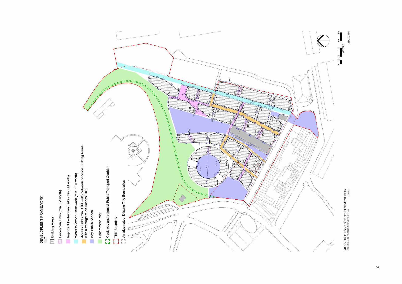
195

196
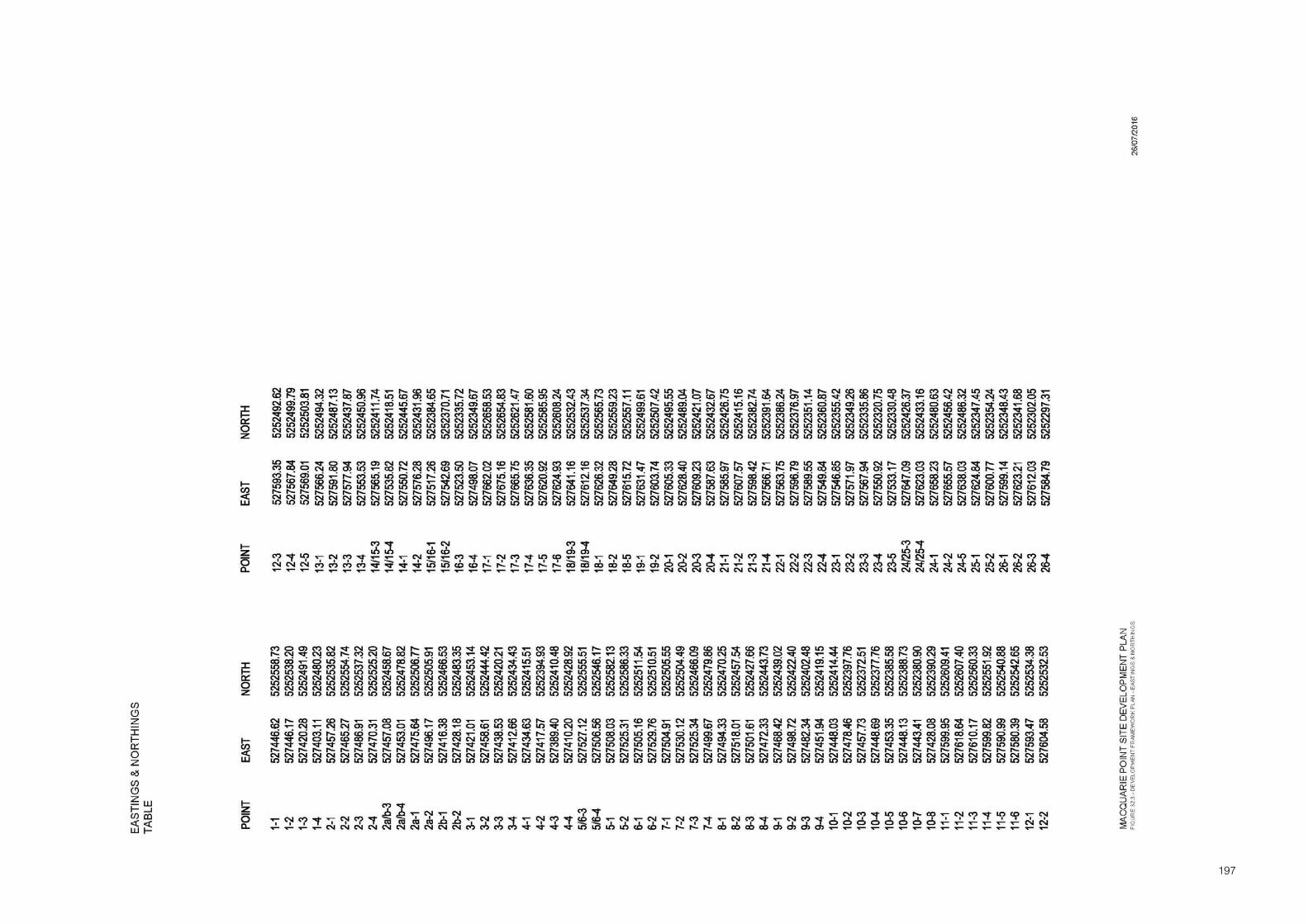
197

198

199

200

201
PART G - DEFINITIONS
Activity Area
A defined area of land as delineated in Part D, Figure 4.
Adjacent
In relation to proposed development means sites alongside, behind or diagonally behind a place of identified cultural significance or on the opposite side of the street.
Apparent Size
‘Size’ of development when viewed in elevation. It is the length of wall and the area of a wall of a building relative to the width of the abutting street or other public space.
Archaeological Sensitivity Report
A report accepted by the Planning Authority that is prepared by a qualified archaeologist or other suitably qualified professional that may be required to be submitted as part of any applications to undertake works, and which includes the following:
Investigation of documentary evidence on the application site history.
Sampling program which includes timing and method of sampling, and procedures tobe followed where items of archaeological value are discovered.
Details of archaeological ‘watching brief’ procedures to be implemented during thecompletion of works.
Art and Craft Centre
Land used to manufacture, display, and sell works of art or craft, such as handicrafts, paintings, and sculptures.
Arts and Cultural Centre
Land used for art and cultural activities which are open to the public, such as a performing arts or literature venue. Also includes an Art Gallery, Museum.
Art Gallery
Land used to display works of art, such as ceramics, furniture, glass, paintings, sculptures, and textiles.
Bed and Breakfast Establishment
A Dwelling used, by a resident of the dwelling for permanent accommodation, to provide accommodation for persons away from their normal place of residence.

202
Best Practice Environmental Management
Means the management of an activity to achieve an ongoing minimisation of the activities environmental harm through cost effective measures assessed against the current international and national standards applicable to the activity. In determining the best practice environmental management of an activity, regard must be had to the following:
(a) strategic planning by the person carrying out, or proposing to carry out the activity;
(b) administrative systems implemented by the person, including staff training;
(c) public consultation carried out by the person;
(d) product and process design
(e) waste prevention, treatment and design.
Boat Launching Facility
Land used to launch boats into the water and to retrieve boats from the water.
Building
Includes:
(a) structure and part of a building or structure; and
(b) fences, walls, outbuildings, service installations and other appurtenances of a building; and
(c) boat or pontoon which is permanently moored or fixed to land.
‘Building or Works’ (This definition is exclusive to Schedule 1)
‘Building or works’ means the carrying out of building construction, alteration or decoration or works.
Burra Charter
The Australia ICOMOS Charter for Places of Cultural Significance 1999 (including Guidelines), adopted by the Australian National Committee of the International Council on Monuments and Sites (Australia ICOMOS Inc.) on 26 November 1999.
Car Park
Any land used primarily for the parking of motor vehicles as a public or private car park, but does not include part of any road used for parking, or a transport depot.
Caretaker's House
A Dwelling on the same site as a building, operation, or plant, and occupied as permanent accommodation by an owner or supervisor of that building, operation, or plant.
Child Care Centre
Land used to care for five or more children who are not permanently resident on the land.
Civic Works and Public Street Furniture Concept Plan
A plan showing the full extent of intended Civic Works, including provision of essential services infrastructure, paving, planting, location of all fixed street furniture including trees and ground covers, artworks, free standing signs, lights and lighting concept.
203
Civic Works
Works undertaken in roads and other public spaces by public authorities, including the Council and the Tasmanian Ports Corporation Pty Ltd, or by individuals. It does not include buildings in the public space.
Commercial and Community Furniture
All ephemeral furniture (furniture which is regularly removed being removed at least every three months or not otherwise fixed to the ground, building or structure) associated with a commercial or community activity. It includes Outdoor Dining Furniture.
Commercial Display Area
Land used only to display goods.
Commercial Port Operations
Any building or area in which any activity or operation (including the administration of commercial port activities) connected with the carrying of goods or people from one port to another for business or commercial purposes is conducted by the Tasmanian Ports Corporation Pty. Ltd.
Community Centre
Means a club room, assembly hall, public hall, games or reading room, canteen, or other building designed or adapted primarily to provide facilities for social, sporting or cultural organisations.
Conservation
Conservation means all the processes of looking after a place so as to retain its cultural significance. It includes maintenance and may according to circumstance include preservation, restoration, reconstruction and adaptation, as defined in the Burra Charter.
Conservation Plan
A Conservation Plan accepted by the Planning Authority and prepared in accordance with the guidelines provided by J. S. Kerr’s (“The Conservation Plan”). The conservation plan includes:
Documentation of the cultural significance of a place.
Documentation of proposed measures to be undertaken to conserve cultural heritage.
An assessment of how proposed ‘building or works’ comply with the conservationstrategy proposed in the Conservation Plan and a Statement of Impact regarding theimpact of the proposed ‘building or works’ on the conservation of cultural significance.
Consulting Rooms
A building or part of a building (not being a hospital) used in the practice of one or more medical, veterinary, or dental practitioners, or by registered practitioners of any therapeutic art or science.
204
Contaminated Site
A site at which hazardous substances occur at concentrations above background levels and where assessment indicates that it poses, or is likely to pose, an immediate or long term hazard to human health or the environment.
Convenience Restaurant
Land used to prepare and sell food and drink for immediate consumption, where substantial provision is made for consumption both on and off the premises.
Convenience Shop
A building with a leasable floor area of no more than 240 square metres, used to sell food, drinks, and other convenience goods. It may also be used to hire convenience goods.
Council
The Hobart City Council.
Cultural Significance
Cultural significance is defined as historic, scientific, aesthetic or social value for past, present and future generations. It may include archaeological values, architectural values and values as a record of various aspects of history. It is synonymous with the term heritage value.
‘Deemed to Comply’ Provisions
Measures which are one way by which a use or development achieves ‘Objectives’.
Development
Includes:
(a) The construction, exterior alteration or exterior decoration of a building; and
(b) The demolition or removal of a building or works; and
(c) The construction or carrying out of works; and
(d) The subdivision or consolidation of land, including buildings or airspace; and
(e) The placing or relocation of a building or works on land; and
(f) The construction or putting up for display of signs or hoardings -
But does not include any development of a class or description, including a class or description mentioned in paragraphs a) to f) prescribed by regulations for the purpose of this definition.
Dwelling
A building used as a self-contained residence which must include:
(a) a kitchen sink;
(b) food preparation facilities;
(c) a bath or shower; and
(d) a closet pan and wash basin.
It includes outbuildings and works normal to a dwelling.

205
Eating Establishment
Land used to prepare and sell food for consumption on, or off, the premises. It also includes a Restaurant/Cafe, Take Away Food Premises and Convenience Restaurant.
Education Centre
Land used for education, such as a primary or secondary school, tertiary institution or university, business college, college of advanced education (TAFE), day seminar facility or employment training centre.
Elderly Persons Unit
Means a Dwelling used for permanent accommodation containing not more than two bedrooms and a floor area of not more than 75 square metres, which is designed and intended for occupation by retired persons.
Environmental Harm
Means ‘environmental harm’ as described in s.5 of the Environment Management and Pollution Control Act 1994.
Exhibition Centre
Land used for the display and public exhibition of goods, information, etc.
Fixed Public Street Furniture
Street furniture permanently located in roads or other public spaces or furniture which is possible to remove but is not removed once every 3 months. Includes but not limited to: street furniture and large landscape items including street trees.
Flat
A Dwelling used for permanent accommodation that has another Dwelling used for permanent accommodation above or below it.
Floor Area
Means the total actual area of each floor of a building (including mezzanines) measured at its greatest point of internal dimension from external walls but excluding lift shafts and stairwells, rooms or areas set aside for the accommodation of mechanical and electrical plant, open balconies or verandahs, and (excepting where a development includes car parking which is additional to that car parking which is required pursuant to this Scheme or which is approved as ancillary to that development) areas for the parking, garaging, loading, unloading and circulation of motor vehicles.
Floor of the Cove
The concept of the flat fill surface of Sullivans Cove having a recognisable identity contained by the built form and topography.

206
Function Centre
Land used, by arrangement, to cater for private functions, and in which food and drink may be served, such as a conference centre or reception centre. It may include entertainment and dancing.
Gambling Premises
Land used for gambling by gaming or wagering, and where there is an ability to receive a monetary reward.
General Industry
Land used for any of the following operations:
(a) any process of manufacture; (b) dismantling or breaking up of any article; (c) treating waste materials; (d) winning clay, gravel, rock, sand, soil, stone, or other materials (other than Mineral,
stone, or soil extraction); (e) laundering, repairing, servicing or washing any article (not including a retail or self
service laundry), machinery, or vehicle, other than on-site work on a building, works, or land; or
(f) any process of testing or analysis. If on the same land as any of these operations, it also includes:
(i) storing goods used in the operation or resulting from it; (ii) providing amenities for people engaged in the operation; (iii) selling by wholesale, goods resulting from the operation; and (iv) accounting or administration in connection with the operation.
Hard Character
Primarily hard constructed surfaces, no landscape works.
Height
In respect of buildings (other than structures), that maximum vertical distance measured between the natural surface level and the eaves or parapet at any point of any part of a building.
In respect of structures (other than buildings), that maximum vertical distance measured between the natural surface level and the highest point of the structure.
Heritage Value
Heritage value (or cultural heritage value) is defined as the historic, aesthetic and social significance of Sullivans Cove. It includes social value, archaeological values architectural values and values as a record of various aspects of history. It is synonymous with the term cultural significance.
Holiday Unit
A Dwelling intended, adapted or designed as tourist accommodation in accordance with Accommodation Standards (No. 4) under Part 3, s.109 of the Liquor and Accommodation Act, 1990. It could be a serviced apartment.

207
Home Occupation
The full or part time business conducted within the curtilage of a dwelling by one or more of the dwelling's permanent residents, and the operation of which does not:
(a) require the occupation of more than 30m2 of land and/or floor area within the curtilage of the dwelling and provided that it occupies no more than 20% of the ‘floor area’ of the dwelling;
(b) create noise at the boundary of the curtilage of the nearest dwelling which exceeds 40 dBA between the hours of 7:00am and 8:00pm, and 35 dBA between the hours of 8:00pm and 7:00am;
(c) require the alteration of the external appearance of the dwelling except for the erection of a sign less than 0.2m2 and mounted flat against the wall of the ‘principal building’ on the site and which indicates only the name and nature of the home occupation;
(d) entail the employment on the site of any person who is not a permanent resident;
(e) entail the provision of additional parking spaces above those required for its use as a permanent residence;
(f) necessitate the enlargement of, or extension to any public utility service to the land;
(g) entail the visitation to the site for business purposes by non residents excepting where the conduct of the 'home occupation' solely involves personal contact on a single person appointment basis and frequency not necessitating a waiting room facility;
(h) entail the use of motive power, except for any electric motor supplied from a single phase general purpose outlet not exceeding 10 amps in rating;
(i) entail the storage of goods or materials in any location visible from any residence, public street or public place.
Hotel
Land used primarily to sell liquor for consumption on and off the premises. Additionally It may include accommodation, food for consumption on the premises, entertainment, dancing, amusement machines, and gambling.
Hydraulic Repairs and Underground Services
The laying, replacement or repair of any water, sewerage or stormwater main or any other piping or ducting required for mains services, electrical supply, communications or other underground activity required to service a public utility installation.
Indoor Recreation Facility
A building used for indoor leisure, recreation, or sport.
Informal Outdoor Recreation
Land open to the public and used by non-paying persons for leisure or recreation, such as a cycle track, picnic or barbecue area, or a walking or jogging track.
Key Site
A site which is regarded as under utilised and having the potential, through development or redevelopment within 5-10 years of the final approval of the Scheme, to be used for activity which will reinforce the strategic framework of the Scheme and objectives of the Activity Area.

208
Land
Includes:
(a) Buildings and other structures permanently fixed to land; and
(b) Land covered with water; and
(c) Water covering land; and
(d) Any estate, interest, easement, servitude, privilege or right in or over land.
‘Level 1’ Activity
Means as defined in the Environmental Management and Pollution Control Act 1994.
‘Level 2’ Activity
Means an activity specified in Schedule 2 of the Environment Management and Pollution Control Act 1994.
‘Level 3’ Activity
Means an activity which is a project of State significance under the State Policies and Projects Act 1993.
Light Industry
Means the use of buildings or spaces for manufacturing, processing or storage of activities which do not:
(a) Cause a nuisance as defined in s.180 of the Local Government (Building and Miscellaneous Provisions) Act 1993; and
(b) Cause “environmental harm” as defined in s.5 of the Environmental Management and Pollution Control Act 1994; and
(c) Create noise at the boundary of a residential zone which exceeds 40 dBA between the hours of 7:00 am and 8:00 pm, and 35 dBA between the hours of 8:00 pm and 7:00 am; and
(d) Require the on street parking, loading, unloading or manoeuvring of vehicles associated with the operation; and
(e) Adversely affect the amenity of nearby dwellings through vibration, dust, grit, smoke fumes, smell, bright lights, electrical interference, traffic generation or unsightly appearance; and
(f) Require the erection of any buildings or structures that are not in accordance with the character of the Planning Area; and
(g) Require the storage of goods or materials in any location visible from any residence, public street or public place.
Lot
Means a block of land created by subdivision of a large block of which it was part.
Major Road Works
Means within the existing road reservation or other public space, all road works required for the construction of additional traffic lanes and vehicle under and overpasses.

209
Major Sport And Recreation
Land used for leisure, recreation or sport where there is substantial provision made for spectators, such as a grandstand, and to which spectators are usually charged admission.
Manufacturing Sales
Land used, as an incidental part of an industry, to retail goods made materially different on the land by that industry.
Marina
Land used to moor boats, or store boats above or adjacent to the water. It may include boat recovery facilities, and facilities to repair, fuel, and maintain boats and boat accessories. It includes, a jetty, pier, mooring pole and pontoon.
Marine Industry
Means the manufacturing, processing, storage, servicing, repair or other similar treatment of commercial boats and other commercial marine equipment or components and includes slipyards, boat servicing workshops, fish processing plants, boat manufacture, the retail of marine equipment and supplies and the like.
Market
Land used to sell goods, including foodstuffs, from stalls.
Minor Maritime Buildings or Works
Means minor buildings or works essential to the safe operation of the Port of Hobart and includes those related to general wharf maintenance, statutory signs, essential services to vessels (power and water), lighting for navigational and ship servicing purposes and the replacement of fenders, dolphins, camel dolphins and bollards.
Minor Landscape Works
Works involving installation of vegetation (planter boxes, etc.) excluding street trees.
Minor Road Works
Means within the existing road or other public space, all road works involved in the sealing or resealing, upgrading or minor widening of an existing carriageway, including the introduction of kerbs, gutters, footpaths, road signs, traffic-control devices, street lighting, traffic calming measures, alterations to the layout and means of traffic control at existing junctions and intersections, and the like, together with pedestrian under and overpasses, but does not involve the construction of any new or additional carriageway or traffic lane and includes all other works not included under Major Road Works.
It includes the formation, widening, improvement or alteration of any existing vehicular access by, or on behalf of, the road authority.
Minor Sports and Recreation
Land used for leisure, recreation, or sport, without substantial provision for spectators, and which is usually open to non-paying spectators, such as open sports ground. Also includes Indoor Recreation Facilities and Outdoor Recreation Facilities.
210
Minor Utility Installation
Land used for a utility installation comprising any of the following:
(a) sewerage or water mains;
(b) storm or flood water drains or retarding basins;
(c) gas mains providing gas directly to consumers;
(d) power lines designed to operate at less than 220,000 volts;
(e) telecommunication lines;
(f) an electrical sub-station designed to operate at no more than 66,000 volts.
Motel
Land used to provide accommodation in serviced rooms for persons away from their normal place of residence, and where provision is made for parking guests' vehicles convenient to the rooms. It does not include Bed and Breakfast Establishment.
Museum
Land used to display archaeological, biological, cultural, geographical, geological, historical, scientific, or other like works or artefacts.
Multiple Accommodation
The letting as permanent accommodation in more than one tenancy of rooms or other non self contained accommodation with the use of common facilities, such as bed sitting rooms, rooming or boarding houses or a hostel.
Objectives
General statements of intention for use or development to attain as a means of satisfying the ‘Principles‘of the Scheme.
Office
Land used for administration, or clerical, technical, professional or other like business activity, such as an electoral office, government office, or insurance outlet. No goods or materials intended for manufacture, sale, or hire may be stored on the land. It also includes Consulting Rooms.
Other Public Spaces
Land which is generally available for access by the general public, but not including a road.
Outdoor Dining Furniture
Means the placement or use of tables, chairs, benches, umbrellas and the like used for the purpose of extending the services of premises whose main function is the provision of food and beverages to the public.
Outdoor Recreation Facility
Land used for outdoor leisure, recreation, or sport.
Passive Recreation
Means the use of land for a park, garden, playground or reserve for leisure activities including Informal Outdoor Recreation. It does not include Major Sport and Recreation or Minor Sport and Recreation.

211
Permanent Accommodation
Means, in relation to Residential Accommodation, occupation by the owner(s) as the principal place of residence, or, if let, on a tenancy of at least six months duration.
Performance Criteria
General statements of the means by which a use or development achieves ‘Objectives’.
Permissible Activity
Means an activity in respect of which a Planning Authority has the discretion to refuse a permit or is bound to grant a permit either unconditionally or subject to conditions.
Place
Place means site, area, building or work, group of buildings, or works with associated contents and surroundings.
Place of Worship
Land used for religious activities, such as a church, chapel, mosque, synagogue, or temple.
Planning Authority
The Hobart City Council
Plan of Subdivision
A plan submitted to the Planning Authority for the purpose of a permit under the Land Use Planning and Approvals Act 1993 in relation to the subdivision of land.
Plot Ratio
Means the ratio between floor area or areas of a building or buildings and the site area upon which such or development is proposed.
Primary Elevations
The side (or sides) of a building presented as the primary street frontage. Primary elevations are distinguished by prominent entrances, signs naming the building or business, a high quality of materials or surfaces or a formal relatively upright building or wall.
Primary Spaces
Roads and spaces shown on Figure 7 as primary spaces.
Public Display Office
Land used for activities which incorporates both office and ‘quasi retail’ functions which require a shop front address such as a real estate agency, travel agency or boat sales agency.
Public Street Furniture
Street furniture permanently located in roads or other public spaces or furniture which is possible to remove but is removed once every 3 months. Includes but not limited to: street furniture and large landscape items including street trees.

212
Public Street Furniture Ancillary to Traffic and Parking Management
Street furniture that is permanently located in roads or other public spaces or furniture which is possible to remove but is not removed once every 3 months and that is necessary for the management by the Council of traffic and parking.
Public Transport Facility
Means any building, structure, activity or area used or intended to be used in association with the transport of people by bus, train, or light rail.
Railway Terminal
Any building, structure, activity or area used or intended to be used in association with the transport of goods or people by rail, but does not include any building, structure, activity or area associated with a tram, or a light railway constructed on a road and/ or other land.
Recreational Boating Facility
Land used to provide, facilities for boats operated primarily for pleasure or recreation, including boats operated commercially for pleasure or recreation. It includes a Marina or Boat Launching Facility.
Research and Development Centre
Land used to develop electronic technology, biotechnology, or any other scientific discipline. It may include administration, promotion, conference, display, laboratory, assembly, and manufacturing areas.
Residential Accommodation
The occupation of one or more buildings known as a Dwelling for permanent accommodation, such as a Flat, Elderly Persons Unit or Caretakers House. It excludes any associated commercial activity except for Home Occupation, Residential Business and Bed and Breakfast Establishment.
Residential Business
The full or part time business conducted within the curtilage of a dwelling by one or more of the dwelling's permanent residents, and the operation of which does not:
(a) entail the employment on the site of any more than one person who is not a permanent resident of the dwelling; and
(b) create noise at the boundary of the curtilage of the nearest dwelling which exceeds 40 dBA between the hours of 7:00 am and 8:00 pm, and 35 dBA between the hours of 8:00 pm and 7:00 am; and
(c) entail the alteration of the external appearance of the dwelling except for the erection of a sign less than 0.2m2 and mounted flat against the wall of the ‘principal building’ on the site and which indicates only the name and nature of the residential business; and
(d) affect the residential amenity of the dwelling, of nearby lots or the vicinity through vibration, dust, grit, smoke fumes, smell, bright lights, harmful emissions, electrical interference traffic generation or unsightly appearance; and
(e) require the occupation of more than 30m2 of land and/or floor area within the curtilage of the dwelling and is confined to one of the following spaces:
(i) Professional consulting rooms; or
(ii) A garden for horticulture (including greenhouses); or

213
(iii) A kitchen area; or
(iv) A laboratory area; or
(v) An office; or
(vi) Storage, display and/or selling room or rooms; or
(vii) Studio, instruction or practice rooms; or
(viii) Workshops and/or craft rooms.
(f) entail the storage of goods or materials in any location visible from any residence, road or public place; and
(g) necessitate the enlargement of, or extension to any public utility service to the land; and
(h) require the use of motive power, except for any electric motor supplied from a single phase general purpose outlet not exceeding 10 amps in rating.
Residential Hotel
Land used primarily for providing tourist accommodation.
Restaurant/Cafe
Land used to prepare and sell food and drink, for consumption on the premises, and where seating is provided for all patrons. Part of the premises (no more than 25% of the total area of the premises in which liquor may be sold) may be used for the supply of liquor other than in association with the serving of meals. It may include entertainment and dancing. It does not include the sale of packaged liquor.
Retail Premises
Land used to:
sell goods by retail, or by retail and wholesale;
sell services; or
hire goods.
Road
Means a road or street, including a public space, over which the general public has permanent right of passage in a motor vehicle, including all land between the boundaries of the road and its reservation and all bridges over which such a road passes, being a road which is the responsibility of the Minister administering the Roads and Jetties Act 1935 or, if a Council road, being a road for which the Council has accepted responsibility under its seal or a road shown on the municipal map.
Road Maintenance
Means the repair and/or replacement of any part of an existing road and its associated infrastructure, and includes carriageway resealing, replacement and/or upgrading of line markings, road signs, other traffic control devices, street lighting together with all road works required to maintain the road in a state and satisfactory operational condition. Also included are any emergency works required for public safety due to an immediate danger to the public and to preserve the integrity of the road and the surrounding area.

214
Road Layout Plan
Means a plan(s) and any accompanying text of the road alignment, including the position and width of carriageway(s), the location and layout of junctions and intersections, the siting and height of major cuttings and embankments and any such further relevant information as may be required by the Planning Authority.
Road Works
Means all work undertaken in, on, under or over the carriageway(s), road shoulders, median, bridges, culverts, footpaths and verges including all works necessary to install and maintain road signs, traffic control devices, infrastructure, landscaping, planting and tree removal required to ensure amenity and the safe, efficient and convenient use of a road by private and public transport.
Secondary Elevations
The sides of a building presented as frontages to the secondary spaces of Sullivans Cove. Secondary elevations generally are those which have less prestigious materials and finishes on walls, may be stepped in elevation and have a ‘service’ or ‘utility’ function.
Secondary Spaces
Smaller roads, lanes, alleys and ad hoc courts running off the primary spaces shown on Figure 7 as secondary spaces.
Service Industry
The use of land, a building or part of a building for processes directed towards the servicing of goods or land/building and used as a depot for necessary goods to be serviced and in no way affects the amenity of other activities in the neighbourhood.
Shop
Land used to sell goods or services, or to hire goods, but does not include Convenience Shop, Manufacturing Sales, Market , Landscape gardening supplies, Motor vehicle, boat, or caravan sales, Postal agency, Primary produce sales, or Trade supplies.
Sign
Means any graphic, pictorial or written display , including any structure or material, when viewed from a road or other public space.
Awning sign - Above A sign attached to and supported above an awning, veranda or similar.
Awning sign - Below A sign on the fascia or return ends of cantilever of suspended awnings.
Awning Sign - Fascia A sign on the fascia or return ends of cantilever or suspended awnings.
Banner sign A sign constructed of lightweight non-rigid material, such as cloth, canvas or similar fabric, attached to the wall of a building or other existing structure including light poles.

215
Blade Sign A sign with a large display surface, which is either permanently attached to the ground or on its own supportive structure. It is not designed or used as a Poster panel sign (billboard) and excludes Business directory, or Public event and cultural directory signs.
Bunting A string of small flags, or streamers strung in a line from or otherwise attached to a building or other structure.
Business directory A sign for a building in multiple tenancies which identifies the name of the business and its location within the building and does not contain any product or other advertising.
Cabinet sign A cabinet with a transparent face attached to the wall of a building or structure for the display of information within (e.g. Menus).
Canopy sign A sign incorporated into the fabric or structure of a sun blind or canopy situated over a door or window.
Construction site sign
A temporary sign indicating that construction works are occurring on a property.
Flag sign A sign constructed of lightweight, non-rigid material attached by one edge to a pole or rope.
Horizontal projecting wall sign
A sign projecting from the wall of a building with a horizontal dimension greater than its vertical dimension.
Internal display sign A sign located great than 150mm from the glass surface of a window or door.
Interpretative sign Provides information for visitors, plans, historic information, location of services, features and businesses, includes artworks which convey meaning.
This type of sign can be private (i.e. Placed by and for the benefit of a private business) or public (i.e. Placed by a public agency in the public interest).
Mobile trader sign A sign attached to a mobile vehicle from which a product or service is being sold (e.g. mobile food van, ice-cream vendor, mobile flower sellers)
Name plate sign A sign identifying one of the occupants of a property used for professional rooms, attached flush to the wall of a building.
Examples are a traditional doctors’ or lawyers’ brass plate.
Pole sign A sign erected on top of one or more vertical supports or suspended from a horizontal support held up by one or more vertical supports, and which is independent of any building or other structure.
Portable sign A freestanding, portable advertising device, commonly known as a sandwich board sign.

216
Poster panel sign (bill board)
A structure either freestanding or attached to a building designed to accommodate standard poster panels, the message of which may be changeable and variable.
Public event and cultural directory sign
A structure permanently attached to the ground, designed to accommodate small bill posters and public notices, the messages of which may be changeable and variable. This type of sign may also fulfil the dual function of an item of public artwork.
Real estate sign Temporary sign erected for purposes of selling/leasing of real estate for the duration of the period the real estate is on the market, which may be more than five days and which is not separately affixed by bolt, nail or screw to masonry, brickwork or other face building material.
Roof sign/sky sign A sign erected on the roof or parapet of a building.
Screen Sign Messages or product logos or other graphics printed or displayed on screens used in association with outdoor dining.
Statutory sign A sign required or specified by statute; and a sign relating to safety of pedestrians, traffic and shipping.
Examples are a hazard sign; hazchem sign; traffic control sign; maritime purposes sign; international/national signposting conventions for service provisions, toilets and street numbers.
Transom sign A sign attached to the transom of a doorway or display window of a building.
Umbrella sign Messages or product logos or other graphics printed or displayed on umbrellas used in association with outdoor dining furniture.
Vertical projecting wall sign
A sign projecting from the wall of a building with a vertical dimension greater than its horizontal dimension.
Wall sign A sign painted on or attached parallel to the wall or window of a building.
Window sign Sign on a glass surface of a window or door located less than 150mm behind a surface. Also includes signs on any window which has been painted opaque.
Site
Means the total area of a lot or two more contiguous lots which is the subject of the same planning application for the use or development of land.
Site Development Plan
A plan which outlines the framework for the future use or development of a site.
Store
Land used only to store goods, machinery, or vehicles. Includes freezing and cool storage.
217
Subdivide
As defined in the Local Government (Building and Miscellaneous Provisions) Act 1993.
Subdivision
As defined in the Local Government (Building and Miscellaneous Provisions) Act 1993.
Sustainable Development
Managing the use, development and protection of physical resources in a way, or at a rate which enables people and communities to provide for their social, economic and cultural well-being and for their health and safety while:
sustaining the potential of natural and physical resources to meet the reasonablyforeseeable needs of future generations, and;
safeguard the life supporting capacity of air, water, soil and ecosystems; and
avoiding, remedying and mitigating any adverse effects of activities on theenvironment.
Take Away Food Premises
Land used to prepare and sell food and drink for immediate consumption off the premises.
The Planning Area
The Scheme applies to all land and water within the Scheme Boundary on "Figure 4" of the Sullivans Cove Planning Scheme 1997, referred to in this Scheme as ‘The Planning Area’.
The Scheme
The Sullivans Cove Planning Scheme.
Traffic Calming
Means the institution of a variety of traffic management measures required to adapt the volume, speed and behaviour of traffic to the primary functions of the areas through which it passes.
Transport Terminal
Land used to assemble and distribute goods or passengers, such as a bus terminal or road freight terminal. It includes facilities to park and manoeuvre vehicles.
Use
In relation to land, includes the manner of utilising land but does not include the undertaking of development.
Utility Installation
Land used:
for telecommunications;
to transmit or distribute gas, oil, or power;
to collect, treat, transmit, store, or distribute water; or
to collect, treat, or dispose of storm or flood water, sewage, or sullage.
Visitor Accommodation

218
Means the use of buildings and spaces for short term occupancy by people who are visitors to the Planning Area, including Residential Hotel, Holiday Unit and Motel.
Void
An architectural feature incorporated into the design for a building facade. These features include openings, doors, windows and shutters, reflective surfaces and glass elements.
Wall of the Cove
The concept of a continuous built wall comprised of a number of building facades, which mark the edge of the Cove Basin with the flat fill surface of Sullivans Cove. The concept has its strongest expression at Salamanca Place and Hunter Street. (Refer to Schedule 2, Figure 6.)
Warehouse
Land used to store or display goods. It may include the distribution and the wholesale selling of the goods. It includes a Store and Commercial Display Area.
Wharf
Land used to provide facilities for ships, such as bulk and container ships, passenger ships, and defence force marine craft.
Waste Management Plan
A plan which details a strategy to systematically reduce waste generation. It includes the assessment of waste, options for eliminating or reducing waste, and actions and associated time-frames for the implementation of waste minimisation measures.
Works
Any change to the natural or existing condition or topography of land including the removal, destruction or lopping of trees and the removal of vegetation or topsoil.