pre- feasibility reportenvironmentclearance.nic.in/writereaddata/online/...the expected life of the...
TRANSCRIPT

KHAD-MOOSIANG LIMESTONE DEPOSIT PFR
0
PRE- FEASIBILITY
REPORT

KHAD-MOOSIANG LIMESTONE DEPOSIT PFR
1
1.0 Introduction
EXECUTIVE SUMMARY
Khad- Moosiang Limestone Deposit mine is situated near village Lumshnong, Tehsil-
Narpuh, District Jaintia Hills, Meghalaya over an area of 4.75 hectares. The State Government
has given consent to grant mining lease in favour of M/s Cement International Limited for a
period of twenty (20) years vide letter no. MG.28/2010/116 on 21st December, 2010. Further
consent order has been received from Mining & Geology Department, Shilong vide letter no.-
28/2010/227 on date 15th
1.1 Salient features of the project
October, 2018. No mining activity has been carried out. The
estimated cost of project is Rs 1.0 crore. The expected life of the mine is 6 years. The
proposed rate of production is 1,49,662TPA of limestone.
Narpuh wildlife Sanctuary is at a distance of approx. 3.5 km towards SSE direction from
mining lease boundary. This mining project falls under Category “A” Project or activity
1(a) as per EIA Notifications 2006 and its subsequent amendment thereof.
Project Name Khad- Moosiang Limestone Deposit mine
Location of mine Village: Lumshnong, Tehsil-Narpuh, Dist: Jaintia Hills,
Meghalaya
Latitude & Longitude
Latitude- 250 09’ 49.14’’ to 250 09’ 49.38”N Longitude- 92022’ 44.46”to 920 22’ 45.12”E
Toposheet number 83 C/8 (Old) or 83C/SW (New)
Minerals of mine Limestone
Life of mine 6.0 years
Proposed production of
limestone
1,49,633 TPA of limestone
Method of mining Opencast mechanized
No of working days 300 days
Water demand
Total water requirement is about 16.5 KLD= 8.5 KLD
(Drinking & Domestic Uses) + 3.0 KLD (Dust
Suppression) + 4.8 or 5.0 KLD (Green Belt) this water
KHAD-MOOSIANG LIMESTONE DEPOSIT PFR
2
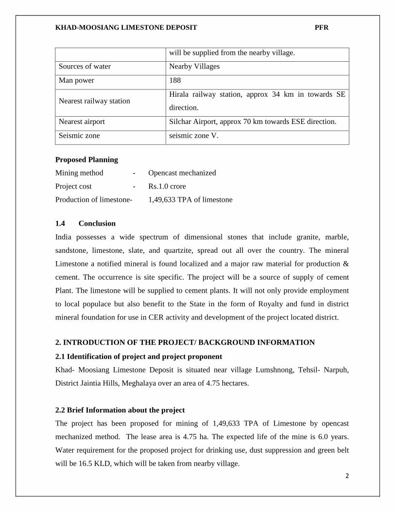
will be supplied from the nearby village.
Sources of water Nearby Villages
Man power 188
Nearest railway station Hirala railway station, approx 34 km in towards SE
direction.
Nearest airport Silchar Airport, approx 70 km towards ESE direction.
Seismic zone seismic zone V.
Proposed Planning
Mining method - Opencast mechanized
Project cost - Rs.1.0 crore
Production of limestone- 1,49,633 TPA of limestone
1.4 Conclusion
India possesses a wide spectrum of dimensional stones that include granite, marble,
sandstone, limestone, slate, and quartzite, spread out all over the country. The mineral
Limestone a notified mineral is found localized and a major raw material for production &
cement. The occurrence is site specific. The project will be a source of supply of cement
Plant. The limestone will be supplied to cement plants. It will not only provide employment
to local populace but also benefit to the State in the form of Royalty and fund in district
mineral foundation for use in CER activity and development of the project located district.
2. INTRODUCTION OF THE PROJECT/ BACKGROUND INFORMATION
2.1 Identification of project and project proponent
Khad- Moosiang Limestone Deposit is situated near village Lumshnong, Tehsil- Narpuh,
District Jaintia Hills, Meghalaya over an area of 4.75 hectares.
2.2 Brief Information about the project
The project has been proposed for mining of 1,49,633 TPA of Limestone by opencast
mechanized method. The lease area is 4.75 ha. The expected life of the mine is 6.0 years.
Water requirement for the proposed project for drinking use, dust suppression and green belt
will be 16.5 KLD, which will be taken from nearby village.

KHAD-MOOSIANG LIMESTONE DEPOSIT PFR
3
2.3 Need for the project and its importance to the country or region
The mineral Limestone a notified mineral is found localized and a major raw material for
production & cement. The occurrence is site specific. The project will be a source of supply
of cement Plant. The limestone will be supplied to cement plants. It will not only provide
employment to local populace but also benefit to the State in the form of Royalty and fund
in district mineral foundation for use in CER activity and development of the project located
district.
2.4 Demands-Supply Gap
The region is a major hub for cement & refractory plants. The ML area full fills the
requirements and hence the demand is always adequate and more than supply.
2.5 Imports vs. Indigenous Production
The quantity of Limestone produced will meet the requirement for Limestone to be imported.
2.6 Export Possibility
There is no proposal to export the Limestone.
2.7 Domestic/ Export Markets
DOMESTIC MARKET
Limestone has a good potential market in the country. No export market exists of the
available grade.
EXPORT MARKET
The proposed mining activity is for indigenous consumption only for cement factories.
2.8 Employment Generation
The proposed mining activity will provide employment to about 188 workers. The workers
will be hired mostly from the nearby villages.

KHAD-MOOSIANG LIMESTONE DEPOSIT PFR
4
3. PROJECT DESCRIPTION
3.1 Type of Project Including Interlinked and Interdependent Projects, If Any.
The mine is over an area of 4.75 hectares. The proposed production is 1,49,662 TPA of
Limestone.
The project falls under Category “A” Project or activity 1(a) as per EIA Notifications
2006 and its subsequent thereof.
3.2 Location
The mining lease area is located at Village- Lumshnong, Tehsil- Narpuh, District Jaintia Hills,
Meghalaya
Toposheet No. : 83 C/8 (Old) or 83C/SW (New)
PILLAR NO.
LATITUDES (N)
LONGITUDE (E)
1 250 92 09’ 49.14’’ 022’ 44.46” 2 250 92 09’ 48.96” 0 22’ 43.92’ 3 250 92 09’ 49.02” 022’ 43.8” 4 250 92 09’ 48.6” 022’ 42.6” 5 250 92 09’ 48.36” 0 22’ 41.7’’ 6 250 92 09’ 47.94” 0 22’ 40.44” 7 250 92 09’ 47.76” 0 22’ 40.2” 8 250 92 09’ 48.84” 022’ 38.76” 9 250 92 09’ 48.72” 0 22’ 38.16” 10 250 92 09’ 48.54’’ 0 22’ .36.72’ 11 250 92 09’ 48.84’’ 0 22’ 35.64” 12 250 92 09’ 48.84’’ 0 22’ 35.4’ 13 250 92 09’ 48.66’’ 0 22’ 34.98’’ 14 250 92 09’ 48.66’’ 022’ 34.56’
15’’ 250 92 09’ 48.12’’ 0 22’ 34.14 16 250 92 09’ 47.94’’ 022’ 33.84” 17 250 92 09’ 46.92” 0 22’ 33.36” 18 250 92 09’ 46.74” 0 22’ 33.18” 19 250 9209’ 54.00” 0 22’ 33.3” 20 250 9209’ 53.76’’ 0 22’ 33.6’’ 21 250 92 09’ 53.34” 022’ 34.32” 22 250 92 09’ 52.98” 022’ 35.4” 23 250 9209’ 52.98’’ 022’ 35.52” 24 250 92 09’ 53.22” 022’ 36.48” 25 250 92 09’ 52.5’’ 0 22’ 36.00’’ 26 250 9209’ 52.5” 0 22’36.9” 27 250 92 09’ 51.78’’ 0 22’ 38.4” 28 250 92 09’ 51.0’’ 0 22’ 38.28”

KHAD-MOOSIANG LIMESTONE DEPOSIT PFR
5
29 250 9209’ 51.18’’ 022’ 38.52” 30 250 92 09’ 51.54’’ 0 22’ 39.96” 31 250 9209’ 51.48” 0 22’ 40.74’ 32 250 92 09’ 51.84’’ 0 22’ 40.98” 33 250 92 09’ 52.02” 0 22’ 41.1’’ 34 250 9209’ 52.08” 022’ 41.1” 35 250 92 09’ 55.26” 022’ 41.82” 36 250 92 09’ 56.82” 0 22’ 43.14” 37 250 92 09’ 56.94” 0 22’ 43.5” 38 250 92 09’ 56.52” 022’ 43.5” 39 250 92 09’ 56.1’’ 0 22’44.1’’ 40 250 92 09’ 55.5” 0 22’ 44.74” 41 250 92 09’ 54.96’’ 0 22’ 45.54’’ 42 250 92 09’ 53.88” 022’ 45.18” 43 250 92 09’ 53.4” 0 22’ 44.82” 44 250 9209’ 52.86” 0 22’ 44.82” 45 250 9209’ 52.5” 0 22’ 45.24” 46 250 92 09’ 51.6” 022’ 44.76” 47 250 9209’ 50.58” 0 22’ 44.46” 48 250 92 09’ 49.38” 0 22’ 45.12”

KHAD-MOOSIANG LIMESTONE DEPOSIT PFR
6
Location map

KHAD-MOOSIANG LIMESTONE DEPOSIT PFR
7
5 km buffer map
3.3 Details of Alternate Sites
Not Applicable.
3.4 Size or magnitude of operation
The mine has lease over an area of 4.75 ha. The mine will be worked on the day time only.
The average number of working days in the year would be 300 days.
Reserve calculation
The total mineral resources and reserves have been calculated by cross sectional area method.
In this method the cross sectional area of section line is multiplied by the influence of the
section line to give the volume. This in turn has been multiplied by the bulk density to find out
the tonnage. The mineral reserve thereafter has been calculated by depleting remaining resources
from total mineral resources

KHAD-MOOSIANG LIMESTONE DEPOSIT PFR
8
Mineral Reserve as Per UNFC Classification:
Classification Code Quantity in MT
Average Grade Threshold value
A. Total Mineral Reserve Proved Mineral Reserve 111 -- -- --
Probable Mineral Reserve 121 -- -- -- 122 870525 CaO – 52% CaO-35% (Min)
B. Total Remaining Resources
Feasibility Mineral Resource
211 -- -- --
Pre-feasibility Mineral Resource
221 -- -- -- 222 3850727 CaO – 52% CaO-35% (Min)
Measured Mineral Resource 331 -- -- -- (Indicated Mineral Resource
332 4767069 -- --
Inferred Mineral Resource 333 -- -- -- Reconnaissance Mineral Resource
334 -- -- --
Total Reserves + Resources 9488321 CaO – 52% CaO-35% (Min)
3.5 General Geology:
The topography and general local / mine geology of the mineral deposit including drainage pattern: -
(i) Topography - The Limestone and Sandstone deposits in Lumshnong areas of Jaintia hills
of the Shillong plateau are located on hilly terrain. The ground surface shows rough and
rolling topography with steep escarpments at places. The limestone bearing area is
characterized by slumped blocks, innumerable cracks, fissures, solution cavities and sinkholes
exhibiting typical karst topography. The maximum height attained by the area is 534m from
MSL and minimum height attained by the area is 516 m from MSL. The maximum height of
the area is at the north western part and the minimum height of the area is at the south western
part. The central and eastern part of the area is comparatively flatter. The studied area is
covered by erosional scree consisting of detrital materials embedded in a soil cover over the

KHAD-MOOSIANG LIMESTONE DEPOSIT PFR
9
bedrock. The thickness of the scree is variable attaining maximum thickness in the valleys
between the hill side spurs.
(ii) Drainage Pattern: - Numerous streams and nalas flowing into the nearest river Lubha
intersect the area. These nalas remain active during rainy season but carry little or even no
water during summer and winter. General hydrological gradient in the area is to southeast
direction. The underground water, whenever finds an outlet, comes out to the surface as hill
side springs.
(iii) Vegetation – The area is devoid of any large vegetation. Different kind of bushes can be
seen in the area.
(iv) Climate:
The region experiences humid and sub-tropical monsoon climate. The Cherrapunji-
Mawsinram belt, which has the distinction of having the World’s heaviest rainfall records, lie
near from the area under investigation. The rainy season persists from May to October.
Sometimes intermittent showers accompanied by storm are experienced in March and April
before the onset of monsoon. During summer (April – May) the temperature reaches around
35o C while in winter (December – January) temperature falls down to a minimum of 8o to
10o C.
v) Regional Geology:
The rock formation of the southern fringe of Meghalaya Plateau belongs to a part of the
Cretaceous- Tertiary sequence. The calcareous and calc – arenaceous formation of the region
belongs to the Jaintia Group of Paleocene – Eocene period. The Jaintia Group has been sub –
divided into three (3) formations viz. Langpur, Sylhet & Kopili. The Langpur Formation
consists of three – (3) sandstone and three (3) limestone members beginning with Therria
Sandstone at the bottom followed by Lakadong Limestone, Leading Sandstone, Umlatdoh
Limestone, Narpuh Sandstone and Prang Limestone at the top. The Prang Limestone of Jaintia
Group is overlain unconformably by the younger Kopili Formation of Upper Eocene to
Oligocene age. The junction between Prang Limestone and Kopili formation is a fault and
shows a discordant relationship between the two – (2) formations. The Kopili formation is

KHAD-MOOSIANG LIMESTONE DEPOSIT PFR
10
again unconformably overlain by Older and Newer Alluvium Group of Pleistocene to Recent
age.
Local Geology:
The limestone formation occurring over the applied area belongs to the lower Lakadong
limestone unit of Sylhet formation of Jaintia Group. The base of this limestone unit lies
conformably over the Therria Sandstone. The Lakadong Sandstone is underlain conformably
by Lakadong Limestone interbedded with sandstone to the further south of the area.
3.6 PROJECT DESCRIPTION WITH PROCESS DETAILS
3.6.1 Method of Mining
The development of the area will be by mechanical means. The overburden will be removed
by excavator - dumper combination. The first mining bench will start from the proposed area
of the leasehold by slicing method from top in overburden along mineralized zone in the area.
As per topography, the area is almost undulating. Depending on the boom height of excavator
and width of the dumper deployed for R.O.M. removal, proper benching will be done as per
the statute and mineral will be done manually with tractors/trucks. Light drilling and blasting
will be done.
Drilling and blasting has been proposed for heaving purpose only and the quantity of
explosive will be optimum which will not produce any ground vibration.
Requirement of Machinery:
Sl.no Machinery Numbers Remarks 1 Hydraulic Excavator –
PC300 02 One for limestone handling and One
for overburden handling. 2 Hydraulic Excavator –
PC200 01 Standby, as and when require either
in limestone or in overburden, in case of breakdown of regular excavator.
3 Dumpers – TATA - HYVA
5 For 03 excavators, including standby.
4 Compressor 02 One in limestone one in overburden. 5 Wagon drill 02 - do -

KHAD-MOOSIANG LIMESTONE DEPOSIT PFR
11
PRODUCTION DETAILS
The Proposed Production of Limestone is 1,49,662 TPA.
Year Soil in (Cu.m)
Sandstone in (Cu.m)
Total Overburden
(Cu.m)
ROM in tonnes.
Stripping Ratio
Ore: O.B. 1st Year 28490 30297 58787 149374 1:0.39 2nd Year 0 20163 20163 149633 1:0.13 3rd Year 0 18464 18464 149662 1:0.12 4th Year 14144 15456 29600 149463 1:0.20 5th Year 5166 14240 19406 149555 1:0.13 Total : 24764 62616 146420 747687 1:0.20 (Av.)
3.7 Raw Material Required Along With Estimated Quantity, Likely Source, Marketing
Area of Final Product/S, Mode of Transport of Raw Material and Finished Product
No raw material will be required for production of Limestone. In the operation phase
limestone will be excavated by opencast mechanized method.
3.8 Resource Optimization/ Recycling and Reuse
Not envisaged.
3.9 Availability of Water Its Source, Energy/ Power Requirement and Source
3.9.1 Water Requirement
Water required is 16.5 KLD. It is proposed to obtain water for drinking from nearby village.
SI. No. Activities Average demand KLD
Source
1
Mine Operation Dust Suppression 3.0
Will be taken from Mine Sump
2 Green Belt & afforestation 4.8
3 Drinking & Domestic 8.5 Will be taken from old Ground water Source situated in ML area
Total 16.3 or 16.5
3.9.2 POWER
The power will be supplied by Meghalaya State Electricity Regulatory Commission.

KHAD-MOOSIANG LIMESTONE DEPOSIT PFR
12
3.10 QUANTITY OF WASTES TO BE GENERATED (LIQUID AND SOLID) AND
SCHEME FOR THEIR MANAGEMENT/ DISPOSAL
3.10.1 Solid Waste Generation
The R.O.M. production target (calculated on the basis of sections) for the next five years,
along with the target for removal of OB and waste is given below:
Year Soil in (Cu.m)
Sandstone in (Cu.m)
Total Overburden
(Cu.m)
ROM in tonnes.
Stripping Ratio
Ore: O.B. 1st Year 28490 30297 58787 149374 1:0.39 2nd Year 0 20163 20163 149633 1:0.13 3rd Year 0 18464 18464 149662 1:0.12 4th Year 14144 15456 29600 149463 1:0.20 5th Year 5166 14240 19406 149555 1:0.13 Total : 24764 62616 146420 747687 1:0.20 (Av.)
It is proposed to form proper benches in OB and ore and during the next five years of working
about 7,47,687 tonnes of Limestone will be produced and this will involve removal of about
1,46,420 tonnes of waste.
3.10.2 Liquid Effluent
The liquid effluent will be generated in meager quantity which is negligible.
4. SITE ANALYSIS
4.1 Connectivity
The area is easily approachable from kachha road via metalled road, NH-35 at about 1.0 km
towards SE direction. Details of site connectivity are as follow:-
Nearest railway station Hirala railway station, approx 34 km in towards SE direction.
Nearest road NH-35, Approx. 1.0 km towards SE direction
Nearest airport Silchar Airport, approx 70 km towards ESE direction.
Nearest Town khliehriat, approx 20 km towards NNW direction.
State, National boundaries Asam- Meghalaya interstate boundary, approx. 13 km towards
SE direction
Nearest water body Lukha river, approx. 4.0 km SE direction

KHAD-MOOSIANG LIMESTONE DEPOSIT PFR
13
Rashiang nadi, approx. 7.0 km West direction
Nearest forest Narpur Reserve Forest, approx. 9.0 km SE direction
National Parks, Wildlife
Sanctuaries, Biosphere
Reserves within 10 km
radius
Narpuh wildlife Sanctuary, approx. 3.5 km towards SSE
direction
4.2 LANDFORM, LANDUSE AND LAND OWNERSHIP
The area is a stony waste land with moderate slope.
Land ownership
The proposed lease area is own waste Land.
4.3 Topography
The Limestone and Sandstone deposits in Lumshnong areas of Jaintia hills of the Shillong
plateau are located on hilly terrain. The ground surface shows rough and rolling topography
with steep escarpments at places. The limestone bearing area is characterized by slumped
blocks, innumerable cracks, fissures, solution cavities and sinkholes exhibiting typical karst
topography. The maximum height attained by the area is 534m from MSL and minimum
height attained by the area is 516 m from MSL. The maximum height of the area is at the
north western part and the minimum height of the area is at the south western part. The central
and eastern part of the area is comparatively flatter. The studied area is covered by erosional
scree consisting of detrital materials embedded in a soil cover over the bedrock. The thickness
of the scree is variable attaining maximum thickness in the valleys between the hill side spurs.
4.4 Soil Classification
It has been mentioned in the Geological Section that overburden consists of yellowish brown
silty clay mixed with boulders of sandstone and yellowish brown, medium to fine grained,
weathered, fractured with brown stain. Constituent minerals are feldspar, quartz, mica &
calcite (as traces).
4.5 Existing Infrastructure
Village is near to the working site. Manpower is cheaply available.

KHAD-MOOSIANG LIMESTONE DEPOSIT PFR
14
4.6 Rainfall & Climate
The region experiences humid and sub-tropical monsoon climate. The Cherrapunji-
Mawsinram belt, which has the distinction of having the World’s heaviest rainfall records, lie
near from the area under investigation. The rainy season persists from May to October.
Sometimes intermittent showers accompanied by storm are experienced in March and April
before the onset of monsoon. During summer (April – May) the temperature reaches around
35o C while in winter (December – January) temperature falls down to a minimum of 8o to 10o
C.
5. PLANNING BRIEF
5.1 Planning Concept
All drilling operations are done mechanically by using wagon drill for deep hole drilling and
to reduce the Size by deployment of Rock breaker. The blasted materials will be loaded from
the face with the help of excavator. The maximum feed size will be 800mm.
Method of Mining
The sequence of operations will be:
The development of the area will be by mechanical means. The overburden will be removed
by excavator - dumper combination. The category of the mine is category A (Fully
Mechanized Mine)
The first mining bench will start from the proposed area of the leasehold by slicing method
from top in overburden along mineralized zone in the area. As per topography, the area is
almost undulating. Depending on the boom height of excavator and width of the dumper
deployed for R.O.M. removal, proper benching will be done as per the statute.
All drilling operations are done mechanically by using wagon drill for deep hole drilling and
to reduce the Size by deployment of Rock breaker. The blasted materials will be loaded from
the face with the help of excavator. The maximum feed size will be 800mm.

KHAD-MOOSIANG LIMESTONE DEPOSIT PFR
15
Bench Design and Formation:
Since the mine will be worked by fully mechanized mining method during the next five
years, bench height will be restricted to the 6m, width minimum 6m and bench slope angle
less than 450 as per MMR, 1961. The work will be carried out by slicing method. The face
width will vary in each year as in the development plan & sections maintaining above said
parameters.
Layout of Mine Working:-
• Cutting and removal of overburden by Excavator, dumper combination
• Removal of blasted overburden by Excavator, dumper combination
• Drilling of holes by wagon drill in harder ground depending upon the
thickness of Limestone, maximum bench height being 6 meters
• Charging and blasting of holes
• Removal of OB and waste in dumpers to the dumping site.
On the basis of nature of deposit the overall recovery will be to the tune of 100%.
Haul road & ramp:- Considering safety regulations and the size of dumper selected, the
haulage road shall have a minimum width of three times the maximum width of the largest
moving equipment excluding the safety berm and the ditch for drainage. The road width is not
a constraint for mine designs in this case. The horizontal benches themselves act as roads for
most of their length; specific roads for dumper haulage are to be maintained only in certain
portion of the lease. Gradient of haul roads shall be 1:16. For maintaining ramp and haul road
geometry will be adopted as permitted by DGMS. Fencing around the quarry will be done
before starting the bench reduction process for safety purpose.
OB & waste:- During quarry development in the first year soil will be generated from the first
bench which will be temporarily stacked / dumped separately within the lease area over the
old soil dump as shown on the plan.
A close observation to the exposures particularly in the central part of the studied area is
characterized by existence of thin bands of sandstone parallel to bedding. this sandstone will

KHAD-MOOSIANG LIMESTONE DEPOSIT PFR
16
be excavated from 2nd bench & will be temporarily stacked / dumped separately within the
lease area as shown on the development plan.
Reclamation and rehabilitation - During the course of mining activity in the area temporary
soil dump & waste dump will be formed within the leasehold area. The concurrent backfilling
and reclamation would not be possible as per the geology of the area and working in the
nearby area which indicates the mineralization in depth also. After the extraction of mineral
up to the life of the mine the area will be formed as water reservoir and the plantation will be
done all around the periphery of the leasehold area to maintain the aesthetic beauty.
The detailed exploration (G1 level) is proposed during the first year up to the depth of
Mineralization as per Rule 12 of MCDR 2017. The details of Reclamation and rehabilitation
have been shown in respective Development Plan & Section.
5.2 Land use Planning
During the five year plan period a total area covered by the mining excavation would be 1.36
hectares with an average depth of 36 m. Out of the total 4.75 hectares area, 1.36 hectares will
be used as quarry purpose where as 0.42 hectares area will be used for plantation.
Particulars Existing After 5 Years After life of Mine
Excavated Area -- 2.84 (Including 1.07 Ha of
backfilled area)
2.84(Including 1.18 Ha of backfilled
area+1.60 Ha of Reservoir)
Dump 0.47 0.00 -- Road 0.26 0.05 0.05
Plantation -- 0.96 0.96 Total Area In Use 0.73 3.85 3.85
Balance Area Un Used 4.02 0.90 0.90 Total Lease Hold
Area 4.75 4.75 4.75

KHAD-MOOSIANG LIMESTONE DEPOSIT PFR
17
5.3 Assessment of Infrastructure Demand (Physical & Social)
On the basis of the preliminary site visit, the infrastructure demand in the villages was
assessed on the basis of need and priority. On need basis survey have been conducted for
development of the local people; Budget for CER activities has been all ready given in this
report. Lessee has committed towards the better development of the surrounding people.
5.4 Amenities/Facilities
Mines Office, Workshop etc.
Proper site services such as First Aid, temporary shelter, Drinking Water will be provided to
the mine workers.
Transport of Men and Material:
Workers from nearby villages will be engaged for mining and transportation purposes. They
will come for work on foot. The material from the mine will be transported by trucks /
dumpers.
6. PROPOSED INFRASTRUCTURE
6.1 Industrial Area (Processing Area)
No infrastructure is proposed.
6.2 Residential Area (Non Processing Area)
As local workers from nearby areas will be engaged for the mining activity, no residential
area/ housing are proposed.
6.3 Green Belt
Plantation along statutory barrier (7.5 m from the all along the ML boundary) shall be carried
out on yearly basis to develop a green belt and plantation is also proposed to be done along
the transportation road on both the sides.
6.4 Social Infrastructure
The following rural activities are being proposed to be done in the region under Rural
Development Programme.
• Rural Health service
• Educational Development Programme

KHAD-MOOSIANG LIMESTONE DEPOSIT PFR
18
• Self-employment, resource development
• Conservation of cultural activities
• Agricultural development & environmental protection
Budget for corporate Social Responsibility
S. No Activities fund in lakhs / year 1 Health awareness and camps for local community in
village Lumshnong 0.50
2 Financial Assistance for Construction of separate toilets for boys and girls in schools in village Lumshnong
1.0
3 Providing Computer in the Higher Secondary school in village Lumshnong along with a instructor
1.50
4 Providing solar panel to villagers in village Lumshnong 0.50
5 Environmental awareness camp regarding MSW management.
0.50
TOTAL 4.00
6.5 Connectivity
The area is easily approachable via kachha road to metalled road NH-35 at about 1.0 km
towards SE direction. Hirala railway station is at approx 34 km in towards SE direction.
Silchar Airport is at approx 70 km towards ESE direction from mine site.
6.6 Drinking Water Management
Water for drinking is required to be 16.5 KLD. It is proposed to obtain water from nearby
village.
6.7 Sewerage System
Domestic waste water will be treated into septic tank followed by soak pit.
6.8 Industrial Waste Management
Not applicable
6.9 Solid Waste management
No solid waste generation is expected from the mining operations.

KHAD-MOOSIANG LIMESTONE DEPOSIT PFR
19
6.10 Power Requirement & Supply/Source
The power will be supplied from Meghalaya State Electricity Regulatory Commission.
6.11 Environmental Management Plan
The environmental management plan consists of the set of mitigation, management,
monitoring and institutional measures to be taken during the implementation and operation of
the project, to eliminate adverse environmental impacts or reduce them to acceptable levels.
The present environmental management plan addresses the components of environment,
which are likely to be affected by the different operations in the mine area.
Budgets for EMP
SI. No.
Measures Capital cost (in Rs.)
Annual recurring cost (in Rs.)
Proposed Proposed 1 Dust suppression (Fixed type
Sprinkler) 3,00,000 2,50,000
2 Garland Drain Protective Bund
1,50,000 50,000/- 75,000
3 Pollution Monitoring -- Air – 1,00,000/- Water – 25,000/-
4 Green belt & afforestation - 2,00,000
Total 5,00,000 6,50,000
7. REHABILITATION AND RESETTLEMENT (R&R) PLAN
Not Applicable as any person or family will be up rooted, needing any resettlement of
rehabilitation.
8 PROJECT SCHEDULE & COST ESTIMATES
8.1 Likely date of start of construction and likely date of completion
No construction activities are proposed. The mining activity will commence only after
receiving environmental clearance.
8.2 Estimated project cost along with analysis in terms of economic viability of the
project
Initial cost of the project has been estimated as 1.0 crore.
9.0 ANALYSIS OF PROPOSAL (FINAL RECOMMENDATIONS)

KHAD-MOOSIANG LIMESTONE DEPOSIT PFR
20
The proposed mine will bring economical benefits to the state by the way of Royalty for
mineral and to the local people by way of direct and secondary employment opportunities.
The mining activities as proposed are the backbone of all construction and infrastructure
projects as the raw material for construction is available only from such mining. The stone
extracted is in high demand at the local market for real estate industry.
Thus the project will bring about socio-economic improvement of the area and will prove
beneficial to the area.
****************