protecting baalbek s integrity 2011
DESCRIPTION
ÂTRANSCRIPT
Protecting BAALBEK’s
Integrity
A PROPOSAL FOR AN INTEGRATED RISK PREPAREDNESS STRATEGY
CAPACITY BUILDING OF HUMAN RESOURCES FORDIGITAL DOCUMENTATION OF WORLD HERITAGE SITES
AFFECTED BY THE 2006 WAR IN LEBANON
Assaad Seif - Mario Santana Quintero, Editors
’Joseph Kreidi, Project Coordinator
UN
ESCO
BEIR
UT- D
GA - R
LICC
(KU
LEUVEN
) - KA
HO
ST LIEVEN
UNESCO BEIRUT OFFICEDIRECTORATE GENERAL OF ANTIQUITIES, LEBANON
RAYMOND LEMAIRE INTERNATIONAL CENTRE FOR CONSERVATION, K.U. LEUVENUNIVERSITY COLLEGE ST. LIEVEN
UNESCO assessment mission for (July –August 2006) war damages on World Heritage Sites of Lebanon expressed concern regarding the routine maintenance of those sites and recommended to prioritize the establishment of an integrate action plan for tangible cultural heritage conservation all over the country.
The main objective of the project presented n this book was to build capacities of Human Resources in charge, or potentially linked with, the conservation, the development and the enhancement of tangible cultural heritage in Lebanon, while the main subject of the action is to establish accurate high definition 3D digital data and documentation for Heritage Sites through pilot on-site operation for Baalbek World Heritage Site.
The project was developed in a two-phase framework, where Phase I was completed in collaboration with Lebanon’s Directorate General of Antiquities and consultants from the Raymond Lemaire International Centre for Conservation (Katholieke Universiteit Leuven) who guided the 3D recording of the property, using a time-of-flight laser scanning device, which produced a reliable and accurate set of 3D point clouds.
Furthermore, Phase II focused on providing the methodological framework for “Risk Preparedness” in order to evaluate the rate of decay affecting the integrity of the traces in the fabric and the significance of the property. A designated pilot area’s state of conservation was studied in detail and the methodology was also tested here. This can serve as an example for future works related to the thorough assessment of the entire property.
This work represents the effort of a multidisciplinary and international team of experts from Lebanon, Belgium, Portugal and Venezuela with the support of UNESCO Beirut Office. Additionally, the team has produced a number of guidelines for the preparation of measured drawings of the entire property, using 3D Laser Scanning data and panoramic photography, acquired during Phase I.
Figure by G. Ghattas, B. Van Genechten, and C. Stephan
Protecting BAALBEK’s
IntegrityA PROPOSAL FOR AN INTEGRATED RISK
PREPAREDNESS STRATEGY
CAPACITY BUILDING OF HUMAN RESOURCES FOR DIGITAL DOCUMENTATION OF WORLD HERITAGE SITES
AFFECTED BY THE 2006 WAR IN LEBANON
Assaad Seif - Mario Santana Quintero, EditorsJoseph Kreidi, Project Coordinator
UNESCO BEIRUT OFFICEDIRECTORATE GENERAL OF ANTIQUITIES, LEBANONRAYMOND LEMAIRE INTERNATIONAL CENTRE FOR CONSERVATION, K.U. LEUVEN UNIVERSITY COLLEGE ST. LIEVEN
© 2011 Katholieke Universiteit Leuven, Faculty of Engineering, Raymond Lemaire International Centre for Conservation
© 2011 UNESCO Beirut Office
© 2011 Ministry of Culture - Directorate General of Antiquities - Lebanon
All rights reserved. No part of the publication may be reproduced in any form by print, photoprint, microfilm, electronic or any other means without written permission from the publishers.
ISBN 978-90-8169-530-5
3
TABLE OF CONTENTS
1. ACKNOWLEDGEMENTS ..................................................................................................... 5 Mario Santana, Assaad Seif
2. PREFACE ............................................................................................................................ 6 Joseph Kreidi, Abdel Moneim Osman
3. INTRODUCTION AND PROJECT SCOPE .............................................................................. 8 Mario Santana, Assaad Seif
4. INFORMED DECISIONS IN PROTECTING HERITAGE PLACES .............................................. 9 Mario Santana
5. BAALBEK: BACKGROUND .................................................................................................. 10 Mario Santana, Bjorn Van Genechten, Assaad Seif
6. 3D RECORDING OF BAALBEK........................................................................................... 12 Bjorn Van Genechten
7. SELECTION OF A STUDY AREA.......................................................................................... 21 Teresa Patricio
8. CONDITION SURVEY AND DAMAGE ATLAS OF BAALBEK ................................................ 25 Teresa Patricio
9. STRUCTURAL INTEGRITY OF BAALBEK ............................................................................ 38 Pierre Smars
10. PREPARING A RISK PREPAREDNESS APPROACH FOR BAALBEK ..................................... 44 Teresa Patricio, Pierre Smars, Mario Santana
11. RECOMMENDATIONS.................................................................................................... 55 Mario Santana
12. CONCLUSIONS .............................................................................................................. 60 Mario Santana, Assaad Seif
13. GLOSSARY ..................................................................................................................... 62
14. BIBLIOGRAPHY AND REFERENCES ................................................................................ 64
15. EXPERTS INVOLVED ...................................................................................................... 69

4
5
1. ACKNOWLEDGEMENTS
The authors wish to acknowledge and thank the support of UNESCO’s regional office in Beirut, Lebanon’s Directorate General of Antiquities (DGA) and Raymond Lemaire International Centre for Conservation for the fruitful collaboration project entitled “Capacity building of human resources for digital documentation of World Heritage Sites affected by the 2006 war in Lebanon”.
It has been a unique opportunity to contribute to the capacity building of Lebanese experts and to exchange know-how and experience with them in the field risk preparedness, condition survey and preventive maintenance, as well as to contribute to the protection of Baalbek.
In addition, we wish to thank the support of Mr. Joseph Kreidi Programme Officer for Culture at UNESCO Beirut Office, Mr. Frederic Husseini the DGA Director General, Mr. Ghassan Ghattas DGA survey and GIS Specialist, Mr. Selim Germanos DGA IT Engineer and the rest of the UNESCO Beirut Office and DGA staff for their support to this project.
We must also acknowledge the hard work and crucial contribution of the senior expert members: Pierre Smars, Teresa Patricio, Bjorn Van Genechten; as well as, the junior experts: Liesbeth Lacroix and Tom Coenegrachts, whose work is the core of this project. Special thanks to Kristine Loonbeek, Barbara Fogarasi and the staff of the Leuven Research and Development for their help in logistics.
Finally, we want to thank all those individuals and institutions that in one way or the other helped with the completion of this report.
Mario Santana and Assaad Seif
6
2. PREFACE
UNESCO assessment mission for (July –August 2006) war damages on World Heritage Sites of Lebanon expressed concern regarding the routine maintenance of those sites and recommended to prioritize the establishment of an integrate action plan for tangible cultural heritage conservation all over the country.
The main objective of the project is to build capacities of Human Resources in charge, or potentially linked with, the conservation, the development and the enhancement of tangible cultural heritage in Lebanon, while the main subject of the action is to establish accurate high definition 3D digital data and documentation for Heritage Sites through pilot on-site operation for Baalbek World Heritage Site.
Baalbek has been inscribed on the UNESCO World Heritage list according to the following criteria: • (i) to represent a masterpiece of human creative genius • (iv) to be an outstanding example of a type of building, architectural or technological ensemble or landscape which illustrates (a) significant stage(s) in human history
Reviewing the nomination file – which was submitted to UNESCO in 1984 at the early stages of the World Heritage List – especially with regards to the two criteria, it is evident that there is a lack of understanding of the “significance” of the property and why it is important to all of us. Undoubtedly, it is an outstanding place worth being protected by humanity. This project not only contributes to the capacity building of local experts and to the protection of the site, but it also enriches the existing knowledge about Baalbek and allows for a more in-depth comprehension of its values and its contribution to our common heritage assets.
This project was developed in a two-phase framework, where Phase I was completed in collaboration with Lebanon’s Directorate General of Antiquities and consultants from the Raymond Lemaire International Centre for Conservation (Katholieke Universiteit Leuven) who guided the 3D recording of the property, using a time-of-flight laser scanning device, which produced a reliable and accurate set of 3D point clouds.
Furthermore, Phase II focused on providing the methodological framework for “Risk Preparedness” in order to evaluate the rate of decay affecting the integrity of the traces in the fabric and the significance of the property. A designated pilot area’s state of conservation was studied in detail and the methodology was also tested here. This can serve as an example for future works related to the thorough assessment of the entire property.
7
This work represents the effort of a multidisciplinary and international team of experts from Lebanon, Belgium, Portugal and Venezuela with the support of UNESCO Beirut Office. Additionally, the team has produced a number of guidelines for the preparation of measured drawings of the entire property, using 3D Laser Scanning data and panoramic photography, acquired during Phase I.
Joseph Kreidi Abdel Moneim OsmanProgramme Officer for Culture DirectorUNESCO Beirut Office UNESCO Beirut Office
8
3. INTRODUCTION AND PROJECT SCOPEMario Santana and Assaad Seif
This publication describes the activities carried out by consultants from the Raymond Lemaire International Centre for Conservation (RLICC) at the Katholieke Universiteit Leuven and from the University College St. Lieven, according to the objectives of the project “Capacity building of human resources for digital documentation of World Heritage Sites affected by the 2006 war in Lebanon”, which is a donation of the United Nations to Lebanon and is administered by UNESCO-Beirut for Lebanon’s Directorate General of Antiquities (DGA).
The main objective of the project was to build human resource capacities in charge or potentially linked with the conservation, development, and enhancement of tangible cultural heritage in Lebanon.
The target group is the DGA staff and local experts, while the main subject of the action is to create a ‘Risk Preparedness Strategy’ (RPS) of Baalbek World Heritage Site, based on accurate high definition 3D digital data, recorded with the help of a laser scanner.
The team was in charge of the following:• Implementing in collaboration with the DGA staff and local experts a
3D Laser Scanning strategy to digitally document the actual structural situation and the physical fabric of Baalbek WH site temple complex.
• Implementing and standardise a “guide to good practice” and methodology for undertaking 3D Laser scanning projects to document large scale sites, namely other WH sites in Lebanon and abroad.
• Preparing a Metric Survey Site Atlas and damage atlas with relevant information for Risk Preparedness.
• Defining appropriate procedures to perform regular updates of the risk preparedness strategy and to detect changes and alterations in Baalbek that might affect the integrity of the property.
• Developing capacity of DGA and local experts in Lebanon to carry out Risk Preparedness Strategies.
• Inducing improvements in heritage site conservation by providing a workflow for the preparation of a Site Atlas for Risk Preparedness using 3D Laser Scanning technology.
9
4. INFORMED DECISIONS IN PROTECTING HERITAGE PLACES Mario Santana and Assaad Seif
According to Clark, “Understanding the physical fabric of a site is an important first step in finding the right conservation strategy, and documentation is the first step in understan-ding.”1 Documentation can serve multiple challenges in the study and protection of cultural heritage, such as the creation of a permanent record, which is passed on from generation to generation and can be available in case of destruction and/or alterations in the heritage’s significance and integrity.
Furthermore, a record can be used for promotion leading to participation, increasing the knowledge about a heritage place. It can be a tool for promoting the participation of society in its conservation, a tool for ‘cultural tourism and regional development’.2 Moreover, this leads to the protection of the built heritage from destruction due to lack of public awareness of its importance and helps in combating ‘the theft of and illicit in cultural property on a global scale’.3
In the case of this particular project, the documentation approach has utilized the most sophisticated surveying techniques in order to correctly capture the “geometric configuration” of Baalbek’s fabric. This can effectively serve as a “base line record” for the detection of changes over time that potentially threat the heritage integrity addressed by the “Outstanding Universal Criteria(s)” for which this important site has been recognize by UNESCO’s World Heritage Committee.
Information is required to be timely, relevant and precise. It should provide a “clear understanding” of the fabric’s condition and materials, as well as, the property’s chronology of modifications and alternations over its extended lifespan. Therefore, documenting and recording these issues, along with assessing the degree and type of “risks” is an essential part of the property’s understanding, conservation and management.
The rapid rise in new digital technologies has revolutionized the practice of recording heritage places. Digital tools and media offer a myriad of new opportunities for collecting, analyzing and disseminating information about heritage sites. With these new opportunities, there are also conflicts, and an intense effort to build digital media into the education of conservation professionals. For the approach presented here, careful attention has been given to the adequate role that information may be used for in the preparation of a “Risk Preparedness Strategy” approach. This can serve as a starting point for designing and implementing a monitoring strategy that allows for the detection of changes, affecting the significance and integrity of Baalbek.
1 Getty, p.3.2 Thornes, R. & Bold, J. 1998, p. 3.3 Ibid 3
10
5. BAALBEK: BACKGROUND Bjorn Van Genechten, Mario Santana and Assaad Seif
Baalbek, with its colossal structures, is one of the finestexamples of Imperial Roman architecture at its apogee.
- Description of BaalbekUNESCO World Heritage Centre4
5.1 History
Situated in the centre of the Beqaa valley, 90km northeast of Beirut, Baalbek lies in the fertile plain between the chains of Mount Lebanon to the west and the Anti-Lebanon mountain ranges to the east. The temple complex is at the crossroads of two main historic trade routes, one connecting the Mediterranean coast with the Syrian interior, and the other linking northern Syria with northern Palestine. It is a masterpiece of Roman baroque style and comparable with the Temple of Artemis at Gerasa (Jerash), Jordan, and the Temple of Bel at Palmyra, Syria, but it is much superior to them due to its grandiosity and architectural elaboration.
Thanks to its favourable conditions, the site has been occupied since the Neolithic times, but it only became an important political and economic centre during the Roman era. Baalbek was the most significant construction project ever made in the East by Emperor Augustus, the founder of the Roman Empire, and his successors. It was later transformed into an important cultural and pilgrimage place in addition to an essential meeting point of all the caravans crossing the Beqaa from the interior to the south (Palestine) or to the Mediterranean coast. Consequently, Baalbek turned into a central strategic place for the dissemination of the Roman civilization and to show the power of Rome to the inhabitants of the region.
The main construction campaign in the complex lasted from the first to the third centuries AD with the construction of the Jupiter Temple, the largest temple of the Roman Empire (from 15 to 55 AD), the Bacchus Temple(from 60 AD till around the middle of the second century), the Great Court (began at the turn of the second century AD), and the Venus Temple (began during the middle of the third century AD, briefly before the Propylaea of the Jupiter temple construction was completed under the reign of the emperor Philippus Arabs 244-249 AD.5) Only the three above mentioned temples (Jupiter, Bacchus and Venus) partly survived and were ever since described with much awe and admiration in several Arab and later European travellers’ accounts.
From the end of the 11th century, Baalbek regained importance as a strategic Seljuk base in the Crusader conflict and its earlier Arab fortification walls were strengthened. The Roman sanctuary was slowly transformed into a citadel and governor’s
11
residence, giving the name “Qalaa” to the area. The complex, successively ruined by earthquakes and the destruction of the Mongols, was rebuilt by the Mamluks at the end of the 13th century. Only few of these buildings, monuments and mosques were preserved to these days, the most important of which is the Great Mosque. During the Ottoman period, Baalbek became the victim of local wars and did not develop much. In 1753 a major earthquake destroyed much of the remains, including the collapse of three of the nine still standing columns of the Jupiter Temple.
Scientific work on the ruins began as early as the 17th century, with detailed reproductions of the above-ground structures, but systematic excavations were launched only in 1898 thanks to the journey of the German Emperor William II to the Holy Land, also paying a visit to Baalbek.6 Deeply impressed by the beauty and size of the monuments, he requested their proper investigation and documentation. Through the course of the 20th century, German and French scholars and archaeologists along with Lebanese professionals uncovered and recorded the main parts of the ruins. Since 1945, the Lebanese Directorate General of Antiquities has been responsible for the maintenance, restoration and the excavations in Baalbek. The site was inscribed on the UNESCO World Heritage List in 1984 under criteria I and iv7. This inscription was based on Baalbek’s universal value, which means that it belongs to all humanity and to future generations.
The uncovered site consists of the Jupiter Sacred Complex, composed of the Propylaea, the Hexagonal Court, the Grand Court and the Jupiter Temple, of which only six columns remain standing. The complete sanctuary is approximately 120 meters wide and 400 meters long, progressively raised and thus creating a dramatic effect for the approaching visitor. South of the complex, lie the Bacchus Temple and the small Venus Temple, with the latter situated outside the Qalaa. Remains of the Arab fortification were found mostly on the west and south parts of the site.
4 “Description of Baalbek”, UNESCO World Heritage Centre, 2010, http://whc.unesco.org/en/list/294/, (accessed 30 September 2009)
5 Chéhab, M. “Monuments de Baalbek et Anjar”. Editions Librairie Antoine, Beyrouth, Liban, 1970.6 van Ess, M. “Heliopolis Baalbek: 1898 – 1998: Rediscovering the Ruins.” Deutches Arcaheologisches Institut
Orient-Abteilung and the Directorate General of Anqtiquities of Lebanon, Beirut, 1998.p.21.7 “Eight Ordinary Session-Reports”, World Heritage Committee (WHC).198, http:// whc.unesco.org/ archive/repcom84.htm#294 (accessed 17 July 2010) and http://whc.unesco.org/en/list/294/ (accessed 17 July 2010)
12
6. 3D RECORDING OF BAALBEK Bjorn Van Genechten
Recent developments in computer vision and sensor technology have led to an emerging awareness of their benefits and uses for the geometrical recording of objects in multiple disciplines. In general, all these techniques use some sort of light source and can broadly be divided into two categories: active (laser scanning) and passive (photogrammetry) techniques. A detailed comparative evaluation of active and passive recording techniques has been published by El-Hakim.8
Passive scanners do not emit any kind of radiation themselves, but instead rely on detecting reflected ambient radiation. Most scanners of this type detect visible light because it is a readily available ambient radiation. Passive methods can be very cheap because they often do not need any particular hardware other than a digital camera. One major problem however, is the fact that they rely on finding correspondences between 2D images, which is not always unambiguous. For example, repetitive patterns tend to ‘fool’ the correspondence search resulting in falsely reconstructed 3D points. The accuracy of these methods depends mostly on the lens characteristics, the resolution of the imaging system and the density of identifiable features in the image. The major problem of photogrammetry for real world recording cases
is its automation and robustness. Although many researchers have been working on algorithms to simplify the photogrammetric process, the results of fully automated (black box) systems are often not sufficient for proper documentation needs.
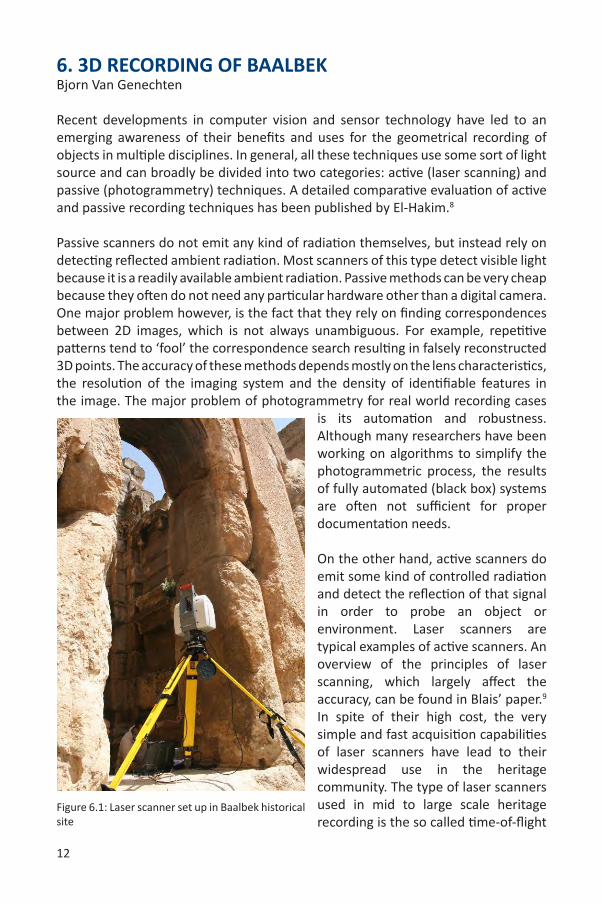
On the other hand, active scanners do emit some kind of controlled radiation and detect the reflection of that signal in order to probe an object or environment. Laser scanners are typical examples of active scanners. An overview of the principles of laser scanning, which largely affect the accuracy, can be found in Blais’ paper.9 In spite of their high cost, the very simple and fast acquisition capabilities of laser scanners have lead to their widespread use in the heritage community. The type of laser scanners used in mid to large scale heritage recording is the so called time-of-flight
Figure 6.1: Laser scanner set up in Baalbek historical site
13
scanners. These scanners measure distances to surfaces by measuring the time interval between sending a signal and receiving a part of its reflection off the surface. Knowing the travelling speed of the signal, the distance to the scanner can be calculated. Laser scanners are easy-to-use instruments and are reliable in their data output. One of the major differences between laser scanning and traditional surveying techniques is the fact that most traditional surveying techniques are selective. This means that the operator or surveyor selects and records the points which he or she thinks are important. Laser scanning is a non-selective technique, as it scans everything. This fact is important when looking for structural integrity. Using laser scanning data, the structure as a whole can be considered instead of spurious points on the object or surface of interest. The specifications of today’s laser scanners allow them to scan approximately 10.000 to 1.000.000 points per second up to a distance of 200 meters, with an accuracy of 5 millimetres. Compared to traditional surveying, contemporary recording techniques, such as laser scanning or photogrammetry, require a substantial post-processing step. The processing of point cloud data (derived from laser scanning or automated photogrammetry) involves data conversion, data cleaning, registration, texturing and modelling.
A wide range of applications in cultural heritage documentation benefit from the three-dimensional recording and modelling of real world objects and scenes. Generally, the application itself involves certain requirements like the level of accuracy, the required detail and/or the level of photorealism.10 However, because of budget restrictions and lack of competence, additional specifications, such as full automation, low cost, portability, flexibility, and efficiency are often desirable.
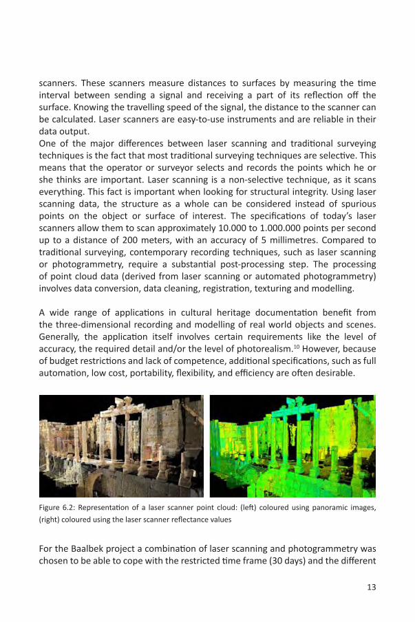
Figure 6.2: Representation of a laser scanner point cloud: (left) coloured using panoramic images,
(right) coloured using the laser scanner reflectance values
For the Baalbek project a combination of laser scanning and photogrammetry was chosen to be able to cope with the restricted time frame (30 days) and the different
14
object scales of the site. Laser scanning was used to acquire the major structure of the site, while close-range photogrammetry was used to reconstruct some of the famous sculptures embedded in the best kept parts of the archaeological site. The combination of both techniques leads to an accurate recording with proper detail that can be used for archiving, structural analysis, condition mapping, or the generation of ‘as-is’ plans of the site.
The project’s aim was to teach a selected group of professionals from the DGA and some surveying experts from a local surveying company (Bureau Stephan) about good practice and execution of project implementation and producing adequate deliverables. Therefore, every step of the project was discussed and for every decision made, the reasons were properly explained.
Phase 1: ReconnaissanceThe first phase in any heritage recording project is the reconnaissance phase. It deals with analysing the scope and the complexity of the physical configuration of the site, required for the planning of the scanner locations and the preparation of the survey control network. This control network has a twofold purpose. First of all, it is used to link scan datasets from different days to each other, creating a full description of the site. Secondly, it provides a stable platform that allows to link datasets from different times to each other, making it possible to perform comparisons and detect changes over time, for instance, in the event of an earthquake.
All scanner positions were carefully planned and marked on a 2D map together with the area to be scanned from that position. Taking into account the effects of heat and the lack of power sockets for the laptop and the scanner, it was decided to make approximately 6 scans a day, of which some covered a field of view of 360 degrees, while others were focused on specific detailed areas. One important issue concerning the placement of the scanner requires special attention. When the scanner is placed near a wall, the scanner’s field of view needs to be split into an upper and a lower part, each with a separate probe point for setting the probe resolution. When the scanner is standing close to a wall, the distance between the closest point to the scanner and the furthest point is very large. As the resolution measure (see next paragraph) of a laser scanner is angle based, the resolution on such surfaces will be inhomogeneous. By splitting the field of view and probing multiple times, a proper resolution can be chosen, so that the final registered point clouds provide a more homogeneous spread of points. This is important in the post-processing phase, as many of the algorithms used there highly rely on an even spread of points.

15
Another part of the reconnaissance phase involves performing test scans in different areas using different recording resolutions. The resolution is the distance between the scanned points and is a crucial element for the level of detail that is recorded. The more points recorded in a certain surface area, the more surface details will be present in the final model. However, the more points to be scanned, the longer the scan will take to complete. As such, it is important to determine a good balance between speed and level of detail required. In close collaboration with heritage specialists of the Lebanon’s Directorate General of Antiquities (DGA), an appropriate level of detail (resolution) was agreed upon, taking into consideration the project scope (risk assessment), time frame, and available funds. A general “physical configuration” of standing structures on the property was scanned at a resolution of 1.5cm at the furthest probe point (the probe point is the distance at which the resolution is defined) and specifically identified areas were scanned at a resolution of 5mm.
Phase 2: Control networkThe second phase involved setting up the survey control network. As already mentioned in the previous paragraph, this network ensures the integrity of the different sets of data from one day of scanning, but also makes it possible to register scan data from different days into a global coordinate system to create a complete dataset of the site. The control network was split into an inner network, which resides inside the temple, and an outer network on the outer boundary of the temple. Both networks were interconnected at well-chosen points. As every single measurement to create the network contains a certain error, a full network adjustment was performed and resulted in a strong, robust and very accurate control network. The accuracy of the network was within the 2 mm range for each position of the control points.
An additional purpose of the control network is to provide means to monitor changes affecting the integrity of the property over the years. Since the Baalbek site is situated in an area prone to earthquakes, it is important to monitor the movement of certain structures in order to ensure the safety of the visitors and that of the structure itself. It is planned to carry out regular scanning of specific critical areas every 5 years in order to detect eventual movement. This allows for a proper decision making in the conservation process before the occurrence of any catastrophic event.
Phase 3: Laser ScanningFor the laser scanning of the Baalbek heritage site, a Leica Scanstation 2 laser scanner was used. This is a pulse-based scanner that has an accuracy of approximately 4 mm per measured point and has a built-in photographic 5 MP camera. During the first
16
week of the scanning phase, the laser scanner expert from the Raymond Lemaire International Centre for Conservation provided training to a selected group of DGA personnel and an external local surveying company (Bureau Stephan) on the use and handling of the equipment and the parameter settings. During this training session, the planned scanner locations, scanner parameters and the planned time frame were evaluated. The planned 6 scans a day did not seem to be a problem.
At the start of the project, it was identified that heat and exposure to direct sunlight affected the survey target accuracy. These metal or plastic targets are necessary to connect several scans and should be placed strategically to be visible from all scanning positions of one day. The targets are also surveyed from the control network, using a high precision total station, to be able to integrate each day of scanning into a complete dataset of the site. However, due to large temperature fluctuations during a day and their exposure to direct sunlight, the targets suffered from thermal expansion, causing them to move. In order to partially solve this problem, targets were covered with pillow covers during the remainder of the scanning phase. In a number of scans, it can also be seen that thermo columns of hot air refract the laser beam, causing excessive noise in the resulting point clouds. In order to overcome this problem, scanning was mostly performed early in the morning.
As already mentioned, the scanner has a built-in photographic camera. However, this camera does not have automatic exposure settings and the quality of the final images does not satisfy the needs required. Therefore, a high-resolution digital reflex camera equipped with a fish-eye lens, mounted on the exact same position of the scanner eye, was used to capture spherical panoramic images. The colours of these high resolution panoramas could later be mapped onto the point cloud data from the laser scanner, in order to provide more information and texture of the fabric’s physical configuration.
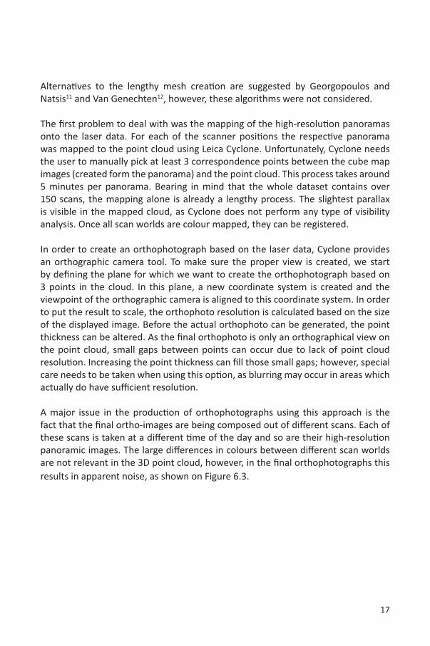
Post-Processing: Generating OrthophotographsAs described in the introduction, laser scanning and automated photogrammetry require a lengthy post-processing phase in order to generate useful data representations for risk assessment. The main deliverables of this post-processing phase are two-dimensional orthophotographs for surface condition survey (construction material and weathering forms) and 3D meshed models for structural analysis. Several methods exist for creating orthophotographs from laser scan data. They all require the geometry of the object to be described in the form of a mesh (a set of connected triangles describing the surface geometry). As the processing/training time frame was very limited, it was decided to generate the orthophotographs directly from the point clouds using the Leica Cyclone software.
17
Alternatives to the lengthy mesh creation are suggested by Georgopoulos and Natsis11 and Van Genechten12, however, these algorithms were not considered.
The first problem to deal with was the mapping of the high-resolution panoramas onto the laser data. For each of the scanner positions the respective panorama was mapped to the point cloud using Leica Cyclone. Unfortunately, Cyclone needs the user to manually pick at least 3 correspondence points between the cube map images (created form the panorama) and the point cloud. This process takes around 5 minutes per panorama. Bearing in mind that the whole dataset contains over 150 scans, the mapping alone is already a lengthy process. The slightest parallax is visible in the mapped cloud, as Cyclone does not perform any type of visibility analysis. Once all scan worlds are colour mapped, they can be registered.
In order to create an orthophotograph based on the laser data, Cyclone provides an orthographic camera tool. To make sure the proper view is created, we start by defining the plane for which we want to create the orthophotograph based on 3 points in the cloud. In this plane, a new coordinate system is created and the viewpoint of the orthographic camera is aligned to this coordinate system. In order to put the result to scale, the orthophoto resolution is calculated based on the size of the displayed image. Before the actual orthophoto can be generated, the point thickness can be altered. As the final orthophoto is only an orthographical view on the point cloud, small gaps between points can occur due to lack of point cloud resolution. Increasing the point thickness can fill those small gaps; however, special care needs to be taken when using this option, as blurring may occur in areas which actually do have sufficient resolution.
A major issue in the production of orthophotographs using this approach is the fact that the final ortho-images are being composed out of different scans. Each of these scans is taken at a different time of the day and so are their high-resolution panoramic images. The large differences in colours between different scan worlds are not relevant in the 3D point cloud, however, in the final orthophotographs this results in apparent noise, as shown on Figure 6.3.
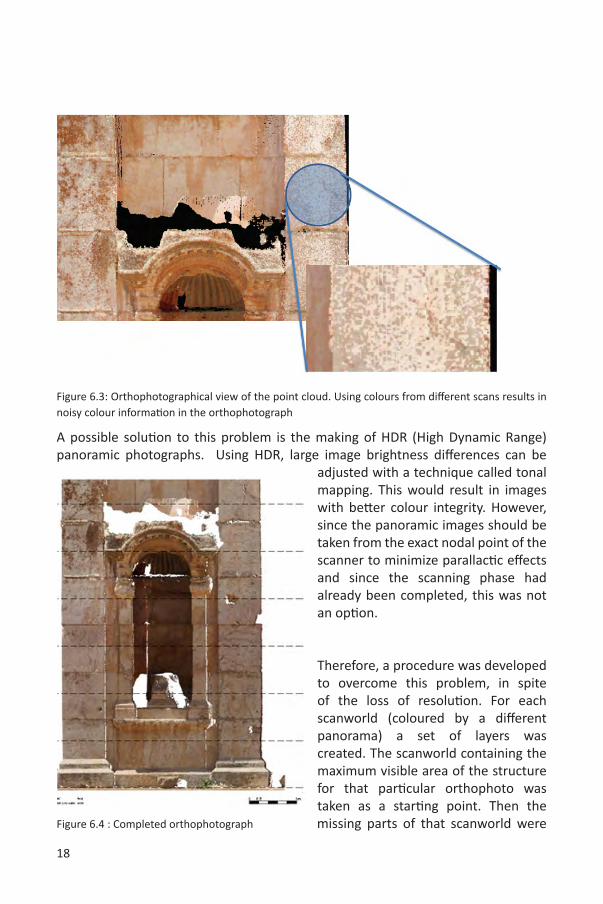
18
Figure 6.3: Orthophotographical view of the point cloud. Using colours from different scans results in noisy colour information in the orthophotograph
A possible solution to this problem is the making of HDR (High Dynamic Range) panoramic photographs. Using HDR, large image brightness differences can be
adjusted with a technique called tonal mapping. This would result in images with better colour integrity. However, since the panoramic images should be taken from the exact nodal point of the scanner to minimize parallactic effects and since the scanning phase had already been completed, this was not an option.
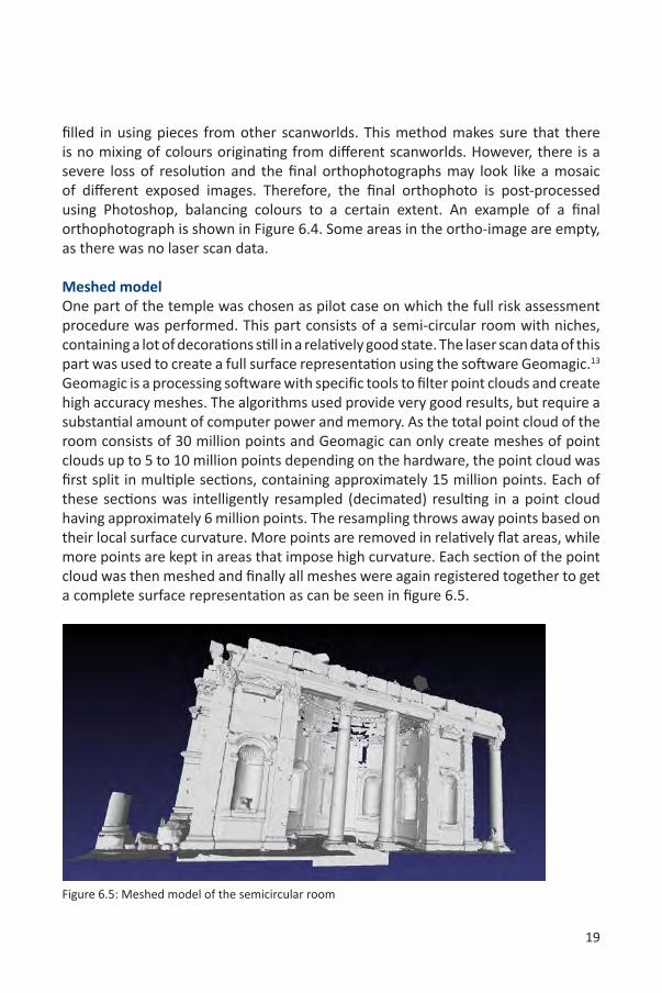
Therefore, a procedure was developed to overcome this problem, in spite of the loss of resolution. For each scanworld (coloured by a different panorama) a set of layers was created. The scanworld containing the maximum visible area of the structure for that particular orthophoto was taken as a starting point. Then the missing parts of that scanworld were Figure 6.4 : Completed orthophotograph
19
filled in using pieces from other scanworlds. This method makes sure that there is no mixing of colours originating from different scanworlds. However, there is a severe loss of resolution and the final orthophotographs may look like a mosaic of different exposed images. Therefore, the final orthophoto is post-processed using Photoshop, balancing colours to a certain extent. An example of a final orthophotograph is shown in Figure 6.4. Some areas in the ortho-image are empty, as there was no laser scan data.
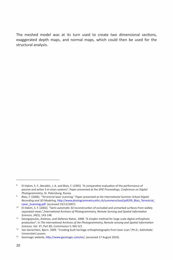
Meshed modelOne part of the temple was chosen as pilot case on which the full risk assessment procedure was performed. This part consists of a semi-circular room with niches, containing a lot of decorations still in a relatively good state. The laser scan data of this part was used to create a full surface representation using the software Geomagic.13 Geomagic is a processing software with specific tools to filter point clouds and create high accuracy meshes. The algorithms used provide very good results, but require a substantial amount of computer power and memory. As the total point cloud of the room consists of 30 million points and Geomagic can only create meshes of point clouds up to 5 to 10 million points depending on the hardware, the point cloud was first split in multiple sections, containing approximately 15 million points. Each of these sections was intelligently resampled (decimated) resulting in a point cloud having approximately 6 million points. The resampling throws away points based on their local surface curvature. More points are removed in relatively flat areas, while more points are kept in areas that impose high curvature. Each section of the point cloud was then meshed and finally all meshes were again registered together to get a complete surface representation as can be seen in figure 6.5.
Figure 6.5: Meshed model of the semicircular room
20
The meshed model was at its turn used to create two dimensional sections, exaggerated depth maps, and normal maps, which could then be used for the structural analysis.
8 El-Hakim, S. F., Beraldin, J.-A. and Blais, F. (1995). “A comparative evaluation of the performance of passive and active 3-d vision systems”, Paper presented at the SPIE Proceedings, Conference on Digital Photogrammetry, St. Petersburg, Russia.
9 Blais, F. (2006). “Terrestrial laser scanning.” Paper presented at the International Summer School Digital Recording and 3D Modeling, http://www.photogrammetry.ethz.ch/summerschool/pdf/09_Blais_Terrestrial_Laser_Scanning.pdf (accessed 19/12/2007)
10 El-Hakim, S. F. (2002). “Semi-automatic 3d reconstruction of occluded and unmarked surfaces from widely separated views.”,International Archives of Photogrammetry, Remote Sensing and Spatial Information Sciences, 34(5), 143-148.
11 Georgopoulos, Andreas, and Stefanos Natsis. 2008. “A simpler method for large scale digital orthophoto production”, In The international Archives of the Photogrammetry, Remote sensing and Spatial Information Sciences, Vol. 37, Part B5, Commission V, WG V/2.
12 Van Genechten, Bjorn. 2009. “Creating built heritage orthophotographs from laser scan.”,Ph.D., Katholieke Universiteit Leuven.
13 Geomagic website, http://www.geomagic.com/en/, (accessed 17 August 2010).
21
7. SELECTION OF A STUDY AREA Teresa Patricio
Risk management strategies help site managers to take decisions on structural interventions. In order to clarify the needs for a risk preparedness approach for Baalbek, it is valuable to first make reference to the ICOMOS charter of 2003 on the “Principles for the analysis, conservation and structural restoration of architectural heritage”.
“#2.6 - Before making a decision on structural intervention it is indispensable to determine first the causes of damage and decay, and then to evaluate the safety level of the structure.”
As the Charter states, it is necessary to evaluate “safety levels” before taking any decision of intervention; nevertheless, to proceed to this evaluation and to give a reliable estimation, a diagnosis of the problems is essential:
“#2.5 - Diagnosis is based on historical, qualitative and quantitative approaches; the qualitative approach being mainly based on direct observation of the structural damage and material decay as well as historical and archaeological research, and the quantitative approach mainly on material and structural tests, monitoring and structural analysis”.
Historical information is a key element to understand ancient structures, giving clues on damages to be expected. Baalbek is a multifaceted site, composed by a complex construction chronology. Besides, Baalbek has always been a centre of attention for archaeologists and architects involved in research, excavations and reconstructions.
“#2.3 - A full understanding of the structural and material characteristics is required in conservation practice. Information is essential on the structure in its original and earlier states, on the techniques that were used in the construction, on the alterations and their effects, on the phenomena that have occurred, and, finally, on its present state. “
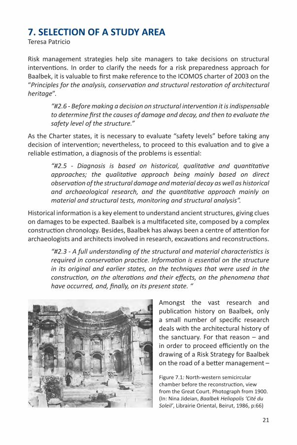
Amongst the vast research and publication history on Baalbek, only a small number of specific research deals with the architectural history of the sanctuary. For that reason – and in order to proceed efficiently on the drawing of a Risk Strategy for Baalbek on the road of a better management –
Figure 7.1: North-western semicircular chamber before the reconstruction, view from the Great Court. Photograph from 1900. (In: Nina Jideian, Baalbek Heliopolis ‘Cité du Soleil’, Librairie Oriental, Beirut, 1986, p:66)
22
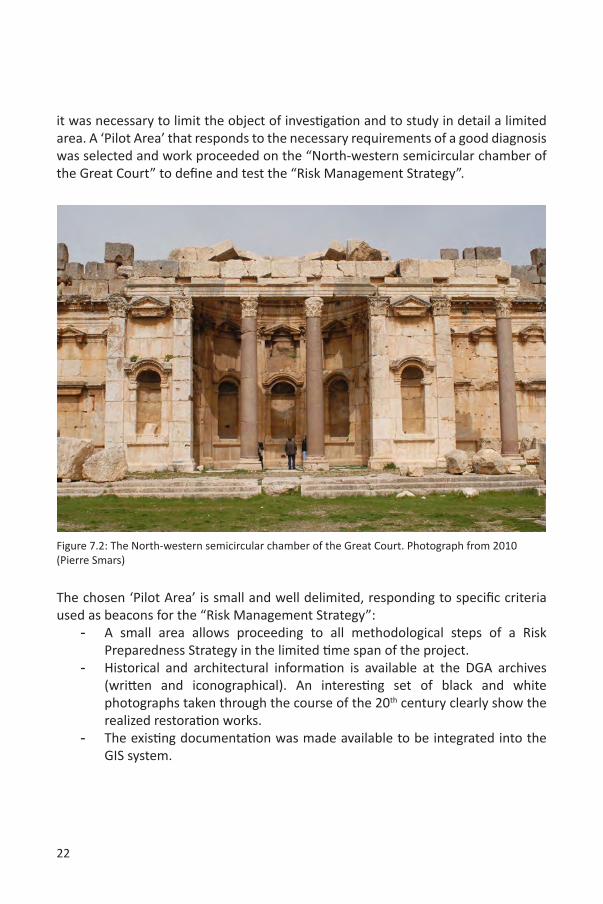
it was necessary to limit the object of investigation and to study in detail a limited area. A ‘Pilot Area’ that responds to the necessary requirements of a good diagnosis was selected and work proceeded on the “North-western semicircular chamber of the Great Court” to define and test the “Risk Management Strategy”.
The chosen ‘Pilot Area’ is small and well delimited, responding to specific criteria used as beacons for the “Risk Management Strategy”:
- A small area allows proceeding to all methodological steps of a Risk Preparedness Strategy in the limited time span of the project.
- Historical and architectural information is available at the DGA archives (written and iconographical). An interesting set of black and white photographs taken through the course of the 20th century clearly show the realized restoration works.
- The existing documentation was made available to be integrated into the GIS system.
Figure 7.2: The North-western semicircular chamber of the Great Court. Photograph from 2010 (Pierre Smars)
23
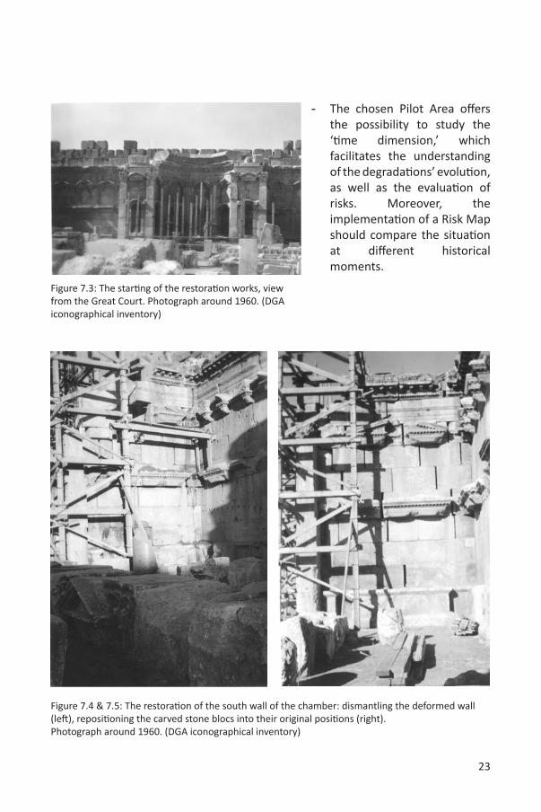
- The chosen Pilot Area offers the possibility to study the ‘time dimension,’ which facilitates the understanding of the degradations’ evolution, as well as the evaluation of risks. Moreover, the implementation of a Risk Map should compare the situation at different historical moments.
Figure 7.3: The starting of the restoration works, view from the Great Court. Photograph around 1960. (DGA iconographical inventory)
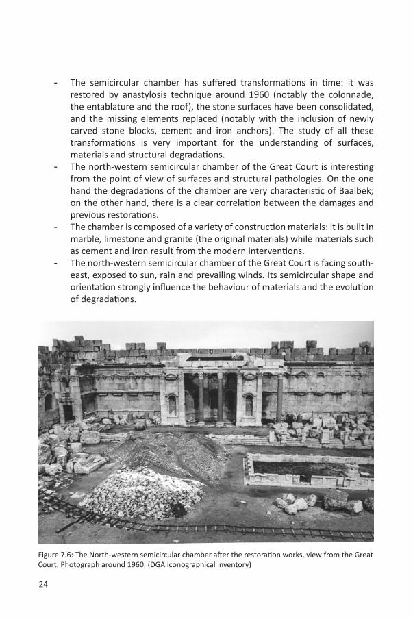
Figure 7.4 & 7.5: The restoration of the south wall of the chamber: dismantling the deformed wall (left), repositioning the carved stone blocs into their original positions (right). Photograph around 1960. (DGA iconographical inventory)
24
- The semicircular chamber has suffered transformations in time: it was restored by anastylosis technique around 1960 (notably the colonnade, the entablature and the roof), the stone surfaces have been consolidated, and the missing elements replaced (notably with the inclusion of newly carved stone blocks, cement and iron anchors). The study of all these transformations is very important for the understanding of surfaces, materials and structural degradations.
- The north-western semicircular chamber of the Great Court is interesting from the point of view of surfaces and structural pathologies. On the one hand the degradations of the chamber are very characteristic of Baalbek; on the other hand, there is a clear correlation between the damages and previous restorations.
- The chamber is composed of a variety of construction materials: it is built in marble, limestone and granite (the original materials) while materials such as cement and iron result from the modern interventions.
- The north-western semicircular chamber of the Great Court is facing south-east, exposed to sun, rain and prevailing winds. Its semicircular shape and orientation strongly influence the behaviour of materials and the evolution of degradations.
Figure 7.6: The North-western semicircular chamber after the restoration works, view from the Great Court. Photograph around 1960. (DGA iconographical inventory)
25
8. CONDITION SURVEY AND DAMAGE ATLAS OF BAALBEKby Teresa Patrício
The deterioration of building materials is related to their intrinsic properties (chemical and mineralogical composition, petrography and porosity), the environmental characteristics and their exposure to these. Related to this, the history of the building and its construction techniques are also important matters. To be systematic and useful, an accurate examination requires a precise classification founded on the identification of factors influencing material deterioration. In the context of building stone decay, these controlling factors include – as defined by the ICOMOS Scientific Committee for Stone14– architectural factors (form, proportions and alterations through time); and physical factors, climatology, petrology, chemistry, biology and ageing.
ProcedureSince the available data concerning previous surface condition assessments were insufficient, it was decided to proceed with a complete assessment of the surface degradations in the Great Court’s north-western semicircular chamber. The data acquisition was based on the 3D digital data and orthophotographs at a scale of 1:20 were used for the visual inspection. The resulting Site Atlas on Surface Condition was prepared in collaboration with Lebanon’s Directorate General of Antiquities (DGA), compiling the data gathered in-situ. The procedure aimed at carrying out thorough investigations and assessments and making sound diagnosis. The applied methodology is presented in a flowchart below (Table 8.1).
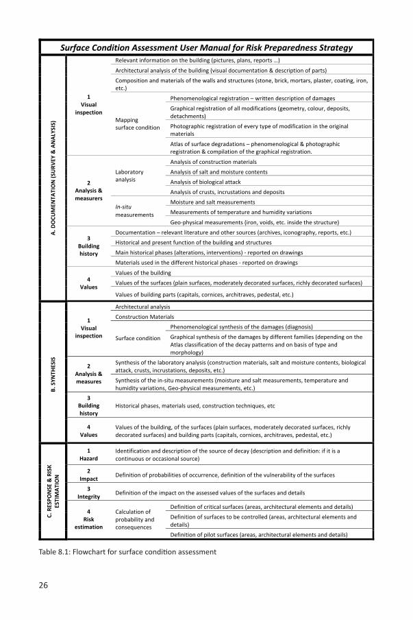
26
Table 8.1: Flowchart for surface condition assessment
27
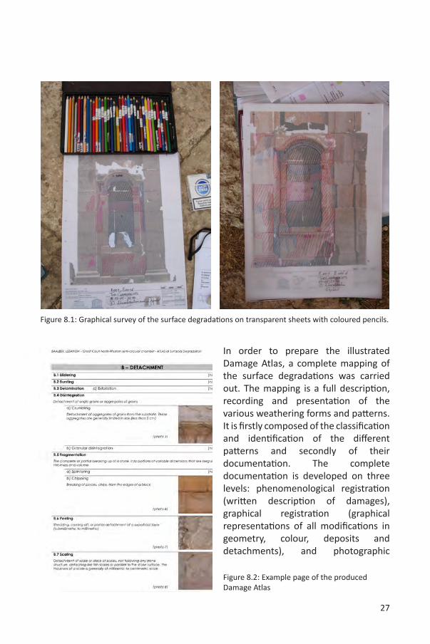
In order to prepare the illustrated Damage Atlas, a complete mapping of the surface degradations was carried out. The mapping is a full description, recording and presentation of the various weathering forms and patterns. It is firstly composed of the classification and identification of the different patterns and secondly of their documentation. The complete documentation is developed on three levels: phenomenological registration (written description of damages), graphical registration (graphical representations of all modifications in geometry, colour, deposits and detachments), and photographic
Figure 8.1: Graphical survey of the surface degradations on transparent sheets with coloured pencils.
Figure 8.2: Example page of the produced Damage Atlas
28
registration of every type of modification in the original materials’ morphology.
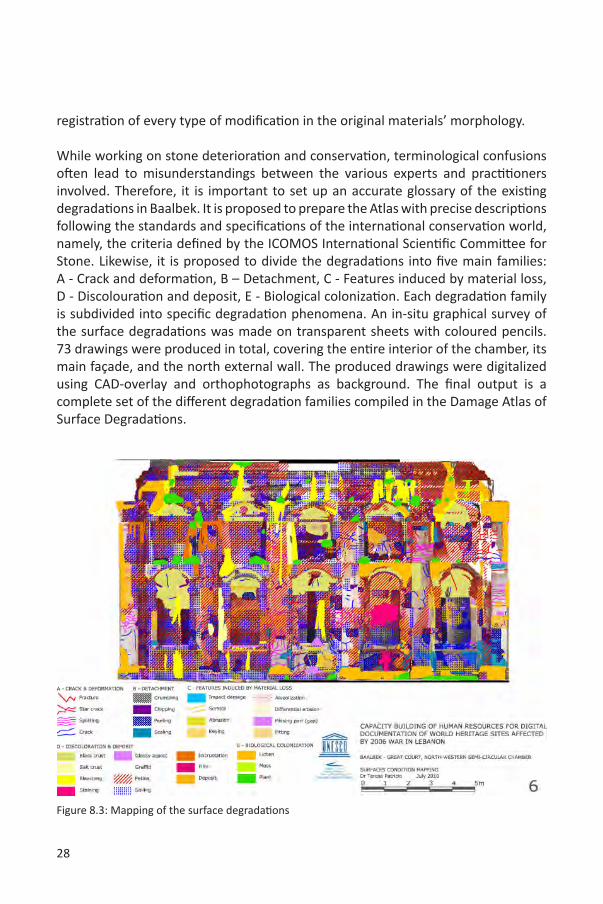
While working on stone deterioration and conservation, terminological confusions often lead to misunderstandings between the various experts and practitioners involved. Therefore, it is important to set up an accurate glossary of the existing degradations in Baalbek. It is proposed to prepare the Atlas with precise descriptions following the standards and specifications of the international conservation world, namely, the criteria defined by the ICOMOS International Scientific Committee for Stone. Likewise, it is proposed to divide the degradations into five main families: A - Crack and deformation, B – Detachment, C - Features induced by material loss, D - Discolouration and deposit, E - Biological colonization. Each degradation family is subdivided into specific degradation phenomena. An in-situ graphical survey of the surface degradations was made on transparent sheets with coloured pencils. 73 drawings were produced in total, covering the entire interior of the chamber, its main façade, and the north external wall. The produced drawings were digitalized using CAD-overlay and orthophotographs as background. The final output is a complete set of the different degradation families compiled in the Damage Atlas of Surface Degradations.
Figure 8.3: Mapping of the surface degradations

29
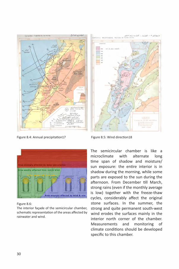
In order to comprehend the surface degradations of the semicircular chamber, it is necessary to study (in-situ and in the laboratory) the materials (decayed or not) as well as the various environmental parameters and their influences on the material surfaces. The laboratory analysis and in-situ measurements provide essential information for a proper risk assessment. Although the laboratory analysis and in-situ measurements were not part of the project, it was decided to briefly examine the weather conditions in Baalbek. Variations in pressure, temperature and humidity may explain the different material degradations and especially their evolution through time.
Table 8.2: Average precipitation in the Beqaa valley.15
Table 8.3: Average annual temperature in the Beqaa valley.16
30
The semicircular chamber is like a microclimate with alternate long time span of shadow and moisture/sun exposure: the entire interior is in shadow during the morning, while some parts are exposed to the sun during the afternoon. From December till March, strong rains (even if the monthly average is low) together with the freeze-thaw cycles, considerably affect the original stone surfaces. In the summer, the strong and quite permanent south-west wind erodes the surfaces mainly in the interior north corner of the chamber. Measurements and monitoring of climate conditions should be developed specific to this chamber.
Figure 8.4: Annual precipitation17 Figure 8.5: Wind direction18
Figure 8.6: The interior façade of the semicircular chamber, schematic representation of the areas affected by rainwater and wind.

31
For a proper understanding of the degradations’ evolution, the notion of time is fundamental, because it greatly facilitates the evaluation of the risks. For this reason, the risk assessment takes into account the historical data and the reported changes through time. During the Surface Condition Mapping all the transformations and historical phases of the structure were added to the maps (restorations, new additions, and new materials). The north-western semicircular chamber suffered several modifications through time, such as reconstruction (colonnade, entablature and roof), surface restorations and the completion of missing parts (with new stone blocks, concrete and iron). To complete the information about the
Figure 8.7: Mapping of the previous interventions and materials on the interior wall of the semicircular chamber.
32
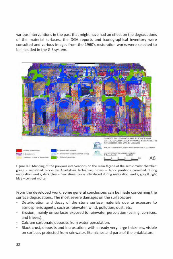
Figure 8.8: Mapping of the previous interventions on the main façade of the semicircular chamber: green - reinstated blocks by Anastylosis technique; brown – block positions corrected during restoration works; dark blue – new stone blocks introduced during restoration works; grey & light blue – cement mortar
various interventions in the past that might have had an effect on the degradations of the material surfaces, the DGA reports and iconographical inventory were consulted and various images from the 1960’s restoration works were selected to be included in the GIS system.
From the developed work, some general conclusions can be made concerning the surface degradations. The most severe damages on the surfaces are:- Deterioration and decay of the stone surface materials due to exposure to
atmospheric agents, such as rainwater, wind, pollution, dust, etc.- Erosion, mainly on surfaces exposed to rainwater percolation (ceiling, cornices,
and friezes). - Calcium carbonate deposits from water percolation.- Black crust, deposits and incrustation, with already very large thickness, visible
on surfaces protected from rainwater, like niches and parts of the entablature.
33
- Pinkish and brown patinas cover the entire stone surfaces (all over the site).- Thin layers of exogenous particles giving a dirty appearance to the surfaces
(soiling). The soiling is present almost all over the chamber, except in the areas suffering from water percolation. In some situations, the particles form concretions. The soiling is due to the strong winds (dust deposits) but probably also to soot deposits.
- Crumbling, scaling, and peeling with fissuring mainly due to the poor-quality of the stone and to the effect of freezing and thawing. These are the most serious degradation patterns.
- Iron within the structure (probably suffering from corrosion) provokes several fissuring phenomena visible on the stone surfaces. The presence of iron is a result of the 20th century interventions, consisting mainly of the re-erection of carved stone blocks, using reinforced concrete.
- Salt crust related to the water percolation and the use of modern cement.- Anthropogenic action, related to visitor behaviour and the carrying capacity of
the site, has several negative effects, such as scratching, modern graffiti, and other types of incisions, stains, film and gloss layers.
- Biological colonization (mainly lichens) is present on almost all surfaces exposed to rain, or parts of the structure with high moisture content. Plants are also present, mostly on horizontal surfaces where the water stagnates, like niches, the top of capitals and pediments. In some cases, the plants have already large roots.
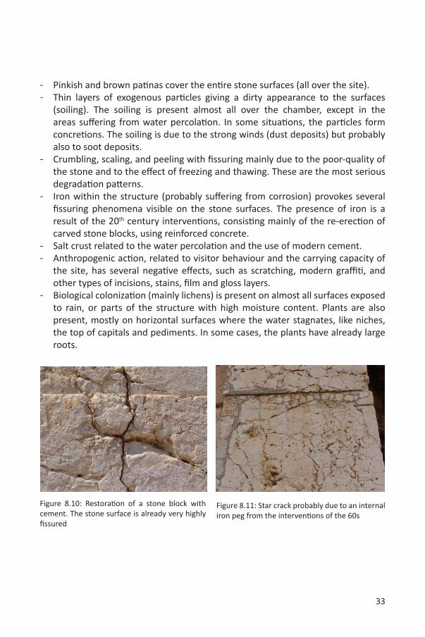
Figure 8.10: Restoration of a stone block with cement. The stone surface is already very highly fissured
Figure 8.11: Star crack probably due to an internal iron peg from the interventions of the 60s
34
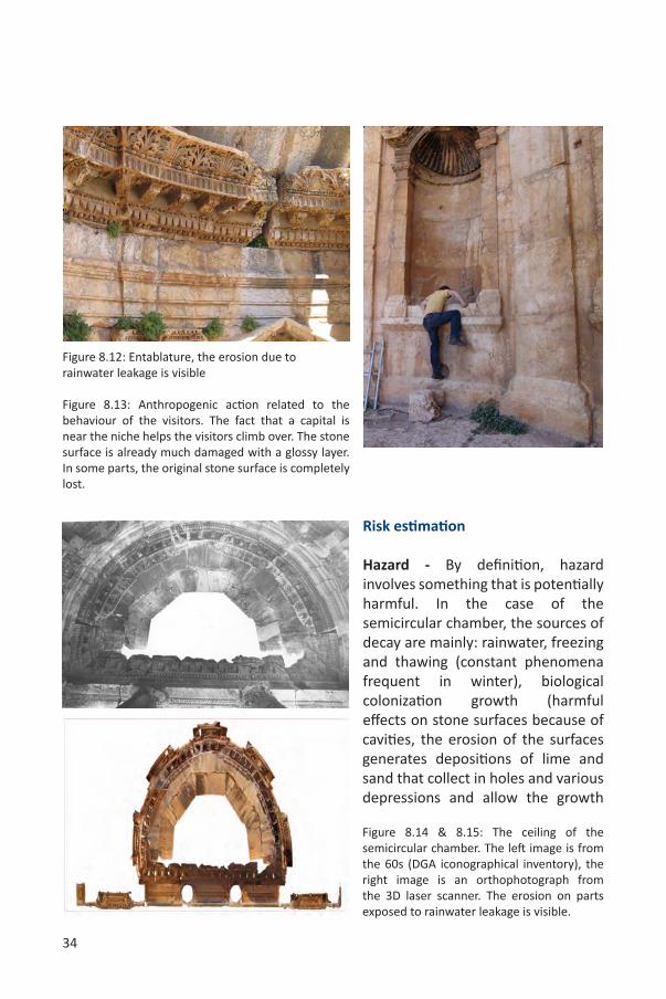
Figure 8.12: Entablature, the erosion due to rainwater leakage is visible
Figure 8.13: Anthropogenic action related to the behaviour of the visitors. The fact that a capital is near the niche helps the visitors climb over. The stone surface is already much damaged with a glossy layer. In some parts, the original stone surface is completely lost.
Risk estimation
Hazard - By definition, hazard involves something that is potentially harmful. In the case of the semicircular chamber, the sources of decay are mainly: rainwater, freezing and thawing (constant phenomena frequent in winter), biological colonization growth (harmful effects on stone surfaces because of cavities, the erosion of the surfaces generates depositions of lime and sand that collect in holes and various depressions and allow the growth
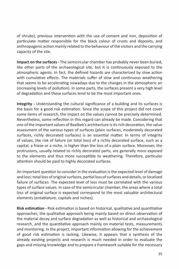
Figure 8.14 & 8.15: The ceiling of the semicircular chamber. The left image is from the 60s (DGA iconographical inventory), the right image is an orthophotograph from the 3D laser scanner. The erosion on parts exposed to rainwater leakage is visible.
35
of shrubs), previous intervention with the use of cement and iron, deposition of particulate matter responsible for the black colour of crusts and deposits, and anthropogenic action mainly related to the behaviour of the visitors and the carrying capacity of the site.
Impact on the surfaces - The semicircular chamber has probably never been buried, like other parts of the archaeological site, but it is continuously exposed to the atmospheric agents. In fact, the defined hazards are characterized by slow action with cumulative effects. The materials suffer of slow and continuous weathering that seems to be accelerating nowadays due to the changes in the atmospheric air (increasing levels of pollution). In some parts, the surfaces present a very high level of degradation and these surfaces tend to be the most important ones.
Integrity - Understanding the cultural significance of a building and its surfaces is the basis for a good risk estimation. Since the scope of this project did not cover some items of research, the impact on the values cannot be precisely determined. Nevertheless, some reflection in this regard can already be made. Considering that one of the important values of Baalbek’s architecture is its rich decoration, the value assessment of the various types of surfaces (plain surfaces, moderately decorated surfaces, richly decorated surfaces) is an essential matter. In terms of integrity of values, the risk of failure (or total loss) of a richly decorated surface, such as a capital, a frieze or a niche, is higher than the loss of a plain surface. Moreover, the protrusions, usually related to richly decorated parts, are generally more exposed to the elements and thus more susceptible to weathering. Therefore, particular attention should be paid to highly decorated surfaces.
An important question to consider in the evaluation is the expected level of damage and loss: total loss of original surfaces, partial loss of surfaces and details, or localized failure of surfaces. The expected level of loss must be correlated with the various types of surface values. In case of the semicircular chamber, the areas where a total loss of original surface is expected correspond to the most valuable architectural elements (entablature, capitals and niches).
Risk estimation - Risk estimation is based on historical, qualitative and quantitative approaches; the qualitative approach being mainly based on direct observation of the material decay and surface degradation as well as historical and archaeological research, and the quantitative approach mainly on material tests, measurements and monitoring. In the project, important information allowing for the achievement of good risk estimation is lacking. Likewise, it appears that a synthesis of the already existing projects and research is much needed in order to evaluate the gaps and missing knowledge and to prepare a framework suitable for the necessary
36
conservation of the surfaces (and the site).
In view of the gaps in the research, the risk estimation of the surfaces is approximate and should be controlled and supported by a more in-depth research in the future. For the risk estimation, different areas of surfaces were defined:
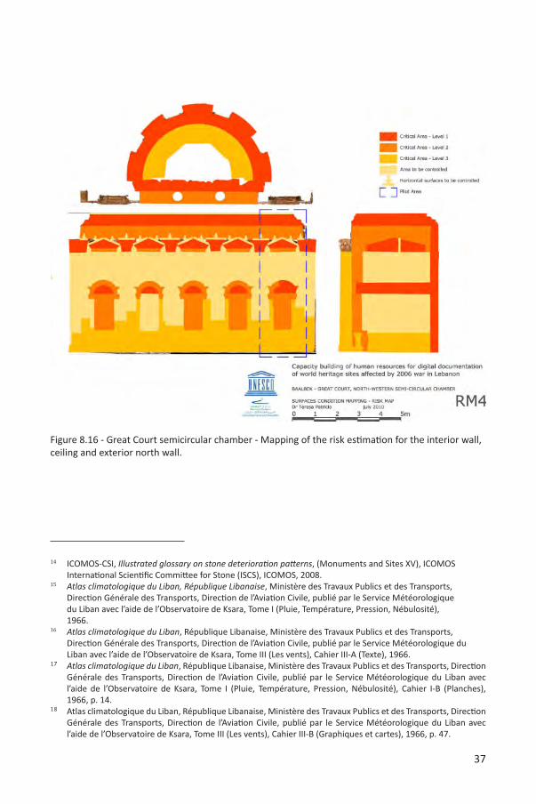
- Critical areas - risk of irreversible damage and loss of integrity.o Level 1: surfaces with severe level of degradation – High level of integrity
loss. o Level 2: surfaces with advanced state of degradation – Moderate level of
integrity loss.o Level 3: surfaces with advanced state of degradation – Low level of
integrity loss.- Areas to be controlled – reversible damages and low level of integrity loss.
These areas are characterized by soft and reversible damages, if prompt conservation action is taken and should be controlled regularly (monitoring the damages through time).
- Pilot area – area characterized by all types of damages, where the hazards are more recurrent. The monitoring of this area is fundamental for the comprehension of the damages’ evolution, the impacts of hazards, and the impacts on values.
37
Figure 8.16 - Great Court semicircular chamber - Mapping of the risk estimation for the interior wall, ceiling and exterior north wall.
14 ICOMOS-CSI, Illustrated glossary on stone deterioration patterns, (Monuments and Sites XV), ICOMOS International Scientific Committee for Stone (ISCS), ICOMOS, 2008.
15 Atlas climatologique du Liban, République Libanaise, Ministère des Travaux Publics et des Transports, Direction Générale des Transports, Direction de l’Aviation Civile, publié par le Service Météorologique du Liban avec l’aide de l’Observatoire de Ksara, Tome I (Pluie, Température, Pression, Nébulosité), 1966.
16 Atlas climatologique du Liban, République Libanaise, Ministère des Travaux Publics et des Transports, Direction Générale des Transports, Direction de l’Aviation Civile, publié par le Service Météorologique du Liban avec l’aide de l’Observatoire de Ksara, Tome III (Les vents), Cahier III-A (Texte), 1966.
17 Atlas climatologique du Liban, République Libanaise, Ministère des Travaux Publics et des Transports, Direction Générale des Transports, Direction de l’Aviation Civile, publié par le Service Météorologique du Liban avec l’aide de l’Observatoire de Ksara, Tome I (Pluie, Température, Pression, Nébulosité), Cahier I-B (Planches), 1966, p. 14.
18 Atlas climatologique du Liban, République Libanaise, Ministère des Travaux Publics et des Transports, Direction Générale des Transports, Direction de l’Aviation Civile, publié par le Service Météorologique du Liban avec l’aide de l’Observatoire de Ksara, Tome III (Les vents), Cahier III-B (Graphiques et cartes), 1966, p. 47.
38
9. STRUCTURAL INTEGRITY OF BAALBEKPierre Smars
The present section focuses on the “structural risks” affecting the archaeological site of Baalbek, resulting from its exposure to various kinds of hazards, either natural (earthquakes, storms, etc), or human (vandalism, armed conflicts, etc).
The interest of a Risk Preparedness Strategy (RPS) results from the fact that resources are limited and risks are endangering the values at stake (affecting the site and its visitors). It is therefore reasonable to prepare a strategy to maximise the effectiveness of the actions which are taken. The main outcome is the definition of priorities: where and when should the money be first spent to better protect the values at stake? A risk map will synthesize the key elements of decision about possible actions on specific buildings of the site:
• No action; understand the risk (hopefully) and accept it.
• Structural mitigation; interventions on the building: reinforcements (with various level of intensity, from maintenance to more extreme interventions[1]).
• Non-structural mitigation; reduce the “human-related” vulnerability (limit/control access, document structures to facilitate post-disaster repairs, prepare an effective disaster response...).
• Improvement of knowledge (gather new data, prepare detailed studies in order to get better estimates of the risks).
The following text intends to precise the steps necessary for the establishment of such a structural risk map for the site. Due to an unexpected lack of data and limited time, it is not possible to produce a map at this stage.
Conceptually, a quantitative evaluation of the structural risks seems possible. PEER, the Pacific Earthquake Engineering Research Center has for instance developed a very complete framework for a scientific evaluation of seismic performance of buildings: performance-based earthquake engineering (PBEE).19 A requirement of this approach is to be able to precisely characterise hazards (earthquake occurrence), vulnerability (the structural resilience of the buildings, the estimation of which requires the ability to predict the physical effect of a given earthquake on the building) and expected losses (consequence of a deterioration on the values).
This is an excellent direction to follow but a difficult one (especially at this stage). In the reality of Baalbek – and actually of many other sites or buildings – difficulties arise. Quantitative evaluations are tainted by uncertainties: statistical uncertainties (which can be quantified and dealt with by PBEE) but also epistemic uncertainties (related to insufficient knowledge on the process involved, the choice of models, etc.)
39
In the case of the structures of the archaeological site of Baalbek, the major problems are:
• No results from previous studies can be used to quantify structural risks: most structures were not yet studied and the safety levels of those studied were not evaluated[2].
• At this stage, data is too scarce to characterise statistical uncertainties (precisely enough to be useful).
• There are numerous epistemic uncertainties. Some aspects are not yet addressed: quantitative evaluation of the vulnerability: models used in the framework of previous studies to evaluate structures of the site were clearly not sophisticated enough (estimating the seismic vulnerability of large block masonry structures is not trivial20), exposure of the public to dangers, definition of the values...
This type of situation is not exceptional. Klinke and Rena21 categorise risks, assigning them to specific classes: (low intensity, low probability), (high intensity, low probability), (unknown probability, given intensity, high uncertainty). They then propose to give to each class a special treatment. When uncertainties are high, a first obvious measure is to improve knowledge. An intermediate conclusion (if one is ultimately targeting a PBEE type approach, a risk-based approach following Klinke and Rena) is that a RPS should not be static: the approach is likely to be mainly qualitative at first and to acquire progressively more quantitative elements[3].
• New research can help provide better estimates of the statistical uncertainties (a local evaluation of the seismic hazard – taking into account the geological situation of the site, investigations on the materials...)
• New research can help reduce epistemic uncertainties (transforming them in statistical uncertainties). Examples: research on the construction techniques and on the inner constitution of the structures (survey and non-destructive techniques).
Other sources of information (possibly more qualitative[4] and often related to the time dimension of the problem), can also be used to give useful clues for a better modelling and more assurance to a diagnosis:
• Historical information (Fig. 9.1): Many structures of the site still hold traces of past earthquakes (the last important one occurred in 1759) and previous interventions. Analysing them can help us understand the behaviour of the structures and also evaluate the effects to be expected in case of a new occurrence.
40
• Changes should be monitored22: The implementation of the “risk map” will allow an easy comparison of the situation at different periods.
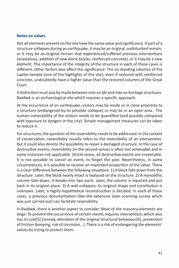
• Structural pathology analysis: A good understanding of existing pathologies (resulting from past events) and their possible evolution greatly facilitates the evaluation of risks. Interpretation maps were prepared using data gathered by a laser scanner (Fig. 9.2).
Figure 9.2: Eastern wall elevation of the semicircular chamber of the Great Court (1/100). Colours indicate the distance between the surface of the wall and a vertical reference plane fitting the wall (distance from red to blue: 10cm, blue is closer). They show that the wall is broken (along a roughly vertical hinge line clearly marked by cracks). Variations of colours indicate also that the precise deformation of the structure is more complex. Isolines (interval: 1cm) help a quantitative interpretation.
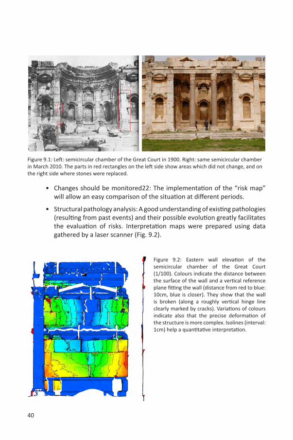
Figure 9.1: Left: semicircular chamber of the Great Court in 1900. Right: same semicircular chamber in March 2010. The parts in red rectangles on the left side show areas which did not change, and on the right side where stones were replaced.
41
Notes on values
Not all elements present on the site have the same value and significance. If part of a structure collapses during an earthquake, it may be an original, undisturbed remain, or it may be an original remain that experienced/suffered previous interventions (anastylosis, addition of new stone blocks, reinforced concrete), or it may be a new element. The importance of the integrity of the structure in each of these cases is different. Other factors also affect the significance. The six standing columns of the Jupiter temple (one of the highlights of the site), even if restored with reinforced concrete, undoubtedly have a higher value than the restored columns of the Great Court.
A distinction must also be made between risks on life and risks on heritage structures. Baalbek is an archaeological site which requires a specific approach.
At the occurrence of an earthquake, visitors may be inside or in close proximity to a structure (endangered by its possible collapse) or may be in an open area. The human vulnerability of the visitors needs to be quantified (and possibly compared with exposure to dangers in the city). Simple management measures can be taken to reduce it.
For structures, the question of the reversibility needs to be addressed. In the context of conservation, reversibility usually refers to the reversibility of an intervention. But it could also denote the possibility to repair a damaged structure. In the case of destructive events, reversibility (in the second sense) is often not achievable and in some instances not applicable. Stricto sensu, all destructive events are irreversible. It is not possible to cancel an event, to forget the past. Nevertheless, in some circumstances, it is possible to recover an important proportion of the value. There is a clear difference between the following situations: 1) A block falls down from the structure. Later, the block nearly intact is replaced on the structure. 2) A monolithic column falls down, it breaks into two parts. Later, the column is repaired and put back in its original place. 3) A wall collapses, its original shape and constitution is unknown. Later, a highly hypothetical reconstruction is decided. In each of those cases, a previous documentation (like the extensive laser scanning survey which was just carried out) can facilitate reversibility.
In Baalbek, there is another aspect to consider. Most of the masonry elements are large. To prevent the occurrence of certain events requires intervention, which also has its cost[5] (money, alteration of the original structural behaviour[6], prevention of friction damping, risk of corrosion...). There is a risk of endangering the elements’ values by trying to protect them.
42
Recommendations:
• Develop strategies to reduce epistemic uncertainties and precise statistical uncertainties.
• Hold a debate among stakeholders to identify and prioritize the values to protect.
• Define (a) the hazards (local seismic study), (b) the data required for a vulnerability assessment (materials, construction techniques, walls constitution, reinforcements introduced, visitor habits...), (c) the values.
• Assess the vulnerability of critical structures: the columns of the temple of Jupiter, the temple of Bacchus...
• Develop collaborations with Universities or research centres to work on the previous points.
• Consider the possibility of direct measures to reduce vulnerabilities: control visitor routes in the site, move some of the most unstable blocks on some walls (or limit access to their proximity).
• Capacity building: train staff to document and monitor the evolution of the structural condition of the structures of the site.
• Preparedness: prepare a post-disaster action plan (determine respon-sibilities, evacuation of injured, measures of provisional reinforcements, etc.).
43
The following text references are taken from:ICOMOS. Principles for the analysis, conservation and structural restoration of architectural heritage, 2003. URL http://iscarsah.icomos.org/content/principles/ISCARSAH_Principles_English.pdf ICOMOS Charter.
[1] “1.7 No action should be undertaken without having ascertained the achievable benefit and harm to the architectural heritage, except in cases where urgent safeguarding measures are necessary to avoid the imminent collapse of the structures (e.g. after seismic damages); those urgent measures, however, should, when possible, avoid modifying the fabric in an irreversible way”.[2] “2.6 Before making a decision on structural intervention it is indispensable to determine first the causes of damage and decay, and then to evaluate the safety level of the structure”. See also Report on Activity 1 of “Capacity building of human resources for digital documentation of world heritage sites affected by the 2006 war in Lebanon”[3] “2.2 Data and information should first be processed approximately, to establish a more comprehensive plan of activities in proportion to the real problems of the structures.”[4] “2.5 Diagnosis is based on historical, qualitative and quantitative approaches; the qualitative approach being mainly based on direct observation of the structural damage and material decay as well as historical and archaeological research, and the quantitative approach mainly on material and structural tests, monitoring and structural analysis.”[5] “1.3 The value of architectural heritage is not only in its appearance, but also in the integrity of all its components as a unique product of the specific building technology of its time.”
[6] “2.4 In archaeological sites specific problems may be posed because structures have to be stabilized during excavation when knowledge is not yet complete. The structural responses to a “rediscovered” building may be completely different from those to an “exposed” building. Urgent site-structural-solutions, required to stabilize the structure as it is being excavated, should not compromise the complete building’s concept form and use.”
19 Keith A. Porter. “An overview of PEER’s performance-based earthquake engineering methodology”. In Ninth International Conference on Applications of Statistics and Probability in Civil Engineering (ICASP9) July 6-9, 2003, San Francisco, 2003.
Nicola Burati. Assessment of Seismic Safety: Response Surface Approach and Accelerogram Selection Issues. Ph.D. thesis, Università di Bologna, 2008. Dottorato di Ricerca in Meccanica delle Strutture, Ciclo XXI.
20 Matthew J. DeJong, Seismic Assessment Strategies for Masonry Structures, Ph.D. thesis, Massachusetts Institute of Technology, June 2009.
21 Andreas Klinke and Ortwin Rena. “A new approach to risk evaluation and management: Risk-based, precaution-based, and discourse-based strategies”. Risk Analysis (Society for Risk Analysis), 22(6):1071–1094, 2002.
22 ICOMOS. Principles for the analysis, conservation and structural restoration of architectural heritage, 2003. URL http://iscarsah.icomos.org/content/principles/ISCARSAH_Principles_English.pdf ICOMOS Charter.
44
10. PREPARING A RISK PREPAREDNESS APPROACHFOR BAALBEKTeresa Patricio
The ‘Risk Preparedness Strategy’ (RPS) for Baalbek is a tool prepared to help the site managers prevent or reduce the negative impacts of threats on the significance/integrity of the property and on human life. It deals with major threats, like earthquakes, but also with factors increasing the vulnerability to hazards. Minor factors, which can become preponderant with time because of their cumulative effects, are also considered: lack of maintenance, inadequate management, progressive erosion and deterioration.
The proposed RPS should further be integrated into the risk management plan. The development of this methodological process explores and defines a step-by-step working method, the responsibilities of the various protagonists, the elaboration of accurate and exhaustive analytical documentation, and the establishment of strategies based on the identification and constant assessment of values. This method allows for the development of plans, actions, concepts and proposals, with the sole aim being the preservation of historical property23.The strategies for Baalbek have the following aims: organizing and systematizing the risk estimation process; providing an interactive framework to guide and plan further mitigation actions, preventive conservation and monitoring; and identifying the tools, stakes and potentialities for sustainable preservation. The planned methodology presupposes six basic criteria, identified in order to guarantee the success of the process and necessary for the risk estimation of archaeological and architectural heritage:
- Professional ethics: The definition of the responsibilities, obligations and ethics of the various protagonists in the risk estimation process.
- Dynamic process: Preparation of a workflow based on scientific research - Sustainability: Sustainable risk estimation includes a program for preventive
conservation, mitigation, monitoring, maintenance and control based on the identified values for which Baalbek was inscribed on the World Heritage List.
- Integrated strategies: Defending the preparation of sustainable and integrated programs (risk estimation, preparedness strategies and decision making), as well as through the establishment of strategies based on the identified values for which Baalbek was inscribed on the World Heritage List.
- Commitment: Strengthening political commitment and coordination between the various public and private sector protagonists.
- Methodological holism: Archaeological properties and their contexts form a system in which factors are mutually interdependent, making it a system with a holistic nature. Thus, only a holistic interdisciplinary approach may be used in their study. This approach is a philosophical attitude, which irrevocably integrates all disciplines in the process and necessitates cooperation between professionals.
45
Using these criteria, the overall methodology for a RPS is inscribed on a general planning process for conservation (Flowchart 1) and consists of three main working phases (Flowchart 2):
Analysis – For the analysis of the property and the preparation of a complete Damage Site Atlas the deployment of a multidisciplinary team is required. This working phase concerns the gathering of all relevant information for the damage assessment and is developed through two channels - synchronic and diachronic - that constantly overlap:
-archaeological and historical information (reports, iconographic and relevant information).
-analysis of the architectural features (geometry, typology, structural condition, surface condition, materials and construction techniques).
-environmental context (seismology, climatology, geology, hydrology, etc.).-anthropogenic actions (visitors, population).-the cultural significance of the property.
Insofar as the RPS for Baalbek is concerned, the analysis focused on the documentary and analytical damage studies, mainly the geometry of the property, structural condition and surface condition. To produce a correct analysis of damages, the historical information and a value assessment were taken into consideration. Nevertheless, for a more accurate risk assessment, the analysis should be continued, every step completed and the results cross-referenced.
Synthesis – this is a determining moment in the follow-up and outcome of the risk estimation and future decision making process and should present quantitative and qualitative information concerning the damages and identified degradations. Regarding the RPS for Baalbek, the lack of available documentary and analytical information makes it impossible to achieve all the synthesis objectives. Nevertheless, some conclusions were made on structural damage and surface degradation to allow for the experimentation of a Risk Preparedness Strategy for Baalbek;
Response – defining priorities and preparedness actions as a result of the property’s risk estimation. To achieve this estimation, it is necessary to: a) Apprehend the various hazards and threats (natural and human-made, occasional with immediate and drastic effects or continuous with slow and cumulative effects);b) Measure the hazards’ impact on the property;c) Measure the impact on the property’s integrity. The RPS follows a methodology intended to be a guide for the development of a proper overall risk assessment plan for Baalbek, which is well founded and enables the preservation of the property. This methodological approach establishes the
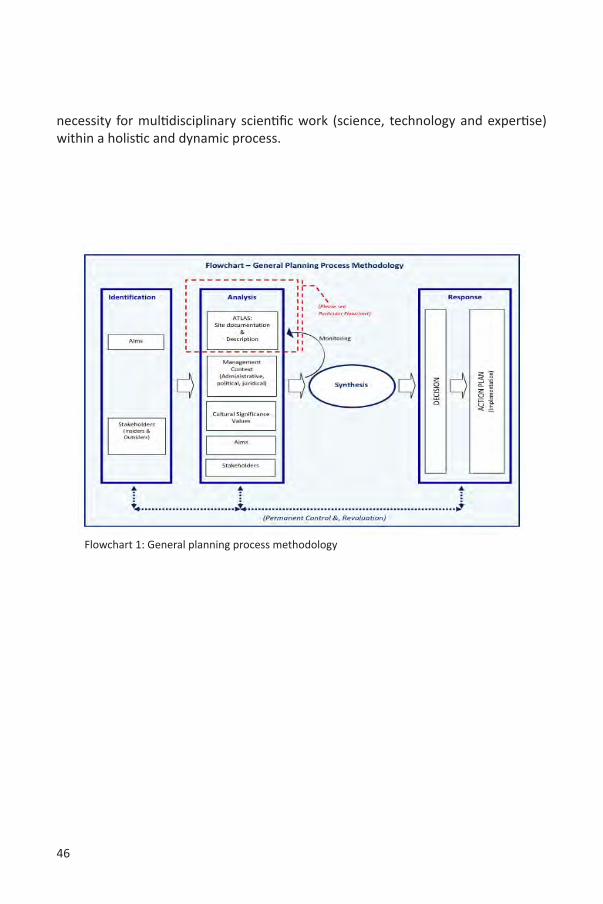
46
necessity for multidisciplinary scientific work (science, technology and expertise) within a holistic and dynamic process.
Flowchart 1: General planning process methodology
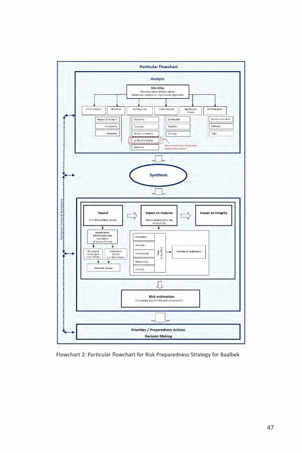
47
Flowchart 2: Particular flowchart for Risk Preparedness Strategy for Baalbek
48
Risk estimation
In order to assess risks and calculate their probabilities of occurrence and consequences to the property, it is necessary to effectuate three steps of reasoning:I precisely identify the hazards and the factors that may increase the vulnerability
of the property;II consider the impacts on the property; consider the probability of occurrence
of an event or process, its intensity and the vulnerability of the property under assessment;
III correlate the previous and estimate the impact on the property’s authenticity and/ or integrity and consequently the loss of a specific value.
These issues must be considered together; and the quality of the risk estimation will depend on the quality of the acquired knowledge (for instance, one cannot expect a good risk estimation if the vulnerability of the structure to earthquakes is not known). Moreover, it is important to keep in mind that a certain relationship exists between risk factors, which increases the property’s vulnerability. For example, a hazard like vegetation growing in between the blocks of the structure (a secondary hazard) can decrease the structure’s strength, making it more vulnerable to earthquakes (a primary hazard). Finally, the main objectives of the risk assessment are ensuring the safety of the visitors and the preservation of the authenticity of the site and the remains. Questions related to knowledge, access, safety, and preservation are the foundations of a sound Risk Preparedness Strategy.
Hazards/threats identification – Built heritage is commonly exposed to various hazards and one or more types of risk. Various small and progressive factors may increase the vulnerability of a site to hazards. A hazard is a specific phenomenon that has the potential to cause disorder or damage in a property. Hazards are directly related to a site’s vulnerability as well as to its capacity or incapacity to resist a hazard. Whereas a hazard is an external source of damage, vulnerability concerns the inherent weakness of the property due to its characteristics, environmental context, etc. (Table 10.1).
Impact on property - To scientifically assess risks and values, both physical and social criteria need to be considered (Table 10.2). Criteria are useful to qualify risks in relation to hazards, such as earthquakes, anthropogenic hazards, aggressive environment, or ordinary decay. One needs to qualify (and preferably quantify) not only the probability of an event, its intensity, and the vulnerability of the property, but also the reversibility of the expected damage, its spread and the potential to generate reactions in the public (positive or negative, support or outrage). All the criteria should be considered with their respective time dimensions.
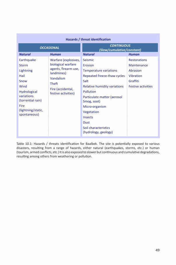
49
Table 10.1: Hazards / threats identification for Baalbek. The site is potentially exposed to various disasters, resulting from a range of hazards, either natural (earthquakes, storms, etc.) or human (tourism, armed conflicts, etc.) It is also exposed to slower but continuous and cumulative degradations, resulting among others from weathering or pollution.
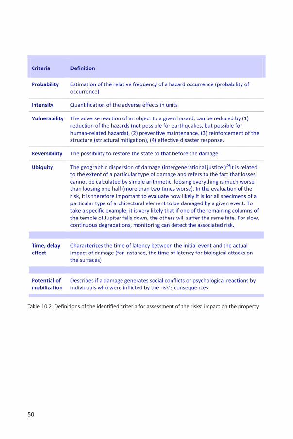
50
Table 10.2: Definitions of the identified criteria for assessment of the risks’ impact on the property
51
Impact on integrity - Another important issue relates risk assessment (probability, intensity and vulnerability) to values, authenticity, and integrity and to the loss of a specific value and/or ensemble of values. The values for which Baalbek was inscribed on the World Heritage List in 1984 should be the foundation on which all plans and actions are based. Moreover, ‘cultural heritage’, as defined in articles 1 and 2 of the World Heritage Convention, are properties of ‘outstanding universal value’25 from an historical, artistic or scientific, aesthetic, ethnological or anthropological point of view.
The values presented above are of course essential to consider, but their description does not have the necessary “granularity” for a Risk Preparedness Strategy. Ideally, a RPS should specify values at the level of individual structures (or sometimes at the level of structural elements). A RPS is a tool that facilitates the establishment of priorities. It therefore requires the establishment of a hierarchy of values for the remains of the site. The columns of the temple of Jupiter or the decoration of the temple of Bacchus have a greater importance than a random block in a wall. This is a complex issue, which needs to be addressed and deserves to be studied in detail.
A hazard can change, alter or even destroy the identified values of a property. Hazards, such as natural disasters play a significant role in shaping the character, function and outstanding universal value of a property. An important point is the fact that the various identified hazards don’t have the same impact on the different values.
Concerning the estimation of values, each type of feature (colonnade, capitals, decoration, monolithic blocs, exedra, temple, etc.) should be estimated using a specific criteria. “The value of architectural heritage is not only in its appearance, but also in the integrity of all its components as a unique product of the specific building technology of its time…”26
In an attempt to illustrate the importance of value estimation, some mapping work was produced for the semicircular chamber of the Great Court. In terms of surface integrity, the risk of losing a richly decorated surface is higher than that of losing a plain surface. The impact on the authenticity and integrity of the semicircular chamber, from the point of view of surfaces, is manly estimated based on the risk of losing decorated surfaces.
In order to analyze the impacts on the property’s integrity, a detailed estimation of values is needed and a comprehensive inventory of the outstanding universal value’s attributes should be prepared and mapped.
52
Risk identification - Baalbek is certainly exposed to one or more types of risks due to hazards that can potentially change, degrade, or destroy the intrinsic system equilibrium of the property’s integrity.
Over the last few years, natural and human-induced risks have been causing losses in the property: seismic activities provoke the collapse of some parts, anthropogenic actions aggravate the vulnerability of surfaces, previous interventions intensify structural loss of integrity, and the increasing air pollution irrevocably damages the surfaces.
Risks are not only damaging the physical attributes and values of the property, but also threaten the lives of the visitors, staff and local communities. They can also have negative consequences on the local economy (for instance, loss of tourism income).
There are nine main risks identified for Baalbek (Table 10.3): total disappearance (following, for instance, a natural catastrophe, like an earthquake of large magnitude, a war or massive bomb explosions), complete collapse (earthquake), partial collapse (earthquake, storm, lightning or vibrations during the festival activities), formation of cracks (vibrations during the festival activities, inclusion of incompatible materials, such as iron and cement, freeze-thaw cycles), structural deformations (earthquakes, geological movements, vibrations), loss of parts (robbery, etc.), total surface loss (robbery, biological attack or weather erosion), partial surface loss (weather erosion, air pollution attack or the weight of the festival seats’ structure), and human losses (exposure to open excavation trenches, collapse of parts of the structure due to earthquakes or the vibration during festival activities).
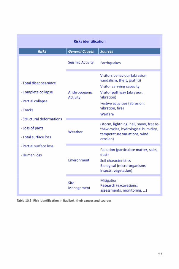
53
Table 10.3: Risk identification in Baalbek, their causes and sources
54
Final considerations on risk estimationFor the final risk estimation, risks are evaluated based on criteria defined by UNESCO27.The probability of a particular risk or disaster scenario to occur in the property may be:
- high, as in the case of partial surface loss due to weather erosion, air pollution attack or the weight of the festival seats’ structure
- medium, as in the case of total surface loss due to robbery, biological attack or weather erosion
- low, as in the case of the total or partial collapse of the structure due to an earthquake that may happen once every hundred and fifty years in the Baalbek region.
The severity of the risk scenario’s consequences (the direct effect) on the site, including visitors, staff, property, physical attributes, which represent the values of the property in Baalbek, may be catastrophic, severe or mild and/or gradual. This can be numerically expressed in relative terms on a scale from 0 to 3, where 0 means no consequences and 3 means catastrophic consequences. The consequences are measured in terms of loss of integrity and values, but the values and the various remains do not share the exact same attributes. Within a single property some attributes may be absolutely essential and irreplaceable to the ‘outstanding universal value’ assessment, while others, though also important, could be less crucial28. The level of risk must be assessed by taking into account probability, severity and the potential of loss of values.
23 Teresa Patrício, “Methodology for the restoration of archaeological remains”, in: T. Patricio, K. Van Balen and K. De Jonge (eds.) Conservation in Changing Societies: Heritage and Development, Proceedings of the International Conference on the occasion of the 30th anniversary of the RLICC (1976-2006), Leuven, May 22-25 2006, Leuven, 2006, p:243-250.
24 Andreas Klinke, Ortwin Rena, “A New Approach to Risk Evaluation and Management: Risk-Based, Precaution-Based, and Discourse-Based Strategies”, Risk Analysis, Society for Risk Analysis, vol. 22, n° 6, 2002, pp: 1071-1094.
25 “Outstanding universal value means “cultural and/or natural significance, which is so exceptional as to transcend national boundaries and to be of common importance for present and future generations of all humanity. As such, the permanent protection of this heritage is of the highest importance to the international community as a whole (…) which will be the key reference for the future effective protection and management of the property.” In: Operational Guidelines for the Implementation of the World Heritage Convention, UNESCO/WHC, 2008a, paragraph 49 & 50.
26 Principles for the analysis, conservation and structural restoration of architectural heritage, ICOMOS, 2003, paragraph 1.3.
27 World Heritage Resources Manual, UNESCO, 2010, p: 29.28 World Heritage Resources Man
55
11. RECOMMENDATIONSMario Santana
Heritage information strategy at Baalbek
As described by Letellier (2007, p. xiii): “As a prerequisite for informed conservation, recording is a prime responsibility of everybody involved in conservation processes. All those involved with the understanding, care, and management of a heritage place must have access to existing information and will generate records, which must be preserved and made available to others. It is the task of heritage managers and decision makers to establish policies and programs for the correct recording and effective management of conservation-related information”.
The group of experts involved in this project carried out an exhaustive research on the existing documentation of the property, including previous mitigations, archaeological research reports, development projects, brochures, etc. This work took a considerable amount of time.
Some critical questions regarding the future of the information collected in this project should be raised:
• By whom and how would the 3D point cloud data be maintained, stored, managed, and accessed/shared among stakeholders in the future?
• How would the surface conditions and structural integrity be linked to the 3D point cloud data?
• When and how will the current surface condition mapping be implemented in the entire property?
These are issues that should be addressed by an appropriate heritage information strategy.
Preparation of a Long-term Risk Preparedness Strategy for Baalbek
The RPS prepared in this project focused on the pilot area defined and offers a reliable methodology to carry out an extensive research on the entire property of Baalbek. The report was based on reliable data from the 3D Laser Scanner, which provided an appropriate dataset to produce a measured drawing atlas of the site for the identification of surface degradations. This information can be enriched with more non-destructive methods, in order to identify the issues beyond the surface that would yield more relevant information.
This project has also shed light on the weaknesses of previous assessments on Baalbek’s condition, whose shortcomings should be addressed from now on. It is recommended that the DGA prepare a strategy to systematically map the
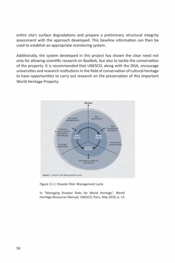
56
entire site’s surface degradations and prepare a preliminary structural integrity assessment with the approach developed. This baseline information can then be used to establish an appropriate monitoring system.
Additionally, the system developed in this project has shown the clear need not only for allowing scientific research on Baalbek, but also to tackle the conservation of the property. It is recommended that UNESCO, along with the DGA, encourage universities and research institutions in the field of conservation of cultural heritage to have opportunities to carry out research on the preservation of this important World Heritage Property
Figure 11.1: Disaster Risk Management cycle.
In “Managing Disaster Risks for World Heritage”, World Heritage Resources Manual, UNESCO, Paris, May 2010, p. 13
57
Specific Recommendations on Surface Degradation Mapping
• Prepare a complete study (in-situ and in laboratory) of materials (decayed or not), the various environmental parameters affecting these material surfaces, and the various weathering forms
• Prepare an in-depth study of the sun’s rotation in relation to the interior wall of the semicircular chamber and identify the areas most exposed to rain and wind
• Prepare a porosimetric analysis on local stones to check their susceptibility to freezing and thawing
• Define regular monitoring procedures by implementing a constant and periodic monitoring of the surface degradations
• Review and compile a summary of the existing research (ARS Progetti, PlanArch, IFAPO, etc) in order to evaluate the potential gaps and missing knowledge; as well as prepare a framework suitable for the necessary conservation of the surfaces (and the property)
• Use GIS with the accurate 3D data collected to link with the existing information (reports, plans, iconography, etc) in space and time
• Facilitate access to information. The following should be considered:o Creating a unique database that is accessible to all the
stakeholderso Providing broad access to the “risk map” and related information,
which can help its development and increase its efficiency• Make available all information to all stakeholders involved in the
conservation and management of archaeological sites (authorities, experts and researchers).
Specific Recommendations on Structural Integrity
• Complete the first-level assessment for all the site (mostly qualitative, using the techniques illustrated in this project: pathology interpretation, historical intervention documentation);
• It is necessary to give relevant priorities for interventions and future studies;• Improve general knowledge on aspects relevant to all structural analysis;• Commission a study to better define the seismic hazard in Baalbek:
o Complete the inventory of documents or studies on the seismicity ofLebanon (possibly affecting the archaeological site of Baalbek)
o Make a synthesis. Extract from the existing information what is relevant to the site.
58
o Study the local situation of the site – influenced by local geological factors (soil, distance to faults, expected source mechanism...)
o Prepare necessary data for structural analysis: a set of relevant accelerograms that can be used for non-linear structural analysis, Peak Ground Acceleration (PGA) expected for various return periods, response spectra
o Possibly install monitoring devices in Baalbek, such as an accelerometer, which is aimed at recording low to moderate seismic activity that would help define the response spectra and would complement a climatic factor monitoring (mainly useful for understanding surface pathology)
o Possibly prepare a separate document on the geological and geotechnical condition of the site.
• Undertake a study to define the structural behaviour of the materials;• Devise a strategy to complete the 3D survey (parts not measured by the
laser scanner, upper parts, construction technique). Test it on the most critical areas of the site;
• Organize the information and make it easily available (studies, historical photographs, photographic inventory, etc.);
• Design more suitable areas to install the superstructures of “Baalbek International Festival”;
• Start the iterative dynamics (gather data, synthesize, define priorities, improve knowledge, prepare interventions) described in the “Risk Preparedness Strategy”.
Preventive Maintenance
Activity 3 proved the need for an appropriate maintenance strategy for the property, as currently very little maintenance work is done. Many projects focus on mitigation towards the entire preservation of the remains in Baalbek, without taking into consideration that it is more cost effective to start doing punctual repairs of the site. The current RPS is the starting point for the development of a preventive maintenance plan.
Specific Recommendations on Risk preparedness
• The Risk Preparedness Strategy should be integrated into the Management Plan of Baalbek.
• The proposed Risk Preparedness Strategy should be completed and kept up-to-date; it is a continuous process, not a report. Other specialists, such as meteorologists, climatologists, seismologists, hydrogeologists, public
59
health experts, etc. can also provide valuable input.• As defined by UNESCO / WHC in its recent (2010) “Managing Disaster
Risks for World Heritage”, World Heritage Resources Manual, there are three main stages of Disaster Risk Management: before, during and after disasters. The preparedness activities to be undertaken before a disaster include risk assessment, prevention and mitigation measures for specific hazards (maintenance and monitoring, and formulating and implementing various disasters management policies and programmes). Emergency preparedness to be undertaken before a disaster includes measures such as creating an emergency team, evacuation plan procedures, warning systems and drills, and temporary storage.
• The developed Risk Preparedness Strategy for Baalbek is the first step in this process. Likewise, we strongly recommend to further develop tools to achieve a sound Risk Strategy Plan for Baalbek, taking into consideration the geology, hydrology, climate and air characteristics, land use, human population characteristics, tourism and site carrying capacity, transport and new developments, and to reduce the existing and potential risk to the site.
• Site maintenance and monitoring systems should be implemented, taking into account the equipment, techniques and strategies for prevention and mitigation of risks.
• An evacuation plan for staff and visitors should also be prepared.• Risk Preparedness Strategy should be linked to the site management plan
and to the disaster management systems at local, regional and national levels.
• A Risk Preparedness Strategy can take many forms, depending on the audience, for example, a brochure or poster about the site can be useful for raising public awareness.
60
12. CONCLUSIONSMario Santana, Assaad Seif
This two-phase project “Capacity building of human resources for digital documentation of World Heritage Sites affected by the 2006 war in Lebanon” has achieved the development of guidelines and a solid methodology for the preparation of a “Risk Preparedness Strategy” of Baalbek, based on the results of Phase I, in which a group of experts captured a complete physical 3D surface configuration of the property using a 3D laser scanner.
It is important that the acquisition of a 3D mapping device and the “Risk Preparedness Strategy” methodology – compiling results from the definition of a “damage atlas”, surface condition maps and a structural surface integrity study – are not put aside for the future conservation of this important heritage place.
A set of recommendations have been provided that build upon the success of the developed approach, while the information acquired, assessed and presented here should be aimed at ensuring timely, sufficient and relevant actions, such as:
- Prepare an integral approach for monitoring those “changes” – rate of change, other risk factors and hazards to visitors/staff – on the property, which have been identified in Phase II;
- Re-evaluate ‘significance’ and its relation with integrity, based on these changes;
- Develop a preventive maintenance plan to ensure that issues identified in the RPS are tackled;
The current administration of the DGA has hired specialized staff on GIS who has finished the design, development of an information system for cataloguing and storing all information about heritage places in Lebanon. Additionally the DGA GIS staff is in the process of finalising the proper GIS database, that was initiated during the project implementation phase in collaboration with the international experts, in order to integrate the structural and surface condition survey results. It should provide the opportunity to share information among cultural heritage stakeholders.
In addition, the DGA is in the process of updating its current “heritage information strategy”, in order to fully identify essential documentation on heritage places. In fact, the DGA realized that by adopting the use of laser scanning and other digital tools, the amount of information that can be captured of a property in specific periods of time will triplicate, and without a proper strategy this amount of generated data will become unmanageable.
61
On the other hand, the close coordination between the DGA and the UNESCO office in Beirut along with the international experts allowed the project to reach its aims and to respond to the needs of the local heritage management administration. The methodologies and strategies developed during the implementation of the different phases of the project have set the needed basis and standards for the application of RPS to cover the entire site of Baalbek and consequently other heritage sites in Lebanon in the future.
Furthermore, this experience can be of great help to other WH sites management authorities. It could be taken as a model in the integrated approach using the latest technologies along with well known research techniques for the implementation of Risk Preparedness Strategies for their sites in the Future. Moreover, this project contributed to the experience of both national and international experts; which will help both parties to further improve their methods and applications in their respective future projects. Finally, and as mentioned in the recommendations, Baalbek can benefit from the creation of a research area within the conservation field, where conservation institutes, universities and other organizations carry out research aimed at preserving the integrity of the property. This should be coordinated by the DGA with the support of UNESCO.
62
13. GLOSSARY
Many scholars have defined terms related to risk. Among them the most relevant to the Baalbek situation is the thesaurus developed by David Ball and John Watt (Ball, Watt, 2001), as well as the glossary of relevant disaster management terms adopted by UNESCO in its Managing Disaster Risks for World Heritage, World Heritage Resources Manual, 2010:
Hazard: A natural or human-caused phenomenon that may occur in or near the property and may threaten human life and well-being, or cause physical damage and economic loss. Hazard is a situation, which could damage or destroy (Ball, Watt, 2001), for instance, an earthquake, an excess of visitors, etc.
Risk: The possibility of a certain damaging or destructive event (hazard: human action or event) or degradation process to occur within a certain time span that may harm the aspects valued by human beings (Kates, Kasperson, 1983). The actual destruction effect of the harmful event or process is related to its intensity and to the vulnerability of the structures and stone surfaces in question.The probability that a certain kind of damage is realized, e.g. the probability of fire (Ball, Watt, 2001).
Threat: Natural or man-made source, cause of harm or difficulty. A threat differs from a hazard in that a threat is directed at an entity, asset, system, network, or geographic area, while a hazard is not directed.
Disaster: A serious disruption to the functioning of a community or a society, causing widespread human, material, economic or environmental losses, which exceed the ability of the affected community or society to cope using its own resources.(www.unisdr.org)
Mitigation: Taking action in the time frame before a disaster to lessen post-event damage to lives and property. In risk management, many hazards, such as earthquakes, cannot be diminished, but the risk from that hazard can be reduced, or mitigated(UNESCO , 2010).
Preparedness: Planning efforts to reduce the risk and consequences of a disaster; also includes planning efforts to prepare for response and recovery.
Preventive conservation: Denotes an approach, whose primary objective is to ensure the long-term physical survival of a property, with minimal intervention on the fabric itself(Woolfitt, 2007).
63
Risk analysis: The process of arriving at a risk assessment.
Risk assessment: The activity of identifying hazards and assessing the probability of harm(Ball, Watt, 2001). It is composed of a report that describes assets, vulnerabilities, likelihood of damage, cost of recovery estimates, summaries of mitigation measures and their costs, and estimated probable savings from better protection.
Risk management: The decision-making process following a risk assessment.(Ball, Watt, 2001)
World Heritage property: World Heritage properties are those defined in Article 1 and 2 of the World Heritage Convention and inscribed on the World Heritage List on the basis of their outstanding universal value, which is fulfilled through meeting one or more of the criteria (i)-(x) in the Operational Guidelines for the Implementation of the World Heritage Convention, UNESCO/WHC, 2008.
64
14. BIBLIOGRAPHY AND REFERENCES
Atlas climatologique du Liban. République Libanaise, Ministère des Travaux Publics et des Transports, Direction Générale des Transports, Direction de l’Aviation Civile, publié par le Service Météorologique du Liban avec l’aide de l’Observatoire de Ksara, Tome I (Pluie, Température, Pression, Nébulosité), Cahier I-A (Texte), 1966.
Atlas climatologique du Liban. République Libanaise, Ministère des Travaux Publics et des Transports, Direction Générale des Transports, Direction de l’Aviation Civile, publié par le Service Météorologique du Liban avec l’aide de l’Observatoire de Ksara, Tome I (Pluie, Température, Pression, Nébulosité), Cahier I-B (Planches), 1966.
Atlas climatologique du Liban. République Libanaise, Ministère des Travaux Publics et des Transports, Direction Générale des Transports, Direction de l’Aviation Civile, publié par le Service Météorologique du Liban avec l’aide de l’Observatoire de Ksara, Tome III (Les vents), Cahier III-A (Texte), 1966.
Atlas climatologique du Liban. République Libanaise, Ministère des Travaux Publics et des Transports, Direction Générale des Transports, Direction de l’Aviation Civile, publié par le Service Météorologique du Liban avec l’aide de l’Observatoire de Ksara, Tome III (Les vents), Cahier III-B (Graphique et Cartes), 1966.
Atlas climatologique du Liban. République Libanaise, Ministère des Travaux Publics et des Transports, Direction Générale des Transports, Direction de l’Aviation Civile, publié par le Service Météorologique du Liban avec l’aide de l’Observatoire de Ksara, Tome IV (Tension de Vapeur, Cartes d’Isobares), Cahier IV-B (Cartes), 1973.
Ball,David; John Watt. “Risk Management and Cultural Presentation”, ARIADNE Workshop, ARIADNE 4, Vulnerability of cultural heritage to hazards and prevention measures, Prague, 18-24 August 2001 (www.arcchip.cz/w04/w04_ball.pdf)
Blais, F. “Terrestrial laser scanning.” Paper presented at the International Summer School Digital Recording and 3D Modeling, 2006.http://www.photogrammetry.ethz.ch/summerschool/pdf/09_Blais_Terrestrial_Laser_Scanning.pdf (accessed 19/12/2007)
Burati, Nicola. “Assessment of Seismic Safety: Response Surface approach and Accelerogram Selection Issues.”Ph.D. thesis, Università di Bologna, 2008. Dottorato di Ricerca in Meccanica delle Structture, Ciclo XXI.
Burra charter.The Illustrated Burra Charter, Australia ICOMOS, Sydney, 1992.
Carlon,Claudio; A. Marcomini; L. Fozzati; P. Scanferla; S. Bertazzon; S. Bassa; F.
65
Zanovello; S. Foramiti; R. Chiarlo; F. Penzo. “ArcheoRisk: a Decision Support System on the Environmental Risk for Archaeological Sites in the Venice Lagoon.”iEMSs 2002, Integrated Assessment and Decision Support, 24-27 June 2002, Lugano, Switzerland, International Environmental Modelling and Software Society. http://www.iemss.org/iemss2002/proceedings/pdf/volume%20uno/257_carlon.pdf
Clark, K. “Informing Conservation.” In: Eppich, E. Chabbi, A. ed. Illustrated Examples Recording, Documentation, and Information Management for the Conservation of Heritage Places. The Getty Conservation Institute, J. Paul Getty Trust, Los Angeles, 2007.
de la Torre, Marta.(ed.) “Assessing the Values of the Cultural Heritage.”Research Report, The Getty Conservation Institute, Los Angeles, 2002.
DeJong,Matthew J. “Seismic Assessment Strategies for Masonry Structures.”Ph.D. thesis, Massachusetts Institute of Technology, June 2009.
El-Hakim, S. F. “Semi-automatic 3D Reconstruction of Occluded and Unmarked Surfaces from Widely Separated Views.”International Archives of Photogrammetry, Remote Sensing and Spatial Information Sciences, 34(5), 2002.
El-Hakim, S. F.; J.A. Beraldin; F. Blais. “A Comparative Evaluation of the Performance of Passive and Active 3D Vision Systems.” Paper presented at the SPIE Proceedings, Conference on Digital Photogrammetry, St. Petersburg, Russia. 1995.
Erickson,Jane. “Applied Risk Management.”ATP Bulletin, Association for Preservation, Technology International, vol. 21, n° 3/4, 1989.
EU-Project DEMOTEC-A, Work package 2: Pilot GIS development Nemi. Monitoring and Risk Assessment of Monuments and Archaeological Sites in the Nemi basin, Colli Albani, Italy, vol. 1 (report n° 2004-039), 26 May 2004.
Geomagic website, http://www.geomagic.com/en/, (accessed 17 August 2010).
Georgopoulos, Andreas; Stefanos Natsis. “A simpler method for large scale digital orthophoto production.” In:The international Archives of the Photogrammetry, Remote sensing and Spatial Information Sciences, Vol. 37, Part B5, Commission V, WG V/2. 2008.
Hovden, Jan. “Risk and Uncertainty Management Strategies.” 6th International CRN Expert Workshop on Societal Security and Crisis Management in the 21st Century, Stockholm, 22-24 April 2004.
ICOMOS. Principles for the analysis, conservation and structural restoration of
66
architectural heritage. 2003. URL http://iscarsah.icomos.org/content/principles/ ISCARSAH?Principles?English.pdf. ICOMOS Charter.
ICOMOS-CSI. Illustrated glossary on stone deterioration patterns/Glossaire illustré sur les formes d’altération de la Pierre. (Monuments and Sites XV), ICOMOS International Scientific Committee for Stone (ISCS), ICOMOS, 2008.
IFAPO report, Temple de Bacchus à Baalbeck (Liban). Etude préalable sur l’état des pierres du temple et leurs techniques antiques d’extraction, de façonnage et de mise en oeuvre, conséquences sur la conservation du temple et propositions d’action.Beirut, sans date.
Jidejian, Nina.Baalbek Heliopolis “Cité du Soleil.”Librairie Orientale, Beirut, 1998.
Johnson, Edward D. “The Need for Seismic Analysis and Planning as Part of Ongoing Archaeological Site Management and Conservation: A Case Study of the Necropolis of Saqqara.”Journal of the American Research Center in Egypt, American Research Center in Egypt, vol. 36, 1999.
Kates, R.W.; J.X. Kasperson. “Comparative Risk Analysis of Technological Hazards. A Review.”Proceedings of the National Academy of Sciences, n°80, 1983.
Klinke, Andreas; Ortwin Rena. “A New Approach to Risk Evaluation and Management: Risk-Based, Precaution-Based, and Discourse-Based Strategies.”Risk Analysis, Society for Risk Analysis, vol. 22, n° 6, 2002.
Letellier, R.;W. Schmid;F. LeBlanc.“Guiding Principles Recording, Documentation, and Information Management for the Conservation of Heritage Places.” Getty Conservation Institute, J. Paul Getty Trust, 2007.
Lohman, D. “Drafting and Designing. Roman Architectural Drawings and their Meaning for the Construction of Heliopolis/Baalbek.” Lebanon, Proceedings of the Third International Congress on Construction History, Cottbus, May 2009.
Meli, G.; Garufi, R. “Building a Risk Map of the Mediterranean Cultural and Environmental Heritage.” HERIMED ONLUS – Association for the Documentation, Preservation and Enhancement of the Euro-Mediterranean Cultural Heritage. http://www.herimed.org/pdf/Building_a_Risk_Map.pdf
Muething, Garnet; Robert Waller; Fiona Graham. “Risk Assessment of Collections in Exhibitions at the Canadian Museum of Nature.”Journal of the American Institute
67
for Conservation, The American Institute for Conservation of Historic & Artistic Works, vol. 44, n° 3 (Fall-Winter), 2005.
Patrício, Teresa. “Methodology for the restoration of archaeological remains”, in: T. Patricio, K. Van Balen and K. De Jonge (eds.) Conservation in Changing Societies: Heritage and Development, Proceedings of the International Conference on the occasion of the 30th anniversary of the RLICC (1976-2006), Leuven, May 22-25 2006, Leuven, 2006.
Porter, Keith A. “An Overview of Peers Performance-Based Earthquake Engineering Methodology.” In:Ninth International Conference on Applications of Statistics and Probability in Civil Engineering (ICASP9) July 6-9, 2003, San Francisco, 2003.
Sullivan, S. “Modèle de planification pour la gestion des sites archéologiques.”In: M. De La Torre (dir.), La conservation des sites archéologiques dans la région méditerranéenne, Conférence Internationale, Athènes 6-12 mai 1995, (Actes de Conférence), The Getty Conservation Institute, Los Angeles, 1997.
Taylor, Joel. “An Integrated Approach to Risk Assessments and Condition Surveys.” Journal of the American Institute for Conservation, The American Institute for Conservation of Historic & Artistic Works, vol. 44, n° 2 (Summer), 2005.
UNESCO World Heritage Centre, Nomination of Baalbek, http://whc.unesco.org/en/list/294/documents/ (accessed: May 30, 2010)
UNESCO. “Managing Disaster Risks for World Heritage.”World Heritage Resources Manual, United Nations Educational, Scientific and Cultural Organisation, Paris, May 2010.
van Ess, M. “Heliopolis Baalbek: 1898 – 1998: Rediscovering the Ruins.” Deutches Arcaheologisches Institut Orient-Abteilung and the Directorate General of Anqtiquities of Lebanon, Beirut, 1998.
van Ess, Margarete. (ed.) “Baalbek / Heliopolis. Results of Archaeological and Architectural Research 2002 – 2005.” German – Lebanese Colloquium, Berlin 2006, In: BAAL, Bulletin d’Archéologie et d’Architecture Libanaises, volume IV, Ministère de la Culture, Direction générale des Antiquités, Beyrouth, 2008.
Van Genechten, Bjorn. “Creating Built Heritage Orthophotographs from Laser Scan.”Ph.D., Katholieke Universiteit Leuven, 2009.
68
Woolfitt, C. “Preventive Conservation of Ruins: Reconstruction, Reburial and Enclosure.” In: J. Ashurst (ed.), Conservation of Ruins, Oxford, 2007.
69
15. EXPERTS INVOLVED
Senior experts:
Ghassan GhattasHe completed technical studies in surveying and civil engineering. He worked for 10 years as a support specialist for the Leica Geosystems’ local representative in Lebanon, a period during which he received extensive training on the use of total stations, GPS and surveying and photogrammetry softwares. He worked on several projects, one of which is the preparation of a complete IKONOS satellite imagery for Lebanon and the establishment of a geodetic network for the city of Khartoum using GPS. He is currently working at the DGA as a GIS and surveying specialist. His involvement in this project included, amongst other things, the contribution in the development of the surveying methodology and the design of a GIS database for the surface degradations.He is currently following post-graduate studies in GIS at the Vrije Universiteit in Amsterdam.
Teresa PatricioShe completed studies on architecture in Portugaland obtained a Master of Science in Architecture, as well as aSpecialization on the Conservation of Historic Towns and Buildings at the R. Lemaire International Centre for Conservation (Katholieke Universiteit Leuven) in 1993. She obtained a Ph.D. on Conservation of Archaeological remains. Drawing of an applied methodology at the Lemaire Centre (K.U. Leuven) in 2004. She is currently Guest Professor at the Lemaire Centre and at the University of Évora (Portugal).She owns a private office in Brussels and provides public and private clients with cultural heritage expertise. Her office covers a wide range of projects and activities including conservation of monuments and heritage sites in various countries. She collaborates with major foreign and domestic institutions, including UNESCO, ICOMOS (International Council on Monuments & Sites) and European Institutions.
Mario Santana QuinteroHe completed undergraduate studies in architecture and obtained a Ph.D. on The use of three-dimensional documentation and dissemination techniques in studying built heritage at the R. Lemaire International Centre for Conservation (K.U. Leuven) in 2003. He is currently Assistant Professor at the Lemaire Centre and post-doctoral researcher for the MACE EU Project, University of Leuven. A Professor at the University College St Lieven and lecturer at the University of Pennsylvania, he serves as Vice President of the ICOMOS Scientific Committee on Heritage Documentation (CIPA) and Executive Officer of the Virtual Systems and Multimedia Society (VSMM Society).
70
Assaad SeifHe studied archaeology at the Lebanese University and received his Ph.D. from Paris1 Pantheon-Sorbonne in February 2010 on The Spatial Dynamics and the Pottery of the Syro-Palestinian Corridor from the Neolithic to the Middle Bronze Age : The Case of the “Akkār”. He taught GIS applications in archaeology for the Landscape Archaeology MA students at Paris1 in 1999. He is a Honorary Senior Research Associate at the Institute of Archaeology, UCL and member of the Editorial Advisory Board of CMAS (a publication dealing with the Conservation and Management of Archaeological Sites; Maney Publishing, UK). He worked on numerous excavations and he is scientific director of more than 20 urban excavations, mainly in the Beirut region. He is currently the Coordinator of Archaeological Research and Excavations at the Lebanese Directorate General of Antiquities. He coordinated many scientific research projects with the CNRSL, namely covering the domains of geo-archaeology and archaeo-seismology in North Lebanon. He initiated the current project in collaboration with the UNESCO office in Beirut, and was responsible for the overall coordination on behalf of the DGA.
Pierre SmarsHe is assistant professor at the Department and Graduate School of Cultural Heritage Conservation at the National Yunlin University Of Science & Technology. He has a degree in architectural engineering from the Catholic University of Louvain, UCL (1989) and completed a master degree in conservation of monuments (1992) and a Ph.D. in engineering (2000), both at the K.U.Leuven.He worked at the R. Lemaire International Centre for Conservation (KUL) from 1993 to 2001. From 2001 to 2003, he was research associate at the University of Bath. From 2003 to 2005, he worked on projects in Afghanistan and Pakistan (in collaboration with the University of Aachen) and at the World Heritage Centre in Paris. Since 2005, he is working at the National Yunlin University of Science & Technology.
Koen Van BalenHe has a degree in engineer-architecture (1979), in architectural conservation (1984) and a Ph.D. in engineering (1991). He focuses his activities on the preservation of historical structures and the understanding of the behaviour of ancient materials and building technologies. He is professor in building materials and their preservation. His research concerns technical aspects in conservation, embedded in conservation methodologies for the architectural heritage. He is strongly connected to heritage organizations in Flanders (Monumentenwacht Vlaanderen) and to international NGOs in the field. He holds the UNESCO Chair on Preventive Conservation, Maintenance and Monitoring of Monuments and Sites.
71
Bjorn Van GenechtenHe is an architectural engineer, active in research on photogrammetry and laser scanning. He has participated in different international laser scanner projects, such as the scanning of the Ramsess II statue in Cairo.From 2007 till 2008, he was involved in a Leonardo project called “3DRISKMAPPING”, whose outcome is considered a state-of-the-art book on laser scanning and its applicationsat this time.In June 2009, he successfully presented his Ph.D. Creating Built Heritage Orthophotographs from Laser Scans at the K.U.Leuven and since October 2009 he is a full time professor at the University College KaHo St. Lieven in Ghent.
Junior experts:
Liesbeth LacroixShe is an architectural engineer, graduated at the K.U. Leuven and is currently finishing the second year of the Advanced Master in Conservation of Monuments and Sites at the Raymond Lemaire International Centre for Conservation, in which she is preparing a thesis on The Use of Terrestrial Laser Scanning for Condition Mapping of Historical Sites. She also conducted an internship at the Metric Survey Team of English Heritage in 2009.
Tom Coenegrachts He is an archaeologist,graduated at the K.U. Leuven and is currently finishing the second year of the Advanced Master in Conservation of Monuments and Sites at the Raymond Lemaire International Centre for Conservation. He has worked with many ruined castles, not only doing excavation, but also obtaining information from the standing structures by carefully documenting them mostly by hand drawing, total station and photographs. During his studies in the Master of Conservation of Monuments and Sites his knowledge was further developed on condition assessment and preventive conservation.

72
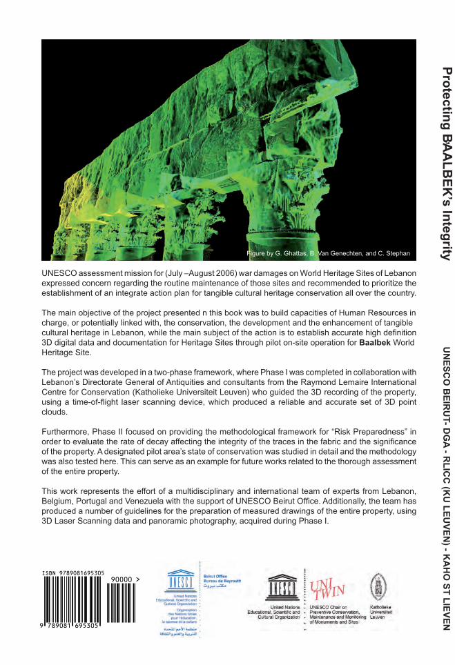
Protecting BAALBEK’s
Integrity
A PROPOSAL FOR AN INTEGRATED RISK PREPAREDNESS STRATEGY
CAPACITY BUILDING OF HUMAN RESOURCES FORDIGITAL DOCUMENTATION OF WORLD HERITAGE SITES
AFFECTED BY THE 2006 WAR IN LEBANON
Assaad Seif - Mario Santana Quintero, Editors
’
Joseph Kreidi, Project Coordinator
UN
ESCO
BEIR
UT- D
GA - R
LICC
(KU
LEUVEN
) - KA
HO
ST LIEVEN
UNESCO BEIRUT OFFICEDIRECTORATE GENERAL OF ANTIQUITIES, LEBANON
RAYMOND LEMAIRE INTERNATIONAL CENTRE FOR CONSERVATION, K.U. LEUVENUNIVERSITY COLLEGE ST. LIEVEN
UNESCO assessment mission for (July –August 2006) war damages on World Heritage Sites of Lebanon expressed concern regarding the routine maintenance of those sites and recommended to prioritize the establishment of an integrate action plan for tangible cultural heritage conservation all over the country.
The main objective of the project presented n this book was to build capacities of Human Resources in charge, or potentially linked with, the conservation, the development and the enhancement of tangible cultural heritage in Lebanon, while the main subject of the action is to establish accurate high definition 3D digital data and documentation for Heritage Sites through pilot on-site operation for Baalbek World Heritage Site.
The project was developed in a two-phase framework, where Phase I was completed in collaboration with Lebanon’s Directorate General of Antiquities and consultants from the Raymond Lemaire International Centre for Conservation (Katholieke Universiteit Leuven) who guided the 3D recording of the property, using a time-of-flight laser scanning device, which produced a reliable and accurate set of 3D point clouds.
Furthermore, Phase II focused on providing the methodological framework for “Risk Preparedness” in order to evaluate the rate of decay affecting the integrity of the traces in the fabric and the significance of the property. A designated pilot area’s state of conservation was studied in detail and the methodology was also tested here. This can serve as an example for future works related to the thorough assessment of the entire property.
This work represents the effort of a multidisciplinary and international team of experts from Lebanon, Belgium, Portugal and Venezuela with the support of UNESCO Beirut Office. Additionally, the team has produced a number of guidelines for the preparation of measured drawings of the entire property, using 3D Laser Scanning data and panoramic photography, acquired during Phase I.
Figure by G. Ghattas, B. Van Genechten, and C. Stephan