provided by the author(s) and university college dublin...
TRANSCRIPT

Provided by the author(s) and University College Dublin Library in accordance with publisher
policies., Please cite the published version when available.
Title Palawan Island Palaeohistoric Research Project: Report on the 2011 El Nido Field Season
Authors(s) Paz, Victor; Ronquillo, Wilfredo; Lewis, Helen; et al.
Publication date 2011-09
Publisher Archaeological Studies Program, University of the Philippines and National Museum of the Phillippines
Item record/more information http://hdl.handle.net/10197/7221
Downaloaded 2018-08-27T19:48:31Z
The UCD community has made this article openly available. Please share how this access
benefits you. Your story matters! (@ucd_oa)
Some rights reserved. For more information, please see the item record link above.

1
PALAWAN ISLAND PALAEOHISTORIC RESEARCH PROJECT REPORT ON THE 2011 EL NIDO FIELD SEASON
Victor Paz, Wilfredo Ronquillo, Helen Lewis, Emil Robles, Vito Hernandez, Jane Carlos,
Andrea Malaya Ragragio, Myra Lara, Noel Amano, Shawn O’Donnell, Caterine Manalo,
Michael Herera, Janine Ochoa, Darko Stojanovski, Wilhelm Solheim II
Archaeological Studies Program
University of the Philippines
National Museum of the Philippines
2011

2
Philodrill Corp.
A project supported by:
PCSD
3
In Memory
Max Rohrer &
Rudy Omega

4
ACKNOWLEDGMENT
The research team would like to acknowledge the assistance in this year’s work from the
Chancellor of the UP-Diliman, Prof. Cesar Saloma, PhD; the Director of the National Museum of
the Philippines, Jeremy Barns; the Palawan Council for Sustainable Development; Barangay
Captain Isaac Lim of Barangay New Ibajay; and Mayor Edna Gacot-Lim of El Nido, Palawan.
The research team would like to thank the good people of Barangay New Ibajay for continuing
to welcome us this field season. Our thanks are especially due to the family of Mrs. Herminia
Libudan, Mrs. Mimi Cabral, and Mr. Rome Fines. Thank you also to Arvin Acosta of the El Nido
Tourism Office and Bong Acosta of the El Nido Planning and Development Office. Thank you
very much, Mrs. Gloria Fernandez, the grand dame of El Nido. Thank you too so much to Cely
and Danny Dangan, as well as their family and their staff at Laly and Abet – Our base in El Nido.
Special mention and the team’s warm thanks go to Josephine Gabayan and Max Rohrer†. They
have supported and helped since the project began in El Nido. Also, the team’s gratitude goes to
Rudy Omega† and his family who have watched over the Solheim Foundation Property in
Barangay Calitang. Max and Rudy passed away during the field season. They will be missed.
The research team would also like to thank its mother-unit, the UP-Archaeological Studies
Program, especially the administrative and support staff. These are Aida Tiama, Digna Jacar,
Tess Lubang, Arcadio Pagulayan and Ramil Mainot. We deeply appreciate the support given by
Antonio Ventura for this season’s work. We continue to warmly acknowledge the help of Mr.
Anthony Ferrer who has opened many opportunities for the project to expand in the last four
years. The assistance extended by Dr. Yoly Aguilar of the Bureau of Mines and Dr. Benjamin
Vallejo of the UP Environmental Science Department in the identification of most of the shell
species presented here are much appreciated. For allowing us the use of its large-bed scanners
we would like to thank Dr. Ariel Blanco of the UP Center for Geodesy and Geodetic Engineering
and Engineer Jules Bangate.
Lastly, but equally important to the team, is that we continue to express our most heartfelt
gratitude to the institutions and companies that have supported the project this season, namely,
the Coral Bay and Rio Tuba Nickel Mining Companies, Philodrill Corporation, Petro Energy
Resources Corporation, Cybersoft integrated Geoinformatics, and the Solheim Foundation. We
continue to acknowledge the support that the British Academy, The Oxford University Dating
Laboratory, The University College Dublin Seed Fund, The Irish Research Council for the
Humanities and Social Sciences, Southeast Asian Airlines and the Luce Foundation and the
University of Washington has given the project in various seasons in the past.

5
CONTENTS Acknowledgment ........................................................................................................................................................... 4
List of Figures ................................................................................................................................................................... 7
List of Plates ...................................................................................................................................................................... 7
2. Introduction ................................................................................................................................................................. 8
3. Objectives ...................................................................................................................................................................... 9
4. Palaeohistoric work in northern Palawan ................................................................................................. 9
5. Methodology ............................................................................................................................................................. 18
5.1 Excavation ............................................................................................................................................................ 18
5.2 Survey .................................................................................................................................................................... 19
5.3 High resolution recovery of finds ............................................................................................................... 19
5.4 Public archaeology initiatives ...................................................................................................................... 19
6. Results .......................................................................................................................................................................... 20
6.1 Pasimbahan-Magsanib (IV-2007-Q1) ....................................................................................................... 20
6.2 Ille Site (IV-1998-P).......................................................................................................................................... 25
East Chamber Trench Excavation ................................................................................................................. 25
East-West Connection Trench (N2-3 W6-11) .......................................................................................... 29
Grid squares N2-3 W8-11 ................................................................................................................................. 29
Grid squares N2-3 W6-7 ................................................................................................................................... 34
Cremation burials from the East-West Connection Trench ............................................................... 39
6.3 Past Landscape and Environment Surveys............................................................................................. 42
6.4 Investigations in Makangit Karst Complex ............................................................................................. 43
The Fines property excavations .................................................................................................................... 44
Makangit Cave site .............................................................................................................................................. 44
Idelet site ................................................................................................................................................................ 45
Reconnaissance around Makangit ................................................................................................................ 45
6.5 Survey of New Sites in Kulanga Maliit and New Ibajay Proper ..................................................... 46
6.6 Public Archaeology ........................................................................................................................................... 48
7. Discussion .................................................................................................................................................................... 50
The Looting of the Imorigue Ossuary sites .................................................................................................... 50
On the 9000 year old cremations ....................................................................................................................... 50
On the landscape survey and river terraces .................................................................................................. 53

6
8. Summary and Recommendations ...................................................................................................................... 54
9. Project Participants for 2011 .............................................................................................................................. 55
10.Plates ............................................................................................................................................................................ 56
11. Appendices ................................................................................................................................................................ 66
Appendix 1: National Museum Authorization .............................................................................................. 67
Appendix 2: Letter on the looting of the Imorigue with National Museum Reply ........................ 68
Appendix 3: Three Dimensional Mapping of the Kulanga River Terraces Emil Robles ............. 74
Appendix 4: Preliminary analysis of Pacaldero pottery Darko Stojanovski ................................... 76
Appendix 5: Analysis of Animal Remains…East Chamber of Ille Cave Noel Amano ................... 88
Appendix 6: Pasimbahan Cave Bone Assemblage Janine Ochoa ......................................................... 97
Appendix 7: Report on the Shell Count from Ille Jane Carlos ............................................................... 99
12. References ............................................................................................................................................................... 103

7
LIST OF FIGURES Figure 1. General Location Map of the Project Area
Figure 2. Map of the El Nido Landscape and the Dewil valley
Figure 3. The Pasimbahan-Magsanib site plan indicating locations of excavation trenches
Figure 4. Context List for Pasimbahan-Magsanib Site
Figure 5. Vertical profiles of East and West walls of Trench A & B, Pasimbahan-Magsanib Site
Figure 6. Vertical profiles of North and South walls of Trench A & B, Pasimbahan-Magsanib Site
Figure 7. East and West Stratigraphic Profiles of the East Chamber Trench Excavation
Figure 8. North and South Stratigraphic Profiles of the East Chamber Trench Excavation
Figure 9. Stratigraphic Profiles of the East Chamber Long Trench
Figure 10. Stratigraphic Profiles of the East-West Connecting Trench
Figure 11. Comprehensive map of Ille cave and rockshelter site
Figure 12. Stratigraphic profile of test excavation in Makangit
Figure 13. General plan of the Pasimbahan dos Kulanga
LIST OF PLATES Plate 1. The PIPRP Set-up for 2011
Plate 2. Images of Ille and Pasimbahan-Magsanib sites
Plate 3. Images of Pasimbahan-Magsanib and Kulanga Maliit
Plate 4. A few examples of Ille shell artefact finds
Plate 5. Various artefact-types from Ille site
Plate 6. Maulohin site and Anastacio site artefact samples
Plate 7. Makangit survey and excavation
Plate 8. General survey and augering at the Makangit karst cluster
Plate 9. Coring sampling at Makangit
Plate 10. Public Archaeology in 2011: The exhibit for the UP community

8
2. INTRODUCTION
The Palawan Island Palaeohistoric Research Project (PIPRP) is in its ninth year. The project was
initiated in 2003 primarily led by researchers from the Archaeological Studies Program of the
University of the Philippines and the National Museum of the Philippines. In its first two years
the project concentrated work at the south and central parts of the main island; namely within
the Rio Tuba-Bataraza and the Quezon area (Paz 2003a,b). The work focused on site
assessments and palaeoenvironmental sampling, which further improved our general
understanding of past environments in the region (see Paz et al. 2003; Lewis 2003; Lewis et al.
2007; Wurster et al. 2010). Since 2004, focus shifted towards the northern end of the island,
particularly within the municipality of El Nido. Much of the work shifted towards larger-scale
excavations anchored primarily in the Dewil Valley. Apart from excavations at the two main
Dewil sites, Ille and Pasimbahan-Magsanib, more surveys were conducted in the valley’s open
landscape and in other parts of the municipality, such as in Sibaltan and the El Nido town
proper. The field season for this year started in late March and ending in early May. The
protracted progress of the project for 2011 is reflected in this report, supplemented by
specialist reports on data accumulated through several field seasons. It is worth underscoring
that post-excavation work continues as of this writing.
Authorization to conduct the project was granted by the National Museum of the Philippines
through Director Jeremy Barns to Dr. Victor Paz in behalf of the other project proponents,
namely Dr. Helen Lewis and Prof. Wilfredo Ronquillo. This year’s fieldwork team was, as usual,
international in composition, with specialist and graduate students coming from Ireland and
England joining graduate students and researchers from the University of the Philippines and
the National Museum.
A standing clearance for the project from the Palawan Council for the Sustainable Development
is in effect. There has always been close coordination with the Office of the Mayor of El Nido,
especially under the current leadership of Mayor Edna Gacot-Lim; and with the Barangay
administration under the leadership of Barangay Captain Isaac Lim.

9
3. OBJECTIVES
The objectives set for the season were the following:
1. To continue the excavation at the Ille and Pasimbahan-Magsanib sites; further
investigate the two sites to better understand the archaeology and improve the
recording system.
2. Search and record more archaeological sites around the valley, especially for
open/habitation sites; correlate sites recorded in the area to the archaeology of the Ille
and Pasimbahan sites.
3. Further improve the on-going heritage work in Palawan towards a better practice of
public archaeology and heritage tourism with close coordination through local
government coordination and basic community outreach activities.
As in previous seasons, there was no illusion that these objectives could be comprehensively
answered at the end of this season. It was however the research team’s goal for this year to
move significantly towards this direction, knowing full well that a research project of this
magnitude needs many years to complete.
4. PALAEOHISTORIC WORK IN NORTHERN PALAWAN
The Dewil Valley is located in the northern region of the main island of Palawan. The valley is 9
km northwest of the town of El Nido and lies between 11°00’ to 11°15’ North and 119°29’ East.
This town governs Barangay New Ibajay the settlement located inside the Dewil Valley. New
Ibajay is approximately 235 km north of Puerto Princesa, Palawan’s capital. It takes about 45
minutes by motorized vehicle to reach New Ibajay from El Nido. The Dewil Valley is
approximately 7 km long and 4 km wide. From New Ibajay, Sibaltan Bay is approximately 4 km
away to the east. The main Dewil River sits south of Ille and runs eastward towards Sibaltan
Bay. During the rainy season, the waters can turn torrential. Across the valley what are mostly

10
dry ponds and streams during the dry months are brought to life during the wet months of the
year.

11
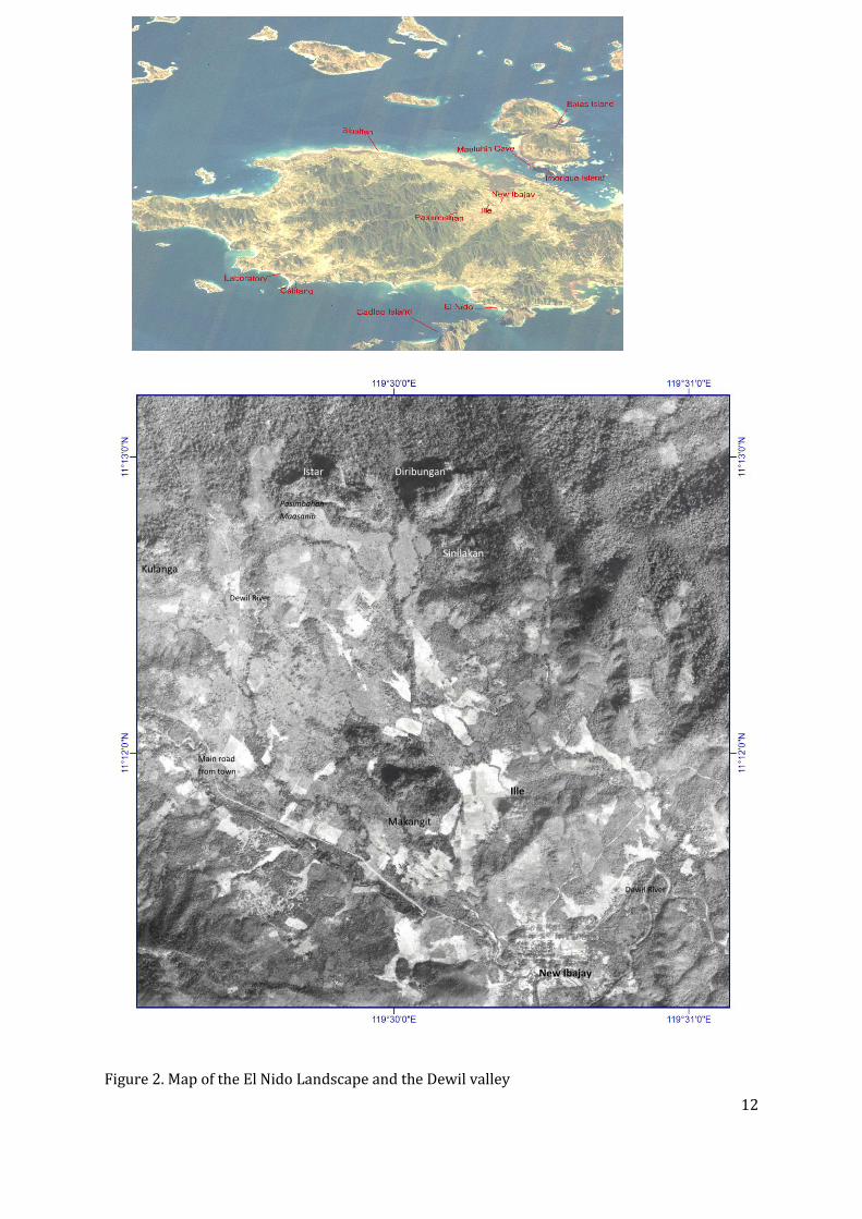
Figure 1. General location map of project area.
Dewil Valley
Tabon
12
Figure 2. Map of the El Nido Landscape and the Dewil valley
NNeeww IIbbaajjaayy
Dewil River
IIllllee
Makangit
Sinilakan
Diribungan Istar
Pasimbahan-
Magsanib
Kulanga
Dewil River
Main road
from town

13
New Ibajay has a Global Positioning System (GPS) reading of 11°11’46” North and 119°30’19”
East. It has a population mainly composed of late 20th century settlers, originally from the
province of Aklan in northern Panay Island. The Dewil area, however, and most of the
communities within the Municipality of El Nido are dominantly populated by people belonging
to the Cuyonin ethnolinguistic group. The people of El Nido town proper and Barangay New
Ibajay are now familiar with the presence of research teams working in the Dewil Valley. It is
however an on-going goal and challenge, done through our heritage initiatives, to ensure that
the local population understands the significance of our study to their lives.
The central area of the project to date is the area around the Ille site. The Ille karst tower is a
short walk northwards from the main road of New Ibajay. It is approximately 75 metres high
from the base. A cave network hollows the tower with three main mouths located at its base.
The main entrance to the cave is composed of two mouths leading to a single chamber. There is
a large platform in front of the cave mouths and an overhang that extends to about 10 metres.
Thick vegetation surrounds the karst tower, which creates a shaded and cool environment
around the platform of the cave. The karst tower formations in the Dewil Valley are surrounded
by islands of thick vegetation, which in turn are surrounded by rain-fed rice fields and vegetable
gardens tended by people living in New Ibajay.
While archaeological research has a relatively long history in northern Palawan, starting in the
1920s, there has never been a sustained research effort matching the initiative now seen
centered at the Dewil Valley. In the 1920s, the archaeologist Carl Guthe (1927, 1929, 1935, and
1938) pioneered a Philippine wide archaeological and ethnographic-material collecting project.
Guthe specifically explored northern Palawan as part of his objective to collect as much
ethnographic and archaeological materials from the Philippines for the University of Michigan.
In the processes he recorded archaeological sites in and around the vicinity of present day El
Nido (see also Solheim 2002). Guthe’s work, however, never went beyond recording and
reporting what he surveyed and collected. There was no attempt to earnestly do a synthesis
from the vase collection of material culture he gathered and brought back to the United States.
Specifically, the Palawan data was not utilized to better understand the nature of the
transformation of human culture through time, nor the attempt to know the processes involved
in the formation of the old cultures.
In the 1960s, Robert Fox (1970) traced-back and continued Guthe’s work in northern Palawan.
In the process Fox recorded new sites from the area, adding to the long list of sites reported by
Guthe. A good number of these sites were from small islands located in Bacquit Bay. Of the sites
Fox surveyed within the islands of the bay, a few were excavated. One such site excavated in the
1960s was the Leta-leta cave. Located in Lagen Island currently integrated in the Lagen resort
complex, Leta-leta cave was a site earlier reported by Guthe. It was confidently established
through systematic excavations that the burial site was of antiquity associated with the “Metal
Figure 2. Map of the El Nido Landscape and the Dewil valley

14
Age”, or about 2000 to about 1500 years old. The excavation also recovered a unique jar with its
rim fashioned to look like a yawning/shouting person, which is now permanently displayed in
the National Museum of the Filipino People.
During Fox’s stay in El Nido, Mrs. Gloria Fernandez and her family assisted in the National
Museum project. The keen interest of Mrs. Fernandez in archaeology was of valuable help to the
National Museum, who in turn deputized her to monitor and continue the exploration of the
area for new archaeological sites. Way after Fox’s research season in Palawan, Mrs. Fernandez
noted and reported to the National Museum new archaeological sites from El Nido. Some of
these sites were personally located by Mrs. Fernandez or were brought to her attention by
people who did or witnessed pot hunting activities. Gloria Fernandez is likely the source for the
short reference of Fox in his work stating “reliable reports of caves containing cultural materials
in the Diwil (sic) and Taytay areas...” (Fox 1970: 179). The information shared by Mrs.
Fernandez played a significant role in the 1998 El Nido survey, which is the direct origin of the
current project. Though there is an eye witness account that Fox personally saw the Makangit
karst within Dewil valley, the 1998 survey directly led to the full-blown study of the Dewil
valley. It was Fernandez who was responsible in directing our team to previously known sites in
the Dewil Valley. The survey made at the valley consequently led to the discovery of the Ille site.
At that time, Ille was an unrecorded site near known sites within the valley, such as “Star” and
“Makangit”.
In the 1960s to the 1980s, after the initial interest in sites such as Leta-leta waned, northern
Palawan was for all intents and purposes relegated to the sideline of archaeological research.
This was the case because there were very few full-time field archaeologists and the interest in
the island’s archaeology was focused on central Palawan. This interest in the archaeology of
central Palawan was brought about by the recovery of fossilized human remains from Tabon
cave located at Lipuun Point in Quezon. These were then the earliest accepted evidence of
modern human existence in the Philippine Islands (Fox 1970, Dizon 2003). By the 1970s, with
limited capable archaeologists in the Philippines, northern Palawan could also not compete in
priority with the work pursued in the Cagayan valley in northern Luzon. The Cagayan valley
was a priority consistent with the research direction at the time where the objective was to
recover direct evidence of the existence of pre-modern humans in the Philippines (Fox & Peralta
1974).
The interest in antiquity continued in an unfortunate way in northern Palawan with the absence
of directed archaeological research. Large scale pot hunting activity was present throughout the
1970s and 1980s coupled with treasure hunting in search of the “Yamashita treasure” fiction. In
the coastal barangay of Sibaltan, El Nido, the scale of pot hunting was so large and the finds of
hoards of porcelain and trade goods spectacular, that the National Museum responded by
sending a team from the Cultural Properties Division to supervise excavation and collection of
15
tradeware ceramics. The presence of the Museum started in 1976 and returned for one more
season in 1977. The National Museum team, however, focused on collecting ceramic samples
and did not have the man-power or resources to pursue directed research. Sibaltan was
revisited during the 1998 survey (see Paz 1998) with the potential of the area reiterated in
preceding reports (e.g. Paz et al. 2008, 2009). The area was finally integrated into the PIPRP
project with full-blown excavations at the Sibaltan elementary school and the Acosta Property
site in 2010 (Paz et al. 2010).
In the midst of extensive pothunting during the decades from the 1970s to the 1990s there
were a few systematic archaeological surveys done in northern Palawan. An initial survey was
done by the National Museum in 1990 on the vast landscape of El Nido and Taytay (Aguilera
1990). A sustained archaeological interest however only returned to northern Palawan in the
late 1990s through the initiatives of NGOs like the Philippine Rural Reconstruction Movement
(PRRM), and the Southeast Asian Institute of Culture and Environment, Inc. (SEAICE). These
initiatives were closely coordinated with the National Museum of the Philippines and Ten Knots
– a private company that manages the first class resorts in El Nido. The survey done in 1998
resulted not only in improving the data on previously reported sites (Paz 1998, Jago-on 1998),
as mentioned earlier, it also resulted in the rediscovery of the high research potential of the
Dewil valley. Within the Dewil valley the Ille karst tower captured the imagination of
archaeologists such as Wilhelm Solheim, who was part of the 1998 survey team. Within the
same year of the survey the Ille site was mapped (Mijares et al. 1998) and a test excavation
initiated.
Excavation at the Ille site started in 1998 with a 1.87m x 1m (site grid location N3W12) test pit
at the front of the West mouth; time, manpower constraints, the presence of human burials and
large buried boulders limited the depth of this excavation to less than a metre (Hara & Cayron
2001). The first full scale excavation was conducted in 1999 (Solheim 1999, de la Torre 1999,
Bautista 1999) with four excavation areas opened, following the 1m x1m grid previously
established across the platform. The excavation concentrated on grid squares N3W12, N4W12,
N3W13, N2W12, and N2W12. Several human burials were excavated in the processes as well as
a shell midden. The nature of the archaeology once again slowed down the team to get to the
deeper cultural deposits.
In 2000, excavations continued at the Ille site with the previous West mouth excavation
reopened and excavated deeper (Jago-on 2000, SEAICE 2000a, 2000b). The excavation did not
manage to go much deeper than the previous season with the due to a large rock fall that
occupied most of the space of the excavation area. In 2002 equal emphasis was given to
excavating both West and East mouth fronts of the cave’s platform (Swete Kelly & Szabo 2002,
Kress 2002). The season ended with substantial progress in the understanding of the
archaeology of Ille. The season also provided better evidence for a shell midden layer in both

16
the West and East mouth excavation areas; more burials and artefacts were uncovered similar
to the results of the previous excavations; more importantly a series of tight radiocarbon dates
came out from the stratigraphic sequences at the East mouth excavation area. The dates allowed
for a clear understanding of the time depth of the cultural deposits from the excavated shell
midden layer to around the depth of 125cm from the surface. There was a consensus in the
understanding that below the recorded shell midden layer there was a strong case for cultural
remains below the radiometric dated to c. 10,000 years-ago-level from the 2002 season (see
Szabo et al. 2004). Almost simultaneous with the 2002 report, all previous excavations were
further synthesized in a status report written by Prof. Wilhem Solheim II (2004) for the Solheim
Foundation. In this report, insights on the possible fate of Burial No. 1 to 4 at the West mouth
were expanded. It was postulated at this time that we may be looking at the remains of
massacred individuals hurriedly buried. The Solheim report also reiterated a call for the
Philippine archaeology community to commit a long-term research initiative at Ille, which the
PIPRP responded to.
The PIPRP heeded the call of Prof. Solheim by refocusing its fieldwork from the southern part of
the main island of Palawan to the north. There was also the urgency involved when reports
reached the archaeology community of massive pot hunting activities taking place in the Dewil
valley after the end of each excavation season from 2000 to 2003. For details of the results of
the project for the seasons 2004 are covered in the previous reports. It is however appropriate
to mention that so far, based on a robust series of isotope dates representing the stratified
archaeology at Ille site, human cultures were flourishing in the El Nido area as far back as
14,000 years ago (Lewis et al. 2006), and that the new knowledge we have of the complexities of
cultures that flourished within this time period is remarkable .
The materials from all the Dewil valley excavation seasons are mainly stored in the facilities of
the Archaeological Studies Program in Diliman, where analysis of many of its facets continues.
The access given by the project proponents to researchers has so far led to completion of top
quality analysis and publications. We can see this in the challenge of initially mapping the site,
which resulted to the creation of the first detailed map of the Ille site (Pawlik 2004). Since 2007,
Emil Robles has updated and improved the mapping of the two major sites in the valley, i.e. the
Ille and Pasimbahan-Magsanib sites. The human teeth from the burials excavated in the first two
seasons were studied in detail (Medrana 2002). This study gave us a better understanding of the
ages and health of some of the individuals buried in the platform. This line of inquiry continues
with several graduate students taking up the challenge of looking at the mostly poorly
preserved human remains. From the various shell remains excavated from Ille an initial study
managed to determine most of these shells to species level and initiate a discussion on
subsistence (Faylona 2003, 2006). The shell artefacts also contributed to the dissertation
research of Dr. Katherine Szabó at the Australian National University (Szabó 2004). Pauline
Basilia, who gained interest and inspiration from Szabó’s (2004) dissertation, recently
17
conducted an experimental study on the shell artefacts to advance our knowledge of prehistoric
technology in the area (Basilia 2012). More basic taxonomic work continues on the numerous
shell remains from the site.
From another perspective, the discovery of a terracotta turtle figurine from Pacaldero cave site
in the Sinilakan karst in the Dewil valley, allowed for reflection on the significance of turtles in
the cosmology of the early inhabitants of the valley (Cayron 2004). The continuing study of
Pacaldero led to the discovery of other parts of this figurine, which led to the reinterpretation of
the vessel as that of a bird representation (Paz et al. 2010). There is also an article by Ochoa
(2005) analyzing the juvenile dog remains found at the West mouth trench at Ille. She situated
this find within the larger view of dog domestication. The study of Makangit cave (see Teodosio
in Paz & Ronquillo 2004) also tackled questions revolving around the identification of bone tool
technology in Island Southeast Asia (Teodosio 2005). A look by Kress (2006) on the work done
by Robert Fox on the Negritos situates the potential of the current excavation work at Ille to
elucidate on modern human origins in the Philippine archipelago. Aside from the archaeology,
members of the project also did ethnographic studies. A good published example is Medrana’s
(2005) work recording the weekly butchery practice of pigs in New Ibajay.
More recently, several in-depth analyses were completed associated with the study of the Dewil
valley, especially the Ille site materials. Two polished stone adzes were analyzed by Pawlik
(2007) from the stand point of use-wear analysis. He documented the high-level of edge-
sharpening skill that the makers of the tools had. The Ille faunal assemblage was the focus of
Ochoa’s (2009) Masters Thesis; explaining the changing animal resource availability in the
valley through arguments related to animal exploitation patterns. The confirmation of
recovering tiger bones from Ille (Piper et al. 2008) expanded the known range of animals and its
implications to our understanding of ancient landscapes; the effect of changes in the
environment during the end of the Pleistocene. The completion of the analysis of the first
recovered cremation remains from Ille was the focus of Myra Lara’s thesis (Lara 2009); she
called on caution when on purely bone morphological grounds scholars argue for cannibalistic
behavior. Paz and Vitales (2009) re-thought the arrangement of artefacts from burial context
727 at Ille and argued that it most likely represented a talisman of the person buried. Vitales’s
interest in the cosmology and shell artefacts from Ille brought him to study the context of shell
artefacts, particularly the Melo spp. shells (Vitales 2009). Through his approach he
demonstrates the significance of this particular shell in the cosmology of the early inhabitants of
Palawan Island.
A study of a large portion of the collection of ceramic finds from the valley has also begun with
Balbaligo’s (2010) work. She studied and described, giving details on quantities, fabric and form
of pottery collected from the 2004 to 2008 Dewil valley seasons. She also discusses the
manufacture and decoration styles of this enigmatic assemblage. The limestone hand axe
recovered from the Ille rockshelter was contextualized in at least two publications, drawing
18
from the analysis done by Pawlik (see Paz et al. 2010), which revisits the long standing
discourse on the technological analysis of stone tools in Southeast Asia (Pawlik 2010, Dizon and
Pawlik 2010). A recently completed PhD area studies dissertation at the Nation University of
Singapore focused on PIPRP data to discuss long term and long range trade and exchange
patterns in Island Southeast Asia (Cayron 2011).
The study of Dewil valley has also benefitted from parallel research from colleagues working on
related concerns. A good example comes from the Quaternary geologists mostly based at the
National Institute of Geological Sciences at the UP (see Maeda et al. 2003). The combined
analysis of data collected from the study of uplifted tidal notches, sediment cores and coral reef
terraces may allow for an understanding of sea levels and possible climatic conditions at the
time the Ille tower was utilized as a burial and habitation site. Another example is the research
group of Reotita, Siringan and Kamiya (2008) from the UP Marine Science Institute working on
the palaeoenvironmental reconstruction of the Dewil valley. There is also a pioneering study on
the use of guano deposits as proxy evidence for local and regional vegetation change, as well as
a dating proxy for archaeological sites in the area. This work started with deposits from the
Makangit tower inside the Dewil valley (Bird et al. 2007). As of writing there are many more
collaborative research work centered on Palawan, whose results are sure to come out soon.
5. METHODOLOGY
Several methods were utilized to address the research objectives of this project. These methods
have been consistently applied since the beginning of the project.
5.1 EXCAVATION
Excavation is still the primary method employed for this research. This year the excavation was
both at the platform/rockshelter and inside the cave of Ille. Like in the previous year, the West
Mouth was not re-opened and work concentrated instead on the East Mouth area (East Mouth,
East Chamber, East Chamber Long Trench and East-West Connection). A week before actual
excavation started, backfill was removed until the thick plastic lining from the previous season
was exposed. At the end of each season, all excavated areas were lined with plastic sacks and
back-filled to protect both the site and the cave visitors including animals that might fall in the
trenches.
The East mouth trench has been lacking much back-fill material mainly due to the high
resolution methodology applied on site since 2004 wherein wet sieving and flotation off-site
was extensively practiced. Backfill had to be collected from other nearby areas and this practice
has been done since 2007 when it first became apparent that there was not enough sediment to

19
fill the trenches to their original levels. An intricate terraced sandbagging system was also
applied to prevent the walls of the trench from collapsing.
For the Pasimbahan-Magsanib site in the Istar limestone karst, this is the fourth straight year of
excavation. Only the Trenches A and B were opened for this season. Test excavation trenches
were also opened along the Makangit karst formation in pursuit of possible open habitation
sites.
5.2 SURVEY
The method of survey was done with the help of informant work. From the areas pointed out by
the informant, an ocular inspection was carried out on the known area and its surroundings.
The survey of the Dewil valley continued. This year more extensive surveys were conducted in
the valleys open areas, particularly in the vicinities of Makangit, the northwestern end of the
valley and portions of areas south, southeast of the Ille karst tower, and the New Ibajay
barangay proper.
5.3 HIGH RESOLUTION RECOVERY OF FINDS
It has been the aim of the excavation at Dewil to practice high resolution recovery of all possible
evidence of past human activity, especially human-plant and human-animal interactions; there
is a constant aim to understand both ecological and cultural patterns on site. The matrix
associated with known surfaces and features such as shell middens and hearths coming from
the excavations were subjected to flotation. The heavy fraction that remained after the wet
sieving were sun-dried, sorted for biological remains and artefacts while at the field base. The
light fraction samples from the flotation were brought back to the ASP laboratory for further
sorting and analysis. Special interest was also given to the types of shell remains recovered from
the site. All sediments above the shell midden layers not associated with hearths and pits were
dry sieved. The sediments from the shell middens were completely floated and wet sieved. All
contexts from the shell middens down to the lowest levels that were not hearths, pits or
combustion features underwent wet sieving. Coring was also conducted in identified areas with
good potential to inform on palaeoenvironment. This was done in conjunction with this year’s
landscape surveys (see results on palaeoenvironment and landscape survey).
5.4 PUBLIC ARCHAEOLOGY INITIATIVES
There has always been an effort towards disseminating knowledge generated from the surveys
and excavations done within the framework of the PIPRP. In the early years, the research teams
conducted dialogues and meetings with the Barangay Council mostly to explain the nature of the
project’s archaeological work, its methods and general objectives. Every now and then these
dialogues are still held although mostly in an informal way. In 2007, an exhibit on the scientific

20
findings of the excavation in Ille was put up right in the Ille Site. Consisting of a single back to
back wooden panel and a framed tarpaulin, it contains photographs, texts and casts / replicas of
the major artifacts found in the site and in Palawan. This exhibit was updated last year. The
landscape survey work has also made headway in reaching to owners of properties which have
been surveyed and cored; explaining to local and tourists the nature and potential of the work in
open sites.
6. RESULTS
6.1 PASIMBAHAN-MAGSANIB (IV-2007-Q1)
The Pasimbahan-Magsanib site, located at N110 12”881’. E 1190 29’59’, is within the western
side of the large Istar karst formation, and is within Sitio Magsanib of Barangay New Ibajay. For
this season excavation in this cave and rockshelter site was limited to the reopening of Trenches
A & B. These two trenches were first investigated in 2007 during the first excavation season at
the site. They were excavated every season hence. Trenches A and B by the end of the season
had the dimensions of 442cm (N) x 384cm(S) x 365cm (E) x 279cm(W). The irregular shape of
the trench was due to the limits provided by the rockshelter wall and the width of the sediment
deposits at it location on the western end of the shelter. As in previous seasons, we were still
trying to reach the oldest archaeological deposits on site and at the same time compare the
archaeological assemblage of the site with the other sites in the valley.
After taking out the backfill from the trenches and exposing the last surface excavated last year,
this surface was trowel-cleaned exposing once again an archaeological-rich loose light yellowish
brown clayey silt surface [c.414]. The absence of pottery remains and the relative abundance of
animal bones amongst chert flakes found at this c.414 surface suggested a much older
archaeological deposit waiting than those previously to be further exposed.
Two Local Datum Points were established for depth measurements: LDP1 was 195cm below the
DP, and LDP2 was 189cm below DP. Trenches A and B by the end of the season only had the
dimensions of 442cm (NN)) x 384cm(S) x 365cm (E) x 279cm(W). As with the previous
seasons, among the goal this year was to investigate whether there are older deposits that might
show evidences of human occupation or activity. The season started by exposing the last context
(414) investigated by the 2010 season. This was initially interpreted as the oldest layer and as
the activity floor of the prehistoric settlement of the area. (Paz et al, 2010)
(There is no homogenous layer in the trench). As context c.414 had many stone inclusions, we
removed these stones and checked each one to see if they were it first and then sorted them out
to check if there are potential stone tools or and debitage of stone tool making. Within and

21
younger than c.414 were several depressions that could have been animal burrows [c.420] and
were named as context 420. Mid-reddish brown sediment with orange (oxidized) inclusions
became apparent in the north-eastern quadrant of the trench [c.421] while a dark reddish
brown sediment with numerous shell inclusions were evident in the northwestern part of the
trench [c.422].
Figure 3. The Pasimbahan-Magsanib site plan indicating locations of excavation trenches
More significant were features that seem to have formed on the surface of c.414. There were at
least two major deposits of cemented ashy sediment concentration [c.427 & c.430]. These
features have chert flakes and obsidian debitage inclusions. Meanwhile in the Southwest corner
of Trench B, c.57 continue to go down until hitting the rockfall, thereby causing the excavation
in that area to stop at the moment. It also became apparent that there were simultaneous
depositions of at least two types of sediments on the surface of the rockshelter, with the floor
inclined towards the gaping crack along the base of the rockshelter wall. The excavation ended
just further exposing the rock fall dominated surface.
22
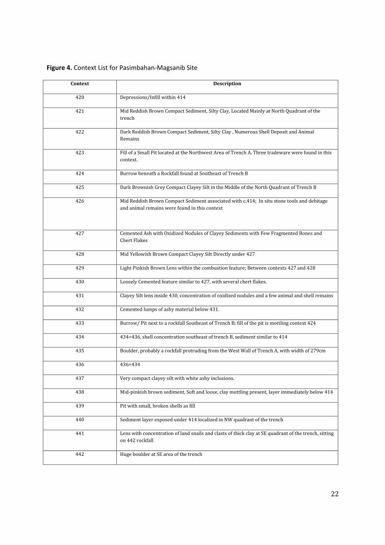
Figure 4. Context List for Pasimbahan-Magsanib Site
Context Description
420 Depressions/Infill within 414
421 Mid Reddish Brown Compact Sediment, Silty Clay, Located Mainly at North Quadrant of the
trench
422 Dark Reddish Brown Compact Sediment, Silty Clay , Numerous Shell Deposit and Animal
Remains
423 Fill of a Small Pit located at the Northwest Area of Trench A. Three tradeware were found in this
context.
424 Burrow beneath a Rockfall found at Southeast of Trench B
425 Dark Brownish Grey Compact Clayey Silt in the Middle of the North Quadrant of Trench B
426 Mid Reddish Brown Compact Sediment associated with c.414; In situ stone tools and debitage
and animal remains were found in this context
427 Cemented Ash with Oxidized Nodules of Clayey Sediments with Few Fragmented Bones and
Chert Flakes
428 Mid Yellowish Brown Compact Clayey Silt Directly under 427
429 Light Pinkish Brown Lens within the combustion feature; Between contexts 427 and 428
430 Loosely Cemented feature similar to 427, with several chert flakes.
431 Clayey Silt lens inside 430, concentration of oxidized nodules and a few animal and shell remains
432 Cemented lumps of ashy material below 431.
433 Burrow/ Pit next to a rockfall Southeast of Trench B; fill of the pit is mottling context 424
434 434=436, shell concentration southeast of trench B, sediment similar to 414
435 Boulder, probably a rockfall protruding from the West Wall of Trench A, with width of 279cm
436 436=434
437 Very compact clayey silt with white ashy inclusions.
438 Mid-pinkish brown sediment, Soft and loose, clay mottling present, layer immediately below 414
439 Pit with small, broken shells as fill
440 Sediment layer exposed under 414 localized in NW quadrant of the trench
441 Lens with concentration of land snails and clasts of thick clay at SE quadrant of the trench, sitting
on 442 rockfall
442 Huge boulder at SE area of the trench

23
Figure 4. Vertical profiless of East and West walls of Trench A & B, Pasimbahan-Magsanib Site in 2011
Figure 5. Vertical profiles of East and West walls of Trench A&B, Pasimbahan-Magsanib Site in 2011

24
Figure 5. Vertical profiless of North and South walls of Trench A & B, Pasimbahan-Magsanib Site in 2011
Figure 6. Vertical profiles of North and South walls of Trench A&B, Pasimbahan-Magsanib Site in 2011

25
6.2 ILLE SITE (IV-1998-P)
EAST CHAMBER TRENCH EXCAVATION
The East Chamber Trench (ECT) from the first time it was opened provided information about
the depositional history within Ille site and its use by past peoples. The excavation of ECT this
season allowed the recovery of numerous microvertebrate remains (e.g. bats, porcupine, and
other rodent groups), several big vertebrate elements (e.g. deer), and a number of stone chert
fragments. The excavation started with the complete removal of c.2138 to expose new
sedimentary horizons such as the highly organic c.2139. During the early part of the season,
excavation units N15W2 and N15W1 in c.2139 revealed a noticeably high concentration of
microvertebrate remains. A suspected hearth [c.2148] was investigated in N13W3 at the depth
of 118cm. Context 2148 cuts through c.2139. Context 806 (N15W1-W2) was concurrently
peeled away to expose the speleothem layer underneath [c. 2150]. It was also noted that c.806
is physically similar to c.866 save for the prominent content of gravel in c.866. This is consistent
with observations made in previous seasons on areas towards the mouth of the cave with c.806
and c. 866 deposits. The excavation in the chamber suggests that the bulk of animal remains
recovered in these deposits come from c.806 and the increase in amount of animal remains in
c.866 might be a product of sorting by fluvial processes believed to transport the sediments and
artefacts, including animal remains towards the mouth of the cave. Other evidences that may
suggest this were that concentrations of animal remains in c.2150 were described as having an
indurated compaction type and that both c.2150 and c.806 are coarse grained deposits.
Additionally, the general scatter of microvertebrate remains is absent in both these contexts.
The northward continuity of c.1306 in the East Mouth Long Trench (EMLT) into the ECT was
also investigated during the season. It can be established that c.1306 punctuated somewhere
between N9-10 and did not extend into the ECT. The high representation of microvertebrate
remains in c.2149 such as the maxillary and other sturdy bone elements may indicate that the
bones were introduced by a certain predator that may have stayed in the area directly above the
context during periods when it was exposed.

26
Figure 6. East and West Stratigraphic Profiles of the East Chamber Trench Excavation
Figure 7. East and West stratigraphic profiles of the East Chamber Trench excavation

27
Figure 7. North and South Stratigraphic Profiles of the East Chamber Trench Excavation
Figure 8. North and South stratigraphic profiles of the East Chamber Trench excavation

28
Figure 9. East Chamber Connecting Trench profiles
29
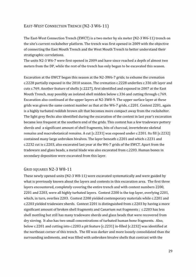
EAST-WEST CONNECTION TRENCH (N2-3 W6-11)
The East-West Connection Trench (EWCT) is a two meter by six meter (N2-3 W6-11) trench on
the site’s current rockshelter platform. The trench was first opened in 2009 with the objective
of connecting the East Mouth Trench and the West Mouth Trench to better understand their
stratigraphic correlations.
The units N2-3 W6-7 were first opened in 2009 and have since reached a depth of almost two
meters from the DP, while the rest of the trench has only begun to be excavated this season.
Excavation at the EWCT began this season at the N2-3W6-7 grids; to exhume the cremation
c.2228 partially exposed in the 2010 season. The cremation c.2228 underlies c.336 silt layer and
cuts c.769. Another feature of shells [c.2227], first identified and exposed in 2007 at the East
Mouth Trench, may possibly an isolated shell midden below c.336 and cutting through c.769.
Excavation also continued at the upper layers at N2-3W8-9. The upper surface layer at these
grids was given the same context number as that at the W6-7 grids, c.2201. Context 2201, again
is a highly turbated reddish brown silt that becomes more compact away from the rockshelter.
The light grey flecks also identified during the excavation of the context in last year’s excavation
became less frequent at the southern end of the grids. This context has a few tradeware pottery
sherds and a significant amount of shell fragments, bits of charcoal, invertebrate skeletal
remains and macrobotanical remains. A cut [c.2231] was exposed under c.2201. Its fill [c.2232]
contained many large unbroken bivalves. The layer beneath c.2201 and which c.2231 and
c.2232 cut is c.2203, also excavated last year at the W6-7 grids of the EWCT. Apart from the
tradeware and glass beads, a metal blade was also excavated from c.2203. Human bones in
secondary deposition were excavated from this layer.
GRID SQUARES N2-3 W8-11
These newly opened units (N2-3 W8-11) were excavated systematically and were guided by
what is previously known about the layers and contexts in this excavation area. The first three
layers encountered, completely covering the entire trench and with context numbers 2200,
2201 and 2203, were all highly turbated layers. Context 2200 is the top layer, overlying 2201,
which, in turn, overlies 2203. Context 2200 yielded contemporary materials while c.2201 and
c.2203 yielded tradeware sherds. Context 2201 is distinguished from c.2203 by having a more
significant amount of broken shell fragments and Canarium nut fragments ; c.2203 has less
shell mottling but still has many tradeware sherds and glass beads that were recovered from
dry sieving. It also has two small concentrations of turbated human bone fragments. Also,
below c.2201 and cutting into c.2203 a pit feature [c.2231] in-filled [c.2232] was identified at
the northeast corner of this trench. The fill was darker and more loosely consolidated than the
surrounding sediments, and was filled with unbroken bivalve shells that contrast with the

30
fragmented shells in the surrounding sediments. No other significant finds were found in this
pit.
Below c.2203, at around five cm below the DP, was c.2244, a reddish brown clayey silt sediment
layer of similar composition as c.2203. However, it has smaller shell fragments, more significant
scatterings of human bone fragments and has less tradeware than c.2203. The dominance of
earthenware sherds in this layer and in the burial fills associated with this layer was also noted.
Further, the assignation of a different context number was done because of the presence of
several burials within this layer.
The first burial cutting into c.2244 was c.2239 at the southwest corner of the trench in N3 W10-
11. The fill of this burial [c.2238] is reddish brown silt with shell and earthenware pottery
sherds and is slightly more compact in proximity to the skeleton than the surrounding elements.
Burial c.2239 consists of the upper portion of an adult skeleton oriented north to south (toe to
head). The lower skeleton is truncated, leaving nothing below the left innominate; its right
forearm and hand are also missing, though the remaining forearm is crossed over the area of the
pelvis. Also the anterior portion of the skull and the right lower arm are disturbed/missing.
Associated material culture with this burial are a large Melo shell fragment near its right
shoulder and a small glass bead from the grave fill. This burial was completely recovered.
At the same level as c.2239, 13 cm from DP and lying on top of c.2244, is a cache of
disarticulated human bones [c.2240]. This cache of bones consists of a left humerus, left ulna,
left radius, carpals and phalanges from the left hand, left scapula, fragments from thirteen ribs,
fragments from five vertebra, a right innominate, two femurs (left and right) and a left pubic
bone, all from a juvenile and an incisor from an infant. This main cache was surrounded by
other disarticulated human bone fragments, including ulna, cranium and femur fragments. The
cache and the other disarticulated elements were all recovered.
As c.2244 was continued to be scraped, a pair of crania [c.2246 & c.2247] was revealed at the
southern wall of the trench between W7 and W8; excavations followed their orientation (head
towards the south and feet towards the north) to find the extent of the burials. The top of the
skull of c.2247 was 19 cm below DP while the top of the skull of c.2246 was 15 cm below DP.
Only c.2247 proved to be a largely complete burial as the postcranial elements of c.2246 were
not found to be articulated. Context 2247 was an adult, buried with its head to the south and its
feet to the north. Its arms were flexed upwards tightly to the chest with the hands across the
clavicles. When it was first exposed, the individual's mandible was agape and in its mouth were
pieces of rocks and shells.

31
Figure 10. Stratigraphic Profiles of the East-West Connecting Trench

32
Whether this was deliberate or due to taphonomic reasons is still unknown. Two shells were
noted beside the left ear and an andesitic hammerstone was recovered under the rib cage of this
individual.
The cache of human bones [c.2240], found above the pelvic region of c.2247, was surmised to
be the rest of skeleton c.2246, disturbed and replaced in the ground during the burial of c.2247.
Context 2246 is therefore the older of the two burials.
Context 2247 is likewise heavily turbated. It was revealed that its left leg was truncated and the
elements replaced, with the long bones positioned in the opposite direction. These misplaced
bones were initially labeled c.2251 and a separate number for the fill [c.2250], but are now
treated as equivalent to c.2247 and the fill was labeled c.2245 - mid-reddish brown silty clay
with inclusions of complete shells particularly around the skulls of c.2246 and c.2247. These
bones were all recovered.
The lower portion of c.2247 was disturbed by yet another burial designated as c.2249. Context
2249 is an infant burial encountered under what would have been c.2247's legs, at a depth of 28
cm below the DP. In order to bury the infant at this location, the grave cuts through Burial
c.2247 and its fill c.2245, causing the dislocation of the latter burial's lower left legs. Further, a
large root runs across the central portion of c.2249's body. The fill of this burial [c.2248] was a
friable mid reddish brown clayey silt. Upon further exposing the burial, it was revealed that it
was an infant burial, and that it had no cranial elements; the portions of the right rib cage,
including the right scapula, were also missing. The presence of the first cervical vertebra and
the absence of the skull raise some possibilities as to how this may be explained, but a definite
answer is yet to be had. Associated material culture with the infant burials were eight small
shell beads found within the left ribcage. This skeleton and all associated artefacts were
recovered. The temporal sequence of these burials thus far is: c.2246 is the earliest burial,
truncated by c.2247, with the disturbed bones replaced on top of c.2247 and recorded as human
bone cache c.2240. Context 2247 was then disturbed by the infant burial c.2249, making this
the youngest interment.
At a similar level as c.2249 but not in proximity to it was another primary burial [c.2255] in grid
N2-3 W9. Though the burial was encountered at a depth of 26 cm below the DP, no cuts were
found cutting into c.2244, raising the possibility that the fill [c.2254] of c.2255 is associated with
the upper layer c.2203, which may make this a temporally younger burial compared to the other
burials so far discussed. Material culture will not be of help here as no artefacts were found to
be directly associated with this burial.

33
In any case, this burial c.2255, that of a juvenile, appears to have been disturbed as the cranium
above the mandible, the right arm, right half of the torso and pelvis are missing. Nevertheless,
the position of this burial could still be determined as supine extended, with the feet pointing to
the north and the head to the south, consistent with the other burials.
Another truncated burial was exposed once again in proximity to the burial cluster
c.2246/c.2247/c.2249. Under the lower portion of the leg of c.2247 were exposed a pair of
femurs and part of a right pelvis [c.2253] at 32 cm from the DP. No cuts were immediately
visible for c.2253, though the fill [c.2252], was distinguished as a friable, mid reddish brown
clayey silt. The pelvis and the pair of femurs are arranged in the correct anatomical position,
though the lower half of the femurs (and thus the rest of the legs) goes into the unexcavated
northern baulk of N3W9. The pelvis was easily recovered but the femurs had to be carefully
extracted from the wall. We are still not certain if the rest of the skeleton was included in the
human bones cache c.2240 or are among the isolated elements found throughout layer c.2244
covering the entire trench.
As the team continued removing c.2244, another extended burial [c.2263], was exposed at N1-3
W9 at a depth of around 80 cm from the DP. This burial is that of a subadult (six-year molars
erupted). Its head was oriented towards the south while its feet were pointing to the north. Its
right forearm is flexed across the pelvis while its left arm may be lying on its side or flexed
across the pelvis as well. The skeleton is very friable and disturbed by a root running along the
middle portion of the body. However, the burial's cut [c.2272] and fill [c.2264] were both quite
apparent. The burial's fill is mid-yellowish brown silt similar to c.2244, but is more compact
than the surrounding sediments. The fill also has numerous shells, pottery and animal and
human bone fragments that are not directly associated with the burial. Material culture that
were associated with this burial were a few red and blue glass beads and shell beads found near
the rib area, as well as a few yellow and white glass beads somewhere near the hands and legs.
At the chest portion were recovered what may possibly be textile fragments, white in color and
with a 'waffle-like' pattern. This skeleton was also completely recovered.
The final extended primary burial excavated from these units this season is c.2266, uncovered
as c.2244 was being cleared in the grids N2-3 W10-11 near the western baulk at around 90 cm
from the DP. Context 2266 was originally c.120, a partially excavated burial from the West
Mouth first uncovered in 2004. As such, it now consists of a complete right arm, a fragmented
scapula and some vertebral elements. From these elements it was still possible to reconstruct
the position of the body with its head towards the south and its lower body pointing towards
the south. The remaining arm was tightly flexed, with its hand perhaps lying beside the
individual's head. A complete shell disc was found on top of the most proximal vertebra. A
stone that is possibly worked was also found near the right shoulder of the burial. After
recovering these elements the fill [c.2267], which is very similar to c.2244 but is more compact,

34
was recorded, but the cut could not immediately be seen. Burial c.2266 is the last burial to be
recovered from the c.2244 layer.
To the north of burial c.2244 was a pit feature [c.2296]; its cut [c.2278] and its fill [c.2269]. This
fill is similar to c.2244 but its color is slightly darker than c.2244. The cut [c.2278], can clearly
be seen as a pair of potsherds were deposited upright, delineating the borders of the pit. One
sherd was earthenware and the other was tradeware. Though this feature is at almost the same
level as Burial c.2266, this pit seems to be younger than the burial as it truncates the lower
portion of the skeleton. Also, a fragment of a pelvis was included in the fill for c.2296, which
may be part of the missing pelvis of c.2266. As c.2244 was finally cleared away, a new layer
[c.2229] was uncovered. Context 2229 is a mid-yellowish brown, loose sandy silt layer which
was 67 cm below DP. Within this layer were complete shells, and it is possibly correlated with
c.2217.
Within c.2229 at the north wall was a feature consisting of a stone-lined pit and human remains.
The arranged stones [c.2287] was first noticed peeking out of c.2244, but the bulk of it is within
c.2229. This stone formation, consisting of nine stones arranged in a semi-circle (It's complete
configuration is still uncertain as the rest of the feature goes into the northern baulk) has the
following depths: the top portion is 88 cm from the DP and the lowest portion is 94 cm from the
DP. The sediment within c. 2287, designated c.2288, is sediment very similar to c.2229, but is
more loosely consolidated. The fill includes fragmented and whole shells and some animal
bones. Also within this fill was an assemblage of human cranial fragments, mandible fragments
and hand phalanges [c.2291]; a boar tusk which may have been worked and used as an
ornament was also found. Context 2291 was cleared as much as possible for the remainder of
the excavation. We are confident that all skeletal elements have been recovered. However, we
are still not confident of the bottom of c.2288 was reached at a depth of 111 cm from the DP.
The stone comprising the stone formation were recorded and removed.
A final context to be recorded in this trench was c.2282, which is a very thin layer (around one
cm) of sediment that was more silty and reddish than the surrounding contexts. This is so far
confined only near the southern wall, between grid numbers N2W7 and N2W8 at a maximum
depth of 68 cm from the DP. A hammerstone was found in this context. These final two contexts
are at a similar depth: Context 2229 is 67 cm below the DP while c.2282 is 68 cm below the DP.
For grid numbers N2-3 W8-11, the season's excavations ended at these layers at these levels.
GRID SQUARES N2-3 W6-7
The previous season's excavation had left this unit of the EWCT with a cremation [c.2228] at the
northwest corner of the trench and substantial limestone deposits on the southern half of the
trench. The limestone layer was the previously identified c.769, and based upon past

35
excavations, c.336 overlies c.769. The team therefore began by further exposing the southern
quadrants, which sloped down to the center of the square (the highest point of the slope was the
square's southwest corner) and ascertaining the deposits to the north, which still appeared to
have patches of c.336.
The deposits in the south quadrants of this trench appear to be the easiest to explain as they are
mostly made up of a succession of limestone (speleothem) deposits with lenses of silt in
between. The team began by clearing away what was previously recorded as c.769, though it
was soon apparent that while substantial areas of the slope were already c.769, patches of c.336
sediment were still present. One of the areas at the corner of N2W7 was initially identified as a
separate context [c.2256], though later it was revealed that it is equivalent to c.336. As
c.336=c.2256 were being cleared away to reach c.769, small concentrations of bone were noted
at the south quadrants, as is expected in these deposits based on previous excavations, as all
previously excavated cremations (including c.2228) are lying on top of this limestone layer
(another cremation, c.2274, appears to be sandwiched between two layers of limestone, with
c.769 on top of it. For full discussion, see cremation section below.
Also in this area, there was a seemingly random concentration of bones and shell fragments
[c.2265] 183 cm below the DP. Another interesting bone concentration feature within c.336 and
on top of c.769 was a cluster of macaque bones [c.2259]. The recovered bones represent the
cranial, dental and appendicular regions and show indications of burning. The bone
concentration seemed to have just been piled on the limestone layer as no indications of a pit or
other containers were seen. These overlying features were recorded and cleared in order to
remove c.769. Under c.769 was a series of ashy-colored limestone lenses and brownish silty
lenses/interfaces that were interspersed throughout the southern quadrants. Context 2268 was
one such interface; it was light brownish orange in color, with orange nodules that is more
compact and lighter in color than c.336 that was encountered as c.769 was being removed.
Below this was an ashy-colored deposit [c.2271]that was initially thought to be the next
substantial limestone layer but also turned out to be a thin lens.
Below these lenses, the next layer was c.337 (=c.2275), a mid orangey brown layer with orange
nodules that is lighter than c.2268, probably because its coloring is not tainted by the ashy
lenses described above. Below c.337=2275 was another thick limestone layer that was initially
separately recorded as c.2270 and c.2281. Context 2270 is a white limestone layer that came
out in big chunks first encountered at the southwestern section of the trench that extended
eastward as a less cemented layer [c.2281] from the middle of N2W6 and N2W7 extending to
the west. Aside from being less compact, c.2281 terminated to the north as a powdery ashy
deposit. However, it soon became apparent that all these were one layer with just different
degrees of compactness. Its depth at its highest point (at the southwest corner of the square)

36
was 155 cm below the DP and at its lowest, near the east edge of the trench, was 194 cm from
the DP. No cultural materials were recovered from this layer.
Below c.2281=2270 was a thin ashy-colored silty deposit [c.2284], at around 154 cm below DP,
which is probably the interface between c.2281=2270 and the next limestone layer [c.2280].
Context 2280 is very similar to c.2281=2270, only that it is separated by c.2284. Like
c.2281=2270, c.2280 occupies the entire sloping portion at the south quadrants of the square, at
quite close depths: at the highest portion (also the southwest corner of the trench) c.2280 is
156cm from the DP. Also like c.2281=2270, c.2280 also terminates as a powdery ashy deposit
towards the middle of the square, though it occupies a somewhat smaller area: unlike
c.2281=2270 which extends until the east edge of the square, c.2280 terminates some 40-50 cm
from the edge of the square. At this point at the exposed eastern section a new context, c.2279,
is revealed, which shall be discussed below.
For the southern quadrants, c.2280 is the last substantial limestone layer to be recorded and
removed during this season. Under c.2280 were identified at least five different contexts which
may or may not be substantial layers. At the westernmost edge of the square, right against the
west wall, was a very compact limestone section [c.2292] that was harder and more difficult to
remove than the preceding limestone layers; this has a depth of 166 cm from the DP. To the
north of c.2292 and also found against the west wall was a concentration of land and freshwater
shells [c.2289] that were lying on top of a flat rock that is part of c.2262 (discussed below).
Also, this feature is located to the south of cremation c.2228. The bottom of c.2289 is 170 cm
below the DP (see profile).
Moving to the east, mostly in the N2W7 quadrant, the sediment below c.2280 is light orangey
brown silty sediment that scrapes off in crumbs [c.2293]; at the lowest point is 178 cm below
DP. To the east of c.2293 is a medium reddish orange silty sediment [c.2294], concentrated
mostly at the southern quadrants, specifically the western portion of square N2W6; it is
distinguished from c.2293 by its coloration as well as its depth, which, at 192 cm below DP, is
deeper than the latter. A swath of limestone runs across c.2294, but whether this is a new
feature or an incidental deposit is still uncertain.
Finally, to the west of c.2294 is a possible feature composed of angular rocks and shell
fragments within a dark orangey brown matrix [c.2295]; confined mostly to the south of N2W7,
and runs into the south wall; it is similar to c.2293 but is darker in color and more organic. At its
highest (still the southwest corner of the square) c.2295 is 157 from the DP and slopes
downward to merge c.2294.
For now, the relationships of these contexts at the lowest exposed level are still not certain as
only their surfaces have been revealed this season. Also, no cultural materials were found from

37
these deposits. What is, for the moment, quite certain is that these contexts, being part of the
sloping area of the trench, overlie c.2279, as discussed below.
As for the northern quadrants of N2-3 W6-7, the presence of several features makes the
deposition history of this portion of the trench less straightforward than that of the southern
quadrants. However, it initially resembled the southern quadrants in that c.769 was visible in
some portions. After the initial scraping it turns out that c.769 was not the only previously
recorded context still remaining in the square, as the lowest portion of c.2227, which was a pit
fill consisting of univalves, animal bones and loose dark brown silty sand was still visible at the
easternmost edge of N3W6. After clearing this pit fill a new feature was uncovered: a posthole
[c.2234] with fill labeled c.2233. After looking at the records it was seen that this feature was
first recorded in 2006 as part of the pit c.2227 but it was now clear that this posthole was
separated by a thin layer of sediment from the rest of the pit. The cut is ringed with stones and
the fill was dark reddish silty clay with bits of charcoal and reddish nodules. The bottom of the
posthole, which was a concentration of rocks, was reached at a depth of 199 cm below the DP.
As the posthole was being cleared away at this portion of the square, a dark brown matrix with
lots of orange nodules was revealed [c.2235]. The posthole c.2233/2234 cuts through c.2235,
which was first noticed at a depth of 190 cm from the DP. At the same level, a section to the
west of c.2235 with more shells and animal bones in a dark yellow-orangey brown matrix
[c.2236]. Though they are found at the same depth, it was seen that c.2236 overlies c.2235, as
after c.2236 was scraped away c.2235 appeared under it. Context 2235 was not totally removed
from the area until the end of the excavation at the northeast section of N3W6, with the
maximum exposed depth at 198 cm from the DP. No cultural materials were recovered from
this matrix.
At the northern quadrants of the area, c.769 was visible in patches. This context did not occur in
these quadrants as a solid, level layer but rather as limestone chunks with different sediments
visible in between. These sediments were initially given separate context numbers, such as the
dark brown compact but crumbly sediment with lots of inclusions of bivalve shell fragments
[c.2237]; it was first encountered near the northeast corner of N3W7 surrounded by chunks of
c.769 at a depth of 197 cm from the DP. At first thought to be a fill naturally deposited into the
crevices between the chunks of c.769, further excavations revealed that c.2237 goes under
c.769 and is therefore older than c.769.
As mentioned, different sediments were deposited within the c.769 patches, and were given the
following context numbers: c.2283 was sediment that first appeared adjacent to c.2237 to its
west and south. Like the originally identified c.2237, c.2283 was also surrounded by chunks of
c.769. Its composition and colour were also very similar, as is its depth, which is 196 cm from
the DP. Context 2283 extends to the west where it merges with c.2241; c.2241, dark, compact

38
yet crumbly sediment with bivalve fragments and animal bone fragments, similar to c.2237 and
c.2283. It may also be directly associated with the cremation c.2228, as it occurs adjacent to
c.2242, which is a dark, yellowish brown compact silty sediment that is within c.2228, and the
delineation between the two contexts are quite blurry. Also, c.2241 is also found within c.2262,
pertaining to the rocks surrounding the cremation c.2228, which is further explained below.
Finally, c.2286 is a thin lens of dark brown compact sediment just to the south of c.2228 which
terminates against the west wall of N3W7. It is visually similar to c.2237, c.2283, c.2241 and
c.2242. Also, similar to c.2241, c.2286 was also lying between the rock slabs of c.2262
(discussed below), especially towards the west wall. However, it is important to note that
although c.2286 overlies c.2262, at the highest point of the rock pile c.2289 (the feature
composed of land and freshwater shells discussed above) forms a thin barrier between c.2286
and the rock. Though they were noted separately, they may, at this point, be treated as
equivalent to each other, because these sediments are very similar in colour and inclusions, all
appear adjacent to the next context, and almost all their levels are the same.
In any case, the entire above discussed context were located under c.769, and upon the removal
of most of these deposits, their underlying deposits are quite similar. When c.2237 and c.2283
were removed, the underlying layer was c.2279 - loose, silty, light reddish orange sediment that
is easily scraped, but has yielded no cultural materials so far. It is also the sediment under
c.2235, as was seen when c.2235 was being scraped away at the grid N3W6. By the end of the
excavation c.2279 mostly dominated the lowest levels of the trench especially at N3W6, moving
south and southwest. Portions of c.2279 also form part of the slope of the alternating limestone
and silt layers at the southern quadrants, though c.2279 was not completely exposed in this
area of the trench. As such, its depths range from 185 cm from the DP to as low as 201 cm from
the DP. Therefore, at the end of the excavation c.2279 and c.2235 overlying it are visible in
most of the eastern quadrants and the middle portion of the trench.
As for c.2241, c.2242 and c.2286, as mentioned above, their underlying context is a feature
composed of rocks associated with the cremation c.2228, designated as c.2262. The top portion
of c.2262 was already exposed at the beginning of the excavation, at around 165 cm below the
DP, and as the surrounding contexts were cleared away (including the cremation c.2228) it soon
became apparent that most of the northwest corner of N3W7 was occupied by these rocks. By
the end of the excavation, rocks at and adjacent to the north wall of N3W7 that were initially
thought to be isolated, eventually merged with the substantial rock pile at the trench's
northwest corner. This was made clear by the removal of c.769 and c.2283 at this portion of
the trench. Context 2262 then dominates the western side of the northern quadrants of N2-3
W6-7, and the rocks vary in depth from 165 cm below to DP at the highest to 193 cm from the
DP at the deepest.

39
In summary, the southern quadrants of this square consists of alternating layers of limestone
and silt with thin lenses of both ashy and silty deposits in between that slopes downward from
the west to the east. The northern quadrants, basically occupying the foot of the limestone
slope, is characterized at first by uneven depositions of limestone overlying dark, compact
sediments. To the east the excavation ended with the incomplete exposure of c.2279 and to the
west the final context reached were the stones of c.2262. For the lower portion of EWCT, the
most important cultural materials recovered were the cremations found all over the trench,
including a possible deposition of macaque bones. Apart from this, no other artefacts were
recovered from this portion of the trench.
CREMATION BURIALS FROM THE EAST-WEST CONNECTION TRENCH
Two cremation burials were encountered in 2011, c.2228 and c.2274. As mentioned above,
c.2228 was already discovered last excavation season (2010) but only fully exposed and
recovered this year. Context 2274 was discovered this year but was not recovered completely.
Context 2228
The first human bone fragments encountered last year in c.2228 were dispersed within the
northern section of N3W7, between depths 166 and 169 cm DP. These fragments include those
of a calcaneus, a proximal femur, a patella, and a distal humerus. Further exploration this year
towards the south of these fragments, however, uncovered the bulk of the assemblage which lay
in concentration in an area about 10 cm from the proximal femur, the most southerly-located
fragment found last year. This concentration appears to be still in original deposition while
those that were found towards the north could have been dispersed post-depositionally. The
concentrated assemblage of fragments is small, measuring about 7-10 cm in diameter at the top.
Previously found cremation features were larger than this ranging between 14 and 20 cm in
diameter. Already small at the top, the feature becomes narrower towards the bottom,
suggesting a cone-shaped configuration of about 8-10 cm deep. Bone fragments at the western
and south-western edges of the feature were found to be sloping towards the center, following
the slope of large rocks located beneath the fragments. The top of the concentrated pile is at the
same level as the dispersed elements.
Long bone fragments at the east section of the concentrated assemblage were found vertically
orientated with no other bone fragments found further east. Immediately east of these
fragments, however, was a portion of c.769. This suggests that the eastern edge of the feature is
demarcated by c.769 with the long bone fragments probably placed in a pit or a decayed
container judging from their configuration. The south edge was similarly demarcated by c.769.

40
The northern and western limits of the feature are, however, not as clearly demarcated as the
other edges, as no clear indication of the presence of c.769 was noted. No cut was also observed
around the feature.
West of the feature are stones and shells (c.2241, c.2243, and c.2262) which most probably
marked the limit of the western edge of the feature since no bone fragments were found in these
contexts. One matrix in between the fragments in c.2228 is similar to the bulk at the north on
which the dispersed bone fragments laid, an observation also made from floted samples of the
same contexts. This made the northern edge of the concentrated pile more difficult to determine
and might suggest that the fragments from the northern bulk of the pile (the dispersed
fragments) were actually in original deposition and still part of the pile. However, the absence of
fragments at lower levels in the northern bulk does not support this. Alternatively, a large stone
and large gastropod shell (each about 8-10 cm) found at the bottom level of the concentrated
assemblage probably form its northern limit.
Context 2228 is composed of fewer fragments compared to the other cremation burials such as
Cremation c.758, c.1324, and c.1325, which were uncovered in 2005 and 2007. The fragments
recovered from this cremation number only 160 compared to about 700 from c.758. However,
many fragments in c.2228 are larger than those found previously. Shafts of an ulna and a femur
measure about 10-12 cm long with complete shaft diameters. The other fragments however are
of comparable size with those found in c.1325 or c.2274. The degree of burning of fragments in
c.2228 is however similar to those attained in other burials although other modifications, found
exhibited in c.758, will need to be verified if also present in c.2228. Initial results of the analysis
do, however, confirm the presence of cutmarks similar to those found in c.758.
Context 2274
This cremation feature was uncovered at the south-eastern corner of the East-West Connection
Trench (EWCT) while exposing c.769 down to the next deposit [c.2268=784=2275]. Fragments
of bone at its northern edge were found entangled under a large root (~15 cm in diameter),
actually a segment of the same root that was found on top of another cremation burial [c.1324]
in 2007. The bottom portions of the south wall of N2W6 and east wall of N1W5 (largely c.336)
were removed and the root cut to gain a better access to the cremation feature. This exposed a
large portion of c.2274 with only a bit of the feature (`1-2 cm of the diameter) still embedded in
the south wall of the trench. The feature appears rounded if viewed from above
although the fragments at the top had a concave arrangement following the contour of the root
that had directly grew on them. As the north edge of c.2274 had already been exposed and some
of the fragments removed while still under the root, this revealed a tapering cross section of the
feature. The whole bulk however appears to be inserted between ridges of c.2271, another ashy
unit that is below c.769. Context 769, which in the EWCT appears to slope from the

41
southwest corner northeastward, slopes steeply from the west wall of N1W5 eastward. Its
northern portion at N2W6, however, appears to have been displaced upwards by the root, but
could have covered c.2274 prior to the displacement. Observations that support this
interpretation are the following: there was a portion of c.769 directly on top of the root (while
the root is directly on top of c.2274); a portion of c.769 was found directly north of the
assemblage, removed while the assemblage was still under the root to expose its northern edge;
fragments at the south edge of c.2274 were directly under a portion of c.769. It appears,
therefore, that c.2274 was covered by c.769, although this does not imply that c.769 sealed
c.2274. It is more probable that c.769 had been cut further to the south or southwest (or still
within the unexcavated southern bulk) and then c.2274 was inserted through the opening.
Sediments at the north, east and west of Context 2274 were removed to expose underlying
matrices. Fragments from the top and west edge were removed to leave a flat top, which would
have lessened the difficulty of retrieving the feature in bulk. The feature, however, was left in
place for complete retrieval next excavation season.
In size and configuration, c.2274 is similar to c.758 and c.1324. Fragments that are initially
collected and identified are those of an axis, hand phalanges, radial shaft, and cranium. A cut
was observed 1.5-3 cm west of the feature made through c.2268 (=?784=2275). Fragments of a
mineralized root, perhaps 3-4 cm in diameter and arranged in a semi-circular form, are found
just at the east edge of the bottom of the feature. Whether it was already there when the
cremation burial was placed in c.769 or appeared afterwards is a question that may be
addressed in next year’s excavation.

42
Figure 11. Comprehensive map of Ille cave and rockshelter site
6.3 Past Landscape and Environment Surveys
A set of coring sites were located off the western and southwestern edges of the Makangit karst
complex, as well as within a bog north of the Ille karst. Deposits in both areas appear to house
decent preservation of macrobotanical remains and, by extension, the potential for pollen
recovery. A series of river terraces was discovered south to southwest of the Pasimbahan-
Magsanib site, between the Istar and Kulanga Malaki towers, after a large swidden plot was
cleared for the first time since the project in the valley started. This environment represents a
potentially good sequence to find preserved archaeology in the Dewil’s alluvial landscape as
well as possibly date these open-site sequences.

43
The walk-through surveys that followed the Dewil Valley drainage network (main Dewil River,
as well as tributaries to the north which drain sub-catchments within which archaeological sites
have been excavated and/or identified) allow for some preliminary geomorphologic
interpretations. Exposed undercut riverbanks, alluvial terraces and terrace-like formations are
testament to a dynamic fluvial landscape within the valley. This landscape could have formed
within the last few decades to thousands of years and looking for datable sequences would
provide an idea of the time-depth we are looking at. By walking the length of the Makangit
River bed from its southward-flowing emergence from between the Istar and Diribungan karsts
to its passage along the northeast edge of the Makangit karst complex, a general picture of long-
stream stratigraphy and deposits was gleaned. A layer of light-brown silts sits atop the majority
of these sequences, and this silt deposit thins in the downstream direction. These silts
presumably represent alluvial fans which originate from the steeper hill slopes bordering the
valley to the north and are associated with the initial widespread clearance/management of this
landscape following modern settlement by immigrants from Panay Island and surrounds in the
early 1960s. Below these silts are a sequence of clayey silts, rounded gravels and more clayey
silts, which are interpreted to be deposits from the meandering stream. At the base of most
exposed sequences are deposits of bluish-grey clays, and these same clays mottled with
orangey-brown clays, which seem to be thickest around the Makangit karst complex. These
deposits are indicative of variably reducing and oxidizing environments, possibly related to sea-
level fluctuations, climatic changes and/or fluctuating water tables.
6.4 INVESTIGATIONS IN MAKANGIT KARST COMPLEX
The Makangit karst complex is part of the Imorigue limestone complex in which the other karst
towers (Ille, Istar, Diribungan, Sinalakan, Kulanga) in the Dewil Valley and Imorigue Island
belong. It is described as coralline limestone dated with its formation dated to the Jurassic
Period (Foronda in Paz et al. 2010). The complex is located around 300 m west of Ille and is
composed of five main towers. It plays an important role in many aspects. The original Cuyonin
settlement is claimed to have been located west of this complex. In the base of one of its towers
is a spring which is one of the few water sources that does not dry up even during droughts as
we have witnessed in 2010. The caves in Makangit, according to local accounts, were one of the
most productive in the past in terms of the abundance of “bird's nests” which the locals harvest
for the El Nido industry fueled by the Chinese market for such a commodity. Later on, due to
over harvesting of the nests, Makangit lost its productivity as a source of bird’s nest.
In 2004, one of the cave mouths, labeled Makangit Cave, in the main tower was
excavated revealing a shallow deposit containing deer bone, and tools made of chert and bone
(Teodosio in Paz & Ronquillo 2004). The absence of pottery or mollusk remains suggests that
this site might be dated to an earlier stage of occupation of the valley during the Late
Pleistocene- Early Holocene. Another interesting site, Idelet, rediscovered in 2007 (UP ASP
2007) contains a scatter of shells, bone, and pottery at the entrance of the cave and some

44
remains of jar burials inside the cave but has been looted and a large pit was dug out by
treasure hunters.
During the 2010 and 2011 season of the Palawan Palaeohistoric Project the Makangit
complex was reinvestigated in order to record the sites previously discovered and to look for
open air sites in order to understand better the Late Holocene archaeology of the Valley. This
task was done in two parts. The first part carried out in 2010, was the test excavation beside of
the smaller karst towers, dubbed the Fines property site (Paz et al. 2010). This site was chosen
for investigation because the owner of the property Mr. Rome Fines has been part of the project
since 2007 and has given his permission. The second part of the initiative carried out in 2011
included an extensive survey of the area to record spatially the previously recorded
archaeological sites of Makangit Cave (Paz & Ronquillo 2004) and Idelet (UP ASP 2007); and to
look for an open air site to further understand the Late Holocene archaeology of the Valley. For
this part, auger sampling and test excavations were done in order to assess the sediment
deposits and check for archaeology. The whole survey was recorded with GPS (using Garmin 60
Csx receiver) except in instances where it was not possible to receive satellite signal, an
example would be inside the caves. Photographs were also geotagged for location, The data
were downloaded to the computer via GPS-Babel and then managed, cleaned and visualized
using QGIS. The following are the results.
THE FINES PROPERTY EXCAVATIONS (F)
The excavations reached only a depth of half a meter primarily because of the sediment was
very compact and tough to excavate. The sediments and a few earthenware sherds encountered
were interpreted as redeposit probably they originated from the karst towers where jar burials
have been reported.
MAKANGIT CAVE SITE (MC)
Makangit cave site was revisited and its geographic coordinates taken with a GPS receiver. We
failed to locate the site at the first attempt due to the complexity of the Makangit cave system
and the local guide Joey Sugbo was only working on instructions from George Danay who was
the guide during the excavations in 2004. On the second attempt Mr. George Danay
accompanied the author and the site was located and recorded. There are a few cave mouths in
Makangit A that can be used to access the site and getting to the site would involve some rock
climbing. Deer remains and some chert flake tools were recovered during the excavations in
2004.
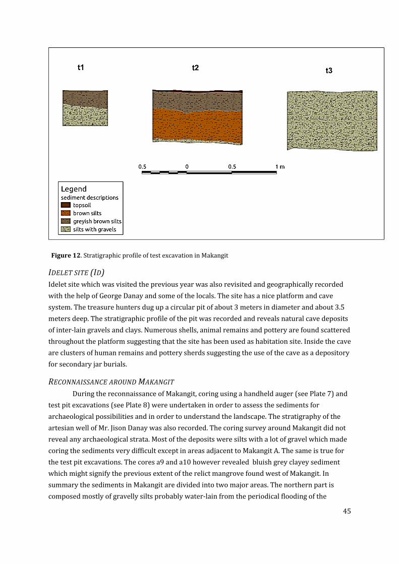
45
Figure 12. Stratigraphic profile of test excavation in Makangit
IDELET SITE (ID)
Idelet site which was visited the previous year was also revisited and geographically recorded
with the help of George Danay and some of the locals. The site has a nice platform and cave
system. The treasure hunters dug up a circular pit of about 3 meters in diameter and about 3.5
meters deep. The stratigraphic profile of the pit was recorded and reveals natural cave deposits
of inter-lain gravels and clays. Numerous shells, animal remains and pottery are found scattered
throughout the platform suggesting that the site has been used as habitation site. Inside the cave
are clusters of human remains and pottery sherds suggesting the use of the cave as a depository
for secondary jar burials.
RECONNAISSANCE AROUND MAKANGIT
During the reconnaissance of Makangit, coring using a handheld auger (see Plate 7) and
test pit excavations (see Plate 8) were undertaken in order to assess the sediments for
archaeological possibilities and in order to understand the landscape. The stratigraphy of the
artesian well of Mr. Jison Danay was also recorded. The coring survey around Makangit did not
reveal any archaeological strata. Most of the deposits were silts with a lot of gravel which made
coring the sediments very difficult except in areas adjacent to Makangit A. The same is true for
the test pit excavations. The cores a9 and a10 however revealed bluish grey clayey sediment
which might signify the previous extent of the relict mangrove found west of Makangit. In
summary the sediments in Makangit are divided into two major areas. The northern part is
composed mostly of gravelly silts probably water-lain from the periodical flooding of the

46
intermittent streams flowing through Makangit. The southern part is composed of silts and
clays overlying greyish clay sediment that is similar in color and texture to the mangrove
sediments from the core sampling from the mangrove areas. Vegetation characteristic of
mangrove environments, like Avicenea, are still found in the western part of the area and might
signify the extent of the mangrove forest during the middle to late Holocene.
6.5 SURVEY OF NEW SITES IN KULANGA MALIIT AND NEW IBAJAY PROPER It was deemed necessary for a resurvey of Kulanga Maliit karst formation after knowledge of
previously unknown archaeological sites were reported to us by Boy Sarmiento, who not only
did birds nest collecting in the karst formation but also was involve in treasure hunting activity
in the late 1990s. The project director was accompanied by Romie Fines, Boy Sarmiento and his
young son Enre Sarmiento. A few sites were inspected, some of which were already noted in the
previous exploration of Kulanga Maliit in 2007, but different from the two sites Cayron (1999)
reported as “Kulanga 1” and “Kulanga 2” cave sites. The informants for Kulanga Maliit, Romie
Fines and Boy Sarmiento are veteran bird’s nest collectors. They agreed on the names of the
caves that were surveyed and when asked how they knew that these were the names of these
places, they mentioned that they both learned the place-names from older Cuyon bird’s nest
collectors.Pasimbahan Uno Kulanga (IV-2007-W)
This is a cave site formed from a large crack in the middle of the Kulanga Maliit karst formation.
It was already surveyed and reported in 2007 as positive of archaeological deposits. No
excavation or artefact sample collection was done on site. However, it holds good potential for
further study.
Pasimbahan dos Kulanga ( IV-2011-G4)
This site is a relatively large cave that faces easterly. The cave is not easily noticeable because of
the large amount of rock fall debris in front of the current mouth. There are four chambers
inside the cave, three of which further continues but substantially narrows – these chambers
were not further investigated. Extensive digging activities of treasure hunters and pot hunters
can be seen in various locations on the cave floor. They, however, do not look like determined
efforts. Several pottery sherds came out of the holes made on the cave floor, some of these
sherds are highly decorated.

47
Lapus-lapus/Mahangin cave (IV-2011-I4)
This cave is located at the upper reaches of the Kulanga tower. There is no discernible
archaeological deposit within the cave that is narrow with a high chamber. At the westerly
entrance there is a narrow platform that drops drastically to the cliffside of the tower. At this
entrance, that overlooks Kulanga Malaki, heavy digging activity eventually led to the collapse of
a good portion of the deposit at its mouth. According to our informant, this is where they found
a skeleton “still wearing a boot” and a few pottery sherds was uncovered. This cave site does
not hold much potential to merit further investigation.
Figure 13. General plan of Pasimbahan dos Kulanga
Rock fall concentration
Drip line
10 m
21 m
11 m
N
Clear signs of digging
Decorated pottery sherd
scatter from diggings

48
Balikat ng Kulanga Maliit (IV-2011-H4)
This is an open site in the sharp, highly weathered, limestone surface of the high shoulder of the
Kulanga karst formation. The site has a scattering of highly weathered pottery sherds, some of
which are decorated. It is within this area that Boy Sarmiento found a large fossilized half of a
Tridacna shell that covered 12 pieces of polished stone adzes of various sizes. He chance upon
this adze cache in 2004. This was the second time they went up the shoulder to look for treasure
after 1998 when they dug the narrow entrance of Lapus-lapus cave. The nature of the
scattering of the pottery sherds left exposed to the elements may be due to people using the
place to place offerings or perform rituals. A more comprehensive future survey of the area
with the right safety equipment may yield more information. The difficulty of the approach
demands caution, and the sharpness of the uneven rock surface created numerous cracks and
holes where artefacts have fallen-in through the years.
Anastacio Property Site (IV-2011-J4)
This is an open site located at a promontory of Barangay New Ibajay. It is at the middle of the
Barrio’s grid road system, adjacent to the bend of the river from the bridge approaching New
Ibajay. It is near the Seven Day Adventist church located at a promontory of this area. A new
member of the project from New Ibajay, Marlon Anastacio, reported to the team that when he
was building his house and made an undercut on the natural slope of the land, he unearthed two
large adzes with some pottery sherds and shells associated with these adzes. These adzes were
shown to the team, recorded and given back. It was not necessary at this point to collect the
adzes from a new member of the project who may easily misconstrue the intention of the act.
The site after inspection definitely must be further investigated through excavation.
6.6 PUBLIC ARCHAEOLOGY
Our effort to manage and protect the archaeological resources of Palawan experienced a major
set-back this year. Last year, we celebrated that thought that because of increase community
awareness we were able to foil an attempt to loot the bones inside the two ossuary sites in
Imorigue Island - Maulohin (IV-2007-L) and Cave 3 (IV-2007-M). Our optimistic view was short
lived. A month after we ended the season in 2010 the looters came back and successfully to all
the human bones from these two sites. We formally reported the looting to a meeting of the
senior staff of the National Museum headed by Director Barns, which led to a formal
investigation by the National Museum (see Appendix 2). On a positive note, the season was
filled with several productive interactions where we managed to reach-out to the local
government sector of El Nido, the private and NGO sectors, and the general public.
The Civil Service commission organized an upgrade seminar for the municipal employees of El
Nido on April 14. The seminar was headed by the provincial civil service officer of Palawan who
saw it fitting for the purposes of upgrading the knowledge of civil servants to add a lecture on

49
Palawan archaeological heritage. We were invited to give a lecture on Palawan archaeology
centering on the results of the PIPRP among the Municipal employees of El Nido. The reception
to the talk was positive and questions were raised as to more detailed recommendations as to
what the Municipal government should do the one hectare land purchased by the local
government next to Ille tower during the term of Mayor Coral.
On the 15th of April the team was also invited by the management of the two Ten Knots resorts.
We were hosted by the resident manager of Lagen resort, Carmel Delos Santos, and the
Assistant General Manager of Miniloc resort, Mitzi Cañafranca of Miniloc, with the
Environmental officer of Lagen resort, Christine Soriano, responsible for putting together a
program that could highlight the archaeological heritage of the two island resorts.. A healthy
discussion and brainstorming took place after the inspection of archaeological sites in Lagen,
which includes the famous Leta-leta cave site. We gave some suggestions as to how they can
integrate the known archaeological sites to their guest activity offerings. This initial talk with a
new set of management staff of the Ten Knots resort has potentials for more collaborative work
in the future.
The project also supported the annual Arts Festival in El Nido town. This purely local initiative
of the home-grown artist community in the municipality is laudable for its being organic and
effective in raising the cultural consciousness of the local residents of El Nido. It also draws in
participation from the tourist population and basic researchers to its advocacy. Our support for
this year was more financial and moral. The project was well represented in the slide showing
that was on constant loop during the “Concert for Mother Earth” held on the evening of April 16
at the Municipal Covered Court.
There was a seminar organized by the PCSD and the El Nido Foundation on cave management
for barangay officials across El Nido. This was held on the 26th of April at the Barangay hall of
New Ibajay. We gave a talk on cultural resources inside caves and reported to the officials the
sad tale of the recent looting of the Imorigue sites. The response was general good, but clearly
the concern of the organizers was more centered on the protection of natural resources rather
than the cultural.
We had our first walked-in tourist group to visit Pasimbahan-Magsanib. They were 12
individuals who were mostly adults from Puerto Princesa. They heard about the project and
wanted to see not only Ille but also the Pasimbahan site. After visiting Ille they approached
Pasimbahan from the main-road by car and not from the longer walk across the valley. This
visit demonstrates that need for a standing exhibit explaining the Pasimbahan site to visitors;
similar to what we already have at Ille. We could only guest how many walk-in tourist.

50
7. DISCUSSION
THE LOOTING OF THE IMORIGUE OSSUARY SITES
There is a clear insight that came out of the looting of the Imorigue ossuary sites - we still have a
long way to go when it comes to effectively protecting archaeological resources in El Nido.
Hiring people to guard archaeological sites, such as what we have been doing since 2006 at the
Dewil valley, has a very limited effectiveness. At the valley, our people manage to protect
heritage resources at Ille and Pasimbahan-Magsanib. Our information dissemination, presence
and active protection systems, however, has not led to the end of treasure hunting and pot-
hunting in the other karst formations, i.e., Makangit and Kulanga. There was a great deal of
naivety on our part to think that the Imorigue sites were protected enough just because our
project covers this island.
As a consolation, the policy of the Japanese government that encouraged unethical systems of
searching for Japanese remains has been effectively curtailed with the high level protest done
from our part, and the expose by the Japanese media. A damning documentary was made by the
NHK on the issue, which resulted to government investigation and suspension of their policy.
The Japanese media in the Philippines also pursued the issue relentlessly. The Mainichi
newspaper, read by Japanese expats, has covered the story heavily. This was supported also by
the coverage of the issue by Kyodo News and the local NHK correspondence. The Japanese
media exposed the irregular activities of the company in-charge of looking for Japanese war
dead and have demanded that the Japanese government compensate the Philippines for the
wanton disrespect of Philippine ancestral dead. The experience has made us realize that the
desire of nation states involved in the last World War for closure is still strong, and initiatives to
look for missing war dead remains continues to be relevant. The government agencies involve,
especially the National Museum, is now better informed about the dangers of such initiatives.
In the long term, the sustainable approach that will lead to the protection of our heritage sites
still sits squarely on the need to improve the heritage consciousness of the population and
government officials/employees. In this manner alone can we be certain that the recent tragic
acts we have witness shall not be repeated.
ON THE 9000 YEAR OLD CREMATIONS
With the increasing number of in-situ cremations at hand, we have a better understanding of
the processes involved in the formation of these burial features. If we include c.2228 and c.2274
excavated this year, there are now at least six cremation features bearing grossly similar
characteristics of being burnt and fragmented. The others are c.758 exposed in 2005, c. 1324
and c.1325 exposed in 2007, and c.1358, exposed in 2008. The human bone fragments were

51
found accumulated in separate stacks, each only about a meter or so apart from the others. The
stacks are constrained within small volumes (not dispersed) and some (e.g., c.1324) contain
little matrix within them.
The cremation features were found in contiguous grids in the East Mouth (N3/W4 N3-4/W5)
and the East-West Connection Trench (EWCT, N2-3/W6-7), which is just outside the east mouth
of Ille Cave but very well within its rock shelter. Encountered at depths between 130 and 206
cm BDP, they constitute the deepest derived human remains to date at this site. The layer from
which they were derived from is c.769, although most were initially encountered while
removing c.336, the layer overlying c.769. Context 769 is a unit of wood ash deposit mixed with
speleothem and so far encountered at the East Mouth and the EWCT only. They appear as
consolidated, light-colored (almost white) unit which may become chunky when removed. In
2005 when only grids N2-4/W2-4 were excavated down beyond 150 cm BDP, c.769 was found
sloping from the northern grids (80 cm BDP) towards the south (200 cm BDP), with its base
falling along girds N3/W4-5. In 2010 and 2011, the same sloping configuration of c.769 is noted
in the EWCT (grids N2-3/W6-7) with the highest level in the southwest (N2W7) and the base at
grids N2-3/W6.
Context 769 is the youngest in at least three consolidated ashy deposits. A second deposit,
c.2271 in the present excavation (could be equivalent to c.2280 and c.2281), is less consolidated
and becomes powdery when scraped. It is also light gray in color. This unit was already noted as
c.1326 in 2007. The third, c.2270, only noted this year, appeared at a higher level than the two
deposits but eventually recognized as the oldest deposit of the three. It is also better
consolidated like c.769 but has a more rough surface, unlike c.769 which has a smooth top.
Matrices of varying hues of red and orange, with red-nodule inclusions, are found inserted in
between these deposits.
Although grids N1-2/W2-3 of the East Mouth were excavated to the same level, no similar
feature was found here. Excavation at the West Mouth had also reached the same level without
encountering similar features, although no layer similar to c.769 was encountered there.
However, it remains possible that the EWCT-2 (N2-3/W8-9) and further south of the East
Mouth may yield cremation burials since c.769 seems to continue there.
All cremation features were found at the bottom of these sloping ash deposits, in grids N3/W4
[c.758], N3/W5 [c.1325], N3/W7 [c.2228], and N2/W6 [c.2274] except for one [c.1324]. Two
interpretations are proposed to explain the depositional contexts of the cremation burials: First,
c. 769 was probably an exposed surface at the time of the deposition of the cremation burials
with c.336 only later covering the deposits and features. Second, the cremation burials probably
were not being buried but were only being inserted or placed in found or modified crevices in
c.769. Field observations that seem to support these interpretations are:
52
1. Context 769 is almost always found at the level of the top of the cremation features. Context
769 was observed at the level of the top fragments in c.2228 and found immediately at its east
and south edges. Context 769 lay immediately west of c.1324 and surrounded c.1325. The top
fragments in c.2274 were found directly under c.769, which in effect roofed the fragments.
Context 769 also capped the feature at its eastern and northern sides. This suggests that the
fragments were probably inserted from an opening that was not discovered during the initial
investigation of the feature.
2. If the cremation features are being buried from overlying layers such as c.336, then cuts
would have been observed made from this layer and not only through c.769. So far, cuts are only
being observed at the level of c.769 or in c.769, with no cut being observed higher up in c.336.
Cuts had been observed at the level of the top of fragments in c.1325 which is also the level of
c.769 found immediately west of the feature. A cut had been observed in c.769 around c.1324
but not in the overlying c.336.
3. So far, no cremation feature is found just within c.336 i.e. without association to c.769,
suggesting that the cremation features are not being buried or placed higher than c.769.
4. If the features are being buried from c.336, with the cut being made through c.769, the fill
should be mixed content from these two units. So far, however, the matrix found within the
features are either the same as the overlying layer c.336, which might suggest later in-filling, or
the cut layer, c.769. The matrix inside c.1325 is similar to c.336. There are at least two separate
matrices inside c.2228: one of these is similar with the matrix found at the western bulk, the
other is similar to the matrix from the northern bulk. This might also suggest later infilling. The
matrix inside c.1324 is ashy, similar to the components of c.769.
5. Although the cremation burials were found near each other, no burial was found extending
beyond another, suggesting either the burials were marked or they were exposed to be readily
identified before the deposition of another burial. However, the non-intercutting of the
cremation features would also be possible had they been deposited at the same time.
6. Except for c.1324, most of the cremation features are found at the bottom of the sloping
surface of c.769. This might suggest there had been preference for certain spots (the bottom) in
which to deposit the human remains, which would only have been allowed if the top or surface
of c.769 had been exposed. The above initial interpretations, however, have to resolve at least
one concern: the bone fragments in c.758 exhibit minimal depositional damage implying that
prolonged exposure to the surface had not been extensive or did not occur at all. Also, most
features were found concentrated and not dispersed (although c.2228 might have had dispersed
fragments, most were still found accumulated in one area). If indeed the remains were not being
buried as suggested here then it must be explained why the fragments exhibit these
preservational qualities. This problem may be resolved depending on the rate of the deposition
of c.336 or if the fragments are actually being placed inside containers before deposition in

53
c.769. It is also possible that there had been no extensive scavenging present in the area, that
scavengers might not have been attracted to burnt bones, and/or that the rockshelter had
provided sufficient protection to the bones from other post-depositional processes or elements
that can potentially cause damage.
As a final point, we need to verify if the southwestern edge c.2274 will present a strong sloping
arrangement of fragments by the time the feature is to be completely excavated next year.
ON THE LANDSCAPE SURVEY AND RIVER TERRACES
Refinement of the archaeological record for the Dewil Valley, and indeed for this part of the
world, can be further advance through the identification and study of open sites. The results
from the surveys described in this report may prove fruitful in this respect. In past searches for
open sites within the Dewil Valley, progress has been hindered by the realization that deposits
of ages of archaeological interest in open contexts underlie many metres of relatively recent
alluvial deposits. However, the identification this year during the above described surveys of a
set of well-defined river terraces along the upper stretches of the Kulanga River about 250 m
south-southwest from ongoing excavations at Pasimbahan-Magsanib, represent the opportunity
to explore deposits which potentially span a large time slice of archaeological relevance, and
which may be located relatively close to the surface. Additionally, these terraces are, by
definition, within spatial proximity of a past consistent water source, and are also nearby to
cave sites with established archaeology, thus increasing the chances for locating a site within
the terrace deposits that can be linked with what are mostly ritualized activities within the
limestone towers.
It is worth mentioning our insight concerning landscape surveying in the tropical swidden
agricultural land. We have done landscape walks and informant work for the past six years in
the valley, but it took the clearing of long fallowed land (at least eight years) to reveal the river
terraces of the Dewil river. This newly cleared land also revealed potential open sites, which
may be the location of past settlements in the valley. We can never underestimate the
effectiveness of vegetation in further masking features and sites buried in the landscape.

54
8. SUMMARY AND RECOMMENDATIONS The set objectives for this field season were generally achieved. Excavating Ille and
Pasimbahan-Magsanib has yielded new information that makes us further develop our
understanding of the history of humanity in the Dewil valley. Our excavation recording archives
are now better organize and post excavation work on all archaeological assemblages coming
from the project are better stored and studies continue at the Palawan room located at
Villadolid Hall, Archaeological Studies Program. We have succeeded in finding new sites in the
valley, including two high potential open sites that may prove to be the location of
habitations/settlements. We, however, have had setbacks in our heritage work. The
comprehensive looting of the Imorigue sites shows how much we still have to strive to achieve a
level of community collective consciousness that will lead to strong local initiatives towards
protection and development of archaeological resources for the benefit of all.
For the next season, the sites of Ille and Pasimbahan-Magsanib will continue to be central to our
work. We need to complete the excavation of the EWCT at Ille and retrieve all the cremation
burials uncovered before going further deeper to older deposits. The investigation of the
adjacent area west of the West Mouth Trench shall be excavated to see if we can uncover more
burials with stone markings associated to the time depth of the boat-shaped burial marker from
the West Mouth Trench. The excavation of Trenches A&B at Pasimabhan-Magsanib can be
completed next season. We must get the needed permission from land owners to excavate the
identified potential open sites along the river terrace between the Kulanga and Istar tower.
Equal in potential is the Anastacio site in New Ibajay proper, where there is good potential to
see in situ archaeology associated with the large adzes that were found in the area.
A more robust landscape archaeological/palaeoenvironmental investigation of the valley is now
more than ever relevant. The coring sites identified and augered during these surveys need to
be revisited and recorded with proper coring equipment. Specifically, a Livingstone or Russian
D-section corer with 80+ mm diameter barrel would facilitate sub-sampling for both pollen and
macrobotanical remains.
The amount of new knowledge coming out of our project is already substantial. However, the
potential for new knowledge and the pursuit for better ways to advance heritage advocacies is
still far more immense.
55
9. PROJECT PARTICIPANTS FOR 2011
Wilhelm G. Solheim II – Honorary Team Leader
Project Directors
Victor Paz, Ph.D.
Helen Lewis, Ph.D.
Wilfredo Ronquillo, MSc
Specialist and ASP research students
Jane Carlos, MA mil
Emil Robles , MA
Vito Hernandez, MA
Aya Ragragio, MA
Myra Lara, MA
Noel Amano, MS
Mindy Ceron, MS
Michael Herera, MS
Janine Ochoa, MS
Taj Vitales, MA
Kate Lim
Kat Manalo
Bea Ferera
Sigrid Labidon
Hermine Xauflair, MA –Natural History Museum, Paris
Sigrid Labidon – University of Otago, New Zealand
Margaret Williams - University College Dublin
Faye Pendell – University College Dublin
Shawn O’Donell, MA – University of Cambridge, UK
From Barangay New Ibajay
George Danay (Deputized by National Museum)
Danilo Libudan (Deputized by National Museum)
Romie Fines (Responsible for Pasimbahan)
Rolando Agon
Jania Agon
Johor Agon
Marlon Anastacio
Mimi Cabral
Nimfra Castro
Boy Danay
Eustaquio Danay
Eric Danay
Jason Danay
Jay ar Danay
Jomer Danay
Rosie Fines
Lorenzo Ingcad
Gerald Leuterio
Jake Naranjo
Jeney Naranjo
Joelius Naranjo
Joey Naranjo
Jenex Naranjo
Joven Naranjo
Felicito Paulino
Ammen Sarmiento
Noel Sarmiento
Enre Sarmiento
Cesar Vitorin
Mary Ann Vitorin
Dyna Libudan
Jojo Sugbo
Jay-ar Vallejo
Gemarie Vallejo

56
10.PLATES

57

58
View of the East Chamber Trench and East
Chamber Connecting Trench; cave lighting
was for the first time powered by a gas
generator
Excavating the deep end of the East-West
Connecting Trench; in the process of
exposing a new cremation feature
EWCT looking east with exposed burials EWCT looking west
Pasimbahan-Magsanib showing
location of Trenches A & B at the
rockshelter; looking east towards
the cave entrance
View of Trench B with c. surface exposed and the showing the
profiles of the west and north walls
Plate 2. Ille and Pasimbahan sites

59
View of the east wall of Trench B Excavating the surface of c.414 at Trenches A & B
Combustion feature c.427
View from Kulanga Maliit shoulder of
Kulanga malaki and Istar karst formations
Approaching Kulanga Maliit;
shoulder of karst clearly visible
Mr. Sarmiento pointing at the location of adze cache underneath a
Tridacna shell at Kulanga Maliit Balikat; numerous weathered
earthenware pottery sherds in the area
The Pasimbahan Kulanga Dos cave site (IV-2011-G4)
Plate 3. Images of Pasimbahan-Magsanib and Kulanga Maliit

60
Shell preform Beads
Bracelet fragments
Plate 4. A few examples of Ille shell artefact finds

61
Glass beads from EWCT Stone bead from EWCT
Stone bead from EWCT
Chert flakes
Bone point
Tradeware ceramics from EWCT
Metal blades from EWCT
Plate 5. Various artefact-types from Ille site

62
Two large adzes found by Marlon Anastacio in
the Anastacio Property Site (IV-2011-J4) while
constructing his house. The site is scheduled
to be studied in the 2012 season; it has the
potential to be a settlement/habitation site
The inspection of the Maulohin site after
it was looted for all its human remains
yielded several interesting artefacts, i.e.,
stone lingling-o (above left), earthenware
spout-like sherd (above right), fragment
of green glass bracelet
Plate 6. Maulohin site and Anastacio site artefact samples

63
Geographic locations of images indicated below
Plate 7. Makangit survey and excavation

64
Plate 8. General survey and augering at Makangit karst cluster
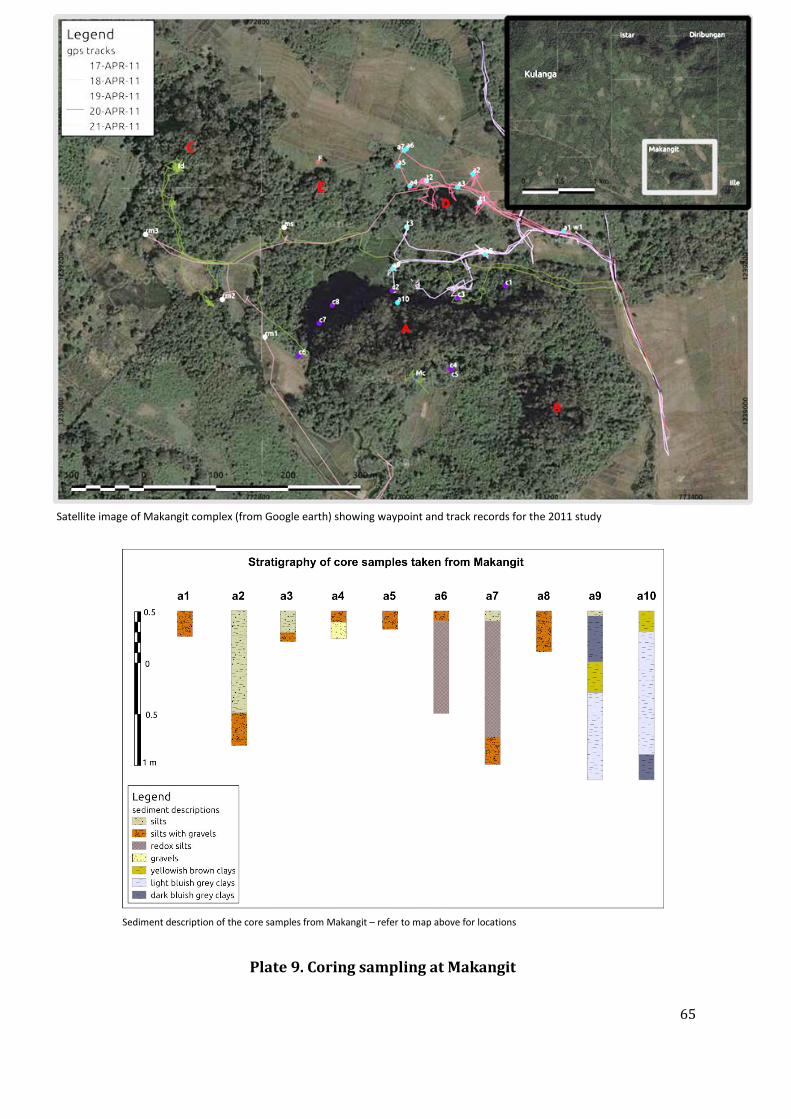
65
Plate 9. Coring sampling at Makangit
Satellite image of Makangit complex (from Google earth) showing waypoint and track records for the 2011 study
Sediment description of the core samples from Makangit – refer to map above for locations

66
11. APPENDICES

67
APPENDIX 1: NATIONAL MUSEUM AUTHORIZATION

68
APPENDIX 2: LETTER ON THE LOOTING OF THE IMORIGUE
WITH NATIONAL MUSEUM REPLY
Jeremy Barns Director National Museum of the Philippines P. Burgos St. Manila Greetings,
We write to report to the National Museum a dastardly act done to our archaeological resources and collective heritage. The archaeological sites of Maulohin cave (IV-2007-L) and Istar cairn (Cave 3: IV-2007-M), both in the island of Imorigue, in New Ibajay, El Nido Palawan, were totally looted of their human remains. The circa 1000 to 500 year old skeletal remains of ancestral Filipinos placed in these osuaries were carted away to be passed off as Japanese World War II war dead. At Maouluhin, all that is left of the four whole crania and bones from approximately a dozen individuals were a few phallanges. At Cave 3, where there once had been remains from at least 16 individuals, only cranium fragments and a few phallanges were left behind. The materials deposited in Cave 3 from an unknown site confiscated by our team last year were also taken away.
The known facts:
January-February 2010 - The sites of Maulonhin and Istar were
visited by Japanese nationals with local guides, who carefully sorted
and sacked all the bones. These were then left to the care of the
guards of the concessionaire for bird’s nest collecting in the island.
The guards brought all the bones to their basecamp in the island of
Imorigue for safe keeping. The bones were not carted away only after
they were challenged by locals, who witnessed the event, about the
legality of what they were doing – if they had permits from the
National Museum or the PCSD.
May 2010 - The Palawan Island Palaeohistoric Research Project (PIPRP)
team excavating in Dewil valley, New Ibajay persuaded the concessionaire
for Imorigue to direct his guards to surrender the sacks of bones to the
team. The team returned the bones to their proper place in the two sites.
One larger plastic sack contained materials from a site not known to the
team. The materials were covered in very dark guano and contained mostly
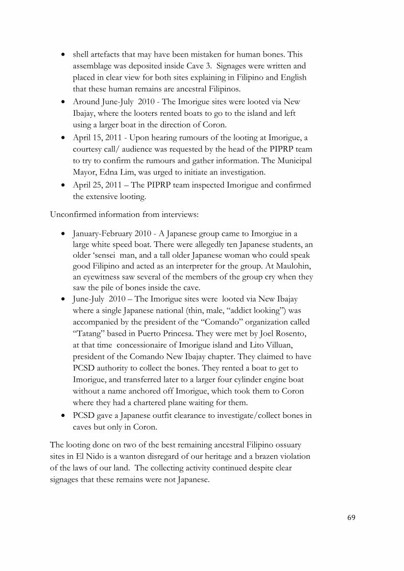
69
shell artefacts that may have been mistaken for human bones. This
assemblage was deposited inside Cave 3. Signages were written and
placed in clear view for both sites explaining in Filipino and English
that these human remains are ancestral Filipinos.
Around June-July 2010 - The Imorigue sites were looted via New
Ibajay, where the looters rented boats to go to the island and left
using a larger boat in the direction of Coron.
April 15, 2011 - Upon hearing rumours of the looting at Imorigue, a
courtesy call/ audience was requested by the head of the PIPRP team
to try to confirm the rumours and gather information. The Municipal
Mayor, Edna Lim, was urged to initiate an investigation.
April 25, 2011 – The PIPRP team inspected Imorigue and confirmed
the extensive looting.
Unconfirmed information from interviews:
January-February 2010 - A Japanese group came to Imorgiue in a
large white speed boat. There were allegedly ten Japanese students, an
older ‘sensei man, and a tall older Japanese woman who could speak
good Filipino and acted as an interpreter for the group. At Maulohin,
an eyewitness saw several of the members of the group cry when they
saw the pile of bones inside the cave.
June-July 2010 – The Imorigue sites were looted via New Ibajay
where a single Japanese national (thin, male, “addict looking”) was
accompanied by the president of the “Comando” organization called
“Tatang” based in Puerto Princesa. They were met by Joel Rosento,
at that time concessionaire of Imorigue island and Lito Villuan,
president of the Comando New Ibajay chapter. They claimed to have
PCSD authority to collect the bones. They rented a boat to get to
Imorigue, and transferred later to a larger four cylinder engine boat
without a name anchored off Imorigue, which took them to Coron
where they had a chartered plane waiting for them.
PCSD gave a Japanese outfit clearance to investigate/collect bones in
caves but only in Coron.
The looting done on two of the best remaining ancestral Filipino ossuary
sites in El Nido is a wanton disregard of our heritage and a brazen violation
of the laws of our land. The collecting activity continued despite clear
signages that these remains were not Japanese.

70
Given the methodology of bone collecting, there is no quick way one can
determine the ethnicity of bones collected. There is, however, certainty that
the bones are definitely not Japanese soldiers who died during the 1940s,
given the condition of their preservation and the context of their curation in
association with metal period pottery sherds and tradeware ceramic sherds.
We appeal to the National Museum to lead the nation in formal queries with
the Japanese government towards a review of its policy that supports
unsystematic and unconfirmable collection of human remains in the
Philippines. The Japanese government should feel guilty for these brazen
acts. We would also like to seek the help of the National Museum in
exposing the Japanese nationals who have been active in this exercise. We
are now convinced that the standing offer for bones, no matter what
provenience, has created a whole new level of archaeological and
patrimonial looting, which in all probabililty has now surpassed pot-hunting
or Yamashita treasure hunting activities in the past. The financial poverty
experienced by most Filipinos presents too strong a preasure to sucumb to
offers of cash needless that laws are violated and our heritage sold. We
therefore squarely put the blame on the shoulders of the bone hunting
activities of the Japanese dealers.
At the rate the looting is going, we will have nothing left for future
generations of Filipinos to protect and learn from; thousands of Filipino and
ancestral Filipino remains will be processed through Shinto rites, and will
give the Japanese people closure as they are consoled in the belief that the
spirits of their compatriots are in peace. The Japanese people should know
the truth. As a final thought, should the closure of this dark past in Japanese
history once again be at the expense of our history and heritage?
Respectfully Yours,
Victor Paz, PhD
Representing the members of the Palawan Island Palaeohistoric Research Project and Research Associate, National Museum of the Philippines (CPD-RA-2011-04)
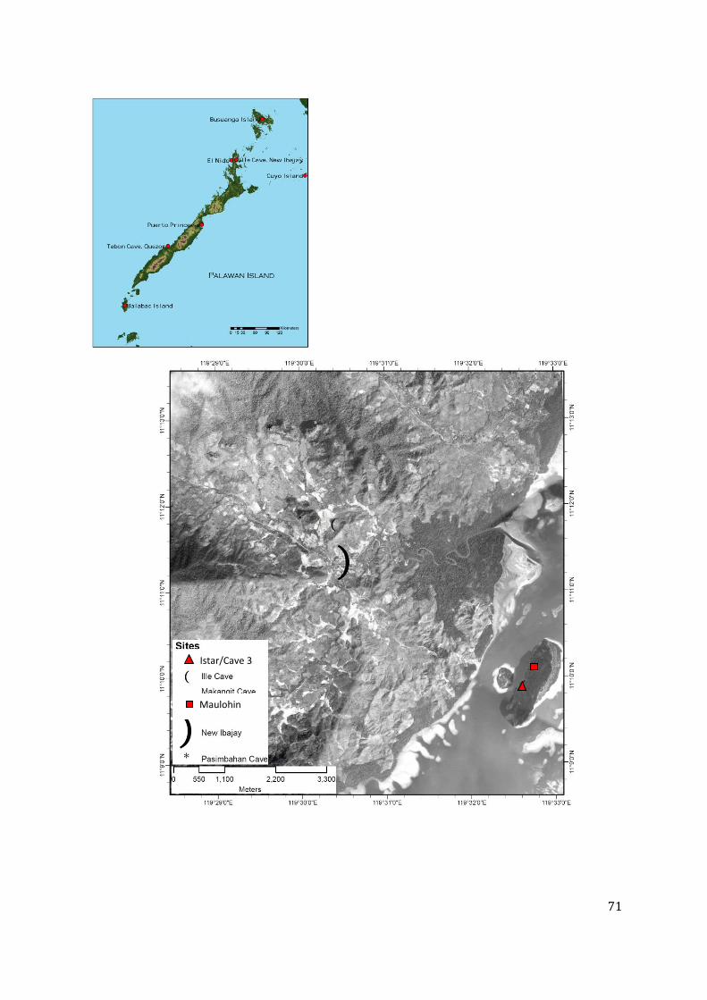
71
Istar/Cave 3
Maulohin

72
1
Maulohin site in 2007 (left); the site after 2010 looting (right). The looters were only after the human remains –
they left the log coffin behind in both occations.
May 2010 recovery of bones sacked for shipment; mostly white cotton sacks
labelled “Imoligue” and a sack No (top); Bones returned to Cave 3 sites (right)
Istar/Cave 3 site in 2007 (above). Except for a few
fragments, all the bones were taken, including the
materials that were deposited in the cave coming
from an unknown site.
Example of the temporary signage placed on the sites
after the return of the bones in May 2010 to prevent
further looting. This sign was found discarded by the
side of Maulohin cave (right).

73

74
APPENDIX 3: THREE DIMENSIONAL MAPPING OF THE KULANGA RIVER TERRACES Emil Robles
River terraces along the Kulanga River were observed during the 2011 field season of
the Palawan Palaeohistoric Project. These terraces were mapped during the 2011 field season.
The goal of the mapping exercise was to document the terraces and construct a three
dimensional model of the area. A 3D model of the site has numerous advantages over the usual
flat maps because not only are the Cartesian plane coordinates recorded, the topography and
relief are also recorded and visualized. It takes a lot more time to collect data for 3D maps than
it is for planimetric maps. In order to create a 3D map using surveying equipment sample points
across the surface should be measured for their x, y, and z coordinates. The distribution and the
quantity of points depends on the resolution and the accuracy desired for the model. A tilting
theodolite and a 60 meter measuring tape was used in the Kulanga river terrace survey.
The edges of the terrace were and the Kulanga River were mapped using a hand held
GPS and field walking. The three dimensional models were created using raster interpolation of
points. Spatial interpolation is a mathematical process of calculating and assigning values
between points with given values. For the examples here, interpolation of the points taken
during the survey was done using r.surf.idw in GRASS (see GRASS Development Team 2007).
The result is a raster map with pixel values representing elevation. The resulting three
dimensional visualization of the raster map can be done using Nviz in GRASS.
Figure 1. Kulanga terrace looking to the north with Istar karst tower seen in the background

75
Figure 2. One of edges of the terraces looking towards Kulanga River
Figure 3. Resulting raster image
after interpolation of elevation
points seen as red dot
Figure 4. Three dimensional views of interpolated surface looking. Arrow points to north and
scale bar is equivalent to 10 meters.

76
APPENDIX 4: PRELIMINARY ANALYSIS OF PACALDERO POTTERY- DECORATION TYPES
AND SURFACE ALTERATION
Darko Stojanovski
1. Introduction
Pacaldero, New Ibajay Region, El Nido municipality, Palawan. A cave site that, since the
first archaeological survey in 1999 by Jun Cayron (survey project of The National Museum of
The Philippines, UP-ASP and the SEAICE, headed by Dr. Dizon and Dr. Solheim), was known as
Sinalakan, after the name of the limestone formation it was naturally carved in. The general
conclusion from this first visit of the cave was: possible secondary burial site intensively
disturbed by human and natural agents. There are previously recorded cases of intentional
destruction of archaeological material in cave sites in the Philippines, either as “demonstration
of bravado” (Solheim 2002) or treasure hunting. From the natural agents, earthquake would be
the most obvious one. Based on the observed materials scattered all over the floor of the cave
(human bones, shells and earthenware fragments), the cave site was said to have “great
archaeological potential” (Paz et al. 2010).
During the last visit of the cave in 2010, when the biggest amount of material was
retrieved, the team found out the local name “Pacaldero” which is specific for that cave opening.
In between 1999 and 2010, there were two brief archaeological surveys of the cave in
2004 and 2006.
2. The method
All the archaeological material from Pacaldero was collected from the surface during the
previously mentioned surveys. Archaeological excavations of any type were never performed.
Having this in mind, together with the fact that there was continuous disturbance of the
archaeological context for a long period of time, the fragmented state of the pottery is
understandable. There are only few cases where enough pieces were refitted together to reveal
enough elements that give the possibility for the vessels to be reconstructed. With further
refitting exercise there is a good prospect for more earthenware vessels to be reconstructed.
That would open the path for shape analyses and the connection between shapes, decoration
and purpose.
At this stage, due to time limitations, I will concentrate only on the basic classification of
the decoration types as it can be done by simple macroscopic observation of the pottery
fragments. The effort was to choose the best representative fragment from each type of
decoration/surface treatment and describe it, in co-ordinance of course with previously
established classifications from Palawan and The Philippines (Solheim 2002; Balbaligo 2010).

77
Except for the obvious dominance of the plain pottery fragments, it is difficult to speak
about the percentage of the different decoration types, since complete accessioning of the
artefacts is yet to be completed. So, this report can be taken even as a catalogue of chosen
fragments that in my subjective judgment represent their group the best; catalogue showing the
range of decoration types of the Pacaldero pottery.
3. Decoration types
A total number of 21 pottery fragments were
selected. The number of fragments though, does not
correspond with the number of different types of
decoration as some types are represented by two or
more fragments.
Fig. 1: Plain pottery fragment
3.1 Plain pottery:
Even though maybe its place is not in this section where the ways of surface alteration
are described, I placed the plain pottery here in order not to be seen as opposition of decorated
pottery, but just another type of physical representation, in the same line with the decorated.
3.1.1 IV-1999-G-66 – pottery body fragment (Fig.1);
- Wall thickness: 18 mm.; - Paste: - gray to black core with abrupt margins;
- fine grained silica inclusions; - Firing: low; - Texture: smooth; - Surface colour: brown; - Condition: calcification;
3.2 Paddle impressed pottery – basket bound paddle:
3.2.1 IV-1999-G-46 – pottery body fragment (Fig.2);

78
Fig. 2: Paddle impressed pottery-basket bound paddle;
- Decoration: impressions on the outer surface from basket bound paddle; the grooves are so shallow, they are barely visible;
- Wall thickness: 5-6 mm.; - Paste: brown with fine grained silica inclusions; - Firing: low; - Texture: smooth; - Surface colour: reddish brown;
3.3 Paddle impressed pottery – carved paddle;
3.3.1 IV-1999-G-126 – pottery body fragment (Fig.3);
Fig. 3: Paddle impressed pottery – carved paddle – deep;
- Decoration: impressions on the outer surface from relatively deep carved paddle (carvings are 2 mm. wide with 2 mm. space in between);
- Wall thickness: 5-6 mm.; - Paste: dark brown with fine grained silica and organic temper; - Firing: low; - Surface colour: brown; - Condition: partial calcification;

79
3.4 Paddle impressed pottery – cord-wrapped paddle (cord-marked pottery):
3.4.1 1V-1999-G-209 – pottery body fragment (Fig.4);
- Decoration: impressions on the outer surface from cord-wrapped paddle; the paddle was wrapped tightly with 2 mm. wide cord;
- Wall thickness: 7-8 mm; - Paste: brown with fine-grained silica inclusions; - Firing: low; - Surface colour: brown; - Condition: minimal calcification traces;
Fig. 4: Paddle impressed pottery – cord- wrapped paddle (cord-marked);
Fig. 5: Paddle impressed pottery – cord-wrapped paddle (cord-marked);
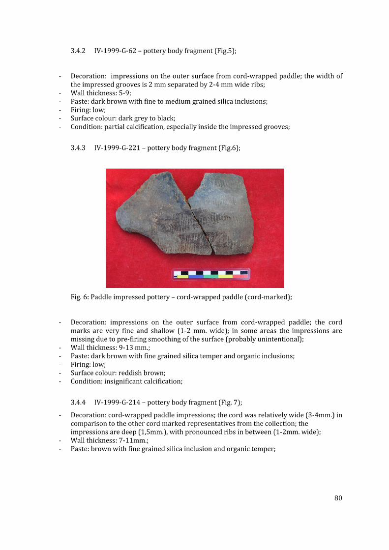
80
3.4.2 IV-1999-G-62 – pottery body fragment (Fig.5);
- Decoration: impressions on the outer surface from cord-wrapped paddle; the width of the impressed grooves is 2 mm separated by 2-4 mm wide ribs;
- Wall thickness: 5-9; - Paste: dark brown with fine to medium grained silica inclusions; - Firing: low; - Surface colour: dark grey to black; - Condition: partial calcification, especially inside the impressed grooves;
3.4.3 IV-1999-G-221 – pottery body fragment (Fig.6);
Fig. 6: Paddle impressed pottery – cord-wrapped paddle (cord-marked);
- Decoration: impressions on the outer surface from cord-wrapped paddle; the cord marks are very fine and shallow (1-2 mm. wide); in some areas the impressions are missing due to pre-firing smoothing of the surface (probably unintentional);
- Wall thickness: 9-13 mm.; - Paste: dark brown with fine grained silica temper and organic inclusions; - Firing: low; - Surface colour: reddish brown; - Condition: insignificant calcification;
3.4.4 IV-1999-G-214 – pottery body fragment (Fig. 7);
- Decoration: cord-wrapped paddle impressions; the cord was relatively wide (3-4mm.) in comparison to the other cord marked representatives from the collection; the impressions are deep (1,5mm.), with pronounced ribs in between (1-2mm. wide);
- Wall thickness: 7-11mm.; - Paste: brown with fine grained silica inclusion and organic temper;

81
- Firing: low; - Surface colour: greyish brown; - Condition: some calcification;
Fig. 7: Paddle impressed pottery – cord-wrapped paddle
(cord-marked);
3.5 Finger nail impressed pottery; this type of decoration I was able to identify only on the
lip on one rim fragment from a relatively small jar;
3.5.1 IV-1999-G-226 – pottery rim fragment (Fig.8);
- Decoration: short diagonal lines on the lip of the rim, impressed with a finger nail; - Diameter: 11 cm. (fragment is 35% from vessel); - Wall thickness: - body part: 4 mm; - neck: 6 mm; - Paste: brownish yellow, well purified clay with very little fine grained silica inclusions; - Firing: low; - Surface colour: brownish yellow;
Fig. 8: Finger nail impressed pottery rim fragment;

82
3.6 Incised/punctuated pottery;
3.6.1 IV-1999-G-223 – pottery body fragment (Fig. 9);
- Decoration: pair of incised parallel lines, bordering punctuations, forming angular scroll pattern; this motif is with horizontal disposition filling the space between the carination and the neck;
- Wall thickness: - carination and neck: 7 mm.; body: 4 mm.; - Paste: greyish brown with fine grained silica and organic temper; - Firing: low; - Surface colour: brownish yellow;
3.6.2 IV-1999-G-224 – pottery carination fragment (Fig. 10);
- Decoration: pair of incised parallel lines forming waves, illustrated through punctuations; this motif is positioned horizontally in the upper half of the vessel, starting from the carination line;
- Wall thickness: carination-9 mm.; body-4-6 mm.; - Paste: light brown with fine grained silica temper; - Firing: low; - Surface colour: brownish yellow;
Fig. 9: Incised/punctuated pottery fragment; Fig. 10: Incised/punctuated pottery fragment;
3.6.3 IV-1999-G-225 – pottery rim fragment (Fig. 11);
- Decoration: horizontal stripe bellow the neck on the outer side of the vessel, containing alternating four short horizontal incised lines with two diagonal;
- Diameter: 14 cm. (the fragment is 20% of the rim); - Wall thickness: carination-5 mm.; body-3 mm.; - Paste: yellowish brown with fine grained silica inclusions; - Firing: low; - Surface colour: brownish yellow; -
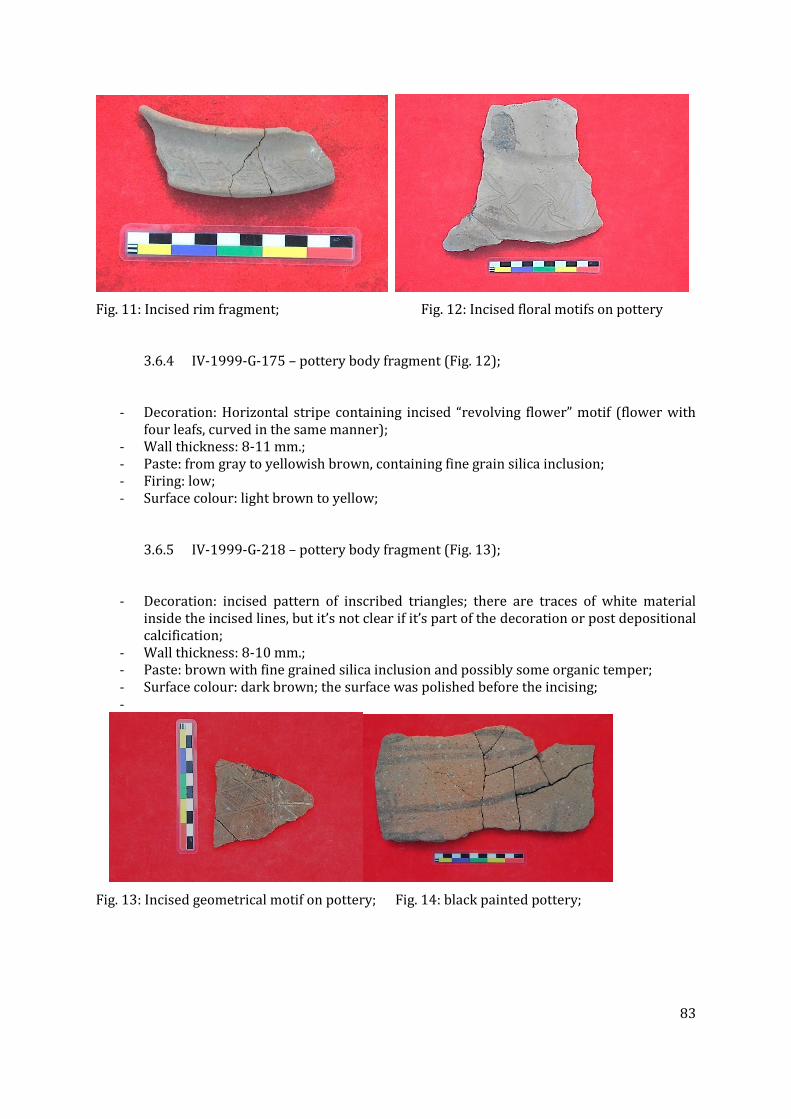
83
Fig. 11: Incised rim fragment; Fig. 12: Incised floral motifs on pottery
3.6.4 IV-1999-G-175 – pottery body fragment (Fig. 12);
- Decoration: Horizontal stripe containing incised “revolving flower” motif (flower with four leafs, curved in the same manner);
- Wall thickness: 8-11 mm.; - Paste: from gray to yellowish brown, containing fine grain silica inclusion; - Firing: low; - Surface colour: light brown to yellow;
3.6.5 IV-1999-G-218 – pottery body fragment (Fig. 13);
- Decoration: incised pattern of inscribed triangles; there are traces of white material inside the incised lines, but it’s not clear if it’s part of the decoration or post depositional calcification;
- Wall thickness: 8-10 mm.; - Paste: brown with fine grained silica inclusion and possibly some organic temper; - Surface colour: dark brown; the surface was polished before the incising; -
Fig. 13: Incised geometrical motif on pottery; Fig. 14: black painted pottery;

84
3.7 Painted pottery;
3.7.1 IV-1999-G-222 – pottery body fragment (Fig. 14);
- Decoration: black paint directly on the unprepared surface of the pot; no positive figural motif can be recognized, although the configuration of the lines suggest that originally on the body of this relatively big vessel there was some black painted figural motif; the paint itself is almost worn out; future chemical analysis should reveal the pigment source;
- Wall thickness: 8-14 mm; - Paste: gray core with abrupt margins, contrasting the thin yellowish brown surface
layers of the vessel; there is a big amount of sand inclusion with grains as big as 8 mm in diameter; these grains are visible even on the outer surface;
- Firing: low; - Surface colour: yellowish brown; - Condition: very fragile and easy crumbling; no calcification;
3.8 Anthropomorphic pottery;
3.8.1 IV-1999-G-210 – pottery body fragment (Fig. 15);
- Decoration: incised eye and plastically formed eye brow ridge; traces of red paint are
also visible; - Wall thickness: 8 mm; - Paste: dark gray with fine grained sand inclusion; - Firing: low; - Surface colour: brown; - Condition: some calcification present;
3.9 Pottery with combined decoration;
3.9.1 IV-1999-G-227 – fragmented ceramic pot (eleven fragments; Fig. 16);
- Decoration: incised lines forming inscribed rectangles, filled with red paint; the decoration field is the upper half of the vessel (horizontal field 37 mm. wide);
- Wall thickness: -bottom: 2 mm; -carination: 6 mm; -body: 4 mm; -neck: 6 mm; -rim: 5 mm;
- Paste: yellowish brown with very fine grained silica inclusion; - Firing: low; - Surface colour: yellowish brown; - Condition: relatively well preserved 11 fragments forming about 50 % of the pot; no
calcification;

85
3.9.2 IV-1999-G-50 – pottery body fragment (Fig. 17);
- Decoration: incised lines filled with white paste, forming geometrical elements, some of
which were filled with red paint; - Wall thickness: 7-15 mm; - Paste: brown with silica grains inclusion; - Firing: low; - Surface colour: dark brown; - Condition: some calcification present and part of the white paste incrustation removed
during washing;
Fig. 15: anthropomorphic pottery; Fig. 16: combined decoration (incision/paint);
3.9.3 IV-1999-G-216 – pottery body fragment (Fig. 18);
- Decoration: Incised complex ornament; some of the fields were filled with red paint following a pattern;
- Wall thickness: 8-16 mm; - Paste: brown with silica grain inclusion; - Firing: low; - Surface colour: dark brown; - Condition: some calcification;
3.9.4 IV-1999-G-(4+153+179) –pottery body fragment (Fig. 19);
- Decoration: complex ornament with combination of incision, carving, finger modeling and red paint;
- Wall thickness: 10-15 mm; - Paste: brown with fine grained silica inclusion; - Firing: low; - Surface colour: brown; - Condition: traces of white material which is probably post depositional;
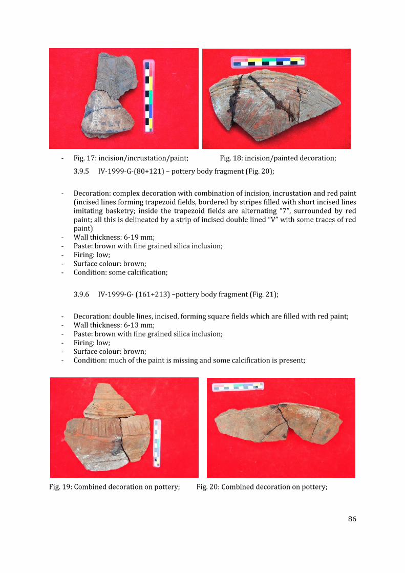
86
- Fig. 17: incision/incrustation/paint; Fig. 18: incision/painted decoration;
3.9.5 IV-1999-G-(80+121) – pottery body fragment (Fig. 20);
- Decoration: complex decoration with combination of incision, incrustation and red paint
(incised lines forming trapezoid fields, bordered by stripes filled with short incised lines imitating basketry; inside the trapezoid fields are alternating “7”, surrounded by red paint; all this is delineated by a strip of incised double lined “V” with some traces of red paint)
- Wall thickness: 6-19 mm; - Paste: brown with fine grained silica inclusion; - Firing: low; - Surface colour: brown; - Condition: some calcification;
3.9.6 IV-1999-G- (161+213) –pottery body fragment (Fig. 21);
- Decoration: double lines, incised, forming square fields which are filled with red paint; - Wall thickness: 6-13 mm; - Paste: brown with fine grained silica inclusion; - Firing: low; - Surface colour: brown; - Condition: much of the paint is missing and some calcification is present;
Fig. 19: Combined decoration on pottery; Fig. 20: Combined decoration on pottery;

87
Fig. 21: incised squares with red paint;
4. Conclusion
It would be difficult to draw precise chronological conclusions from the Pacaldero
pottery, not only because it’s a surface collection, but also because some of the decoration types
in South East Asia show very long temporal persistence. The paddle impressed for example is
present since the Neolithic until probably today in both continental and Island Southeast Asia.
Also this site in particular, sets a lot of puzzles with its intriguing anthropomorphic and
zoomorphic vessels, some of them already published (Cayron 2004). Nevertheless, following the
typology already established by Solheim and the chronology of Fox (Fox 1970), we can say with
confidence that this cave was most frequently visited during the Metal Age. That the cave was
visited afterwards, we can tell by the burial jars, scattered all over the cave floor. What remains
to be answered is whether this cave was occupied by the Neolithic people or even earlier. The
determination of the chronologically sensitive pottery types in The Philippines I think is still a
challenge for future research.
N.B.: The accession numbers of the pottery fragments were changed after the completion of this
report, but carefully relabeled, they are still retraceable.

88
APPENDIX 5: ANALYSIS OF ANIMAL REMAINS RECOVERED FROM C.2139 OF THE EAST
CHAMBER OF ILLE CAVE Noel Amano
Zooarchaeologists usually deal with bone assemblages that were recovered from
specific areas that have higher than average concentration of animal remains (Lyman, 1994:
189). Animal bone concentration on a particular area could have resulted from human activities
or natural processes. During the 2011 excavation, a significant concentration of microvertebrate
remains was found within a silty clay sediment layer [c.2139] inside the East Chamber.
Although there are still no direct radiocarbon dates for the layer, it could date back to the
terminal Pleistocene since it is under Early Holocene contexts 866 and c.806. Based on early
counts, more than 1500 microvertebrate bone fragments were recovered from this
concentration. Majority of the bone fragments from c.2139 were not covered in concretion, in
contrast to animal remains recovered from other sediment layers. Likewise, there is also a
notable rarity or absence of taxa usually hunted for subsistence. This research aims to
determine the process(es) that resulted to the accumulation of animal remains in c.2139 by
examining the taphonomy of the bone fragments recovered.
The maximum lengths of all bone fragments were taken using a digital caliper. The
elements were identified to the highest possible taxonomic level using the modern comparative
reference collection housed at the UP ASP Zooarchaeology laboratory. Elements and element
pairing was recorded. Enumeration of archaeofauna was based on analytical units, specifically
NISP (Number of Identified Specimens), MNI (Minimum Number of Individuals) and MNE
(Minimum Number of Elements).
Surface modification of bone fragments were recorded in detail including weathering,
burning and butchery. A scale-based categorization was used to record burning, with the value
1 assigned to partially burnt specimens and 3 to calcined bone fragments. Anatomical
placements of cutmarks were also recorded. Special attention was given to edge abrasion and
rounding. As with the recording of burning, a scale-based categorization was used to record
edge abrasion. All specimens with key taphonomic and anthropic modifications were
documented using a Canon Powershot SX130 IS camera. Micrographs were taken using a Nikon
Coolpix digital camera mounted on a Nikon C-LEDS stereomicroscope. All measurements and
records were stored in a database devised from MS Access and MS Excel.
A total of 4081 bone and tooth fragments were recovered from c. 2149. Of these, 3378 (82.7%)
bone fragments were from rodents, 282 (6.9%) were from bats, 30 (0.73%) were from
intermediate size mammals (stink badger, macaque, etc.), 16 (0.39%) were from large mammals
(deer and pig), 118 (2.9%) were from reptiles (turtle, snake and varanids) and 215 (5.31%)
were not identified to any taxon. Of the 3378 rodent remains recovered, 4.19% (142) belonged
to the family Sciuridae (squirrel), 2.8% (95) belonged to Hystricidae (porcupine), 60.2% (2039)
were from murids (rats and mice) and 32.5 (1102) cannot be assigned to any family (mostly
vertebra, long bone shaft fragments and loose incisors) (Figure1).

89
A total of 133 murid mandibles were recovered. Of these 109 (89.1%) lacked teeth.
Likewise, 77.21% of the 79 murid maxilla fragments recovered also lacked teeth. This made the
identification of species difficult. Furthermore, biometric comparisons were severely limited
since most of the time just a single tooth is preserved in the maxilla and mandible fragments
examined. Based on the morphology of the first molar, specimens belonging to Rattus
tiomanicus and Sundamys muelleri were recorded. Other murid bone fragments identified
included humerus (422, 12.49%), ulna (250, 7.4%), femur (406, 12.1%), tibia (459, 13.5%) and
pelvis (76, 2.24%).
Figure 1. Number of identified specimens recovered from c. 2139
Squirrel long bones were differentiated from murid bones based on morphology and
size. A total of 29 (20.4%) squirrel radius fragments, 20 (14.8%) ulna, 24 (16.9%) humerus, 5
(3.5%) scapula, 34 (23.9%) femur, 27 (19.01%) tibia and 3 (2.11%) pelvis were recorded. Of the
28 squirrel mandible recorded, only 8 (28.6%) had the dentition preserved. Likewise, only 5
maxilla fragments (29.4%) had dentition. Nonetheless specimens identified as belonging to
Hylopetes negripes (arrow-tailed flying squirrel) and Sundascuirus sp. have been recorded.
Rodents, 3378,
83%
Bats,
282, 7%
Medium-sized
Mammals, 30,
1%
Large
Mammals, 16,
1%
Reptiles, 118,
3% Birds, 10, 0%
Indet
Fragments,
217, 5%

90
Of the 282 bat remains recovered, 31 (10.9%) were wing elements (phalanges and
metapodials), 22 (7.8%) were humerus, 51 (18.08%) were radius, 29 (10.2%) were femur, 32
(11.3%) were tibia, 24 (8.5%) were maxilla and 92 (32.6%) were mandible fragments. Only 19
(20.6%) mandible fragments had preserved dentition. Specimens belonging to Cynopterus
brachyotis, Hipposideros diadema (Figure 2) and Myotis sp. were identified.
Figure 2. Hipposideros diadema mandibles recovered from contest 2139
Medium sized mammals identified in the assemblage included stink badger (Mydaus
marchei Figure 3), macaque (Macaca fascicularis Figure 4) and civet cat (Paradoxurus
hermaphroditus). Majority (86.6%) of the medium-sized mammal remains recovered were loose
teeth. This is the same with large size mammals. A total of 5 loose pig teeth (including lower
canines, deciduous fourth premolar and lateral incisors) and 2 unfused distal metapodial
articular end were recorded. A mandible from a young deer (Figure 5), in addition to premolars
and molars, was identified.

91
Figure 3. Stink badger (Mydaus marchei) upper and lower third molar recovered from context
2139
Figure 4. Macaque lower third molar and upper central incisor recovered from context 2139
Figure 5. Juvenile deer mandible containing deciduous premolar 2 to deciduous premolar 4
from context 2139

92
A total of 41 snake and 51 monitor lizard (Varanus salvator) vertebrae were recorded
(Figure 6). On the other hand, a total of 37 turtle remains were noted, including 21 carapace and
16 plastron fragments. Specimens belonging to Cyclemys dentata (Asian lead turtle) and Cuora
ambionensis (Malayan box turtle) were identified. Bird remain were represented by long bone
shaft fragments (10).
Figure 6. Monitor lizard (Varanus salvator) mandibular fragment recovered from context 2139
A total of 217 bone fragments were not identified to any taxon, majority of which
were long bone shaft fragments belonging to microvertebrates (112), medium-sized vertebrates
(62) and large mammals (43).
The size of the bone fragments varied from 3.21 mm (murid phalanx) to 35.21 mm
(deer mandible fragment). The fragments recorded had an average size of 15.21 mm. A total of
1680 bone fragments (41.16%) measured between 15-20 mm, 1003 (24.57%) measured
between 10-15 mm, 941 (23.05%) measured between 20-25 mm, 321 (7.86%) had
measurements between 5-10 mm, 121 (2.9%) measured between 0-5 mm and 7 (0.12%)
measured above 30 mm (Figure 7).

93
Figure 7. Size distribution of the vertebrate remains recovered within c. 2139
Figure 8. Angularity and sphericity of the bone fragments recovered from c. 2139
0
200
400
600
800
1000
1200
1400
1600
1800
0-5 mm 5-10 mm 10-15 mm 15-20 mm 20-25 mm 25-30 mm 30-35 mm 35-40 mm
Heavily
Rounded,
1139, 41%
Slightly
Rounded,
984, 36%
Angular, 619,
23%

94
A
B
C
Figure 9. Examples of heavily rounded specimens recovered from c. 2139. A. a murid right
mandible; B. murid pelvis; C. murid caudal vertebrae (compared to the modern comparative
specimen at the right).

95
Majority of the bone fragments examined exhibited heavily rounded fracture edges (Figure 8).
Specifically, 41.53% were heavily rounded, 35.88% were slightly rounded and only 22.5% had
angular fracture edges. Furthermore, 68.21% of the bone fragments showed polishing and
32.11% were burnt (Figure 9). None of the bone fragments examined exhibited evidence of
digestion.
Although prehistoric rodent consumption has been documented (i.e. Simonetti
and Cornejo, 1991), study of microvertebrate consumption requires a taphonomical approach
that will allow differentiation of incidentally incorporated animal bones from those that were
intentionally exploited in the past human subsistence (Medina et al., 2011). Human
consumption of small vertebrates could be identified through the presence of cutmarks and
burned bones, breakage patterns, skeletal representation and age profile. Human mediated
bone accumulation is usually evidenced by predominance of particular skeletal elements
(Lyman, 1994; Reitz and Wing, 1999; O’Connor, 2000). This was not observed in the
assemblage. Instead all skeletal elements were well represented, including elements that are
usually lost when carcasses are consumed. There was also a predominance of species that
naturally inhabits caves (murids and bats). Butchery marks on microvertebrate remains are
usually difficult recognize since their depth and width are superficial (Quintana, 2005), being
similar to trampling marks (Domínguez-Rodrigo et al., 2009). No such marks were identified in
the microvertebrate remains recovered. Cutmarks and percussion marks were also absent from
intermediate and large sized mammals. These taphonomic indicators suggest that the
accumulation of microvertebrates in c.2139 could have resulted from natural processes rather
than human activities.
Animals such as rodents, pythons, birds and carnivores also accumulate animal
bones. Porcupines are known to accumulate bones, but the signature damages caused by
porcupine to animal bones were not found. Porcupines are known to cause gnawing damages in
forms of “broad, contiguous, shallow scrape marks” and most of the time cancellous bones are
scooped out of the end of long bones creating “tubular shafts”(Maguire et al., 1980: 91). Pythons
and owls are known to roost in caves and accumulate small animals. But owl and python-
accumulated fragments usually show corrosion, as brought about by digestion and this type of
damage was not observed in the animal bone fragments recovered.
The taphonomy of the animal bone fragments recovered from c.2139 is
consistent with the effects of fluvial transport on small animal bones. The predominance of
heavily rounded and abraded bone fragments is consistent with experimental studies on the
effects of fluvial accumulations (Korth, 1979; Andrews, 1990; Fernandez-Jalvo and Andrews,
2003). Mandibles and maxillae usually lack dentition since hydronomic sorting usually causes
the breakage of the ascending ramus and inferior angles of the mandible and detachment of
teeth from alveoli. Pelvic bones lose the pubis and the ischium and the iliac bone is usually
perforated. Limb bones transported by water action are usually broken on its ends or along the
shaft. Long become fragments become rounded and polished. Loose teeth are sometime split

96
and usually rounded, both the dentine and the enamel. This is in contrast to damage made by
bird digestion which usually results to erosion of the enamel more than the dentine
accumulations (Korth 1979; Andrews, 1990; Fernandez-Jalvo and Andrews, 2003). Rounded
pebbles were also found in the sediment matrix. The consistency of the size distribution of the
animal bones recovered also provides information on the speed of stream current. The fact that
the majority of the bone fragments recovered measured 10-20 mm suggest that fragments were
transported by a stream speed of 6 cm/s of a quite low energy (Dodson, 1973). The larger
elements (deer mandible, large mammal teeth, etc.) could have been transported by a stream
with a speed of not more than 35 cm/s.
The identification of specimens to the highest taxon, as noted earlier, was limited
by the absence of mandibles and maxillae containing teeth. The identified specimens are known
to be present in Palawan during the early Holocene, but since limited biometric data were taken,
no generalizations on size change through time could be made.
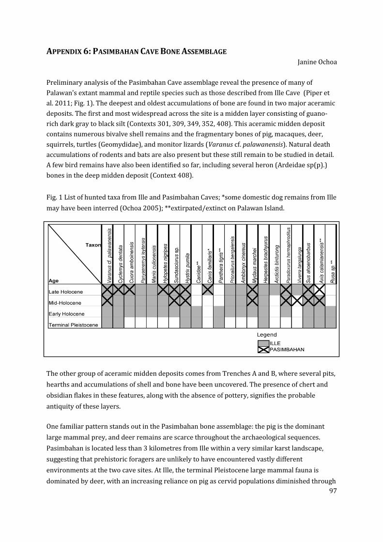
97
APPENDIX 6: PASIMBAHAN CAVE BONE ASSEMBLAGE Janine Ochoa
Preliminary analysis of the Pasimbahan Cave assemblage reveal the presence of many of
Palawan's extant mammal and reptile species such as those described from Ille Cave (Piper et
al. 2011; Fig. 1). The deepest and oldest accumulations of bone are found in two major aceramic
deposits. The first and most widespread across the site is a midden layer consisting of guano-
rich dark gray to black silt (Contexts 301, 309, 349, 352, 408). This aceramic midden deposit
contains numerous bivalve shell remains and the fragmentary bones of pig, macaques, deer,
squirrels, turtles (Geomydidae), and monitor lizards (Varanus cf. palawanensis). Natural death
accumulations of rodents and bats are also present but these still remain to be studied in detail.
A few bird remains have also been identified so far, including several heron (Ardeidae sp(p).)
bones in the deep midden deposit (Context 408).
Fig. 1 List of hunted taxa from Ille and Pasimbahan Caves; *some domestic dog remains from Ille
may have been interred (Ochoa 2005); **extirpated/extinct on Palawan Island.
The other group of aceramic midden deposits comes from Trenches A and B, where several pits,
hearths and accumulations of shell and bone have been uncovered. The presence of chert and
obsidian flakes in these features, along with the absence of pottery, signifies the probable
antiquity of these layers.
One familiar pattern stands out in the Pasimbahan bone assemblage: the pig is the dominant
large mammal prey, and deer remains are scarce throughout the archaeological sequences.
Pasimbahan is located less than 3 kilometres from Ille within a very similar karst landscape,
suggesting that prehistoric foragers are unlikely to have encountered vastly different
environments at the two cave sites. At Ille, the terminal Pleistocene large mammal fauna is
dominated by deer, with an increasing reliance on pig as cervid populations diminished through

98
the mid-Holocene. Thus biostratigraphic correlation with the well-dated Ille assemblage would
seem to point to the mid-Holocene as perhaps the maximum age of the oldest aceramic midden
deposits at Pasimbahan. Small deer remains are present nonetheless throughout the
Pasimbahan stratigraphic sequence in very small quantities, including in the younger layers
with associated pottery. In Trench B for instance, two stratified midden remains – c.64 and
c.339 - contain some deer remains (Fig. 3). Based on artefact association, the Metal Period is the
maximum age that can be set for the Context 64 deer remains. A distal deer tibia was also found
in c.71. A young midden deposit [c. 403] in Trench D with Indo-Pacific glass beads also contains
a few deer remains.
Several specimens have been sent for radiocarbon dating to the Waikato Radiocarbon
Dating Laboratory in New Zealand. The radiocarbon dating programme, funded by an outright
research grant from the UP Office of the Vice Chancellor for Research and Development, hopes
to get direct dates for pig and deer remains in order to answer pertinent archaeological and
palaeoecological questions regarding deer extinction and the introduction of domestic pigs in
northern Palawan.
Inventory of specimens for dating
Accession No. Site Trench Context/Level Taxon Element
IV-1998-P-
46161 Ille Site
West
Mouth
85 to 95 cm
below LDP pig lower third molar
IV-2007-Q-2012
Pasimbahan
Cave Trench C 309 deer mandible fragment
IV-2007-Q-1541
Pasimbahan
Cave Trench C 309
Chicoreus
capuchinus Shell fragment
IV-2007-Q-2015
Pasimbahan
Cave Trench J 408 pig mandible fragment
IV-2007-Q-1401
Pasimbahan
Cave Trench B 71 deer distal tibia fragment
IV-2007-Q-1548
Pasimbahan
Cave Trench B 339 pig
lower fourth
premolar

99
APPENDIX 7: REPORT ON THE SHELL COUNT FROM ILLE Jane Carlos
The continuing study of the collected shell assemblage from Ille since the 2007 season has
reached a new benchmark with the identification and substantial count of most of the samples
collected. All shells quantified for this study were initially stored in plastic bags that were placed
in several sacks. The plastic bags were labeled with the context number, depth and square
number. Despite yearly replacement of the bags and sacks, some of the recovered shells have
either been lost or thrown due to breakage of the sacks and plastics causing the mixture of some
shells. Some plastic bags also had faded labels so the contents were discarded.
A total of 155 plastic bags of shells, equivalent to seven sacks, have been sorted and counted this
season. These bags are coming from 69 contexts from the East Mouth area which also includes
the East Chamber, East Chamber Long Trench (ECLT), and the East-West Connection Trench
(EWCT). Also, the bags of shells come from the excavation seasons of 2006 until 2011. There are
seven (7) more sacks left to sort and count from the East Mouth area which will hopefully be
completed in the coming 2012 season. As for the shells coming from the West Mouth area (West
Mouth, West Long Trench, Outlier, and Outlier South Extension) and Ihian Trench, these have
not yet been accounted for, along with the shells from Pasimbahan - Magsanib Cave.
All in all, a total of 33 shell types have been added to the original 61 shell types/species of the
reference collection – total now is ninety-four (94). Fifty-eight (58) of these have been identified
to either the family, genus or species level (see Table 1) while thirty-six (36) shell types are yet
to be determined. These are coming from three classes (Bivalvia, Gastropoda, and
Polyplacophora) of the Phylum Mollusca. Included also are two types from the Phylum
Arthropoda.
The various shells types are from marine (31), estuarine/mangrove (18), freshwater (3), and
terrestrial (1) sources. There were more species of gastropods (44) than bivalves (13) and
initial counts show that among the gastropods, the Family Neritidae dominates, which includes
at least twelve species. Considering the bivalves, the freshwater to mangrove Batissa sp. is
dominant in terms of quantity.
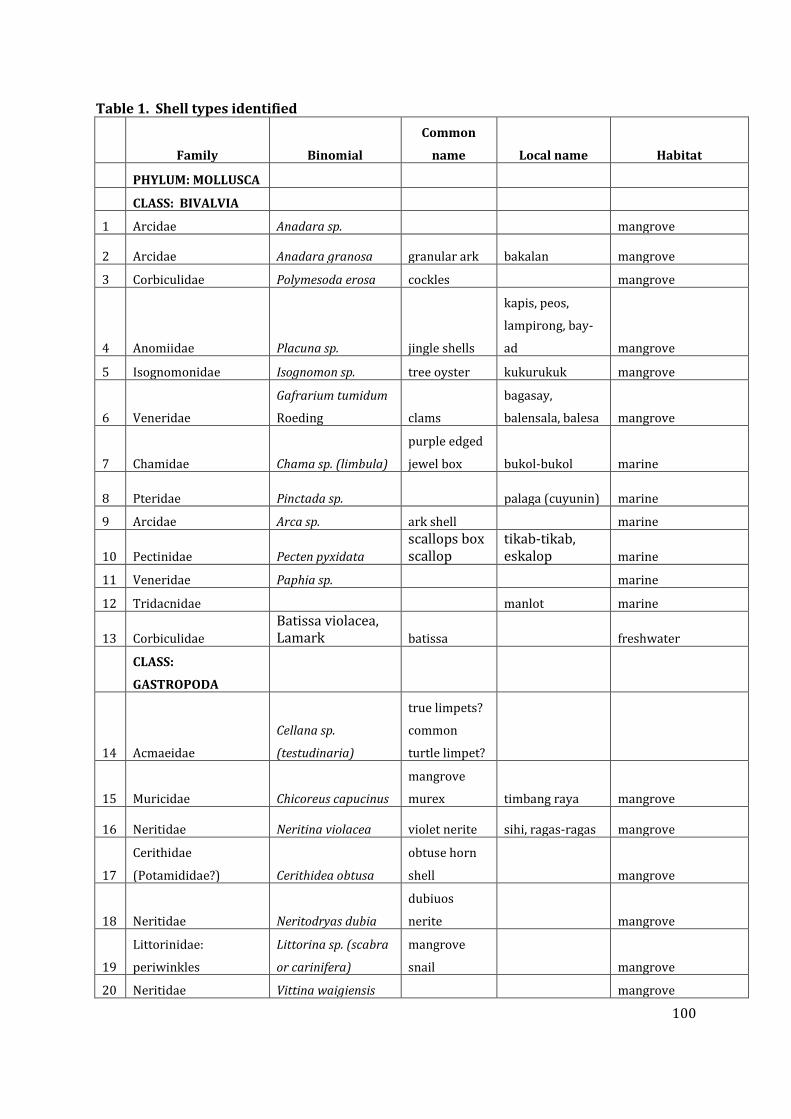
100
Table 1. Shell types identified
Family Binomial
Common
name Local name Habitat
PHYLUM: MOLLUSCA
CLASS: BIVALVIA
1 Arcidae Anadara sp. mangrove
2 Arcidae Anadara granosa granular ark bakalan mangrove
3 Corbiculidae Polymesoda erosa cockles mangrove
4 Anomiidae Placuna sp. jingle shells
kapis, peos,
lampirong, bay-
ad mangrove
5 Isognomonidae Isognomon sp. tree oyster kukurukuk mangrove
6 Veneridae
Gafrarium tumidum
Roeding clams
bagasay,
balensala, balesa mangrove
7 Chamidae Chama sp. (limbula)
purple edged
jewel box bukol-bukol marine
8 Pteridae Pinctada sp. palaga (cuyunin) marine
9 Arcidae Arca sp. ark shell marine
10 Pectinidae Pecten pyxidata
scallops box scallop
tikab-tikab, eskalop marine
11 Veneridae Paphia sp. marine
12 Tridacnidae manlot marine
13 Corbiculidae
Batissa violacea, Lamark batissa freshwater
CLASS:
GASTROPODA
14 Acmaeidae
Cellana sp.
(testudinaria)
true limpets?
common
turtle limpet?
15 Muricidae Chicoreus capucinus
mangrove
murex timbang raya mangrove
16 Neritidae Neritina violacea violet nerite sihi, ragas-ragas mangrove
17
Cerithidae
(Potamididae?) Cerithidea obtusa
obtuse horn
shell mangrove
18 Neritidae Neritodryas dubia
dubiuos
nerite mangrove
19
Littorinidae:
periwinkles
Littorina sp. (scabra
or carinifera)
mangrove
snail mangrove
20 Neritidae Vittina waigiensis mangrove

101
21 Potamididae
Telescopium
telescopium
telescope
shell bagungon mangrove
22 Melampidae
Cassidula
vespertiliones bat cassidula mangrove
23 Melampidae Ellobium aurisjudae mangrove
24 Potamididae Terebralia sulcata horn shells sudsud mangrove
25 Neritidae
Vittoida (Vittoria)
aquatilis mangrove
26 Neritidae neritid mangrove
27 Cerithidae Clypeomorus sp. marine
28 Cerithidae Cerithium sp. tutok/ saka saka marine
29
Muricidae
(murex/rocksnails) Drupa sp. (ricinus)
prickly
spotted drupe marine
30 Muricidae Rapana sp.
murex/
rocksnails marine
31 Nassaridae Nassarius sp.
nassa mud
shells sibod-sibod? marine
32
Naticidae carnivorous feeding on bivalves Polinices aurantius
orange/golde
n moon shell
bulan bulan,
bulaklak marine
33 Neritidae Nerita balteata marine
34 Neritidae Nerita antiquata marine
35 Neritidae Nerita exuvia
snake skin
nerite marine
36 Neritidae Nerita planospira
flat spired
nerite sihi marine
37 Neritidae tangkuka marine
38 Olividae Oliva reticulata
olive shells /
blood olive
sibit sibit,
korakol marine
39 Planaxidae Fissilabra sp. marine
40 Siphonariidae false limpets marine
41 Strombidae Lambis sp. conchs
sarang-sarang;
ranga-ranga marine
42 Strombidae Strombus sp. conch
sikad-sikad,
pasyak, liswi, marine
43 Terebridae auger snails tisoy-tisoy, sabilan marine
44 Trochidae Monodonta sp. top shell marine
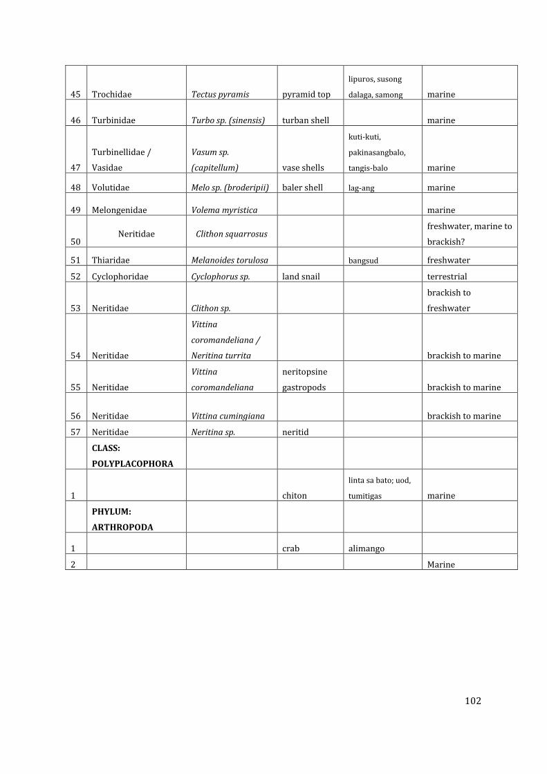
102
45 Trochidae Tectus pyramis pyramid top
lipuros, susong
dalaga, samong marine
46 Turbinidae Turbo sp. (sinensis) turban shell marine
47
Turbinellidae /
Vasidae
Vasum sp.
(capitellum) vase shells
kuti-kuti,
pakinasangbalo,
tangis-balo marine
48 Volutidae Melo sp. (broderipii) baler shell lag-ang marine
49 Melongenidae Volema myristica marine
50 Neritidae Clithon squarrosus
freshwater, marine to
brackish?
51 Thiaridae Melanoides torulosa bangsud freshwater
52 Cyclophoridae Cyclophorus sp. land snail terrestrial
53 Neritidae Clithon sp.
brackish to
freshwater
54 Neritidae
Vittina
coromandeliana /
Neritina turrita brackish to marine
55 Neritidae
Vittina
coromandeliana
neritopsine
gastropods brackish to marine
56 Neritidae Vittina cumingiana brackish to marine
57 Neritidae Neritina sp. neritid
CLASS:
POLYPLACOPHORA
1 chiton
linta sa bato; uod,
tumitigas marine
PHYLUM:
ARTHROPODA
1 crab alimango
2 Marine

103
12. REFERENCES
Aguilera, Melchor L., Jr. 1990. Archaeological survey of El Nido-Taytay, Palawan. Typescript.
Manila: National Museum of the Philippines.
Andrews, P. 1990. Experiments in taphonomy Journal of Archaeological Science, 22: 147–153.
Archaeological Studies Program (ASP) 2005-2006. Report on the excavation at Dewil Valley, El
Nido Palawan. Unpublished report. Archaeological Studies Program, University of the
Philippines.
Balbaligo, Y. 2009. 'Notes on the 2008 tradeware ceramics from Ille Cave, Palawan, the
Philippines '. In Test pit, 14: 15-16.
Balbaligo, Y. (2010). "Preliminary Report on the Earthenware Pottery from Ille Cave and
Rockshelter, Palawan Philippines." Hukay 15: 1-20.
Basillia, P. G. A. (2012). Morphological and Technological Analysis of the Microperforated Cut
Shell Beads from Ille Site, El Nido, Palawan. MA Thesis, Archaeological Studies Program.
Quezon City, University of the Philippines Diliman.
Bautista, Angel P. 1999. Analysis of human remains from Ille Cave, New Ibajay, El Nido, Palawan.
Typescript. Manila: National Museum of the Philippines.
Bird, M., E. Boobyer, C. Bryant, H. Lewis, V. Paz, and W. E. Stephens. 2007. A long record of
environmental change from bat guano deposits in Makangit Cave, Palawan, Philippines.
Transactions of the Royal Society of Edinburgh: Earth and Environmental Science 98:59-
69.
Carlos, J. 2006. ‘Exploring the ‘landscape’ of a pottery sherd: notes on the Ille Cave rice imprints’.
In Test pit, 8: 27-28.
Cayron, J. 1999. Report on the archaeological survey and exploration in Barangay New Ibajay, Il
Nido, Palawan (Feb. 19-25, 1999). Hukay 2(1):47-53.
Cayron, J. 2004. The Sinalakan Turtle-Shaped artefact. In Paz, V. (ed). Southeast Asian
Archaeology: Wilhelm G. Solheim Festschrift. Quezon City: University of the Philippines
Press, pp. 276-291.
Cayron, J. 2011. Archaeology and Exchange in Palawan Island, Philippines, PhD Dissertation,
National University of Singapore.
De la Torre, A.1999. Brief report. Archaeological exploration at Ille Cave site (IV-98-P), New
Ibajay (Formerly Dewil), El Nido, Palawan (January 19-Fehbruary 2 1999). Typescript.
Manila: National Museum of the Philippines.
Dizon, E. Z. 2003. New direct dating of the human fossils from Tabon cave, Palawan, Philippines.
Proceedings of the Society of Philippine Archaeologists 1:63-67.
104
Dizon, E. Z., Ronquillo, W. P. & Orogo, A. B. 2001. Recent field campaigns at Tabon Cave in
Lipuun Point, Quezon, Palawan, Philippines. Unpublished manuscript, National Museum
of the Philippines.
Doherty, C., Beavitt, P. & Kurui, E. 2000. Recent observations of rice temper in pottery from Niah
and other sites in Sarawak. Bulletin of the Indo-Pacific Prehistory Association 20, 147-152.
Domínguez-Rodrigo, S. de Juana, A. Galán, M. Rodriguez. 2009. A new protocol to differenciate
trampling marks from butchery cut marks. Journal of Archaeological Science 36: 2643-2654.
Eusebio, M. S. 2006. 'Notes on the Earthenware Jarlet from the West Mouth'. In Test Pit, 8: 28.
Faylona, Marie Grace Pamela. 2006. Notes on the Shells of Ille Cave Eat Mouth (Excavation
Seasons 2004-2005). Test Pit November:32-34.
Faylona, Marie Grace Pamela G. 2002. An update on the recent fieldwork in Ille Cave, Palawan.
Hukay 4(1):xii.
Faylona, Marie Grace Pamela G. 2003. A preliminary study on shells from Ille Rock Shelter.
Hukay 5:31-49.
Fernandez-Jalvo, F. and Andrews, P. 2003. Experimental Effects of Water Abrasion on Bone
Fragments. Journal of Taphonomy 1(3): 147-163.
Fox, R. B. 1970. The Tabon Caves: Archaeological explorations and excavations on Palawan
Island, Philippines. Vol. 1. Monograph of the National Museum. Manila: National Museum
of the Philippines.
Guthe, C. E. 1927. The University of Michigan Philippine Expedition. American Anthropologists
29:69-76.
Guthe, C. E. 1929. Distribution of sites visited by the University of Michigan Philippine
Expedition, 1922-1925. Michigan Academy of Science, Arts and Letters 10:79-89.
Guthe, C.E. 1935. Gold-decorated teeth from the Philippine Islands. Papers of the Michigan
Academy of Science, Arts, and Letters 20:7-22.
Guthe, C.E. 1938. A burial site on the Island of Samar, Philippine Islands. Papers of the Michigan
Academy of Science, Arts, and Letters. 28:29-35.
Hara, Yoshiyuki and Jun G. Cayron. 2001. A preliminary report on the excavation of Ille Cave, El
Nido, Palawan. Hukay 3(1):81-92.
Harris, E. 1989. Principles of archaeological stratigraphy, 2nd edition. London: Academic Press.
Jago-on, Sheldon Clyde. 2000.Archaeological Program: Ille Rock Shelter 11 March-17 May 2000.
Typescript. Manila: National Museum of the Philippines.
Jago-on, Sheldon Clyde. 1998. Field report on the archaeological exploration conducted in El
Nido, Palawan (May 3-9,1998). Typescript. Manila: National Museum of the Philippines.

105
Korth, W. 1979. Taphonomy of Microvertebrate Fossil Assemblages. Annals of the Carnegie
Museum 48: 235-245.
Kress, Jonathan H. 2006. Robert Fox, Negritos and Philippine Prehistory. Hukay 9:49-64.
Kress, Jonathan H. 2004. The necrology of Sa’gung rockshelter and its place in Philippine
Prehistory. In V. Paz (ed.) Southeast Asian Archaeology: Wilhelm G. Solheim II Festschrift.
Quezon City: UP Press, 239-275.
Kress, Jonathan H. 2002. Report to Wilfredo Ronquillo on excavations conducted at Ille Cave,
Barangay New Ibajay, El Nido Municipality, Palawan, from March 22 to April 10 2002.
Lewis, H. 2003. The potential of soil micromorphology in Southeast Asian archaeology:
Preliminary work at Niah Cave, Sarawak, Malaysia, and Ille Cave, Palawan, Philippines.
Hukay 5:60-72.
Lewis, H., K. Johnson, and W. Ronquillo. 2007. Preliminary Results of Speleothem Dating from
Tabon Cave, Palawan, Philippines:Moisture increase at the LastGlacial Maximum. Hukay
12:35-50.
Lewis, H., V. Paz, M. Lara, H. Barton, P. Piper, J. Ochoa, T. Vitales, J. Carlos, T. Higham, L. Neri, V.
Hernandez, J. Stevenson, E. Robles, A. Ragrario, R. Padilla, W. Solheim, and W. Ronquillo.
2008. Terminal Pleistonece to mid-Holocene occupation and an early cremation burial at
Ille cave, Philippines. Antiquity 82(316): 318-335.
Lewis, H. A., Paz, V., Kress, J., Lara, M.G., Medrana, J. G. L., Carlos, A. J. Piper, P., Hernandez, V.,
Barton, H., Robles, E., Vitales, T. J., Ragragio, A. Solheim, W. G. II and Ronquillo, W. 2006.
Early occupation at Ille Cave, New Ibajay, El Nido, Palawan, Philippines: Report on the
2005 excavation season. Unpublished report. British Academy, NERC/Orads & National
Museum of the Philippines.
Lyman, R.L. 1994. Vertebrate Taphonomy. Cambridge Manuals in Archaeology. Cambridge:
Cambridge University Press.
Maeda, Y., F. Siringan, A. Omura, R. Berdin, Y. Hosono, S. Atsumi & T. Nakamura. 2003. Higher-
than-present Holocene mean sea levels in Ilocos, Palawan and Samar, Philippines.
Quaternary International, 115-116:15-26.
Medina, M.E., Teta, P. and Rivero, D. 2011. Burning damage and small-mammal human
consumption in Quebrada del Real 1 (Cordoba, Argentina): an experimental approach.
Journal of Archaeological Science 39(3): 737–743.
Medrana. J.G.L. 2005. Notes on livestock butchery among the Ifugao and Visayan Migrants of
Palawan. Test Pit (7): 23-28.
Medrana, Jack GI. 2002. A report on the human teeth from Ille Cave: An Exercise in Odontology.
Hukay 4(1):35-48.
Mijares, Armand Salvador, Sheldon Clyde Jago-on and Jun Cayron. 1998. Report on the
archaeological survey of Lagen, Miniloc, Pangolasian and Cadlao Islands and

106
archaeological mapping of Ille Cave, Dewil, El Nido, Palawan. Typescript. Manila: National
Museum of the Philippines.
Munsell soil color charts 2000. New York: New Windsor.
Ochoa, J.T. 2008. Terrestrial vertebrates from Ille cave, Northern Palawan, Philippines:
Subsistence and palaeoecology in the Terminal Pleistocene. Masters Thesis,
Archaeological Studies Program, University of the Philippines, Diliman.
Ochoa, J. T. 2005. In Dogged Pursuit: A Reassessment of the Dog's Domestication and Social
Incorporation. Hukay 8:37-66.
O’Connor, T. 2000. The Archaeology of Animal Bones. GB: Sutto Publishing. 206 pp.
Orogo, A. B. 2000. Archaeological re-investigation and re-excavation of Tabon Cave, Municipality
of Quezon, Palawan Province. Unpublished manuscript, National Museum of the
Philippines.
Orogo, A. B. 2001. Progress report: result of the archaeological re-investigation and re-
excavation of Tabon Cave, Municipality of Quezon, Palawan. Unpublished manuscript,
National Museum of the Philippines.
Orton, C., Tyers, P. and Vince, A. 1993. Pottery in archaeology. Cambridge: Cambridge University
Press.
Paz, V. 1998. Participant Report, Archaeological Survey of El Nido, Palawan (with Ethnographic
notes). Typescript. Quezon City: Archaeological Studies Program Library.
Paz, V. 2003a. The Palawan Island Palaeohistoric research: a project proposal. Manuscript.
Archaeological Studies Program, UP-Diliman.
Paz, V. 2003b. Annual Report of the Palawan Island Palaeohistoric Research Project. Manuscript.
Archaeological Studies Program.
Paz, V., J. Cayron, and L. Lacsina. 2003. Archaeological Fieldwork Preliminary Report:, Bataraza,
Palawan, May-June 2003. Manuscript. Archaeological Studies Program, UP-Diliman.
Paz, V. and T. Vitales. 2008. Isang pagtingin sa ilang mga artefak ng Burial 727 sa Ille. Test Pit 13:
30-34.
Paz, V. and Ronquillo. W. 2004. Report on the Palawan Island Palaeohistoric Research Season for
2004. Manuscript. Archaeological Studies Program, UP-Diliman.
Pawlik, A. 2007. Analysis of two polished stone adzes from Ille cave at El Nido, Palawan Island,
Philippines. Hukay 10: 38-59.
Pawlik, A. (2004). A geodetic site catchement of the Ille Cave Platform with tilted theodolite and
vector graphics mapping. Southeast Asian Archaeology: Wilhelm G. Solheim II Festschrift.
V. Paz. Quezon City, University of the Philippines Press: 225-238.

107
Piper, P., J. Ochoa, V. Paz, H. Lewis, W. Ronquillo. 2008. The first evidence for the past presence
of the tiger Panthera tigris (L.) on the island of Palawan, Philippines: Extinction in an
island population. Palaeogeography, Palaeoclimatology, Palaeoecology 264:123-127.
Quintana, C. 2005. Despiece de microrroedores en el Holoceno Tardío de las sierras de Tandilia
(Argentina) Archaeofauna, 217 (2005), pp. 227–241.
Reitz, E., and E. Wing. 1999. Zooarchaeology. Cambridge Manuals in Archaeology. Cambridge:
Cambridge University Press.
Rice, P. M. 1987. Pottery analysis: A source book. Chicago: University of Chicago Press.
SEAICE. 2000a Archaeological Study El Nido Community Based Conservation and Development
Program. Quezon City: Archaeological Studies Program Library.
SEAICE. 2000b A Brief Summary of the Archaeological Exploration of Ille Cave and Rock Shelter.
Typescript. Archaeological Studies Program Library.
Shepard, A. O. 1956. Ceramics for the archaeologist. Washington: Carnegie Institution of
Washington.
Simonetti, J.A. and Cornejo L.A. 1991. Archaeological Evidence of Rodent Consumption in Chile.
Latin American Antiquity 2(1); 92-96.
Solheim, W. G. II. 2004. Excavations of Ille rock shelter, Palawan, Philippines: Preliminary
Report. Archaeological Studies Program.
Solheim, W. G. II. 2002. The Archaeology of Central Philippines, Revised edition. Quezon City:
Archaeological Studies Program, University of the Philippines.
Solheim, W. G. II. 1998. Palawan Fieldtrip 19-24 October 1998. Typescript. Manila: National
Museum.
Solheim, W.G. II. 2000. Archaeological Program: Ille Rock shelter. Typescript. Manila: National
Museum of the Philippines.
Solheim, W.G. II. 1999. Ille Rock Shelter field notes 19 January to 31 January 1999. Typescript.
Manila: National Museum of the Philippines.
Southeast Asian Ceramics Society 1979. Chinese Celadons and other related wares in Southeast
Asia. Singapore: Southeast Asian Ceramic Society and Arts Orientalis.
Swete Kelly, M.C. and Szabó, K. 2002. Archaeological excavation at Ille Cave, New Ibajay, El Nido,
Palawan (April 2002-Eastern Trench). Test Pit 1(1):17-24.
Szabó, K., M.C. Swete Kelly & A. Peñalosa. 2004. Preliminary Results from excavations in the
eastern mouth of Ille cave, northern Palawan. In Paz, V. (ed.). Southeast Asian
Archaeology: Wilhelm G. Solheim II Festschrift. Quezon City: University of the Philippines
Press, pp. 209-224.

108
Teodosio, S. F. R. 2005. The earliest bone tools in the Philippines: Patterns and Issues. Hukay
8:13-36.
Wurster, C. M., M. I. Bird, I. D. Bull, F. Creed, C. Bryant, J. A. J. Dungait, and V. Paz. 2010. Forest
contraction in north equatorial Southeast Asia during the Last Glacial Period Proceedings
of the National Academy of Sciences of the United States of America 107:15508-15511.
Vitales, Timothy James, 2009. Form, Function, and Meaning: An Approach in Understanding
Melo Shell Artifacts in Philippine Sites. MA Archaeology, Archaeological Studies Program,
University of the Philippines, Diliman.