pwtb 200-1-150 multinational analysis of military vehicle ... · multinational analysis of military...
TRANSCRIPT
PUBLIC WORKS TECHNICAL BULLETIN 200-1-150 30 JULY 2015
MULTINATIONAL ANALYSIS OF MILITARY VEHICLE IMPACTS AND
REGULATORY PRESSURES ON TRAINING LAND MANAGEMENT

Public Works Technical Bulletins are published by the U.S. Army Corps of Engineers, Washington, DC. They are intended to provide information on specific topics in areas of Facilities Engineering and Public Works. They are not intended to establish new Department of Army policy.

DEPARTMENT OF THE ARMY U.S. Army Corps of Engineers
441 G Street NW Washington, DC 20314-1000
CECW-CE
Public Works Technical Bulletin 30 July 2015
No. 200-1-150
Facilities Engineering Environmental
MULTINATIONAL ANALYSIS OF MILITARY VEHICLE IMPACTS AND REGULATORY PRESSURES ON
TRAINING LAND MANAGEMENT
1. Purpose.
a. To gain strategic insight into effective and efficient land management practices, this Public Works Technical Bulletin (PWTB) documents how certain U.S.-allied nations have dealt with challenges related to intensified human development, encroachment, soil conservation, climate change, and ecosystem management on their military training lands. The opportunities identified and lessons learned are presented to enable the U.S. Army to save money, optimize co-land utilization, and preserve training land resources long-term. Innovative technologies may have been developed in other countries to deal with more stringent regulations, and this project reviews applicable foreign solutions, identifies solutions for use within the U.S. Army, and projects potential up-and-coming regulatory pressures (e.g., proposed new Threatened and Endangered Species [TES] listings). The knowledge gained from this effort may bolster stewardship, enhance land rehabilitation, and promote military training sustainment.
b. All PWTBs are available electronically at the National Institute of Building Sciences’ Whole Building Design Guide webpage, which is accessible through this link:
http://www.wbdg.org/ccb/browse_cat.php?o=31&c=215

PWTB 200-1-150 30 July 2015
2
2. Applicability. This PWTB applies to engineering and training land management activities at all U.S. Army facilities.
3. References.
a. Army Regulation (AR) 200-1, “Environmental Protection and Enhancement,” 13 December 2007, http://www.apd.army.mil/pdffiles/r200_1.pdf.
b. This document is based on allied nations’ training and environmental stewardship context. Therefore, selected legal drivers for each country are listed in Appendix C.
4. Discussion
a. AR 200-1 contains policy for environmental protection and enhancement, pollution prevention, conservation of natural resources, sustainable practices, and compliance with environmental laws. This PWTB explores how four allied nations have approached changing regulatory environment so that we might glean lessons learned.
b. Appendix A provides background into the driving concept behind this publication. It explores the need to look abroad for potential land management solutions to future regulatory and compliance scenarios.
c. Appendix B explains the investigative considerations and methods conducted in this work.
d. Appendix C provides a country-by-country review of the environmental legislative / regulatory / compliance drivers that exist, relative to military training and installations management.
e. Appendix D provides a country-by-country review of the land-based management practices that have been developed in each country relative to the regulatory restrictions and training and/or land sustainment targets.
f. Appendix E presents a synthesis discussion, allowing a summarized “compare-and-contrast” review of the findings in Appendix C and Appendix D.
g. Appendix F contains “lessons learned” and recommendations, as well as some broader takeaways that might assist U.S. installations in land management and compliance with


PWTB 200-1-150 30 July 2015
4
(This page intentionally left blank.)

PWTB 200-1-150 30 July 2015
A-1
APPENDIX A: PROBLEM STATEMENT AND RELEVANT BACKGROUND
The fieldwork, investigation, and write-up for this PWTB were conducted by Anne P. Koster, Heidi R. Howard, and Jesse Nosbaum of the Ecological Processes Branch at ERDC-CERL (CEERD-CN-N).
Sustaining Training Lands for Military Missions
The Army’s ability to sustain its lands and ranges for continued training activities is a critical component to maintaining operational readiness. Such land-based training provides essential realism to support the Army’s cardinal principle: “Fight as You Train, Train as You Fight.” The long-term condition of soils and vegetative cover is a key to providing sufficient carrying capacity for sustained land-based training activities.
The Army also is responsible to the American public as a legally accountable caretaker of federal lands, as outlined in AR-200-1. This responsibility contributes to the many compliance-driven actions taken across the Army enterprise. These activities range from: (a) caring for threatened and endangered species (TES) populations, to (b) cultivation, maintenance, and protection of habitat for any species with a protected status (whether state or federal), to (c) environmental compliance associated with stormwater, pollution prevention, or erosion control.
The U.S. Army has pioneered land rehabilitation with land management practices (LMPs) and innovative technologies for maintaining their training lands under the Integrated Training Area Management (ITAM) program. These efforts respond to legal compliance requirements and proactively sustain land resources for continuous and future training capabilities. However, changing environmental regulation and funding is putting added pressure on training land management.
Changing Environmental Regulatory Environment in the United States
By reviewing historic environmental regulatory requirements, it is observed that required levels of compliance typically become more stringent over time. Graphics from multiple studies confirm this observation has held true over multiple time periods. Figure A-1 shows the cumulative number of regulatory pressures on federal lands (including military installations) between 1918

PWTB 200-1-150 30 July 2015
A-2
and 1996. Figure A-2 shows the cumulative number of federal laws and amendments between 1870 and 1992. Figure A-3 shows the cumulative number of EU regulations on health, safety, and environment from 2004 through 2012. Figure A-4 shows American generational opinion toward stricter environmental laws and regulations. It can be thus concluded that environmental regulatory requirements will continue to increase in both number and restrictive nature, no matter what sector or country. This finding may be due to a number of factors, as taken from Bernosky (2011, 28):
• Increased public awareness via immediate (and ever more visual) news media.
• Advent of the Baby Boomer generation.
• Improved laboratory analytical techniques with lower and lower detection limits (see "The Vanishing Zero" in chapter 15).
• A growing middle class with higher standards of living.
• Growing social movements and accompanying activism (not necessarily related to environmental issues).
• Greater understanding of environmental epidemiology in the medical profession.
The above-listed factors remain true today.

PWTB 200-1-150 30 July 2015
A-3
Figure A-1. Chart showing accumulation of regulatory pressures on federal
lands (including military installations) within the 20th century (Lacey et al. 2011).
Figure A-2. Chart showing “cumulative growth in the federal environmental laws and amendments” from 1870 through 1992 (does not include current day)
(Allen and Shonnard 2002).

PWTB 200-1-150 30 July 2015
A-4
Figure A-3. Cumulative number of EU regulations on health, safety, and environment from 2004 through 2012 (CHEManager International 2014).
Figure A-4. American generational opinion toward stricter environmental laws
and regulations (Pew Research Center 2011, 96).

PWTB 200-1-150 30 July 2015
A-5
At the same time, Department of Defense (DoD) installations are facing heavy budget cuts that will likely reduce the amount of money available for training land rehabilitation and sustainment efforts.
A possible solution for the current scenario of increased regulation that is coupled with decreased funding is to incorporate new developments from ongoing compliance-related research in the following areas:
• increasing training land availability by maintaining environmental regulatory standards;
• increasing capacity of military activities on lands;
• supporting training realism;1 and
• supporting natural resources management and conservation objectives
As a proactive measure, this bulletin was created to assist the U.S. Army with potential future adjustments or implementation of new LMPs that would be able to efficiently solve potential stringent future compliance requirements. Thus, from this research, novel responses to environmental regulatory requirements could be developed and/or incorporated (if another LMP exists elsewhere) for military training and response to mission requirements. These novel developments could relate to vehicles utilized, particular training doctrine and cultural contexts, as well as governmental requirements. Differences in the installation training environment versus the operational environment can also be realized in developing LMPs and actions, as the environmental sensitivities might differ per the context of the activity. LMPs included in this bulletin are considered to be not only physical/structural practices but also management strategies, logistical approaches, and good housekeeping practices to reduce environmental impacts and meet regulatory needs.
This study was conducted in order to seek out approaches that may exist outside of the United States to address environmental compliance and to prevent excessive land impacts from future military training conducted in the United States. This bulletin
1 In this document, “sustainable lands” means those lands on which units can carry out their training mission without the
need to replicate an environment or a location.

PWTB 200-1-150 30 July 2015
A-6
does not assume or imply that methods currently in use by the U.S. Army are faulty; however, it is recognized that environmental compliance and associated land management issues are dynamic and that by historic precedence, it can be assumed that the future regulatory oversight will only become more restrictive.
This bulletin‘s proactive approach looks at what allied nations’ military organizations are doing in the area of training land management. Whether or not the U.S. land management model was utilized in their planning and land management process development, it is expected that these countries have followed their individual trajectories in developing their approach to military land care. Hence, their management systems and LMPs may differ from practices on U.S. military installations simply due to the customized response to varying operating conditions, funding levels, cultural differences, availability of materials and supplies, and differing regulatory conditions. At the same time, it is also likely that emerging technologies developed in response to contextual pressures in allied countries may have direct application to military, civil works, and/or research programs within the United States.
It is hoped that the knowledge gained about environmental compliance response, land rehabilitation LMPs, and other strategies and technologies developed elsewhere will provide U.S. installations with insight and lessons learned to bolster stewardship and land rehabilitation measures, with the goal of saving money and enhancing efficiency of military training to help ensure its sustainment.
PWTB 200-1-150 30 July 2015
B-1
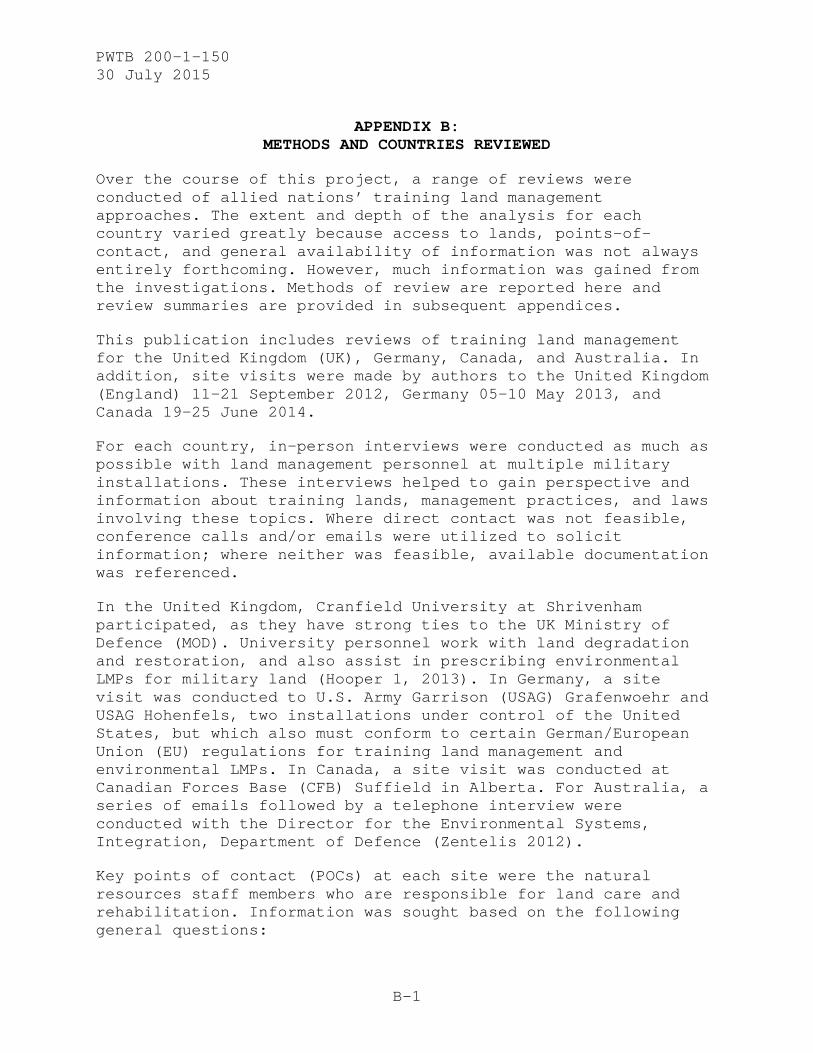
APPENDIX B: METHODS AND COUNTRIES REVIEWED
Over the course of this project, a range of reviews were conducted of allied nations’ training land management approaches. The extent and depth of the analysis for each country varied greatly because access to lands, points-of-contact, and general availability of information was not always entirely forthcoming. However, much information was gained from the investigations. Methods of review are reported here and review summaries are provided in subsequent appendices.
This publication includes reviews of training land management for the United Kingdom (UK), Germany, Canada, and Australia. In addition, site visits were made by authors to the United Kingdom (England) 11–21 September 2012, Germany 05–10 May 2013, and Canada 19–25 June 2014.
For each country, in-person interviews were conducted as much as possible with land management personnel at multiple military installations. These interviews helped to gain perspective and information about training lands, management practices, and laws involving these topics. Where direct contact was not feasible, conference calls and/or emails were utilized to solicit information; where neither was feasible, available documentation was referenced.
In the United Kingdom, Cranfield University at Shrivenham participated, as they have strong ties to the UK Ministry of Defence (MOD). University personnel work with land degradation and restoration, and also assist in prescribing environmental LMPs for military land (Hooper 1, 2013). In Germany, a site visit was conducted to U.S. Army Garrison (USAG) Grafenwoehr and USAG Hohenfels, two installations under control of the United States, but which also must conform to certain German/European Union (EU) regulations for training land management and environmental LMPs. In Canada, a site visit was conducted at Canadian Forces Base (CFB) Suffield in Alberta. For Australia, a series of emails followed by a telephone interview were conducted with the Director for the Environmental Systems, Integration, Department of Defence (Zentelis 2012).
Key points of contact (POCs) at each site were the natural resources staff members who are responsible for land care and rehabilitation. Information was sought based on the following general questions:
PWTB 200-1-150 30 July 2015
B-2
• What are the military installations in your country that provide land-training capabilities to your military?
• What laws, regulations, and guidance exist that govern: (a) military training operations and (b) military land maintenance, rehabilitation, and reclamation that relate to environmental compliance (and land management, soils, water, etc.)?
• Who utilizes your training lands (i.e., which countries send groups for training)?
• What types of military training activities are conducted on your training lands? What intensity is this training and how frequently does it occur?
• What vehicles do these training lands typically utilize?
• How is your training schedule decided?
• Are there any safeguards in place against overuse of the land or training in overly wet conditions (or otherwise non-optimal conditions)?
• Are there any LMPs/ guidelines that exist for trainers and soldiers on environmental stewardship?
• Who performs your training land maintenance/ rehabilitation/ reclamation (i.e., natural resource staff on the installation or is it contracted out)?
• How are various land maintenance/ rehabilitation/ reclamation projects prioritized?
• What are the indicators that land managers utilize to decide if an area requires maintenance/ rehabilitation/ reclamation?
• What department/ division funds the land maintenance/ rehabilitation/ reclamation?
• What types of multiple activities are allowed on training lands, and how are these activities integrated together (e.g., military training, recreation, agriculture activity, farming activity, natural resource habitat maintenance, prescribed burning)?

PWTB 200-1-150 30 July 2015
B-3
• What land care operations are preformed on the installation for maintenance/ rehabilitation/ reclamation?
• What are the typical LMPs that have been identified for implementation at the installation for land, soil, and water management/ maintenance/ rehabilitation within the training lands?
• Have there ever been training activities resulting in large-scale land degradation on the installation? How was the land rehabilitated afterwards? Was the project successful? Were there any lessons learned that have changed the way that the installation natural resources managers operate?
• What machines does the installation use for military training land’s maintenance/ rehabilitation/ reclamation (e.g., tractors, bulldozers, sprayers) and what implements (e.g., subsoilers, tines, plows, seed drills)?
• How often do these types of activities occur (e.g., seasonally, monthly, weekly) or just a general idea of frequency of use?
• What are the soils on the installation (soil type, any other general info relative to vegetative cover establishment and soil erosion, etc.)?
• What is the target vegetation community or profile for your installation?
• If reseeding is preformed, what types of vegetation are planted?
• Are there any invasive plans that are managed at your installation?
• What are the other natural resource targets that the land maintenance/ rehabilitation/ reclamation activities are aimed at (e.g., threatened and endangered species, habitat management, invasive control, etc.)?
In general, the questions asked were more detailed than most responses gained; however, having the questions at hand to spur discussion points helped to provide better insight into each

PWTB 200-1-150 30 July 2015
B-4
nation’s land management regulations and plans as covered in Appendix C and Appendix D, respectively.

PWTB 200-1-150 30 July 2015
C-1
APPENDIX C: COUNTRY REVIEW
Environmental Regulatory Drivers and Defense Planning Processes
Every country has its own suite of regulatory drivers and policies that must be abided by, relative to environmental protection and stewardship. Compliance and regulatory standards can be linked to political drivers; consequently, some nations are facing more stringent standards. Each country’s military must comply with its own country’s rules as well as to any regulations that apply if they are training within the boundaries of another country. For example, if an element of the U.S. military goes to the UK to train, it must comply with UK regulatory policies and laws as well as any applicable U.S. laws and regulation.
The following listings offer some insight into the range of regulations that exist within the four countries selected for this study.
United Kingdom
• EU
o Birds Directive (1979; updated 2009)
o Habitats Directive (1992; updated 2007)
o Natura 2000 Networking Programme (http://www.natura.org/)
• United Kingdom
o Environmental Protection Act 1990
o Environmental Act 1995
o International Organization for Standardization (ISO) 14001: Environmental management
o ISO 14040: Environmental management - Life cycle assessment - Principles and framework
o Listed Buildings and Conservation Areas Act 1990
o Ancient Monuments and Archaeological Areas Act 1979
o Wildlife and Countryside Act 1981

PWTB 200-1-150 30 July 2015
C-2
• MOD
o Defence Equipment and Support Acquisition Safety and Environmental Management System (ASEMS) Project Oriented Environmental Management System (POEMS) Manual
o Sustainable Development and Environmental Manual (Joint Service Publication [JSP] 418)
o Defence, Health, Safety and Environmental Protection (JSP 815)
Germany
• EU
o Birds Directive, 1979; updated 2009.
o Habitats Directive, 1992; updated 2007.
o Natura 2000 Networking Programme http://www.natura.org/
• U.S. Army, DoD
o AR 200-1, “Environmental Quality – Environmental Protection and Enhancement,” December 2007.
o Memorandum, “Management of Cultural, Historical and Archeological Resources on Properties Accommodated to the U.S. in Germany,” October 2009.
o Army in Europe (AE) Regulation 200-1, “Environmental Quality – Army in Europe Environmental Quality Program,” May 2012.
o DoD Final Governing Standard for Belgium, Germany, and Netherlands, July 2012.
o Memorandum, “Standard Operating Procedure for the Conservation and Management of Natural Resources,” January 2013.
o Environmental Handbook and Environmental Standard Operating Procedure for Tenant Units/Activities
o Soldier Field Card

PWTB 200-1-150 30 July 2015
C-3
• Germany
o Bundesnaturschtzgesrtz (German Federal Act on Nature Conservation), July 2009.
o Bayerisches Naturschutzgetetz (Bavarian law on Nature Conservation), February 2011.
Canada
• Canadian Environmental Assessment Act, 2012. https://www.ceaa-acee.gc.ca/default.asp?lang=en&n=16254939-1
• Canadian Environmental Protection Act, 1999. http://www.ec.gc.ca/lcpe-cepa/default.asp?lang=En&n=26A03BFA-1
• Fisheries Act, 1985. http://laws-lois.justice.gc.ca/eng/acts/F-14/FullText.html
• Report of the Auditor General of Canada: Chapter 7—“National Defence—Environmental Stewardship of Military Training and Test Areas,” 2003. http://www.oag-bvg.gc.ca/internet/English/parl_oag_200304_07_e_12913.html
Australia
• Environment Protection and Biodiversity Conservation Act, 1999.
• Defence Environmental Strategic Plan 2010-2014. http://www.defence.gov.au/environment/strat_plan.pdf
• Defence Environmental Policy, 1999. http://www.defence.gov.au/environment/
• Hazardous Waste (Regulation of Exports and Imports) Act, 1989. http://www.environment.gov.au/topics/environment-protection/hazardous-waste/about-hazardous-waste-act
PWTB 200-1-150 30 July 2015
D-1
APPENDIX D: COUNTRY-SPECIFIC TRAINING LAND MANAGEMENT PRACTICES
LMPs, Approach, Strategy
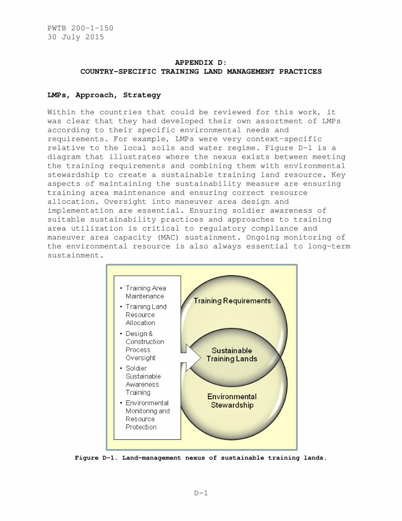
Within the countries that could be reviewed for this work, it was clear that they had developed their own assortment of LMPs according to their specific environmental needs and requirements. For example, LMPs were very context-specific relative to the local soils and water regime. Figure D-1 is a diagram that illustrates where the nexus exists between meeting the training requirements and combining them with environmental stewardship to create a sustainable training land resource. Key aspects of maintaining the sustainability measure are ensuring training area maintenance and ensuring correct resource allocation. Oversight into maneuver area design and implementation are essential. Ensuring soldier awareness of suitable sustainability practices and approaches to training area utilization is critical to regulatory compliance and maneuver area capacity (MAC) sustainment. Ongoing monitoring of the environmental resource is also always essential to long-term sustainment.
Figure D-1. Land-management nexus of sustainable training lands.

PWTB 200-1-150 30 July 2015
D-2
United Kingdom: Site Visit to Cranfield University, Shrivenham (11–21 September 2012)
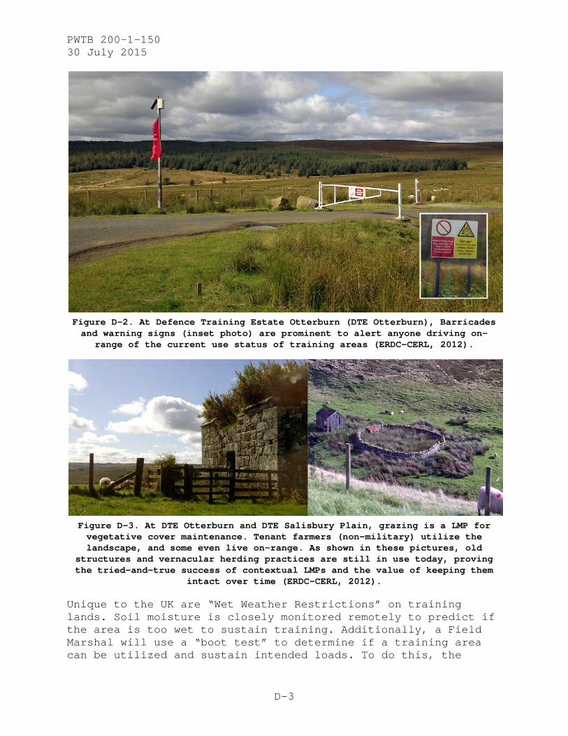
Two-thirds of the 240,000 ha of land owned by the MOD is held for training of armed forces. The land collectively is known as the Defence Training Estate (DTE). The DTE comprises 16 major Armed Forces training areas and 104 other minor training areas, ranges, and camps. The DTE is managed to ensure that it delivers military training facilities which prepare the troops for operations worldwide. There is an average daily throughput of 9,000 service personnel on DTE lands (MOD 2014).
Training areas are highly managed within the UK due to its relatively limited land mass. Overall, limited land availability results in multipurpose use and co-utilization of training lands. For instance, target practice can occupy the same area as a reconnaissance exercise and a force-on-force event. Training lands also are utilized by tenant farmers and as open-access public areas. It is not uncommon to see civilians walking, hiking, biking, or simply cohabitating an active military training area. Therefore, an extensive management system (complete with warning signs) is in place to ensure the safety and well-being of all occupants (Figure D-2). Currently, both the U.S. Army and the MOD are integrating this type of management approach into U.S. Army systems of record Range Field Management Scheduling System (RFMSS).
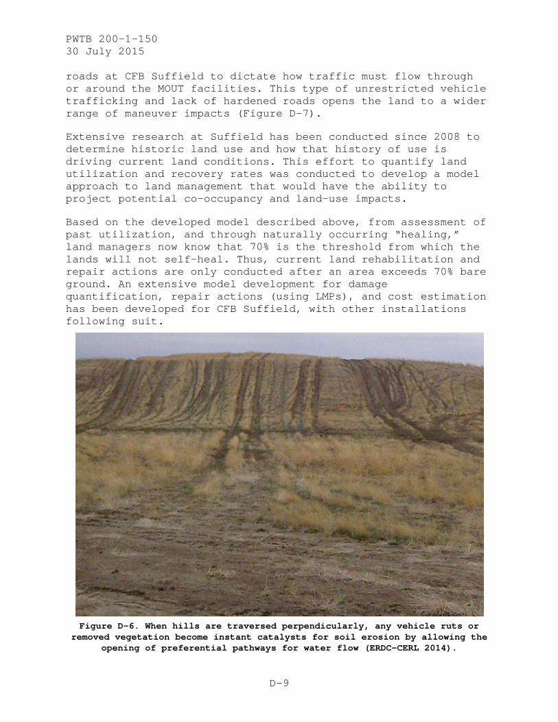
Grazing of sheep and cattle is used for vegetation control, specifically for control of invasive species and for fire management. Grazing is the most common LMP; grazing agreements with local farmers allow for minimal fire risk and protect species that evolved under the naturally occurring grazing regime (Figure D-3).
Unlike in the United States, however, the presence of TES will not close down a training area in the United Kingdom. Instead, management tactics are utilized to coexist with and to minimize impacts to the TES, but priority is given to the MOD actions. To ensure success, the MOD utilizes installation personnel (similar to U.S. Army’s ITAM office) along with local experts and regulators to form an Environmental Steering Committee. The Environmental Steering Committee will determine productivity goals for any TES present, such as three chicks or fledglings per pair per year.
PWTB 200-1-150 30 July 2015
D-3
Figure D-2. At Defence Training Estate Otterburn (DTE Otterburn), Barricades and warning signs (inset photo) are prominent to alert anyone driving on-
range of the current use status of training areas (ERDC-CERL, 2012).
Figure D-3. At DTE Otterburn and DTE Salisbury Plain, grazing is a LMP for vegetative cover maintenance. Tenant farmers (non-military) utilize the landscape, and some even live on-range. As shown in these pictures, old
structures and vernacular herding practices are still in use today, proving the tried-and-true success of contextual LMPs and the value of keeping them
intact over time (ERDC-CERL, 2012).
Unique to the UK are “Wet Weather Restrictions” on training lands. Soil moisture is closely monitored remotely to predict if the area is too wet to sustain training. Additionally, a Field Marshal will use a “boot test” to determine if a training area can be utilized and sustain intended loads. To do this, the

PWTB 200-1-150 30 July 2015
D-4
Field Marshall assigned to the unit will dismount, walk the training area, and see how deep their boot sinks into the soil. The Field Marshall will then make a call on the type of training to be allowed: dismounted only, light vehicles only, or “all green” for any type. Additionally, the UK utilizes remote sensing data and field data to determine instances of bare ground. Linking the current state of the training area with past “wet weather training” conditions is now providing recovery data to better refine training land utilization.
Finally, another management technique is a rotational approach to digging activities. Digging areas within the training areas are on a three-year rotation, allowing for recovery over time of the impact areas and providing for more realistic training experiences. Finally, land repair occurs immediately after any ground-disturbing activities.
Germany: Site Visits to USAG Grafenwoehr and USAG Hohenfels (05–10 May 2013)
The USAG Grafenwoehr Training Area is spread over 223 km2 in the center portion of USAG Grafenwoehr in Bavaria, Germany. It is the largest North American Treaty Organization (NATO) training area in Europe and is under the auspices of the U.S. Army Europe (USAREUR) Command (Grafenwoehr 2014). The training area is also home to the critically endangered Common Snipe (Gallinago gallinago), that inhabits one of the area’s largest transitional bogs. There is also a significant population of beavers (250-300) which often create flooded landscapes (Hayden 2013).
The USAG Hohenfels Training Area is located 72.5 km. southwest of USAG Grafenwoehr and was first used by U.S. military forces in 1951. In 1988, it became home to the Combat Maneuver Training Center (CMTC), the mission of which was to provide realistic combined arms training for the USAREUR. In December 2005, the CMTC was transformed and named the Join Multinational Readiness Center (JMRC), part of the Joint Multinational Training Center (JMTC) which oversees training for all of USAREUR. Hohenfels Training Area is the largest of USAREUR maneuver training areas and comes under the command of the Commanding General, JMTC, at Grafenwoehr. More than 60,000 soldiers train here annually (Installation Management Command [IMCOM] n.d.).
There is an accepted list of LMPs available for use at the German training areas. These are included within a handbook from the Directorate of Public Works (DPW) Environmental Division, the “Environmental Handbook,” and from Tab A of the handbook,

PWTB 200-1-150 30 July 2015
D-5
“Environmental Standard Operating Procedure for Tenant Units/ Activities.”
There is also a “Soldier Field Card,” provided either via hard copy or as a digital smart-phone application, that gives a detailed training area “do and don’t” list for soldiers. This Soldier Field Card also includes a POC list to contact should any issue arise.
ITAM also participates in a wide variety of events that provide outreach to the soldiers, and it shares information with them on impacts to training lands from training activities. There is also a smart-phone application released in 2014 by the USAREUR Sustainable Range Program, “USAREUR Environmental Officer.”2
Typical land-care operations that are performed on the installations for maintenance, rehabilitation, and/or reclamation include: (a) flattening incisions and deep tracks, (b) reseeding, (c) removal of woody vegetation at drop zones and within open maneuver areas, and (d) removal of successionary growth along training area boundaries and maneuver trails. Maintenance is also a constant activity at retention basins, check dams, and drainage areas. Erosion control (EC) actions include: (a) reducing the potential of land erosion due to overland flow by sustaining grass on open areas, (b) flattening any incisions and deep tracks, and (c) reseeding if necessary.
In addition, an extensive perimeter EC program has been developed over the last 20 years. This system is composed of sediment basins (lined and unlined) throughout the training areas and skirting the entire perimeter (Figure D-4). These sediment basins are done singularly and in series. Those basins in series act as a water control structure.
All in all, the land-care LMPs are very simple applications. Typically, there are not any EC LMPs deployed beyond check dams (no blankets, hydroseeding, geotextile, etc.). There have not been any large-scale or intensely degraded areas of land for some time now, due to integrated approaches to training and the successful working relationship between ITAM, DPW Environmental, and German Forestry (Figure D-5). All the LMPs now in use were learned together by all parties.
2 Available for download at https://play.google.com/store/apps/details?id=com.usareu.eo&hl=en.

PWTB 200-1-150 30 July 2015
D-6
Figure D-4. JMRC Hohenfels Training Area and Grafenwoehr Training Area have
the largest and most dynamic live-fire training facility in Europe. An extensive soil erosion and sediment control network system has been
implemented around the entire training area to facilitate the prevention of sediment from leaving the installation (ERDC-CERL, 2013).

PWTB 200-1-150 30 July 2015
D-7
Figure D-5. At both Hohenfels and Grafenwoehr, integrated approaches to
training have been developed to utilize existing structures while protecting both natural and cultural resources. Shown here are Siebert Staked off
culturally significant orchard adjacent to a former church tower utilized as a training facility. Inset is a historic food stock location which is now
open to bat species as roosting habitat (ERDC-CERL, 2013).

PWTB 200-1-150 30 July 2015
D-8
Canada: Site Visit to CFB Suffield, Alberta (18–25 June 2014)
The Canadian military has modeled their land management approach very similarly to that of the United States. Like the United States, Canada’s military land management is both regulatory-driven and Army-driven.
Canadian Forces Base (CFB) Suffield is host to the largest military training area in Canada. CFB Suffield's mission is to provide sustainable world-class range and training areas that enable Defence Research and Development Canada-Suffield (DRDC), the British Army Training Unit Suffield (BATUS), and other potential users to achieve their training mandates through effective stewardship and maintenance of all the range training areas’ infrastructure and equipment (Canadian Forces Base Suffield 2014).
CFB Suffield and the prairie of Alberta have hosted training for the British Army on a large scale since 1972. BATUS trains on one of the most sparsely populated areas of that Alberta plain. BATUS is equipped with in excess of 1,000 vehicles including a full complement of Challenger 2 tanks and Warrior Infantry Fighting Vehicles. Each year, a regiment is sent there for six months to take the part of the “enemy” for the other regiments that are there to train each year. The duration of the exercises and size of the training area allow all elements of a combined arms battle group (Infantry, Armour, Artillery, Engineers, Air Defence, Logistics, and Equipment Support) to conduct realistic live-firing training at all levels and to practice sustaining this activity over a long period of time (The British Army in Canada 2014). Suffield’s training areas also are co-utilized by visiting military units from other countries and for oil mining, cattle grazing, and native grass baling.
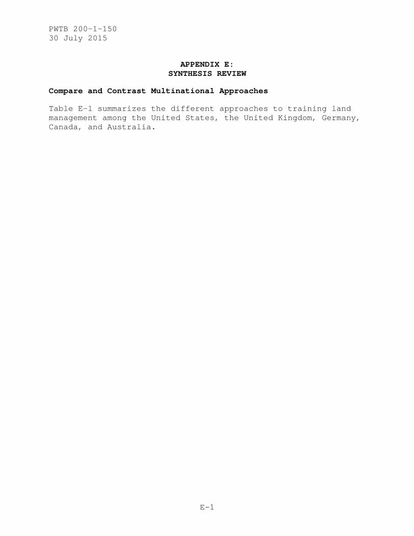
While CFB Suffield has extensive maneuver land, there are few restrictions as to how vehicles are allowed to traffic the open expanses of maneuver areas. Training areas there have multipurpose uses, and very few static and hardened ranges have been constructed. Considering the size of the training areas, lack of restrictions, and heavy use, advance planning for potential impacts is very difficult at CFB Suffield. The problems combine to create vehicle impacts (Figure D-6).
In addition, while military operations on urban terrain (MOUT) training areas at CFB Suffield are set up similarly to those in the United States (i.e., temporary buildings sited to mimic villages or operational environments), there are no set range
PWTB 200-1-150 30 July 2015
D-9
roads at CFB Suffield to dictate how traffic must flow through or around the MOUT facilities. This type of unrestricted vehicle trafficking and lack of hardened roads opens the land to a wider range of maneuver impacts (Figure D-7).
Extensive research at Suffield has been conducted since 2008 to determine historic land use and how that history of use is driving current land conditions. This effort to quantify land utilization and recovery rates was conducted to develop a model approach to land management that would have the ability to project potential co-occupancy and land-use impacts.
Based on the developed model described above, from assessment of past utilization, and through naturally occurring “healing,” land managers now know that 70% is the threshold from which the lands will not self-heal. Thus, current land rehabilitation and repair actions are only conducted after an area exceeds 70% bare ground. An extensive model development for damage quantification, repair actions (using LMPs), and cost estimation has been developed for CFB Suffield, with other installations following suit.
Figure D-6. When hills are traversed perpendicularly, any vehicle ruts or
removed vegetation become instant catalysts for soil erosion by allowing the opening of preferential pathways for water flow (ERDC-CERL 2014).

PWTB 200-1-150 30 July 2015
D-10
Figure D-7. This panoramic view of a Canadian MOUT site shows the impact of
various trafficking patterns and array of vehicular approaches (ERDC-CERL, 2014).
Australia
Australian Defence Forces training areas have a major land presence in South Australia. Of these areas, Cultana Training Area is becoming the largest due to a five-fold expansion that is increasing its mass to 2,300 km2. Its climate provides year-round training to the nation’s armored, mechanized, and cavalry forces and combined forces training (Defence SA 2014). The country is also host to increased U.S. military forces on short-term rotations designed to provide improved response “to a range of contingencies in the Indo-Pacific” (Robson 2013). Australia offers “great training opportunities” according to MAJ Maurice Brown, U.S. Marine Corps (Robson 2013; Figure D-8 and Figure D-9). The Modernisation and Strategic Planning Division of Australian Army Headquarters prepares an annual “Future Land Warfare Report” for the Directorate of Future Land Warfare. The report assesses long-term future trends in the operating environment including joint operations and their possible influence on Defence resources (Australian Army 2014).

PWTB 200-1-150 30 July 2015
D-11
Figure D-8. U.S. Marines and Australian soldiers take cover in a trench during joint training for Exercise Koolendong in 2013 at Mount Bundey
Training Area, Northern Territory, Australia (Robson 2013).
Figure D-9. U.S. Marines move forward in support of Australian soldiers
during joint training for Exercise Koolendong at Mount Bundey Training Area, Northern Territory, Australia, in 2013 (Robson 2013).

PWTB 200-1-150 30 July 2015
D-12
Australia’s regulatory system is set up similarly to that of the United States, because Australia has legislative requirements under which the Army must maintain and protect ecosystems, species, habitats, and environments. Maintaining and protecting Australia’s Commonwealth Government at the state or territory level is the primary objective (Zentelis 2012). Thus, whichever legislation requirements are the most conservative—local, state, territory, or national—the Australian Government Department of Defence will maintain the capability of the training areas to those requirements. Extensive effort is used to minimize impacts from training and to take into account environmental issues including those related to climate change, contamination, and the impacts of urban encroachment, mining, and noise (Australian Department of Defence 2010, 23). Each training area is responsible and accountable for the land’s condition. The Australian Army’s Range Control Officers can and will close down or modify training if a perceived environmental risk is likely to occur (Zentelis 2012).
Australian training areas are very open and can be quickly reconfigured to fit the military’s mission objectives. Scheduling efforts for the training areas include establishment of upper and lower levels of damages; these established damage levels then become part of the assessment and planning process prior to a rotational unit utilizing the training areas. Plans and requirements for a series of concerns (e.g., erosion guidelines) are developed to determine any need for preventive intervention. Due to the fragile soils of the training areas, extensive land-management research has been conducted by the Department of Defence and Australian universities since the 1980s (Zentelis 2012). An example LMP which came from Australian research is the Hesco® basket system3 which is a collapsible wire mesh container with heavy liner that, when filled with earthen material, serves as a barrier. It was originally designed for erosion and flood control, and it has since been modified to become a barrier for force protection which has been used frequently for that purpose in Iraq and Afghanistan (Figure D-10; Gibson 2006).
3 System was developed in late 1980s by a British entrepreneur who formed a firm of the same name (HESCO Bastion Ltd.).
Due to the container’s successful performance during U.S. flooding (particularly Hurricane Katrina), the firm also operates Bastion USA in Hammond, Louisiana.

PWTB 200-1-150 30 July 2015
D-13
Figure D-10. U.S. Navy personnel assembling HESCO bastions (Wikipedia http://en.wikipedia.org/wiki/Hesco_bastion).
Australia does not utilize engineering for site hardening and static ranges as extensively as the United States military does. However, LMPs have been developed for the arid regions, taking into account the frequent risk of drought (either it rains or not in those regions). Guidelines for LMPs have been developed by habitat and climatic zones; these guidelines require specialized erosion and sediment control for each of Australia’s climatic zones. Like the UK (but unlike the United States), Australia has the majority of its environmental monitoring and land management conducted by privately owned companies (Zentelis 2012).
PWTB 200-1-150 30 July 2015
E-1
APPENDIX E: SYNTHESIS REVIEW
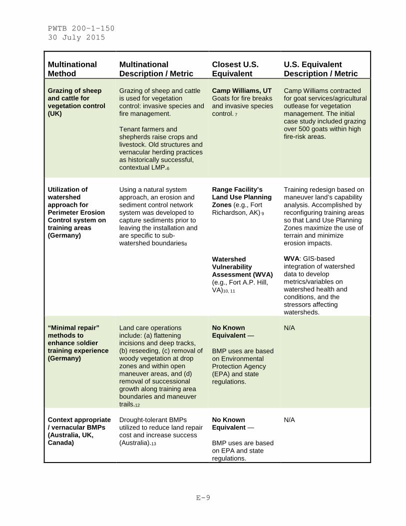
Compare and Contrast Multinational Approaches
Table E-1 summarizes the different approaches to training land management among the United States, the United Kingdom, Germany, Canada, and Australia.

PWTB 200-1-150 30 July 2015
E-2
Table E-2 compares multinational methods of training land management with the nearest equivalent method in U.S. military training land management.

PWTB 200-1-150 30 July 2015
E-3
Table E-1. Summary of various countries’ approaches to training land management for ground forces. (Note: See pages that follow for explanation of abbreviations, given by country in the order used.)
United States United Kingdom Germany Canada Australia
Rule-
Making
Agencies
• Federal
• Department of
Defense
• Army
• European Union •
United Kingdom
• Ministry of
Defense
• Defense
Training Estate
• European Union
• Germany
• Province
• Department of
Defense
• United States
Army in Europe
• Federal
• Province
• Department of
National Defence
• Canadian Forces
Base
• Federal
• Commonwealth
State
• Territory
• Australian
Ministry of
Defence - Defence
Environmental
Management
Plans and
Processes
• ITAM
• SRP
• INRMP
• ICRMP
• RPMP
• ACUB
• EMS
• IRMP
• RA-RO-RC
• RW-RTAM
• ITAM
• SRP
• INRMP
• ICRMP
• EU Natura 2000
Management Plans
• Federal/local
management plans
per host nation
• SDS
• SSMP
• ISMP
• (I)MRG
• RTAC
• BSO-RSO
• SMRP
• ESP
• DEP
• EWG

PWTB 200-1-150 30 July 2015
E-4
United States United Kingdom Germany Canada Australia
Training
Types
• Single service,
but some ranges
open to tenants
from other units,
commands, and
organizations
• Installation
mission (can
change)
• Open ranges with
impact areas off-
limits
• Multiple
service
• Training type
matched with land
capability
• Open areas with
semi-accessible
impact areas
(cleaned)
• Multiple service
• Multiple country
• Range of
training types
from convoy to
maneuver, to
infantry and
earthworks
• Moderate
frequency, low
intensity
(recently)
• Multiple
service
• Multiple
country (e.g.,
BATUS at CFB);
• Large-scale
brigade-type
training
• Full site
access (across-
site cleaning,
biannual)
• Multiple
service
• Multiple
country (e.g.,
Exercise
Koolendong)
• Large-scale
brigade-type
training
• Full site
access (across-
site)
Training
Land Uses
• Training area
allocations
• Single-use
• Central range
control
• Limited public
access for
agriculture,
hunting, and
recreation.
• Semi-limited off-
road maneuver
access
• Shared training
areas
• Range control
and range warden
real-time monitor
• Public access
• None or limited
off-road maneuver
• Shared training
areas
• Range operations
monitoring
• Open public
access (certain
activities are
permitted, some
are not)
• Agricultural and
forestry
outleasing
• Broad use of
CFB over combined
training areas
• Central range
control
• No public
access
• Open off-road
maneuver access
• Broad use over
entire training
area, and
combined training
• Central range
control
• No public
access
• Open off-road
maneuver access

PWTB 200-1-150 30 July 2015
E-5
United States United Kingdom Germany Canada Australia
LMP
Takeaways
N/A
(Recommendations
for United States
per other
countries’
takeaways is in
Appendix F, Lessons
Learned)
• Heavy co-
utilization of
land (includes
supporting
coordination) for
multi-service and
multi-objective
military training
to minimize
impacts
• Fit-for-purpose
matching of land
use to
environmental
capacity and
concentrated land
uses; static
stationing and
training loads
• Boot-Test
‘tool’ developed
for at-risk-
installations
• Utilization of
watershed approach
for Perimeter
Erosion Control
system on training
areas
• Established
methods for
“minimal repair”
approach to
enhance soldier
training
experience and
realism
• Developed
training areas to
mimic natural
elements found in
forward operations
• Developed
assessment system
estimating pre-
training and
post-training
conditions to
determine repair
requirements and
costs
• Developed
modeling approach
to determine
recovery rates
for sensitive
areas
• Developed
environmental
rehabilitation
techniques that
match site soil
and vegetation
properties versus
generic standard
solutions
• Rotational
Training Approach
taken to allow
land to sit
fallow and
recover through
natural processes
• Developed LMP
prescriptions
based on climatic
zones
• Drought-
tolerant LMPs are
utilized to
reduce land
repair cost and
increase success
• Minimal site
hardening to
reduce repair
costs and
increase training
realism (reliant
to rotational
training area
approach)

PWTB 200-1-150 30 July 2015
E-6
Definitions of Abbreviations in Table E-1
United States:
ITAM Integrated Training Area Management
SRP Sustainable Range Plan
INRMP Integrated Natural Resource Management Plan
ICRMP Integrated Cultural Resource Management Plan
RPMP Real Property Master Plan
ACUB Army Compatible Use Buffer
United Kingdom:
BATUS British Army Training Unit Suffield
EMS Environmental Management System
IRMP Integrated Rural Management Plans
RA-RC-RO Range Allocation;, Range Control; Range Orders & Operating
Instructions
RW-RTAM Range Wardens, and Range Training Area Marshals
Germany:
ITAM Integrated Training Area Management
SRP Sustainable Range Plan
INRMP Integrated Natural Resource Management Plan
ICRMP Integrated Cultural Resource Management Plan

PWTB 200-1-150 30 July 2015
E-7
Canada:
SDS Sustainable Development Strategy
SSMP [Suffield] Sustainability Master Plan
RTAC Range and Training Area Characterization
(I)MRG (Interim) Military Reclamation Guide
BSO/RSO Base Standing Orders / Range Standing Orders
Australia:
ADF Australian Defence Force
EPBC Environment Protection and Biodiversity Conservation Act
1999 (EPBC Act)
SMRP Sustainability Management Resource Plan
ESP Environmental Strategic Partnerships
DEP Defence Environmental Policy
EWG Environmental Working Group

PWTB 200-1-150 30 July 2015
E-8
Table E-2. Comparison of multinational methods for training land management with the nearest equivalent method used by U.S. Army. (Note that subscript
numbers relate to references that follow this table (if no other info listed, then reference is to page numbers within this PWTB.)
Multinational Method
Multinational Description / Metric
Closest U.S. Equivalent
U.S. Equivalent Description / Metric
Wet weather restrictions (UK)
Boot Test: Field marshal assigned to the unit will dismount, walk the training area, and assess depth of boot sinkage. Depth that boot sinks to is used to determine type of training allowed.1
Soil Moisture Monitoring (SMM) (e.g., Yakima Training Center)2
Code-based suitability assessment based on real-time and historical field data. Protocol involves collection of field soil sample, moisture analysis of sample, and analysis results plotted on a geographic information system (GIS) map to indicate training suitability
Dictated multipurpose use / co-utilization of training lands (UK)
Rotation of land uses between military and non-military uses such as tenant farming, open-access public recreation, military training; (e.g., DTE Otterburn and DTE Salisbury Plain)3
Co-utilization of land resources is coordinated at the installation range level. This coordination is used to communicate installation status and range/training area utilization. To ensure safety of public, alerts of training area status are made available via community announcements, field barricades, and warning signs to anyone driving on-range.4
RFMSS Army-wide
Facility utilization requests are submitted and processed by training division support. RFMSS forms are submitted by military and nonmilitary entities for area utilization. Exact scheduling process is range-specific.5
PWTB 200-1-150 30 July 2015
E-9
Multinational Method
Multinational Description / Metric
Closest U.S. Equivalent
U.S. Equivalent Description / Metric
Grazing of sheep and cattle for vegetation control (UK)
Grazing of sheep and cattle is used for vegetation control: invasive species and fire management.
Tenant farmers and shepherds raise crops and livestock. Old structures and vernacular herding practices as historically successful, contextual LMP.6
Camp Williams, UT Goats for fire breaks and invasive species control. 7
Camp Williams contracted for goat services/agricultural outlease for vegetation management. The initial case study included grazing over 500 goats within high fire-risk areas.
Utilization of watershed approach for Perimeter Erosion Control system on training areas (Germany)
Using a natural system approach, an erosion and sediment control network system was developed to capture sediments prior to leaving the installation and are specific to sub-watershed boundaries8
Range Facility’s Land Use Planning Zones (e.g., Fort Richardson, AK) 9
Watershed Vulnerability Assessment (WVA) (e.g., Fort A.P. Hill, VA)10, 11
Training redesign based on maneuver land’s capability analysis. Accomplished by reconfiguring training areas so that Land Use Planning Zones maximize the use of terrain and minimize erosion impacts.
WVA: GIS-based integration of watershed data to develop metrics/variables on watershed health and conditions, and the stressors affecting watersheds.
“Minimal repair” methods to enhance soldier training experience (Germany)
Land care operations include: (a) flattening incisions and deep tracks, (b) reseeding, (c) removal of woody vegetation at drop zones and within open maneuver areas, and (d) removal of successional growth along training area boundaries and maneuver trails.12
No Known Equivalent —
BMP uses are based on Environmental Protection Agency (EPA) and state regulations.
N/A
Context appropriate / vernacular BMPs (Australia, UK, Canada)
Drought-tolerant BMPs utilized to reduce land repair cost and increase success (Australia).13
No Known Equivalent —
BMP uses are based on EPA and state regulations.
N/A

PWTB 200-1-150 30 July 2015
E-10
Multinational Method
Multinational Description / Metric
Closest U.S. Equivalent
U.S. Equivalent Description / Metric
Site rotation of land-damaging training exercises
(UK & Australia)
Digging areas within the training areas are on a three-year rotation, allowing for recovery over time of the impact areas and providing for more realistic training experience. Land repair occurs immediately after any ground-disturbing activities. (UK).14
Rotational Training Approach allows land to sit fallow and recover through natural processes (Australia).
Land Repair Rotation (e.g., Yakima Training Center, WA)2
Establishes monitoring protocols for land utilization. Uses rotation for land repair, land rest, and monitoring of land repair success. Determines recovery rates for trainings prior to occurrence of impacts.
EC actions (Germany)
Methods involve: (a) reducing the potential of land erosion due to overland flow by sustaining grass on open areas, (b) flattening any incisions and deep tracks, and (c) reseeding if necessary.15
Land Rehabilitation and Maintenance Program (LRAM) (e.g., Fort Hunter Liggett, CA)16
Wear-Tolerant Vegetation Standards (e.g., Fort Drum, New York; Yakima Training Center, WA)17
Protocol designed to implement improvements and repairs of disturbed land and water crossings, improve vegetation cover and concealment for training activities, and repair other landscape damage for safety and continued availability of land for training. Contains standards for revegetation techniques to prevent wind erosion.
Wear-resistant cultivar development by ERDC-CRREL to assist in erosion control, invasive weed prevention, fire control, and line- of-sight maintenance.

PWTB 200-1-150 30 July 2015
E-11
Multinational Method
Multinational Description / Metric
Closest U.S. Equivalent
U.S. Equivalent Description / Metric
Assessment system to determine repair requirements, costs (Canada)
Estimation established via pre-training and post-training condition analysis.18
Army Training and Testing Area Carrying Capacity (ATTACC), Optimal Allocation of Land for Training and Non-Training Uses (OPAL), and Maneuver Area Capacity (MAC) Development
Ongoing research to improve land managers’ abilities to assess potential impacts and related land repair costs.
Modeling approach to determine recovery rates for sensitive areas (Canada)
Model based on historical land use and natural land recovery rates. Uses 70% bare ground threshold.18
ATTACC/OPAL/MAC Development
Ongoing research to improve land managers abilities to assess potential impacts and related land repair costs.
Environmental rehabilitation techniques that match site soil and vegetation properties versus generic standard solutions (Canada)
“[Use of] filtration materials such as activated carbon, peat moss and bone char in preventing contaminants from migrating from ranges to surface and groundwater sources.” 19
(Valcartier, Quebec–Small Arms Range)
Revegetation methods implemented on disturbed sites.20
Intermountain West Military Training Lands Planting Guide21
Local contractors in conjunction with state Department of Natural Resources (DNR) implement site-specific restoration measures. (e.g., Ft Carson, CO)
Guidelines for training-land revegetation using site-specific vegetation developed to combat site-specific concerns related to land use, soil type, and local environment.
Establishment of upper and lower levels of damages
Plans and requirements for a series of concerns (e.g., erosion guidelines) are developed to determine any need for preventive intervention prior to scheduling land for training exercise.22
Training Requirements Integration (TRI) Multiple sites (Army -wide)5
Coordination with NEPA and Recognized Environmental Condition in conjunction with training activities.
PWTB 200-1-150 30 July 2015
E-12
Multinational Method
Multinational Description / Metric
Closest U.S. Equivalent
U.S. Equivalent Description / Metric
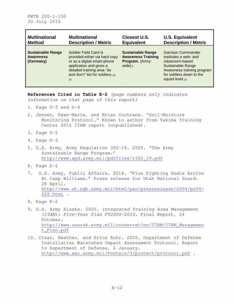
Sustainable Range Awareness (Germany)
Soldier Field Card is provided either via hard copy or as a digital smart-phone application and gives a detailed training area “do and don’t” list for soldiers.15,
23
Sustainable Range Awareness Training Program. (Army-wide) 5
Garrison Commander institutes a web- and classroom-based Sustainable Range Awareness training program for soldiers down to the squad level.15
References Cited in Table E-2 (page numbers only indicates information on that page of this report)
1. Page D-3 and D-4
2. Jensen, Dawn-Marie, and Brian Cochrane. “Soil-Moisture Monitoring Protocol.” Known to author from Yakima Training Center 2014 ITAM report (unpublished).
3. Page D-2
4. Page D-3
5. U.S. Army, Army Regulation 350-19. 2005. “The Army Sustainable Range Program.” http://www.apd.army.mil/pdffiles/r350_19.pdf
6. Page D-2
7. U.S. Army, Public Affairs. 2014. “Fire Fighting Goats Arrive At Camp Williams.” Press release for Utah National Guard. 28 April. http://www.ut.ngb.army.mil/html/pao/pressrelease/2004/pr04-028.html .
8. Page F-2
9. U.S. Army Alaska. 2005. Integrated Training Area Management (ITAM): Five-Year Plan FY2006-2010. Final Report, 24 October. http://www.usarak.army.mil/conservation/ITAM/ITAM_Management_Plan.pdf
10. Cisar, Heather, and Erica Rohr. 2005. Department of Defense Installation Watershed Impact Assessment Protocol. Report to Department of Defense, 6 January. http://www.aec.army.mil/Portals/3/protect/protocol.pdf .

PWTB 200-1-150 30 July 2015
E-13
11. Fraser, Doug, Scott Smizik, and Gef Fisher. 2013. “Watershed Vulnerability and Impact Assessment: United States Army Garrison Fort A.P. Hill, Caroline County, Virginia.” Presentation by EEE Consulting, Inc. at AWRA conference held 27–28 June 2013 at Hartford, CT. http://www.awra.org/meetings/HealthyForest2013/doc/PP/slides/HFW_S14_Fraser_Douglas.pdf
12. Page D-5
13. Page E-4
14. Page D-3
15. Page D-5
16. U.S. Army “Integrated Training Area Management (ITAM): Program Land Rehabilitation and Maintenance (LRAM)- at Fort Hunter Liggett. http://www.liggett.army.mil/sites/dptms/lram.asp
17. Miller, Kristen. 2009. “Research Improves Vegetation on Training Lands.” Environmental Update, Newsroom Summer 2009 Edition. U.S. Army Environmental Command. http://aec.army.mil/portals/3/newsroom/update/sum09/sum0917.html
18. Page D-9
19. Canadian Army. 2014. Canadian Army Invests in Environmental Science and Technology for Cleaner Ranges and Training Areas.” Canadian Army News (online) 29 December, Project #14-02520drdc. http://www.army-armee.forces.gc.ca/en/news-publications/national-news-details-no-menu.page?doc=canadian-army-invests-in-environmental-science-and-technology-for-cleaner-ranges-and-training-areas/i3yaourw
20. Hinchman, Ray R., Kenneth G. McMullen, Ralph P. Carter, and William D. Severinghaus. 1990. Rehabilitation of Training Areas Damaged by Tracked Vehicles at Fort Carson, CO. TR-N-91/01 for U.S. Army Engineering and Housing Support Center, Fort Belvoir, VA. Champaign, IL: U.S. Army Construction Engineering Research Laboratory. http://www.dtic.mil/dtic/tr/fulltext/u2/a232066.pdf
PWTB 200-1-150 30 July 2015
E-14
21. Palazzo, Antonio J., Susan E. Hardy, Timothy J. Cary, Kay H. Asay, Kevin B. Jensen, and Daniel G. Ogle. 2009. Intermountain West Military Training Lands Planting Guide: Selecting Seed Mixtures for Actively Used Military Lands. ERDC/CRREL TR-09-9 for United States Department of Agriculture-Agricultural Research Service (USDA-ARS), Logan, Utah. Champaign, IL: U.S. Army Cold Regions Research and Engineer Laboratory. http://www.nrcs.usda.gov/Internet/FSE_PLANTMATERIALS/publications/idpmspu9391.pdf
22. Page D-12
23. U.S. Army. 20004. Appendix V, “Mitigation and Monitoring Plan” for Transformation of the 2d Armored Cavalry Regiment and Installation Mission Support, Joint Readiness Training Center (JRTC) and Fort Polk, Louisiana, and Long-Term Military Training Use of Kisatchie National Forest Lands. http://www.jrtc-polk.army.mil/SEMP/Appendix_V-Final_29JAN04.pdf

PWTB 200-1-150 30 July 2015
F-1
APPENDIX F: LESSONS LEARNED, RECOMMENDATIONS, AND TAKEAWAYS
Lessons Learned / Recommendations
Key lessons learned from this multi-country review are noted here. Please note that these recommendations are not meant to be prescriptive; they are noted in order to provide suggestions of how approaches that have been used by other nations could be integrated and implemented within the United States. Some of these solutions are smaller-scale and could be utilized at an installation level; others point to broader and higher-level shifts within U.S. Army training and land management.
• Opportunities to integrate variables such as training types, land access and range-control systems, and utilization of public activities should be considered, wherever possible, to improve training land management. Such integration will result in training opportunities that are more efficient and likely of higher quality. This type of training approach requires a higher level of awareness and coordination by and between soldiers and units. It also mimics reality more closely because in the operational environment, multiple service types and units as well as multiple nationalities must work together in a coordinated fashion. By previously training in an intentionally integrated and coordinated way, soldiers will function better during operational exercises.
• While training can become more integrated and system-oriented, on-the-ground activities can also be monitored in real time, so as to further enhance training. The use of field marshals in the UK, for example, is a great opportunity to promote environmental awareness and resolve implementation of sustainability measures that might not otherwise be utilized. This solution would also ensure a cross-check of a military unit’s use of maneuver lands or training ranges. Often times, compliance breaches occur when a unit inadvertently crosses into a restricted area or when training occurs on susceptible soils after heavy precipitation. Having a person on hand to review advisability of current activities would prevent those types of small but expensive and publicly embarrassing mistakes.

PWTB 200-1-150 30 July 2015
F-2
• If environmental compliance related to development of military vehicles is considered within and throughout the research, design, and development phases, then environmental impacts by military vehicles and other types of infrastructure can possibly be avoided. It is in the early stages that vehicle performance can be fine-tuned to match environmental concerns, thus reducing long-term costs (e.g., saving money that would have been otherwise spent on compliance fines or land rehabilitation efforts).
• Placement of field units and their associated training activities types can be planned to occur in environmental locations that are best suited to withstand any anticipated impacts. Once the training activities and environments are paired, they can be quite easily managed for indefinite sustainment of the training area. For example, maneuver ranges required for tanks and other heavy vehicles could be placed on semi-hardened landscapes or on landscapes where vegetative growth and soils are resilient to such impacts (not where soils are poor and erosive or vegetative growth is hard to establish).
• Training area delineation on U.S. Army installations typically reflects safety, infrastructure, or vernacular/historical boundaries. If it were possible to re-align training area boundaries so that they reflect subwatersheds, the resulting reorganization could allow the opportunity for more intense training activities. This is how training areas were set up in Germany, and that relation to subwatersheds, in combination with a perimeter erosion control strategy, allows the training units more freedom in how they train. The implemented erosion control approach ensures that any impacts on water quality do not travel out of that particular training area, and it remains in regulatory compliance. For most installations, full-scale training area boundary realignment would not be cost-effective; however, some effort could be made to initiate the shift. Initially, vulnerability assessments could be performed, with the intent to indicate which training areas would most benefit from boundary realignment (e.g., if they are having water quality or erosion control issues or if the training needs require impact to the watercourses). By prioritizing the vulnerability of training areas and realigning boundaries of the highly vulnerable ones by setting them to the sub-watershed boundaries, not only would compliance breaches occur less often, but training

PWTB 200-1-150 30 July 2015
F-3
units also would have more leeway as to the types of activities that could be performed.
• LMPs in the United States tend to be developed for intended application nationwide. One approach that could benefit the U.S. military would be to refine its compliance guidance of LMPs. Instead of following nationwide LMPs with local modification, solutions or variations should be proposed that are paired to habitat and climatic zones. This pairing is done in Australia and to a similar extent in the United Kingdom. This approach allows the vernacular landscape to be retained and takes advantage of local skill sets and knowledge of soils and vegetation; thus, this approach ensures that LMPs are always applied in a context-appropriate manner, which typically results in a better-functioning LMP.
• Currently the allocation or shifting of training-type assignments per installation or training area are subject to NEPA analysis but can be improved with a more integrated approach prior to decisions being finalized. One area where the United States could maximize environmental compatibility of training and minimize environmental impacts and compliance breaches would be to include consideration and assessment of environmental constraints prior to any change or any new allocations of stationing, training activities, and/or training loads per location. For example, soil resiliency could be utilized to determine an installation’s capability to support a particular mission. Then, once a compatible training type is matched to the environmental condition, the approach should be to allow that assignment to remain. This would allow land managers to adjust any maintenance and rehabilitation actions to better match the situation. In doing this, they would be able to function more efficiently (always having context-based solutions versus generic strategies that may or may not work), but they would also start to build a strong base of vernacular knowledge about how to deal with various issues that may arise.
Takeaways
• A proactive stance is best. Environmental regulations are typically becoming more stringent, a proactive stance means that staying ahead of the “regulatory curve” would make that moving curve less likely to impede operations.

PWTB 200-1-150 30 July 2015
F-4
• In certain responses to environmental regulations, proactive and innovative thinking about training lands can actually contribute to a more efficient military by increasing soldier readiness and saving the military both time and money.
• Creating a smaller environmental footprint can create easier, quicker, and more sustained deployments of new technologies.
• The most effective strategies for sustaining training lands are tools for education and awareness that put the responsibility with the soldiers. On-the-ground training (e.g., marshals, coordinators, and range officers) and in-person outreach with educational materials (e.g., field cards) are very effective at ensuring knowledge of resources and compliance requirements. The ability to enforce this individual responsibility also assists in creating a culture of proactive stewardship.
• All nations are dealing with fewer resources, constrained finances, and enduring stressors (e.g., natural disasters, changing climates, and management reconfigurations). Land projects intending to rehabilitate and sustain existing areas, and management actions allowing sustainment activities to be effective, are long-term solutions that are much cheaper than buying new lands or losing access to training areas altogether.

PWTB 200-1-150 30 July 2015
G-1
APPENDIX G: ACRONYMS AND ABBREVIATIONS
Term Definition
AE Army in Europe
AR Army Regulation
ASEMS Acquisition Safety and Environmental Management System (UK)
ATTACC Army Training and Testing Area Carrying Capacity
CECW Directorate of Civil Works, United States Army Corps of Engineers
CEMP-CE Directorate of Military Programs, United States Army Corps of Engineers
CERL Construction Engineering Research Laboratory
CFB Canadian Forces Base
CMTC Combat Maneuver Training Center
DNR Department of Natural Resources
DPW Directorate of Public Works
DoD Department of Defense (U.S.)
DTE Defense Training Estate
EC erosion control
EPA Environmental Protection Agency (U.S.)
ERDC Engineer Research and Development Center
EU European Union
GIS geographical information system
HQUSACE Headquarters, United States Army Corps of Engineers
IMCOM Installation Management Command
ISO International Organization for Standardization
ITAM Integrated Training Area Management
JMRC Joint Multinational Readiness Center

PWTB 200-1-150 30 July 2015
G-2
Term Definition
JMTC Joint Multinational Training Center
JSP Joint Service Publication
LMP land management practices
LRAM Land Rehabilitation and Maintenance Program
MAC maneuver area capacity
MOD Ministry of Defence (UK)
MOUT military operations on urban terrain
NATO North American Treaty Organization
OPAL Optimal Allocation of Land
POC point of contact
POEMS Project Oriented Environment Management System
PWTB Public Works Technical Bulletin
RFMSS Range Field Management Scheduling System
SMM soil moisture monitoring
TES threatened and endangered species
UK United Kingdom
U.S. United States of America
USACE United States Army Corps of Engineers
USAG U.S. Army Garrison
USAREU U.S. Army Europe
WVA Watershed Vulnerability Assessment

PWTB 200-1-150 30 July 2015
H-1
APPENDIX H: REFERENCES
Allen, David T. and David R Shonnard. 2002. “Environmental Law and Regulations: From End-of-Pipe to Pollution Prevention.” Chapter 3 in Green Engineering: Environmentally Conscious Design of Chemical Processes (EPA's Green Engineering Textbook). Upper Saddle River, NJ: Prentice Hall. http://www.epa.gov/opptintr/greenengineering/pubs/ch3_summary.html
Australian Army, Modernisation and Strategic Planning Division. 2014. Future Land Warfare Report 2014. Canberra: Commonwealth of Australia. Accessed online: http://www.army.gov.au/~/media/Files/Our%20future/Publications/FLWR_Web_B5_Final.pdf.
Australian Department of Defence. 2010. Defence Environmental Strategic Plan: 2010–2014. DPS NOV012/10. Australian Government: Department of Defense. Accessed online: http://www.defence.gov.au/environment/strat_plan.pdf.
Bernowsky, Joseph J. 2011. Overview of Environmental Laws and Regulations: Navigating the Green Maze. Denver, CO: American Water Works Association.
“The British Army in Canada.” 2014. Accessed 28 August 2014. http://www.army.mod.uk/operations-deployments/22727.aspx
“Canadian Forces Base Suffield.” 2014. Accessed 28 August 2014. http://www.army-armee.forces.gc.ca/en/cfb-suffield/index.page.
CHEManager International. 2014. “Global Competitiveness of EU Chemicals Sector - Costs of implementing legislation.” (News & Opinions – Graphics). http://www.chemanager-online.com/en/news-opinions/graphics/global-competitiveness-eu-chemicals-sector
Defense SA (South Australia, The Defence State). 2014. “Defense Facilities.” Accessed online: http://www.defencesa.com/precincts/defence-facilities.
Gibson, Tom. 2006. “HESCO Bastion Develops Modular Building Units for Flood Protection and Much More.” Progressive Engineer (published online). Accessed 15 September 2014: http://www.progressiveengineer.com/company_profiles/hesco.htm
“Grafenwohr Army Base, Germany.” Accessed 29 August 2014. http//www.army-technology.com/projects grafenwohrarmybase/

PWTB 200-1-150 30 July 2015
H-2
Hayden, Molly. 2013. “Environmental Tour Spotlights Training Area” Bavarian Times 15 August. U.S. Army Garrison Grafenwoehr: Public Affairs Office.
Hooper, Geoff and Tracey Temple. 2013. Lessons Learned from Joint Training Land Management. Contract Report Number: DEAS/GH/TT/1676/13. Swindon, Wiltshire: Cranfield University, Shrivenham Campus.
Installation Management Command (IMCOM). n.d. “U.s. Army Garrison Hohenfels—Brief History.” http://www.hohenfels.army.mil/sites/about/mission.asp.
Lacey, Robert E., Ellen R. Hartman, and Sunny E. Adams. 2011. "History of Land Conservation on Military Lands." Presented October 17 at ASA-CSSA-SSSA International Annual Meetings, San Antonio, TX. Available online: https://a-c-s.confex.com/crops/2011am/webprogram/Paper65884.html.
MOD. 2014. “The Defence Training Estate.” Accessed online: https://www.gov.uk/defence-infrastructure-organisation-and-the-defence-training-estate.
Pew Research Center. 2011. “Domestic and Foreign Policy Views.” Section 8 in The Generation Gap and the 2012 Election. http://www.people-press.org/2011/11/03/the-generation-gap-and-the-2012-election-3/11-3-11-102/.
Robson, Seth. 2013. “US increasing number of Marines on rotation to Australia.” Stars and Stripes 14 June. Accessed online: http://www.stripes.com/news/pacific/us-increasing-number-of-marines-on-rotation-to-australia-1.225843.
Zentelis, Rick. 2012. “The Australian Army.” Personal conversation on November 07, 2012 between author Howard and Rick Zentelis, Director for the Environmental Systems, Integration, Department of Defence.

(This publication may be reproduced.)