qdb 15 = radio nav
DESCRIPTION
EASATRANSCRIPT

Radio Nav - P a g e | 1
1. Reflection from ionosphere layers is used in the following radio frequencies:
HF
2. The wavelength of a radio transmitted on frequency 121.95 MHz is:
2.46 m
3. For weather radar, the frequency 9375 MHz in X Band is preferable to C Band because:
It better detects clouds contour and range is greater with the same transmission power
4.
A VOR is sited at position A (45°00'N, 010°00'E). An aircraft is located at position B (44°00'N, 010°00'E). Assuming
that the magnetic variation at A is 10°W and at B is 15°W, the aircraft is on VOR radial:
190°
5. Which of the following will give the most accurate calculation of aircraft ground speed?
A DME station sited on the flight route
6. The frequency of the amplitude modulation and the colour of an outer marker (OM) light is:
400 Hz, blue
7. An RMI indicates aircraft heading. To convert the RMI bearings of NDBs and VORs to true bearings the
correct combination for the application of magnetic variation is:
NDB: aircraft position; VOR: beacon position
8. An aircraft is flying on the true track 090° towards a VOR station located near the equator where the magnetic
variation is 15°E. The variation at the aircraft position is 8°E.
The aircraft is on VOR radial:
255°
9. Given:
Magnetic heading 280°
VOR radial 090°
What bearing should be selected on the omni-bearing selector in order to centralise the VOR deviation needle with a
"TO" indication?
270°
10. A VOR is sited at position 58°00'N 073°00'W where the magnetic variation equals 32°W.
An aircraft is located at position 56°00'N 073°00'W where the magnetic variation equals 28°W.
The aircraft is on VOR radial:
212
11. In order to plot a bearing from a VOR station, a pilot needs to know the magnetic variation:
At the VOR
12. An aircraft DME receiver does not lock on to its own transmissions reflected from the ground because:
They are not on the receiver frequency
13. The DME (Distance Measuring Equipment) operates in the following frequency range:
962 to 1213 MHz
14. A DME is located at MSL.
An aircraft passing vertically above the station at flight level FL 360 will obtain a DME range of approximately:
6 NM
15. During a flight at FL 210, a pilot does not receive any DME distance indication from a DME station located
approximately 220 NM away.
The reason for this is that the:
Aeroplane is below the 'line of sight' altitude

Radio Nav - P a g e | 2
16. What is the approximate angular coverage of reliable navigation information for a 3° ILS glide path out to a
distance of 10 NM?
1.35° above the horizontal to 5.25° above the horizontal and 8° each side of the localiser centreline
17. ILS is subject to false glide paths resulting from:
Multiple lobes of radiation patterns in the vertical plane
18. When Mode C is selected on the aircraft SSR transponder the additional information transmitted is:
Flight level based on 1013.25 hPa
19. The ground Secondary Surveillance Radar (SSR) equipment incorporates a transmitter and receiver
respectively operating in the following frequencies:
Transmitter Receiver
1030 MHz 1090 MHz
20. The major source of cross-track error in a Doppler navigation system is:
Compass error
21.
What is the approximate maximum theoretical range at which an aircraft at FL130 could receive information from a
VDF facility which is sited 1024 FT above MSL?
180 NM
22. The maximum theoretical range at which an aircraft at FL80 can obtain bearings from a ground VDF facility
sited 325 FT above MSL is:
134 NM
23. A radio beacon has an operational range of 10 NM. By what factor should the transmitter power be increased
in order to achieve an operational range of 20 NM?
Four
24. 'Night Effect' which causes loss of signal and fading, resulting in bearing errors from NDB transmissions, is
due to:
Skywave distortion of the null position and is maximum at dawn and dusk
25. Quadrantal errors associated with aircraft Automatic Direction Finding (ADF) equipment are caused by:
Signal bending by the aircraft metallic surfaces
26. Errors caused by the effect of coastal refraction on bearings at lower altitudes are maximum when the NDB is:
Inland and the bearing crosses the coast at an acute angle
27. The principle used in VOR bearing measurement is:
Phase comparison
28. Which frequency band is used by VOR transmissions?
VHF
29. Transmissions from VOR facilities may be adversely affected by:
Uneven propagation over irregular ground surfaces
30. If VOR bearing information is used beyond the published protection range, errors could be caused by:
Interference from other transmitters
31. An aircraft is 100 NM from a VOR facility. Assuming no error when using a deviation indicator where 1 dot = 2°
deviation, how many dots deviation from the centre line of the instrument will represent the limits of the airway
boundary? (Assume that the airway is 10 NM wide)
1.5

Radio Nav - P a g e | 3
32. An aircraft is required to approach a VOR via the 104° radial. Which of the following settings should be made
on the VOR/ILS deviation indicator?
284° with the TO flag showing
33. An aircraft on a heading of 280°(M) is on a bearing of 090°(M) from a VOR.
The bearing you should select on the OMNI bearing selector to centralise the VOR/ILS left/right deviation needle with
a 'TO' indication is:
270°
34. An aircraft is required to approach a VOR station via the 244° radial. In order to obtain correct sense
indications the deviation indicator should be set to:
064° with the TO flag showing
35. What is the maximum theoretical range that an aircraft at FL150 can receive signals from a VOR situated 609
feet above MSL?
184 NM
36. A typical frequency employed in Distance Measuring Equipment (DME) is:
1000 MHz
37. Distance Measuring Equipment (DME) operates in the:
UHF band and is a secondary radar system
38. For a conventional DME facility 'Beacon Saturation' will occur whenever the number of simultaneous
interrogations exceeds:
100
39. On a DME, display counters rotating throughout their range indicates:
The airborne receiver is conducting a range search
40. The aircraft DME receiver is able to accept replies to its own transmissions and reject replies to other aircraft
interrogations because:
Pulse pairs are discrete to a particular aircraft
41. The aircraft DME receiver cannot lock on to interrogation signals reflected from the ground because:
Aircraft transmitter and DME ground station are transmitting on different frequencies
42. In which situation will speed indications on an airborne Distance Measuring Equipment (DME) most closely
represent the groundspeed of an aircraft flying at FL400?
When tracking directly towards the station at a range of 100 NM or more
43. The time taken for the transmission of an interrogation pulse by Distance Measuring Equipment (DME) to
travel to the ground transponder and return to the airborne receiver was 2000 microseconds.
The slant range from the ground transponder was:
165 NM
44. A Category 1 Instrument Landing System (ILS) ground installation provides accurate guidance from coverage
limit down to:
200 feet above the runway threshold
45. The reason why pre take-off holding areas are sometimes further from the active runway when ILS Category 2
and 3 landing procedures are in progress than during good weather operations is:
Aircraft manoeuvring near the runway may disturb guidance signals
46. An aircraft tracking to intercept the Instrument Landing System (ILS) localiser inbound on the approach side,
outside the published ILS coverage angle:
May receive false course indications

Radio Nav - P a g e | 4
47. The MIDDLE MARKER of an Instrument Landing System (ILS) facility is identified audibly and visually by a
series of:
Alternate dots and dashes and an amber light flashing
48. The OUTER MARKER of an Instrument Landing System (ILS) facility transmits on a frequency of:
75 MHz and is modulated by Morse at two dashes per second
49. What approximate rate of descent is required in order to maintain a 3° glide path at a groundspeed of 120 kt?
600 FT/MIN
50. The outer marker of an ILS with a 3° glide slope is located 4.6 NM from the threshold. Assuming a glide slope
height of 50 FT above the threshold, the approximate height of an aircraft passing the outer marker is:
1450 FT
51. Airborne weather radar systems use a wavelength of approximately 3 cm in order to:
Detect the larger water droplets
52. The ISO-ECHO facility of an airborne weather radar is provided in order to:
Detect areas of possible severe turbulence in cloud
53. In the MAPPING MODE the airborne weather radar utilises a:
Fan shaped beam effective up to a maximum of 50 NM to 60 NM range
54. Which of the following cloud types is most readily detected by airborne weather radar when using the 'weather
beam'?
Cumulus
55. Why is a secondary radar display screen free of storm clutter?
The principle of 'echo' return is not used in secondary radar
56. In order to indicate radio failure the aircraft SSR transponder should be selected to code:
7600
57. In order to indicate unlawful interference with the planned operation of the flight, the aircraft Secondary
Surveillance Radar (SSR) transponder should be selected to:
7500
58. An RMI slaved to a remote indicating compass has gone unserviceable and is locked on to a reading of 090°.
The tail of the VOR pointer shows 135°. The available information from the VOR is:
Radial 135°, relative bearing unknown
59. The VOR system is limited to about 1° of accuracy. One degree at 200 NM represents a width of:
3.5 NM
60. An aircraft is "homing" to a radio beacon whilst maintaining a relative bearing of zero.
If the magnetic heading decreases, the aircraft is experiencing:
Right drift
61. Given:
Compass heading 270°
Deviation 2°W
Variation 30°E
Relative bearing 316°
044°

Radio Nav - P a g e | 5
62. The wavelength of a non-directional beacon (NDB) at a frequency of 300 kHz is:
1000 metres
63. The minimum airborne equipment required for operation of a VHF direction finder is a:
VHF transmitter-receiver operating in the 118 MHz to 136 MHz range
64. The Secondary Surveillance Radar (SSR) uses the following wavelengths:
Decimetric
65. The VHF Omni range (VOR) uses the following wavelengths:
Metric
66. The Instrument Landing System (ILS) uses the following wavelengths:
LOC: metric / GP: decimetric
67. The Distance Measuring Equipment (DME) uses the following wavelengths:
Decimetric
68. The Fan Markers uses the following wavelengths:
Metric
69. The VHF direction finder uses the following wavelengths:
Metric
70. The Microwave Landing System (MLS) uses the following wavelengths:
Centimetric
71. The High Altitude Radio Altimeter uses the following wavelengths:
Decimetric
72. The Low Altitude Radio Altimeter uses the following wavelengths:
Centimetric
73. The Automatic Direction Finder uses the following wavelengths:
Hectometric or kilometric
74. In which frequency band do VOR transmitters operate?
VHF
75. Primary radar operates on the principle of:
Pulse technique
76. What is the wavelength of an NDB transmitting on 375 kHz?
800 m
77. The transmission of the glide slope beacon is characterised by a:
UHF frequency with a minimum range of 10 NM
78. Which of the following is likely to have the greatest effect on ADF accuracy?
Interference from other NDBs, particularly at night
79. Assuming a CDI with five dots on each side of the display operating in ILS (localiser) mode, what does each
of the dots represent approximately?
0.5°
80. Outer marker transmits on 75 MHz and has an aural frequency of:
400 Hz
Radio Nav - P a g e | 6
81. The two signals transmitted by a conventional VOR ground station are 90° out of phase on magnetic:
East
82. In order to enter a phantom waypoint that is designated by a VOR/DME simple RNAV system, the VOR/DME:
Does not have to be in range when entered but must be when used
83. An aircraft is flying on a heading of 270° (M). The VOR OBS is also set to 270° with the full left deflection and
FROM flag displayed.
In which sector is the aircraft from the VOR ground station?
NW
84. An Omni-bearing selector (OBS) shows full deflection to the left when within range of a serviceable VOR.
What angular deviation are you from the selected radial?
10° or more
85. ADF bearings by an aeroplane by day within the published protection range should be accurate to within a
maximum error of:
+/-5°
86. What is the minimum number of satellites required by a GPS in order to obtain a three dimensional fix?
4
87. In the response curve of an amplifier, the bandwidth is:
The frequency band corresponding to maximum gain less 3 decibels
88. What is the colour sequence when passing over an Outer, Middle and Inner Marker beacon?
Blue - amber - white
89. In a Satellite-Assisted Navigation system (GNSS/GPS) a position line is obtained by:
Timing the period that is taken for a satellite's transmission to reach the aircraft's receiver
90. In which frequency band do Satellite-Assisted Navigation systems (GNSS/GPS) provide position information
that is available to civil aircraft?
UHF
91. The two main design functions of Secondary Surveillance Radar (SSR) Mode S are:
Air to ground and ground to air data link communications and improved ATC aircraft surveillance capability
92. Which one of the following is an advantage of a Microwave Landing System (MLS) compared with an
Instrument Landing System (ILS)?
It is insensitive to geographical site and can be installed at sites where it is not possible to use an ILS
93. A frequency of 10 GHz is considered to be the optimum for use in an airborne weather radar system because:
The larger water droplets will give good echoes and the antenna can be kept relatively small
94. What is the minimum number of satellites required for a Satellite-Assisted Navigation System (GNSS/GPS) to
carry out two dimensional operations?
3
95. The azimuth transmitter of a Microwave Landing System (MLS) provides a fan-shaped horizontal approach
zone which is usually:
+ Or - 40° of the runway centre-line
96. Which of the following is a complete list of airborne weather radar antenna stabilisation axes?
Roll and pitch
Radio Nav - P a g e | 7
97. In an Airborne Weather Radar that has a colour cathode ray tube (CRT) increasing severity of rain and
turbulence is generally shown by a change of colour from:
Green to yellow to red
98. When an aircraft is operating its Secondary Surveillance Radar in Mode C an air traffic controllers
presentation gives information regarding the aircraft's indicated flight level that is accurate to within:
+ Or - 50 FT
99. Which of the following statements concerning the variable, or directional, signal of a conventional VOR is
correct?
The rotation of the variable signal at a rate of 30 times per second gives it the characteristics of a 30 Hz
amplitude modulation
100. Which of the following combinations is likely to result in the most accurate Area Navigation (RNAV) fixes?
DME/DME
101. The maximum theoretical range at which an aircraft at FL230 may receive signals from a VOR facility sited at
mean sea level is:
190 NM
102. Which of the following gives the best information about the progress of a flight between 2 en-route waypoints
from RNAV equipment?
ETO
103. The Doppler Navigation System is based on:
Radar principles using frequency shift
104. Skip distance is the:
Range from the transmitter to the first sky wave
105. A radio signal loses strength as range from the transmitter increases, this is called:
Attenuation
106. The principle of operation of an ILS localiser transmitter is based on two overlapping lobes that are
transmitted on (i).......... frequencies and carry different (ii)..........
(i) The same (ii) modulation frequencies
107. Signal reception is required from a minimum number of satellites that have adequate elevation and suitable
geometry in order for a Satellite-Assisted Navigation System (GPS) to carry out independent three dimensional
operations without the Receiver Autonomous Integrity Monitoring (RAIM) function. The number of satellites is:
4
108. Where, in relation to the runway, is the ILS localiser transmitting aerial normally situated?
On the non-approach end of the runway about 300 m from the runway on the extended centreline
109. In which mode of operation does the aircraft weather radar use a cosecant radiation pattern?
MAPPING
110. There are two NDBs, one 20 NM inland, and the other 50 NM inland from the coast.
Assuming that the error caused by coastal refraction is the same for both propagations, the extent of the error in a
position line plotted by an aircraft that is over water will be:
Greater from the beacon that is 50 NM inland
111. The main factor which determines the minimum range that can be measured by pulsed radar is pulse:
Length
112. Which of the following is the ICAO allocated frequency band for ADF receivers?
200 - 1750 kHz

Radio Nav - P a g e | 8
113. In order to obtain an ADF bearing the:
Signal must be received by both the sense and loop aerials
114. Every 10 kt decrease in groundspeed, on a 3° ILS glidepath, will require an approximate:
Decrease in the aircraft's rate of descent of 50 FT/MIN
115. MLS installations notified for operation, unless otherwise stated, provide azimuth coverage of:
+ Or - 40° about the nominal courseline out to a range of 20 NM
116. In general the operation of airborne weather radar equipment on the ground is:
Only permitted with certain precautions, to safeguard health of personnel and to protect equipment
117. Complete the following statement. Airport Surface movement Radar operates on frequencies in the (i) ..........
band employing an antenna that rotates at approximately (ii) .......... revolutions per minute; it is (iii) ......... possible to
determine the type of aircraft from the return on the radar screen.
(i) SHF (ii) 60 (iii) sometimes
118. Instrument Landing Systems (ILS) Glide Paths provide azimuth coverage (i) ..........° each side of the localiser
centre-line to a distance of (ii) .......... NM from the threshold.
(i) 8 (ii) 10
119. The pencil shaped beam of airborne weather radar is used in preference to the mapping mode for the
determination of ground features:
Beyond 50 to 60 NM because more power can be concentrated in the narrower beam
120. Factors liable to affect most NDB/ADF system performance and reliability include:
Static interference - night effect - absence of failure warning system
121. What is the maximum distance between VOR and DME/TACAN ground installations if they are to have the
same Morse code identifier?
600 m
122. Which combination of characteristics gives best screen picture in primary search radar?
Short pulse length and narrow beam
123. Which of the following lists are all errors that affect the accuracy and reliability of the Satellite-Assisted
Navigation system (GNSS/GPS)?
Satellite clock; satellite ephemeris; atmospheric propagation
124. The maximum theoretical range at which an aircraft at FL210 may receive signals from a VOR facility sited
340 feet above mean sea level is approximately:
204 NM
125. An aircraft carrying out an ILS approach is receiving more 90 Hz than 150 Hz modulation notes from both the
localiser and glidepath transmitters. The ILS indication will show:
Fly right and fly down
126. An aircraft carrying out a 3° glidepath ILS approach experiences a reduction in groundspeed from 150 kt at
the outer marker to 120 kt over the threshold. The effect of this change in groundspeed on the aircraft's rate of
descent will be a decrease of approximately:
150 FT/MIN
127. The minimum range of primary radar, using the pulse technique, is determined by the (i)........ ; The maximum
unambiguous range by the (ii).........
(i) Pulse length (ii) pulse recurrence frequency
Radio Nav - P a g e | 9
128. Which one of the following statements is correct concerning the use in primary radar of continuous wave
transmissions as?
It eliminates the minimum target reception range
129. Signal reception is required from a minimum number of satellites that have adequate elevation and suitable
geometry in order for a Satellite-Assisted Navigation System (GNSS/GPS) to carry out independent three dimensional
operations, Receiver Autonomous Integrity Monitoring (RAIM) and to isolate any faulty satellite and remove it from
contributing to the navigation solution. The number of satellites is:
6
130. If an aircraft flies along a VOR radial it will follow a:
Great circle track
131. An aircraft at 6400 FT will be able to receive a VOR groundstation at 100 FT above MSL at an approximate
maximum range of:
110 NM
132. An aircraft at FL 100 should be able to receive a VOR groundstation at 100 FT above MSL at an approximate
maximum range of:
135 NM
133. What is the minimum level (ISA conditions) that an aircraft, at a range of 113 NM, must fly in order to contact
the tower on R/T for a VDF bearing from an airport sited 169 FT above MSL?
FL60
134. An aircraft is on radial 120 with a magnetic heading of 300°, the track selector (OBS) reads: 330. The
indications on the Course Deviation Indicator (CDI) are 'fly':
Left with 'TO' showing
135. A DME in tracking mode subsequently experiences a reduction in signal strength will switch the equipment in
the first instance to:
Memory mode
136. Which one of the following disturbances is most likely to cause the greatest inaccuracy in ADF bearings?
Local thunderstorm activity
137. Given: Course Deviation Indicator (CDI) for a VOR is selected to 090°.
From/To indicator indicates "TO".
CDI needle is deflected halfway to the right.
On what radial is the aircraft?
275
138. Of what use, if any, is a military TACAN station to civil aviation?
It can provide DME distance
139. The frequency range of a VOR receiver is:
108 to 117.95 MHz
140. If the reference phase differs 30° with the variable phase the radial from the VOR station will be:
030°
141. Which of the following is an ILS localiser frequency?
109.15 MHz
142. The maximum range of primary radar depends on:
Pulse recurrence frequency

Radio Nav - P a g e | 10
143. A frequency of airborne weather radar is:
9375 MHz
144. The ATC transponder system, excluding Mode S, contains:
Two modes, each of 4096 codes
145. In a Satellite-Assisted Navigation System (GNSS/GPS), a fix is obtained by:
Measuring the time taken for a minimum number of satellites' transmissions, in known positions, to reach the
aircraft's receiver
146. Which of the following coordinate systems is used by the GPS receiver to determine position (Latitude,
longitude and altitude)?
WGS 84
147. Which of the following lists all the parameters that can be determined by a GPS receiver tracking signals from
4 different satellites?
Latitude, longitude, altitude and time
148. What approximate rate of descent is required in order to maintain a 3° glidepath at a groundspeed of 90 kt?
450 FT/MIN
149. The skip distance of HF-transmission will increase with:
Higher frequency and higher position of the reflecting ionospheric layer
150. Which of the following is one of the functions of the Computer in a basic RNAV system?
It transfers the information given by a VOR/DME station into tracking and distance indications to any chosen
Phantom Station/waypoint
151. Which of the following combinations of satellite navigation systems provide the most accurate position fixes in
air navigation?
NAVSTAR/GPS and GLONASS
152. The required 24 NAVSTAR/GPS operational satellites are located on:
6 orbital planes with 4 satellites in each plane
153. Which of the following statements about the 'visibility' of NAVSTAR/GPS satellites is correct?
It varies, depending on the time and observer's location
154. How many operational satellites are required for Full Operational Capability (FOC) of the satellite navigation
system NAVSTAR/GPS?
24
155. Which of the following satellite navigation systems has Full Operational Capability (FOC) and is approved for
specified flights under IFR conditions in Europe?
NAVSTAR/GPS
156. The distance between a NAVSTAR/GPS satellite and receiver is:
Determined by the time taken for the signal to arrive from the satellite multiplied by the speed of light
157. In relation to the satellite navigation system NAVSTAR/GPS, 'All in View' is a term used when a receiver:
Is tracking more than the required 4 satellites and can instantly replace any lost signal with another already
being monitored
158. The reason why the measured distance between a NAVSTAR/GPS satellite navigation system satellite and a
receiver is called a 'Pseudo-Range' is because the:
Calculated range includes receiver clock error

Radio Nav - P a g e | 11
159. What type of satellite navigation system NAVSTAR/GPS receiver is most suitable for use on board an aircraft?
Multichannel
160. What is the minimum number of NAVSTAR/GPS satellites required to produce an accurate independent 3-D
position fix?
4
161. The receiver aerial for a NAVSTAR/GPS system should be mounted:
On the upper side of the fuselage in the vicinity of the centre of gravity
162. In the NAVSTAR/GPS satellite navigation system, 'Selective Availability' (SA) is the artificial degradation of
the navigation accuracy by:
Dithering the satellite clock
163. How does 'Selective Availability' (SA), if at all, affect the navigation accuracy of the NAVSTAR/GPS satellite
navigation system?
It degrades position accuracy by manipulating satellite signals
164. In the NAVSTAR/GPS satellite navigation system, receiver clock error:
Is corrected by using signals from four satellites
165. The navigation accuracy for civil users of the NAVSTAR/GPS satellite navigation system was formerly
influenced by:
The 'Selective Availability' (SA) function
166. The influence of the ionosphere on the accuracy of the satellite navigation system NAVSTAR/GPS is:
Minimised by the receiver using a model of the atmosphere and comparing signals transmitted by the
satellites
167. Which one of the following is an advantage of a multi-sensor system using inputs from a global navigation
satellite system (GNSS) and an inertial navigational system (INS)?
The GNSS can be used to update a drifting INS
168. ICAO Annex 11 defines Area Navigation (RNAV) as a method of navigation which permits aircraft operation
on any desired flight path:
Within the coverage of station-referenced navigation aids or within the limits of the capability of self-
contained aids or a combination of these
169. Precision RNAV (P-RNAV) requires a track-keeping accuracy of:
1.0 NM standard deviation or better
170. Basic RNAV requires a track-keeping accuracy of:
+/- 5NM or better for 95% of the flight time
171. The Flight Management Computer (FMC) position is:
The computed position based on a number of sources (IRS, Radio, ILS, GPS etc)
172. Under JAR-25 colour code rules, features displayed in red on an Electronic Flight Instrument System (EFIS),
indicate:
Warnings; flight envelope and system limits
173. Under JAR-25 colour code rules, features displayed in amber/yellow on an Electronic Flight Instrument
System (EFIS), indicate:
Cautions, abnormal sources

Radio Nav - P a g e | 12
174. Under JAR-25 colour code rules, features displayed in green on an Electronic Flight Instrument System
(EFIS), indicate:
Engaged modes
175. Under JAR-25 colour code rules features displayed in cyan/blue, on an Electronic Flight Instrument Systems
(EFIS), indicate:
The sky
176. Under JAR-25 colour code rules for Electronic Flight Instrument Systems (EFIS), current data and values are
coloured:
White
177. Under JAR-25 colour code rules for Electronic Flight Instrument Systems (EFIS), armed modes are coloured:
White
178. Under JAR-25 colour code rules for Electronic Flight Instrument Systems (EFIS), selected data and values are
coloured:
Green
179. Under JAR-25 colour code rules for Electronic Flight Instrument Systems (EFIS), a selected heading is
coloured:
Magenta
180. Under JAR-25 colour code rules for Electronic Flight Instrument Systems (EFIS), increasing intensity of
precipitations are coloured in the order:
Green, amber/yellow, red, magenta
181. Under JAR-25 colour code rules for Electronic Flight Instrument Systems (EFIS), turbulence is coloured:
White or magenta
182. Which of the figures depicts an Electronic Flight Instrument System (EFIS) display in MAP mode?
Figure 1

Radio Nav - P a g e | 13
183. Which of the figures depicts an Electronic Flight Instrument System (EFIS) display in PLAN mode?
Figure 4
184. Which of the figures depicts an Electronic Flight Instrument System (EFIS) display in Expanded (EXP)
VOR/ILS mode with an ILS frequency selected?
Figure 1

Radio Nav - P a g e | 14
185. Which of the figures depicts an Electronic Flight Instrument System (EFIS) display in Expanded (EXP)
VOR/ILS mode with a VOR frequency selected?
Figure 2
186. Which of the figures depicts an Electronic Flight Instrument System (EFIS) display in FULL VOR/ILS mode
with an VOR frequency selected?
Figure 2

Radio Nav - P a g e | 15
187. Which of the figures depicts an Electronic Flight Instrument System (EFIS) display in PLAN mode?
Figure 4
188. Which of the figures depicts an Electronic Flight Instrument System (EFIS) display in MAP mode?
Figure 4

Radio Nav - P a g e | 16
189. Which of the figures depicts an Electronic Flight Instrument System (EFIS) display in FULL VOR/ILS mode
with an ILS frequency selected?
Figure 3
190. What drift is being experienced?
8° Left

Radio Nav - P a g e | 17
191. What is the value of the track from TBX to YTB?
097° (T)
192. What wind velocity is indicated?
105° (M)/20KT
Radio Nav - P a g e | 18
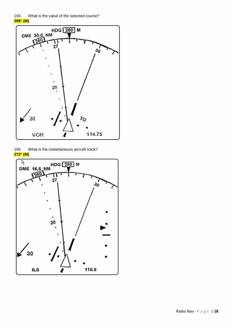
193. What is the value of the selected course?
299° (M)
194. What is the instantaneous aircraft track?
272° (M)

Radio Nav - P a g e | 19
195. The letters QTX and adjacent symbol indicate a:
VOR/DME
196. The 'O' followed by the letters 'KABC' indicate:
An off-route airport

Radio Nav - P a g e | 20
197. What is the heading bug selected to?
260° (M)
198. The diagram indicates that the aircraft is to the:
Right of the localizer and below the glidepath
199. What airborne equipment, if any, is required to be fitted in order that a VDF let-down may be flown?
VHF radio
200. Which of the following is an advantage of Ground/DF (VDF) let-down?
It only requires a VHF radio to be fitted to the aircraft

Radio Nav - P a g e | 21
201. In which one of the following circumstances is ground direction finding (VDF) likely to be used to fix an
aircraft's position?
When using the emergency VHF frequency 121.5 MHz
202. In which frequency band does the Microwave Landing System (MLS) operate?
SHF
203. In an Electronic Flight Instrument System (EFIS) data relating primarily to navigation is provided by:
Navigation radios, Flight Management Computer, Inertial Reference Systems
204. In an Electronic Flight Instrument System (EFIS) data relating primarily to automatic flight is provided by:
Flight Control Computers, Flight Management Computers, Autothrottle
205. For any given circumstances, in order to double the effective range of a primary radar the power output must
be increased by a factor of:
16
206. The prime factor in determining the maximum unambiguous range of a primary radar is the:
Pulse recurrence rate
207. In the propagation of MF waves, the phenomenon of FADING is particularly found:
At night, due to the combination of the sky and ground waves
208. The basic elements of the satellite navigation system NAVSTAR/GPS are the:
Control, space and user segments
209. One of the tasks of the control segment of the satellite navigation system NAVSTAR/GPS is to:
Monitor the status of the satellites
210. The main task of the user segment (receiver) of the satellite navigation system NAVSTAR/GPS is to:
Select appropriate satellites automatically, to track the signals and to measure the time taken by signals from
the satellites to reach the receiver
211. One of the tasks of the space segment of the satellite navigation system NAVSTAR/GPS is to:
Transmit signals which can be used, by suitable receivers, to determine time, position and velocity
212. The geometric shape of the reference system for the satellite navigation system NAVSTAR/GPS, defined as
WGS 84, is:
An ellipsoid
213. In civil aviation, the height value computed by the receiver of the satellite navigation system NAVSTAR/GPS
is the:
Height above the WGS-84 ellipsoid
214. In relation to the satellite navigation system NAVSTAR/GPS, the term 'inclination' denotes the angle between
the:
Orbital plane and the equatorial plane
215. How long does it take a NAVSTAR/GPS satellite to orbit the earth?
Approximately 12 hours (1/2 of a sidereal day)
216. At what approximate height above the WGS-84 ellipsoid are NAVSTAR/GPS satellites circling the earth?
20200 km
217. The orbital planes of the satellite navigation system NAVSTAR/GPS are:
Inclined 55° to the equatorial plane
Radio Nav - P a g e | 22
218. In which frequency bands are the L1 and L2 frequencies used by the satellite navigation system
NAVSTAR/GPS for transmission of the navigation message?
UHF
219. In relation to the satellite navigation system NAVSTAR/GPS, which of the following statements correctly
describes the term 'Pseudo Random Noise (PRN)' signal?
PRN is a code used for the identification of the satellites and the measurement of the time taken by the signal
to reach the receiver
220. Which of the following NAVSTAR/GPS satellite navigation system codes can be processed by 'unauthorised'
civil aviation receivers?
C/A
221. Almanac data stored in the receiver of the satellite navigation system NAVSTAR/GPS is used for the:
Fast identification of received signals coming from visible satellites
222. How does a NAVSTAR/GPS satellite navigation system receiver recognise which of the received signals
belongs to which satellite?
Each satellite transmits its signal, on common frequencies, with an individual Pseudo Random Noise code
223. Which of the following data, in addition to the Pseudo Random Noise (PRN) code, forms part of the so called
'Navigation Message' transmitted by NAVSTAR/GPS satellites?
Almanac data; satellite status information
224. In the NAVSTAR/GPS satellite navigation system, what is the maximum time taken to receive the complete
set of almanac data from all satellites?
12.5 minutes (= 30 seconds per data frame)
225. Which of the following statements concerning the L1 and L2 NAVSTAR/GPS transmission frequencies and
codes is correct?
The higher frequency is used to transmit both the C/A and P codes
226. Which one of the following errors can be compensated for by a NAVSTAR/GPS receiver comparing L1 and L2
frequencies?
Ionospheric
227. Which of the following statements is correct concerning the principle behind the correction of one of the
NAVSTAR/GPS satellite navigation system errors by the transmission of the signals on two frequencies (L1 and L2)?
The path delay of the signals in the earth atmosphere is proportional to the inverse of the carrier frequency
squared
228. Concerning the NAVSTAR/GPS satellite navigation system, what is the meaning of the term 'Receiver
Autonomous Integrity Monitoring' (RAIM)?
It is a technique by which a receiver ensures the integrity of the navigation information
229. Given:
VOR station position N61° E025°, variation 13°E;
Estimated position of an aircraft N59° E025°, variation 20°E.
What VOR radial is the aircraft on?
167°
230. GPS system satellites transmit their signals on two carrier waves 1575 MHz and 1227 MHz and supply two
possible codes accessible according to user (civil or military).
Commercial aviation uses:
Only the 1 575 MHz carrier wave and one code

Radio Nav - P a g e | 23
231. A weather radar, set to the 100 NM scale, shows a squall at 50NM. By changing the scale to 50 NM, the
return on the radar screen should:
Increase in area and move to the top of the screen
232. Secondary radar can provide up to 4096 different codes.
These 4096 codes can be used in:
All modes
233. In weather radar the use of a cosecant beam in 'Mapping' mode enables:
Scanning of a large ground zone producing echoes whose signals are practically independent of distance
234. The code transmitted by a SSR transponder consists of:
Pulses
235. The database of an FMS (Flight Management System) is organised in such a way that:
The navigation database is "read only" to the pilot
236. The following flight plan has been inserted into the navigation system :
WPT1, WPT2, WPT3, WPT4, WPT5.
Between WPT1 and WPT2, a clearance is given to proceed directly to WPT5.
In order to achieve this the pilot must:
Type DIR TO WPT5 on his keyboard
237. The ADF reception loop is always used so that the electromotive force (EMF)
Induced is zero
238. Which one of the following methods is used by a Microwave Landing System (MLS) to indicate distance from
the runway threshold?
A DME co-located with the MLS transmitters
239. Which one of the following correctly lists the major ground based components of a Microwave Landing
System (MLS)?
Separate azimuth and elevation transmitters, DME facility
240. In which frequency band do most airborne weather, and ground based ATC, radar systems operate?
SHF
241. The maximum range obtainable from an ATC Long Range Surveillance Radar is approximately:
300 NM
242. In Airborne Weather Radar (AWR), the main factors which determine whether a cloud will be detected are:
Size of the water drops; wavelength/frequency used
243. In order to ascertain whether a cloud return on an Aircraft Weather Radar (AWR) is at or above the height of
the aircraft, the tilt control should be set to:
(Assume a beam width of 5°)
2.5° up
244. Which of the following Secondary Surveillance Radar (SSR) codes is used to indicate transponder
malfunction?
0000
245. Which one of the following Secondary Surveillance Radar (SSR) codes should be used by aircraft entering
airspace from an area where SSR operation has not been required?
2000

Radio Nav - P a g e | 24
246. Which of the following lists information required to input a waypoint or 'Phantom Station' into a basic
VOR/DME-based Area Navigation System?
Radial and distance from a VOR/DME to the waypoint or 'Phantom Station'
247. Which of the distances indicated will be shown on a basic VOR/DME-based Area Navigation Equipment when
using a 'Phantom Station'?
12 NM
248. Which of the distances indicated will be shown on a basic VOR/DME-based Area Navigation Equipment when
using a 'Phantom Station' at position 'X'?
9 NM
249. Erratic indications may be experienced when flying towards a basic VOR/DME-based Area Navigation System
'Phantom Station':
When operating at low altitudes close to the limit of reception range from the reference station
250. What is the deviation per dot on the HSI when using a 2-dot basic RNAV system in the en-route mode?
2 NM
251. What are the effects, if any, of shadowing by parts of the aircraft (e.g. wing) on the reception of signals from
NAVSTAR/GPS satellites?
It may prevent the reception of signals
252. Which of the following geometric satellite constellations provides the most accurate NAVSTAR/GPS position
fix?
3 satellites with a low elevation above the horizon and an azimuth of 120° from each other together with a
fourth directly overhead
Radio Nav - P a g e | 25
253. In relation to the NAVSTAR/GPS satellite navigation system, what is involved in the differential technique (D-
GPS)?
Fixed ground stations compute position errors and transmit correction data to a suitable receiver on the
aircraft
254. Which of the following statements about the accuracy that can be obtained with the differential technique (D-
GPS) of the satellite navigation system NAVSTAR/GPS is correct?
The nearer a receiver is situated to a D-GPS ground station, the more accurate the position fix
255. How does a receiver of the NAVSTAR/GPS satellite navigation system determine the elevation and azimuth
data of a satellite relative to the location of the antenna?
It calculates it by using Almanac data transmitted by the satellites
256. In relation to the NAVSTAR/GPS satellite navigation system, 'Search the Sky' is a:
Procedure that starts after switching on a receiver if there is no stored satellite data available
257. What is the procedure to be followed if, on a flight under IFR conditions using the NAVSTAR/GPS satellite
navigation system, the number of satellites required to maintain the RAIM (Receiver Autonomous Integrity Monitoring)
function are not available?
The flight may be continued using other certificated navigation systems
258. Which of the following, if any, is a prerequisite if a receiver of a NAVSTAR/GPS satellite navigation system is
to be used in combination with a multi sensor system?
The prescribed IFR-equipment must be installed and operational
259. Which of the following procedures must be adopted if, on a flight under IFR conditions using a
NAVSTAR/GPS satellite navigation system receiver, the position fix obtained from the GPS receiver differs from the
position of conventional navigation systems by an unacceptable amount?
It may be continued using conventional navigation systems
260. What datum is used for the Minimum Descent Altitude (MDA) on a non-precision approach when using the
NAVSTAR/GPS satellite navigation system?
Barometric altitude
261. Which of the following is the datum for altitude information when conducting flights under IFR conditions on
airways using the NAVSTAR/GPS satellite navigation system?
Barometric altitude
262. The captain of an aircraft flying at FL100 wishes to obtain weather information at the destination airfield from
the airfield's VOR. At what maximum theoretical range will it be possible to obtain this information?
123 NM
263. The BFO selector switch on the ADF control panel must be in the ON position to enable the pilot to:
Hear the IDENT of NDBs using NON A1A transmissions
264. An ADF provides the aircraft with bearing information with respect to a ground station. To do this, the ground
station emits a signal pattern which is:
Omnidirectional
265. DME channels utilise frequencies of approximately:
1000 MHz
266. A VOR and DME are co-located.
You want to identify the DME by listening to the callsign.
Having heard the same callsign 4 times in 30 seconds the:
DME callsign is the one with the higher pitch that was broadcast only once

Radio Nav - P a g e | 26
267. The heading rose of an HSI is frozen on 200°.
Lined up on the ILS of runway 25, the localizer needle will be:
Centred
268. In relation to radar systems that use pulse technology, the term 'Pulse Recurrence Rate (PRR)' signifies the:
Number of pulses per second
269. When switching on the weather radar, after start-up, a single very bright line appears on the screen.
This means that the:
Scanning of the cathode ray tube is faulty
270. The advantage of the use of slotted antennas in modern radar technology is to:
Virtually eliminate lateral lobes and as a consequence concentrate more energy in the main beam
271. What is the maximum number of usable Secondary Surveillance Radar (SSR) transponder codes?
4096
272. Which of the following lists phenomena that CANNOT be detected by weather radar?
Snow; clear air turbulence
273. Given:
Aircraft heading 160°(M),
Aircraft is on radial 240° from a VOR,
Selected course on HSI is 250°.
The HSI indications are deviation bar:
Behind the aeroplane symbol with the FROM flag showing
274. Consider the following statements on the NDB transmitter:
It is very simple, being required to transmit only a carrier wave and identification
275. A loop aerial, as used in the ADF, will
Receive a minimum or null signal from a transmitter when the plane of the loop is at right angles to the
direction of the transmitter
276. The basic information given by the ADF is
The relative bearing from the aircraft to the NDB
277. The combination of the polar diagrams of the loop and the sense aerial results in
A cardioids polar diagram, having only one null or minimum
278. Of the bearing indicators available for use on ADFs, the most sophisticated one is
The Radio Magnetic Indicator
279. Using an ADF indicator of the manually rotateable card type:
The card should be rotated so that the aircraft heading is at the top of the indicator
280. The heading read on a standard RMI is
The compass heading
281. Homing on an NDB:
Will in most situations result in frequent heading changes when approaching the NDB
282. When using ADF, the sky-wave (night) effect:
Is most dominant around dusk and dawn

Radio Nav - P a g e | 27
283. A Doppler shift will occur
a) All 3 answers are correct
b) When the distance between a transmitter and a receiver is changing during a transmission
c) If a receiver is moving during reception of transmissions from a fixed position transmitter
d) If a transmitter is moving during transmission to a fixed position receiver
284. In the normal applications using Doppler shift registered in aircraft equipment
The Doppler shift will be doubled, because it is based on measuring the frequency of a reflected signal from
the ground
285. In using an airborne Doppler navigation system, the Doppler shift is proportional to
Aircraft speed and transmitter frequency
286. In using an airborne Doppler navigation system, the expected accuracy
Is 0.3% in ground speed
287. A Homing you prefer with a difference of angle greater than
70°
288. Which interception do you choose with a difference of angle of 15° and an EET of 4 minutes?
45° Interception
289. Act QDM 140°
Act HDG 020°
Req QDM 110°
First turn?
Left HDG 155°
290. Act QDM 330°
Act HDG 060°
Req QDM 350°
Intercept HDG?
305°
291. Act QDM 150°
Act HDG 330°
Req QDM 120°
Kind of interception?
45° Interception
292. Act QDM 210°
Act HDG 060°
Req QDM 260°
First turn?
Right HDG 170°
293. Act QDM 095°
Act HDG 090°
Req QDM 090°
EET 5Min.
Correction?
15°

Radio Nav - P a g e | 28
294. Act QDM 120°
Act HDG 120°
Req QDR 060°
Int-HDG?
040°
295. Act QDR 285°
Act HDG 290°
Req QDR 290°
Time passed the station 2Min.
Correction HDG?
300°
296. From the following statements, select those which apply:
-1: The coupling of MLS with DME/P greatly enhances accuracy
-2: A DME/P channel is not paired with the azimuth and elevation channel of the MLS
-3: A DME/P may be substituted by a navigation DME and is therefore not an integral part of the MLS
-4: The DME/P may be used to enhance accuracy of an Instrument Landing System (ILS)
Only 1 is correct
297. Which one of the following inputs to an Area Navigation System (RNAV) comes from an external, not on-
board system?
VOR/DME radial/distance
298. Which facility associated with the ILS may be identified by a two-letter identification group?
Locator
299. In the Flight Management Computer (FMC) of the Flight Management System (FMS), data relating to flight
plans is stored in the:
Navigation database
300. In the Flight Management Computer (FMC) of the Flight Management System (FMS), data relating to cruising
speeds is stored in the:
Performance database
301. The databases on a FMC:
Are read only
302. In the Flight Management Computer (FMC) of the Flight Management System (FMS), data relating to V1, VR
and V2 speeds is stored in the:
Performance database
303. NDB approach: What accuracy does the ADF provide by day with respect to the published track?
+/- 5°
304. Locators transmit in the following frequency bands:
LF/MF
305. Primary radar displays the following information:
Position
306. Gain control in an airborne weather radar (AWR) is used for:
Sensitivity control
307. Rho-rho navigation uses:
DME/DME

Radio Nav - P a g e | 29
308. Cross-track distance is displayed on:
Navigation display
309. Which of the figures depicts an Electronic Flight Instrument System (EFIS) display in PLAN mode?
Figure 2

Radio Nav - P a g e | 30
310. Which of the figures depicts an Electronic Flight Instrument System (EFIS) display in MAP mode?
b) Figure 3
311. What is an example of a self contained RNAV system?
INS

Radio Nav - P a g e | 31
312. When operating in an RNAV mode using multiple DME, inaccuracy can be due to:
Inability to confirm the aircraft is within the DOC of the DMEs because of identification problems
313. Which of the following errors is associated with the use of VOR?
Scalloping
314. In flight, a pilot can improve the range of his transmission with a VDF operator by:
Increasing altitude
315. The range of a locator according to ICAO Annex 10 is
10-25 NM
316. You are plotting a chart and use a DME arc. What does the DME arc represent?
Slant range
317. What is the accuracy of an NDB signal at night?
Lower
318. In the NAV message, the "ephemeris" refers to the exact:
Position and orbit of the observed satellite
319. What are the risks when using an airborne weather radar (AWR) in MAP mode over polar regions?
The ice offshore lines may be mistaken for the real coast lines
320. On what carrier frequency does the inner marker transmit?
75 MHz
321. A primary pulse radar system operates with a pulse repetition frequency of 400 pps. The maximum theoretical
range of the system is:
202 NM
322. A primary pulse radar system operates with a pulse repetition frequency of 1200 pps. The maximum
theoretical range of the system is:
125 km
323. A primary pulse radar system operates with a pulse repetition frequency of 550 Hz. The maximum theoretical
range of the system is:
147 NM
324. A primary pulse radar system operates with a pulse repetition frequency of 360 pps. The maximum theoretical
range of the system is:
225 NM
325. On a primary radar system, identify which component(s) is/are rotating:
Both
326. The correction for an aircraft GNSS receiver in EGNOS and WAAS systems are broadcasted:
Via a geostationary satellite
327. What spacing is used to separate the P1 pulse from a P2 pulse in a mode C SSR interrogation?
2μsec between P1 and P2 pulse
328. How can an airborne SSR transponder differentiate a mode A from a mode C interrogation?
By a pulse spacing between the P1 and P3 pulse of 8μsec for a mode A and 21μsec for a mode C
interrogation

Radio Nav - P a g e | 32
329. An aircraft heading 315°(M) shows an NDB bearing of 180° on the RMI. Any Quadrantal error affecting the
accuracy of this bearing is likely to be:
At a maximum
330. A relative bearing indicator shows 030°. The heading of the aircraft is 090° (M). The intercept angle for a
course to the NDB of 180°(M) is:
060°
331. A VOR and an NDB are co-located. You cross the VOR radial 240 on a heading of 360°(M). In the vicinity of
the station you should read an ADF bearing of:
60°
332. An NDB is on a relative bearing of 316° from an aircraft.
Given:
Compass heading: 270°
Deviation at aircraft: 2°W, variation 30°E
Variation at station: 28°E
Calculate the true bearing of the NDB from the aircraft:
254°
333. If a failed RMI rose is stuck on 090° and the ADF pointer indicates 225°, the relative bearing to the station will
be:
135°
334. On the QDR of 075° (in the vicinity of the station) with a magnetic heading of 295°, the relative bearing on the
ADF indicator is:
320°
335. You are on a magnetic heading of 055° and your ADF indicates a relative bearing of 325°. The QDM is:
020°
336. An aircraft is tracking 060°(T) in still air. The relative bearing of an NDB is 035° at 1300. 12 minutes later, the
relative bearing is 070°. What is the aircraft's distance from the NDB at 1312, with a GS of 180 kt?
36 NM
337. To maintain the 314° QDR to an NDB with 7° right drift, the heading in °M and relative bearing will be:
127°/007°

Radio Nav - P a g e | 33
338. Refer to the diagram # 5. Assume that the indicator is set to define the centreline of an airway, that the aircraft
is 90 NM from the VOR and inbound to the facility. At the time of observation the aircraft was located on radial
063°
339. Refer to diagram # 4. An aircraft is attempting to track 186° M on an airway (10 NM wide), defined by a VOR
80 NM away. The VOR display indicates the aircraft position. With these indications, the aircraft is on the ... radial
and ... the airway.
001°, outside

Radio Nav - P a g e | 34
340. Refer to diagram # 1. The indication was obtained when the aircraft was at a range of 50 NM from the VOR.
Assuming that the VOR is correctly set-up, the radial and horizontal distance the aircraft is off track are:
089 radial and 3,3 NM right of track
341. Refer to diagram # 2. The indication was obtained when the aircraft was at a range of 90 NM from the VOR.
Assuming that the VOR is correctly set-up, the radial and horizontal distance the aircraft is off track are:
062 radial and 9 NM right of track
342. The maximum range an aircraft at FL270 can receive transmissions from a VOR/DME at 800 ft is:
240 NM

Radio Nav - P a g e | 35
343. A VOT is:
A test VOR
344. An aircraft at FL350 is using a VOR (2060 ft AMSL). The maximum theoretical range at which the VOR can be
used is:
290 NM
345. In order to measure the radial from a VOR, the aircraft VOR receiver:
Measures the phase difference between the reference phase and the variable phase of the signal
346. The phase difference between the reference and variable signals on QDM 050° (VAR 10°W) for a
conventional VOR is:
230°
347. The quoted accuracy of a VOR is valid:
At all times
348. An aircraft flies over position A which is due North of a VOR station sited at position B. The magnetic variation
at A is 18°W and at B is 10°W. What radial from B is the aircraft on?
010°
349. An aircraft is heading 075°M. The OBS is set to 025°. The VOR indications are TO with the needle showing
right deflection. Relative to the station, the aircraft is situated in a quadrant defined by the radials:
205° and 295°
350. An aircraft is flying a heading of 090° along the equator, tracking direct to a VOR. If the variation at the
aircraft's position is 10°E and 15°E at the VOR, the aircraft is situated on radial:
255°
351. A Course Deviation Indicator (CDI) shows full deflection to the left when within range of a serviceable VOR.
What is the angular deviation from the selected radial?
10° or more
352. The VOR monitor will remove the identification or switch off the VOR transmitter if there is a change of
measured bearing greater than:
1°
353. What is the maximum range a transmission from a VOR beacon at 169 ft can be received by an aircraft at
1200 ft?
60 NM
354. The OBS is set on 048°, "TO" appears in the window. The needle is close to full right deflection. The VOR
radial is approximately:
238°
355. When tracking a VOR radial inbound, the aircraft flies:
A great circle track
356. An aircraft is on the 120° radial from a VOR station. Course 340° is selected on the HSI. If the magnetic
heading is 070°, the deviation bar relative to the aeroplane model will be:
Behind
357. On a CVOR the phase difference between the AM and FM signals is 30°. The VOR radial is:
030
358. An aircraft is maintaining an airway centreline of 000°, defined by a VOR ahead of the aircraft. Variation at the
VOR is 5E. At 60 NM to go the QDM is 004. The aircraft's position relative to the airway lateral boundary is:
1 NM inside the airway's western boundary

Radio Nav - P a g e | 36
359. If the remote compass providing heading information to the RMI suddenly suffers a 20° deviation:
a) the magnetic track to the VOR station may be read on the compass card under the tip of the VOR needle.
b) all answers are correct.
c) the relative bearing to the VOR, as observed on the RMI, will be incorrect by 20°.
d) the value of the received radial may still be read on the compass card under the tail of the VOR needle.
360. A VOR receiver with a phase comparison of 90° is on radial:
East
361. An aircraft at FL100 should be able to receive a VOR ground station located at 100 ft AMSL at an
approximate maximum range of:
137 NM
362. An aircraft is inbound to VOR X on the 073° radial and experiences a drift of 12°L. A position report is required
when crossing the 133° radial from VOR Y. If the aircraft is on track, the RMI indications at the reporting point would
be:
Heading 265°, X pointer 253°, Y pointer 313°
363. An aircraft on a heading of 180° M is on a radial of 270° M from a VOR. The bearing which should be selected
on the OBS to centralize the VOR/ILS left/right deviation needle and to proceed to the VOR is:
090°
364. The indication of a VOR receiver in an aircraft tracking towards a VOR are 075° M with a "TO" indication and
the CDI centered. A co-located NDB shows 012° relative. What are drift and heading in °M?
12° right, 063°
365. At an altitude of 20000 ft you would expect to detect a VOR (located at sea level) at a range of:
177 NM
366. The OBS is set to 235°, magnetic heading 200°. The indications of the VOR receiver are half full scale
deflection left and "TO". The aircraft is therefore on the radial:
050°
367. An aircraft is on a VOR radial of 235°, heading 003° M, and with the OBS set to 060. The correct indications
are:
TO, 1/2 scale deflection to the left
368. What is the minimum height an aircraft must be to receive signals from a VOR at 196 ft AMSL at a range of
175 NM?
16000 ft
369. A pilot flying an aircraft at FL80 tunes in a VOR which has an elevation of 313 metres. Given ISA conditions,
what is the maximum theoretical distance at which a pilot might expect to receive the VOR signals?
151 NM
370. Which of the following applies to the Doppler VOR, when comparing conventional and Doppler VOR?
The reference and variphase signals are reversed but the phase difference remains the same
371. The designated operational coverage of a VOR is:
An altitude and range limited by signal to noise ratio
372. Given:
OBS for a VOR is selected to 090°
From/To indicator indicates "TO"
CDI needle is deflected halfway to the right
On what radial is the aircraft?
275°

Radio Nav - P a g e | 37
373. A VOR indication of 240° "FROM" is given. Variation at the aircraft's position is 9°W and at the VOR 7°W. The
heading to reach the station in nil wind conditions is:
053° T
374. An aircraft flies from a VOR at 61°N 013°W to 58°N 013°W. The variation at the VOR station is 13°W and at
the aircraft's position 5°W. What radial is the aircraft on?
193°
375. Which of the following is a valid frequency (MHz) for a VOR?
112.20
376. An aircraft is situated at 30°N 005°E with a magnetic variation of 10°W. A VOR is located at 30°N 013°E with
a magnetic variation of 15°W. The aircraft is situated on the VOR radial:
287°
377. An aircraft is on radial 070° of a VOR, HDG 270°. If the OBS is set to 260°, this CDI will show:
Fly left "TO"
378. The maximum width of the cone of silence above a VOR at 30000 ft is:
11.6 NM
379. In a conventional VOR the direction of rotation of the signal will be ... (i) and the variable signal is ... (ii). In a
Doppler VOR the reference signal is ... (iii) and the direction of rotation will be ... (iv):
(i) Clockwise, (ii) AM, (iii) AM, (iv) anticlockwise
380. The maximum theoretical range at which an aircraft at FL340 may receive signals from a VOR facility sited at
mean sea level is:
227 NM
381. When the term "radial" is used with reference to VOR, it means:
The magnetic bearing from the VOR station
382. The QUJ is 335° by VDF. The variation of a VOR at the same position is 12°W. What is the phase difference
between the reference and variable signals in the aircraft's receivers from that VOR?
167°
383. When using a DVOR, the pilot should be aware that the reference and variable signals are reversed. This:
Improves the accuracy
384. Airborne weather radar is using a 3° beam. A cloud is detected at a range of 40 NM. If the scanner is tilted up
to 3° the cloud echo disappears. The top of the cloud, in relation to the aeroplane's cruising level is approximately:
6000 ft above the level
385. An airborne weather radar unit transmits a 4° beam from a parabolic dish aerial reflector assembly. If the
wavelength is 3 cm, what is the diameter of the dish?
52.5 cm
386. Airborne weather radar, with a beamwidth of 4° in azimuth, is used in mapping mode. At what maximum range
would it be able to detect a 1 NM wide opening in a facing sea cliff?
15 NM
387. Airborne weather radar use a frequency of approximately 9 GHz because:
The wavelength is such that reflections are obtained only from the larger water droplets
388. The cosecant squared beam is used for mapping in the AWR because:
A larger area of ground is illuminated by the beam

Radio Nav - P a g e | 38
389. An aircraft flying at 25000 ft is equipped with AWR. The beam width is 5° with the radar tilted up at 3,5°. The
radar is showing the top of a cloud return at 105 NM. The approximate height of the cloud is:
35600 ft
390. The AWR can be used on the ground, provided:
1) The aircraft is clear of personnel, buildings and vehicles
2) The conical beam is selected
3) Maximum tilt-up is selected
4) The AWR must never be operated on ground
The correct statement(s) is (are):
1, 2, 3
391. The tilt angle on the AWR at which an active cloud just disappears from the screen is 4° up. If the beam width
is 5° and the range of the cloud is 40 NM, use the 1:60 rule to calculate the approximate height of the cloud, relative to
the aircraft:
6000 ft above
392. What is the orbital time of a GLONASS navigation satellite?
11h 15min
393. What is the orbital time of a NAVSTAR/GPS navigation satellite?
11h 58min
394. How many orbits does the fully operational NAVSTAR/GPS consist of?
6 orbits
395. How many orbits does the fully operational GLONASS consist of?
3 orbits
396. What inclination do the orbits of the NAVSTAR/GPS have?
55° inclination
397. What inclination do the orbits of GLONASS have?
65° inclination
398. What is the minimum number of satellites required for a global coverage of the NAVSTAR/GPS?
24 satellites
399. What number of satellites can be found in one orbit of the full operational NAVSTAR/GPS system?
4 satellites
400. What number of satellites can be found in one orbit of the full operational GLONASS system?
8 satellites
401. At what approximate height above the WGS-84 ellipsoid are GLONASS satellites circling the earth?
19100 km
402. An aircraft at FL300 (ISA conditions), with a ground speed of 300 kts, is about to pass overhead a DME
station at MSL. The DME receiver is capable of determining ground speed. One minute before the overhead, DME
speed and distance indications are respectively:
Less than 300 kts and 7 NM

Radio Nav - P a g e | 39
403. An aircraft is flying on a MH of 210°. The magnetic variation at the VOR is 5°W and at the aircraft 10°W.
Which VOR-RMI corresponds to the indications on the HSI shown below?
Figure B
404. Given:
Aircraft heading 160°(M)
Aircraft is on radial 240° from a VOR
Selected course on HSI is 250°
The HSI indications are deviation bar:
Behind the aeroplane symbol with the FROM flag showing
405. An aircraft is flying a heading of 245° towards a VOR at FL300. The HSI displays a "selected course" of 255°
with a TO indication. The variation at the VOR is 15°E. Variation at the aircraft position is 16°E and the deviation is +1°
When the pilot keeps the CDI on the left inner dot on a display with two dots on either side,
The VOR will be approached along radial 070

Radio Nav - P a g e | 40
406. An aircraft is flying on the 050 radial with a MH of 250°. On the HSI the CRS is set to 060. Which HSI shows
the correct indications?
Figure B
407. An aircraft is flying on the 245 radial with a MH of 250°. On the CDI the CRS is set to 060. Which CDI shows
the correct indications?
Figure D

Radio Nav - P a g e | 41
408. An aircraft is flying on the 050 radial with a MH of 250°. On the CDI the CRS is set to 060. Which CDI shows
the correct indications?
Figure C
409. An aircraft is flying on the 170 radial with a MH of 315°. On the CDI the CRS is set to 180. Which CDI shows
the correct indications?
Figure D

Radio Nav - P a g e | 42
410. An aircraft is flying on a MH of 210°. The magnetic variation at the VOR is 5°W and at the aircraft 10°W.
According to the HSI shown the aircraft is on radial:
025
411. An aircraft is flying on a MH of 210°. The magnetic variation at the VOR is 5°W and at the aircraft 10°W.
Which VOR-RMI corresponds to the indications on the CDI shown below?
Figure D

Radio Nav - P a g e | 43
412. An aircraft is flying on a MH of 010°. The magnetic variation at the VOR is 10°W and at the aircraft 12°W.
Which VOR-RMI corresponds to the indications on the HSI shown?
Figure C

Radio Nav - P a g e | 44
413. An aircraft is flying on a MH of 010°. The magnetic variation at the VOR is 10°W and at the aircraft 12°W.
Which VOR-RMI corresponds to the indications on the CDI shown?
Figure A

Radio Nav - P a g e | 45
414. An aircraft is flying on a MH of 010°. The magnetic variation at the VOR is 10°W and at the aircraft 12°W.
Which VOR-RMI corresponds to the indications on the HSI shown?
Figure B

Radio Nav - P a g e | 46
415. An aircraft is on the 065 radial with a heading of 090°M. The Course Reference Selector (CRS) is set on 240.
Which HSI shows the correct indications?
B
416. The ILS marker with an aural frequency of 3000 Hz is the:
Inner marker (if available)
417. Which statement with respect to interrogation modes is correct?
Mode S Broadcast will transmit information to all mode S transponders
418. A pilot is flying between two waypoints defined by suitably located VOR/DMEs. Equipped with a simple 2D
RNAV system, this pilot:
Reads cross track error and the distance to go on CDI or HSI
419. Which statement is correct with respect to the range of an NDB?
With propagation over sea the range will be greater than the range with propagation over land
420. Which statement is correct for homing towards an NDB in an area with constant wind and constant magnetic
variation?
The Relative Bearing of the NDB should be kept 000°

Radio Nav - P a g e | 47
421. How can a DME-interrogator distinguish between its own reply pulse-pairs and the reply pulse-pairs of other
aircraft in the area, using the same DME-station?
The Pulse Repetition Frequency of the pulse-pairs transmitted by the interrogator varies, for each interrogator,
in a unique rhythm
422. Garbling in mode A and C may occur:
When two or more aircraft are in approximately the same direction from the interrogator with a difference in
slant range of less than 1.7 NM
423. A locator beacon differs from an NDB with respect to:
1) operational use
2) transmission power
3) presentation in the cockpit
4) frequency band.
From the above stated differences the following numbers are correct:
1 and 2
424. The FMS navigation data base usually contains:
1) airport reference data
2) ATC frequencies
3) Company routes
4) Nav. Aid frequencies
The combination regrouping all the correct statements is:
1, 3 and 4
425. The inputs of information used to achieve the RNAV required accuracy may be:
1) NDB
2) IRS
3) VOR/DME
4) GNSS
The combination regrouping all the correct statements is:
2, 3 and 4
426. Classify the marker from lower aural frequency to higher aural frequency: 1. Inner marker (if available) 2.
Middle marker 3. Outer marker
3 - 2 -1
427. Locators are:
1) High powered NDBs used for en route and airways navigation
2) Low powered NDBs used for airfield or runway approach
3) Beacons with a usually range of 10 to 250 NM
4) Beacons with a usually range of 10 to 25 NM.
The combination regrouping all the correct statements is:
2 and 4
428. Concerning the localiser principle of operation in an ILS system, the difference in depth of modulation (DDM):
1) decreases with respect to the angular displacement from the centerline
2) increases with right displacement from the centerline
3) decreases with left displacement from the centerline
4) increases linearly with displacement from the centreline.
The combination regrouping all the correct statements is:
2 and 4

Radio Nav - P a g e | 48
429. With respect to the principle of distance measurement using DME can be stated that:
1) the interrogation signal is transmitted on the same frequency as the reply signal
2) the DME station always has a transponder delay of 50 milliseconds
3) the time between the pulse pairs of the interrogation signal is at random
4) In the search mode more pulse pairs per second are transmitted than in the tracking mode
Which of the above given statements are correct?
3 and 4
430. Benefits of Area Navigation include:
1) Shorter flight distance
2) Reduction in fuel and flight time
3) No radio contact within RNAV airspace
4) Reduction in the number of ground facilities
5) Pilot choice of vertical and horizontal separations
The combination regrouping all the correct statements is:
1, 2 and 4
431. The basic principle of operation of the ILS is the difference in depth of modulation (DDM) between the two
lobes:
1) if the aircraft strays right, the higher tone lobe will be received at a higher intensity than the lower tone lobe
2) a DDM of zero indicates the exact runway centreline
3) the depth of modulation increases away from the centerline
4) a DDM of zero indicates a balance between modulations
The combination that regroups all of the correct statements is:
1, 2, 3 and 4
432. In accordance with ICAO Annex 10 the GPS NAVSTAR position accuracy in SPS should be for 95% of the
time:
13 metres horizontally
433. What is the maximum latitude of a GPS-satellite ground track?
55° N/S
434. Which statement about RNAV-routes is correct?
A method of navigation which permits aircraft operation on any desired flight path
435. EGNOS (European Geostationary Navigation Overlay System) is a form of:
Wide Area Differential GPS (WADGPS)
436. Which of the following statements about the scalloping (path deflection) of VOR-radials, in relation to the
accuracy of navigation using a VOR/DME RNAV-system, is correct?
Scalloping has a negative effect on the accuracy of navigation
437. In an ILS system, concerning the glidepath principle of operation, the difference in depth of modulation (DDM):
1) decrease with angular displacement below the glidepath
2) increase with angular displacement above the glidepath
3) decrease with angular displacement above the glidepath
4) increase with angular displacement below the glidepath
The combination regrouping all the correct statements is:
2 and 4
438. What is the function of the Echo Protection Circuit (EPC)?
The EPC has to detect if the interrogator-receiver has been locked on, by reflected pulse-pairs
439. Which statement about the interrogation by the DME-interrogator is correct?
The indication does not start before pulse-pairs of the tuned DME-station are received

Radio Nav - P a g e | 49
440. The most widely used AC frequency in aircraft is:
400 Hz
441. Which one of the following sensors/systems is self-contained?
Inertial Navigation System
442. In relation to Area Navigation Systems (RNAV), which of the following is an Air Data input?
True airspeed
443. In the Flight Management Computer (FMC) of the Flight Management System (FMS), data relating to STARs
and SIDs is stored in the:
Navigation database
444. In the Flight Management Computer (FMC) of the Flight Management System (FMS), data relating to aircraft
flight envelope computations is stored in the:
Performance database
445. In the Flight Management Computer (FMC) of the Flight Management System (FMS), data relating to
waypoints is stored in the:
Navigation database
446. Apart from radials and distances from VOR/DME stations, what information is required by the VOR/DME Area
Navigation computer in order to calculate the wind?
Heading from the aircraft compass system and true airspeed from the air data computer
447. On what data is a VOR/DME Area Navigation system operating in the dead reckoning mode?
TAS from the Air Data Computer; heading from the aircraft compass; the last computed W/V
448. Under which of the following circumstances does a VOR/DME Area Navigation system switch to Dead
Reckoning mode?
VOR/DME Area Navigation computer is receiving neither radial nor distance data information from VOR/DME
stations
449. Under which of the following circumstances does a VOR/DME Area Navigation system switch to Dead
Reckoning mode?
The system is receiving information from only one VOR
450. How does a VOR/DME Area Navigation system selects the DME stations to be used for positioning?
The VOR/DME Area Navigation system has its own NAV tuner and the system itself tunes the DME stations
providing the most accurate position
451. What is cross track distance (XTK distance) in an Area Navigation System?
Distance between actual position and great circle track between active waypoints
452. By which of the following flight deck equipment are the waypoints inserted into an FMS RNAV system by the
pilot?
Control Display Unit
453. Which of the following statements regarding B-RNAV is correct?
For 95% of the flight time, the track keeping accuracy must not exceed 5 NM
454. A fix obtained by rho-rho navigation is based on information of two:
DMEs

Radio Nav - P a g e | 50
455. Which of the following data can be found in the navigation database?
1) SIDs and STARs
2) radio aids
3) optimum flight level
4) company routes
5) cruise speeds
The combination that regroups all of the correct statements is:
1, 2, 4
456. A phantom station (as used in a 2D RNAV system is:
A waypoints defined by a radial and a DME distance from a VOR/DME station
457. The navigational function of the Horizontal Situation Indicator (HSI) in relation to Area Navigation Systems is:
The indication of the cross track distance (XTK)
458. A 3-dimensional RNAV system has capability in:
The horizontal plane and in the vertical plane
459. A 2-dimensional RNAV system has capability in the:
Horizontal plane
460. One of the benefits of RNAV is:
RNAV allows aircraft to take a more direct flight path without requiring to fly over ground based facilities
461. On modern passenger aircraft, the navigation data base usually contains:
Airport reference data
462. Concerning FMC databases:
The navigation database may be customized for the specific airline operations
463. What is true about FMC databases?
The data includes SID, STARs and runway approaches
464. On a modern commercial aircraft, the FMS provides:
Lateral and vertical navigation and guidance performance management
465. Kalman filtering is used within the:
Navigation computer
466. The Control and Display Unit (CDU) on an FMS is:
Used by the crew to input data into FMC
467. The frequency which corresponds to a wavelength of 12 cm is:
2500 MHz
468. The wave length of a radio signal transmitted at a frequency of 75 MHz is:
4 m
469. The wave length of a radio signal transmitted at a frequency of 118.7 MHz is:
2.53 m
470. Phase modulation:
Is a modulation form used in GPS where the phase of the carrier wave is reversed
471. What is meant by keying in A1A modulation?
Interrupting the carrier wave to break it into dots and dashes

Radio Nav - P a g e | 51
472. A radio signal may be classified by three symbols in accordance with the ITU radio regulation e.g. A1A. Which
statement is true?
The first symbol indicates the type of modulation of the main carrier
473. The phase angle of a wave is:
The fraction of one wavelength expressed in degrees from 000° to 360°
474. The amplitude of a wave or oscillation is:
Its maximum deflection
475. How is the unit "Hertz" (Hz) defined?
The number of electromagnetic oscillations per second
476. What describes "Polarisation"?
The orientation of the plane of oscillation of the electrical component of the electromagnetic wave
477. At what velocity do electromagnetic waves travel?
The speed of light
478. The frequency of a VOR is 117.5 MHz What is the corresponding wavelength?
2.55 m
479. The frequency of an NDB is 427 kHz. What is the corresponding wavelength?
702.5 m
480. The frequency of an Airborne Weather Radar is 9.33 GHz. What is the corresponding wavelength?
3.2 cm
481. An Airborne Weather Radar transmits pulses of a wavelength of 3.2 cm. What is the corresponding frequency?
9.38 GHz
482. What is the frequency of a radio wave with a wavelength of 3 km?
100 kHz
483. What is the frequency of a radio wave with a wavelength of 8.25 m?
36.4 MHz
484. What is the frequency of a radio wave with a wavelength of 2.54 m?
118.1 MHz
485. Radio waves travel with an approximate velocity of:
300000 km/s
486. The unit for measuring frequency is ......, and measures cycles......:
Hertz; per second
487. Modulation is:
The addition of information onto a radio wave during transmission
488. How is amplitude modulation achieved?
The information is added onto the carrier wave by altering the amplitude of the carrier
489. Where is pulse modulation used?
In radar
490. Modulation is:
The addition of a low frequency signal (tone, voice) onto a high frequency carrier wave

Radio Nav - P a g e | 52
491. Which of the following summaries lists only directional antennae?
Loop antenna, parabolic antenna, slotted planar array antenna, helical antenna
492. A dipole antenna in its simplest form, suited for a frequency of 110 MHz, ought to have a length of:
136 cm
493. Given a wire fed with alternating current and a second wire parallel to, but remote from it. The result will be:
The first wire will radiate electro-magnetic waves into space and alternating current will be induced in the
second wire
494. A reason that GPS satellites use helical antennae is:
That the signal has a circular polarization
495. An electromagnetic wave consists of an oscillating electric (E) and an oscillating magnetic (H) field. Which of
the following answers is true?
The (E) field and the (H) field are perpendicular to each other
496. What is the simplest type of an antenna called?
Dipole
497. What is required to enable an antenna to transmit an electromagnetic wave?
The antenna has to be fed with an alternating current of high frequency
498. What type of antenna is used in a modern Airborne Weather Radar?
Slotted planar antenna
499. A parabolic antenna:
Is a directional antenna
500. Comparing a parabolic reflector with a flat plate antenna of the same size:
The flat plate antenna generates less side lobes than the parabolic reflector
501. Mountain Effect, occurring for instance with NDBs, is caused by what physical phenomenon?
Reflection
502. The superposition of two EM waves of the same or nearly the same frequency is called:
Interference
503. The process by which EM energy is taken up by the atmosphere is called:
Absorption
504. The phenomenon of a change in direction of an EM wave occurring at an interface between two different
media, so that the wave returns into the medium from which it originated, is called:
Reflection
505. The phenomenon of a change in direction of an EM wave occurring due to a change in its speed is called:
Refraction
506. In aviation electronic systems the so-called Doppler principle my be used in
VOR, GPS and MTI and the turbulence mode of AWR
507. What is the Doppler effect with reference to radio signals?
It is the shift in frequency of the radio wave due to the relative movement between transmitter and receiver

Radio Nav - P a g e | 53
508. Which statement about VHF/UHF propagation in connection with Ground Direction Finders is correct?
For both VHF/UHF propagation, the space wave is the only propagation path of practical use. There is no sky
wave under normal conditions
509. The phenomenon when a wave bends when it passes around an impenetrable obstacle is called:
Diffraction
510. From which physical phenomenon do sky waves originate?
Refraction
511. Single Side Band (SSB) is used:
In HF two-way communication
512. Radio waves in the VHF and higher frequency bands propagate mainly as:
Space waves
513. Which physical effects affecting wave propagation as shown in the figure?
A = refraction B = absorption C = reflection
514. The skip zone is defined as:
The area, where neither the ground waves nor the sky waves are received
515. Which letter in the figure below indicates the Skip Zone?
C
516. Which letter in the figure below indicates the Skip Distance?
D
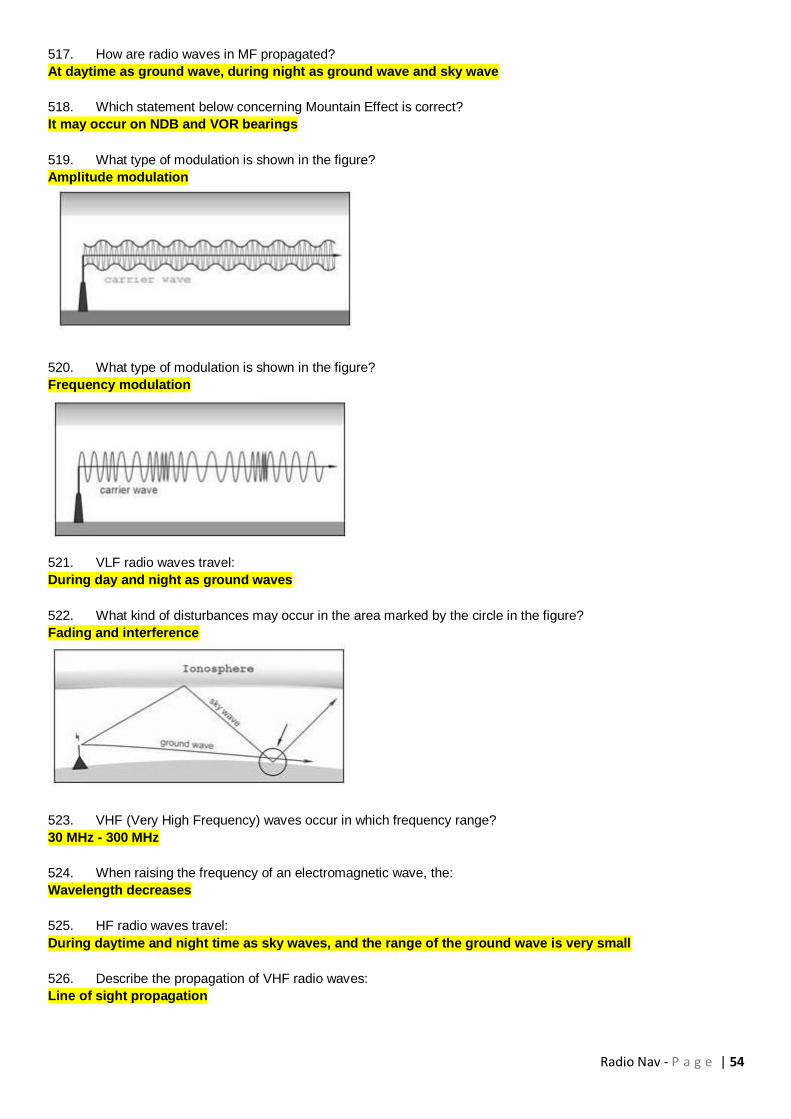
Radio Nav - P a g e | 54
517. How are radio waves in MF propagated?
At daytime as ground wave, during night as ground wave and sky wave
518. Which statement below concerning Mountain Effect is correct?
It may occur on NDB and VOR bearings
519. What type of modulation is shown in the figure?
Amplitude modulation
520. What type of modulation is shown in the figure?
Frequency modulation
521. VLF radio waves travel:
During day and night as ground waves
522. What kind of disturbances may occur in the area marked by the circle in the figure?
Fading and interference
523. VHF (Very High Frequency) waves occur in which frequency range?
30 MHz - 300 MHz
524. When raising the frequency of an electromagnetic wave, the:
Wavelength decreases
525. HF radio waves travel:
During daytime and night time as sky waves, and the range of the ground wave is very small
526. Describe the propagation of VHF radio waves:
Line of sight propagation
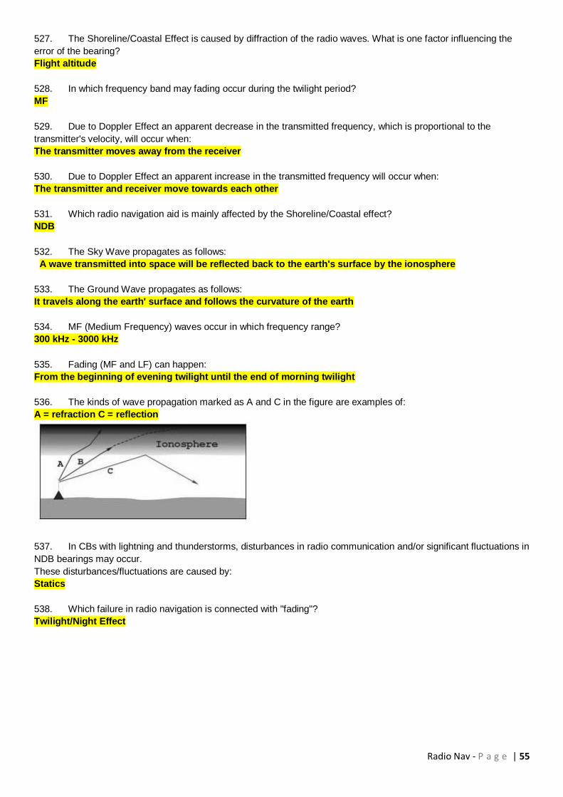
Radio Nav - P a g e | 55
527. The Shoreline/Coastal Effect is caused by diffraction of the radio waves. What is one factor influencing the
error of the bearing?
Flight altitude
528. In which frequency band may fading occur during the twilight period?
MF
529. Due to Doppler Effect an apparent decrease in the transmitted frequency, which is proportional to the
transmitter's velocity, will occur when:
The transmitter moves away from the receiver
530. Due to Doppler Effect an apparent increase in the transmitted frequency will occur when:
The transmitter and receiver move towards each other
531. Which radio navigation aid is mainly affected by the Shoreline/Coastal effect?
NDB
532. The Sky Wave propagates as follows:
A wave transmitted into space will be reflected back to the earth's surface by the ionosphere
533. The Ground Wave propagates as follows:
It travels along the earth' surface and follows the curvature of the earth
534. MF (Medium Frequency) waves occur in which frequency range?
300 kHz - 3000 kHz
535. Fading (MF and LF) can happen:
From the beginning of evening twilight until the end of morning twilight
536. The kinds of wave propagation marked as A and C in the figure are examples of:
A = refraction C = reflection
537. In CBs with lightning and thunderstorms, disturbances in radio communication and/or significant fluctuations in
NDB bearings may occur.
These disturbances/fluctuations are caused by:
Statics
538. Which failure in radio navigation is connected with "fading"?
Twilight/Night Effect

Radio Nav - P a g e | 56
539. You are flying parallel to the coastline. An NDB is positioned about 10 NM inland. In which areas will you
observe the Shoreline/Coastal Effect?
Area C + D, deflection to the coastline
540. A typical consequence of the Shoreline/Coastal Effect is:
Refraction of the radio waves
541. The damping of a radio wave is so strong that no signal can be received. This phenomenon is called:
Absorption
542. On which bearings do the errors caused by the Shoreline/Coastal Effect reach their maximum?
On bearings 000° to 030° to the coastline
543. The D-layer and E-layer of the atmosphere are part of the:
Ionosphere
544. You are flying over sea parallel to the coastline. An NDB is situated 10 NM inland. In which sectors in the
diagram does the Shoreline/Coastal Effect reach its minimum?
Sectors A + B
545. What is meant by the term "fading"?
The interference of the ground and sky wave
546. Which statement about the range of VHF waves is correct?
It depends on the altitude of the aircraft and the elevation of the ground antenna
547. The minimum airborne equipment required for operation of a VHF direction finder is a:
VHF transmitter-receiver operating in the 118 MHz to 136 MHz range
548. Which of the following affects VDF range?
The height of the transmitter and of the receiver
549. What is the "Q" code for a magnetic bearing from a VDF station?
QDR

Radio Nav - P a g e | 57
550. A VDF may be used:
To provide the ATC controller with bearings of aircraft in the absence of radar
551. To provide a pilot with the position of the aircraft in the absence of radar, ATC must have at its disposal at
least:
Two VDF's at different locations, able to take bearings simultaneously on the transmitted frequency
552. Range of VDF depends on:
1) loudness of the voices of the pilot and the operator when transmitting
2) power of airborne and ground transmitters
3) power of pilot voice when transmitting
4) aircraft altitude and ground transmitter elevation
The combination that regroups all of the correct statements is:
2, 4
553. Range of VDF depends on:
1) line of sight formula
2) power of transmitters
3) intervening high ground
The combination that regroups all of the correct statements is:
1, 2, 3
554. VDF measures the bearing of the aircraft with:
Reference to true or magnetic north at the station
555. What is the effect of multipath signals (coming from the same aircraft) at the Ground VHF Direction Finder
station?
They may result in bearing errors
556. A cumulonimbus cloud in the vicinity of an aeroplane can cause certain navigation systems to give false
indications. This is particularly true of the:
ADF
557. Given:
W/V (T) 230/20 kt
Var. 6E
TAS 80 kt
What relative bearing from an NDB should be maintained in order to achieve an outbound course of 257°(M) from
overhead the beacon?
188°
558. The BFO selector switch on the ADF receiver is used to:
Hear the IDENT of some NDB stations radiating a continuous wave signal
559. An NDB transmits a signal pattern in the horizontal plane which is:
Omnidirectional
560. According to ICAO Annex 10, in which frequency band(s) does a locator normally transmit?
LF/MF
561. Which of the following is correct regarding the range of an NDB?
Aircraft height is not limiting for the reception of signals from the NDB
562. With regard to the range of NDBs and the accuracy of the bearings they provide can be stated that in general
at night:
The range increases and the accuracy decreases

Radio Nav - P a g e | 58
563. The Quadrantal error of an ADF:
Is caused by the refraction from the aircraft's fuselage and is compensated for
564. Allocated frequencies for NDB are:
190 kHz to 1750 kHz
565. Locators are:
LF/MF NDBs used as an aid for final approach
566. Which statement is correct for tracking towards an NDB in an area with constant wind and constant magnetic
variation?
The Relative Bearing of the NDB should be equal (in magnitude and sign) to the experienced Drift Angle
567. What causes the so-called night effect?
A change in the direction of the plane of polarisation due to reflection in the ionosphere
568. Night effect in an ADF may cause:
Fluctuating indications of the needle on the RMI
569. The ADF indication in the cockpit is a:
Relative bearing on a fixed card indicator
570. The reading of the RMI bearing is 300° at the tip of the needle. The magnetic variation at the DR position is
24°W, the magnetic variation at the NDB is 22°W and the deviation is -2°. The compass heading is 020°. The true
bearing is:
274°
571. Which statement about the errors and effects on NDB radio signals is correct?
The mountain effect is caused by reflections onto steep slopes of mountainous terrain which may cause big
errors in the bearing
572. Which of the following frequencies is within the DME frequency band?
1000 MHz
573. ICAO specifications are that range errors indicated by Distance Measuring Equipment (DME) should not
exceed:
+ Or - 0.25 NM plus 1.25% of the distance measured
574. An aircraft passes overhead a DME station at 12000 feet above the station. At that time, the DME reading will
be:
Approximately 2 NM
575. An aircraft at FL 410 (ISA conditions) is passing overhead a DME station at mean sea level. The DME
indicates approximately:
6.8 NM
576. The operating principle of a DME is the measurement of the:
Time between the transmission and reception of radio pulses
577. When flying at 6000 feet above ground level, the DME indicates 5 NM. What is the horizontal distance from
the aircraft to overhead the DME?
4.9 NM
578. Regarding the DME system, which one of the following statements is true?
The transponder reply carrier frequency differs by 63 MHz from that of the interrogation signal

Radio Nav - P a g e | 59
579. Which one is the most correct statement regarding the range of the DME system?
Range within line of sight, and maximum 200 NM
580. Which one of the statements below is correct regarding the DME?
The DME operating frequencies are in the UHF frequency band
581. The indicated range from a DME station is:
Slant range
582. What is the function of the Echo Protection Circuit (EPC)?
The EPC has to detect if the interrogator-receiver has been locked on, by reflected pulse pairs
583. The DME Line Of Position is a circle with radius:
The ground distance and centre the DME station
584. Given:
Aircraft position 34°15'N 098°E, magnetic variation 28°W, FL 280.
PTC VOR/DME position 36°12'N 098°E, magnetic variation 13°E.
In order to read the most accurate ground speed given by the DME receiver from his present position, the pilot must
fly on which PTC radial?
167°
585. Given:
Aircraft position 52°09'S 024°E, magnetic variation 14°W, FL 310.
BIT VOR/DME position 54°42'S 024°E, magnetic variation 14°E.
In order to read the most accurate ground speed given by the DME receiver from his present position, the pilot must
follow which BIT radial?
346°
586. Given:
Aircraft position 36°15'S 178°E, magnetic variation 21°W, FL 310.
UEB VOR/DME position 36°15'S 178°W, magnetic variation 21°E.
In order to read the most accurate ground speed given by the DME receiver from his present position, the pilot must
follow which UEB radial?
249°
587. The identification of a DME in combination with a collocated VOR is as follows:
In a period of 40 seconds the DME ident will be heard once on an audio frequency of 1350 Hz
588. By selecting one VHF frequency, in the range of 108 to 112 MHz, on the NAV receiver:
Rho-theta information from a terminal VOR/DME can be obtained
589. Which of the following correctly describes the Instrument Landing System (ILS) localiser radiation pattern?
Two overlapping lobes on the same VHF carrier frequency
590. What are the modulation frequencies of the two overlapping lobes that are used on an ILS approach?
90 Hz 150 Hz
591. What is measured in order to establish aircraft position in relation to the localiser beam on an ILS?
The difference in depth between the 90 Hz modulation and the 150 Hz modulation
592. Assuming a five dot display on either side of the ILS localiser cockpit display, what is the angular
displacement of the aircraft from the localiser centreline when the CDI is deflected 2 dots to the right?
1.0° to the left
593. Full deflection on a glide slope indicator indicates that the aircraft is approximately:
0.7° above or below the correct glide path

Radio Nav - P a g e | 60
594. Which of the following is correct regarding false beams on a glide path?
False beams will only be found above the correct glide path
595. Full scale deflection of the localiser needle indicates that the aircraft is approximately:
2.5° offset from the localiser centreline
596. What is the audio frequency of the inner marker?
3000 Hz
597. Which of the following alternatives is correct regarding audio and visual signals in the cockpit when passing
overhead a middle marker?
Audio: 1300 Hz, alternating dots and dashes. Visual: Amber light flashes
598. An ILS marker beacon operates in the:
VHF band
599. The glide path antenna is located on the side of the runway approximately:
300 m beyond the threshold
600. The back CRS of an ILS may give:
Non-precision approach guidance for the reciprocal of the main approach runway
601. A VOR is situated at the far end of a runway on which an aircraft is making an ILS approach. Nav 1 is
switched to the localiser frequency and Nav 2 to the VOR frequency. At the moment that the needle of #1 indicator
reaches the outer dot the deflection of the needle of #2 indicator will be at:
Approximately a quarter of the scale
602. The UHF band is the assigned frequency band of the:
ILS glide path transmitter
603. ILS transmitters use the:
UHF and VHF bands
604. All ILS marker beacons transmit at:
75 MHz
605. The localiser transmitters operate in a frequency band between:
108 MHz and 111.975 MHz
606. 108.35 MHz can only be:
An ILS frequency
607. Regarding ILS which of the following is true?
All markers transmit at 75 MHz
608. Which of the following list use the VHF band?
1) Locator
2) Localiser
3) Outer Marker
4) Glide path
The combination that regroups all of the correct statements is:
2, 3

Radio Nav - P a g e | 61
609. The UHF band is assigned to the:
1) Locator
2) Localiser
3) Outer Marker
4) Glide path
The combination that regroups all of the correct statements is:
4
610. The localiser transmits in:
The VHF band
611. The ILS marker with an aural frequency of 400 Hz is the:
Outer marker
612. The ILS marker with an aural frequency of 1300 Hz is the:
Middle marker
613. The audio frequency modulation of the outer marker shall be keyed as follows:
2 dashes per second continuously
614. The audio frequency modulation of the middle marker shall be keyed as follows:
A continuous series of alternate dots and dashes, the dashed keyed at the rate of 2 dashes per second, and
the dots at the rate of 6 dots per second
615. The audio frequency modulation of the inner marker (if available) shall be keyed as follows:
6 dots per second continuously
616. On final on an ILS approach, you are flying overhead the outer marker. You can expect to be at:
4 NM from the threshold
617. In an ILS, concerning the localiser principle of operation, the difference in depth of modulation (DDM) will:
Increase with displacement from the centreline
618. Concerning the localiser principle of operation in an ILS, the needle of the aircraft indicator is centred when
the difference in depth of modulation (DDM) is:
Null
619. The type of modulation used for the ILS frequency carrier is:
Amplitude modulation
620. ILS produces:
A radiation pattern which is amplitude modulated by a 90 Hz and a 150 Hz signal
621. The ILS receiver of an aircraft flying down the exact runway centreline will receive:
90 Hz and 150 Hz lobes at equal depth
622. The ILS receiver of an aircraft on approach and flying on the glidepath will receive:
The modulation from both lobes at equal depth
623. The ILS receiver of an aircraft on approach and flying on the right of the exact runway centreline will receive:
More of the 150 Hz localiser signal than the 90 Hz localiser signal
624. The principle of operation of an ILS is:
The difference in depth of modulation
625. An ILS receiver:
Measures the difference in depth of modulation of the two transmitted signals

Radio Nav - P a g e | 62
626. An apparent increase in the transmitted frequency, which is proportional to the transmitter's velocity, will occur
when:
The transmitter moves toward the receiver
627. One of the tasks of the GPS control segment is:
To determine and send new ephemeris and new satellite clock errors data to the GPS satellites
628. For what reason is a mask angle set-up in a GPS receiver?
To deny the receiver the use of GPS satellites with an elevation less than the mask angle
629. What is the function of the control segment in GPS NAVSTAR?
To ensure that the transmitted data of the satellites is controlled and updated from time to time by ground
stations
630. The GPS control segment consists of:
A Master Control Station, monitors stations, and ground antennas
631. One of the tasks of the GPS control segment is:
To detect the malfunctioning of satellites
632. Which of the following statements concerning differential GPS is true?
DGPS can improve the accuracy of position information
633. Which of the following is not improved by the application of differential GPS?
Multi-path effects
634. Which satellite NAVSTAR GPS navigation system error(s) is/are corrected for by the D-GPS technique?
Clock and Selective Availability (SA)
635. In order to determine "ionospheric delay" corrections on a civilian aeroplane:
An "ionospheric delay" model is determined from the satellite Nav message
636. The GPS system uses L1 and L2 frequency bands. Which band is used for the P code and which for the C/A
code?
L1 is modulated with the P and C/A code
637. Unauthorised civilian users of NAVSTAR GPS can access:
The C/A code
638. In respect of the use of GNSS, Dilution of Precision (DOP) is a loss of accuracy due to:
Relative position of the visible satellites
639. RAIM is achieved:
Within the receiver
640. In NAVSTAR GPS the PRN codes are used to:
Determine satellite range
641. GPS satellites transmit on two L-band frequencies with different types of signals. Which of these are generally
available for use by civil aviation?
L1-coarse acquisition (C/A) with selected availability (S/A)
642. The visibility of GPS satellites is:
Dependent on the location of the user

Radio Nav - P a g e | 63
643. Which of the following statements is correct concerning the principle behind the correction of one of the
NAVSTAR GPS satellite navigation system errors by the transmission of the signals on two frequencies (L1 and L2)?
The path delay of the signals in the earth's atmosphere is proportional to the inverse of the carrier frequency
squared
644. A pseudo range in GNSS is a range based on a:
Time measurement using the receiver clock
645. NAVSTAR GPS receiver clock error is removed by:
Adjusting the pseudo ranges to determine the error
646. What are the data elements transmitted by NAVSTAR GPS satellites?
1) Offset of the satellite clock from UTC
2) Ephemeris data
3) Health data
4) Ionospheric delays
5) Solar activity
The combination the regroups all of the correct statements is:
1, 2, 3, 4
647. Which of the following statements about the accuracy that can be obtained with the LAAS (local area
augmentation system) of the satellite navigation system NAVSTAR GPS is correct?
The closer the receiver is to a LAAS ground reference station, the more accurate is the aircraft position fix
648. Which of the following statements concerning augmentation systems is true?
An augmentation system can only enhance preexisting position information of a GNSS
649. What are is the main differences between a ground based and a satellite based augmentation system?
A satellite based augmentation system uses one or more geostationary satellites to broadcast correction
information
650. Which of the following system are considered augmentation systems?
LAAS, WAAS, EGNOS
651. What are the characteristics of a ground based augmentation system?
The GNSS errors are detected in close proximity to an area of interest and transmitted using a ground station
simulating a satellite, called a pseudolite
652. Which of the following system are considered satellite based augmentation systems?
EGNOS, WAAS
653. What are the characteristics of a ground based augmentation system?
It increases accuracy in a relatively small area to allow approaches to a minimum comparable with a ILS CAT
III approach
654. What are the characteristics of a satellite based augmentation system?
The system is limited to areas of a certain proximity to the equator due to the nature of the transmission of
the correction signal via geostationary satellite
655. What are the characteristics of a satellite based augmentation system?
It increases accuracy in a wide area to allow approaches to a minimum comparable with a ILS CAT I approach

Radio Nav - P a g e | 64
656. A DME station is located 1000 feet above MSL.
An aircraft flying at FL 370, 15 NM away from the DME station will have a DME reading of:
16 NM
The DME will read the slant distance. Calculate the slant distance using the formula of Pythagoras as follows:
Distance (horizontal) D= 15 NM, Height H = 36'000 ft, convert H into NM by dividing by 6076 (learn this factor by heart,
6076 ft = 1 NM), so H = 36'000/ 6076 = 5.92495 NM (it would be sufficiently precise to say H= 6 NM)
Calculate slant distance SD: SD = square root of ( D squared plus H squared) = SQRT(D^2 + H^2) = SQRT(15^2 +
62^) = SQRT (225+36) = SQRT(261) = 16.155 NM
657. Assuming sufficient transmission power, the maximum range of a ground radar with a pulse repetition
frequency of 450 pulses per second is: (Given: velocity of light is 300 000 km/second)
333 km
658. An airway 10 NM wide is to be defined by two VORs each having a resultant bearing accuracy of plus or
minus 5.5°.
In order to ensure accurate track guidance within the airway limits the maximum distance apart for the transmitters is
approximately:
105 NM
659. The airborne weather radar uses the following wavelengths:
Centimetric
660. In which navigation system does the master station transmit a continuous string of pulses on a frequency
close to 100 kHz?
Loran C
661. Which of the following statements concerning LORAN-C is correct?
It is a hyperbolic navigation system that works on the principle of differential range by pulse technique
662. Which of the following correctly gives the principle of operation of the Loran C navigation system?
Differential range by pulse technique
663. The frequency of an SSR ground transmission is:
1030 +/- 0.2 MHz
664. Ground radar transmitting at a PRF of 1200 pulses/second will have a maximum unambiguous range of
approximately:
67 NM
665. Ignoring pulse length, the maximum pulse repetition frequency
(PRF) that can be used by a primary radar facility to detect targets
unambiguously to a range of 200 NM is:
(pps = pulses per second)
405 pps
666. The maximum pulse repetition frequency (PRF) that can be
used by a primary radar facility in order to detect targets
unambiguously at a range of 50 NM is:
(pps = pulses per second)
1620 pps
667. Ignoring pulse length and fly-back, a radar facility designed to have a maximum unambiguous range of 50 km
will have a PRF (pulses per second) of:
3000

Radio Nav - P a g e | 65
668. A DME that has difficulty obtaining a "lock-on":
(NOTE: PRF = pulse recurrence frequency,
PPS = pulses per second)
Stays in search mode but reduces PRF to max. 60 PPS after 15000 pulse pairs have been transmitted
669. A Cat III ILS glidepath transmitter provides reliable guidance information down to:
The surface of the runway
670. Which of the following frequency-bands is used by the Loran C navigation system?
90 - 110 kHz
671. The track-line on the Electronic Horizontal Situation Indicator (EHSI) or Navigation Display of an Electronic
Flight Instrument System:
Represents the track of the aircraft over the ground. When it co-incised with the desired track, wind influence
is compensated for
672. In which of the following cases would ETOs and ETA at destination calculated by the Flight Management
Computer (FMC) be correct?
When the actual winds match the forecast winds, and the actual cruising Mach number is equal to the FMC
calculated Mach number
673. Radar returns, on a B737-400, can be displayed on all Electronic Horizontal Situation Indicator (EHSI) screen
modes of an Electronic Flight Instrument System (EFIS) WITH THE EXCEPTION OF:
FULL NAV, FULL VOR/ILS and PLAN
674. How does the Electronic Flight Instrument System display of a B737-400 respond to the failure of VHF
navigation (VOR) receiver?
It removes the associated magenta deviation bar and/or pointer from the display
675. Which component of the B737-400 Electronic Flight Instrument System generates the visual displays on the
EADI and EHSI?
Symbol Generator
676. The purpose of the Flight Management System (FMS), as for example installed in the B737-400, is to provide:
Continuous automatic navigation guidance and performance management
677. The component of a FMS used to enter flight plan routing and performance parameters is the:
Multi-Function Control Display Unit (MCDU)
678. What indication, if any, is given in the B737-400 Flight Management System if radio updating is not available?
A warning message is displayed on the EHSI and MFDU
679. The validity period of the "permanent" data base of aeronautical information stores in the database of a FMS
is:
28 days
680. In the B737-400 Flight Management System the CDUs are used during preflight to:
Manually initialize the IRSs and FMC with dispatch information
681. How is the radio position determined by the FMC in the B737-400 Electronic Flight Instrument System?
DME/DME
682. In which of the following situations is the FMC present position of a B737-400 Electronic Flight Instrument
System likely to be least accurate?
At top of descent
Radio Nav - P a g e | 66
683. What are, in order of highest priority followed by lowest, the two levels of message produced by the CDU of
the B737-400 Electronic Flight Instrument System?
Alerting and Advisory
684. Which of the following can all be stored as five letter waypoint identifiers through the CDU of a B737-400
Electronic Flight Instrument System?
Waypoint names; navaid identifiers; runway numbers; airport ICAO identifiers
685. Which of the following lists all the methods that can be used to enter 'Created Waypoints' into the CDU of a
B737-400 Electronic Flight Instrument System?
Identifier bearing/distance; place bearing/place bearing; along-track displacement; latitude and longitude
686. Which FMC/CDU page normally appears on initial power application to the B737-400 Electronic Flight
Instrument System?
IDENT
687. Which of the following lists the first three pages of the FMC/CDU normally used to enter data on initial start-up
of the B737-400 Electronic Flight Instrument System?
IDENT - POS INIT - RTE
688. Loran C coverage is:
Confined to certain limited areas of the world
689. Which one of the following lists information given by a basic VOR/DME-based Area Navigation System?
Crosstrack distance; distance to go
690. The Flight management System consists of the following major units:
The Flight management computer and the Command display unit
691. A typical FMS installation consists of 2 EFIS and 2 CDU. When the FMC switch is placed in the "ALTN"
position
The related CDU and EFIS displays will be connected to the other computer
692. VDF for aeronautical use provides service in the frequency band
118 - 137 MHz
693. In the VDF system directional antennas are used
At the ground installation
694. The indicator of the ground VDF equipment responds to
The carrier wave received
695. In VDF service the report "QDR 235, Class C" means
The magnetic bearing from the station to the aircraft is 235° +/-10°
696. If, when you are requesting a QDM from an airfield, you are offered a QGH, it means
The VDF unit is prepared to give you assistance during an approach to the airfield, based on VDF bearings
697. Abnormal long ranges may be experienced on VDF channels, caused by
Super refraction of signals in the atmosphere
698. The information carried by a signal emitted from a VOR is
In what magnetic direction the signal left the VOR antenna, and the identification of the station
699. The antenna polar diagram of a conventional VOR
Rotates at 30 revolutions per second
Radio Nav - P a g e | 67
700. The reference and the variable modulation signals from a VOR
Are both at 30 Hz, one frequency modulated and the other amplitude modulated
701. The TO/FROM indicator of a VOR
Tells whether a track equal to the selected bearing will bring you to or away from the VOR
702. OBS 123, TO/FROM showing TO, CDI is indicating 4 dots right on a 5-dot indicator.
On what radial is your position?
Radial 311
703. In order to establish what radial you are on, you could
Rotate the OBS until the CDI gets centred and the TO/FROM indicator is showing FROM. Then read the radial on the
OBS
704. When the warning flag on a VOR indicator appears, it may indicate
All 3 answers are correct
a) That no signal is received
b) That the received signal is too weak to be processed in the receiver
c) That the quality of the received signal is so poor that a stable establishment of phase difference between the
reference and the variable signal is not possible
705. On an HSI (Horizontal Situation Indicator) used in combination with a VOR receiver
A pictorial presentation of aircraft deviation relative to VOR radials is provided
706. When using an RMI as an indicator for the VOR receiver
You will read the number of the received radial under the tail of the VOR needle
707. When a maximum range and altitude is published for a VOR
The reception from this VOR is guaranteed free from harmful interference from other VORs when you are
within this airspace
708. In the DME system
The receive and the transmit frequency is always split by 63 MHz
709. The reason for using different frequencies for transmitting and receiving in the DME system
Is to prevent self-triggering of the receiving equipment by the transmitter
710. The airborne DME equipment will transmit pulse pairs at a comparatively high PRF
When first switched on and after a channel selection
711. In the DME system, responses in the aircraft equipment to answers to other aircraft is prevented
By an irregular change in pulse-pair PRF in every aircraft installation, and by making the receiver sensitive for
reception only in a short period of time of around the anticipated time of arrival of the answer from the ground
station
712. System, or beacon, saturation of the DME system
May occur when more than 100 aircraft are demanding replies from a single ground station
713. When VOR and DME stations are associated
They may be separated by as much as 600 metres if they are meant for en-route navigation
714. If a VOR station and a DME station, having different locations, are selected to provide a fix
All 3 answers above are correct
a) Two sets, with separate frequency control, are required in the aircraft
b) Two positions, being ambiguous, will be presented
c) Two different IDs will have to be checked

Radio Nav - P a g e | 68
715. Consider the following statements on horizontal/slant distance when using DME:
The difference between the two distances will be negligible for en-route navigation when the indicated
distance in NM is more than the height of the aircraft above the DME site, stated in thousands of feet
716. Using modern DME equipment meant for general navigation use, the accuracy expected is
+/- 0,2 NM or 0,25% of the slant range, whichever is greater
717. What is the slant range error for an aircraft flying at 9000 feet absolute altitude above a DME located at
elevation 2000 ft, when the slant range is 12 NM?
0,055 NM
You may calculate the horizontal distance between aircraft and DME station using Pythagoras's theorem:
Distance D = Square root of ( Slant Range squared - height squared) Slant Range = 12 NM = 12*6080 ft = 72960ft
Height = 9000 - 2000 = 7000 ft Horizontal Distance = SQRT(72'960^2 - 7000^2) = 72623 ft Slant range error = slant
range - horizontal distance = 72960-72623 = 337 ft 337 ft / 6080 = 0.055 NM
718. Consider the following statements on ILS:
ILS is the primary precision approach facility for civil aviation
719. The function of a locator beacon in an ILS procedure
Is to provide a navigation aid that will clearly indicate that the aircraft is within the coverage of the ILS
localizer and glide path
720. Which of the following frequencies are used by ILS?
a and b above
a) 109,35 MHz
b) 111,10 MHz
c) 108,45 MHz
721. At a distance of 20 NM from the localizer transmitter, the horizontal extent of the localizer coverage is
+/- 10° from the runway extended centre line
722. The ILS glidepath transmitter is located
About 300 meters upwind from the threshold and about 150 meters from the centre line of the runway
723. The ILS glidepath is 2.8°. At what altitude above the threshold level is the upper limit of the glide path
coverage at a distance of 1.5 NM from the touchdown point?
745 feet
724. The glide path transmitter operates on
40 frequencies from 329,15 MHz to 335,00 MHz
725. One of the possible disturbances of the ILS signal is "scalloping". Which statement is correct?
Scalloping causes rapid indicator changes from side to side of the intended approach path which cannot be
followed by the aircraft
726. Consider the following statements on ILS back beam approach:
All 3 statements are correct
a) Using a standard ILS indicator, a back beam approach must be flown with heading adjustments from the localizer
needle
b) Only when a published procedure is at hand, a back beam approach must be flown
c) Using an HSI the course selector should be set to the inbound track of the localizer front beam, in order to get
normal sensing
727. ILS Cat II will permit instrument approaches down to
DH 100 ft, RVR 300 m

Radio Nav - P a g e | 69
728. If the ILS monitoring equipment senses a shift or change outside set limits in the basic transmission
The transmissions on a Cat I ILS will be stopped within 6 seconds
729. In an ILS system, the identification
Is transmitted in Morse by the localizer transmitter with a tone of 1020 Hz
730. Flying a 3° glidepath ILS approach, at a ground speed of 100 Kt., the "rule of thumb" gives a required rate of
descent of
500 ft/min
731. There are four types of marker beacons, all transmitting on the same carrier frequency:
Airway marker (fan marker) Outer marker, Middle marker, Inner marker
732. The middle marker is identified by
Audible alternate dots and dashes with tone 1300 Hz and an amber light
733. Flying an ILS approach, the middle marker is positioned so as to be passed
At about 200 ft AAL
734. Compared to the ILS, MLS has the following advantages:
Many different approaches to the same runway may be defined by 1 set of ground equipment
735. The MLS use a technique based on
"Time Reference Scanning Beam"
736. In an MLS the azimuth information is available in the approach sector
To a distance of 20 NM in an 80 degree wide sector
737. Making an MLS approach, the aircraft
Receives elevation information three times as frequent as azimuth information
738. In a primary radar system
All radio frequency energy is produced by the radar located at the radar site
739. A simple schematic diagram of a typical primary radar set, will show that
The Display unit is fed information from the receiver and the timebase generator
740. Long-range surveillance radar will typically use a frequency of
1000 MHz
741. In primary radar the maximum range requires
High pulse effect and long PRI
742. Minimum useful range of primary radar requires
Short pulses
743. For a parabolic reflector to make a narrow beam
The size must be large compared to the wavelength
744. The receiver in primary radar
All 3 answers are correct
a) Must be very sensitive in order to detect weak signals
b) Must be protected from the influence of the high-power transmitter pulse
c) Must have a short recovery time in order to receive echoes from near-by aircraft
745. On standard radar display (PPI)
The time base is made to rotate synchronously with the antenna in order to display bearing as well as range

Radio Nav - P a g e | 70
746. Using primary radar, super refraction may play a role, because
Super refraction may cause the direct wave range to be considerably increased
747. Using a primary radar,
All 3 answers are correct
a) Target size will influence the maximum range
b) Detection of targets in the area close to the radar will be difficult
c) Precipitation may reduce the useful range
748. Radar used by ATC has the following characteristics: Long wavelength, aerial rotation speed 5 RPM. Most
likely this is
En route surveillance radar
749. Two types of radar approaches may be available
Surveillance approach and Precision approach
750. A Surveillance Radar installation will often consist of
Primary radar and a Secondary Surveillance Radar (SSR)
751. The frequencies used by SSRs are
Interrogations are transmitted on 1030 MHz and transponder responses are transmitted on 1090 MHz
752. The spacing between the two pulses transmitted by an SSR interrogator decides
What mode is used
753. What SSR modes are currently in use by ATC?
Mode A and Mode C
754. Using SSR, the normal transmission from the ATC transponder in the aircraft consists of
The two pulses received plus an additional number of pulses between them
755. The transponder code set in an SSR system consists of
4 digits, forming any of 4096 different codes
756. When the ATC transponder "IDENT" button is pressed by the pilot
The airplane's echo on the controller's display will flash or "fill in"
757. When both SSR and primary radar is presented on the controller's display
The primary radar information is more accurate in bearing and distance
758. On a typical computer generated SSR display the following data on a particular flight will be shown:
Squawk code, Flight level, Ground speed, Airplane callsign
759. In the SSR terminology "de-fruiting" means
The removal from the display of random responses
760. Consider the following statements on SSR Mode S:
All 3 statements are correct
a) Mode S will have the ability to transmit short messages from the ground to a particular aircraft
b) A mode S interrogator, when installed, will also collect data from old mode A and C transponders
c) Mode S will be able to address any particular of some 16 million aircraft
761. Airborne weather radar uses a particularly high frequency radar signal, at 9 - 12 GHz, in order to
Get good returns from droplets of water and other sorts of precipitation

Radio Nav - P a g e | 71
762. The stabilisation of the weather radar, aerial is effective
For up to +/- 20° of combined roll and pitch
763. When the airborne weather radar is operating in its primary mode, to detect precipitation,
The radar beam is pencil-shaped
764. On the airborne weather radar display, different colours are used
To display different intensity of precipitation
765. You want to use your airborne weather radar to detect areas with turbulence. Consider the following
statements:
If you are flying at low altitude, the detection of turbulence at levels below the aircraft may be difficult
because of ground returns
766. Using the airborne weather radar, before take-off
The radar transmitter should not be operated when personnel is observed in the sector ahead of the aircraft
767. When using hyperbolic navigation systems to provide lines of position, the basic measurements are
Timing
768. In a hyperbolic navigation system the area of highest accuracy of a single line of position is
Along the base-line
769. To produce a two-position line fix, the ground elements of a hyperbolic navigation system must consist of at
least
2 slave stations and a master station serving them both
770. Within the area of coverage of a hyperbolic navigation system, the highest accuracy of a two-position line fix
will be achieved when
The 2 position lines intersect at right angles, and the distances to the ground stations are not too long
771. LORAN C use a radio frequency of
Around 100 kHz
772. The base-line between the LORAN C master and slave station is typically
600 - 1000 NM
773. In a LORAN C system the spacing between lines of position having a 10 msec time difference
Is most narrow along the base-line
774. In a LORAN C system you will detect a constant time difference when moving
Along any hyperbola
775. In the LORAN C system a single master station may trigger two or more slave stations. The pulses
transmitted from each of the slave stations may be identified by
The delay in time introduced at each slave station
776. All modern LORAN C receivers intended for use in aircraft
Have a built-in navigation computer, programmed for great circle navigation
777. The satellites used in the GPS
Orbit the Earth at an altitude of about 20 200 km
778. Using GPS, the primary position information is in the form of
Spheres, with the satellites in the centre of the spheres

Radio Nav - P a g e | 72
779. The GPS satellites will pass positions on the Earth having latitude as high as
55°
780. Of the types of GPS receivers available for civil aviation, which is the most advanced type?
The continuous tracking receiver
781. In the GPS system Receiver Autonomous Integrity Monitoring (RAIM)
Means that the receiver evaluates the signals from 5 satellites and discards the signals from a satellite
exhibiting anomalous pseudo range errors
782. Differential GPS (DGPS)
Is used to improve the accuracy of GPS signals within an area, by using data from a receiver placed in a
known position as a correction to the data received in the aircraft from the satellites
783. In a hybrid navigation system
Data from two or more of sources is electronically compared and the best information is used
784. In its simplest form, RNAV may consist of
A VOR/DME receiver with an associated navigation computer
785. RNAV equipment will
All 3 answers are correct
a) Allow frequent changes in flight plan and ATC clearances to be executed by the air crew
b) Lead to a more economic air transport
c) Permit airplanes to be navigated along direct tracks between predetermined as well as chosen waypoints, with a
high order of accuracy
786. Typically the following sources of information are used by the FMS to establish the aircraft's position
VOR/DME, ILS, IRS, GNSS, Radio altimeter
787. The FMC database is divided into two broad sections, namely
The Navigation database and the Performance database
788. When data are published for a hyperbolic navigation system, they are valid
For users at sea level
789. Output from which of the following combination of navigational sources provide enough information to the
RNAV equipment to calculate the wind vector?
Inertial Reference System and Air Data Computer
790. Area Navigation is a method of navigation that permits aircraft operation on any desired flight path within the
limits of the capability of self contained systems. Which of the following systems is such a self contained system?
Inertial Reference System
791. Which component of an Area Navigation System displays the cross track distance?
Navigation display

Radio Nav - P a g e | 73
792. An aircraft is flying on a MH of 010°. The magnetic variation at the VOR is 10°W and at the aircraft 12°W.
Which VOR-RMI corresponds to the indications on the CDI shown?
Figure D

Radio Nav - P a g e | 74
793. The picture below are showing an aircraft's position with respect to some thunderstorm cells and the image
the pilot is getting from the radar. To detect this "blind alley" the pilot should:
Increase the range setting of his radar
794. An airborne weather radar unit transmits a 5° beam from a parabolic dish aerial reflector assembly. If the
wavelength is 4 cm, what is the diameter of the dish?
56 cm

Radio Nav - P a g e | 75
795. An aircraft is flying on the 245 radial with a MH of 250°. On the HSI the CRS is set to 060. Which HSI shows
the correct indications?
Figure A
796. What is a common characteristic of GPS, GLONASS and GALILEO?
All three systems use time measurement to determine a position
797. A GPS satellite is marked "unhealthy" by:
The GPS control segment
798. A mode S transponder receives among other pulses a short P4 pulse from an interrogator.
What does this mean?
The interrogator transmits a Mode A/C only all call
799. Which statement is true about the navigation data in the navigation message of GPS?
The navigation data is uploaded to the satellites by the GPS control segment
800. Assume that one of the satellites used by a GPS receiver is faulty and that the PDOP has a relatively low
value. When the signals of 6 satellites are received (including the faulty one) the RAIM software in the receiver:
Is able to detect that one of the satellites is faulty and is able to identify and isolate the faulty one
801. Assume that one of the satellites used by a GPS receiver is faulty. When the signals of 5 satellites are
received (including the faulty one) the RAIM software in the receiver:
Is able to detect that one of the satellites is faulty but is unable to identify the faulty one

Radio Nav - P a g e | 76
802. Regarding the NAVSTAR/GPS which of the following is correct ?
1) The satellites are distributed in 8 orbital planes with 3 satellites each
2) The satellite completes an orbit in approximately 11h15min
3) The satellites are orbiting inclined 55° to the plane of the equator
4) All of the above
3
803. Regarding the NAVSTAR/GPS which of the following is correct ?
1) It takes 7 minutes for a GPS receiver to receive all the data frames in the navigation message
2) The almanac contains only the orbital data of the specific satellite
3) The clock correction parameters are data for correction of the satellite clock
4) All of the above
3
804. One of the advantages of a Satellite Based Augmentation System (SBAS) over a Ground Based
Augmentation System (GBAS) is:
The coverage area of an SBAS is much larger than that of a GBAS
805. What is the frequency band used by the datalink of a GPS based Satellite Augmentation System (SBAS)?
UHF
806. A GPS based SBAS uses satellites to transmit corrections to users. Which statement about these satellites is
true?
Pseudo-range measuremants to these geostationary satellites can be made as they also transmit a valid GPS
navigation message on the GPS frequency
807. What is the difference between satellites used by EGNOS and those used by GPS?
EGNOS satellites are geostationary and GPS satellites are not
808. By using EGNOS in combination with GPS:
The integrity is improved by reducing the mean failure reporting time from up to 3 hours to 6 seconds
809. Each range calculated by the GPS receiver defines:
A sphere with its centre at the satellite
810. The Doppler frequency shift of the received GPS carrier frequency may be used to:
Calculate the groundspeed of the aircraft
811. Which statement regarding GLONASS is true?
GLONASS satellites orbit at lower height than GPS/NAVSTAR satellites
812. Which statement regarding GLONASS compared to GPS/NAVSTAR is true?
GLONASS satellites orbit faster than GPS/NAVSTAR satellites
813. What is a common characteristic of GPS, GLONASS and GALILEO?
All three systems use time measurement to determine a position
814. The almanac data of the navigation message of a GPS satellite contains:
Orbital data of all the satellites in the GPS constellation
815. With reference to which time scale do the GPS satellites broadcast the PRN codes?
SV GPS time
816. The UTC parameters in the navigation message of a GPS satellite are factors determining:
The difference (in seconds) between GPS time and UTC
Radio Nav - P a g e | 77
817. Which statement about the C/A code transmitted by the GPS satellites is correct?
The C/A code is a PRN code, repeating every millisecond
818. When a GPS satellite is marked "unhealthy":
The navigation data of the satellite is not valid
819. A GPS satellite is marked "unhealthy" by:
The GPS control segment
820. Which statement is true about the navigation data in the navigation message of GPS?
The navigation data is uploaded to the satellites by the GPS control segment
821. In general, a GPS receiver is able to determine:
A three dimensional position, groundspeed and a precise time reference
822. A GPS receiver is able to calculate the aircraft's airspeed by measuring:
The Doppler (frequency) shift of the satellite carrier frequency
823. When a GPS receiver is using barometric altitude as an augmentation to RAIM:
The number of satellites to perform the RAIM function may be reduced by one
824. The clock correction parameters in the navigation message are used for:
Correction of the satellite time
825. Which statement about dilution of precision (DOP) is correct?
The value of the DOP depends upon the geometry and the number of satellites in view
826. GPS receivers, using both GPS frequencies L1 and L2, can nearly eliminate:
Ionospheric propagation delay
827. Errors in GPS satellite orbits are due to:
The solar wind and the gravitation of sun, moon and planets
828. For GPS navigation it can be stated that:
The clock error of the satellite clock is important for accurate position fixing
829. The navigation message of a GPS satellite contains the parameters of the model of the ionosphere. This
enables:
The receiver to calculate the delay of GPS signals passing through the ionosphere
830. In a modern FMS-equipped aircraft with a modern ADF receiver, the Beat Frequency Oscillator:
Is activated automatically
831. The accuracy the pilot has to fly the required bearing in order to be considered established during an ADF
approach according to ICAO DOC 8168 is within plus or minus:
5°
832. The definition of the term QDR is:
The magnetic bearing from the station
833. There are two modulation types of NDBs: NON/A1A and NON/A2A.
Which of the following statements is true?
The bearing indicator is erratic when a NON/A1A station is identifying
834. When an NDB fails which kind of warning is visible in the cockpit?
No warning
Radio Nav - P a g e | 78
835. The range of a locator beacon is much shorter than that of an NDB because:
Locator beacons have a lower power output
836. Which statement about ADFs is correct?
ADFs can receive and take bearing on any broadcasting stations transmitting within the frequency band 190-
1750 kHz
837. The main factor that limits the range of an NDB is:
The transmitted power
838. During daytime the range of an NDB depends on:
The power output and the nature of the earth's surface over which the ground wave travels
839. There are two NDBs, one 20 NM inland, and the other 50 NM inland from the coast.
Assuming that the error caused by coastal refraction is the same for both propagations, the extent of the error in a
position line plotted by an aircraft that is over water will be:
Greater from the beacon that is 50 NM inland
840. What causes coastal refraction?
The difference in speed of the EM wave over land and over sea
841. To avoid the inaccuracies that may be caused by coastal refraction the pilot should take an ADF bearing when:
The aircraft is on the perpendicular to the coast which runs through the NDB
842. With respect to the monitoring system of a VOR which statement is correct?
Failure of the VOR station to stay within the required limits can cause the removal of identification and
navigation components from the carrier or radiation to cease
843. DVOR is less sensitive to site errors than CVOR because of the:
Relatively large antenna of DVOR (compared to CVOR)
844. The indication of the FROM/TO indicator of a VOR shifts from TO to FROM (or vice versa) when the value of
the difference between the selected course and the measured radial passes in either direction:
090°
845. Which statement is true about the use of the Doppler effect in a Doppler VOR?
The Doppler effect is used to create a signal which is received by the aircraft's VOR receiver as a frequency
modulated signal
846. Two aircraft are located on the same radial but at (arbitrary) different distances from a VOR station. Which
statement is true?
At a certain moment of time, both the phase of the reference signals and of the variable signals are equal for
both aircraft
847. Two aircraft are located on (arbitrary) different radials but at equal distances from a VOR station. Which
statement is true?
At a certain moment of time, the phase of the reference signals is equal and the phase of variable signals is
unequal for both aircraft
848. On the RMI the tip of a VOR needle indicates 060.
With the CRS set on 055 the indications on the HSI are:
TO, half scale deflection to the right
849. In the VOR receiver the radial is determined by measurement of the:
Phase difference between the variable signal and the reference signal

Radio Nav - P a g e | 79
850. Which statement is correct with respect to the different types of VOR?
A TVOR has a limited range
851. On an RMI the front end of a VOR pointer indicates the:
Radial plus 180°
852. TVOR is a:
VOR with a limited range used in the terminal area
853. An aircraft has a Magnetic Heading of 290° and is on VOR radial 280. Which value has to be selected on the
OBS to get a TO indication and the CDI centered?
100
854. A VOR and an NDB are located in the same position. Both the VOR and the ADF readings are displayed on
the RMI. The aircraft is tracking away from the beacons along the 090 radial. The magnetic variation is changing
rapidly.
Which of the following is correct?
The direction of the ADF pointer will change, the direction of the VOR pointer will not change
855. A DME station is co-located with a VOR station. Which of the following statements is true?
Both stations have the same ident transmitted at different tones
856. The DME reading is 100 NM (DME installed after 1989). The error of the DME reading shall, according to
ICAO Annex 10, not exceed:
0.2 NM
857. The DME reading is 100 NM (DME installed before 1989). The error of the DME reading shall, according to
ICAO Annex 10, not exceed:
1.5 NM
858. A DME measurement is initiated by:
The interrogator in the aircraft
859. What is the reason that DME utilizes pulse pairs instead of single pulses?
To distinguish the DME transmissions from transmissions of other (radar) systems utilising single pulses
860. What is the reason that a DME interrogator makes use of an irregular transmission sequence?
In this way the DME interrogator is able to distinguish between his own reply pulse pairs and the reply pulse
pairs of other aircraft
861. An aircraft is flying:
1) Directly towards a DME station
2) Directly away from a DME station
3) A DME Arc
4) Passing abeam a DME station
In which of the above given situations should the DME give an accurate groundspeed reading?
1, 2
862. An aircraft is flying at FL 240. The DME reading, uncorrected for altitude, is 8 NM. What is the ground
distance to the beacon?
7.0 NM
863. If the number of pulse pairs received by the DME transponder exceeds the maximum number possible, which
aircraft will always be denied a DME range first?
The aircraft from which the weakest pulse pairs are received

Radio Nav - P a g e | 80
864. What is the reason that a DME station can generally respond to a maximum of 100 aircraft?
The number of reply pulse pairs per second that a DME transponder can transmit is limited to a certain
maximum value
865. Which statement is correct according to ICAO DOC 8168?
The aircraft has to be established within half scale deflection of the LLZ before staring descent on the GP
866. Reflection from large objects within the ILS coverage area may cause:
Multi-path interference
867. Consider the following circumstances related to ILS operations:
1) The measured DDM is zero
2) The absence of the 90 and 150 Hz modulation simultaneously
3) The cloud base as reported by the ATIS below landing minima
4) The modulation depth of either the 90 or 150 Hz signal reduced to zero
Which of the above given circumstances will trigger warning flags for the LLZ and the GP?
2, 4
868. If, during an ILS approach, after having been established, the pilot deviates by more than half scale deflection
on the Localizer:
An immediate missed approach should be executed because obstacle clearance may no long be guaranteed
869. FM broadcast stations transmitting just below 108 MHz are:
Likely to cause interference to ILS receivers not equipped with an immunity filter
870. What is the function of a FM immune filter?
To make the ILS localizer receiver less susceptible to interference from commercial FM stations (radio and
television)
871. If the (angular) displacement of an aircraft (with respect to the localizer centre line) doubles (e.g. from 1° to 2°)
the measured Difference in Depth of Modulation:
Doubles
872. The ILS outer marker modulation frequency is:
400 Hz
873. The ILS inner marker (if available) modulation frequency is:
3000 Hz
874. The PRF for the maximum theoretical unambiguous 200 NM range of a radar is approximately:
400 Hz
875. Which statement about code garbling is correct?
Code garbling occurs at the SSR ground station if the mode A/C replies of two different aircraft overlap (in
time)
876. Sometimes an SSR ground station receives (from a certain aircraft) the reply pulses caused by interrogations
from other SSR ground stations.
What is the name of this effect?
Fruiting
877. What is (one of) the differences between a mode A/C/S all call and a mode A/C only all call?
The length of the pulse P4
878. A mode S transponder receives among other pulses a short P4 pulse from an interrogator.
What does this mean?
The interrogator transmits a Mode A/C only all call

Radio Nav - P a g e | 81
879. A mode A/C transponder receives a P2 pulse from which the amplitude is larger than that of the P1 (and P3)
pulse.
What is the reason?
The transponder is located in the direction of one of the side lobes of the interrogator antenna
880. A mode A/C transponder receives a P2 pulse from which the amplitude is smaller than that of the P1 (and P3)
pulse.
What is the reason?
The transponder is located in the direction of the main lobe of the interogator antenna
881. Moving Target Indicator (MTI) in ground radar is used to:
Suppress all stationary echoes
882. An airborne transponder can provide coded reply signals in response to interrogation signals from:
Ground secondary surveillance radar and from aircraft equipped with TCAS
883. What is (one of) the differences between a mode A/C/S all call and a mode A/C only all call?
The length of the pulse P4
884. Which statement about the Special Position Identification (SPI) pulse is correct?
This pulse is transmitted by the transponder as a result of the pilot pushing the IDENT button
885. The airborne weather radar:
May receive no reflections from a thunderstorm in an area behind a heavy rain shower
886. When an operator increases the range on a radar display, in general:
The PRF becomes lower and the pulse length larger
887. Echoes that do not change in distance from the antenna (relative speed zero) of ground radar with a Moving
Target Indicator (MTI) are dangerous for the following reason:
The Moving Target Indicator (MTI) eliminates such echoes
888. The antennae of modern airborne weather radars are stabilized by means of:
Inputs from the aircraft's attitude system
889. Airborne Weather Radar has been primarily developed to detect:
The kinds of precipitation which are usually accompanied by turbulence
890. Refer to Route Manual chart E(LO)2:
The magnetic heading of an aircraft is 040°. On the Airborne Weather Radar display the relative bearing of and the
distance to the most southerly part of Lands End (approximate position: 50°03'N, 005°40'W) are 030°R and 80 NM.
What is the position of the aircraft based on these observations? (The slant range correction and the map
convergency between aircraft position and Lands End may be neglected)
(49°25'N, 007°30'W)
891. In relation to primary radar, what does the term Pulse Recurrence Frequency signify?
The number of pulses transmitted per second
892. Which of the following radar equipment operate by means of the pulse technique?
1) Aerodrome Surface Movement Radar
2) Airborne Weather Radar
3) Secondary Surveillance Radar (SSR)
4) Aerodrome Surveillance (approach) Radar
1, 2, 3, 4

Radio Nav - P a g e | 82
893. In a primary radar using pulse technique, the ability to discriminate between targets in azimuth is a factor of:
Beam width
894. In a primary radar using pulse technique, Pulse Recurrence Frequency (PRF)/Pulse Recurrence Rate (PRR)
determines:
Maximum theoretical range
895. In a primary radar using pulse technique, pulse length determines:
Minimum measurable range
896. Which of the following equipments uses primary radar principles?
Airborne Weather Radar (AWR)
897. Which of the following lists the phenomena least likely to be detected by radar?
Clear air turbulence
898. RNP1 (Required Navigation Performance) requires a navigation performance of:
+/- 1 NM both lateral and longitudinal 95% of the flying time
899. A basic RNAV (B-RNAV) system requires:
RNP5
900. A Precision RNAV (P-RNAV) system requires:
RNP1
901. The calculated output data from a 4D RNAV system are:
1) Distance to any waypoint
2) The wind vector
3) TAS and altitude
4) Radial to a VOR station
The combination that regroups all of the correct statements is:
1, 2
902. The position of a waypoint can be inserted into the computer of a 4D RNAV system in different ways:
1) Alphanumeric ICAO identifier
2) Latitude, Longitude and altitude
3) Radial and distance from a VOR station
4) Distance and bearing from another waypoint
The combination that regroups all of the correct statements is:
1, 3
903. Which statement is true about the navigational database of a FMS?
Crew-created navigational data may be saved in additional space in the database
904. For what purpose does an aircraft's RNAV computer receive a TAS input and a heading input?
To calculate the actual wind velocity
905. Which statement is true for aircraft equipment which operates to RNP1 and better?
The equipment should be able to compute an estimated value of the aircraft's position error
906. In order to give the flight crew control of the required lateral guidance functions, the RNAV equipment should
be able to perform a number of functions.
Which of the following is not such a function?
Display the satellites used by the GPS receiver on the CDU

Radio Nav - P a g e | 83
907. In order to give the flight crew control of the required lateral guidance functions, the RNAV equipment should
be able to perform a number of functions.
Which of the following is not such a function?
Provide guidance to another selected flight level
908. In order to give the flight crew control of the required lateral guidance functions, the RNAV equipment should
be able to perform a number of functions.
Which of the following is not such a function?
Control automatically the speed of the aircraft in order to arrive at the next waypoint at a specified time
(timing function)
909. Check the following statements for a 4D RNAV system:
1) The system has "direct to" capability to any waypoint
2) The system is capable of parallel offset tracking
1) is correct, 2) is correct