recommendations for state of delaware gis coordination and
TRANSCRIPT

Recommendations for State of Delaware GIS Coordination and Governance
August 2021
Prepared byTroy Mix, Policy ScientistMarcia Scott, Policy ScientistEllen Schenk, Public Administration FellowSade Bruce, Public Administration FellowCarolann Wicks, Senior Fellow
Institute for Public AdministrationBiden School of Public Policy & AdministrationUniversity of Delaware
In coordination withDelaware Department of TransportationOffice of State Planning Coordination

Recommendations for State of Delaware GIS Coordination and Governance
August 2021
Prepared by
Troy Mix, Policy Scientist
Marcia Scott, Policy Scientist
Ellen Schenk, Public Administration Fellow
Sade Bruce, Public Administration Fellow
Carolann Wicks, Senior Fellow
Institute for Public Administration Joseph R. Biden, Jr. School of Public Policy & Administration
University of Delaware
In coordination with
Delaware Department of Transportation Office of State Planning Coordination

Recommendations for State of Delaware GIS Coordination and Governance August 2021
i
Preface
As the director of the Institute for Public Administration (IPA) at the University of Delaware, I
am pleased to provide this report, Recommendations for State of Delaware GIS Coordination
and Governance. This study was funded by the Delaware Department of Transportation
(DelDOT) in support of the work of the State of Delaware’s Government Efficiency and
Accountability Review (GEAR) Board. The purpose of this study is to assess existing geospatial
coordination practices in Delaware and recommend enhancements to the state’s management
and oversight of geospatial mapping and data integration for all state agencies. To complete
this analysis, IPA staff and students surveyed GIS managers and practitioners in Delaware,
conducted listening sessions with GIS stakeholders, and researched and analyzed policy and
governance approaches relevant to Delaware.
IPA is committed to supporting the State of Delaware through collaborative, practical research
that aides in the development of policies beneficial to all Delawareans. It is my hope that this
report will help to structure future approaches to managing geospatial activities in Delaware.
Jerome R. Lewis, Ph.D.
Director, Institute for Public Administration
Recommendations for State of Delaware GIS Coordination and Governance August 2021
ii
Acknowledgements
On behalf of the IPA project team, I want to extend thanks to the state agency coordinators of
this study, Bruce Allen and Colton Phillips of the Delaware Department of Transportation
(DelDOT) and Miriam Pomilio of the Office of State Planning Coordination (OSPC). They
provided invaluable assistance in scoping this endeavor and organizing and advising on research
and stakeholder engagement activities. I hope this study provides useful insights for enhancing
the efficiency and effectiveness of the State of Delaware’s geospatial activities.
Additionally, thank you to all the Delaware GIS stakeholders who responded to the survey for
this study or engaged in listening session activities. I greatly appreciate their commitment to
serving Delawareans. This report would not have been possible without their insights.
Troy Mix

Recommendations for State of Delaware GIS Coordination and Governance August 2021
iii
Table of Contents
Executive Summary ......................................................................................................................... 1
Project and Recommendations Summary ................................................................................................. 1
Potential ROI from Enhanced GIS Coordination and Governance ............................................................ 5
Introduction .................................................................................................................................... 6
Recommended Path Forward for GIS Coordination and Governance in Delaware ....................... 8
Description of Core Recommended Activities .......................................................................................... 8
Budget for, Develop, and Deliver Geospatial Initiatives ....................................................................... 8
Coordinate, Surface, and Support Geospatial Data and Service Needs ............................................. 10
Develop and Implement a Framework for Evaluating GIS Investments ............................................. 13
Summary of Proposed GIO Responsibilities ............................................................................................ 14
Context for These Recommendations ..................................................................................................... 14
Rationale for Locating GIO Responsibilities within DTI ...................................................................... 15
Current GIS Use, Coordination, and Governance in Delaware ..................................................... 17
Geospatial Applications ...................................................................................................................... 17
Funding Data and Analytical Capabilities ............................................................................................ 19
Developing and Maintaining Staff Awareness of GIS ......................................................................... 20
Strategic Planning and Performance Management ............................................................................ 20
Coordination and Organization ........................................................................................................... 21
Options and Opportunities for Enhanced GIS Governance .......................................................... 23
Contemporary State Approaches to Geospatial Governance ................................................................. 23
Funding Data and Analytical Capabilities ............................................................................................ 23
Developing and Maintaining Staff Awareness of GIS ......................................................................... 24
Strategic Planning and Performance Management ............................................................................ 24
Coordination and Organization ........................................................................................................... 26
Framing Potential Approaches for Enhanced Geospatial Governance in Delaware .............................. 27
Appendix A. Project Kickoff Meeting Summary ............................................................................ 28
Appendix B. Summary of GIS Coordination in Delaware Survey .................................................. 34
Appendix C. GIS Coordination in Delaware Survey ....................................................................... 40
Appendix D. Synopsis of Survey and Listening Sessions ............................................................... 48

Recommendations for State of Delaware GIS Coordination and Governance August 2021
iv
List of Abbreviations Used
Abbreviation Meaning
CTO Chief Technology Officer
DDA Delaware Department of Agriculture
DelDOT Delaware Department of Transportation
DGDC Delaware Geographic Data Committee
DIDS Delaware Integrated Data System
DNREC Department of Natural Resources and Environmental Control, State of Delaware
DTI Department of Technology & Information, State of Delaware
GEAR Government Efficiency and Accountability Review Board, State of Delaware
GIC Government Information Center, State of Delaware
GIO Geographic Information Officer
GIS Geographic Information System
IPA Institute for Public Administration, University of Delaware
LIDAR Light Detection and Ranging
LULC Land Use/Land Cover
NSGIC National States Geographic Information Council
OMB Office of Management and Budget, State of Delaware
OSPC Office of State Planning Coordination, State of Delaware
PLUS Preliminary Land Use Service, State of Delaware
ROI Return on Investment
TIC Technology Investment Council, State of Delaware
Tables and Figures
Table 1. Alternative Approaches for Enhancing GIS Coordination and Governance in Delaware . 2
Table 2. Agency Participation in Stakeholder Engagement Activities .......................................... 17
Table 3. Sources of Funding for Selected State GIS Programs...................................................... 23
Table 4. Selected Goals and Outputs from Washington, D.C.’s GIS Strategic Plan (2016–2021) 25
Table B-1. Managers’ Stance on Coordination and Integration Statements (n=19) .................... 37
Table B-2. Practitioners’ Stance on Coordination and Integration Statements (n=33) ................ 38
Figure B-1. GIS Tasks Indicated by Managers (n=113) and Practitioners (n=164) ....................... 35
Figure B-2. Positive ROI as Indicated by Managers (n=84) and Practitioners (n=121) ................. 36

Recommendations for State of Delaware GIS Coordination and Governance August 2021
1
Executive Summary
Project and Recommendations Summary
To address the lack of "consistent Geographic Information System (GIS) governance within the
State," the University of Delaware’s Institute for Public Administration (IPA) partnered with the
Delaware Department of Transportation (DelDOT) and the Office of State Planning Coordination
(OSPC) within the Office of Management and Budget (OMB) to complete a study of Delaware’s
approach to GIS governance.1 This study considered Delaware’s current and historic use and
governance of geospatial data and applications; background research on GIS coordination and
governance models used by other states; responses from a survey of Delaware GIS
stakeholders; and findings from semi-structured interviews with Delaware Geographic Data
Committee (DGDC) participants and other Delaware GIS stakeholders on the current and
potential functioning of statewide GIS governance.
Based on this analysis, the IPA team agrees with the findings of a 2012 GIS business plan for
Delaware: “collegial and cooperative efforts have gone as far as they can go.”2 The State of
Delaware has achieved impressive outcomes through “ad hoc” GIS coordination, including
leveraging investments in geospatial data and analysis for the more effective, efficient, and
transparent delivery of many state programs and services. However, the current scale of
geospatial investments across state agencies outstrips the capacity of Delaware’s loosely
coordinated GIS governance approach to prioritize, fund, monitor, and diffuse lessons from
these investments.
Table 1 summarizes the alternatives that IPA developed and considered while formulating the
recommendations for this study. While all the options present tradeoffs, IPA recommends that
the State of Delaware establish a Geographic Information Officer (GIO) position in the
Delaware Department of Technology & Information (DTI). Details of this recommendation and
the analysis that led to it appear in the body of this report.
1 “Annual Report,” State of Delaware Government Efficiency and Accountability Review Board, December 1, 2018, page III, https://gear.delaware.gov/wp-content/uploads/sites/103/2018/12/2018-GEAR-Annual-Report.pdf. 2 “Revised Business Plan for the Geospatial Coordination for Delaware State Government,” State of Delaware Office of State Planning Coordination, 2012, https://stateplanning.delaware.gov/dgdc/strategic-plan/2012-geospatial-business-plan.pdf.

Recommendations for State of Delaware GIS Coordination and Governance August 2021
2
Table 1. Alternative Approaches for Enhancing GIS Coordination and Governance in Delaware
Approach Benefits Challenges
GIO in DTI (PREFERRED OPTION)
Create a GIO position as a senior
management role within DTI to lead the
deployment and continued development of
Delaware’s enterprise GIS and direct strategic
planning and statewide coordination efforts
to prioritize, invest in, develop, support, and
evaluate state GIS applications.
• Would represent clear centralization
of core statewide GIS clearinghouse,
IT architecture, procurement, and
application development functions.
• Leverages significant GIS expertise on
DTI’s FirstMap team.
• Leverages ongoing IT centralization.
• Likely to require significant
investment in building relationships
with agencies less mature in GIS use.
• Centralization of GIS staff has
strained some GIS user/agency
relationships with DTI.
• Need to develop strategic visioning
and planning expertise.
GIO in OMB/OSPC
Appoint the OMB/OSPC employee serving in
the role of state Geospatial Data Coordinator
as the state’s GIO, responsible for
coordinating investments in and the
development and evaluation of the state’s
GIS services and applications.
• OMB/OSPC already tasked with
coordinating with other agencies.
• Role of coordinating investments is
closely aligned with OMB’s mission.
• Current Geospatial Data Coordinator
role provides a platform for solid
working relationships with users.
• Limited staff in OSPC would require
significant interagency coordination
to accomplish GIO functions.
• Separation of GIS strategy and
licensing/IT services will demand
significant coordination.
GIO in Department of State
Appoint a new employee within the
Government Information Center (GIC) as the
state’s GIO, responsible for coordinating
investments in and developing and evaluating
the state’s GIS services and applications.
• Leverages GIC expertise in
promulgating statewide digital
communications standards, enabling
focus on statewide GIS initiatives.
• Clear GIC mission could provide a
suitable home for GIS evangelist.
• Limited GIS staff in GIC will demand
significant interagency coordination.
• Separation of GIS strategy and
licensing/IT services will require
significant coordination.
Status Quo with a Restructured DGDC
Task a reinvigorated DGDC Executive Council,
with rotating chair and appropriate task
forces, with developing a GIS strategic plan
and reporting on progress to the Governor.
• Leverages existing structure provided
for in Delaware Code.
• Clear workflows from technical task
forces to Executive Council could aid
in translating user experience to
informed executive decisions.
• Robust DGDC participation will place
significant demands on agency
leaders and task force participants.
• Lack of apparent decision-making
authority may hinder coordination.

Recommendations for State of Delaware GIS Coordination and Governance August 2021
3
In summary, IPA recommends the following course of action for enhanced GIS coordination and
governance in Delaware:
1. Establish a Geographic Information Officer (GIO) Position – The State of Delaware should
create, recruit for, and fill a GIO position to:
a. Lead the deployment and continued development of Delaware’s enterprise GIS,
including directing the FirstMap Team (approximately 25% of duties).
b. Facilitate the coordination of GIS activities and resource needs among state
agencies, counties, municipalities, educational institutions, and the federal
government (20%).
c. Lead the development and management of procedures and approaches to identify
innovative geospatial practices, design and implement geospatial solutions relevant
to the business needs of Delaware’s agencies, and monitor, evaluate, and, as
appropriate, replicate successful geospatial solutions statewide (20%).
d. Coordinate with the state’s executive leadership and agency stakeholders to develop
and maintain strategic plans guiding investments and policies for geospatial data,
applications, and human resource needs (10%).
e. Partner with state agencies to create and implement a statewide GIS budget for the
acquisition of core geospatial datasets and applications (10%).
f. Identify and implement appropriate geospatial data sharing practices (10%).
g. Assess and coordinate the delivery of GIS training for agency personnel to maintain
and enhance the state’s capacity to leverage geospatial applications for the efficient
and effective delivery of programs and services (5%).
Rationale: Why Establish a GIO for Delaware?
o This study identified the need to institutionalize a centralized approach to
funding core geospatial datasets, sharing data, and implementing and
monitoring geospatial solutions.
o The State of Delaware could realize economies of scale by centralizing the
governance of investments in geospatial data and analysis capabilities.
o A GIO could enhance efficiency and effectiveness gains from GIS by extending
the use of geospatial applications beyond existing user agencies.
o The formally authorized GIO position is a widely used model for GIS
coordination, with 33 states adopting this model as of 2019.3 Maryland’s GIO
experience offers an example of the form and potential benefits of this model.4
3 “2019 Geospatial Maturity Assessment,” National States Geographic Information Council, https://nsgic.memberclicks.net/assets/2019GMARawResults/2019GMAReportCards/2019%20GMA%20Report%20FULL.pdf. 4 “Problem Solver Leads Pandemic Response by the State of Maryland,” ESRI ArcNews, https://www.esri.com/about/newsroom/arcnews/problem-solver-leads-pandemic-response-by-the-state-of-maryland/.

Recommendations for State of Delaware GIS Coordination and Governance August 2021
4
2. Place the GIO Position within DTI – Building on DTI’s experience in the design, acquisition,
deployment, support, and monitoring of Delaware’s IT systems, the GIO position should be
placed within DTI.
Rationale: Why Place Delaware’s GIO within DTI?
o DTI’s broad involvement in the acquisition, development, and delivery of data,
hardware, and software services for state agencies, including responsibility for
FirstMap, creates considerable opportunities for leveraging this involvement for
expansive GIS governance and coordination roles.
o Ongoing state IT centralization has concentrated GIS personnel in DTI and
created opportunities to leverage economies of scale in the governance of both
IT and geospatial data and applications.
o Formal GIOs within state IT departments represent the dominant model of state
GIS coordination and governance.5
3. Task the GIO with Senior Management Responsibilities – In recognition of the
responsibilities for frequent and effective coordination of executive, agency, and
intergovernmental stakeholders, the State of Delaware should establish the GIO role as a
director-level position reporting to DTI’s Chief Technology Officer (CTO).
Rationale: Why establish the GIO as a director position?
o The responsibilities of a GIO will demand the skills of a seasoned professional to
facilitate ongoing communication with the Governor’s leadership team, Cabinet
secretaries and other agency leaders, technical advisory groups, and other GIS
stakeholders.
o Incumbents in GIS and enterprise data management positions often share similar
skills. However, GIS has developed as an independent field of work, and the
successful application of geospatial techniques in public policy contexts requires
specialized knowledge and experience. While coordination among those
managing spatial and non-spatial enterprise data is critical, organizational
structures that place GIS underneath data management—or vice versa—
threaten to undermine geospatial applications’ standalone importance for
improved government service delivery. This positioning in the organizational
structure could also undermine the ability of the GIO to facilitate ongoing, high-
level communications.
5 “2017 Geospatial Maturity Assessment Responses,” National States Geographic Information Council, https://docs.google.com/spreadsheets/d/1MWOkmefvkTBJdDZhrbhdnzC1N581AELIa9Cz6ECrnGU/edit#gid=959838703.

Recommendations for State of Delaware GIS Coordination and Governance August 2021
5
4. Review and Revise Delaware Code Provisions on Geospatial Data Coordination – The State
of Delaware should review and develop appropriate revisions to Title 29 Chapter 91
Subchapter IV of the Delaware Code, which addresses Geospatial Data Coordination.6 At a
minimum, the GIO should be “assigned the role of State Geospatial Data Coordinator.”
Amendments to the membership and duties of DGDC should also be considered.
Potential ROI from Enhanced GIS Coordination and Governance
While the State of Delaware has appreciated impressive ROI from agency use of GIS, Delaware’s
current approach to GIS governance has also contributed to:
• Uncoordinated data and software purchases resulting in excess expenditures and the
potential for service and program disruptions.
• Inefficient, relationship-driven sharing of agency data that limits the ability to
implement timely and accurate cross-agency analyses of programs and policies.
• Significant disparities across agencies in the use of geospatial applications for enhancing
program effectiveness and efficiency in service delivery.
• Inconsistent and inadequate attention paid to monitoring the pace and direction of
geospatial innovation, assessing opportunities to implement these innovations,
evaluating implementation outcomes, diffusing lessons learned, and replicating projects
across the state, as appropriate.
Based on this study, the IPA team feels that a more centralized and formally structured
approach to geospatial governance is necessary to best leverage its considerable geospatial
investments for efficient and effective program and service delivery.
What ROI Could Result from the Establishment of a Delaware GIO?
o Reduced expenditures on single-purpose or agency-specific geospatial
applications or data products.
o Reductions in staff time spent on ad hoc, “pass the hat” approaches to fund
mission-critical datasets across state agencies.
o Enhanced ability to efficiently and nimbly analyze, respond to, and communicate
about public health, safety, and welfare concerns using geospatial information
across numerous agencies, program areas, and geographic scales.
o Enhanced ability to systematically assess the ROI of existing and potential
geospatial applications in Delaware and encourage transparency in budget and
investment decision-making.
6 “The Delaware Code Online – Title 29, Chapter 91, Subchapter IV. Geospatial Data Coordination,” Accessed July 20, 2021, https://delcode.delaware.gov/title29/c091/sc04/index.shtml.

Recommendations for State of Delaware GIS Coordination and Governance August 2021
6
Introduction
At the request of the Delaware Department of Transportation (DelDOT), the University of
Delaware’s Institute for Public Administration (IPA) assessed and recommended practices
relative to statewide geospatial coordination efforts and the management and oversight of
geospatial mapping and data integration for all state agencies. This study responds to the need
expressed through Delaware’s Government Efficiency and Accountability Review (GEAR) Board
to address the lack of “consistent Geographic Information System (GIS) governance within the
state” by conducting “an independent survey looking at current [geospatial] practices and ways
to improve management and coordination of all geospatial data and mapping efforts.”7
While previous studies and plans have addressed geospatial coordination and governance in
Delaware, this is the first completed within the context of GEAR, which aims to increase “the
efficiency and effectiveness of state government...[and drive] the broad adoption of standard
strategic planning processes, the use of metrics to guide resource allocation decisions, and the
implementation of a culture of continuous process improvement.”8 In seeking to assess
Delaware’s current approach to geospatial coordination and governance and recommend
potential practices for an enhanced strategy, the IPA team considered how Delaware and other
states answer core GIS governance questions:
• How are sufficient funds for geospatial data and analytical capabilities secured and
allocated?
• How are state agencies and personnel made aware of available geospatial data, analysis
approaches, and potential efficiencies from the application of geospatial analyses?
• How are geospatial funding, coordination, and awareness activities integrated with a
state’s strategic planning and performance management processes?
• How is geospatial coordination and governance organized within a state?
To assess the variety of responses to these fundamental questions of GIS governance and the
appropriateness of these responses to Delaware’s context, the IPA team completed the
following major tasks:
• Conducted Background Research on Statewide GIS Coordination and Governance
Models – IPA’s team reviewed existing assessments and plans focused on GIS
coordination and governance in Delaware, including the 2010 “Business Plan for the
Development of a GIS Office for Delaware State Government” and the 2012 revision of
7 “Annual Report,” State of Delaware Government Efficiency and Accountability Review Board, December 1, 2018, page III, https://gear.delaware.gov/wp-content/uploads/sites/103/2018/12/2018-GEAR-Annual-Report.pdf 8 “About GEAR,” State of Delaware Government Efficiency and Accountability Review Board, https://gear.delaware.gov/about-gear/.

Recommendations for State of Delaware GIS Coordination and Governance August 2021
7
this plan titled “Revised Business Plan for the Geospatial Coordination for Delaware
State Government.” Further, IPA drew from other states’ websites and surveys
conducted by the National States Geographic Information Council (NSGIC) to
characterize the variety of approaches to coordinate and govern statewide geospatial
resources.
• Administered a Survey of GIS Managers and Practitioners in Delaware – During
November 2019, IPA administered a survey of GIS practitioners and managers in
Delaware. Fifty-six of 90 stakeholders responded to the survey, offering their
perspectives on the benefits of and barriers to GIS usage and how geospatial activities
are supported statewide.
• Facilitated Numerous Opportunities for GIS Stakeholder Engagement to Contextualize
Current and Potential Approaches to Coordination and Governance – IPA organized
and facilitated: (1) a September 11, 2019, project kickoff meeting with GIS stakeholders
to discuss the project work plan and solicit feedback on GIS coordination challenges and
opportunities for Delaware; (2) eight GIS stakeholder listening sessions that engaged 55
participants in semi-structured discussions around the existing utility of geospatial
applications, coordination with other agencies, future goals for the use of geospatial
applications, and perceived coordination and governance needs to accomplish these
goals; and (3) five interviews with a total of six GIS stakeholders involved in the state’s
COVID-19 response efforts to elicit feedback on geospatial coordination during this
public health crisis.
The body of this report does not focus on a summary of these undertakings, per se. Instead, the
results of these research and engagement activities are used as reference material to address
the questions at the heart of this study:
• How are state agencies using geospatial data and applications, and what are the
impacts of these activities?
• How is the State of Delaware funding geospatial data acquisition and application?
• How are geospatial activities integrated with strategic agency and statewide goals?
• How are Delaware’s geospatial activities coordinated and governed?
• How can Delaware’s approach to geospatial coordination and governance be
enhanced to increase the efficiency and effectiveness of state government?
The remaining three sections of this report recommend a path forward for GIS governance in
Delaware; summarize Delaware’s current approach to GIS use, coordination, and governance;
and outline opportunities for alternative approaches revealed through stakeholder engagement
and background research. Appendices document the survey and stakeholder engagement
components of this study.

Recommendations for State of Delaware GIS Coordination and Governance August 2021
8
Recommended Path Forward for GIS Coordination and Governance in Delaware
The IPA team’s overall recommendation for enhanced GIS coordination and governance in
Delaware is to establish a Geographic Information Officer (GIO) position within the Delaware
Department of Technology & Information (DTI). This section describes the core activities
suggested as part of this overall recommendation and summarizes the rationale for making this
recommendation.
Description of Core Recommended Activities
A GIO within DTI should:
1. Budget for, develop, and deliver geospatial initiatives.
2. Coordinate, identify, and support existing and future geospatial data and service needs.
3. Develop and implement a framework for evaluating GIS investments.
Budget for, Develop, and Deliver Geospatial Initiatives
A core GIO function should be to coordinate the budgeting for, development or acquisition of,
and delivery of critical geospatial data and analysis initiatives across Delaware. This study
reinforced that, particularly around budgeting for necessary data, Delaware practices an ad
hoc, “pass the hat” approach. While the practice of rigorous Return on Investment (ROI)
analyses of GIS applications is not commonplace in Delaware, documented impacts indicate
that GIS datasets and applications are necessary and should be budgeted for on a regular basis.
Components to consider in institutionalizing efforts to budget for, develop, and deliver
geospatial initiatives include:
• Developing Interagency Procedures to Coordinate Geospatial Data and Service
Purchases – There is a widespread and ongoing need to regularly purchase updated
orthoimagery (aerial photography), land use/land cover (LULC), and light detection and
ranging (LIDAR) datasets to support critical planning and operations activities. The
number of core datasets and applications is likely to grow as the availability of real- or
near-time data and tools increases and the relevance to state services becomes clear. As
such, the State of Delaware should deliberately plan for a shared approach to funding
the acquisition and delivery of data and services. In the near-term, the GIO should work
to develop an MOU with the significant users and typical funders of core GIS datasets
and applications. This MOU should outline an agreed-upon update schedule and cost-
sharing model and identify funding sources. As part of ongoing IT centralization efforts
that call for a “consistent standardized service delivery model” for IT services, DTI and

Recommendations for State of Delaware GIS Coordination and Governance August 2021
9
the GIO should develop detailed cost-sharing or chargeback models for geospatial data
and services, including FirstMap and relevant enterprise licenses.9 This recommendation
assumes a continuation of DTI’s already intensive role in managing FirstMap—the State
of Delaware Enterprise GIS system—and managing the state’s enterprise license
agreement for GIS software and services.
• Incorporating Geospatial Investment Decision-Making into Technology Investment
Planning – Delaware Code already calls for coordination in the use and sharing of
geospatial data through the Delaware Geographic Data Committee (DGDC). DGDC
serves as an “open users’ group of those working with geospatial data in Delaware” that
is “to make regular recommendations to the Executive Council of the Delaware
Geographic Data Committee on actions and policies relating to the use and sharing of
geospatial data in Delaware.”10 Delaware Code also establishes the DGDC Executive
Council, which stipulates Cabinet Secretary membership, to “oversee coordination of
the use and sharing of geospatial data and information in Delaware.”11 However, while
the DGDC meets and a staff member from the Office of State Planning Coordination
(OSPC) serves as the DGDC Chair and State Geospatial Data Coordinator, participants in
this study indicated that Executive Council activities have been sporadic at best. DGDC
has not been able to marshal the high-level coordination of GIS data and services among
state agencies.
Rather than requiring a wholly separate area of coordination around geospatial
activities for state agency leads, a suggested path forward is to provide the proposed
GIO with a seat on the Technology Investment Council (TIC).12 The GIO should assume
the role of identifying ongoing and emerging statewide needs for geospatial data and
services; translating these needs into recommendations for statewide funding; and
reporting on the status and performance of significant state geospatial initiatives.
Further, the GIO and DTI staff should incorporate geospatial resource needs and
investment priorities into the statewide technology plan within TIC’s purview.
The State of Delaware should not abandon the role of DGDC in this effort to incorporate
geospatial investment decision-making into technology investment planning. Instead,
9 “Government Efficiency and Accountability Review Board: IT Efficiency,” https://gear.delaware.gov/it-efficiency/. 10 “The Delaware Code Online – Title 29, Chapter 91, Subchapter IV. Geospatial Data Coordination,” Accessed July 20, 2021, https://delcode.delaware.gov/title29/c091/sc04/index.shtml. 11 Ibid. 12 “Technology Investment Council,” Delaware Department of Technology & Information, Accessed July 20, 2021, https://dti.delaware.gov/about-dti/offices/office-chief-technology-officer/project-management/technology-investment-council-tic/.

Recommendations for State of Delaware GIS Coordination and Governance August 2021
10
Delaware Code should be revised to appoint the GIO as the “State Geospatial Data
Coordinator and…nonvoting Chair of the Executive Council of the Delaware Geographic
Data Committee.”13 Further, the GIO should reconstitute the Executive Council with a
precise charge to advise on the statewide data and funding needs and geospatial
initiative performance topics outlined in the preceding paragraph.
As routine Cabinet Secretary participation in Executive Council meetings has been
elusive, initial efforts should focus on identifying proxies that will ensure broad, ongoing
agency participation that is knowledgeable about GIS data and service needs. Armed
with data from the reconstituted Executive Council, the GIO may further engage Cabinet
Secretaries and other relevant agency leaders with clear decision points to consider in
finalizing budget priorities. These engagements should occur through both the TIC and
other outreach efforts that may be necessary and appropriate.
Coordinate, Surface, and Support Geospatial Data and Service Needs
As a complement to a more formalized approach to planning for and delivering on the state's
geospatial investments, the GIO function should incorporate several efforts to coordinate,
surface, and support geospatial data and service needs. Recommended efforts include:
• Convening an Interagency Technical Advisory Group – While the State of Delaware has
centralized a significant portion of its GIS expertise within DTI, considerable GIS capacity
still exists within other agencies. A more centralized approach to coordinating and
governing GIS should strengthen agency capacity to realize geospatial intelligence. To
engage with existing, capable GIS users in state agencies, the GIO and DTI staff should
periodically convene an Interagency Technical Advisory Group. This effort will allow the
GIO to check in on customers’ technical needs, discuss emerging geospatial trends and
potential geospatial applications, and workshop approaches to developing and
delivering geospatial solutions. As appropriate, the DGDC Executive Council may be
enlisted to serve in this capacity.
The GIO should also use the Interagency Technical Advisory Group to monitor and seek
to address human resource needs relative to GIS expertise across agencies. Stakeholders
engaged for this study pointed to the loss of GIS expertise within agencies that
accompanied IT centralization. While this centralization has made DTI the logical home
for a GIO, it may have simultaneously stressed DTI’s ability to deliver geospatial services
to agencies in a sustainable manner. While there are undoubtedly technical components
to GIS expertise that often result in a natural overlap between IT positions and those
13 “The Delaware Code Online – Title 29, Chapter 91, Subchapter IV. Geospatial Data Coordination,” Accessed July 20, 2021, https://delcode.delaware.gov/title29/c091/sc04/index.shtml.

Recommendations for State of Delaware GIS Coordination and Governance August 2021
11
with GIS capabilities, a blanket assignment of all or almost all staff with GIS roles to DTI
seems counterproductive. Effective design and delivery of GIS solutions requires
considerable attention to agencies’ policy goals and the relevance of data and analyses
to these goals. Short of a much larger DTI staff with GIS expertise that could provide
considerable one-on-one time to agencies, the most cost-effective way to ensure this
policy relevance seems to require at least a small cadre of GIS-capable staff working
directly for these agencies. For agencies mature in the use of GIS (e.g., DNREC and
DelDOT), this cadre is likely to be larger than in agencies only beginning to explore the
routine use of GIS. Over time, the GIO should work with the Interagency Technical
Advisory Group and the Department of Human Resources to identify the need for GIS
staff within agencies, including the appropriate job titles, descriptions, and salaries
necessary to recruit and retain these staff.
• Educating and Engaging Existing and Potential GIS Stakeholders – Throughout this
study, stakeholders identified DGDC as a valuable venue for networking and user
education. The GIO should expand upon the user network and education components of
DGDC. In addition to providing opportunities for educating on the technical aspects of
GIS (e.g., through ESRI training modules), effort should be made to raise awareness of
the potential applicability of geospatial solutions to numerous public policy and
management topics. The goal should be to pique broad interest in geospatial
applications’ potential benefits while also surfacing potential roles for DTI assistance in
further ideation of and eventual development of relevant solutions.
• Organizing a DTI GIO Team with Clear Agency Assignments – The current process of
receiving GIS assistance from DTI seems overly driven by longstanding professional
networks. While professional relationships among the GIS community have helped
tremendously in advancing geospatial solutions for Delaware, they can also reinforce
significant disparities. Due to a strong connection with the GIS community, agencies
with a history of GIS applications are more seamlessly able to access DTI assistance than
agencies that are new to GIS. Further, though it may run counter to the helpful nature
of Delaware’s GIS community, instituting new protocols for receiving and processing
requests for GIS assistance should safeguard DTI staff time while ensuring opportunities
to broaden the reach of meaningful geospatial applications to more agencies.
One recommended protocol for routinizing agency requests for GIS assistance is to
organize a DTI GIO Team with staff assigned to discrete state agencies or divisions.
These assignments should cover both agencies with existing GIS use and those that have
not yet developed applications. Ideally, each staff member would be assigned a healthy
mix of mature and immature GIS agencies so that time is not unduly monopolized by

Recommendations for State of Delaware GIS Coordination and Governance August 2021
12
one agency relationship. This will allow staff to devote time to understanding agency
missions and workflows and surface opportunities for geospatial applications. While DTI
staff would still reactively respond to requests for assistance, an additional role would
be to proactively and periodically reach out to all designated agencies to build rapport,
assess existing GIS uses, and, as appropriate, ideate potential applications. While
individual staff members would be responsible for managing select agency relationships,
this relationship management activity should be conducted in the context of the
Interagency Technical Advisory Group activities so that needs are placed in a broader
context and shared service opportunities are maximized.
For examples of the division of this type of management structure, the proposed GIO
could look to the OSPC circuit-rider planner model for inspiration on how ongoing
agency relationships may be carried out. Further, and more specific to centralized
approaches to GIS governance, Maryland’s Geographic Information Office assigns staff
both agency and regional responsibilities.14
• Creating and Modeling Data Sharing Agreements – The GIO and DTI staff should create
and model data sharing agreements so that the State of Delaware can effectively
leverage its geospatial data assets. Data collected and stored by state agencies are often
subject to various legal and practical limitations on their usage. Even if these limitations
are not legal prohibitions, perceptions around usage restrictions can derail well-meaning
collaboration and result in siloed data universes that do not speak with one another.
This derailment may result in hard feelings among state employees—who perceive the
proverbial rug being pulled out from under them—or may lead to the contracting out of
services that might otherwise have been provided in-house for less cost.
A proactive approach to developing data sharing agreements is necessary to enable
meaningful efforts to “connect the dots” in understanding how disparate datasets
overlap and impact places and households in Delaware.15 Further, adopting a reactive
approach may increase the likelihood of “collaboration derailment” as the need to work
out agreements on the fly stalls progress. DTI and the GIO should lead efforts to develop
geospatial data sharing agreements and then model them to encourage other agencies
to follow suit.
14 “GIO Organizational Chart,” Accessed July 20, 2021, https://imap.maryland.gov/Pages/gio-organizational-chart.aspx. 15 For an example see “AISP Network: Delaware Integrated Data System (DIDS),” https://www.aisp.upenn.edu/network-site/delaware/.

Recommendations for State of Delaware GIS Coordination and Governance August 2021
13
Develop and Implement a Framework for Evaluating GIS Investments
There are limited formal examples of Return on Investment (ROI) analyses used to justify
proposed geospatial investments or demonstrate after-the-fact impacts of geospatial
applications in Delaware. In keeping with both the GEAR initiative’s focus on the use of metrics
in resource allocations and the more explicit and central role proposed for DTI in coordinating
and governing GIS activities, DTI and the GIO should develop and institutionalize a framework
for determining and evaluating the results of Delaware’s future geospatial investments.
Recommended efforts include:
• Adopting and Modeling an ROI Template for Delaware’s Geospatial Investments – As a
central purveyor of support for the state’s geospatial initiatives, DTI should adopt an ROI
template for evaluating GIS projects, apply and encourage others to use this template,
and host and share the results of these evaluations. A four-part series in ESRI’s ArcUser
magazine provides comprehensive guidance for developing and implementing an ROI
template.16,17,18,19,20 Adopting an ROI template should provide DTI with a framework to
prospectively assess the likely impacts of GIS investments and retrospectively evaluate
the actual impacts realized through implementation. As DTI documents prospective and
retrospective ROIs over time, these should help to finetune analytical approaches and
provide support for proposed investment priorities considered through the TIC.
• Developing a Library of Business Cases for Geospatial Applications in Delaware – As an
extension of the proposed effort to implement ROI analyses for geospatial applications,
the GIO and DTI staff should create a library of GIS business cases implemented in
Delaware. These applications should be catalogued and made readily available to state
agency managers. The business case profiles should report the problem, the designed
and implemented solutions, and the documented results. The library should provide
material for the GIO’s outreach activities to raise awareness of geospatial application
opportunities while also supporting ongoing evaluation needs.
16 “The ROI Mind-Set for GIS Managers,” https://www.esri.com/about/newsroom/wp-content/uploads/2018/09/the-roi-mind-set-for-gis-managers.pdf. 17 “Downsizing the ROI Report,” https://www.esri.com/about/newsroom/wp-content/uploads/2018/09/downsizing-the-roi-report.pdf. 18 “The Business Impact of GIS,” https://www.esri.com/about/newsroom/wp-content/uploads/2018/09/the-business-impact-of-gis.pdf. 19 “Best Practices for Generating GIS ROI Momentum,” https://www.esri.com/about/newsroom/wp-content/uploads/2018/09/best-practices-for-generating-gis-roi-momentum.pdf. 20 “ROI and Benefits Report Template,” http://www.esri.com/~/media/Files/Pdfs/news/arcuser/0616/gis-roi-and-benefit-template.

Recommendations for State of Delaware GIS Coordination and Governance August 2021
14
Summary of Proposed GIO Responsibilities
Without the leadership of a seasoned professional manager, a simple centralization of GIS
coordination within DTI is unlikely to yield the efficiencies outlined in this study. Frequent and
effective coordination of executive, agency, and intergovernmental stakeholders will be a
prerequisite if a GIO is to craft innovative, effective, and durable plans and procedures for GIS
governance in Delaware. As such, the State of Delaware should establish the GIO role as a
director-level position reporting to DTI’s Chief Technology Officer (CTO), with responsibilities
including:
a. Leading the deployment and continued development of Delaware’s enterprise GIS,
including directing the FirstMap Team (approximately 25% of duties).
b. Facilitating the coordination of GIS activities and resource needs among state
agencies, counties, municipalities, educational institutions, and the federal
government (20%).
c. Leading the development and management of procedures and approaches to
identify innovative geospatial practices, design and implement geospatial solutions
relevant to the business needs of Delaware’s agencies, and monitor, evaluate, and,
as appropriate, replicate successful geospatial solutions statewide (20%).
d. Coordinating with the state’s executive leadership and agency stakeholders to
develop and maintain strategic plans guiding investments and policies for geospatial
data, applications, and human resource needs (10%).
e. Partnering with state agencies to create and implement a statewide GIS budget for
the acquisition of core geospatial datasets and applications (10%).
f. Identifying and implementing appropriate geospatial data sharing practices (10%).
g. Assessing and coordinating the delivery of GIS training for agency personnel to
maintain and enhancing the state’s capacity to leverage geospatial applications for
the efficient and effective delivery of programs and services (5%).
Context for These Recommendations
Strategic planning efforts in 2010 prioritized establishing a GIO position for Delaware in order to
realize benefits and efficiencies through “protecting and leveraging Delaware’s geospatial
investments… [, the] development of shared resources…[, and] controlling the cost of
geospatial technology growth.”21 Since that time, the efficiencies that could result from a GIO
position have increased along with the volume, complexity, and utility of geospatial data and
applications.
21 “Business Plan for the Development of a GIS Office for Delaware State Government,” State of Delaware, 2010, https://stateplanning.delaware.gov/dgdc/strategic-plan/2010-delaware-gis-business-plan-summary.pdf.

Recommendations for State of Delaware GIS Coordination and Governance August 2021
15
Stakeholders engaged for this study pointed to the:
• Considerable investments made in geospatial data and analysis capabilities.
• Impressive efficiency and decision-making returns from geospatial investments.
• Need for further investments to extend and strengthen these benefits beyond agencies
relatively mature in their adoption of GIS.
• Need to institutionalize a shared, centralized approach to funding core geospatial
datasets, enabling data sharing, and monitoring and implementing geospatial solutions
in emerging areas such as big data and artificial intelligence.
The State of Delaware has achieved impressive outcomes through “ad hoc” GIS coordination,
but the IPA team agrees with the sentiment that “collegial and cooperative efforts have gone as
far as they can go.”22
Rationale for Locating GIO Responsibilities within DTI
While the call for a GIO is not new, the recommendation to locate these responsibilities within
DTI does depart from previous business plans. The IPA team concurs with the assertion in
previous plans that fulfilling the promise of a centralized approach to GIS governance requires
more than just "a focus that is solely on technical administration of GIS technology and
software contracts."23 However, at least three reasons speak to the suitability of a GIO's
placement within DTI at this point:
1. The centralization of IT services within DTI has been a state focus for several years, with
the GEAR initiative reinforcing the commitment to centralization to drive efficiency
gains. While geospatial data and services are not entirely synonymous with IT, they
share many components, including the need for acquiring and distributing software,
challenges associated with storing and sharing data, and the potential for a proliferation
of custom applications to result in unnecessary duplication of effort and an inefficient
use of resources. To put it simply, there are enough similarities between the challenges
of IT governance and the challenges of GIS governance that choosing to centralize GIS
efforts outside of DTI is akin to unnecessarily choosing to swim upstream.
2. As part of IT centralization, DTI has absorbed GIS expertise from several agencies. This
concentration of expertise seems to leave DTI well positioned to assume a significant
role in coordinating a centralized approach to GIS governance.
22 “Revised Business Plan for the Geospatial Coordination for Delaware State Government,” State of Delaware Office of State Planning Coordination, 2012, https://stateplanning.delaware.gov/dgdc/strategic-plan/2012-geospatial-business-plan.pdf. 23 “Business Plan for the Development of a GIS Office for Delaware State Government,” State of Delaware, 2010, https://stateplanning.delaware.gov/dgdc/strategic-plan/2010-delaware-gis-business-plan-summary.pdf.

Recommendations for State of Delaware GIS Coordination and Governance August 2021
16
3. Outside of the GIS space, DTI’s broader experience in the management of data and
coordination of data sharing agreements—such as those associated with the Open Data
Council and the Delaware Integrated Data System—suggests value in assigning DTI a
more significant role in the centralized governance of GIS.
In sum, from a technical standpoint DTI’s broad involvement in the acquisition, development,
and delivery of data, hardware, and software services for state agencies creates considerable
opportunities for leveraging this expertise for the GIS arena. Further, IT centralization has
concentrated GIS expertise in DTI. This concentration has strengthened DTI’s technical
capacities while also lending it considerable credibility as the home of staff who have been
directly involved in conceiving and developing impactful geospatial applications within and
across state agencies.

Recommendations for State of Delaware GIS Coordination and Governance August 2021
17
Current GIS Use, Coordination, and Governance in Delaware
This section describes the current use, coordination, and governance of geospatial data and
applications within the state of Delaware. To populate this section, the IPA team drew from
existing GIS business plans, the survey of GIS stakeholders, and listening session results. In
addition to the 36 survey respondents who identified as state agency representatives, Table 2
lists the extent of agency participation in the listening sessions. The material in this section
provides an illustrative treatment of GIS use and coordination in Delaware, not an exhaustive
review of all individual and agency efforts.
Table 2. Agency Participation in Stakeholder Engagement Activities
Agency
Number of Participants by Engagement Activity
Kickoff
Meeting
Listening
Sessions
COVID Response
Discussion
Dept. of Agriculture (DDA) - 1 1
State Historic Preservation Office - 2 -
Dept. of Health and Social Services 2 2 -
Office of State Planning
Coordination (OSPC) 1 2 1
Homeland Security 1 2 -
DEMA 1 1 -
Division of Libraries - 1 -
DTI 1 6 4
DNREC 1 9 -
DelDOT 4 15 -
Geospatial Applications
The use of GIS by Delaware state agencies is widespread but not ubiquitous. Nearly all the
managers and practitioners who responded to the GIS survey identified GIS applications as
important for the mission of their organizations. Further, roughly 80 percent of respondents
indicated that either their organization or they used GIS daily. The following tasks were
commonly identified as the focus of agency GIS activities:
• Producing maps for internal or external documents.
• Developing organization-specific data and basemaps.
• Analyzing data for policy development, planning, or evaluation purposes.

Recommendations for State of Delaware GIS Coordination and Governance August 2021
18
• Generating public-facing data (e.g., FirstMap layers).
• Managing assets or infrastructure.
• Conducting field surveys or inspections.
• Developing applications to share or collect information with/from the public.
Within and across agencies, user types can be roughly categorized as “end users” and “power
users.” End-user agencies and individuals typically consume data produced by others and
served through platforms such as the state’s enterprise GIS, FirstMap. In some cases, agencies
less mature in the use of GIS may conduct basic analyses in-house, such as when DPH’s
epidemiologists translate spreadsheet data on disease incidence into visualizations like simple,
point-based maps. In other instances, lack of in-house expertise may require contracting for
access to real-time data or sophisticated analyses or the development of more comprehensive
dashboards.
Power users tend to have more significant capabilities built up through either the maturity of
their organization or staff in GIS use or the investment in significant geospatial tools or
platforms that enable online data access and analysis. The development, maintenance, and use
of the DelDOT Gateway to share transportation data with the public, initiate project review,
and analyze project and program impacts constitute one example of power-user activity.
DNREC GIS capabilities date back to at least the 1990s, with applications related to well
permitting in place since 1996. The range of DNREC applications includes analyzing the
ecological value of potential open space acquisitions and generating and tracking data relative
to the state’s environmental features and programs. Similarly, DDA uses GIS across several
programs that manage data relative to grants and land features and enable inspections related
to the agricultural lands preservation program. OSPC uses GIS to administer the Preliminary
Land Use Service (PLUS) process that involves sharing multiple layers of geographic information
among state agencies, municipalities, and development interests.
FirstMap enables both end- and power-user activities by providing one location for regularly
updated state data layers. Some power users indicated that FirstMap democratized
mapmaking—making data layers more available to less sophisticated users and therefore
freeing up more sophisticated users to focus on analysis activities. In some instances, power
users said they did not rely on FirstMap as the first or most accurate source of information
because time lags between agency updates and uploading to FirstMap made reaching out
directly to agency contacts more desirable. FirstMap also does not capture certain purpose-
built applications and datasets, such as the Delaware Criminal Justice Information System
(DELJIS), public health information, or DelDOT TMC’s real-time travel and incident information,
that may have practical or legal restrictions on use and sharing.

Recommendations for State of Delaware GIS Coordination and Governance August 2021
19
Funding Data and Analytical Capabilities
Data Acquisition
Stakeholders engaged in this study consistently referred to the method of funding GIS data as
“pass the hat.” The minutes of the February 20, 2020, DGDC meeting identified orthoimagery,
land use/land cover (LULC), and LIDAR as the primary GIS datasets, with “passing the hat”
identified as part of the funding solution for the most recent update of orthoimagery and
LULC.24 In short, the approach to funding the GIS datasets considered critical to state agency
operations is not routinized. DGDC offers a venue for communicating on the necessary update
frequency and collaborating on funding solutions. However, funding for GIS datasets seems to
be more directly linked to organizational relationships and access to grants than it is to either
agency need or any official process. Participants in this study did note that this approach
creates unpredictability around the continued funding for what have become mission critical
datasets. In some instances, agencies have incurred duplicative expenses for datasets.
Establishing a fair and clear process for identifying and funding GIS data needs—especially for
core datasets—seems to be a key initial step for improved GIS coordination in Delaware.
Software and Applications
DTI manages the state’s enterprise GIS software license and facilitates agency purchase of
licenses. Some stakeholders engaged in this study indicated that, to avoid operational
disruptions, there was a need for more predictability in the negotiation and renewal of
software licensing. FirstMap infrastructure expenses have been largely borne by DTI, with
minimal chargebacks to agencies. Unfunded aspects of FirstMap were alluded to by
participants, with some indication that agencies lack the necessary resources to update and
share GIS datasets in a timely manner.
Staffing
With the consolidation of IT staff in DTI, participants in this study indicated that agency-based
GIS resources are often “one deep” and at risk of significant disruption if a particular staff
person should leave their position. While many planner positions in the state may assume at
least basic knowledge of GIS, stakeholders indicated that acquiring more substantial and
technical GIS expertise can be a challenge. As such, GIS stakeholders indicated a tendency to
rely upon outside consultants rather than test the waters of securing a new hire or submitting a
business case to DTI.
24 “DGDC Meeting Minutes,” Delaware Geographic Data Committee, February 20, 2020, https://stateplanning.delaware.gov/dgdc/meeting-minutes/2020/0220-meeting-minutes.pdf.
Recommendations for State of Delaware GIS Coordination and Governance August 2021
20
Developing and Maintaining Staff Awareness of GIS
DTI formally administers GIS training in the state, including making training credits available as
part of the state’s enterprise license. Most participants in this study expressed dissatisfaction
with the formally administered training, conveying a general feeling that these efforts have not
been appropriately prioritized or publicized. As such, training tends to be informal, delivered via
hands-on efforts within agencies or reliant upon YouTube-hosted tutorials. The user group and
conference functions coordinated through DGDC also provide for substantial education and
training opportunities, though participation in these activities often depends upon existing
professional relationships. Finally, participants in this study pointed to one particular area of
training that needs attention: the need to better document and share standardized GIS
business processes across agencies.
Strategic Planning and Performance Management
Strategic Planning Tasks
While previous business plans for GIS in Delaware have been developed, these plans have little
official standing. DGDC is established in Delaware Code and high-level coordination of GIS goals
and resources was envisioned through the Executive Council. However, this coordination has
proved elusive, with only sporadic executive participation in DGDC over time. As such, the
establishment of overall goals for the use of GIS in Delaware has been limited. Further, while a
dedicated subset of power users explores the frontier of geospatial applications, there is no
established process for monitoring advances in GIS, ideating and designing potential business
cases, or prioritizing hardware, software, and personnel investments necessary to realize
forecasted efficiencies. Participants in this study identified substantial future advancements
that the GIS community will need to consider, leverage, and adapt to, including artificial
intelligence, real-time data integration and monitoring for incident management, and 3D data
applications.
Return on Investment (ROI)
Though Delaware boasts numerous mature applications of GIS, few formal ROI analyses have
been conducted. A significant majority of the GIS managers (85%) and practitioners (79%)
responding to this study’s survey indicated that their “organization realized a positive ROI
from…use of GIS.” Common areas of ROI reported through the survey include:
• Higher-quality research or analysis.
• Increased capacity for evidence-based decision-making.
• Improved customer service.
• Enhanced transparency.
• Reduced costs and faster completion of tasks due to more efficient workflows.

Recommendations for State of Delaware GIS Coordination and Governance August 2021
21
Many of the formally or informally documented GIS ROIs in state agencies focus on the
automation of previously time-consuming tasks, the ability to efficiently share information, and
the increased capacity to conduct sophisticated analyses that improve decision-making.
Examples include:
• Allowing for efficient storage, retrieval, and updating of data on DelDOT’s stormwater
facilities.
• Significant reductions in time associated with field work, including use of GIS to monitor
and inspect land and environmental features in connection with natural resources and
agriculture programs.
• More effective analysis of potential contaminants in connection with well permitting
reviews.
• Access to 24/7 digital historic property information, which saves staff time researching
and pulling paper files and maps.
• Ability to quickly generate analytical maps for specific uses and topics.
Coordination and Organization
Though coordination through DGDC is provided for in Delaware Code, lack of consistent
executive involvement in this effort has stymied its success. As such, Delaware’s approach to
GIS coordination and governance is best described as voluntary and decentralized. Voluntary
efforts have borne considerable fruit in developing GIS capabilities and positive interagency
relationships that result in cost-sharing arrangements. However, these efforts will likely be
increasingly stressed as personnel turnover occurs.
DTI currently governs substantial portions of GIS activities in Delaware, including developing
and maintaining FirstMap and managing the state’s enterprise GIS license. As part of its broader
IT support role, DTI also provides for the substantial IT architecture that allows for GIS
applications.
Example coordination challenges identified by participants in this study include:
• Open data efforts coordinated in DTI tend not to be linked with the spatial datasets and
applications coordinated by the FirstMap team.
• Lack of data sharing arrangements may limit coordination and result in unnecessary
redundance of data and applications, particularly in instances where legal and privacy
considerations apply.
• DTI’s existing customer engagement approach for developing geospatial solutions was
identified as lacking, with the business case process seen as disconnected from FirstMap
solutions and knowledge of the specialized technology requirements of GIS users.

Recommendations for State of Delaware GIS Coordination and Governance August 2021
22
• Issues that span agency boundaries, including disasters, climate change, and public
health emergencies, were seen as particularly likely to strain Delaware’s informal
approach to GIS coordination since representatives with functional authority to share
critical information are not clearly established. During stakeholder engagement in late
2019, a comment was made that Delaware hasn’t “had the crisis that has highlighted
the gaps.” Stakeholders engaged during the COVID response discussions portion of
outreach confirmed that these informal coordination measures were put under
considerable stress during the COVID-19 pandemic.

Recommendations for State of Delaware GIS Coordination and Governance August 2021
23
Options and Opportunities for Enhanced GIS Governance
Guided by NSGIC surveys of state approaches to GIS governance, this section presents
information on how other governments have addressed GIS coordination and governance. This
overview provides context for considering the recommendations presented in this study, along
with references that may be consulted for further details on state approaches. The concluding
portion of this section outlines alternative approaches that were considered in formulating this
study’s recommended path forward for Delaware.
Contemporary State Approaches to Geospatial Governance
Funding Data and Analytical Capabilities
There is no obvious formula for funding state GIS programs. Some states provide little to no
fundraising assistance to their respective GIS agencies, and instead push these organizations to
raise funds through federal grants or partnerships and ad-hoc, multi-agency partnership
funding. Other states have more formal systems in place to fund their GIS programs, such as an
annual appropriation process that involves a formal budget request. Standardized structures
may allow states to provide more reliable and consistent levels of funding and enable greater
stability in the provision of GIS services.
Table 3. Sources of Funding for Selected State GIS Programs
State Sources of Funding
New York Federal partnership, 911 tax/fee, state fuel or road tax/fee
New Jersey Environmental protection tax/fee, federal grant, federal partnership, state
general fund appropriation, assessment on state agencies, ad-hoc multi-
agency partnership funding
Pennsylvania Environmental protection tax/fee, federal grant, 911 tax/fee, property
tax/fee, state general fund appropriation, assessment on state agencies (or
state IT internal service fund), state fuel or road tax/fee
Maryland 911 tax/fee, state general fund appropriation, other: Chesapeake and Atlantic
Coastal Bays Trust Fund
Arizona Federal partnership, 911 tax/fee, state fuel or road tax/fee
Source: National States Geographic Information Council, “States,” https://www.nsgic.org/states, accessed
September 2019.

Recommendations for State of Delaware GIS Coordination and Governance August 2021
24
Developing and Maintaining Staff Awareness of GIS
To increase technical capabilities and provide consistent service across government agencies,
many states identify education as a primary goal of their strategic and business plans for GIS.
For example, Connecticut has sought to establish a GIS Coordination Unit that would provide
educational support to staff in government agencies who regularly work with GIS.25 Similarly,
Wyoming’s Technical Services Program aims to provide training in technology and data use.26
Washington D.C.’s Office of the Chief Technology Officer provides direct educational
opportunities and support to agencies working on projects with GIS.27
Many states have technical working groups to support end users. In Idaho, technical working
groups include Cadastral Reference, Geodetic Control, Government Boundaries, and Parcels.28
Pennsylvania’s GeoBoard is responsible for interoperability standards for data sharing to allow
all users to use necessary data, enhance government business, and provide cost-effective
services.29 Rhode Island uses their data-sharing standards to enhance the experience for power
users, while providing end users with user-friendly and efficient access to geospatial data.30
Strategic Planning and Performance Management
Evaluation components such as cost effectiveness and ROI should be considered for any
implementation of GIS coordination and governance. The results of these evaluation efforts can
be used to assess how GIS is serving government agencies and whether resources should be
redistributed or prioritized to better meet needs. In general, approaches to strategic and
performance management for GIS can be classified relative to the following extremes:
• There is no framework in place to guide, measure, and evaluate GIS programming in the state, with reporting occurring intermittently, if at all; or
• There is a clear framework in place to guide, measure, and evaluate GIS programming in the state with clear instructions on the frequency and purpose of reporting.
Practically speaking, most state approaches fall somewhere between these extremes. States
that trend toward a clear evaluation framework usually have detailed outcomes and outputs
25 “Strategy for Connecticut Enterprise GIS,” Applied Geographics, Inc., October 4, 2007, https://www.ct.gov/gis/lib/gis/StateOfCT_Strategic_Plan_final_10_04_2007.pdf. 26 “State of Wyoming Geographic Information Systems (GIS) Business Plan,” Applied Geographics, Inc., February 16, 2007, https://www.fgdc.gov/grants/2006CAP/relateddocs/095-06-3-WY-BusinessPlan.pdf. 27 “Geospatial Strategic Plan for the District of Columbia 2016-2021,” AppGeo, March 31, 2016, https://octo.dc.gov/sites/default/files/dc/sites/octo/publication/attachments/DC_GIS_Strategic_Plan%202016_FINAL.pdf. 28 “Idaho State GIS Strategic Plan,” Idaho Geospatial Council— Executive Committee, December 6, 2016, https://ita.idaho.gov/wp-content/uploads/sites/3/2018/10/GIS-Strategic-Plan-APPROVED-20161206.pdf. 29 “GIS Strategic Plan Draft 2017,” Pennsylvania State Geospatial Coordinating Board, May 8, 2017, https://www.oa.pa.gov/Programs/Information%20Technology/Documents/geoboard-050817-strategic-plan-outline.pdf. 30 “Business Plan for Rhode Island Enterprise GIS,” Applied Geographics, Inc., August 30, 2007, https://www.fgdc.gov/initiatives/50states/RIGISBusinessPlan.pdf.

Recommendations for State of Delaware GIS Coordination and Governance August 2021
25
attached to their GIS-related goals. This level of detail may act as a guidepost that helps
coordinating bodies monitor progress. For example, Arizona uses a traffic light system (i.e., red,
yellow, green) to report completion of strategic goals and related outputs.31 Illinois uses a Gap
Analysis to summarize strategic planning themes and quantify existing technology, IT skills, and
organizational gaps.32 Wyoming uses a programmatic scorecard to assess and quantify progress
on proposed targets and goals.33 Table 4 lists examples of relevant goals and outputs from
Washington, D.C.’s GIS Strategic Plan.
Table 4. Selected Goals and Outputs from Washington, D.C.’s GIS Strategic Plan (2016–2021)
Goal Output
Focus on geospatial data governance and
delivery in alignment with district priorities.
Ensure that feature-level metadata is current,
readily accessible, and easily discoverable.
Provide outstanding infrastructure and
service delivery to the DC GIS stakeholder
community.
Increase agency awareness of DC GIS services
among both technical GIS users and
executive-level leaders.
Be innovative and adaptive and maintain a
multi-platform geospatial technology
strategy.
Promote the availability of new tools and
resources (e.g., street-level and oblique
imagery) to the broader DC GIS community
through the GIS Steering Committee and
social media channels.
Sustain geospatial coordination through DC
GIS Steering Committee and nurture new
partnerships within the district.
Maintain dialogue with community-focused
organizations and nonprofits and stay
abreast of evolving needs for data and web
services. Create opportunities to engage and
build awareness with new organizations.
Support data-driven decision-making and
performance measurement.
Leverage emerging geo-analytical and
visualization tools to gain insight into events
and patterns within the district and improve
government responsiveness.
Source: “Geospatial Strategic Plan for the District of Columbia: 2016-2021,” AppGeo for the DC Office of the Chief
Technology Officer, March 31, 2016,
https://octo.dc.gov/sites/default/files/dc/sites/octo/publication/attachments/DC_GIS_Strategic_Plan%202016_FI
NAL.pdf, accessed July 2019.
31 “GIS Strategic Plan,” Arizona Geographic Information Council, February 25, 2010, https://repository.asu.edu/items/42168. 32 “Geographic Information Systems Strategic Plan,” Coles County, Illinois, https://www.co.coles.il.us/GIS/strategicPlan.pdf. 33 “State of Wyoming Geographic Information Systems (GIS) Business Plan,” Applied Geographics, Inc., February 16, 2007, https://www.fgdc.gov/grants/2006CAP/relateddocs/095-06-3-WY-BusinessPlan.pdf.

Recommendations for State of Delaware GIS Coordination and Governance August 2021
26
Coordination and Organization
States differ in their use of centralized and decentralized approaches to geospatial
coordination, outreach, and communication. Using the 2017/2019 NSGIC Geospatial Maturity
Assessment as a guide, a centralized approach usually consists of a geographic information
officer, or equivalent, who serves as the statewide GIS coordinator on a full- or part-time basis.
The GIO office may have a professional staff and exert influence on matters of state and local
policy, budgets, technology coordination, data administration, and intergovernmental
coordination. Put simply, a centralized GIS model consists of a GIS coordinating unit responsible
for geospatial technology investments, development of shared resources, and the management
of costs associated with technological growth for state and local governments. Under a strictly
decentralized approach, GIS is developed for a single department and used only for the
applications and needs of that agency. While data sharing does exist, there are no data
standards and no central clearinghouse for GIS resources.34
Decentralized Systems
States with more decentralized GIS governance systems tend to have multiple task forces,
offices, or agencies carrying out the programmatic and administrative responsibilities required
of a statewide GIS program. The State of Pennsylvania employs the Pennsylvania State
Geospatial Coordinating Board (GeoBoard) to manage many of the high-level responsibilities
typically carried out by a state GIS office or agency. GeoBoard members come from a variety of
state agencies, relevant professional associations, and the legislature. Its responsibilities are
broad and are best characterized as goal- and standard-setting. These responsibilities include:
• Establishing standards and priorities for interagency coordination and data sharing.
• Establishing strategic priorities.
• Developing task forces and/or committees to formulate recommended positions or
actions.
More specific tasks are overseen and carried out by the task forces created by the GeoBoard,
such as its Data Program Task Force, Governance Task Force, and the Service Delivery Task
Force.
Centralized Systems
Centralized systems have permanent staff who carry out coordination and management
activities. Though they have permanent staff, these offices are rarely standalone agencies. The
office is typically housed within a state’s main technology agency and overseen by, or
coordinated through, a committee or council made up of personnel from related agencies.
34 “Geographic Information Systems,” Jan Coyne, William C. Bell, Mary Maureen Brown, Chad Rupert, and James Nolan,
https://cviog.uga.edu/_resources/documents/publications/handbook-gis.pdf.

Recommendations for State of Delaware GIS Coordination and Governance August 2021
27
Examples of common stakeholders include other federal, state, and local government agencies;
utility companies; the emergency management community; academia; and the law
enforcement community. A state statute, executive order, or administrative rule defines the
purpose, responsibilities, and authorities vested in the council or office by the state. Examples
of coordination and governance activities carried out by such bodies include:
• Developing data standards and implementation procedures.
• Establishing requirements for identifying, reviewing, and acquiring new sources of data.
• Defining level of access for stakeholders.
• Maintaining Cloud- and Web-based mapping platforms.
• Developing task forces or committees to formulate recommended positions or actions.
• Establishing standards and priorities for interagency coordination and data sharing.
More centralized systems usually have a full-time GIO. A GIO is a specialized C-suite position
with typical responsibilities that include:
• Establishing and improving communications regarding geospatial activities among state
agencies.
• Coordinating with appropriate stakeholders to develop and promote data and
technology standards.
• Implementing a process for prioritizing strategic goals.
• Establishing and maintaining relationships with the statewide GIS community.
• Facilitating the pursuit and distribution of resources from federal, private, and nonprofit
sources to support geospatial activities in the state.
States that have a GIO or a centralized GIS organization typically have a framework in place that
outlines the structure of the managing organization and its reporting relationships.
Framing Potential Approaches for Enhanced Geospatial Governance in Delaware
A successful enhancement of Delaware’s approach to governing and coordinating GIS activities
will depend on instituting clear measures for budgeting for, developing, and delivering
geospatial initiatives; coordinating, surfacing, and supporting geospatial data and service needs;
and developing and implementing a framework for evaluating state GIS investments. Table 1,
presented in the Executive Summary section of this report, lists and briefly outlines alternative
approaches that were considered in formulating this study’s recommendations for enhanced
GIS governance.
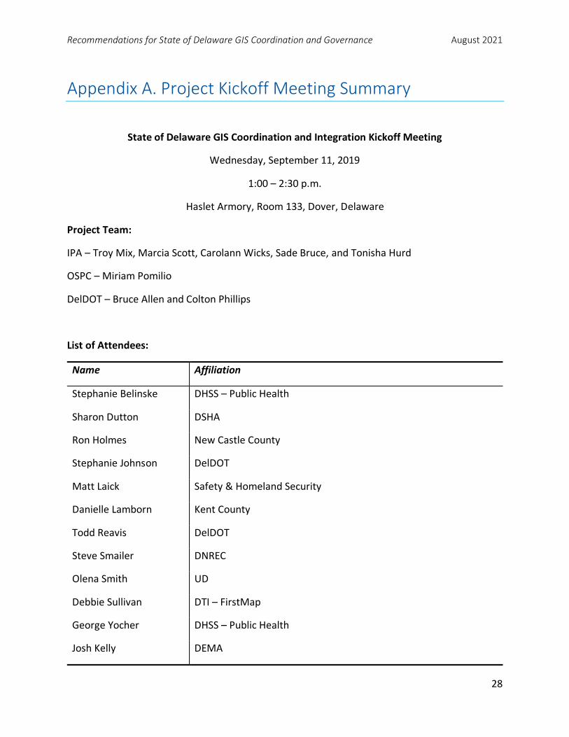
Recommendations for State of Delaware GIS Coordination and Governance August 2021
28
Appendix A. Project Kickoff Meeting Summary
State of Delaware GIS Coordination and Integration Kickoff Meeting
Wednesday, September 11, 2019
1:00 – 2:30 p.m.
Haslet Armory, Room 133, Dover, Delaware
Project Team:
IPA – Troy Mix, Marcia Scott, Carolann Wicks, Sade Bruce, and Tonisha Hurd
OSPC – Miriam Pomilio
DelDOT – Bruce Allen and Colton Phillips
List of Attendees:
Name Affiliation
Stephanie Belinske DHSS – Public Health
Sharon Dutton DSHA
Ron Holmes New Castle County
Stephanie Johnson DelDOT
Matt Laick Safety & Homeland Security
Danielle Lamborn Kent County
Todd Reavis DelDOT
Steve Smailer DNREC
Olena Smith UD
Debbie Sullivan DTI – FirstMap
George Yocher DHSS – Public Health
Josh Kelly DEMA

Recommendations for State of Delaware GIS Coordination and Governance August 2021
29
Summary of Proceedings:
I. Welcome and Introductions
a. DelDOT’s Bruce Allen and OSPC’s Miriam Pomilio welcomed the group. Allen
explained that this project aligns with Delaware’s Government Efficiency and
Accountability Review (GEAR) Board initiative. IPA was contracted to provide
applied research, evaluation, and strategic planning services to assess and
recommend potential practices relative to statewide geospatial coordination
efforts and the management and oversight of geospatial mapping and data
integration for all state agencies. The recommendations that come about as a
result of this working group/report will be different from recommendations of
the past because they (the recommendations) are going to GEAR. This increases
the likelihood that there will be action taken after the final report is submitted.
b. Pomilio provided an overview of the GEAR initiative. She explained that this
initiative has been prioritized through GEAR, addressing the lack of “consistent
Geographic Information System (GIS) governance within the state” by
conducting “an independent survey looking at current [geospatial] practices and
ways to improve management and coordination of all geospatial data and
mapping efforts.”
c. Pomilio stated that the project goal is to incorporate better data integration and
mapping, dedicated funding sources, and more efficient coordination for
Delaware’s state government. Through IPA’s report, the group is expected to
provide GEAR with an overview of how the state can better coordinate GIS
efforts while also saving money.
II. Project Purpose and Overview
a. IPA’s Troy Mix introduced himself as the project coordinator and had other team
members (Marcia Scott, Carolann Wicks, Tonisha Hurd, and Sade Bruce)
introduce themselves. He explained that the purpose of this project is to assess
and recommend practices for statewide geospatial coordination efforts (i.e., GIS
governance). The assessment includes:
i. Management and oversight of data acquisition/mapping.
ii. Geospatial data integration for all agencies (into their practices).
b. Within the framework of the Government Efficiency Accountability Review
(GEAR) Board, project tasks/activities will focus on:

Recommendations for State of Delaware GIS Coordination and Governance August 2021
30
i. Increased efficiency and effectiveness.
ii. Improved strategic planning.
iii. Metrics to inform resource allocation.
iv. Institutionalizing continuous improvement.
c. The approach includes a scan of best practices on governance in other states,
but the focus is more on building and institutionalizing practical approaches that
work for Delaware’s context. Mix noted that we’re not starting from scratch.
From DataMIL forward, at least, Delaware’s efforts have been recognized as high
quality and these efforts have depended on formal/informal collaboration
structures that evidently add value. What works depends on context (above) and
what you want. The research, discussions, and deliberations will be bounded by
the goals of GEAR. The goal is to set up an ongoing framework, not just
addressing known or near-term needs. This includes:
i. Involving new partners through resource propagation.
ii. Incubating, testing, and refining new and existing applications.
iii. Moving from “what’s seemed to work” to “evidence-based ROIs.”
d. The project time frame was discussed. It is projected to take about nine months
to complete. A questionnaire about the current state of GIS in Delaware will be
sent out in late October/early November. IPA will need the working group’s help
identifying potential recipients. After reviewing the results of the questionnaire,
stakeholder listening sessions will be held. These meetings will take place during
November and December. In January, the first draft of the framing report will be
submitted to the working group. This preliminary report will contain alternative
approaches to reinvigorate GIS Delaware. It will frame questions around “what
if… ?” in order to encourage dialogue within the working group. Example
questions include:
i. What if Delaware did XYZ? How would it work? What would the
challenges be? What people should be involved? How costly would this
be (in terms of time and money)? What would the ROI be? What ROI
already exists?
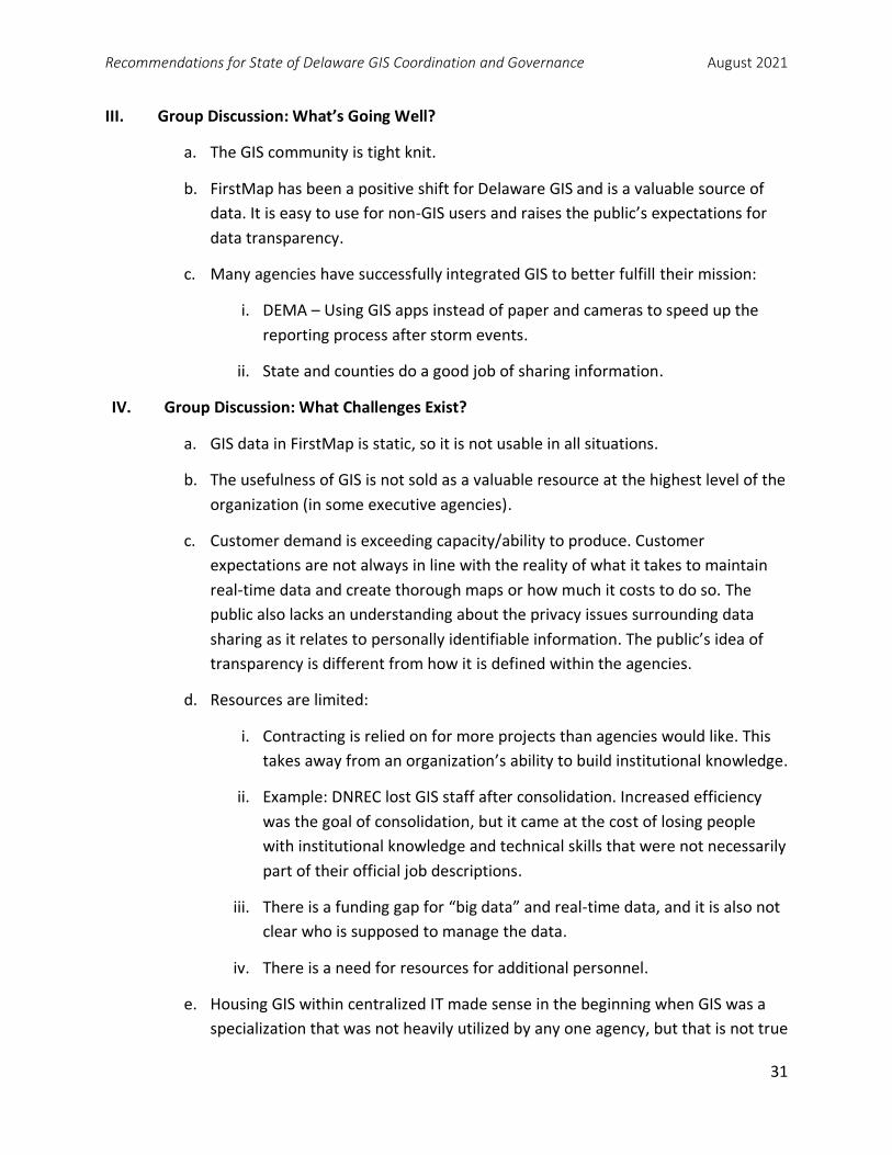
Recommendations for State of Delaware GIS Coordination and Governance August 2021
31
III. Group Discussion: What’s Going Well?
a. The GIS community is tight knit.
b. FirstMap has been a positive shift for Delaware GIS and is a valuable source of
data. It is easy to use for non-GIS users and raises the public’s expectations for
data transparency.
c. Many agencies have successfully integrated GIS to better fulfill their mission:
i. DEMA – Using GIS apps instead of paper and cameras to speed up the
reporting process after storm events.
ii. State and counties do a good job of sharing information.
IV. Group Discussion: What Challenges Exist?
a. GIS data in FirstMap is static, so it is not usable in all situations.
b. The usefulness of GIS is not sold as a valuable resource at the highest level of the
organization (in some executive agencies).
c. Customer demand is exceeding capacity/ability to produce. Customer
expectations are not always in line with the reality of what it takes to maintain
real-time data and create thorough maps or how much it costs to do so. The
public also lacks an understanding about the privacy issues surrounding data
sharing as it relates to personally identifiable information. The public’s idea of
transparency is different from how it is defined within the agencies.
d. Resources are limited:
i. Contracting is relied on for more projects than agencies would like. This
takes away from an organization’s ability to build institutional knowledge.
ii. Example: DNREC lost GIS staff after consolidation. Increased efficiency
was the goal of consolidation, but it came at the cost of losing people
with institutional knowledge and technical skills that were not necessarily
part of their official job descriptions.
iii. There is a funding gap for “big data” and real-time data, and it is also not
clear who is supposed to manage the data.
iv. There is a need for resources for additional personnel.
e. Housing GIS within centralized IT made sense in the beginning when GIS was a
specialization that was not heavily utilized by any one agency, but that is not true

Recommendations for State of Delaware GIS Coordination and Governance August 2021
32
anymore. GIS has since become a tool for all agencies, and different agencies
have different needs and data sets. (Question from working group: what
datasets are important for all agencies?)
f. The legislation that consolidates IT positions into one agency is very broad.
Positions categorized as IT positions don’t always have explicit IT responsibilities.
Sometimes they are management positions that oversee the IT work of a
particular agency or department (i.e., technician vs. planner classification). As a
result, many agencies have renamed positions to avoid losing people.
i. Agency ability to develop GIS strategy plans was weakened.
ii. There are loose agency/unit data requirements. Need more stringent
requirements to make data sharing easier/more seamless.
iii. There should be several GIS coordinators across agencies who talk to
each other and work together. We currently lack people who understand
the business analysis/business intelligence aspects.
V. How Are Needs Expressed within an Agency? Statewide? How Does It Impact the
Competition for Resources?
a. There is no coordination for funding, so agencies tend to “pass the hat” to cover
the costs of certain projects. This partnering is not sustainable or strategic.
b. It would be nice if the state had a dedicated fund to provide certain base layers
to all agencies while also giving agencies the option to “buy up” for any extras
they might need or want (e.g., increased resolution). Without a centralized
strategy from the state, it is not clear what they will pay for and what the
agencies need to provide for themselves. Sometimes agencies pay for data that
another agency or unit already has.
c. People don’t know what they don’t know. Managers don’t know what to ask for
if they don’t know what GIS is capable of. There is a need for some sort of basic
training to provide staff with an understanding of what GIS can accomplish.
VI. What Would Success in GIS Coordination and Integration Look Like?
a. Funding for the three big datasets: LIDAR, aerial imagery, and LULC.
b. Dedicated funding for GIS positions and better position classification systems.

Recommendations for State of Delaware GIS Coordination and Governance August 2021
33
i. Full-time GIS positions in every agency: Many people who have GIS duties
do so unofficially and on top of their core job responsibilities. If this
person is lost, there is no position to fill to get those skills back.
ii. Need to fill potholes left by missing technical people.
c. People who are familiar with GIS business process and coordination needs at all
levels (i.e., GIS coordinators).
d. GIO position.
e. A way to facilitate better data sharing across agencies:
i. Creation of applications to share and leverage data strategically.
ii. Data quality objectives and standards needed as part of governance
process. What are critical data framework elements?
iii. Way to identify multi-agency data needs.
f. Universal templates to document ROI to provide finance with the information
they want and need.
g. More real-time data.
h. Education on how to use GIS and what it is for.
i. For example, by digitizing the fieldwork, the Department of Agriculture
was able to save time and money in its farmland preservation project.
i. Agile partnerships.
j. Going paperless as a result of digital maps.
VII. Project Path Forward
a. Marcia Scott talked about the questionnaire as a way to find out if there are
other units or agencies that IPA needs to include in the conversation.
Participants expressed a desire to collaborate on and coordinate the collection of
this data.

Recommendations for State of Delaware GIS Coordination and Governance August 2021
34
Appendix B. Summary of GIS Coordination in Delaware Survey
The GIS Coordination in Delaware Survey was administered online between November 13 and
22, 2019, to approximately 90 individuals who were identified as GIS stakeholders in the state.
Fifty-six of these 90 GIS stakeholders completed the survey—a 62 percent response rate.
The 18 questions in the survey focused on characterizing the respondents, understanding the
usage of GIS, cataloguing the benefits of GIS use, and gathering perspectives on existing
coordination and integration approaches in Delaware.
Respondent Characteristics
Survey questions 3 and 4 asked respondents to best describe their organization/agency and
their professional role. Most respondents were from state agencies (64%), with responses also
collected in descending frequency from municipalities, counties, institutions of higher
education, MPOs, and federal agencies.
When asked to identify their professional role, 21 respondents self-identified as GIS Managers,
while 35 respondents identified as GIS Practitioners.
GIS Use
Questions 5–8 asked respondents about the frequency and the importance of GIS usage within
a respondent’s organization. The majority of managers’ organizations (80%) and practitioners
(76%) use GIS on a daily basis. With the mission of their organization in mind, 90 percent of
managers believe the use of GIS is important, while 91 percent of practitioners believe the use
of GIS is important.
Question 9 asked, “What tasks does your organization use GIS for?” Respondents indicated that
GIS is used for a wide variety of tasks. Managers and practitioners concurred on the following
top tasks: (1) producing maps for internal or external documents, (2) developing organization-
specific data and basemaps; and (3) analyzing data for policy development, planning, or
evaluation purposes.
Figures B-1 shows the breakdown of GIS uses within organizations, as indicated by managers
and practitioners.

Recommendations for State of Delaware GIS Coordination and Governance August 2021
35
Figure B-1. GIS Tasks Indicated by Managers (n=113) and Practitioners (n=164)
Benefits of GIS Applications
Question 11 asked respondents, “How effective is your organization in using GIS technology to
achieve its mission?” Among the 54 responses, 44 percent deemed GIS as effective while 39
percent chose somewhat effective, and 12 percent thought it was neither effective nor
ineffective.
Managers and practitioners were asked a series of questions regarding return on investment
from using GIS. Question 12 asked, “Has your organization realized a positive return on
investment (ROI) from its use of GIS?” Both managers (85%) and practitioners (79%) indicated
that their organizations have realized a positive ROI from its use of GIS.
If a respondent answered “yes” to the presence of a positive ROI, a follow-up question asked,
“In which of the following areas do you feel your organization has realized a positive ROI from
its use of GIS?” Managers highlighted evidence-based decision-making as a top ROI area,
whereas practitioners indicated that higher-quality research was a top ROI area. Figure B-2
displays the positive ROI responses as indicated by managers and practitioners.
5
21
14
15
24
24
30
31
7
11
14
14
15
16
17
19
0 10 20 30 40
Other (please specify)
Developing applications to share information with orgather information from the public
Managing assets or infrastructure
Conducting field surveys or inspections
Generating public-facing data (e.g., layers for sharing onFirstMap)
Analyzing data for policy development, planning, orevaluation purposes
Developing organization-specific data and basemaps
Producing maps for internal or external documents
Managers Practicioners

Recommendations for State of Delaware GIS Coordination and Governance August 2021
36
Figure B-2. Positive ROI as Indicated by Managers (n=84) and Practitioners (n=121)
Barriers to Optimal GIS Usage
Question 14 asked respondents, “Has your organization experienced barriers to its optimal use
of GIS?” Managers (79%) and practitioners (74%) have experienced barriers to optimal use of
GIS in their organizations. If a respondent identified GIS barriers, a follow-up question asked,
“Which of the following factors are barriers to your organization’s optimal use of GIS?”
Managers responded that both staffing resources (27%) and funding (27%) are top barriers.
Practitioners indicated that support from agency/organization management (21%) and staffing
resources (20%) are leading barriers.
FirstMap Benefits
Question 16 asked respondents to, “Indicate the extent to which you agree or disagree with the
following statements: FirstMap has enabled my organization to be more efficient; FirstMap has
increased support for GIS usage in my organization; FirstMap offers an easily navigable portal
for finding geospatial data; FirstMap enables my organization to share data with citizens and
2
16
21
7
15
18
19
23
4
10
10
10
11
12
13
14
0 5 10 15 20 25
Other (please specify)
Reduced costs due to more efficient workflows
Faster completion of tasks due to more efficient workflows
Cost avoidance and savings from improved monitoring andmaintenance of assets
Enhanced transparency to the public or organizationalstakeholders
Improved customer service
Increased capacity for evidence-based decisionmaking
Higher quality research or analysis
Managers Practicioners

Recommendations for State of Delaware GIS Coordination and Governance August 2021
37
collaborating agencies; FirstMap saves my organization time or money by providing a
centralized source for accessing GIS data.”
Most respondents completely agree or generally agree that FirstMap provides benefits to their
organizations. Managers either completely agree (42%) or agree (42%) with the statement that
FirstMap has enabled their organizations to be more efficient. Forty-seven percent of managers
generally agree that FirstMap offers an easily navigable portal for finding geospatial data.
Practitioners indicated significant levels of “complete agreement” with the following
statements regarding FirstMap: (1) It saves their organization time or money by providing a
centralized source for accessing GIS data (53%); (2) It has enabled my organization to be more
efficient (47%); and (3) It offers an easily navigable portal for finding geospatial data (44%).
GIS Coordination and Integration
To better understand how GIS is coordinated and integrated in Delaware, Question 17
asked, “To what extent do you agree or disagree with the following statements regarding
the current state of GIS coordination and integration in Delaware.” A detailed accounting of
managers and practitioner stances on the provided statements are listed in tables B-1 and
B-2.
Table B-1. Managers’ Stance on Coordination and Integration Statements (n=19)
Completely
agree
Generally
agree
Neither agree
nor disagree
Generally
disagree
Completely
disagree
There are sufficient opportunities
for GIS training. 1 8 5 4 1
GIS staffing levels are adequate. 0 2 8 8 1
Access to needed GIS datasets is
sufficient. 0 9 7 3 0
Available Delaware GIS datasets
are accurate. 1 11 5 1 1
Funding for acquiring GIS data is
adequate. 0 4 4 7 4
Decision makers in your
organization provide sufficient
support for GIS technology and
applications.
2 8 2 4 3

Recommendations for State of Delaware GIS Coordination and Governance August 2021
38
Table B-2. Practitioners’ Stance on Coordination and Integration Statements (n=33)
Completely
agree
Generally
agree
Neither agree
nor disagree
Generally
disagree
Completely
disagree
There are sufficient opportunities
for GIS training. 6 10 11 5 1
GIS staffing levels are adequate. 4 3 14 11 1
Access to needed GIS datasets is
sufficient. 5 15 10 3 0
Available Delaware GIS datasets
are accurate. 5 21 6 1 0
Funding for acquiring GIS data is
adequate. 3 1 11 9 9
Decision makers in your
organization provide sufficient
support for GIS technology and
applications.
5 7 10 8 3
Additional Comments
Lastly, participants were given the opportunity to, “Make any additional comments you would
like to provide regarding the current state of and future opportunities for GIS coordination and
integration in Delaware.” The following lists provide abstracts of top responses provided by
managers and practitioners.
Summary of Comments – Managers
• DGDC is functioning well for data sharing.
• Some agencies are limited in knowledge of FirstMap benefits.
• Organizational structures do not support continuity with GIS capabilities (e.g., staffing
changes).
• Not all agencies share data well (e.g., lack of data access).
• Lack of upper management support.
• Lack of adequate funding and staff training.

Recommendations for State of Delaware GIS Coordination and Governance August 2021
39
Summary of Comments – Practitioners
• Lack of data sharing from municipalities.
• Lack of consistent, adequate funding for statewide uses such as aerial photography.
• Not sharing costs equitably (e.g., passing the hat; DTI maintenance agreements).
• Lack of consistent job titles/responsibilities.
• Data sets are inconsistent among users.
• No data maintenance/management protocols.
• Delaware open data legislation? No coordination with GIS community. Less successful
open data portal?
• DTI needs a more active role to reduce one-off solutions.
• Inadequate and unorganized training.
• Lack of knowledge on upcoming technology trends.
• Practitioners and managers lack access to cabinet level/directors for critical GIS
decisions.
• No marketing of FirstMap to agencies/external partners.
• Ineffective executive council – not their area of expertise.
• Need to move from seeing GIS as a nice tool to a mission-critical technical resource.

Recommendations for State of Delaware GIS Coordination and Governance August 2021
40
Appendix C. GIS Coordination in Delaware Survey Q1 Dear Delaware GIS Stakeholder -
Many state agencies and external partners use geospatial technology, data, and applications for the public good.
Through Delaware's Government Efficiency and Accountability Review Board (GEAR) initiative, a study has been
commissioned to evaluate the efficacy of the existing structure for the management and oversight of geospatial
data and applications across state agencies, as well as the coordination of geospatial efforts among state agencies
and external partners.
The University of Delaware’s Institute for Public Administration (IPA) has been contracted to complete research
that assesses and recommends practices relative to statewide geospatial coordination efforts and GIS governance
practices. As part of this research, IPA is conducting an online survey of Delaware state agencies and external
entities that use geospatial data. The purpose of this survey is to understand what's working well, what current
challenges exist, and what needs to be done to collectively work toward a more coordinated and integrated GIS
system for Delaware. Follow-up interviews and listening sessions will be scheduled to detail and refine findings
from this survey.
The survey is voluntary and should take about 15 minutes to complete. All individual responses will remain
confidential. The information you share will be reported in the aggregate only and will contain no references to
individual respondents. For more information about this survey or project, please contact IPA Policy Scientist Troy
Mix ([email protected]) or (302) 831-6191.
Please select "Yes" (below) if you have read and understand this informed-consent statement and agree to take
the survey. If you elect not to participate in the survey, select "No."
o Yes, I consent to participate in the survey
o I do not consent, I do not wish to participate

Recommendations for State of Delaware GIS Coordination and Governance August 2021
41
Q2 Which of the following best describes your organization?
o Delaware state agency (please specify) ________________________________________________
o Federal agency
o Metropolitan Planning Organization
o Municipality
o County
o College/University
o Other (please specify) ________________________________________________ Q3 Which of the following best describes your professional role?
o I supervise GIS analysts or specialists, or manage an organization where GIS work is completed
o I am a GIS practitioner and use GIS for my professional work Q4 About how frequently is GIS used in your organization? (Please select one)
o Daily
o Weekly
o Once or twice a month
o Several times per year
o Once or twice per year
o Never
Q5 About how frequently do you use GIS for your organization's work? (Please select one)
o Daily
o Weekly
o Once or twice a month
o Several times per year
o Once or twice per year
o Never

Recommendations for State of Delaware GIS Coordination and Governance August 2021
42
Q6 When thinking about the mission of your organization, how important is the use of GIS?
o Important
o Somewhat Important
o Neither important nor unimportant
o Somewhat unimportant
o Unimportant Q7 When thinking about your job duties and responsibilities, how important is your use of GIS?
o Important
o Somewhat Important
o Neither important nor unimportant
o Somewhat unimportant
o Unimportant
Q8 What tasks does your organization use GIS for? (Select all that apply)
▢ Developing organization-specific data and basemaps
▢ Generating public-facing data (e.g., layers for sharing on FirstMap)
▢ Analyzing data for policy development, planning, or evaluation purposes
▢ Producing maps for internal or external documents
▢ Developing applications to share information with or gather information from the public
▢ Managing assets or infrastructure
▢ Conducting field surveys or inspections
▢ Other (please specify) ________________________________________________

Recommendations for State of Delaware GIS Coordination and Governance August 2021
43
Q9 What tasks do you use GIS for as a part of your work? (Select all that apply)
▢ Developing organization-specific data and basemaps
▢ Generating public-facing data (e.g., layers for sharing on FirstMap)
▢ Analyzing data for policy development, planning, or evaluation purposes
▢ Producing maps for internal or external documents
▢ Developing applications to share information with or gather information from the public
▢ Managing assets or infrastructure
▢ Conducting field surveys or inspections
▢ Other (please specify) ________________________________________________ Q10 How effective is your organization in using GIS technology to achieve its mission?
o Effective
o Somewhat effective
o Neither effective or ineffective
o Somewhat ineffective
o Ineffective Q11 Has your organization realized a positive return on investment (ROI) from its use of GIS?
o No
o Yes

Recommendations for State of Delaware GIS Coordination and Governance August 2021
44
Q12 In which of the following areas do you feel your organization has realized a positive ROI from its use of GIS? (Select all that apply)
▢ Reduced costs due to more efficient workflows
▢ Faster completion of tasks due to more efficient workflows
▢ Increased capacity for evidence-based decision-making
▢ Higher quality research or analysis
▢ Cost avoidance and savings from improved monitoring and maintenance of assets
▢ Improved customer service
▢ Enhanced transparency to the public or organizational stakeholders
▢ Other (please specify) ________________________________________________ Q13 If your organization has experienced a positive ROI from its use of GIS, please provide one or more specific examples.
________________________________________________________________

Recommendations for State of Delaware GIS Coordination and Governance August 2021
45
Q14 Has your organization experienced barriers to its optimal use of GIS?
o No
o Yes Q15 In your opinion, which of the following factors are barriers to your organization's optimal use of GIS? (Select all that apply)
▢ Access to GIS data
▢ Access to hardware and software resources
▢ Staffing resources
▢ Funding levels
▢ Support from agency/organization management
▢ Other (please specify) ________________________________________________

Recommendations for State of Delaware GIS Coordination and Governance August 2021
46
Q16 FirstMap is Delaware's self-service Enterprise Geographic Information System that is designed to support the GIS needs of all state agencies, counties, municipalities, higher education, and the public. Indicate the extent to which you agree or disagree with the following statements.
Completely
agree Generally agree
Neither agree nor disagree
Generally disagree
Completely disagree
FirstMap has enabled my
organization to be more efficient.
o o o o o
FirstMap has increased
support for GIS usage in my
organization.
o o o o o
FirstMap offers an easily
navigable portal for finding
geospatial data.
o o o o o
FirstMap enables my
organization to share data with
citizens and collaborating
agencies.
o o o o o
FirstMap saves my organization time or money by providing a
centralized source for
accessing GIS data.
o o o o o

Recommendations for State of Delaware GIS Coordination and Governance August 2021
47
Q17 To what extent do you agree or disagree with the following statements regarding the current state of GIS coordination and integration in Delaware.
Completely
agree Generally agree
Neither agree nor disagree
Generally disagree
Completely disagree
There are sufficient
opportunities for GIS training.
o o o o o
GIS staffing levels are adequate. o o o o o Access to
needed GIS datasets is sufficient.
o o o o o
Available Delaware GIS datasets are
accurate. o o o o o
Funding for acquiring GIS
data is adequate.
o o o o o
Decision makers in your
organization provide
sufficient support for GIS technology and
applications.
o o o o o
Q18 Please make any additional comments you would like to provide regarding the current state of and future opportunities for GIS coordination and integration in Delaware.
________________________________________________________________ ________________________________________________________________ ________________________________________________________________ ________________________________________________________________ ________________________________________________________________

Recommendations for State of Delaware GIS Coordination and Governance August 2021
48
Appendix D. Synopsis of Survey and Listening Sessions

Recommendations for State of Delaware GIS Coordination and Governance August 2021
49

Recommendations for State of Delaware GIS Coordination and Governance August 2021
50

Recommendations for State of Delaware GIS Coordination and Governance August 2021
51

Recommendations for State of Delaware GIS Coordination and Governance August 2021
52

Recommendations for State of Delaware GIS Coordination and Governance August 2021
53

Recommendations for State of Delaware GIS Coordination and Governance August 2021
54

Recommendations for State of Delaware GIS Coordination and Governance August 2021
55

Institute for Public AdministrationBiden School of Public Policy & Administration
University of Delaware
180 Graham Hall University of Delaware Newark, DE 19716-7380
phone: 302-831-8971 email: [email protected] fax: 302-831-3488
www.ipa.udel.edu
The University of Delaware’s Institute for Public Administration (IPA)
addresses the policy, planning, and management needs of its partners
through the integration of applied research, professional development,
and the education of tomorrow’s leaders.
The University of Delaware is an equal opportunity/affirmative action employer and Title IX institution. For the University’s complete non-discrimination statement, please visit http://www.udel.edu/home/legal-notices/
Institute forPublic AdministrationSCHOOL OF PUBLIC POLICY & ADMINISTRATION