recommendations - review of lower lachlan groundwater
TRANSCRIPT

November 2006
SCIENTIFIC REVIEW
LOWER LACHLAN GROUNDWATER SHARING
PLAN

Scientific review
Lower Lachlan Groundwater Sharing Plan
NOVEMBER 2006

Enquiries Enquiries about this Report should be directed to: Katrina Van Lint Phone (02) 8227 4300 Fax (02) 8227 4399 E-mail [email protected] Postal address GPO Box 4206, Sydney NSW 2001
List of acronyms DNR Department of Natural Resources GDE Groundwater dependent ecosystem LLGSP Lower Lachlan Groundwater Sharing Plan NRC Natural Resources Commission NSW New South Wales URS URS Australia Pty Ltd This work is copyright. The Copyright Act 1968 permits fair dealing for study, research, news reporting, criticism and review. Selected passages, tables or diagrams may be reproduced for such purposes provided acknowledgement of the source is included. Document No. DO6/2912 ISBN: 1 921050 25 X

Table of Contents
1 Introduction 5
1.1 Summary of findings and recommendations 5
1.2 Process for review 6
2 Scientific basis for current estimated average annual recharge 8
3 Surface water flow requirements 10
4 Exclusion of recharge estimates west of Cobb Highway 11
5 Provision for groundwater dependent ecosystems 12
Attachment 1 – Terms of Reference
Attachment 2 –Scientific Expert Review

Natural Resources Commission Scientific Review Published: November 2006 Lower Lachlan Groundwater Sharing Plan
Document No: D06/2912 Page: 5 of 17 Status: Final Version: 1.1
1 Introduction The Natural Resources Commission (NRC) was asked to review the scientific basis of aspects of the Water Sharing Plan for the Lower Lachlan Groundwater Source (LLGSP) prior to the plan’s commencement. The Premier requested the review on 10 October in response to concerns of stakeholders about elements of the plan. In particular the Government sought advice on:
1. the scientific basis for the estimated average annual recharge
2. the Lachlan surface water flow requirements to provide for the average annual recharge
3. the scientific basis for exclusion of recharge estimates west of the Cobb Highway
4. the scientific basis for the provision of water for groundwater dependent ecosystems (GDEs).1
This report outlines in brief the NRC’s findings and recommendations on each of these issues. The NRC commissioned URS Australia Pty Ltd (URS) to undertake a scientific review including coordinating input from a number of relevant experts. The NRC has drawn on the URS report to develop its findings and recommendations. The content of the URS report is not repeated but is included as Attachment 2. It should be referred to for more detailed documentation of the scientific evidence that informed the NRC’s recommendations.
1.1 Summary of findings and recommendations Overall, the NRC has found that the information used to inform the average annual recharge estimate and the provision for GDEs contains relatively high levels of uncertainty. Improving the knowledge base is critical to improving the quality of the plan and to providing greater certainty for groundwater users. In respect to each of the Terms of Reference, the key findings are that:
the average annual recharge estimate of 120 GL currently used in the LLGSP is close to and within the wide error band of the best scientific estimate of 115 GL
the best available information suggests that Lachlan River surface water flows, including both river leakage and overbank flows, contribute approximately 67 GL to average annual recharge for the groundwater source
there is a sound rationale for excluding recharge estimates west of the Cobb Highway in the overall estimate of recharge for the management unit and a similar rationale could be applied to the saline portions of other zones of the management unit
there is no scientific basis for the current provision for GDEs in the LLGSP – specific ecosystems dependent on the Lachlan Groundwater Source have not been identified but this does not mean that there are no ecosystems dependent on groundwater that flows through the Lower Lachlan groundwater management area.
The NRC has developed a series of recommendations in response to these findings. Some of the NRC’s recommendations focus on making provisions in the plan for the uncertainty in the available information as well as improving the information base that informs the plan. This
1 The Terms of Reference were received on 10 October 2006 and are included in Attachment 1.

Natural Resources Commission Scientific Review Published: November 2006 Lower Lachlan Groundwater Sharing Plan
Document No: D06/2912 Page: 6 of 17 Status: Final Version: 1.1
should allow scheduled reviews of the plan to be brought forward as this information becomes available. Significant advances in the quality of the plan are unlikely without this additional work. The NRC’s recommendations are:
1. A precautionary approach to setting extraction limits within the plan should be adopted because of the high level of uncertainty in the recharge estimate—one approach is to reduce extraction limits to at least 20 percent below the estimate of average annual recharge however socio-economic impacts and equity across valleys should be considered before adopting such an approach.
2. The average annual recharge estimate used in the LLGSP should be reviewed when the enhanced Department of Natural Resources (DNR) numerical model has been completed, which is expected to be within three years. The LLGSP should be amended if the refined recharge estimate is significantly different from the existing estimate.
3. Estimates of the Lachlan River’s contribution to the groundwater average annual recharge estimate should be further refined as part of DNR’s numerical modelling.
4. Estimates of the Lachlan River’s contribution to groundwater recharge should be integrated into the Water Sharing Plan for the Lachlan Regulated River Water Source once they have been refined.
5. Further studies within and outside the groundwater management area should be undertaken and completed as soon as possible to determine the occurrence of GDEs.
6. Any provision for GDEs contained in the LLGSP should be reviewed following completion of additional GDE studies, which is expected to be within 18 months. The plan should be amended, if warranted, and should make provision for GDEs if studies demonstrate that there are GDEs dependent on the Lower Lachlan Groundwater Source.
1.2 Process for review The major components of the review process are described in Table 1.1. Additional detail of the Scientific Expert Review is included in Attachment 2.

Natural Resources Commission Scientific Review Published: November 2006 Lower Lachlan Groundwater Sharing Plan
Document No: D06/2912 Page: 7 of 17 Status: Final Version: 1.1
Table 1.1 Steps in review process
Review Component Process
1. Commission independent Scientific Expert Review
The NRC appointed URS to lead an independent scientific review of components of the plan.
2. Consultation with stakeholders
URS consulted stakeholders to understand their key concerns and to help identify available information.
3. Expert workshop URS facilitated a workshop of experts2 to examine the conceptual model of the groundwater system and its interaction with surface water.
4. Review of GDEs Existing information and evidence of GDEs was evaluated.
5. Preparation of review report
URS drafted, and finalised its report:
Scientific Expert Review for the Lower Lachlan Groundwater Sharing Plan (Scientific Expert Review)3
The draft report was peer reviewed by participants at the workshop.
6. NRC findings and recommendations
The NRC prepared its findings and recommendations after considering the evidence documented in the Scientific Expert Review.
2 Experts included three specifically engaged for the review, DNR staff and experts engaged by groundwater users. 3 Scientific Expert Review for the Lower Lachlan Groundwater Sharing Plan (URS, 2006) is included in Attachment 2.

Natural Resources Commission Scientific Review Published: November 2006 Lower Lachlan Groundwater Sharing Plan
Document No: D06/2912 Page: 8 of 17 Status: Final Version: 1.1
2 Scientific basis for current estimated average annual recharge
The estimated average annual recharge for the Lower Lachlan Groundwater Source in the current LLGSP is 120 GL per annum. This is close to and well within the error bands of the best scientific estimate which is 115 GL per annum. However, this scientific estimate is only of low to moderate reliability. Given the high levels of uncertainty in the estimate, the NRC believes a precautionary approach is warranted when setting extraction limits in the LLGSP. The Scientific Expert Review describes and assesses four methods that have been used to derive estimates of average annual recharge for the Lower Lachlan Groundwater Source over the last ten years. The four estimates range from 62 to 150 GL per annum. The Scientific Expert Review was not able to quantify the uncertainties associated with each estimate given the available information. It has rated confidence in two of the estimates as ‘low’ and in the two most recent estimates as ‘low to moderate’. The latter were 122 GL and 115 GL. The 115 GL estimate is considered the best to date. However, uncertainty in this estimate is still high and has been estimated at +/- 70% in one instance.4 The Scientific Expert Review judged that the uncertainty in the 115 GL per annum estimate could not be significantly reduced in the immediate term using available data. However, DNR is currently developing a more accurate numerical model to assess the estimated average annual recharge. This model is expected to be completed within approximately three years. It is likely that the current average annual recharge estimate will change as DNR progressively improves the numerical model and additional data and monitoring are used to reduce the uncertainty associated with each element of the estimate. The NRC believes it would be prudent to set the annual extraction limit below the current estimate of average recharge because:
the Scientific Expert Review suggests that the 115 GL per annum estimate includes an over-estimate of the contribution of rainfall
the Scientific Expert Review states there is only low to moderate confidence in the overall estimate
the estimate, which was derived using historic data, does not take into account the expected impact of climate change.
The only quantitative estimate available to indicate the extent of uncertainty associated with the best average annual recharge estimate suggests that uncertainty may be as high as +/- 70%.4 This estimate was calculated by summing the error estimates of the individual components of the water balance used in this instance. Attendees at the Expert Workshop considered this uncertainty estimate to be potentially at the upper end of the scale. When determining a feasible uncertainty factor to apply, issues that are conventionally considered include the principles of ecologically sustainable development and risk management. In this case, the principles of ecologically-sustainable development trigger the need to apply an uncertainty factor to provide protection for unsustainable use of the resource. In addition, the principles of risk management determine the appropriate size of the uncertainty
4 This is the error calculated by CM Jewell and Associates when using the water balance method to derive estimates.
Natural Resources Commission Scientific Review Published: November 2006 Lower Lachlan Groundwater Sharing Plan
Document No: D06/2912 Page: 9 of 17 Status: Final Version: 1.1
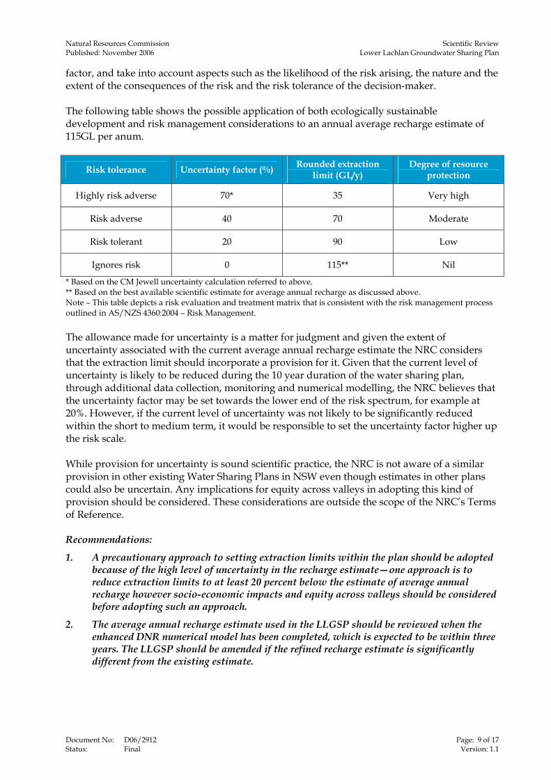
factor, and take into account aspects such as the likelihood of the risk arising, the nature and the extent of the consequences of the risk and the risk tolerance of the decision-maker. The following table shows the possible application of both ecologically sustainable development and risk management considerations to an annual average recharge estimate of 115GL per anum.
Risk tolerance Uncertainty factor (%) Rounded extraction limit (GL/y)
Degree of resource protection
Highly risk adverse 70* 35 Very high
Risk adverse 40 70 Moderate
Risk tolerant 20 90 Low
Ignores risk 0 115** Nil
* Based on the CM Jewell uncertainty calculation referred to above. ** Based on the best available scientific estimate for average annual recharge as discussed above. Note – This table depicts a risk evaluation and treatment matrix that is consistent with the risk management process outlined in AS/NZS 4360:2004 – Risk Management. The allowance made for uncertainty is a matter for judgment and given the extent of uncertainty associated with the current average annual recharge estimate the NRC considers that the extraction limit should incorporate a provision for it. Given that the current level of uncertainty is likely to be reduced during the 10 year duration of the water sharing plan, through additional data collection, monitoring and numerical modelling, the NRC believes that the uncertainty factor may be set towards the lower end of the risk spectrum, for example at 20%. However, if the current level of uncertainty was not likely to be significantly reduced within the short to medium term, it would be responsible to set the uncertainty factor higher up the risk scale. While provision for uncertainty is sound scientific practice, the NRC is not aware of a similar provision in other existing Water Sharing Plans in NSW even though estimates in other plans could also be uncertain. Any implications for equity across valleys in adopting this kind of provision should be considered. These considerations are outside the scope of the NRC’s Terms of Reference. Recommendations:
1. A precautionary approach to setting extraction limits within the plan should be adopted because of the high level of uncertainty in the recharge estimate—one approach is to reduce extraction limits to at least 20 percent below the estimate of average annual recharge however socio-economic impacts and equity across valleys should be considered before adopting such an approach.
2. The average annual recharge estimate used in the LLGSP should be reviewed when the enhanced DNR numerical model has been completed, which is expected to be within three years. The LLGSP should be amended if the refined recharge estimate is significantly different from the existing estimate.
Natural Resources Commission Scientific Review Published: November 2006 Lower Lachlan Groundwater Sharing Plan
Document No: D06/2912 Page: 10 of 17 Status: Final Version: 1.1
3 Surface water flow requirements The NRC was asked to assess the Lachlan River surface water flow required to contribute to the average annual recharge of the Lower Lachlan Groundwater Source. The Scientific Expert Review found that the best available average annual recharge estimate assumes that 40 GL per annum of recharge is derived from leakage from the Lachlan River within the groundwater management area and that 27 GL per annum of recharge is from overbank flows, which occur as floods. The linkages between the Water Sharing Plan for the Lachlan Regulated River Water Source and the LLGSP are currently weak. However, it is evident that the assumed 40 GL per annum from surface water flow to recharge may be provided for through unaccounted losses from the river. For example, the leakage estimate of 40 GL per annum appears to be contained within the model outputs of the DNR IQQM model since unaccounted losses from the river are estimated to be 137 GL per annum. Overbank flows, however, are not explicitly mentioned or provided for in the Water Sharing Plan for the Lachlan Regulated River Water Source, even though these flows are a key recharge source to the groundwater system of the Lower Lachlan Groundwater Source. The Water Sharing Plan for the Lachlan Regulated River Water Source should make provision for overbank flows to ensure that a significant proportion of groundwater recharge is maintained. Recommendations:
3. Estimates of the Lachlan River’s contribution to the groundwater average annual recharge estimate should be further refined as part of DNR’s numerical modelling.
4. Estimates of the Lachlan River’s contribution to groundwater recharge, including both river leakage and overbank flows, should be integrated into the Water Sharing Plan for the Lachlan Regulated River Water Source once they have been refined.

Natural Resources Commission Scientific Review Published: November 2006 Lower Lachlan Groundwater Sharing Plan
Document No: D06/2912 Page: 11 of 17 Status: Final Version: 1.1
4 Exclusion of recharge estimates west of Cobb Highway The area now defined as the Lower Lachlan Groundwater Management Area was previously managed as three zones. Zone 3, located west of the Cobb Highway, was managed in isolation from Zones 1 and 2. A recharge estimate of 23 GL per annum was previously adopted for the more saline Zone 3. When the three zones became one management unit, the 23 GL per annum recharge estimate for Zone 3 was excluded from average annual recharge estimates for the combined system. The NRC has found that the rationale for excluding the estimate is sound. Since most of the recharge to Zone 3 results from additions of rainfall to unusable saline aquifers, it should be accounted for separately to the recharge to the mainly usable, freshwater aquifers of Zones 1 and 2. When Zone 3 was managed independently of Zones 1 and 2, extraction of water from Zone 3 was naturally limited due to the high salinity levels within the zone, resulting in the maximum extraction being less than the recharge estimate. The zone boundaries have now been removed and the recharge component from Zone 3 could potentially be made available for extraction across the entire groundwater management area. However, extraction from Zone 3 would still be naturally limited and as a result unsustainable amounts of freshwater could potentially be extracted from the fresher Zones 1 and 2. Thus, inclusion of Zone 3 recharge in the overall estimate for the groundwater management area would result in an over estimation of the freshwater recharge and unsustainable freshwater extraction from Zones 1 and 2. Finding: The rationale for excluding the Zone 3 recharge estimate from the overall average annual recharge estimate for the groundwater management area is sound.

Natural Resources Commission Scientific Review Published: November 2006 Lower Lachlan Groundwater Sharing Plan
Document No: D06/2912 Page: 12 of 17 Status: Final Version: 1.1
5 Provision for groundwater dependent ecosystems The current plan for the Lower Lachlan Groundwater Source includes a provision of 20 per cent of the average annual recharge for the purpose of supporting GDEs. The NRC found that the provision in the plan was based on negotiation between stakeholders and that at that time there was no scientific basis for this provision. Stakeholders expected that further investigations would be undertaken to better inform the provision for GDEs in the final plan. The Scientific Expert Review identified that no additional study has been undertaken to assess the likelihood of the existence of GDEs dependent on the Lower Lachlan Groundwater Source. Preliminary investigation undertaken as part of the Scientific Expert Review has revealed that there are a number of threatened flora species and communities that are located both within and outside the groundwater management area that may or may not be dependent on the Lower Lachlan Groundwater Source. Some consideration was given to the likely occurrence of GDEs which may include riparian vegetation along the Lachlan River between Lake Brewster and Lake Cargelligo, the Great Cumbung Swamp and the Willandra Lakes system. Recent investigations undertaken by DNR suggest that the Great Cumbung Swamp is not dependent on the Lower Lachlan Groundwater Source. Further study would be required to confirm this and assess the occurrence of other GDEs and their level of dependence on the groundwater source within this area. The State Water Management Outcomes Plan stipulates that in the absence of a detailed assessment of ecosystem dependency, long term average extractions should be limited to:
100 percent of the average annual recharge for a groundwater source where there is no significant ecosystem dependency
70 percent of average annual recharge where there is significant ecosystem dependency.5
Given the inconclusive nature of the evidence, the NRC’s view is that an appropriate provision for GDEs cannot be sensibly determined on a scientific basis until further studies are completed. Recommendations:
5. Further studies within and outside the groundwater management area should be undertaken and completed as soon as possible to determine the occurrence of GDEs.
6. Any provision for GDEs contained in the LLGSP should be reviewed following completion of additional GDE studies, which is expected to be within 18 months. The plan should be amended, if warranted, and should make provision for GDEs if studies demonstrate that there are GDEs dependent on the Lower Lachlan Groundwater Source.
5 State Water Management Outcomes Plan – made in August 2003 under the Water Management Act 2000.

Attachment 1 – Terms of Reference

Premier of New South Wales Australia
1 0 OCT 2006
Dr John Williams Commissioner Natural Resources Commission GPO Box 4206 SYDNEY NSW 2001
Dear Dr Williams,
Pursuant to section 13 of the Natural Resources Commission Act 2003, I request that you carry out a review in relation to elements of the scientific basis of the Lower Lachlan Groundwater Sharing Plan. The terms of reference are to:
1. assess the scientific basis for current estimated average annual recharge for the lower Lachlan Groundwater Source; 2. assess the Lachlan surface water flow requirements to provide for the average annual recharge for the lower Lachlan Groundwater Source; 3. assess the scientific basis and rationale for the exclusion of recharge estimates west of the Cobb Highway (previously Zone 2); and 4. assess the scientific basis for the provision of water for groundwater dependent ecosystems for
the lower Lachlan Groundwater Source and in particular the scientific basis for the 20% default provisions (24,000 ML) for groundwater dependent ecosystems.
Should you have any inquiries concerning the terms of reference or timing of the review, please contact Mr Paul Elton, The Cabinet Office on 9228 5493.
I appreciate your co-operation in this matter.
Yours sincerely
John Watkins MP Acting Premier
LEVEL 39, GOVERNOR MACQUARIE TOWER, 1 FARRER PLACE, SYDNEY 2000, AUSTRALIA TEL: (02)92285239 FAX: (02)9228 3935 URL: www.premiers.nsw.gov.au G.P.O. BOX 5341, SYDNEY 2001.

Attachment 2 –Scientific Expert Review
R E P O R T
Scientific Expert Review for the Lower Lachlan Groundwater Sharing Plan
Prepared for
Natural Resources Commission 15 Castlereagh St Sydney NSW 20 2 November 2006
43270797


Scientific Expert Review for the Lower Lachlan Groundwater Sharing Plan
Contents
Prepared for Natural Resources Commission, 2 November 2006
J:\JOBS\43270797\Reporting\XpertReview3.doc
i
1 Introduction ...................................................................................................................... 1-1
1.1 Terms of Reference 1-1 1.2 Approach 1-1 1.3 Expert Input 1-2
2 Conceptual Model of Groundwater Flow ....................................................................... 2-1
2.1 Lower Lachlan Groundwater Management Area (012) 2-1 2.2 Regional context of GMA 012 2-1 2.3 Relationship between the aquifers and the Lachlan River 2-3
3 Components of the Water Balance................................................................................. 3-1
3.1 Introduction 3-1 3.2 Components of the water balance in the regional flow system 3-2
3.2.1 The natural water balance 3-2
3.2.2 The developed water balance 3-2
3.3 Components of the water balance in the Lower Lachlan GMA 3-3
4 Groundwater recharge and extraction limits................................................................. 4-1
4.1 Previous recharge estimates 4-1 4.1.1 Comparison with Lower Murrumbidgee 4-2
4.1.2 Throughflow and rise 4-2
4.1.3 Data from regional model 4-3
4.1.4 Water balance 4-4
4.2 Adoption of a recharge estimate 4-6 4.3 CM Jewell and Associates Review 4-7 4.4 Lachlan River contributions to recharge 4-8 4.5 Zone 3 recharge 4-8
5 Groundwater Dependent Ecosystems ........................................................................... 5-1
6 Conclusions...................................................................................................................... 6-1
7 Recommendations ........................................................................................................... 7-1
8 References........................................................................................................................ 8-1

Scientific Expert Review for the Lower Lachlan Groundwater Sharing Plan
Contents
Prepared for Natural Resources Commission, 2 November 2006
J:\JOBS\43270797\Reporting\XpertReview3.doc
ii
9 Limitations ........................................................................................................................ 9-1
TABLES
Table 1 Water balance approach .............................................................................................. 4-4
Table 2 Annual groundwater recharge estimates and confidence ............................................ 4-6
FIGURES
Figure 1 Lower Lachlan Groundwater Management Area ........................................................ 2-3
Figure 2 Uppermost aquifers in the Lower Lachlan................................................................... 2-4
Figure 3 Former Groundwater Management Zones - Lower Lachlan ....................................... 2-6
Figure 4 Change in groundwater level from winter 1980 to winter 2005 ................................... 2-7
Figure 5 Hydrogeological boundaries - eastern and central Murray Basin, NSW ..................... 2-2
Figure 6 Hydraulically connected and disconnected reaches Riverine Plain, NSW.................. 2-4
Figure 7 Components of a groundwater water balance ............................................................ 3-1
Figure 8 Arid shrubland distribution north and west of Hillston ................................................. 5-4
Figure 9 Acacia subformation distribution north and west of Hillston........................................ 5-5
Figure 10 Distribution of bores and first water bearing zones ................................................... 5-6
Scientific Expert Review for the Lower Lachlan Groundwater Sharing Plan
Contents
Prepared for Natural Resources Commission, 2 November 2006
J:\JOBS\43270797\Reporting\XpertReview3.doc
iii
APPENDICES
Appendix 1: Geological and hydrogeological features of the region
Appendix 2: Threatened species in the groundwater discharge area
ACRONYMS
The following list of acronyms is used in this report:
ASGE Achieving Sustainable Groundwater Entitlements
CMA Catchment Management Authority
DEC Department of Environment and Conservation
DNR Department of Natural Resources
EL Extraction Limit
ESY Ecologically Sustainable Yield
ET Evapo-transpiration
GMA Groundwater Management Area
GDEs Groundwater Dependent Ecosystems
LGMC Lachlan Groundwater Management Committee
NRC Natural Resources Commission
NSW New South Wales
SWMOP State Water Management Outcomes Plan
WRL Water Research Laboratory, Manly

Scientific Expert Review for the Lower Lachlan Groundwater Sharing Plan
Executive Summary
Prepared for Natural Resources Commission, 2 November 2006
J:\JOBS\43270797\Reporting\XpertReview3.doc
iv
This following summary specifically addresses each of the terms of reference provided for this review. The summary provides a brief overview of the issues associated with each term of reference and also outlines the findings of the expert review.
Assess the scientific basis for current estimated average annual recharge for the Lower Lachlan Groundwater Source
There have been continued attempts to refine the estimate of the annual recharge to the Lower Lachlan Groundwater Management Area. The progression is in the right direction, particularly in light of the limited resources made available by the Department of Natural Resources (DNR) to undertake the task. There is a perception of increased accuracy in terms of the water balance component approach, but further advances can still be made.
The best estimates of annual average recharge to date are 114,100 and 122,200 ML/y, although both estimates are likely to have substantial uncertainty associated with them. It was not possible to quantify these errors on the basis of the information reviewed.
While these are the best estimates they do not, however, represent the best science. A more rigorous approach would be to apply a detailed, moderate complexity numerical groundwater model linked to the IQQM model already developed for the Lachlan River. This modelling approach could be supported by work aimed at better estimating the recharge component from rainfall using hydro-chemical techniques and work aimed at understanding the flood recharge and irrigation components.
There does not appear to be any account of groundwater salinity in the estimate of average annual recharge. It is felt that salinity considerations may reduce the overall volume of groundwater available.
Assess the Lachlan surface water flow requirements to provide for the average annual recharge for the Lower Lachlan Groundwater Source
The water balance component approach estimates that 40,000 ML/y of recharge is derived from leakage from the Lachlan River within the Groundwater Management Area (GMA), and that 27,100 ML/y of recharge occurs from overbank floods.
There is no specific allocation of water from the Water Sharing Plan for the Lachlan Regulated River Water Source to recharge to the Lower Lachlan GMA. However, results from the IQQM model for the Lachlan River show that flow in the River at Lake Cargelligo is always greater

Scientific Expert Review for the Lower Lachlan Groundwater Sharing Plan
Executive Summary
Prepared for Natural Resources Commission, 2 November 2006
J:\JOBS\43270797\Reporting\XpertReview3.doc
v
than 40,000 ML/y and that unaccounted losses for the River between Lake Cargelligo and Booligal are 137,000 ML/y.
This data appears to confirm that the water balance component of river leakage fits within the model outputs of the IQQM model.
There is no explicit mention of overbank flows in the Water Sharing Plan for the Lachlan Regulated River Water Source. There needs to be mention that overbank flows are a key recharge source to the groundwater system of the Lower Lachlan GMA and floodplain flow harvesting rules need to be put in place to protect floods with an average recurrence interval that has been identified as critical to overbank flood recharge.
Assess the scientific basis and rationale for the exclusion of recharge estimates west of the Cobb Highway (previously Zone 3)
The Zone 3 recharge estimate of 23,100 ML/y has been excluded from the overall recharge estimate for the GMA. This is appropriate since rainfall recharge to Zone 3 must infiltrate the overlying saline Shepparton aquifer and hence is not useable.
There are small areas in Zone 3 where rainfall recharge will not be to saline groundwater and recharge to these areas could be attributed to the GMA recharge estimate. However, it would therefore also be appropriate to reduce the rainfall recharge components in Zones 1 and 2 by the volume that falls over areas of saline groundwater in the surficial aquifer for the same reason.
Assess the scientific basis for the provision of water for groundwater dependent ecosystems for the Lower Lachlan Groundwater Source and in particular the scientific basis for the 20% default provisions (24,000 ML/y) for groundwater dependent ecosystems
The default proportion of the estimated average annual recharge to be made available for Groundwater Dependent Ecosystems (GDEs) is set at 30%. There is provision for this proportion to be varied based on consideration of the ecosystems involved. It appears that the 20% proportion adopted in the Lower Lachlan Water Sharing Plan was arrived at after a set of trade-off negotiations. Environmental groups involved were unhappy with this conclusion and delivered a dissenting report on the matter to the Minister.
The discharge zones of the aquifers in the Lachlan GMA are not mapped, fully understood, nor documented. There is inconclusive data and information to decide what GDEs are present either inside the GMA or outside the GMA but dependent on groundwater that flows through the GMA. There have been suggestions that wetlands such as the Great Cumbung Swamp are
Scientific Expert Review for the Lower Lachlan Groundwater Sharing Plan
Executive Summary
Prepared for Natural Resources Commission, 2 November 2006
J:\JOBS\43270797\Reporting\XpertReview3.doc
vi
dependent on groundwater from the productive aquifers, but that has been challenged by reports of investigations from DNR.
There have been other suggestions that riparian vegetation on the Lachlan River between Lake Brewster and Lake Cargelligo are GDEs.
There is a need for investigations to determine the location of dependent ecosystems associated with the groundwater resources of the GMA, and whether they are at risk from the impacts of groundwater extraction. The dependent ecosystems may or may not be within the GMA boundary, and the impacts of groundwater extraction may relate to captured discharge impacts found down hydraulic gradient from the GMA as well as to areas where drawdown of groundwater levels impacts on river levels in highly connected stretches of the River in the eastern upstream portions of the GMA. A risk based approach is required. Consideration of the groundwater flow system suggests that most dependent ecosystems will lie further west of the GMA where groundwater levels approach the ground surface.
This term of reference can be split into two separate, but related parts. Firstly, the scientific basis for the adoption of the 20% proportion of estimated average annual recharge, and secondly, the presence of any GDE dependent on groundwater from the GMA:
In response to the first issue, there is no scientific basis for the choice of the 20% proportion of water set aside for the environment.
In response to the second issue, no groundwater dependent ecosystems have been explicitly identified because no work has been undertaken to find them.
Scientific Expert Review for the Lower Lachlan Groundwater Sharing Plan
Section 1 Introduction
Prepared for Natural Resources Commission, 2 November 2006
J:\JOBS\43270797\Reporting\XpertReview3.doc
1-1
1 Introduction
The Premier of NSW requested that the Natural Resources Commission (NRC) carry out a review in relation to elements of the scientific basis of the Lower Lachlan Groundwater Sharing Plan, pursuant to Section 13 of the Natural Resources Commission Act 2003.
URS Australia Pty Ltd was appointed to manage the review.
1.1 Terms of Reference
The terms of reference for the Review are to:
1. assess the scientific basis for current estimated average annual recharge for the Lower Lachlan Groundwater Source;
2. assess the Lachlan surface water flow requirements to provide for the average annual recharge for the Lower Lachlan Groundwater Source;
3. assess the scientific basis and rationale for the exclusion of recharge estimates west of the Cobb Highway (previously Zone 3); and
4. assess the scientific basis for the provision of water for groundwater dependent ecosystems for the Lower Lachlan Groundwater Source and in particular the scientific basis for the 20% default provisions (24,000 ML/y) for groundwater dependent ecosystems.
1.2 Approach
The following principles were used in the conduct of this review:
Maintain independence.
Be open in communications.
Be inclusive, for example include irrigator’s experts in the review of scientific evidence.
Review the science rather than undertake additional studies or be involved in water sharing planning decisions.
The following methodology was used in conducting this review:
Confirm Terms of Reference and expectations with NRC.

Scientific Expert Review for the Lower Lachlan Groundwater Sharing Plan
Section 1 Introduction
Prepared for Natural Resources Commission, 2 November 2006
J:\JOBS\43270797\Reporting\XpertReview3.doc
1-2
Engage with irrigators and the Lachlan CMA to understand their key concerns and expectations.
Establish a set of criteria for selection of independent reviewers in consultation with NRC, irrigators and Lachlan CMA.
Engage expert reviewers.
Collate scientific information used in the development of the water sharing plan.
Run a workshop of experts to review the conceptualisation of the groundwater system and the interactions between the aquifer and the surface.
Prepare a report on the agreed groundwater conceptualisation and circulate to workshop attendees for comment.
Review the needs of GDEs based on available evidence.
Provide independent advice based on expert review of scientific evidence.
1.3 Expert Input
Experts were engaged according to the following criteria developed by NRC, and agreed to by Lachlan irrigators and the Lachlan CMA:
1. Independence
2. Availability within the tight timeframe
3. Expert will do the review, not devolve to a junior.
4. Credibility
5. Cost
The following experts were engaged for this project:
Dr Ray Evans, Salient Solutions
Dr Boyd Dent, University of Technology Sydney
Dr Noel Merrick, University of Technology, Sydney

Scientific Expert Review for the Lower Lachlan Groundwater Sharing Plan
Section 1 Introduction
Prepared for Natural Resources Commission, 2 November 2006
J:\JOBS\43270797\Reporting\XpertReview3.doc
1-3
In addition, discussions were held with a number of experts on groundwater dependent ecosystems but none were formally engaged due to the outcomes from the groundwater conceptualisation workshop, limited experience in the area, and the paucity of information regarding the potential location and characteristics of relevant ecosystems.
Ray Evans provided the review of groundwater systems based upon the outcomes of the expert workshop on groundwater conceptualisation and additional investigations. Members of the expert workshop were given the opportunity to comment on and improve the report.
During the review, the Lachlan irrigators engaged Water Research Laboratory (WRL), Sydney to undertake a separate review. The following WRL staff participated in the NRC expert workshop and provided comments on the ensuing report detailing the conceptualisation of the Lower Lachlan groundwater resource:
Dr Wendy Timms
Mr Brett Miller
Ms Alexandra Badenhop
DNR provided expert input on groundwater investigations, bore monitoring, groundwater modelling and surface vegetation. In particular, Mike Williams (Parramatta), Sue Hamilton (Dubbo) and James Val (Buronga) provided valuable information that supported this review.
Kathryn Skelt (URS) program manager of the Groundwater Status Report for the Murray Darling Basin Commission provided additional up-to-date groundwater information and analysis for the review.
Scientific Expert Review for the Lower Lachlan Groundwater Sharing Plan
Section 2 Conceptual Model of Groundwater Flow
Prepared for Natural Resources Commission, 2 November 2006
J:\JOBS\43270797\Reporting\XpertReview3.doc
2-1
2 Conceptual Model of Groundwater Flow
As an underpinning to the later review of the estimated average annual recharge to the Lower Lachlan Groundwater Source (Section 4), a conceptual model of the groundwater flow system will be described. This model is based on the various reports and descriptions of the hydrogeology of the region and builds on deliberations and consensus at the expert workshop.
2.1 Lower Lachlan Groundwater Management Area (012)
The Lower Lachlan Groundwater Management Area (GMA) lies along the Lachlan River between Lake Cargelligo and Oxley in the south-west, and beyond Ivanhoe in the northwest. The GMA lies predominantly on the north eastern margin of the Riverine Plain of the Murray Geological Basin (Figure 1).
Appendix 1 includes a number of figures that provide an overview of relevant geology and hydrogeology. The reader is referred to Brown and Stephenson (1991), and Kellett (1989) for detailed descriptions of the geology of the area.
The aquifers of the GMA are contained within sediments of the Shepparton Formation, the Calivil Formation and the Renmark Group.
The Renmark Group sediments are the deepest and overlie the basement rocks. In the western part of the GMA the Renmark Group sediments can be divided into the Lower, Middle and Upper Renmark Group, but in the eastern part of the GMA the units are indistinguishable. In the central and western parts of the Riverine Plain the Middle Renmark is clayey and merges with the marine deposited Geera Clay which drapes over the southern parts of the Iona Ridge, part of the Ivanhoe Block west of the GMA. The Upper Renmark is hydraulically continuous with the overlying Pliocene Sands.
The Pliocene Sands consist of the terrestrially deposited Calivil Sands located within the Riverine Plain and the marine deposited Loxton-Parilla Sands which extend west of the Ivanhoe Block. The Calivil Formation and Upper Renmark Group form the main aquifer in the Lower Lachlan GMA referred to as the Calivil Subsystem.
The Shepparton Formation contains the uppermost unconfined aquifer system of the eastern Murray Geological Basin (Ife and Skelt, 2004). The formation is dominated by clay sediments inter-bedded with fluvial channel sands distributed throughout the profile. The Shepparton Formation is unsaturated in the northeastern margins of the GMA.
In the eastern part of the GMA it is effectively a two aquifer system with the Calivil Formation and Renmark Group hydraulically continuous as the Calivil Subsystem. The aquifer within the

Scientific Expert Review for the Lower Lachlan Groundwater Sharing Plan
Section 2 Conceptual Model of Groundwater Flow
Prepared for Natural Resources Commission, 2 November 2006
J:\JOBS\43270797\Reporting\XpertReview3.doc
2-2
Shepparton Formation forms the Shepparton Subsystem and this is partially connected to the underlying Calivil Subsystem. In the western portion of the GMA there are effectively three aquifers because the clayey Middle Renmark unit separates the water within the Lower Renmark Group (Renmark Subsystem) from the water in the overlying Calivil Subsystem (incorporating the Upper Renmark and Calivil Formations). As in the eastern part of the GMA the overlying Shepparton Subsystem is partially connected to the Calivil Subsystem.
To the northeast of the GMA, rainfall and floods are very important recharge processes. In this area the Shepparton and Calivil Subsystems both contain relatively fresh water.
However, as one moves westward, the water contained in the Shepparton Subsystem becomes more saline than within the Calivil Subsystem indicating that throughflow is a key process for replenishing the useable water. Some localised freshwater lenses in the Shepparton Subsystem are located near surface water bodies (eg Umbrella Creek and Whipstick Lake) and occasionally this is transmitted vertically to the Calivil Subsystem (eg Whipstick Lake). Throughflow is still the key process but localised recharge from surface water bodies also occurs but is a relatively minor recharge mechanism. In the former Zone 3 rainfall recharge contributes to the overlying more saline Shepparton Subsystem (Figure 2).
Because the Calivil and Shepparton Subsystems are partially connected, when pumping from the Calivil Subsystem exceeds the throughflow of groundwater from the east water will be drawn vertically from the overlying more saline Shepparton Subsystem causing salinity in the Calivil Subsystem to increase.
The main aquifer in the eastern part of the GMA (upstream of the confluence of Willandra Creek and the Lachlan River) lies along a constricted valley of the Lachlan River. As well, there is a small section of the Calivil Subsystem that is found to the north of a bedrock area (north of Lake Brewster and Lake Cargelligo). This part of the aquifer leaves the main Lachlan River upstream of Lake Cargelligo and rejoins the main aquifer of the Riverine Plains at the northern end of the Mt Hope Road in the GMA. At the eastern margin, the aquifer is comprised of sediments of the Lachlan and Cowra Formations. The Cowra Subsystem is the highland equivalent of the Shepparton Subsystem and the Lachlan Subsystem is the highland equivalent of the Calivil Subsystem. The stratigraphic boundary between this group of sediments and those further west on the Riverine Plain is somewhere in the region where Willandra Creek diverges from the main Lachlan River channel, but the exact position is irrelevant for the purposes of this review.

Scientific Expert Review for the Lower Lachlan Groundwater Sharing Plan
Section 2 Conceptual Model of Groundwater Flow
Prepared for Natural Resources Commission, 2 November 2006
J:\JOBS\43270797\Reporting\XpertReview3.doc
2-3
Figure 1 Lower Lachlan Groundwater Management Area (source DLWC, 2003)
LachlanCatchment
Town
#
#
#
#
##
LakeCargelligo
Hillston
Booligal
Oxley
IvanhoeMount Hope
COBBHIGHWAY
WESTERN
MID
HIGHWAY
LACHLAN
RIVER
Willandra
MiddleMoolbong
Merrowie
Creek
Creek
Creek
##
HillstonSydney
#
#
HighwayRiverCreek
Water Storage
Fractured Rock
Lower LachlanGroundwater Resource
20 0 20 40 60 80 100 120
Kilometres
N
Creek

Scientific Expert Review for the Lower Lachlan Groundwater Sharing Plan
Section 2 Conceptual Model of Groundwater Flow
Prepared for Natural Resources Commission, 2 November 2006
J:\JOBS\43270797\Reporting\XpertReview3.doc
2-4
Figure 2 Uppermost aquifers in the Lower Lachlan (source Booligal Map Sheet, Murray Basin Hydrogeological Map Series, 1994)

Scientific Expert Review for the Lower Lachlan Groundwater Sharing Plan
Section 2 Conceptual Model of Groundwater Flow
Prepared for Natural Resources Commission, 2 November 2006
J:\JOBS\43270797\Reporting\XpertReview3.doc
2-5
The watertable lies in the Shepparton Formation in the south of the GMA, but in the north and northwest (generally under the Willandra Creek system) the watertable lies in the Calivil Formation. That is, the Shepparton Formation is unsaturated.
Groundwater within the Calivil Subsystem flows laterally into the Loxton-Parilla Sands and is ultimately discharged to the Murray River. As the groundwater flows into the Loxton-Parilla Sands (deposited in a marine environment) it picks up salt. Flows of water from the Loxton-Parilla Sands into the Murray are saline and are currently being intercepted by a number of interception schemes and the water is disposed by evaporation.
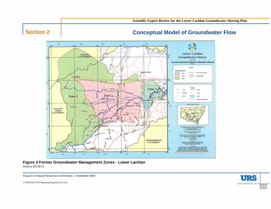
The GMA was originally sub-divided into three zones for the purposes of water allocation management (Figure 3). Zone 1 lies to the east of the Mt Hope Road. Zone 2 lies between the Mt Hope Road and the Cobb Highway and is bounded by the Broken Hill to Sydney railway line to the north. The remaining area of the GMA comprises Zone 3 (essentially west of the Cobb Highway and north of the railway line).
Groundwater quality varies substantially across the GMA. Generally groundwater salinity increases with distance west from the point where the Lachlan River runs past Lake Brewster. As well, the freshest groundwater is contained within the Calivil and Renmark Subsystems.
Generally, Zone 1 contains the freshest groundwater, Zone 2 the next freshest and Zone 3 the most saline.
Good quality irrigation water can be pumped from the Calivil Subsystem in Zone 1, with salinity typically less than 500 mg/L. Groundwater is slightly more saline in the Shepparton Subsystem in this Zone though still less than 500 mg/L.
Zone 2 also contains good quality groundwater in the Calivil and Renmark Subsystems, especially related to the central and southern parts of the Zone. Salinities vary in the range of 500 to 1,000 mg/L. In the north western corner of the Zone, groundwater salinities in these aquifers can range between 1,000 and 3,000 mg/L. Groundwater salinity in the Shepparton Subsystem is marginally higher, with bores more likely to intersect groundwater with salinity in the range 1,000 to 3,000 mg/L, except around the Lachlan River where it is fresher. Some areas on the immediate western margin of Zone 2 in the Shepparton Formation can have salinities up to 7,000 mg//L.
Scientific Expert Review for the Lower Lachlan Groundwater Sharing Plan
Section 2 Conceptual Model of Groundwater Flow
Prepared for Natural Resources Commission, 2 November 2006
J:\JOBS\43270797\Reporting\XpertReview3.doc
2-6
Figure 3 Former Groundwater Management Zones - Lower Lachlan (source DLWC)
Scientific Expert Review for the Lower Lachlan Groundwater Sharing Plan
Section 2 Conceptual Model of Groundwater Flow
Prepared for Natural Resources Commission, 2 November 2006
J:\JOBS\43270797\Reporting\XpertReview3.doc
2-7
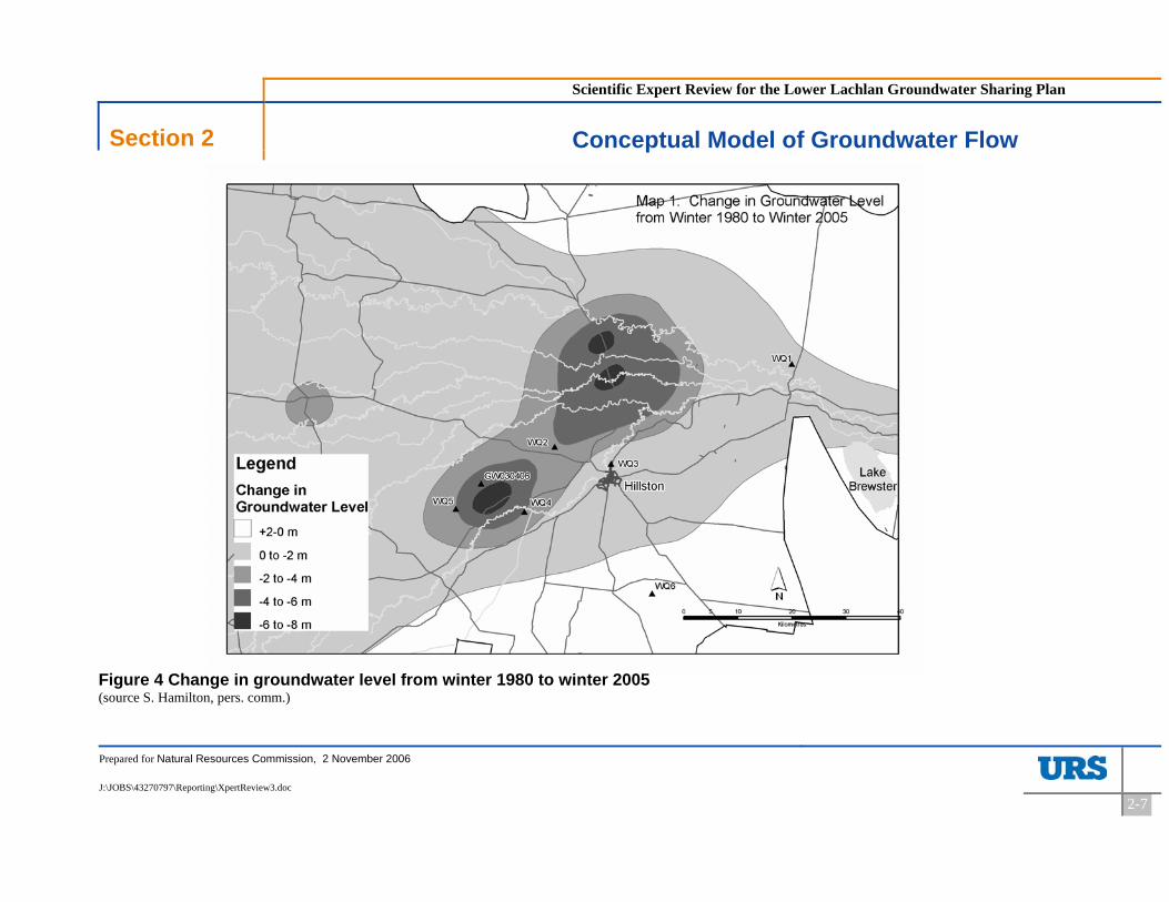
Figure 4 Change in groundwater level from winter 1980 to winter 2005 (source S. Hamilton, pers. comm.)

Scientific Expert Review for the Lower Lachlan Groundwater Sharing Plan
Section 2 Conceptual Model of Groundwater Flow
Prepared for Natural Resources Commission, 2 November 2006
J:\JOBS\43270797\Reporting\XpertReview3.doc
2-1
Zone 3 contains predominantly more saline groundwater. There is a small zone about half way between Booligal and Mossgiel, and another northwest of Mossgiel, where the deeper productive aquifers contain groundwater in the range 500 to 1,000 mg/L. However, these areas are the exception; with the majority of groundwater in the deeper aquifers ranging in salinity between 1,500 and 7,000 mg/L. Groundwater in the Shepparton Formation is generally more saline. South of Ivanhoe, salinity ranges between 3,000 and 7,000 mg/L, while north of the Broken Hill railway, salinity can range up to 14,000 mg/L.
The majority of irrigation water in the Lower Lachlan GMA is taken from the Calivil and Renmark Subsystems to the west of Lake Brewster and east of the Cobb Highway. This area has a high correlation with the map of groundwater depletion shown in Figure 4.
2.2 Regional context of GMA 012
The Lower Lachlan GMA (012) occupies the northern part of the Riverine Plain and is coincident with the north-eastern extremity of the Murray Geological Basin that underlies the whole region. The aquifers present in the GMA are extensive and can be found across the Riverine Plain. The GMA is situated in the upper parts of a regional flow system for all the major aquifers, which extends from the eastern part of the GMA across the Riverine Plain.
The Riverine Plain is bounded by the Great Dividing Range to the east and south and a subsurface basement high known as the Ivanhoe Block to the north and west. The Ivanhoe Block is a complex structure consisting of two North-North-East to South-South-West ridges. These ridges are higher to the north than the south. The Willandra Lakes complex lies within a trough that runs between the two ridges. The easternmost ridge, (the Iona Ridge) forms the western boundary of the Balranald Trough which is the hydrogeological extent of the Riverine Plain.
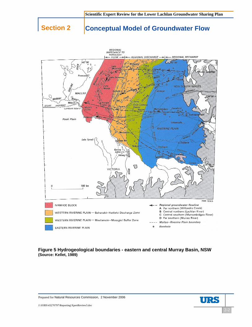
Groundwater flow is generally east to west in all aquifers, with subtle changes in flow direction related to recharge from the Lachlan River (Figure 5).
In the western margin of the Riverine Plain between Hatfield and Balranald a regional groundwater discharge zone has been identified (Kellett, 1989). In this area the Iona Ridge (part of the Ivanhoe Block) provides major impedance to groundwater flow in the Lachlan Alluvial Fan and causes groundwater flow to either discharge vertically upwards, or to flow more south-westerly towards the Murray River (Figure 5).
Kellett (ibid.) also postulates that a minor component of flow occurs along the line of Willandra Creek further westward into the Willandra Trough.
Scientific Expert Review for the Lower Lachlan Groundwater Sharing Plan
Section 2 Conceptual Model of Groundwater Flow
Prepared for Natural Resources Commission, 2 November 2006
J:\JOBS\43270797\Reporting\XpertReview3.doc
2-2
Figure 5 Hydrogeological boundaries - eastern and central Murray Basin, NSW (Source: Kellet, 1989)
Scientific Expert Review for the Lower Lachlan Groundwater Sharing Plan
Section 2 Conceptual Model of Groundwater Flow
Prepared for Natural Resources Commission, 2 November 2006
J:\JOBS\43270797\Reporting\XpertReview3.doc
2-3
The Hatfield groundwater discharge lake complex lies within the Balranald Trough and is caused by the uplift of the Iona Ridge during the Tertiary. Groundwater in the Renmark Subsystem is forced upwards into the Calivil and Shepparton Subsystems and refluxing of salt has created an area of high salinity in this location.
Groundwater flow into the Murray at Mallee Cliffs is currently being intercepted and disposed to reduce the salinisation of the River Murray.
2.3 Relationship between the aquifers and the Lachlan River
The relationship between water in the Lachlan River and groundwater in the aquifers of the Riverine Plain underneath the Lachlan River is an important consideration in this review. In the upstream sections of the GMA (that is, above Lake Brewster), the Lachlan River is a connected stream (Kellett, 1997; Braaten and Gates, 2003, 2004). This means that it is in direct hydraulic connection with the water held in the surface aquifers and there is no unsaturated zone intervening. Variations in water levels in the groundwater can impact on river water levels, depending on the hydraulic gradient between the two water bodies.
As the Lachlan River (and its distributaries) flows out across the Riverine Plain, the River becomes disconnected from the groundwater (ibid.). This means that there is an unsaturated zone immediately below the river. Variations in groundwater levels below the unsaturated zone will have no impact on river water levels. As the River approaches the western margin of the Riverine Plain it is possible that groundwater levels are high enough for saturated conditions between the groundwater and surface water to be re-established. However, the riverine network along the western margin of the Riverine Plain is highly ephemeral and ill defined, so precise characterisation of the system is impossible.
Thus, the Lachlan River is connected in the very upper parts of the GMA, disconnected for large parts of the GMA, and finally likely to be connected again at the western margin of the Riverine Plain, but outside the GMA (see Figure 6).

Scientific Expert Review for the Lower Lachlan Groundwater Sharing Plan
Section 2 Conceptual Model of Groundwater Flow
Prepared for Natural Resources Commission, 2 November 2006
J:\JOBS\43270797\Reporting\XpertReview3.doc
2-4
Figure 6 Hydraulically connected and disconnected reaches Riverine Plain, NSW (source Braaten and Gates, 2003)

Scientific Expert Review for the Lower Lachlan Groundwater Sharing Plan
Section 3 Components of the Water Balance
Prepared for Natural Resources Commission, 2 November 2006
J:\JOBS\43270797\Reporting\XpertReview3.doc
3-1
3 Components of the Water Balance
This section details the components of the water balance for the regional groundwater flow system and more specifically for the Lower Lachlan GMA. The discussion at each of these levels is centred on both the natural water balance and the water balance under developed conditions.
3.1 Introduction
A water balance for an aquifer system is constructed by the sum of the volumetric inputs to the system (its recharge) and the sum of the volumetric outputs from the system (its discharge). Identification of the components of the water balance operating in any flow system is a critical first step in quantifying volumes of groundwater involved.
Figure 7 Components of a groundwater water balance (after NWC, 2006)1
1 Note: ET is evapo-transpiration

Scientific Expert Review for the Lower Lachlan Groundwater Sharing Plan
Section 3 Components of the Water Balance
Prepared for Natural Resources Commission, 2 November 2006
J:\JOBS\43270797\Reporting\XpertReview3.doc
3-2
3.2 Components of the water balance in the regional flow system
3.2.1 The natural water balance
The components of the water balance under natural conditions for the regional aquifer system can be divided between recharge and discharge processes.
The recharge processes operating have been described by others (DNR, unpublished, CMJA, 2004) and do not appear to be in dispute. These recharge processes include recharge from:
- Rainfall; - Instream river flows; - Overbank flooding; and - Lateral inflow through the aquifer at the eastern boundary.
Discharge from the aquifer can occur via discharge from:
- Shallow watertables via evaporation; - Terrestrial vegetation via transpiration; - Riparian vegetation via transpiration; - Discharge to streams and wetlands; - Lateral outflow to aquifers at the western boundary of the Riverine Plain; and - Some unquantifiable losses to fractured bedrock along the northern boundaries.
Note that these discharge mechanisms are being described for the complete aquifer system and not just the GMA. Therefore, it is probable that most discharge from these processes would occur outside the GMA.
3.2.2 The developed water balance
The principle of conservation of mass for a closed system says that the inputs and outputs to and from an aquifer system must balance when storage is accounted for. Essentially, this means that if a new output is introduced into a system (such as groundwater extraction), a previous output (e.g. discharge to a wetland) will have to diminish to attain the volumetric balance.
Thus, when groundwater is extracted from the aquifers of the Lower Lachlan GMA, either recharge has to increase (termed induced recharge) or discharge has to decrease (termed captured discharge) or a combination of both, to attain a new balance. However, the reality will be that the re-balancing will occur over a time period that depends on the characteristics of the aquifer system, and while that re-balancing is occurring, the volumes of groundwater extracted will come from groundwater storage.

Scientific Expert Review for the Lower Lachlan Groundwater Sharing Plan
Section 3 Components of the Water Balance
Prepared for Natural Resources Commission, 2 November 2006
J:\JOBS\43270797\Reporting\XpertReview3.doc
3-3
The major changes that occur with development of irrigated agriculture are the importation of additional surface water, regulation of the river system and pumping of groundwater. The effect of irrigation is to increase the recharge rate under the irrigated land, and the effect of river regulation in rivers such as the Lachlan River is to decrease the variability of surface water flow, maintaining water in the system at a higher frequency than under natural conditions. This causes a higher rate of leakage from the river to groundwater.
Groundwater pumping can induce increased recharge from river systems where the cone of depression from the pumping intersects a connected river system. However, the Lachlan River is disconnected over most of its length and certainly in the areas where pumping has drawn down the regional watertable (see Figure 6). The only area where the River is connected with the groundwater system is in the upstream region east of Lake Brewster, and there are no production bores in this region. Therefore, it is highly unlikely that induced recharge of river water to the groundwater system is a viable process.
The new components of the water balance under developed conditions are:
- Increased recharge from irrigation deep drainage; - Increased recharge from river regulation; - Increased discharge from groundwater pumping; - Decreased discharge due to lower hydraulic gradients caused by groundwater
pumping; and - Decreased discharge due to capture by pumping.
The decreased discharge due to lower hydraulic gradients is most likely to diminish all of the discharge components listed in Section 3.2.1.
3.3 Components of the water balance in the Lower Lachlan GMA
The components of the water balance for the Lower Lachlan GMA are a sub-set of those for the regional aquifer based on the artificial boundary imposed by the Management Area.
Essentially the recharge components remain the same except lateral inflows across some of the boundaries become slightly more important due to the GMA being located on the very eastern part of the Riverine Plain near the major recharge sources. The major change in the analysis of the components of the water balance occurs when considering the discharge components. Because groundwater flows a considerable distance across the Riverine Plain before discharging, the main form of losses from the GMA (besides groundwater pumping) will be discharge via lateral flow out of the GMA via the major aquifers.

Scientific Expert Review for the Lower Lachlan Groundwater Sharing Plan
Section 4 Groundwater recharge and extraction limits
Prepared for Natural Resources Commission, 2 November 2006
J:\JOBS\43270797\Reporting\XpertReview3.doc
4-1
4 Groundwater recharge and extraction limits
NSW defines, within its Groundwater Sharing Plans, the concept of an average annual extraction limit as the upper limit of groundwater extraction for all purposes. The extraction limit is synonymous with the term Ecologically Sustainable Yield and is a proportion of the estimated average annual recharge to the groundwater system. The other proportion of the estimated average annual recharge is an allowance for ecosystem function.
The SWMOP Target 1e (see page 2-5) provides for 30% of the average annual recharge estimate to be set aside for environmental purposes where there is “significant ecosystem dependency” or 0% where there is no significant ecosystem dependency. In the latter case the extraction limit can be set equal to the estimated average annual recharge.
In this Section the various estimates of average annual recharge and the issues regarding the inclusion or exclusion of Zone 3 recharge are investigated.
4.1 Previous recharge estimates
There have been a number of estimates of the average annual recharge for the Lower Lachlan GMA over the past 10 or so years. The following is a brief history – a more detailed discussion of the history is found in DNR (unpub) and CMJA (2004).
Initially, the Lower Lachlan GMA was comprised of Zones 1 & 2 and in the early recharge estimates these were the only Zones considered. Around 2001, Zone 3 was included in the Management Area. This necessitated an estimate of average annual recharge to be derived for this Zone, and this estimate was added into the overall total, where the recharge estimation process warranted. This issue will be discussed in a later Section.
In 2002, the Zones were removed, and the GMA was treated as one entity for the purposes of the Water Sharing Plan.
There have been four pieces of work that have been used to estimate the average annual recharge to the Lower Lachlan GMA aquifer system. These four have been termed:
1. Comparison with Lower Murrumbidgee; 2. Throughflow and Rise; 3. Data from Regional Model; and 4. Estimated Recharge Contributions (Water Balance).
Scientific Expert Review for the Lower Lachlan Groundwater Sharing Plan
Section 4 Groundwater recharge and extraction limits
Prepared for Natural Resources Commission, 2 November 2006
J:\JOBS\43270797\Reporting\XpertReview3.doc
4-2
4.1.1 Comparison with Lower Murrumbidgee
Ross (1999) reported estimating the recharge of the Lower Lachlan GMA by comparing the size of the fresh groundwater resource between the Lower Lachlan and the Lower Murrumbidgee GMA aquifers. That is, the approach is limited to consideration of Zone1 and Zone 2 only.
A numerical model for the Lower Murrumbidgee had estimated recharge for that aquifer to be 250,000 ML/y. Based on a ratio of 42% between the area of fresh groundwater between the two aquifers, an estimate of recharge to the Lower Lachlan GMA of 105,000 ML/y was derived. After further calibration of the Murrumbidgee model, the estimate of Lower Lachlan recharge was later increased to 150,000 ML/y using the same proportionate method.
The method employed in this analysis is highly speculative and considered to be of extremely low confidence as it doesn’t take into account specific processes operating in the Lower Lachlan GMA.
4.1.2 Throughflow and rise
In this extremely simple approach completed in 2001 (S. Hamilton pers. comm.), the recharge to the Lower Lachlan aquifer was estimated using Darcy’s groundwater flow law. Darcy’s Law is a fundamental law of groundwater that relates the volume of groundwater flow between two points as being equal to the groundwater head difference between those two points (the hydraulic gradient), the cross sectional area of flow and the hydraulic conductivity.
Darcy’s Law was used to derive the volume of groundwater flowing out of the GMA. This volume was then assumed to be the volume flowing into the GMA under steady state conditions from both recharge and lateral inflow at the upstream end of the GMA. An initial recharge estimate of average annual recharge of 37,500 ML/y was made but this was later adjusted to 61,700 ML/y after allowing for increasing volumes of groundwater storage. Increased storage was observed through rising trends in groundwater levels across the GMA prior to the onset of widespread pumping and was presumably the result of river regulation.
The increasing storage estimates were derived assuming a steady state rise of 0.02 m/y (observed) divided by an estimate of aquifer porosity.
DNR applied this approach to the GMA based on estimates of hydraulic gradients, aquifer hydraulic conductivities and cross sectional areas of flow. However, no data used in the analysis was sighted as part of this review.

Scientific Expert Review for the Lower Lachlan Groundwater Sharing Plan
Section 4 Groundwater recharge and extraction limits
Prepared for Natural Resources Commission, 2 November 2006
J:\JOBS\43270797\Reporting\XpertReview3.doc
4-3
Errors in the process relate to the number of groundwater flow paths where Darcy calculations of flow have been estimated and the choice of aquifer parameters such as hydraulic conductivity, aquifer thickness and aquifer porosity.
The approach has been based on a better understanding of the groundwater processes but does not take account of groundwater salinity and is highly sensitive to parameter estimates. It is assessed as having a low confidence level.
4.1.3 Data from regional model
A regional numerical groundwater model (including coverage of the Lower Lachlan GMA) was developed during the early 1990s and reported by Kellett (1997). The model was based on the Modflow package as a steady-state simulation on a coarse grid (7.5 x 7.5 km).
Recharge from rainfall across the Riverine Plain part of the model area was set at 1% of annual average rainfall. The rainfall surface was derived by contouring average values from long term observation stations. This surface was gridded to the model grid and an estimate derived. The percentage of rainfall was cross checked against shallow groundwater salinity using the chloride mass balance method.
The chloride mass balance method assumes that chloride only enters the ground water through precipitation and that chloride is conserved in the system, i.e. it doesn’t react and disappear when mixed with other components of ground water. These assumptions make the amount of rainfall that recharges the ground water proportional to the chloride concentrations in the ground water and the rainfall. It is further assumed that steady-state conditions are maintained in the system, so that average concentrations and rainfall amounts may be used in the calculations. Finally, it is also assumed that no surface runoff leaves the aquifer area, that no recycling of the chloride occurs in the ground water, and that ground water does not evaporate up-gradient from the sampling points used to determine chloride concentrations. The errors inherent in this approach arise from errors in estimating rainfall, errors in measuring chloride concentration in rainfall, errors in determining chloride concentration in the groundwater.
The chloride mass balance approach adopted by Kellett confirmed the 1% estimate adopted initially. There is no error analysis undertaken of this approach, nevertheless it is concluded that the range of errors likely and the degree to which the assumptions hold would lead to a low level of confidence in the final estimate of rainfall recharge.
The other recharge mechanism used in the model was leakage from the Lachlan River. As reported in the original review document, this was derived from consideration of flow duration
Scientific Expert Review for the Lower Lachlan Groundwater Sharing Plan
Section 4 Groundwater recharge and extraction limits
Prepared for Natural Resources Commission, 2 November 2006
J:\JOBS\43270797\Reporting\XpertReview3.doc
4-4
curves for the Lachlan River, and estimated leakage rates between gauging stations. The estimated leakage rates would be subject to considerable error and perhaps provide an upper bound to the likely leakage.
Estimates of recharge to groundwater within the Lower Lachlan GMA were not derived by Kellett per se. DNR subsequently used the model results to derive the recharge estimates reported by them in later work. The timing of this analysis is unknown although there are indications that it was completed in 2000/2001 (S. Hamilton pers. comm.). DNR superimposed the Lower Lachlan GMA boundary (Zones 1 and 2 only according to Jewell) and derived the amount of modelled recharge to the Zones from both rainfall and river sources as 122,200 ML/y.
The approach taken by DNR is valid, but it does suffer from some difficulties. The approach assumes that the Kellett model was well calibrated for the Lower Lachlan GMA. The approach also assumes that the calibrated values of recharge derived from the Kellett model are unique. No account has been taken of overbank flows.
The DNR analysis also assumes that the recharge to the GMA is of sufficient groundwater quality that it can all be extracted.
The estimate of total recharge is considered to have a low to moderate confidence level.
4.1.4 Water balance
The various components of the water balance for Zones 1 and 2 were estimated in this approach completed early 2001 (S. Hamilton pers. comm.). The components of the water balance and their volumetric contributions to recharge are given in Table 1.
Table 1 Water balance approach
Component ML/y
Rainfall 40,100
Irrigation 6,800
Overbank Floods 27,100
Lachlan River losses 40,100
Total 114,100

Scientific Expert Review for the Lower Lachlan Groundwater Sharing Plan
Section 4 Groundwater recharge and extraction limits
Prepared for Natural Resources Commission, 2 November 2006
J:\JOBS\43270797\Reporting\XpertReview3.doc
4-5
Recharge from rainfall was calculated assuming a rate of 1% of average annual rainfall at Hillston; irrigation deep drainage was derived assuming an efficiency of 95% of applied water; recharge from overbank floods was derived by an analysis of three floods over the period 1955 to 1998 and applying an average recurrence interval to the volume derived; and river losses were based on an analysis of a spreadsheet model (i.e. the CAIRO model) of the river.
There are a number of weaknesses in the water balance component approach, even though it represents the best approach used to date. These weaknesses are:
There is no independent test whether 1% is a reasonable factor to use for rainfall recharge;
Rainfall recharge is derived irrespective of the salinity of the watertable aquifer. A more accurate approach would be to limit rainfall recharge to those areas where the watertable aquifer is below a certain salinity threshold;
The volume of flood recharge suffers from the poor records of groundwater response due to floods in 1956 and 1974. There is also some uncertainty regarding the average recurrence interval of these floods and how these might be modified due to river regulation and changes in catchment land use; and
There is poor understanding of the losses from in-stream flows in the Lachlan River. An IQQM model of the river now exists, but the understanding of the unaccounted losses is poor.
The IQQM model output has not been used to update the original estimate of leakage from the Lachlan River. The original estimate was based on a CAIRO model for the river and the reliability of this is uncertain.
The assumption of 95% irrigation efficiency has not been quantified, nor has the degree of deep drainage following irrigation
The approach did not include the inflow contribution from aquifers up-gradient from the GMA. An estimate of 500 ML/y was derived by DNR during analysis of the throughflow and rise approach. This additional volume should be added to the recharge estimate.
The relative error in the different components of the water balance is difficult to judge. All estimates of the various components suffer from some uncertainty through either parameter estimation or through lack of data. There is no one component that has been analysed better than another and as such all probably are equally uncertain.
The estimate of recharge derived via this method has a better conceptual basis than the other estimates, but still suffers from the problem of parameterisation.
The confidence in this approach is also low to moderate.
Scientific Expert Review for the Lower Lachlan Groundwater Sharing Plan
Section 4 Groundwater recharge and extraction limits
Prepared for Natural Resources Commission, 2 November 2006
J:\JOBS\43270797\Reporting\XpertReview3.doc
4-6
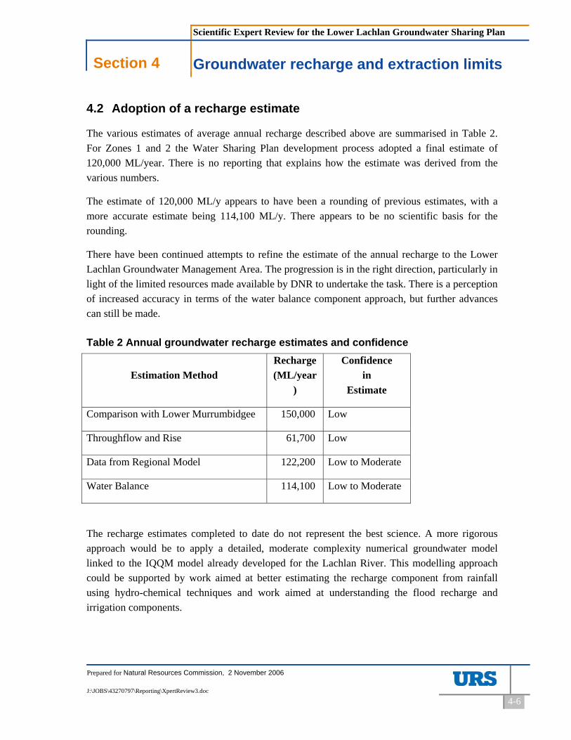
4.2 Adoption of a recharge estimate
The various estimates of average annual recharge described above are summarised in Table 2. For Zones 1 and 2 the Water Sharing Plan development process adopted a final estimate of 120,000 ML/year. There is no reporting that explains how the estimate was derived from the various numbers.
The estimate of 120,000 ML/y appears to have been a rounding of previous estimates, with a more accurate estimate being 114,100 ML/y. There appears to be no scientific basis for the rounding.
There have been continued attempts to refine the estimate of the annual recharge to the Lower Lachlan Groundwater Management Area. The progression is in the right direction, particularly in light of the limited resources made available by DNR to undertake the task. There is a perception of increased accuracy in terms of the water balance component approach, but further advances can still be made.
Table 2 Annual groundwater recharge estimates and confidence
Estimation Method Recharge(ML/year
)
Confidence in
Estimate
Comparison with Lower Murrumbidgee 150,000 Low
Throughflow and Rise 61,700 Low
Data from Regional Model 122,200 Low to Moderate
Water Balance 114,100 Low to Moderate
The recharge estimates completed to date do not represent the best science. A more rigorous approach would be to apply a detailed, moderate complexity numerical groundwater model linked to the IQQM model already developed for the Lachlan River. This modelling approach could be supported by work aimed at better estimating the recharge component from rainfall using hydro-chemical techniques and work aimed at understanding the flood recharge and irrigation components.

Scientific Expert Review for the Lower Lachlan Groundwater Sharing Plan
Section 4 Groundwater recharge and extraction limits
Prepared for Natural Resources Commission, 2 November 2006
J:\JOBS\43270797\Reporting\XpertReview3.doc
4-7
4.3 CM Jewell and Associates Review
An independent review of the recharge estimates for the Lower Lachlan GMA was undertaken by CM Jewell and Associates (CMJA, 2004) on behalf of Lachlan Valley Water Inc.
The review analysed the approaches used previously to derive recharge estimates (as listed above). The review then went on to derive a further estimate of recharge and then to provide some commentary on likely errors in the estimates.
The report (ibid.) concludes that of the four approaches, the Water Balance approach appears to be the most detailed and potentially the most accurate technique. This is in accord with the findings of the current review. The CMJA review went on to suggest that the flood component of recharge derived by DNR was in error and that CMJA had derived a better estimate. CMJA reported a new recharge estimate that incorporated the new flood component as well as a recharge estimate for Zone 3. From this CMJA derived new recharge estimates using the water balance method and calculated an error of the order of +/- 70%.
There is no discussion within the CMJA report of groundwater salinity and it is concluded here that inclusion by CMJA of Zone 3 recharge estimates in the overall GMA total is erroneous as this water falls on saline groundwater which is not useable.
As well, there is some criticism of the flood analysis undertaken by CMJA, whilst acknowledging that further work could be done on this matter. CMJA assumes that the flood recharge volume estimated as coming from the 1990 flood is the long term mean flood recharge volume. However, the return period of this flood is taken to be the return period of the 1974 flood (1 in 24) as opposed to the return period of the 1990 flood (about 1 in 40) on the basis that this represented a threshold value for overbank flow. The assumption is that when overbank flow occurs, the volume of recharge is the same regardless of the area inundated. The approach used by CMJA represents an annual recharge volume from flooding using the 1974 return period of 42,000 ML/y as opposed to a flood recharge volume of about 25,200 ML/y when using the 1990 return period. The latter estimate is very close to the flood recharge estimate derived by DNR (27,100 ML/y).
The estimate of error made by CMJA is considered to be technically correct, but probably overly conservative since it adds the errors associated with each element of the water balance.
Scientific Expert Review for the Lower Lachlan Groundwater Sharing Plan
Section 4 Groundwater recharge and extraction limits
Prepared for Natural Resources Commission, 2 November 2006
J:\JOBS\43270797\Reporting\XpertReview3.doc
4-8
4.4 Lachlan River contributions to recharge
The water balance component approach estimates that 40,000 ML/y of recharge is derived from leakage from the Lachlan River within the GMA, and that 27,100 ML/y of recharge occurs from overbank floods.
There is no specific allocation of water for the Water Sharing Plan from the Lachlan Regulated River Water Source to recharge to the Lower Lachlan GMA. However, results from the IQQM model for the Lachlan River show that flow in the River at Lake Cargelligo is always greater than 40,000 ML/y and unaccounted losses for the River between Lake Cargelligo and Booligal are 137,000 ML/y suggesting the estimates of leakage from the Lachlan River are possible.
This data appears to confirm that the water balance component of river leakage fits within the model outputs of the IQQM model.
There is no explicit mention of overbank flows in the Water Sharing Plan for the Lachlan Regulated River Water Source. There needs to be mention that overbank flows are a key recharge source to the groundwater system of the Lower Lachlan GMA and that floodplain flow harvesting rules are put in place to protect floods with an average recurrence interval that has been identified as critical to overbank flood recharge.
4.5 Zone 3 recharge
At some point in the Water Sharing Plan process the issue of Zone 3 recharge became important. Prior to that point, a recharge estimate for Zone 3 was derived based on rainfall recharge of 1% of average rainfall applied to the surface area of Zone 3. It is not clear what rainfall was used to derive the estimate, nor the basis for adoption of 1% recharge. This process derived an average annual recharge volume of 23,100 ML/y.
Under earlier water management policy when groundwater extraction from Zone 3 was managed in isolation to Zones 1 & 2, this estimate was considered to be realistic since the salinity of water being pumped would place a limit on extractions. Since only limited areas of Zone 3 are sufficiently fresh for use the maximum extraction would be substantially less than the recharge estimate.
When the three Zones were removed and the GMA became the management unit, the recharge component from Zone 3 could potentially be made available for extraction across the entire management area. Under this situation there would be an over-estimate of the amount of sustainable water extraction in the GMA. A decision was made within DNR to therefore exclude

Scientific Expert Review for the Lower Lachlan Groundwater Sharing Plan
Section 4 Groundwater recharge and extraction limits
Prepared for Natural Resources Commission, 2 November 2006
J:\JOBS\43270797\Reporting\XpertReview3.doc
4-9
the Zone 3 recharge estimate from the estimate of average annual recharge for the GMA within the Water Sharing Plan.
Rainfall recharge to Zone 3 must infiltrate the overlying saline Shepparton aquifer and hence is not useable with the exception of a number of small areas. In the area of Whipstick Lake and Umbrella Creek there is also recharge from surface water when it occurs.
It could be argued that it is appropriate to increase the estimate of the average annual recharge in the GMA according to recharge from these small areas, it would also be appropriate to reduce the rainfall recharge components in Zones 1 and 2 by the volume that falls over areas of saline groundwater in the surficial aquifer for the same reason.

Scientific Expert Review for the Lower Lachlan Groundwater Sharing Plan
Section 5 Groundwater Dependent Ecosystems
Prepared for Natural Resources Commission, 2 November 2006
J:\JOBS\43270797\Reporting\XpertReview3.doc
5-1
5 Groundwater Dependent Ecosystems
In this Section we investigate the potential for GDEs both within and outside of the GMA. However, this does not constitute a formal assessment of groundwater dependent ecosystems.
Water Sharing Plans must take into account the integrity of the water resource as well as the needs of dependent ecosystems. The Water Management Act 2000 (the Act) is silent on whether consideration should be given to the needs of ecosystems in districts outside the immediate planning area, however advice from DNR is that this is in fact the case. Certainly the principles of the Act would suggest that this should be the case.
The Lachlan River is connected in the very upper parts of the GMA, disconnected for large parts of the GMA, and finally likely to be connected again at the western margin of the Riverine Plain, but outside the GMA. However, it should be noted that the discharge zones of the aquifers in the Lachlan GMA are not mapped, fully understood, nor documented.
According to Kellett (1997), some flow from the Riverine Plain appears to move into the Willandra Trough, where the World Heritage listed Willandra Lakes are located. This was challenged at the expert workshop where the opinion was that there is a substantial disconnection. Depths to first water shown in Figure 10 suggest that even if some water does move into the Willandra Trough it would be unlikely to contribute to the lakes system.
There have been suggestions that riparian vegetation on the Lachlan River between Lake Brewster and Lake Cargelligo are GDEs. This would need to be tested by the installation of nested piezometers along the sections in question together with the use of other techniques such as isotope methods that allow discrimination of the source of water used by plants. Whether the riparian ecosystems are dependent on surficial aquifers that are hydraulically connected to or disconnected from the deeper aquifers used for irrigation extraction should be a focus of investigation.
There have been suggestions that wetlands such as the Great Cumbung Swamp are dependent on groundwater from the productive aquifers, but that has been challenged by recent investigations by DNR (Braaten and Gates, 2003) showing that there is a hydraulic disconnection between the surface the aquifers in this region (see Figure 6). This is supported by the relatively low salinity of waters in the swamp when compared with groundwater salinities of the area.
DNR have formally written to the Lachlan irrigators indicating that the Great Cumbung Swamp is not dependent on groundwater discharge.
The regional hydrogeology clearly indicates the potential for groundwater discharge in the regional discharge zone between Hatfiled and Balranald (Figure 5). In this area saline lake systems do occur and field investigation is required to determine whether there are halophytes or
Scientific Expert Review for the Lower Lachlan Groundwater Sharing Plan
Section 5 Groundwater Dependent Ecosystems
Prepared for Natural Resources Commission, 2 November 2006
J:\JOBS\43270797\Reporting\XpertReview3.doc
5-2
other organisms that are dependent on groundwater discharge. The potential for groundwater extraction to impact on this area through pressure responses should be investigated as part of detailed hydrogeological modelling.
There is a need for field investigations to determine the location of ecosystems associated with the groundwater resources of the GMA, and whether they are at risk from the impacts of groundwater extraction. A risk based approach is warranted similar to that currently being undertaken by Smith et al. (2006).
Smith (ibid.) note that there is limited information that demonstrates the use of groundwater by terrestrial species in NSW ecosystems. Very few studies of this type have been completed, and there is a sparse depth of expert knowledge.
They propose a methodological approach based upon the sensitivity of GDEs to groundwater fluctuations derived from groundwater models. Once the extent and quantum of the spatial impact on the water level in the aquifer is confirmed, a woody/non-woody vegetation map is used to discriminate potential areas of GDEs. The risk to each identified GDE is then assessed according to the following set of risk categories:
GDEs not likely, or not likely to be sensitive if:
Aquifer beyond root zone
Shallow aquifer not connected to managed aquifer
There is subsurface barrier to root penetration
GDEs likely, or likely to be sensitive if:
The depth and fluctuations are within historical norms
Assumed that vegetation adapted to existing regime
GDE is at risk if:
The depth or fluctuation is outside of historical range
The aquifer is depleting.
If water table depths are less than 30m it is considered that there is some potential for roots to be within this zone based upon the work by Jolly et al (2002) on Red Gums cited in Smith et al (2006). However, while roots of sub-humid woodland woody species have been recorded to

Scientific Expert Review for the Lower Lachlan Groundwater Sharing Plan
Section 5 Groundwater Dependent Ecosystems
Prepared for Natural Resources Commission, 2 November 2006
J:\JOBS\43270797\Reporting\XpertReview3.doc
5-3
58m, generally most woodland systems have 90% of roots to depths of less than 17m (Shenke and Jackson, 2002b cited in Smith et al (2006)).
A list of threatened species was extracted from the threatened species database (http://www.threatenedspecies.environment.nsw.gov.au) for the following areas - Lachlan CMA sub-region, Lachlan (Part A) SMA sub-region, and South Olary Plain, Murray Basin Sands CMA sub-region. These regions coincide and exceed the extent of the Hatfield – Balranald discharge area. Table A-1 in Appendix 2 provides the full list of threatened species and highlights threatened plant species in shaded rows. Both plant and animal species are included here since animals may be impacted by any changes in vegetation.
Many of the plant species listed are herbaceous and are unlikely to be tolerant to hypersaline conditions or able to extract moisture from significant depths (e.g. greater than 25m). Some woody species (mainly acacias) may however have this capacity and scientific investigation is warranted. Figure 8 and Figure 9 provide shrubland and acacia species distribution maps, Figure 10 shows the distribution of first bore water depths across the region. More detailed investigation of vegetation using the approach of Smith et al (2006) may allow specific areas to be targeted for investigation.
The default proportion of the estimated average annual recharge to be made available for groundwater dependent ecosystems (GDEs) is set at 30%. It appears that the 20% proportion adopted in the Lower Lachlan Water Sharing Plan was arrived at after a set of trade-off negotiations. There are differences of opinion regarding the purpose of setting aside this amount. Environmental groups involved were unhappy with the provision of water for ecosystems in the plan and delivered a dissenting report on the matter to the Minister.
There is no scientific basis for the adoption of the 20% proportion of estimated average annual recharge.
No groundwater dependent ecosystems have been explicitly identified because no work has been undertaken to find them.

Scientific Expert Review for the Lower Lachlan Groundwater Sharing Plan
Section 5 Groundwater Dependent Ecosystems
Prepared for Natural Resources Commission, 2 November 2006
J:\JOBS\43270797\Reporting\XpertReview3.doc
5-4
Figure 8 Arid shrubland distribution north and west of Hillston
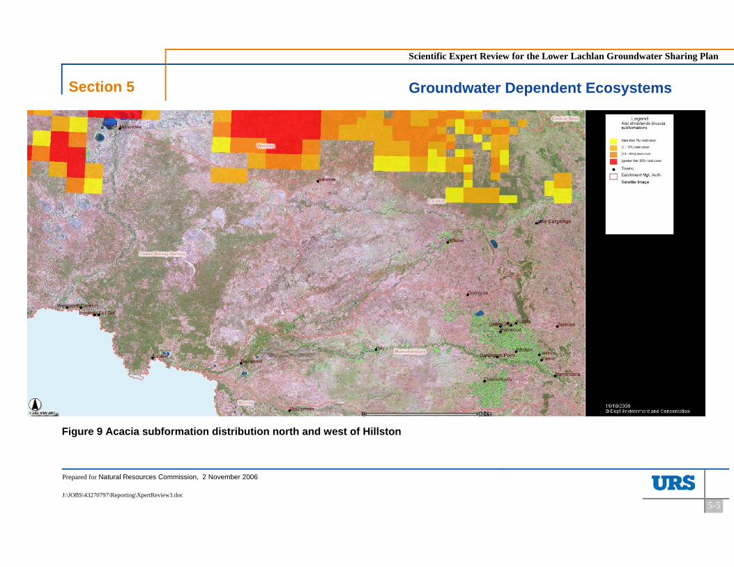
Scientific Expert Review for the Lower Lachlan Groundwater Sharing Plan
Section 5 Groundwater Dependent Ecosystems
Prepared for Natural Resources Commission, 2 November 2006
J:\JOBS\43270797\Reporting\XpertReview3.doc
5-5
Figure 9 Acacia subformation distribution north and west of Hillston

Scientific Expert Review for the Lower Lachlan Groundwater Sharing Plan
Section 5 Groundwater Dependent Ecosystems
Prepared for Natural Resources Commission, 2 November 2006
J:\JOBS\43270797\Reporting\XpertReview3.doc
5-6
Figure 10 Distribution of bores and first water bearing zones (K Skelt, pers. comm.)
D
DD
D
DD
D
D
D
D
D
D
D
DD
D
D
D
D
DD
D
D
D
DDD
D
D
D
D
D
D
D
D
D
D
D
D
D
D
D
D
D
D
D
D
D
D
D
D
DD
D
D
D
D
D
D
D
D
D
D
D
D
D
D
D
D
D
D
D
D
DD
3
2
1
1 1
HAY
ROTO
YENDA
YANCO
TRIDA
OXLEY
MAUDE
BINYA
WAMOON
MOONEE
MANARA
LEETON
GUNBAR
EUSTON
BREWER
BILBULYOOGALI
WHITTON
WARBURNTABBITA
PENARIE MURRAMI
KIKOIRA
KAMARAH
IVANHOE
HANWOOD
GUBBATA
EURATHA
DARNICK
CONOBLE
TALLIMBA
TALEEBAN
NARADHAN
MOSSGIEL
HILLSTON
HATFIELD
GRIFFITH
GOOLGOWIERIGOLIA
BOOLIGAL
GILLENBAH
EUABALONG
BURGOONEY
BALRANALD
MOUNT HOPE
MERRIWAGGA
CARRATHOOL
BENEREMBAH
WARRAWIDGEE
TULLIBIGEAL
RANKINS SPRINGS
PAYNTERS SIDING
LAKE CARGELLIGO
DARLINGTON POINT
N0 50 10025
Kilometers
LegendNSWGWMA_2002
D Towns
First water bearing zone<15
15.1 - 20.0
20.1 - 25.0
25.1 - 30.0
>30

Scientific Expert Review for the Lower Lachlan Groundwater Sharing Plan
Section 6 Conclusions
Prepared for Natural Resources Commission, 2 November 2006
J:\JOBS\43270797\Reporting\XpertReview3.doc
6-1
6 Conclusions
The following conclusions can be made:
The Lower Lachlan GMA lies within the a broader groundwater flow system associated with the regional aquifers of the Riverine Plain, but the full extent (discharge zone(s)) of these aquifers is not fully understood;
The current best estimates of average annual recharge are 114,100 and 122,200 ML/y, although both estimates have substantial uncertainty associated with them;
It is not possible to quantify the errors in the recharge estimates based upon the information reviewed;
These estimates do not represent the best science available. However, the best scientific approach will require substantial investment in further hydrogeological studies;
The threat of groundwater resource salinisation in the Lower Lachlan GMA is high and extraction limits should be derived that reflect the salinisation process;
There is no explicit link between the Water Sharing Plan for the Lachlan Regulated River Water Source and the Lower Lachlan Groundwater Source Water Sharing Plan even though the Groundwater Plan requires recharge from the Lachlan River and overbank flood flows;
Recent IQQM models indicate that there are sufficient surface water flows to accommodate the recharge estimates for the Lower Lachlan Groundwater Source;
Recharge to the former Zone 3 of the GMA was based on consideration of rainfall infiltration and the decision to exclude this amount from the estimate of average annual recharge for the GMA is valid on the grounds of the groundwater salinity in Zone 3; and
The occurrence of GDEs in the Lower Lachlan GMA is poorly described and requires further work. It is likely that GDEs dependent on groundwater flow from the Lower Lachlan GMA exist outside the GMA boundary further to the west. However, their nature and value are unknown.
Scientific Expert Review for the Lower Lachlan Groundwater Sharing Plan
Section 7 Recommendations
Prepared for Natural Resources Commission, 2 November 2006
J:\JOBS\43270797\Reporting\XpertReview3.doc
7-1
7 Recommendations
The following recommendations are made:
A moderate complexity groundwater model of the Lower Lachlan GMA should be developed and linked with the IQQM model of Lachlan River flow. The model boundaries should be such that they are removed from possible groundwater extraction impacts. The model should be completed as soon as possible. It is understood that DNR has commenced development of a model that might be suitable for the purpose. Appropriate levels of resources should be made available for the model and efforts explored to accelerate the process. Potential use of external resources should be considered;
Independent studies of groundwater recharge processes are required to add to the calibration of the groundwater model. These studies would include hydrochemical characterisation;
A more detailed analysis of overbank flood recharge processes is required;
The Water Sharing Plan for the Lachlan Regulated River Water Source should be modified to explicitly include a high security provision of 40,000 ML/y of recharge to the Lower Lachlan GMA. As well, specific rules governing floodplain harvesting should also be applied that protect the flood recharge process to the Lower Lachlan GMA aquifers;
A risk based approach should be undertaken to identify potential GDEs dependent on the groundwater systems of the Lower Lachlan GMA. The approach could be modelled on an approach developed by DNR (Smith et al, 2006). The investigation should not be constrained to the GMA itself. This work is required urgently within the next 12 months. A further analysis of aquifer discharges and GDEs needs to be undertaken, including field evaluation.
Scientific Expert Review for the Lower Lachlan Groundwater Sharing Plan
Section 8 References
Prepared for Natural Resources Commission, 2 November 2006
J:\JOBS\43270797\Reporting\XpertReview3.doc
8-1
8 References
Braaten R. and Gates G., (2003). Groundwater-Surface Water Interaction in Inland New South Wales. Water Science and Technology, 48(7): 215-224.
Braaten R. and Gates G., (2004). Lagging Behind: Exploring the Time Lag in River-Aquifer Interaction, 9th Murray Darling Basin Groundwater Workshop, Bendigo 17-20th February.
Brown C.M. and Stephenson A.E. (1991), Geology of the Murray Basin, Southeastern Australia. Bureau of Mineral Resources, Australia, Bulletin 235.
CMJA, (2004), Independent Review – Lower Lachlan Groundwater Management Area 012. Confidential report to Lachlan Valley Water inc.
DLWC, (2003) Water Sharing Plan for the Lower Lachlan Groundwater Source. Department of Land and Water Conservation.
DLWC, (2004) NSW State Groundwater Dependent Ecosystems Policy, Department of Land and Water Conservation, April 2004. ISBN 0 7347 5225 3.
Driscoll F.G. (1986), Groundwater and Wells 2nd ed., Johnson Filtration Systems inc., Minnesota, ISBN 0 9616456 0 1.
Ife D. & Skelt K, 2004 Murray-Darling Basin Groundwater Status 1990 – 2000: Summary Report, Murray-Darling Basin Commission, Canberra, ISBN 1 876830 94 8.
Kellett J.R. (1989), The Ivanhoe Block – its structure, hydrogeology and effect on groundwaters of the Riverine Plain of New South Wales. BMR Journal 11 (2/3).
Kellett J.R. (1997), Lachlan Fan/Ivanhoe Block Steady State Groundwater Model. Model development, Calibration, Sensitivity Analysis and Predictions, Australian Geological Survey Organisation Report.
NWC (2006), Appendix C Theme Report: Groundwater, Discovery Phase, Australian Water Resources 2005, Report to National Water Commission, May 2006. Web reference: http://www.nwc.gov.au/nwi/docs/AppendixC_Groundwater.pdf
Smith P. L., Williams R. M., Hamilton S. and Shaik M. (2006), A risk-based approach to groundwater management for terrestrial groundwater dependent ecosystems, Proceedings 10th Murray Darling Basin Groundwater Workshop, 2006.

Scientific Expert Review for the Lower Lachlan Groundwater Sharing Plan
Section 9 Limitations
Prepared for Natural Resources Commission, 2 November 2006
J:\JOBS\43270797\Reporting\XpertReview3.doc
9-1
9 Limitations
URS Australia Pty Ltd (URS) has prepared this report in accordance with the usual care and thoroughness of the consulting profession for the use of the Natural Resources Commission and only those third parties who have been authorised in writing by URS to rely on the report. It is based on generally accepted practices and standards at the time it was prepared. No other warranty, expressed or implied, is made as to the professional advice included in this report. It is prepared in accordance with the scope of work and for the purpose outlined in the Project Charter dated 25th September 2006. The methodology adopted and sources of information used by URS are outlined in this report. URS has made no independent verification of this information beyond the agreed scope of works and URS assumes no responsibility for any inaccuracies or omissions. No indications were found during our investigations that information contained in this report as provided to URS was false. This report was prepared between 11th October and 22nd October and is based on the information reviewed at the time of preparation. URS disclaims responsibility for any changes that may have occurred after this time. This report should be read in full. No responsibility is accepted for use of any part of this report in any other context or for any other purpose or by third parties. This report does not purport to give legal advice. Legal advice can only be given by qualified legal practitioners.
Appendix 1
Geological and hydrogeological
features of the region

Appendix 1: Geological and hydrogeological features
J:\JOBS\43270797\REPORTING\XPERTREVIEW3.DOC\2-NOV-06
Appendix 1-1
Figure A-1 Structure contours of pre-Tertiary basement on the Ivanoe Block and under part of the western Riverine Plain (from Kellett, 1989)

Appendix 1: Geological and hydrogeological features
J:\JOBS\43270797\REPORTING\XPERTREVIEW3.DOC\2-NOV-06
Appendix 1-2
Figure A-2 Stratigraphic sections through the Ivanhoe block and western Riverine Plain (from Kellett, 1989)
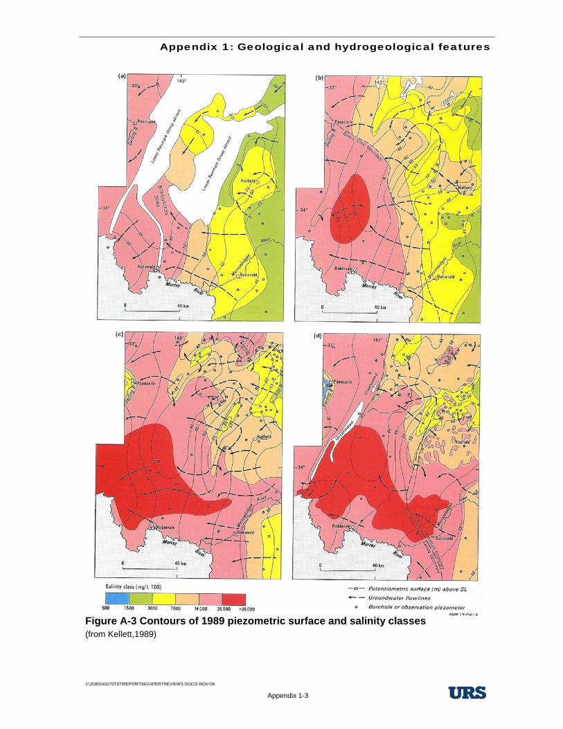
Appendix 1: Geological and hydrogeological features
J:\JOBS\43270797\REPORTING\XPERTREVIEW3.DOC\2-NOV-06
Appendix 1-3
Figure A-3 Contours of 1989 piezometric surface and salinity classes (from Kellett,1989)

Appendix 1: Geological and hydrogeological features
J:\JOBS\43270797\REPORTING\XPERTREVIEW3.DOC\2-NOV-06
Appendix 1-4
Figure A-4 Calivil aquifer potentiometric surface and salinity yield classes (source Cargelligo and Booligal 1:250,000 hydrogeological maps)

Appendix 1: Geological and hydrogeological features
J:\JOBS\43270797\REPORTING\XPERTREVIEW3.DOC\2-NOV-06
Appendix 1-5
Figure A-5 Chloride profiles in Tertiary aquifers and along regional flow lines (after Kellett, 1989)

Appendix 2
Threatened species in the groundwater
discharge area
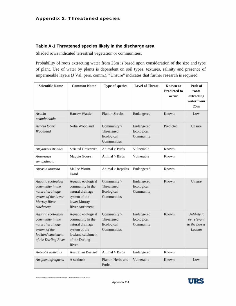
Appendix 2: Threatened species
J:\JOBS\43270797\REPORTING\XPERTREVIEW3.DOC\2-NOV-06
Appendix 2-1
Table A-1 Threatened species likely in the discharge area Shaded rows indicated terrestrial vegetation or communities.
Probability of roots extracting water from 25m is based upon consideration of the size and type of plant. Use of water by plants is dependent on soil types, textures, salinity and presence of impermeable layers (J Val, pers. comm.). “Unsure” indicates that further research is required.
Scientific Name Common Name Type of species Level of Threat Known or Predicted to
occur
Prob of roots
extracting water from
25m
Acacia acanthoclada
Harrow Wattle Plant > Shrubs Endangered Known Low
Acacia loderi Woodland
Nelia Woodland Community > Threatened Ecological Communities
Endangered Ecological Community
Predicted Unsure
Amytornis striatus Striated Grasswren Animal > Birds Vulnerable Known
Anseranas semipalmata
Magpie Goose Animal > Birds Vulnerable Known
Aprasia inaurita Mallee Worm-lizard
Animal > Reptiles Endangered Known
Aquatic ecological community in the natural drainage system of the lower Murray River catchment
Aquatic ecological community in the natural drainage system of the lower Murray River catchment
Community > Threatened Ecological Communities
Endangered Ecological Community
Known Unsure
Aquatic ecological community in the natural drainage system of the lowland catchment of the Darling River
Aquatic ecological community in the natural drainage system of the lowland catchment of the Darling River
Community > Threatened Ecological Communities
Endangered Ecological Community
Known Unlikely to be relevant
to the Lower Lachan
Ardeotis australis Australian Bustard Animal > Birds Endangered Known
Atriplex infrequens A saltbush Plant > Herbs and Forbs
Vulnerable Known Low

Appendix 2: Threatened species
J:\JOBS\43270797\REPORTING\XPERTREVIEW3.DOC\2-NOV-06
Appendix 2-2
Scientific Name Common Name Type of species Level of Threat Known or Predicted to
occur
Prob of roots
extracting water from
25m
Austrostipa wakoolica
A spear-grass Plant > Herbs and Forbs
Endangered Predicted Low
Bidyanus bidyanus Silver perch Animal > Fish Vulnerable Known
Botaurus poiciloptilus
Australasian Bittern
Animal > Birds Vulnerable Known
Brachycome papillosa
Mossgiel Daisy Plant > Herbs and Forbs
Vulnerable Known Low
Burhinus grallarius Bush Stone-curlew Animal > Birds Endangered Known
Cacatua leadbeateri Pink Cockatoo Animal > Birds Vulnerable Known
Calyptorhynchus banksii
Red-tailed Black-Cockatoo
Animal > Birds Vulnerable Known
Cercartetus concinnus
Western Pygmy-possum
Animal > Marsupials
Endangered Known
Certhionyx variegatus
Pied Honeyeater Animal > Birds Vulnerable Known
Chalinolobus picatus
Little Pied Bat Animal > Bats Vulnerable Known
Cinclosoma castanotus
Chestnut Quail-thrush
Animal > Birds Vulnerable Known
Climacteris affinis - endangered population
White-browed Treecreeper population in the Carrathool LGA south of the Lachlan River and Griffith LGA
Animal > Endangered Populations
Endangered Population
Known
Cyclodomorphus melanops elongatus
Slender Mallee Blue-tongue Lizard
Animal > Reptiles Endangered Known
Diplodactylus elderi Jewelled Gecko Animal > Reptiles Vulnerable Known
Drymodes brunneopygia
Southern Scrub-robin
Animal > Birds Vulnerable Known

Appendix 2: Threatened species
J:\JOBS\43270797\REPORTING\XPERTREVIEW3.DOC\2-NOV-06
Appendix 2-3
Scientific Name Common Name Type of species Level of Threat Known or Predicted to
occur
Prob of roots
extracting water from
25m
Dysphania plantaginella
Dysphania plantaginella
Plant > Herbs and Forbs
Endangered Predicted Low
Eleocharis obicis Spike-Rush Plant > Herbs and Forbs
Vulnerable Predicted Low
Falco hypoleucos Grey Falcon Animal > Birds Vulnerable Known
Glossopsitta porphyrocephala
Purple-crowned Lorikeet
Animal > Birds Vulnerable Known
Grantiella picta Painted Honeyeater
Animal > Birds Vulnerable Predicted
Grus rubicunda Brolga Animal > Birds Vulnerable Known
Hamirostra melanosternon
Black-breasted Buzzard
Animal > Birds Vulnerable Known
Hylacola cauta Shy Heathwren Animal > Birds Vulnerable Known
Kippistia suaedifolia
Fleshy Minuria Plant > Shrubs Endangered Known Unknown
Lasiopetalum behrii Pink Velvet Bush Plant > Shrubs Endangered Known
Leipoa ocellata Malleefowl Animal > Birds Endangered Known
Lepidium monoplocoides
Winged Peppercress
Plant > Herbs and Forbs
Endangered Known Low
Leptorhynchos orientalis
Lanky Buttons Plant > Herbs and Forbs
Endangered Known Low
Lichenostomus cratitius
Purple-gaped Honeyeater
Animal > Birds Vulnerable Known
Limosa limosa Black-tailed Godwit
Animal > Birds Vulnerable Known
Litoria raniformis Southern Bell Frog Animal > Amphibians
Endangered Known
Lophoictinia isura Square-tailed Kite Animal > Birds Vulnerable Known
Melanodryas cucullata cucullata
Hooded Robin (south-eastern form)
Animal > Birds Vulnerable Known

Appendix 2: Threatened species
J:\JOBS\43270797\REPORTING\XPERTREVIEW3.DOC\2-NOV-06
Appendix 2-4
Scientific Name Common Name Type of species Level of Threat Known or Predicted to
occur
Prob of roots
extracting water from
25m
Melithreptus gularis gularis
Black-chinned Honeyeater (eastern subspecies)
Animal > Birds Vulnerable Known
Myall Woodland in the Darling Riverine Plains, Brigalow Belt South, Cobar Peneplain, Murray-Darling Depression, Riverina and NSW South western Slopes bioregions
Myall Woodland in the Darling Riverine Plains, Brigalow Belt South, Cobar Peneplain, Murray-Darling Depression, Riverina and NSW South western Slopes bioregions
Community > Threatened Ecological Communities
Endangered Ecological Community
Known Unknown
Myotis adversus Large-footed Myotis
Animal > Bats Vulnerable Predicted
Neobatrachus pictus
Painted Burrowing Frog
Animal > Amphibians
Endangered Known
Neophema pulchella
Turquoise Parrot Animal > Birds Vulnerable Known
Ningaui yvonneae Southern Ningaui Animal > Marsupials
Vulnerable Known
Ninox connivens Barking Owl Animal > Birds Vulnerable Known
Notopala sublineata River snail Animal > Aquatic Invertebrates
Endangered Known
Nyctophilus timoriensis
Greater Long-eared Bat (south eastern form)
Animal > Bats Vulnerable Known
Oxyura australis Blue-billed Duck Animal > Birds Vulnerable Known
Pachycephala inornata
Gilbert's Whistler Animal > Birds Vulnerable Known
Pedionomus torquatus
Plains-wanderer Animal > Birds Endangered Known

Appendix 2: Threatened species
J:\JOBS\43270797\REPORTING\XPERTREVIEW3.DOC\2-NOV-06
Appendix 2-5
Scientific Name Common Name Type of species Level of Threat Known or Predicted to
occur
Prob of roots
extracting water from
25m
Pimelea serpyllifolia subsp. serpyllifolia
Thyme Rice-Flower
Plant > Shrubs Endangered Known Low
Polytelis anthopeplus monarchoides
Regent Parrot (eastern subsp.)
Animal > Birds Endangered Known
Pomatostomus temporalis temporalis
Grey-crowned Babbler (eastern subspecies)
Animal > Birds Vulnerable Known
Pseudomys bolami Bolam's Mouse Animal > Rodents Endangered Known
Pyrrholaemus brunneus
Redthroat Animal > Birds Vulnerable Known
Rostratula benghalensis
Painted Snipe Animal > Birds Endangered Known
Saccolaimus flaviventris
Yellow-bellied Sheathtail-bat
Animal > Bats Vulnerable Predicted
Santalum murrayanum
Bitter Quandong Plant > Shrubs Endangered Known Unsure
Solanum karsense Menindee Nightshade
Plant > Herbs and Forbs
Vulnerable Known Low
Stagonopleura guttata
Diamond Firetail Animal > Birds Vulnerable Known
Stictonetta naevosa Freckled Duck Animal > Birds Vulnerable Known
Swainsona pyrophila
Yellow Swainson-pea
Plant > Herbs and Forbs
Vulnerable Known Low
Tiliqua occipitalis Western Blue-tongued Lizard
Animal > Reptiles Vulnerable Predicted
Vespadelus baverstocki
Inland Forest Bat Animal > Bats Vulnerable Known
