remote sensing and unmanned aerial system (uas
TRANSCRIPT
166
СПИСАНИЕ НА БЪЛГАРСКОТО ГЕОЛОГИЧЕСКО ДРУЖЕСТВО, год. 81, кн. 3, 2020, с. 166–168REVIEW OF THE BULGARIAN GEOLOGICAL SOCIETY, vol. 81, part 3, 2020, p. 166–168
Национална конференция с международно участие „ГЕОНАУКИ 2020“National Conference with international participation “GEOSCIENCES 2020”
Remote sensing and Unmanned Aerial System (UAS) application for geological explorationПриложение на дистанционни изследвания и Безпилотна Летателна Система (БЛС) при геоложки проучванияAnton Filipov1, Kamen Bogdanov2, Ognian Ognianov3
Антон Филипов1, Камен Богданов2, Огнян Огнянов3
1 Sofia University “St. Kl. Ohridski”, Department of Cartography and GIS, 1504 Sofia; E-mail: [email protected] Sofia University “St. Kl. Ohridski”, Department of Mineralogy, Petrology and Economic Geology, 1504 Sofia; E-mail: [email protected] 3 “O&Co,” 8 Ruy Planina Str., 1407 Sofia; E-mail: ognianov@ acceco.com
Keywords: unmanned aerial systems (UAS), remote sensing, mineral exploration, satellite images.
IntroductionDuring thе recent decades, the unmanned aerial systems (UAS) in addition to the remote sensing in mineral exploration (Sabine,1999) have demon-strated significant potential for application in many areas. One of the significant scientific applications in particular is in the field of photogrammetry as a low-budget alternative to classical aerial ortho-photography. Modern unmanned aerial vehicles are equipped with navigation equipment that allows you to follow a certain course of flight (altitude, direction and speed), maintaining two-way com-munication with the aircraft and sensor control. The integration of a GPS receiver allows correct georef-erencing of images acquired from the aircraft’s sen-sors. In case of need for particularly high accuracy (Eugster, Nebiker, 2008) of the orthophoto-mosaic positioning it is envisaged to build a network of a sufficient number of ground control points or to use RTK (Real-Time Kinematic) equipment on board the aircraft.
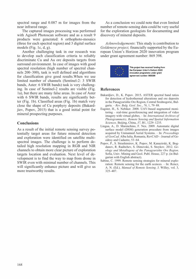
Sources of information such as satellite images (Sentinel-2, Aster) with several spectral channels in SWIR band (Fig. 1a, b) but pure spatial resolu-tion and Drone images with high spatial resolution but limited number of spectral bands in VIS-NIR region (Fig. 1 c–g). Data fusion and feature clas-sification at current research are performed manu-ally because of complexity for automation in this approach. Challenge in this approach is need for good qualification in mineralogy and multi-spectral image processing, but relatively lower cost of image collection and good results sound as a good alterna-
tive for using multi-spectral technology in mineral-ogy exploration.
Combining satellite and UAS applications in geological surveys are the ever-expanding possi-bilities for using specific technical means to acquire spatial information such as multispectral (up to sev-eral spectral channels) and hyperspectral (several tens or even hundreds of spectral channels) radi-ometers and cameras and active scanning devices such as Lidar and Georadar. These capabilities of modern remote-sensing satellite-UAS approach is used in geological exploration in three directions: a) express geological survey for initial target se-lection and appraisal; b) detailed research through UAS with application of advanced technological solutions, aimed at acquiring specific characteristics such as spectral signatures of mineral alterations as a signatures for Cu and Au deposits; c) field geo-logical activities documentation aimed at purchas-ing of time-related surveys for mineral exploration.
Results and discussion Satellite images for Panagyurishte ore district (Pop-ov et al., 2012) that have been obtained from open sources were processed according to criteria for maximum reliability of classification to distinguish known deposits from surrounding environment. The use of UAS as a tool for generating ortho-photo mosaic and a precise surface model of the imaged area is based on an algorithm developed by a re-search group from the Polytechnic University of Turin (Lingua et al., 2009). The survey of the terri-tory is carried out by a pre-prepared flight plan with

167
partially (up to 80%) overlapping individual images (Fig. 1), which ensures their reliable integration into the orthophoto-mosaic and the generation of a digital surface model (Fig. 1c–g). The acquisition of individual images is performed by the UAS in au-tomatic flight mode, as for the capture of relatively small areas (up to 1 km2, as in this case) are using “rotating wing” aircraft, while for capturing larger areas using “fixed wing” aircraft.
The results of a preliminary geological recon-naissance study by means of an unmanned aerial vehicle “rotating wing“ type with the ability to acquire images in two spectral regions: visible (400–700 nm) and near infrared (700–900 nm) zone. The scanning took place in three separate missions at an altitude of 200 m (AGL). This al-lowed the acquisition of images with a spatial resolution of 0.056 m for images from the visible
Fig. 1. a, Sentinel-2 image with classification of ore mineralisations; b, Aster image with classification of ore mineralisations; c, drone visual imaging overlayed on 3D generated model with detected mineral zones.; d, drone IR imaging overlayed on 3D denertated model with ground sample locations; e, VIS spectral range of Tsar Assen porphyry-copper deposit; f, IR spectral range of Tsar Assen porphyry-copper deposit; g, generated digital surface model with zones of mineralisation
168
spectral range and 0.087 m for images from the near infrared range.
The captured images processing was performed with Agisoft Photoscan software and as a result 9 products were generated: 6 orthophoto-mosaics (three for each spectral region) and 3 digital surface models (Fig. 1c, d, g).
Another challenging task in our research was to develop such classification criteria to reliably discriminate Cu and Au ore deposits targets from surround environment. In case of images with good spectral resolution (high number of spectral chan-nels 200–300), task is well defined and algorithms for classification give good results.When we use limited number of channels (Sentinel-2: 3 SWIR bands, Aster: 6 SWIR bands) task is very challeng-ing. In case of Sentinel-2 results are visible (Fig. 1a), but there are many false areas. In case of Aster with 6 SWIR bands, results are significantly bet-ter (Fig. 1b). Classified areas (Fig. 1b) match very close the shape of Cu porphyry deposits (Bakard-jiev, Popov, 2015) that is a good initial point for mineral prospecting purposes.
ConclusionsAs a result of the initial remote sensing survey po-tentially target areas for future mineral detection and exploration were identified on satellite multi-spectral images. The challenge is to perform de-tailed high resolution mapping in RGB and NIR channels to obtain more clear picture of exploration targets location and evaluation. Next level of de-velopment is to find the way to map from drone in SWIR even with minimal number of channels. This will significantly enhance picture and will give us more trustworthy results.
As a conclusion we could note that even limited number of remote-sensing data could be very useful for the exploration geologists for documenting and discovery of mineral deposits.
Acknowledgements: This study is contribution to Goldeneye project, financially supported by the Eu-ropean Union’s Horizon 2020 innovation program under grant agreement number: 869 398.
ReferencesBakardjiev, D., K. Popov. 2015. ASTER spectral band ratios
for detection of hydrothermal alterations and ore deposits in the Panagyurishte Ore Region, Central Srednogorie, Bul-garia. – Rev. Bulg. Geol. Soc., 76, 1, 79–88.
Eugster, H., S. Nebiker. 2008. UAV-based augmented moni-toring – real-time georeferencing and integration of video imagery with virtual globes. – In: International Archives of Photogrammetry, Remote Sensing and Spatial Information Sciences. Beijing, China, 37, B1, 1229–1235.
Lingua, A., D. Marenchino, F. Nex. 2009. Automatic digital surface model (DSM) generation procedure from images acquired by Unmanned Aerial Systems. – In: Proceedings of GeoCad. Alba Iulia, Romania, RevCAD – Journal of Ge-odesy and Cadastre, 53–64.
Popov, P., S. Strashimirov, K. Popov, M. Kanazirski, K. Bog-danov, R. Raditchev, S. Dimovski, S. Stoykov. 2012. Ge-ology and Мetallogeny of the Panagyurishte Оre Region. Sofia, Univ. Mining and Geol. Publ. House, 227 p. (in Bul-garian with English abstract).
Sabine, C. 1999. Remote sensing strategies for mineral explo-ration: Remote sensing for the earth scences. – In: Rencz, A. N. (Ed.), Manual of Remote Sensing. J. Willey, vol. 3, 325–407.