remote sensing to advance sustainable mining …
TRANSCRIPT

REMOTE SENSING TO ADVANCE SUSTAINABLE MINING PRACTICES
B P Banerjee 1 and S Raval 2* 1 PhD student, Australian Centre for Sustainable Mining Practices, University of New South Wales, Sydney, NSW
2052, Australia Email: [email protected] 2 Deputy Director - Undergraduate Studies, School of Mining Engineering, University of New South Wales,
Sydney, NSW 2052, Australia Email: [email protected] * Corresponding Author
KEY WORDS: multispectral, hyperspectral, LiDAR, RADAR, UAVs ABSTRACT: This paper outlines applications of both active (RADAR/LiDAR) and passive (multispectral/hyperspectral) sensors for monitoring mine environment and mine safety. Examples are cited from various remote sensing platforms including satellite, aircraft and unmanned aerial vehicles (UAVs). These platforms are evaluated for their suitability to monitor mining environments on the basis of spatial, spectral and temporal resolutions. Examples are drawn from monitoring different aspects of mining such subsidence, pit slope stability, mine water quality, mine tailings, mine rehabilitation, engineering inspections, abandoned mines, and land cover land use changes. As a concluding remark, the recent advancements in the remote sensing systems are projected in a futuristic visualisation of a smart sensor network for advancing sustainable mining practices.
1. INTRODUCTION Expressions of mining and mineral processing are found in all civilisations throughout history and across the world. Mining provides essential commodities for human livelihood. The demand of earth’s mineral resources has increased ever since industrialisation. The accelerated depletion of the finite earth minerals has triggered the issues of sustainability in mining. Sustainable mining practices is a concept that embeds the principles of sustainable development into the whole mine life-cycle, from exploration, extraction and processing through to mine closure. Sustainability in mining embraces following core concepts (ACSMP, 2011): • Environmental leading practices • Community engagement and support • Economic development • Safety excellence • Optimum resource utilisation
The Australian Centre for Sustainable Mining Practices (ACSMP) has been established at the University of New South Wales, Sydney, Australia to promote leading practices in sustainable development in the mining industry. To this end, the centre has developed a very unique Laboratory for Imaging of the Mining Environment (LIME) in 2010 to apply remote sensing to advance sustainable mining practices. LIME is engaged in developing applications of remote sensing for mining (Figure 2) by using satellite airborne, unmanned aerial vehicles (UAV) and ground based sensors (LIME, 2010). Various LIME projects have utilised satellite images from number of government space agencies including European, Japanese, Italian, German and NASA as well as images from commercial satellite operators such as DigitalGlobe. LIME research is spread all along the electromagnetic spectrum and deals with both active and passive remote sensing (LIME, 2010).
Figure 1 A representation of the five dimensions of sustainable mining practices (ACSMP, 2011, AusTrade, 2013)

Figure 2 Areas for application for remote sensing in sustainable mining (LIME, 2010)
In the recent past, there have been significant advancements in the development of remote sensing platforms (satellite, aircraft and Unmanned Aerial Vehicles – UAVs) as well as sensor systems (multispectral, hyperspectral, thermal, light detection and ranging – LiDAR) and Radio Detection and Ranging – RADAR). However, the selection of appropriate remote sensing techniques for a mining application is complex and requires scrutiny on multiple scales including spatial, temporal and imaging capabilities (Banerjee, et al. 2016b). This paper highlights few case studies conducted at LIME utilising satellite, airborne and UAV platforms for mine environmental and safety monitoring. 2. SATELLITES REMOTE SENSING Satellite based sensing methods have been long applied in the areas of earth observation. Global coverage provided by such systems make them candidate of interest for decision makers and administrative process. In mining context, these have been used as to identify zones of mineralisation (Nakano, et al. 1998) – efficient targeting of resources. Furthermore, these technologies have been also used in the application of environment monitoring and addressing safety issues in mining. This section outlines use of satellite imaging for monitoring land deformations, Land Use Land Cover (LULC) changes, mine re-vegetation and water. 2.1 Monitoring land deformations Many underground mines are prone to cause surface subsidence that is critical to monitor at a required spatial and temporal resolution. There are various ground-based methods that can be used for deformation monitoring, including optical levelling, GPS, and tiltmeters. LIME is involved in promoting Interferometric Synthetic Aperture Radar (InSAR) based subsidence monitoring. Earlier studies involved Envisat (Ng, et al. 2011) and Advanced Land Observation Satellite - Phased Array L-band Synthetic Aperture Radar (ALOS PALSAR) (Ng, et al. 2012b) data. Later, advanced Persistent Scatterer Interferometric Synthetic Aperture Radar (PSInSAR) (Ng, et al. 2012a) approaches were adopted to monitor the displacement at sub-centimetre scale. Morgan, et al. (2013) used satellite-based InSAR for the monitoring of surface movement over an underground coal mine located in the Southern Coalfields of New South Wales, Australia where ground subsidence has been documented. Two stacks of Envisat radar imagery (87 total images) acquired between June 2006 and August 2010 were analysed with the SqueeSAR™ algorithm to reconstruct ground movement patterns during this period at the mine site. The use of two image stacks acquired from different viewing geometries allowed both the vertical and east–west components of ground movement over this site to be determined. The timing and direction of movements were similar to the ground-based Global Positioning System (GPS) survey.

Figure 3 Measured surface displacement rates for the decomposed vertical (left panel) and east-west horizontal movement (right panel), expressed in millimetres per year (Morgan, et al. 2013)
2.2 Monitoring Land Use Land Cover (LULC) changes Sustainable management of land requires regular acquisition of qualitative information regarding the status of its use. It is especially important to track the changes relating to the land’s competitive development needs such as mining and agriculture. The field-based monitoring of a mine with a wide footprint is expensive and time-consuming. Raval, et al. (2014b) has demonstrated use of remote sensing techniques as cost-effective alternatives for the conventional methods of LULC monitoring. They tracked the land cover changes that occurred between the year of 2000 and 2009 in a kaolin mining and processing area in the Kutch region of India using two Landsat-5 Thematic Mapper (TM) images. For this purpose, the spectral signature of the land covers including vegetation cover and kaolin were determined and matched filtering (MF) method was applied to classify the images. The overall accuracy of the classified 2009 image was estimated for the kaolin and the vegetation cover to 89.5% and 86.0% respectively. This study provided a practical framework for rapid mapping of the land cover changes around open-cut kaolin mining area using freely available Landsat data.
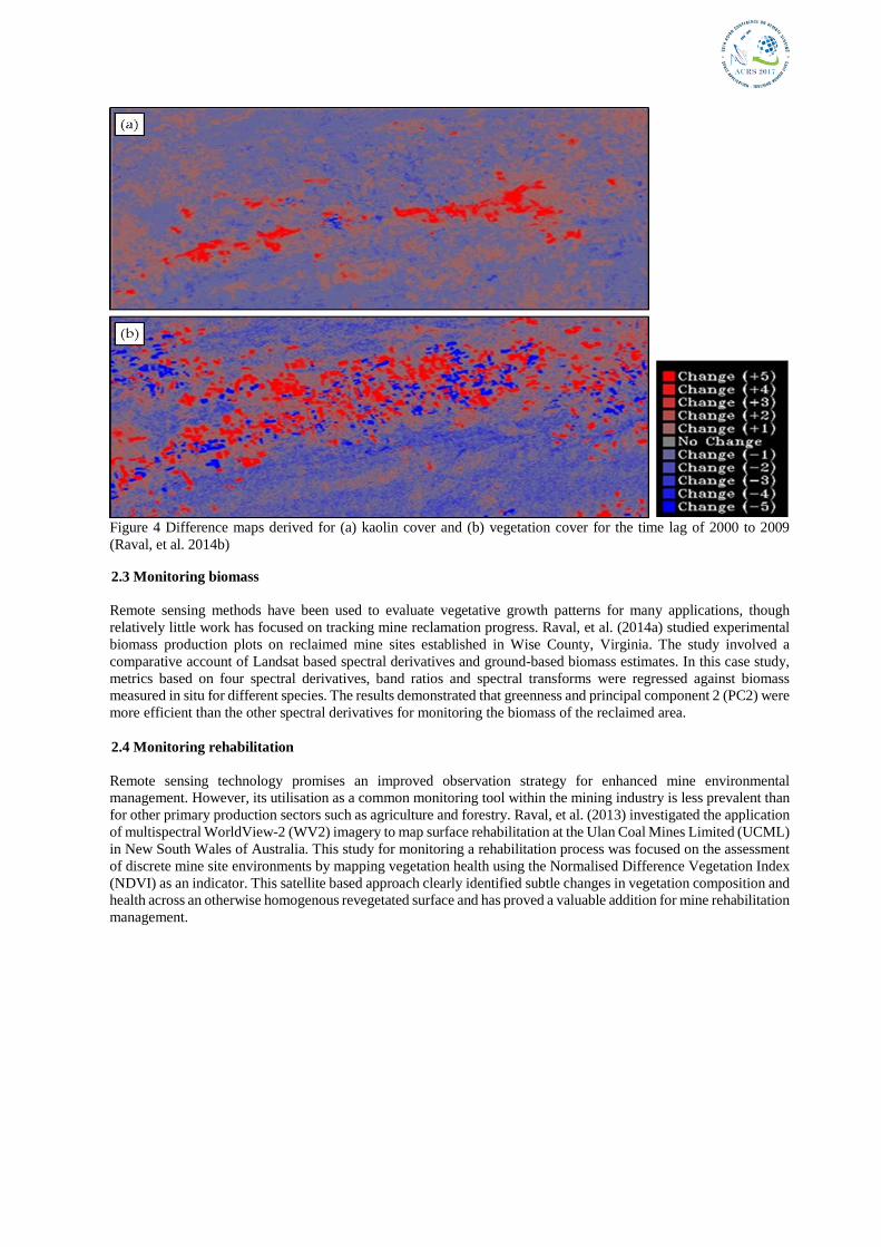
Figure 4 Difference maps derived for (a) kaolin cover and (b) vegetation cover for the time lag of 2000 to 2009 (Raval, et al. 2014b)
2.3 Monitoring biomass Remote sensing methods have been used to evaluate vegetative growth patterns for many applications, though relatively little work has focused on tracking mine reclamation progress. Raval, et al. (2014a) studied experimental biomass production plots on reclaimed mine sites established in Wise County, Virginia. The study involved a comparative account of Landsat based spectral derivatives and ground-based biomass estimates. In this case study, metrics based on four spectral derivatives, band ratios and spectral transforms were regressed against biomass measured in situ for different species. The results demonstrated that greenness and principal component 2 (PC2) were more efficient than the other spectral derivatives for monitoring the biomass of the reclaimed area. 2.4 Monitoring rehabilitation Remote sensing technology promises an improved observation strategy for enhanced mine environmental management. However, its utilisation as a common monitoring tool within the mining industry is less prevalent than for other primary production sectors such as agriculture and forestry. Raval, et al. (2013) investigated the application of multispectral WorldView-2 (WV2) imagery to map surface rehabilitation at the Ulan Coal Mines Limited (UCML) in New South Wales of Australia. This study for monitoring a rehabilitation process was focused on the assessment of discrete mine site environments by mapping vegetation health using the Normalised Difference Vegetation Index (NDVI) as an indicator. This satellite based approach clearly identified subtle changes in vegetation composition and health across an otherwise homogenous revegetated surface and has proved a valuable addition for mine rehabilitation management.
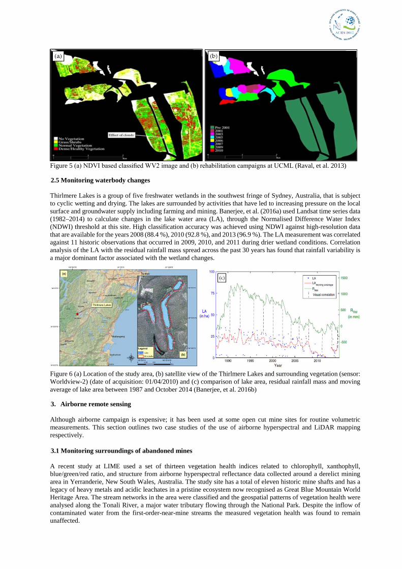
Figure 5 (a) NDVI based classified WV2 image and (b) rehabilitation campaigns at UCML (Raval, et al. 2013)
2.5 Monitoring waterbody changes Thirlmere Lakes is a group of five freshwater wetlands in the southwest fringe of Sydney, Australia, that is subject to cyclic wetting and drying. The lakes are surrounded by activities that have led to increasing pressure on the local surface and groundwater supply including farming and mining. Banerjee, et al. (2016a) used Landsat time series data (1982–2014) to calculate changes in the lake water area (LA), through the Normalised Difference Water Index (NDWI) threshold at this site. High classification accuracy was achieved using NDWI against high-resolution data that are available for the years 2008 (88.4 %), 2010 (92.8 %), and 2013 (96.9 %). The LA measurement was correlated against 11 historic observations that occurred in 2009, 2010, and 2011 during drier wetland conditions. Correlation analysis of the LA with the residual rainfall mass spread across the past 30 years has found that rainfall variability is a major dominant factor associated with the wetland changes.
Figure 6 (a) Location of the study area, (b) satellite view of the Thirlmere Lakes and surrounding vegetation (sensor: Worldview-2) (date of acquisition: 01/04/2010) and (c) comparison of lake area, residual rainfall mass and moving average of lake area between 1987 and October 2014 (Banerjee, et al. 2016b)
3. Airborne remote sensing Although airborne campaign is expensive; it has been used at some open cut mine sites for routine volumetric measurements. This section outlines two case studies of the use of airborne hyperspectral and LiDAR mapping respectively. 3.1 Monitoring surroundings of abandoned mines A recent study at LIME used a set of thirteen vegetation health indices related to chlorophyll, xanthophyll, blue/green/red ratio, and structure from airborne hyperspectral reflectance data collected around a derelict mining area in Yerranderie, New South Wales, Australia. The study site has a total of eleven historic mine shafts and has a legacy of heavy metals and acidic leachates in a pristine ecosystem now recognised as Great Blue Mountain World Heritage Area. The stream networks in the area were classified and the geospatial patterns of vegetation health were analysed along the Tonali River, a major water tributary flowing through the National Park. Despite the inflow of contaminated water from the first-order-near-mine streams the measured vegetation health was found to remain unaffected.

Figure 7 Forest cover, abandoned mines and stream in the historic township of Yerranderie in as Great Blue Mountain World Heritage Area
3.2 Airborne LiDAR vigilance of mine sites Airborne LiDAR has been utilised by mine sites primarily for volumetric calculations of mining dumps. However, few mine sites use the LiDAR data for monitoring subsidence as well as designing weathering profiles. Airborne LiDAR data could overcome some of the shortcomings of the widely-used ground survey marks. A study was conducted at LIME to compare airborne LiDAR measurements against the ground based traditional survey (Figure 8).
Figure 8 Overlay of subsidence derived from LiDAR on (a) underground longwall panels and (b) survey lines and (c) comparison of LiDAR measurements against a crossline survey line measurement
4. UAV based remote sensing Primarily, the development of UAVs was mediated by its application in military. However, low cost of operation, high data fidelity, high resolution, high frequency mission planning, etc. made them ideal platforms to be used in different remote sensing applications such as agriculture, forestry, urban, disaster management, etc. The utility of UAVs in mining application has been gaining popularity. 4.1 Monitoring spontaneous combustion Coal stockpiles at mine sites are susceptible to spontaneous combustion with a potential of causing a fire. Coal fires can cause both enormous economic losses and release a lot of greenhouse gases which causes air pollutions. A UAV based thermal imaging system has been operated by LIME to monitor and assess the risk of spontaneous combustion

by measuring minute changes in ground temperature on a coal stockpile (Figure 9).
Figure 9 (a) A UAV integrated with a FLIR Tau2 and a GoPro Hero3 camera system and (b) thermal anomaly map of the coal reserve
4.2 Monitoring sensitive eco-system surrounded by mining activities If not managed properly, mining in sensitive environment can cause severe environmental implications. Sensitive ecosystem needs to be monitored at higher resolution since the satellite resolution is often not sufficient to map these ecosystems at desired scale. Recent development of light weight hyperspectral sensors now make them possible to be carried on UAVs for a closed ranges high-resolution data acquisition. A light weight UAV-hyperspectral system has been integrated at LIME to address the environmental monitoring in context of mining around sensitive eco-systems. In a study, the UAV-hyperspectral system has been used to map threated vegetation in an endangered swamp ecosystem on top of an underground mining operation. The system was also deployed to map photosynthetic activity of the vegetation to identify the level of stress in the threatened vegetation (Figure 10).
Figure 10 (a) An integrated UAV-hyperspectral sensor system (b) and (c) false colour infrared composite (850.35, 670.31, and 550.14 nm) of two transects, (d) and (e) classification outputs
4.3 Mapping structural parameters of a pit wall Safety is one of the leading challenges in a dynamic mining environment, continual changes in the landscape in an open cut mine often leave behind unstable slopes, highwalls, pits and dumps. It is necessary to map such environment dynamically. A UAV based LiDAR system has been recently integrated at LIME to map structural parameters of high-walls. Funded by the Australian Coal Research Corporation (ACARP); the designed system is the first of its kind deployed in mapping highwalls in open-cut coal mines (Figure 11).

Figure 11 (a) A UAV integrated with a Velodyne LiDAR, Inertial Measurement Unit (IMU), and Real Time Kinematic - GPS (RTK GPS) (Phoenix LiDAR system) and (b) colourised point cloud map of the highwall
4.4 Remote water sampling In another case study, a water sampling system has been designed at LIME to collect sample from remote tailings dams on a mine site using a UAV (Figure 12). Tailings dam is an artificial enclosure which is created to collect the by-products of a processed minerals extracted from ore. It is necessary to monitor the quality of water in tailingss dam since abnormality of water quality could pollute ground water and could also cause structural instability of the dam wall. The results obtained through this study indicated that a UAV based water sampling system could be used to obtain water samples from inaccessible environments such as tailings dam without compromising on the quality of the collected water samples.
Figure 12 (a) A UAV integrated with a water sampling system designed in LIME and (b) interpolated map of Electrical Conductivity (EC) on the tailings dam water
5. Conclusion Generally, mine sites cover large landscapes that needs frequent observations to monitor encompassed soil, water, vegetation and air for environmental conservation as well as safety implications. Traditional use of remote sensing for mining has remained for exploration, mainly from satellite and airborne hyperspectral sensors. However, recent advancements in heavy-duty platforms and lightweight sensors provided great potential for future applications. Banerjee, et al. (2016b) has summarised the number of remote sensing studies conducted for mining applications sourced from the Scopus publication data (Scopus, 2016) in Table 1. The table clearly indicates dominance of applications in exploration and safety monitoring from satellite and airborne platforms. However recent advancements in UAVs pose significant potential for future applications.

Table 1 Summary of the number of remote sensing studies applied for life-of-mine applications (Banerjee, et al. 2016a).
Sensor Multispectral Hyperspectral LiDAR Microwave Thermal Other sensors Total
Platform
Sate
llite
Airb
orne
UA
V
Sate
llite
Airb
orne
UA
V
Sate
llite
Airb
orne
UA
V
Sate
llite
Airb
orne
UA
V
Sate
llite
Airb
orne
UA
V
Sate
llite
Airb
orne
UA
V
Exploration 51 53 0 30 55 2 0 0 0 2 0 0 43 37 0 4 33 0 310 Planning 0 0 0 1 2 0 0 0 0 0 0 0 0 0 0 0 0 0 3 Safety 6 1 0 1 4 0 0 3 0 49 0 0 36 18 0 0 0 1 119 Air 0 0 0 0 0 0 0 0 0 0 0 0 0 0 0 0 0 1 1 Water and tailings 0 4 0 3 9 0 0 0 0 0 0 0 0 0 0 0 0 0 16
Soil 18 6 0 12 10 0 0 0 0 0 0 0 0 0 0 0 0 0 46 Vegetation 10 0 0 3 12 0 0 6 0 0 0 0 0 0 0 0 0 0 31 Abandoned mines 0 5 0 0 10 0 0 0 0 1 0 0 0 0 0 0 0 0 16
LULC change 6 0 0 0 0 0 0 0 0 0 0 0 0 0 0 0 0 0 6
Legend (number of studies in Scopus (Scopus, 2016)): 0 1-24 25 50+
Technological advances over the last six or seven years have made so many more things possible, and the systems continue to advance at a rapid rate. Not only do we have access to increasingly powerful, light weight and cost-effective sensors but, simultaneously, we have access to increasingly powerful drones and UAVs with a higher load carrying capacity. On the other hand, algorithms to handle the generated data are getting smarter too. What is necessary is to intelligently mould them for specific applications. Statically, we have seen the commercial use of drones has increased nearly five folds in the last decade. The global drone market size is expected to be USD 21.23 Billion by 2022 (Markets and Markets, 2017). In mining, futuristic vision for a mine site is to have a number of drones making automated observations that feed into a smart system to predict areas of concern and mitigate against them.
6. References ACSMP (Australian Centre for Sustainable Mining Practices), 2011. A Guide to Leading Practice Sustainable Development in Mining. Leading Practice Sustainable development program for the mining industry, Australian Government.
AusTrade (Australian Trade), 2013. Sustainable mining. Australian Trade Commission, Australian Government.
Banerjee, B.P., Raval S., and Timms W., 2016a. Evaluation of rainfall and wetland water area variability at Thirlmere Lakes using Landsat time-series data. International Journal of Environmental Science and Technology. pp. 1-12.
Banerjee, B.P., and Raval, S., 2016b. Applications of Advanced Remote Sensing Systems during a Mine Life. Life-of-Mine, Brisbane, Queensland, Australia. pp. 119-123.
LIME (Laboratory for Imaging the Mining Environment), 2010. Laboratory for Imaging the Mining Environment. Retrieved 20 September 2017, from http://www.acsmp.unsw.edu.au/laboratory-for-imaging-the-mining-environment-lime-0.
Markets and Markets, 2017. Retrieved 20 September 2017, from http://www.marketsandmarkets.com/PressReleases/commercial-drones.asp
Morgan, J., Raval, S., Macdonald, B., Falorni G., and Iannacone J., 2013. Application of advanced InSAR techniques to detect vertical and horizontal displacements. Proceedings of international symposium in slope stability in open pit mining and civil engineering, Brisbane, Australia.

Nakano, O., Ishii, E., Ozawa, N., Mullard, B., Beckett, J., Robson, D., and Willmore, A., 1998. Examination of the gravity & electromagnetic survey methods applied to coal exploration in the area of the southern Gunnedah Basin. Exploration Geophysics. (29), pp. 543-549
Ng, A., Ge, L., and Zhang, K., 2011. Application of Persistent Scatterer Interferometry for Land Subsidence Monitoring in Sydney, Australia using ENVISAT ASAR Data. 34th International Symposium on Remote Sensing of Environment.
Ng, A., H.-M., Ge, L., Li, X., Abidin, H. Z., Andreas, H., and Zhang, K., 2012a. Mapping land subsidence in Jakarta, Indonesia using persistent scatterer interferometry (PSI) technique with ALOS PALSAR." International Journal of Applied Earth Observation and Geoinformation 18(Supplement C), pp. 232-242.
Ng, A. H.-M., Ge, L., Zhang, K., and Li, X., 2012b. Estimating horizontal and vertical movements due to underground mining using ALOS PALSAR. Engineering Geology 143(Supplement C), pp. 18-27.
Raval, S., Merton, R. N., and Laurence, D., 2013. Satellite based mine rehabilitation monitoring using WorldView-2 imagery. Mining Technology 122(4): 200-207.
Raval, S., Sarver, E., Shamsoddini, A., Zipper, C., Donovan, P., Evans D., and Chu, H. T., 2014a. Satellite remote sensing-based estimates of biomass production on reclaimed coal mines. Mining Engineering 66(4), pp. 76-82.
Raval, S., and Shamsoddini, A., 2014b. A monitoring framework for land use around kaolin mining areas through Landsat TM images. Earth Science Informatics 7(3), pp. 153-163.
Scopus, 2016. Sopus online search database. from: http://www.scopus.com.