report on the geological mapping and soil geochemistry of
TRANSCRIPT

Report on the Geological Mapping and Soil Geochemistry of Part of Claim 1183925, Kaladar Twp. South-Eastern, Ontario
Dr. Derek McBride P.Eng. Toronto, Ontario,
May 29, 2015.

2
Table of Contents
Introduction 3 Property Location and Description (Figure 1) 3 Regional Geological Setting and Mineralization 3 Regional, local and Property Geology 3 Mineralization 5 2015 Exploration program 5 Investigations 6 Geological Observations on Claim 1183925 (Map 1) 6 Soil Geochemistry 9 Interpretation and Conclusions 9 References 11 Statement of Costs 11 Certificate 12 Assay Certificate 13
List of Figures
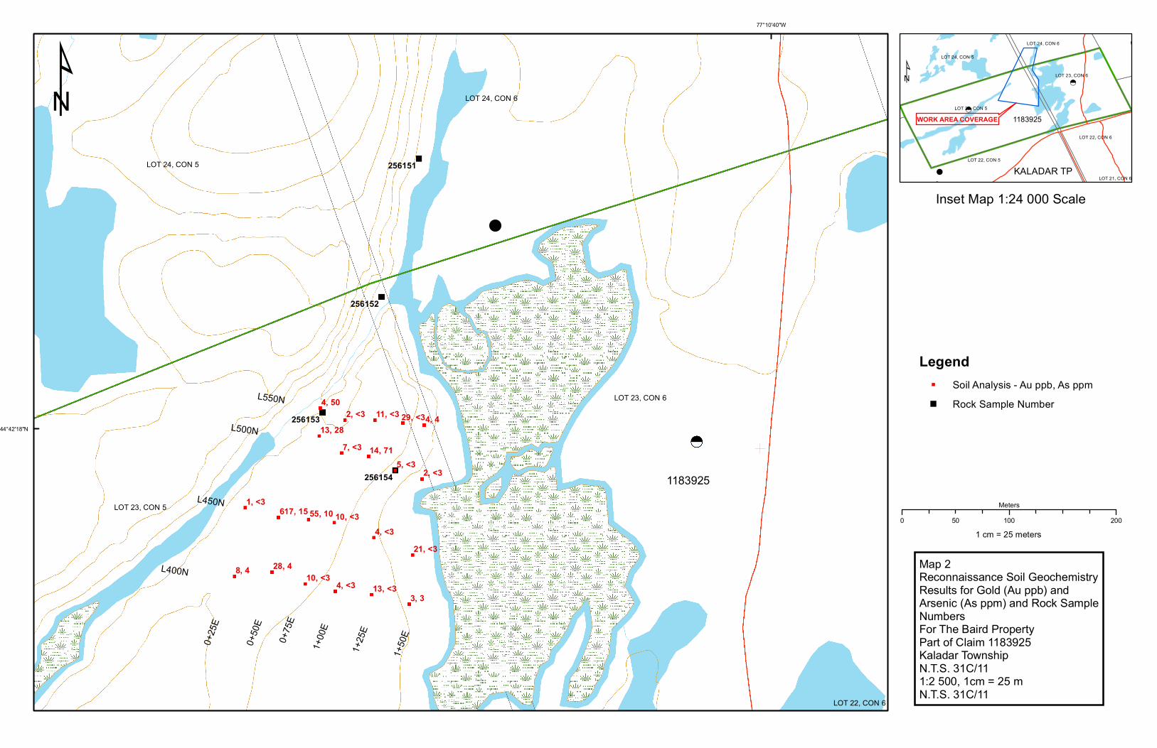
1: Showing Position of Claim 1183925 in Kaladar Township 4 2: Geology Map 15 3: Geochemistry map Soils and Rocks 16
List of Photos 1: Folded quartz vein in with regional foliation axial plan 6 2: Old trench up hill near north boundary of property 7 3: Pit on Line 500N, 1+25E exposing 1.5 metre wide quartz vein system 8 4: 20 cm conformable quartz vein in mafic volcanic tuffs 8 5: Quartz pebble conglomerate that forms the basal part of the sedimentary sequence 9
3
INTRODUCTION Dr. Derek McBride P.Eng. has been requested by Mr. D. Baird, owner of the mining claim to complete a brief survey claim, number 1183925, to determine if the Addington Mine horizon is present on the property. The Baird Property ties on to the south boundary of the old Addington Mine which is situated one and a half kilometres southwest of the Hamlet of Northbrook on Highway 41 north of Kaladar, Ontario (Figure 1). GEOLOGICAL SETTING AND MINERALIZATION REGIONAL, LOCAL AND PROPERTY GEOLOGY The Addington gold deposit is within the Grenville Geological Province an approximately 1.2 to 1.3 billion year old belt of highly metamorphosed volcanic and sedimentary rocks. In the area centred on Marmora and extending east northeast to past the Ottawa River, the rocks are part of an “orogenic” greenstone belt of a metamorphosed volcano-sedimentary sequence similar to the greenstone belts of the Archean of Northern Ontario and Quebec. Early geologists commented on the geology and gold deposits, but the first regional mapping was carried out by Harding (1942). He summarizes the thinking of previous geologists like Selwyn, Miller and Knight. These geologists had various interpretations for the sedimentary rocks ranging from part of the larger Grenville Series to being part of the Temiskaming of Northern Ontario. Harding says the rocks are Pre-Cambrian consisting of andesites and basalts with minor sediments on the bottom, Keewatin Series of Miller and Knight, overlain by a mixture of clastic and chemical sediments and capped by conglomerates and the sediments of the Hastings or Grenville Series. His mapping defined the volcano-sedimentary belt of rocks trending through Kaladar Twp. The strikes and dips of the three series is essentially parallel indicating they are essentially a conformable succession. Harding goes on to describe the folding of these rocks about a warping and/or primary distribution of the major rock units. Wolff did not add anything new to the knowledge of the Addington Mine area. When all these maps are combined they show a complexly infolded succession of volcanic and sedimentary rocks. The author has worked and mapped in many parts of the Madoc-Bancroft-Kaladar area and sees many common features with the Beardmore-Geraldton Greenstone Belt of Northern Ontario which show up in its volcanic-sedimentary evolution and subsequent deformation. That is not to say they are the same age; they are not! and are less than half the age. The evolution of the Beardmore-Geraldton Greenstone Belt and the position of economic gold deposits within in it have been discussed by the author (McBride, 1987). In general,

4

5
the sequence starts off with ultramafic-mafic volcanic rocks and trends upward though some felsic rocks and ends in a sedimentary succession of clastic and chemical sedimentary rocks. Economic or potentially economic gold deposits are concentrated along the transition from the volcanic to sedimentary rocks. All types of mineral deposits found in this “greenstone” belt are also found in all the others around the world regardless of their ages. These rocks have been folded by a single major deformation that produced a regional schistosity and folds. The present distribution of these rocks reflects this period of deformation. The property geology has been described by Harding and was more recently mapped by E&B Explorations. All rock units strike just east to of north and dip to the east. To the west the property is underlain by mafic volcanic pillow lavas, agglomerates and tuffs of the Tudor Group and to the east, overlying them are quartzites and conglomerates of the Flinton Group. Over most of the property, these rocks form two parallel ridges separated by a narrow valley. The mineralization is exposed in the mafic volcanic rocks on the west side of this valley. To the south it vanishes under a pond and to he north under thin overburden and swamps. Historically the mineralization was traced by 18 trenches and the main shaft is an inclined shaft sunk on the mineralization. At this location the mineralization is seen to consist of arsenopyrite-bearing volcanic tuffs and quartz veins. MINERALIZATION Mineralization has been found intermittently along the contact described above. It has been described as occurring in the transition zone from volcanic to sedimentary rocks. During the present investigations, it was observed that the transition zone was a sequence of interbedded mafic tuffs and quartzites. Gold correlated with higher arsenopyrite concentrations in the host rocks. Arsenopyrite is less common in the quartz veins and so are the gold values. Tourmaline is common in the quartz veins and as bands (?) in the host rocks. It forms as slender needles which have been fractured, probably during the regional deformation. This deformation is represented by regional schistosity (foliation) that is pervasive throughout all rock units; is axial planar to the folds and is responsible for the flattening of pebbles in the conglomerates, and the gold-bearing arsenopyrite grains. 2015 EXPLORATION PROGRAM In 2015 a small program was undertake on the north central part of the claim to confirm the continuation of the Addington Mine gold-bearing horizon on to the claim. Historical reports had mentioned gold in old pits. In 2005 D. Baird had put in a small flagged grid west of the large pond in the east part of the property. He returned in 2012 and carried out some prospecting that exposed a quartz vein with 1.93 g/T gold. His filed assessment report shows an MMI anomaly that appeared to be a continuation of the horizon known to carry the Addington Mine gold mineralization.

6
INVESTIGATIONS Initial access was along the old fence line marking the north boundary of the claim. It crosses low ridges composed of quartzites and quartz pebble conglomerate until it hits a long narrow pond. Across the pond is the sequence of ridge forming mafic volcanic tuffs; thus the pond marks the contact between the two rock sequences. An outcrop of mafic tuff beside the pond shows a folded quartz vein (Photo 1). On the east edge of these ledges a series of old trenches trace a series of bedding parallel folded quartz veins. Four trenches or pits were encountered on the northern part of the claim. Three are north of the junction of the creeks and beyond the MMI survey area where one goes up the hill for 15 metres (Photo 1). A fourth is on line 5+00N on the new grid exposes a quartz vein system about 1 and a half metres wide (Photo 3). This grid ideally duplicates that of Baird, but no markers were found, just a few bleached flags. The four north lines of the Baird grid were duplicated; geological mapping and soil sampling were carried out. A single picket was found that was legible; it read base line, 3+75N. This base line has a 008 deg. azimuth with perpendicular cross lines. GEOLOGICAL OBSERVATIONS A long linear pond comes to the north boundary of the claim where it meets another linear creek from the southwest; together they entre a large pond that occupies the western half of the eastern claim unit. The south side is marked by a ridge, the back bone of which is the footwall mafic volcanic rocks which is also the anomalous gold trend in the Baird MMI survey. These rocks are composed of finely bedded tuffs that have been
Photo 1
Folded quartz vein in favourable geology with regional foliation axial planar

7
Photo 2
Old trench up hill near north boundary of property metamorphosed to amphibole-chlorite schists with conformable quartz veining within the upper 50 to 75 metres of the unit (Photo 4). To the east the lower ground is underlain by quartzites and quartz pebble conglomerate. Conglomerates dominate the sedimentary rocks of the lower (West) part of the sedimentary sequence in the area (Photo 5).

8
Photo 3
Pit on Line 5N, 1+25E exposing 1.5 metre wide quartz vein system
Photo 4
20 cm conformable quartz vein in mafic volcanic tuffs
9
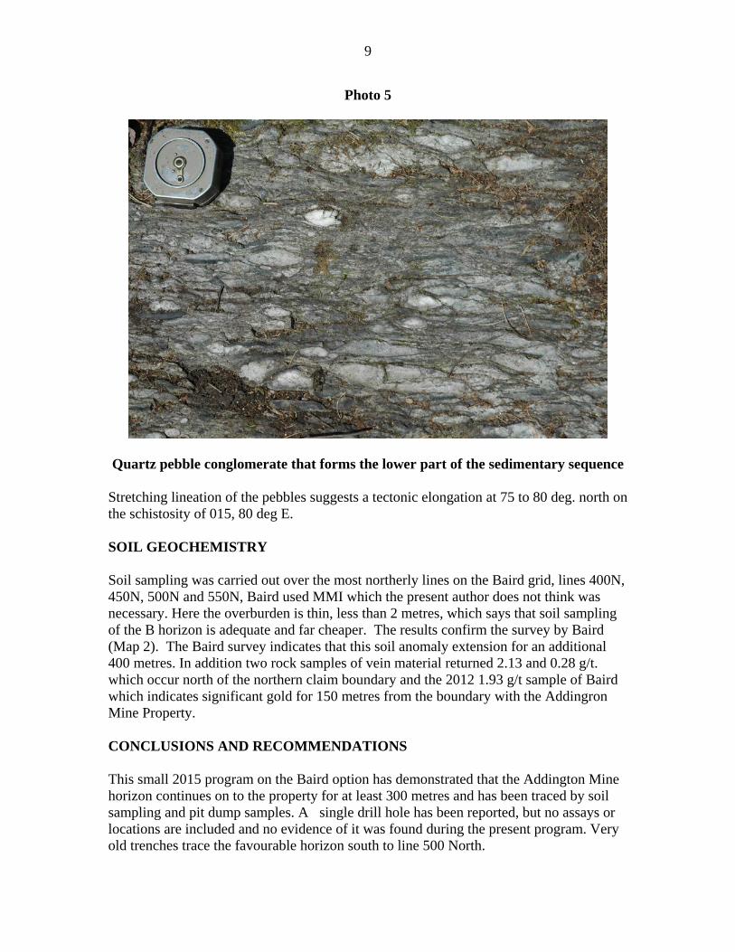
Photo 5
Quartz pebble conglomerate that forms the lower part of the sedimentary sequence
Stretching lineation of the pebbles suggests a tectonic elongation at 75 to 80 deg. north on the schistosity of 015, 80 deg E. SOIL GEOCHEMISTRY Soil sampling was carried out over the most northerly lines on the Baird grid, lines 400N, 450N, 500N and 550N, Baird used MMI which the present author does not think was necessary. Here the overburden is thin, less than 2 metres, which says that soil sampling of the B horizon is adequate and far cheaper. The results confirm the survey by Baird (Map 2). The Baird survey indicates that this soil anomaly extension for an additional 400 metres. In addition two rock samples of vein material returned 2.13 and 0.28 g/t. which occur north of the northern claim boundary and the 2012 1.93 g/t sample of Baird which indicates significant gold for 150 metres from the boundary with the Addingron Mine Property. CONCLUSIONS AND RECOMMENDATIONS This small 2015 program on the Baird option has demonstrated that the Addington Mine horizon continues on to the property for at least 300 metres and has been traced by soil sampling and pit dump samples. A single drill hole has been reported, but no assays or locations are included and no evidence of it was found during the present program. Very old trenches trace the favourable horizon south to line 500 North.

10
It is recommended that the present grid be extended across the claim; it should be mapped and soil sampled. There is a report of a gold showing south along strike on the Flinton Road. If this site is connected it would indicate that the known gold-bearing horizon is more than 1000 metres to the southwest. A gold showing is reported just of the northwest corner of the property and pits have been noted in the same area on the property. This area deserves some investigation.

11
References Harding, W. D. 1942: Geology of Kaladar and Kennebec Townships: Ont. Dept. Mines, vol. 51, pt. 4, pp. 51-74. Hewitt, D.F. 1968: Geology of Madoc Township ad the North part of Huntington Township: Ont. Dept. Mines, Geol Rept. 73, 45p. Johnson, W. 1982: Geophysical and Geological Surveys on the Flinton Project, Kaladar Township, Ontario for E&B Explorations Inc. 22p. Wolff, J. M. 1982: geology of the Kaladar Area, Lennox and Addington and Frontenac C Counties; Ont. Geol. Surv., Rept. No. 215, 94p.
Statement of Costs
Statement of Costs Date Item Cost HST pd.. 27/05/2015 Subcontracting J Laidlaw $1,582.00 $ 182.00 27/05/2015 SGS assaying $1,418.82 $ 163.22 27/05/2015 Auto use KM 1106 @$0.50 $ 624.89 $ 71.89 30/05/2015 Expenses $ 136.79 30/05/2015 Consulting Fee D. McBride $4,237.50 $ 475.50
TOTALS $8,000.00 $ 892.61
12
CERIFICATE I, Dr. Derek E. McBride P.Eng., do hereby certify that: 1. I reside at 20 Forsythia Dr., West Hill, Ontario, Canada, M1E 1Y1. 2. I am a consulting geologist and have been authorized to practice as a geological
engineer since 1980 in Ontario, British Columbia and prior to that in New Brunswick and Nova Scotia since 1975.
3. I am a graduate of the Haileybury School of Mines with a diploma in Mining
Technology and from the Queen’s University, Kingston, Ontario with B. Sc. Eng. And M.Sc. Eng. Degrees in 1968 and 1972 respectively and a Ph.D. in geology from the University of New Brunswick 1976, and I have practised my profession continuously since that time. My speciality has been in mineral exploration and has included porphyry copper, volcanogenic massive sulphide, orogenic gold, silver, iron, uranium and diamond experience. Projects have covered most geological provinces in Canada and in 16 different countries. I am credited with two gold mine discoveries.
4. I am a Professional Engineer licensed by PEO (Membership Number 29879012). 5. I am a “Qualified Person” for the purpose of NI 43-101. 6. I am solely responsible for all sections of this report.
“Original signed by Dr. Derek McBride P.Eng.”
Dr. Derek McBride, P.Eng.
May 29, 2015

13
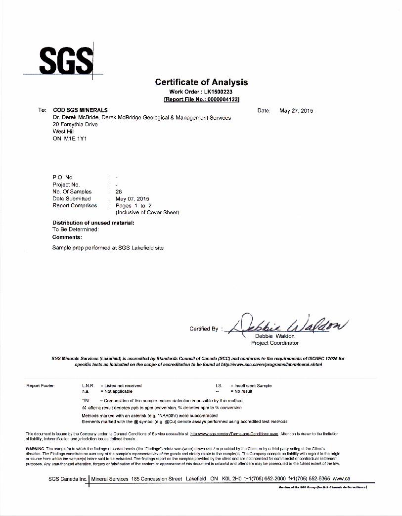
SGS Assay Certificate
ANALYTE Wt Kg Au As METHOD G_WGH79 GE_FAI313 GE_ICP12B DETECTION 0.001 1 3 UNITS kg ppb ppm
256151 0.525 2130 6 256152 0.488 278 567 256153 0.643 3 5 256154 0.313 4 <3
L4+50N - 0+25E 0.281 1 <3 L4+50N - 0+50E 0.244 617 15 L4+50N - 0+75E 0.293 55 10 L4+50N - 1+00E 0.171 10 <3 L4+50N - 1+25E 0.325 4 <3 L4+50N - 1+50E 0.233 21 <3 L4+00N - 0+50E 0.1 28 4 L4+00N - 0+25E 0.247 8 4 L4+00N - 1+50E 0.21 4 <3 L4+00N - 1+25E 0.243 13 <3 L4+00N - 1+50E 0.199 3 3 L4+00N - 1+75E 0.242 10 <3 L5+00N - 1+00E 0.156 14 71 L5+00N - 1+25E 0.2 5 <3 L5+00N - 1+50E 0.173 2 <3 L5+00N -0+50E 0.131 13 28 L5+00N -0+75E 0.188 7 <3 L5+50N -0+50E 0.159 4 50 L5+50N -1+25E 0.159 29 <3 L5+50N -1+00E 0.146 11 <3 L5+50N -0+75E 0.218 2 <3 L5+50N -1+50E 0.108 4 4 REP-256154 3 REP-L4+50N - 1+00E <3

14

15

256154
256153
256152
256151
4, 4
3, 3
8, 4
2, <34, 50
7, <3
2, <35, <3
4, <328, 4
4, <3
1, <3
11, <3 29, <313, 28
14, 71
10, <313, <3
21, <3
10, <355, 10617, 15
LOT 23, CON 6
LOT 23, CON 5
LOT 24, CON 5
LOT 24, CON 6
LOT 22, CON 6
77°10'40"W
44°42'18"N
¹
0 100 20050Meters
1 cm = 25 meters
Map 2Reconnaissance Soil GeochemistryResults for Gold (Au ppb) andArsenic (As ppm) and Rock SampleNumbersFor The Baird PropertyPart of Claim 1183925Kaladar TownshipN.T.S. 31C/111:2 500, 1cm = 25 mN.T.S. 31C/11
1183925
L550N
0+50
E
0+25
E
0+75
E
1+00
E
1+25
E
1+50
E
L500N
L450N
L400N
LegendSoil Analysis - Au ppb, As ppmRock Sample Number
LOT 23, CON 5
LOT 22, CON 5
LOT 23, CON 6
LOT 24, CON 5
LOT 22, CON 6
LOT 24, CON 6
LOT 21, CON 6
1183925WORK AREA COVERAGE
KALADAR TP
Inset Map 1:24 000 Scale
¹