request for approval to ask 14 projects to submit full ...deltaconservancy.ca.gov/docs/ai 10 board...
TRANSCRIPT
Agenda Item: 10 Attachment: 1
Meeting Date: January 27, 2015 Page 1
Request for approval to ask 14 projects to submit full proposals for the Ecosystem Restoration and Water Quality Grant Program.
January 27, 2016
RECOMMENDATIONS
Staff requests approval to ask the 14 projects indicated in Table 1 to submit full proposals for the Ecosystem Restoration and Water Quality Grant Program.
PROJECT DESCRIPTION
The Water Quality, Supply, and Infrastructure Improvement Act of 2014 (Prop. 1) identifies projects to protect and restore California rivers, lakes, streams, and watersheds (Sec. 79732 et seq). In Prop. 1, $50 million is identified for the Conservancy “for competitive grants for multibenefit ecosystem and watershed protection and restoration projects in accordance with statewide priorities” (Sec. 79730 and 79731). The Conservancy’s Ecosystem Restoration and Water Quality grant program is focused on the restoration of important species and habitat. During its first grant cycle, the Conservancy‘s highest priority projects will address (1) restoration and enhancement; (2) water quality; and (3) agricultural sustainability.
BACKGROUND The Conservancy's reopened Concept Proposal solicitation period closed on December 18, 2015. The Conservancy received a total of 24 Concept Proposals. The proposals fell into the following categories: floodplain restoration, fish screen construction, habitat enhancement for listed species, channel margin habitat restoration, flood and conservation easements, habitat enhancement of working lands, agricultural sustainability, invasive species removal, and habitat restoration. Of these proposals:
7 were new proposals, 7 were revised from the previous solicitation, and 10 were unchanged from the first solicitation;
9 requested Category 1 funds, and 15 requested Category 2 funds;
4 are located in Contra Costa County, 5 are in Sacramento County, 5 are in San Joaquin County, 3 are in Solano County, and 7 are in Yolo County; and
9 are in the North Delta, 2 are in the Central Delta, 5 are in the West Delta, and 8 are in the South Delta.
The total funds requested for all proposals was $18,308,189, with funding requests ranging from $28,245 to $2 million. A summary of Concept Proposal recommendations is provided in the attached table.
1450 Halyard Drive, Suite 6 West Sacramento, CA 95691 www.deltaconservancy.ca.gov
Agenda Item: 10 Attachment: 1
Meeting Date: January 27, 2015 Page 2
Conservancy staff has reviewed and scored all 24 proposals, and recommends asking 14 of the applicants to submit full proposals, with an anticipated total funding request of $11,869,141. The Concept Proposals for the 14 recommended projects are included as an attachment; the projects are in the order they appear in the table below. Each proposal was reviewed independently by at least three staff members (the Executive Officer, Deputy Executive Officer, and at least one staff person). After independent scoring, staff met to discuss all proposals with scoring discrepancies. Significant discrepancies in individual scores were discussed and normalized, and are reflected in the final scores and recommendations presented to the Board.
Pending Board approval, staff proposes to open the full proposal solicitation period on February 1, 2016, and to close the solicitation on March 15, 2016 at 5pm. Staff will contact all applicants eligible to submit a full proposal. All applicants will be provided with detailed feedback on their Concept Proposal.
BUDGET
In Prop. 1, $50 million is identified for the Conservancy “for competitive grants for multibenefit ecosystem and watershed protection and restoration projects in accordance with statewide priorities” (Sec. 79730 and 79731). For the 2015-2016 fiscal year, $9 million has been allocated to the Conservancy for the Ecosystem Restoration and Water Quality grant program. Funds requested by Concept Proposal applicants total $18,308,189. Conservancy staff is recommending 14 to submit full proposals with an anticipated total funding request of $11,869,141. Full proposals will be subject to a rigorous scoring and evaluation process by both staff and the technical review panel, and will be recommended based upon score and funding availability.
Contact Person: Campbell Ingram, Executive Officer Sacramento-San Joaquin Delta Conservancy Phone: (916) 375-2089
Agenda Item: 10 Attachment: 1
Meeting Date: January 27, 2015 Page 3
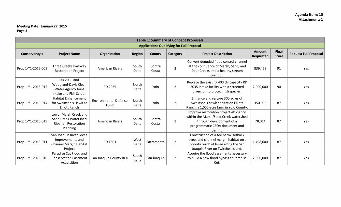
Table 1: Summary of Concept Proposals
Applications Qualifying for Full Proposal
Conservancy # Project Name Organization Region County Category Project Description Amount
Requested Final Score
Request Full Proposal
Prop 1-Y1-2015-009 Three Creeks Parkway
Restoration Project American Rivers
South Delta
Contra Costa
2
Convert denuded flood control channel at the confluence of Marsh, Sand, and
Deer Creeks into a healthy stream corridor.
839,458 91 Yes
Prop 1-Y1-2015-015
RD 2035 and Woodland-Davis Clean
Water Agency Joint Intake and Fish Screen
RD 2035 North Delta
Yolo 2 Replace the existing 400 cfs capacity RD
2035 intake facility with a screened diversion to protect fish species.
2,000,000 90 Yes
Prop 1-Y1-2015-014 Habitat Enhancement
for Swainson's Hawk at Elliott Ranch
Environmental Defense Fund
North Delta
Yolo 2 Enhance and restore 300 acres of Swainson's hawk habitat on Elliott
Ranch, a 1,000-acre farm in Yolo County. 350,000 87 Yes
Prop 1-Y1-2015-019
Lower Marsh Creek and Sand Creek Watershed
Riparian Restoration Planning
American Rivers South Delta
Contra Costa
1
Improve restoration project efficiency within the Marsh/Sand Creek watershed
through development of a programmatic CEQA document and
permit.
78,014 87 Yes
Prop 1-Y1-2015-011
San Joaquin River Levee Improvements and
Channel Margin Habitat Project
RD 1601 West Delta
Sacramento 2
Construction of a toe berm, setback levee, and channel margin habitat on a
priority reach of levee along the San Joaquin River on Twitchell Island.
1,498,600 87 Yes
Prop 1-Y1-2015-010 Paradise Cut Flood and Conservation Easement
Acquisition San Joaquin County RCD
South Delta
San Joaquin 2 Acquire the flood easements necessary to build a new flood bypass at Paradise
Cut. 2,000,000 87 Yes
Agenda Item: 10 Attachment: 1
Meeting Date: January 27, 2015 Page 4
Conservancy # Project Name Organization Region County Category Project Description Amount
Requested Final Score
Request Full Proposal
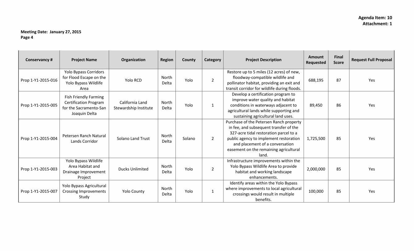
Prop 1-Y1-2015-016
Yolo Bypass Corridors for Flood Escape on the
Yolo Bypass Wildlife Area
Yolo RCD North Delta
Yolo 2
Restore up to 5 miles (12 acres) of new, floodway-compatible wildlife and
pollinator habitat, providing an exit and transit corridor for wildlife during floods.
688,195 87 Yes
Prop 1-Y1-2015-005
Fish Friendly Farming Certification Program
for the Sacramento-San Joaquin Delta
California Land Stewardship Institute
North Delta
Yolo 1
Develop a certification program to improve water quality and habitat
conditions in waterways adjacent to agricultural lands while supporting and
sustaining agricultural land uses.
89,450 86 Yes
Prop 1-Y1-2015-004 Petersen Ranch Natural
Lands Corridor Solano Land Trust
North Delta
Solano 2
Purchase of the Petersen Ranch property in fee, and subsequent transfer of the 327-acre tidal restoration parcel to a
public agency to implement restoration and placement of a conversation
easement on the remaining agricultural land.
1,725,500 85 Yes
Prop 1-Y1-2015-003
Yolo Bypass Wildlife Area Habitat and
Drainage Improvement Project
Ducks Unlimited North Delta
Yolo 2
Infrastructure improvements within the Yolo Bypass Wildlife Area to provide
habitat and working landscape enhancements.
2,000,000 85 Yes
Prop 1-Y1-2015-007 Yolo Bypass Agricultural Crossing Improvements
Study Yolo County
North Delta
Yolo 1
Identify areas within the Yolo Bypass where improvements to local agricultural
crossings would result in multiple benefits.
100,000 85 Yes
Agenda Item: 10 Attachment: 1
Meeting Date: January 27, 2015 Page 5
Conservancy # Project Name Organization Region County Category Project Description Amount
Requested Final Score
Request Full Proposal
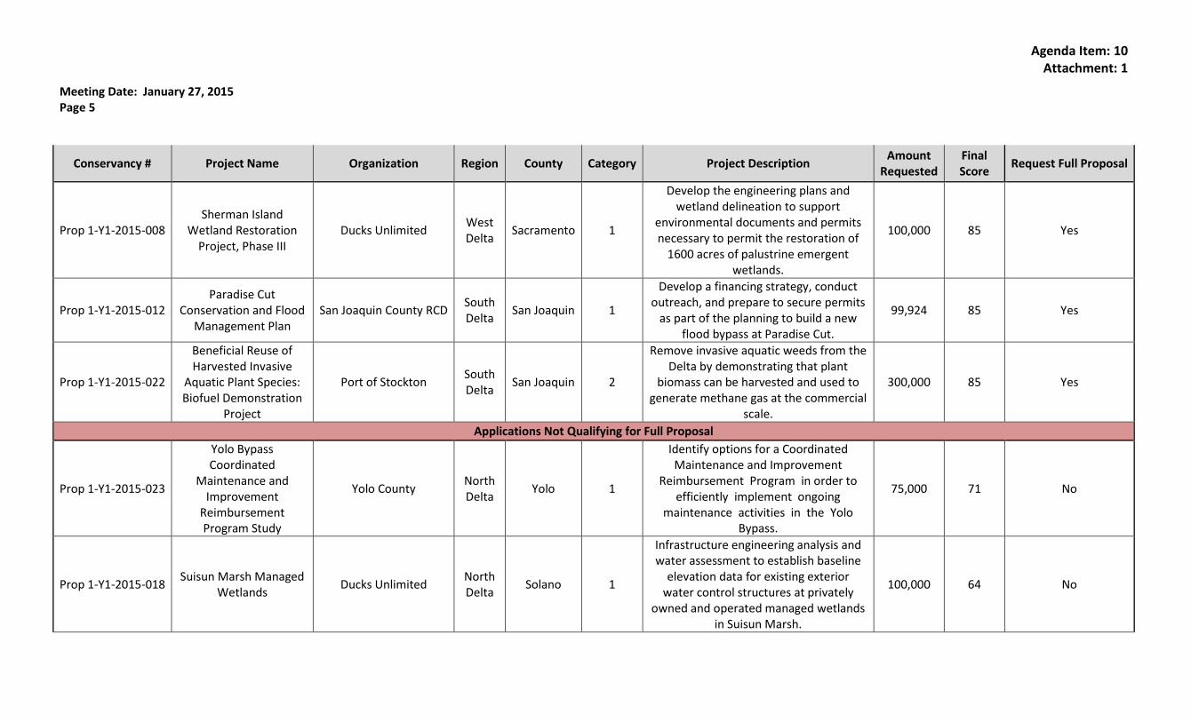
Prop 1-Y1-2015-008 Sherman Island
Wetland Restoration Project, Phase III
Ducks Unlimited West Delta
Sacramento 1
Develop the engineering plans and wetland delineation to support
environmental documents and permits necessary to permit the restoration of
1600 acres of palustrine emergent wetlands.
100,000 85 Yes
Prop 1-Y1-2015-012 Paradise Cut
Conservation and Flood Management Plan
San Joaquin County RCD South Delta
San Joaquin 1
Develop a financing strategy, conduct outreach, and prepare to secure permits
as part of the planning to build a new flood bypass at Paradise Cut.
99,924 85 Yes
Prop 1-Y1-2015-022
Beneficial Reuse of Harvested Invasive
Aquatic Plant Species: Biofuel Demonstration
Project
Port of Stockton South Delta
San Joaquin 2
Remove invasive aquatic weeds from the Delta by demonstrating that plant
biomass can be harvested and used to generate methane gas at the commercial
scale.
300,000 85 Yes
Applications Not Qualifying for Full Proposal
Prop 1-Y1-2015-023
Yolo Bypass Coordinated
Maintenance and Improvement
Reimbursement Program Study
Yolo County North Delta
Yolo 1
Identify options for a Coordinated Maintenance and Improvement
Reimbursement Program in order to efficiently implement ongoing
maintenance activities in the Yolo Bypass.
75,000 71 No
Prop 1-Y1-2015-018 Suisun Marsh Managed
Wetlands Ducks Unlimited
North Delta
Solano 1
Infrastructure engineering analysis and water assessment to establish baseline
elevation data for existing exterior water control structures at privately
owned and operated managed wetlands in Suisun Marsh.
100,000 64 No
Agenda Item: 10 Attachment: 1
Meeting Date: January 27, 2015 Page 6
Conservancy # Project Name Organization Region County Category Project Description Amount
Requested Final Score
Request Full Proposal
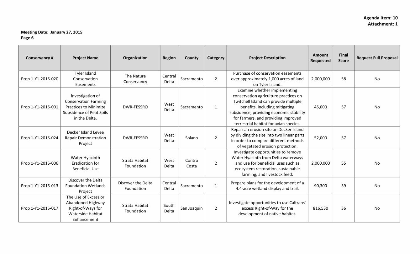
Prop 1-Y1-2015-020 Tyler Island
Conservation Easements
The Nature Conservancy
Central Delta
Sacramento 2 Purchase of conservation easements
over approximately 1,000 acres of land on Tyler Island.
2,000,000 58 No
Prop 1-Y1-2015-001
Investigation of Conservation Farming Practices to Minimize
Subsidence of Peat Soils in the Delta.
DWR-FESSRO West Delta
Sacramento 1
Examine whether implementing conservation agriculture practices on Twitchell Island can provide multiple
benefits, including mitigating subsidence, providing economic stability
for farmers, and providing improved terrestrial habitat for avian species.
45,000 57 No
Prop 1-Y1-2015-024 Decker Island Levee
Repair Demonstration Project
DWR-FESSRO West Delta
Solano 2
Repair an erosion site on Decker Island by dividing the site into two linear parts in order to compare different methods
of vegetated erosion protection.
52,000 57 No
Prop 1-Y1-2015-006 Water Hyacinth Eradication for Beneficial Use
Strata Habitat Foundation
West Delta
Contra Costa
2
Investigate opportunities to remove Water Hyacinth from Delta waterways
and use for beneficial uses such as ecosystem restoration, sustainable
farming, and livestock feed.
2,000,000 55 No
Prop 1-Y1-2015-013 Discover the Delta
Foundation Wetlands Project
Discover the Delta Foundation
Central Delta
Sacramento 1 Prepare plans for the development of a
4.4-acre wetland display and trail. 90,300 39 No
Prop 1-Y1-2015-017
The Use of Excess or Abandoned Highway
Right-of-Ways for Waterside Habitat
Enhancement
Strata Habitat Foundation
South Delta
San Joaquin 2 Investigate opportunities to use Caltrans'
excess Right-of-Way for the development of native habitat.
816,530 36 No

Agenda Item: 10 Attachment: 1
Meeting Date: January 27, 2015 Page 7
Conservancy # Project Name Organization Region County Category Project Description Amount
Requested Final Score
Request Full Proposal
Prop 1-Y1-2015-002
Relating in Real-time the Movements of Juvenile Spring-run Chinook to Climate-
driven Flows in South Delta For Effective
Management
U.C. Davis South Delta
San Joaquin 2 Monitor migratory movements of Spring-run Chinook to determine survival rates.
1,231,973 ineligible No
Prop 1-Y1-2015-021
Aquatic Weed Survey and Dissemination of Current and Historical
Survey Data
CDFA South Delta
Contra Costa
2
Conduct a visual survey of aquatic plant populations within 3 parts of the Delta;
provide this and historical survey information in an accessible format on
the agency website.
28,245 ineligible No
1
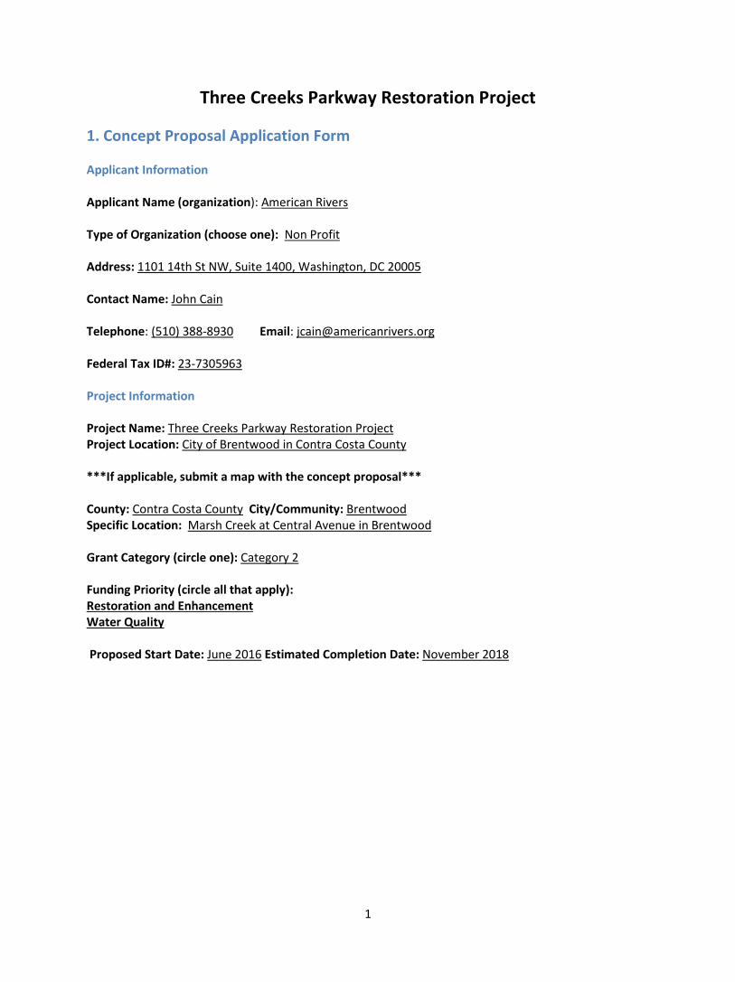
Three Creeks Parkway Restoration Project 1. Concept Proposal Application Form Applicant Information Applicant Name (organization): American Rivers Type of Organization (choose one): Non Profit Address: 1101 14th St NW, Suite 1400, Washington, DC 20005 Contact Name: John Cain Telephone: (510) 388-8930 Email: [email protected] Federal Tax ID#: 23-7305963 Project Information Project Name: Three Creeks Parkway Restoration Project Project Location: City of Brentwood in Contra Costa County ***If applicable, submit a map with the concept proposal*** County: Contra Costa County City/Community: Brentwood Specific Location: Marsh Creek at Central Avenue in Brentwood Grant Category (circle one): Category 2 Funding Priority (circle all that apply): Restoration and Enhancement Water Quality Proposed Start Date: June 2016 Estimated Completion Date: November 2018
2
2. Project Description American Rivers and our partners propose a multi-benefit ecosystem restoration project at the confluence of Marsh, Sand, and Deer Creeks (Three Creeks) to convert the denuded flood control channel into a healthy stream corridor. The Three Creeks Parkway Restoration Project (Project) will restore native vegetation on 12.5 acres along nearly a mile of Marsh Creek. The Project will restore floodplain and riparian habitat along 4,000 linear feet of creek to increase flood protection and contribute to achieving water quality objectives in the Delta. It will also maximize voluntary landowner participation (all of the project site landowners are involved in and supportive of our proposed efforts). This Project is aimed at reestablishing the thriving habitat and functional floodplains that are at the heart of healthy creek and wetland ecosystems. The Project will greatly enhance the habitat and resilience of the Marsh Creek watershed ecosystem, including increasing resilience to climate change. This Project will also improve the quality of life for Delta residents in one of the most densely developed areas of the Delta by reducing flood risk, improving recreational opportunities, and providing a place to make meaningful connections with the natural world of the Delta region. Project Location and Vision Marsh Creek watershed, located in eastern Contra Costa County, is uniquely situated between the Delta and Mt. Diablo, providing an important ecological corridor in a burgeoning urban area of the Delta. Marsh Creek flows 30 river miles from the eastern slope of Mount Diablo through eastern Contra Costa County to the San Joaquin Delta at Big Break. Our vision for Marsh Creek is a stream of clean, cold water, surrounded by stands of native trees and a spread of grasses and wildflowers—a vital and healthy habitat corridor between protected conservation areas on the Delta shoreline and Mt. Diablo State Park. Over the past decade, the project team has been working to achieve our vision, organizing community members, building a fish ladder, designing restoration projects, and restoring a two-acre site along the creek.
Project Need Unfortunately, 6.5 miles of the once sinuous and wooded creek are now a denuded, trapezoidal flood control channel with steep banks vegetated with non-native grasses and no riparian canopy. The Soil Conservation Service and the Contra Costa County Flood Control and Water Conservation District (District) constructed this earthen trapezoidal channel, along with Marsh Creek Reservoir, a flood control detention basin, during the 1960s and early 1970s, after large, damaging flood events occurred. The channel and reservoir were designed to convey a 50-year storm in an agricultural area when the region was mostly undeveloped and agriculture was the predominant land use. Since the channel was constructed, the upper watershed has remained mostly protected parklands and open space, but the lower watershed has urbanized rapidly. The watershed is home to more than 184,000 people, its cities growing 55 to 336 percent over the past 20 years. Marsh Creek now flows through extensive development before entering the Delta, carrying mostly urban runoff into the heart of the western Delta. Like many urban creeks, water quality in Marsh Creek is impaired by several pollutants. The creek is on the 2006 303(d) list classified as impaired by mercury and metals. In addition, the current draft 303(d)/305(b) Integrated Report recommends listing Marsh Creek as impaired by diazinon, E. coli, sediment toxicity and unknown toxicity. The 2011 State of the Marsh Creek Watershed report prepared by Friends of Marsh Creek Watershed (FoMCW) identifies temperature, turbidity, dissolved oxygen, and excessive nitrates as additional water quality issues. This report points to discharges from rapid urbanization, loss of filtering wetlands, and intensive agriculture as the three main drivers of these water quality issues.
3
Improving water quality in Marsh Creek is particularly important to protect the major investments the state plans to make to restore over 1,200 acres of tidal marsh at the mouth of Marsh Creek. To date, the state has already spent or committed more than $50 million for the Dutch Slough Restoration project and the adjacent tidal marsh project on the west side of Marsh Creek at the Ironhouse Sanitary District. At the time of those investments, the CALFED Ecosystem Restoration Program specifically urged the Dutch Slough proponents to consider watershed restoration investments necessary to ensure that Dutch Slough is successful.
Marsh Creek’s aquatic and riparian habitat is severely limited, with little complexity, no floodplain wetlands and no shade. High velocities during annual peak flow events, which are greatly increased by runoff from newly urbanized surfaces, presumably flush most of the egg and larval stages of aquatic species downstream. Poor water quality from urban runoff is made worse by the lack of wetlands, shade, and microbial activity in the channel. Relatively high temperatures combined with low-dissolved oxygen levels have resulted in four major fish kills on Marsh Creek over the last nine years.
It is clear that traditional management methods will not improve the degraded habitat and water quality of Marsh Creek and the larger Delta ecosystem. The engineered channel does not act as a filter to capture and immobilize contaminants. Also, an annual mowing program conducted by the District prevents trees from growing in the undersized channel where non-native grasses flourish. Thus unimpeded, urban and agricultural runoff currently spills into Marsh Creek and flows through a denuded channel into the Delta.
In spite of the problems discussed above, there are significant opportunities for achieving our vision. For example, the creek is currently home to a surprising diversity and abundance of native fish and wildlife such as western pond turtles, river otters, beavers, green and blue herons, egrets, Chinook salmon, and warm-water native fishes such as California roach and hitch. Despite channelization, Marsh Creek provides an important wildlife corridor for species moving from the Diablo Range to the Sacramento-San Joaquin River Delta. Through the existing East Bay Regional Parks District (EBRPD) park facilities and trails, Marsh Creek also provides a cultural and physical connection to the Delta, allowing East County residents to walk and bike from Big Break and its aquatic recreation facilities, through Oakley to downtown Brentwood and on to Marsh Creek State Park – one of the earliest European settlements in the Delta. Thus, the creek provides one of the longest, non-motorized pathways in Contra Costa County. This project will build upon these existing advantages and greatly enhance the habitat and resilience of the Marsh Creek ecosystem. Goals and Objectives The overall goal of this multi-benefit project is to improve habitat and water quality along Marsh Creek and in the Delta by restoring riparian and floodplain habitat along the Marsh Creek flood control channel through the cities of Brentwood, Oakley, and Antioch. The specific objectives of this project are to
1. Restore floodplain and native vegetation along 4,000 linear feet of Marsh Creek between Dainty Avenue and the Union Pacific Railroad.
2. Dramatically improve habitat by restoring 12.5 weedy, ruderal and treeless acres with native vegetation to enhance the creek’s ecosystem, including 3.6 acres of frequently inundated floodplain (seasonal wetland), 5.2 acres of woody riparian vegetation, and 5.3 acres of grasslands and native scrub that will provide habitat for several species covered by the East Contra Costa County Habitat Conservation Plan/ Natural Community Conservation Plan (HCP/NCCP).

4
3. Create an attractive parkway environment along the Marsh Creek Trail. 4. Improve flood management and ecosystem resilience to climate change for the Delta
communities of Brentwood, Antioch, and Oakley, where a large fraction of Delta residents live. 5. Implement a successful multi-benefit flood management project that can serve as a catalyst for
other projects along Marsh Creek and throughout the Delta watershed. Tasks and Deliverables Task 1: Project management and administration American Rivers will serve as the fiscal lead for the grant and coordinate management with the District though a formal memorandum of agreement. Deliverables: 1) timely invoices, 2) quarterly reports, 3) final close-out report. Task 2: Detailed design American Rivers has already retained a consultant and developed detailed conceptual plans. American Rivers will work with the District to refine the conceptual design and develop final designs by the spring of 2017. Deliverables: 1) 35% conceptual design, 2) 60% design 3) detailed planting plan, 4) final design and bid package. Task 3: Construction American Rivers and the District will jointly retain a construction contractor to widen 4,000 linear feet of channel and excavate a new floodplain bench. Construction is currently planned for the summer of 2017. Most of the excavated material will be deposited on adjacent parcels that are slated for urban development. Deliverables: 1) widen 4,000 linear feet of channel and construct floodplain 30-60 feet wide bench, 2) grade and create new trail crossings under Central and Dainty avenues. Task 4: Revegetation American Rivers and the District will jointly retain a revegetation contractor to plant 12.5 acres of native vegetation along 4,000 feet of channel including 300 trees. Deliverables: 1) revegetate 12.5 acres with native vegetation including 300 15-gallon trees, 11,000 one-gallon plants, 2,000 five-gallon plants, and 30,000 square yards of native hydro-seed. Task 5: Public outreach and agency coordination The Friends of Marsh Creek Watershed (FoMCW) will lead a public outreach and education effort to teach local residents about the value of Marsh Creek and the impact of Marsh Creek water quality on the Delta. The FoMCW will install several interpretive signs along the creek to interpret natural history, human history, and the Delta. Deliverables: 1) three tours of the creek and restoration site, 2) three presentations about the project at public meetings in Brentwood and Oakley.
5
Task 6: Monitoring and maintenance American Rivers and the District will develop a long-term monitoring and maintenance plan for the project to manage invasive species and ensure the project performs as intended. American Rivers has already secured a $150,000 maintenance endowment. Deliverables: 1) annual salmon counts, 2) seasonal water quality sampling at five locations along the creek where FoMCW has historically collected data, 3) three years of vegetation monitoring and maintenance to ensure survival of plantings and replacement of failed plantings, 4) a long-term maintenance agreement between the District, the City of Brentwood, and the East Bay Regional Park District, which maintains a trail through the site. 3. Organizational Capacity
American Rivers will work closely with the District and FoMCW to implement this Project. American Rivers is a national nonprofit organization that has completed dozens of similar scale restoration projects, such as removing outdated dams across the country and restoring mountain meadows in the Sierra Nevada. We have a strong reputation of completing projects on time and within budget. In 2013, American Rivers worked with the U.S. Forest Service to restore the hydrology and habitat of Indian Valley Meadow, an iconic 500-acre site located on the Mokelumne River that is home to several threatened and endangered species. Our experienced restoration program team has directly worked on more than 230 dam removal projects around the country, and we have trained hundreds of professionals in government agencies, nonprofits, and consulting firms to manage many other dam removal projects.
Since its founding in 1951, the District has completed individually or participated as a team member in numerous flood control and multi-use projects in Contra Costa County. Most recently in 2014, the District completed the Upper Sand Creek Basin (USCB), a flood detention basin located a few miles to the west of the Three Creeks Parkway site on a tributary to Marsh Creek. USCB cost over $14 million which included $2 million of Department of Water Resources (DWR) Prop 1E grant funds. USCB created 10 acres of seasonal and permanent wetlands as part of the restoration project, and the remainder of the site has been designed to accommodate a future sports park for the City of Antioch.
FoMCW is a local grassroots, citizen’s group that has been actively supporting this project and engaged in the planning since the concept for this project was developed in 2004. FoMCW was incorporated as a nonprofit in November 2009 and since that time has received and managed many grants and implemented projects ranging from on-the-ground restoration to water quality monitoring to creek cleanups and an at-risk youth work-study program. FoMCW consistently meets or exceeds grant expectations and is a responsible and committed partner. 4. Consistency with Funding Requirements, Project Selection, and Programmatic Criteria The Three Creeks Parkway Restoration Project (Project) is a great example of a multi-benefit project that will reduce flood risk associated with a changing climate, improve Delta water quality, restore denuded stream-side habitat, and enhance the Delta as place. New floodplain wetlands and riparian vegetation along the channel will cleanse polluted run-off from agricultural and urban lands that drain to Marsh Creek, Dutch Slough, and eventually to the Delta and Bay. The project will advance water quality recommendations of the Delta plan to improve environmental water quality by reducing several pollutants conveyed to the Delta by urban and stormwater run-off

6
including nitrates, pathogens, and contaminants. Improving environmental water quality in Marsh Creek is particularly important to ensure that the Delta Plans recommendations to protect Dutch Slough - apriority habitat restoration area.
Restoring native vegetation along the creek will also help restore habitat for several sensitive species, such as spawning Chinook salmon, and others that are covered by the Contra Costa HCP/NCCP, including Swainson’s hawk, California red-legged frog, California tiger salamander, western pond turtle, and Alameda whipsnake. The HCP/NCCP does not cover aquatic species, but in recognition of the value of the creek to terrestrial species, did recommend creek restoration and mandates a 75-foot native vegetation buffer for all new projects along Marsh Creek. In 2010 American Rivers, FoMCW, and the District successfully constructed a fish ladder to allow Chinook salmon to access spawning habitat on Marsh Creek. The proposed Project will help restore spawning and rearing habitat in the heart of Brentwood. Restoring habitat for sensitive species in a suburban center provides a great place to raise public awareness and hope about the plight of endangered species. In addition to the multiple benefits described above, the Project will increase opportunities for tourism and recreation leading to quality of life improvements for a large fraction of the Delta’s residents. It will significantly enhance the heavily used Marsh Creek Trail and catalyze the development of a parkway from the Delta shoreline to Mt. Diablo – the Delta’s most visible landmark. The Marsh Creek Trail is managed by the EBRPD and links their Big Break Visitor Center at the Delta with Dutch Slough and Mt. Diablo. The trail combined with the connecting De Anza Trail links the communities of Antioch, Oakley, and Brentwood and conservatively serves over 1,000 people per day. 5. Readiness American Rivers is applying for a category 2 implementation grant, and we plan to construct the Project during the summer of 2017. We have all necessary landowner agreements in place to implement the Project. We have detailed topographic, hydrologic, and biological data to complete project design and permitting. Archeological surveys are currently our only data gap and we are arranging to conduct those surveys over the next few months. We have already obtained commitments for eighty three percent of the funding we will need to build the Project. The District will provide $2.3 million for design and construction. The partners obtained a $744,000 grant from the DWR Urban Streams Restoration Program, and American Rivers obtained an additional one million dollars from a neighboring developer for construction. The developer will also finance the construction of an adjacent creek-side park on three acres with 2.5 acres of native vegetation at a cost of approximately $900,000. We need an additional $1,000,000 to complete the Project.
The District completed an EIR to widen 2,400 linear feet of creek in 1998, and a nearby developer completed an EIR in 2014 to build a linear park along the remaining 1,600 linear feet of the Project as part of an adjacent subdivision. Because the District EIR is seventeen years old and the developer’s EIR did not entail modifying the creek, American Rivers and the District are currently preparing a new CEQA document. The District will serve as the lead agency under CEQA. Because much of the Project is identified as a priority restoration area in the HCP/NCCP and due to the very poor quality of existing habitat at the site, the District plans to file a mitigated negative declaration. A biological survey of the site conducted this spring characterized the entire site as “ruderal habitats,” and ruled out potential impacts to any special status plant species, and identified avoidance and mitigation measures for a small number of animal species that could potentially use the site.
7
6. Cooperation and Support The Project is a model of collaboration that has brought together a government entity (District), a national conservation organization (American Rivers), a private developer (Pulte Homes), a municipality (City of Brentwood), a local community group (Friends of Marsh Creek Watershed), a local habitat conservancy (East Contra Costa County Habitat Conservancy), and a regional park district (East Bay Regional Park District) to agree on a plan to restore Marsh Creek. The District and American Rivers have worked particularly closely to coordinate project planning with all of these entities, and we will continue to do so throughout project implementation.
Although the District owns the channel and must approve all projects, large parts of the project were initiated by the Friends of Marsh Creek Watershed, American Rivers, and the City of Brentwood. Staff from American Rivers and volunteers with FoMCW have been working on this project for over 15 years. The City of Brentwood and the District have consistently supported the project, and in 2014 American Rivers obtained $1 million to implement the project from a neighboring developer followed by a $744,000 grant from the Department of Water Resources Urban Streams Restoration Program. 7. Available Science and Adaptive Management
This Project is an innovative non-structural approach to habitat restoration and flood management. Instead of trying to control the creek in a narrow zone with levees and floodwalls, it focuses on giving the creek more room to safely convey flood waters while also providing habitat for aquatic and terrestrial species. The project will restore 4,000 linear feet of channel margin and floodplain. Numerous recent plans and scientific studies have validated the importance of floodplains for native aquatic species and to enhance water quality. Floodplain restoration will provide habitat for native fish, including rearing Chinook salmon and a host of other aquatic and terrestrial species, including riparian song birds. Equally important, restored floodplain and riparian habitat will filter pollutants from the watershed and improve the quality of water conveyed to the Delta. American Rivers, FoMCW, and the District have spent years collecting data on the biota, channel conditions and vegetation along Marsh Creek. We successfully restored a two-acre floodplain in Oakley with a unique assemblage of plants native to east Contra Costa County. We have a long-record of fish utilization of Marsh Creek dating back to the mid nineteen nineties. The project team will continue to monitor water quality, channel habitat, and vegetation success after the project is constructed. The team has already secured a $150,000 maintenance endowment to adaptively manage the restoration project. The Project will increase adaptability to climate change by accommodating larger runoff events, providing shade along a creek, creating a wildlife corridor, and using native plants in lieu of traditional landscape plants that require irrigation. There are currently no trees at all along Marsh Creek and the adjacent regional trail. The project will strive to create a nearly continuous shade canopy along all 4,000 feet of trail and at least 2,400 linear feet of creek. The project will also enable the creek channel to convey larger flood events that are expected to occur as a result of climate change. 8. Project Assessment The objectives (listed under “Goals and Objectives” above) will inform the benchmarks we will use to measure our progress, success, and effectiveness. More specifically, the outcomes and outputs we expect as a result of this Project are listed below. American Rivers will work with the District and
8
FoMCW to track and report on our progress toward completing the outputs and achieving the outcomes. Outputs:
• Number of native plants planted • Area of new floodplain created • Area of seasonal floodplain wetlands created
Outcomes: • Percent survival of native plants planted • Number of acres with restored native plant habitat • Reduction of pollutants in Marsh Creek (see section 2 above) • Increase benthic macroinvertebrate diversity • Increased diversity and abundance of native fish species • Length of stream channel with improved habitat • Area of frequently inundated floodplain reestablished
9. Funding Request and Budget
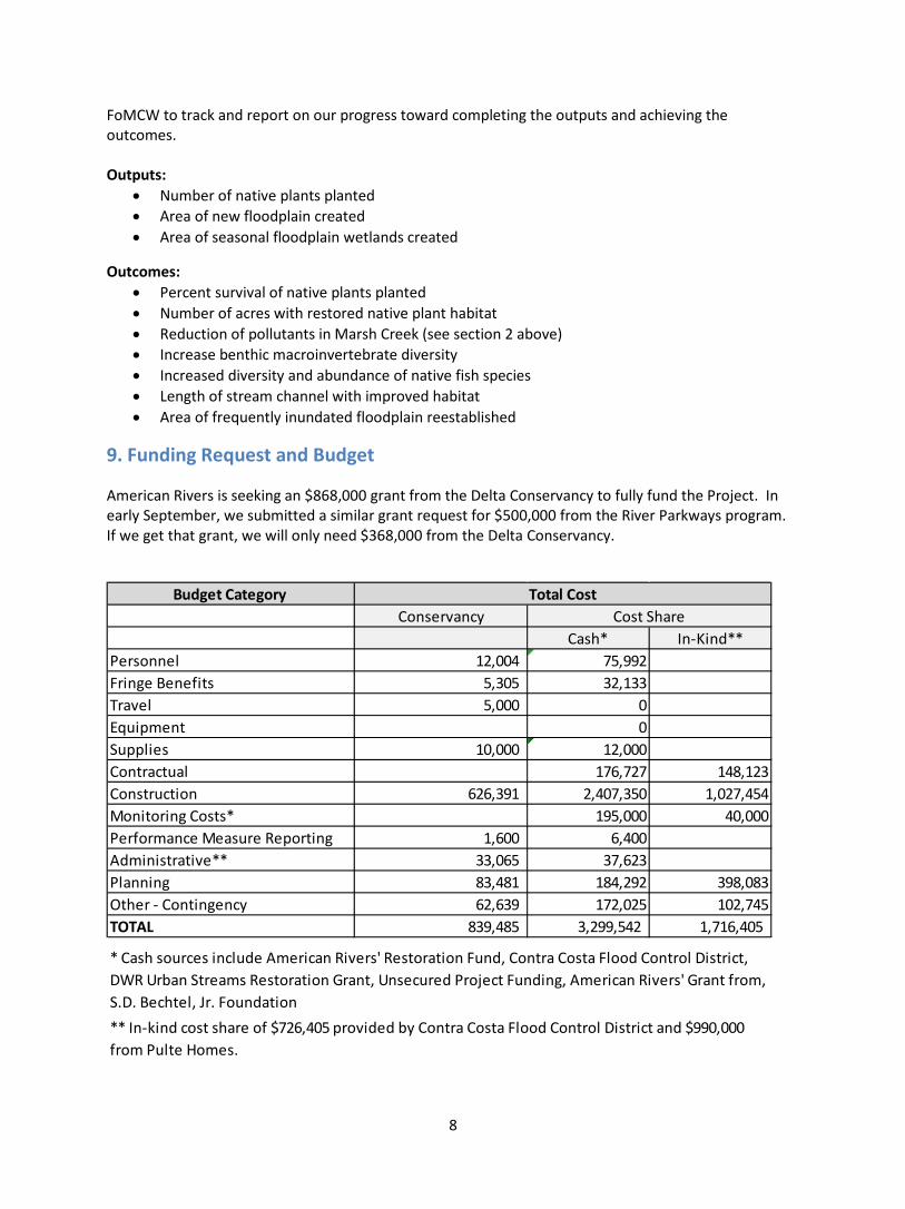
American Rivers is seeking an $868,000 grant from the Delta Conservancy to fully fund the Project. In early September, we submitted a similar grant request for $500,000 from the River Parkways program. If we get that grant, we will only need $368,000 from the Delta Conservancy.
Budget Category Conservancy
Cash* In-Kind** Personnel 12,004 75,992Fringe Benefits 5,305 32,133Travel 5,000 0Equipment 0Supplies 10,000 12,000Contractual 176,727 148,123Construction 626,391 2,407,350 1,027,454Monitoring Costs* 195,000 40,000Performance Measure Reporting 1,600 6,400Administrative** 33,065 37,623Planning 83,481 184,292 398,083Other - Contingency 62,639 172,025 102,745TOTAL 839,485 3,299,542 1,716,405
Total CostCost Share
* Cash sources include American Rivers' Restoration Fund, Contra Costa Flood Control District, DWR Urban Streams Restoration Grant, Unsecured Project Funding, American Rivers' Grant from, S.D. Bechtel, Jr. Foundation** In-kind cost share of $726,405 provided by Contra Costa Flood Control District and $990,000 from Pulte Homes.
16
Appendices
Appendix A: Concept Proposal Application Form and Budget Template
Concept Proposal Application Form **Submit this document and the required attachments in PDF**
Applicant Information
Applicant Name (organization): __________________________________________________________
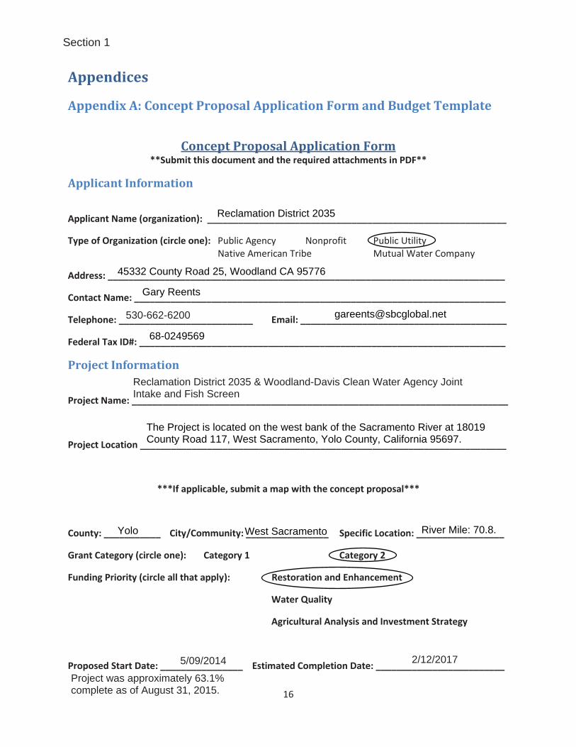
Type of Organization (circle one): Public Agency Nonprofit Public Utility Native American Tribe Mutual Water Company
Address: _____________________________________________________________________________
Contact Name: ________________________________________________________________________
Telephone: __________________________ Email: ________________________________________
Federal Tax ID#: _______________________________________________________________________
Project Information
Project Name: _________________________________________________________________________
Project Location _______________________________________________________________________
***If applicable, submit a map with the concept proposal***
County: ___________ City/Community: ________________ Specific Location: _________________
Grant Category (circle one): Category 1 Category 2
Funding Priority (circle all that apply): Restoration and Enhancement
Water Quality
Agricultural Analysis and Investment Strategy
Proposed Start Date: ________________ Estimated Completion Date: _________________________
Reclamation District 2035
45332 County Road 25, Woodland CA 95776
Gary Reents
530-662-6200 [email protected]
68-0249569
Reclamation District 2035 & Woodland-Davis Clean Water Agency JointIntake and Fish Screen
The Project is located on the west bank of the Sacramento River at 18019County Road 117, West Sacramento, Yolo County, California 95697.
Yolo River Mile: 70.8.West Sacramento
5/09/2014 2/12/2017
Project was approximately 63.1%complete as of August 31, 2015.
Section 1

Reclamation District 2035 Concept Proposal for the Reclamation District 2035 & Woodland-Davis Clean Water Agency Joint Intake and Fish Screen Project
Page 1 of 7
Section 2 – Project Description The Reclamation District 2035 (RD 2035)/Woodland-Davis Clean Water Agency (WDCWA) Joint Intake and Fish Screen Project (Joint Intake and Fish Screen Project) will replace the existing 400 cfs capacity RD 2035 intake facility. The project is located in Yolo County on the Sacramento River, just north of the Interstate 5 bridge. The existing facility has been in operation since 1919, and currently remains the largest unscreened intake on the Sacramento River. The new diversion structure will include a state-of-the-art fish screen designed to protect fish from entrainment into the pump station facility, and is particularly aimed at protecting endangered species native to local fisheries. The Joint Intake and Fish Screen Project also facilitates new conjunctive use opportunities for the WDCWA as RD 2035 would modify its diversion quantity to 320 cfs to allow the other 80 cfs to be utilized for the WDCWA. Specific Need for Project Natural populations of Chinook salmon and steelhead have declined over the years, leading to their listing under state and federal Endangered Species Acts. The declines of Chinook salmon and steelhead populations in the Sacramento River system have been caused by factors such as inadequate flows, unscreened diversions, inadequate passage at diversion dams, agricultural return drains, poor water quality, reduced spawning gravel, and illegal harvest. Unscreened diversions have been particularly detrimental to winter-run Chinook salmon. Water diversions entrain emigrating juvenile salmon and create flow changes near pump stations that confuse adult salmon during migration. As a result of these declines, under the federal Anadromous Fish Screen Program (AFSP), federal and state fish agencies have been working for over two decades with water districts and agencies, as well as individual landowners, to minimize or eliminate entrainment of these fish species through the construction of modern, state-of-the-art fish screens on their diversions. The Joint Intake Facility and Fish Screen Project is one such example that will improve conditions for the Sacramento River fisheries and Delta resources, as well as work in conjunction with the Davis Woodland Water Supply Project (DWWSP), which will improve groundwater management sustainability and the quality of treated wastewater discharged into the Sacramento River upstream of the Delta. Project’s Goals and Objectives The Project’s goals (i.e. benefits) and objectives include: Goal/Benefit #1: Fish Protection - replacing the existing unscreened intake will result in a measurable increase in the survival rate of fish populations in the Sacramento River. Furthermore, maintaining low velocities across the surface of the screen to reduce the potential for impingement will help insure these benefits are maximized. Objective #1: Replace an existing unscreened intake with a new state-of-the-art screened intake. Goal/Benefit #2: Improved Quality of Treated Water and Wastewater/Improved Sacramento River and Delta Water Quality - The new, higher-quality (fewer salts and harmful minerals) water supply that will be provided to WDCWA as a result of the Project, will lead to improved water being delivered and, as a result, will lead to an improvement in the treated wastewater quality for WDCWA customers. The treated wastewater eventually discharges back to the Sacramento River. Therefore, this project also improves the quality of water in the Sacramento River upstream of the Delta. Objective #2: Improve the salt and mineral content of the drinking water supply for the City of Davis, the City of Woodland, and the University of California, Davis, (UC Davis) which will also improve the water quality of the wastewater discharge. Goal/Benefit #3: Water Supply Reliability and Drought Preparedness - The Joint Intake is an integral part of the DWWSP, as it will allow for joint use by the WDCWA in conjunction with implementation of the DWWSP. The DWWSP will provide the cities with the ability to use both groundwater and surface
Reclamation District 2035 Concept Proposal for the Reclamation District 2035 & Woodland-Davis Clean Water Agency Joint Intake and Fish Screen Project
Page 2 of 7
water which will improve water supply reliability and give both cities greater flexibility in managing water supplies during on-going and future drought events. Objective #3: Maximize efficient utilization and reliability of surface and groundwater supplies in coordination with local groundwater management plans. Goal/Benefit #4: Improve the Pacific Flyway Habitat - The new Joint Intake project will provide more reliable wetland habitat within the Yolo Bypass by allowing farmers to divert water in fall and winter months, when listed salmonid species are present in the river, to provide Pacific Flyway habitat in support of objectives contained in the Central Valley Joint Venture 2006 Implementation Plan. Objective #4: Support the long-term viability of maintaining and creating wetland habitat within the Yolo Bypass. Specific tasks that will be undertaken The following tasks are included in the Project: Task 1 - Performance Measure Reporting and Program Management; Task 2 - Engineering Support, Construction Management and Monitoring Costs; Task 3 - Environmental Monitoring; Task 4 - Environmental Permitting and Mitigation; Task 5 - Site Power; Task 6 - Land Acquisition; and Task 7 - Construction and Task 8 - Contingency. Work Products and Deliverables RD 2035 will provide the following deliverables to the Sacramento-San Joaquin Delta Conservancy (Conservancy) as part of the Proposition 1 Grant Program: 1. Monthly Invoices – RD 2035 will provide invoices on a monthly basis for services, products or supplies to be approved for reimbursement by the Conservancy. 2. Quarterly Progress Reports – RD 2035 will provide Quarterly Progress Reports to the Conservancy. The report will include the following information: a summary of progress to date including progress since the last report, a summary of upcoming activities, percent construction complete, percent contractor invoiced, and percent schedule elapsed; a description of compliance with environmental requirements; a listing of change orders including amount, description of work, and change in contract amount and schedule; any problems encountered, proposed resolution, schedule for resolution, and status of previous problem resolutions. 4. Draft Final Report – RD 2035 will provide a Draft Final Report to the Conservancy. The report will include the following information: a summary of the completed construction project progression; a summary of the construction budget, change orders and schedule; a description of compliance with environmental requirements; any problems encountered and how they were resolved, any problems remaining unresolved, and proposed resolution for any unresolved problems. 5. Final Report – RD 2035 will provide a Final Report to the Conservancy. The report will be similar to the Draft Final Report, but will address any comments on the Draft Final Report provided by Conservancy. 6. Close-out Summary Report – RD 2035 will provide a Close-Out Summary Report to the Conservancy. The report will summarize the status of the Project at project completion and deliverables for the Proposition 1 Grant Program provided to the Conservancy over the course of the Project. The report will serve as the request to finalize and close out the Proposition 1 Grant Program for the Project. Section 3 – Organizational Capacity RD 2035 has been operating its existing intake facility since 1919. RD 2035 has contracted with Montgomery Watson Harza Global (MWH) for the design and construction management of the Project, Balfour Beatty Infrastructure Inc. (BBII) for the construction of the Project, and Environmental Science Associates (ESA) for the environmental compliance portion of the Project. BBII is a global infrastructure design, construction and operations group, with over 100 years of experience. BBII has constructed a number of regional fish screen and intake projects, including the Red Bluff Pumping Station Fish Screen in Red Bluff, the Freeport Regional Water Intake Facility in Sacramento, and the Sacramento River Water

Reclamation District 2035 Concept Proposal for the Reclamation District 2035 & Woodland-Davis Clean Water Agency Joint Intake and Fish Screen Project
Page 3 of 7
Intake Facility in Sacramento. MWH is an internationally recognized global engineering company with expertise in designing river intakes. ESA is a national firm with offices throughout the US and has provided expertise for the CEQA permitting process.
The following individuals have a key role in this project: Gary Reents R.C.E. 40290, RD2035, Project Manager; Janet Atkinson R.C.E. 54852, MWH, Principal-in-Charge of the design and construction management; Glen Grant R.C.E. 43380, MWH, Construction Manager; Phil Atkinson R.C.S.E. 7375, MWH; Brian Jensen R.C.E. 30534, MWH; Debi Lewis, R.C.E. 76765, LEED AP; Dave Palmer, R.C.E. 65089 and R.S.E. 5353; Philip Salzman, R.C.E. 59207; Carlos Villalpando, R.E.E. 14969; and Nathan Peoples, C.P.A. 21795 (license is in state of Colorado). Janet Atkinson was the project manager for the design of the Meridian Farms Fish Screen and Infrastructure Improvement Project and the West Stanislaus Irrigation District Joint Use Fish Screen Project. Glen Grant was the project manager for the construction management team on the Patterson Irrigation District Fish Screen Intake Project. Section 4 – Consistency with Funding Requirements, Project Selection, and Programmatic Criteria The Project's multiple benefits include: Fish Protection, Improved Quality of Treated Water and Wastewater/Improved Sacramento River and Delta Water Quality, Water Supply Reliability and Drought Preparedness, and Improvements to the Pacific Flyway Habitat.
Prop. 1 provides funding to implement the three objectives of the California Water Action Plan (CWAP): more reliable water supplies, restoration of important species and habitat and a more resilient and sustainably managed water infrastructure. The Conservancy’s Ecosystem Restoration and Water Quality Grant Program focuses on the restoration of important species and habitat. The Project is consistent with the CWAP, and therefore the Conservancy’s Proposition 1 grant program, in the following ways:
• Protect and Restore Important Ecosystems - Eliminate Barriers to Fish Migration – This project is also identified as a priority unscreened diversion, pursuant to the CDFW’s document, “Priority Unscreened Diversions in the Central Valley and Delta,” dated July 2015 (https://nrm.dfg.ca.gov/FileHandler.ashx?DocumentID=103960&inline). - Water for Wetlands and Waterfowl – The completion of the fish screen will ensure the ability to divert water year-round, including during the fall and winter when water deliveries are necessary to provide valuable Pacific Flyway habitat that address goals established in the Central Valley Joint Venture 2006 Implementation Plan.
• Make Conservation A California Way of Life - Increase Water Sector Energy Efficiency and Greenhouse Gas Reduction Capacity – The project will replace approximately 100 year-old water pumps with new, efficient pumps that will use less electricity and pump less water to meet needs within the service area.
• Manage and Prepare for Dry Periods - Revise Operations to Respond to Extreme Conditions – The new pumping facility will be operational at lower water levels, allowing for water needs to be met even if upstream reservoirs change operations in response to drought or other environmental conditions.
• Improve groundwater management - Improve Sustainable Groundwater Management and Increase Statewide Groundwater Recharge - By allowing the cities to implement conjunctive use whereby groundwater is primarily used when surface water supplies are less available, and the groundwater basin can be left to recharge when surface water supplies are available.
The Project aligns with the Conservancy’s enabling legislation and Strategic Plan goals of implementing projects that will result in integrated environmental, economic and social benefits because the Project

Reclamation District 2035 Concept Proposal for the Reclamation District 2035 & Woodland-Davis Clean Water Agency Joint Intake and Fish Screen Project
Page 4 of 7
was developed through the collaborative efforts of RD 2035, WDCWA, the cities of Woodland and Davis, and UC Davis. The Project is consistent with the following Conservancy strategic plan goals and objectives: 1) Lead efforts in protecting, enhancing, and restoring the Delta ecosystem, 2) Establish the Conservancy as a leader in gathering and communicating scientific and practical information about the Delta ecosystem and economy, 3) Create an effective organization based on principles of community service, collaboration, coordination, appropriate transparency, and efficient use of resources. The Project is consistent with, and implements, several other key local, state, and federal plans. Some of these plans include:
U.S. Fish and Wildlife Service (USFWS), 1994, “Central Valley Project Improvement Act Anadromous Fish Screen Program”, Sacramento, CA. The Anadromous Fish Screen Program protects juvenile anadromous fish from entrainment in water diversions in California on the Sacramento and San Joaquin rivers and the Delta. The project would support the AFSP through screening the existing unscreened intake.
National Marine Fisheries Service (NMFS), 2014, “Recovery Plan for the Evolutionarily Significant Units of Sacramento River Winter-run Chinook Salmon and Central Valley Spring-run Chinook Salmon and the Distinct Population Segment of California Central Valley Steelhead”, NMFS California Central Valley Area Office, Sacramento, CA. The plan objective is the recovery of anadromous fish species. The recovery strategy includes ensuring that freshwater migration corridors afford safe passage conditions. The installation of fish screens supports this strategy.
Department of Fish and Game, 1996, “Steelhead Restoration and Management Plan for California”, Sacramento, CA. The plan includes a restoration measure of screening diversions along the main stem of the Sacramento River to increase survival of anadromous species. The installation of fish screens support this plan.
USFWS, 2001, “Final Restoration Plan for the Anadromous Fish Restoration Program: A Plan to Increase Natural Production of Anadromous Fish in the Central Valley of California”. The recommended actions in the plan include continuing to implement the Anadromous Fish Screen Program, which this project supports.
CalFed Bay-Delta Program, 1999, “Ecosystem Restoration Program Plan, Strategic Plan for Ecosystem Restoration”, Sacramento, CA. The plan identifies the removal of barriers to anadromous fish migration which includes constructing state-of-the-art fish passage structures. The fish screen is designed to facilitate fish passage on the Sacramento River.
Vogel, Dave, 2011, “Insights into the Problems, Progress, and Potential Solutions for Sacramento River Basin Native Anadromous Fish Restoration”, Natural Resource Scientists, Red Bluff, CA. The plan calls for the screening of diversions to protect outmigrating fry and juvenile salmonids from entrainment, which this project provides for.
Westside Sacramento Regional Water Management Group, 2014, “Westside-Sacramento Integrated Regional Water Management Plan.” Project No. 95 of the IRWMP is the RD2035 Sacramento River Joint Intake Project.
Section 5 - Readiness Design is complete and construction of the Project is approximately 63.1% complete as of August 31, 2015. The City of Davis certified the Davis-Woodland Water Supply Project Final EIR in 2007 and the Cities of Davis and Woodland Approved the project. On August 28, 2012, RD 2035 adopted the Initial Study/Mitigated Negative Declaration (IS/MND) and approved the project. The Bureau of Reclamation (BOR) issued a Finding of No Significant Impact (FONSI) for the project on November 18, 2013. All regulatory permits have been obtained for the project. All land easement acquisitions necessary for Project implementation are complete.

Reclamation District 2035 Concept Proposal for the Reclamation District 2035 & Woodland-Davis Clean Water Agency Joint Intake and Fish Screen Project
Page 5 of 7
The following cost share table identifies the funding sources for the Project and demonstrates cost share efforts and leveraging of State funds for the Project.
Source of Funds Status Total
CA Department of Water Resources Approved $10,000,000
CA Wildlife Conservation Board Approved $2,000,000
U.S. Bureau of Reclamation (Federal) Approved* $20,128,621*
Woodland Davis Clean Water Agency (Local) Approved $16,226,449
Remaining Funds to be Secured In Progress $8,128,621
Total Project Cost __ $56,483,691 *The approval of federal funds is contingent upon the Project obtaining a 50% match of “non federal/state” funds under AFSP. At this time there are no anticipated data needs or data gaps needing to be addressed to complete the construction of the Joint Intake and Fish Screen Project. Section 6 – Cooperation and Support The following individuals and organizations are participating in the Project: RD 2035: Robert Thomas, Gary Reents; WDCWA: Dennis Diemer; Balfour Beatty; MWH: Janet Atkinson (Principal-in-Charge of design and construction management), Glen Grant (Construction Manager), Phil Atkinson, Brian Jensen, Debi Lewis, Dave Palmer, Philip Salzman, and Carlos Villalpando; ESA: Erich Fischer. U.S. Representatives John Garamendi, Doris Matsui, Mike Thompson, and Ami Bera are on record in strong support of this federal funding and for the state to allocate matching dollars, as required by Anadromous Fish Screen Program (AFSP), including written support for this application. Similarly, U.S. Representative Doug LaMalfa and U.S. Senator Dianne Feinstein are on record over the last few years in strong support for federal AFSP funding and state matching dollars for the Project. Support from state elected officials is shown by the letters of support for this application from State Senator Lois Wolk and Assemblyman Bill Dodd. State agencies’ support is evidenced by written communication from John Laird, Secretary of CA Natural Resources Agency. Local support for the Project and this application is evidenced by a September 2015 letter co-signed by the following key locally-elected officials and community leaders: City of Davis Mayor and WDCWA Chair Dan Wolk; City of Woodland Mayor Tom Stallard; Water Resources Association of Yolo County Chair and WDCWA Vice Chair William Marble; WDCWA Directors Brett Lee and Jim Hilliard; UC Davis Assistant Vice Chancellor Sid England; Yolo County Board of Supervisors Don Saylor and Matt Rexroad; RD 2035 President Robert Thomas; Conaway Preservation Group President Kyriakos Tsakopoulos; Northern California Water Association President David Guy; Sierra Club/Yolano Group Chair and Davis Natural Resources Commission Member Alan Pryor; Regional Water Authority Executive Director John Wooding; Yolo Audobon Society officer Chad Roberts; Tuleyome Board member Bob Schneider; Woodland Chamber of Commerce CEO Kristy Wright; Yolo County Farm Bureau President Jeff Merwin. Good neighbor practices have also been incorporated into the Project such as adhering to CEQA noise and light construction requirements, minimizing traffic impacts, and dust control. RD2035’s partner, WDCWA, has a public website where updated construction progress is posted. Section 7 – Best Available Science and Adaptive Management
Reclamation District 2035 Concept Proposal for the Reclamation District 2035 & Woodland-Davis Clean Water Agency Joint Intake and Fish Screen Project
Page 6 of 7
The Joint Intake and Fish Screen Project is an integral part of the DWWSP and has undergone a thorough examination under multiple planning and analysis documents. Many alternatives were considered and reviewed by the Cities of Woodland and Davis, as well as several consultants, including professors from UC Davis’ Department of Civil and Environmental Engineering. Alternative solutions were also analyzed to address the cities’ and university’s water supply and wastewater discharge issues. The unanimous conclusion of these studies was that a joint intake project would minimize environmental impacts for the least cost while improving water quality and water supply reliability. The fish screen, fish refugia and fish screen flow control baffles were analyzed in a TM “Design of Fish Screen Installation/Removal System, Fish Refugia, and Fish Screen Flow Control Baffles for the RD 2035/WDCWA Joint Intake Project” dated February 16, 2012. The fish refugia concept being implemented on the Project was closely coordinated with NMFS, AFSP and CDFW during the design phase. The refugia design, materials of construction, placement and implementation represent new technology that will be further analyzed by these agencies (upon construction completion) to further scientific study to protect threatened fish populations. The new fish screens as stated in the Final NMFS Biological Opinion “will comply with the CDFW, USFWS and NMFS anadromous fish screen guidelines and design criteria”. NMFS has been actively involved in the fish screen design process. The final project is described in the RD 2035/WDCWA Joint Intake Final Initial Study/Environmental Assessment dated October 2012. The Project’s Basis of Design (BODR) report discusses how the fish screens will be designed to have an approach velocity below NMFS and CDFW design criteria and includes an automated screen cleaning system to avoid “velocity hot spots”. The BODR includes a Computational Fluid Dynamic (CFD) modeling memorandum for the proposed intake configuration. The CFD analysis was performed both to verify pump performance within the proposed intake configuration and to confirm compliance with fish screening criteria. The CFD analysis showed acceptable results in both areas. The fish screen, fish refugia, baffles and pumping operation are important components of the Project and the Project design considered the health of native fish populations in the Sacramento River. A Baffle Adjustment Procedure is described in the BODR. The purpose of the procedure is to verify the Project is functioning based on the CFD modeling analysis once construction is complete. Anticipated climatic change in the Central Valley includes increased air temperatures and a drier hydrology predominated by rain rather than snowfall, which will alter runoff patterns and transform the Sacramento River from a spring/summer snowmelt dominated system to a rain dominated system. The resulting impacts of this climate change of importance to the Project area include the potential for declining migratory fish populations, increased erosion, sedimentation, and larger fluctuations in the Sacramento River levels.
The Project includes the following features to adapt or respond to these climate change impacts: Operational flexibility to accommodate both water level fluctuations and sediment load
fluctuations resulting from climate change. Supplement to municipal groundwater supplies to provide conjunctive use opportunities that
will help ensure long-term groundwater sustainability. Low water demand landscaping of Project areas post-construction as they will be hydroseeded
with native grasses and plants suitable for stabilizing soil, reducing storm water erosion, and requiring a minimum of water and maintenance.
New screened intake to minimize additional survival stressors to the anadromous fish in the Sacramento River. Future climate change conditions will negatively impact fish populations through altered river runoff patterns, increased summer water temperatures and flow levels.

Reclamation District 2035 Concept Proposal for the Reclamation District 2035 & Woodland-Davis Clean Water Agency Joint Intake and Fish Screen Project
Page 7 of 7
Section 8 – Project Assessment To achieve the objectives stated in Section 2, the Project output performance measures include the installation of the new fish screen on the RD 2035 diversion in accordance with CDFW Fish Screening Criteria and the installation of a new surface water intake to replace the existing RD 2035 intake. Project outcome performance measures include specific maximum water velocity across the fish screen to avoid impingement of fish on the screen (not to exceed 0.33 ft/sec), water and wastewater quality analysis, quantity of surface water use for WDCWA members (Davis, Woodland and UC Davis), quantity of groundwater use for WDCWA members, and annual acreage of Pacific Flyway habitat. With these performance measures in mind, the monitoring will include 1) A Fish Screen Performance Evaluation and Monitoring Plan, 2) A Fishery Investigations Study on the Sacramento River, 3) Drinking water quality analysis, 4) Wastewater discharge quality analysis, 5) Surface water and groundwater consumption data collection, and 6) Pacific Flyway habitat acreage documentation. Biological monitoring must be performed several times within the first year of operation to monitor the effectiveness of the fish screen facility in terms of fish protection. This biological monitoring will test the fish screen facility to make sure that fish are not being entrained on the fish screen. The Performance Evaluation and Monitoring Plan will verify that the velocity across the screen does not impinge or entrain fish. Meters will be employed to measure velocities at varying positions along the face of the screen during a peak diversion period, and a brief technical report describing the results will be prepared for the Conservancy.
RD 2035 will use the fisheries study that WDCWA will conduct to satisfy RD 2035’s own monitoring and assessment obligations. The Fishery Investigations Study on the Sacramento River will be an academic study and will include data collection about fish populations in the vicinity of the new intake. This study will focus on the health of Sacramento River fisheries in the vicinity or downstream of the Project’s Sacramento River diversion facility, and will use appropriate methods to collect useful scientific data. A scope of work is being developed in coordination with WDCWA and the CDFW, and the study will begin within a year after operations begin. The final work product may be an M.S. thesis or Ph.D. dissertation, and will include brief annual reports to CDFW prior to the completion of the study.
To monitor whether the drinking water quality objective is achieved, the cities prepare Annual Water Quality Reports as required by the DDW. These reports are publicly available on the websites for each city. Similarly, the cities’ wastewater discharge quality is regulated by the CVRWQCB under the NPDES, and water quality information for these cities is publicly available through the Electronic Self Monitoring Reports (eSMR) available on the California Integrated Water Quality System Project (CIWQS) website.
Surface water and groundwater consumption data will be collected by the cities on a daily basis via flows meters on the different water source influent pipes. The seasonal and annual changes in water consumption for surface water and groundwater, including quantities, will be reported in the 2020 Urban Water Management Plans (UWMP) for Davis and Woodland. Each city is expected to provide a 2015 UWMP and 2020 UWMP.
To support the long-term viability of maintaining and creating wetland habitat within the Yolo Bypass, the Pacific Flyway habitat acreage in the Yolo Bypass will be documented and reported on an annual basis with data from EcoAtlas, the state’s repository for wetland project data, and annual reports for the Conaway Preservation Group’s 4,000 acre Agricultural Easement Area. The Central Valley Joint Venture 2016 Implementation Plan will also be used to assess change in habitat acreage.

17
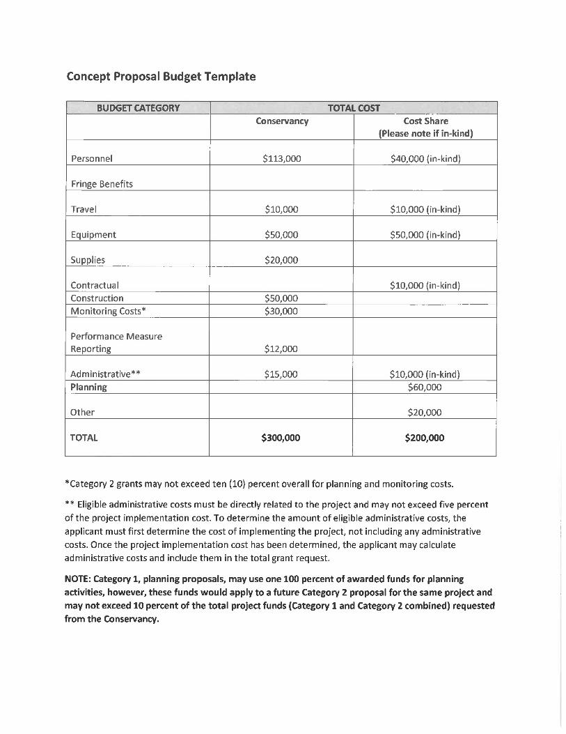
Concept Proposal Budget Template
Budget Category Total Cost
Conservancy Cost Share (Please note if in-kind)
Personnel
Fringe Benefits
Travel
Equipment
Supplies
Contractual
Construction Monitoring Costs* Performance Measure Reporting
Administrative**
Planning Other
TOTAL
*Category 2 grants may not exceed ten (10) percent overall for planning and monitoring costs. ** Eligible administrative costs must be directly related to the project and may not exceed five percent of the project implementation cost. To determine the amount of eligible administrative costs, the applicant must first determine the cost of implementing the project, not including any administrative costs. Once the project implementation cost has been determined, the applicant may calculate administrative costs and include them in the total grant request. NOTE: Category 1, planning proposals, may use one 100 percent of awarded funds for planning activities, however, these funds would apply to a future Category 2 proposal for the same project and may not exceed 10 percent of the total project funds (Category 1 and Category 2 combined) requested from the Conservancy.
$0
$0
$0
$0
$0
$0
$1,796,147$190,793
$13,060
$0
$0$0
$2,000,000
$0
$0
$0
$0
$0
$0
$45,227,540$5,463,334
$368,850
$0
$0
$5,423,967
$54,483,691
4
2
Notes:1. The estimated project cost is $56,483,691. Of this, the federal share is $20,128,621, the stateshare is $20,128,621, and the balance is locally funded. Approximately $12 million in state fundinghas been approved leaving a balance of $8,128,621 to be secured. This application requests$2,000,000 of the remaining $8,128,621 needed to be secured.2. Construction of the Project is approximately 63.1% complete as of August 31, 2015. Constructioncosts include estimated costs for Balfour Beatty Infrastructure Inc. (Contractor). Conservancy portionrequested to be funded is based on approximately 4% of the estimated construction cost of$45,227,540.3. Includes estimated costs for MWH Global and Environmental Science Associates. Conservancyportion requested to be funded is based on approximately 3.5% of MWH Global estimated costs forengineering services during construction and construction management of $5,388,334. Funding forESA budgetary costs will not be sought from the Conservancy.4. Includes estimated costs for Project Manager, Gary Reents P.E.. Conservancy portion requested tobe funded based on approximately 3.5% of Gary Reents estimated costs for project management of$368,850.5. Includes estimated costs for Mitigation bank - Westervelt, Electrical Utility - PG&E, Land andContingency. Funding for these budgetary costs will not be sought from the Conservancy. 6. Projectfunding of $2,000,000 requested from the Conservancy and $54,483,691 from other funding sourcesresult in the total estimated project cost of $56,483,691.
6
5
3
1
Section 9
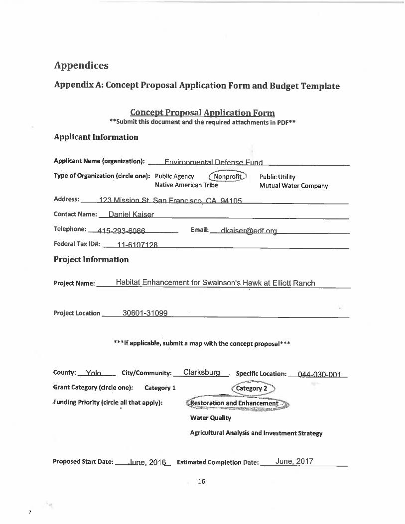
PROJECT DESCRIPTION Habitat Enhancement for Swainson’s Hawk at Elliott Ranch
This proposal requests Proposition 1 funding to support implementation of the Elliott Ranch project, an effort to enhance and restore 300 acres of Swainson’s hawk habitat on Elliott Ranch, a 1,000-acre farm located at the urban/rural boundary of West Sacramento in Yolo County within the statutory Sacramento-San Joaquin Delta.
Primary goal: Create high quality nesting and foraging habitat for Swainson’s hawk, a state-listed species, in the Sacramento-San Joaquin Delta by partnering with a private working landowner interested in voluntary habitat conservation that maintains agriculture productivity.
Objectives
Create meaningful habitat outcomes for an at-risk species by using a scientifically rigorous and consistent method to maximize habitat restoration outcomes for Swainson’s hawk, and to track and report ‘functional acres of habitat’ as a performance measure over time.
Ensure long term and sustainable habitat outcomes by maintaining benefits for Swainson’s hawk using a clear and actionable management plan, landowner contract, and financial assurance package.
Demonstrate the value of using the Habitat Quantification Tool (HQT) for measuring habitat quality, and promote the use of the HQT for defining and valuing habitat credits provided under mitigation and conservation programs.
Demonstrate local and state agency support for voluntary projects on private lands that conclusively demonstrate an improvement in habitat for key species.
PROJECT OVERVIEW
The Elliott Ranch project is a pilot project of the Central Valley Habitat Exchange (Exchange), a new program that works to facilitate high value conservation projects for at-risk species that are compatible with productive agricultural lands. The Exchange applies scientifically rigorous habitat quantification tools and performance incentives to develop the highest value habitat enhancement and restoration projects, and to evaluate and monitor habitat outcomes with a focus on transparency and adaptive management. When implemented at scale, the Exchange offers an opportunity to establish wildlife friendly practices on working lands that will contribute to the recovery of at-risk species in the Central Valley. California Fish and Wildlife will ultimately have to approve the Exchange to provide mitigation credit for impacts to listed species, so this project will also serve as a demonstration of how the Exchange operates for the benefit of CDFW.
For the past year the Exchange has been following the efforts of a recently launched Yolo County program that aims to help achieve the goals and objectives stated in the Yolo Habitat Conservation Plan and Natural Communities Conservation Plan (HCP/NCCP) by partnering with landowners interested in selling habitat conservation easements and establishing mitigation receiving sites on their property. Elliott Ranch is currently under an existing agricultural easement and has been accepted into the Yolo Conservation Easement (CE) Program. The total area of the property is about 1,800 acres, with approximately half of the site being considered as a mitigation receiving site, and the remaining half (including the 300 acre project area) slated to remain in the CE program. This project will only affect the habitat quality on a 300 acre portion of the site that will not be used for mitigation.

PAGE | 2
In April 2015, Environmental Defense Fund (EDF), in partnership with Stillwater Sciences and a team of organizations developing the Exchange, used the Swainson’s hawk habitat quantification tool (HQT) to conduct a preliminary site evaluation of Elliott Ranch to determine the existing quality of the site for Swainson’s hawk as measured in total functional acres of hawk habitat. The Swainson’s hawk HQT measures the percent function of a piece of land based on the extent to which it provides for the life cycle needs of the hawk. Habitat value is measured based on foraging quality, availability of nesting habitat, and the suitability of the habitat within the broader landscape. These three values are combined into one site score that provides a quantitative assessment of habitat value.
The evaluation concluded that 700 acres of Elliott Ranch provide high-quality foraging and nesting habitat for the hawk, but 300 acres of the site provide only marginal hawk habitat. To improve these 300 acres, EDF and partners are working with Elliott Ranch to develop a restoration plan that would improve the marginal foraging habitat provided by existing row crops like onions, safflower, and vine seeds by converting these crops to a flood irrigated pasture. In addition, the restoration project would install hedgerows to support prey habitat and increase the nesting habitat of the site by planting additional trees on the borders of the agricultural fields. Concurrent with the restoration plan, the Exchange is developing a landowner contract agreement and an accompanying management plan to ensure the habitat created by the project will be maintained and managed for at least 10 years.
With implementation of the restoration plan, Elliott Ranch is poised to become a model project in Yolo County and the Sacramento-San Joaquin Delta. As a private property partnering with public entities, Yolo County and the Delta Conservancy, it will create a vast quantity of demonstratively high-quality habitat for a state-listed species. Funding from Proposition 1 would be used to make this restoration project a reality. Further, by implementing this habitat enhancement project, EDF and partners will demonstrate how the use of a scientifically rigorous and consistent method (i.e., the HQT) for measuring habitat quality, combined with a management plan and financial assurance package, can improve how public funding is invested in wildlife habitat projects on private working lands.
TASKS
The following tasks will be completed pending acquisition of Proposition 1 funding:
A detailed pre-project HQT evaluation will be completed and will be attached to the full proposal. The HQT analysis will establish the exact linear feet of hedgerows and number of nesting trees that will be planted, and estimate the functional acres of habitat projected to be created by project implementation.
Hedgerows and nesting trees will be planted to maximize habitat quality for Swainson’s hawk. All conservation practices will be implemented and management plans developed according to NRCS standards. Tree species will be chosen based on their functionality as nesting habitat and prey refugia, and also based on the co-benefits the trees may offer to other animal species. Overall, the design of the restoration project will include a focus on maximizing the biodiversity benefits of the hedgerows and nesting trees to the benefit of a multitude song bird and insect species. Within the next two years the Exchange plans to have completed development of a multi-species HQT, which can be used to evaluate the habitat function of Elliott Ranch for additional species, including riparian songbirds and giant garter snake.
Crop fields will be converted from row crops to a laser-leveled, flood irrigated pasture system. The management plan will include a commitment by the landowner to maintain the pasture system productively for at least 10 years. An established pasture usually stays in place for about five years,
PAGE | 3
so the landowner’s commitment to re-establish the pasture for an additional five years is a valuable habitat outcome.
A portion of the funds will be managed as an endowment to fund habitat maintenance and periodic monitoring in years five and ten. The HQT will be used to conduct this periodic monitoring and to report whether the projected functional acres of habitat to be created by the restoration plan have been maintained. As part of the management plan, EDF will prepare a detailed description of the activities for which funds can be withdrawn from the endowment over the length of the contract period.
The project team will conduct an on-site HQT assessment following project implementation to confirm final habitat function scores, and adjust the management plan as needed to generate and maintain expected post-project habitat function. The management plan will also be adapted based on the results of HQT monitoring in year five.
DELIVERABLES
The following documents and contracts will be delivered to the Delta Conservancy upon completion of the grant term.
Pre and post-project HQT analysis that defines the improvement in functional acres of habitat achieved by restoration actions and changes in farm management.
Management plan and contract agreement with landowner to maintain and monitor habitat enhancement for at least 10 years.
HQT verification at years five and ten of contract agreement.
ORGANIZATIONAL CAPACITY
This project will be implemented by a partnership of non-governmental organizations and consultants working on behalf of the Exchange. The lead organization is Environmental Defense Fund (EDF), with assistance from Stillwater Sciences, Peter F. Brennan & Sons (farm management), Environmental Incentives, and Ms. Linda Christine Elliott (landowner). Together the project team has experience in the development and administration of the Swainson’s hawk HQT, in land acquisition and easement negotiations, and is familiar with local and statewide land use policy and regulations.
The table below describes the relevant expertise and project role of each project team member.
Environmental Defense Fund (EDF)
Relevant Expertise
EDF is a leader in the development of market-based programs that incentivize landowner participation in habitat conservation throughout the U.S. EDF has experience developing and applying tools to consistently quantify habitat value and develop habitat restoration plans. Over the past four years, EDF has been a leader in the development of conservation programs in California’s Mokelumne River watershed, a Greater Sage-Grouse Exchange with applications in Colorado, Nevada and Wyoming, and a Lesser Prairie Chicken Exchange in the Southwest.
Role in Project
EDF is the team lead on this project. This includes coordinating finalization and implementation of the restoration plan, contracting with consultants and with the landowner, and facilitating engagement from the rest of the Central Valley Habitat Exchange working group as needed.
Stillwater Sciences
Relevant Expertise
Stillwater Sciences specializes in science-based approaches to environmental issues. They developed the Swainson’s Hawk HQT using expert opinion and best available science, and are leading the build out of the Swainson’s Hawk HQT into a multi-species HQT that can quantify and flexibly evaluate

PAGE | 4
habitat benefit for multiple species (i.e., chinook salmon, giant garter snake, riparian songbirds).
Role in Project
Stillwater Sciences will work with contractors to ensure the restoration plan implemented aligns with habitat needs of Swainson’s hawk as determined by the HQT, and will use the HQT to monitor post-project habitat function on the project site over time.
Peter F. Brennan & Sons
Relevant Expertise
Farm management, sustainable agriculture, and environmental market consultations with private landowners.
Role in Project
Coordinate implementation of the restoration plan with a focus on establishing flood irrigated pasture system. Develop management plan for the site that accommodates agriculture production and habitat management activities.
Environmental Incentives, LLC.
Relevant Expertise
In partnership with EDF, Environmental Incentives has facilitated the development and implementation of habitat exchanges across the Western U.S., including for Lesser Prairie Chicken in the Southwest and for Greater Sage-Grouse in the Intermountain West and state of Nevada.
Role in Project
Environmental Incentives will develop templates and guidance for the management plan, participant contracts, and financial assurances for the site. It will also develop tracking and verification protocols for the Exchange administrator to consistently report functional acres of habitat created and maintained.
Ms. Linda Christine Elliott (landowner)
Relevant Expertise
Long-time local landowner with an interest in preserving agriculture while creating habitat for wildlife.
Role in Project
Manage the project site to maintain the expected habitat functionality stated in the participant contract and management plan. Management includes operation and maintenance of the flood irrigated pasture system and ensuring the survival and health of the hedgerows and nesting trees.
Central Valley Habitat Exchange (Exchange) Working Group
Relevant Expertise
Exchange partners include American Rivers, Point Blue Conservation Science, Audubon, Trout Unlimited, Natural Resources Conservation Service and others. Together these organizations have decades of experience related to Central Valley habitat conservation, politics, and agricultural and environmental markets.
Role in Project
Exchange partners will be called upon to consult on the final restoration plan and to coordinate CDFW engagement and buy-in, to review and confirm the legal sufficiency of the management plan and associated financial assurance packages, and to provide oversight and direction with respect to developing the monitoring plan and associated habitat outcome reports.
CONSISTENCY WITH FUNDING REQUIREMENTS, PROJECT SELECTION, AND
PROGRAMMATIC CRITERIA
The Elliott Ranch project aligns with and reflects the stated goals and principles associated with Proposition 1, the California Water Action Plan, the Delta Conservancy’s Enabling Legislation and Strategic Plan, and the proposed Agricultural Land Steward Strategies for maintaining Delta agriculture and incentivizing conservation on farmland. In addition, the Elliott Ranch project supports implementation of Yolo County’s efforts to engage landowners and farmers to achieve conservation goals and objectives of the Yolo County HCP/NCCP.
PROPOSITION 1
The Elliott Ranch project will contribute to the goals established in the General Provisions section of Proposition 1. Section 79707 (j) calls for the use of voluntary habitat credit exchange mechanisms and encourages collaboration with willing landowners to achieve the watershed objectives of Proposition 1. The Elliott Ranch project addresses both of these objectives by using a habitat credit exchange

PAGE | 5
mechanism and working with a willing landowner to improve land intended for inclusion in the Yolo County Swainson’s Hawk MRS program.
More specifically, section 79710 (b) authorizes the Delta Conservancy to use the funds allocated in Section 79731 (k) for payments to landowners for the creation of measurable habitat improvements or other improvements to the condition of endangered or threatened species. The Elliott Ranch project is specifically designed to improve conditions for the Swainson’s hawk, a threatened species in California.
Section 79710 (b) also encourages the Delta Conservancy to achieve the wildlife conservation objectives of Proposition 1 through voluntary projects on private lands, and empowers the Delta Conservancy to fund projects that provide measurable and long-lasting habitat or species improvements in the Delta. The Elliott Ranch project is designed to meet both of these provisions: it is a voluntary project that will occur on private land and will provide measurable and lasting habitat benefits for the Swainson’s hawk.
CALIFORNIA WATER ACTION PLAN
Action 4 of the California Water Action Plan, Protect and Restore Important Ecosystems, cites the tremendous loss of habitat for fish and wildlife that has taken place over the past 150 years. The Elliott Ranch project will develop new habitat designed specifically for the state-listed Swainson’s hawk, which will also benefit other local species. By creating new habitat for a state-listed species, this project will help achieve Action 4 “Protect and Restore Important Ecosystems” of the California Water Action Plan.
DELTA CONSERVANCY ENABLING LEGISLATION
The following sections of the Delta Conservancy’s enabling legislation cite the role of the Conservancy in protecting and enhancing habitat and the Delta’s agriculture and working landscapes:
32301. (i) A Sacramento-San Joaquin Delta Conservancy can support efforts that advance both environmental protection and the economic well-being of Delta residents in a complementary manner, including all of the following:
(1) Protect and enhance habitat and habitat restoration.
(2) Protect and preserve Delta agriculture and working landscapes.
32322. (a) The Conservancy shall act as a primary state agency to implement ecosystem restoration in the Delta.
(b) The Conservancy shall support efforts that advance environmental protection and the economic well-being of Delta residents, including all of the following:
(1) Protect and enhance habitat and habitat restoration.
(2) Protect and preserve Delta agriculture and working landscapes.
The project will simultaneously help protect and enhance habitat for the state-listed Swainson’s hawk and protect and enhance the working landscape of the Elliott Ranch property.
DELTA CONSERVANCY STRATEGIC PLAN
The Delta Conservancy’s 2012 Strategic Plan lists six goals, with associated objectives, for the Conservancy, including the following:
Goal: Lead efforts in protecting, enhancing and restoring the Delta ecosystem in coordination with other governmental and non-governmental entities and citizens in the Delta. (Page 39)

PAGE | 6
Objective 3.6: Provide incentives and acknowledgement to private landowners who maintain and create wildlife habitat on private lands. (Page 44)
The Elliott Ranch project will help protect and enhance the Delta ecosystem by improving the quality of habitat for the threatened Swainson’s hawk, and by contracting with the landowner to ensure these improvements are maintained and managed for at least 10 years. Further, the project will represent coordination with both agencies and non-governmental organizations in the Delta region. In addition, the Elliott Ranch project clearly helps achieve objective 3.6 of the Strategic Plan by working collaboratively with a private landowner to create wildlife habitat.
AGRICULTURAL LAND STEWARDSHIP STRATEGIES
The Agricultural Land Stewardship Strategies recognize that farmers and private landowners are critical to achieving the state’s ecological conservation goals and objectives for the Central Valley. The Elliott Ranch project is specifically aligned with the following Agricultural Land Stewardship Strategies:
Strategy 12: Partner with others to maintain and enhance environmental quality on farmland
Strategy 13: Compensate farmers to manage agricultural lands as habitat for wildlife
Strategy 14: Provide incentives for famers to take part in a market based conservation program
The Elliot Ranch project is an example of a project that allows an existing landowner to continue productive agricultural use of their land while also supporting habitat needs for a listed species. The project demonstrates to landowners the importance state agencies place on ecological conservation, and creates a rigorous example of potential financial rewards for landowners who are able to demonstrate their land’s value in functional acres of species habitat.
GENERAL COORDINATION WITH OTHER RELATED EFFORTS
The Elliott Ranch project will fulfill a critical step in the development of the Central Valley Habitat Exchange. The Elliott Ranch project will be implemented by Exchange partners, leveraging Exchange products – such as the Swainson’s hawk HQT and performance-based contract templates – which as a whole can be beneficial in demonstrating that the Exchange is a viable new approach for conservation.
READINESS
Elliott Ranch, a Category 2 project, is ready to be implemented as soon as funding is secured. The landowner is intent on pursuing the restoration project and project partners have been briefed on the draft restoration plan and are poised to begin work. The final project area HQT assessment and detailed restoration plan will be developed by Stillwater Sciences, with restoration implementation overseen by Peter F. Brennan & Sons. As indicated in the budget, EDF personnel as well as consultants working on the Exchange will be contributing a significant portion of their time to implement the project.
CEQA is not expected to be triggered by the habitat uplift planned for the project site. The project site is privately owned and the habitat uplift planned is an addition of vegetation to an agricultural easement to increase the habitat value of the site for Swainson’s hawk. No state or local permits are required to implement the uplift project, and to date there are no indications of state or federally listed species on the project site that would be negatively impacted by this uplift project.
COOPERATION AND SUPPORT
PAGE | 7
Participating Parties: EDF, Ms. Linda Christine Elliott (landowner), Peter F. Brennan & Sons, Stillwater Sciences, Environmental Incentives
Cooperating Parties: Yolo Land Trust, Yolo Habitat Conservancy
Supporting Parties: Exchange Working Group Member Organizations include: Point Blue Conservation Science, American Rivers, Audubon, Department of Water Resources, CalTrout, Trout Unlimited, Conservation Strategies Group, California Department of Fish and Wildlife, Department of Water Resources, Department of Conservation, Barg Coffin Lewin & Trapp (BCLT)
BEST AVAILABLE SCIENCE
The Swainson’s hawk HQT is an innovative new technology that represents the best available science for determining high quality habitat for the species. The HQT was developed by Stillwater Sciences and was reviewed and modified with input from a Technical Advisory Committee consisting of representatives from California Department of Fish and Wildlife, U.S. Fish and Wildlife Service, California Department of Water Resources, Audubon, Golden Gate Raptor Observatory, and Point Blue Conservation Science, as well as private consultants Dick Anderson and Jim Estep. The Swainson’s hawk HQT is also benefitting from review from three CDFW regional offices and headquarters staff.
EDF has contracted with NatureServe to evaluate the effect of climate change with respect to habitat suitability of the Swainson’s hawk. Their analysis compares existing habitat for a species with predicted bio-climate conditions according to four different climate models. Preliminary results indicate that where suitable habitat is stable, contracting (getting worse), and expanding (improving). As illustrated in the attached map, Yolo County is within the area where climate conditions are predicted to remain stable and therefore investment in habitat restoration is consistent with climate smart conservation.
PROJECT ASSESSMENT AND ADAPTIVE MANAGEMENT
The HQT will be used to consistently and comprehensively measure habitat quality and quantity on the project site in order to generate and report on outcome-based performance measure data (i.e., functional acres of habitat provided on-site). The functional acre habitat target set for the site will be based on the HQT’s projection of post-project functional habitat at vegetation maturity. Per the terms of the contract set by the Exchange, the Elliott Ranch landowner will be required to conduct annual monitoring of the project site, which will be reported to EDF. In addition, EDF and project partners will use the HQT to evaluate the habitat function provided by the site every five years, the outcome of which will be reported to the Delta Conservancy and other interested stakeholders. This evaluation will provide EDF and the landowner with the information needed to make any management or maintenance improvements to ensure the site is meeting the expected post-project functional habitat target. Such performance measures, combined with prescribing monitoring and transparent reporting procedures, reflect adaptive management best practices.
CONCEPT PROPOSAL BUDGET
Budget Category Total Cost
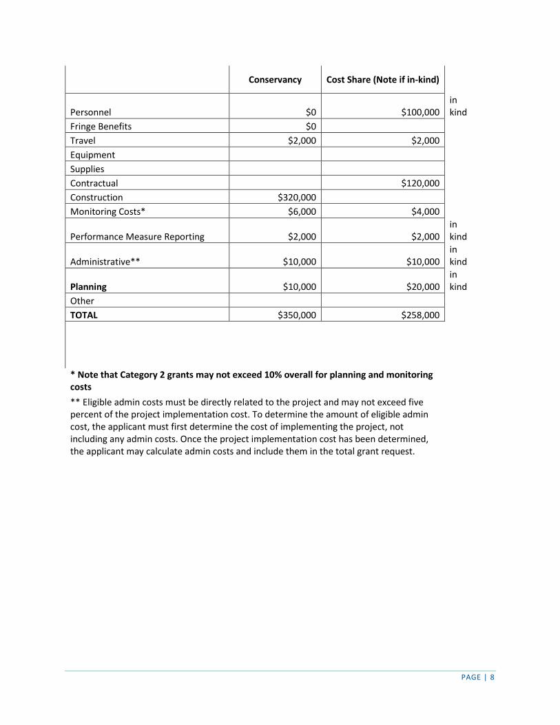
PAGE | 8
Conservancy Cost Share (Note if in-kind)
Personnel $0 $100,000 in kind
Fringe Benefits $0 Travel $2,000 $2,000 Equipment Supplies Contractual $120,000 Construction $320,000 Monitoring Costs* $6,000 $4,000
Performance Measure Reporting $2,000 $2,000 in kind
Administrative** $10,000 $10,000 in kind
Planning $10,000 $20,000 in kind
Other TOTAL $350,000 $258,000
* Note that Category 2 grants may not exceed 10% overall for planning and monitoring costs
** Eligible admin costs must be directly related to the project and may not exceed five percent of the project implementation cost. To determine the amount of eligible admin cost, the applicant must first determine the cost of implementing the project, not including any admin costs. Once the project implementation cost has been determined, the applicant may calculate admin costs and include them in the total grant request.
Concept Proposal Application Form
Applicant Information
Applicant Name (organization): __________________________________________________________
Type of Organization (circle one): Nonprofit
Address: _____________________________________________________________________________
Contact Name: ________________________________________________________________________
Telephone: __________________________ Email: ________________________________________
Federal Tax ID#: _______________________________________________________________________
Project Information
Project Name: _________________________________________________________________________
Project Location _______________________________________________________________________
County: ___________ City/Community: ________________ Specific Location: _________________
Grant Category:
Funding Priority (circle all that apply): Restoration and Enhancement
Water Quality
Proposed Start Date: ________________ Estimated Completion Date: _________________________
1
2. Project Description
Overview: A Vision for Restoration of Marsh Creek Watershed
Marsh Creek watershed, located in eastern Contra Costa County, provides an important ecological corridor in a burgeoning urban area of the Delta region. Marsh Creek flows 30 river miles from the eastern slope of Mount Diablo through eastern Contra Costa County to the San Joaquin Delta at Big Break. Our vision for Marsh Creek is a stream of clean, cold water, surrounded by stands of native trees, a spread of grasses and wildflowers, and served by regional trails that will help Californians discover the Delta—a vital and healthy habitat corridor between protected conservation areas on the Delta shoreline and the open space areas of Mt. Diablo State Park and Black Diamond Mines Regional Park. Over the past decade, our diverse and qualified team has been working to achieve this vision. American Rivers, the Friends of Marsh Creek Watershed, Contra Costa County, the Contra Costa County Flood Control and Water Conservation District, the City of Brentwood, and the City of Oakley have organized community members to steward the creek, build a fish ladder for salmon, design multiple restoration projects, and restore two-acres of riparian and floodplain habitat along the creek. Recently the City of Antioch joined with the team to explore how all our organizations can work together to reduce stormwater pollution and improve water quality discharged to Marsh Creek and the Delta. We have the vision, the team, and the technical capacity, but our progress has been slowed by the complex permitting process for stream restoration, stormwater management, and creek-side trail projects. A programmatic CEQA document and permit would allow us to overcome this bottleneck and advance our vision without navigating the complex permitting process from scratch on each individual project. Such a document will not obviate the need for site-specific analysis, but it will greatly reduce the time and transaction costs associated with a more piecemeal approach. Equally important, it will help persuade skeptical landowners, developers, and city staff that our vision will not expose them to indeterminate permitting delays. Many landowners and developers share our vision for a healthy creek, but regulatory uncertainties make it difficult to integrate their economic development plans with creek restoration and stormwater wetlands.
Project Need
Water Quality
Marsh Creek is significantly degraded and carries polluted run-off into the Delta. Six and a half miles of the once sinuous and tree-lined creek are now a denuded, trapezoidal flood control channel with steep banks vegetated with non-native grasses and no riparian canopy. The Soil Conservation Service and the Contra Costa County Flood Control and Water Conservation District (District) constructed this earthen trapezoidal channel, along with Marsh Creek Reservoir (a flood control detention basin), during the 1960s. The region was mostly undeveloped at that time, and the channel and reservoir were designed to convey a 50-year storm in a landscape dominated by agriculture. Since the channel was constructed, the upper watershed has remained mostly protected parklands and open space, but the lower watershed has urbanized rapidly. The watershed is home to more than 184,000 people, its cities growing 55 to 336% over the past 20 years. Marsh Creek now flows through extensive development, carrying urban runoff into the heart of the western Delta. Like many urban creeks, water quality in Marsh Creek is impaired by several pollutants. The creek is on the 2006 303(d) list classified as impaired by mercury and metals. In addition, the current draft 303(d)/305(b) Integrated Report recommends listing Marsh Creek as impaired by diazinon, E. coli, sediment toxicity and unknown toxicity. The 2011 State of the Marsh Creek Watershed report prepared by Friends of Marsh Creek Watershed (FOMCW) identifies temperature, turbidity, dissolved oxygen, and excessive nitrates as additional water quality issues. This report points to discharges from rapid urbanization, loss of filtering wetlands, and intensive agriculture as the three main drivers of these water quality issues. Improving water quality in Marsh Creek is particularly important for protecting the major investment that the State will make at Dutch Slough and an adjacent tidal marsh on the west side of Marsh Creek. To date, the State has spent or committed more than $50 million for these projects, which will restore over 1,200 acres of
2
tidal marsh at the mouth of Marsh Creek. The CALFED Ecosystem Restoration Program has specifically urged the Dutch Slough proponents to consider watershed restoration investments, such as what we propose, necessary to ensure that Dutch Slough restoration is successful.
Aquatic and Riparian Habitat
Marsh Creek’s aquatic and riparian habitat is severely limited, with little complexity, no floodplain wetlands and no shade. High velocities during annual peak flow events, which are greatly increased by runoff from newly urbanized surfaces, presumably flush most of the egg and larval stages of aquatic species downstream. Poor water quality from urban runoff is made worse by the lack of wetlands, shade, and microbial activity in the channel. Relatively high water temperatures combined with low-dissolved oxygen levels have resulted in five major fish kills in Marsh Creek over the last nine years. It is clear that traditional management methods will not improve the degraded habitat and water quality of Marsh Creek and the larger Delta ecosystem. The engineered channel does not act as a filter to capture and immobilize contaminants. Ongoing development will further increase polluted run-off and constrain future channel restoration. The District’s existing management practices to prevent establishment of riparian vegetation in the undersized flood control channel will preclude natural recovery and the channel will continue to be dominated by weedy, non-native grasses. The discharge of polluted urban and agricultural runoff into the Delta will also continue. The Solution: Facilitating Landscape-Scale Restoration and Stewardship
The project team has made tremendous progress raising awareness, conducting monitoring, developing trail and storm water management plans, and designing and constructing restoration projects that expand channel capacity so that Marsh Creek can safely accommodate riparian vegetation and floodwaters. What’s needed now is a new programmatic environmental document that will allow us to rapidly expand the pace and scale of restoration, improve the quality of water flowing to the Delta and appropriately integrate recreational opportunities. The approach we propose will make room for riparian vegetation, reduce polluted discharge, and provide creek-side trails so the community can access and steward the creek. Over the last decade, American Rives and our partners have developed watershed-scale plans to develop a restored corridor along the lower 6.5 miles of Marsh Creek and 3.5 miles of flood control channel. The plans are premised on integrating development of these parcels with creek restoration. Counting the Dutch Slough project, we now have commitments to expand and restore 2.5 miles of the flood control channel, including a 4,000 linear-foot project that is the subject of an implementation proposal to the Delta Conservancy (submitted in September 2015). In the past, we restored stream corridors parcel by parcel and developed separate CEQA documents for each project. Despite our success, the pace of our progress is simply too slow due to the rapidly changing watershed, the rushed timescale of most developers, and the complex and changing regulatory regime. Expanding the channel and constructing trails requires collaboration with neighboring landowners who have plans to develop new housing. Integrating channel expansion and restoration into these new developments is a great opportunity, but the permitting challenges associated with each site-specific project are too complex and the adjacent landowners are generally not willing to slow their projects while we attempt to navigate the permitting process. Section C.3 of the Central Valley Regional Water Quality Control Board’s Municipal Regional Permit requires new developments to treat stormwater on-site before it is discharged into Marsh Creek. This typically involves constructing stormwater treatment facilities, which are typically biofiltration wetlands. All four pending residential housing subdivision developments planned in the City of Brentwood adjacent to Marsh Creek have designed biofiltration wetlands along the edge of Marsh Creek. New stormwater management rules create an opportunity to integrate treatment wetlands into creek restoration, but since this is a new idea that has not yet been tested, developers are inclined to fall back on traditional engineering approaches.
3
A Programmatic Environmental Impact Report (EIR) for the lower Marsh and Sand Creek watershed would enable Contra Costa County and the cities of Oakley, Antioch and Brentwood to implement a large-scale, multi-benefit vision for the region that covers opportunities for restoration, stormwater treatment and trails on all parcels along the creeks. Programmatic CEQA documents and permits for creek restoration would also allow us to persuade skeptical landowners and developers to work with us before the neighboring landowners are ready to develop their creek-side parcels. A programmatic EIR would make it far easier to integrate restoration, water quality, and trail improvements into development of parcels along 10 miles of creek over the next decade. The programmatic EIR will provide criteria that integrate C3 stormwater requirements into creek restoration and creek-side developments. Fortunately, Antioch, Oakley, and Brentwood still have several large parcels of undeveloped land adjacent to Marsh Creek and its principal tributary, Sand Creek. This is a tremendous opportunity to cost effectively restore these creeks, treat stormwater runoff and construct trails as the cities develop the creek-side parcels, but this opportunity will pass as the next wave of urbanization rolls over the watershed. The pace of development has already accelerated in the last year as home prices in the Bay Area have skyrocketed. The cities share our vision for a restored creek, but they don’t have the authority or political climate to require restoration. It is politically untenable for cities to force the developers to navigate the permitting associated with creek restoration on a project by project basis on land that the developers do not own. Creek restoration is an amenity that does not require lots of new land, and thus most developers are amenable as long as it doesn’t entail significant and time-consuming permitting uncertainty. The best way to significantly reduce the permitting uncertainty is to develop programmatic CEQA documents and permits before landowners are ready to develop their parcels.
A programmatic document and permit would not compel local governments and landowners to implement creek restoration, but it would allow them to more easily integrate restoration into development where all parties are willing. A programmatic document will not obviate the need for site-specific analysis, but it will greatly reduce the time and transaction costs associated with a more piecemeal approach. Goals and Objectives The overall goal of this multi-benefit project is to improve habitat, water quality, recreational opportunities and public access along Marsh and Sand Creeks. Our overall objectives are to: 1) Improve water quality in Marsh and Sand Creeks and their receiving waters, the Delta; 2) Improve flood management and ecosystem resilience to climate change for the Delta communities of Brentwood, Antioch, and Oakley, where a large fraction of Delta residents live; 3) Create restored urban greenways along Marsh and Sand Creek from the Diablo Range to the Delta; and 4) Improve flood protection while also restoring riparian habitat in Marsh and Sand Creek. The specific objectives of this proposal are to: 1) Develop a programmatic environmental impact report for the lower Marsh and Sand Creek watersheds that will facilitate permitting of multi-benefit projects designed to improve water quality, enhance flood protection, restore habitat, increase recreation opportunities, and expand public access along the creeks; 2) Develop design criteria for integrating new stormwater treatment rules into wetland restoration on creek-side parcels, 3) Develop specifications and cost estimates for a creek-side trail along 3.5 miles of Sand Creek that is integrated into riparian restoration and stormwater treatment wetlands along the creek; and 4) Integrate creek restoration and better stormwater management. Tasks and Deliverables Task 1: Project Management and Administration American Rivers will serve as the fiscal lead for the grant and coordinate planning with the Flood Control District though a formal memorandum of agreement. Deliverables: 1) timely invoices, 2) quarterly reports, 3) final close-out report. Task 2: Programmatic Environmental Impact Report The District will be the lead agency for the programmatic EIR. American Rivers will work with the District to hire a CEQA consultant, coordinate project partners, and help develop the project description. The draft
4
programmatic EIR will be complete in the fall of 2017, and the final will be complete in spring 2018. Deliverables: 1) contract with CEQA consultant, 2) project description 3) draft EIR, 4) final EIR. Task 3: Trail Planning American Rivers will coordinate with project partners to plan for the development and expansion of the Sand Creek Trail to connect with other regional trails including the Marsh Creek Trail, the Mokelumne Coast to Crest Trail, and Black Diamond Mines trails. American Rivers and partners will determine proposed trail location, cost, and funding options and prioritize construction of segments. We will work to include the Sand Creek Trail in the East Bay Regional Park District’s General Plan and in the park and recreation and general plans in Brentwood and Antioch. Deliverables: 1) map of proposed Sand Creek Trail location, 2) agendas from two meetings with trail planning partners, 3) memo summarizing proposed development and funding of Sand Creek Trail, 4) incorporating of Sand Creek Trail into general plans. Task 4: Stormwater Planning American Rivers will work with project partners to develop design specs for creek restoration projects that create riparian habitat, improve water quality, and meet stormwater treatment requirements required under provision C3 (new development) of the recently revised Municipal Regional Permit. Deliverables: 1) development of creek restoration designs to treat stormwater, 2) incorporation of creek restoration designs into the Contra Costa Clean Water Program’s Stormwater C3 Guidebook.
3. Organizational Capacity and Experience with Similar Projects
American Rivers will work closely with the District and FOMCW to develop programmatic documents for lower Marsh and Sand Creeks. American Rivers is a national nonprofit organization with a strong reputation of completing projects on time and within budget. For over a decade, American Rivers has been a respected expert in natural stormwater and flood management practice and policy. We have applied this expertise to successfully advocate for national green infrastructure policies, practices and funding, including natural stormwater management as a major component. In states and cities across the country, we have managed the construction of green infrastructure projects and have provided training on these approaches. In addition, American Rivers has significant expertise in the management and restoration of creeks and floodplains in the Sacramento-San Joaquin River and Bay-Delta ecosystems. As noted above, American Rivers staff have long-standing relationships and project history in the lower Marsh Creek watershed. John Cain, Director, California Flood Management, has focused on interrelated issues of river restoration, water supply management and flood risk reduction in the Central Valley and Bay-Delta over the last 15 years. He has advocated, analyzed, and planned multi-benefit projects (such as 1,200-acre Dutch Slough restoration) and made key technical contributions to the historic San Joaquin River Settlement. He was a member of the Delta Vision committee, the Bay Delta Conservation Plan Steering Committee, and co-chair of BDCP technical committees. Sarah Puckett, Associate Director, River Restoration specializes in urban creek and wetland restoration. For over ten years, Sarah worked as a senior restoration ecologist with the Natural Heritage Institute where she worked to restore rivers and wetlands around the San Francisco Bay and Delta including the Dutch Slough wetland restoration project. She has been working in the Marsh Creek watershed since 2002 and helped found FOMCW. Since its founding in 1951, the Contra Costa Flood Control and Water Conservation District has completed individually or participated as a team member in numerous flood control and multi-use projects in Contra Costa County. Most recently in 2014, the District completed the Upper Sand Creek Basin (USCB), a flood detention basin located on Sand Creek, a few miles to the west of Marsh Creek. USCB cost over $14 million, which included $2 million of Department of Water Resources (DWR) Prop 1E grant funds. USCB created 10 acres of seasonal and permanent wetlands as part of the restoration project, and the remainder of the site has been designed to accommodate a future sports park for the City of Antioch. Mike Carlson, District Division Manager, oversees the District and the construction and maintenance of all regional flood control basins, channels and creeks in Contra Costa County. Tim Jensen, Senior Civil Engineer, oversees the plans and permitting for new development projects being built adjacent to the Marsh Creek flood control channel. Tom has extensive knowledge of all the facilities on Marsh Creek including detention basins, stormwater outfalls, drop structures, and dams.
5
The Friends of Marsh Creek Watershed is a local grassroots, citizen’s group that has been actively supporting this project and engaged in the planning since the concept for this project was developed in 2004. FOMCW was incorporated as a nonprofit in November 2009 and since that time has received and managed many grants and implemented projects ranging from on-the-ground restoration to water quality monitoring to creek cleanups and an at-risk youth work-study program. FOMCW consistently meets or exceeds grant expectations and is a responsible and committed partner. Diane Burgis, Executive Director has been recognized for her efforts to build partnerships and provide leadership in protecting, restoring or enhancing creeks and watersheds. Diane serves as Ward 7 Director of East Bay Regional Park District (EBRPD), which represents all the cities in the Marsh Creek Watershed including Oakley, Brentwood and Antioch. She has served on the Advisory Committee for the East Contra Costa County Habitat Conservancy and was named California State Assembly District 15 Woman of the Year for 2012 for her work on behalf of the environment and in the community.
4. Consistency with Funding Requirements, Project Selection, and Programmatic Criteria The proposed project is well aligned with the Conservancy’s stated ecosystem restoration and water quality priorities, the California Water Action Plan, the Delta Plan, State Parks Recreation Proposal for the Delta, the Delta Protection Commissions Economic Sustainability Plan, and the East Contra Costa Habitat Conservation Plan. The project will expedite permitting and voluntary implementation of multi-benefit projects that reduce flood risk associated with a changing climate, improve Delta water quality, restore denuded channel margin habitat in a measurable and long-lasting manner, enhance the Delta as place, and increase public access. Consistent with the Conservancy strategic plan and funding priorities, the project will lay the planning foundation for multi-benefit projects that: restore channel margin and riparian habitat, reduce the impacts of climate change, integrate access and trails into restoration projects, enhance and expand the Delta Trail, create a wildlife corridor from the Delta shoreline to the Diablo Range, assist local entities in the implementation of habitat conservation plans, prevent pollution, restore impaired water bodies, and improve flood management. In accordance with the California Water Action Plan, the proposal will advance integrated water management across all levels of government (action 2) through focus on multi-benefit projects, advance co-equal goals (action 3) by protection of water quality, protect and restore important ecosystems (action 4), increase flood protection (action 8) through streamlined and consolidated permitting of projects that plan for climate change and achieve multiple benefits. The project is also consistent with Delta Plan priorities to improve water quality for the environment, protect and enhance unique recreational values, reduce flood risk, and restore the Delta ecosystem. Enhancement of the Marsh Creek trail and expansion of the Sand Creek channel will develop the Delta Trail network and is consistent with State Park’s Recreation Proposal for the Delta and the Delta Protection Economic Sustainability Plan. Lastly, the project will expedite project that advance the East Contra Costa HCP to recover several endangered species in the region, including Swainson’s hawk, California red-legged frog, California tiger salamander, western pond turtle, and Alameda whipsnake.
5. Readiness
American Rivers is applying for a Category 1 grant and together with our partners have already generated all the information necessary to complete a programmatic EIR. Over the last decade American Rivers and our partners have collected extensive data on water quality, geomorphology, species presence, stormwater management, restoration opportunities, and public preferences. American Rivers, FOMCW, the District, the HCP, the EBRPD, and the Cities have all developed extensive plans and policies for creek restoration, storm water management, and trails. This planning grant will draw on these data and plans to develop a programmatic environmental document that is consistent with existing plans and policies. It will not require any entity to develop new policies or ordinances.

6
The District owns a 70-100-foot corridor along Marsh and Sand Creek and will serve as the lead agency under CEQA. No landowner permission is necessary because the district owns a corridor of land along the creek and the plan will not obligate or require any landowner action. Rather, the plan will simply facilitate voluntary actions by willing landowners. Because much of the project is identified as a priority restoration area in the East Contra Costa County HCP and due to the very poor quality of existing habitat at the project site, the District may very likely be able to file a programmatic mitigated negative declaration.
American Rivers and our partners have obtained over $300,000 of non-state cost share dollars over the last five years. We have recently submitted an application to the EPA’s Urban Waters Small Grant program for $45,000 in additional federal cost share dollars.
6. Cooperation and Support The project is a model of collaboration that has brought together a flood control district, Contra Costa County, a national conservation organization (American Rivers), three municipalities (the Cities of Antioch, Oakley, and Brentwood), a local community group (Friends of Marsh Creek Watershed), a local habitat conservancy (the East Contra Costa County Habitat Conservancy), and a regional park district (the East Bay Regional Park District) to develop a plan to restore water quality and habitat in Marsh Creek. The FOMCW informed the Delta Protection Commission about this effort as recently as August and the coordinator of the FOMCW, Dianne Burgis, previously served on the Delta Protection Commission. In July, the FOMCW, the District, and American Rivers hosted a public event to announce our efforts to restore Marsh Creek and the Delta’s water quality. The event was attended by over 100 residents and staff from local agencies. Congressman McNerny, Supervisor Mary Piepho, Brentwood Mayor Bob Taylor, and EBRPD Director Diane Burgis all spoke at the event. In September 2015, American Rivers and the District convened the three cities, the county, and the federal government (EPA) to conduct a watershed-scale storm water management charrette. Staff from all three cities and the multiple county departments attended including the city managers of both Brentwood and Oakley. The parties agreed to work together to develop a regional stormwater management strategy to integrate creek restoration and storm water management, which is exactly what this proposal will advance.
7. Best Available Science and Adaptive Management This project advances an innovative non-structural approach to habitat restoration and flood management. Instead of trying to control the creek in a narrow zone with levees and floodwalls, it focuses on giving the creek more room to safely convey flood waters while also providing habitat for aquatic and terrestrial species. The project will develop programmatic environmental documents for restoring up to 10 miles of channel margin, riparian, and floodplain habitat. Numerous recent plans and scientific studies have validated the importance of floodplains for native aquatic species and to enhance water quality. Floodplain restoration will provide habitat for native fish, including rearing Chinook salmon and a host of other aquatic and terrestrial species, including riparian song birds. Equally important, restored floodplain and riparian habitat will filter pollutants from the watershed and improve the quality of water conveyed to the Delta. American Rivers, FOMCW, and the District have spent years collecting data on the biota, channel conditions and vegetation along Marsh Creek. We successfully restored a two-acre floodplain in Oakley with a unique assemblage of plants native to east Contra Costa County. We have a long record of fish utilization of Marsh Creek dating back to the mid-1990s. The project team will continue to monitor water quality, channel habitat, and vegetation success after the project is constructed. The team has already secured a $150,000 maintenance endowment to adaptively manage the restoration project. The project will increase adaptability to climate change by accommodating larger runoff events, providing shade along a creek (there are currently no trees at all along the majority of Marsh Creek), creating a wildlife corridor, and using native plants in lieu of traditional landscape plants that require irrigation. The project will create the planning foundation for a nearly continuous shade canopy along all 10 miles of trail and creek. The project will also enable the creek channel to convey larger flood events that are expected to occur as a result of climate change.
7
8. Project Assessment
The objectives (listed under “Goals and Objectives” above) will inform the benchmarks we will use to measure our progress, success, and effectiveness. More specifically, the outcomes and outputs we expect as a result of this project are listed below. American Rivers will work with the District and FOMCW to track and report on our progress toward completing the outputs and achieving the outcomes. Outputs include: 1) a programmatic Environmental Impact Report for the lower Marsh and Sand Creek watersheds that will facilitate permitting of multi-benefit projects designed to improve water quality, enhance flood protection, restore habitat, increase recreation opportunities, and expand public access along the creeks; 2) design criteria for integrating new storm water treatment rules into wetlands restoration on creek side parcels; and 3) specifications and cost estimates for a creek-side trail along 3.5 miles of Sand Creek that is integrated into riparian restoration and storm water treatment wetlands along the creek. Outcomes include: 1) Expedited permitting and implementation of multi-benefit restoration projects on Marsh and Sande Creek; 2) reduced discharge of polluted water to Marsh Creek and the Delta; 3) improved water quality in Marsh and Sand Creeks and their receiving waters – the Delta; 4) improved habitat for native aquatic species and numerous terrestrial species covered by the East Contra Cost County HCP; 4) increased public access to creek-side trails, safe pedestrian and cycling routes for school children and adults, improved quality of life for Delta residents; 5) improved flood management and ecosystem resilience to climate change for the Delta communities of Brentwood, Antioch, and Oakley, where a large fraction of Delta residents live; 6) urban greenways and habitat corridors along Marsh and Sand Creek, connecting the Diablo Range to the San Joaquin-Sacramento Delta; 7) improved flood protection and riparian habitat in Marsh Creek watershed.
9. Funding Request and Budget American Rivers is seeking a $65,000 grant from the Conservancy to fund the proposed project. American Rivers will pledge a minimum of $19,146 in non-state funds for development of a programmatic EIR and obtain in-kind contributions of another $10,000 from partners. The project will leverage other state funds to develop the content of the programmatic EIR. We will rely on DWR funding for the Three Creeks Project EIR to characterize impacts of a creek restoration project with associated with a representative creek restoration projects and will draw heavily on the state funded water quality studies previously conducted for the Dutch Slough project. A concept proposal budget is provided on the next page.
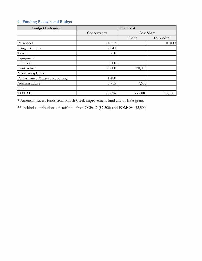
Budget Category
Conservancy
Cash* In-Kind**
Personnel 14,527 10,000
Fringe Benefits 7,043
Travel 750
Equipment
Supplies 500
Contractual 50,000 20,000
Monitoring Costs
Performance Measure Reporting 1,480
Administrative 3,715 7,608
Other
TOTAL 78,014 27,608 10,000
9. Funding Request and Budget
Total Cost
Cost Share
* American Rivers funds from Marsh Creek improvement fund and or EPA grant.
** In-kind contributions of staff time from CCFCD ($7,500) and FOMCW ($2,500)
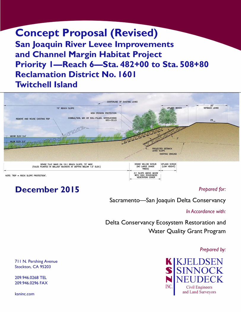
Prepared by:
711 N. Pershing AvenueStockton, CA 95203
209.946.0268 TEL209.946.0296 FAX
ksninc.com
Sacramento—San Joaquin Delta Conservancy
Concept Proposal (Revised)San Joaquin River Levee Improvementsand Channel Margin Habitat ProjectPriority 1—Reach 6—Sta. 482+00 to Sta. 508+80Reclamation District No. 1601Twitchell Island
Prepared for:December 2015
Delta Conservancy Ecosystem Restoration andWater Quality Grant Program
In Accordance with:
Delta Conservancy Ecosystem Restoration Concept Proposal and Water Quality Grant Program Reclamation District No. 1601
San Joaquin River Levee Improvements & Channel Margin Habitat Project Priority 1 – Reach 6 – Sta. 482+00 to Sta. 508+80 1 | P a g e
1. Concept Proposal Application Form
Applicant Information
Applicant Name (organization): Reclamation District No. 1601 – Twitchell Island
Type of Organization (circle one): Public Agency Nonprofit Public Utility
Native American Tribe Mutual Water Company
Address: 2360 W. Twitchell Island Road, Rio Vista, California 94571
Contact Name: Christopher H. Neudeck, District Engineer
Telephone: 209‐946‐0268 Email: [email protected]
Federal Tax ID#: 26‐0101095
Project Information
Project Name: San Joaquin River Levee Improvements & Channel Margin Habitat Project
Priority 1 – Reach 6 – Sta. 482+00 to Sta. 508+80
Project Location: Twitchell Island, Sacramento County, California
***Map is shown in Exhibit A***
County: Sacramento City/Community: N/A Specific Location: Twitchell Island
Grant Category (circle one): Category 1 Category 2
Funding Priority (circle all that apply): Restoration and Enhancement
Water Quality
Agricultural Analysis and Investment Strategy
Proposed Start Date: July 2016 Estimated Completion Date: November 2017
`
`
Delta Conservancy Ecosystem Restoration Concept Proposal and Water Quality Grant Program Reclamation District No. 1601
San Joaquin River Levee Improvements & Channel Margin Habitat Project Priority 1 – Reach 6 – Sta. 482+00 to Sta. 508+80 2 | P a g e
2. Project Description The project defined in this Concept Proposal is the first component of the overall San Joaquin River Levee Improvements & Channel Margin Habitat Project at Twitchell Island. The overall project is an approximately $90 million endeavor that is anticipated to be constructed in multiple phases and consists of rehabilitating the Twitchell Island levee of Reclamation District No. 1601 (District) along the San Joaquin River in a manner that will provide much-needed channel margin habitat along a four-mile stretch of the San Joaquin River. The habitat that will be created is a major ecological enhancement that will greatly improve conditions for delta smelt and other native fish and is consistent with the State’s net long-term habitat improvement requirement. Furthermore, the project will increase the levee’s resistance to erosion, provide better overall levee stability, and provide additional freeboard to protect against overtopping due to wind generated waves.
Project Need
The Delta Reform Act and the Delta Plan specify that the goal of protecting, restoring, and enhancing the Delta ecosystem is coequal to the goal of providing a more reliable water supply for California. The San Joaquin River Levee Improvements & Channel Margin Habitat Project meets both of these coequal goals.
Ecosystem Enhancement A primary objective to the ecosystem goal is to “restore the Delta ecosystem, including its fisheries and wildlife, as the heart of a healthy estuary and wetland ecosystem” (Water Code 85020(c)). Multiple agencies and plans have identified channel margin habitat as a restoration priority for ecosystem enhancement in the Delta. Channel margin habitat is defined as a complex of aquatic, wetland, and riparian habitats at the edges of watercourses designed to benefit native fish species
Reliable Water Supply Twitchell Island is one of the state’s more critical levee systems because it is within the area of the Delta where freshwater and salt water mix, and it is believed that even short-term flooding in this area could have a significant detrimental impact on water quality and could jeopardize the massive north-to-south Federal and State water-transfer system. The Twitchell Island levee system, and in particular the San Joaquin River levee reach, has a history of levee stability problems including settlement, movement, seepage, and slope failure. Deep organic soils and sands in conjunction with deep waterways and high winds common in the western Delta cause the San Joaquin River levee reach to be extremely vulnerable to erosion and failure, particularly when high winds coincide with high water events and direct significant wave energy at the levees. Steep waterside slopes resulting from frequent wave-generated erosion are a general characteristic of the levee along the San Joaquin River.
Project Objectives
The overall San Joaquin River Levee Improvements & Channel Margin Habitat Project will provide for the following primary objectives:
to provide valuable channel margin habitat along this stretch of the San Joaquin River; and
Delta Conservancy Ecosystem Restoration Concept Proposal and Water Quality Grant Program Reclamation District No. 1601
San Joaquin River Levee Improvements & Channel Margin Habitat Project Priority 1 – Reach 6 – Sta. 482+00 to Sta. 508+80 3 | P a g e
to provide landside levee improvements that increase the levee’s resistance to erosion, provide better overall levee stability, and provide additional freeboard.
Specific Tasks / Work Products
The specific work described within this Concept Proposal is for Priority 1 of the overall San Joaquin River Levee Improvements & Channel Margin Habitat Project which consists of Reach No. 6 from Sta. 482+00 to Sta. 508+80, as shown on the overall conceptual design and phasing plan attached as EXHIBIT A. Actual construction will be phased as follows:
Phase 1, Toe Berm: To provide a sound foundation for the new levee, consolidation, and thereby strengthening, of the deep peat soils on the landside of the existing levee is needed prior to construction of the new setback levee. Phase 1 will consist of a substantial toe berm placed on the landside of the existing levee that will increase the peat foundation strength and provide stability for new levee embankment construction to allow landside crown widening and raising to be safely performed.
Phase 2, Setback Levee: Phase 2 will consist of the new setback levee. It will be constructed on top of the foundation toe berm immediately behind the existing levee with a levee crown elevation equal to the 100-year base flood elevation plus 4.7 feet estimated wave run-up plus 0.5 foot future consolidation.
Phase 3, Channel Margin Habitat: Phase 3 consists of the proposed waterside habitat design and is consistent with Department of Water Resources’ (DWR) Delta Levees Program emphasis on creating channel margin habitat consisting of aquatic, wetland, and riparian habitats at the edge of watercourses. The primary design objective is the creation of a diverse range of channel margin habitat structures and shaded riverine aquatic habitats, and their associated ecological functions and target species benefits. A secondary objective is the creation of a continuous corridor of riparian and upland scrub habitats having a diversity of botanical species and canopy structure. To achieve these objectives, the project will to design structures and habitats that can withstand the erosive forces of chronic ship/boat wakes and wind waves, and the occasional high energy storm waves, with minimal loss of substrate, soil and vegetation and the ability to recover from infrequent storm-related damage.
Budget
The total project cost for Reach No. 6 amounts to $9,991,000. The District has already secured funding for its local cost share of 85% ($8,492,300) and therefore is seeking the remaining 15% ($1,498,700) by means of this grant program being offered by the Delta Conservancy.
3. Organizational Capacity The District has a long history of managing, designing, permitting, and constructing flood control and habitat projects with DWR. Kjeldsen, Sinnock and Neudeck, Inc. (KSN) has been the District’s engineering consultant for over 20 years and currently represents approximately two dozen reclamation districts throughout the Delta. As District Engineer, Christopher Neudeck from KSN has over thirty years of working in the Delta. Over the years, signifcant coordination has been made with DWR personnel including Bryan Brock and Randy Mager. Together, the District, KSN, and DWR have worked together to bring a number of projects to fruition on Twitchell Island, including the following:
Delta Conservancy Ecosystem Restoration Concept Proposal and Water Quality Grant Program Reclamation District No. 1601
San Joaquin River Levee Improvements & Channel Margin Habitat Project Priority 1 – Reach 6 – Sta. 482+00 to Sta. 508+80 4 | P a g e
1999 Twitchell Island Setback Levee Habitat Enhancement Project (as described in further details in Section 7)
2008 Twitchell Island Sevenmile Slough Setback Levee Project
2012 Twitchell Island Sevenmile Slough HMP Levee Crown Project
2013 Twitchell Island San Joaquin River HMP Levee Crown Project
2013 Twitchell Island East End Wetland Project
4. Consistency with Funding Requirements, Project Selection, and Programmatic Criteria
The overall San Joaquin River Levee Improvements & Channel Margin Habitat Project includes creating channel margin habitat along the waterside of the San Joaquin River levee reach of Twitchell Island that will provide nearly four miles of aquatic, wetland, and riparian habitats, including a total of 20.6 acres of improved fish habitats.
Consistency with Prop. 1 and State Priorities
The project is consistent with Prop 1 and state priorities as described in the grant application packet. Specifically, Reach 6 will create approximately 5 acres of shallow shoreline and tule marsh habitat and approximately 2 acres of dense willow scrub, upland scrub, and mixed riparian. This new levee design will benefit native fish species by providing rearing and outmigration habitat for juvenile salmonids while decreasing habitat for predators of native fishes.
Multiple Benefits
The project is a multi-benefit flood protection and ecosystem restoration project that provides for the creation of a diverse range of channel margin habitat structures and shaded riverine aquatic habitats. The project is fully integrated in that the Phase 3 channel margin habitat work cannot be constructed until the Phase 1 berm and Phase 2 setback levee work is completed.
All channel margin habitat created by this project will not be counted as mitigation. Instead, all waterside habitat improvements implemented as part of the project stand alone as a long-term net habitat improvement resulting in the permanent addition of riparian and marsh habitats.
Climate Change Considerations
As noted earlier, the channel margin habitat design is currently at a 60% level for the overall project. The multiple design options along four miles of levee allow for easy adaptability and design refinement from one reach to the next based the effectiveness of prior reaches and any effects on habitat resulting from climate change.
With the enhancement to erosion protection, levee stability, and freeboard, the improved Twitchell Island levee along the San Joaquin River will greatly increase the level of protection provided to life and property on the island, especially during high wind and/or high water events. The construction of the toe berm provides for a sound foundation that allows for future incremental levee height increases that easily incorporate projected rises in sea level as a result of climate change.
Delta Conservancy Ecosystem Restoration Concept Proposal and Water Quality Grant Program Reclamation District No. 1601
San Joaquin River Levee Improvements & Channel Margin Habitat Project Priority 1 – Reach 6 – Sta. 482+00 to Sta. 508+80 5 | P a g e
5. Readiness The project will be fully shovel-ready in spring 2016. The status of individual tasks that are being performed under a separate DWR grant agreement is as follows:
CEQA compliance for the overall project has been achieved via the certification of an Environmental Impact Report.
Permitting for the overall project has largely been attained with the exception of the U.S. Army Corps of Engineers (USACE) Section 404 permit which will be finalized in spring 2016.
Engineering for Phase 1 is currently at an 80% design level and will be completed by spring 2016.
Engineering for Phase 3 is currently at a 60% design level.
The District has applied for and been approved for a grant by DWR under DWR’s 2014 Projects Solicitation for Multi-Benefit Projects to account for the District’s 85% local cost share
6. Cooperation and Support KSN, the District Engineer, will be the entity that is primarily responsible for managing the project on behalf of the District. DWR is also a major participant.
Affected Parties
DWR is the majority landowner on Twitchell Island and is the only landowner on the island, other than the District, with property adjacent to the overall project. DWR is fully engaged in the project, and all work performed thus far has been done with full cooperation of DWR.
As part of the ongoing permitting process, the various jurisdictional agencies for the project, including the USACE and the California Department of Fish and Wildlife (CDFW) have already been informed and consulted. Also, a consultation with the Delta Stewardship Council has already occurred, and a consistency determination with the Delta Plan is underway.
Local Support
DWR has directly coordinated with the District’s consultants and provided input to project design to ensure all is consistent with its overall vision for the western DWR-owned islands. Through the Interagency Ecological Program (IEP), DWR will be taking the lead on project assessment and monitoring. Also, DWR is the contributor of project funding through Prop 1E funds to provide for the District’s local cost share. Letters of support for the project from DWR are attached as EXHIBIT B.
7. Best Available Science and Adaptive Management Basic design elements, information of existing channel margin habitat, and “lessons learned” from prior, similar projects have all been utilized as a basis of design for the current project.
Scientific Basis
In 1999, DWR and the District constructed the Twitchell Island Setback Levee Habitat Enhancement Project on 3,000 linear feet of the right bank of the San Joaquin River, just upstream of the mouth of Threemile Slough. The levee at this location had a steep, unstable
Delta Conservancy Ecosystem Restoration Concept Proposal and Water Quality Grant Program Reclamation District No. 1601
San Joaquin River Levee Improvements & Channel Margin Habitat Project Priority 1 – Reach 6 – Sta. 482+00 to Sta. 508+80 6 | P a g e
waterside slope and high energy wind wave erosion. The site was identified as both a threat to levee integrity and an opportunity to combine Delta ecosystem enhancement with a levee protection project. The goals of the 1999 habitat enhancement project were to build a more stable setback levee and create emergent marsh and shaded riverine aquatic habitats. The District will be incorporating “lessons learned” to implement the same concept to the remainder of the Twitchell Island levee along the San Joaquin River.
To achieve the channel margin habitat project objective, the project utilizes the following general design criteria:
On the waterside, create wave-resistant banks using a combination of dense tule and willow thickets and low gradient beach slopes to attenuate wave energy, and hardpoint wave breaks and rock or biotechnical bank slope protection.
Sculpt flat benches or beach slope surfaces at elevations within the locally appropriate tidal range that can support emergent marsh (tule) vegetation.
Create tidal “sloughs” in the form of protected back channels that are submerged during high tides, but fully drain to an exposed bottom at mean lower low tide (MLLW). Complete drainage at MLLW is intended to discourage colonization by water hyacinth, and provide small areas of intertidal mudflat habitat.
Provide sufficient soil depth and volume under tree-planting surfaces so that larger riparian tree species can grow to mature heights with a vigorous canopy, thereby optimizing canopy width and SRA habitat at water’s edge.
For riparian areas, shape variable height planting surfaces in relation to water levels, including low elevation benches that are partially inundated by higher tides.
On soil surface slopes, slopes must be stable to prevent surface erosion, depending on exposure to wind wave energy.
Minimize or protect trees from exposure to damage from beaver populations.
In general, minimize linear shorelines and landform uniformity, and maximize vertical and horizontal variability in relation to tidal range and soil depth to shallow groundwater.
Some of the more limiting constraints and other design frameworks include bank steepness and wave erosion, limits of excavation, and tidal range. Existing tule marsh depths were measured along the perimeter of Twitchell Island to develop a more reliable picture of tule growth potential, in particular the maximum water depth threshold for the occurrence of tule patches. Based on the design criteria and limiting constraints, the following five design options were developed:
Barrier islands and tidal back channel;
Wide islands with discontinuous back channels;
Stable beach slope with tule band;
Undulating bench with scalloped bankline; and
Deep back bays between rock hardpoints.
Adaptive Management
As noted earlier, the channel margin habitat design is currently at a 60% level for the overall project. The multiple design options along four miles of levee allow for easy adaptability and
Delta Conservancy Ecosystem Restoration Concept Proposal and Water Quality Grant Program Reclamation District No. 1601
San Joaquin River Levee Improvements & Channel Margin Habitat Project Priority 1 – Reach 6 – Sta. 482+00 to Sta. 508+80 7 | P a g e
design refinement from one reach to the next based the effectiveness of prior reaches and any effects resulting from climate change.
All habitat design elements have been, and will continue to be, developed in cooperation with appropriate DWR staff to include diversity in structure, topography, vegetation and hydrology so that the maximum habitat benefits are achieved. The design flexibilities allow for future modifications if deemed necessary.
8. Project Assessment Since habitat monitoring is generally not one of the functions of the District, the task of assessing the project’s effectiveness will be delegated to the IEP Tidal Wetland Project Work Team. The purpose of the IEP team is collaborate in the design of monitoring programs for fish and foodweb resources in restored tidal wetlands in the Bay Delta system. The primary goal of the IEP team is to provide monitoring on various projects and habitats throughout the Delta over a long period of time. Specific goals include:
Lead and support the development of a system-wide biological monitoring program for fish and foodweb resources in restored wetlands;
Participate in the development of site-specific biological monitoring plans for tidal wetland projects concurrent with implementation planning; and
Provide guidance and review of tidal wetland research and monitoring proposals.
The IEP team is comprised of staff from various agencies and organizations:
State: CDFW, DWR, Delta Stewardship Council, Delta Conservancy, State and Federal Contractors Water Agency, and Metropolitan Water District.
Federal: Fish and Wildlife Service, Environmental Protection Agency, and NOAA Fisheries.
Other: San Francisco Estuary Institute, ESA Inc., Westlands Water District, ICF, UC Davis.
9. Funding Request and Budget The total project budget for Reach No. 6 amounts to $9,991,000. In addition to construction costs, this budget amount consists of project management, final design, bidding and contract award, and construction management and inspection. Environmental, permitting, initial design, and mitigation costs have been addressed through a separate funding mechanism. A budget breakdown is indicated below.
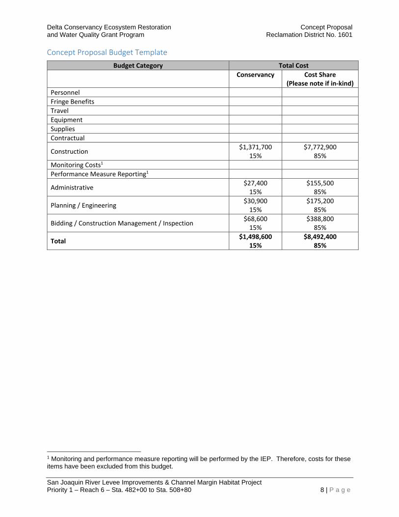
Delta Conservancy Ecosystem Restoration Concept Proposal and Water Quality Grant Program Reclamation District No. 1601
San Joaquin River Levee Improvements & Channel Margin Habitat Project Priority 1 – Reach 6 – Sta. 482+00 to Sta. 508+80 8 | P a g e
Concept Proposal Budget Template
Budget Category Total Cost
Conservancy Cost Share (Please note if in‐kind)
Personnel
Fringe Benefits
Travel
Equipment
Supplies
Contractual
Construction $1,371,700
15% $7,772,900
85%
Monitoring Costs1
Performance Measure Reporting1
Administrative $27,400 15%
$155,500 85%
Planning / Engineering $30,900 15%
$175,200 85%
Bidding / Construction Management / Inspection $68,600 15%
$388,800 85%
Total $1,498,600
15% $8,492,400
85%
1 Monitoring and performance measure reporting will be performed by the IEP. Therefore, costs for these items have been excluded from this budget.
1
Paradise Cut Acquisition Proposal to the Delta Conservancy
December 18, 2015
1. Concept Proposal Application Form
Applicant Information Applicant Name (organization): San Joaquin County Resource Conservation District Type of Organization (choose one): Public Agency Address: _3422 W. Hammer Ln, Suite A Stockton, CA 95219___________________________ Contact Name: Jonna Spaletta or John Herrick Telephone: _209-472-7127 ext. 125_________ Email: [email protected]____ Federal Tax ID#: _68-0376811____________________________________________________ Project Information Project Name: Paradise Cut Flood and Conservation Easement Acquisition Project Location Immediately south of Paradise Cut_(figure 1)_______________ ***If applicable, submit a map with the concept proposal*** County: San Joaquin City/Community: Lathrop and unincorporated Specific Location: _See map Grant Category: Category 2 (easement acquisition) Funding Priority: Restoration and Enhancement
Proposed Start Date: June 2016_ Estimated Completion Date: June 2018
2. Project Description
Project Need
The flood bypass system in the Sacramento Valley and north Delta has kept the valley’s residents safe from flooding and provided multiple benefits to fish, farmers, and fowl for nearly a century. Will Green, the 19th century editor of the Colusa Sun, first advocated for the bypass system starting in the 1860’s, but the state’s leaders didn’t commit to build it until the devastating floods of the early twentieth century left them no other choice. Today we have a chance to build a bypass in the South Delta to protect against the floodwaters that climate change will bring, but we should act now while we still have a choice.
The following excerpt below illustrates why the Delta Conservancy should act now to end the planning paralysis and fund acquisition of flood easements in the South Delta.
“A latter-day version of the bypass debate is now unfolding on the San Joaquin River, after

2
the 1997 flood. In this most recent event, the San Joaquin River and several of its tributaries overwhelmed the channel capacity, inundating farmland and some communities. In contrast to the two major Sacramento Valley levee breaks in 1997, in which flows did not exceed channel capacity but rather seeped in some way through the levees to cause blow-outs, the San Joaquin channels were not large enough for the size of the flows. Recognizing the futility of simply raising the levees, flood control experts will now evaluate the feasibility of removing levees in some locations and letting future flood flows pond onto adjacent lands. Further, consideration is being given to opening up some form of bypass through the south Delta to relieve pressure on the levees as the San Joaquin River flows into the Delta. It is hoped these issues will be resolved and changes will be made before the next flood.”
- David Kennedy, 1998
Seventeen years after David Kennedy, the longest serving director of the Department of Water Resources (DWR), wrote these words in the foreword to the second of edition of Battling the Inland Sea, the project team offers this application to the Delta Conservancy for a locally led effort to acquire flood and conservation easements that will eventually be necessary to construct a new flood bypass along the lower San Joaquin River.
The San Joaquin County Resource Conservation District has joined with a diverse team of local stakeholders and conservation groups to offer this proposal to the Delta Conservancy. The team includes the South Delta Water Agency (SDWA), Reclamation District 2062 (RD 2062), River Islands Development Company, American Rivers, and the Trust for Public Land (TPL).
The Delta Conservancy has a choice, they can act now to fund acquisition, and in doing so, provide a catalyst for a new bypass, or they can defer while government planners continue to plan. In the words of the Delta Plan (pg. 16): “Act now . . . Waiting is not an option.” Numerous modeling analyses have repeatedly demonstrated that a new bypass would reduce flood risk for farms and cities and significantly improve habitat for native species.
Urban and agricultural communities along the San Joaquin River are vulnerable to catastrophic flooding because the San Joaquin River through the south Delta is not large enough to convey the design flow, let alone the 100-year flood. During a different era with different climate assumptions, cities and farms leveed and armored the banks of the lower San Joaquin River resulting in significant habitat degradation. Expanding the floodway today to safely convey the larger flood events scientists now predict is the best way to keep communities safe and will also help preserve farmland and restore habitat for sensitive species.
Over the last four years, the project team has worked collaboratively with DWR and numerous other agencies and stakeholders to develop a promising conceptual design for expanding Paradise Cut (see figure 1). Extensive modeling analyses conducted by DWR and others indicate that the proposed design will lower the flood stage by over two feet where Interstate Highway 5 crosses the San Joaquin River. This will substantially reduce flood risk for the rapidly urbanizing reach of river between Highway 5 and Stockton.
Expanding the floodway along the lower San Joaquin River will significantly improve habitat for several sensitive species without changing agricultural production in most years. DWR’s hydraulic analyses indicate that farmland incorporated into an expanded floodway would only be inundated once every 12 years. Moreover it should be possible to plant crops even in those infrequent years when the area is inundated during the spring. Expanding the floodway will un-constrain the river enabling managers to create more functional riparian and floodplain habitats along the channel margins of the lower San Joaquin River through a reach of river that is now characterized by heavily armored levees. Acquiring

3
flood and conservation easements today will preserve farmland and habitat and maintain the option to eventually construct a flood bypass.
Goals and Objectives
The overall goal of the proposed project is to reduce flood risk while improving habitat and maintaining agricultural land along the Lower San Joaquin River south of Paradise Cut. The specific objectives of a new bypass are to:
Substantially reduce flood stage (1.5 – 3 feet) on the mainstem San Joaquin River between Mossdale and Stockton.
Reduce the probability of catastrophic urban flooding and loss of life in the communities of Lathrop, Manteca, Stockton, and unincorporated San Joaquin County.
Substantially increase flood conveyance capacity through a constrained reach of the San Joaquin River floodway.
Provide floodplain and riparian habitat for a variety of sensitive species including riparian brush rabbit, giant garter snake, Sacramento splittail, and juvenile Chinook salmon.
Preserve agricultural land and protect it from uncontrolled flooding. This proposal is focused on acquiring the flood easements necessary to eventually build a new flood bypass. The specific outputs and outcomes of this phase include:
Finalize appraisals and obtain all necessary reviews from the Department of General Services.
Negotiate options to purchase flood and conservation easements on up to 2,000 acres.
Create the momentum necessary to induce DWR and other funding agencies to join with the Delta Conservancy in financing easement acquisition on up to 2,000 acres.
Purchase and record flood and conservation easements. The project team has identified a 2,000-acre acquisition zone and has already secured $700,000 from the River Islands Settlement Fund to purchase options on all 2,000 acres. Financial support from the Delta Conservancy and other funding agencies will be necessary to execute all the options. Calculating the value of flood easements is complex, but we expect the total acquisition costs to range from $8 to $16 million. A grant now from the Conservancy will make easier for the project team to secure significant cost-share contributions from DWR, DFW, and other funding agencies. The project team has also submitted a separate proposal to the Conservancy for a planning grant to complete several tasks necessary to initiate environmental compliance for the expanded bypass under NEPA and CEQA. Regardless of whether the planning grant is awarded, acquiring flood easements on the property will help protect farmland and habitat in the Delta and will maintain the option for developing a flood bypass in the future as recommended in the Delta Plan.
Tasks and Deliverables
Task 1: Project Management. The San Joaquin County Resource Conservation District (RCD) will serve as the fiscal lead, submit regular reports, and perform administrative tasks necessary to finalize acquisitions. American Rivers and River Islands will contract with the Trust for Public Land to finalize appraisals and negotiate option contracts. Deliverables: 1) Quarterly reports, 2) contracts with consultants, 3) invoices at least quarterly or more frequently if required by the Conservancy.
4
Task 2: Landowner Outreach. The San Joaquin County RCD will convene meetings with landowners and local agencies to review the project, identify concerns, and provide guidance on how to structure the acquisition process to address these concerns. Deliverables: 1) Three meetings with local officials; 2) at least five meetings with landowners. Task 3: Finalize Appraisals: TPL will work with individual landowners to select an appraiser and finalize the appraisal process for each willing landowner with funds from the River Islands Settlement Fund. TPL will ensure that all appraisals meet the strict requirement of the California Department of General Services. Deliverables: 1) Completed appraisals on at least six parcels. Task 4: Negotiate and Purchase Options. TPL will negotiate option terms with landowners and purchase options using the River Islands Settlement fund. TPL will negotiate relatively long option terms, or renewable option terms, to give the project team enough time to secure funds from a variety of funding sources to acquire easements. Deliverables: 1) Fully executed option agreements. Task 5: Purchase and Record Easements. TPL will purchase and record the easements with funding from the Delta Conservancy, the River Islands Settlement Fund, and other funders. In addition to the Delta Conservancy, the team plans to request funding from DWR, the Department of Fish and Wildlife, and the Wildlife Conservation Board. Each funding entity would deposit funds directly into an escrow account when all the paper work is completed. The easements will only be secured when it is clear that Paradise Cut will be expanded or upon determination that the specific easements would have important farmland or habitat preservation benefits. The project team will work collaboratively with willing landowners to design the easements to advance multiple objectives so that even if the bypass is never expanded habitat benefits consistent with ongoing farming practices can still occur
Deliverables: 1) Flood and conservation easements on one or more parcels; 2) recorded easements.
3. Organizational Capacity
The project team has deep roots in the South Delta and includes a diverse group of stakeholders with unique local and regional expertise in property acquisition, farmland conservation, flood management planning, and river and habitat restoration. John Herrick has served as legal counsel for the South Delta Water Agency and is trusted by numerous local landowners. The San Joaquin County RCD has managed several large conservation projects. Susan Dell’Osso of River Islands is a very experienced planner and developer who successfully shepherded the complex River Islands project through numerous regulatory requirements, including a detailed hydraulic and hydrologic analysis that was closely scrutinized and reviewed by the State Reclamation Board and the U.S. Army Corps of Engineers. John Cain is the Director of Central Valley Flood Planning for American Rivers. He has nearly two decades of experience focusing solely on restoration of the San Joaquin River and the Delta. He spearheaded the $60 million Dutch Slough tidal marsh restoration project in Oakley, a similarly large and complicated project. Dave Sutton, Bob Flewelling, Shelby Semmes, and Rob Levy will lead the real estate acquisition team for TPL. They are all practicing real estate professionals with graduate degrees in business, law, and natural resources. Collectively, they have several decades of experience negotiating and completing complex conservation acquisitions across California, including the Sierra Nevada, coastal wetlands, and inland southern California.
5
The San Joaquin RCD will manage the grant and lead landowner outreach efforts. The Southern Delta Levee Protection and Channel Maintenance Authority, a Joint Powers Authority that comprises the South Delta Water Agency and Reclamation District 2062, will hold title to the perpetual flood easements until the State of California is able to take title and will transfer conservation easements to an appropriate conservation easement holder. American Rivers will provide cost share dollars from the River Islands legal settlement to acquire options and easements.
4. Consistency with Funding Requirements, Project Selection, and Programmatic Criteria
The project is consistent with Proposition 1 as well as several state and local plans, including the California Water Action Plan and the Delta Conservancy’s Strategic Plan. The project is the quintessential multi-benefit project—it will safeguard Delta communities, restore habitat for sensitive species, and preserve privately held agricultural land within the footprint of the expanded bypass. The project is specifically identified in the Central Valley Flood Protection Plan (CVFPP) and the Delta Plan. Both plans describe and map an expanded flood bypass south of Paradise Cut in the south Delta. The 2012 CVFPP identifies the bypass as the single system-wide improvement for the San Joaquin Basin, and the Lower San Joaquin Regional Flood Management Plan developed by the San Joaquin County Flood Control Agency also includes the project. Lastly and most significantly, the project is precisely aligned with several enforceable Delta Plan policies, including creation of a new flood bypass south of Paradise Cut (RR P4-3 Floodplain Protection), restoration of floodplains and riparian habitats as part of flood management projects (ER P4), and protection of high-priority habitat restoration opportunities (ER P3). The project will improve habitat for several threatened and endangered terrestrial and aquatic species within the project footprint and along the San Joaquin River. Riparian revegetation along the proposed remnant levee upstream of Paradise Cut will substantially increase habitat for riparian brush rabbit, potentially justifying its delisting. Preservation of seasonal crops on agricultural land within the expanded bypass, combined with riparian revegetation along the river, will protect and enhance 2,000 acres of prime Swainson’s hawk habitat in the geographic heart of their range. Removal of armored banks along with establishment of shade trees and floodplains along the channel margins of the San Joaquin floodway will significantly improve rearing conditions for juvenile salmon. If designed properly, the project should also benefit a number of other species including California black rail, least Bell’s vireo, riparian wood rat, valley elderberry beetle, delta button celery, giant garter snake, greater sandhill crane, slough thistle, bank swallow, and yellow billed cuckoo. The project will enhance habitat values on working lands, complement the goals of the San Joaquin County Habitat Conservation Plan (HCP), and reduce the impacts of climate change for the south Delta ecosystem and communities. Expanding the floodway will add 2,000 acres of farmland, but the land will still be farmable because it will only be inundated during the biggest flood events - once every 12 years or less. Reconnecting the river to its floodplain will give farmers increased opportunities to be compensated for wildlife-friendly agriculture and will increase opportunities for protecting species covered by the San Joaquin County HCP. Lastly, expanding the floodway will enable the San Joaquin River to safely accommodate increased floods that are expected to result from climate change. The project team members, particularly American Rivers and the South Delta Water Agency, will coordinate with key agencies and other planning processes including San Joaquin County and the San Joaquin County HCP; DWR Division of Flood Management, which is currently revising the CVFPP; the
6
Delta Stewardship Council, which is conducting a levee prioritization study; and the State Water Resources Control Board, which is scheduled to revise the Bay-Delta Water Quality Control Plan.
5. Readiness
The San Joaquin County RCD is applying for a Category 2 acquisition grant. The project team has worked with DWR and several other agencies to develop all of the preliminary planning information and data necessary to justify public investment in easement acquisition. The acquisition footprint is perfectly aligned with the footprint identified in the Delta Plan and the locally preferred alternative modeled for the 2017 CVFPP. The only data and surveys needed are those typically associated with real estate transactions and will be conducted as part of the acquisition process to obtain landowner purchase agreements if and when the Conservancy funds this proposal. If invited to submit a full proposal, the project team will be ready with appraisals, land management plans, willing seller letters, and potentially even option agreements. Expanding the floodway is an enormously complicated chicken and egg problem: State and federal flood planners are reluctant to plan expanded floodways on private lands, and granting agencies are reluctant to invest in land acquisition until the state and federal planning agencies have finalized flood protection plans. A grant from the Delta Conservancy is needed now to change this paralyzing dynamic and expedite the eventual completion of a new flood bypass. In the words of the Delta Plan (pg. 16):
“Act now . . . Waiting is not an option.” An investment today will not be a stranded asset even in the very unlikely case that a flood bypass is never built. We will use the acquisition funds to purchase a flood easement that can double as a conservation easement to advance the San Joaquin County HCP or otherwise improve conditions for covered species. The parcels are ideally suited to provide habitat for Swainson’s hawk and riparian brush rabbit – endangered species habitat that will be lost when and if the agricultural crop type is converted to orchard or vineyard. The Conservancy’s investment now in this visionary project will very likely leverage tens of millions of dollars in other state funds to complete acquisition and construction. Already, DWR and the Delta Stewardship Council have spent over a million dollars studying and developing this project first as part of Delta restoration plans and later as part of the 2012 and 2017 CVFPP. The project team will seek additional implementation dollars from DWR, DFW, and WCB over the coming year, and the Conservancy’s initial investment will greatly increase the probability of securing these other state funds. The project partners and other agencies have been intensively planning the project for several years and have vetted the project at seven public meetings. In 2011, the San Joaquin RCD sought grant funding from the DWR Floodway Corridor Program and presented the proposal at a meeting of the Central Valley Flood Protection Board prompting the CVFPB to write a letter of support to the Delta Stewardship Council, which in turn prompted the Council to include the bypass in the Delta Plan. In 2007, the legislature passed SB 5 directing DWR to evaluate expansion of Paradise Cut, and DWR subsequently included an expanded Paradise Cut in the 2012 Central Valley Flood Protection plan. Since then, DWR has conducted a thorough evaluation of the proposal and alternative approaches for advancing flood and habitat objectives in the south Delta. DWR held four well-attended public meetings in Lathrop during 2012 to gather public input, and the public strongly supported the proposed project over other alternatives. The San Joaquin Flood Control Agency together with the Flood Protection Board convened two well-attended public workshops in 2013 and 2014, and nobody voiced opposition to the project. Since late 2014, the project team has been refining the proposal under the Delta Dialogues process, a

7
diverse stakeholder forum convened by the Delta Conservancy. DWR recently conducted a detailed analysis of the Delta Dialogues alternative, which substantiated that the project would significantly reduce flood stage and improve habitat without substantially diminishing agricultural productivity on lands added to the floodway.
6. Cooperation and Support
The project is a unique collaboration of local entities and national non-profit organizations including the RCD, the South Delta Water Agency, RD 2062, River Islands Development Company, American Rivers, and TPL. The project team has thoroughly briefed and discussed the project with senior County Staff, two county supervisors, the Director of the Delta Protection Commission, staff and directors of the Delta Stewardship Council, the City of Lathrop, landowners in the acquisition zone, and landowners outside the acquisition zone. No one has expressed opposition and several entities and landowners have expressed support including the Delta Stewardship Council, which included the project in the Delta Plan and adopted a binding policy to prevent encroachments that would preclude the project. As discussed in sections 4 and 5, above, the project is consistent with or part of larger plans including the 2012 Central Valley Flood Protection Plan, the Delta Plan, and the San Joaquin County HCP. The project has been vetted at seven public meetings. Six of the meetings were attended by numerous local residents and landowners. Several residents expressed support for the project and nobody expressed opposition. Due to vacation schedules and trial dates, the project team was unable to solicit a substantial number of support letters, but we hope that the diversity and local character of proposal team is sufficient evidence of local support. If selected to submit a full proposal, the project team will produce letters of support from local agencies and landowners. The RCD will manage the grant and lead landowner outreach efforts in collaboration with SDWA and RD 2062. River Islands and American Rivers will provide cost-share dollars from the River Islands Settlement Fund to finance appraisals and acquire options. TPL or a similarly qualified real estate professional will negotiate option contracts and finalize the easement acquisition process. The following individuals will be actively involved in the project: John Herrick from the South Delta Water Agency, Susan Dell’Osso of River Islands, John Cain of American Rivers, and Dave Sutton, Bob Flewelling, Shelly Semmes, and Rob Levy from TPL.
7. Best Available Science and Adaptive Management
The project design and the claims made in this proposal are based on the best available scientific information and practices. The hydraulic performance of the proposed project has been modeled and refined several times with state of the art modeling tools, including most recently with the CVFED model developed by the Army Corps of Engineers for the Central Valley Flood Protection Plan (HEC-RAS 2D version released 03-22-2015). This new 2D application of HEC-RAS uses the most updated topographic (LIDAR) and bathymetric data. Over seven different modeling studies, dating back to 2006 on different modeling platforms all show the same consistent results: expanding Paradise Cut significantly lowers flood stage along the San Joaquin River.
The proposed project is to facilitate acquisition of land that can be adaptively managed to achieve a variety of habitat benefits associated with working lands, flood management, and flood plain restoration. Numerous peer reviewed articles have documented the ecological benefits of floodplain restoration in the Central Valley, and as a result, several restoration plans including DFW’s Ecosystem Restoration Plan and the CVFPP Conservation Strategy have identified floodplain restoration has a high priority for species recovery.
8
Previous project planning has also used state of the art science to quantify ecosystem benefits associated with expanding Paradise Cut. The 2012 DWR study assembled a team of experts who used the Delta Regional Ecosystem Implementation Plan (DREIP) developed by the Delta Science Program to evaluate the ecological outcomes of the project for a variety of different species. More recently, the DWR Central Valley Flood Planning Office has used the draft Conservation Strategy metrics developed by DWR in collaboration with an interagency group of scientists to measure the benefits of the project for several endangered aquatic and terrestrial species.
8. Project Assessment
As stated in the Goals and Objectives portion of section 2, above, the overall goal of this project is to reduce flood risk while improving habitat and maintaining agricultural land along the Lower San Joaquin River south of Paradise Cut. In that section, we also describe the specific outcomes and deliverable anticipated for this phase of the project. Success for this phase will be achieved if are able to acquire options and easements for a significant fraction of the 2,000 acre acquisition zone. This proposal is focused on acquiring the flood easements necessary to eventually build a new flood bypass. The specific outcomes of this phase include:
Finalize appraisals and obtain all necessary reviews from the Department of General Services.
Negotiate and purchase options for flood and conservation easements on up to 2,000 acres.
Create the momentum necessary to induce DWR and other funding agencies to join with the Delta Conservancy in financing easement acquisition on up to 2,000 acres.
Purchase and record flood and conservation easements.
The Specific outputs associated with each outcome are as follows:
Appraisals and general services: 1) landowner permission to conduct appraisal, 2) contract with a licensed appraiser, 3) submit appraisals to Department of General Services and follow-up as necessary to obtain General Services certification of appraisals.
Negotiate and purchase options: 1) meet with landowners and discuss option terms and purchase price based on appraisals; 2) draft purchase agreement and obtain landowners signature; 3) commit River Islands settlement funds to purchase of options.
Create momentum: 1) complete purchase agreements; 2) brief other funding entities (DWR, DFW, WCB, and others on project, 3)draft and submit proposition 1 funding proposals to DWR, WCB, DFW, and others.
Purchase and record easements: 1) obtain additional funding necessary to exercise options, 2) record conservation easement and or notice of unrecorded grant agreement if preferred by granting agency.

9
9. Funding Request and Budget The San Joaquin Resource Conservation District requests a $2,000,000 acquisition grant and has assembled a team that is able to match that grant with a $625,000 cost share.
References Cited
Cain, J.R. 2014. Overview of Hydraulic Modeling Analyses for and Expanded Paradise Cut and Ecological Considerations. American Rivers.
Das, T., Maurer, EP, Pierce, D.W., Dettinger, M.D., Cayan, D.R., 2013. Increases in flood magnitudes in California under warming climates. Journal of Hydrology 501, 101-110.
Budget Category
Conservancy
Cash* In-Kind**
Personnel 50,000$
Fringe Benefits 29,000$
Travel 2,000$
Equipment
Supplies
Contractual 75,000$
Construction
Monitoring Costs
Perfmormance Measure Reporting
Administrative 12,150$
Planning 25,000$
Other (Acquisition and Appraisals) 1,906,850$ 525,000$
TOTAL 2,000,000$ 600,000$ 25,000$
* Cash from River Islands Settlemen Fund
** In-kind staff time provided by American Rivers, and River Islands.
Total Cost
Cost Share
Appendices
AppendixA:ConceptProposalApplicationFormandBudgetTemplate
ConceptProposalApplicationForm**Submit this document and the required attachments in PDF**
ApplicantInformation
Applicant Name (organization): Yolo County Resource Conservation District
Type of Organization (circle one): Public Agency Nonprofit Public Utility
Native American Tribe Mutual Water Company
Address: 221 West Court St., Suite 1, Woodland, CA 95695___________________________________
Contact Name: Heather Nichols, Executive Director
Telephone: 530‐661‐1688 ext. 12 Email: [email protected]
Federal Tax ID#: 80‐0606602
ProjectInformation
Project Name: Wildlife Corridors for Flood Escape on the Yolo Bypass Wildlife Area
Project Location Yolo Bypass Wildlife Area, southeast. 38o27’59” North x 121o37’12” West
***If applicable, submit a map with the concept proposal*** County: Yolo City/Community: Specific Location: 38o27’59” North x
121o37’12” West
Grant Category (circle one): Category 1 Category 2
Funding Priority (circle all that apply): Restoration and Enhancement
Water Quality
Agricultural Analysis and Investment Strategy Proposed Start Date: July 1, 2016 Estimated Completion Date: June 30, 2020
16

Yolo County RCD: Wildlife Corridors for Flood Escape on the Yolo Bypass Wildlife Area
1
1. Concept Proposal Application Form Please See Appendix A: Applicant Information 2. Project Description Description of Need The Yolo Bypass Wildlife Area (YBWA) is owned and managed by the California Department of Fish and Wildlife (CDFW) with the intent of restoring and managing a variety of wildlife habitats in the Yolo Basin, a natural basin in the north part of the Sacramento-San Joaquin River Delta (See Location Map). The 16,770-acre YBWA is part of the Yolo Bypass flood control channel that protects Sacramento and other cities from flooding, and is also a haven for fish, waterfowl, shorebirds and wading birds, neotropi-cal migrants, raptors, invertebrates, reptiles, amphibians and bats. However, an unintended consequence of flooding in the YBWA, is the stranding of wildlife during flood events. As flood waters rise from east to west, wildlife including deer, furbearers and ground nesting birds lack adequate cover to move out of lower areas. CDFW staff report cases of deer climbing trees in an attempt to survive. The project would create two habitat corridors to provide cover for wildlife escaping flood events; it would also enhance year round habitat for a wide variety of migratory birds, pollinators and other wildlife in the YBWA, and would be the first step among numerous opportunities to integrate wildlife habitat with the ongoing agri-cultural operations on the property (See Wildlife Habitat Corridors Plan map). The sites are currently a hodgepodge of grazed and unmanaged grasslands that primarily consist of annual rye and noxious inva-sive weeds such as yellow star thistle and perennial pepperweed. The project would treat the noxious plant species and establish a much more diverse mix of non-woody native plant species appropriate to the re-gion. The project will monitor wildlife use of the habitat corridors to measure success and inform future restoration on the Yolo Bypass Wildlife Area. The YBWA is also an escape from the urban life of nearby Sacramento and Davis. Bird watchers, hunters and schoolchildren all come to the area to experience wildlife up-close in nature. The project would en-gage the region’s community through organized field days where school age children, high school stu-dents and community volunteers would learn about restoration and plant native plants in the corridor areas. These field days would bring the public to parts of the bypass where they are not usually allowed, expanding their awareness and understanding of the area and its importance for flood safety, agriculture and wildlife. Future environmental policy and private land stewardship successes depend on informed in-dividuals who have firsthand experiences as environmental stewards to help build their knowledge and values. The project will provide regional education programs and schools with hands-on training oppor-tunities for docents, stewardship leaders and mentors. Goals and Objectives The goal of this multi-benefit project is to create wildlife habitat on the Yolo Bypass Wildlife Area to solve wildlife flood-safety problems and enhance year round wildlife habitat, create and reinforce partnerships and provide public connections to habitat restoration in the Delta. This project brings together multiple partners including the California Department of Fish and Wildlife (CDFW), the local Resource Conserva-tion District (RCD), the Yolo Basin Foundation (YBF), Putah Creek Council (PCC), the Center for Land-Based Learning (CLBL), Point Blue Conservation Science, the Natural Resources Conservation Service (NRCS) and the farmers and ranchers leasing property adjacent to the project activities, and the general

Yolo County RCD: Wildlife Corridors for Flood Escape on the Yolo Bypass Wildlife Area
2
public through volunteerism, on publicly owned property (The Yolo Bypass Wildlife Area). Through these partnerships and the volunteer connection it will reinforce the concepts and practices of installing pollinator, migratory bird, upland bird, and mammal habitat that is compatible with floodway manage-ment, provide life-saving escape cover from advancing flood water, supports groundwater recharge through the use of deep-rooted native perennial plants and increase awareness and appreciation of the Yolo Bypass Wildlife Area and its multiple values and functions. The objectives of this project are to:
1. Create five miles of wildlife habitat corridor and a publicly accessible demonstration planting, 2. Educate high school students and the public about our local environment and the benefits of re-
storing and enhancing the Delta’s natural communities and ecosystems, and 3. Involve students and community members in hands-on environmental stewardship projects to
give them experience working collectively to make a difference in the Delta and inspire them to take action on environmental issues.
Specific Tasks
• Carry out native restoration resulting in 5 miles (12 acres) of new, floodway-compatible wildlife and pollinator corridor habitat that will also provide an exit and transit corridor for a range of bird, mammal and other wildlife species to escape from advancing floodwater and move to higher ground. The RCD will plan, prepare, coordinate and lead all restoration efforts in coordination with the grazing lessee, CDFW as well as NRCS, cbec ecoengineering, YBF, PCC and the CLBL.
• Carry out a demonstration wildlife habitat planting that will be installed in a main parking lot in the YBWA to provide cover for waterfowl from vehicle disturbance and showcase the larger project in a more publically accessible area. The RCD will plan, prepare, coordinate and lead all restora-tion efforts in coordination with the rice lessee and CDFW as well as NRCS, cbec ecoengineering, YBF, PCC and the CLBL.
• Monitor wildlife. The RCD will lead wildlife monitoring in coordination with Point Blue Conser-vation Science (NRCS Partner Biologist) for baseline and post installation summer/winter bird counts, bee and butterfly surveys, and wildlife species index through trail camera visual capture.
• Involve community volunteers in 12 habitat restoration/stewardship events. Putah Creek Council will coordinate with the Yolo Basin Foundation to bring community members from cities and towns throughout the Delta region to 12 stewardship events.
• Coordinate 3 SLEWS (Student and Landowner Education and Watershed Stewardship) field days. The CLBL will organize 3 SLEWS field days to provide over 30 high school students with 45 hours of hands-on, personal experience in land stewardship.
Deliverables
• Five miles of wildlife corridor and demonstration planting with at least 80% survival and estab-lishment of restoration plantings.
• Completion of 15 community planting events. • Monitoring results to show bird, invertebrate and mammal use of corridor throughout project. Experience and qualifications are listed under #6; examples of similar projects are listed in #3.
Yolo County RCD: Wildlife Corridors for Flood Escape on the Yolo Bypass Wildlife Area
3
3. Organizational Capacity The RCD has been planning, managing and implementing restoration and conservation projects in Yolo County for over 20 years. It has worked with a broad variety of local, state and federal agencies and organ-izations. The RCD has an established track record of consistently completing projects on time and within budgets ranging up to $2.2 million with multiple subcontractors. Recent funders include the California Dept. of Fish and Wildlife, State Strategic Growth Council, Urban Greening Program, US Fish and Wild-life Service–Partners for Fish and Wildlife Program, the USDA Natural Resources Conservation Service, Solano County Water Agency, the County of Yolo, and the Cities of Woodland and Davis. Recent projects include the City of Davis’ Putah Creek Parkway, North Davis Riparian Greenbelt Corridor, Working Wa-terways (restoration on private land), and the Yolo Creek and Community Partnership (tribal funding for habitat improvement, linked to community and education). 4. Consistency with Funding Requirements, Project Selection, and Programmatic Criteria Proposition 1 calls for voluntary projects that provide measurable, long-lasting habitat or species im-provements in the Delta. The California Water Action Plan specifically names the Yolo Bypass as one of its 6 priority areas for restoration. It calls for restoration that promotes resilience in times of changing cli-mate; increased collaboration between state, federal and local governments, regional agencies, tribes, and the private sector; and for projects with multiple benefits. This is a voluntary project that establishes per-manent habitat within the Yolo Bypass, engages multiple partners, and fulfills the goals of Prop 1. The plant species chosen for this project will be exclusively California natives that are not only already adapted to the state’s wide ranging climatic swings but also tolerant of the periods of floodwater inundation that occur in this important flood management corridor. The Delta Conservancy’s enabling legislation estab-lished the Conservancy in 2009 for the expressed purpose of restoring and enhancing ecosystems, habitats and native species in the Sacramento-San Joaquin Delta. In its 2012 Strategic Plan, the Conservancy states Goals, Objectives and Strategies that establish it as a valuable partner with Delta agriculturalists and a leader in enhancing and restoring Delta ecosystems. One of the Conservancy’s Strategies (3.2.1) is to pro-tect, enhance and restore large areas of interconnected intertidal marsh, floodplain, transitional and up-land habitats. Our project seeks to establish lengthy (2-1/2 miles each) native plant corridors that will pro-vide pollinator resources, food, cover, and resting/nesting habitat for a wide range of other wildlife species during the dry season, and during times of advancing flood waters will provide a protective corridor from east to west toward higher ground for the same wildlife to safely escape floods and be drawn to higher, safer ground to reduce entrapment and death in lower elevation habitats. The State Water Resources Control Board has a “Water Quality Control Plan for the San Francisco Bay/Sacramento-San Joaquin Delta Estuary.” Chapter II discusses beneficial uses of water and includes enhancement of ecosystems and habitats that support terrestrial wildlife (mammals, birds, reptiles, am-phibians and invertebrates) and their food sources. In Chapter IV, Implementation, The State Board gives Recommendations to Other Agencies, directing them to restore marsh, riparian, and upland habitat in the Delta, to the benefit of many species in the Bay-Delta Estuary, and in fact recommends that restoration be required as a condition of approval of other projects. The Delta Plan itself names the Yolo Bypass as one of 6 zones around the margins of the Delta where the soil surface is still high enough (land subsidence not as severe as in Delta islands) that it provides suitable Delta habitat restoration sites.
Yolo County RCD: Wildlife Corridors for Flood Escape on the Yolo Bypass Wildlife Area
4
The project is also consistent with habitat goals and objectives of the Yolo Habitat Conservancy (HCP/NCCP) for its Planning Area 18 - South Yolo Bypass. 5. Readiness This is a Category 2 project. Locations for the wildlife corridors in the YBWA have been determined by CDFW. Initial plant lists, concept design, and preliminary strategies for implementation, establishment and monitoring have been developed by the RCD in coordination with CDFW, cbec ecoengineering, and NRCS Partner Biologist with Point Blue Conservation Science. CEQA requirements for the project activi-ties will be covered under the existing Yolo Bypass Wildlife Management Plan. The Central Valley Flood Protection Board (CVFPB) has been contacted and will require an encroachment permit for the project for which hydraulic modeling, cross sections, and profiles will be provided either by engineers from NRCS or by cbec ecoengineering. The project will use the YBWA’s existing Biological Opinion for Giant Garter Snake (GGS) to cover USFWS endangered species consultation, and the RCD project manager will con-sult with NOAA to ensure that the project activities are in compliance with any requirements relating to endangered species. Army Corps of Engineers has been contacted about the project and will not require notification, however they may review the project in coordination with CVFPB. Site preparation work should be able to begin during the first year of the project. The RCD will communicate closely with the lessees and CDFW to ensure that agricultural operations will not be disrupted by the project. 6. Cooperation and Support (Please see the support letters attached.) The California Department of Fish and Wildlife (CDFW) at the YBWA will be a project participant. Jeff Stoddard is a Senior Environmental Scientist and Manager of the YBWA. Jeff identified the locations for the wildlife corridors as a priority habitat project and urged the RCD to develop it. He has worked with the Department for 11 years monitoring wildlife, overseeing habitat management and restoration activi-ties on public and private lands throughout the state. (Note: CDFW at the YBWA was not able to provide a support letter because CDFW is involved in review of grant proposals with the Delta Conservancy.) The Yolo County RCD (RCD) will be the Project Lead. The RCD is currently managing the agricultural leases on the Yolo Bypass Wildlife Area for the CDFW and is working closely with the farmers and ranch-ers who manage a total of over 15,000 acres of rice and grazing ground within the wildlife area. The RCD is working in close coordination with the grazing lessees to ensure that the restoration is beneficial or at least compatible with the grazing operations. All major stakeholders have been contacted, and there has been no significant conflict from local interests identified so no further consultation with affected parties is necessary. Project management and implementation will be overseen by Heather Nichols, RCD Execu-tive Director. Heather is currently representing the RCD as the primary liaison between the CDFW and agricultural lessees on the YBWA and has been designing and managing restoration and revegetation pro-jects in Yolo County for the past eight years. Additional RCD staff will be engaged in the project: Senior Program Manager Jeanette Wrysinski will participate in planning, implementation and monitoring activ-ities, drawing on more than 20 years of experience with the RCD. She has designed and coordinated mon-itoring programs to determine conservation effects on plant and wildlife species and has coordinated re-search-level investigations on working landscapes. Project Manager Joanne Heraty is currently managing
Yolo County RCD: Wildlife Corridors for Flood Escape on the Yolo Bypass Wildlife Area
5
the agricultural leases for the CDFW on the YBWA and would be directly involved in project manage-ment and implementation. For over five years she managed a restoration ecology research program at UC Davis. She has participated in leading wetland restoration activities with Putah Creek Council and US Fish and Wildlife Service and has been a mentor with the Center for Land Based Learning’s SLEWS program. The Yolo Basin Foundation (YBF), a 501(c)(3) non-profit organization, will be a project participant. It was founded in 1990 and has a unique partnership with the CDFW that makes the Yolo Bypass Wildlife Area accessible to thousands of people each year. Robin Kulakow, Executive Director, will work with Pu-tah Creek Council to conduct community volunteer days for project implementation. As the founder of the YBF she has developed numerous robust, highly successful environmental education programs for all ages related to wetlands and wildlife in the YBWA. The Putah Creek Council (PCC), a 501(c)(3) non-profit founded in 1988, will be a project participant. Carrie Shaw, Executive Director, and her Education Coordinator will coordinate community volunteer days in cooperation with YBF. She has over 30 years of professional experience in natural resource conser-vation and protection. Carrie previously worked with the Association for Fire Ecology, UC Davis Infor-mation Center for the Environment, California Department of Fish and Wildlife and The Nature Con-servancy. The Center for Land-Based Learning (CLBL), another 501(c)(3) non-profit formed in 1998, will be a project participant. Mary Kimball, Executive Director, and her SLEWS Program Director, Nina Suzuki, will coordinate student educational field trip/work days to the project site. The Student and Landowner Education and Watershed Stewardship (SLEWS) Program has been engaging high school students in hands-on restoration projects that foster a culture of respect for people and their relationship to the land for 20 years. Point Blue Conservation Science will be a project participant. Corey Shake, a Partner Biologist for Point Blue Conservation Science’s Rangeland Watershed Initiative since 2013 through a partnership with NRCS, will participate in wildlife monitoring for documentation of project effectiveness. Corey works with landowners and livestock producers to improve ecosystem health on private farm and rangeland. He teams up with NRCS staff to implement on-the-ground conservation practices and management strate-gies. Corey has extensive training and experience in planning conservation and monitoring projects, wildlife monitoring methods (particularly bird counts), and vegetation measurement. Cbec ecoengineering will be a project participant. Chris Campbell, Vice President and Civil Engineer, will oversee the hydraulic analysis of the impacts of the corridor planting on flood conveyance, in support of CVFPB permitting. He has more than 15 years of engineering and project management experience with an emphasis in eco-hydraulics and eco-hydrology, specializing in hydrodynamics, physical hydrology, sediment transport, geomorphology, water resources, and ecosystem restoration. He has been working in the Yolo Bypass for more than a decade on data collection, restoration, and mitigation projects. The USDA Natural Resources Conservation Service (NRCS) will be a project cooperator, providing technical support during multiple stages of the project. Phil Hogan, District Conservationist for the Yolo
Yolo County RCD: Wildlife Corridors for Flood Escape on the Yolo Bypass Wildlife Area
6
County Field Office, oversees the administration of the USDA Farm Bill cost-share programs and tech-nical services provided at the Woodland Service Center. He is a Certified Conservation Planner and has extensive experience writing conservation plans for Yolo County cropland, GIS map creation, and profes-sional-level photography. Ha Truong, Agricultural Engineer, has been at the Woodland Field Office since 2001 and assists Yolo County landowners, ranchers, farmers, and local partners with technical assistance and engineering designs. He has extensive experience in developing field borders and hedgerows, and ri-parian & wildlife habitat enhancements. Nick Gallagher, Rangeland Management Specialist, has been at the Woodland Field Office since 2005 and works with private landowners to develop conservation plans on farms and ranches that involve livestock operations. He works on irrigated pasture as well as upland rangeland in Yolo County. 7. Best Available Science and Adaptive Management Documentation of habitat fragmentation, species isolation, the importance of patch size, and the impacts on reduced genetic diversity go back several decades (Wilcox 1985, Wilcove, 1986, Brussard, 1988). Stud-ies of wildlife corridors and their benefits began in the early 1990’s and have continued into recent years (Beier 1992, Harrison 1992, Fahrig 2003). More recent studies emphasize the importance of re-connecting separated habitat areas and providing safe, diverse corridors for wildlife movement between habitat zones so as to allow response to changing conditions of weather, climate, food resources, population density and other life-history needs (Harrison 1992, Fischer 1999, Bond 2003, Beier 2008,). There are even docu-mented benefits to improved native plant movement with the establishment of wildlife corridors (Brudvig 2009). The USDA Natural Resources Conservation Service produced a publication dealing specifically with wildlife corridor planning and management and highlights the environmental, social and economic benefits (Johnson 1999). The 2012 Wilderness Society publication, Designating Wildlife Corridors on the Public Lands (Protection through BLM’s Land Use Planning Process), describes how crucial wildlife pop-ulations are to quality of life and developed a framework for defining and preserving wildlife movement patterns through habitat-connecting corridors. Locally, in 1996 the Yolo County Resource Conservation District published the Willow Slough Watershed Integrated Resources Management Plan. One of the key concepts in this plan is the importance of connective corridors between the Coast Range Foothills and the Sacramento River for movement of wildlife of all types to seek food, cover, shelter and refuge under changing conditions. The RCD, along with its many partners has continued to work toward the goal of completing such corridors as those requested in this project. The project will utilize the best available sci-ence for plant selection, corridor design and adaptive management techniques to ensure a successful pro-ject. We will use the NRCS’s science-based practice specifications when appropriate as well as consulta-tion with CDFW’s staff, peer-reviewed and scientific publications and local expertise is restoration. Preliminary designs for this wildlife corridor project use exclusively California native plants from the Sac-ramento Valley, and the location and length of each of them – approximately 2-1/2 miles each – will pro-vide extensive pathways toward cover that is less affected by flooding. Non-native, invasive weeds provide poor cover and poor adaptability to climate change. Weeds in the project area will be replaced with native plants which are already adapted to the fluctuating conditions that California has experienced over thou-sands of years, which will provide assurances of the best survival rates as our climate changes in the com-ing years. Plant selections will also be narrowed to those adapted to periods of complete inundation, as happens in this flood protection bypass. As winter and spring flooding is anticipated to increase due to

Yolo County RCD: Wildlife Corridors for Flood Escape on the Yolo Bypass Wildlife Area
7
reduced snowpack and warmer winter storms, this type of corridor will be more frequently used and be-come more important as wild birds and mammals seek out visual cues to higher ground. 8. Project Assessment The project’s objectives are to (1) Establish up to 5 miles of successful wildlife corridor and a publically accessible demonstration planting, (2) Educate high school students and the public by coordinating up to 15 volunteer restoration events with the Yolo Basin Foundation, CLBL, and the Putah Creek Council, and (3) Involve students and community members in hands-on environmental stewardship projects to give them experience working collectively to make a difference in the Delta and inspire them to take action on environmental issues. Project success will be measured by considering timeframe, objectives and progress indicators as follows: Timeframe: long-term Objective 1: Create five miles of wildlife habitat corridor and a publicly accessible demonstration planting. Progress Indicators:
• Percentage of plants survived. • Percent cover of plantings in corridor areas. • Species richness of invertebrates using project sites. • Species richness of birds using project sites. • Number of mammals using project sites.
Timeframe: intermediate Objective 2: Educate high school students and the public about our local environment and the benefits of restoring and enhancing our natural communities and ecosystems. Progress Indicators:
• Number of community volunteer stewardship events completed with Yolo Basin Foundation and Putah Creek Council.
• Number of Center for Land-Based Learning SLEWS field days completed.
Timeframe: long-term Objective 3: Involve students and community members in hands-on environmental stewardship projects to give them experience working collectively to make a difference on the land and inspiring them to take action on environmental issues. Progress Indicators:
• Number of high school students involved. • Number of community volunteers involved. • Number of Yolo Basin Foundation Docents, SLEWS Mentors, and Council Stewardship Team
Members trained and involved. 9. Funding Request and Budget Please see: Concept Proposal Budget
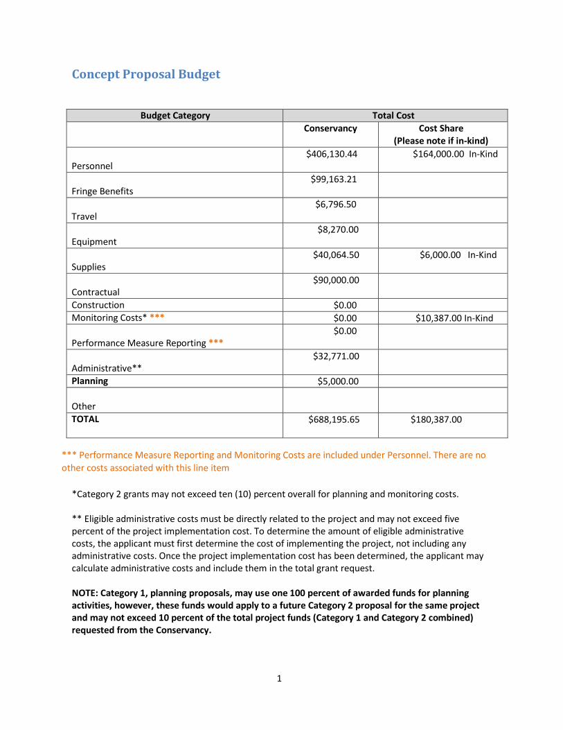
1
Concept Proposal Budget
Budget Category Total Cost Conservancy Cost Share
(Please note if in-kind)
Personnel $406,130.44 $164,000.00 In-Kind
Fringe Benefits $99,163.21
Travel $6,796.50
Equipment $8,270.00
Supplies $40,064.50 $6,000.00 In-Kind
Contractual $90,000.00
Construction $0.00 Monitoring Costs* *** $0.00 $10,387.00 In-Kind
Performance Measure Reporting *** $0.00
Administrative** $32,771.00
Planning $5,000.00
Other TOTAL $688,195.65 $180,387.00
*** Performance Measure Reporting and Monitoring Costs are included under Personnel. There are no other costs associated with this line item
*Category 2 grants may not exceed ten (10) percent overall for planning and monitoring costs.
** Eligible administrative costs must be directly related to the project and may not exceed five percent of the project implementation cost. To determine the amount of eligible administrative costs, the applicant must first determine the cost of implementing the project, not including any administrative costs. Once the project implementation cost has been determined, the applicant may calculate administrative costs and include them in the total grant request.
NOTE: Category 1, planning proposals, may use one 100 percent of awarded funds for planning activities, however, these funds would apply to a future Category 2 proposal for the same project and may not exceed 10 percent of the total project funds (Category 1 and Category 2 combined) requested from the Conservancy.
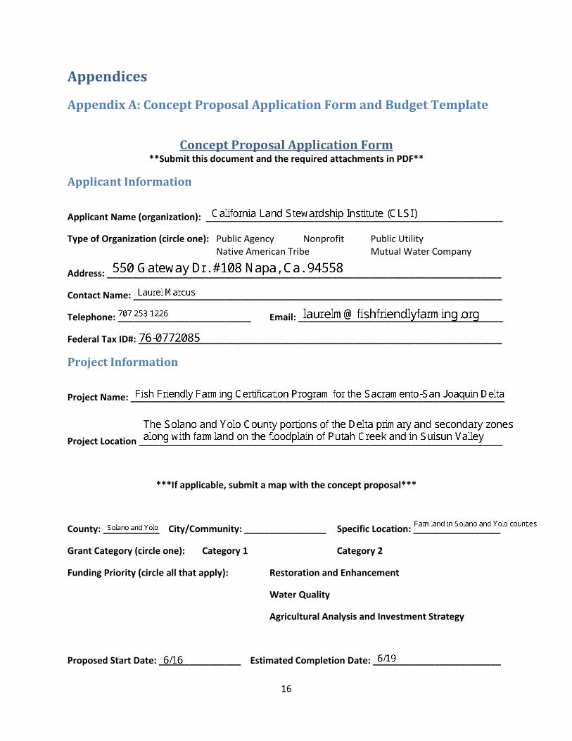
16
Appendices
Appendix A: Concept Proposal Application Form and Budget Template
Concept Proposal Application Form **Submit this document and the required attachments in PDF**
Applicant Information
Applicant Name (organization): __________________________________________________________
Type of Organization (circle one): Public Agency Nonprofit Public Utility Native American Tribe Mutual Water Company
Address: _____________________________________________________________________________
Contact Name: ________________________________________________________________________
Telephone: __________________________ Email: ________________________________________
Federal Tax ID#: _______________________________________________________________________
Project Information
Project Name: _________________________________________________________________________
Project Location _______________________________________________________________________
***If applicable, submit a map with the concept proposal***
County: ___________ City/Community: ________________ Specific Location: _________________
Grant Category (circle one): Category 1 Category 2
Funding Priority (circle all that apply): Restoration and Enhancement
Water Quality
Agricultural Analysis and Investment Strategy
Proposed Start Date: ________________ Estimated Completion Date: _________________________

17
Concept Proposal Budget Template
Budget Category Total Cost
Conservancy Cost Share (Please note if in-kind)
Personnel
Fringe Benefits
Travel
Equipment
Supplies
Contractual
Construction
Monitoring Costs*
Performance Measure Reporting
Administrative**
Planning
Other
TOTAL
*Category 2 grants may not exceed ten (10) percent overall for planning and monitoring costs. ** Eligible administrative costs must be directly related to the project and may not exceed five percent of the project implementation cost. To determine the amount of eligible administrative costs, the applicant must first determine the cost of implementing the project, not including any administrative costs. Once the project implementation cost has been determined, the applicant may calculate administrative costs and include them in the total grant request. NOTE: Category 1, planning proposals, may use one 100 percent of awarded funds for planning activities, however, these funds would apply to a future Category 2 proposal for the same project and may not exceed 10 percent of the total project funds (Category 1 and Category 2 combined) requested from the Conservancy.
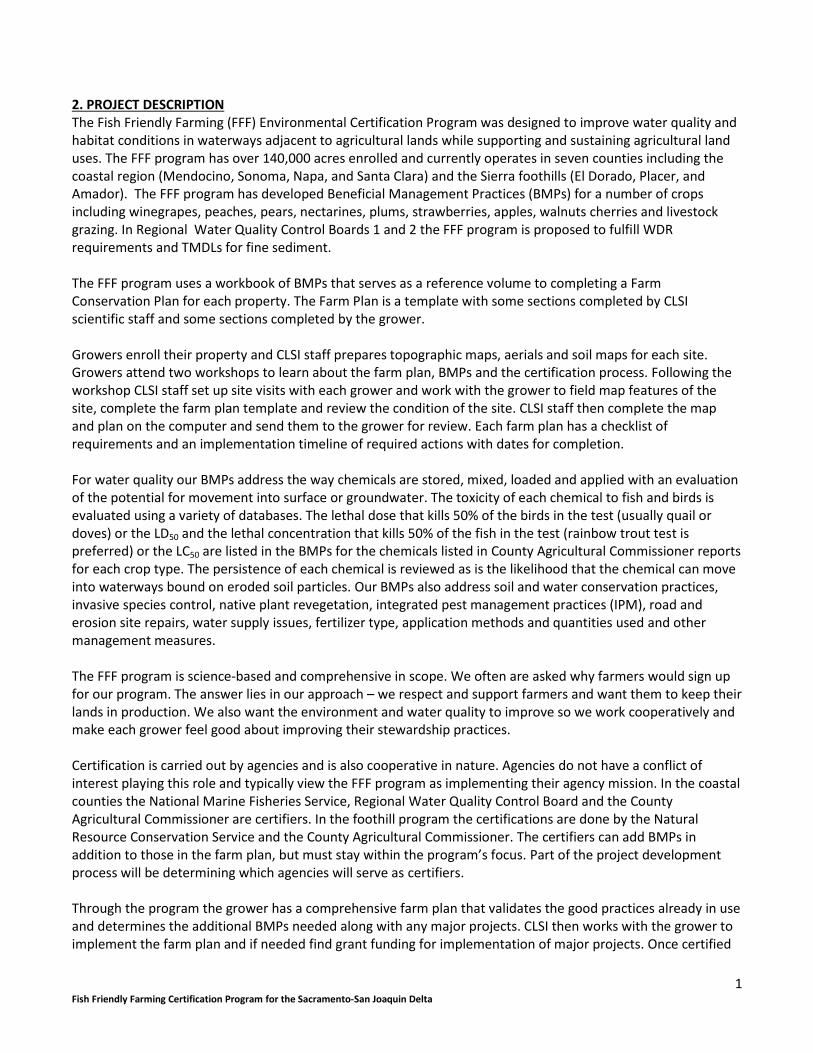
1 Fish Friendly Farming Certification Program for the Sacramento-San Joaquin Delta
2. PROJECT DESCRIPTION The Fish Friendly Farming (FFF) Environmental Certification Program was designed to improve water quality and habitat conditions in waterways adjacent to agricultural lands while supporting and sustaining agricultural land uses. The FFF program has over 140,000 acres enrolled and currently operates in seven counties including the coastal region (Mendocino, Sonoma, Napa, and Santa Clara) and the Sierra foothills (El Dorado, Placer, and Amador). The FFF program has developed Beneficial Management Practices (BMPs) for a number of crops including winegrapes, peaches, pears, nectarines, plums, strawberries, apples, walnuts cherries and livestock grazing. In Regional Water Quality Control Boards 1 and 2 the FFF program is proposed to fulfill WDR requirements and TMDLs for fine sediment. The FFF program uses a workbook of BMPs that serves as a reference volume to completing a Farm Conservation Plan for each property. The Farm Plan is a template with some sections completed by CLSI scientific staff and some sections completed by the grower. Growers enroll their property and CLSI staff prepares topographic maps, aerials and soil maps for each site. Growers attend two workshops to learn about the farm plan, BMPs and the certification process. Following the workshop CLSI staff set up site visits with each grower and work with the grower to field map features of the site, complete the farm plan template and review the condition of the site. CLSI staff then complete the map and plan on the computer and send them to the grower for review. Each farm plan has a checklist of requirements and an implementation timeline of required actions with dates for completion. For water quality our BMPs address the way chemicals are stored, mixed, loaded and applied with an evaluation of the potential for movement into surface or groundwater. The toxicity of each chemical to fish and birds is evaluated using a variety of databases. The lethal dose that kills 50% of the birds in the test (usually quail or doves) or the LD50 and the lethal concentration that kills 50% of the fish in the test (rainbow trout test is preferred) or the LC50 are listed in the BMPs for the chemicals listed in County Agricultural Commissioner reports for each crop type. The persistence of each chemical is reviewed as is the likelihood that the chemical can move into waterways bound on eroded soil particles. Our BMPs also address soil and water conservation practices, invasive species control, native plant revegetation, integrated pest management practices (IPM), road and erosion site repairs, water supply issues, fertilizer type, application methods and quantities used and other management measures. The FFF program is science-based and comprehensive in scope. We often are asked why farmers would sign up for our program. The answer lies in our approach – we respect and support farmers and want them to keep their lands in production. We also want the environment and water quality to improve so we work cooperatively and make each grower feel good about improving their stewardship practices. Certification is carried out by agencies and is also cooperative in nature. Agencies do not have a conflict of interest playing this role and typically view the FFF program as implementing their agency mission. In the coastal counties the National Marine Fisheries Service, Regional Water Quality Control Board and the County Agricultural Commissioner are certifiers. In the foothill program the certifications are done by the Natural Resource Conservation Service and the County Agricultural Commissioner. The certifiers can add BMPs in addition to those in the farm plan, but must stay within the program’s focus. Part of the project development process will be determining which agencies will serve as certifiers. Through the program the grower has a comprehensive farm plan that validates the good practices already in use and determines the additional BMPs needed along with any major projects. CLSI then works with the grower to implement the farm plan and if needed find grant funding for implementation of major projects. Once certified

2 Fish Friendly Farming Certification Program for the Sacramento-San Joaquin Delta
the grower can display an FFF sign on their property, a source of pride for many growers and market their products with our logo. A full recertification with the certifying agencies occurs every 5 years and an annual on-line audit is required. Recertification assures that the farm plan continues to be implemented and progress is made on major projects. For this proposal CLSI will develop a version of the FFF program derived from the current program that addresses the crops grown in the Yolo and Solano county sections of the Delta and that addresses the specific water quality problems documented in this part of the Delta. We are also proposing to include two areas outside of the Delta in the project: the farmland on the floodplain of Putah Creek and in Suisun Valley (see map). Both of these waterways can provide pollutants directly to the Delta and Suisun Marsh. The more farmland in the immediate watershed of the Delta that can complete BMP implementation the greater the improvement in water quality. In addition to developing the FFF for the Delta program we will work with the Yolo and Solano RCDs to outreach to growers, involve them in program development and gain signups for implementing the program in the next phase. As the program progresses additional Delta counties may be added. Goals and Objectives Goal 1: Increase the ability of agricultural operators to improve Delta water quality Objectives:
Develop the FFF for the Delta program including BMPs for the major crops grown the Yolo/Solano County areas of the Delta and a Farm Conservation Plan template for the new program
Develop BMPs for agricultural chemicals listed in the Yolo and Solano County Agricultural Commissioner reports for major crops and/or occurring as pollutants in the Delta waterways.
Goal 2: Support and sustain agriculture in the Delta Objectives:
Complete outreach and involve Delta growers in the development of the FFF for the Delta program
Work with growers to field test the Draft program and revise it to address grower comments
Assist and support growers to sign up for the program once developed. Goal 3 Enhance fish and wildlife habitat in the Delta to the greatest degree feasible Objectives:
As part of the FFF for the Delta program include BMPs to enhance wildlife habitats
Tasks 1. Collect documents and data Background documents, data on crop types, chemicals used, IPM methods and water quality monitoring will be collected. 2. Agricultural organizations Contact agricultural organizations and give presentations on the project. Farm bureaus, grower associations and other groups will be included. 3. Agricultural and water quality professionals Contact UC Cooperative Extension farm advisors, NRCS staff, Agricultural Commissioners, Regional Board staff and Irrigated Lands Water Quality Coalitions and local PCAs (Pest Control Advisors) to discuss the program and collect data on cultivation and chemical methods for major crops, chemical and fertilizer application methods, water quality monitoring results and other information.

3 Fish Friendly Farming Certification Program for the Sacramento-San Joaquin Delta
4. Problem statement Determine the list of major crops and their spatial coverage, determine the primary pests and diseases for each crop, determine the list of chemicals used for each pest and disease, determine the primary cultural and chemical control practices used for each pest and disease, determine the primary water pollutants measured at various locations in the Delta, evaluate drought preparedness and climate change adaptations currently in use. Prepare a problem statement that forms the basis of the FFF program content. Existing data will be used. 5. Draft Beneficial Management Practices workbook For each crop develop a set of BMPs for chemical use, cultural and cultivation practices, IPM recommendations and fertilizer use. Adapt the existing FFF program documents for crops already covered by the FFF program to address Delta issues. Develop new BMPs for crops not already covered. Adapt the erosion control, soil health, water conservation, fish and wildlife enhancement BMPs for inclusion in the FFF for the Delta program. Create a new section on drought preparedness and climate change adaptations. Determine certification procedures. 6. Draft Farm Conservation Plan template Adapt the current FFF farm plan template for the Delta program 7. Meetings with growers In conjunction with the Yolo and Solano RCDs hold meetings with growers to discuss the program and gain feedback on the BMPs and farm plan template. Field test the template and BMPs with several willing growers. 8. Final Workbooks Following review by the grant manager finalize the Draft BMP workbook and the Farm Plan Template incorporating comments. 9. Signups Meet with grower and agricultural organizations to complete site signups so the new program can move into implementation. Deliverables
List of collected documents and data
List of agricultural organizations contacted
List of agricultural and water quality professionals contacted
Problem statement
Draft BMP workbook
Draft Farm Plan template
Summary of grower meetings
Final BMP and Farm plan workbooks
Summary of sign ups 3. ORGANIZATIONAL CAPACITY The California Land Stewardship Institute (CLSI) currently operates the Fish Friendly Farming (FFF) Certification Program in seven counties. We have run the FFF program since our incorporation in 2004 and prior to that our Executive Director, Laurel Marcus, ran the program in association with several RCDs. Ms Marcus developed the program starting in 1997 and has built its popularity with growers and agencies since that time. CLSI has scientific staff that completes the site visits/assessments and is trained to work cooperatively with growers. We developed a new adaptation of the FFF program for agriculture in the Sierra foothills. Our coastal counties

4 Fish Friendly Farming Certification Program for the Sacramento-San Joaquin Delta
program addresses fine sediment and high water temperatures as the primary water quality pollutants, but also reviews pesticide use. Our foothill program addresses pesticides as the primary pollutants and evaluates the many pathways for agricultural chemicals and fertilizers to reach surface and groundwater. Our program for livestock grazing adapted in 2011 uses portions of the original FFF program with new sections written for the effects of livestock grazing on water quality and stream habitats. Short resumes for a few of our staff are included below. California Land Stewardship Institute: LAUREL MARCUS, EXECUTIVE DIRECTOR Laurel Marcus has over 30 years of experience in environmental analysis, wetland and watershed restoration, erosion control projects, permitting and negotiation and project implementation. Her experience includes: the acquisition of lands, environmental assessment and project design, preparation of CEQA documents, the negotiation of permits, public relations and communications, development of feasibility analyses for project development, public outreach and education programs, project implementation and monitoring. For the last 15 years she has focused on working with private landowners to sustain economic uses of farm and ranch land while improving water quality and fish and wildlife habitats. California Land Stewardship Institute: LESLIE SCOTT, PROJECT MANAGER Leslie has over 20 years of experience in natural resource management including aquatic habitat restoration, invasive plant control and pesticide use. Leslie has worked with private landowners, ranchers and farmers to implement habitat restoration projects and improvements to water quality. California Land Stewardship Institute: KAREN PEITZ, PROJECT ASSISTANT Ms. Peitz specializes in the coordination of community-based planning and the coordination of diverse stakeholders to facilitate environmental improvement and restoration projects. Ms. Peitz is part of the team that coordinates and manages the Fish Friendly Farming Program and works with landowners to implement restoration projects such as invasive plant removal and revegetation. CLSI will work with the Yolo and Solano RCD. Some information about their staff is included below: Solano RCD personnel are well-qualified to implement the activities outlined in the proposed project. Solano RCD’s Executive Director Chris Rose has designed, implemented, and overseen hundreds of acres of native grassland and riparian restoration projects in the Sacramento Valley since 1993. Other personnel include: Amy King (MS, Ecology, emphasis in Agricultural Ecology), who has 14 years experience in native plant ecology, landscape design and water quality monitoring and landowner outreach and collaboration; Miles DaPrato who has 11 years of experience in restoration implementation in Central Valley and coastal foothills ecosystems; Andrea Mummert who has been working on agricultural surface water quality monitoring as well as wildlife conservation projects since 1999. Yolo County RCD Executive Director, Heather Nichols, graduated from CSU Humboldt (1999) with a B.S. in Sustainable Systems and a minor in Soil Science. She earned her M.A. in Landscape Design from the Conway School of Landscape Design. Heather has over 10 years’ experience in watershed planning, design, and project management on a variety of restoration projects in California, New England, and the UK. Jeanette Wrysinski, has been planning, managing and implementing projects for more than 20 years, has worked with a broad variety of local, state and federal agencies and organizations and has managed budgets exceeding $2 million dollars with multiple subcontractors. These projects have involved extensive coordination for program development, communication; and installation of conservation methods to benefit water quality and wildlife habitat in agricultural and watershed contexts. She has designed and coordinated monitoring programs to determine conservation effects on plant and wildlife species and has coordinated research-level investigations on working landscapes.
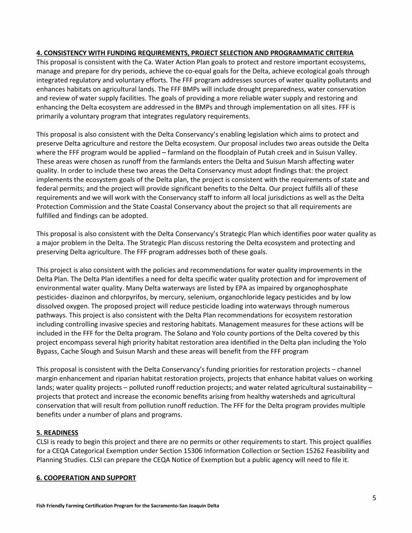
5 Fish Friendly Farming Certification Program for the Sacramento-San Joaquin Delta
4. CONSISTENCY WITH FUNDING REQUIREMENTS, PROJECT SELECTION AND PROGRAMMATIC CRITERIA This proposal is consistent with the Ca. Water Action Plan goals to protect and restore important ecosystems, manage and prepare for dry periods, achieve the co-equal goals for the Delta, achieve ecological goals through integrated regulatory and voluntary efforts. The FFF program addresses sources of water quality pollutants and enhances habitats on agricultural lands. The FFF BMPs will include drought preparedness, water conservation and review of water supply facilities. The goals of providing a more reliable water supply and restoring and enhancing the Delta ecosystem are addressed in the BMPs and through implementation on all sites. FFF is primarily a voluntary program that integrates regulatory requirements. This proposal is also consistent with the Delta Conservancy’s enabling legislation which aims to protect and preserve Delta agriculture and restore the Delta ecosystem. Our proposal includes two areas outside the Delta where the FFF program would be applied – farmland on the floodplain of Putah creek and in Suisun Valley. These areas were chosen as runoff from the farmlands enters the Delta and Suisun Marsh affecting water quality. In order to include these two areas the Delta Conservancy must adopt findings that: the project implements the ecosystem goals of the Delta plan, the project is consistent with the requirements of state and federal permits; and the project will provide significant benefits to the Delta. Our project fulfills all of these requirements and we will work with the Conservancy staff to inform all local jurisdictions as well as the Delta Protection Commission and the State Coastal Conservancy about the project so that all requirements are fulfilled and findings can be adopted. This proposal is also consistent with the Delta Conservancy’s Strategic Plan which identifies poor water quality as a major problem in the Delta. The Strategic Plan discuss restoring the Delta ecosystem and protecting and preserving Delta agriculture. The FFF program addresses both of these goals. This project is also consistent with the policies and recommendations for water quality improvements in the Delta Plan. The Delta Plan identifies a need for delta specific water quality protection and for improvement of environmental water quality. Many Delta waterways are listed by EPA as impaired by organophosphate pesticides- diazinon and chlorpyrifos, by mercury, selenium, organochloride legacy pesticides and by low dissolved oxygen. The proposed project will reduce pesticide loading into waterways through numerous pathways. This project is also consistent with the Delta Plan recommendations for ecosystem restoration including controlling invasive species and restoring habitats. Management measures for these actions will be included in the FFF for the Delta program. The Solano and Yolo county portions of the Delta covered by this project encompass several high priority habitat restoration area identified in the Delta plan including the Yolo Bypass, Cache Slough and Suisun Marsh and these areas will benefit from the FFF program This proposal is consistent with the Delta Conservancy’s funding priorities for restoration projects – channel margin enhancement and riparian habitat restoration projects, projects that enhance habitat values on working lands; water quality projects – polluted runoff reduction projects; and water related agricultural sustainability – projects that protect and increase the economic benefits arising from healthy watersheds and agricultural conservation that will result from pollution runoff reduction. The FFF for the Delta program provides multiple benefits under a number of plans and programs. 5. READINESS CLSI is ready to begin this project and there are no permits or other requirements to start. This project qualifies for a CEQA Categorical Exemption under Section 15306 Information Collection or Section 15262 Feasibility and Planning Studies. CLSI can prepare the CEQA Notice of Exemption but a public agency will need to file it. 6. COOPERATION AND SUPPORT
6 Fish Friendly Farming Certification Program for the Sacramento-San Joaquin Delta
CLSI will work with the Yolo County RCD and the Solano County RCD on this project. We have also coordinated with the Putah Creek Streamkeeper, Putah Creek Council, National Marine Fisheries Service and others. Support letters are attached to our application. As part of the project w will include local government in Solano and Yolo Counties and the Delta Protection Commission to review the NMPs developed for the program. This project uses a number of Agricultural Land Stewardship Strategies including improving on-farm agricultural productivity including soil and water quality (A2); partner with others to maintain and enhance environmental quality (B1); provide incentives for farmers and landowners to take part in market-based conservation programs (B2); help farmers and landowner navigate regulatory requirements (D5.2) and involve farmers and landowner in project planning (E1.2.1). 7. BEST AVAILABLE SCIENCE AND ADAPTIVE MANAGEMNET The FFF program is based on the best available science from a number of disciplines – soil science, hydrology, riparian and aquatic ecology, biochemistry, fate and transport studies and toxicity studies of agricultural chemicals, integrated pest management studies and others. As described in the project description we will collect information from a wide array of sources and consult with local experts as part of developing the BMP workbook. The Delta Science Plan defines adaptive management as “ a strategy for proceeding with management decisions under uncertain conditions rather than delaying actions until more information is available or adopting a rigid prescriptive approach” The Delta Science Plan calls for adaptive management liaisons in the Delta and an adaptive management framework. We will coordinate our efforts with this system. Under this project we will employ the adaptive management concept by field testing our Draft BMP workbook and farm plan template with interested growers. We will use grower’s practical knowledge and economic review of the BMPs to revise the program and make it acceptable and more attractive to the growers while making sure it addresses reductions in priority pollutants. We see this step as essential to the success of program implementation. In the next implementation phase we will try to use before and after water quality monitoring results in an area where a large number of farm plans are implemented. 8. PROJECT ASSESSMENT We will measure several project performance measures as part of the planning process Project Goal 1: Increase the ability of agricultural operations to improve Delta water quality Desired Outcome: Completed Fish Friendly Farming for the Delta program Output Indicators: Grower and agency involvement Outcome Indicators: Comprehensive water quality program for agriculture ready for implementation Measurement Tools and Methods: Number of comments incorporated or resolved in final program Target: Comments from 30 growers Project Goal 2: Support and sustain agriculture in the Delta Desired Outcome: Growers involved in the FFF program development and signing up for the implementation phase Output Indicators: Growers providing comments, input and sign ups Outcome Indicators: Growers attending meetings and signing up. Measurements Tools and Methods: Number of growers and agricultural organizations attending meetings and signing up Target: 50 growers attending.
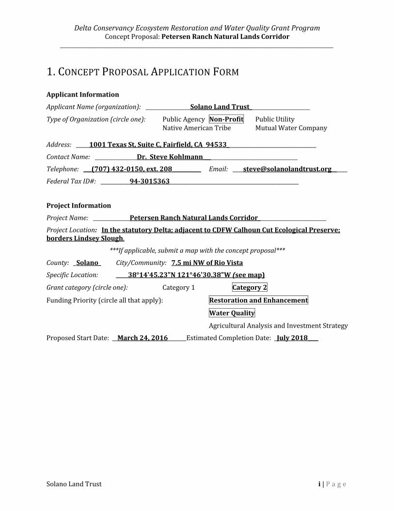
Delta Conservancy Ecosystem Restoration and Water Quality Grant Program Concept Proposal: Petersen Ranch Natural Lands Corridor
________________________________________________________________________________________________________
Solano Land Trust i | P a g e
1. CONCEPT PROPOSAL APPLICATION FORM
Applicant Information
Applicant Name (organization): _________________Solano Land Trust_______________________
Type of Organization (circle one): Public Agency Non-Profit Public Utility Native American Tribe Mutual Water Company Address: _____1001 Texas St, Suite C, Fairfield, CA 94533__________________________________
Contact Name: ________________Dr. Steve Kohlmann____________________________________
Telephone: ___(707) 432-0150, ext. 208___________ Email: [email protected]______
Federal Tax ID#: ___________94-3015363_________________________________________________
Project Information
Project Name: ______________Petersen Ranch Natural Lands Corridor__________________________
Project Location: In the statutory Delta; adjacent to CDFW Calhoun Cut Ecological Preserve; borders Lindsey Slough.
***If applicable, submit a map with the concept proposal***
County: _Solano_ City/Community: 7.5 mi NW of Rio Vista
Specific Location: ____ 38°14'45.23"N 121°46'30.38"W (see map)
Grant category (circle one): Category 1 Category 2
Funding Priority (circle all that apply): Restoration and Enhancement
Water Quality
Agricultural Analysis and Investment Strategy
Proposed Start Date: __March 24, 2016_______Estimated Completion Date: _July 2018____
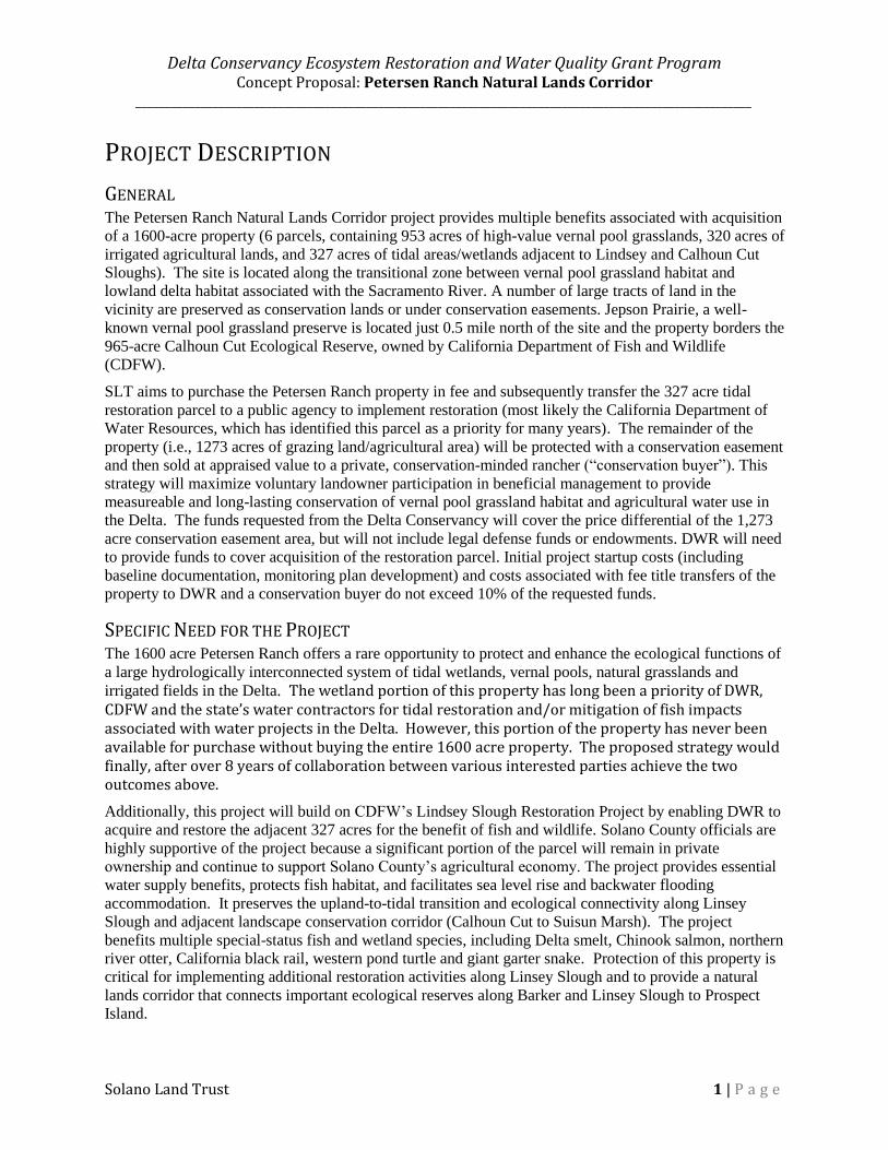
Delta Conservancy Ecosystem Restoration and Water Quality Grant Program Concept Proposal: Petersen Ranch Natural Lands Corridor
________________________________________________________________________________________________________
Solano Land Trust 1 | P a g e
PROJECT DESCRIPTION
GENERAL The Petersen Ranch Natural Lands Corridor project provides multiple benefits associated with acquisition
of a 1600-acre property (6 parcels, containing 953 acres of high-value vernal pool grasslands, 320 acres of
irrigated agricultural lands, and 327 acres of tidal areas/wetlands adjacent to Lindsey and Calhoun Cut
Sloughs). The site is located along the transitional zone between vernal pool grassland habitat and
lowland delta habitat associated with the Sacramento River. A number of large tracts of land in the
vicinity are preserved as conservation lands or under conservation easements. Jepson Prairie, a well-
known vernal pool grassland preserve is located just 0.5 mile north of the site and the property borders the
965-acre Calhoun Cut Ecological Reserve, owned by California Department of Fish and Wildlife
(CDFW).
SLT aims to purchase the Petersen Ranch property in fee and subsequently transfer the 327 acre tidal
restoration parcel to a public agency to implement restoration (most likely the California Department of
Water Resources, which has identified this parcel as a priority for many years). The remainder of the
property (i.e., 1273 acres of grazing land/agricultural area) will be protected with a conservation easement
and then sold at appraised value to a private, conservation-minded rancher (“conservation buyer”). This
strategy will maximize voluntary landowner participation in beneficial management to provide
measureable and long-lasting conservation of vernal pool grassland habitat and agricultural water use in
the Delta. The funds requested from the Delta Conservancy will cover the price differential of the 1,273
acre conservation easement area, but will not include legal defense funds or endowments. DWR will need
to provide funds to cover acquisition of the restoration parcel. Initial project startup costs (including
baseline documentation, monitoring plan development) and costs associated with fee title transfers of the
property to DWR and a conservation buyer do not exceed 10% of the requested funds.
SPECIFIC NEED FOR THE PROJECT The 1600 acre Petersen Ranch offers a rare opportunity to protect and enhance the ecological functions of
a large hydrologically interconnected system of tidal wetlands, vernal pools, natural grasslands and
irrigated fields in the Delta. The wetland portion of this property has long been a priority of DWR, CDFW and the state’s water contractors for tidal restoration and/or mitigation of fish impacts associated with water projects in the Delta. However, this portion of the property has never been available for purchase without buying the entire 1600 acre property. The proposed strategy would finally, after over 8 years of collaboration between various interested parties achieve the two outcomes above.
Additionally, this project will build on CDFW’s Lindsey Slough Restoration Project by enabling DWR to
acquire and restore the adjacent 327 acres for the benefit of fish and wildlife. Solano County officials are
highly supportive of the project because a significant portion of the parcel will remain in private
ownership and continue to support Solano County’s agricultural economy. The project provides essential
water supply benefits, protects fish habitat, and facilitates sea level rise and backwater flooding
accommodation. It preserves the upland-to-tidal transition and ecological connectivity along Linsey
Slough and adjacent landscape conservation corridor (Calhoun Cut to Suisun Marsh). The project
benefits multiple special-status fish and wetland species, including Delta smelt, Chinook salmon, northern
river otter, California black rail, western pond turtle and giant garter snake. Protection of this property is
critical for implementing additional restoration activities along Linsey Slough and to provide a natural
lands corridor that connects important ecological reserves along Barker and Linsey Slough to Prospect
Island.
Delta Conservancy Ecosystem Restoration and Water Quality Grant Program Concept Proposal: Petersen Ranch Natural Lands Corridor
________________________________________________________________________________________________________
Solano Land Trust 2 | P a g e
PROJECT GOALS AND OBJECTIVES Protect the Peterson Ranch property as natural land in perpetuity;
Enable restoration of tidal and wetland habitat on the marsh portion of the property by transferring
it to DWR for subsequent restoration;
Provide for the perpetual conservation and management of sensitive upland and vernal pool
habitats through a conservation easement;
Facilitate private landowner participation in beneficial management of the agricultural portion of
Peterson Ranch upon transfer to a conservation buyer;
Establish stakeholder partnership to promote the long-term protection of the Petersen Ranch lands
to enhance the interconnected Delta resources – agriculture, water resources and fish/wildlife
habitat.
TASKS AND DELIVERABLES TASK DELIVERABLE & OUTCOME Prepare and Negotiate purchase of the entire Petersen Ranch at appraised value.
Title report (due diligence) Phase 1 Dual appraisal (valuation of fee and easement) Purchase and Sale Agreement Recorded transaction (SLT is owner)
Transfer 327-acre tidal/wetland parcel of the property to DWR
Recorded transaction (State is owner)
Sell the balance of the property (1,273 acres) to a conservation buyer subject to appraised value and Conservation Easement
Recorded Transaction (Conservation Buyer is owner, SLT holds easement)
Simultaneously with #3: Convey a Conservation Easement on 1,273 acres protecting the conservation and agricultural values of the agricultural parcels in perpetuity.
Baseline Report Recorded Conservation Easement and Deed Restriction Monitoring Plan Interim / Long-term Management Plan (if needed)
2. ORGANIZATIONAL CAPACITY Solano Land Trust (SLT) is a private, non-profit organization founded in 1986 to preserve agricultural
lands, open space, and natural resources through the acquisition of land and conservation easements,
implementation of ecological restoration projects, education/community outreach, and land management.
SLT is a Land Trust Alliance (LTA) – accredited organization and is authorized to hold conservation
easements by CDFW and U.S. Fish and Wildlife Service (USFWS).
To date, SLT has preserved over 22,000 acres of natural lands in Solano County, including our anchor properties at Jepson Prairie Preserve and Wilcox Ranch, Rush Ranch, King-Swett Ranches, Lynch Canyon, and Rockville Trails Preserve, representing the rich and varied landscapes that make Solano County unique. Habitats protected by SLT include some of the most productive vernal pools for California Tiger Salamander and other sensitive species (e.g., Jepson Prairie, Wilcox Ranch), the largest remnant tidal marsh in Suisun Bay (e.g., Rush Ranch), large expanses of rolling oak woodlands and grasslands protecting viable populations of California redlegged frog and Calippe silverspot butterfly (King/Swett Ranches), and highly productive agricultural soils providing local food and fiber (e.g., SLT’s 8,000 acres of Conservation Easements).
Delta Conservancy Ecosystem Restoration and Water Quality Grant Program Concept Proposal: Petersen Ranch Natural Lands Corridor
________________________________________________________________________________________________________
Solano Land Trust 3 | P a g e
SLT has a long and successful track record of acquiring, managing and transferring conservation properties, including the 2,085 acre Cullinan Ranch (SLT purchased and transferred the property as part of the San Pablo Bay National Wildlife Refuge) , Lindsey Slough (SLT served as project manager for CDFW on a large restoration project at the Calhoun Cut Ecological Reserve, adjacent to SLT’s Jepson Prairie property and the Petersen Ranch), Beelard Farm (SLT purchased a 132 acre agricultural property and transferred to new owners after placing a Swainson’s hawk conservation easement on the property), Escano property (SLT purchased 237-acres of land and then re-sold the property with a conservation easement), and others (http://www.solanolandtrust.org/Overview.aspx).
SLT’s conservation activities preserve a network of habitats and their ecological and economic benefits for residents in the local communities, the Greater Bay Area and all of California. By protecting natural and agricultural lands, SLT focuses on three primary interests:
1. Habitat conservation and beneficial use of water. SLT has implemented or is currently planning restoration projects designed to conserve and enhance open space and water supply through conservation of natural/agricultural lands and restoration of more than 1,000 acres of wetlands, riparian areas, ponds, grasslands and tidal marshes. Ag-land protection, increased water supply, endangered species protection, sea level rise accommodation and water quality benefits are the primary measurable outcomes of our activities.
2. Scientific management. SLT has long-standing partnerships with two premier scientific institutions (University of California Reserve System (at UC Davis) and the San Francisco National Estuarine Research Reserve (in partnership with San Francisco State University and the National Oceanic and Atmospheric Administration), which are critical in implementing best management practices and adaptive management for all our projects and properties. SLT staff and science partners work collaboratively to implement adaptive management plans that are founded in sound science and are supported by strong monitoring components.
3. Local Community. Working in close partnership with local landowners, municipal agencies, cattle and sheep producers, nonprofits and our over 350 dedicated volunteers, SLT's strives to protect and enhance the biological and agricultural resources that support our communities. In addition, SLT supports public recreation and education activities and events on our properties free of charge to the public.
3. CONSISTENCY WITH FUNDING REQUIREMENTS, PROJECT
SELECTION, AND PROGRAMMATIC CRITERIA This working landscape enhancement project addresses the Conservancy‘s highest priority of (1) Habitat Restoration and Enhancement (including tidal and riparian habitats, fish population recovery, watershed health, adaptation to sea level rise, protection and restoration of aquatic ecosystems and working landscapes, and protecting a vital fish and wildlife corridor in the Delta); and (2) Water-related Agricultural Sustainability issues related to maintaining conservation practices and economic benefits arising from agricultural conservation in the Delta. The Petersen Ranch Natural Lands Corridor project consists of two major outcomes:
1. Habitat restoration. Transfer of the ecologically valuable 327 acres of tidal and near-tidal lands to the appropriate public agency for restoration; and
2. Agricultural conservation. Transfer of economically valuable agricultural portion of the ranch to a conservation buyer following the conveyance of a conservation easement.

Delta Conservancy Ecosystem Restoration and Water Quality Grant Program Concept Proposal: Petersen Ranch Natural Lands Corridor
________________________________________________________________________________________________________
Solano Land Trust 4 | P a g e
The habitat restoration component of the project is consistent with Proposition 1 which provides funding to implement the primary objectives of the California Water Action Plan: more reliable water supplies (by preserving wetlands, vernal pools and channel margins) and the restoration of important species habitats (tidal habitats along Lindsey Slough to benefit Delta fish species). Transferring the restoration parcel into public ownership serves the Delta Plan’s coequal goals by providing for overflow zones where storm waters and sea level rise can be accommodated without harming infrastructure or residential developments. The Cache Slough area has been identified as one of six priority areas of the Delta Plan for aquatic and intertidal habitat restoration. By protecting hydrological and ecosystem connectivity across the upland-tidal gradient, this project clearly meets the ecosystem and watershed protection mandate. In addition, by transferring the tidal parcel to a public implementing entity, restoration can be implemented in accordance with statewide priorities. Finally, a conversion of the wetland portion of the property from an agricultural use to primary habitat function is consistent with Policy P2 of the Delta Commission’s Land Use and Resource Management Plan because this activity is focused on a portion of the ranch where productivity and agricultural values are lowest.
Placing a conservation easement and prohibiting water rights transfers and non-beneficial uses of water is likewise consistent with Prop 1 by providing a more resilient and sustainably managed water infrastructure. A conservation easement also serves the Delta Plan’s coequal goals, protects the unique natural resource and agricultural values and restricts development that may impact hydrological and ecosystem connectivity. The Conservancy’s enabling legislation emphasizes purchasing private lands with public funds. This project proposes to use public funds to purchase private lands of high conservation value to enable maximization of conservation benefits. A conservation easement “maximizes voluntary landowner participation” in management practices that safeguard species populations, habitat quality and landscape connectivity. By implementing easement stewardship monitoring, SLT will provide “measureable and long-lasting habitat or
species improvements in the Delta.”
The Solano County General Plan identifies the Petersen Property as part of the Jepson Prairie Agricultural region (zoned A-160); its protection serves multiple goals and policies (AR.G-1 through AR.G-3, AR.G-6), to support agriculture in the county. The Solano Multispecies Habitat Conservation Plan identifies the Jepson Prairie Region as the most suitable location to implement the plan’s “Valley Floor Grassland and Vernal Pool Natural Community Conservation Strategy” and associated reserve system. In addition, the project provides conservation of key aquatic species (e.g., California Tiger Salamander, vernal pool species) and is part of a USFWS Vernal Pool Species Recovery Plan core area within the Solano-Colusa vernal pool region. Both vernal pool fairy shrimp (federally threatened) and midvalley fairy shrimp (California species of concern) have been observed at Petersen Ranch. The USFWS Vernal Pool Recovery Plan explicitly aims to “Promote natural ecosystem
Figure 2: Sea level rise and floodwater accommodation
Delta Conservancy Ecosystem Restoration and Water Quality Grant Program Concept Proposal: Petersen Ranch Natural Lands Corridor
________________________________________________________________________________________________________
Solano Land Trust 5 | P a g e
processes and functions by protecting and conserving intact vernal pools and vernal pool complexes within the recovery planning area to maintain viable populations of listed species and species of concern, and prevent additional threats from emerging over time”. The Petersen Ranch is also within USFWS designated critical habitat for Delta Smelt. In addition to serving as priority restoration area for fish, preliminary analysis strongly suggests that the portion of the ranch designated for tidal habitat restoration (upon transfer to the State) is highly suited to accommodate sea level rise and flood waters (Figure 2).
4. READINESS The acquisition of the Petersen Ranch is ready to be finalized as soon as funding is available. The Ranch has been listed and earlier obstacles to a purchase (mineral rights) have been resolved. Initial preparatory work, including extensive planning, biological assessments, preliminary title report examination, and several previous Purchase Offers have been completed by SLT over the past decade. The project is a fee acquisition and therefore does not require any permits or CEQA. SLT intends to leverage the Prop 1 funds with funds through public agencies (DFW).
The following list identifies the next steps necessary to complete the acquisition project:
- Coordinate funding strategy, including matching funds and bridge loans to cover parts of the
acquisition cost. - Obtain an appraisal. (est. $15,000) to determine current market value and value of a
conservation easement - Negotiate funding and transfer agreement for the marsh parcel with DWR (327-acre restoration
parcel) - Negotiate and execute a PSA with property owners with a 60-day refundable deposit of
$50K to be funded by the SLT Reserve Fund, including a potential grant from TPL. - Conduct due diligence - Title Investigation and Phase 1, as appropriate. - Contact potential conservation buyers. - Discuss SLT match (endowment funding) with the SLT Committees and Board
5. COOPERATION AND SUPPORT The Petersen Ranch Natural Lands Corridor project will involve a critical collaboration between SLT, public agencies (DWR, CDFW), the Delta Conservancy, county officials and other interested parties (e.g., private conservation buyers). We fully anticipate that commitment letters from leverage partners (public agencies) will be available at the time of the full proposal. The following is a list of Individuals and Organizations participating or being considered as potential collaborators in the Petersen Ranch Natural Lands Corridor, along with their anticipated role:
Individual/Organization Anticipated Role
(active participation, cooperation, support)
Department of Water Resources
(DWR) Most likely potential recipient of the 327 acre marsh parcel for restoration; Consultation with Erik Lobochevsky on June 29, 2015; will need to provide additional funds for acquisition and restoration;
CA Department of Fish and
Wildlife (CA DFW) Potential recipient of the 327 acre marsh parcel for restoration; consultation with Carl Wilcox in June 2015; CDFW has implemented the Lindsey Slough restoration project on the

Delta Conservancy Ecosystem Restoration and Water Quality Grant Program Concept Proposal: Petersen Ranch Natural Lands Corridor
________________________________________________________________________________________________________
Solano Land Trust 6 | P a g e
adjacent Calhoun Cut Ecological Reserve.
Delta Conservancy Funder (active participation) Consultation on June 29, 2015, Campbell Ingram.
Solano County Department of
Environmental Management Supporting the acquisition, ongoing consultations; multiple consultations with Director of Resources, Bill Emlen in March, May, June and September 2015
Trust for Public Land (TPL) Partner and potential transaction facilitator
6. SCIENTIFIC MERIT AND PERFORMANCE MEASURES Scientific basis and adaptive management will be most relevant if SLT holds a portion of the fee property for any length of time. While serving as interim land manager, SLT will implement an interim land management plan to protect and maintain the property’s conservation values. This will include moderate grazing to manage vernal pool vegetation, weed managements, and beneficial water use for irrigated pastures. All actions will be designed as adaptive management to integrate best available science and management experience into the conservation of the property.
The transaction will follow best industry practices and the Land Trust Alliance (LTA) accreditation standards. SLT’s performance standards apply to all phases of the project, including Project Initiation, Due Diligence, Stewardship and Records Management. SLT will monitor the property annually for compliance with prohibited uses and other deed restrictions identified in the Conservation Easement over the agricultural portion of the property.
SLT will prepare and submit a Project Performance Measures Table as part of the full proposal to provide a framework for assessment and evaluation of project performance. The PAEP will identify monitoring metrics and measures to fully comply with the Conservancy’s reporting and monitoring requirements. These will include a full accounting of all project expenditures; all recorded legal documents, including communications and supporting data and exhibits (maps, reports, measurements); all management, stewardship and other planning documents pertinent to the property; all monitoring reports, biological and geospatial data; any lease and/or use permits.
7. PROJECT ASSESSMENT SLT will measure project effectiveness by the following objectives, criteria, and outcomes:
Objective Criteria/Metrics Outcome
Develop a viable funding strategy for the Petersen Ranch (ongoing, current stage of the project)
Objective selection of funding options, time to obtain funds, funding security and repayment requirements, share/match requirements, legal obligations.
SLT has a clear, measurable funding strategy including schedules, alternative pathways, critical milestones and contingencies.
Establish public agency partnership to restore the tidal/marsh parcel and its water resources and fish/wildlife habitat.
Letters of commitment by public agency to acquire the 327 acre restoration parcel; transition strategy
SLT and the public agency have agreements for transfer in place, funding is available, responsibilities are clear, timeline has been established.

Delta Conservancy Ecosystem Restoration and Water Quality Grant Program Concept Proposal: Petersen Ranch Natural Lands Corridor
________________________________________________________________________________________________________
Solano Land Trust 7 | P a g e
SLT purchases the Petersen Ranch
Appraisal, Executed PSA, Recorded Deed
SLT is interim landowner of Petersen Ranch
SLT transfers restoration parcel to public agency
Recorded deed The 327 acre restoration parcel is owned by a public agency
SLT transfers the agricultural lands to a conservation buyer
Recorded Deed The remaining 1273 acres of the Petersen Ranch is owned by a conservation land owner
SLT holds a Conservation easement in perpetuity
Recorded Conservation easement, Baseline study, monitoring plan/checklist
SLT monitors the landowner’s compliance with the deed restrictions in perpetuity.
8. FUNDING REQUEST AND BUDGET
Budget Category
Total Cost (USD)
Delta Conservancy
Cost Share (note if in-kind)
Personnel
Stewardship Director (SLT in kind) 11,400.00
Project Manager (SLT in kind) 16,200.00
Executive Director (SLT in kind) 8,000.00
Business Manager/Accountant (SLT in kind) 2,400.00
Fringe Benefits (SLT in kind) 7,600.00
Solano County Delta Water Consultant consultation on consistency with county programs and priorities (Solano County in kind)
3,250.00
Travel - 250
Supplies - 500
Transaction Costs
Appraisal (includes an appraisal update) 15,000.00
Title Reports and Policy 5,000.00
Closing Costs 10,000.00
Taxes (real estate transaction) 60,000.00
Broker fee reduction (2%) - SLT's broker matching funds 10,000.00
Administrative (max 5% of implementation cost) 33,000.00
Env. Assessment (Phase 1) $10,000.00
Other
Value differential of Conservation Easement (35%) $1,592,500.00
Acquisition of Restoration parcel ($4500/acre) - potential DWR 1,471,500.00
Easement Endowment (SLT matching funds) 30,000.00
Legal Defense Funds (SLT Matching funds) 5,000.00
Total 1,725,500.00 1,566,100.00

16
Appendices
Appendix A: Concept Proposal Application Form and Budget Template
Concept Proposal Application Form **Submit this document and the required attachments in PDF**
Applicant Information
Applicant Name (organization): __________________________________________________________
Type of Organization (circle one): Public Agency Nonprofit Public Utility Native American Tribe Mutual Water Company
Address: _____________________________________________________________________________
Contact Name: ________________________________________________________________________
Telephone: __________________________ Email: ________________________________________
Federal Tax ID#: _______________________________________________________________________
Project Information
Project Name: _________________________________________________________________________
Project Location _______________________________________________________________________
***If applicable, submit a map with the concept proposal***
County: ___________ City/Community: ________________ Specific Location: _________________
Grant Category (circle one): Category 1 Category 2
Funding Priority (circle all that apply): Restoration and Enhancement
Water Quality
Agricultural Analysis and Investment Strategy
Proposed Start Date: ________________ Estimated Completion Date: _________________________

Delta Conservancy Ecosystem Restoration and Water Quality Grant Program Proposal Project Name: Yolo Bypass Wildlife Area Habitat and Drainage Improvement Project Applicant Information:
Organization Address Contact Contact Info Federal tax ID Organization Type
Ducks Unlimited
3074 Gold Canal Drive, Rancho Cordova, CA
Aaron Will
(916) 852-2000 [email protected] 13-5643799 501(c)(3)
Project Information: 1. Project Name: Yolo Bypass Wildlife Area Habitat and Drainage Improvement Project 2. Location:
State(s): California County: Yolo County Sub-region: Yolo Bypass Wildlife Area
3. Start Date: April 2016 4. Estimated Completion Date: October 2017 2. Project Description The Ducks Unlimited, as the grantee, will implement the project on behalf and in coordination with the partners: California Department of Fish and Wildlife (CDFW), Yolo Basin Foundation, Yolo County, Douglas Environmental, CBEC Eco Engineering (CBEC), and Metropolitan Water District of Southern California (MWD). The proposed project is a multitude of infrastructure improvements within the Yolo Bypass Wildlife Area (YBWA). This project provides both habitat and working landscape enhancements. Need: Drainage and water infrastructure improvements are an important aspect in integrating proposed actions to benefit fish species, as described in the National Marine Fisheries Service Biological Opinion on the Long-Term Operations of the Central Valley Project and the State Water Project. (Reasonable and Prudent Alternative 1.6.1) This project exemplifies the state and local partnerships that are needed to implement multi-benefit improvements in the Yolo Bypass. The improvements proposed in this project address agriculture and wetland management conflicts that would arise from increases in frequency and duration of spring flooding. Drainage and water supply infrastructure changes will improve management of individual wetland ponds. Individual management of ponds is a key element of creating diverse habitat while also managing vegetation, minimizing mosquito larvae populations and controlling avian disease during specific times of the year. Wetlands are flooded up in the fall in time for the fall migration of birds traveling the Pacific Flyway. Timing of wetland drawdown in early spring is particularly important for the germination of nutritious wetland plants such as swamp timothy, water grass and sedge. Quick drawdown in the early spring is key to controlling the germination and growth of noxious weeds and mosquito production. This is an essential management tool for keeping the Yolo Bypass flood way open. Goals and Objectives: The Project Goals are to improve agricultural, habitat, species, and public access conditions within and adjacent to the Yolo Bypass Wildlife Area. Objective 1: Improve water supply conveyance and beneficial re-use of Davis Drain water within the YBWA through infrastructure improvement. Objective 2: Increase utilization of Davis Drain water to provide independent water delivery to
1
wetland and agricultural units within the YBWA. Objective 3: Utilize earthen material spoils from infrastructure improvements to provide increased public access by raising berms within YBWA. Tasks that will be undertaken: Ducks Unlimited (DU) will serve as the overall project manager. DU will utilize the engineering designs developed by CBEC, CDFW and Yolo Basin Foundation to develop the appropriate permitting packages and deliver the restoration project. Habitat restoration and improvements include raising the grade on sections of the main access road. Selected dual function ditches will be separated. New water control structures will be installed. Other improvements will include expansion of canals and installation of large diameter box culverts at crossings. New pumps will be installed and an existing pump will be relocated. Specific project activities within the northern half of the YBWA include five major components that provide a comprehensive lift in operational flexibility resulting in agricultural, habitat, species, and public access benefits. These components all directly connect to the Davis Drain and rely on each other for either water conveyance or earthwork necessities. I.e., one component's excavation provides needed fill material for the other project's compacted fill needs. 1 - Drainage Improvements at "Rice Corner" – This component of the project will improve drainage along Davis Drain, which will in turn improve access through YBWA by alleviating flooding along the roadway east and south of Rice Corner. The project requires installation of a larger hydraulic structure (i.e., bridge, or box culvert) at a roadway crossing of Davis Drain to improve conveyance. Road improvements include raising the grade of a portion of road to the south and to the east of the corner. Existing diversion structures on the dual channel north of the corner will be upgraded to provide increased conveyance, and a drainage ditch will be extended west from that structure to enhance water distribution flexibility. 2 - Green's Lake – will create operational flexibility by separating drainage and supply infrastructure. Diversion structures will be added between the south end of Green's Lake and Davis Drain to enable operators to maintain water levels in Green's Lake during drainage of Davis Drain. Two diversion structures and associated culverts will be upgraded at a location just west of "4 Risers." The grade will be raised on the existing access road along the east bank of Green's Lake to allow for access during minor flood events. A diversion structure will be upgraded and vegetation will be cleared from the drainage channel at the north end of Green's Lake to add operational flexibility when draining the lake. 3 - Drainage Improvements at "The Y" – The pipe culverts beneath the existing road crossing are insufficient to convey flows in the South Davis Drain, and present a maintenance issue as they are relatively easy for beavers to block. Conveyance will be improved, and maintenance improved by installing a box culvert in place of the existing pipe culverts. The existing supply pump will be relocated to the northeast corner of The Y. A new diversion structure will be added on the existing north/south ditch along for operational flexibility. Two new diversion structures will be installed at the north and south ends of a recently enlarged drainage channel to allow operators to divert South Davis Drain water to the south, to "4 Risers” location, or to direct water back to Green's Lake to be recycled. There will be minor irrigation piping work, ditch enhancements, and a ditch block associated with the pump relocation, and potential ditch enhancements in the north/south conveyance channel. 4 - Inundation Compatibility – The grade will be raised along the roadway south of Green’s Lake to increase access and to help separate flood waters from wetlands and rice fields. Two lift pumps will be installed on the main drains to allow for drawdown for rice and wetlands in March and April if there is
2

minor flooding in March - June. 5 - Parker Pump – The Parker Unit Component will utilize water from the Davis Drain to provide water to 271 acres of previously contoured land which will result in new wetland habitat units and provide 34 acres of publicly hunted managed seasonal wetland and mixed uplands. Component activities include construction of a pump, electrical panel, and pump platform and excavation near pump location to provide source water to the Parker Units 9-13. In addition, the project will excavate 1,928 lineal feet of main line ditch to provide independent delivery to each wetland unit. The total grant amount requested from the Conservancy is $2,000,000. Total cost share is $343,425. Of the total cost share $232,144 dollars is being provided by CDFW through Minor Capital Outlay. Ducks Unlimited will donate $10,000 of in-kind cost share for permitting related services. Cost share of the engineering design in the amount of $101,281 has been provided by MWD. The proposed project presented to the Conservancy is a complete project; however, the project has the ability to expand and provide additional benefits through additional excavation and road improvements. Project partners will also seek additional money from other state granting agencies such as CDFW Proposition 1 dollars once CEQA is complete to allow for these greater benefits to be realized. Project Deliverables: CEQA, Wetland Delineation, US ACOE404 Nation Wide application, RWQCB 401 application, Construction Daily Job Reports, post construction completion report, post construction monitoring reports. 3. Organizational Capacity Since its incorporation in 1937, Ducks Unlimited has conserved more than 12 million acres of wetland habitat in the United States, Canada and Mexico. Our approach to conservation is collaborative and cost-effective and we work with a broad array of public and private entities to deliver wetland conservation projects. Ducks Unlimited team members have restoration expertise that extends from initial restoration planning through preparation of design drawings and specifications, environmental compliance documentation and permitting, bid support, construction observation, construction management and post-project monitoring. DU’s biological and support staff possess a wide breadth of knowledge and practical experience in the fields of wetland ecology and restoration, avian population dynamics and conservation, and conservation policy. Mr. Will is a regional biologist with 13 years of experience. He currently oversees conservation program operations in the Sacramento – San Joaquin Delta and Suisun Marsh and is responsible for the delivery of several multi-million dollar restoration projects and planning efforts. Mr. Will functions as project manager and design biologist and has helped complete a wide variety of environmental projects that have included restoration, enhancement and protection of wetland, riparian and upland habitats. Mr. Williams is a registered civil engineer with 19 years of experience and is responsible for providing engineering and construction management services for projects throughout Northern California primarily in the Sacramento San Joaquin Delta and Suisun Marsh. His contributions to these projects have included restoration feasibility, water supply and water delivery assessments, design, construction budgeting, and construction oversight. The proposed DU staff have delivered project management, habitat restoration planning, permitting and design on over 36 projects of varying size throughout the Suisun Marsh, Delta and Yolo Bypass within the last 5 years that are similar is scope and include all specific project element tasks. Project examples completed by DU staff include but not limited to Twitchell Island East End (750 acre wetland restoration), Sherman Island Whales Mouth (750 acre wetland restoration), YBWA 1000’s unit Drainage Enhancement (expansion of drainage canal and infrastructure installation, Stone Lakes
3

SP Cut (earthen crossing removal and railcar bridge), Suisun Marsh NAWCA RD1607 (pump station replacement and drainage improvements). Doug Brown has a diverse background preparing planning and environmental compliance documents throughout California and Nevada, specializing in resource management, land use planning and CEQA/NEPA compliance. He has over 25 years of professional experience with specific expertise regarding the complex regulatory environment within the Sacramento-San Joaquin Delta. He was the lead author for the Delta Protection Commission (DPC) on their Resource Management Plan update, prepared the Primary Zone Study for the DPC, and is the lead environmental consultant on the Lower Sacramento/Delta North Regional Flood Management Plan. Jeff Stoddard is the Yolo Bypass Wildlife Area manager and will be coordinating all flooding and draw down activities necessary to facilitate construction activities as well as conducting ongoing field level monitoring activities post construction. Robin Kulakow is the Executive Director of the Yolo Basin Foundation. Ms. Kulakow will function as coordination with other planning and restoration efforts in and near the Yolo Bypass to ensure adequate and consistent integration of restoration and public access and recreation efforts. Her experience in bring planning efforts and Partners together has been ongoing in the Yolo Bypass area for decades. Cbec’s work within recent years in the Yolo Bypass include field data collection, hydrodynamic model development and evaluation for salmonid habitat restoration alternatives (USBR/DWR), realignment of Putah Ck through the YBWA, various tidal restoration projects in the southern Yolo Bypass, various mitigation banking projects, and identification and prioritization of drainage and infrastructure issues within the Yolo Bypass. Cbec as the design engineers will also assist during construction to ensure field fitting of the design. 4. Consistency with Funding Requirements, Project Selection, Programmatic Criteria The project as proposed will provide habitat benefits at a regional scale by increasing functionality of existing wetlands, providing new water efficiencies within the Yolo Bypass and new infrastructure to create new habitat opportunities for terrestrial and aquatic species. In addition, wetlands provide water-quality benefits and flood attenuation benefits. The Yolo Bypass Wildlife Area has many public access and recreational opportunities and this project will directly increase public access use days. This project aligns with the objectives and strategies identified in the Delta Plan to address habitat degradation, improving water quality, agricultural values, and recreation. The Delta Plan identifies these issues as essential for achieving the coequal goals of providing a more reliable water supply for California and protecting, restoring, and enhancing the Delta ecosystem in a manner that protects and enhances the unique cultural, recreational, natural resource, and agricultural values of the Delta as an evolving place. Delta Science Plan: This project will contribute to transparent and collaborative science in the Delta envisioned by the Delta Science Program. This project provides infrastructure improvements need to support key projects identified in the Yolo Bypass Salmonid Habitat Restoration and Fish Passage Implementation Plan; which is specifically identified within the Delta Science Plan. The following table outlines sections of the corresponding documents that are in line with Project goals. Federal, State and Local Plans Project Consistent with Document Section: Proposition 1: Chapter 6 §79731, §79732 (2,4,12,13), Chapter 7
§79743(a, b, f(2)) California Water Action Plan: Action 1, 3, 4, and 8
4

Delta Conservancy’s Enabling Legislation Balances Coequal goals by supporting agriculture, habitat and flood resource and recreational benefits.
Delta Plan. Delta Stewardship Council (2013) ER-R2,DR-R10, DR-R14 2012 Strategic Plan. Sacramento‐San Joaquin Delta Conservancy (2012):
Chapter V Criteria 2, 3, 5 and multiple Objectives strategies of Chapter VI.
Department of Water Resources Agricultural Land Stewardship Strategies:
Section I: A, Section II: A4, E
Central Valley Flood Protection Plan: Section 1.6.2 Supporting goals 2 & 4, Chapter 3.7 Land Use and Resource Management Plan. Delta Protection Commission:
Goals for Land Use, Agriculture, Natural Resources, Recreations & Access, Water, Levees, and Utilities and Infrastructure
2006 Implementation Plan. Central Valley Joint Venture (2006):
Chapter 4. Yolo Basin Enhancement and Ag. Objectives
Delta Science Plan. Box 3-1 Economic Sustainability Plan for the Sacramento‐San Joaquin Delta. DPC
Chapter 7: Section 7.6.2.2 7.6.2.3 Chapter 8: Section 8.5.1.3
Recreation Proposal for the Sacramento‐San Joaquin Delta and Suisun Marsh. California State Parks
Recommendations for CDFW.
Yolo County Agricultural Economic Development Fund. (2014):
Road & Agricultural Infrastructure Improvements
National Oceanic and Atmospheric Administration’s Recovery Plans: Central Valley Salmon and Steelhead Recovery Plan
Reduction of Key Threat 6 & 7
United States Shorebird Conservation Plan Southern Pacific Regional Shorebird Plan to Partners in Flight Conservation of the Land Birds of the United States
Physiographic Area 90. Consistent with recommendation for this area is to restore “natural hydrology and habitat.
North American Waterfowl Management Plan Strategic Guidance
Chapter IV, Pop. objectives as derived by Central Valley Joint Venture objectives for Yolo Basin.
North American Waterbird Conservation Plan Part 4, Habitat and Species Goals Yolo Bypass Wildlife Area Land Management Plan Chapter 5.2.1.1: SG-1, SG-2, SG-3, 5. Readiness The project design and engineering specifications are being finalized by CBEC as funded by match partner MWD. The full bid documents will be completed by December 2015. The project has well established practices and methodologies that have been successfully utilized throughout the restoration community and throughout the Yolo Bypass Wildlife Area for several years. There are no known data gaps for successfully completing the project. Ducks Unlimited has the expertise and capacity to develop and subcontract all needed environmental documents and construction contracts to complete the project in less than 2 years of grant award assuming 2 construction seasons. Depending on timing of grant award, this project may be completed within 1 year. Several environmental documents are already in place such as the USFWS and NOAA Biological Opinions and since the project will occur on California Fish and Wildlife Property a Lake and Streambed Alteration Permit will issued internally. We anticipate that once awarded, any additional environmental documentation and permits required will take approximately 6 months. Douglas Environmental in partnership with CDFW, and Yolo County will make a determination as to whether the Project will be deemed to be beyond the scope and analysis of the existing IS/ND prepared for the Yolo Bypass Land
5
Management Plan in 2008. If it is determined that a subsequent CEQA document review will be needed, the project team will complete the needed environmental document. Ducks Unlimited will submit the US ACOE 404 and RWQCB 401 applications. No Section 7 consultation is anticipated due to the LMP. This project pulls together other State Funds from CDFW Minor Capital Outlay program, Metropolitan Water District and private funds from Ducks Unlimited. If awarded it is anticipated that these state funds will be further utilized as match to leverage Federal funds through the North America Waterfowl Conservation Act to provide further habitat, agricultural and infrastructure benefits within the Yolo Bypass Wildlife Area. 6. Cooperation and Support The project is being developed and supported by a broad coalition of interested stakeholders in the Yolo Bypass. The following are the individuals who will be participating in the project, cooperating (providing guidance, etc.), and supporting the project. Active Project members: Aaron Will, Brett Williams and Pat Britton from Ducks Unlimited; Jeff Stoddard CDFW; Robin Kulakow Yolo Basin Foundation; Doug Brown Douglas Environmental, and Chris Campbell and Sam Diaz of Cbec Eco Engineering. Cooperating and Supporting Project Members: Phil Pogledich and Cindy Tuttle, Yolo County; Tim Washburn, Sacramento Area Flood Control Agency; Marty Meisler, MWD; and Petrea Marchand, Consero Solutions The Project was originally conceived as one of 12 projects identified in the Yolo Bypass Drainage and Water Infrastructure Improvement Study prepared by Yolo County in April 2014. This study included extensive interviews with landowners, farmers, local government representatives, water managers, wetland managers, and non-governmental organizations (NGOs) with extensive knowledge of the Yolo Bypass. The interviews were used to determine, from key stakeholders’ perspectives, what infrastructure improvements were necessary to enhance the management of water supplies and improve ecological functions within the Bypass. Following study completion, the Project was further refined through a close working relationship with, and a significant commitment of staff resources from, Ducks Unlimited, the California Department of Fish and Wildlife (CDFW), the Yolo Basin Foundation (YBF), Yolo County, and the Metropolitan Water District of Southern California (MWD). The Project has been included as one of six early implementation projects identified by the Yolo Bypass Stakeholders Group; which focused on identifying multi-objective, habitat restoration projects that can improve ecosystem functions for listed fish species in the Yolo Bypass. In addition to major landowners in the Yolo Bypass, this group includes representatives from Yolo County, the Sacramento Area Flood Control Agency (SAFCA), YBF, Reclamation District 2068 (RD 2068), Cal Trout, and MWD. Through this engagement, MWD is contributing nearly $101,281 toward the project’s design costs. The Project is also included in the Lower Sacramento/Delta North Regional Flood Management Plan developed by a coalition of local agencies representing the Yolo Bypass region. These agencies include Solano County, Yolo County, West Sacramento Flood Control Agency, SAFCA, Solano County Water Agency, and RD 2068. These agencies believe that the often competing single objectives of flood risk reduction, enhanced ecosystem function, and agricultural sustainability can be achieved through a partnership of federal, state, and local agencies focused on implementing these types of projects. The Project is also included as one of the 65 projects identified by the Coalition to Support Delta Projects, an ad hoc group representing a broad cross section of Delta stakeholder interests. This group collaboratively identified near-term projects that could be broadly supported by regulatory agencies, water contractors, local governments, NGOs, land owners, and farmers in the Delta. The Coalition
6
advocated for Governor Brown’s assistance in moving these projects forward through the environmental and permit review process. 7. Best Available Science and Adaptive Management This Project directly facilitates adaptive management of the wildlife area’s agricultural and wetland practices by improving the ability to manage the area’s water delivery and drainage functions. The Project will improve water management within existing and expanded wetlands, which is a key element in creating diverse habitat, while also allowing enhanced vegetation management, minimized mosquito larvae populations, and control of avian disease. By providing better control over the timing of wetland flooding and drawdown, the wildlife area managers can ensure waterfowl food resources are maximized and noxious weeds are controlled. The ability to control the growth of emergent vegetation through appropriate and timely water management is also an essential tool for maintaining flood conveyance capacity in the bypass. By adaptively adjusting water management practices, the land managers can ensure that emergent vegetation does not increase bypass roughness, which could decrease flood conveyance capacity. Improved water management also increases the ability to manage potential climate change impacts including more frequent flooding in the bypass. The project would include the establishment of a long-term monitoring program that identifies key habitat, agricultural sustainability and educational access objectives intended to be achieved. The monitoring program would be implemented immediately following project construction and would include quantifying wetland and waterfowl habitat acreages created and enhanced, quantifying agricultural productivity by comparing pre-Project crop yields to post-Project yields, and quantifying increases in educational access (e.g., increases in student visits per year). Data would be collected on an annual basis and would be compared to the Project’s specific objectives. Adjustments would be made in the Project facilities and in the management of the drainage and water supply operations, if necessary, to best achieve the Project’s objectives. Climate change has caused increased flooding and drought events within the Yolo Bypass. This project will allow us to utilize water more efficiently during drought conditions optimizing wetland, agriculture and wildlife management during those years while simultaneously creating conditions that will provide increased public (education, hunting, research and wildlife viewing) access through improved drainage and water management and post flooding access through improving roads and channel crossings. 8. Project Assessment Monitoring and Assessment: Project performance will measure, track, and report based on the three objectives. Upon grant approval a monitoring program will be developed that is consistent and reasonable with the management of the Yolo Bypass Wildlife Area. Baseline conditions will be collected prior to construction activities. CDFW and DU staff after construction installation will conduct monitoring inspections at appropriate intervals based on management and adaptive management activities for each habitat or agricultural unit involved. Metrics of monitoring will include visual and measured observations for agricultural and wetland units that include data collection of flow rates for flood-up and drainage phases, depth of inundation, timing, predominant wildlife species use and public recreation activity. Data will also include measurable days of public access on wet years to determine increases in public access use days. A preconstruction evaluation will be included in the baseline conditions report which will be used to develop the metrics of success. 9. Funding Request and Budget The total grant amount requested from the Conservancy is $2,000,000. Total cost share is $343,425. Of the total cost share $232,144 dollars is being provided by CDFW through Minor Capital Outlay. Ducks Unlimited will donate $10,000 of in-kind cost share for permitting related services. Cost share of the engineering design in the amount of $101,281 has been provided by MWD.
7

Budget Category Total Cost Conservancy Cost Share Personnel $ 104,800.00 $ 10,978.60 Fringe Benefits $ 18,200.00 $ 1,937.40 Travel $ 1,325.00 $ - Equipment $ - $ - Supplies $ - $ - Contractual $ - $ - Construction $ 1,630,992.90 $ 200,300.00 Monitoring Costs $ 15,000.00 $ - Performance Measure Reporting $ 12,000.00 $ - Administrative $ 95,238.10 Planning $ 122,444.00 $ 130,209.00 Other Total $ 2,000,000.00 $ 343,425.00
8
1
Delta Conservancy Ecosystem Restoration and Water Quality Grant Program Proposal
1. Concept Proposal Application Form Yolo County appreciates this opportunity to submit a Category 1 Concept Proposal Application for the Yolo Bypass Agricultural Crossing Improvements Study. The Concept Proposal Application Form is attached as Appendix A to this proposal. The following is a summary of the information included in the Application Form. Applicant Yolo County Project Name: Yolo Bypass Agricultural Crossing Information: 625 Court Street, Room 202 Information: Improvements Study Woodland, CA 95695 Location: Yolo Bypass Wildlife Area and Ms. Cindy Tuttle lands directly to the north (530) 666-8061 Start Date: April 2016 [email protected] Estimated Completion Date: December Federal Tax ID: 94-6000548 2016 Org. Type: Local Government 2. Project Description
Project Need - Water is supplied to lands within the Yolo Bypass through multiple canals and ditches. In most cases, these canals and ditches are also used to drain the lands. To access these lands, land owners have constructed agricultural crossings over the canals and ditches that generally consist of wooden bridges or rail car crossings covering rudimentary culvert and fill materials placed in the canals. Within the Yolo Bypass Wildlife Area, these agricultural crossings also provide public access for recreational purposes (e.g., bird watching, hunting) and environmental education programs. However, during and directly after flood events, land access is restricted due to elevated water levels. In many cases, the duration of the flood drawdown is dependent upon the capacity of the canal system to drain the water off the Bypass. The longer the flood event and the associated drawdown, the higher the potential for the productivity of the land to be diminished, particularly for flood events that occur in the spring. For farmers and wetland managers, this results in lower crop yields and waterfowl food supplies, respectively. The agricultural crossings require persistent maintenance to minimize blockages caused to beaver activity and invasive aquatic vegetation. Culvert blockages can also occur due to an accumulation of debris following Yolo Bypass flood events. Blockages within drainage canals result in water backing up behind and overtopping the crossings, causing surrounding fields to remain inundated long after flood events recede in other areas. These backwater areas increase mosquito breeding opportunities. In some cases, culvert blockages may restrict fish passage; such as along lower Putah Creek.
Goals and Objectives - The goal of this Study is to identify areas within the Yolo Bypass where improvements to local agricultural crossings would improve water delivery, shorten drainage times, improve access for farmers and wetland managers, reduce maintenance costs, minimize mosquito breeding, improve fish movement, and improve access for recreation and environmental education purposes. The goal is intended to be achieved consistent with the Delta Conservancy’s enabling legislation and the goals and objectives of the 2012 Strategic Plan. One of the objectives is to use the analysis and local land owner engagement conducted in the initial stage of the Study to identify specific

2
agricultural crossing improvements that will best achieve the multiple objectives identified in the Study goal. Another objective is to rank the crossings, based on their ability to achieve multiple objectives, in order to quantify which crossings would be appropriate for inclusion in a Category 2 grant application. Tasks To Be Undertaken - The Study will initially include defining the Study area boundary and preparing a detailed inventory of the agricultural crossings to be evaluated. The agricultural crossings identified in the Yolo Bypass Drainage and Water Infrastructure Improvement Study will provide the baseline for this effort. A meeting of the Yolo Bypass Working Group managed by Robin Kulakow, Executive Director of the Yolo Basin Foundation, will be convened to discuss the Study purpose with Bypass landowners, farmers and wetland managers and to determine if additional crossings should be included in the Study. Follow up with individual stakeholders will be conducted to gather information on the operational characteristics of key crossings and to identify specific deficiencies. All of the crossings will be identified on a GIS map. Reconnaissance surveys will be conducted on each of the crossings to assess the surrounding environmental conditions and to identify their existing operational characteristic. A detailed assessment of the existing physical conditions will be prepared. This will include assessing the effects of existing culvert designs on drainage flows during flood drawdown events and during typical operations. Existing drainage constraints will be described, particularly as they related to existing land management activities. U.C. Davis fisheries biologist, Robert Lusardi, who works closely with Dr. Peter Moyle in the Center for Watershed Sciences, will assist in describing fish usage patterns for the drainage canals in the Bypass and evaluating the physical characteristics of individual crossings to determine their potential to constrain fish movement. Mr. Lusardi will also consult with other fish experts conducting research in the Yolo Bypass to validate the field assessment. Based on this initial analysis, detailed improvements will be identified for each of the crossings. These improvements are expected to typically include the installation of rail car bridges with concrete abutments. Improvements to crossings that also act as water control structures may consist of similar clear span decks with concrete abutments with the addition of sluice gates or flashboard riser combination gates. These gates can be removed in the winter for improved drainage by creating a larger flow conveyance area. The enhancements to land management activities that would be expected with specific improvements will be described in detail. This will include identifying the anticipated improvements in water supply and delivery, the acceleration in flood drawdown and associated reduction in localized flooding, the increase in visitor-use days accessing the wildlife area, the fish movement enhancements, and the potential for restoration opportunities associated with improved water management. This latter component will be conducted with the assistance of Ducks Unlimited, an organization with extensive experience implementing innovative restoration projects in floodplains. Individual stakeholders will be consulted regularly to determine the best strategies for implementing the identified improvements and how best to achieve multiple objectives. Also, applicable Agricultural Land Stewardship Strategies will be evaluated to determine how best they could be integrated into project implementation. The Study will include the development of a work plan that identifies the implementation priority, recommended improvements for each crossing, permitting requirements, construction timing and duration, and the anticipated benefits achieved. Project Deliverables - The Study will include a draft report that identifies the agricultural crossings evaluated, the existing conditions of crossings, their operational function in the context of the regional drainage system, the suggested improvements, and the anticipated benefits associated with
3
implementing the improvements. The draft Study will be circulated electronically to key local, state and federal stakeholders for a 45-day public review. Following the close of the comment period, the Study will be revised to incorporate the input received from reviewers and a final Study will be prepared and broadly circulated electronically. The final Study will be posted on Yolo County’s website. .
3. Organizational Capacity
Yolo County has a strong history of engagement within the Yolo Bypass. Over the last four years, the County has increased this engagement through the initiation of several studies that are intended to improve local and regional knowledge about the resource and land use issues in the Yolo Bypass. In 2012, Yolo County prepared the Yolo Bypass MIKE-21 Model Review: Strengths, Limitations and Recommendations for Refinement (Northwest Hydraulic Consultants et al.). This report evaluated the strengths and weaknesses of the 2D hydrodynamic model being used to model floodplain inundation conditions in the Yolo Bypass. Based in part on this evaluation, the California Department of Water Resources selected an alternative model to evaluate floodplain inundation in the Yolo Bypass.
In April 2013, Yolo County prepared a report entitled Agricultural and Economic Impacts of Yolo Bypass Fish Habitat Proposals (Howitt et al.). This report modeled the agricultural and economic effects of state and federal proposals to increase the frequency and duration of inundation in the Yolo Bypass for fish habitat. Following release of this report, the USBR decided to use the same model to evaluate economic impacts in their EIR/EIS for the Fremont Weir modifications.
In April 2014, the County prepared the Yolo Bypass Drainage and Water Infrastructure Improvement Study (cbec et al.) to identify the improvements necessary to ensure that the Bypass continued to provide regional flood protection while also accommodating habitat restoration, a sustained
agricultural economy, and expanded public access for educational/recreational purposes. The Yolo Bypass Agricultural Crossing Improvements project was one of the 12 projects included in this report. The results of these three County studies contributed to a much better understanding of the land use and resource issues in the Yolo Bypass both at the local level and among state and federal agencies.
In addition, the County has been deeply involved in the development of the Lower Sacramento
River/Delta North Regional Flood Management Plan (RFMP), which was released in July 2014. The development of the RFMP and the work that has followed among the six agencies that authored it,
has formed the basis for the development of an unprecedented partnership of local, state and federal agencies focused on integrating multi-objective flood control, habitat restoration and agricultural sustainability projects in the Yolo Bypass and the surrounding corridor.
Based on this successful history of developing the critical information needed for decision making and the desire to effectively engage with local, state and federal partners to use this information to implement mutually-beneficial projects, the County has the organizational capacity and experience to prepare the Yolo Bypass Agricultural Crossing Improvements Study.
The County proposes to use the same internal management team and consultants involved in prior studies conducted for the County to prepare this Study with the addition of Ducks Unlimited. The Study team includes the following:
4
Cindy Tuttle, Yolo County - Project Lead
Phil Pogledich, Yolo County - Legal Review
Doug Brown, Douglas Environmental – Project Manager
Petrea Marchand, Consero Solutions – Landowner and Agency Outreach
Aaron Will, Ducks Unlimited – Agricultural Crossing Assessments
Robin Kulakow, Yolo Basin Foundation – Landowner Outreach
Sam Diaz, cbec eco engineering – GIS Mapping
Robert Lusardi, U.C. Davis – Fisheries Biology
All of the members of this Study team have been intimately involved in Yolo Bypass issues for years. They have a proven track record of conducting practical and directly applicable research that is
regularly used to inform decision making in the Yolo Bypass by local, state and federal agencies. The work they have done in the Yolo Bypass has directly and positively influenced the course of major projects. They have the capacity to prepare this Study within the identified timeline and budget, and look forward to the opportunity to initiate the work.
4. Consistency with Funding Requirements, Project Selection, and Programmatic Criteria The following provides a description of the Project’s consistency with key legislation and plans. Proposition 1 - Consistent with Chapter 6, Section 79732 of Proposition 1, the Study will describe how the improvements in agricultural crossings will benefit water management within the Yolo Bypass. The improvements are expected to result in economic benefits associated with improved water delivery and drainage, improved access for farmers and wetland managers, reduced maintenance costs, minimized mosquito breeding, and improved fish movement. Consistent with Chapter 7, Section 79743, the Study will describe how the improvements will provide multiple benefits including improved water use efficiency and water supply reliability, improved localized flood control, and enhanced fish movement. California Water Action Plan - The Study is consistent with Actions 1, 3, 4 and 8 of the California Water Action Plan. The agricultural crossings are expected to improve water use efficiency by removing flow barriers, to achieve the co-equal goals by improving water supply reliability and fish movement, and to increase local flood protection. Delta Conservancy’s Enabling Legislation and Strategic Plan - The improvements are consistent with the Delta Conservancy’s enabling legislation because they would support efforts to advance both environmental protection and the economic well-being of Delta residents in a complementary manner. They are also consistent with the Delta Conservancy’s mission and goals, as identified in the 2012 Strategic Plan. The mission requires the Conservancy to work collaboratively with local communities in leading efforts to protect, enhance, and restore the Delta’s economy, agriculture and working landscapes, and environment. This mission is reflected in the goals of the Strategic Plan, which include protecting and enhancing the Delta’s working landscapes, leading economic enhancement activities, leading ecosystem restoration activities, and establishing the Conservancy as a leader in scientific information. Delta Plan - The Study aligns with the policies and recommendations identified in the Delta Plan including the co-equal goals of providing a more reliable water supply and protecting, restoring and enhancing the

5
Delta ecosystem. Specifically, the improvements will be consistent with Recommendation ER-R2 because they will enhance fish movement within a recommended area for prioritization and implementation of habitat restoration projects. The funding of the improvements will be consistent with Recommendation RR-R3 because it will reduce the flooding of existing agricultural and wetland management infrastructure. The improvements will also be consistent with Policy DP-R16 by improving access within the Yolo Bypass Wildlife Area for the Yolo Basin Foundation’s environmental education efforts and for recreation. The Study will be conducted in close coordination with staff for the Delta Conservancy, CDFW, and the Yolo Basin Foundation, as well as with farmers within the Yolo Bypass. Also, the project team is directly involved in the multiple flood protection and habitat restoration initiatives being pursued in the Yolo Bypass and they are working closely with state/federal agencies on developing a partnership to address Bypass resource issues. Regular coordination is expected to occur with all interested stakeholders. The table below outlines how the improvements will be consistent with the legislation and plans.
Federal, State and Local Plans Project
Consistency (Yes/No)
Project Consistent with Document Section:
Proposition 1 Yes Chapter 6 §79731 (k), §79732 (1, 2, 6, 9, 11, 12, 13), Chapter 7 §79743(b, e, f[1,2])
California Water Action Plan Yes Action 1, 3, 4, and 8
Delta Conservancy’s Enabling Legislation Yes Support efforts to advance both environmental protection and the economic well-being of Delta residents in a complementary manner
Sacramento‐San Joaquin Delta Conservancy 2012 Strategic Plan
Yes Chapter VI, Goals 1 through 4 and multiple Objectives/Strategies.
Delta Stewardship Council Delta Plan (2013) Yes ER-R2, RR-R3, DP-P2, DP-R16
2012 Central Valley Flood Protection Plan Yes Section 1.6.2 Supporting goals 2, 4, and Ch. 3.7
Delta Protection Commission Land Use and Resource Management Plan
Yes Goals for Land Use, Agriculture, Natural Res., Rec. & Access, Water, and Utilities and Infrast.
Central Valley Joint Venture 2006 Implementation Plan Yes Chapter 4. Yolo Basin Enhancement and Agricultural Objectives
Delta Science Plan Yes Chapter 4, Action 4.1
Delta Protection Commission Economic Sustainability Plan for the Sacramento‐San Joaquin Delta
Yes Chapter 7: §§7.6.2.2 and 7.6.2.3 Chapter 8: §8.5.1.3
Yolo County Ag. Economic Development Fund (2014) Yes Agricultural Infrastructure Improvements
NOAA Recovery Plans: Central Valley Salmon and Steelhead Recovery Plan
Yes Reduction of Key Threat 6 & 7
Yolo Bypass Wildlife Area Land Management Plan Yes Chapter 5.2.1.2: SS-1; Chapter 5.2.1.3: IS-1; and Chapter 5.2.1.6, AE-1 and AE-3
5. Readiness
The County and its consultants have the expertise and capacity to initiate the Study immediately following the issuance of a grant award. The initial efforts to define potential improvements occurred during the development of the Yolo Bypass Drainage and Water Infrastructure Improvement Study (Yolo County, April 2014). This document provides a strong base of information for the Study. The 2014 effort included conducting extensive interviews with landowners, farmers, local government representatives, water managers, wetland managers, and NGOs with extensive Yolo Bypass knowledge. The interviews
6
were used to determine, from key stakeholders’ perspectives, what improvements were necessary to enhance water supply management and improve ecological functions. A detailed map identified multiple possible locations for crossing improvements in the Bypass. The Study being proposed will refine this effort with a focus specifically in the Yolo Bypass Wildlife Area and lands directly to the north. Because the improvements are relatively easy to install, require limited permitting, and are inexpensive, implementation of specific improvements could occur within six months to one year of Study completion, depending upon the availability of necessary funding. The data necessary to identify recommended improvements includes the locations of deficient agricultural crossings, the condition of the crossings, their potential usage for fish movement, their operation during flood draw downs, and the areas to which they provide access. California Environmental Quality Act compliance is not required for the Study because it does not implement specific improvements. Once specific improvements are identified, CEQA compliance will be required. CEQA compliance is anticipated to require Categorical Exemptions or Negative Declarations. One component of the Study will be an assessment of potential funding sources for the recommended improvements. Yolo County anticipates that following Study completion, a Category 2 grant application will be submitted to the Delta Conservancy for specific improvements. During Study preparation and subsequent development of the Category 2 grant application, other cost-share partners will be identified, which may include CDFW through their Proposition 1 grant program. Affected land owners may also contribute funding. For the Study, the County currently anticipates providing in-kind cost-share services of approximately $10,000 for administrative and planning support.
6. Cooperation and Support This Study is supported by a broad coalition of interested stakeholders in the Yolo Bypass. The following are the individuals who will be participating in the Study, cooperating (providing guidance, etc.), and/or providing support.
Phil Pogledich, Yolo County
Cindy Tuttle, Yolo County
Jeff Stoddard, CDFW
Robin Kulakow, Yolo Basin Foundation
Aaron Will, Ducks Unlimited
Doug Brown, Douglas Environmental
Sam Diaz, cbec eco engineering
Petrea Marchand, Consero Solutions
Robert Lusardi, U.C. Davis
The agricultural crossing improvements were originally identified after extensive interviews with the key stakeholders to identify the infrastructure improvements that would enhance the management of water supplies and improve ecological functions within the Yolo Bypass. The agricultural crossing improvements are included in the Lower Sacramento/Delta North RFMP developed by a coalition of local agencies representing the Yolo Bypass region. These agencies include Solano County, Yolo County, West Sacramento Flood Control Agency, SAFCA, Solano County Water Agency, and RD 2068. The agricultural crossing improvements are also included as one of the 65 projects identified by the Coalition to Support Delta Projects, a group representing a broad cross section of Delta stakeholder interests. This group collaboratively identified near-term projects that could be broadly supported by regulatory agencies, water contractors, local governments, NGOs, land owners, and farmers in the Delta.

7
As represented above, the agricultural crossing improvements are supported by a diverse group of local, regional and state-wide interests. Letters of support are included with this application.
7. Best Available Science and Adaptive Management The potential enhancements in fish movement within the Yolo Bypass drainage system associated with the improvements will be evaluated within the context of the current scientific understanding of fish biology within inundated floodplains. This specifically includes understanding how juvenile fish that are entrainment in the Yolo Bypass from the Sacramento River during Fremont Weir overtopping events and fish from the west side tributaries move through the Bypass. This also includes understanding how adult fish move from the Delta into the Bypass and its tributaries. Climate change is expected to result in more water arriving in the Central Valley Flood Control System through larger rain events rather than through spring snow melt. The Study will evaluate how proposed improvements could ensure that the Yolo Bypass drainage system better adapts to these types of events through improved drainage passage. The improvements are expected to enhance drainage functions and adaptability during the smaller flood events that would be expected if an operable notch is installed in the Fremont Weir. Finally, the improvements are expected to help ensure the Yolo Bypass fully drains between flood events, which would maximize the bypass’s flood conveyance capacity during subsequent flood events. Therefore, the improvements are expected to provide the ability to adaptively manage changes in drainage characteristics in the Yolo Bypass into the future.
8. Project Assessment The Study will specifically characterize and quantify the existing conditions for each agricultural crossing evaluated for improvement. This includes characterizing the size and capacity of the existing culverts/crossings, their operational characteristics during typical operations and following flood drawdowns, any physical constraints or deficiencies, and the ease with which improvements could be installed. The Study will specifically determine how potential improvements could alleviate identified deficiencies. Each crossing will then be ranked based on its ability to achieve the multiple objectives of improved water management, flood control, fish movement, and land owner and public access. The success of the Study will be determined based on whether clear benefits can be generated in a cost-efficient manner that meet the objectives of the Delta Conservancy’s Grant Program and other state and federal initiatives in the Yolo Bypass. The outcome of the Study will be the development of a work plan that identifies the implementation priority, recommended improvements for each crossing, permitting requirements, construction timing and duration, and the anticipated benefits achieved. A key Study outcome will be to position the highest priority improvements for future grant funding.
9. Funding Request and Budget Yolo County is requesting $100,000 from the Delta Conservancy to prepare the Study. The County is anticipating providing in-kind, cost-share services of approximately $10,000 for administrative and planning support, for a total project cost of $110,000. Please see the Concept Proposal Budget Template below for a breakdown of the Study’s cost estimate.
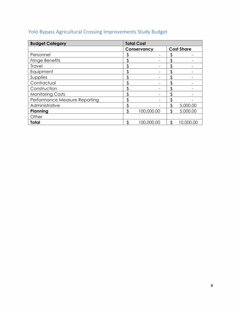
8
Yolo Bypass Agricultural Crossing Improvements Study Budget
Budget Category Total Cost
Conservancy Cost Share
Personnel $ - $ -
Fringe Benefits $ - $ -
Travel $ - $ -
Equipment $ - $ -
Supplies $ - $ -
Contractual $ - $ -
Construction $ - $ -
Monitoring Costs $ - $ -
Performance Measure Reporting $ - $ -
Administrative $ - $ 5,000.00
Planning $ 100,000.00 $ 5,000.00
Other
Total $ 100,000.00 $ 10,000.00
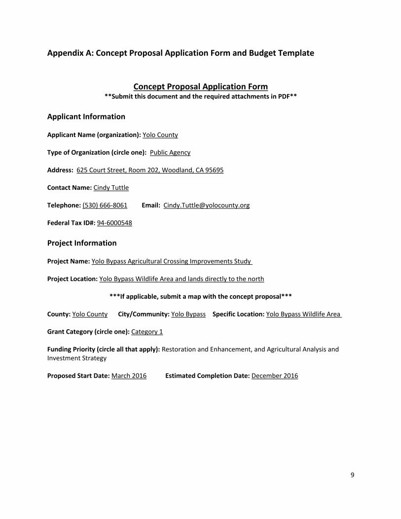
9
Appendix A: Concept Proposal Application Form and Budget Template
Concept Proposal Application Form **Submit this document and the required attachments in PDF**
Applicant Information Applicant Name (organization): Yolo County Type of Organization (circle one): Public Agency Address: 625 Court Street, Room 202, Woodland, CA 95695 Contact Name: Cindy Tuttle Telephone: (530) 666-8061 Email: [email protected] Federal Tax ID#: 94-6000548
Project Information Project Name: Yolo Bypass Agricultural Crossing Improvements Study Project Location: Yolo Bypass Wildlife Area and lands directly to the north
***If applicable, submit a map with the concept proposal*** County: Yolo County City/Community: Yolo Bypass Specific Location: Yolo Bypass Wildlife Area Grant Category (circle one): Category 1 Funding Priority (circle all that apply): Restoration and Enhancement, and Agricultural Analysis and Investment Strategy Proposed Start Date: March 2016 Estimated Completion Date: December 2016

Delta Conservancy Ecosystem Restoration and Water Quality Grant Program Proposal
Project Name: Sherman Island Wetland Restoration Project Phase III Applicant Information:
Organization Address Contact Contact Info Federal tax ID Organization Type
Ducks Unlimited
3074 Gold Canal Drive, Rancho Cordova, CA
Aaron Will
(916) 852-2000 [email protected] 13-5643799 501(c)(3)
Project Information:
1. Project Name: Sherman Island Wetland Restoration Project Phase III (Project) 2. Location: o State(s): California o County: Sacramento County o Sub-region: West Delta 3. Start Date: April 2016 4. Estimated Completion Date: May 30, 2017
2. Project Description
The proposed Project will restore approximately 1,600 acres of palustrine emergent wetlands. The Project is located on a portion of Sherman Island which is owned by California Department of Water Resources (DWR). The property is currently managed for flood irrigated pasture and includes a regular and extensive disturbance regime associated with field prepping, disking, and grazing. The Project focuses on the restoration of palustrine emergent wetlands, complemented with upland riparian forest, scrub shrub, and grassland to add diversity of structure and habitat to the site. Restoration of wetlands will be accomplished by upgrading existing water management infrastructure and installing new infrastructure such as water control structures and water conveyance channels and swales. The Project will create berms to managed water surface elevations in each managed wetland unit. In addition, habitat features such as habitat loafing islands will give wildlife nesting and resting opportunity. When the Project is completed, water will be maintained on the Project site year-round, effectively creating a permanent wetland. Restoring permanent wetlands on Delta islands have been shown to halt and reverse land subsidence. This Project will combine the wildlife benefits of wetland restoration with the importance of reversing Delta island subsidence. Upland vegetation will be planted on a higher elevation area adjacent to the wetland. Need: Sherman Island is significantly subsided, consisting of land elevations between 10 and 25 feet below sea level. Land surface subsidence threatens the stability of the levee system that maintains the current configuration of the Sacramento San Joaquin Delta (Ingebritsen and Ikehara 1999). Wetland sequestration restoration projects such as the proposed Project have been found to reverse subsidence by capturing atmospheric carbon and converting it to organic material which in turn creates new soils surface material. Subsided Delta islands are like bowls and when tule wetlands are constructed and permanently flooded, these bowls over time will fill up with rhizome root material (or carbon). If these lands are flooded permanently, and agricultural activities do not subject the peat soils to oxygen or fertilizers, the underlying peat will not continue to emit Green House Gasses (GHG) into the atmosphere and allow subsidence. The Project goals are to re-habilitate/restore the project area to semi-permanent wetland that will support a plethora of native species, provide GHG sequestration benefits, and increase levee stability. This phase
1
of the Project will seek funding to develop the engineering plans and wetland delineation to support environmental documents (CEQA) and permits necessary to permit a constructible Project. Objective 1: Collaboratively Develop Wetlands Restoration and Enhancement Plans The presented team will work together along with outside Partners to develop a comprehensive wetland restoration plan that will function as the baseline report for environmental documents and permit applications. Tasks that will be undertaken: Ducks Unlimited (DU), as the grantee, will implement the Project collaboratively with the Project partners: California Department of Water Resources (FESSRO & DES), Reclamation District 341(RD), WRA Environmental Consultants and Tom Origer & Associates. Ducks Unlimited will utilize the topographic survey that will be collected by DWR to develop the conceptual, 30% and 60% engineering designs collaboratively with DWR FESSRO and DES. Additionally DU staff will conduct a wetland delineation of the project area to facilitate submission of the US ACOE 404 permit. From the engineering design and other subsequent studies, DU will develop and submit the appropriate permit applications. The CEQA environmental document will be prepared with RD as the lead agency and DWR as the responsible agent. If grant award correlates in a timely manner consistent with the Sherman Island Wetland Restoration Project Phase II timeline, the proposed Project may be included as part of the Phase II CEQA document, which could provide time and financial efficiencies for the further development of the Project. As part of the Conservancy funded portion of the Project a concept plan will be collaboratively developed that incorporates the goals of the Project within the scope of the construction budget, specific elements in the design include: Pond configuration and anticipated water depths, Water control structure locations, Water delivery and drainage, Habitat features that will attract a diversity of wildlife, Anticipated biological response of restored/enhanced habitats, Engineering impact analysis input for environmental permitting, Evaluation and hydraulic analysis of the necessary control of water to manage supply and drainage, Field fitting design features to the existing contour of the land, Detailed design of berms, swales, ponds, islands, loafing bars, and water supply and drainage structures, Earthwork and material quantities will be calculated. The Project seeks $100,000 from the Conservancy to assist in the planning and design of the Project. Cost share to this proposal in the amount of $100,000 is being provided by DWR through the development of other critical tasks. Cost share may be provided by in kind services of staff time for collection of survey data, Project activity work and DWR Funds expended on other direct Project tasks. Project Deliverables of Conservancy funded tasks: Ducks Unlimited will provide a copy of the Wetland Delineation as well as Conceptual design, 30% engineering design, and 60% engineering design.
3. Organizational Capacity Since its incorporation in 1937, Ducks Unlimited has conserved more than 12 million acres of wetland habitat in the United States, Canada and Mexico. Our approach to conservation is collaborative and cost-effective through working with a broad array of public and private entities to deliver wetland conservation projects. Ducks Unlimited team members have restoration expertise that extends from initial restoration planning through preparation of design drawings and specifications, environmental compliance documentation and permitting, bid support, construction observation, construction
2

management and post-project monitoring. DU’s biological and support staff possess a wide breadth of knowledge and practical experience in the fields of wetland ecology and restoration, avian population dynamics, conservation, and policy. Mr. Will is a regional biologist with 13 years of experience. He currently oversees conservation program operations in the Sacramento – San Joaquin Delta and Suisun Marsh and is responsible for the delivery of several multi-million dollar restoration projects and planning efforts. Mr. Will functions as project manager and design biologist. Mr. Will has helped complete a wide variety of environmental projects that have included restoration, enhancement and protection of wetland, riparian and upland habitats in both Washington and California. Mr. Williams is a registered civil engineer with 19 years of experience and is responsible for providing engineering and construction management services for projects throughout Northern California primarily in the Sacramento San Joaquin Delta and Suisun Marsh. His contributions to these projects have included restoration feasibility, water supply and water delivery assessments, design, construction budgeting, and construction oversight. Mr. Britton as the Environmental Compliance Specialist is responsible to ensuring environmental compliance for projects located throughout California. Mr. Britton will facilitate environmental document strategy and any needed permit submittals. The proposed DU staff have delivered project management, habitat restoration planning, permitting and design on over 36 projects of varying size throughout the Suisun Marsh, Delta and Yolo Bypass within the last 5 years that are similar is scope and include all specific project element tasks. Project examples completed by DU staff include but not limited to Twitchell Island East End (a 750 acre wetland restoration subsidence reversal project), Sherman Island Whales Mouth (a 600 acre wetland restoration subsidence reversal project), Yolo Bypass Wildlife Area 1000’s unit Drainage Enhancement (expansion of drainage canal and infrastructure installation, Stone Lakes Southern Pacific Cut (earthen crossing removal and railcar bridge), Suisun Marsh NAWCA RD1607 (pump station replacement and drainage improvements). Reclamation District 341 is a public agency created by the California Water Code, responsible for levee, drainage, and water conveyance on Sherman Island. The District has a productive relationship with DWR and supports subsidence reversal projects by working very closely with DWR to implement these projects on Sherman Island. The District is currently managing approximately 8 active state grants with a total budget of approximately $20 million. The District has 3 full time staff that implement maintenance activities on the Island, as well as a professional team that handles all accounting, legal, and engineering activities. Furthermore, the District is able to contract with other professional subcontractors on an as needed basis. Lastly, the District has significant experience with implementing large public works projects, such as this one, to ensure that all aspects are compliant with State law and Grant requirements. DWR West Delta Program: The West Delta Program is responsible for effectively managing state owned lands land on Sherman and Twitchell islands (approximately 12,500 acres total). The West Delta team works with the Reclamation Districts on both Sherman and Twitchell Islands to: Improve the integrity of local levees; Implement land use management techniques to control subsidence, soil erosion, and greenhouse gas; and Provide diverse habitat for wildlife, especially waterfowl. Since 2008, the West Delta Program has worked with Reclamation Districts on both Sherman and Twitchell Islands to plan, design, permit, construct, operate, and maintain approximately 2,000 acres of habitat restoration/subsidence reversal projects. Additionally, the West Delta Program has helped to implement approximately 6,000 feet of habitat setback levees on Sherman Island, and is in the process of
3
helping to design and permit approximately 30,000 feet of habitat setback levees on Twitchell Island, including a 75 acre tidal wetland. The West Delta Program also manages a contract with University of California, Berkley (UCB) to collect GHG data on existing agricultural fields and wetland systems on Sherman and Twitchell Islands.
4. Consistency with Funding Requirements, Project Selection, and Programmatic Criteria The Delta Plan: The Delta Stewardship Council lays out a long-term vision for the Delta outlined in the Delta Plan and the Delta Science Plan. This Project will contribute to implementing strategies and actions recommended in the Delta Plan and goals laid out in the Delta Science Plan. This Project aligns with the objectives and strategies identified in the Delta Plan to address habitat degradation, improving water quality, reverse subsidence, and address climate change. The Delta Plan identifies these issues as essential for achieving the coequal goals of providing a more reliable water supply for California and protecting, restoring, and enhancing the Delta ecosystem in a manner that protects and enhances the unique cultural, recreational, natural resource, and agricultural values of the Delta as an evolving place. Delta Science Plan: This Project will contribute to transparent and collaborative science in the Delta envisioned by the Delta Science Program. The Governor’s California Water Plan Update 2013 Public Review Draft (Water Plan Update): The California Water Plan is the State’s long-term strategic plan for guiding the management and development of water resources. The Water Plan Update identifies carbon capture farming in the Delta as an example of an on-the-ground effort that would advance the objectives stated in the Water Plan and identifies securing funding for a farm-scale demonstration as a key next step. President’s Climate Action Plan: This plan supports the goal of reducing carbon emissions to 17 percent below 2005 levels by 2020 stated in President Obama’s Climate Action Plan. As an important strategy for achieving emission reduction goals, the President’s Climate Action Plan calls for identifying approaches to protect and restore wetlands and other diminishing, yet critical landscapes which sequester carbon. In this plan, the Administration recommends strategies which conserve land and water resources, protect biodiversity and promote ecosystem resilience to ameliorate climate change. California Executive Order S-3-05: This order calls for the State to reduce greenhouse gas emissions to 1990 levels by 2020 and to reduce greenhouse gas emissions to 80 percent below 1990 levels by 2050. Additionally, this order established the Climate Action Team (CAT) for State agencies. The CAT is chaired by the Secretary of the California Environmental Protection Agency. This Project contributes to the emission reduction goals in this order and the Delta Conservancy (Conservancy) will coordinate with CAT on this effort as regular participants of CAT meetings. California Assembly Bill 32 (2006): The California Global Warming Solutions Act of 2006 (AB 32) set the 2020 greenhouse gas emission reduction goal to reduce greenhouse gas emissions to 1990 levels by 2020 into law. This Project will contribute to this emission reductions goal. AB 32 directed the Air Resource Board (ARB) to develop a scoping plan to identify how to best reach the 2020 goal and the ARB has since adopted the final cap-and-trade regulation. 2009 California Climate Adaptation Plan: This plan summarizes the best known science on climate change impacts to California and outlines strategies to increase California’s resiliency from the impacts from climate change. Carbon sequestration projects through wetland restoration is recommended in this plan as an opportunity to provide significant reduction of emissions, capture and sequestration of greenhouse gases while simultaneously providing habitats necessary for the longterm conservation of
4

California's biodiversity. This plan also recommends prioritizing and expanding Delta island subsidence reversal and land accretion projects to create equilibrium between land and estuary elevations along select Delta fringes and islands, and identifies further degradation of water quality and the Delta ecosystem as significant impacts of climate change. This Project also is in accordance with California Executive Order S-13-05 which required this plan and was created by CAT, of which the Conservancy is an active participant. The following table outlines sections of the corresponding documents that are in line with the goal of the Project. Federal, State and Local Plans Project Consistent with Document Section: Proposition 1: Chapter 6 §79731, §79732 (2,4,12,13), Chapter 7
§79743(a, b, f(2)) California Water Action Plan: Action 1, 3, 4, and 8 Delta Conservancy’s Enabling Legislation Balances Coequal goals by supporting habitat and
flood resource and recreational benefits. Delta Plan. Delta Stewardship Council (2013) ER-R2,DR-R10, DR-R14 2012 Strategic Plan. Sacramento‐San Joaquin Delta Conservancy (2012):
Chapter V Criteria 2, 3, 5 and multiple Objectives of Chapter VI.
Department of Water Resources Agricultural Land Stewardship Strategies:
Section I: A, Section II: A4, E
Central Valley Flood Protection Plan: Section 1.6.2 Supporting goals 2 & 4, Chapter 3.7 Land Use and Resource Management Plan. Delta Protection Commission:
Goals for Land Use, Agriculture, Natural Resources, Recreations & Access, Water, Levees, and Utilities and Infrastructure
2006 Implementation Plan. Central Valley Joint Venture (2006):
Chapter 4. Delta Basin Objectives
Delta Science Plan. Chapter 3 Economic Sustainability Plan for the Sacramento‐San Joaquin Delta. DPC
Chapter 7: Section 7.6.2.2 7.6.2.3 Chapter 8: Section 8.5.1.3
Recreation Proposal for the Sacramento‐San Joaquin Delta and Suisun Marsh. California State Parks
Recommendations for DWR.
National Oceanic and Atmospheric Administration’s Recovery Plans: Central Valley Salmon and Steelhead Recovery Plan
Reduction of Key Threat 6 & 7
United States Shorebird Conservation Plan Southern Pacific Regional Shorebird Plan to Partners in Flight Conservation of the Land Birds of the United States
Physiographic Area 90. Consistent with recommendation for this area is to restore “natural hydrology and habitat.
North American Waterfowl Management Plan Strategic Guidance
Chapter IV, Pop. Objectives as derived by Central Valley Joint Venture objectives for Delta Basin.
North American Waterbird Conservation Plan Part 4, Habitat and Species Goals
5. Readiness Once awarded, DWR will conduct a topographic survey of the Project area to support the engineering design. Ducks Unlimited biologist will conduct a wetland delineation to determine the location of existing wetlands and upland areas.
5

The Project has well established practices and methodologies that have been successfully utilized throughout the restoration community and specifically for three extremely similar projects recently completed by the Partners. Data related to GHG sequestration is already being collected as part of the previously awarded CDFW Green House Gas grant. Ducks Unlimited and the Project Partners have the expertise and capacity to develop all needed environmental documents and engineering plans as exhibited by the previous three projects. The Project area is owned by DWR and no additional landowner agreements will be required. Depending on timing of grant award, this Project’s CEQA document may be completed with the Phase II Project that is being funded by DWR, as well as CDFW Green House Gas Cap n Trade funds. If awarded it is anticipated that these grant funds will be further utilized as match to leverage and seek other State funds through CDFW cap n Trade funds and/or CDFW Proposition 1 funds. The importance of the Conservancy funding to this proposal is critical as it provides seed money to develop the design to get through CEQA, which is required prior to submittal of CDFW Proposition 1 grant. Cost share for this proposal in the amount of $100,000 is being provided by DWR through the development of other critical tasks. Cost share may be provided by in kind services of staff time for collection of Survey data, Project activity work and DWR Funds expended on other direct Project tasks.
6. Cooperation and Support The Project is being developed and supported by a broad coalition of interested stakeholders in the Sacramento San Joaquin Delta. The following are the individuals who will be participating in the Project, cooperating (providing guidance, etc.), and supporting the Project. Individuals include: Aaron Will, Brett Williams, and Pat Britton, Ducks Unlimited; Bryan Brock, Sam Miller, Jim Long, Juan Mercado, DWR; Jesse Barton, Gallery and Barton; Matt Richmond, WRA Environmental; and Tom Origer, Origer & Associates Although there are several individuals working on the Project, only the three Ducks Unlimited staff will affectively be working on tasks funded by Conservancy. No compensation for DWR staff is being sought at this time. There are three similar projects complete and two ongoing similar projects that have been supported and delivered in the immediate vicinity of the Project. Those projects include Sherman Island Mayberry Farms, Sherman Island Wetland Restoration Project (Whales Mouth), Sherman Island Wetland Restoration Project Phase II, and Twitchell Island East End Project. The Project is Phase III of a project included as one of the 65 projects identified by the Coalition to Support Delta Projects, an ad hoc group representing a broad cross section of Delta stakeholder interests. This group collaboratively identified near-term projects that could be broadly supported by regulatory agencies, water contractors, local governments, NGOs, land owners, and farmers in the Delta. The Coalition advocated for Governor Brown’s assistance in moving these projects forward through the environmental and permit review process.
7. Best Available Science and Adaptive Management Once the wetlands are mature this Project is expected to sequester approximately 11.5 metric tons CO2-eq per acre per year or nearly 18,000 metric tons CO2-eq per year for the entire Project. This Project is also extremely similar to adjacent projects that include a Delta wide monitoring program for CO2, CH4, and
6
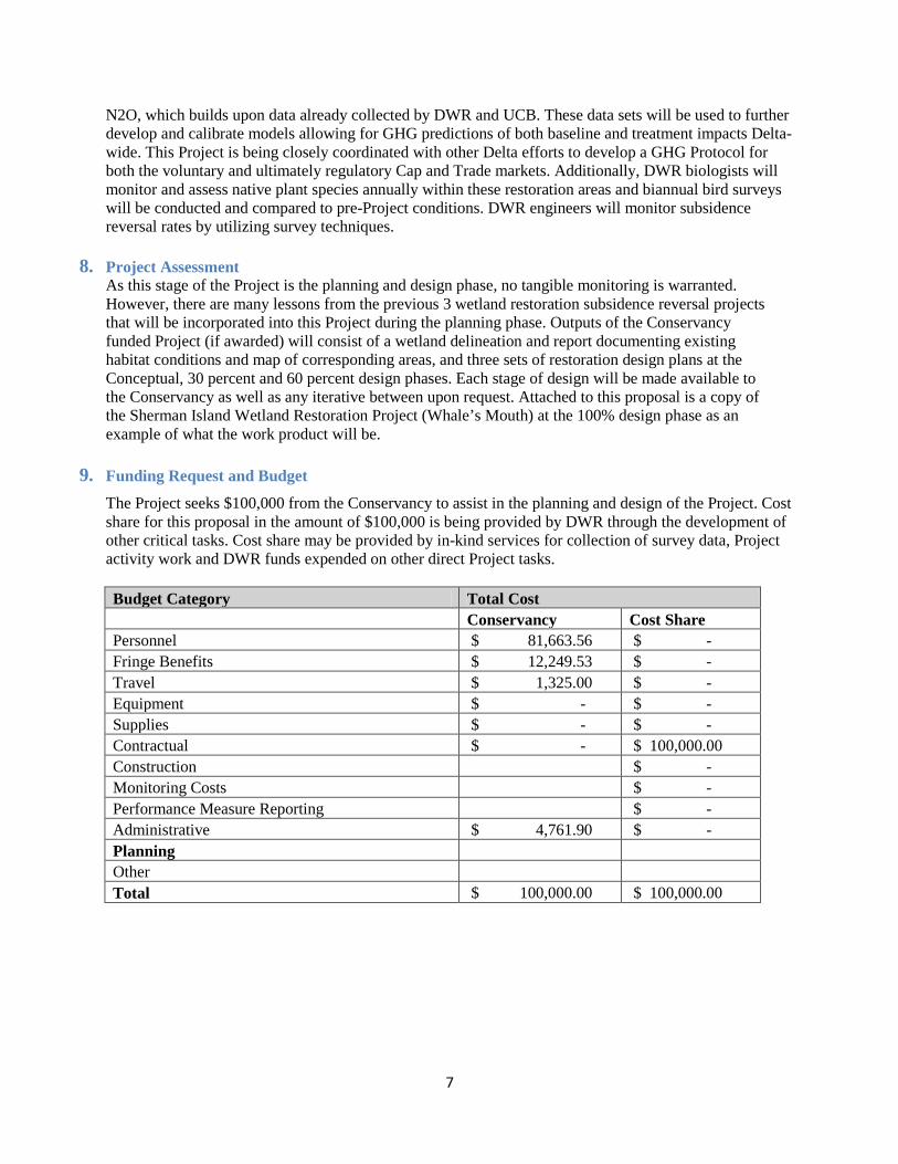
N2O, which builds upon data already collected by DWR and UCB. These data sets will be used to further develop and calibrate models allowing for GHG predictions of both baseline and treatment impacts Delta-wide. This Project is being closely coordinated with other Delta efforts to develop a GHG Protocol for both the voluntary and ultimately regulatory Cap and Trade markets. Additionally, DWR biologists will monitor and assess native plant species annually within these restoration areas and biannual bird surveys will be conducted and compared to pre-Project conditions. DWR engineers will monitor subsidence reversal rates by utilizing survey techniques.
8. Project Assessment As this stage of the Project is the planning and design phase, no tangible monitoring is warranted. However, there are many lessons from the previous 3 wetland restoration subsidence reversal projects that will be incorporated into this Project during the planning phase. Outputs of the Conservancy funded Project (if awarded) will consist of a wetland delineation and report documenting existing habitat conditions and map of corresponding areas, and three sets of restoration design plans at the Conceptual, 30 percent and 60 percent design phases. Each stage of design will be made available to the Conservancy as well as any iterative between upon request. Attached to this proposal is a copy of the Sherman Island Wetland Restoration Project (Whale’s Mouth) at the 100% design phase as an example of what the work product will be.
9. Funding Request and Budget
The Project seeks $100,000 from the Conservancy to assist in the planning and design of the Project. Cost share for this proposal in the amount of $100,000 is being provided by DWR through the development of other critical tasks. Cost share may be provided by in-kind services for collection of survey data, Project activity work and DWR funds expended on other direct Project tasks. Budget Category Total Cost Conservancy Cost Share Personnel $ 81,663.56 $ - Fringe Benefits $ 12,249.53 $ - Travel $ 1,325.00 $ - Equipment $ - $ - Supplies $ - $ - Contractual $ - $ 100,000.00 Construction $ - Monitoring Costs $ - Performance Measure Reporting $ - Administrative $ 4,761.90 $ - Planning Other Total $ 100,000.00 $ 100,000.00
7
1
Paradise Cut Planning Proposal to the Delta Conservancy
September 15, 2015 1. Concept Proposal Application Form Applicant Information Applicant Name (organization): San Joaquin County Resource Conservation District Type of Organization (choose one): Public Agency Address: _3422 W. Hammer Ln, Suite A Stockton, CA 95219_________________________________ Contact Name: Jonna Spaletta or John Herrick Telephone: _209-472-7127 ext. 125__________ Email: [email protected]___________________ Federal Tax ID#: _68-0376811__________________________________________________________ Project Information Project Name: Paradise Cut Conservation and Flood Management Plan Project Location Immediately south of Paradise Cut (figure 1)___________________________ ***If applicable, submit a map with the concept proposal*** County: San Joaquin City/Community: Lathrop and unincorporated Specific Location: (see map) Grant Category: Category 1 (planning) Funding Priority: Restoration and Enhancement Proposed Start Date: _June 2016___ Estimated Completion Date: __November 2017_____ 2. Project Description Project Need
The flood bypass system in the Sacramento Valley and north Delta has kept the valley’s residents safe from flooding and provided multiple benefits to fish, farmers, and fowl for nearly a century. Will Green, the 19th century editor of the Colusa Sun, first advocated for the bypass system starting in the 1860’s, but the state’s leaders didn’t commit to build it until the devastating floods of the early twentieth century left them no other choice. Today we have a chance to build a bypass in the South Delta to protect against the floodwaters that climate change will bring, but we should act now while we still have a choice.
The following excerpt below illustrates why the Delta Conservancy should act now to help end the planning paralysis that has delayed the construction of a new bypass in the south Delta.

2
“A latter-day version of the bypass debate is now unfolding on the San Joaquin River, after the 1997 flood. In this most recent event, the San Joaquin River and several of its tributaries overwhelmed the channel capacity, inundating farmland and some communities. In contrast to the two major Sacramento Valley levee breaks in 1997, in which flows did not exceed channel capacity but rather seeped in some way through the levees to cause blow-outs, the San Joaquin channels were not large enough for the size of the flows. Recognizing the futility of simply raising the levees, flood control experts will now evaluate the feasibility of removing levees in some locations and letting future flood flows pond onto adjacent lands. Further, consideration is being given to opening up some form of bypass through the south Delta to relieve pressure on the levees as the San Joaquin River flows into the Delta. It is hoped these issues will be resolved and changes will be made before the next flood.”
- David Kennedy, 1998 Seventeen years after David Kennedy, the longest serving director of the Department of Water Resources (DWR), wrote these words in the foreword to the second of edition of Battling the Inland Sea, the project team offers this application to the Delta Conservancy for a locally led planning effort to advance a new flood bypass in the Southern Delta south of Paradise Cut.
The San Joaquin County Resource Conservation District has joined with a diverse team of local stakeholders and conservation groups to offer this proposal to the Delta Conservancy. The team includes the South Delta Water Agency (SDWA), Reclamation District 2062 (RD 2062), River Islands Development Company, American Rivers, Environmental Science Associates, and MBK Engineering. DWR has agreed to assign staff both flood planning and environmental stewardship staff to participate in this planning effort as an in-kind contribution. The new bypass will reduce flood risk to farms and cities while improving habitat for native species. Urban and agricultural communities along the San Joaquin River are vulnerable to catastrophic flooding because the San Joaquin River through the south Delta is not large enough to convey the design flow, let alone the 100-year flood. During a different era with different climate assumptions, cities and farms leveed and armored the banks of the lower San Joaquin River resulting in significant habitat degradation. Expanding the floodway today to safely convey the larger flood events scientists now predict is the best way to keep communities safe and will also help preserve farmland and restore habitat for sensitive species.
Over the last four years, the project team has worked collaboratively with DWR and numerous other agencies and stakeholders to develop a promising conceptual design for expanding Paradise Cut (figure 1). Extensive modeling analyses conducted by DWR and others indicate that the proposed design will lower the flood stage by over two feet where Interstate Highway 5 crosses the San Joaquin River. This will substantially reduce flood risk for the rapidly urbanizing reach of river between I-5 and Stockton.
Expanding the floodway along the lower San Joaquin River will significantly improve habitat for several sensitive species without changing agricultural production in most years. DWR’s hydraulic analyses indicate that farmland incorporated into an expanded floodway would only be inundated once every 12 years. Moreover it should be possible to plant crops even in those infrequent years when the area is inundated during the spring. Expanding the floodway will un-constrain the river enabling managers to create more functional riparian and floodplain habitats along the channel margins of the lower San Joaquin River through a reach of river that is now characterized by heavily armored levees. Expanding the floodway along the lower San Joaquin River will significantly improve habitat for several
3
sensitive species without changing agricultural production in most years. DWR’s hydraulic analyses indicate that farmland incorporated into an expanded floodway would only be inundated once every 12 years. Moreover it should be possible to plant crops even in those infrequent years when the area is inundated during the spring. Expanding the floodway will un-constrain the river enabling managers to create more functional riparian and floodplain habitats along the channel margins of the lower San Joaquin River through a reach of river that is now characterized by heavily armored levees.
Goals and Objectives
The overall goal of the proposed project is to reduce flood risk while improving habitat and maintaining agricultural land along the Lower San Joaquin River south of Paradise Cut. The specific objectives of this project are to:
• Substantially reduce flood stage on the mainstem San Joaquin River between Mossdale and Stockton.
• Reduce the probability of catastrophic urban flooding and loss of life in the communities of Lathrop, Manteca, Stockton, and unincorporated San Joaquin County.
• Substantially increase flood conveyance capacity through a constrained reach of the San Joaquin River floodway.
• Provide floodplain and riparian habitat for a variety of sensitive species, including riparian brush rabbit, giant garter snake, Sacramento splittail, and juvenile Chinook salmon.
• Preserve agricultural land and protect it from uncontrolled flooding.
The proposed project is for Phase 1 of a larger effort. The specific outputs and outcomes of this phase include:
• Further development of the conceptual plan and project description sufficient for advancing a CEQA/NEPA analysis.
• Better quantification of costs and benefits so that flood managers and other potential implementation funders can make better investment decisions.
• A strategy to expedite a successful Section 408 permit (Section 14 of the Rivers and Harbors Act of 1899 and codified in 33 USC 408; commonly referred to as “Section 408”).
• A finance strategy for subsequent project phases, including project implementation and long-term operations and maintenance.
• A detailed scope of work and budget to complete a NEPA/CEQA analysis. • Informed local residents and officials who understand the pros and cons of the project.
Tasks and Deliverables
Task 1: Project Management. The San Joaquin County RCD will serve as the fiscal lead, contract with consultants, and submit regular invoices and reports. The South Delta Water Agency will manage the planning effort in collaboration with River Islands and American Rivers.
Deliverables: 1) quarterly reports, 2) contracts with consultants, 3) invoices at least quarterly or more frequently if required by the Conservancy, 4) agendas and notes from management committee meetings.
Task 2: Planning and Design. The project will build on the excellent work that DWR has already done to evaluate the promise of expanding Paradise Cut as part of the San Joaquin Basin-Wide Feasibility Study, a key element of the 2017 Central Valley Flood Protection Plan (CVFPP). MBK Engineers, who conducted the modeling analysis for the feasibility study will conduct additional hydraulic modeling analyses to
4
refine the design in a manner that maximizes flood-stage reduction benefits and minimizes adverse hydraulic impacts. MBK will work with Environmental Science Associates (ESA) to evaluate the potential for levee overtopping and scour and erosion potential along the levee upstream of Paradise Cut weir. ESA will compile all existing information on current site conditions, including surficial geologic mapping, geotechnical investigations, local drainage networks and related infrastructure, as well as habitat and agricultural data, to refine conceptual designs and support cost estimation. River Islands and ESA will convene a value planning workshop to refine the project concept and description and consider issues, factors and approaches to engineering, levee authorization/permitting (e.g., Section 408), environmental regulatory permitting, agricultural operations, habitat restoration, and construction. This refinement process will be reflected in a refined cost-benefits analysis. Under the direction of the management team, ESA will prepare a graphically rich summary report to clearly communicate the benefits and costs of the project to local stakeholders and officials.
Deliverables: 1) existing conditions technical memorandum; 2) hydraulic analyses technical memorandum; 3) detailed conceptual design and accompanying technical memorandum; 4) value planning workshop and summary report; 5) detailed cost estimate; 6) graphically rich summary report/brochure with maps, graphics, and text design to communicate the costs and benefits of the project to stakeholders and local officials.
Task 3: Quantify Conservation Benefits. American Rivers will convene a workshop of species experts to review and refine a habitat quantification methodology to measure the predicted benefits of the project for a broad range of special status species. American Rivers will use the Central Valley Flood Protection Plan Draft Conservation Strategy metrics developed by DWR as the basis for the initial methodology. ESA will refine the methodology based on results of the workshop and complete the quantification analysis.
Deliverables: 1) meeting with species experts to refine methodology for measure conservation benefit for a range of species and habitats, 2) technical memorandum describing quantification methodology, 3) technical memorandum detailing results of quantification study.
Task 4: Public Outreach and Agency Coordination. The San Joaquin RCD will work with the South Delta Water Agency to convene a series of “small group” meetings to introduce key stakeholders to the project. Under the guidance and auspices of the management team, American Rivers will convene three meetings for agency staff where ESA and MBK will provide presentations and answer technical questions.
Deliverables: 1) three meeting with agency staff; 2) five small group meeting with local residents and landowners; 3) two meetings with local officials.
Task 5: Environmental Compliance and Permitting Strategy. Navigating the Army Corps of Engineer’s complex flood management permitting process will be the biggest obstacle to advancing this project. With support from ESA, American Rivers, Rivers Islands and other appropriate stakeholders will jointly develop a levee modification permit strategy to identify opportunities for expediting implementation. ESA will develop a detailed work plan and cost estimate for NEPA/CEQA compliance.
Deliverables: 1) strategy for obtaining a 408 levee modification permit from USACE and associated CVFPP encroachment permit; 2) detailed project description for preparation for EIR/EIS; 3) detailed plan and cost estimate for NEPA/CEQA compliance.
5
3. Organizational Capacity The project team has deep roots in the South Delta and includes a diverse group of stakeholders with unique local and regional expertise in farmland conservation, flood management planning, and river and habitat restoration. John Herrick is legal counsel for the South Delta Water Agency and is trusted by numerous local landowners. The San Joaquin County RCD has managed several large conservation projects in which they have successfully worked with local landowners and farmers. Susan Dell’Osso of River Islands is a very experienced planner, economist, and developer who successfully shepherded the complex River Islands project through numerous regulatory requirements, including a detailed hydraulic and hydrologic analysis that was closely scrutinized and reviewed by the State Reclamation Board and the U.S. Army Corps of Engineers. John Cain is the Director of Central Valley Flood Planning for American Rivers and has nearly two decades of experience focusing solely on restoration of the San Joaquin River and the Delta. He spearheaded the $60 million Dutch Slough tidal marsh restoration project in Oakley, a similarly large and complicated project. The proponents will retain a team of qualified consultants to conduct planning tasks, including Mike Archer of MBK Engineers and Eric Ginney of ESA, both of whom have extensive planning experience along the lower San Joaquin River.
The San Joaquin County RCD will manage the grant and lead landowner outreach efforts. The Southern Delta Levee Protection and Channel Maintenance Authority, which comprises the South Delta Water Agency and Reclamation District 2062, will oversee the planning effort. American Rivers will serve on the planning team and provide cost share dollars from the River Islands legal settlement to design the project to provide both public safety and ecological benefits. River Islands will provide additional hydraulic modeling in conjunction with MBK. The project team will contract with MBK Engineers and ESA consultants to conduct the technical work described in the task descriptions above. Mike Archer of MBK engineers has been modeling this stretch of the San Joaquin River for over 15 years. Eric Ginney and the ESA team have conducted two previous studies on environmental opportunities and constraints for DWR and the California Department of Fish and Wildlife for a new flood bypass and habitat restoration on the lower San Joaquin River/South Delta.
4. Consistency with Funding Requirements, Project Selection, and Programmatic Criteria The project is consistent with Proposition 1 as well as several state and local plans, including the California Water Action Plan and the Delta Conservancy’s Strategic Plan. The project is the quintessential multi-benefit project—it will safeguard Delta communities, restore habitat for sensitive species, and preserve privately held agricultural land within the footprint of the expanded bypass.
The project is specifically identified in the CVFPP and the Delta Plan. Both plans describe and map an expanded flood bypass south of Paradise Cut in the south Delta. The 2012 CVFPP identifies the bypass as the single system-wide improvement for the San Joaquin Basin, and the Lower San Joaquin Regional Flood Management Plan developed by the San Joaquin County Flood Control Agency also includes the project. Lastly and most significantly, the project is precisely aligned with several enforceable Delta Plan policies, including creation of a new flood bypass south of Paradise Cut (RR P4-3 Floodplain Protection), restoration of floodplains and riparian habitats as part of flood management projects (ER P4), and protection of high-priority habitat restoration opportunities (ER P3).
The project will improve habitat for several threatened and endangered terrestrial and aquatic species within the project footprint and along the San Joaquin River. Riparian revegetation along the proposed remnant levee upstream of Paradise Cut will substantially increase habitat for riparian brush rabbit,
6
potentially justifying its delisting. Preservation of seasonal crops on agricultural land within the expanded bypass, combined with riparian revegetation along the river, will protect and enhance 2,000 acres of prime Swainson’s hawk habitat in the geographic heart of their range. Removal of armored banks along with establishment of shade trees and floodplains along the channel margins of the San Joaquin floodway will significantly improve rearing conditions for juvenile salmon. If designed properly, the project should also benefit a number of other species including California black rail, least Bell’s vireo, riparian wood rat, valley elderberry beetle, delta button celery, giant garter snake, greater sandhill crane, slough thistle, bank swallow, and yellow billed cuckoo. The project will enhance habitat values on working lands, complement the goals of the San Joaquin County Habitat Conservation Plan (HCP), and reduce the impacts of climate change for the south Delta ecosystem and communities. Expanding the floodway will add 2,000 acres of farmland, but the land will still be farmable because it will only be inundated during the biggest flood events - once every 12 years or less. Reconnecting the river to its floodplain will give farmers increased opportunities to be compensated for wildlife-friendly agriculture and will increase opportunities for protecting species covered by the San Joaquin County HCP. Lastly, expanding the floodway will enable the San Joaquin River to safely accommodate increased floods that are expected to result from climate change.
The project team members, particularly American Rivers and the South Delta Water Agency, will coordinate with key agencies and other planning process including San Joaquin County and the San Joaquin County HCP; DWR Division of Flood Management, which is currently revising the CVFPP; the Delta Stewardship Council, which is conducting a levee prioritization study; and the State Water Resources Control Board, which is scheduled to revise the Bay-Delta Water Quality Control Plan.
5. Readiness The San Joaquin County RCD is applying for a Category 1 planning grant. The project team has worked with DWR and several other agencies to develop all of the preliminary planning information and data necessary to achieve the project objectives and outcomes. DWR will assign staff to participate as an in-kind cost share contribution to this locally led planning effort. American Rivers and River Islands will provide a $50,000 cash contribution from the River Islands Settlement Fund.
The project partners and other agencies have been intensively planning the project for several years and have vetted the project at seven public meetings. In 2011, the San Joaquin RCD sought grant funding from the DWR Floodway Corridor Program and presented the proposal at a meeting of the Central Valley Flood Protection Board prompting the CVFPB to write a letter of support to the Delta Stewardship Council, which in turn prompted the Council to include the bypass in the Delta Plan. In 2007, the legislature passed SB 5 directing DWR to evaluate expansion of Paradise Cut, and DWR subsequently included an expanded Paradise Cut in the 2012 Central Valley Flood Protection Plan. Since then, DWR has conducted a thorough evaluation of the proposal and alternative approaches for advancing flood and habitat objectives in the south Delta. DWR held four well-attended public meetings in Lathrop during 2012 to gather public input, and the public strongly supported the proposed project over other alternatives. The San Joaquin Flood Control Agency together with the Flood Protection Board convened two well-attended public workshops in 2013 and 2014, and nobody voiced opposition to the project. Since late 2014, the project team has been refining the proposal under the Delta Dialogues process, a diverse stakeholder forum convened by the Delta Conservancy. DWR recently conducted a detailed analysis of the Delta Dialogues alternative, which substantiated that the project would significantly reduce flood stage and improve habitat without substantially diminishing agricultural productivity on lands added to the floodway.
7
6. Cooperation and Support The project is a unique collaboration between the San Joaquin County RCD, the South Delta Water Agency, RD 2062, River Islands Development, American Rivers, and DWR. The San Joaquin RCD will manage the grant and lead landowner outreach efforts in collaboration with South Delta Water Agency and RD 2062. The planning studies will be managed by the Southern Delta Levee Protection and Channel Maintenance Authority. American Rivers will serve on the planning team and provide cost-share dollars from the River Islands legal settlement to design the project to provide both public safety and ecological benefits. River Islands will provide additional hydraulic modeling in conjunction with MBK. DWR has agreed to assign flood management and environmental stewardship staff to participate in the planning process as a cost share contribution. The following individuals will be actively involved in the project: John Herrick from the South Delta Water Agency, Susan Dell’Osso of River Islands, John Cain of American Rivers, and Ron Melcer of DWR.
As discussed in section 5, above, the project has been vetted at seven public meetings. Six of the meetings were attended by numerous local residents and landowners. Several residents expressed support for the project and nobody expressed opposition. The South Delta Water Agency and others have kept local agencies and affected property owners informed about the status of the project. We have coordinated this proposal with the San Joaquin HCP and they have provided a letter of support for this proposal. Due to vacation schedules and trial dates, the project team was unable to solicit a substantial number of support letters, but we hope that the diversity and local character of proposal team is sufficient evidence of local support. If selected to submit a full proposal, the project team will produce letters of support from local agencies and landowners.
7. Best Available Science and Adaptive Management The project design and the claims made in this proposal are based on the best available scientific information and practices. The hydraulic performance of the proposed project has been modeled and refined several times with state of the art modeling tools, including most recently with the CVFED model developed by the Army Corps of Engineers for the Central Valley Flood Protection Plan (HEC-RAS 2D version released 03-22-2015). This new 2D application of HEC-RAS uses the most updated topographic (LIDAR) and bathymetric data. Over seven different modeling studies, dating back to 2006 on different modeling platforms all show the same consistent results: expanding Paradise Cut significantly lowers flood stage along the San Joaquin River.
Previous project planning has also used state of the art science to quantify ecosystem benefits associated with expanding Paradise Cut. The 2012 DWR study assembled a team of experts who used the Delta Regional Ecosystem Implementation Plan (DREIP) developed by the Delta Science Program to evaluate the ecological outcomes of the project for a variety of different species. More recently, the DWR Central Valley Flood Planning Office has used the draft Conservation Strategy metrics developed by DWR in collaboration with an interagency group of scientists to measure the benefits of the project for several endangered aquatic and terrestrial species.
8. Project Assessment As stated in the Goals and Objectives portion of section 2, above, the overall goal of this project is to reduce flood risk while improving habitat and maintaining agricultural land along the Lower San Joaquin
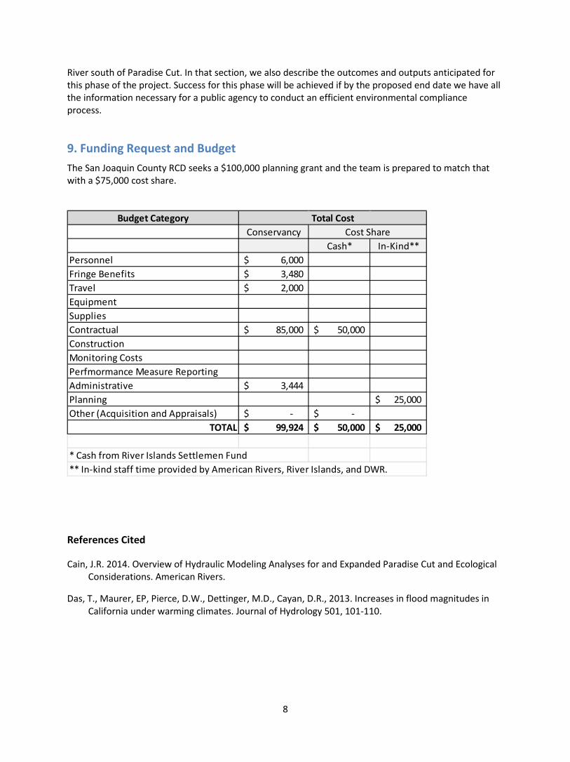
8
River south of Paradise Cut. In that section, we also describe the outcomes and outputs anticipated for this phase of the project. Success for this phase will be achieved if by the proposed end date we have all the information necessary for a public agency to conduct an efficient environmental compliance process.
9. Funding Request and Budget The San Joaquin County RCD seeks a $100,000 planning grant and the team is prepared to match that with a $75,000 cost share.
References Cited
Cain, J.R. 2014. Overview of Hydraulic Modeling Analyses for and Expanded Paradise Cut and Ecological Considerations. American Rivers.
Das, T., Maurer, EP, Pierce, D.W., Dettinger, M.D., Cayan, D.R., 2013. Increases in flood magnitudes in California under warming climates. Journal of Hydrology 501, 101-110.
Budget CategoryConservancy
Cash* In-Kind**Personnel 6,000$ Fringe Benefits 3,480$ Travel 2,000$ EquipmentSuppliesContractual 85,000$ 50,000$ ConstructionMonitoring CostsPerfmormance Measure ReportingAdministrative 3,444$ Planning 25,000$ Other (Acquisition and Appraisals) -$ -$
TOTAL 99,924$ 50,000$ 25,000$
* Cash from River Islands Settlemen Fund** In-kind staff time provided by American Rivers, River Islands, and DWR.
Total CostCost Share