rio algom mining llc · 2019-07-10 · raml anticipates that the ongoing discussions will identify...
TRANSCRIPT

P.O. Box 218, Grants, NM USA 87020 - Tel: 505.287.8851 - Fax: 505.285.5550
June 27, 2019
Mr. Holland ShepardProgram Manager, MARPNM Energy, Minerals and Natural Resources Department1220 South St. Francis DriveSanta Fe, NM 87505
Mr. Kurt VollbrechtProgram ManagerNM Environment Department1190 St. Francis Drive.P.O. Box 5469Santa Fe, NM 87502
Re: Interim Closure/Closeout Plan, New Mexico Mine Permit No. MK009RE and New MexicoDischarge Permits -67, -71, -264, and -362
Dear Mr. Shepard and Mr. Vollbrecht:
Rio Algom Mining LLC (RAML) respectfully submits the enclosed Interim Closure/Closeout Plan (CCP)for mine permit no. MK009RE and discharge permits (DP) 67, 71, 264, and 362. The purpose of thisinterim CCP is to provide a basis for updating RAML’s financial assurance with the State of NewMexico during the pendency of discussions amongst RAML, the State of New Mexico, and the U.S.Environmental Protection Agency (EPA) regarding the scope of potential investigation and remediationresponse actions in the western portion of the San Mateo Creek Basin near Grants, New Mexico(hereafter referred to “Ambrosia Lake”). The geographic scope of this Interim CCP was approved byNew Mexico Mining and Minerals Division and New Mexico Environment Department in a 13 May2019 letter to RAML.
As you are aware, the geographic scope of this Interim CCP includes parcels of land which have beenimpacted by operations historically conducted by several entities, including those with no affiliation toRAML. Significantly, Tronox Worldwide LLC (formerly Kerr-McGee Corporation [“KM”]) conductedoperations on and impacting parcels included in the Interim CCP beginning in the 1950s and throughthe early 1980s. RAML is not the corporate successor to Tronox/KM. It is a separate entity. In 1983,Tronox/KM transferred its mining leases to a subsidiary, Kerr-McGee Nuclear Corporation (KMNC).KMNC subsequently changed its name to Quivira Mining Company, and RAML purchased Quivirafrom Tronox/KM in 1988. As part of the transaction, Tronox/KM retained responsibility for the bulk ofenvironmental concerns at Ambrosia Lake.
In 2009, Tronox declared bankruptcy. Both EPA and RAML filed proofs of claim in the bankruptcyproceeding for future response costs at Ambrosia Lake. The State of New Mexico declined toparticipate. In the resultant litigation, Tronox admitted it was 100% responsible for all future responsecosts at Ambrosia Lake. Moreover, EPA’s claim in bankruptcy supplanted RAML’s. EPA took a priorityposition under the premise that EPA would recover funds from the liable party, Tronox, to satisfy futureobligations. Thus the projected future response costs at Ambrosia Lake were disbursed to EPA as part
Rio Algom Mining LLC

P.O. Box 218, Grants, NM USA 87020 - Tel: 505.287.8851 - Fax: 505.285.5550
of the Tronox Funds. Indeed, EPA is currently conducting non-time critical actions on these sameparcels using Tronox Funds.
Since at least 2017, RAML has been in discussions with EPA and the State of New Mexico regardingthe scope of potential investigation and remediation response actions at Ambrosia Lake andassociated distribution of the Tronox Funds. RAML remains committed to these discussions andsubmits this Interim CCP in good faith for the purposes of providing a basis for updating RAML’sfinancial assurance with the State of New Mexico. The Interim CCP outlines a conceptual plan for thecloseout of permit MK009RE and closure of DPs -67, -71, -264, and -362. This conceptual plan formsthe basis for estimating costs associated with the identified closure and closeout activities, which inturn forms the basis for updating RAML’s financial assurance with the State of New Mexico. As such,this Interim CCP does not outline a timeframe for implementing the work described within. Rather,RAML anticipates that the ongoing discussions will identify mutually agreeable timeframes, scopes ofwork, and legal agreements under which to conduct any such work. By submitting this Interim CCP,RAML does not intend to waive any legal arguments with respect to the scope of and responsibility forthe closure/closeout activities described in this interim CCP.
An electronic copy of this report is included on the accompanying disc. If you have any questionsor need additional information, please call me at (916) 947-7637 or Theresa Ballaine at (209) 753-7005.
Sincerely,
Sandra L. Ross, P.G.ManagerRio Algom Mining LLC
cc: Theresa Ballaine, RAML New Mexico Project Manager

Prepared for:
RIO ALGOM MINING, LLC PO Box 218
Grants, NM 87020
INTERIM CLOSURE/CLOSEOUT PLAN NEW MEXICO MINE PERMIT NO. MK009RE
AND NEW MEXICO DISCHARGE PERMITS -67, -71, -264, -362
June 27, 2019
Prepared by:
Environmental Restoration Group 8809 Washington St NE
Ste. 150 Albuquerque, NM 87113
and
INTERA Incorporated 6000 Uptown Blvd NE Suite 220
Albuquerque, NM 87110

i
Table of Contents List of Figures .............................................................................................................................................................. ii List of Tables ............................................................................................................................................................... iii Acronyms and Abbreviations ................................................................................................................................... 1 1 Introduction ........................................................................................................................................................ 2
1.1 Purpose and Objectives ........................................................................................................................... 2 1.2 Organization .............................................................................................................................................. 2 1.3 Regulatory Authority ................................................................................................................................. 5
1.3.1 The New Mexico Mining Act Administrative Rules .......................................................................... 5 1.3.2 Closeout Planning ................................................................................................................................ 5 1.3.3 Closure Planning .................................................................................................................................. 5
1.4 History of CCP Submittal ......................................................................................................................... 6 1.5 Description and History of Project Area Mines ..................................................................................... 6
1.5.1 Conventional Mining Period (1958-1985) ......................................................................................... 6 1.5.2 Old Stope Leaching Period (1985-2002) .......................................................................................... 7
2 Permits and Discharge Plans ......................................................................................................................... 10 2.1 Mining Act Permits ................................................................................................................................. 10 2.2 Discharge Permits .................................................................................................................................. 10 2.3 Stormwater Permit .................................................................................................................................. 11
3 Facilities and Conditions ................................................................................................................................. 12 3.1 Description of Existing Mine Features ................................................................................................. 12
3.1.1 Mine Shafts and Underground Workings ........................................................................................ 12 3.1.2 Vent Holes and Leach Holes............................................................................................................. 12 3.1.3 Historical Mine Disposal Areas ......................................................................................................... 12
3.2 Past and Current Land Use ................................................................................................................... 12 3.3 Environmental Setting ............................................................................................................................ 12
3.3.1 Topography ......................................................................................................................................... 12 3.3.2 Geology ............................................................................................................................................... 17 3.3.3 Soils ...................................................................................................................................................... 20 3.3.4 Climate ................................................................................................................................................. 20 3.3.5 Hydrology ............................................................................................................................................ 22 3.3.6 Vegetation ........................................................................................................................................... 25 3.3.7 Wildlife ................................................................................................................................................. 25 3.3.8 Cultural Resources ............................................................................................................................. 26 3.3.9 Acid Rock Drainage ........................................................................................................................... 26
4 Description of Completed Reclamation ........................................................................................................ 27 5 Reclamation Design Criteria .......................................................................................................................... 29
5.1 Reclamation Objectives ......................................................................................................................... 29 5.1.1 Grading ................................................................................................................................................ 29 5.1.2 Drainage Areas ................................................................................................................................... 29 5.1.3 Roads ................................................................................................................................................... 29 5.1.4 Vent Holes and Mine Shafts .............................................................................................................. 29 5.1.5 Radiological ......................................................................................................................................... 30 5.1.6 Vegetation ........................................................................................................................................... 30 5.1.7 Wildlife ................................................................................................................................................. 30 5.1.8 Protection of Biological and Cultural Resources ............................................................................ 30 5.1.9 Post Closure/Closeout Land Use ..................................................................................................... 31
5.2 Radiological ............................................................................................................................................. 31 5.2.1 Estimation of Horizontal Extent of Remedial Types ....................................................................... 31 5.2.2 Soil Depth of Remedial Types .......................................................................................................... 31 5.2.3 Remedial Volumes by Section .......................................................................................................... 36

ii
5.2.4 Alternatives analysis........................................................................................................................... 36 5.2.5 Alternative selection ........................................................................................................................... 37
5.3 Stormwater Management ...................................................................................................................... 38 5.4 Cover Design and Materials .................................................................................................................. 39 5.5 Revegetation............................................................................................................................................ 39 5.6 Reclamation Permitting .......................................................................................................................... 40 5.7 Field Components .................................................................................................................................. 40
5.7.1 Soil Characterization .......................................................................................................................... 40 5.7.2 Wildlife Surveys .................................................................................................................................. 41 5.7.3 Cultural Resources Surveys ............................................................................................................. 41 5.7.4 Remediation ........................................................................................................................................ 42
6 Confirmatory Environmental Monitoring and Reporting ............................................................................ 43 6.1.1 Groundwater Monitoring ................................................................................................................... 43 6.1.2 Radiological Final Status Survey ...................................................................................................... 43 6.1.3 Vegetation Surveys ............................................................................................................................ 43 6.1.4 Reclamation Summary Report.......................................................................................................... 44
7 Basis for Cost Estimate ................................................................................................................................... 45 8 Schedule ........................................................................................................................................................... 46 References ................................................................................................................................................................ 47 Appendix A – Repository cover typical ................................................................................................................. 50 Appendix B – Remedial volumes and areas by section and by type ................................................................ 53 Appendix C – Closure/closeout plan cost estimate ............................................................................................. 56
List of Figures Figure 1. Map of the project area and shafts used to access project area mines. ........................................... 4 Figure 2. Typical infrastructure associated with former conventional mines-affected sections within the project area (i.e., T14N R10W sections 22, 24 and T14N R09W sections 17, 30, 33, 35) ............................... 8 Figure 3. Typical infrastructure associated with former mine water recovery or OSL affected sections within the project area (i.e., T14N R10W section 26 and T14N R09W sections 20 and 29)............................ 8 Figure 4. Map of historical underground workings in the project area. ............................................................ 13 Figure 5. Map of open vent holes within and adjacent to the project area ...................................................... 14 Figure 6. Map of roads within the project area. ................................................................................................... 15 Figure 7. Topographic map of the project area ................................................................................................... 16 Figure 8. Ambrosia Lake Valley stratigraphic column. ........................................................................................ 18 Figure 9. Geologic map of the Ambrosia Lake Valley ......................................................................................... 19 Figure 10. Ambrosia Lake Valley soils map .......................................................................................................... 21 Figure 11. Map of surface water features in the Ambrosia Lake Valley (Hydrography Data sourced from the National Hydrography Dataset) ....................................................................................................................... 23 Figure 12. Ambrosia Lake Valley hydrogeological conceptual site model. ...................................................... 24 Figure 13 Schematic of capping process for closure of ventilation holes. ...................................................... 27 Figure 14. Schematic of capping process for closure of mine shafts. .............................................................. 28 Figure 15. EPA gamma survey data within the project area. ............................................................................. 34 Figure 16. Map of remedial type extent within the project area ........................................................................ 35 Figure 17. The section 106 process (CEQ and ACHP, 2013) ............................................................................ 42

iii
List of Tables Table 1. Summary characteristics of those sections and former mines addressed within this interim CCP. 9 Table 2 Climate data from the Grants airport for Grants, NM for the most recent observational period. .... 20 Table 3 Remedial types found within the project area boundary. ..................................................................... 32 Table 4 Depth assumptions used to estimate removal volumes. ...................................................................... 33 Table 5. Estimated soil volume requiring removal to meet a 6 pCi g-1 radium-226 soil cleanup level, per section. ...................................................................................................................................................................... 36 Table 6. Summary of selected remedial action(s), per section. ........................................................................ 38 Table 7. Seed mixture to be used for revegetation (Quivira, 1999). ................................................................. 40

RIO ALGOM MINING LLC INTERIM CLOSURE/CLOSEOUT PLAN NMMMD MINE PERMIT MK009RE AND NMED DISCHARGE PERMITS -67, -71, -264, -362
1
Acronyms and Abbreviations ACHP Advisory Council on Historic Preservation ARPA Archaeological Resources Protection Act BMP Best Management Practice CEQ Council on Environmental Quality CCP Closure/Closeout Plan CFR Code of Federal Regulation CSM Conceptual Site Model CSR Characterization Summary Report CWP Characterization Work Plan cpm counts per minute Cy cubic yard DOE U.S. Department of Energy DP Discharge Permit DQO Data Quality Objective EMNRD New Mexico Energy, Minerals, & Natural Resources Department EPA U.S. Environmental Protection Agency ERG Environmental Restoration Group, Inc. ft feet FSS Final Status Survey FWS U.S. Fish and Wildlife Service lb pounds LiDAR Light Detection and Ranging MSGP Multi Sector General Permit NMED New Mexico Environmental Department NMMMD New Mexico Mining and Minerals Department NEPA National Environmental Policy Act NHPA National Historic Preservation Act NM New Mexico NMAC New Mexico Administrative Code NRC U.S. Nuclear Regulatory Commission NCRP National Council on Radiation Protection NRCS Natural Resource Conservation Service m meter OSL Old Stope Leaching pCi picoCurie µR/hr micro-roentgen per hour mrem/yr milli-roentgen equivalent man per hour R range RAML Rio Algom Mining, LLC RHR Roca Honda Resources s second SAP Sampling and Analysis Plan SRWP Site Reclamation Work Plan SWPPP Stormwater Pollution Prevention Plan T township WQCC New Mexico Water Quality Control Commission Yd yard

RIO ALGOM MINING LLC INTERIM CLOSURE/CLOSEOUT PLAN NMMMD MINE PERMIT MK009RE AND NMED DISCHARGE PERMITS -67, -71, -264, -362
2
1 Introduction Rio Algom Mining, LLC (RAML) owns parcels of land in the Ambrosia Lake Valley, approximately 25 miles north of Grants, New Mexico, that are associated with a former uranium recovery operation. Uranium recovery on the property was historically conducted by several entities, including those with no affiliation to RAML. Of specific interest to this submittal, RAML has five permits with the State of New Mexico related to historical Ambrosia Lake mining operations: MK009RE (issued by the New Mexico Mining and Minerals Division [NMMMD]) and Discharge Permits (DPs) -67, -71, -264, and -362 (issued by the New Mexico Environment Department [NMED]). Uranium recovery ceased in 2002, and RAML has no plans to resume mining. As such, all facilities and mines described or referenced in this interim closure/closeout plan (CCP) should be regarded as “former”.
1.1 Purpose and Objectives The purpose of this interim CCP is to provide a basis for updating RAML’s financial assurance with the State of New Mexico. This interim CCP outlines a conceptual plan for the closeout of permit MK009RE and closure of DPs -67, -71, -264, and -362. This conceptual plan forms the basis for estimating costs associated with closure and closeout activities, which in turn provides the basis for updating RAML’s financial assurance with the State of New Mexico.
The geographic scope of this interim CCP (“project area”) is presented on Figure 1. The project area includes a number of mine sites specifically designated for special funding held and administered by the United States Environmental Protection Agency (EPA). EPA is currently conducting non-time critical actions to inform distribution of this special funding. RAML has been negotiating with EPA, NMMMD and NMED since at least 2017 regarding affected areas associated with activities authorized by RAML’s mining and discharge permits. The project area depicted on Figure 1 was approved by NMMMD and NMED for the purposes of this interim CCP in May 2019. Neither RAML nor the State of New Mexico intend to waive any legal arguments with respect to the scope of and responsibility for the closure/closeout activities described in this interim CCP.
This interim CCP has been written to satisfy guidance for closeout issued by the New Mexico Mining Act Reclamation Bureau (NMMMD, 1996) and joint guidance issued by NMED and NMMMD for uranium mines (EMNRD & NMED, 2016) during the pendency of these negotiations. The performance objectives and cleanup levels described in the guidance documents above were used to develop the cost estimate for surety purposes. The scope of this interim CCP and the associated performance objectives and clean up levels are subject to change.
Based on this conceptual plan, the total estimated closure/closeout cost associated with the project area described in this interim CCP is $85,561,000. This cost includes capital, operational, and maintenance costs, as well as contingency and indirect costs.
1.2 Organization The organization of this interim CCP is as follows:
• Section 1 provides an overview of this interim CCP, regulatory setting and history. • Section 2 describes RAML’s mine permit and applicable discharge permits. • Section 3 describes existing mine features, land use, and environmental setting. • Section 4 summarizes completed reclamation within the project area.

RIO ALGOM MINING LLC INTERIM CLOSURE/CLOSEOUT PLAN NMMMD MINE PERMIT MK009RE AND NMED DISCHARGE PERMITS -67, -71, -264, -362
3
• Section 5 describes the performance objectives and conceptual reclamation design, as appropriate, for each component of the planned reclamation.
• Section 6 describes confirmatory environmental monitoring and reporting. • Section 7 provides a cost estimate for reclamation, confirmatory monitoring and reporting, and
post-closure care. • References used to prepare this interim CCP. • Appendix A presents typical, conceptual designs for store-and-release covers for proposed
repositories. • Appendix B provides remedial soil volumes by section and type. • Appendix C presents the cost estimate for all closure/closeout components.

RIO ALGOM MINING LLC INTERIM CLOSURE/CLOSEOUT PLAN NMMMD MINE PERMIT MK009RE AND NMED DISCHARGE PERMITS -67, -71, -264, -362
4
Figure 1. Map of the project area and shafts used to access project area mines.

RIO ALGOM MINING LLC INTERIM CLOSURE/CLOSEOUT PLAN NMMMD MINE PERMIT MK009RE AND NMED DISCHARGE PERMITS -67, -71, -264, -362
5
1.3 Regulatory Authority The New Mexico Mining Act (the Act), promulgated in 1993, requires that closeout plans be put into place for applicable mines. State regulations implementing the requirement of the Act were passed in 1994. This interim CCP was prepared to comply with the applicable regulations and conditions specified in the Act, Mining Act Rules for Existing Mining Operations, the New Mexico Water Quality Act, and the New Mexico Water Quality Control Commission (WQCC) regulations, in addition to applicable guidance documents (EMNRD & NMED, 2016 and NMMMD, 1996).
1.3.1 The New Mexico Mining Act Administrative Rules The administrative rules (regulations) that implement the requirements of the Act are contained in the New Mexico Administrative Code (NMAC), specifically 19.10 NMAC administered by the NMMMD. 19.10 NMAC describes the permitting requirements for non-coal mining. 19.10.5 NMAC further describes the permitting requirements for existing mining operations, including the requirements for closeout plans.
The New Mexico Water Quality Act is implemented by regulations developed by the WQCC. The regulations contained in 20.6.2 NMAC define the requirements for discharge plan permitting, permit closure, and abatement and are administered by the NMED.
1.3.2 Closeout Planning The Closeout Plan Guidelines for Existing Mines (NMMMD, 1996) was used as the primary guidance document to development this interim CCP. “Closeout”, as used in this document, refers to the process of and commitments related to reclamation of the project area to meet the requirements of Section 69-36-11B(3) of the Act and the performance and reclamation standards and requirements in 19.10.5.507 NMAC and the “Joint Guidance for the Cleanup and Reclamation of Existing Uranium Mining Operation in New Mexico” (EMNRD & NMED 2016).
1.3.3 Closure Planning The WQCC Regulations define the requirements for discharge plan permitting, permit closure, and abatement. The WQCC Regulations (20.6.2.4103 NMAC) also defines the abatement process that an operator must complete to close a discharge permit where groundwater concentrations exceed the WQCC Standards (20.6.2.3103 NMAC). In summary, characterization data must be adequate to support the design of an effective abatement remedy.
Though all discharges associated with RAML’s discharge permits have ceased, NMED has directed RAML to characterize potential impacts to groundwater and soils associated with RAML’s discharge permits, per 20.6.2.4106 (C) NMAC. For the purpose of this interim CCP, “Closure” reflects NMED’s direction that RAML complete the abatement process as described in the WQCC regulations and in a manner consistent with the site-specific requirements given in RAML’s discharge permits. Some soil and groundwater abatement activities associated with RAML’s discharge permits are complete. The results of these activities are presented in the Phase 1 Interim Site Investigation Report (INTERA, 2017a).
1.3.4 Scope and Authority of Closure/Closeout Plan Due to the complex operational history on the RAML-owned parcels in the Ambrosia Lake valley, RAML and NMMMD and NMED have disagreements regarding the scope of closure and abatement requirements pursuant to permit MK009RE and the DPs. At the request of NMMMD and NMED, RAML has prepared a conceptual joint closure/closeout interim CCP for the project area in order to provide a conservative approach for estimating costs and updating financial assurances. Neither RAML nor the State of New

RIO ALGOM MINING LLC INTERIM CLOSURE/CLOSEOUT PLAN NMMMD MINE PERMIT MK009RE AND NMED DISCHARGE PERMITS -67, -71, -264, -362
6
Mexico intend to waive any legal arguments with respect to the scope of and responsibility for the closure / closeout activities described in this interim CCP.
1.4 History of CCP Submittal The existing closeout plan (Quivira, 1999) was submitted to New Mexico Energy, Minerals and Natural Resources Department (EMNRD), Mining and Minerals Division on August 30, 1999 and approved on September 21, 1999. The existing closeout plan does not incorporate the closure requirements for DPs associated with old stope mining or the recommendations in the “Joint Guidance for the Cleanup and Reclamation of Existing Uranium Mining Operations in New Mexico” (EMNRD & NMED, 2016).
This interim CCP is intended to supersede the 1999 MK009RE closeout plan (Quivira, 1999) for purposes of updating financial assurances. The project area that is described in this interim CCP was approved by NMMMD and NMED in May 2019 (NMMMD & NMED, 2019).
1.5 Description and History of Project Area Mines The project area is located approximately 25 miles north of Grants in McKinley County, New Mexico. The project is within the Ambrosia Lake mining subdistrict of the Grants Mineral Belt. The Ambrosia Lake mining subdistrict consists of more than 50 mines that were active between approximately 1950 and 2002 (McLemore et al, 2013).
Portions of 15 sections of land and seven uranium mines are within the project area (Figure 1). Two sections (T14N R09W sections 34 and 32) contain uranium mines historically operated by other entities. The project area thus includes only the portions of these sections associated with a water pipeline easement utilized by RAML. At the request of NMMMD and NMED, four sections (T13N R09W sections 1, 2, 3, and 11) are included in the project area as they may have been affected by upgradient mining operations in adjacent T14N R09W section 35.
Uranium mining in the Ambrosia Lake Valley began in the late 1950s. RAML and its predecessors in interest conducted operations beginning in 1983. Today, none of the mines within the project area are operational, and, except for the Section 30W shaft, which is currently used to conduct groundwater monitoring, all the mine shafts within the project area have been closed. The mines in the Ambrosia Lake Valley produced uranium from the Westwater Canyon Member of the Morrison Formation via a combination of underground (conventional) mining and mine water recovery of uranium. Ore from the mines within the project area was processed at the Ambrosia Lake West uranium mill facility. Ion exchange facilities to support mine water recovery from mines within the project area were located at the Ambrosia Lake West uranium mill (T14N R09W section 31) and near the Section 35 mine (T14N R09W section 35). Mine water was also used as process water at the Ambrosia Lake West uranium mill.
1.5.1 Conventional Mining Period (1958-1985) 1 In 1958, the Section 22 mine became the first mine within the project area to produce uranium ore. Conventional mining had ceased at all mines by 1985, when the nearby Ambrosia Lake West mill went on standby status following a decrease in uranium prices. Between 1958-1985, conventional mining production occurred from shafts located on T14 R10W sections 22 and 24 and T14N R09W sections 17, 30 (two shafts),
1 RAML offers the information in this Section to provide important historical context regarding conventional mining operations at Ambrosia Lake. Due to the nature of this document, the information is represented in summary form. The vast majority of these operations were conducted by, or under the express control of, parties other than predecessors to RAML, primarily Tronox Worldwide LLC (“Tronox”) (formerly known as Kerr-McGee Corporation). Not until late 1983 did Tronox/Kerr McGee yield some control of these operations to its subsidiary Quivira Mining Company (Quivira). RAML acquired certain Ambrosia Lake properties in late 1988 through its purchase of Quivira from Tronox/KM, well after conventional mining operations had ceased.

RIO ALGOM MINING LLC INTERIM CLOSURE/CLOSEOUT PLAN NMMMD MINE PERMIT MK009RE AND NMED DISCHARGE PERMITS -67, -71, -264, -362
7
33 and 35. The production period differs for each mine. In some cases, the underground workings associated with the conventional mines extend onto adjacent sections (Table 1).
All conventional mines within the project area were dewatered prior to and during underground mining. Mine water was actively managed, and each conventional mine had infrastructure, including leach holes, ponds, ditches, and pipelines, dedicated to mine water management and facilitating uranium recovery from mine water. Uranium was extracted from mine water via ion exchange, or directly via the use of mine water in the Ambrosia Lake West mill’s process.
Each conventional mine had infrastructure (e.g., ore and waste rock piles, laydown area, and operations buildings) to support mine operation and facilitate management and shipment of uranium ore (Figure 2). T14N R10W section 26 and T14N R09W sections 20 and 29 did not have mine shafts or other operational infrastructure associated with conventional mining activities but did have infrastructure associated with mine water management and uranium recovery (Figure 3).
1.5.2 Old Stope Leaching Period (1985-2002) In 1985, the nearby Ambrosia Lake West Mill was placed on standby status and conventional mining and milling of uranium within the project area ceased. From 1985 on, uranium was recovered only via ion exchange removal of uranium from recirculated mine water (Old Stope Leaching or OSL), an activity that was permitted under DP-362 with the New Mexico Environmental Improvement Division in the same year. Mine water was recirculated throughout the project area and sent to ion exchange facilities at the Ambrosia Lake West mill or on T149 R09W section 35. OSL had ceased by 2002, although the operational period for OSL differs in each section (Table 1). The infrastructure required to support OSL was like that required to manage mine water.

RIO ALGOM MINING LLC INTERIM CLOSURE/CLOSEOUT PLAN NMMMD MINE PERMIT MK009RE AND NMED DISCHARGE PERMITS -67, -71, -264, -362
8
Figure 2. Typical infrastructure associated with former conventional mines-affected sections within the project area (i.e., T14N R10W sections 22, 24 and T14N R09W sections 17, 30, 33, 35)
Figure 3. Typical infrastructure associated with former mine water recovery or OSL affected sections within the project area (i.e., T14N R10W section 26 and T14N R09W sections 20 and 29).

RIO ALGOM MINING LLC INTERIM CLOSURE/CLOSEOUT PLAN NMMMD MINE PERMIT MK009RE AND NMED DISCHARGE PERMITS -67, -71, -264, -362
9
Table 1. Summary characteristics of those sections and former mines addressed within this interim CCP.
Section Township
Range
Shaft Coordinates
3, 4
Surface Physical Disturbance
(acres) 6
OSL Period 4
Notes
22 14N-10W 2708652 (X) 1612763 (Y)
24.7+2.48 1985 -1991 Section 22 mine was used to access ore in section 22
24 14N-10W 2717030 (X) 1609003 (Y)
59 1985 -1999 Section 24 mine was used to access ore in sections 24 and 26
26 14N-10W No shaft N/A N/A Mined through the Section 24 shaft
17 14N-09W 2727461 (X) 1615257 (Y)
39.7 1985 -1993 Section 17 mine was used to access ore in sections 17 and 20
20 14N-09W No shaft N/A N/A 2 Mined through the Section 17 shaft
29 14N-09W No shaft N/A N/A 2 NM Hwy 509 passes through this section Mined through the Section 30 shaft and Section 33 shaft
30 14N-09W 2725418 (X) 1606359 (Y)
63.4 1985 -1999
NM Hwy 509 passes through this section Release previously approved; areas included in this interim CCP are adjacent affected areas Section 30 mine was used to access ore in sections 30 and 29
30 (West)
14N-09W 2722125 (X) 1606403 (Y)
63.4 1985 -2002
NM Hwy 509 passes through this section Release previously approved; areas included in this interim CCP are adjacent affected areas Used to access ore in section 30 Pumped from 2002-2005 in accordance with the NRC-approved groundwater CAP 7
32 1 14N-09W No shaft 1,2 N/A N/A NM Hwy 509 passes through this section Right-of-way for water pipeline crosses this section
33 14N-09W 2734441 (X) 1601752 (Y)
50.35 1985 -1992 Section 33 mine was used to access ore in sections 29 and 33
34 1 14N-09W No shaft 1,2 N/A N/A Right-of-way for water pipeline crosses this section
35 14N-09W 2744988 (X) 1600504 (Y)
74.7 1985 -1999 Section 35 mine was used to access ore in section 35
1 5 13N-09W No shaft N/A N/A Section 35 adjacent area 2 5 13N-09W No shaft N/A N/A Section 35 adjacent area 3 5 13N-09W No shaft N/A N/A Section 35 adjacent area
11 5 13N-09W No shaft N/A N/A Section 35 adjacent area 1 The portions of sections 32 and 34 evaluated by RAML for the purpose of this interim CCP are limited to disturbances related to RAML’s easements within these sections. The estimates provided in this interim CCP do not include disturbance and infrastructure related to the uranium mines located on these sections. 2 Some data are not independently available for sections without shafts. For sections without shafts, the relevant data are included within the section whose shaft was used to access the subsurface of a secondary section. 3 Coordinate system is State Plane NM West FIPS 3003 (ft) 4 Defined as the issuance of DP-362 (1985) through the final production date in NMMMD’s mine database (2011) 5 The surface of these sections may have been impacted by historic mining operations that may include the adjacent Section 35 mine. The volume and cost estimates provided in this interim CCP are limited to potential impacts from adjacent operations and do not reflect disturbance and infrastructure related to historical mining that may have occurred in these sections. 6 RAML surface disturbance memo (RAML, 2013). 7 AVM and AHA, 2000. 8 Reported disturbance consists of two spatially discontinuous areas.

RIO ALGOM MINING LLC INTERIM CLOSURE/CLOSEOUT PLAN NMMMD MINE PERMIT MK009RE AND NMED DISCHARGE PERMITS -67, -71, -264, -362
10
2 Permits and Discharge Plans This section describes RAML’s mine permit and applicable discharge permits
2.1 Mining Act Permits NMMMD issued Mine Permit MK009RE for OSL in 1999. MK009RE completely incorporated the separate, older permit for the Section 35 mine (MK002RE). At the time of issuance, the permit recognized closeout plans for the OSL program and the Section 35 mine.
2.2 Discharge Permits This interim CCP addresses four RAML DPs on file with NMED: DP-67, DP-71, DP-362, and DP-264. These four DPs are currently in Stage 1 Abatement in accordance with 20.6.2.4103 NMAC. Monitoring and reporting requirements for these DPs are included in the DP-362 permit renewal application (INTERA, 2012) and in the sampling and analysis plan (SAP) (INTERA, 2015). Summaries of the four DPs, along with ongoing monitoring and reporting requirements, are presented below:
• DP-67 – This DP authorized historical mine dewatering discharges associated with the ion-exchange facility and treatment ponds at the Section 35 and 36 mines. Conditions of DP-67 required RAML to prepare a closure plan which was submitted in 1997 (RAML, 1997). The abatement plan proposal for this area was submitted on April 8, 2008 and was approved by NMED in a letter dated September 29, 2009. A well network, consisting of nine monitoring wells in the alluvium and one monitoring well in the Tres Hermanos C sandstone, is monitored quarterly and results are reported to NMED semiannually in a combined monitoring report for DP-67, DP-71, and DP-362.
• DP-71 – This DP authorized discharge of fluids from the Ambrosia Lake West uranium mill and associated mines into 11 evaporation ponds on T13N R09W section 4. The post-closure monitoring plan (INTERA, 2008) covered groundwater monitoring associated with discharges to the alluvium from the ponds. The ponds have been removed following requirements of the Nuclear Regulatory Commission (NRC). A monitoring well network consisting of 14 alluvial monitoring wells is monitored annually. The 14 wells are either dry or do not contain enough water to collect a representative sample. Annual monitoring includes measuring total depth and depth to water (if present) and results are reported semiannually in a combined monitoring report for DP-67, DP-71, and DP-362.
• DP-362 – The original DP covered mine water recovery of uranium from conventional mining areas. A closure plan was submitted in 1993. A SAP (INTERA, 2013, 2015) was developed as a part of DP-362 Stage 1 Abatement activities and includes groundwater monitoring from mine shafts, vent holes, and monitoring wells in both the Westwater Canyon Member and the alluvium. The monitoring network for DP-362 consists of quarterly monitoring of groundwater from the alluvium and the Westwater Canyon Member. Results are reported semiannually in a combined monitoring report for DP-67, DP-71, and DP-362.
• DP-264 – This DP covered discharges associated with tailings sand backfilling of mined out stopes. This DP was originally approved on May 27, 1983. Backfilling activities had ceased at all mines by 1985. Monitoring of groundwater is described in the SAP (INTERA, 2015).
Mine dewatering discharges at RAML’s mine sites are no longer occurring, and current regulatory requirements associated with the DPs are limited to monitoring and reporting of the approved groundwater monitoring well network in accordance with the SAP (INTERA, 2015).

RIO ALGOM MINING LLC INTERIM CLOSURE/CLOSEOUT PLAN NMMMD MINE PERMIT MK009RE AND NMED DISCHARGE PERMITS -67, -71, -264, -362
11
2.3 Stormwater Permit A multi-sector general permit (MSGP) is in place for closure and reclamation activities associated with the Section 35 mine (NPDES ID NMR053107). A stormwater pollution prevention plan (SWPPP) is in place as required by the MSGP. The MSGP was re-certified on October 31, 2018.
Control measures described by the SWPPP include:
1) diverted run-on, 2) placement of uncontaminated alluvial cover over a small pile of residual low-grade uranium ore, a
disposal cell, and areas where industrial materials were removed, 3) stabilization of alluvial covers and regraded native soils using revegetation, and 4) clarification of runoff using vegetated swale areas.
The SWPPP will be revised if needed to address any further reclamation in the T14N R09W section 35 area.

RIO ALGOM MINING LLC INTERIM CLOSURE/CLOSEOUT PLAN NMMMD MINE PERMIT MK009RE AND NMED DISCHARGE PERMITS -67, -71, -264, -362
12
3 Facilities and Conditions This section describes existing mine features in addition to current land use and environmental setting.
3.1 Description of Existing Mine Features 3.1.1 Mine Shafts and Underground Workings Historical mine shafts are located on T14 R10W sections 22 and 24 and T14N R09W sections 17, 30 (two shafts), 33, and 35 (Figure 1). Historical underground workings associated with these shafts are present on T14 R10W sections 22, 24, and 26 and T14N R09W sections 17, 20, 29, 30, 33, and 35 (Figure 4).
3.1.2 Vent Holes and Leach Holes Vent and leach holes were historically located on sections that also had underground workings: T14 R10W sections 22, 24, and 26 and T14N R09W sections 17, 20, 29, 30, 33, and 35. Most project area vent and all project area leach holes have been closed. At present, open vent holes occur on T14N R10W sections 22, 26, and 24 and T14N R09W sections 17, 30, and 35 (Figure 5).
3.1.3 Historical Mine Disposal Areas Within the project area, there is one known historical mine disposal area, located on T14N R09W section 35.
3.2 Past and Current Land Use Mining has been the primary land use and economic support for the area since the 1950s. The Ambrosia Lake mining subdistrict is rural and sparsely populated. The closest population center is the community of San Mateo, approximately 10 miles southeast of the project area, and the largest incorporated city in the region is Grants, NM. The project area lands have had a variety of uses including residential, utility access, grazing, and recreation. Current use is limited to grazing.
NM State Highway 509 crosses the project area and access roads reach into most of the sections within the project area. NM 509 splits the project area into western and eastern regions, which is important for planning remedial logistics, the siting of repositories, and understanding historical mine operations. Figure 6 depicts existing roads within the project area.
Approximately 5 miles to the south of the project area, NM 509 terminates in NM Highway 605. NM 605 connects San Mateo, NM to Milan, NM. Interstate 40 is located approximately 15 miles south-southwest of the NM 605/509 interchange in Milan, NM.
3.3 Environmental Setting 3.3.1 Topography The topography of the Ambrosia Lake site consists of broad valleys separated by elongated mesas. The project area is bounded by the San Mateo Mesa to the northeast and an unnamed elevated ridge of mesas to the southwest. These elevated areas bound the watershed for the Arroyo del Puerto and ultimately San Mateo Creek. Elevation varies from about 2,070 m to 2,200 m above sea level, with a slight downward gradient from northwest to southeast. A topographic map is provided in Figure 7.

RIO ALGOM MINING LLC INTERIM CLOSURE/CLOSEOUT PLAN NMMMD MINE PERMIT MK009RE AND NMED DISCHARGE PERMITS -67, -71, -264, -362
13
Figure 4. Map of historical underground workings in the project area.

RIO ALGOM MINING LLC INTERIM CLOSURE/CLOSEOUT PLAN NMMMD MINE PERMIT MK009RE AND NMED DISCHARGE PERMITS -67, -71, -264, -362
14
Figure 5. Map of open vent holes within and adjacent to the project area

RIO ALGOM MINING LLC INTERIM CLOSURE/CLOSEOUT PLAN NMMMD MINE PERMIT MK009RE AND NMED DISCHARGE PERMITS -67, -71, -264, -362
15
Figure 6. Map of roads within the project area.

RIO ALGOM MINING LLC INTERIM CLOSURE/CLOSEOUT PLAN NMMMD MINE PERMIT MK009RE AND NMED DISCHARGE PERMITS -67, -71, -264, -362
16
Figure 7. Topographic map of the project area

RIO ALGOM MINING LLC INTERIM CLOSURE/CLOSEOUT PLAN NMMMD MINE PERMIT MK009RE AND NMED DISCHARGE PERMITS -67, -71, -264, -362
17
3.3.2 Geology The geology of the Ambrosia Lake area has been described by numerous authors (Stone et al., 1983; Bostick, 1985; Kernodle, 1996), and summarized most recently by RAML in an Environmental Report to the Nuclear Regulatory Commission (RAML, 2018b). A generalized stratigraphic column is presented in Figure 8, and a geologic map of the Ambrosia Lake valley is presented in Figure 9.
Alluvium occurs over much of the Ambrosia Lake Valley. It is composed primarily of Mancos Shale-derived sediments, producing soils ranging from clayey sands to sandy clays. The alluvium is stratified and contains occasional basal gravels (Bostick, 1985). The thickness of the alluvium ranges from 0 feet (ft) near outcrops to 70 ft thick in the center of the valley. A paleochannel occurs within the alluvium in the center of the valley, striking roughly parallel to the modern Arroyo del Puerto (Maxim, 2001).
The Westwater Canyon and the Brushy Basin Members are the two uppermost units of the Morrison Formation (Figure 8). The Westwater Canyon Member is present throughout the San Juan Basin at thicknesses that range from about 50 ft in the southeast corner of the basin to about 300 ft in the southwest-central part of the basin; in the Ambrosia Lake area, the Westwater Canyon Member thickness is roughly 200 ft. It consists of locally conglomeratic sandstone interbedded with sandstone, shale, and claystone; the proportion of sandstone and the grain size of the sandstones decrease toward the northeast. The Westwater Canyon Member is the uranium-ore-bearing unit in Ambrosia Lake area (McLemore et al., 2005; McLemore, 2007). The Westwater Canyon Member is underlain by the Recapture Member of the Morrison Formation, which is a shale unit and is considered an impermeable lower boundary to groundwater flow in the Westwater Canyon Member and shallower sandstone units. The Brushy Basin Member consists mainly of calcareous and bentonitic claystone and mudstone and functions as an aquitard throughout the basin. It is generally 100 to 200 ft thick in the Ambrosia Lake area.
The Dakota Sandstone overlies the Westwater Canyon Member throughout the San Juan Basin. It consists of a basal section of sandstone and conglomeratic sandstone overlain by a middle section of siltstone, shale, and lenticular sandstone beds, and an upper section of fine-grained sandstone interbedded with shale. The Dakota Sandstone ranges from 10 to about 500 ft thick and is commonly 200 to 300 ft thick. Its thickness in the Ambrosia Lake area is generally 100 to 300 ft thick.
The main body of the Mancos Shale is present above the Dakota Sandstone throughout the San Juan Basin. In the northern part of the basin, the main body of the Mancos Shale is up to 2,300 ft in thickness. The aggregate thickness of the Mancos Shale tongues in the southern part of the basin is about 1,000 ft. The main body of the Mancos Shale is generally 500 to 800 ft thick in the Ambrosia Lake area. Three sandstone beds are found near the bottom of the Mancos Shale, termed the Tres Hermanos (Bostick, 1985). From highest to lowest the three sandstone beds are referred to as Tres Hermanos C, Tres Hermanos B, and Tres Hermanos A. They are thin (less than10 ft thick), fine-grained sandstones and do not yield much water.

RIO ALGOM MINING LLC INTERIM CLOSURE/CLOSEOUT PLAN NMMMD MINE PERMIT MK009RE AND NMED DISCHARGE PERMITS -67, -71, -264, -362
18
Figure 8. Ambrosia Lake Valley stratigraphic column.

RIO ALGOM MINING LLC INTERIM CLOSURE/CLOSEOUT PLAN NMMMD MINE PERMIT MK009RE AND NMED DISCHARGE PERMITS -67, -71, -264, -362
19
Figure 9. Geologic map of the Ambrosia Lake Valley Note: Geologic map is from Santos and Thaden (1966); Thaden, Santos, and Ostling (1967).

RIO ALGOM MINING LLC INTERIM CLOSURE/CLOSEOUT PLAN NMMMD MINE PERMIT MK009RE AND NMED DISCHARGE PERMITS -67, -71, -264, -362
20
3.3.3 Soils In general, soils in the project area are composed predominantly of silty sands and sandy to silty clays (Figure 10). Petrologic analysis indicates that they contain abundant clay, quartz, and chalcedony in limonite and calcite cement (RAML, 2001). Presence of abundant iron oxyhydroxides (limonite) and calcite give these soils a high capacity to attenuate metals and radionuclides (i.e. remove these constituents from infiltrating water).
Much of the project area is covered by what is classified as “uranium mined lands (265)” by the Natural Resource Conservation Service (NRCS) soil survey of McKinley County Area and shown on Figure 10 (NRCS, 2005).
3.3.4 Climate The Ambrosia Lake Valley has a cool semiarid climate characterized by low precipitation, abundant sunshine, low relative humidity, and a relatively large diurnal temperature range. Meteorological data are collected at the Grants Airport (approximately 20 miles south of the project area). Climate summary data for the most recent available observational period (November 1997 through December 2008) are presented in Table 2.
Table 2 Climate data from the Grants airport for Grants, NM for the most recent observational period.
Mean
Temperature (oF)
Mean Max Temperature
(oF)
Mean Min Temperature
(oF)
Mean Precipitation
(in.)
Mean wind speed (mph)
Mean Snowfall1
(in.) Jan 31.0 46.9 15.2 0.41 7.7 2.7 Feb 34.5 50.7 18.3 0.36 8.5 1.9 Mar 40.5 58.2 22.8 0.56 9.1 0.4 Apr 47.8 66.1 29.4 0.33 10.4 0.3 May 57.1 76.7 37.4 0.25 9.6 0 Jun 66.1 86.1 46.1 0.45 9.3 0 Jul 71.1 88.0 54.2 1.40 7.7 0
Aug 68.4 84.7 52.1 1.65 6.9 0 Sept 61.5 79.2 43.7 0.94 7.5 0 Oct 50.1 68.1 32.0 0.94 8.1 0.5 Nov 38.7 56.3 21.1 0.59 7.8 0.7 Dec 29.3 45.5 13.1 0.58 7.6 2.9 Year 49.7 67.2 32.1 8.44 8.3 9.4 1 Snowfall totals are for National Oceanic and Atmospheric Administration’s (NOAA’s) 1971-2000 observational period. °F = degrees Fahrenheit in. = inches mph = miles per hour Sources: Western Regional Climate Center, NOAA
A former NMED meteorological station was used to collect data near the center of the project area over an 11-month period during 1976-77. The general trend in temperature and precipitation data from this NMED station is consistent with data collected at the Grants airport, although NMED’s weather station measurements are consistently 3-5 °F cooler (RAML, 2004). The NMED meteorological station did not measure precipitation; precipitation data from nearby communities (e.g., San Mateo, Marquez, and San Fidel) suggests that mean precipitation is quite variable on a hyperlocal basis (with up to 30 percent difference between observation location), likely due fluctuations in topography and elevation (RAML, 2004).

RIO ALGOM MINING LLC INTERIM CLOSURE/CLOSEOUT PLAN NMMMD MINE PERMIT MK009RE AND NMED DISCHARGE PERMITS -67, -71, -264, -362
21
Figure 10. Ambrosia Lake Valley soils map Note: Soils map is from NRCS (2005).

RIO ALGOM MINING LLC INTERIM CLOSURE/CLOSEOUT PLAN NMMMD MINE PERMIT MK009RE AND NMED DISCHARGE PERMITS -67, -71, -264, -362
22
3.3.5 Hydrology For over 30 years, uranium was extracted from the host sandstones of the Westwater Canyon Member, the principal uranium-bearing zone in the Ambrosia Lake area (RAML, 2018b). Development of uranium from subsurface mines required continuous dewatering during mining operations. As a result, conventional mining could not proceed without production of large quantities of water being pumped and discharged to the surface (Stone et al., 1983).
3.3.5.1 Surface Water Hydrology There are no natural perennial streams or other surface water bodies in the Ambrosia Lake Valley. The principal drainage channel for the Ambrosia Lake area is the Arroyo del Puerto, which is a tributary of San Mateo Creek. The Arroyo del Puerto is classified as an intermittent stream and flows from the northwest to the southeast through the valley (Figure 11). Intermittent streams flow for only a part of the year in response to heavy storms or periods of prolonged snow melt while ephemeral drainages flow only after exceptionally heavy storms and may not have surface flow for many years.
Water discharge from historical mine dewatering operations occurred throughout the project area and created continuous surface water flow in portions of the Arroyo del Puerto and other local ephemeral drainages (DOE, 1990) during the Valley’s operational period. Since the termination of mining, there has been no perennial surface water in the Ambrosia Lake Valley.
3.3.5.1 Groundwater Hydrology Groundwater in the project area is found in the alluvium, the Tres Hermanos sandstones A, B, and C of the lower Mancos Shale, the Dakota Sandstone, and the Westwater Canyon Member of the Morrison Formation (Figure 8).
The occurrence of groundwater in the alluvium was historically limited or non-existent due to limited natural recharge in this area. At present, saturation in the alluvium within the project area (Figure 1) is largely due to mine dewatering-related surface discharge. Alluvial groundwater saturation is diminishing, and is expected to continue to diminish, due to removal of the source of water and downward drainage along shafts, vent holes, and leach holes. The extent of groundwater flow in the Tres Hermanos A, B, and C is not well documented, as these are relatively thin, discontinuous units that generally have not been developed for beneficial use. Saturated conditions in these units may also be largely due to mine dewatering-related recharge, and groundwater flow is also expected to be diminished due to downward drainage along shafts, vent holes, and leach holes (Ganus, 1980).
Regional groundwater flow is generally towards the northeast in the bedrock units, toward the center of the San Juan Basin, and toward the southeast in the alluvium following the natural drainage. However, mine dewatering in the Westwater Canyon Member has modified the hydraulic gradient by forming a large cone of depression in the Ambrosia Lake area (INTERA, 2018). A cone of depression has also formed in the Dakota Sandstone, and most likely in the saturated areas of the Tres Hermanos units, due to downward drainage into mine shafts, vent holes, and leach holes that penetrate to the Westwater Canyon Member from the ground surface. Figure 12 illustrates a conceptual model of this process. Water levels began to recover following the end of conventional mining and mine dewatering in the 1980s; however, pumping of the Westwater Canyon Member continued within the project area through 2005 via the Section 30W mine shaft in accordance with the NRC-approved groundwater CAP (AVM and AHA, 2000). Pre-mining groundwater flow patterns in the Westwater Canyon Member are not expected to return within 1,000 years, limiting transport of mine-impacted groundwater outside the Ambrosia Lake area.

RIO ALGOM MINING LLC INTERIM CLOSURE/CLOSEOUT PLAN NMMMD MINE PERMIT MK009RE AND NMED DISCHARGE PERMITS -67, -71, -264, -362
23
Figure 11. Map of surface water features in the Ambrosia Lake Valley (Hydrography Data sourced from the National Hydrography Dataset) Note: Basin hydrography is from USGS (2018).

RIO ALGOM MINING LLC INTERIM CLOSURE/CLOSEOUT PLAN NMMMD MINE PERMIT MK009RE AND NMED DISCHARGE PERMITS -67, -71, -264, -362
24
Figure 12. Ambrosia Lake Valley hydrogeological conceptual site model.

RIO ALGOM MINING LLC INTERIM CLOSURE/CLOSEOUT PLAN NMMMD MINE PERMIT MK009RE AND NMED DISCHARGE PERMITS -67, -71, -264, -362
25
3.3.6 Vegetation Existing vegetation resources adjacent to the project area have been characterized in nearby T13N R09W section 4 (Marron, 2004), which is geographically outside of but similar to the project area.
The plant community is dominated by blue grama grass (Bouteloa gracilis), winterfat (Krascheninnikovia lanaga), rabbitbrush (Ericamaria nauseosa), Southwestern rabbitbrush (Chrysothamnus pulchellus), dropseed (Sporobolus contractus), sand sagebrush (Artemisia filifolia), blazingstar (Mentzelia sp.), one-seed juniper (Juniperus monosperma), spineless horsebrush (Tetradymia canescens), and snakeweed (Gutierrezia sarothrae). Other common plants include common sunflower (Helianthus annuus), Russian thistle (Salsola tragus), milkweed (Asclepias latifolia), hoary aster (Machaeranthera canescens), nightshade (Solanum elaeagnifolium), kochia (Kochia scoparia), ring muhly (Muhlenbergia torreyi), gumweed (Grindelia nuda), ragwort (Senecio flaccidus), and four-wing saltbrush (Atriplex canescens) (Marron, 2004).
3.3.7 Wildlife Avian wildlife expected in the project may include northern mockingbird (Mimus polyglottos), mourning dove (Zenaida macroura), turkey vulture (Carthartes aura), western kingbird (Tyrannus verticalis), barn swallow (Hirundo rustica), common raven (Corvus corax), scaled quail (Callipepla squamata), sparrow (Zonotrichia sp.), white crowned sparrow (Zonotrichia leucophrys), dark eyed junco (Junco hyemalis), and horned lark (Eremophilia alpestris). Scattered juniper trees provide nesting potential and perching habitat for the ferruginous hawk (Buteo regalis) (Marron, 2004).
Other vertebrate species that may be found in the area include elk (Cervus canadensis), mule deer (Odocoileus hemionus), pocket gopher (Thomomys sp.), desert cottontail (Sylvilagus auduboni), black-tailed jackrabbit (Lepus californicus), ground squirrel (Spermophilus sp.), kangaroo rat (Dipodomus ordi), pronghorn (Antilocapra americana), coyote (Canis latrans), New Mexico whiptail (Cnemidophorus neomexicanus), collared lizard (Crotaphytus collaris), gopher snake (Pituophis meanoleucus), and striped whipsnake (Masticophis taeniatus) (Marron, 2004).
By letter dated September 1, 2015, the U.S. Fish and Wildlife Service (FWS) (FWS, 2015) transmitted the Federal list of potential threatened and endangered species for the former Ambrosia Lake West mill area (on T14N R09W section 31 and T13N R09W section 4). Although these areas are not within the geographic scope of the project area, RAML believes that this list is indicative of species likely to be found within the project area. According to the FWS, a total of 5 threatened or endangered species may be found within T13N R09W section 4. No critical habitats were found on T13N R09W section 4.
The Mexican Spotted owl (Strix occidentalis lucida) and the Yellow-Billed Cuckoo (Coccyzus americanus) are listed as threatened bird species and the Southwestern Willow Flycatcher (Empidonax traillii extimus) is listed as an endangered bird species that may occur within the project area. The Zuni Bluehead Sucker (Catostomus discobolus yarrowi) is listed as an endangered fish species within the surrounding area. The Zuni Fleabane (Erigeron rhizomatus) is listed as a threatened flowering plant that may be found within the area. Although the Bald Eagle was delisted on August 9, 2007, both the Bald Eagle (Haliaeetus leucocephalus) and the Golden Eagle (Aquila chrysaetos) are still protected under the Migratory Bird Treaty Act and the Bald and Golden Eagle Protection Act which protect both eagles from unlawful disturbance.
SWCA Environmental Consultants (SWCA) conducted a threatened and endangered species habitat survey of the former Ambrosia Lake West mill area and surrounding area (near T14N R09W section 31 and T13N R09W section 4) in September 2015. No special-status species, endangered or threatened, were observed during the survey (SWCA, 2015). In addition, the special-status species were determined not to have the

RIO ALGOM MINING LLC INTERIM CLOSURE/CLOSEOUT PLAN NMMMD MINE PERMIT MK009RE AND NMED DISCHARGE PERMITS -67, -71, -264, -362
26
potential to occur and no suitable habitat was observed in the area (SWCA, 2015). No bald or golden eagles were observed during the biological survey (SWCA, 2015).
3.3.8 Cultural Resources RAML’s previous work identifying and mitigating impacts to cultural resources has focused on the Ambrosia Lake West mill facility, including the former section 4 ponds area (RAML, 2018b) (near T14N R09W section 31 and T13N R09W section 4, respectively). These results are indicative of cultural resources likely to be present throughout the project area. A cultural resource survey (Class III Survey) of 18.58 hectares (45.91 acres) conducted for RAML by Ecosystem Management, Inc in September 2004 identified eight isolated occurrences. These occurrences consisted of three separate occurrences of sandstone tool fragments and five separate occurrences pottery fragments (Burleson, 2004). Further, a 2006 environmental assessment conducted in support of the Ambrosia Lake West mill soil decommissioning plan (NRC, 2006) noted that cultural resource surveys conducted in 1990 identified two recordable cultural sites in undisturbed locations on 97 surveyed acres north and east of the T13N R09W section 4 area.
3.3.9 Acid Rock Drainage RAML considers the potential for acid or other toxic drainage from project area mines to be low due to the geochemical properties of the excavated material. Groundwater samples from the Westwater Canyon Member collected via mine shafts and vent holes exhibit circumneutral pH values (INTERA, 2017a). Additionally, calcareous cement noted within the Westwater Canyon Member in the region of Ambrosia Lake supports the assumption that acid rock drainage potential is low at Ambrosia Lake mines (Freeman and Hilpert, 1956). Geological properties are anticipated to be very similar to the nearby, well-documented Roca Honda mine (RHR, 2012). Previous work has indicated that acid rock drainage has not been a problem in the Grants Mineral Belt, with acid neutralization potential exceeding acid generation potential, although some sulfides are known to exist. (RHR, 2012).

RIO ALGOM MINING LLC INTERIM CLOSURE/CLOSEOUT PLAN NMMMD MINE PERMIT MK009RE AND NMED DISCHARGE PERMITS -67, -71, -264, -362
27
4 Description of Completed Reclamation This section summarizes completed reclamation within the project area.
Prior reclamation within the project area was completed under a closeout plan prepared by Quivira Mining Company (Quivira, 1999). A detailed history of prior reclamation activities per section is provided in correspondence from RAML to NMED (RAML 2011). In general, reclamation proceeded with the following basic steps:
1. Removal and disposal of surface structures and equipment, 2. Earthwork for project area recontouring, and 3. Revegetation
Step 1 included plugging and covering of leach holes, ventilation holes, and production shafts. Leach holes were reclaimed by excavating down approximately four feet, cutting off and capping the pipe, and backfilling to the original grade. This step was also applied to closure of ventilation holes, including excavation of the ventilation hole casing, casing removal, and welding steel plates onto the open holes (Figure 13). For mine shafts, closure included removal and disposal of all equipment and capping of the hole (Figure 14).
Figure 13 Schematic of capping process for closure of ventilation holes.

RIO ALGOM MINING LLC INTERIM CLOSURE/CLOSEOUT PLAN NMMMD MINE PERMIT MK009RE AND NMED DISCHARGE PERMITS -67, -71, -264, -362
28
Figure 14. Schematic of capping process for closure of mine shafts.
Recontouring and land shaping (step 2) followed removal of all non-permanent surface facilities and equipment. The objective of recontouring was to have the project area blend in with the surrounding land area taking into consideration post mining use. Grading activity has been accomplished using earthmoving equipment, with generally minimal impact due to the minimal surface disturbance associated with the OSL process. Contouring was followed by placement of cover material with an overall average of one-foot depth for use as a growth medium where required for revegetation efforts and to reduce gamma exposure rates less than 57 µR/hr, consistent with guidance for limiting radiation exposure to members of the public (NCRP, 1993).
Prior revegetation activities (step 3) were performed in a manner consistent with the revegetation methods described in Section 5.5 of this interim CCP.

RIO ALGOM MINING LLC INTERIM CLOSURE/CLOSEOUT PLAN NMMMD MINE PERMIT MK009RE AND NMED DISCHARGE PERMITS -67, -71, -264, -362
29
5 Reclamation Design Criteria This section summarizes the conceptual reclamation design for future work under this interim CCP. These conceptual design criteria were developed with the intent of meeting NMMMD and NMED’s requirements and guidance (NMMMD, 1999 and EMNRD & NMED, 2016). A final reclamation design will be submitted to NMMMD in a separate site reclamation work plan (SRWP). The final design may deviate from the conceptual design presented in this interim CCP.
5.1 Reclamation Objectives The following sections describe reclamation objectives for each project type.
5.1.1 Grading The final surface configuration of the project area will be suitable to support a self-sustaining ecosystem, consistent with the approved post-closure land use.
Where practical, final surface configuration will allow for even, unconcentrated drainage and facilitate revegetation. Slopes will be revegetated and will be graded to no steeper than 3 horizontal to 1 vertical. Areas prone to instability or subsidence will be identified and mitigated, and durability of engineered solutions will be documented. The goal for erosion control is that soil loss will be equal to or less than the natural rate of soil formation (NMMMD, 1996).
5.1.2 Drainage Areas RAML will implement measures to minimize the transport mine related material, including diversion of surface waters, construction of rock drains, encapsulation or placement of impermeable covers to reduce surface water infiltration.
5.1.3 Roads Existing roads within the project area are shown in Figure 6. Additional access roads may be constructed with the project area during remedial activities.
Roads which will no longer be needed after completion of closure activities will be ripped or scarified prior to reseeding. Road reclamation will be designed to control erosion and prevent unauthorized entry over the removed road.
5.1.4 Vent Holes and Mine Shafts All surface entrances that do not have a post-mining land use will be reclaimed to prevent water from flowing into these entrances.
Vent holes and mine shafts will be closed in a similar manner. The surface in the vicinity of the hole casing will be excavated to facilitate the installation process. The exposed steel casing will be removed, and a steel plate will be welded on the open hole. A steel reinforced concrete collar plug will then be placed on the sealed hole. The reinforced collar plug diameter will exceed the inside diameter of the hole to provide stability and ensure a seal. Upon completion of the plug, the areas in the vicinity of the hole will be backfilled and covered with a minimum of two fee of alluvial fill material. Upon placement of the alluvial cover, the area will be graded and seeded.
Vent hole reclamation may be postponed or modified (i.e., monitoring ports or equipment may be installed) for vents that are required for groundwater monitoring under an agency-approved monitoring program.

RIO ALGOM MINING LLC INTERIM CLOSURE/CLOSEOUT PLAN NMMMD MINE PERMIT MK009RE AND NMED DISCHARGE PERMITS -67, -71, -264, -362
30
5.1.5 Radiological The objective of radiological reclamation is to ensure protection of the public and meet the criteria of NMED and NMMMD’s 2016 joint guidance (EMNRD & NMED, 2016).
5.1.5.1 Cleanup criterion For the purpose of this interim CCP, RAML selected a soil cleanup criterion of 6 pCi g-1 of radium-226 averaged over the upper 15 cm of soil and an area of 100 square meters as the basis for estimating removal volumes. This is consistent with NMED and NMMMD’s 2016 joint guidance (EMNRD & NMED, 2016) of 5 pCi g-1 plus background. The average background concentration of radium-226 in soil is assumed to be 1 pCi g-1 of radium-226 based on data collected for the nearby Roca Honda mine baseline investigation (RHR, 2011).
Mine waste repository covers will achieve an average radon flux equal to or less than 20 pCi m-2 s-1.
5.1.5.1 Gamma guideline corresponding to the cleanup criterion In 2015, Roca Honda Resources (RHR) conducted a supplemental radiological survey as part of its baseline characterization for the Roca Honda Mine (RHR, 2018). In addition to other characterization work, RHR collected data to correlate the concentration of radium-226 in surface soil to both ambient gamma count rate and ambient exposure rate. RHR’s survey – including correlation work - was submitted to NMMMD in July 2018. The function (taken as the regression mean) relating radium-226 to gamma count rate reported by RHR to NMMMD was:
𝛾𝛾 = 5511 × �ln�𝑅𝑅𝑅𝑅226
0.0119� − 2.1639�
Where: γ is in units of counts per minute (cpm), as measured on a 2x2 inch sodium iodide crystal, doped with thallium, and 226Ra is the soil concentration of radium-226 in units of pCi g-1
Using this relationship, 6 pCi g-1 of radium-226 corresponds to a gamma count rate of about 22,000 cpm.
5.1.6 Vegetation The goal of this work is to reclaim the project area to a condition that allows for the reestablishment of a self-sustaining ecosystem following closure, appropriate for the life zone of the surrounding area unless conflicting with the approved post-mining land use. RAML will define a standard for revegetation success based on vegetation surveys as discussed in Section 6.1.3.
5.1.7 Wildlife If wildlife habitat is included in the post mine land use, technical expertise from the New Mexico Game and Fish Department will be sought. RAML will provide an analysis of remedial activities’ impact on wildlife, including mitigative steps which will be implemented at closeout. Developed water resources or any other retained features will be described along with their impact or use to wildlife.
5.1.8 Protection of Biological and Cultural Resources RAML will appropriately manage project area cultural and historical resources throughout the reclamation process. Once areas subject to remediation are identified, a cultural resource survey will be conducted as discussed in Section 5.7.3.

RIO ALGOM MINING LLC INTERIM CLOSURE/CLOSEOUT PLAN NMMMD MINE PERMIT MK009RE AND NMED DISCHARGE PERMITS -67, -71, -264, -362
31
5.1.9 Post Closure/Closeout Land Use Future land use will ensure compliance with Federal, State, and local laws, regulations, and standards and adequate protection of the public. RAML conducts an annual land use survey near the former Ambrosia Lake West mill facility (near T14N R09W section 31 and T13N R09W section 4); the most recent year is 2018 (RAML, 2018a). Although these areas are not within the project area, RAML believes this survey is indicative of post-closure land use throughout the project area. This survey found that land use within two miles of the nearby former Ambrosia Lake West Mill was limited to grazing land and utilities and noted the presence of a nearby residence approximately three miles north-northeast of the mill.
Project area closure activities have been planned to remediate operational surface impacts that are present within the project area and to restore disturbed areas to a livestock grazing habitat with utility access capacity. Livestock grazing or industrial use are the most likely future use scenarios for the project area. The closure goal is to reclaim to a range condition consistent in content and form to that of the surrounding area (Quivira, 1999).
5.2 Radiological This section describes remedial type classification and alternative selection for radionuclides in soil. Under the conceptual site models described in Figure 2 and Figure 3, and on the basis of field and desktop observation and analysis, seven remedial types have been identified. These types are summarized in Table 3. The assumed geographic extent of each remedial type within the project area boundary is provided in Figure 16.
5.2.1 Estimation of Horizontal Extent of Remedial Types The horizontal extent of each gamma-based remedial type (“Other Drainage”, “Miscellaneous Above Gamma Guideline”, and “Overland Flow”) was determined, per section, using gamma survey data provided to RAML by the U.S. Environmental Protection Agency (EPA). EPA’s data was collected using the same instruments described in Section 5.1.5 and used to derive the gamma guideline value of 22,000 cpm. EPA’s gamma data is presented as Figure 15. Future characterization efforts will include development of a project area-specific gamma guideline level and additional gamma surveys, as needed, to fill potential gamma data gaps within the project area.
The horizontal extent of the disturbed areas was determined from historical imagery showing the mine facilities and supporting infrastructure, which corresponds approximately to the areas reported by RAML (2013). In most cases, the disturbed area was covered with mine material to provide a stable and well drained foundation for mine operations.
The horizontal extent of roads within the project area was determined by analysis of Light Detection and Ranging (LiDAR) data. The horizontal extent of the arroyo within the project area was based on a 100-foot buffer on either side of its thalweg. The areal extent of historical disposal areas is based on LiDAR data, project area reconnaissance, and knowledge from project area personnel. Details for the horizontal extent of each remedial type by section is provided in Appendix B.
5.2.2 Soil Depth of Remedial Types The estimate of impacted soil depth for each remedial type and the basis for the estimate is provided in Table 4. Little information regarding the depth of impacted soil is available. When additional characterization data becomes available to better delineate the vertical extent of mine-related material above the cleanup level, the depths provided in will be updated.

RIO ALGOM MINING LLC INTERIM CLOSURE/CLOSEOUT PLAN NMMMD MINE PERMIT MK009RE AND NMED DISCHARGE PERMITS -67, -71, -264, -362
32
Table 3 Remedial types found within the project area boundary. Area Classification
Found in Section(s) Description
Arroyo T14N R10W: 26 Portions of the Arroyo del Puerto within the project area.
Disturbed area T14N R10W: 22, 24 T14N R9W: 17, 30, 33, 35
Areas where mine material was historically applied as a base course material. LiDAR analysis of disturbed areas shows that they are like the surrounding natural grade. Disturbed areas correspond approximately to the areas reported in RAML (2013). Application of a gamma guideline value directly may be inappropriate due to historical reclamation work which reduced the associated gamma count rate.
Historical disposal area
T14N R10W: 24 T14N R9W: 33, 35
Areas were mine material has historically been consolidated, these were identified using LiDAR analysis, project area reconnaissance, and historical project area knowledge.
Miscellaneous above gamma guideline
T14N R10W: 22, 24, T14N R9W: 17, 20, 29, 30, 32, 33, 34 35 T13N R9W: 1
Areas not meeting another classification that exceed the gamma guideline value. Typically, the result of aeolian deposition.
Other Drainage T14N R10W: 22 T14N R9W: 17, 20, 30
Any other channeled drainage (excluding the Arroyo del Puerto) that also exceeds the gamma guideline value.
Overland flow T14N R9W: 35 T13N R9W: 1, 2, 3, 11
Areas impacted by historical overland flow of water which exceed the gamma guideline value.
Roads T14N R10W: 22, 24 T14N R9W: 30
Portion(s) of a road that exceed the gamma guideline value.

RIO ALGOM MINING LLC INTERIM CLOSURE/CLOSEOUT PLAN NMMMD MINE PERMIT MK009RE AND NMED DISCHARGE PERMITS -67, -71, -264, -362
33
Table 4 Depth assumptions used to estimate removal volumes.
Area Classification
Assumed Depth
(yd)
Basis for Assumption
Arroyo 0.67 Considered a conservative estimate for a well-incised drainage
Drainage 0.33 Considered a conservative estimate for a shallow drainage
Disturbed Area 0.5 Assumes 6 inches of mine waste covered by 12 inches of soil used in previous reclamation.
Overland 0.67 Considered a conservative estimate for a drainage
Existing repository
Varies LiDAR was used to estimate above ground height and horizontal extent.
Miscellaneous above gamma
guideline 0.17
Typically, this results from aeolian deposition and is superficial. The minimum depth heavy equipment can efficiently excavate is six inches.
Road 0.9 LiDAR was used to estimate above ground height and horizontal extent.

RIO ALGOM MINING LLC INTERIM CLOSURE/CLOSEOUT PLAN NMMMD MINE PERMIT MK009RE AND NMED DISCHARGE PERMITS -67, -71, -264, -362
34
Figure 15. EPA gamma survey data within the project area. Note: Gamma survey data received by ERG from the EPA (2018).

RIO ALGOM MINING LLC INTERIM CLOSURE/CLOSEOUT PLAN NMMMD MINE PERMIT MK009RE AND NMED DISCHARGE PERMITS -67, -71, -264, -362
35
Figure 16. Map of remedial type extent within the project area
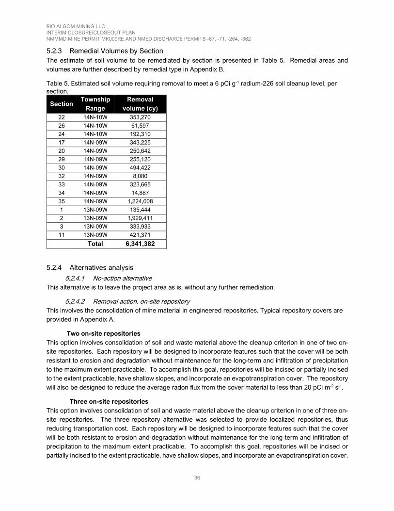
RIO ALGOM MINING LLC INTERIM CLOSURE/CLOSEOUT PLAN NMMMD MINE PERMIT MK009RE AND NMED DISCHARGE PERMITS -67, -71, -264, -362
36
5.2.3 Remedial Volumes by Section The estimate of soil volume to be remediated by section is presented in Table 5. Remedial areas and volumes are further described by remedial type in Appendix B.
Table 5. Estimated soil volume requiring removal to meet a 6 pCi g-1 radium-226 soil cleanup level, per section.
Section Township
Range Removal
volume (cy) 22 14N-10W 353,270
26 14N-10W 61,597
24 14N-10W 192,310
17 14N-09W 343,225
20 14N-09W 250,642
29 14N-09W 255,120
30 14N-09W 494,422
32 14N-09W 8,080
33 14N-09W 323,665
34 14N-09W 14,887
35 14N-09W 1,224,008
1 13N-09W 135,444
2 13N-09W 1,929,411
3 13N-09W 333,933
11 13N-09W 421,371
Total 6,341,382
5.2.4 Alternatives analysis
5.2.4.1 No-action alternative This alternative is to leave the project area as is, without any further remediation.
5.2.4.2 Removal action, on-site repository This involves the consolidation of mine material in engineered repositories. Typical repository covers are provided in Appendix A.
Two on-site repositories This option involves consolidation of soil and waste material above the cleanup criterion in one of two on-site repositories. Each repository will be designed to incorporate features such that the cover will be both resistant to erosion and degradation without maintenance for the long-term and infiltration of precipitation to the maximum extent practicable. To accomplish this goal, repositories will be incised or partially incised to the extent practicable, have shallow slopes, and incorporate an evapotranspiration cover. The repository will also be designed to reduce the average radon flux from the cover material to less than 20 pCi m-2 s-1.
Three on-site repositories This option involves consolidation of soil and waste material above the cleanup criterion in one of three on-site repositories. The three-repository alternative was selected to provide localized repositories, thus reducing transportation cost. Each repository will be designed to incorporate features such that the cover will be both resistant to erosion and degradation without maintenance for the long-term and infiltration of precipitation to the maximum extent practicable. To accomplish this goal, repositories will be incised or partially incised to the extent practicable, have shallow slopes, and incorporate an evapotranspiration cover.

RIO ALGOM MINING LLC INTERIM CLOSURE/CLOSEOUT PLAN NMMMD MINE PERMIT MK009RE AND NMED DISCHARGE PERMITS -67, -71, -264, -362
37
The repository will also be designed to reduce average radon flux from the cover material to less than 20 pCi m-2 s-1.
5.2.5 Alternative selection Table 6 presents remaining remedial activities within the project area on a per-section basis. Table 6 assumes that three repositories will be constructed on T14N R10W section 22, T14N R09W section 35, and T13N R09W section 4.

RIO ALGOM MINING LLC INTERIM CLOSURE/CLOSEOUT PLAN NMMMD MINE PERMIT MK009RE AND NMED DISCHARGE PERMITS -67, -71, -264, -362
38
Table 6. Summary of selected remedial action(s), per section.
Section Township-
Range Selected Remedy(ies)
22 14N-10W
• Impacted soil will be placed in a repository established in T14N R10W section 22.
• Subsidence areas will be stabilized. • One (1) vent hole will be closed.
26 14N-10W • Impacted soil will be placed in a repository established in section T14N
R10W 22. • One (1) vent hole will be closed.
24 14N-10W • Impacted soil will be placed in a repository established in section T14N
R10W 22. • One (1) vent hole will be closed.
17 14N-09W • Impacted soil will be placed in a repository established in T13N R09W
section 4. • One (1) vent hole will be closed.
20 14N-09W • Impacted soil will be placed in a repository established in T13N R09W
section 4.
29 14N-09W • Impacted soil will be placed in a repository established in T13N R09W
section 4.
30 14N-09W
• Seventy-five percent of impacted soil volume will be placed in T14N R10W section 22.
• Twenty-five percent of impacted soil volume will be placed in T13N R09W section 4.
• Mine shaft (Section 30W) will be closed. • Two (2) vent holes will be closed.
32 14N-09W
• Ninety-seven percent of impacted soil will be placed in a repository established in T13N R09W section 4.
• Three percent of impacted soil will be placed in a repository in section T14N R10W 22.
33 14N-09W • Impacted soil will be placed in a repository established in T13N R09W
section 4. 34 14N-09W • Impacted soil will be placed in a repository established in section 35.
35 14N-09W • Impacted soil placed will be placed in repository established in T14N
R09W section 35. • One (1) vent hole will be closed.
1 13N-09W • Impacted soil placed will be placed in repository established in T14N
R09W section 35.
2 13N-09W • Impacted soil placed will be placed in repository established in T14N
R09W section 35.
3 13N-09W • Impacted soil placed will be placed in repository established in T14N
R09W section 35.
11 13N-09W • Impacted soil placed will be placed in repository established in T14N
R09W section 35.
5.3 Stormwater Management Post-reclamation surface hydrology will be addressed during reclamation to support positive drainage away from buried materials to prevent re-exposure. Reconstructed drainages will be designed to stabilize and

RIO ALGOM MINING LLC INTERIM CLOSURE/CLOSEOUT PLAN NMMMD MINE PERMIT MK009RE AND NMED DISCHARGE PERMITS -67, -71, -264, -362
39
control flow velocities, including addressing areas prone to flooding during storm events. All major reconstructed drainages that carry runoff across or around regraded mine wastes or dumps will be designed for long term stability.
Final closure of the project area will include removal and reclamation of all temporary runoff control measures (including ditches, berms, dikes, contour furrows, etc) once the project area has been finally stabilized with vegetation or equivalent permanent stabilization measures.
5.4 Cover Design and Materials Cover, where needed to reclaim areas with rocky soils following removal of mine related material, will consist of native soil obtained from borrow areas, with an overall average of one foot of material for use as a growth medium. Some areas may include check dams, water bars, terracing along the contour, installation of armored channels, slope reduction and/or use of other erosion control practices where required for the successful establishment of vegetation.
Cover will also be used to ensure long-term stability and reduce radiation dose from approved on-site repositories. The repositories will be designed to incorporate features such that the cover will be both resistant to erosion and degradation without maintenance for the long-term and infiltration of precipitation to the maximum extent practicable. To accomplish this goal, repositories will be incised or partially incised to the extent practicable, have shallow slopes, and incorporate an evapotranspiration cover. The repository will also be designed to reduce average radon emission from the final surface to less than 20 pCi m-2 s-1. A typical repository cover design is included in Appendix A.
5.5 Revegetation Revegetation activities will consist of a three-step process to include drill seeding/broadcast spreading, hay/straw mulching, and mulch crimping. To facilitate revegetation, compacted areas such as roads and parking areas will either be scarified or they will be disced to a depth of 1.5 feet prior to seeding.
The seed mixture to be used will be similar to the seed mixture employed in revegetation activities at other sites in the vicinity of the project area and that developed for the 1999 project area interim CCP (Table 7). Based on vegetation results at other nearby sites, successful revegetation is achievable with a variety of seed mixes, provided the composition is like plant communities found in the surrounding areas (Quivira, 1999).

RIO ALGOM MINING LLC INTERIM CLOSURE/CLOSEOUT PLAN NMMMD MINE PERMIT MK009RE AND NMED DISCHARGE PERMITS -67, -71, -264, -362
40
Table 7. Seed mixture to be used for revegetation (Quivira, 1999). Species Seed Mix (%) Blue grama grass 20
Indian ricegrass 15.5
Native Western wheatgrass 20
Sideoats grama 20
Galleta 2
Sand dropseed 2.5
Alkali sacaton 3
Intermediate Western wheatgrass 4
Fourwing saltbrush 5
Winterfat 4
Forbs* 4 *Two forb species will be selected from the following in equal proportions (i.e. 2% each): 1) blue flax, 2) California poppy, 3) purple prairie clover, 4) yellow sweetclover, 5) desert globemallow, or 6) purple aster.
5.6 Reclamation Permitting A Section 404 Permit (Section 404 of the Clean Water Act) will be obtained prior to any soil or sediment remediation in the Arroyo del Puerto.
NMED’s requirement for a construction permit related air emissions will be evaluated at the time of the remedial activities, and, if needed, a permit will be obtained.
Stormwater permitting related to closure will be conducted under the existing EPA construction general permit. A project area and activity-specific storm water pollution prevention plan will be developed to cover closure activities.
5.7 Field Components The following actions support earthwork and remedial activities.
5.7.1 Soil Characterization A characterization work plan (CWP) will be developed to characterize the project area by section prior to reclamation. The CWP will focus on determining background radiological conditions and the nature and extent of impacts to surface soil above background levels using both field instruments and laboratory analysis. The scope of the characterization work plan will allow for the discrimination of areas impacted by mining activities, unimpacted areas (background) and areas containing suitable cover or borrow materials. The work plan will supplement existing data collected by RAML and others where appropriate.
Data from the soil characterization will be used to establish a Project Area-specific background concentration of radium-226 and also a new cleanup criterion and associated gamma guideline value by correlating radium-226 concentrations in soil to gamma count rate. This data will also be used to re-evaluate mine impacted and unimpacted areas within the project area.
A characterization summary report (CSR) including all results and conclusions from data gathered under the CWP will be submitted to NMMMD for review and approval.

RIO ALGOM MINING LLC INTERIM CLOSURE/CLOSEOUT PLAN NMMMD MINE PERMIT MK009RE AND NMED DISCHARGE PERMITS -67, -71, -264, -362
41
5.7.2 Wildlife Surveys A wildlife survey will also be conducted prior to reclamation. This survey will include the following:
• A description where wildlife areas are present, the habitat in use, and the species using it • An analysis of the mining operation’s impact on wildlife and what mitigative steps if any will be used
upon mine closeout • An analysis if any mine features are currently being used by wildlife (e.g. bats using shafts or adits) • A description of how the specific reclamation effort and post-closure land use promotes wildlife
use.
5.7.3 Cultural Resources Surveys RAML takes measures to appropriately manage cultural and historical resources throughout the project area. Prior to conducting future remedial activities on lands within the project area RAML will conduct a Class I Cultural investigation consisting of a combination of background research and fieldwork designed to identify resources and define project area boundaries. RAML will provide the State with maps of the project area indicating the locations of any cultural resources potentially eligible for the National Register of Historic Places and/or Historic Places and/or the State Register of Cultural Properties. RAML will further describe how impacts to cultural resources will be avoided during reclamation activities. Where impacts to cultural resources cannot be avoided, RAML will consult with the State Historic Preservation Office to develop appropriate data recovery and mitigation plans specific for each project area.
On lands within the project area that require future reclamation and where surface ownership is the State of New Mexico or any other Tribal or Federal agency, cultural resources activities will be conducted in compliance with all applicable laws, including, the National Historic Preservation Act (NHPA) (including the 36 CFR Part 800 implementing regulations) and the Archaeological Resources Protection Act (ARPA) (PL 95-96). Appropriate efforts will be made to (a) inventory and evaluate eligibility of cultural resources in the area of potential effect, and (b) evaluate adverse effects of the undertaking and pursue related mitigation efforts in conjunction with NHPA and Section 106 compliance. These compliance efforts will follow steps in the flow chart included in Figure 17 and as outlined in the NEPA and NHPA handbook for integrating NEPA and Section 106 (CEQ and ACHP, 2013). RAML will be the proponent and will follow the State or Federal agency as the lead in the Section 106 consultation process.

RIO ALGOM MINING LLC INTERIM CLOSURE/CLOSEOUT PLAN NMMMD MINE PERMIT MK009RE AND NMED DISCHARGE PERMITS -67, -71, -264, -362
42
Figure 17. The Section 106 process (CEQ and ACHP, 2013)
5.7.4 Remediation
5.7.4.1 Site Reclamation Work Plan Following submittal of the characterization report, a site reclamation work plan (SRWP) will be prepared. The SRWP will specify the proposed final location of the excavated material above the cleanup criterion, the design and proposed cover materials for the repository(s), and the post-reclamation radiation assessment and sampling program (final status survey) to document remediation goals.
5.7.4.2 Soil Remediation Soil remediation will consist of consolidation of soil and mine waste exceeding the cleanup criterion into one of three incised or partially incised repositories. RAML will establish permanent markers to delineate the boundaries of reclaimed mine project area areas.

RIO ALGOM MINING LLC INTERIM CLOSURE/CLOSEOUT PLAN NMMMD MINE PERMIT MK009RE AND NMED DISCHARGE PERMITS -67, -71, -264, -362
43
6 Confirmatory Environmental Monitoring and Reporting This section describes confirmatory environmental monitoring and reporting occurring after remediation.
6.1.1 Groundwater Monitoring RAML will conduct groundwater quality monitoring in accordance with the conditions specified in approved NMED abatement plans. Current groundwater quality monitoring includes 41 monitoring locations in four hydrostratigraphic units. Site characterization activities will be identified during the Data Gap Analysis (INTERA, 2017b) and may include characterization of sediment in the Arroyo del Puerto, characterization of alluvial saturation in the Section 35 and 36 discharge area, and identification of public water supply wells. As abatement activities are implemented and completed, the monitoring program will be optimized (in consultation with NMED) to include additional wells where needed and remove wells that are no longer necessary. As abatement activities and permit closure progress, RAML estimates a reduced monitoring well network in each of the four hydrostratigraphic units to address post-closure monitoring requirements.
6.1.2 Radiological Final Status Survey A post-reclamation radiation assessment and sampling program (final status survey or FSS) will be conducted in accordance with joint guidance from EMNRD & NMED (2016). The objective of the FSS is to demonstrate that the final condition of the site is protective of the public and consistent with the approved post-mining land use.
The FSS will be based on the gamma guideline level developed during the characterization process based on project area-specific background radium-226 concentration(s) and approved cleanup level(s). The FSS strategy will be described in detail in the SRWP.
Parts of the project area which are designated as unimpacted by mining activities may be released without a survey with appropriate documentation of unimpacted classification. Areas impacted by mining activities will be scanned for gross gamma radiation, and release will be based on a comparison of grid-average gamma count rate with the derived gamma guideline value.
The result of the FSS will be described in the reclamation summary report.
6.1.3 Vegetation Surveys Vegetation field measurements will be conducted in the manner prescribed in the 1999 closeout plan (Quivira, 1999). Measurements will utilize a 9.6 ft2 sample size as vegetation density and production within the project area and surrounding areas is expected to be relatively light. Using a plot of this size allows a direct conversion from grams per plot to pounds per acre when sampling ten plots.
Ground cover, abundance, and estimated production values will be determined for each sample plot. Sampling will consist of identifying species present within the plot and utilizing the weight-unit method for estimating and recording the weight in grams of each species found in the sample plot. Productivity will be determined by estimating and harvesting the production of species located within the plots. The unit weight method is described in Section 604 of the NRCS National Range Handbook, Methods of Determining Production and Composition.
Number of samples will be determined at 90% confidence within 10% of the mean. The formula to determine sample adequacy will be:

RIO ALGOM MINING LLC INTERIM CLOSURE/CLOSEOUT PLAN NMMMD MINE PERMIT MK009RE AND NMED DISCHARGE PERMITS -67, -71, -264, -362
44
𝑛𝑛 =𝑡𝑡2 × 𝑠𝑠2
(0.1 × 𝑁𝑁)2
Where:
𝑛𝑛 is the number of samples 𝑡𝑡 is the t value from standardized statistical tables 𝑠𝑠2 is the variance 𝑁𝑁 is the mean In general, the procedure used will be to establish a grid pattern over the area to be evaluated. The project areas to be evaluated will be randomly selected from the overall population group with the following minimum sample numbers:
• Continuous disturbed area of 20 acres or less: minimum of 3 samples • Continuous disturbed area of 20 acres or more: minimum of 10 samples, maximum of 30 samples
In the case where a grid pattern is not feasible or several small areas are present such as may be expected in revegetation of a leach field, each land section (1 square mile) will be classified as a discrete area where a minimum of 10 samples will be required.
The results of vegetation surveys will be described in the reclamation summary report.
6.1.4 Reclamation Summary Report A final reclamation report that compiles all post-reclamation data, engineering calculations, engineering drawings, and activities that were conducted during reclamation will be submitted to NMMMD for review and approval. Once approved, the report will also be provided to surface landowners if applicable and recorded with McKinley County for a permanent record.

RIO ALGOM MINING LLC INTERIM CLOSURE/CLOSEOUT PLAN NMMMD MINE PERMIT MK009RE AND NMED DISCHARGE PERMITS -67, -71, -264, -362
45
7 Basis for Cost Estimate Section 7 summarizes all conceptual activities associated with project area reclamation for which a cost has been assigned as part of this interim CCP.
Subtasks have been grouped into tasks and then assigned to one of five reclamation phases: pre-reclamation studies (PSW), remedy implementation (EM), cover construction (CC), post-reclamation studies (PSR), post-closure care (PC) and groundwater abatement activities (ABA). A description of the tasks required to execute each reclamation phase and associated costs are presented in Appendix C.
The total estimated closure/closeout cost associated with the project area described in this interim CCP is $85,561,000. This cost includes capital, operational, and maintenance costs, as was all contingency and indirect costs.

RIO ALGOM MINING LLC INTERIM CLOSURE/CLOSEOUT PLAN NMMMD MINE PERMIT MK009RE AND NMED DISCHARGE PERMITS -67, -71, -264, -362
46
8 Schedule The schedule for closure and closeout will defer to the ongoing negotiation between RAML, the State Agencies, and the EPA.

RIO ALGOM MINING LLC INTERIM CLOSURE/CLOSEOUT PLAN NMMMD MINE PERMIT MK009RE AND NMED DISCHARGE PERMITS -67, -71, -264, -362
47
References AVM and AHA, 2000. AVM Environmental Services and Applied Hydrology Associates, 2000. Groundwater Corrective
Action Program and Alternate Concentration Limits Petition, Uppermost Bedrock Units. Prepared for Quivira Mining Company. February 15, 2000.
Bostick, 1985. “Ground-Water Discharge Plan Analysis for Kerr-McGee Nuclear Corporation”.
Burleson, 2004. “Cultural Resource Survey: Class III Survey of 18.58 Hectares (45.91 Acres) for Rio Algom Mining, LLC, near Ambrosia Lake, McKinley County, New Mexico. Burleson, R. 2004. Ecosystem Management, Inc. EMI Report Number 612
CEQ and ACHP, 2013. “NEPA and NHPA handbook for integrating NEPA and Section 106.” Council on Environmental Quality Executive Office of the President and Advisory Council on Historic Preservation. March 2013.
Chenoweth, WL and Learned, EA and Rautman, CA (compiler), 1979. “Geology and mineral technology of the Grants uranium region 1979”. New Mexico Bureau of Mines and Mineral Resources, Memoir 38. January 1979.
Department of Energy (DOE) United States. 1990. “Remedial Action Plan and Site Conceptual Design for the Stabilization of the Inactive Uranium Mill Tailings Site at Ambrosia Lake, New Mexico”. Final. UMTRA-DOA/AL-650516.0000, September 1990. Transmitted by DOE letter dated September 25, 1990.
EMNRD & NMED, 2016. “Joint Guidance for the Cleanup and Reclamation of Existing Uranium Mining Operations in New Mexico”. New Mexico Energy, Minerals & Natural Resources Department and New Mexico Environment Department. March 2016.
EPA, 2018. United States Environmental Protection Agency, 2018. Phase-2 Ground-Water Investigation Report for the San Mateo Creek Basin Legacy Uranium Mines Site. September 28.
ERG, 2007. Environmental Restoration Group, Inc., 2005. Characterization Report for the Section 35 and 36 Mine Drainage. Prepared for Rio Algom Mining, LLC.
Freeman, V.L., and Hilpert, L.S., 1956. “Stratigraphy of the Morrison Formation In Part of Northwestern New Mexico.” Geological Survey Bulletin 1030-J
FWS, 2015. Fish and Wildlife Service (FWS) United States, 2015. “List of Threatened and Endangered Species That May Occur in Your Proposed Project Location, and/or May Be Affected by Your Project, Ambrosia Lake Mill MSGP”. Letter from FWS, New Mexico Ecological Services Field Office, September 01, 2015.
Ganus, WJ, 1980. “Hydrologic Assessment of Ambrosia Lake Area. Exhibit E.” Groundwater Discharge Plan submitted by Kerr-McGee’s Ambrosia Lake Uranium Mill to New Mexico Environmental Improvement Division: Santa Fe, New Mexico Health and Environment Department. 1980.
INTERA, 2007. INTERA Incorporated, 2007. Evaluation of Impacts from Section 35 and 36 Mine Dewatering, Ambrosia Lake Valley, New Mexico. Prepared for Rio Algom Mining, LLC. October 26.
INTERA, 2008. INTERA Incorporated, 2008. Post Closure Monitoring Plan NRC License # SUA-1473. Submitted to the Nuclear Regulatory Commission and New Mexico Environment Department Ground Water Quality Bureau. June 2.
INTERA, 2008. INTERA Incorporated, 2008. Rio Algom Mining Stage 1 Abatement Plan. Submitted to New Mexico Environment Department Ground Water Quality Bureau. April 8.

RIO ALGOM MINING LLC INTERIM CLOSURE/CLOSEOUT PLAN NMMMD MINE PERMIT MK009RE AND NMED DISCHARGE PERMITS -67, -71, -264, -362
48
INTERA, 2010. INTERA Incorporated, 2010. Work Plan for Monitor Well Installation Stage 1 Abatement Investigation, Section 35-36 Mines, October 7.
Intera, 2012, INTERA Incorporated 2012. Discharge Permit Application for the Renewal and Modification of DP-362, March 30. Prepared for Rio Algom Mining, LLC. Submitted to New Mexico Environment Department, Ground Water Quality Bureau.
INTERA, 2013a, INTERA Incorporated 2013. Rio Algom Sampling and Analysis Plan for DP-362, Stage 1 Abatement. Prepared for Rio Algom Mining, LLC. April 26.
INTERA, 2013b. INTERA Incorporated, 2013. Work Plan for Monitoring Well Installation, Stage 1 Abatement Investigation, Section 35-36 Mines. Prepared for Rio Algom Mining, LLC. March 29.
INTERA, 2014. INTERA Incorporated, 2014. Rio Algom DP-362 Monitoring Well Installation 2013 Report, MW-35-09, MW-35-10, MW-33-02 Jmw. May 16.
Intera, 2015. INTERA Incorporated, 2015. Rio Algom Sampling and Analysis Plan For DP-362, Stage 1 Investigation. Submitted to New Mexico Environment Department, Ground Water Quality Bureau. June 19.
INTERA, 2017a. INTERA Incorporated, 2017. Rio Algom Mining, LLC. Ambrosia Lake Mines Stage 1 Interim Site Investigation. September 19.
INTERA, 2017b. INTERA Incorporated, 2017. Ambrosia Lake Uranium Mines: Updated Conceptual Site Model and Data Gap Analysis Work Plan. December 19.
INTERA, 2017c. INTERA Incorporated, 2017. “DP-362 Data Summary Report, Rio Algom Mining, LLC, McKinley County, New Mexico”. Submitted to NMED, January 31, 2017.INTERA, 2018. INTERA Incorporated. 2018. “Groundwater Modeling for Closure of Old Stope Leaching Operations, Ambrosia Lake Facility, McKinley County, New Mexico, 2018 Model Update”. Submitted to NMED, May 10, 2018.
Kerr-McGee Corporation, 1967. “Dakota Sandstone – Tres Hermanos Relationship Southern San Juan Basin Area”. Internal Report. 1967.
Kernodle, 1996. “Hydrogeology and Steady-State Simulation of Ground-Water Flow in the San Juan Basin, New Mexico, Colorado, Arizona, and Utah: U.S. Geological Survey Water-Resources Investigations Report 95-4187”.
Marron, 2004. “Biological Survey Memorandum for the KGL Haul Road Project, Milan, McKinley County, New Mexico. Marron and Associates, Inc. 2004.
Maxim, 2001. Maxim Technologies, Inc. 2001. “Application for Alternate Concentration Limits for the Alluvial Materials Quivira Mill Facility Ambrosia Lake, New Mexico”. May 2001.
McLemore VT and Chenoweth WL, 1991. “Uranium Mines and Deposits in the Grants district, Cibola and McKinley Counties, New Mexico. New Mexico Bureau of Minds and Mineral Resources Open-file Report 353”. December 1991.
McLemore et al, 2005. McLemore, V.T., Hoffman, G., Smith, M., Mansell, M., and Wilks, M., 2005. “Mining districts of New Mexico: New Mexico Bureau of Geology and Mineral Resources, Open-file Report 494”. CD-ROM.
McLemore, 2007. McLemore, V.T., 2007. “Uranium resources in New Mexico”. Society of Mining, Metallurgy, and Exploration (SME) preprint, 2007 annual meeting, 18 p., http://geoinfo. nmt.edu/staff/mclemore.htm.

RIO ALGOM MINING LLC INTERIM CLOSURE/CLOSEOUT PLAN NMMMD MINE PERMIT MK009RE AND NMED DISCHARGE PERMITS -67, -71, -264, -362
49
McLemore et al, 2013. McLemore, V.T., Hill, B., Khalsa, N., and Lucas Kamat, S. A. 2013. “Uranium resources in the Grants uranium district, New Mexico: an update”. New Mexico Geological Society Guidebook, 64th Field Conference, Geology of Route 66 Region: Flagstaff to Grants, 2013, p. 117-126.
NCRP, 1993. “Limitation of Exposure to Ionizing Radiation. Recommendations of the National Council on Radiation Protection and Measurements”. NCRP Report No. 116. 1993.
NMED, 2012. Letter dated April 23, 2012 to Mr. Billy Ray, Rio Algom Mining, LLC from Mr. Jerry Schoeppner, New Mexico Environment Department, RE: Administrative Completeness Determination and Applicant’s Public Notice Requirements, DP-362, Rio Algom Mining, LLC.
NMMMD, 1995. “Prior Reclamation Release for Section 36 Mine”. Correspondence between K.A. Garland, Mining and Minerals Division, and P. Luthiger, Quivira Mining Company. September 29, 1995.
NMMMD, 1996. “Closeout Plan Guidelines for Existing Mines”. New Mexico Mining and Minerals Division. April 30, 1996.
NMMMD, 2011. Geodatabase of mines in the Grants Uranium District. 2011.
NMMMD and NMED, 2019. “Scope of Closure/Closeout Plan, Old Stope Leach Mine Area, McKinley County, New Mexico, Mining Act Permit No. MK009RE and Discharge Permit DP 362”. Memorandum to S. Ross. May 13, 2019.
NRC, 2006. “Environmental Assessment for the Soil Decommissioning Plan Rio Algom Mining LLC’s Uranium Mill Facility, Ambrosia Lake, New Mexico”. May 15, 2006. [ADAMS Accession No. ML061630291]
NRCS, 2005. “Soil Survey of McKinley County Area, New Mexico, McKinley County and Parts of Cibola and San Jan Counties.” United States Department of Agriculture, Natural Resources and Conservation Science in cooperation with United States Department of Interior, Bureau of Land Management
Quivira, 1995. Section 35 Mining Operation Closeout Plan. December 29, 1995
Quivira, 1999. “Mine Permit MK009RE Closeout Plan”. Quivira Mining Company Ambrosia Lake Facility. August 30, 1999.
RAML, 2001. Rio Algom Mining, LLC (RAML), 2001. “Application for Alternate Concentration Limits in the Alluvial Materials at the Quivira Mill Facility Ambrosia Lake, New Mexico, Grants, New Mexico”. 2001.
RAML, 2004. “Rio Algom Mining LLC, Closure Plan Lined Evaporation Ponds, October 2004, Appendix A through End”. November 1, 2004. [ADAMS Accession No. ML050240064]
RAML, 2006. Rio Algom Mining, LLC. (RAML), 2006. Section 35 and 36 Mine Drainage Characterization Work Plan. Submitted to New Mexico Environment Department. September 29.
RAML, 2011. Letter from Billy Ray (RAML) to David Myerson (Ground Water Quality Bureau) Regarding: Surface Reclamation Activities Primarily Associated with Mine Permit MK009RE. January 6, 2011.
RAML, 2013. Memorandum from Gail Alexander (RAML) to D.J. Ennis (New Mexico Mining and Minerals Division) regarding estimated disturbed areas for Mine Permit MK009RE. October 2, 2013
RAML, 2018a. “2018 Land Use Survey”. Rio Algom Mining LLC, Ambrosia Lake Facility. June 15, 2018. [ADAMS Accession No. ML18183A587]

RIO ALGOM MINING LLC INTERIM CLOSURE/CLOSEOUT PLAN NMMMD MINE PERMIT MK009RE AND NMED DISCHARGE PERMITS -67, -71, -264, -362
50
RAML, 2018b. “Section 4 Ponds Area Environmental Report, Ambrosia Lake, Rio Algom Mining, LLC”. August 16, 2018. [ADAMS Accession No. ML18236A478]
RHR, 2011. “Baseline Data Report for the Roca Honda Mine, Section 13.0 Radiological Survey”. January 2011.
RHR, 2012. “Mine Operations Plan for Roca Honda Mine, Revision 1”. Submitted to New Mexico Mining and Materials Division. Energy, Minerals and Natural Resources Department and U.S. Forest Service (Cibola National Forest). January 2012.
RHR, 2018. “Addendum to Roca Honda Mine Baseline Data report; Permit Nos. MK-025RN, DP1717”. Report to NMMMD. July 24, 2018.
Sandin, D., 2007, riosanjose_bedem_woutlaguna.img [DEM] “New Mexico Digital Elevation Models & Contours” June 2018. RGIS Data Portal. New Mexico Geospatial Data Acquisition Coordination Committee (November 2007).
Santos, E.S., and Thaden, R.E., 1966, Geologic map of the Ambrosia Lake quadrangle, McKinley County, New Mexico: Geologic Quadrangle Map GQ-515, scale 1:24,000.
SWCA, 2015. SWCA Environmental Consultants (SWCA), 2015. “Rio Algom Mill Site Threatened and Endangered Species Habitat Survey, Prepared for Rio Algom Mining LLC, Ambrosia Lake”. September 29, 2015.
Stone et al, 1983. Stone, W. J., F. P. Lyford, P. F. Frenzel, N. H. Mizell, and E. T. Padgett, 1983. “Hydrogeology and Water Resources of the San Juan Basin, New Mexico: New Mexico Bureau of Mines and Mineral Resources Hydrologic Report 6”. 1983.
Thaden, R.E., Santos, E.S., and Ostling, E.J., 1967, Geologic map of the Dos Lomas quadrangle, Valencia and McKinley Counties, New Mexico: Geologic Quadrangle Map GQ-680, scale 1:24,000.
USGS, 2018. San_Mateo_Creek_Basin_Hydrography [ESRI Shapefile]. [1:24,000]. National Hydrography Dataset. December 2018. USDA National Resources Conservation Service, Geospatial Data Gateway (October 2018) Appendix

RIO ALGOM MINING LLC INTERIM CLOSURE/CLOSEOUT PLAN NMMMD MINE PERMIT MK009RE AND NMED DISCHARGE PERMITS -67, -71, -264, -362
51
Appendix A – Repository cover typical

RIO ALGOM MINING LLC INTERIM CLOSURE/CLOSEOUT PLAN NMMMD MINE PERMIT MK009RE AND NMED DISCHARGE PERMITS -67, -71, -264, -362
52

RIO ALGOM MINING LLC INTERIM CLOSURE/CLOSEOUT PLAN NMMMD MINE PERMIT MK009RE AND NMED DISCHARGE PERMITS -67, -71, -264, -362
53
Appendix B – Remedial volumes and areas by section and by type

RIO ALGOM MINING LLC INTERIM CLOSURE/CLOSEOUT PLAN NMMMD MINE PERMIT MK009RE AND NMED DISCHARGE PERMITS -67, -71, -264, -362
54
LOCATION VOLUME ESTIMATE (cu yd)
Township: Range
Section Other
Drainage Disturbed
area
Miscellaneous above gamma
guideline
Overland flow
Arroyo Road Historical disposal
area Total
13N9W 1 0 0 6,413 129,031 0 0 0 135,444
13N9W 2 0 0 0 1,929,411 0 0 0 1,929,411
13N9W 3 0 0 0 333,933 0 0 0 333,933
13N9W 11 0 0 0 421,371 0 0 0 421,371
14N9W 17 74,490 211,912 56,823 0 0 0 0 343,225
14N9W 20 236,111 0 14,531 0 0 0 0 250,642
14N9W 29 3,721 11,049 240,351 0 0 0 0 255,120
14N9W 30 10,257 330,123 126,799 0 0 27,243 0 494,422
14N9W 32 0 0 8,080 0 0 0 0 8,080
14N9W 33 0 103,219 192,336 0 0 0 28,110 323,665
14N9W 34 0 0 14,887 0 0 0 0 14,887
14N9W 35 0 102,904 123,920 557,195 0 0 439,990 1,224,008
14N10W 22 163,725 134,573 47,411 0 0 7,561 0 353,270
14N10W 24 0 134,678 37,229 0 0 1,684 18,719 192,310
14N10W 26 1,005 0 1,557 0 59,035 0 0 61,597
Total Volume: 6,341,382

RIO ALGOM MINING LLC INTERIM CLOSURE/CLOSEOUT PLAN NMMMD MINE PERMIT MK009RE AND NMED DISCHARGE PERMITS -67, -71, -264, -362
55
LOCATION AREA ESTIMATE (Acres)
Township: Range
Section Other
Drainage Disturbed
area
Miscellaneous above gamma
guideline
Overland flow
Arroyo Road Historical disposal
area Total
13N9W 1 0 0 8 40 0 0 0 48
13N9W 2 0 0 0 598 0 0 0 598
13N9W 3 0 0 0 103 0 0 0 103
13N9W 11 0 0 0 130 0 0 0 130
14N9W 17 46 88 70 0 0 0 0 204
14N9W 20 146 0 18 0 0 0 0 164
14N9W 29 2 4 298 0 0 0 0 304
14N9W 30 6 137 157 0 0 6 0 306
14N9W 32 0 0 10 0 0 0 0 10
14N9W 33 0 43 238 0 0 0 12 293
14N9W 34 0 0 18 0 0 0 0 18
14N9W 35 0 42 173 154 0 0 51 420
14N10W 22 101 56 59 0 0 2 0 218
14N10W 24 0 56 47 0 0 0 8 111
14N10W 26 1 0 2 0 18 0 0 21
Total Area: 2,948

RIO ALGOM MINING LLC INTERIM CLOSURE/CLOSEOUT PLAN NMMMD MINE PERMIT MK009RE AND NMED DISCHARGE PERMITS -67, -71, -264, -362
56
Appendix C – Closure/closeout plan cost estimate

RIO ALGOM MINING LLC INTERIM CLOSURE/CLOSEOUT PLAN NMMMD MINE PERMIT MK009RE AND NMED DISCHARGE PERMITS -67, -71, -264, -362
57
Reclamation Phase Cost Estimate
PSW Pre-reclamation Studies& Workplans $9,032,000
EM Remedy Implementation $42,628,000
CC Cover Construction $26,359,000
PSR Post Reclamation Studies & Reports $1,939,000
PCC Post Closure Care $230,000
ABA Groundwater Abatement Activities $3,695,000
Indirect Costs1 $0
Subtotal $83,883,000
Contingency 2% (total > $50 million)2 $1,678,000
Total $85,561,000
1 Indirect costs are built into line item estimates.
2 Per Attachment 4 of Closeout Plan Guidelines for Existing Mines (NMMMD, 1996)

$9,032,000
Task Description No. Units Unit Unit Cost Total Cost
PSW-1 Prepare Workplan
PSW-1.1 Evaluate nature and extent of contamination 1 ea $157,000 $157,000PSW-1.2 Geotechnical characterization of borrow material 300 hr $102 $31,000PSW-1.3 Cultural resource surveys 1 ea $35,000 $35,000PSW-1.4 Biological resource surveys 1 ea $25,000 $25,000PSW-1.5 Geomorphology surveys 233 hr $102 $24,000PSW-1.6 Vegetation surveys 1 ea $25,000 $25,000PSW-1.7 Soil & vegetation suitability 1 ea $15,000 $15,000
PSW-2 Field sampling services to implement workplan
PSW-2.1 Evaluate nature and extent of contamination 1 ea $1,307,000 $1,307,000PSW-2.2 Geotechnical characterization of borrow material 1,000 ea $260 $260,000PSW-2.3 Cultural resource surveys 3,000 ac $667 $2,000,000PSW-2.4 Biological resource surveys 7,500 ac $10 $75,000PSW-2.5 Geomorphology surveys 210 hr $102 $21,000PSW-2.6 Vegetation surveys 7,500 ac $13 $100,000PSW-2.7 Soil & vegetation suitability 1 ea $75,000 $75,000
PSW-3 Prepare Report
PSW-3.1 Evaluate nature and extent of contamination 1 ea $249,000 $249,000PSW-3.2 Geotechnical characterization of borrow material 400 hr $102 $41,000PSW-3.3 Cultural resource surveys 1 ea $20,000 $20,000PSW-3.4 Biological resource surveys 1 ea $25,000 $25,000
PSW-3.5 Geomorphology surveys 425 hr $102 $43,000
PSW-3.6 Vegetation surveys 1 ea $25,000 $25,000PSW-3.7 Soil & vegetation suitability 1 ea $10,000 $10,000
$4,563,000
Task Description No. Units Unit Unit Cost Total Cost
PSW-4 Prepare Site Reclamation Workplan
PSW-4.1 Repository design - cover, stormwater management 3,027 hr $102 $309,000PSW-4.2 Grading plan for reclaimed areas 527 hr $102 $54,000PSW-4.3 Soil management plan 378 hr $102 $39,000PSW-4.4 Erosion control (soil loss modeling) 156 hr $102 $16,000PSW-4.5 Borrow material description 139 hr $102 $14,000PSW-4.6 Closure of 30W shaft and project area ventholes 1,400 hr $102 $143,000PSW-4.7 Final status survey plan for contaminants 300 hr $130 $39,000PSW-4.8 Final status survey plan for vegetation 1 ea $35,000 $35,000
$649,000
Pre-Reclamation Studies and Reports Phase Total :
Characterization Work Plan
Reclamation Design & Workplan
Task Subtotal
Task Subtotal

$42,628,000
Task Description No. Units Unit Unit Cost Total Cost
EM-1 T14N R10W Section 22
EM-1.1 Remove soil above gamma guideline 353,270 CY $1 $378,000EM-1.2 Seeding & grading 218 Acre $3,100 $676,000
EM-2 T14N R10W Section 24
EM-2.1 Remove soil above gamma guideline 192,310 CY $3 $575,000EM-2.2 Seeding & grading 110 Acre $3,100 $341,000
EM-3 T14N R10W Section 26
EM-3.1 Remove soil above gamma guideline 61,597 CY $3 $206,000EM-3.2 Seeding & grading 21 Acre $3,100 $65,000
EM-4 T14N R09W Section 30
EM-4.1 Remove soil above gamma guideline 494,422 CY $5 $2,331,000EM-4.2 Seeding & grading 306 Acre $3,100 $949,000
EM-5 T14N R09W Section 17
EM-5.1 Remove soil above gamma guideline 343,225 CY $7 $2,252,000EM-5.2 Seeding & grading 204 Acre $3,100 $632,000
EM-6 T14N R09W Section 20
EM-6.1 Remove soil above gamma guideline 250,642 CY $6 $1,439,000EM-6.2 Seeding & grading 164 Acre $3,100 $508,000
EM-7 T14N R09W Section 29
EM-7.1 Remove soil above gamma guideline 255,120 CY $4 $901,000EM-7.2 Seeding & grading 305 Acre $3,100 $946,000
EM-8 T14N R09W Section 32
EM-8.1 Remove soil above gamma guideline 8,880 CY $3 $23,000EM-8.2 Seeding & grading 10 Acre $3,100 $31,000
EM-9 T14N R09W Section 33
EM-9.1 Remove soil above gamma guideline 323,665 CY $4 $1,143,000EM-9.2 Seeding & grading 293 Acre $3,100 $908,000
EM-10 T14N R09W Section 34
EM-10.1 Remove soil above gamma guideline 14,887 CY $4 $60,000EM-10.2 Seeding & grading 19 Acre $3,100 $59,000
EM-11 T14N R09W Section 35
EM-11.1 Remove soil above gamma guideline 1,224,008 CY $2 $2,387,000EM-11.2 Seeding & grading 420 Acre $3,100 $1,302,000
EM-12 T13N R09W Section 1
EM-12.1 Remove soil above gamma guideline 135,444 CY $3 $339,000EM-12.2 Seeding & grading 48 Acre $3,100 $149,000
EM-13 T13N R09W Section 2
EM-13.1 Remove soil above gamma guideline 1,929,411 CY $3 $6,560,000EM-13.2 Seeding & grading 598 Acre $3,100 $1,854,000
EM-14 T13N R09W Section 3
Earthmoving, Grading, and Revegetation
Remedy Implementation Phase Total :

$42,628,000
Task Description No. Units Unit Unit Cost Total Cost
Earthmoving, Grading, and Revegetation
Remedy Implementation Phase Total :
EM-14.1 Remove soil above gamma guideline 333,933 CY $3 $1,149,000EM-14.2 Seeding & grading 104 Acre $3,100 $322,000
EM-15 T13N R09W Section 11
EM-15.1 Remove soil above gamma guideline 421,371 CY $4 $1,597,000EM-15.2 Seeding & grading 131 Acre $3,100 $406,000
$30,488,000
Task Description No. Units Unit Unit Cost Total Cost
EM-16 Road installation
EM-16.1 T14N R10W Section 22 47,520 ft $11 $543,000EM-16.2 T13N R09W Section 4 38,200 ft $12 $440,000EM-16.3 T14N R09W Section 35 28,560 ft $15 $431,000
EM-17 Road maintenance
EM-17.1 T14N R10W Section 22 870 day $4,000 $3,480,000EM-17.2 T13N R09W Section 4 458 day $5,130 $2,349,000EM-17.3 T14N R09W Section 35 622 day $3,013 $1,874,000
EM-18 Upgrades and expansion of water supply
EM-18.1 T14N R10W Section 22 2,640 ft $69 $182,000EM-18.2 T13N R09W Section 4 2,640 ft $94 $249,000
EM-19 Construction worker mobe-demobe
EM-19.1 Mobilization 1 ea $219,479 $219,000EM-19.2 Demobilization 1 ea $236,240 $236,000
EM-20 Radiological support services during construction
EM-20.1 Radiation control technician 1,950 person-day $784 $1,529,000EM-20.2 Health physicist 390 person-day $1,560 $608,000
$12,140,000
Task Subtotal
Infrastructure to Support Remedy Implementation
Task Subtotal

$26,359,000
Task Description No. Units Unit Unit Cost Total Cost
CC-1 T14N R10W Section 22
CC-1.1 Repository preparation 2,077,287 CY $1 $2,846,000
CC-1.2 Install and compact barrier layer 347,933 CY $3 $929,000
CC-1.3 Placement of rock mulch 69,855 CY $40 $2,802,000
CC-1.4 Final cover QA including report 90 Acre $17,500 $1,575,000
CC-1.5 Stormwater management 16,300 ft $4 $60,000
CC-1.6 Seeding 90 Acre $3,100 $279,000
CC-1.7 Radon Flux Measurements 100 Number $100 $10,000
CC-2 T14N R09W Section 35
CC-2.1 Repository preparation 2,077,287 CY $2 $3,469,000
CC-2.2 Install and compact barrier layer 349,105 CY $3 $988,000
CC-2.3 Placement of rock mulch 87,276 CY $37 $3,260,000
CC-2.4 Final cover QA including report 90 Acre $17,500 $1,575,000
CC-2.5 Stormwater management 16,300 ft $4 $68,000
CC-2.6 Seeding 90 Acre $3,100 $279,000
CC-2.7 Radon Flux Measurements 100 Number $100 $10,000
CC-3 T13N R09W Section 04
CC-3.1 Repository preparation 1,263,859 CY $1 $1,845,000
CC-3.2 Install and compact barrier layer 313,122 CY $4 $1,112,000
CC-3.3 Placement of rock mulch 78,278 CY $43 $3,356,000
CC-3.4 Final cover QA including report 90 Acre $17,500 $1,575,000
CC-3.5 Stormwater management 16,300 ft $4 $63,000
CC-3.6 Seeding 80 Acre $3,100 $248,000
CC-3.7 Radon Flux Measurements 100 Number $100 $10,000
$26,359,000Task Subtotal
Earthmoving & Revegetation
Cover construction Phase Total :

$1,939,000
Task Description No. Units Unit Unit Cost Total Cost
PSR-1Field sampling services to implement reclamation workplan
PSR-1.1 Radiological final status survey 16000 hr $83 $1,332,000PSR-1.2 Vegetation final status survey 1 ea $150,000 $150,000
PSR-2 Prepare report
PSR-2.1 Radiological final status survey 600 hr $130 $78,000PSR-2.2 Vegetation final status survey 1 ea $35,000 $35,000
$1,595,000
Task Description No. Units Unit Unit Cost Total Cost
PSR-3 Prepare Report
PSR-3.1 As-builts 1577 hr $102 $161,000PSR-3.2 Final grading 526 hr $102 $54,000PSR-3.3 Inspection schedule 158 hr $102 $16,000PSR-3.4 Maintenance plan 235 hr $102 $24,000PSR-3.5 Confirmation reporting 352 hr $102 $36,000PSR-3.6 Draft report 522 hr $102 $53,000
$344,000Task Subtotal
Task Subtotal
Final Status Surveys
Reclamation Summary Report
Phase Total:Post-Reclamation Studies and Reports

$230,000
Task Description No. Units Unit Unit Cost Total Cost
PC-1 Final cover inspection
PC-1.1 Inspection 10 decade $1,000 $10,000PC-1.2 Record keeping & reporting 10 decade $500 $5,000
PC-2 Storm water systems
PC-2.1 Inspection and repairs 10 decade $5,000 $50,000PC-2.2 System upgrades (rip-rap) 1 decade $150,000 $150,000
PC-3 Fencing and site security
PC-3.1 Inspection and repairs 10 decade $1,500 $15,000$230,000
Post-Closure Care
Task Subtotal
Post-Closure Care Phase Total :

$3,695,000
Task Description No. Units Unit Unit Cost Total Cost
ABA-1 Routine groundwater monitoring and reporting
ABA-1.1 Abatement activities 1 ea $1,395,000 $1,395,000
ABA-2Stage 1 abatement workplan, report, and model update
min
ABA-2.1 Abatement update 1 ea $550,000 $550,000
ABA-3 Optimization of well network
ABA-3.1 Optimization of well network 1 ea $1,750,000 $1,750,000
Groundwater Abatement Activities
Groundwater Abatement Activities Phase Total :