river ranch ebook
DESCRIPTION
Oneil Highway Redmond, ORTRANSCRIPT
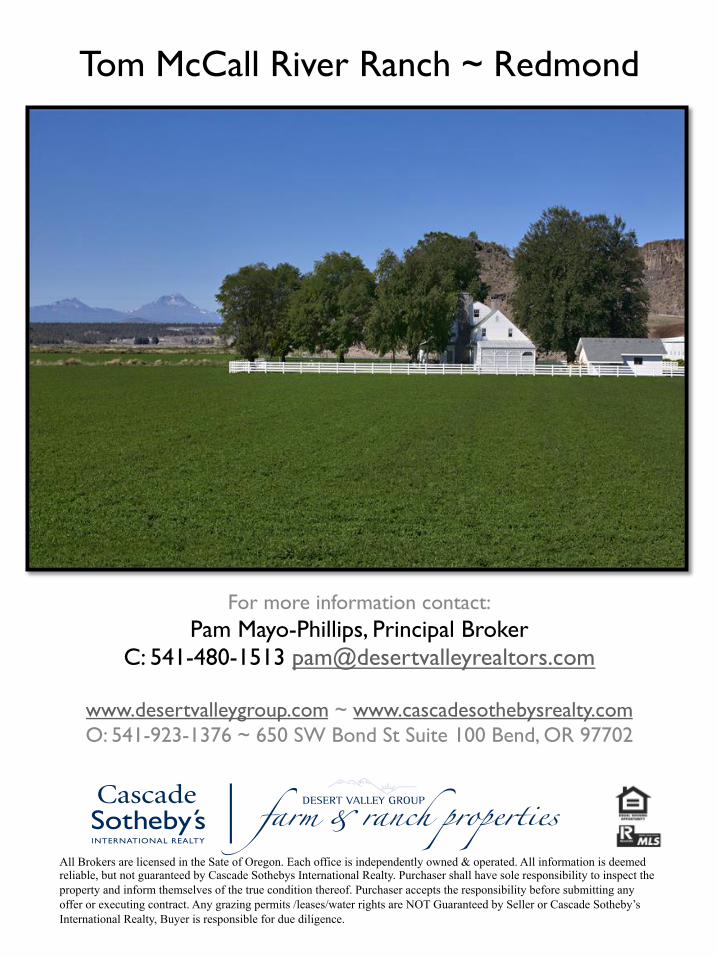
Tom McCall River Ranch ~ Redmond
For more information contact: Pam Mayo-Phillips, Principal Broker
C: 541-480-1513 [email protected]
www.desertvalleygroup.com ~ www.cascadesothebysrealty.com O: 541-923-1376 ~ 650 SW Bond St Suite 100 Bend, OR 97702
All Brokers are licensed in the Sate of Oregon. Each office is independently owned & operated. All information is deemed reliable, but not guaranteed by Cascade Sothebys International Realty. Purchaser shall have sole responsibility to inspect the property and inform themselves of the true condition thereof. Purchaser accepts the responsibility before submitting any offer or executing contract. Any grazing permits /leases/water rights are NOT Guaranteed by Seller or Cascade Sotheby’s International Realty, Buyer is responsible for due diligence.
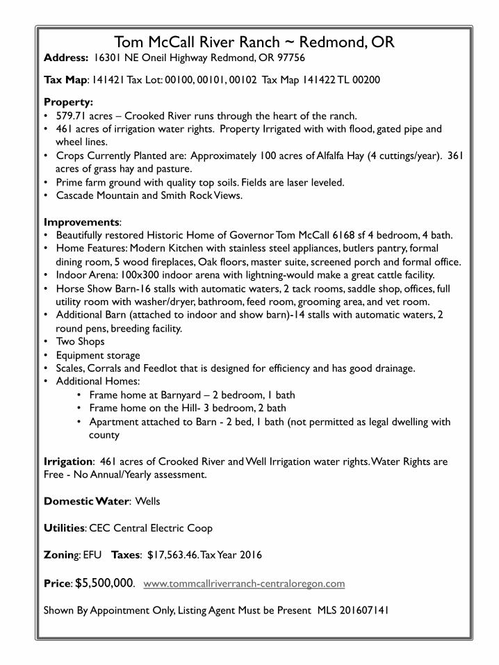
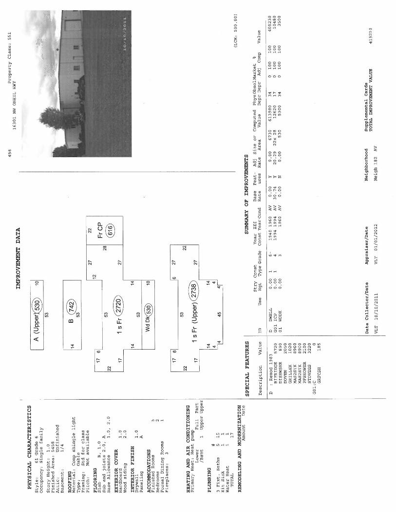
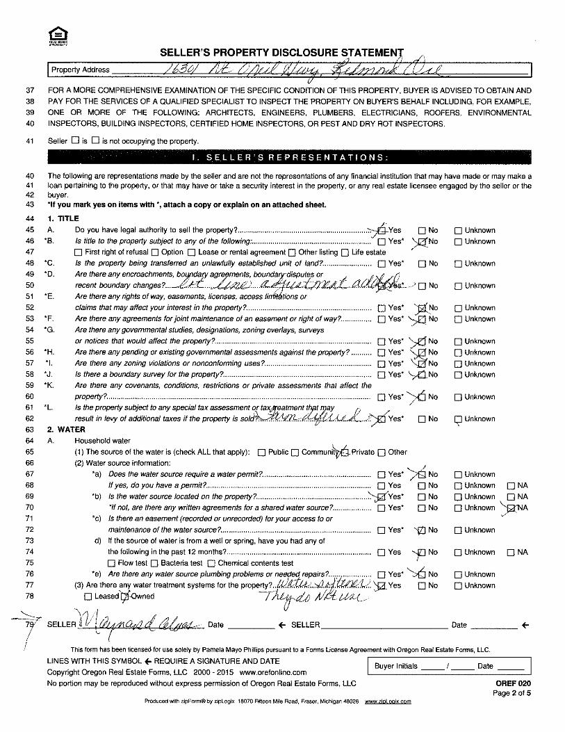
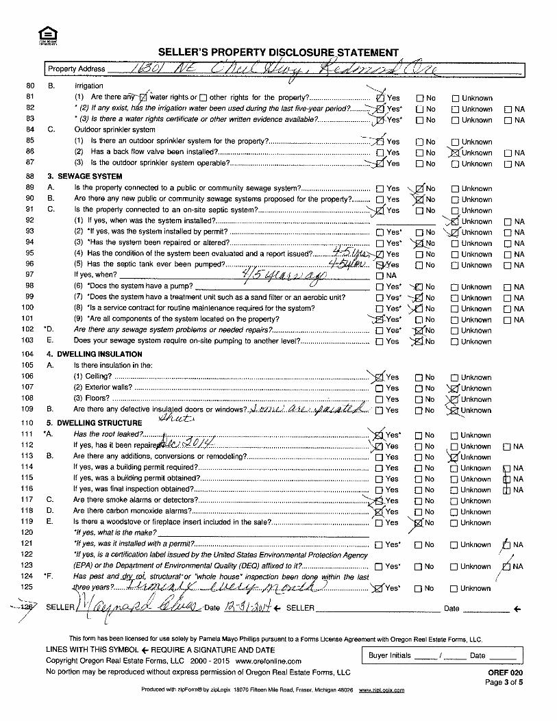
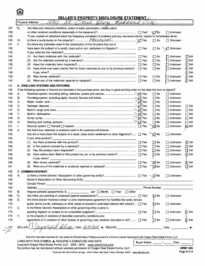
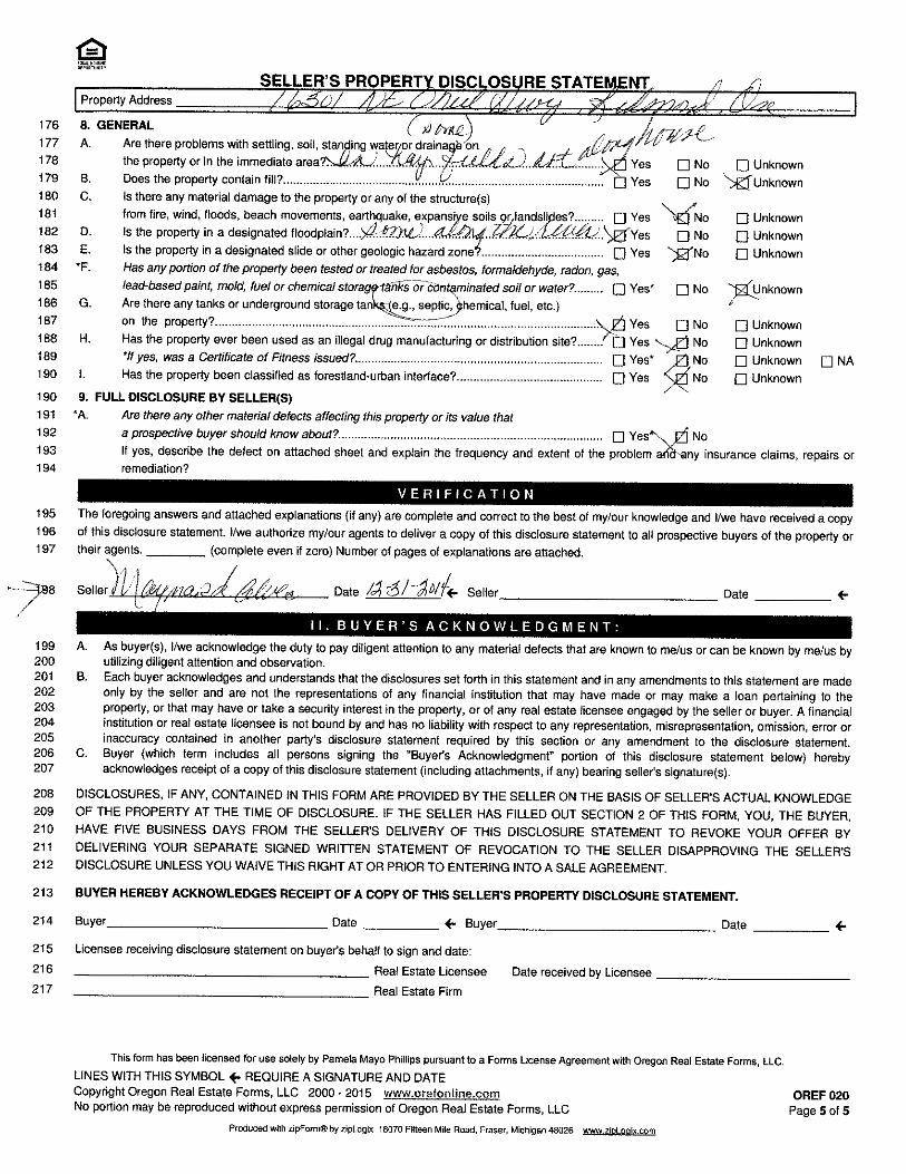
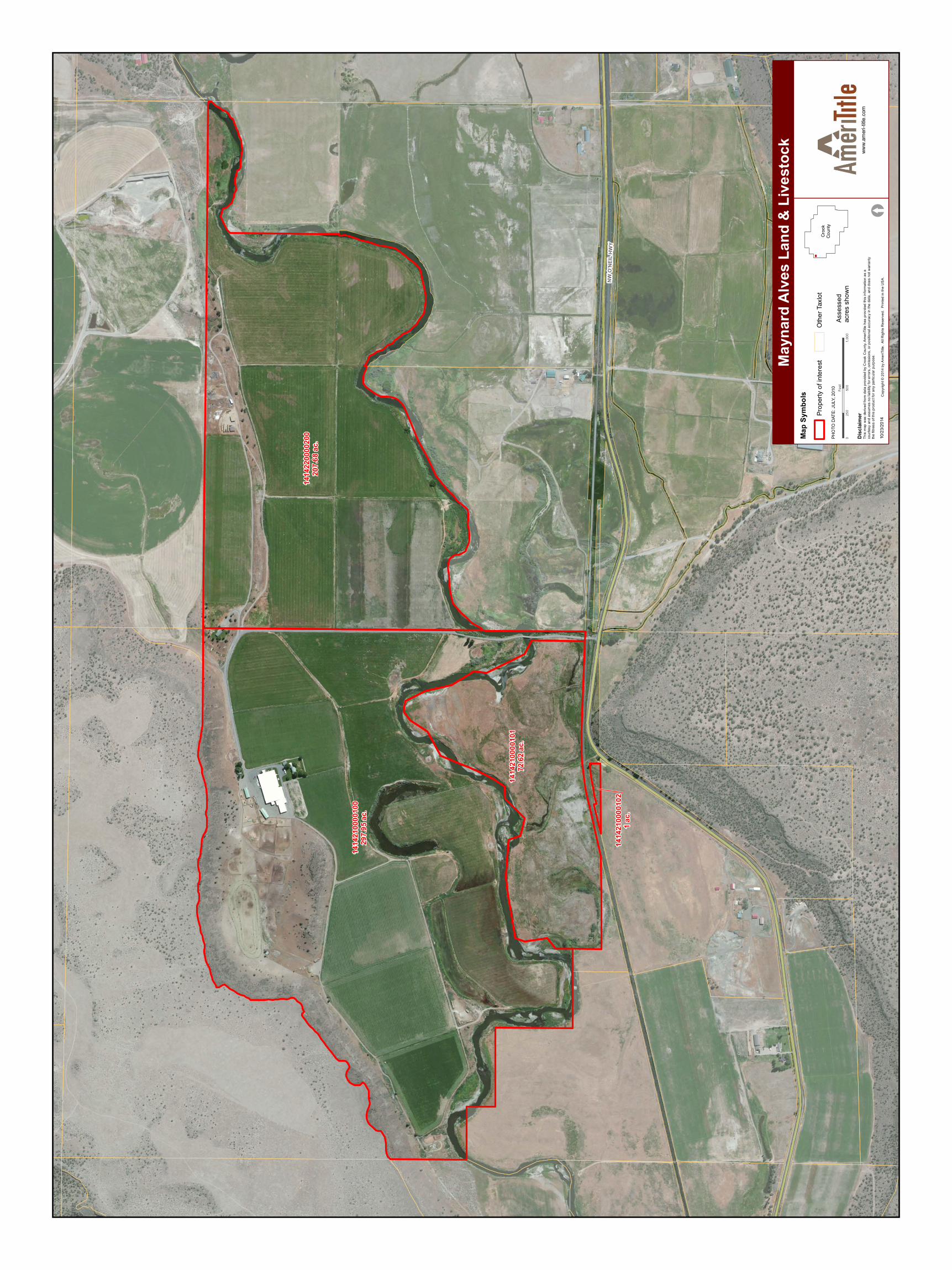
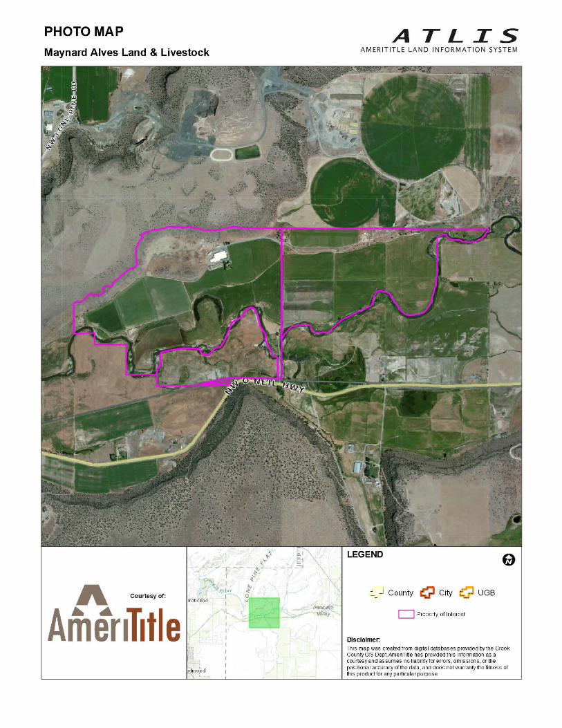
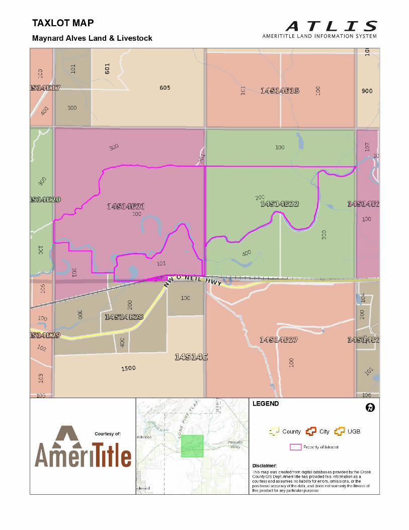
Tom McCall River Ranch ~ Redmond, OR Address: 16301 NE Oneil Highway Redmond, OR 97756
Tax Map: 141421 Tax Lot: 00100, 00101, 00102 Tax Map 141422 TL 00200
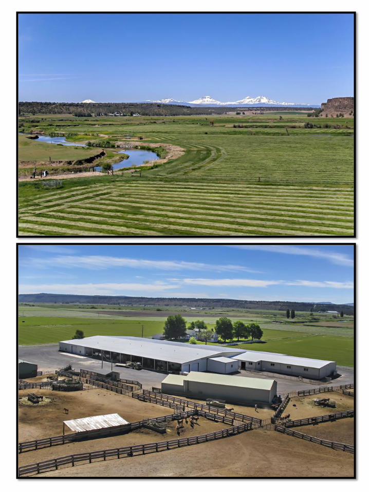
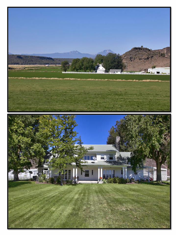
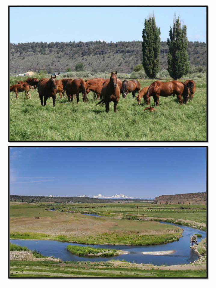
Property: • 579.71 acres – Crooked River runs through the heart of the ranch. • 461 acres of irrigation water rights. Property Irrigated with with flood, gated pipe and
wheel lines. • Crops Currently Planted are: Approximately 100 acres of Alfalfa Hay (4 cuttings/year). 361
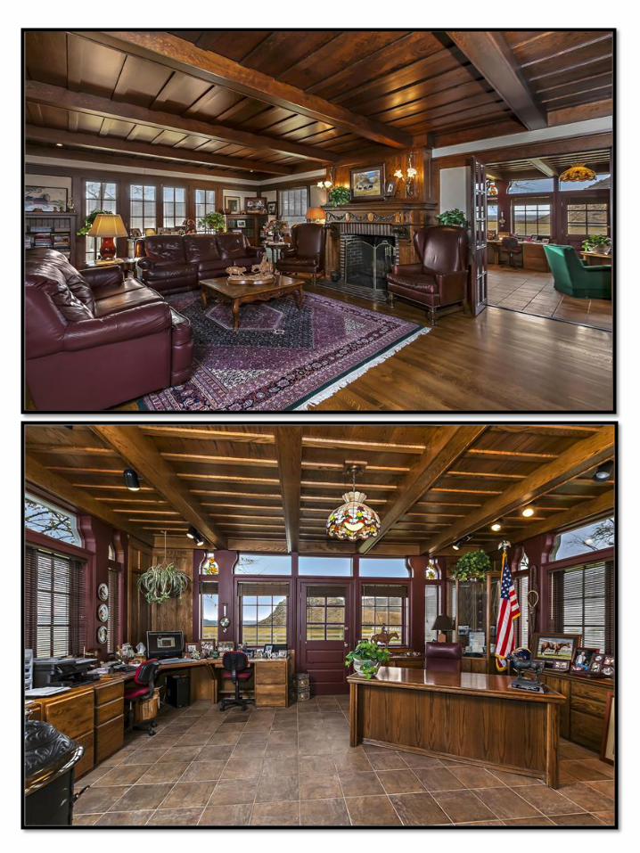
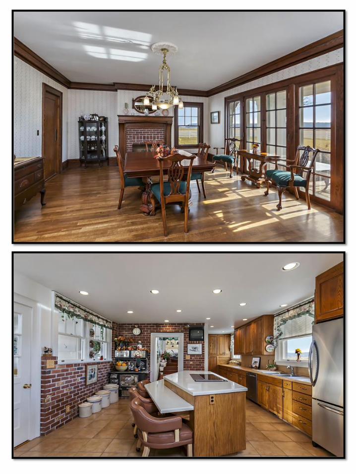
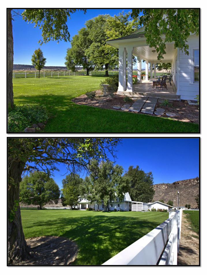
acres of grass hay and pasture. • Prime farm ground with quality top soils. Fields are laser leveled. • Cascade Mountain and Smith Rock Views. Improvements: • Beautifully restored Historic Home of Governor Tom McCall 6168 sf 4 bedroom, 4 bath. • Home Features: Modern Kitchen with stainless steel appliances, butlers pantry, formal
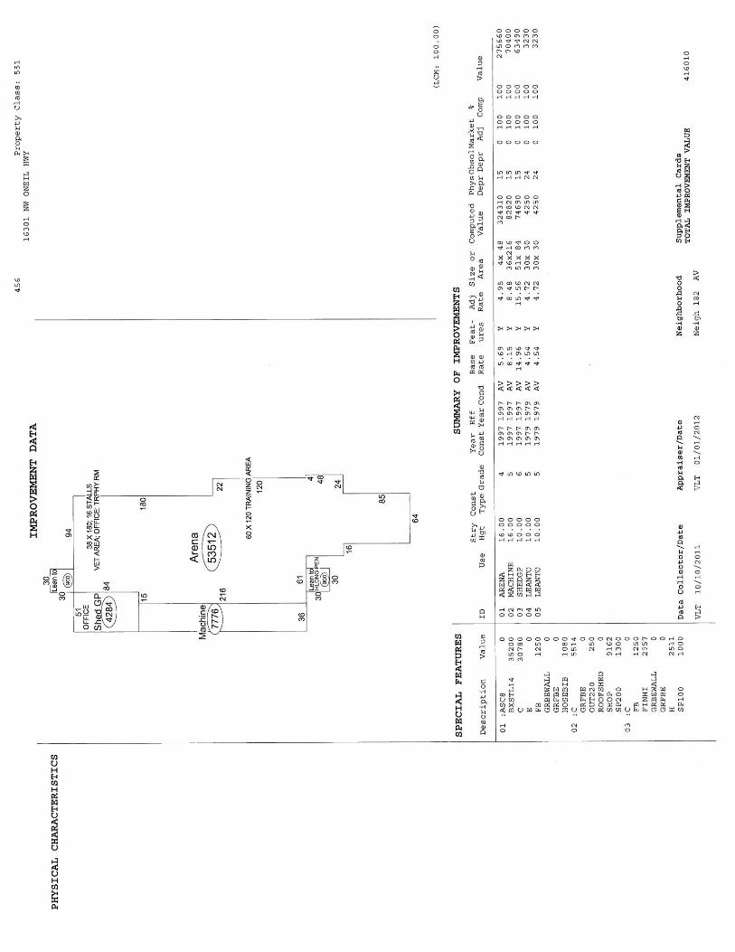
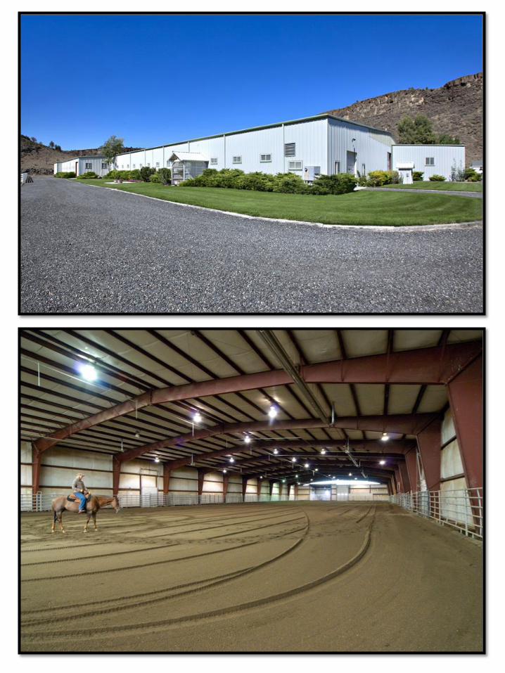
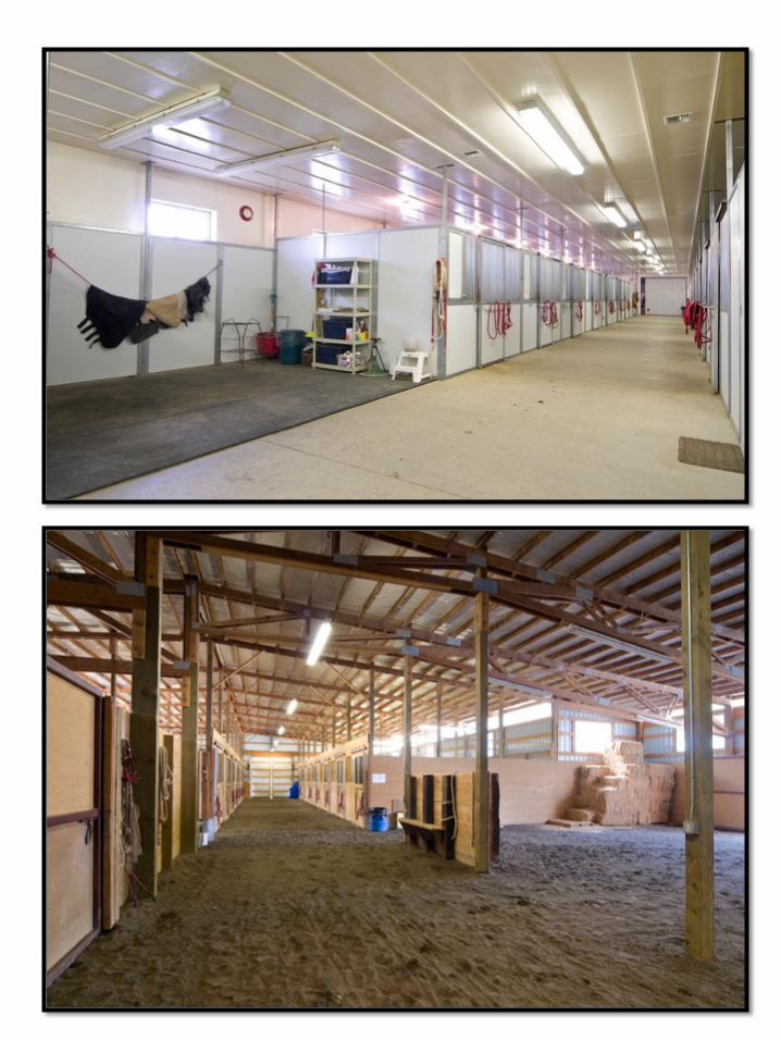
dining room, 5 wood fireplaces, Oak floors, master suite, screened porch and formal office. • Indoor Arena: 100x300 indoor arena with lightning-would make a great cattle facility. • Horse Show Barn-16 stalls with automatic waters, 2 tack rooms, saddle shop, offices, full
utility room with washer/dryer, bathroom, feed room, grooming area, and vet room. • Additional Barn (attached to indoor and show barn)-14 stalls with automatic waters, 2
round pens, breeding facility. • Two Shops • Equipment storage • Scales, Corrals and Feedlot that is designed for efficiency and has good drainage. • Additional Homes:
• Frame home at Barnyard – 2 bedroom, 1 bath • Frame home on the Hill- 3 bedroom, 2 bath • Apartment attached to Barn - 2 bed, 1 bath (not permitted as legal dwelling with
county Irrigation: 461 acres of Crooked River and Well Irrigation water rights. Water Rights are Free - No Annual/Yearly assessment. Domestic Water: Wells Utilities: CEC Central Electric Coop Zoning: EFU Taxes: $17,563.46. Tax Year 2016 Price: $5,500,000. www.tommcallriverranch-centraloregon.com Shown By Appointment Only, Listing Agent Must be Present MLS 201607141
NW
O'N
EIL
HW
Y14
1421
0000
102
1 ac
.
1414
2100
0010
029
7.95
ac.
1414
2100
0010
172
.62
ac.
1414
2200
0020
020
7.68
ac.
Dis
clai
mer
This
map
was
der
ived
from
dat
a pr
ovid
ed b
y C
rook
Cou
nty.
Am
eriT
itle
has
prov
ided
this
info
rmat
ion
as a
co
urte
sy a
nd a
ssum
es n
o lia
bilit
y fo
r err
ors,
om
issi
ons,
or p
ositi
onal
acc
urac
y in
the
data
, and
doe
s no
t war
rant
y th
e fit
ness
of t
his
prod
uct f
or a
ny p
artic
ular
pur
pose
.
10/2
3/20
14[
050
01,
000
250
Feet
Cop
yrig
ht ©
201
4 by
Am
eriT
itle.
All
Rig
hts
Res
erve
d. P
rinte
d in
the
US
A.
May
nard
Alv
es L
and
& L
ives
tock
Map
Sym
bols
Prop
erty
of i
nter
est
Oth
er T
axlo
t
ww
w.a
mer
i-titl
e.co
m
PHO
TO D
ATE:
JU
LY, 2
010
Serv
ice
Laye
r Cre
dits
: Sou
rce:
Esr
i,D
igita
lGlo
be, G
eoEy
e, i-
cube
d, E
arth
star
Geo
grap
hics
, CN
ES
/Airb
us D
S, U
SDA
,U
SGS,
AE
X, G
etm
appi
ng, A
erog
rid, I
GN
, IG
P,
Asse
ssed
acre
s sh
own
Crook
County
2122
4040
33 30
21.5
5
13
3
2.7
2
1.2
30 (S
)
22.8
(S)
19.5
(S)
6.4
(S)
1430
20
10.7
5.3
40
2020
3.6
4040
39
30
30
38.2
28.2
22.8
30.2
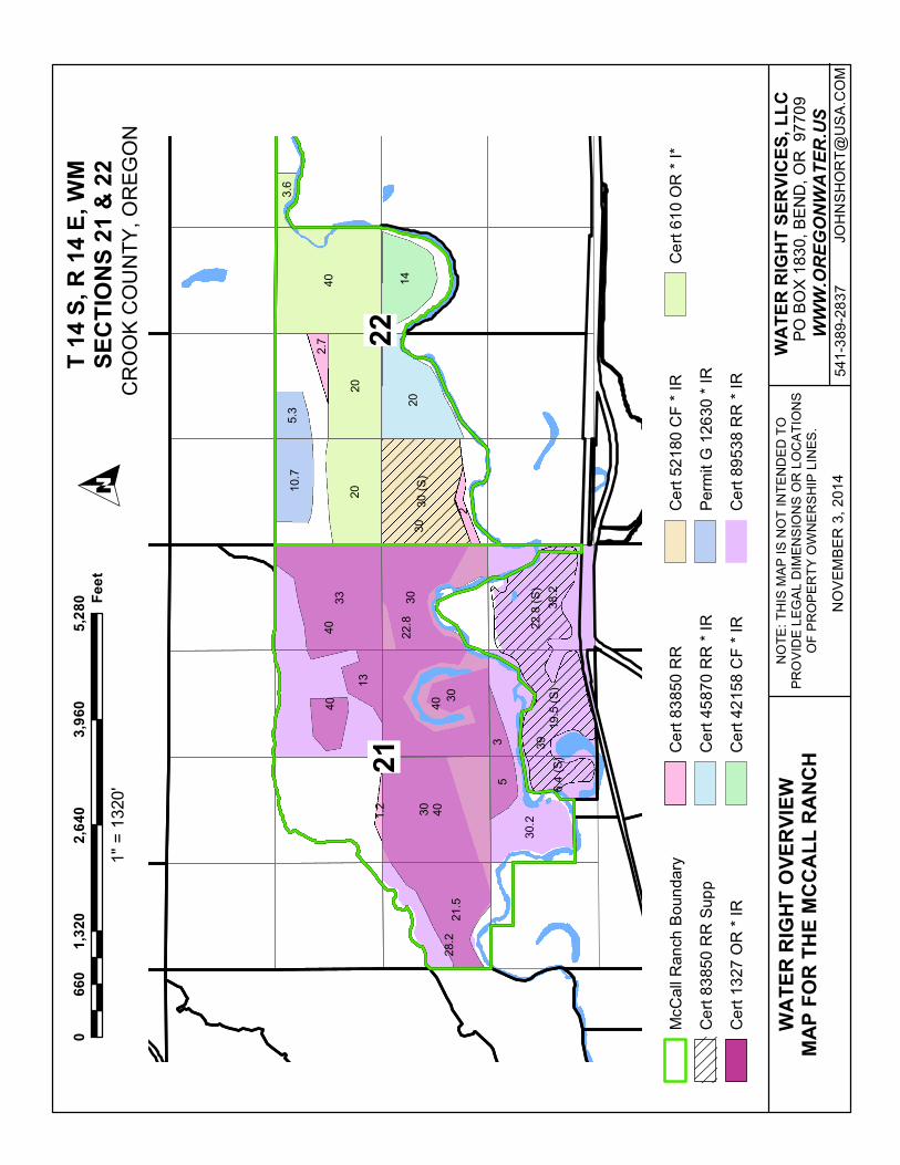
McC
all R
anch
Bou
ndar
y
Cer
t 838
50 R
R S
upp
Cer
t 132
7 O
R *
IR
Cer
t 838
50 R
R
Cer
t 458
70 R
R *
IR
Cer
t 421
58 C
F * I
R
Cer
t 521
80 C
F * I
R
Perm
it G
126
30 *
IR
Cer
t 895
38 R
R *
IR
Cer
t 610
OR
* I*
WA
TER
RIG
HT O
VER
VIEW
MAP
FO
R T
HE
MC
CA
LL R
AN
CH
OC
RO
OK
CO
UN
TY, O
REG
ON
01,
320
2,64
03,
960
5,28
066
0Fe
et
NO
VE
MB
ER
3, 2
014
1" =
132
0'
PO B
OX
1830
, BEN
D, O
R 9
7709
WA
TER
RIG
HT
SER
VIC
ES, L
LC
WWW.OREGONWATER.US
JOH
NS
HO
RT@
US
A.C
OM
NO
TE: T
HIS
MAP
IS N
OT
INTE
ND
ED T
OPR
OVI
DE
LEG
AL D
IMEN
SIO
NS
OR
LO
CAT
ION
SO
F PR
OPE
RTY
OW
NER
SHIP
LIN
ES.
541-
389-
2837
T 14
S, R
14
E, W
MSE
CTI
ON
S 21
& 2
2
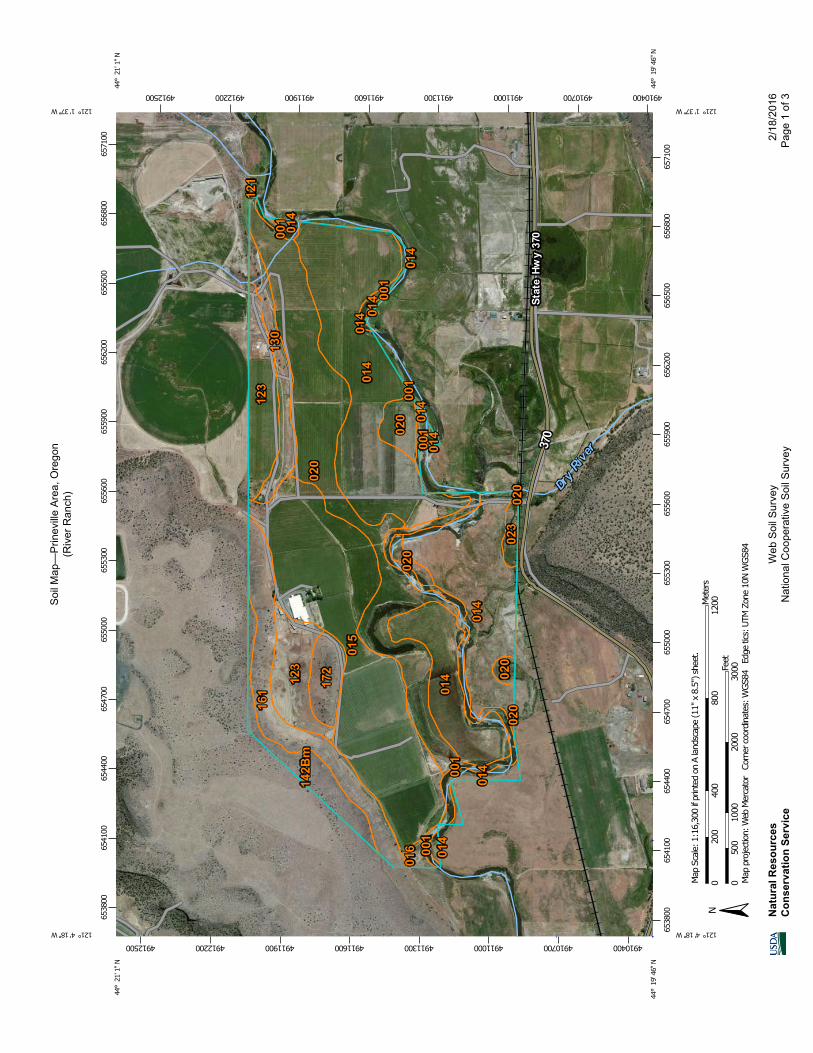
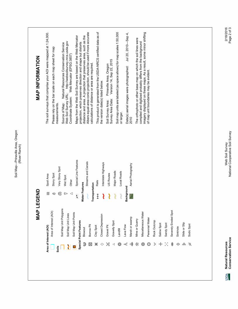
Soi
l Map
—P
rinev
ille
Are
a, O
rego
n(R
iver
Ran
ch)
Nat
ural
Res
ourc
esC
onse
rvat
ion
Serv
ice
Web
Soi
l Sur
vey
Nat
iona
l Coo
pera
tive
Soi
l Sur
vey
2/18
/201
6P
age
1 of
3
49104004910700491100049113004911600491190049122004912500
49104004910700491100049113004911600491190049122004912500
6538
0065
4100
6544
0065
4700
6550
0065
5300
6556
0065
5900
6562
0065
6500
6568
0065
7100
6538
0065
4100
6544
0065
4700
6550
0065
5300
6556
0065
5900
6562
0065
6500
6568
0065
7100
44° 2
1' 1
'' N121° 4' 18'' W
44° 2
1' 1
'' N
121° 1' 37'' W
44° 1
9' 4
6'' N
121° 4' 18'' W
44° 1
9' 4
6'' N
121° 1' 37'' W
N
Map
pro
ject
ion:
Web
Mer
cato
r C
orne
r coo
rdin
ates
: WGS
84
Edge
tics
: UTM
Zon
e 10
N W
GS84
050
010
0020
0030
00Feet
020
040
080
012
00Met
ers
Map
Sca
le: 1
:16,
300
if pr
inte
d on
A la
ndsc
ape
(11"
x 8
.5")
shee
t.
MA
P LE
GEN
DM
AP
INFO
RM
ATI
ON
Are
a of
Inte
rest
(AO
I)A
rea
of In
tere
st (A
OI)
Soils
Soi
l Map
Uni
t Pol
ygon
s
Soi
l Map
Uni
t Lin
es
Soi
l Map
Uni
t Poi
nts
Spec
ial P
oint
Fea
ture
sB
low
out
Bor
row
Pit
Cla
y S
pot
Clo
sed
Dep
ress
ion
Gra
vel P
it
Gra
velly
Spo
t
Land
fill
Lava
Flo
w
Mar
sh o
r sw
amp
Min
e or
Qua
rry
Mis
cella
neou
s W
ater
Per
enni
al W
ater
Roc
k O
utcr
op
Sal
ine
Spo
t
San
dy S
pot
Sev
erel
y E
rode
d S
pot
Sin
khol
e
Slid
e or
Slip
Sod
ic S
pot
Spo
il A
rea
Sto
ny S
pot
Ver
y S
tony
Spo
t
Wet
Spo
t
Oth
er
Spe
cial
Lin
e Fe
atur
es
Wat
er F
eatu
res
Stre
ams
and
Can
als
Tran
spor
tatio
nR
ails
Inte
rsta
te H
ighw
ays
US
Rou
tes
Maj
or R
oads
Loca
l Roa
ds
Bac
kgro
und A
eria
l Pho
togr
aphy
The
soil
surv
eys
that
com
pris
e yo
ur A
OI w
ere
map
ped
at 1
:24,
000.
Ple
ase
rely
on
the
bar s
cale
on
each
map
she
et fo
r map
mea
sure
men
ts.
Sou
rce
of M
ap:
Nat
ural
Res
ourc
es C
onse
rvat
ion
Ser
vice
Web
Soi
l Sur
vey
UR
L:
http
://w
ebso
ilsur
vey.
nrcs
.usd
a.go
vC
oord
inat
e S
yste
m:
Web
Mer
cato
r (E
PS
G:3
857)
Map
s fro
m th
e W
eb S
oil S
urve
y ar
e ba
sed
on th
e W
eb M
erca
tor
proj
ectio
n, w
hich
pre
serv
es d
irect
ion
and
shap
e bu
t dis
torts
dist
ance
and
are
a. A
pro
ject
ion
that
pre
serv
es a
rea,
suc
h as
the
Alb
ers
equa
l-are
a co
nic
proj
ectio
n, s
houl
d be
use
d if
mor
e ac
cura
teca
lcul
atio
ns o
f dis
tanc
e or
are
a ar
e re
quire
d.
This
pro
duct
is g
ener
ated
from
the
US
DA
-NR
CS
cer
tifie
d da
ta a
s of
the
vers
ion
date
(s) l
iste
d be
low
.
Soi
l Sur
vey
Are
a:
Prin
evill
e A
rea,
Ore
gon
Sur
vey
Are
a D
ata:
V
ersi
on 1
4, S
ep 2
2, 2
015
Soi
l map
uni
ts a
re la
bele
d (a
s sp
ace
allo
ws)
for m
ap s
cale
s 1:
50,0
00or
larg
er.
Dat
e(s)
aer
ial i
mag
es w
ere
phot
ogra
phed
: J
ul 2
0, 2
010—
Sep
4,
2010
The
orth
opho
to o
r oth
er b
ase
map
on
whi
ch th
e so
il lin
es w
ere
com
pile
d an
d di
gitiz
ed p
roba
bly
diffe
rs fr
om th
e ba
ckgr
ound
imag
ery
disp
laye
d on
thes
e m
aps.
As
a re
sult,
som
e m
inor
shi
fting
of m
ap u
nit b
ound
arie
s m
ay b
e ev
iden
t.
Soi
l Map
—P
rinev
ille
Are
a, O
rego
n(R
iver
Ran
ch)
Nat
ural
Res
ourc
esC
onse
rvat
ion
Serv
ice
Web
Soi
l Sur
vey
Nat
iona
l Coo
pera
tive
Soi
l Sur
vey
2/18
/201
6P
age
2 of
3
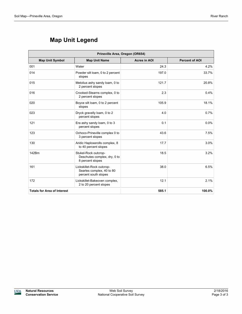
Map Unit Legend
Prineville Area, Oregon (OR654)
Map Unit Symbol Map Unit Name Acres in AOI Percent of AOI
001 Water 24.3 4.2%
014 Powder silt loam, 0 to 2 percentslopes
197.0 33.7%
015 Metolius ashy sandy loam, 0 to2 percent slopes
121.7 20.8%
016 Crooked-Stearns complex, 0 to2 percent slopes
2.3 0.4%
020 Boyce silt loam, 0 to 2 percentslopes
105.9 18.1%
023 Dryck gravelly loam, 0 to 2percent slopes
4.0 0.7%
121 Era ashy sandy loam, 0 to 3percent slopes
0.1 0.0%
123 Ochoco-Prineville complex 0 to3 percent slopes
43.6 7.5%
130 Aridic Haploxerolls complex, 8to 40 percent slopes
17.7 3.0%
142Bm Stukel-Rock outcrop-Deschutes complex, dry, 0 to8 percent slopes
18.5 3.2%
161 Lickskillet-Rock outcrop-Searles complex, 40 to 80percent south slopes
38.0 6.5%
172 Lickskillet-Bakeoven complex,2 to 20 percent slopes
12.1 2.1%
Totals for Area of Interest 585.1 100.0%
Soil Map—Prineville Area, Oregon River Ranch
Natural ResourcesConservation Service
Web Soil SurveyNational Cooperative Soil Survey
2/18/2016Page 3 of 3
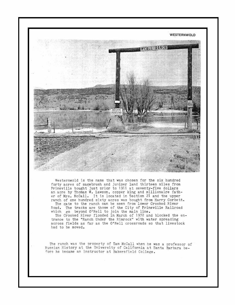
The McCall Family
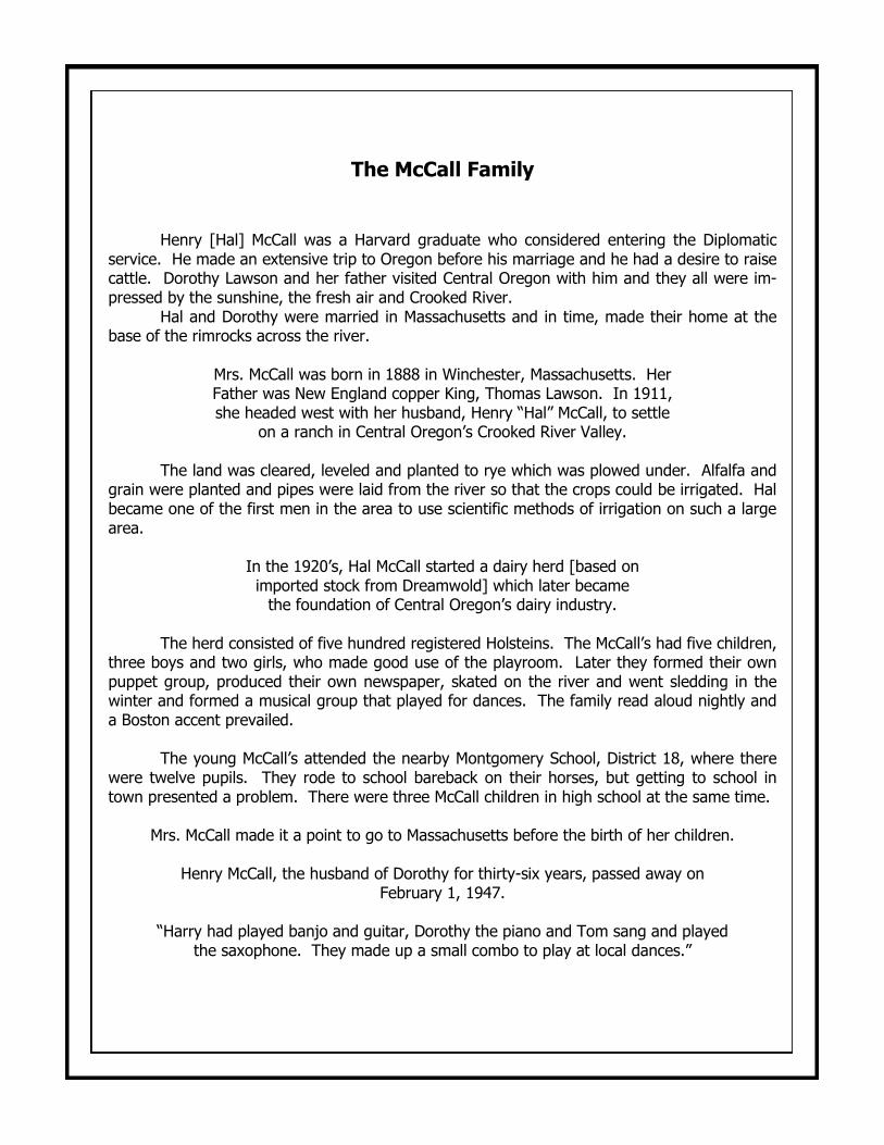
Henry [Hal] McCall was a Harvard graduate who considered entering the Diplomatic service. He made an extensive trip to Oregon before his marriage and he had a desire to raise cattle. Dorothy Lawson and her father visited Central Oregon with him and they all were im-pressed by the sunshine, the fresh air and Crooked River. Hal and Dorothy were married in Massachusetts and in time, made their home at the base of the rimrocks across the river.
Mrs. McCall was born in 1888 in Winchester, Massachusetts. Her Father was New England copper King, Thomas Lawson. In 1911, she headed west with her husband, Henry “Hal” McCall, to settle
on a ranch in Central Oregon’s Crooked River Valley.
The land was cleared, leveled and planted to rye which was plowed under. Alfalfa and grain were planted and pipes were laid from the river so that the crops could be irrigated. Hal became one of the first men in the area to use scientific methods of irrigation on such a large area.
In the 1920’s, Hal McCall started a dairy herd [based on imported stock from Dreamwold] which later became the foundation of Central Oregon’s dairy industry.
The herd consisted of five hundred registered Holsteins. The McCall’s had five children, three boys and two girls, who made good use of the playroom. Later they formed their own puppet group, produced their own newspaper, skated on the river and went sledding in the winter and formed a musical group that played for dances. The family read aloud nightly and a Boston accent prevailed. The young McCall’s attended the nearby Montgomery School, District 18, where there were twelve pupils. They rode to school bareback on their horses, but getting to school in town presented a problem. There were three McCall children in high school at the same time.
Mrs. McCall made it a point to go to Massachusetts before the birth of her children.
Henry McCall, the husband of Dorothy for thirty-six years, passed away on February 1, 1947.
“Harry had played banjo and guitar, Dorothy the piano and Tom sang and played
the saxophone. They made up a small combo to play at local dances.”
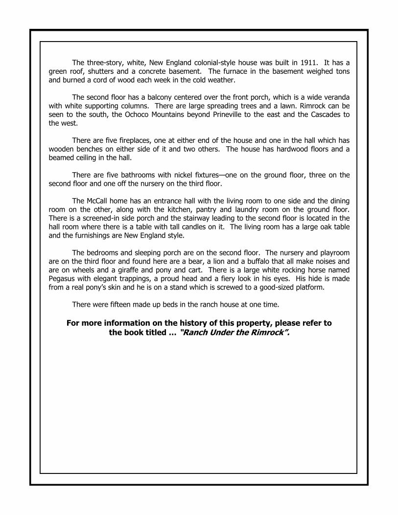
The three-story, white, New England colonial-style house was built in 1911. It has a green roof, shutters and a concrete basement. The furnace in the basement weighed tons and burned a cord of wood each week in the cold weather. The second floor has a balcony centered over the front porch, which is a wide veranda with white supporting columns. There are large spreading trees and a lawn. Rimrock can be seen to the south, the Ochoco Mountains beyond Prineville to the east and the Cascades to the west. There are five fireplaces, one at either end of the house and one in the hall which has wooden benches on either side of it and two others. The house has hardwood floors and a beamed ceiling in the hall. There are five bathrooms with nickel fixtures—one on the ground floor, three on the second floor and one off the nursery on the third floor. The McCall home has an entrance hall with the living room to one side and the dining room on the other, along with the kitchen, pantry and laundry room on the ground floor. There is a screened-in side porch and the stairway leading to the second floor is located in the hall room where there is a table with tall candles on it. The living room has a large oak table and the furnishings are New England style. The bedrooms and sleeping porch are on the second floor. The nursery and playroom are on the third floor and found here are a bear, a lion and a buffalo that all make noises and are on wheels and a giraffe and pony and cart. There is a large white rocking horse named Pegasus with elegant trappings, a proud head and a fiery look in his eyes. His hide is made from a real pony’s skin and he is on a stand which is screwed to a good-sized platform. There were fifteen made up beds in the ranch house at one time.
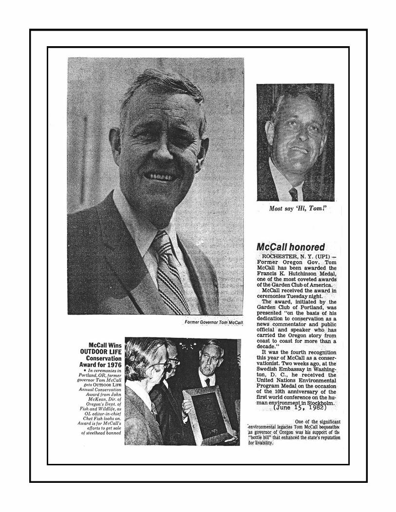
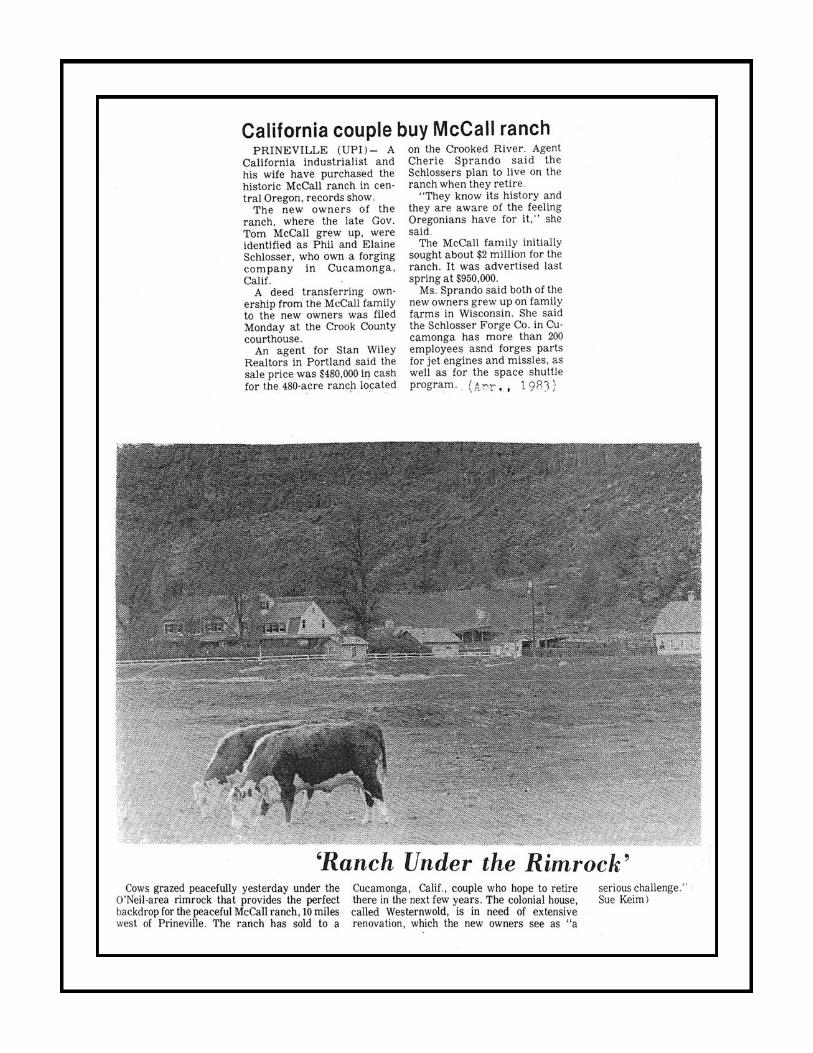
For more information on the history of this property, please refer to the book titled … “Ranch Under the Rimrock”.