scanned from original by isric - world soil information
TRANSCRIPT

Scanned from original by ISRIC - World Soil Information, as ICSU World Data Centre for Soils. The purpose is to make a safe depository for endangered documents and to make the accrued information available for consultation, following Fair Use Guidelines. Every effort is taken to respect Copyright of the materials within the archives where the identification of the Copyright holder is clear and, where feasible, to contact the originators. For questions please contact [email protected] indicating the item reference number concerned.
SOIL EXCURSION IN THE VICINITY OF WAGENINGEN
i .J, '0
Sandy District p. 1 - 9 Fluviatile Area p. 10 - 14

HOLOCENE
fine sand (coastal and inland dunes)
@~~~~~~~1 predominantly Joamy material (marine)
mmmmrnm::::::1 fine sand (mariiie)
l l l l l l l l l l l l l l 1oamy and clayey material (fluviatile)
peat (partlY covered with marine
or fluviatile sediment< 40 cm)
PLEISTOCENE
~ silt and silt loam (loess)
BELGIUM
FED. REP. OF
GERMANY
0 10
l·:·:-:·:·:·:·:·:·:·:·:-::j fine and loamy fine sand :;::::;:;::::;:;:;::::;:; (predominantly cover sand)
!·~:·.·.·.·.·~:·:·~~::· ditto overlying loamy material .~f~:~:~:lfü:3 (ditto overlying glacial till)
1
• • · • · • '/ sand and coarse sand, aften gravellv ....... • • • • • • • (fluviatile preglacial and fluvioglacial)
40km
••••••• southern boundary of the Saaie ice sheet
OLDER FORMATIONS
(PREDOMINANTLY CRETACEOUS)
l! ! ! ! ! il predominantly loamy ma~erial
Fig. l ... Parent material and surf ace geology in the N etherlands. In Belgium and in the Federal Republic of Germany only the loess is indicated. ( :Vll:h~ku1 <5 70J) .

Southern Flevoland
2 4 6 %Km 1--....L--..i-' -....L---ft
B:Zf5j
[i:{tt<I
~
Dunes of Early Dryas age in the low cover sand area
High cove~ sa~d area of Late dryas age
Ice-pushed ridges
Recent inland dunes
BoundaT.y of the sandy area and the marine deposits of the former Zuiderzee
Fig. 2 Geomorphological conditions of the "Gelderse Vallei"
( ç +-; ~D /( il- \

~I
ice-pushed ridges
fluvio(peri)glacial de pos its
~ ~
D ~
Fig. 1. Physiographic map.
area
pleistocene aeolian sands (cover sand)
holocene aeolian sands (drift- sand)
river clay
2 km
peat
plaggen soils
built -up area
meters above sea level

MAN-MADE SOILS IN THE PLEISTOCENE SANDY LANDSCAPE.
Introduction
Plaggen soils are man-made soils, which have been gradually raised by the addition of material by agricultural practice.
Plaggen soils are restricted to part of the (peri)glacially influenced landscapes of the Netherlands, Belgium and Western Germany and mainly occur in areas with fluvio(peri)glacial sands and cover sands. Though similar landscape conditions exist in Denmark, Eastern Germany and Poland, plaggen soils are not known to occur there. It is assumed that the agricultural practice which led to these soils was restricted to the German tribe of the Saxons and partly to the Franks, and that the Frisians, the Scandinavians and the Slavs did not use this practice (De Bakker, 1979).
One third of the Netherlands consists of glacially influenced landscapes with plaggen soils in many loc.ations.
The aim of this excursion is to gain inslght into the origin and properties of the plaggen soils, by description and demonstration of the human use of the sandy landscape and of the consequences of this type of landuse for the character of the landscape and the soil conditions.
Description of the excursion area
Geology ) The area to be visited was mainly formed by Saalian glacial l ?~;e 1 7
erosion and deposition and modified under Weichselian periglacial conditions. During the Saalian the Scandinavian ice-sheet reached the Netherlands. At its margin the ice-sheet was split up into a number of distinct lobes. These tongues of ice exerted great pressure on the valley sides, contorting and pushing up earlier loamy, sandy and gravelly Rhine and Meuse deposits into a series of ice pushed ridges. These ridges mark the limit reached by the ice-sheet and outline the position of the main ice . .:lobes. r-.:.- ·:
The ridges are a prominent element in the landscape of the southern Veluwe. Near Ede their elevation is about 50 meters above sea level, elsewhere on the Veluwe they are up to 110 meter high . On its flanks and between the ridges gently sloping mainly gravelly and sandy glacial outwash (sandr) was laid down.
During the Weichselian the ice-front did not reach the Netherlands, but periglacial conditions prevailed. The subsoil was permanently frozen. In the brief summers a shallow surface layer thawed out and gelifluction occurred on the slopes. Downwards ~ercolation of the melt water being prevented, the water collected into small streams and. rivulets, which carved out valleys. The poorly-sorted sediments thus formed are called fluvioperiglacial deposits.
The upper soil layers- were thouroug~ly mi:r-ed by r:peated freezing and thawing (cryoturbation) and by gel1fluct1on. Relicts of the Eemian soil formation were largely obscured.
In the course of the Weichselian the area became an arctic desert with strong westerly winds. The finer soil particles, not hold in place by the scanty vegetation, were blown far afield and were deposited over large areas. Such aeolian sandy deposits are called cover sand. The older cover sands are laminated and slightly loamy.

They were laid down as a gently undulating sheet over much of the country. The younger cover sands are notably coarser and have a very low heavy-mineral content.
These younger cover sands generally occur at the surface in the Guelders Valley (Gelderse Vallei) and also locally in sheltered places on the Veluwe.
During the Holocene, in the excursion area geological processes were restricted to the formation of local drift - sands (inland-dunes) as a result of clearing the woods and destructing the vegetation by man. -=tJ:te--s-equenc_g_~:~.:cgeological events is -given in .Table L · The ex
cursion area, De G{nl<el;- · :i:s - enclo..2_~~by two iCe-pushed ridges, as is shown in Fig. 'l. The_.fluviopertglacfal deposits are covered by younger ~sand·.s:-lkstwards fluvioperiglacial deposits occur at the-surf ace.
Human influence on the landscape Plaggen soils have developed in the Pleistocene sandy area of
the Netherlands as the result of a typical system of agricultural practice, using "pot" - stables. This system was used for centuries until the introduction of industrial fertilizers.
The pot-stable system dates from the Middle Ages. The sandy soils had to be manured for greater productivity. Because these soils are too poor to recover by just a fallow period a management system has been developed in which as much manure was gathered as possible. Therefore the livestock - bath cattle and sheep - were stabled at night to restrict manure losses. Because sheep pr oduce mor e dung than cattle, few cattle was kept to supply only the household needs. A great amount of litter and earth was used in the stables to absorb the liquid components of the manure in such a way that a tolerable bedding for the animals could be obtained.
The dung-impregnated bedding of the stables was used to manure the arable land. The mineral part in this manure stayed behind after decomposition of the organic matter. As a consequence the arable fields were gradually raised, changing podzol soils into plaggen soils.
The plaggen soils lie in a typical pattern in the landscape: in this area on the fringes of the ice-pushed ridges, as is shown in Fig. 1. The settlers had specific needs which were based on selfsufficiency and preferred sites with the following qualifications : - good drainage conditions for arable land - sufficient moisture supply for pasture - availability of drinking water - adequate fertility level Therefore settlements are found at the transition from (topographi cally and hydrologically) higher to lower parts. Thus the slopes of the gently undulating area could be used for arable land, the wet soils were used for grazing of the livestock and for making hay and the dry sites were used for collection of litter and fuel.
The litter used was heather sods, grass sods, forest litter, peat and sand. Most of it carne from range land on which the livestock also grazed. The continuous removal of organic matter from the range lands caused a decline in fertility and the original forest vegetation impoverished to heath. Therefore heath sods were increasingly used. The sods were cut with special implements. They were 25-30 cm square and about 3 cm thick. Though the sods were cut as thin as possible, some sand was inevitable taken along, often derived from the E-horizon of the podzol soils. High heather was burned before being used as sods. It is possible that much of the charcoal in the plaggen epipedon emanates from this process.

Normally the heath sods were cut once every 5-8 years. In those places where they were cut deeply, intervals were 12-15 years. Also use was made of grass sods. These had less favourable moistureabsorbing properties than heath sods, but sometimes they contained more nutritional compononents, supplied by ground water and flood water. In wooded areas forest litter was important for use in the stables. If "Sphagnum" peat was available, sods of young peat were used on a wide scale, due to the favourable moisture absorption capacity. Although not an absorbing organic material, sand was also used in the stable, sometimes in large quantities.
For a farmer it was necessary to have a large area of range land at his disposal. It has been calculated that a farm with 4 hectares of arable land had to have about 3 ha of heath land at its disposal each year. With an average recovery time of 10 years, 30 ha of heath lanq were thus necessary to keep the farm going (Pape,1970).
Through the increasing population ever more range land was cultivated and an increasing amount of sods had to come from a decreasing area. This led to a degradation of the heather vegetation and the sandy soil started to drift. This wind erosion started already in the Middles Ages and soon there were some government regulations for prevention, i.e. it was forbidden to let sheep graze on soils which were freshly desodded. In the 17th century afforestation was started already. However, the regulations did not help much. Around 1850 about 10 % of the range land in the centre of The Netherlands had turned into drift-sand. It took till
the 20th century until all sand-movements were controlled. At the beginning of this century industrial fertilizers were
introduced in the Netherlands, which led to the gradual disappea rance of the pot-stable system. Therefore the sheep were not longer necessary for producing manure. The heather fields in this area, however, were not cultivated, because they were used for military purposes. Nowadays, periodically sod-cutting is necessary to maintain the heather vegetation.
Continuously practising the pot-stable system (about 8 centuries) introduced typical elements in the landscape. The arable land is elevated with respect to its surroundings by 40-100 cm. It was separated from the range lands by a thick harrier of oak coppice, with deep ditches on either side to protect the crops against the game and the roaming livestock. V :-': -: ·:., ~: : G : · \ J
Area within which Plaggen soils are f ound
from: J.C . Pape Geoderma, 4 (1970)

Table 1. Chronostratigraphy of the central and eastern part of the Netherlands.
Yea rs B. p.
LIJ
z LIJ
u 0 ....J
0 I
Epoch
Subatlantic
Subboreal
Atlantic
Bo real
Preboreal 1 0.0 0 0 +---+----.---.-----------!
Late Dryas Stad.
LIJ ~ Aller-d Interst.
Q) Early Dryas Stad. z ~ 1--~~~~~~~-1
c: _J B-lling Interstad.
1 2.0 0 0 LIJ
u Q)
Pleniglacial Vl
..c:
0 u
6 0.0 0 0
Early Glacial
9 0.0 0 0
LIJ
Eemian ....J
125.0 0 0
Saalian
Inferred mean July temp. (°C)
0 5 10 15 20
Table ,l.: CLASSIFICATION OF THE LATER PLEISTOCENE AND CONVENTIONAL CORRELATIONS* (after WEST, 1977 and MITCHELL et al.1973) .
Glaciation(G) .
Lithostratigraphy and genesis
local formation of drift-sands
peat growth
fluvial deposits along the rivers
Younger Cover Sand II
local peat growth soil formation
Younger Cover sand
weak soil formation
Old Cover Sand I + II
cryoturbation
gel ifluction
meltwater deposits,mainly sand alternating with loam and/or peat layers (fluvioperiglacial deposits)
sandy deposits, mainly aeolian
peat growth
marine and terrestric deposits in valleys
formation of ice-pushed ridges
~lacial outwash deposits (fluvioglacial deposits)
Interglacial(I) BRITAIN N.W.EUROPE ALPS NORTH AMERICA
G Devensian \·/eichsel ~IÜrm Wisconsin
Ipswichian Ecmian Riss/WÜrm Sangamon
G lfols tonian Saale Riss Illinoian
Hoxnian Holstein Mindel/Riss Yarmouth
G Anglian Elster Mindel Kans an
Cromerian Cromerian Gllnz/Mindel Aftonian
G Beestonian Menapian Il
Gunz Nebraskan
/~. l ' .;;__!._

a
~b el evat:ion
in m
E :J Ul
"' "' Utrechtse Heuvelrug
80
60
40
20
c c :J
CD _; ice-pushed ridge
NAP
20
40
60 0 1 2 4 km
[(?11 ~ pregl acial deposits
1 ----1 ice- pushed formations
1 1 boulder cl ay
\< · "1 fluvioglacial deposits
l: ~::::: :: J sandur ~eposits
~ ~
:;:; : \@~b.-===~~-·.:·:·:::;:;:;:;:;:;:;:;::;:::;:::::::::::::;:;::::
··· ····· · ·········,.;-::::;:··-:·.· ·-;.;.;.· ... · ..
a map
b cross section
!!!4ij ice sheet
§ me l ting water
[Tiill ice-pushed deposits
[Jj] sandur
~ ~ ---.. Eemian deposits
1:·-···.</] [2ZJ2]
cove~ sands
holoce ne river sa nds
m• holocene river clays
y .v v peat
f :::;:;:::=:;;:: ~ cover sand
~ · blo\.lîl sand, very lo\l O.H . Z
f=?=?=j · blo\.nl sand, low O.H.%
- blo"1Tl sand, medium O. H.Z
~ : soil profile
Q)
b.O "Cl •r-! H
.... ·-~
"Cl Q)
..c C/J ;::l 0. 1
Q)
CJ •r-!
lH 0
µ c ;::l 0 "Cl
•r-! r:: .;.J rel rel {/)
~ "Cl 0 r:: k. rel
Q)
..c .µ
..c b.O ;::l 0 µ = ..c ·..-1 .w Q)
..--; c ..--; 0 rel
•..-1 :> .w CJ Q) Q) {/)
C/J H Q)
{/) "O Cl) ..--; 0 Q) H (_'.)
c_y
c 0
·..-1 Cl) µ Q) ~ : ...;
:> c Q) ---. ·..-1 p. .. , .)
rel . ( ~ 4-l CJ
C> {/)
·..-1 "Cl ..--; r:: Q) rel µ ,...,
4-l Q)
0 r:: ;::l
.w "Cl c <lJ <lJ 8 !> p. •..-1 0 .µ
r-1 CJ Q) Cll :> Q) c Cl ·r-1
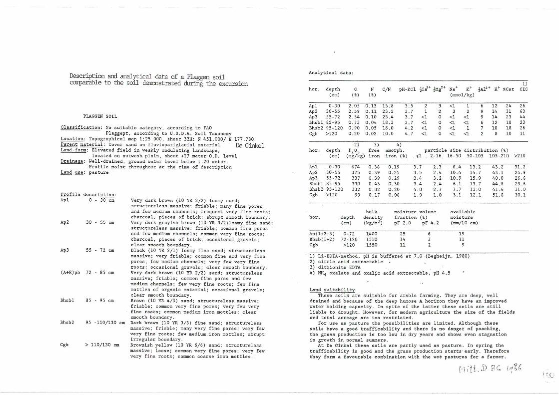
Description and anal ytical data of a Plaggen soil canparable to the soil danonstrated during the excursion
PIAGGEN SOIL
Classification: No suitable category , according to FAO Plaggept , according to U.S . D.A . Soil Taxonomy
Location: Topographical map 1:25 000, sheet 32H: N 451 . 000/ E 177.780 Parent material: Cover sand on fluvioperiglacial material De Ginkel Land-form: Elevated field in weakly undulating landscapè ,
located on outwash plain, about +27 meter O.D. level Drainage: ~ell-drained, ground water level below 1 . 20 meter.
Profile moist throughout at the time of description Land use: pasture
Profile description : Apl 0 - 30 cm
Ap2 30 - 55 cm
Ap3 55 - 72 cm
(A+E)pb 72 - 85 cm
Bhsbl 85 - 95 cm
Bhsb2 95 -110/130 cm
Cgb > 110/130 cm
Very dark brown (10 YR 2/2) loamy sand ; structureless massive; friable; many fine pores and few me dium channels ; frequent very fine roots; charcoal, pieces of brick; abrupt smooth boundary . Very <lark grayish brown (10 YR 3/2)loamy fine s and; structure l ess massive ; friable; common fine pores and few me dium channels ; common very fine roots; charcoal, pieces of brick; occ.asional gravels; clear smooth boundary. Black (10 YR 2/1) loamy fine sand; structureless massive; very friable ; common fine and very fine pores, few medium channels; very few very fine roots; occasional gravels; clear smooth boundary. Very dark brown (10 YR 2/2) sand; structureless massive ; friable; common fine pores and few medium channels; few very fine roots; few fine mottles of organic material ; occasional gravels; clear smooth boundary. Brown (10 YR 4/3) sand; structureless massive; friable; common very fine pores; very few very fine roots; common medium iron mottles; clear smooth boundary . Dark brown (10 YR 3/3) fine sand; structureless massive; friable ; ~any very fine pores; very few very fine roots; few medium .iron mottles; abrupt irregular boundary. Brownish yellow (10 YR 6/6) sand; structureless massive ; loose ; common very fine pores; very few very fine roots; common coarse iron mottles .
Analytical data :
hor. depth c N C/N pH- KCl ~ca>+ ~Mg2+ Na+ K+ ~Al3 + H+ ::;cat 1)
CEC (cm) (% ) (%) (mmol/kg)
Apl 0-30 2 . 05 0.13 15.8 3.5 2 3 <l 1 6 12 24 26 Ap2 30-55 2.59 0.11 23 .5 3.7 1 2 3 2 9 14 31 63 Ap3 55-72 2.54 0.10 25 . 4 3.7 <l 0 <l <l 9 14 23 44 Bhsbl 85-95 0.73 0.04 18.3 3 . 7 <l 0 <l <l 6 12 18 23 Bhsb2 95-120 0 . 90 0.05 18 .0 4 . 2 <l 0 <l 1 7 10 18 26 Cgb >120 0 . 20 0.02 10.0 4. 7 <l 0 <l <l 2 8 10 11
2) 3) 4) hor . depth P20s . free amorph . particle size distribution ( %)
(cm) (mg/kg) iron iron (%) . <;:2 2.-16 16-50 50-105 105-210 >210
Apl 0- 30 674 0 . 36 0 . 19 3.7 2 . 3 6.4 13.2 43 . 2 Ap2 30-55 375 0.39 0.25 3.5 2.4 10.4 14.7 43.1 Ap3 55-72 337 0.39 0.29 3 . 4 3 . 2 10.9 15.9 40.0 Bhsbl 85-95 339 0 . 43 0.30 3 . 4 2 . 4 6.1 13 . 7 44.8 Bhsb2 95- 120 332 0.32 0.20 4.0 2.7 7 . 7 13 .0 41. 6 Cgb >120 99 0 . 17 0.06 1. 9 1.0 3.1 12 . 1 51. 8
bulk moisture volume available hor. . depth density fraction (%) moisture
(cm) (kg/m3) pF 2 . 0 pF 4.2 (mm/10 cm)
Ap(l+2+3) 0-72 1400 25 6 19 Bhsb(l+2) 72-1 20 1510 14 3 11 Cgb >120 1550 11 2 9
1) Li-EDTA-·method, pH is buffered at 7 . 0 (Begheijn, 1980) 2) citric a~ id extractable 3) dithionite · EDTA 4) NH4 oxalate and oxalic acid extractable, pH 4 . 5
Land suitabHity These s oils a re suitable for arable farming. They are deep, well
drained and be cause of the deep humose A horizon they have an improved water holding capacity. In spite of the latter these soils are still liable to drought. However , for modern agriculture the size of the fields and total acreage are too restricted .
For use as pasture the possib i lities are l i mited. Although these soils have a good trafficab i lity and there is no danger of poaching, the grass production is too low in dry years and shows even stagnation in growth in normal summers .
At De Ginkel these soils are partly used as pasture. In spring the trafficab i lity is good and the grass production. starts · early. Therefore they forma favourable comb i nation with the wet pastures for a farmer.
31. 2 25 . 9 26.6 29.6 31. 0 30 . l
f' Lii . ~\> Pc [ ({ % ?. 1 ( ~ .u
- -

J ~-1? ?l+ ~( De~
~t \ luM~I~ 1 ~
..( ~"' r ·\
""~
l!l -f_.; v v v ~\-.(~' v v -:-
vv v v v v v .,_-...,.._ !
, -·.::::.:: ·-.··" .. " '":
... "."" ". . .... ";_-': ::·"·;. ··-..... ,
_"" .. .;.-.:-.:.~-.~:- 1 (.:·. ·-i- -~:·-
.... :::···· , ." .. .····." ..• " ... , ·-···· puez 8LjOSWOJ8>j8M . . ;:. ('··./'·;. ::."1
:······· ... •"'"•: -: .. " ... · " ... , :'" .. "",
::·,: :"'": .-•:: :.~. :.:"• """
:::; - "' " I, ;;: ~ ;"" .... 1"• •• "
· .. .:·":: /"''•• " . "~
... " -.. " . .::.!'~·- ~~·-
v6 !
,_ '-
-:\ ' ( 1
\ p:a'àuo:rg :ra:i.ta )
wo~a~aM JO Á41U1~1~ aq~ u1
JO a~ua~~n~~o ag1
1 ~ 1
-·-1
1
1
c /
~,/-:-
" '

/
·\füiji
Physiographic map of the fluviatile district
[.:·.-~::::< ]
[././)/\j
!'"' "~ ::: ::::::: ::..:: :: ::::
1 ~=~~=uu00
1 r" .... " .. "", ... .. .... ... ... ..... ......... . ......... .. .... ... ............ 1 ""." • • ••••••
~ 1--=-----1 ------------------------
.~ ~
b;<-1 11Rm
ice-pushed ridge
fluvioglacial deposits
cover sands
plaggen soils
river dunes
forelands
meander belt deposits
backswamp deposïts
backswamp over peat
peat
dry valleys
urban area
~
0

THE FLUVIATILE DISTRICT
General information Holocene sediments, associated with the Rhine and the Meuse
(Fig. 1 in 'Envirollinental conditions in the Netherlands'), occupy about 270 000 ha, or nearly 8% of the total area of the country.
At the border with Germany, a few km southeast of Arnhem, the Rhine is about 15 m above sea level. It bifurcates twice shortly after entering the Netherlands; the major branch is the Waal, which is the shipping lane between Rotterdam and the Ruhr industrial area in Germany. The two smaller branches are called the IJssel (which flows north to Lake IJssel) and the Lower Rhine, which flows west past Arnhem and Wageningen. The Meuse leaves Belgium just north of Luik (Liège) at about 50 m above sea level. Both river plains converge at about 6 m above sea level; the Meuse and the Waal-branch of the Rhine actually meet at about 4 m above sea level (Fig. 1). In 1904 a shipping canal was constructed at this point. The fluvial sediments pass beneath the marine sediments at 0. 5 m above sea level .
The transition from floodplain to the adjacent higher grounds formed from Pleistocene deposits is generally gradual, because these older sediments dip very gradually under the finetextured sediments of the backswamps. In a few places the river plain is bordered abruptly by 20-30 m high bluffs, caused by river erosion of the southern slopes of the ice-pushed hills.
The Pleis t ocene outcrops shown in the middle of Fig . 1 are partly buried fossil river dunes bordering buried channels of the braided river systems of the Pleistocene Rhine and Meuse. They have a westward slope- of about 30 cm/km and near Nijmegen disappear beneath the Holocene fluviatile sediments which have a lower seaward gradient of 10-15 cm/km.
Geomorphology and soils The floodplain has three major elements: forelands, meander
belts and backswamps (Fig" 1). The forelarui's lie outside the artificial levees or river
walls, and are subject to flooding. On the forelands land use is limited to pasture and meadow. The hay is protected from the rare, and mostly low, summer floods by low banks, called sunnner dikes. During periods of high discharges by the rivers the forelands are flooded. Flooding across the forelands enables high flood levels to be contained in the rivers. The main river banks are much higher than the summer dikes, and must be able to stem higher floods, which occur mainly in winter; hence the name winter dikes. The area lying landwards of this dike is only flooded when the dike is breached. This happened frequently in the past, as is witnessedby the many scour holes which remain. During the last winter of the Second World War the riverine area was no-man' s-land af ter the Battle of Arnhem. On 3 December 1944 the southern dike of the Lower Rhine west of Arnhem was blown up by the Germans and practically the whole area between the Waal, the Amsterdam-Rhine canal and the Lower Rhine was inundated. The previous time that this area was flooded was in 1855, when the southern dike of the Lower Rhine was breached in four places at a time of high floods.
Brick making is the only industry on the forelands; the chimneys of the brick kilns are a typical feature of the skyline. The buildings are situated on elevated sites and surrounded by partly excavated areas.
1 1

Actual and fossil river .courses in the Netherlands are accompanied by ridges that are 1 m higher than the backswamps. These ridges, ranging from several hundred metres to 2 km wide, are the farmer meander belts. All the villages (Fig. 1) and old roads are situated above the floodplain on these levees. Most villages pre-date embankment (roughly before 1200- 1400 A.D.). The centre of many villages is slightly elevated and has deep, clark soils where medieval or even Roman artefacts may be found.
The soils on the meander belt, formerly called river- ridge soils, are characterized by a medium-textured, well-structured upper part of the solum, overlying a·coarse-textured subsoil at varying depth, resulting in a well-drained soil (B-NL9). The relative elevation of these soils enables them to be used mainly for arable land and orchards. The soils of the meander belts of the Rhine are mostly calcareous at a shallow depth . Locally there are remnants of older meander belts up to 3000 to 5000 years old, which have survived a rejuvenation of the meander belt. Soils at such sites show progressive soil formation; not only decalcification but also evidence of clay translocation. By comparison, the analogous soils from Meuse deposits are noncalcareous th r oughout. This difference in l ime content betwe en Rhine and Meuse sedi ments is up till now not yet satisfactorily explained.
The medium-textured brown soils of the meander belts grade gradually in the fine-textured grey soils of the backswamps, the third element in the Rhine - Meuse floodplain. Edelman spoke of 'basins' referring t o their low- lying situation between the surrounding ridges .
Until the end of the Second World War the landscape of the backswamps was characterized by widespread grasslands, lacking farm buildings and with only some gravel and unsurfaced roads leading to meadows used for extensive grazing. Trees were limited to scattered willow-coppices, some surrounding duck decoys. The soils in these areas are fine-textured, non-calcareous and sometimes have peat at. shallow depth. Untn fairly recently these soils were badly drained, therefore ground- water levels were high and drainage conditions poor.
In the last twenty years many of these areas have been reclaimed, new metalled roads, lined with . poplars, now cross the backswamps. Originally most villages were connected only by roads on top of the winding dikes. Now there is a four-lane highway running eas t-wes t in th i s area • . Modern farmsteads have been built in the farmer uninhabited backswamps. With the reallocation schemes drainage conditions have been improved by <ligging new main drains, by tile- draining and installing modern pumping stations to lower water levels, and by better maintenance of the field ditches.
Two soils have been selected to illustrate the so i l conditions in the fluviatile district. Soil B-NL9 is from a meander belt and B- NL10 from a backswamp.
Soils in meander belts often have a coarse sandy subsoil, B-NL9 is an example of a deep soil (coarse sand at 130 cm depth ) . Locally shallow soils occur, with sand within 50 cm depth. In dry summers shallow soils are clearly recognizable by differences in the colour of sugar-beet leaves.
The high clay content of soil B- NL10 illustrates the calm conditions during sedimentation in this farmer backwater area. The presence of the buried Ah-horizons (see section 'Vegetation horizons') one dating from the Bronze Age, the other from Roman times, demonstrates that this site has been free from erosion by river meanders for over 3000 years.
12

S.top 1, ~o.lt B-NL9
Site description
Classification :
Locatiq~
Top. map Elevation Land form
Land use
Parent material: Drainage
FAO-UNESCO (1974): Calcic Cambisol USDA (1975): Fluventic/Typic Eutrochrept, finesilty, mixed, mesic Netherlands: mapping unit Rd90A on the Soil Map of the Netherlands, scale 1:50 000 E~perimental farm 'De Schuilenburg', 10 km west of Wageningen: 1:25 000, sheet 39 E (Rhenen), 16524394 7 m
Level natural levee in the alluvial plain of the river Rhine, protected from flooding by artificial levees or dikes Orchard. The profile is located in a wind break with deciduous trees (Fraxinus, Fagus, Acer, Corylus, Crataegus, Prunus) Holocene deposits of the river Rhine Controlled polder water in ditches, spaced 100-140 m apart. The fields are not tile-drained. The ground-water level fluctuates between 130 and 200· cm depth
Profile description
Ah 0- 28 cm · Dark greyish brown (10YR4/2.5) moist en light brownish grey (10YR6/2) dry, silt loam; weak
.coarse prismatic breaking to strong very fine angular and subangular blocky; slightly sticky, slightly plastic, friable moist, slightly hard dry; many continuous medium, fine and very fine pores; common worm casts on the soil surface; many filled form burrows; few coarse roots, common very fine, fine and medium roots; calcareous; clear, smooth boundary
Bwl 28- 45 cm Brown (10YR4.5/3) moist and brown (10YR5/3) dry, with common vertically oriented worm burrows filled with dark greyish brown material from Ah, silt loam; weak coarse prismatic breaking to moderate very fine subangular blocky; slightly sticky, slightly plastic, friable moist, slightly hard dry; few large open burrows; common continuous fine and medium pores; few coarse roots, common fine and medium roots; strongly calcareous; clear wavy boundary
Site interpretation
Same aspects of this soil are:
- calcareous throughout; - high biological activity: many worm channels and a good
structure, consequently a good permeability and rootability; loamy texture grading into coarse sand in the deeper subsoil;
- bath features from a young soil (fluvic properties; stratification in the subsoil), and feature s of progressive soil formation (the subsurface horizon satisfies the definition of the Cambic horizon), the soil is an intergrade between Fluvisols and Cambisols.
Bw2 45 - 77 cm
BCg 77-llOcm
Clg 110-127 cm
Brown (10YR4.5 / 3) moist and yellowish brown (10YR4.5/4) when rubbed, silt loam; weak coarse pri smatic breaking to strong very fine angular and subangular blocky; slightly s ticky, sligh tly plastic, friable moist, few large open burrows; common continuous fine and medium pores pores; common vertically oriented filled worm burrows, very few coarse roots, connnon fine and few medium roots; strongly calcareous; clear smooth boundary
Brown (10YR5/3 . 5) moist, few , fine, distinct, sharp brownish yellow mottles, silt loam; weak very fine subangular blocky; s lightly sticky, slightly plastic , friable; f ew large open burrows; f ew continuous fine and medium pores; few.fine and medium roots; strongly calcareous; clear smooth boundary
Greyish brown ( 2.5YR5.5/2) moist and layers with various colours; stratified silt, sandy loam and loam ; structureless; nonsticky, nonplastic, loose moist, strongl y calcareous.
. Ana.lyûc.al do.X.a.
Hor. Depth c N C/N CaC03 pH Texture (%)
(cm) (%) (%) (%) (KCl) <2 2-50 >50 µm
Ah 0- 28 2 . 29 0.30 7.6 2.7 7.0 2~ .6 48.6 26.8 Bwl 28- 45 0 . 75 0 . 12 6.3 4.3 7.4 30.4 50.9 18.7 Bw2 45- 77 0 . 68 0.08 8.5 14.2 7.5 27.8 51.1 21. 1 BCg 77-110 0 . 54 0.05 10.8 17.9 7.6 23.2 48.6 28.2 Clg >110 0 . 43 0 .03 14.0 16 . 9 7.8 13.4 29.4 57.2
Hor. Depth P205 Fe 2o3 ( %) Extr. cations (mmol/kg)
(cm) (mg/kg) dith ox !Ca ++ !Mg++ Na+ K+ CEC
Ah 0- 28 1021 1 .61 0.34 155 12 4 4 189 Bwl 28- 45 282 1.87 0.30 117 10 3 1 207 Bw2 45- 77 159 1.86 0.36 137 7 2 <1 180 BCg 77-110 135 1.41 0 .33 98 5 3 2 103 Clg >110 137 1.05 0.25 42 <1 1 3 53
Tilis kind of soils practically has no limitations, it is excellently sui t ed for arable and horticultural crops and for grassland. Because of its slightly elevated situation above the general level of the floodplain, these sites wer e selected for the settlements . In Fig. 1 it ap pears that the vil lages are either on the natural levees ( the meander belts) or on the bordering hi·ghe r Pleistocene sands.
All these aspects of soil B-NL9 are in striking contrast with the next soil (B-NL10).
.-->-
tN

stop 2, ~o.ll B-NLIO
Site description
Classification : FAO-UNESCO (1974): Eutric Fluvisol USDA (1975): Typic Fluvaquent, fine-clayey, illitic (nonacid), mesic Netherlands: mapping unit Rn44C on the Soil Map of the Netherlands, scale 1: 50 000
Location :~~e Veld, 5 kDi south of Wageningen Top. map : 1:25 000, sheet 39 H (Bergharen), 17134367 Elevation : 6 m Land form
Land use
Parent material: Drainage
Level backswamp in the alluvial plai n of the river Rhine, protected from flooding by artificial levees or dikes . Grassland, alternating pasture and meadow , both hay and silage grass Holocene deposits of the river Rhine Controlled polder water in di t ches spaced 80-100 m apart. The fields have a ridge-and-furrow system, spaced 10-15 m. The ground-water level fluctuates between 30 and 100 cm depth
Profile description
Ahl 0- 7 cm Very dark greyish brown (1 0YR3/2) moist, clay; weak very fine subangular bl ocky ; sticky, plastic, friable moist; common fine and very fine pores; many very fine and fine roo t s; c l ear, smooth boundary
~~~~
Ah2 7- 20 cm Very dark greyish br own ( 10YR3/2.5) moist, clay;
ACg 20- 40 cm
2Ahg 40- 53 cm
2Cg 53- 72 cm
3Ahg 72- 80 cm
3Cg 80-100 cm
moderate coarse prismatic breaking to moderate fine angular blocky; sticky , plastic , friable moist; common fine and very fine pores, common fine and very fine roots; clear, smooth boundary
Greyish brown (10YR4 .5 / 2) moist, common, fine, distinct, sharp strong brown lllDttles around root channels; clay; weak coarse prismatic breaking to strong fine to medium angular blocky; sticky , plastic, friable moist ; few pores , few roots, abrupt, smooth boundary
Dark grey (10YR4/1) moist , few fine faint brown mottles; clay; weak coarse prismatic breaking to strong medium angular blocky; few small slickensides; sticky, plas tic , friable moist; few pores; abrupt/clear, smooth boundary
Grey (10YRS/1) moist, common , fine, distinct reddish yellow mottles; clay; strong coarse prismatic; few smal l slickensides ; sticky, plastic, friable moist; few pores; abrupt , smooth boundary
Dark grey (10YR4/1) moist, many f ine, prominent, strong brown and reddish yellow mottles; clay; weak medium prismatic breaking to moderate very fine angular blocky; sticky , plas tic, friable moist; few pores, clear smooth boundary
Grey (lOYRS/1) moist, many fine prominent strong brown mottles; clay, 'half-ripened'; weak medium prismatic breaking to moderate ~ine angular blocky; sticky, plastic, friable moist, abrupt smooth boundary
4Ahg 100-110 cm
4Cr 110- cm
Very dark grey ( 10YR3 /1 ) moist; clay ; 'halfripened'; moderate co arse prismatic; sticky , plastic, friable moist; clear boundary ·
Gr eyish brown ( 10YRS/2) moist; clay, 'halfripened'; modera te coa rse prismatic, sticky , plastic, friable moist.
Ana.ly.ti.ca.l da;ta.
Hor. Depth c N
(cm) (%) (%)
Ahl 0- 7 5.26 0 . 59 Ah2 7- 20 3.24 0.37 ACg 20- 40 1. 19 0. 16 2Ahg 40- 53 1. 61 0 . 17 2Cg 53- 72 0.81 0.10 3Ahg 72- 80 1. 28 0. 12 3Cg 80-100 0.8 1 0.09 4Ahg 100- 110 4.09 0 . 24
. 4Cg >110 t. 72 0.18
Hor. Depth P205 (cm) (mg/kg)
Ahl 0- 7 806 Ah2 7- 20 214 ACg 20- 40 55 2Ah,g 40- 53 60 2Cg 53- 72 103 3Ahg 72- 80 441 3Cg 80-100 428 4Ahg 100- 110 215 4Cg >110 235
C/N Caco3 pH Texture (%)
(%) (KCl) <2 2-50 >50 µm
8.9 0.2 6 . 0 47.7 45.0 7.3 8.8 0.1 5.4 55.3 38.9 5.8 7.4 0.1 5.5 59.4 36.8 3.8 9.5 0.1 5.8 67.9 30. 5 1.6 8.1 0.1 . 5.7 55.8 42.6 1.6
10.7 0.1 6.0 58.4 38 .1 3.5 9.0 0 . 1 5.9 51.4 47.2 1.4
17.0 0.1 6.1 72.4 27.2 0.4 9.6 0.1 6.0 62.0 37.0 1.0
Fe2o3
( 7. ) Extr. cations (mmolfkg)
dith
2.66 3.00 3.35 2. 11 2.56 4 .15 3.70 1.62 1. 74
ox 'Ca ++ 'Mg++ Na+ K+ CEC
1.25 189 32 <1 7 303 1.41 176 27 2 4 296 0.75 . 207 32 <1 5 303 0.40 202 26 3 13 344 0.97 203 17 1 6 258 2.28 170 8 <1 11 336 2.02 237 23 2 12 259 0.82 252 20 2 12 372 0.76 283 25 <1 18 444
.Site i nterpretation Some aspects of this soil are:
- non-calcareous throughout , hut non-acid; - ' low biological ··activity, angular blocky and prismatic structure,
low permeability (see section 'Soil physical measurement techni ques in clay soils');
- clay texture, even tcÏ greater depth , with the conclusion: although these sediments are from the Holocene river, the river itself (its course) never was on this site;
- bur i ed A-horizons and no Cambic features, clearly a Fluvisol fo r the buried Ah-horizons, see section 'Vegetation horizons').
This kind of soil is too fine-textured for the economically most important crops in this country (potatoes, both seed and consumption, and sugar-beet). There are problems in preparing the seed bed and also during harvesting with machines: low trafficability during wet spells, and in dry periods the seed bed will be too coarse and these root crops then are not easily harve s table.
~
~