world soil resources reportslibrary.wur.nl/isric/fulltext/isricu_i00003026_001.pdf ·...
TRANSCRIPT
World Soil Resources Reports 22
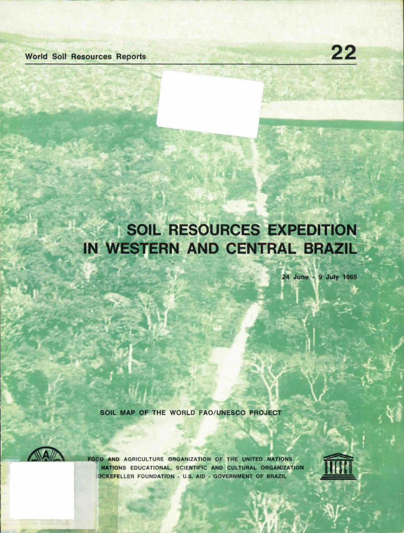
SOIL RESOURCES EXPEDITIONIN WESTERN AND CENTRAL BRAZIL
24 June - 9 July 1965
SOIL MAP OF THE WORLD FAO/UNESCO PROJECT
FOOD AND AGRICULTURE ORGANIZATION OF THE UNITED NATIONS
NATIONS EDUCATIONAL, SCIENTIFIC AND CULTURAL ORGANIZATION
OCKEFELLER FOUNDATION - U.S. AID - GOVERNMENT OF BRAZIL
Also issued in this series:
1. Report of the First Meeting of the Advisory Panel on the Soil Map of the World, Rome,19-23 June 1961.
2. Report of the First Meeting on Soil Survey, Correlation and Interpretation for Latin America,Rio de Janeiro, Brazil. 28-31 May 1962.
3. Report of the First Soil Correlation Seminar for Europe, Moscow. U.S.S.R.. 16-28 July 1962.
4. Report of the First Soil Correlation Seminar for South and Central Asia, Tashkent. Uzbek-istan, U.S.S.R.. 14 September-2 October 1962.
5- Report of the Fourth Session of the Working Party on Soil Classification and Survey (Sub-commission on Land and Water Use of the European Commission on Agriculture). Lisbon,Portugal. 6-10 March 1963.
6. Report of the Second Meeting of the Advisory Panel on the Soil Map of the World, Rome,9-11 July 1963.
7. Report of the Second Soil Correlation Seminar for Europe, Bucharest, Romania, 29 July-6 August 1963.
8. Report of the Third Meeting of the Advisory Panel on the Soil Map of the World. Paris,France, 3 January 1964.
9. Adequacy of Soil Sludies in Paraguay, Bolivia and Peru, November-December 1963.
10. Report on the Soils of Bolivia, January 1964.
11. Report on the Soils of Paraguay. January 1964.
12. Preliminary Definitions, Legend and Correlation Table for the Soil Map of the World, Rome,August 1964.
13. Report of the Fourth Meeting of the Advisory Panel on the Soil Map of the World, Rome,18-21 May 1964.
14. Report of the Meeting on the Classification and Correlation of Soils from Volcanic Ash,Tokyo. Japan. 11-27 June 1964.
15. Report of the First Session of the Working Party on Soil Classification, Survey and SoilResources (European Commission on Agriculture). Florence, Italy, 1-3 October 1964.
16. Detailed Legend for the Third Draft of the Soil Map of South America, June 1965.
17. Report of the First Meeting of Soil Correlation for North America. Mexico. 1-8 February 1965.
18. The Soil Resources of Latin America, October 1965.
19. Report of the Third Soil Correlation Seminar for Europe: Bulgaria, Greece, Romania,Turkey, Yugoslavia, 29 August-22 September 1965.
20. Report of the Meeting of Rapporteurs. Soil Map of Europe (Working Party on Soil Classi-fication and Survey. European Commission on Agriculture), Bonn, Federal Republic of Ger-many, 29 November-3 December 1965.
21. Report of the Second Meeting on Soil Survey. Correlation and Interpretation for LatinAmerica, Rio de Janeiro, Brazil, 13-16 July 1965.
Cover photo by courtesy of Dr. J. Bennema, Netherlands.

Scanned from original by ISRIC - World Soil Information, as ICSUWorld Data Centre for Soils. The purpose is to make a safedepository for endangered documents and to make the accruedinformation available for consultation, following Fair UseGuidelines. Every effort is taken to respect Copyright of thematerials within the archives where the identification of theCopyright holder is clear and, where feasible, to contact theoriginators. For questions please contact soil.isridicBwur.nlindicating the item reference number concerned.
SOIL RESOURCES EXPEDITION IN
WESTERN AND CENTRAL BRAZIL
24 June - 9 July 1965
by
Klaas Jan Beek and Jakob Bennema
Food and Agriculture Organization of the United Nations
United Nations Educational, Scientific and Cultural Organization
Rockefeller Foundation - U.S. AID - Government of Brazil
Rome, 1966
MR/46880 302«

CONTENTS
Participants
Travel schedule
The objectives of the expedition
Organization and character of the expedition
How the fieldwork was carried out
About this report
Acknowledgements
Summary of soil associations
Fieldnotes
Climate
Evaluation of the soil resources foragricultural development 41 -46
Soil Profiles 1 - 1 1
Maps -
Paj1
2
4
8
9
11
20
36
-
3
7
-
-
-
-
ge
3
7
9
10
19
35
40
Soil Profile No,M
H
M
•t
n
H
M
II
I I
I I
1)2)3)4)5)6)7)8)
it n
M H
II M
II II
II II
II II
II ' II
II II
II II
II II
Area studiedClimateVegetationTopography-Geology
. 123456789
1011
I by the expedition
Soil AssociationsSoil ProductivitySoil Potentiality
47 - 4950 - 5253 - 5556 - 5859 - 6162 - 6465 - 6768 - 7071 - 7374 - 7576 - 77

- 1 -
Participants in the 1965 expedition were:
Argentina
Carlos R.O. Miaczyinski (INTA)Pedro Etchevehere (INTA)
Brazil
Waldemar Mendes (DPFS)Marcelo Nun e s Camargo (DPFS)Chyoso Hirano (DPFS)Helio Pierantoni (DPFS)Raymundo Costa de Lemos (DPFS)Italo Falesi (IPEAN)Lucio Salgado Vieira (Universidade deBelem)Francesco Palmiere (DPFS)Antonio Manuel Pires Filho (DPFS)Idare A. Gomes (DPFS)Gelson Rangel Lima (IBGE)Dario de Souza Castelo (IBGE)
Peru
Carlos Zamora (ONERN)
Surinam
Walther Asin (Soil Survey Dept.)
U.S.A.
Francis Cleveland (US-AID)Dirk van der Voet (US-AID)
Venezuela
Justo Avilan Rovira (CIA)
FAO Staff
D. Luis BramaoJakob BennemaClyde ApplewhiteKlaas Jan Beek
Soils and AgricultureSoils and Geology
DirectorSoil CorrelatorSoil SurveySoil ChemistrySoil SurveySoil SurveyProfessor ofSoils and GeologySoil Survey
Geographer and GeomorphologyAssistant Geographer
Soil Survey
Soil Survey
Soil Survey InterpretationAerial Photograph Interpretation
Soil Survey
Chief, World Soil Resources OfficeFAO Consultant(Soil Survey Institute)FAO Soil Survey ExpertFAO Associate Expert

- 2 -
The expedition also had the company of two reporter-cinematographers'Giorgio Fiaschitello, of the newspaper II Tempo and Benedito Toledo da Cruz, of theAgencia Nacional (Brazil), and of Mr. Jorge Pankov of the DNER in Porto Velho, whowas in charge of expedition problems connected with road and bridge conditions,lodging and fuelling of the vehicles.
The travel schedule was as follows:
June 24
First participants arrived by road in Porto Velho (RO).
June 25
Task force of 6 participants arrived in Rio Branco, (AC) by air.
June 26
Field observations in Acre along the road Rio Branco - Vila Plâcida de Castroby task force. Delayed participants arrived from Cuiabâ in Porto Velho by air.
June 27
Task force initiated field work along BR-29 from Rio Branco for approximately21 km. The other participants examined profiles along the first 30 km. of BR-29 fromPorto Velho in the direction of Abuna.
June 28
Task force returned by air from Rio Branco to Porto Velho. Parties joinedand examined soils in the area of the experimental station of IPEAN near Porto Velho.
June 29
Expedition left Porto Velho in eastern direction along BR-29 Porto Velho-Seringal Nova Vida (257 km).
June 30
Seringal Nova Vida - Rondonia (143 km).
July 1
Rondonia - Riozinho (124 km).
July 2
Riozinho - Vilhena (216 km).
July 3
Vilhena - Pensclo AlemSo (Serra dos Parecis) (560 km).
July 4
PensSo Alemäo - Cuiabâ (250 km).
July 5
Cuiabâ- cars serviced.

- 3 -
July 6
Cuiaba-Rondonópolis (225 km).
July 7
Rondonópolis - Jatai (494 km).
July 8
Jatai - Goiânia - Brasilia (200 km) expedition ended.
The objectives of the expedition were as follows:
1. To study the soils of Acre, Rondonia, Mato Grosso and Goiâs along the recentlycompleted road,which provides an interesting cross-section of the area of westernand central Brazil, a region of which practically nothing is known from the soils pointof view.
2. To correlate the soils in this area with similar soils in other parts of Brazil orSouth America where these soils have been thoroughly studied. This correlation givesa better understanding of the soils and their classification, for which purpose soilsamples were also taken. It also provides an important basis for the appraisal ofsoil resources of the area under consideration. For the latter purpose not only soilbut also soil environment was studied, principally vegetation, topography, climate,geology and hydrology.
3. To separate the more promising areas from the soil angle for the development ofagriculture from those areas where no satisfactory development of agriculture can beexpected due to the limitations presented by the soil and/or soil environment.
4. To promote, discussions on genesis, classification, and the agricultural potential-ities of the soils between the participating scientists who represented nine differentcountries (Argentina, Brazil, Netherlands, Paraguay, Peru, Portugal, Surinam,United States and Venezuela). These discussions provided all the participants of theexpedition with a better understanding which will prove to be useful for their soilinvestigations in the near future.
5. To obtain the necessary information for the improvement of the FAO-UNESCOSoil Map of South America, which was presented to the expedition in its third draft,and of which the latest revision will reach the publishing stage at the end of 1966. Theresults of the expedition are also supposed to benefit the Brazilian program of theMinistry of Agriculture which aims at the compilation of a reconnaissance soil mapof Brazil, 1:500,000, and the US-AID, DPFS, Frontier Development Project which hasstarted an exploratory soil survey of the western and central two thirds of Brazil.These three soil mapping projects of FAO/UNESCO MA and US-AID are being carriedout in close co-operation.

- 4 -
Organization and character of the expeditionI
Former soil correlation trips organized by the WSRO of FAO covered groupsof countries and correlation work was done mostly in regions where soil survey workhad already been done before or was being carried out; e.g. , Uruguay, Paraguay,South Brazil, Argentina, Bolivia, Peru. With the last expedition an attempt was madeto obtain information on the soils of the most extensive and least known regions ofSouth America from the soils angle. This area, which is characterised by very difficultaccess and lack of communications, includes the States in Brazil of Acre, Rondonia,Mato Grosso and Goiâs.
When the road connection between Porto Velho (Rondonia) and Cuiabâ hadbeen completed, and surface connection between Porto Velho and Rio Branco (Acre)seemed feasible by train and road, the idea was born of organizing an expedition bysurface from Acre to Brasilia. When FAO launched the suggestion of such an expeditionat the Brazilian Division of Soil and Soil Fertility of the Ministry of Agriculture thisidea found a very enthusiastic reception, and the organization of the expeditioncommenced in December 1964.
The preparations were made by an organizing committee comprised ofMr. Marcelo Camargo of Brazil, and Mr. Klaas Jan Beek of FAO. The informationprovided by the National Department of Public Roads (DNER) indicated that theexpedition required thorough preparation, and that its realisation would only befeasible during the dry season - the latter part of June, July, August, September.The Department of Roads also promised complete coverage of the expedition betweenCuiabä* and Porto Velho, including petrol supply, protection and lodging in camps andsettlements, as lodgings and petrol stations were inadequate to cover the expedition'sneeds.
The expedition was warned that only four-wheel drive vehicles could do thetrip, as much of the success of the expedition would depend on the vehicles' resistanceto the unpaved and sometimes hardly passable roads and tracks. Therefore, theexpedition was very much favored with the contribution from the Soils Division of fivejeeps, four of which were Willys station wagons, and the other a Willys pick-up, all ofwhich were new or almost new. ;
These vehicles were made available through the co-operation of the DPFS ofthe Ministry of Agriculture and of the DPFS-US AID Frontier Development Project.This project, which recently started its plan of operation, has as its main task themapping of soil resources of the whole northwestern and central part of Brazil (abouttwo thirds of the Brazilian territory). It was then decided that FAO should organizethis expedition with the Project on a joint basis, as the respective interests werecompletely parallel. The Project took the responsibility of supporting the expeditionwith provisions, including combat food Type C rations, and the maintenance of thecars, while FAO undertook the petrol costs involved in this 8,000 km expedition.

FAO invited the following participants for the expedition: C.O.Miaczyinskiand Pedro Etchevehere (Argentina); Waldemar Mendes and Marcelo Camargo (Brazil)Carlos Zamora (Peru); Walther Asin (Surinam ); Justo Avilan (Venezuela). Financialsupport from the Rockefeller Foundation to WSRO made it possible to invite the LatinAmerican participants, and the other participants, all from Brazil, were invited by theFrontier Development Project.
The first travel schedule drawn up after consulting the DNER had to be changeda number of times, even before the trip started. The original plan was that the fivejeeps would depart from Rio de Janeiro on June 14th with the Brazilian participantsand Mr. Beek of FAO, to arrive in Porto Velhó on June 21st, to transport the jeepsby train to Abunä.and to continue from there along the road BR-29 to Rio Branco.However, this idea had to be changed owing to the impossibility of travelling by landbetween Abunâ" and Rio Branco.
It was then decided that the participants would leave the cars in Porto Velhoand fly up and down to Rio Branco, doing the field work in Rio Branco with localtransport. Assembling of the participants was then supposed to be in Rio Branco.It was also anticipated that some of the team, if arriving on time in Porto Velho byroad, would make an exploration by "Litorina" (a one-wagon self-driven train carriage)for a period of two days along the Madeira-Mamore' railroad, which runs from PortoVelho via Abuna. to Guajara Mirim at the Bolivian border.
Finally, on the 14th of June the five vehicles with 12 participants left Rio deJaneiro for Porto Velho, a distance of 4, 000 km. A few days before this departure,the DNER had informed the expedition that contrary to press news the obstructionson the road in two places between Vilhena and Porto Velho had been cleared. Previousto this the road had been closed for nine months during the rainy season when largestretches became inundated, and bridges and an earthen dam stretching for variouskilometers had been washed away.
The expedition reached Porto Velho on June 24th, having been delayed threedays owing to minor and major car defects. On the way to Porto Velho observationswere made on soils and environment, and spots were selected which seemed ofspecial interest or to be more representative of the region for excursion stops on thereturn trip. '
On June 25th all other participants were supposed to arrive by air in PortoVelho, and to proceed with the same flight to Rio Branco accompanied by those who hadarrived by jeep. Only Dr;;; Avilan and Mr. Asin arrived according to schedule andproceeded to Rio Branco, followed the same day on a different flight by Messrs.FalesiHirano, Van der Voet and Beek. The other participants coming by air lost one day inCuiabâ as the scheduled flight was cancelled, and the next day on arrival in PortoVelho they found that the connection of the flight to Rio Branco had also been cancelled.Therefore, only a team of six, later described as the "task force", carried out soilinvestigations for two days in Acre. The group which stayed in Porto Velho wentto the field in the neighbourhood of the town on June 27th and June 28th. Reunion of thetwo groups took place on June 28th, when the task force returned from Acre by air.

- 6 -
On June 29th the expedition left Porto Velho in seven vehicles, two morevehicles than there had been on the first part of the trip, since the number ofparticipants had been augmented by the arrival of two geographers of the IBGE, andtwo pressmen of ANSA and Agencia Nacional. The two additional vehicles weregenerously offered, together with drivers and a supervising engineer, by the DNER,District Porto Velho, and these additional vehicles accompanied us until we reached ;
Brasilia. The expedition arrived in Cuiabâ on July 4th (approximately 1554 km) and iarrived in Brasilia on July 9th (approximately 1500 km). The return to Rio was madeon July 11th, after having completed a distance of approximately 8,500 km.
This part of the report would not be complete without the mention of some verycharacteristic situations with which we were faced during the trip. Exceptfojr someshort scattered asphalted stretches in Mato Grosso the road is unpaved until you
, reach Goiânia. Red dust filled the pores of all participants from the first till the lastdays, and it took everyone about an equal number of days to become completely cleanagain after the trip.
When the road goes through the lower area between Porto Velho and Vilhena,where there is Amazon forest, the expedition had to pass over 70 rivers using bridgesor "pinguelas" which had been constructed three years ago, during the first construc-tion of the road. These bridges and pinguelas could not support the weight of the heavyloaded 15 to 20 ton trucks and were the most challenging aspect along the roadto the courage and skill of the drivers as it often occurred that these "bridges"presented themselves as undistinguished bundles of loose rounded and rolling treeswhich were constantly opening and rolling apart. These were the places where thecamera—men showed great activity, perhaps even more than during the stops for soilexaminations and discussions, which must have seemed relatively dull to them incomparison with the passing of these pinguelas. It proved in any case that soil scientistsif necessary are capable of doinp some civil engineering work as well.
Of course this road presented far greater difficulties to the heavy truck driversthan it presented to the expedition with its much lighter vehicles.. One story told howa Japanese truck driver 'worked four months on the construction of a new pinguela inorder to continue on his way. Another group of trucks were stuck last year forseveral weeks at the dam near Muqui which is various kilometers long and whichuntil now has been washed away each year. Drivers in such a situation suffer fromhunger, malaria and other tropical diseases. Sometimes when a bridge had brokendown and could not possibly be repaired, the expedition followed tracks recently cutthrough the forest, leading toward shallow fords in the river. These deviations hadalso been made by the truck drivers, for whom the expedition developed an enormousrespect.
It is obvious that providing this very important road with a proper hardsurface requires priority. This might also lower the cost of living in the area whichis now extremely high in comparison with eastern Brazil. The population along theroad is very small and the villages which appear in the map seldom consist of morethan twenty wooden palm-leaf roofed houses.

- 7 -
The principal economie activities are collecting rubber, seringueiros, Brazilnuts, and wood in the forest region, and extensive grazing in the savannah part beyondCuiabâ. The presence of Indians was often mentioned but they live in the forest whichis quite a considerable distance from the road. However, their invisible presencestimulates the imagination when one travels along this dusty and always very desertedroad, which runs between two high green walls of tropical green forest. Colorful birdsand butterflies are abundant, and although the absence of wild life seems to be somewhatdisappointing the presence of mosquitoes, "pium," and other stinging insects did fulfilthe expedition's expectations of the Amazon jungle.
The nights were spent in hammocks strung up very closely together in the smallhuts of the settlements, and for various members of the expedition these were the firstnights in their lives spent in hammocks. These people were easily recognizable at nightsince they continued to move around causing the hammocks of their neighbours to swingalso, and the following morning they tended to have a somewhat "bent-forward" walk.However, nobody broke any limbs. Of course the expedition was faced with new dishes,some of which were really delicious, as were the pastries filled with monkey meat inthe camp of Colonel Muller in Riozinho.
Modern means of communication - press and radio - had informed the visitedregion about the FAO expedition even before it arrived, and there was a great deal ofencouraging interest in the aims of the expedition. This became particularly evidentduring the receptions given to members of the expedition in Rio Branco by the Governorof Acre, in Porto Velho by the Governor of the Territory of Rondonia, and in Cuiabâby the Governor of Mato Grosso.
How the field-work was carried out
Since the expedition went through an area with very old geological and geneticalsoil surfaces, the changes which had to be observed in the soil patterns were not veryfrequent, and 'were rather easily observable in connection with topography and geology.The long distances which had to be covered every day, on an average 300 km., togetherwith the sometimes complicated road conditions, did not permit many stops for soilstudy even though departure was planned every morning for six o'clock. Most stopswere made at road cuts which saved much digging time. In flat areas and depressionsa Dutch Edelman auger of 120 cm was used. Profile descriptions had to be concisebut a complete description of profiles was made by the personnel of the DPFS. Sampleswere also taken of these profiles which have been analysed by the OPFS laboratory inRio de Janeiro, and for which descriptions; and analyses are presented in the annex ofthis report. Some rock samples were also taken for analysis in the petrology andmineralogy section in Rio de Janeiro.
Samples of diagnostic horizons were sometimes taken without making adescription of the complete profile and where no samples were taken field pH valueswere used to obtain some idea about base-status. Special mention should be madehere of the common y * actice in Brazil of using a magnet for the separation of the so-called Latosol Roxo r i s which have a high content of iron-oxides which can beattracted by the mag t̂.

- 8 -
About this Report
The purpose of this report is to give as complete a picture as possible of theagricultural potential of the region visited from the soils angle. Before this expeditionthere was practically no information available on soils and the information collectedduring the trip has been included, together with a brief description of informationalready existing on climate, (prepared by Mr.^H^ van Baren of the World Soil ResourcesOffice) topography, vegetation and geology. The stops for soil examination had to beshort (3,200 km in 11 days) as is normally the.case in a rapid reconnaissance or wind-shield survey. Therefore, in this report only the more important characteristics ofthe soils are included, to enable their classification at a great soil group or sub-grouplevel.
The soils which have been seen all showed great similarities with othersoils which have been observed and studied earlier in other parts of Brazil. Specialattention was given to soils with an apparently higher nutrient status, since these were ;
expected to be the more promising for eventual agricultural colonization projects. Thesesoils have been completely described and the samples which were taken have beenanalysed in the laboratory of the DPFS, together with some other completely describedand analysed soils which are included as an annex to thereport.Two complete profiledescriptions in the annex which were taken in the neighbourhood of Porto Velho weredescribed and analysed by the personnel of the soil section of IPEAN. Also threeearlier-described profiles taken in the neighbourhood of Brasilia have been includedwith their analysis, as they represent the most frequent soils of the Planalto Centralregion made available by DPFS.
The report commences with a summary, where the area has been sub—dividedinto 25 soil regions, A series of maps (most 1:5,000,000) has been included whichgives:
(a) location of the area within Brazil(b) base-map of the area with physiographical regions(c) map with location of the soils regions(d) climatological map following Koppen(e) climatological map following Thornthwaite(f) geological map(g) vegetation map(h) topographical map with altitudes observed during the trip.
After the summary, a more detailed report follows describing each soilassociation with the stops and observations made there. These stops have beennumbered continuously from Porto Velho to Brasilia.

— Q—
The report finishes with a global evaluation of the agricultural resources bysoil associations and it must be stated that an expedition of this kind can provide onlya very tentative soil map. It is possible to make an inventory of the soils along across-section which need not necessarily be a very representative cross-section, sinceroads are planned on a different basis, but'additional information including indexes ofaerial photographs were consulted for the compilation. It should also be mentionedthat some of the observations given in this Report were made during the journeyto Brasilia, and it was sometimes necessary during the expedition to travel by nightto reach our place of lodging.
Acknowledgements
This expedition was made possible through the most cordial co-operation ofBrazil, for which this country has already become world famous, and it is not possibleto mention all the persons and institutions that in some way contributed to it.
The Minister of Agriculture, Professor Hugo de Almeida Lerne, invited FAO toorganize the expedition in Brazil and authorized the Division of Soil Survey and SoilFertility (DPFS) to co-operate in the preparation and execution of the project. Special '.gratitude goes to the Director of this Division, Mr. Waldeman Mendes, and to ;
Mr. Marcelo Camargo, who took such a great personal interest in the success of theexpedition. The DPFS made available jeeps, equipment, and cartographic materialto outfit the expedition, and Mr. L. Vettori analysed the samples collected during theexpedition.
It was very important for the expedition that the recently formed DPFS-US AIDFrontier Development Project should take an interest in their venture, whichnecessitated travelling through an important section of their Project area. TheFrontier Development Project financed the travel and subsistence expenses of theBrazilian participants who were not officially invited by FAO, and who certainlycontributed to the success of the expedition. Some of the jeeps were provided by the :
F.D.P. and also maintenance costs of the vehicles were paid by them. .It is necessary;to mention personally Mr. Nathaniel Bloomfield, Project Manager, who devoted muchof his time to the organization of the expedition and in addition gave his own projectjeep.
The co-operation and assistance given by the National Department of Public Roadsof the Ministry of Transport and Communications, was indispensable for thé organizationand execution of the expedition. Special thanks are due to the Director GeneralEng. Lafayette, and also to Inspector Crisipio N.D.Miranda, in Rio de Janeiro, whoprovided all information about road conditions and maintained contact by DNER radiowith the areas which •were visited. The DNER gave a complete coverage of theexpedition between Por^o Velho and Brasilia, including petrol supply, lodging andguidance. This coverage was organized by the Chief Inspector, District Porto Velho, ,Eg. Paulo Silva Mourr-, The expedition was guided between Porto Velho and Brasiliaby road engineer Jorg . Pankov, who because of his personal and technical capabilitieswas the ideal person .< r that difficult task. The District Porto Velho also madeavailable two more vf .ides which were required for the transport of the unexpectedgreater number of pa . Ucipants and extra supplies.
-10-
The two DNER drivers did a magnificent job driving us safely from Porto Velhoto Brasilia, and the members of the expedition will never forget the great hospitalityreceived in the road construction camp in Riozinho, of CIB, Construtora IndustrialBrasileira, and their Chief Colonel Nelson Muller. Great encouragement was givenfrom the Governor of the States of Acre and Mato Grosso, and of the territory ofRondonia, who received the expedition in their palaces when it came through. In Acrethe work of the task force was made possible through the co-operation of the StateDepartment of Public Roads (DER) which with great ener-gy is carrying out an ambitiousroad plan under the stimulating directorship of Eng. Manuel Costa Nogueira.
The participation of the seven representatives from Argentina, Brazil, Peru,Surinam and Venezuela, and the petrol costs for the vehicles along the 8,000 km tripwere paid from a most generous grant from the Rockefeller Foundation to the WorldSoil Resources Office of FAO.
Finally, gratitude goes to the Regional Office of FAO in Rio de Janeiro, wheremuch administrative and secretarial help was given.

-11-
Summary of Soil Associations
This part of the report is a legend for the accompanying map, on which soilassociations are separated. The delineation of the associations was done principallyby Dr. Marcelo Camargo, who as well as other basic information had index sheets ofaerial photographs at his disposition, which covered a good part of the area betweenCuiaba and Brasilia.
Soil Association 1.
Location:
Principal soils:
Associated soils:
Vegetation:
Topography:
Geology:
State of Acre, near Rio Branco, Acre River and nearVila Placida de Castro, Abuna River
Red Yellow Podzolic soils; Concretionary Red YellowPodzolic soils and Groundwater Latérites
Red Yellow Latosols; Dark Red Latosols and Hydromorphicsoils
Semi—evergreen tropical forest with many species of theequatorial Amazon forest having heights of more than 30 meters
Level and gently undulating.
Soils derived from tertiary and more recent sediments,including shales and un consolidated material, Rio Brancoformation
Soil Association 2.
Location:
Principal soils:
Associated soils:
Inclusions:
Vegetation:
Soil Association 3,
Location:
Principal soils:
Associated soils:
Vegetation:
Topography:
Geology:
State of Acre, accompanying the BR 29 road in northeastdirection at slightly higher altitude than association 1
Dark Red Latosols
Concretionary Red Yellow Podzolic soils and GroundwaterLaterites
Imperfectly drained Yellow Latosols with plinthite
Topography and Geology as Soil Association 1
<TLow area near Abuna along Madeira River (not visited)
Hydromorphic soils, indiscriminated
Alluvial soils
Probably "Igapo" forest, which is the local name for the typeof Amazon forest which grows in places ("Igapo")» whichbecome inundated for a time each year
Level
UnconsolidatedHolocene sediments..
-12-
Soil Association 4.
Location:
Principal soils:
Associated soils:
Inclusions:
Vegetation:
Topography:
Geology:
Between Porto Velho and Ariquemes
Red Yellow Latosols
Concretionary Red Yellow Latosols
Hydromorphic soils and Groundwater Laterites
Semi-evergreen tropical forest with many species of theequatorial Amazon forest
Level to gently undulating, locally undulating
Mainly Tertiary s ediments (Barreiras formation) andsediments of a more recent age. Elevations often representgranitic material (graissens and peraciditos) formed byintrusions of acid material. These intrusions are of greatimportance as they are related to the most importantmineral of the region - tin. The granitic rock of pegmatoidcharacter has a pinkish red colour, and consists of pertiticmicrocline, not much quartz and biotitic mica.The basement of this association consists of gneissesrich in biotite of Pre-CambrianCand D age, includingmigmatites and charnokites which amongst others can beobserved at some falls in the Madeira River and JamariRiver.
Soil Association 5.
Location: Ariquemes to a few kilometers West of Rondonia •
Principal soils: Eutrophic and Dystrophie Reddish Brown Lateritic soils
Associated soils: Red Yellow Latosols
Vegetation:
Topography:
Geology:
Semi-evergreen tropical forest, with many species of theAmazon forest. Rubber trees (Hevea sp.)-and "Castanheiras"(Brazil nuts, Bertholletia excelsa) are abundant in this areawhich includes two of the most important seringuais" (rubbertapping areas) of the territory: Nova Vida and SeringualSetenta. The Brazil nut tree is said to be associated withareas of higher soil fertilityLocally the vegetation seems drier, probably on the soilswith low water storing capacity due to shallowness
Rolling, strongly undulating locally (hilly)
Metamorphic rocks of Pre- CambrianC and Dage (gneisses ,rich in biotite) and more recent intruded rocks of intermediateand basic character (grano—diorites and diabase).

-13-
Soil Association 6.
Location:
Principal soils:
Vegetation:
Topography:
Geology:
Soil Association 7.
Location:
Principal soils:
Associated soils:
Inclusions:
Vegetation:
Topography:
Geology:
A few kilometers West of Rondonia until approximately50 kilometers East of Rondonia
Dystrophie Red Yellow Podzolic soils
Moist deciduous tropical forest with various species of theAmazon forest, including "Parqueia. H There are a fairnumber of deciduous trees and the forest is not as high anddense as in the former 'associations (most trees 15-20 metershigh).
Rolling with long slopes several hundred meters long
Undifferentiated rocks, metamorphic, of Pre-Cambrian Cand D age. A micaschist -was observed.
50 km east of Rondonia until 66 km east of Riozinho
Dystrophie concretionary Red Yellow Podzolic soils, EutrophicGrumusolic soils with tendency towards development ofargillic B horizon
Imperfectly drained and badly drainedGroundwater Lateritesdystrophic
Undifferentiated Dystrophie Podzolized • Lateritic soils;concretionary phase
Predominantly moist deciduous tropical forest, locallymixed with "cerradao" species
Gently undulating slopes several hundred meters long
Sedimentary rocks of Cambro-Ordovicianage; Ar aras formationpredominantly shales and also sandstone. During the trip toto Porto Velho a calcareous shale was seen indicating thatcalcareous sediments probably occupy a small percentage ofthe area.
Soil Association 8.
Location: 66 km east of Riozinho until 30 km west of Vilhena
Principal soils: Red Yellow Sands
Associated soils: Sandy Red Yellow Latosols
Inclusions: Concretionary Red Yellow Sands
Vegetation: Transitional between semi—deciduous tropical forest andsemi-evergreen tropical forest, the latter occupying aconsiderable part of the area. The region is producingrubber; locally tall cerrado ( cerradao).

-14-
Topography:
Geology:
Soil Association 9
Location:
Principal soils:
Vegetation:
Topography:
Geology:
Gently undulating
Non-calcareous sandstones probably of Cretaceous agebelonging to the Parecis series which is comparable to theBauru series and is presented on the geological map asundifferentiated Mesozoic.
30 km west of Vilhena, approximately 20 km west ofBarracao Queimado
Red Yellow Lato sol s of various textures
The vegetation is transitional; moist deciduous tropicalforest seems predominant. Also on the heavier texturedsoils a transition between semi-evergreen and moist decidP-uous tropical was observed east of Vilhena, and west ofVilhena an area with semi-evergreen tropical forest occurs.Vilhena itself is located in an area of cerrado, which accord-ing to the aerial photographs is only a small island of cerrado
vegetation within the forest area.
Gently undulating
Sediments of Cretaceous (?) age, Parecis series occur inthis area and a fair amount of shales which seem superposedon the more typical sandstones of the Parecis series.
Soil Association 10
Location:
Principal soils:
Associated Soils:
Vegetation:
Topography:
Geology:
Soil Association 11
Location:
Principal soils:
Associated soils:
Inclusions:
Vegetation:
20 km west of Barracao Queimado to 9' km west of Rosario.Oeste, calculated along BR 29 (30 km east of "PensSo AlemSo")
Dark Red Latosols and Sandy Dark Red Latosols
Red Yellow Sands and Red Yellow Latosols
Campo Cerrado
Level
Sediments of various texture of Parecis series (Cretaceous)?
94 km west of Rosario Oeste to 62 km west of RosarioOeste, this area being northwest of the town Diamantino
Dark Red Latosols and Red Yellow Latosols
Dusky Red Latosols (Latosols Roxo) and gravelly Red YellowLatosols
Red Yellow Sands
Campo Cerrado

-15-
Topography:
Geology:
Soil Association 12
Location:
Principal soils:
Associated soils:
Inclusions:
Vegetation:
Topography:
Geology:
Gently undulating and rolling with some escarpments at theedge of the plateau
Sediments óf the Parecis series, which at a lower levelinclude conglomerates as well as shales and sandstone, whileat a still lower level intruded basic rock, basalt of theTapirapua serra occurs.
62 km west of Rosarion Oeste-Nobres
Mediterranean soils (?) Reddish Prairie Soils (?)
Litho sol s of limestone
Hydromorphic soils
Deciduous forest on the slopes, semi-deciduous tropicalforest in the lower and more level parts
Mountainous, arranged in lines with narrow valleys in between
Sedimentary rocks of Permian age (Raizama formation) and ofCambro-Ordovician age (Araras series), the latter occurringlocally on the eastern side of the serra de Tombador as the'nucleus of some more elevated anticlines. The Araras seriesare characterised by calcitic and dolomitic limestones, andadditionally fine detritic sediments. Dolomitic limestonesonly occur at the higher levels. The Raizama formationconsists of sandstones (ortho-quartzites) with less than 10%feldspars, siltites and additionally shales. This formationhas a very characteristic relief called apalachean. Thesandstones of the Raizama formation make contact with theoverlying Parecis formation along BR 29 near Estivada atthe edge of the serra.
Soil Association 13
Location:
Principal soils:
Associated soils:
Vegetation:
Topography:
Geology:
Nobres 64 km east of Cuiabâ, along the road to Brasilia
Concretionary Red and Yellow Podzolic soils and GroundwaterLaterites
Lithosols
Campo cerrado and transitional forest; the forest beingtransitional between deciduous and semi-deciduous tropicalforest difficult to classify
Level and gently undulating
Rocks are of Cuiabâ series of Pre-Cambrian B age:phyllitesquartzites, quartzo sericites, grauwackes and sub-grauwackes.The series started as a thick accumulation of detritic sediments,probably marine.which were later subject to strong tectonic

-16-
influence. Lateritic hardened material is often found whichmay function as parent material.
Soil Association 14
Location:
Principal soils:
Associated soils:
Vegetation:
Topography:
Geology:
Soil Association 15
Location:
Principal soils:
Vegetation:
Topography:
Geology:
Soil Association 16
Location:
Principal soils:
Associated soils:
Vegetation:
Topography:
Geology:
64 km east of Cuiabâ to 84 km east of Cuiabâ, along theroad to Rondonopolis.
Dystrophie andEutrophic gravelly Red Yellow Podzolic soils
Lithosols of granitic rock and Dark Red Latosols
Transitional forest semi-deciduous to deciduous, withbabacu palms (Orbignya martiana)
Strongly undulating (hilly) and mountainous
This area, which is part of the serra Sao Vincente, haspredominantly acidic rocks of recent intrusions, granite,as parent material
84 km to 132 km east of Cuiabâ along the road toRondonopolis
Red Yellow Sands and Sandy Red Yellow Latosols
Campo c err ado
Level
Sandstones of the Chapada series, which is of Devonian age.The series also includes conglomeratic sandstones, shalesand siltites
132 km east of Cuiabâ to approximately 60 km west ofRondonopolis; this area includes the Town of Jaciara.
Red Yellow Podzolic soils (Eutrophic ?) and Dark RedLatosols
Soils with an argillie (textural) B horizon and laterite
Transitional forest with characteristics of a semi-evergreentropical forest and with babacu palms
Rolling (undulating) to hilly (strongly undulating)
Sediments of the Chapada series, Devonian age, includingshales often on top of quartzites
Note: There exists a fair amount of agriculture in this area;a sugarcane factory is under construction, and other cropsinclude citrus, cotton and cassava

-17-
Soil Association 17
Location: 60 km west of Rondonopolis to 20 km west of Rondonopolis
Principal soils: Concretionary Lateritic soils with argillic (textural) B-horizon
Associated Soils: Sandy Red Yellow Latosols and Lithosols of quartz or sand -stone
Vegetation:
Topography:
Geology:
Soil Association 18
Campo cerrado with some inclusions of transitional forest
Mountainous
Sandy sedimentary rocks; sandstones and quartzites of thehapada series of Devonian—1 age
Location:
Principal soils:
Associated soils:
Inclusions:
Vegetation:
Topography:
Geology:
20 km west of Rondonopolis to 175 km east of Rondonopolis( 62 km west of Alto Garcas)
Dark Red Latosols and Sandy Dark Red Latosols
Sandy Red Yellow Latosols and undifferentiated concretionarylateritic soils
Red Yellow Sands, HumicGleys andOrganic soils; in lowerareas Low Humic Gleys
Campo cerrado
Gently undulating, locally undulating (rolling)
Near Rondonopolis the geology is still the Devonian-1,Ghapada series. More to the east at a somewhat higheraltitude there are predominant formations of Upper Carbon-iferous or Lower Permian age; the Aquidauana series.Characteristic are clastic sediments; sandstones of mediumand fine granulation, tillites which are partly sandy withrounded pebbles, sometimes with granitic and quartziticstones. Further conglomeratic stones are siltites and clay.
Soil Association 19
Location:
Principal soils:
Associated soils:
Inclusions:
Vegetation:
Topography:
175 km east of Rondonopolis to Jatai
Red and Yellow sands
Sandy Dark Red Latosols and Sandy Red Yellow Latosols
Soils with an argillic (textural)B-horizon probably dystrophicand Lithosols of sandstone
Campo cerrado
Undulating (rolling)

-18-
Geology: Sandy sediments of Permian and Triassic age, Passa Doisand Botucatu series respectively, the latter of aeolianformation; not calcareous
Soil Association 20
Location: At lower levels along rivers near Jatai and Rio Verde
Principal soils: Dusky Red Lato sol (Latosols Roxo)
Associated soils: Eutrophic Reddish Brown Lateritic soils (Terra Roxa Estrut-urada) of unknown extension but probably very little
Inclusions: Reddish Brown Lateritic soils (Terra Roxa Estruturada ?)
HumicGley soils and Organic soils
Vegetation: Campo cerrado and semi-deciduous tropical forest
Topography: Undulating (rolling)
Geology: Rock material consists of basic intrusions of basalt
Soil Association 21
Location: Between the Rio Verde and the Rio Turvo
Principal soils: Red Yellow Latosols and Dark Red Latosols
Inclusions: Lateritic soils with argillic (textural) B-horizon, Humic Gley
soils and Organic soils
Vegetation: Campo cerrado
Topography: Gently undulating
Geology: Undifferentiated metamorphic rocka of Pre-Cambrian C andD age
Soil Association 22
Location: Between Rio Turvo and plateau of Goiania; between Goiania
and plateau of Anapolis
Principal soils: Dark Red Latosols, Eutrophic (?) and Dystrophie
Associated soils: Eutrophic Red Yellow Podzolic soils (?)
Vegetation: Semi-deciduous tropical forest
Topography: Dissected, undulating, locally strongly undulating (hilly)
Geology: Undiscriminated metamorphic rocks of Pre-CambrianC and Dage, including phyllites and shales.

-19-
Soil Association 23
Location: Between 83 km and 78 km west of Goiania
Principal soils: Dark Red Latosols with a chernozemic A horizon
Associated soils: Rock out-crops of calcareous rock
Inclusions: Rendzina like soils (?)
Vegetation: Deciduous forest
Topography: Mountainous
Geology: Metamorphic calcareous rocks of Pre-Cambrian C and Dage
Soil Association 24
Location:
Principal soils:
Associated soils:
Inclusions:
Vegetation:
Topography:
Geology:
Soil Association 25
Location:
Principal soils:
Associated soils:
Vegetation:
Topography:
Geology:
Plateaus of Goiania and Anapolis. Probably also includesthe plateau of Brasilia if this has a connection with theplateau of Anapolis.
Dark Red Latosols
Red Yellow Latosols
Organic soils,Humic Gley soils and indiscriminatedlater itic concretionary soils with ar gillie (textural)B-horizon
Campo c err ado
Gently undulating
Metamorphic rocks, undifferentiated of Pre-Cambrian age.
Dissected area near Alexsania, between Anapolis andBrasilia
Lithosols of phyllites and ardozias
Rock out-crops and "sols brun acide" or Tropical BrownForest soils? and indiscriminated Later itic Concretionarysoils with argillic (textural) B-horizon
Campo cerrado and semi-deciduous forest
Mountainous
Metamorphic Pre-Cambrian rocks, including phyllites andardozias
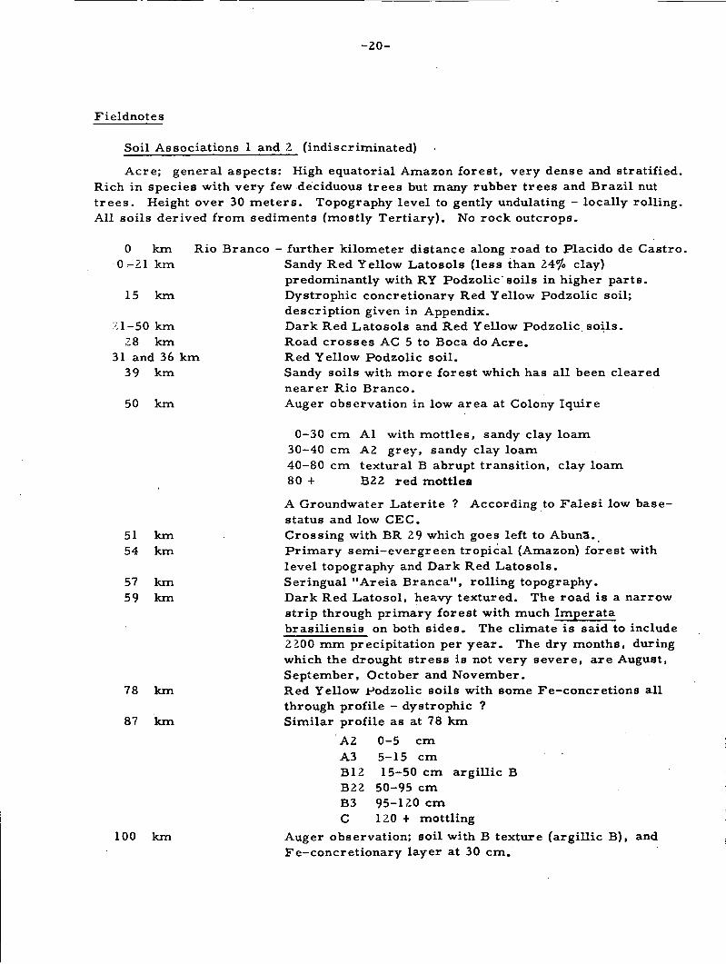
- 2 0 -
Fieldnotes
Soil Associations 1 and 2 (indiscriminated)
Acre; general aspects: High equatorial Amazon forest, very dense and stratified.Rich in species with very few deciduous trees but many rubber trees and Brazil nuttrees. Height over 30 meters. Topography level to gently undulating - locally rolling.All soils derived from sediments (mostly Tertiary). No rock outcrops.
0 km Rio Branco - further kilometer distance along road to Placido de Castro.0-21 km Sandy Red Yellow Latosols (less than 24% clay)
predominantly with RY Podzolic'soils in higher parts.15 km Dystrophie concretionary Red Yellow Podzolic soil;
description given in Appendix.'1-50 km Dark Red Latosols and Red Yellow Podzolic soils.
28 km Road crosses AC 5 to Boca do Acre.31 and 36 km Red Yellow Podzolic soil.
39 km Sandy soils with more forest which has all been clearednearer Rio Branco.
50 km Auger observation in low area at Colony Iquire
0-30 cm Al with mottles, sandy clay loam30-40 cm A2 grey, sandy clay loam40-80 cm textural B abrupt transition, clay loam80 + B22 red mottles
A Groundwater Latérite ? According to Falesi low base-status and low CEC.
51 km Crossing with BR 29 which goes left to AbunS.54 km Primary semi-evergreen tropical (Amazon) forest with
level topography and Dark Red Latosols.57 km Seringual "Areia Branca", rolling topography.59 km Dark Red Latosol, heavy textured. The road is a narrow
strip through primary forest with much Imperatabrasiliensi8 on both sides. The climate is said to include2200 mm precipitation per year. The dry months, duringwhich the drought stress is not very severe, are August,September, October and November.
78 km Red Yellow Podzolic soils with some Fe-concretions allthrough profile - dystrophic ?
87 km Similar profile as at 78 km
A2 0-5 cmA3 5-15 cmB12 15-50 cm argillic BB22 50-95 cmB3 95-120 cmC 120 + mottling
100 km Auger observation; soil with B texture (argillic B), andFe-concretionary layer at 30 cm.
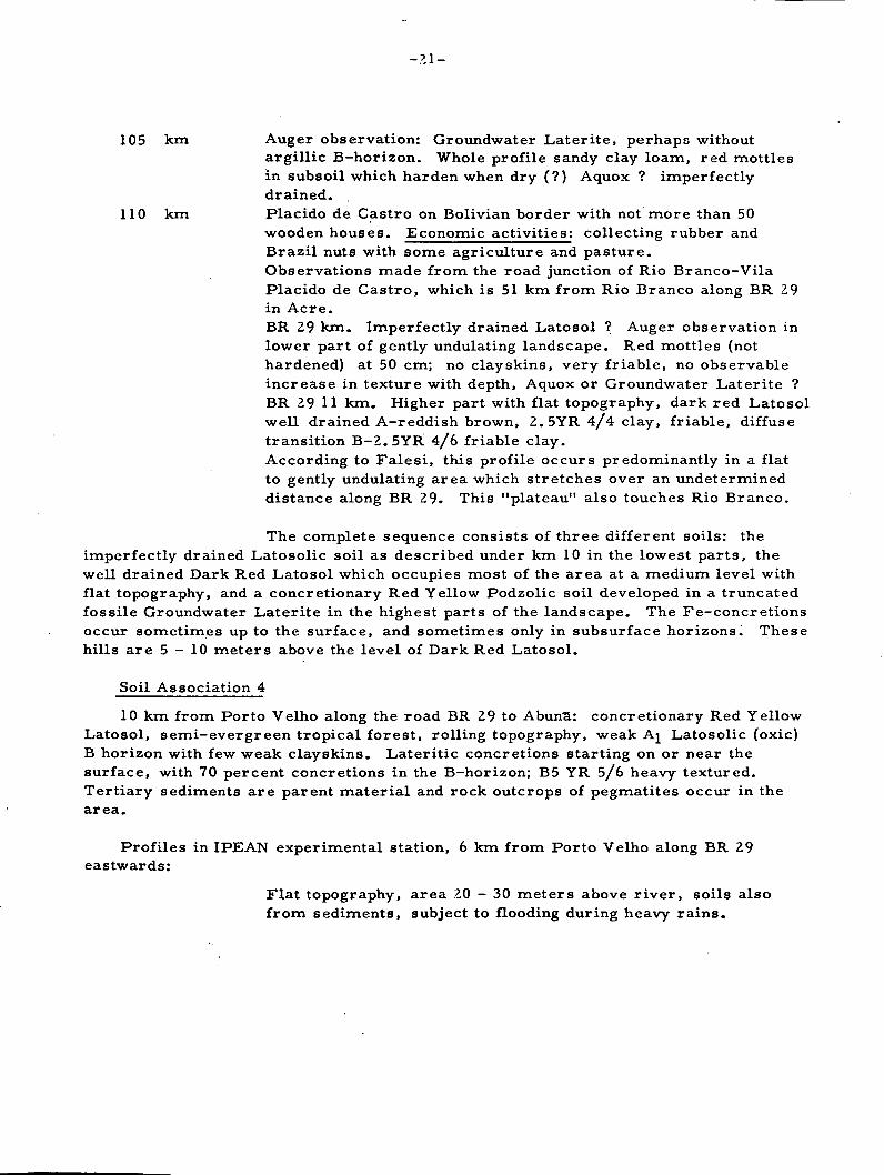
-21-
105 km Auger observation: Groundwater Laterite, perhaps withoutargillic B-horizon. Whole profile sandy clay loam, red mottlesin subsoil which harden when dry (?) Aquox ? imperfectlydrained.
110 km Placido de Castro on Bolivian border with not more than 50wooden houses. Economic activities: collecting rubber andBrazil nuts with some agriculture and pasture.Observations made from the road junction of Rio Branco-VilaPlacido de Castro, which is 51 km from Rio Branco along BR 29in Acre.BR 29 km. Imperfectly drained Lato sol ? Auger observation inlower part of gently undulating landscape. Red mottles (nothardened) at 50 cm; no clayskins, very friable, no observableincrease in texture with depth, Aquox or Groundwater Laterite ?BR 29 H km. Higher part with flat topography, dark red Latosolwell drained A-reddish brown, 2.5YR 4/4 clay, friable, diffusetransition B-2. 5YR 4/6 friable clay.According to Falesi, this profile occurs predominantly in a flatto gently undulating area which stretches over an undetermineddistance along BR 29. This "plateau" also touches Rio Branco.
The complete sequence consists of three different soils: theimperfectly drained Latosolic soil as described under km 10 in the lowest parts, thewell drained Dark Red Latosol which occupies most of the area at a medium level withflat topography, and a concretionary Red Yellow Podzolic soil developed in a truncatedfossile Groundwater Laterite in the highest parts of the landscape. The Fe-concretionsoccur sometimes up to the surface, and sometimes only in subsurface horizons. Thesehills are 5 -10 meters above the level of Dark Red Latosol.
Soil Association 4
10 km from Porto Velho along the road BR 29 to Abuna: concretionary Red YellowLatosol, semi-evergreen tropical forest, rolling topography, weak Aj Latosolic (oxic)B horizon with few weak clayskins. Lateritic concretions starting on or near thesurface, with 70 percent concretions in the B-horizon; B5 YR 5/6 heavy textured.Tertiary sediments are parent material and rock outcrops of pegmatites occur in thearea.
Profiles in IPEAN experimental station, 6 km from Porto Velho along BR 29eastwards:
Flat topography, area 20 — 30 meters above river, soils alsofrom sediments, subject to flooding during heavy rains.
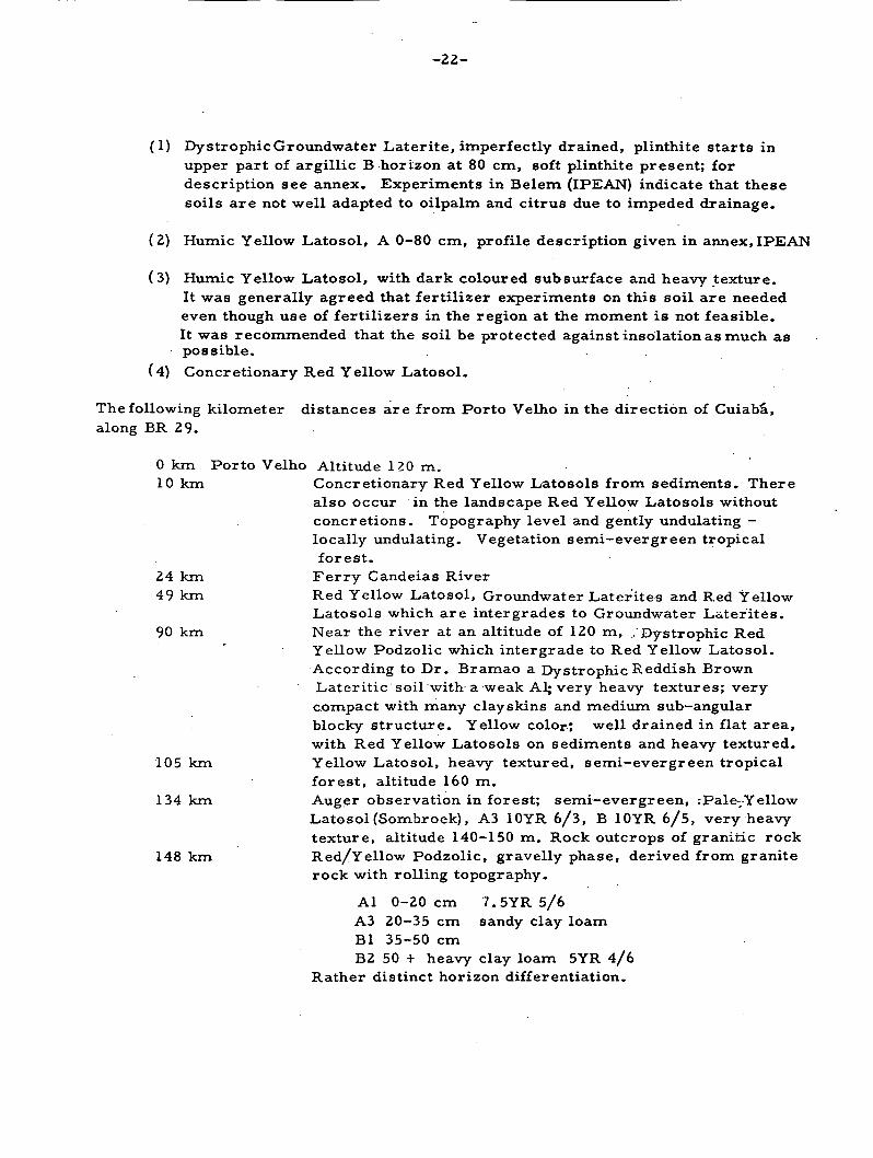
-22 -
(1) Dystrophie Groundwater Latérite, imperfectly drained, plinthite starts inupper part of argillic B horizon at 80 cm, soft plinthite present; fordescription see annex. Experiments in Belem (IPEAN) indicate that thesesoils are not well adapted to oilpalm and citrus due to impeded drainage.
(2) Humic Yellow Lato sol, A 0-80 cm, profile description given in annex, IPEAN
(3) Humic Yellow Latosol, with dark coloured subsurface and heavy texture.It was generally agreed that fertilizer experiments on this soil are neededeven though use of fertilizers in the region at the moment is not feasible.It was recommended that the soil be protected against insolation as much aspossible. .
(4) Concretionary Red Yellow Latosol.
The folio-wing kilometer distances are from Porto Velho in the direction of Cuiabâ,along BR 29.
0 km Porto Velho Altitude 120 m.10 km Concretionary Red Yellow Latosols from sediments. There
also occur in the landscape Red Yellow Latosols withoutconcretions. Topography level and gently undulating -locally undulating. Vegetation semi-evergreen tropicalforest.
24 km Ferry Candeias River49 km Red Yellow Latosol, Groundwater Laterites and Red Yellow
Latosols which are intergrades to Groundwater Latérites.90 km Near the river at an altitude of 120 m, ..Dystrophie Red
Yellow Podzolic which intergrade to Red Yellow Latosol.According to Dr. Bramao a Dystrophie Reddish BrownLateritic soil with a weak Al; very heavy textures; verycompact with many clayskins and medium sub—angularblocky structure. Yellow color-; •well drained in flat area,with Red Yellow Latosols on sediments and heavy textured.
105 km Yellow Latosol, heavy textured, semi-evergreen tropicalforest, altitude 160 m.
134 km Auger observation in forest; semi—evergreen, .pale,YellowLatosol (Sornbroek), A3 10YR 6/3, B 10YR 6/5, very heavytexture, altitude 140—150 m. Rock outcrops of granitic rock
148 km Red/Yellow Podzolic, gravelly phase, derived from graniterock with rolling topography.
Al 0-20 cm 7.5YR 5/6A3 20-35 cm sandy clay loamBl 35-50 cmB2 50 + heavy clay loam 5YR 4/6
Rather distinct horizon differentiation.

-23-
153 km DNER Camp, Caritianas - lunch.166 km Very level area on sediments. Altitude 190 m with semi-
evergreen forest. Observation with auger and near fallen tree -Lato sol ? Not modal with some clay skins B2 5YR 5/6 heavytexture with some coarse sand-grains. Many "Castanha do Para"trees (Brazil nut).
175 km Heavy Red Yellow Latosols on sediments. Not modal with someclay s kin s but not continuous and concretionary in sub-soil.
184 km Red Yellow Latosol on sediments, p H 4.5 in A and B with semi-evergreen Tropical forest, altitude 160 m.
187 km Pink granite observed.247 km Seringual Nova Vida. Expedition spent the first night here.
Note: Soil Association 4 finishes west of Seringual Nova Vidaat Ariquemes.
Soil Association 5
The following distances are from Nova Vida in the direction of Cuiaba, alongBR 29, except the first observation which is west of Nova Vida.
24 km West of Nova Vida, concretionary Red Yellow Podzolic soil ongneiss. Semi-evergreen forest at an altitude of 210 m.
4 km East of Nova Vida, the rock is diorite, Eutrophic Reddish BrownLateritic soil Fe - and Mn concretions with many clayskins,subangular blocky pH top soil 4.5 at 100 cm 6.0 at 150 cm6.5 stoneline at 50 cm between A and B topography rolling,altitude 250 m profile 180 cm deep.
23 km Auger observation, clayey profile 5 YR 5/6 (B-horizon),concretions starting at 70 cm. Probably a soil with argillic -B horizon; altitude 240 m with semi-evergreen tropical forest.
41 km Dystrophie Reddish Brown Lateritic soil of heavy texture. Thewhole profile has lateritic concretions with stony layer oflateritic concretions in upper part of the profile. Clayskins atan altitude of 240 m.
0 - 5 cm Al mixed5 -15 A3
15 -30 Bl30 -70 B2170 -130 B22 7.5YR 3/6
130 -230 B3 10R 3/8 with white spots; structure ofearth worms
230 -330 . Cl some structure of earth worms330 + still biological activity
45 km Rather deep soils with Reddish Brown Lateritic or Dark RedLatosols. Topography rolling with forest somewhat drier
52 km Soil on decomposed shale with semi-evergreen forest; altitude230 m.

-24-
54 km. Jaru River ferry.59 km Reddish Brown Lateritic soil. Profile on slope mixed with
basic rock of textural B—horizon, strongly developed angularblocky structure with many clayskins, 10 YR 3/6 clay, averagedepth of profile 100 cm. Sample of B-horizon taken.
60 km Eutrophic Reddish Brown Lateritic soil; short description byDPFS (see Appendix) pH A-5, pH B, C and rock -6 . Color ofB 2.5YR 4/6, probably from quartzo-diorite. Clay texture withvery porous, friable; clayskins not as well developed here as inother RBL profiles seen so far. Altitude 240 m. Semi-evergreenforest.
71 km Plateau ("Taboleiro"). Yellow Latosol from clayey sediments,in sub-soil plinthite, hard Fe-concrétions, and according toEtchevehere also tuff.
95 km Eutrophic Reddish Brown Lateritic soil resembling the TerraRoxaEstruturasoil of the Furnas area in Minas Gérais.Description by DPFS (see annex). Undulating (rolling) landscape,colour B2 2.5YR4/4 alt. 320 m. The vegetation is changingtowards semi-deciduous perhaps in function with altitude.
Soil Association 6
2 km west of Rondonia: Eutrophic Red Yellow Podzolic soil
Aj 0-15 cm granular, medium to coarse, 7.5YR 3/2 sandyclay loam
A3 15-30 cmB T 50-120 cm strong medium sub-angular blocky 5 YR 5/7
abrupt transition to C, between B and C a thincontinuous Fe layer.
C 120 + mottled yellow, white and red, only part of thespot s harden.
Rolling topography with semi-evergreen vegetation and perhapstransition to semi-deciduous tropical forest. Avilan calls it aRed Yellow Podzolic soil. Altitude 200 m.
The next kilometer distances are east of Rondonia along BR 29.
0 km Ferry Machada River (expedition spent second night in Rondonia)17 km Sandy Red Yellow Podzolic with clear transition A-B concretion-
ary phase and slopes several hundred meters long. Profile hasA2 in sense of 7th Approximation.
29 km Red Yellow Podzolic, Aj-fine sandy clay loam of brownishcolours; depth 100 cm.
45 km Flat topography.

113
132
160
058
k m
k m
k m
k mk m
A lA 1 2A 2B 2
05
1050
80
- 5 cm- 10 cm-50 cm!-80 cm'
- 120 cm
- 2 5 -
Soil Association 7
Kilometer distances are along BR 29 in eastern direction' asfrom Rondonia.
53 km Moderate well drained Red Yellow Podzolic, intergrading toGroundwater Latérite probably from sediments
very -weakwith many concretionssandy clay loamclay loam with much laterite and mica,massive porousplinthite with yellowish and reddish colors,10R 4/8
C 130 + greyish and 10R 4/8mottling only deeper than 70 cm.Altitude 200 m
62 km The vegetation of wetter soils looks somewhat like cerrado andat other times like a mixture of cerrado with forest
78 km Dystrophie Groundwater Latérite with textural B-horizonMottling in first 50 cm, yellow, deeper greyish at 100 cmplinthite, no A^ present. 240 m altitude, vegetation semi-deciduous tropical forest.
79 km Dystrophie concretionary Red Yellow Podzolic soilA light sandy clay loam, B clay loam, pH A-5, B-4.5 colorB 5YR 4/6. Rolling topography, semi-deciduous tropical forest,dry period 4 months. Altitude 250 m.
102 km Dystrophie Red Yellow Podzolic light textured. (For profiledescription see Appendix)Soil derived from sandstone with textural (argillic) B-horizonAj., A2, concretions in the B, plinthite rather soft; sandstonemuch disintegrated.Concretionary soil with an A and A horizon, no B horizon;directly on D which is decomposed sandstone.Riozinho - camp of CIB road constructors where the expeditionspent the third night. Riozinho is located on the taboleiro withYellow Latosols.Ferry over Pimenta Bueno river at settlement of same name.The following distances are kilometers along BR 29 as fromPimenta BuenoPimenta BuenoDystrophie Groundwater Laterite imperfectly drained on shalesmorphology comparable with some Ferruginous Tropical soils.pH surface 5.5, subsoil 4.5 altitude 220 m. Semi-deciduoustropical forest.

-26-
65 km Grumusolic Profile:
Al 0 - 7 cm 7.5YR 6/3.7.5YR 3/4 (moist), clay transitionlevel and clear
A3 7-13 cm transition level and clear
Bl 13-20 cmB2 20-25 cm 5YR 3/3 clay occurrence of clayskins, coarse
prismatic structure. Transition level andgradual
C pH6.0
Deep cracks nearly down to the decomposing rock (D). Slickensidesin lower part of the profile; imperfectly drained soil, flat areaon shale, campo cerrado vegetation. Altitude 240 m.This soil has many characteristics of a Grumusol. The some-what lighter textured top-soil and probably the clayskins in theB— horizon are arguments against the possibility of it being aGrumusol. For description and data see Appendix.
73 km Groundwater Latérite, intergrading to Grey Hydromorphic soil.Aj, A£, B argillic.C. Sticky not hardened mottles in lower B;these mottles are red, matrix color greyish; clay, clearboundaries. Red mottles seem to harden when dry. From shales.Altitude 245 m.The vegetation shows extreme dryness in the dry period, as wellas an excess of water in the rainy season. The vegetation lookssomewhat like a transition between cerrado and caatinga, butthe ecological conditions are quite different. The soil is im-perfectly drained.
79 km Grey Hydromorphic soil, Brazilian concept; soil with probablyan argillic B horizon with red mottles in the lower part whichmay be of the parent material also some slickensides. Fromshales. Vegetation cerrado but some occurrences of semi-deciduous tropical forest. Altitude 245 m.
0 - 5 cm AI pH 4.55 -40 cm Yellowish Brown surfaceB2 medium prismatic, grey colors indicating gleying, pH 4.5B3 red mottling, probably due to parent material.
C pH 5.0Topography: level Poorly drained soil
93 km A calcareous shale was observed during the trip to Porto Velho.

- 2 7 -
Soil Association 8
Kilometer distances along BR 29 as from Pimenta Bueno.
94 km Beginning of sandy region - Red Yellow sands.96 km Shales with lenses on top of sands with lateritic concretions.102 km Red Yellow sands, semi—deciduous tropical forest. Altitude 340m156 km Red Yellow sands, podzolized, profile high in eroded road cut,
semi-deciduous forest. Some people call this a Regosol orQuartzo-Regosol Altitude 360 m.
184 km Lunch in DNER camp. We were told there are abundant rubbertrees.
209 km Red Yellow sands, cerradao. Altitude 500 m.214 km Cerrado vegetation218 km Red sands with latosolic features, semi-deciduous tropical
forest ? Transitional area to semi—evergreen forest.
Soil Association 9
223 km Red Yellow Lato sol with clay texture. Semi-deciduous tropicalforest. Altitude 620 m.
245 km Red Yellow Latosol or Dark Red Latosol,described and sampledby DPFS (see annex). Somewhat excessively drained profile;Bemi-evergreen tropical forest. Altitude 640 m. Profile wasstudied within the forest.
257 km Vilhena; expedition spent . the fourth night here with accommoda-tion provided by DNER
The next kilometer distances are as from Vilhena in thedirection of Cuiabâ'.
Vilhena; located in an island of campo cerrado
Abrupt change to transitional forest; semi-deciduous to semi-evergreen.Heavy Red Yellow Latosol; semi-evergreen forest.Gradual change to cerradao.Transition to forest on dark red heavy soils but with sandy soilsat lower positions.Transition to sandier soils; somewhat drier forest.Somewhat humid Regosol, A 10 YR 6/2 (dry) 10 YR 3/2 moist,Altitude 520 m. Perhaps a weak podzol, semi-deciduous tropicalforest.Medium textured Red Yellow Latosol; semi-evergreen tropicalforestAltitude 600 m.
0
5
k m
k m
7 km1013
4452
63
69
k mk m
kmkm.
km
km
-28-
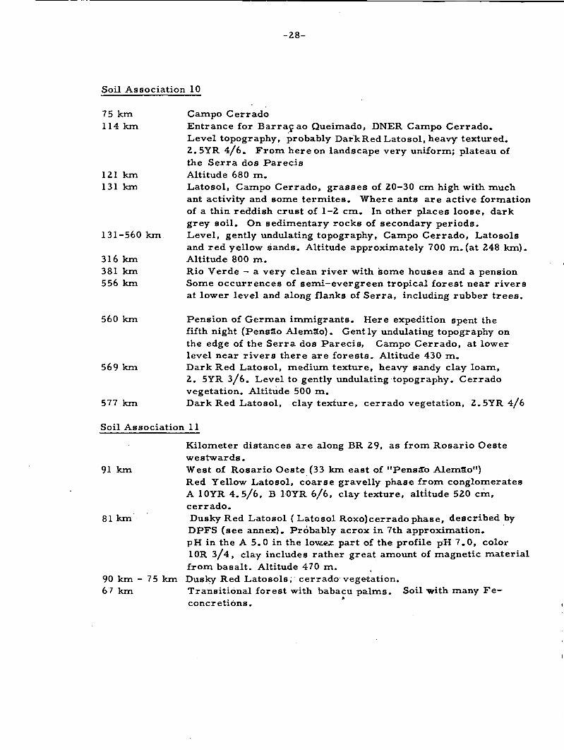
Soil Association 10
75 km Campo C err ado114 km Entrance for Barraç ao Queimado, DNER Campo Cerrado.
Level topography, probably DarkRedLatosol, heavy textured.2.5YR 4/6. From here on landscape very uniform; plateau ofthe Serra dos Parecis
121 km Altitude 680 m.131 km Lato sol, Campo Cerrado, grasses of 20-30 cm high with much
ant activity and some termites. Where ants are active formationof a thin reddish crust of 1-2 cm. In other places loose, darkgrey soil. On sedimentary rocks of secondary periods.
131-560 km Level, gently undulating topography, Campo Cerrado, Latosolsand red yellow sands. Altitude approximately 700 m.(at 248 km).
316 km Altitude 800 m.381 km Rio Verde - a very clean river with some houses and a pension556 km Some occurrences of semi-evergreen tropical forest near rivers
at lower level and along flanks of Serra, including rubber trees.
560 km Pension of German immigrants. Here expedition spent thefifth night (PensSo Alem3o). Gently undulating topography onthe edge of the Serra dos Parecis, Campo Cerrado, at lowerlevel near rivers there are forests. Altitude 430 m.
569 km Dark Red Latosol, medium texture, heavy sandy clay loam,2. 5YR 3/6. Level to gently undulating topography. Cerradovegetation. Altitude 500 in.
577 km DarkRedLatosol, clay texture, cerrado vegetation, 2.5YR4/6
Soil Association 11
Kilometer distances are along BR 29, as from Rosario Oestewestwards.
91 km West of Rosario Oeste (33 km east of "Pensa"o Alemao")Red Yellow Latosol, coarse gravelly phase from conglomeratesA 10YR 4.5/6, B 10YR 6/6, clay texture, altitude 520 cm,cerrado.
81 km Dusky Red Latosol (Latosol Roxo)cerrado phase, described byDPFS (see annex). Probably acrox in 7th approximation.pH in the A 5.0 in the low.ex part of the profile pH 7.0, color10R 3/4, clay includes rather great amount of magnetic materialfrom basalt. Altitude 470 m.
90 km - 75 km Dusky Red Latosols, cerrado vegetation.67 km Transitional forest with babacu palms. Soil with many Fe-
concr étions.
-29-
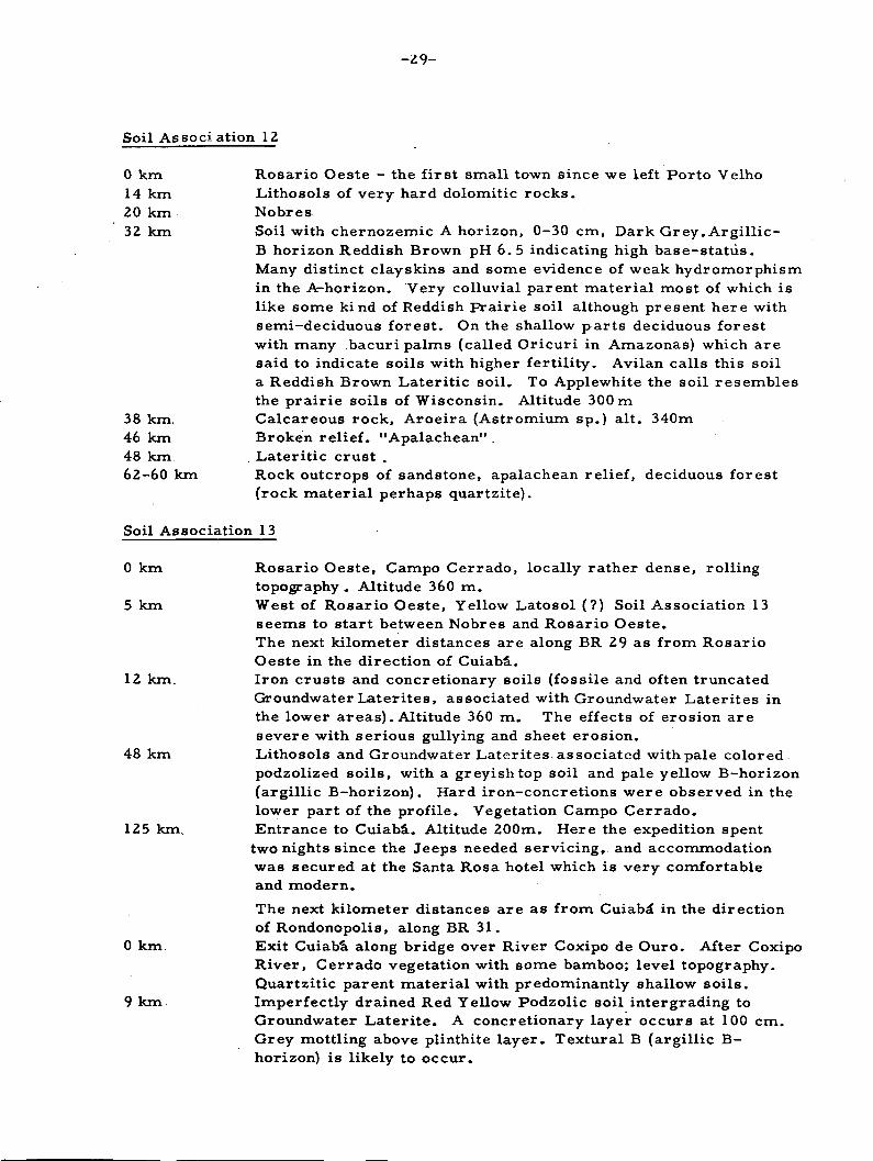
Soil Association 12
0 km Rosario Oeste - the first small town since we left Porto Velho14 km Lithosols of very hard dolomitic rocks.20 km Nobres32 km Soil with chernozemic A horizon, 0-30 cm, Dark Grey. Argillic-
B horizon Reddish Brown pH 6.5 indicating high base-statvis.Many distinct clayskins and some evidence of weak hydromorphismin the A-horizon. Very colluvial parent material most of which islike some kind of Reddish prairie soil although present here withsemi-deciduous forest. On the shallow parts deciduous forestwith many bacuri palms (called Oricuri in Amazonas) which aresaid to indicate soils with higher fertility. Avilan calls this soila Reddish Brown Lateritic soil. To Applewhite the soil resemblesthe prairie soils of Wisconsin. Altitude 300 m
38 km. Calcareous rock, Aroeira (Astromium sp.) alt. 340m46 km Broken relief. "Apalachean" .48 km. Lateritic crust .62-60 km Rock outcrops of sandstone, apalachean relief, deciduous forest
(rock material perhaps quartzite).
Soil Association 13
0 km Rosario Oeste, Campo Cerrado, locally rather dense, rollingtopography . Altitude 360 m.
5 km West of Rosario Oeste, Yellow Latosol (?) Soil Association 13seems to start between Nobres and Rosario Oeste.The next kilometer distances are along BR 29 as from RosarioOeste in the direction of Cuiabâ.
12 km. Iron crusts and concretionary soils (fossile and often truncatedGroundwater Latérites, associated with Groundwater Laterites inthe lower areas). Altitude 360 m. The effects of erosion aresevere with serious gullying and sheet erosion.
48 km Lithosols and Groundwater Laterites, associated with pale colored,podzolized soils, with a greyish top soil and pale yellow B-horizon(argillic B-horizon). Hard iron-concretions were observed in thelower part of the profile. Vegetation Campo Cerrado.
125 km. Entrance to Cuiabâ. Altitude 200m. Here the expedition spenttwo nights since the Jeeps needed servicing, and accommodationwas secured at the Santa Rosa hotel which is very comfortableand modern.
The next kilometer distances are as from Cuiabä in the directionof Rondonopolis, along BR 31.
0 km Exit Cuiabei along bridge over River Coxipo de Ouro. After CoxipoRiver, Cerrado vegetation with some bamboo; level topography.Quartzitic parent material with predominantly shallow soils.
9 km Imperfectly drained Red Yellow Podzolic soil intergrading toGroundwater Laterite. A concretionary layer occurs at 100 cm.Grey mottling above plinthite layer. Textural B (argillic B-horizon) is likely to occur.

- 3 0 -
Horizonation is not very distinct. pH 4.8 dystrophic profile.Quartzitic gravel occurs below the cemented concretionarylayer. The surface consists of sediments, presumably on topof older material. Cerrado vegetation on level topography.Similar soils occur under drier conditions in Venezuela but theyare believed to be eutrophic. The same applies to Ghana.Altitude 220 m. Falesi has. observed soils similar to this profilein Maranhao which he examined. Bennema mentioned that somesimilarity exists (except for the concretionary layer) with theRed Yellow Podzolic soils of the Laras variation in Sao Paulo.
41 km This profile is similar in some respects to the previous onebut its classification is not clear. There is a textural differencebetween A-horizon (sandy loam) and B-horizon (sandy clay loam)giving some argument for an argillic B. Clay skins are notvisible, possibly due to the high porosity. The concretionarylayer is higher (80cm) in the profile. Camargo thinks that theconcretionary layer may be recent and not fossil as in formerprofile. Vegetable Cerrado and Cerradao. A few kilometersbefore this stop on the mesa, silt stone was observed.
56 km Profile transitional to the next soil association, being a Dark RedLatosolwith fine quartz gravel at about 30-40 cm. 2 5YR 4/6.Avilan agrees to its classification as Dark Red Latosols, typicalof the Brazilian classification. Zamora: Red Latosol, altitude230 m mixed transitional vegetation with many babacu palms .The rest of the trip to Rondonopolis was done at night due toengine trouble but observations were made in this area duringthe outgoing excursion.
Soil Association 14
70 km Serra sao Vicente, consisting of granitic rocks giving rise todystrophic and eutrophic gravelly podzolized soils with a stronglyundulating (hilly) to mountainous relief. Granitic hills 30-40 mhigh, covered with transitional forest and babacu in between morelevel topography and cerrado vegetation. Many shallow soilssimilar to gravelly podzolized soils in Sao Paulo, also on granite
84 km Transition to sandstone area.
Soil Association 15.
86 km Red Yellow Latosol with large fazenda, village, campo cerrado,and level topography.
93 km Lower area with gallery forest (forest "ciliar").99 km Sands106 km Red Yellow sands with some very poor cassava and pineapple.I l l km Red Yellow Latosol and campo cerrado.126 km Campo cerrado, recently burnt.130 km Rolling topography with some plinthite in profile and cerrado
vegetation.

-31-
131 km Somewhat higher level: Red Yellow Latosol between soils withplinthite.
132 km Level topography: Red Yellow Latosol with cerrado vegetation.
Soil Association 16
133 km Very near former profile. Moderately drained Red YellowPodzolic with grey Al, yellowish B transitional vegetation,cerrado mixed with forest on shales, and rolling topography.
139 km Concretionary Red Yellow Podzolic, grey sandy clay loam,B-horizon with some plinthite.
140 km Litho sol146 km A small town with some cerrado vegetation. Topography rolling
to hilly with slopes several hundred meters long.148 km Jaciara sugar factory, also citrus cultivated.153 km Intensive agriculture.154 km Soil with textural B and lateritic concretions, moderately well
drained with gravelly Red Yellow Podzolic soil ? At the highestpart of the landscape Dark Red Latosols occur.
156 km Longer slopes with many babacu palms. Intensive pastures withcapim coloniao, also bananas and cassava
161 km Small village of Juscelandia.164 km Strongly undulating (hilly) with cultivation of rice, cassava
cotton, castor—oil.
Soil Association 17.
171 km Concretionary lateritic soil with argillic B-horizon on quartziteon upper part of slope, similar to soils known in Goias, but heresoils podzolized. In Goias many concretionary soils with latosol-ic features, hilly topography and transitional forest.
176 km Many babaqu palms.176-191 km Dark Red Latosols and concretionary Red Yellow Podzolic soils,
concretions of Fe-concretions with rock outcrops of sandstoneand quartzite.
196 km Sandy soils with cerrado vegetation and long slopes.206 km Broken topography with lithosols of sandstone.
Soil Association 18
222 km Red Yellow Latosols, with gently undulating slopes and cerradovegetation.
226 km Rondonopolis where the expedition spent the night. This town isan important center in the agricultural region, especially forcotton and rice and corn and beans. Good connections withGoiania, Brasilia and Campo Grande.

- 3 2 -
The following kilometer distances are from Rondonopolis alongBR 31 in the direction of Jatai.
0 km Rondonopolis, altitude 220m. Pazula River altitude 180 m.Near the river there is forest changing to closed cerrado thencerrado .
10 km Typical cerrado on sandy soils. Altitude 250 m. Many palmswere observed of a type with sub-terranean stem: 'Indaia atleia
14 km Campo cerrado vegetation. Altitude 430 m.21 km Dark Red Latosol, sandy clay loam but clay in lower part,
2.5YR 3/6 with cerrado vegetation. Altitude 500 m.30 km Dark Red Latosol of medium or heavy texture - pH 6.6 Acrox.
cerrado vegetation, rolling landscape with long slopes. Dryperiod of 4 months. Soils too poor for Pinus elliothii.Altitude 460 m.
32 km Altitude 520 m.42 km Open cerrado vegetation.49 km Basalt conglomerate, lithosol, Altitude 420 m. Concretionary
soil •with material apt to harden near the surface.64 km Inhuma, altitude 420 m. with cerrado vegetation.78 km Concretionary Dark Red or Red Yellow Latosol of medium
texture. Altitude 420 m -with a somewhat gravelly profile.83 km Sao Jose de Planalto - a small town with cerrado vegetation and
rolling landscape. Altitude 520 m.94 krr Plateau with Dark Red Latosol of medium texture and cerrado
vegetation -with low shrubs.100-103 km Large depression with hydromorphic soils, semi-deciduous
forest. Altitude 540 m.103 km Serra da Giboia begins with Red Yellow Latosols of medium
texture and more broken topography. Cerrado vegetation.108 km Mudstones and shales with soils high in clay content.125 km High point overlooking canyon of Sao Lourenco, "amphitheater"
Altitude 680 m.139 km Red Yellow Latosols of medium texture and cerrado vegetation.149 km Red Yellow Sands and campo cerrado .158 km Heavier textured soils and cerrado vegetation. Altitude 660 m.166 km Red Yellow Latosol and cerrado vegetation. Altitude 770 m.169 km Dark Red Latosol, Acrox. clay loam, 2.5YR 4/6. Slightly
sticky;topography with gently undulating slopes. Altitude 760 m.
Soil Association 19
178 km Red Yellow Sands on rolling topography.183 km Red Yellow Sands probably of Botucatu sandstone.188 km Latosols190 km Vereda-buriti palms and grass vegetation but on higher parts
campo cerrado.210 km Red Yellow or Dark Red Latosols of medium texture.224 km Cerrado vegetation. Altitude 840 m.

- 3 3 -
237 km Alto Garcas which is a small town with topography gently-undulating. Altitude 830 m.
238 km Red Yellow Sands, podzolized.258 km Red Yellow Lato sol s or sands.288 km Altitude 760 m.296 km Red and Yellow podzolized sands with' cerrado vegetation and
gently undulating slopes. Altitude 760 m.297 km Shales298 km Deep gully erosion in area on limit of sands and light textured
Red Yellow LatosoLs311 km Alto Araguaya. Altitude 680 m.315 km Planted pasture with presence of Buriti palms. Rolling topography
with cerrado vegetation, gullies322 km Sands with areas of severe erosion.
The rest of the trip was made at night. The highest point in thearea(920 m) was passed at 150 km west of Jatai. The vegetationis cerrado and campo cerrado (more open, lower and less shrubs).
Jatai at 670 m. Soil Association 19 ends somewhere west of Jatai.
Soil Association 20
Near Rio Claro river at Jatai: Dusky RedLatosols showing moreclayskins than usual but not enough to be considered as Terra RoxaEstruturada (Reddish Brown Lateritic)from basalt. Further fromthe river the Dusky RedLatosols were more typical but showedin some parts a mixing of material derived from sandstone.The relief is rolling and the vegetation campo cerrado. Thereis a presence of Aroeira. These soils are not known inVenezuela and Peru but do exist in Paraguay. Bananas on thesesoils show symptoms of deficiencies. Most of the area isdedic ated to livestock production.
9 km East of Jatai along BR 54: Dusky Red Latosol (Latosol Roxo)semi-deciduous forest and cerrado vegetation.Between 9 km and 16 km along the same road transition to soilAssociation 21, probably at about 11 km.Soils of Soil Association 20 -were observed again near the town ofRio Verde, at 73 km from Jatai along road BR 54; Dusky RedLatosol, cerrado vegetation and semi-deciduous forest. In thelower parts there occurs a sandy Dark Red Latosol.
85 km 'From Jatai, near Rio Verde Dusky Red Latosol.92 km From Jatai in the town Rio Verde there occurs cerrado vegetation,
Dusky Red Latosol.106 km Dusky Red Latosol,cerrado vegetation. Altitude 730 m. (along
BR 19, as from Jatai)174 km Concretionary Dusky Red Latosol ? Cerrado vegetation.
.Altitude 560 m.

-34-
Soil Association 21.
16 km East of Jatai along BR 54: Red Yellow Latosol of medium texturewith B-horizon and more than 15 percent clay. In Argentina in theWestern Province of Buenos Aires, such soils are calledRegosolic Brunizem as they occur narrowly associated withBrunizems. They exist in the drier areas where there is aproblem of erosion. In Peru they exist on sandstone and inPara similar soils occur under forest vegetation. They respondvery well to NPK fertilizer. It is expected that the cerrado soilsunder discussion will also have a deficiency of micro-nutrientswith hard plinthite at the base of the profile. Altitude 750 m.
25 km Dark Red Latosol with cerrado vegetation and level topography.Many Indaia palms (Atleia exigua) Altitude 800 m.
45 km Hydromorphic soils ?54 km Red Yellow Latosol of medium to heavy texture. Vegetation
campo with few low shrubs. Altitude 840 m.61 km Dark Red Latosol with heavy texture. Semi-deciduous to semi-
evergreen forest. This forest occurs as strips only in thehigher parts of the area with a sharp transition to the cerradoareas. Cerrado is found on the lighter textured soils. Altitude820 m. Topography gently undulating.Transition to soils of soil association 20.Soils of soil association 21 occur again between the river Verdeand the river Turvi along BR 19. Red Yellow Latosol and DarkRed Latosol, with Dusky Red Latosols at the lowest levels.Topography gently undulating.
197 km Presumably Acrox with Dark Red Latosol under third-classforest.Other profile at a few hundred meters: from calcareous rockpH surface 6.5 deeper pH 6.0, medium to high base statuswith a mollic epipedon, and all the other features are of a DarkRed Latosol.Altitude 580 m.
Soil Association 22
Soils of this region were only observed between Goiania andAnapolis, along the BR 14.
6 km From Goiania: rolling to hilly relief with semi-deciduous todeciduous forest. After destruction of the forest there is aregeneration of palm trees and some agriculture. Higher partsare still forested. Altitude 680 m.
13 km Dark Red Latosol, very friable with distinct dark colored Ajdissected relief. Citrus and Bacuri cultivation.
19 km Lithosols on the hills with DarkRed Latosols in areas between.Deciduous forest on Litho sols (on phyllites) pastures.

-35-
25 km. Longer slopes with roundtop hills. Slopes of about 15 per cent, about50-60 m above normal surface elevation. Dark Red LatosolspH 5 at surface,pH 6 in sub—soil •with presumably medium tohigh base status and weak A . Near to this area a very darkcolored rock (possibly basic intermediate) was observed. The
area is predominantly pasture with small areas of horticulture.
Soil Association 23
239 km From Jatai along BR 19: Dark Red Latosol with chernozemicA, altitude 640 m. Semi-deciduous forest with 4 limestonequarries.
247 km. Phyllites and calcareous rocks with dissected relief and quarries.Altitude 650 m.
Soil Association 24
4 km From Goiania along BR 19: Dark Red Latosol with cerradovegetation and gently undulating topography.Along BR 14 near Anapolis there also occur soils of soilassociation 24: at a somewhat higher altitude - 900—1000 mrolling topography with long slopes, open valleys, soils areconcretionary and are locally shallow in the higher parts.Cerrado vegetation associated with predominant DarkRed Latosols.The Planalto of Brasilia is1, also included in Soils Association 24although there is probably no connection between this plateauand the plateaus of Anapolis and Goiania. The topography islevel to gently undulating. Concretionary Red Yellow Latosolsoccur on the highest parts with Dark Red Latosols. on the lowersections. On the edge of the Planalto there are also indiscrimi-natedconcretionary podzolized soils as described by Feuer .
(see Appendix for complete data).
Soil Association 25 '
100-120 km From Goiania in the direction of Brasilia, located near Alexsaniabetween Anapolis and Brasilia: fossil Groundwater Lateritesoccur on some of the higher parts of the area. Very well definedhills, similar to lateritic hills in India near Bengalore. On thelower areas are presumably Acrox, Dark Red Latosols. Thetopography is gently undulating to undulating. Altitude 1000 m.
Rocks are schists and phyllites.125 km Much erosion with strongly undulating (hilly)topography and
shallow soils with an A-horizon over a yellow subsurface soil,which appear to be Tropical Acid Brown Forest soils (Tropepts?)Some spots show an A-horizon directly over decomposing rock(Regosols ?) Many ant-hills are conspicuous within the area.

- 3 6 -
Climate
There are few climatic stations in the area, especially in the Amazon region.Included in this chapter are the data.of six existing stations, plus estimated data of twosupplementary points in the part without stations. For Porto Velho and PresidenteMurtinho the temperatures are approximations.
Although certain objections exist to this method for the tropics, since thesystem is used, for instance, in Brazil, and since differences with the method ofPapadakis are not very striking, the method of Thornthwaite has been chosen for thecalculation of the potential evapotranspiration. It seems that the Thornthwaite methodgives too low figures for the evapotranspiration. The number of dry (D), humid (H),and intermediate (I) months, are calculated according to Papadakis. A month is humidwhen rainfall (r) is greater than evapotranspiration (pe); it is dry when available water(rainfall plus water stored in the soil from previous rains) covers less than half of theevapotranspiration. Other months are intermediate. As the maximum amount of waterwhich can be stored in the soil we have taken 100 mm. "Surplus" in the tables is r-pe,while "deficit" is pe-r, ignoring the amount of stored water. For the system of .calculation we refer to the publication of Papadakis. \J
The representative stations of the northern part, Sena Madureira and PortoVelho, have rainfall of over 2, 100 mm a year, with a heavy rainfall in the months ofOctober to April, and much less in the remaining months. The mean temperature is24. 2°C in Sena Madureira, and 25.1°C in Porto Velho. The summer temperatures are25.0°C and 26.4°C respectively, and the winter temperatures 21.9°C and 24. 3°Crespectively. The lower temperatures occur during the period with minimum rainfall.As can be seen in the tables there are no dry months in Sena Madureira, and two inPorto Velho. It is clear that by the use of mean figures of many years the high and lowtemperatures are levelled. There is no doubt that in the case of Sena. Madureira inyears to come one or more of the four intermediate months will become dry.
The large central part of the investigated area is represented by the two points60°L, 12°S and 58°L, 14°S. Rainfall is a little less than in the previous places, 2, 100-2,250 mm in 60-12 and 1,605 - 1,750 mm in 58-14. The distribution during the yearis the same. The rainfall in the winter months is not exactly known, but in each case itis less than 50 mm. The mean annual temperatures are lower, 24.1 C and 23.9°Crespectively. The summer temperatures are 25.0°C and 25.8 C, the winter tempera-tures in both cases are 23.1°C. The resulting number of dry months is two in 60-12and three in 58-14.
The west of the southern part of the area is represented by the meteorologicalstation of Cuiabâ. The rainfall distribution is the same but the total amount is muchless, 1,350 mm annually. The mean annual temperature is 23.1°C with a mean summertemperature of 26.7°C, and a mean winter temperature of 22.6 C. The number of drymonths is three, but there are two more intermediate months than in 58-14, whichsuggests that one more dry month is easily possible in several years.
1/ Papadakis, J. Climatic Tables for the World, Buenos Aires, 1961

- 3 7 -
The rainfall in Presidente Murtinho is 1,881 mm annually. During the summerthere is generally more than 300 mm per month, while during the colder winter monthsless than 10 mm is normal. The temperature data are not as reliable as in most otherstations; the mean annual temperature is approximately 2Z.6°C, the summer temper-ature is 23.8°C - 24°C, and the winter temperature is about 19.2°C - 19.5°C. Theresulting number of dry months is low, but with three as intermediate classified monthsit is easily possible that there are more months dry, which is more in accordance withthe climatic conditions in the surrounding stations.
The climatic conditions in both remaining stations, Goiania and Formosa, arecomparable. The rainfall is 1,755 and 1,628 mm respectively, and the distribution isthe same as in the stations already mentioned. During the winter months the rainfallis extremely low (less than 10 mm per month), while in the summer months amountsof over 300 mm are no exception. The mean temperature is 21.4 C in Goiania and21.3°C in Formosa. The respective summer temperatures are 22.4°C and wintertemperatures 19.2°C and 19.3°C. The resulting number of dry months is in both casesthree, but the second intermediate month in Goiania can become a dry month in severalyears.
Hundreds of maps are published in the Atlas Climatológico do Brasil ( 5 volumes1955 - I960 ) 1/ which give complete information of the available data.
— Adalberto Serra, Atlas Climatológico do Brasil, Conselho Nacional de Geografia,5 volumes, 1955 - I960.

-38 -
ANNEX 1. CLIMATOLOGICAL DATA
S. Madureira
Porto Velho
60°L 12°S
58°L 14°S
Cuiaba*
Pres . Murtinho
Goiania
Formosa
2137
2542
2100 - 2250
1605 - 1755
1352
1881
1755
1628
Annualrainfallin mm
24.2
25.1
24.1
23.9
23.1
22.6
21.4
21.3
Meanannualtemp, in°C
25.0
26.4
25.0
25.8
26.7
23.8-24
22.4
23.0
Summertemp, in
°C.
21.9
24.3
23.1
21.0
22.6
19.2-19.
19.2
19.3
Wintertemp.in°C
0
2
2
3
3
5 2
3
3
Numberof dry-months
4
2
3
2
4
3
2
2
Numberof inter-mediatemonths
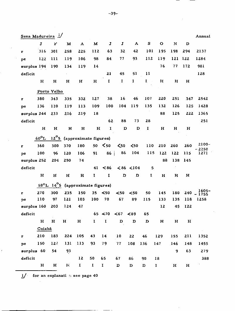
-39 -
Sena Madureira 1/ Annual
r
pe
surplus
deficit
r
pe
surplus
deficit
J
316
122
194
H
Porto
380
136
244
H
60°L
r
pe
surplus
deficit
r
pe
surplus
deficit
r
pe
surplus
deficit
360
100
252
H
58°L
270
110
160
H
j?'
301
111
190
H
Velho
343
110
233
H
12°5
300
96
204
H
14°5
300
97
203
H
Cuiabâ
210
150
60
H
183
127
54
H
M
258
119
134
H
335
119
216
H
A
225
106
119
H
332
113
219
H
M
112
98
14
H
127
109
18
H
J
63
84
21
I
38
100
62
I
(approximate figures)
370
120
250
H
180
106
74
H
50
91
41
I
<50
86
<86
I
(approximate figures)
235
121
124
H
224
131
93
H
150
103
47
H
105
113
12
I
35
100
65
I
43
93
50
I
<50
70
<70
I
14
79
65
I
i->
32
77
45
I
16
104
88
D
<5Q
i 86
<86
D
<50
67
<67
D
10
77
67
D
A
42
93
51
I
46
119
73
D
<50
104
<104
D
<50
89
<89
D
22
108
86
D
S
101
112
11
I
107
135
28
I
110
115
5
I
50
115
65
D
46
136
90
D
O
195
119
76
H
220
132
88
H
210
122
88
H
145
133
12
H
129
147
18
I
N
198
121
77
H
251
126
125
H
260
122
138
H
180
135
45
H
155
146
9
H
D
294
122
172
H
347
125
222
H
260
115
145
H
240
118
122
H
211
148
63
H
2137
1284
981
128
2542
1428
1365
251
2100--22501271
1605-- 17551258
1352
1455
279
388
\J for an explanati r: see page 40

-40 -
Presidente Murtinho
r 301 266 275 151
pe 112 98 109 102
surplus 189 168 166 49
deficit
H H H
Goiania
r 321 250 254
pe 96 87 100
surplus 225 163 154
deficit
H H H
Formosa
r 263 262
pe 97 85
surplus 166 141
deficit
H H
H
109
93
16
H
53
76
23
I
19
93
74
I
8
57
49
I
1
60
59
D
8
56
48
D
4
60
56
D
203 107 20 4 3
91 84 71 62 63
112 17
51 58 60
H H I I D
16
73
57
D
15
82
67
D
73
104
31
I
50
99
49
I
153
111
42
257
112
145
319
116
203
Annual
1881
1126
962
198
H H H
158 238 336
105 94 98
53 144 238
H H H
10 33 142 228 359
78 95 107 100 90
35 128 269
68 62
D D H H H
1755
1067
993
305
1628
1023
868
299
r = rainfall in mmpe = potential evapotranspiration according to Thornthwaite in mmsurplus = r — pedeficit = pe - r
H = Humid monthI = Intermediate monthD = Dry month

- 4 1 -
Evaluation of the Soil Resources for Agricultural Development
The suitability of soils for agricultural production depends upon ecological factorssuch as soil, climate and topography, and also on the type and level of agriculturalmanagement which are very important. Two of the major questions are : -Are fertilizers, drainage, erosion control and other improvement practices within theeconomical possibilities of the farmers or not ? Which type of draft power is used, oris there only hand labor for the cultivation of annual crops ?
In the following interpretation of soils and environment only two types of manage-ment have been considered : -
(a) traditional management - based on natural fertility of the soils and hand labor;
(b) modern management — which will employ fertilizers, tractors and otheradvanced management practices.
In the case of modern management a distinction has been made between : -
1. cultivation of annual crops which because of tractor use remains restrictedto the level or slightly sloping land;
2. cultivation of tree crops 'which can be carried out successfully on steeperslopes.
The soils are interpreted for their suitability for (a) traditional management,Productivity Map and (b) their suitability for modern management, Potentiality Map .
The following suitability classes have been established : -
Productivity Map (traditional management)
Class Level of Productivity
I HighII MediumIII LowIV Very low or nil
Potentiality Map (modern management)
Class Level of Potentiality
I High — for annual and tree cropsII Medium — for annual crops
High - for tree cropsIII Medium - for annual and tree cropsIV Medium - for annual crops
Low - for tree cropsV Low — for annual and tree crops
VI Very low or nil — for annual and tree crops
-42 -
Note:
In the case of soil associations, soils are interpreted separately for theirsuitability, which may result in various suitability classes within a mapped soilassociation, and these are usually represented by strips of different colours on the map.
1. Dark Red Latosols and Red-Yellow Latosols
(a) Traditional Farming
The principal limitation of these soils is their low plant nutrient content.They occur in extensive areas and in some classification systems their color was usedto separate them. It was then assumed that the darker red latosols had higher nutrientlevels than the more yellow counterparts. Although this differentiation may suit certainspecific areas, the color - fertility correlation does not seem to be generally applicable.
The separation of the Latosols which support a forest vegetation from thosewhich are covered by a savannah cerrado vegetation is important. The burning of theforest improves the soil as the ashes help to increase fertility and therefore make theproduction of crops possible for a number of years in a shifting cultivation system.The savannah vegetation on the other hand is so poor that even after burning thesavannah Latosols can only be used for extensive grazing. In fact, many of the CerradoLatosol areas are known for their extremely low fertility which includes minor elementdeficiencies and the almost complete absence of available calcium in the subsoil. Thismakes the growth of roots in this layer almost impossible. Such phenomena have beenobserved for instance in some of the Cerrado Latosol areas of the South AmericanCentral Plateau, where the city of Brasilia is situated.
(b) Modern Management
Experimentation with the Latosols as a whole has not yet developed farenough to state that their fertility is no longer a problem for modern farming. However,research and experimentation indicates that with improvement, including the proper use :of fertilizer, many Forest Latosols could reach high to very high productivity levels.On the otherhand, the Cerrado (savannah) Latosols with their minor element disordersand extremely high calcium deficiency would need much more attention. The Braziliansoil scientists however, who are studying the fertility problems of the Cerrado Latosols,believe that they can be overcome in the not too distant future.
Another important factor for the modern management of Latosols istopography. In the areas visited these soils occurred on level to gently undulatingtopography; therefore no problems are foreseen for the use of tractor driven machinery.However, Latosols are also known to occur on much steeper land,as for instance in theState of Sao Paulo and in North East Brazil, where the employment of mechanizationwould be necessarily restricted.

- 4 3 -
2. Reddish Brown Lateritic Soils
(a) Traditional Management
These soils may either have a low base status (dystrophic) or a high basestatus (eutrophic), depending on the parent rock and the weathering stage. TheEutrophic Reddish Brown Lateritic soils were the best soils seen during the expeditionfor traditional management. This is of great importance, since in Rondonia where theyare found, other soils of low fertility are by far predominant. Therefore, the ReddishBrown Lateritic soils deserve much more attention and a detailed survey, as they wouldbe suitable for immediate settlement. They are favoured by their location on the newCuiaba-Porto Velho road, and these soils could produce an important part of theagricultural needs of western Brazil. The Dystrophic Reddish Brown Lateritic soils,owing to their low content in plant nutrient are similar in productivity level to the Latosols.In other characteristics they are similar to the Eutrophic Reddish Brown Lateritic Soils.In Soil Association 5 they occur under semi-evergreen forest.
(b) Modern Management
The topography of Reddish Brown Lateritic soils in the areas visited isrolling and Jocally hilly, -which reduces the potentiality of these soils which are other-wise high to medium, and locally low for mechanized cultivation of annual crops. Thepotentiality for the cultivation of tree crops is not affected by topography and is there-fore high. As far as we know at present the Reddish Brown Lateritic soils pose noimportant problems on the use of fertilizers and respond well to treatment.
3. Red-Yellow Podzolic Soils and other Podzolized Soils
(a) Traditional Management
The majority of these soils have low base status and occur under forestvegetation, (areas 1.6.7.14). They are roughly comparable to the Latosols inasmuchas they also have a low productivity level. Although their chemical fertility level isperhaps slightly better than that of the Latosols, their physical characteristics are notas good, and they may have a certain degree of excessive water in the rainy season dueto their rather impervious B-horizon.
Some Eutrophic Red-Yellow Podzolic soils and Podzolized soils wereobserved during the expedition which are comparable to the Ferruginous Tropical soilsof Africa (areas 14 and 16). The latter soils seem to occur only in a strongly undulatingor mountainous topography and consequently have a strong erosion hazard. The areasin which they occur have a pronounced dry season, thus restricting the choice of treecrops which can be grown successfully. These soils have, therefore, been classifiedas Class II.

-44-
(b) Modern Management
Red-Yellow Podzolic soils of Soil Association I have level to gently undulatingtopography and belong to Class I. Associated with these soils are the Podzolized soilswith a large amount of iron concretions (plinthite) coming near the surface — a character-istic which makes use of mechanical implements difficult. Consequently, these soilshave been classified as Class II.
The Red-Yellow Podzolic soils of Soil Associations 6 and 7 belong toClass III because of their impediments to mechanization (rolling topography in 6 andgravel near the surface in 7), and restriction as to the choice of tree crops which can begrown due to the dry season. The Red-Yellow Podzolic soils of 13, 14 and 16 have beenclassified as Class V due to limitations caused by topography (14 and 16), concretions(13) and unfavorable climate.
4. Groundwater Latérites
(a) Traditional Management
The suitability of these soils for agriculture varies according to fertilitystatus; depth of the horizon with iron concretions, or mottling which may transformitself into concretions after drainage; present drainage class, and the position of thesoils in the landscape, in view of eventual drainage possibilities. For the interpretationit is preferable to restrict the name Groundwater Latérites to imperfectly drained soilswith plinthite or mottling, within 60 cm depth. The hardening horizons •will causerooting problems and reduction processes. In the studied sites these soils usuallyoccupy depressed positions in the landscape and appear to have low fertility withplinthite generally occurring atadepth of more than 60 cm. Sometimes these soilsintergrade toward Red-Yellow Podzolic soils and are moderately-"well drained, theplinthite probably being fossil. On the map these soils are classified as Class III.
(b) Modern Management
The potentiality of Groundwater Laterites depends on the feasibility ofensuring proper drainage, which is difficult to predict as the depth of plinthite varies.This is made worse by their position in the depressed areas of the landscape whichprecludes the possibility of open drainage. They are grouped as Class III on thepotentiality map when the plinthite occurs rather deep (Association 1) and as Class Vwhen the plinthite comes near the surface (Association 13). In the latter case theclimate restricts the choice of tree crops which can be grown.
-45-
5. Red-Yellow Sands
(a) Traditional Management
When these soils are covered by forest (Association 8) they may still havea restricted suitability for shifting cultivation but it is doubtful whether theforest willever be regenerated after being cleared. Therefore, forest should be maintained onthese soils as crop yields would be extremely low and erosion hazards very high. Ifthese soils are covered by a savannah vegetation (Associations 15 and 19) they may bejudged as unsuitable for traditional agriculture.
(b) Modern Management
It will be very difficult to increase the extremely low absorption complexof these very poor soils which is necessary to ensure their response to fertilizers.Some adapted crops such as pineapple, cashew, cassava, could perhaps be grown andthey are classified as Class V.
6'. Grumusolic Soils (Association 7)
The Grumusols studied along the route are not typical Grumusols as they havea tendency to develop a textural B-horizon. They do, however, show deep cracks inthe B-horizon and other characteristics connected with the presence of expanding clays.
(a) Traditional Management
Because of their high fertility status these soils have a medium suitabilityfor annual crop production of savannah Latosols, which is exceptional in this transitionalarea. Their difficult workability is also a serious drawback for farmers who dependon hand-labor. They are classified as Class II on the productivity map.
(b) Modern Management
Modern equipment also meets with difficulties on these heavy sticky claysoils and tree crops cannot develop proper root systems because of the swelling andshrinking of the soil which damages the roots. Classified as Class IV.
7. Reddish Prairie or Mediterranean Soils (Association 12)
These soils occur in an area which has pronounced dry seasons (4-5 months).However, owing to their natural high fertility they have been grouped in Class II fortraditional management and in Class IV for modern management.
-46-
8. Hydromorphic Soils (Association 3)
Owing to their very low position in the landscape these soils run a serious riskof inundation caused by the overflowing of the Madeira River, and adequate drainage isvirtually impossible. At present the area is very swampy and these soils have beenconsidered as unsuitable for any type of agriculture. However, minor areas may existwhere certain crops, such as rice,which are adapted to special conditions may be grownsuccessfully. This area was not visited.
9. Lithosols (Associations 12,25) and Concretionary Lateritic Soils (Association 17)
Not suitable for agriculture.

-47 -
Profiles 1 - 1 1
Profile 1. Analysis by DPFS Rio de Janeiro
27/6/65Date:Classification:Localization:Situation:Slope:Altitude:Geological formationParent material:Topography:Vege tation:Land use;
Erosion:Drainage:
A. 0 - 7 cm
A3 7-18 cm
12-45 cm
45-70 cm
B 2 c m 9 0 - 1 4 0
B3 140-165 cm
C 165-200 cm +
Observations:
Concretionary Red Yellow Podzolic soilAC1 — road, at a distance of 15 km from Rio Branco do AcreRoad cut in middle part of hill2 - 3 percent220 mTertiarySandy clay sedimentsNearly level - gently undulating locallyAt present dirty grassland, originally semi-evergreen forestGrassland with weed, and at 5 meters grassland with JaragnagrassRareWell drained
Reddish brown 5YR 4/4 (moist), 5YR 5/3 (dry); sandy clay loam,moderate fine to coarse granular, slightly hard, friable, non-plastic, non-sticky, transition clear, wavy (4-8 cm)
Dark red 25YR 3/8 (moist) reddish brown 2.5YR 5/4 (dry), clayloam, weak fine to coarse granular and subangular, slightlyhard friable, non-sticky, non—plastic, clear transition, smooth.
Dark red 2.5YR 7/6 (moist) reddish brown 2.5YR 4/4 (dry);heavy sandy clay, weak fine to coarse granular and subangularslightly hard, very friable, slightly plastic, slightly sticky,gradual and smooth.
Dark red 2.5YR 3/6 (moist) red 2.5YR 4/6 (dry); clay,massiveporous, weak fine to medium granular and somewhat sub—angularslightly hard, very friable, sticky, plastic; irregular, diffuse,(20—40 cm) coatings weak and common.
Red 2.5YR 4/6 (moist); horizon consists of concretions withclayey material in between; transition clear and irregular.Many moderate developed coatings, mainly on the surfaces of theconcretions.
Red 2.5YR 4/6 (moist); clay, moderate fine to coarse subangularhard, friable, plastic, sticky, clear, wavy. (20-40 cm). Manymoderate developed coatings.
Varied colors consisting of 5Y6/1 (dry), to R3/6 (moist), 2. 5Y6/8 (moist) and intermediates; clay strong, very fine, to fine,subangular and angular, hard, firm, non-plastic, non—sticky.Many strong developed coatings covering the structural elements.
Coatings cover structural elements. Roots: Many fascicularroots in Aj, diminishing to a few reaching B2 c r n . Pores: Manypores with predominant diameter of 1 mm.

-48 -
Lab: No.
1216
1217
1218
1219
1220
1221 y
1222
1223
Horizon
A l
A 3
B l
» 2 1
B 2 2
2cn
B 3
C
Depthin cm
0 - 7
- 18
- 45
- 70
- 90
-140
-165
- 200 +
Sample
Stones20 mm
0
0
0
0
0
11
0
0
air-dry
Gravel20-2mm
3
2
2
6
1 4
37
1
0
pH
Water
5 . 1
5 . 1
5 . 2
5 . 3
5 . 7
5 . 5
5 . 5
5.6
KC1 N
4 . 3
4 . 1
4 . 0
4 . 0
4 . 0
4 . 0
4 . 0
4 . 0
MoistureEquivalent
18
18
20
21
24
27
30
33
SiO2
7 . 4
9 . 8
11.9
13.0
14.2
16.2
17.4
19.7
A]
5
7,
10
11 .
1 3 .
1 7 .
19.
2 0 .
L2°3
. 8
5
. 0
2
8
5
5
3
Fe 2 0 3
3 . 3
4 . 1
5 . 1
6 .4
6.0
8 .9
9.6
10.8
TiO2
0.38
0.45
0.49
0.47
0.50
0.50
0.60
0.58
P2°5
0.03
0.03
0.04
0.03
0.04
0.05
0.05
0.04
kiMnO
2.16
2.20
2.02
1.97
1.76
1.57
1.52
1.65
kr
1.58
1.63
1.52
1.45
1.37
1.18
1.16
1.23
A 12°3
2.71
2.85
3.06
2.75
3.55
3.07
3. 18
2.93
P2°5mg/lOOg
0 . 5
0 . 3
0 . 2
0 . 2
0 . 2
0 . 1
0 . 1
0 . 2
1/ Analytical results of the lateritic concretions in 1221/A12O3 \
(SiO2) (A12O3) (Fe2O3) (ki) (kr) ( F T Q " /10.4 11.5 50.9 1.53 0.40 o.236?

- 49 -
Ca Mg
Absorption Complex (mE/lOOg)Amonium Acetate N pH 7
K Na Sumof bases
H CEC BaseSaturation
100.A1A1+ S
1.8 1.0 0.14 0.04 3.0 0.6 3.5 7.1 42
1.0 0.4 0.09 0.03 1.5 1.8 2.5 5.8 26
0.7 0.06 0.03 0.8 3.1 2.1 6.0 13
0.5 0.06 0.03 0.6 3.5 1.8 5.9 10
0.8 0.09 0.03 0.9 3.9 1.8 6.6 14
0.4 0.9 0.13 0.03 1.5 4.5 2.2 8.2 18
0.3 0.9 0.12 0.03 1.4 6.9 1.8 10.1 14
0.3 1.3 0.16 0.05 1.8 10.1 1.4 13.3 14
17
55
79
85
81
75
83
85
C "It
1.24
0.62
0.34
0.25
0.19
0.16
0.17
0.21
N %
0.14
0.09
0.10
0.01
0.07
0.07
0.05
0.05
C
N
9
7
3
-
-
• -
-
-
Granulometric Composition (%)Dispersion with. NaOH
Coarse FineSand Sand
2-0.20 0.20-0.05
30
17
20
18
16
14
9
4
22
16
21
19
17
14
10
4
Silt
34
44
28
30
27
21
26
34
Clay
14
23
31
33
40
51
55
58
NaturalClay %
m
8
10
17
7
6
4
8
22
Degreeof
floccul-ation
43
57
45
79
85
92
85
62
Clay
2.43
1.91
0.90
0.91
0.68
0.41
0.47
0.59
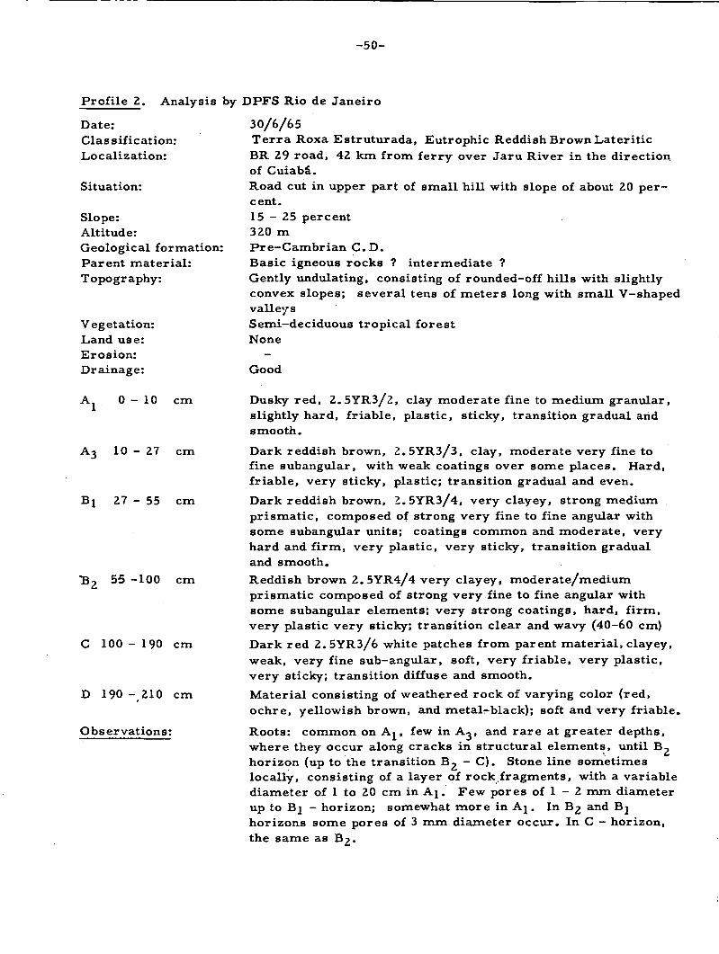
-50 -
Profile 2. Analysis by DPFS Rio de Janeiro
Date:Classification:Localization:
Situation:
Slope:Altitude:Geological formation:Parent material:Topography:
Vegetation:Land use:Erosion:Drainage:
A 0 - 1 0 cm
A3 1 0 - 2 7 cm
Bj 27 - 55 cm
*B2 55 -100 cm
C 100 - 190 cm
D 190 -210 cm
Observations:
30/6/65Terra Roxa Estruturada, Eutrophic Reddish Brown LateriticBR 29 road, 42 km from ferry over Jaru River in the directionof Cuiabâ.Road cut in upper part of small hill with slope of about 20 per-cent.1 5 - 2 5 percent320 mPre-Cambrian C D .Basic igneous rocks ? intermediate ?Gently undulating, consisting of rounded-off hills with slightlyconvex slopes; several tens of meters long with small V-shapedvalleysSemi-deciduous tropical forestNone
Good
Dusky red, 2.5YR3/2, clay moderate fine to medium granular,slightly hard, friable, plastic, sticky, transition gradual andsmooth.
Dark reddish brown, 2.5YR3/3, clay, moderate very fine tofine subangular, -with weak coatings over some places. Hard,friable, very sticky, plastic; transition gradual and even.
Dark reddish brown, Z.5YR3/4, very clayey, strong mediumprismatic, composed of strong very fine to fine angular withsome subangular units; coatings common and moderate, veryhard and firm, very plastic, very sticky, transition gradualand smooth.
Reddish brown 2.5YR4/4 very clayey, moderate/mediumprismatic composed of strong very fine to fine angular withsome subangular elements; very strong coatings, hard, firm,very plastic very sticky; transition clear and wavy (40-60 cm)
Dark red 2. 5YR3/6 white patches from parent material, clayey,weak, very fine sub-angular, soft, very friable, very plastic,very sticky; transition diffuse and smooth.
Material consisting of weathered rock of varying color (red,ochre, yellowish brown, and metal-black); soft and very friable.
Roots: common on A^, few in A,, and rare at greater depths,where they occur along cracks in structural elements, until B-,horizon (up to the transition B2 - C). Stone line sometimeslocally, consisting of a layer of rock fragments, with a variablediameter of 1 to 20 cm in Aj. Few pores of 1 - 2 mm diameterup to Bj - horizon; somewhat more in Aj. In B£ and Bjhorizons some pores of 3 mm diameter occur. In C - horizon,the same as B^.
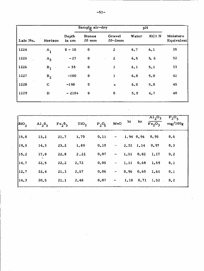
-51 -
Lab: No.
1224
1225
1226
1227
1228
1229
Horizon
A l
A 3
B l
B 2
C
D
Depthin cm
0 - 1 0
- 2 7
- 55
-100
-190
Sample air—dry
Stones20 mm
0
0
0
0
0
- 210+ 0
Gravel20-2mm
2
2
1
1
X
0
Water
6 . 7
6 . 5
6 . 1
6 . 0
6 . 0
5 . 9
pH
KC1 N
6 . 1
5. 6
5 . 1
5 . 0
5 . 0
4 . 7
MoistureEquivalent
35
32
33
41
45
40
SiO2
15.0
19.5
15.2
14.7
12.7
14.3
A12°3
13.2
14.3
17.0
22.5
22.4
20.5
Fe2°3
21.7
23.2
22.8
22.2
21.3
21.1
TiO2
1.70
1.89
2.22
2.72
2.57
2.48
P2°5
0.11
0.10
0.07
0.05
0.06
0.07
kiMnO
1.94
2.32
1.51
1.11
0.96
1.18
0 .
i .
0
0
0
0
94
14
. 8 2
. 6 8
. 6 0
. 7 1
A12°3Fe2O3
0.95
0.97
1.17
1.59
1.65
1.52
P2°5mg/l00g
0 . 6
0 . 3
0 . 2
0 . 1
0 . 1
0 . 2

- 52 -
Ca ++
16.8
15.0
11.7
13.0
14.4
13.5
C %
2.19
0.94
0.40
0.30
0.16
0.09
Absorption Complex (mE/lOOg)Amonium acetate N pH 7
Mg++
2 . 4
2 . 5
2. 3
2 .9
6.3
6 .9
N%
0.26
0.14
0.07
0.07
0.03
0.02
N
8
7
6
4
-
-
K+ Na+ *""<*Bases
0.27 0.06 19.5
0.35 0.06 17.9
0.50 0.06 14.6
0.49 0.07 16.51
0.48 0.09 21.3
0.58 0.09 21.1
A1+++
0
0
0
0
0
0
Granulometric Composition ("fcDispersion with NaOHCoarse FineSand Sand
2-0.20 0.20-0.05
18 7
18 9
13 8
6 4
7 3r
22 7
Silt0.05-0.O.002
48
41
38
29
52
49
H+
1 .8
2 . 5
3 . 3
2 . 7
2 . 9
2 .9
)
Clay002mm
27
32
41
61
38
22
CEC
21.3
20.4
17.9
19.2
24.2
24.2
NaturalClay %
15
17
28
36
16
16
BaseSaturation
92
88
82
86
88
87
Degreeof
floccul-ation
44
47
32
41
58
27
100
Ai
0
0
0
0
0
0
. A l
+ S
Clay
1 .
1 .
0 .
0 .
1 .
2 .
78
28
93
48
37
23

-53 -
Profile 3. Analysis by DPFS, Rio de Janeiro
Date:Classification:Localization:
Situation:Altitude:Geological formation:Parent material:Topography:
Vegetation:Land use:Drainage:
1/7/65Red Yellow PodzolicBR29 - road, 7 km from Rondôniain the direction of PortoVelhoRoad cut in upper part of hill slope with slope of about 10percent200 mPre-Cambrian, C D .Acid gneissGently undulating, consisting of flattened hills with slightlyconvex slopes tens of meters long. Slope 15-20 percentSemi—deciduous forest ?Small areas with corn, manioc and some gardensModerately well drained
A 0 - 1 5 cm
45-70 cm
C 90-120 cm
D 130-150+cm
Observation:
Dark Brown 10YR3/3 clay with gravelly clay loam; moderate,fine to coarse granular, slightly hard, friable, slightly stickyslightly plastic.
Strong brown 7.5YR5.5/7 clayey moderate, very fine tomedium subangular; hard, friable, sticky, slightly plasticwith many moderate coatings.
Reddish yellow 7.5YR6/6, mottling common, fine to mediumdiffuse to YR7/8 and common fine to medium mainly N8/coatings weak, few covering structure elements; clay loam;micaceous weak very fine and fine subangular, slightly hardfriable, non-plastic, non-sticky.
Material consisting of weathered rock, predominantly withyellow (10YR7/8) colors, and common white patches.
A, — there seem to be fascicular roots present. Presence ofgravel up to 3 mm diameter.
B — few roots

-54-
Lab: No.
1230
1231
1232
1233
Horizon
A l
B 2
C
D
Depthin cm
0-15
45-70
90-120
130-150
Sample air-dry(%)
Stones20 mm
8
1
0
0
Gravel20—2 mm
33
4
X
0
PH
Water
5 . 5
5 . 4
5 . 5
5 . 4
KC1 N
4 . 8
4 . 3
4 . 2
4 . 2
MoistureEquivalent
25
36
40
44
SiO2
13.4
16.0
16.7
21.8
à
1 1 .
2 3 .
29.
29.
3
4
1
5
F e2°3
7 . 0
12.9
7 . 2
8 . 4
TiO 2
1.07
1.11
1.10
1.06
P2°5
0.03
0.03
0.01
0.02
kiMnO
2.01
1.17
0.98
1.26
kr
1.44
0.86
0.84
1.06
A l
F e
2 .
2 .
6.
5
2°3
2°3
52
83
. 33
. 4 5
P2?5mg/100g
0 . 8
0 . 2
0 . 5
0 . 5

-55 -
Ca++
3 . 4
1 .0
0 . 7
0 . 5
Mg++
1 .0 0
0
0 .
0 .
Absorption ComplesAmonium Acetate
K+ Na+
.10 0.05
.03 0.05
02 0.05
02 0.06
Sum ofBases
4 . 6
1 .1
0 . 8
0.6
: (mE/lOOg)N pH 7
A1+++
0
0. 6
1 .0
1 .2
H
4 .
1
1
0
+
6
. 8
. 1
.9
CEC
9
3,
2.
2,
. 2
5
9
7
BaseSaturation
50
31
28
22
100. AlA1+ S
0
35
56
67
C
1.
0.
0 .
0 .
%
83
40
07
04
N
0 .
0 .
0
0
%
16
04
.01
.01
CTI
11
10
--
—
Granulometric CompositionDispersion with NaOH
CoarseSand2-0.20
17
9
2
2
FineSand
0.20-0.
19
11
4
4
Silt05 0.05-0.
002
33
23
60
76
Clay<0.002mm
31
57
34
18
NaturalClay %
19
0
0
0
Degreeof
floccul-ation
39
100
100
100
Clay
1 .
0 .
1 .
4 .
06
40
76
22

Profile 4. Analysis by DPFS, Rio de Janeiro
Date:Classification:Localization:
Situation:Altitude:Geological formation:Parent material:Vegetation:Land use:Drainage:Topography:
1/7/65Sandy Red, Yellow Podzolic, dystrophicBR29 - Road Riozinho - RondÔnia, 500 m beyond Castanhal Farmat 30 km distance from Riozinho in the direction of RondóhiaTrench in rounded-off top - slope 0-3 percent240 m
?Sandy9 corresponding with sample Noo 7Semi—deciduous forestBrazil nut, pastures and some manioc farmingVery well drainedUndulating, being a rounded off hill-top at the place of profilewhich is nearly flat
A 0 - 5 cm
A 5 - 8 0 cm
B 80 -160 cm
B 160-220+ cm
Very dark greyish brown 10YR3/2, light clays moderate, fine tomedium granular and individual sand grains; soft, very friable,non-sticky, non-plastic, transition smooth and abrupto
Dark brown 7O5YR3/3P sandy clay, weak, fine to medium,granular and massive pores, breaking totally into fine earth;very friable, slightly; sticky s slightly plastic, transition gradualand smooth»
Reddish brown 5YR4/4, sandy clay, very friable, slightly plastic t
sticky, transition diffuse and smooth,,
Yellowish red 5YR5/6, sandy clay, very friable^ slightly plastic,sticky«,
Obs er vation: Trench of 75 cm depth by auger. Common presence of fascicularroots in A. Few fiöe roots reaching bottom of trench, some witha diameter of up to 3 mm« Pores commonly present in Aj, withdiameters up to 2 mm, and in A with diameters up to 1 mm.Few with diameters up to 2 mm. Presence of charcoal at 20 cmdepth (top of 3rd horizon).
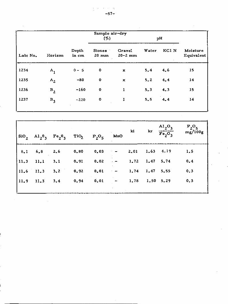
- 5 7 -
Lab: No.
1234
1235
1236
1237
Horizon
A l
A 2
B 2
B 3
Depthin cm
0 - 5
- 8 0
-160
-220
Sample
Stones20 mm
0
0
0
0
air—dry
Gravel20-2 mm
X
X
1
1
Water
5 . 4
5 . 2
5 . 3
5 . 5
pH
KC1 N
4.6
4 . 4
4 . 3
4 . 4
MoistureEquivalent
15
14
15
14
SiO
8 .
11*
U .
1 1 .
2
1
3
6
9
A l
6.
11
11
11
2°3
8
. 1
. 3
. 3
Fe2°3
2 . 6
3 . 1
3 . 2
3 . 4
0.80
0.91
0.92
0.94
P2°5
0.03
0.02
0.01
0.01
IdMnO
2.01
1.72
1.74
1.78
]
1.
1.
1.
1
cr
.63
.47
.47
. 5 0
A l
F e
4
5.
5.
5 .
2°3
2°3
. 1 9
74
55
29
P2°5mg/l00g
1.5
0 . 4
0 . 3
0 . 3
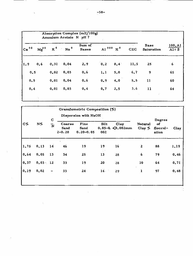
- 5 8 -
Ca+ +
1.9
0.
0 .
0 .
5
5
4
Absorption ComplexAmonitun Acetate N
Mg++ K +
0.6 0.31
0.02
0.01
0.01
Na +
0.04
0.03
0.04
0.03
(mE/lOOg)pH 7
Sum ofBases
2 . 9
0.6
0 .6
0 . 4
0 . 2
1 .1
0 . 9
0 . 7
+ H +
8 . 4
5 . 0
4 . 0
2 . 5
CEC
11.5
6.7
5 . 5
3 . 6
BaseSaturation
25
9
11
11
100.AlAl+S
6
65
60
64
C%
1.75
0.64
0.37
0.19
N%
0.13
0.05
0.03
0.02
C
~N
14
13
12
Granulometric Composition (
Dispersion with
CoarseSand
2-0.20
46
34
33
33
FineSand
0.20-0.
19
25
19
24
NaOH
Silt0.05-0.
05 002
19
13
20
14
Clay<0. 002mm
16
28
28
29
NaturalClay %
2
6
10
1
Degreeof
floccul-ation
88
79
64
97
Clay
1.19
0.46
0.71
0.48

- 59 -
Profile 5. Analysis by DPFS Rio de Janeiro
Date:Classification:Localization:
Situation:Altitude:
2/7/65Grumusolic.BR 29 - Road, Vilhena - Riozinho, taken before ferry ofRio Comemoragao in Pimenta Bueno.Road cut, situated halfway up a hill with a slope of 5-8 percent220 m
Geological formation: Cambro-Ordovician ,Parent material: Shales (occasionally calcareous lenses)Topography:Vegetation:Drainage:
A. 0 - 7 cm
Gently undulating, slopes of hundreds of meters with open valleysSavannah/semi deciduous (deciduous)Imperfect :
Light brown 7.5YR6/3 ( dry ), dark brown 7.5YR3/4 (moist),clayey, moderate, fine to coarse, subangular sometimes angular,very hard, friable, plastic, very sticky; transition smooth andabrupt.
Reddish brown 5YR4/4, clayey, compact massive, breaks inangular blocks; extremely hard, friable, plastic, very sticky,even and clear transition.
Dark reddish brown 5YR3. 5/4, very clayey, idem A3 (somewhatsubangular fine to coarse), hard, firm, plastic, and very sticky;transition smooth and gradual.
Dark reddish brown 5YR3/3, very clayey, strong coarse prismaticcomposed of moderate fine to coarse subangular and angular;extremely hard; firm, plastic, very sticky, transition smoothand gradual.
B- -(C?) 45-55 cm Dark reddish brown 2.5YR3/3, very clayey, moderate coarseprismatic, composed of moderate, very fine to coarse angularand subangular; firm, plastic, very sticky, transition smoothand abrupt.
7 -13 cm
13-20 cm
B_ 20-45 cmÙ
55 - 65+ cm
Observations:
Weathered rock.
Roots: common and consisting of fascicular roots in A., few inA, and B, some occur in top of D. Pores: Few in Aj with adiameter of 1-2 mm; practically absent in rest of profile.Some rounded pebbles in A,, with a diameter varying from 3 to4 cm. Coatings:Many strong ones occur in Band cracks). Strong and common in B, (idem B,). Presence ofsome slicken8ides in B, . Mottling diffuse and few in A , commonand increasing in B, (C?).
weak and few in A, (distributed in stains);(covering all structural elements

-60 -
Li ab: N o .
1238
1239
1240
1241
1242
1243
Horizon
A l
A 3
B l
B 2
B3(C?)
D
Depthin cm
0 - 7
- 1 3
- 2 0
- 4 5
- 5 5
- 6 5
Sample air—dry%
Stones Gravel20 mm 20—2 mm
6 x
0 x
0 x
0 1
0 0
pH
Water
5 . 7
5.9
6 . 1
6.5
6.6
6 .9
KC1
4 . 3
4 . 3
4 . 3
4 . 8
5 . 3
5 . 8
N MoistureEquivalent
37
33
37
37
32(weatheredrock)
23(weatheredrock)
S i O 2
15.6
17.5
15.7
13.0
16.8
15.5
A 1 2°3
12.7
13.7
17.1
18.3
16.6
17.2
F e2°3
11.7
10.0
11.2
10.0
10.1
6.6
TiO2
0.54
0.59
0.63
0.63
0.61
0.59
P2°5
0.07
0.05
0.04
0.03
0.04
0.12
MnO ki
- .2.08
2.18
1.56
1.21
- 1.72
- 1.53
kr
1O31
1.48
1.10
0.90
1.24
1.23
A12°3F e2°3
Io71
2.13
2.40
2.84
2.59
4.12
P2°5mg/l00g
0 . 5
0 . 2
0 . 2
0 . 2
0 . 3
1 .0

- 6 1 -
Ca
5.5
5O2
6.9
8,6
8 , 8
9.3
Absorption Complex (mE/lOOg)Amonium Acetate N pH 7
Mg
5 , 5
6.7
10.3
15,1
15,2
15,4
K
0.40
0.28
0,41
0,41
0o34
0,34
N a
0,15
0,18
0,23
0,34
0,39
0,39
Stun ofBases
11.6
12.4
17,8
24,5
24,7
25.4
A l
0,6
0,6
0,6
0 . 2
0
0
H
6.7
4 . 9
4 . 3
2,6
1.3
0 , 4
CEC
18.9
17.9
22.7
27.3
26.0
25.8
BaseSaturation
61
69
78
90
95
98
100.AlA1+ S
5
5
3
1
0
0
C %
1.90
1.18
0.85
0.52
0.25
0.14
N %
0.19
0.12
0.08
0.04
0.04
0.02
CN
10
10
11
13
-
-
Granulometric Composition (%)Dispersion with NaOH
CoarseSand
2-0.20
2
3
2
1
1
4
FineSand
0.20-0.05
1
1
1
X
X
2
Silt0.05-0
002
51
46
32
30
52
61
Clay<0. 002mm
46
50
65
69
47
33
NaturalClay %
20
27
39
43
32
18
Degreeof floccul-ation
57
46
40
38
32
45
Clay
1.11
0.92
0.49
0.43
1.11
1.85

-62-
Profile 6. Analysis by DPFS Rio de Janeiro
Date: 2/7/65Classification: ? ("Tropaqualf") ;Localization: BR29 Road (Vilhena-Riozinho), 24 km before ferry of Rio
Commemorag£o in Pimenta Bueno.Situation: . Road construction pit in upper part of slight undulation. Slope
of about 3 percentAltitude: 220 m ;Geological formation: Cambro-Ordovician ;Parent material:. Shales (occasionally calcareous lenses)Topography: Gently undulating, open valleys; slightly convex slopes of a
hundred meters in length with slopes not exceeding 8 percentVegetation: Tree savannahLand use: Dirty grasslandDrainage: Poor
A 0 - 5 cm Dark yellowish brown 10YR3/4, heavy sandy clay, moderate,fine to medium, granular and fine subangular, slightly hard,friable, slightly plastic, slightly sticky; transition smooth andclear. ,
B, 25-45 cm Light brownish greyK?) 10YR6/2 ; mottling small and few,predominantly red 2. 5YR4/6; coatings strong, common, coveringstructural elements, ;very clayey, moderate, very fine to fine,angular and subangular, extremely hard, firm, plastic, very
sticky; transition smooth and gradual.
C 50-60 cm N6/; Mottling fine to medium; very predominant red, 2.5YR4/6:Coatings moderate and common, very clayey, •weak, very fine to jfine angular and subangular; firm plastic and very sticky.

- 6 3 -
Lab: No.
1244
1245
1246
Horizon
A l
B 2
C
Depthin
0 -
2 5 •
50 -
c m
- 5
- 45
- 60
Sample
Stones20 mm
0
0
0
air-dry
Gravel20-2 mm
3
2
1
pH
Water
5 . 2
5 . 4
5 . 5
KC1 N
4 . 0
3 . 8
4 . 0
MoistureEquivalent
33
40
40
SiO
16.
2 5 .
2 8 .
2
8
2
7
A l
11
22
20
2°3
. 0
. 9
. 7
F e
6
6.
8 .
2°3
. 7
8
5
TiO2
.0.
0 .
0 .
60
76
68
P 2
0 .
0.
o.
0 5 MnO
01
01
02
2
1
2
ki
. 5 9
. 8 7
. 3 5
k r
1.87
1.57
1.87
A l
F e
2
5
3
2°3
2°3
. 5 7
. 2 3
. 8 3
P2°5mg/l00g
0 .
0 .
0 .
2
2
2
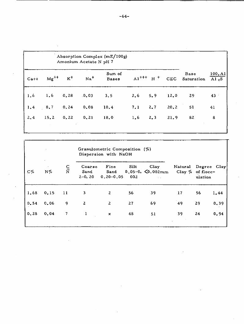
-64 -
Ca++
1.
1,
2
6
. 4
. 4
Absorption ComplexAmonium
Mg++ K+
1.6
8 .7
15.2
0.28
0.24
0.22
Acetate N
N a +
0.03
0.08
0.21
(mE/l00g)pH 7
Sum ofBases
3 . 5
10.4
18.0
A
2 .
7 .
1.
1 + +
6
1
6
+
5
2
2
H +
. 9
. 7
. 3
CEC
12,
20 .
2 1 .
0
2
9
BaseSaturation
29
51
82
100A l
43
41
8
. A l
+s
c%
1.
0.
0.
68
54
28
N%
0.
0 .
o.
15
06
04
CN
11
9
7
Granulometric CompositionDispersion
CoarseSand
2-0. 20 0
3
2
1
with
FineSand
.20-0.
2
2
X
NaOH
Silt0.05-0.
05 002
56
27
48
(%)
Clay<0. 002mm
39
69
51
NaturalClay %
17
49
39
Degreeof flocc-ulation
56 1
29 0
24 0
Clay
. 4 4
. 3 9
.94
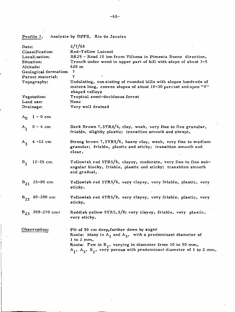
-65-
Profile 7. Analysis by DPFS, Rio de Janeiro
Date:Classification:Localization:Situation:Altitude:Geological formation:Parent material:Topography:
Vegetation:Land use:Drainage:
AQ 1 -0 cm
A 0 - 4 cm
4 -12 cm
12-25 cm
25-80 cm
B 80-200 cm
B2 3 200-270 cm+
2/7/65Red-Yellow LatosolBR29 - Road 10 km from Vilhena in Pimenta Bueno direction.Trench under wood in upper part of hill with slope of about 3-5620 m
Undulating, consisting of rounded hills with slopes hundreds ofmeters long, convex slopes of about 10-30 percent and open "V"shaped valleysTropical semi-deciduous forestNoneVery well drained
Dark Brown 7.5YR4/4, clay, weak, very fine to fine granular,friable, slightly plastic; transition smooth and abrupt.
Strong brown 7.5YR5/6, heavy clay, weak, very fine to mediumgranular; friable, plastic and sticky; transition smooth andclear.
Yellowish red 5YR5/6, clayey, moderate, very fine to fine sub-angular blocky, friable, plastic and sticky; transition smoothand gradual.
Yellowish red 5YR5/8, very clayey, very friable, plastic, verysticky.
Yellowish red 4YR5/8, very clayey, very friable, plastic, verysticky.
Reddish yellow 5YR5.5/8; very clayey, friable, very plastic,very sticky.
Observation: Pit of 50 cm deep,further down by augerRoots: Many in A, and A,, with a predominant diameter of1 to 2 mm.Roots: Few in B. , varying in diameter from 10 to 50 mm.A., A,, B., very porous with predominant diameter of 1 to 2 mm.

- 6 6 -
Lab: No.
1249
1250
1251
1252
1253
1254
1255
Horizon
Ao
A l
A 3
B l
B 2 1
B 2 2
B 2 3
Depthin cm
1 - 0
0 - 4
- 1 2
- 2 5
- 8 0
-200
-270 +
Sample air-dry
Stones20 mm
0
0
0
0
0
0
0
Gravel20-2mm
0
• o
0
0
0
0
0
Water
4 . 3
3 . 9
4 . 1
4 . 4
5 . 2
5 . 3
5 . 8
PH
KC1 N
3 . 4
3 . 4
4 . 0
4 . 2
4 . 5
5 . 0
6.2
MoistureEquivalent
-
74
34
32
30
28
29
SiO
13.2
15.7
17.6
18.3
18.8
18.8
18.2
A 12°3
20.4
27.3
32.6
35.6
36.7
37.3
38.6
-A
6.3
8 . 1
9.6
10.0
10.1
10.2
10.7
TiO2
0.54
0.79
0.96
0.98
1.00
1.05
1.21
P
0 .
0 .
0 .
•
2°5
02
01
01
X
<
MnO ki
1.10
0.98
0.92
0.87
0.87
0.86
0.80
k r
0.92
0.82
0.77
0.74
0.74
0.73
0.68
A12°3F e2°3
5.13
5.25
5.33
5.54
5.71
5.72
5.64
P2°5mg/l00g
2 . 4
0 . 7
0 . 5
0 . 4
0 . 2
0 . 1
0 . 1

- 6 7 -
Absorption Complex (mE/lOOg)Amonium Acetate N pH 7
Ca++ Mg++K Na
Sum ofBases A1+++ H+
Base 100.AlCEC Saturation Al + S
3.2 1.4 0.59 0.10
1.2 0.13 0.04
0. 6 0.05 0.04
0.5
0. 4
0.5
0.4
0.04 0.02
0.05 0.01
0.00 0.02
0.00 0.02
5.3
1.4
0.7
0.6
0.5
0.5
0.4
4.0
4.6
2.0
1.2
0.5
0.0
0.0
50.3
29.3
11.8
7.6
4.9
3.0
1.3
59.6
35.3
14.5
9.4
5.9
3.5
1.7
9
4
5
6
8
14
24
43
77
74
67
50
0
0
Granulometric Composition (%)Dispersion with NaOH
C% N% ^Coarse Fine Silt Clay Natural DegreeSand Sand 0.05-0 <0.002mm Clay of
% floccul-ation
2-0,20 0,20-0.05 002Clay
23.08
7.76
2.67
1.72
1.02
0.60
0.25
1.25
0.69
0.20
0.15
0.08
0.06
0.06
19
11
13
12
13
10
—
8
10
10
9
9
6
3
4
5
5
6
5
25
22
17
11
9
11
64
64
68
75
76
78
21
15
26
0
38
86
67
78
65
100
51
0.39
0.34
0.25
0.15
0.12
0.14

-68-
Profile 8. Analysis by DPFS - Rio de Janeiro.
4/7/65Dusky Red LatosolBR29 - between: Rosario Oeste and Vilhena 43 km before Germanboarding house (PensSo Alemâo)Trench in high part of plateau440 m
Geological formation: ?Parent material: Presumably pseudo-autochtonous
Practically level with slopes of several 100 m in length - 0.5 percentWide spaced low tree savannahExtensive grazingVery well drained
Date:Classification:Localization:
Situation:Altitude:
Topography:Vegetation:Land use:Drainage:
A 0 - 2 0 cm
A3 20 -45 cm
B 45 -130 cm
B21 130-220 cm
B 220-280 cm
B 280-310 cm
• Observation:
Dark greyish red 9R3/3, clay; strong, very fine to medium,granular, slightly hard, very friable, slightly plastic, slightlysticky, transition smooth and gradual.
Dark greyish red 9R3/4, clay, weak, very fine to fine granularand grains consisting of fine earth, slightly hard, very friable, .slightly plastic, slightly sticky, transition smooth and diffuse.
Dark greyish red 10R3/4, clay, massive porous, slightly coherentconsisting of grains •with some nodules of 2 to 5 mm diameter;soft, very friable, slightly plastic and sticky.
Dark greyish red 10R3/3.5; clayey, very friable, plastic, sticky,transition smooth and diffuse.
Dark greyish red 10R3/3, clay, very friable, plastic, very sticky;transition smooth and diffuse.
Dark greyish red 10R 3/3, clay, very friable, plastic, very stickytransition smooth and diffuse.
Roots: Many in top of A.(0-4cm), 1 to 2 mm thick, fascicular,common in Aß, gradually diminishing when reaching the bottomof the trench. Pores: Few pores observed in A. and A,, down-ward, very porous -with a predominant pore-diameter of lessthan 1 mm. 70 cm deep trench further down auger observation.Presence of rounded-off quartz-grains with a diameter of up to2 mm. , reaching the bottom of the trench.

-69 -
LabrNo.
1256
1257
1258
1259
1260
1261
Horizon
A l
A 3
B l
B 2 1
B 2 2
B 2 3
Sample air-dry(%)
Depthin cm
0-20
- 4 5
-130
-220
-280
-310+
Stones20 mm
0
0
0
0
0
0
GravelZ0-Zmm
2
2
3
4
4
4
Water
5 . 2
5 . 4
5 . 5
5 . 5
5 .7
5 . 8
PH
KC1 N
4 . 3
4 . 5
5 . 1
6 . 1
6 . 4
6 . 2
MoistureEquivalent
28
26
27
27
26
27
i
S i O 2
6 . 3
6 . 2
6 . 2
5 . 9
5 . 8
6 . 4
A 12°3
29.3
31.0
32.2
32.8
31.8
33.6
Fe2°3
21.0
21.7
23.1
22.9
23.3
23.1
T i O 2
1.69
1.75
1.86
1.96
1.94
2 . 1 1
P2°5
0.07
0.06
0.05
0.04
0.04
0.04
MnO ki
0.37
0.34
0.33
0.30
- 0.31
0.33
kr
0.25
0.23
0.22
0.21
0.21
0.23
A12°3F e2°3
2.19
2.24
2.19
2.25
2.14
2.28
P2°5mg/lOOg
0 . 3
0 . 2
0 . 1
0 . 1
0 . 1
0 . 1
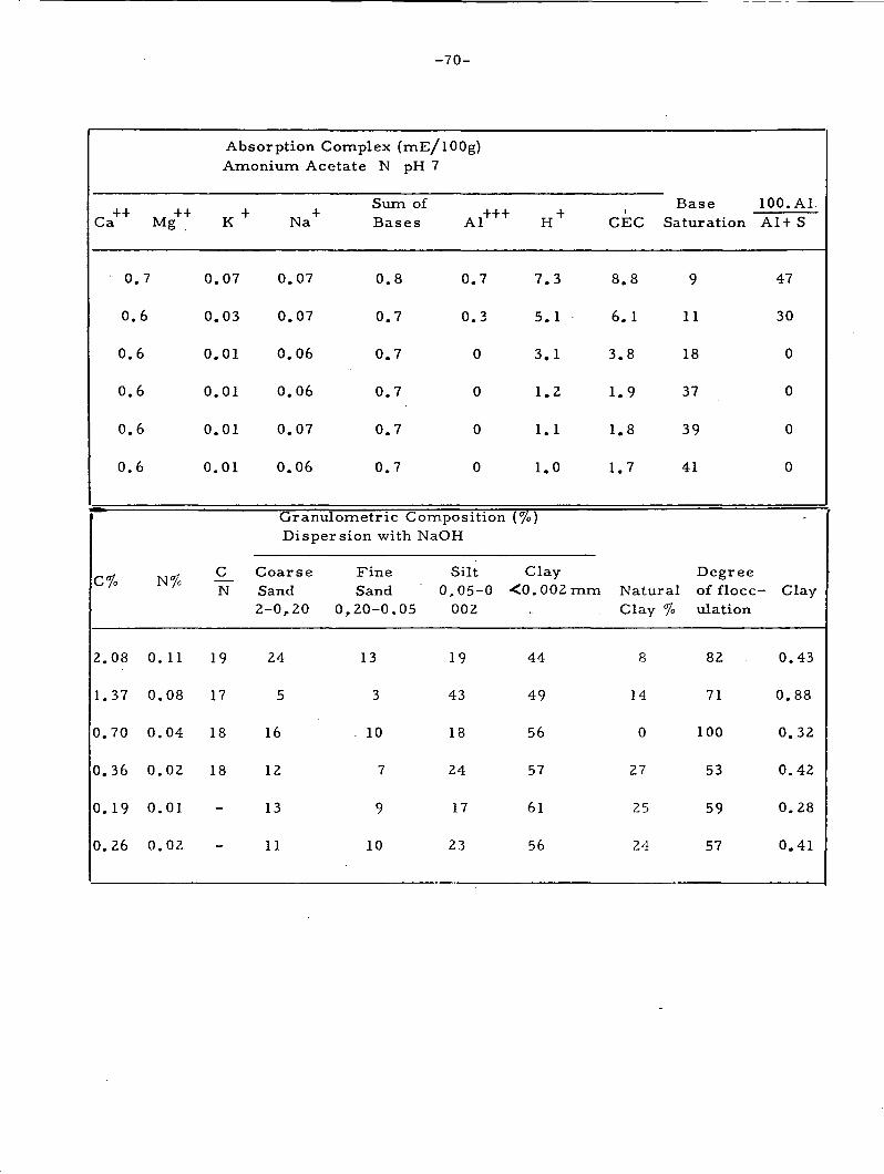
- 7 0 -
Ca++
0
0
0 .
0 .
0 .
0 .
C%
2.
1.
0 .
0 .
0 .
0 .
08
37
70
36
19
26
Mg++
. 7
.6
6
6
6
6
I"
0 .
0 .
0 .
0 .
0 .
0 .
1%
11
08
04
02
01
02
Absorption Complex (mE/l00g)Amonium Acetate N pH 7
K 4
0.07
0.03
0.01
0.01
0.01
0.01
C_N
19
17
18
18
-
-
N a +
0.07
0.07
0.06
0.06
0.07
0.06
Sum ofBases Al
0.8 0.7
0.7 0.3
0.7 0
0.7 0
0.7 0
0.7 0
Granulometric CompositionDispersion with NaOH
CoarseSand2-0,20
24
5
16
12
13
11
Fine SiltSand 0,05-0
0,20-0.05 002
13 19
3 43
10 18
7 24
9 17
10 23
H +
7 . 3
5 . 1
3 . 1
1.2
1.1
1.0
(%)
Clay<0 .002mm
44
49
56
57
61
56
CEC
8
6
3
1
1
1
. 8
. 1
. 8
. 9
. 8
.7
BaseSaturation
9
11
18
37
39
41
100.AlA1+ S
47
30
0
0
0
0
DegreeNatural of flocc- ClayClay % ulation
8
14
0
27
25
24
82
71
100
53
59
57
0.43
0.88
0.32
0.42
0.28
0.41
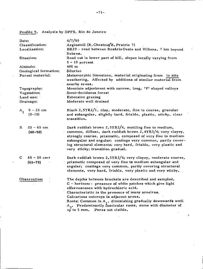
-71-
Profile 9» Analysis by DPFS, Rio de Janeiro
Date:Classification:
Localization:
Situation:
Altitude:Geological formation:Parent material:
Topography:Vegetation:Land use:Drainage:
A 0 - 2 5 cm(0-10)
B 25 - 65 cm(40-50)
C 6 5 - 8 0 cm+(65-75)
Observation:
4/7/65Argiustoll (R.Chestnuy'R. Prairie ?)BR29 - road between RosârioOeste and Vilhena, 7 km beyondNobres.Road cut in lower part of hill, slopes locally varying from5-10 percent400 mSilurianMetamorphic limestone, material originating from in situweathering. Affected by additions of similar material fromnearby areas.Mountain adjustment with narrow, long, 'V' shaped valleysSemi-deciduous forestExtensive grazingModerate •well drained
Black 2.5YR2/1, clay, moderate, fine to coarse, granularand subangular, slightly hard, friable, plastic, sticky, cleartransition.
Dark reddish brown 2. 5YR2/4, mottiing fine to medium,common, diffuse, dark reddish brown 2.4YR3/4; very clayey,strongly coarse, prismatic, composed of very fine to mediumsubangular and angular; coatings very common, partly cover-ing structural elements; very hard, friable, very plastic andvery sticky; transition gradual.
Dark reddish brown 2.5YR3/4; very clayey, moderate coarse,prismatic composed of very fine to medium subangular andangular; coatings very common, partly covering structuralelements, very hard, friable, very plastic and very sticky.
The depths between brackets are described and sampled.C — horizon:- presence of -white patches -which give lighteffervescence with hydrochloric acid.Characteristic is the presence of many aroeiras.Calcarious outcrops in adjacent areas.Roots: Common in A , diminishing gradually downwards untilA,. Predominantly fascicular roots, some with diameter ofup to 5 mm. Pores not visible.
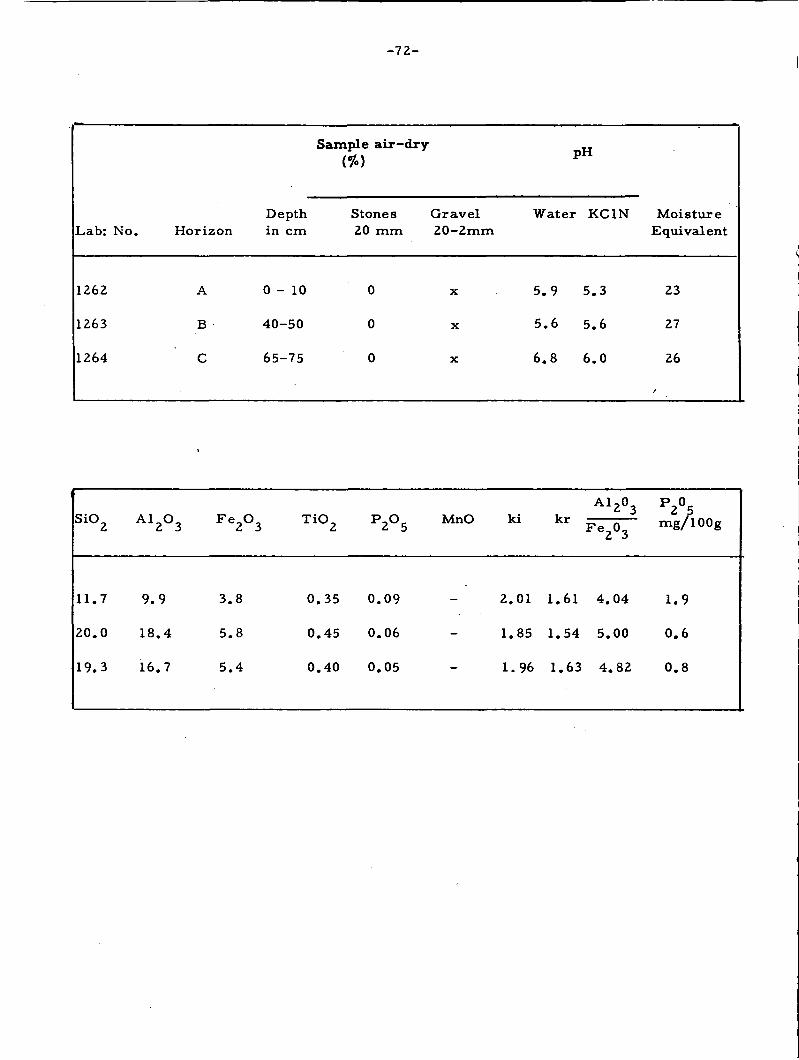
-72-
Lab: No.
1262
1263
1264
Horizon
A
B
C
Depthin cm
0 - 1 0
40-50
65-75
Sample air-dry(%)
Stones20 mm
0
0
0
Gravel20-2mm
X
X
X
PH
Water KC1N
5.9 5.3
5.6 5.6
6.8 6.0
MoistureEquivalent
23
27
26
SiO
1 1 .
2 0 .
1 9 .
2
7
0
3
A l
9.
18
16
2°3
9
. 4
. 7
F e
3 .
5 .
5.
2°3
8
8
4
T i O
0 .
0 .
0 .
35
45
40
P
0 .
0 .
0 .
2°5
09
06
05
MnO
2
1
1
ki
. 0 1
.85
.96
1
1
1
. 6 1
. 5 4
. 6 3
A l
F e 2
4 .
5 .
4 .
2°3
°3
04
00
82
P 02 ?mg/l00g
1.9
0.6
0 . 8

- 7 3 -
Ca
14.
11.
9.
8
4
2
Absorption ComplexAmonium Acetate N
»»„TT v +
Mg K
4.
4.
4.
5 0.24
9 0.12
.0 0.09
Na +
0.06
0.09
0.09
(mE/l00g)pH 7
Sum ofBases
19.6
16 .5
13 .4
Al+H
0
0
0
h + H
3 .
1 .
0 .
6
5
6
CEC
2 3 .
18 .
14 .
2
0
0
BaseSaturation
84
92
96
100 .AlAl + S
0
0
0
C%
1.78
0.78
0.48
N%
0.14
0.08
0.03
C_N
13
10
16
Granulometric Composition (%]Dispersion with NaOH
CoarseSand
2-0,20 0,
10
8
7
FineSand Silt
20-0.05 0.05-0.002
17 42
9 35
12 35
Clay<0. 002mm
31
48
46
NaturalClay
12
23
28
Degreeof
floccul—ation
61 1.
52 0
39 0
Clay
35
. 7 3
. 7 6
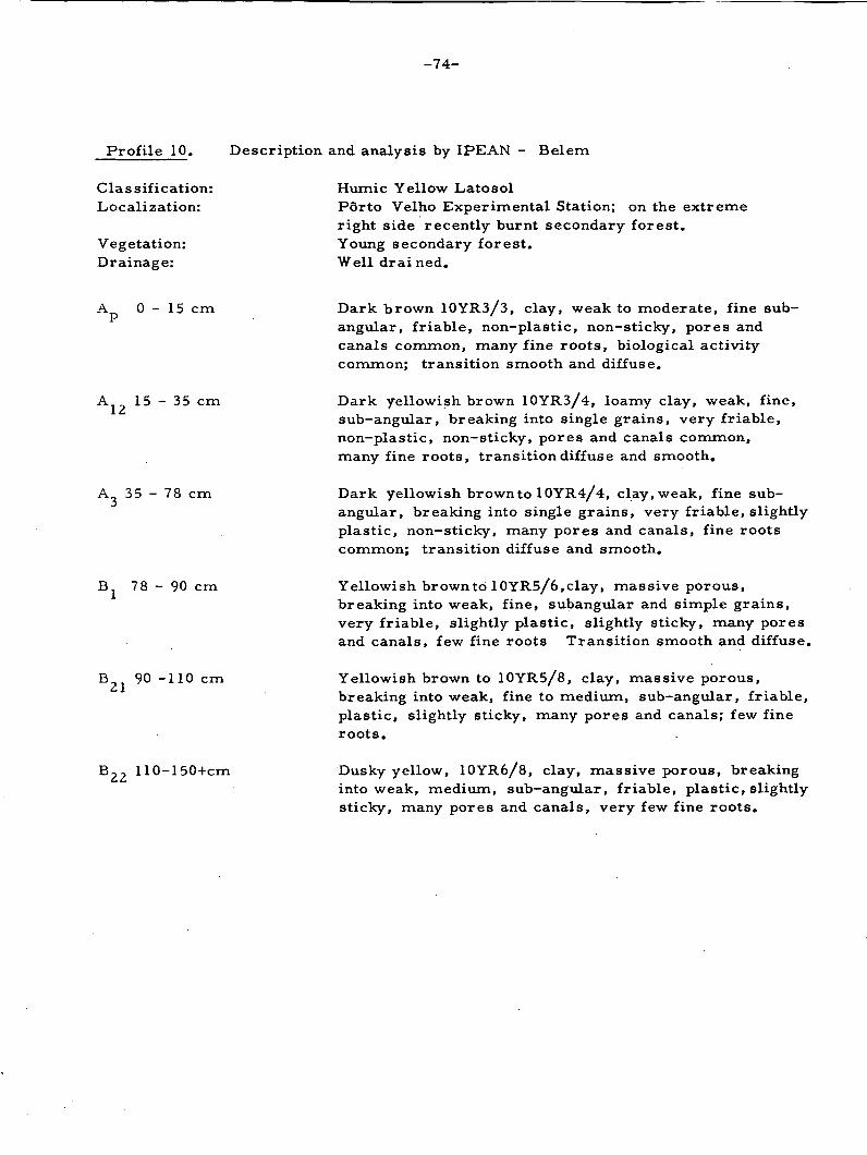
- 7 4 -
Profile 10. Description and analysis by IPEAN - Belem
Classification:Localization:
Vegetation:Drainage:
Humic Yellow LatosolPorto Velho Experimental Station; on the extremeright side recently burnt secondary forest.Young secondary forest.Well drained.
A 0 - 1 5 cm
15 - 35 cm
35 - 78 cm
78 - 90 cm
B 90 -110 cm
110-150+cm
Dark brown 10YR3/3, clay, weak to moderate, fine sub-angular, friable, non-plastic, non-sticky, pores andcanals common, many fine roots, biological activitycommon; transition smooth and diffuse.
Dark yellowish brown 10YR3/4, loamy clay, weak, fine,sub-angular, breaking into single grains, very friable,non-plastic, non-sticky, pores and canals common,many fine roots, transition diffuse and smooth.
Dark yellowish brown to 10YR4/4, clay,weak, fine sub-angular, breaking into single grains, very friable, slightlyplastic, non-sticky, many pores and canals, fine rootscommon; transition diffuse and smooth.
Yellowish brown to 10YR5/6,clay, massive porous,breaking into weak, fine, subangular and simple grains,very friable, slightly plastic, slightly sticky, many poresand canals, few fine roots Transition smooth and diffuse.
Yellowish brown to 10YR5/8, clay, massive porous,breaking into weak, fine to medium, sub-angular, friable,plastic, slightly sticky, many pores and canals; few fineroots.
'Dusky yellow, 10YR6/8, clay, massive porous, breakinginto weak, medium, sub-angular, friable, plastic, slightlysticky, many pores and canals, very few fine roots.

- 7 5 -
Lab: No. Horizon Depth CoarseSand
FineSand
Silt Clay NaturalClay
3023
3024
3025
3026
3027
3028
AP
A 1 2
A 3
B lB 2 1
B 2 2
0-15
- 3 5
- 7 8
- 9 0
-110
-150
1
1
4
3
3
2
19
15
8
7
7
6
2
43
29
19
16
16
39
41
59
71
74
76
5
7
13
14
12
5
mE/ 100 g of air dry fine soil
LabcNo. Horizon pH Sum Base mg/Ca Mg K Na Mn H Al CEC Bases Sat: 100
% gr
3023
3024
3025
3026
3027
3028
ApA 1 2
A 3
B l
B21
B 2 2
4 . 9
4 . 9
5 . 1
5 . 1
5 . 0
5 . 4
0.20
0.15
0.33
0.30
0.20
0.15
0.10
0.15
0.02
0.10
0.23
0.30
0.20
0.16
0.16
0.14
0.15
0.09
0.22
0.26
0.13
0.10
0.11
0.08
0.02
0.02
0.02
0.02
0.02
0.02
14
13
10
8 .
5 .
4 .
. 8 7
. 9 5
. 2 6
04
75
40
3 .
2 .
2.
2
2.
1.
22
82
52
. 4 2
22
40
18 .
1 7 .
13
11
8
6
81
44
42
. 1 0
. 7 3
. 4 2
0 .
0 .
0.
0
0
0
72
67
64
. 6 4
. 8 1
. 6 2
4
4
5
6
9
10
0.55
0.55
traces
11
11
11
g/100 g Air dry fine soil
Lab. No.
3023
3024
3025
3026
3027
3028
C
4 . 0
3.78
2.41
•1.39
0.99
0.54
• N
0.21
0.19
0.09
0.06
0.06
0.05
Org.Mat.
6.98
6.50
4.19
2.38
1.70
0.95
SiO2
21.8
21.0
20.8
21.0
21.8
22.0
Fe2O3
9 . 8
8 . 6
9 .0
9 . 4
9.6
9.6
A12O3
22.4
24.0
25.0
24.2
25.2
25.2
C / N
19
20
27
22
17
12
Ki
1.65
1.49
1.41
1.48
1.47
1.48
K r
1.31
1.21
1.15
1.18
1.18
1.19

-76-
Profile 11. Description and Analysis by IPEÀN, Belem
Classification:Localization:Topography:Vegetation:Drainage:
Hydromorphic Latérite, moderately well drained.Porto Velho Experimental Station, bed with citrus, Road 4.LevelGround covered with grasses; citrus orchardAdjacent area well drained; the profile itself is moderatelywell drained
A 0 - 1 2 cm
A2 12 -30 cm
30 -52 cm
B2 52 -75 cm
B31pl7 3 ~ 1 0 2 c m
Yellowish brown 10YR5/8 heavy clay, weak to moderatefine, subangular, firm, plastic, sticky; many pores andcanals; worm and insect activity; many fine roots; transitionwavy, gradual.
Yellow red 5YR5/6, light clay, moderate, fine to mediumsubangular, friable, plastic, sticky, many pores and canals;many fine roots; transition smooth and diffuse.
Yellow red 5YR4/8, light clay, moderate, fine to mediumsubangular, friable, plastic, sticky, many pores and canals,fine roots; common transition, smooth and diffuse.
Red 2.5YR4/6, light clay, medium subangular, friable, veryplastic, very sticky, many pores and canals; some pisoliticconcretions on transition from Bj to H^; transition clearand wavy.
Red 2.5YR5/6, mottling common, medium and distinct yellow10YR7/6 and abundant, medium to coarse, prominent red10YR4/8, light clay, massive, breaking into weak, fine, sub-angular peds, friable, plastic, sticky; pores common, veryfew fine roots; presence of small lateritic concretions;transition smooth and diffuse.
B32pl 102-150 cm Abundant medium to coarse and prominently mottling red10YR4/8, with medium and distinct yellow 10YR7/6 and withmedium and weak strong brown 7.5YR5/8; rubbed light red10R6/8 light clay, moderate to strong, medium, subangular,firm, plastic, sticky, with many small lateritic concretions;coatings common.

- 7 7 -
Lab: No. Horizon Depth CoarseSand
FineSand
Silt Clay NaturalClay
3000
3001
3002
3003
3004
3005
B ]
B.i
B
B
31pl
32pl
0 - 1 2
- 50
- 52
-75
-102
.-150
2
2
1
1
2
7
19
21
19
17
15
13
40
32
34
35
31
30
39
45
46
49
52
50
LabrNo. Horizon pH m E / 100 g of air dry fine soil Sum Base pHH2O C a t + M g + + K + Na+ Mn++ H+ A1+++CEC. Bases Sat: mg/KC1
% 100
3000
3001
3002
3003
3004
3005
ApA 2
B l
B 2B31P1
B32pl
4 . 3
4 . 7
4 . 5
4 . 5
4 . 8
5 . 0
0 .
0 .
0 .
0 .
0 .
0
45
20
30
30
30
. 30
0.15
0.05
0.15
0.15
0.10
0.15
0.15
0.15
0.15
0.11
0.12
0.11
0.11
0.08
0.23
0.20
0.20
0.22
0 .
0 .
0
0
02
02
. 0 2
. 0 2
-
-
4 .
3 .
3 .
2
2
1
69
30
33
. 4 1
.66
. 8 4
5 .
5 .
5 .
5
6
7
87
65
44
.65
. 8 5
. 8 3
1 1 .
9.
9.
8 .
10
IC
42
43
60
82
.02
0.86
0.48
0.83
0.76
S 0.72
1.45 0.78
V
5
9
0.
o,0
55
55
. 5 5
9traces
7
7
II
tl
4 .
4 .
4 .
4
4
4 .
00
00
00
. 00
. 0 0
00
g/100 g Air dry fine soil
LabrNo.
3000
3001
3002
3003
3004
3005
C
1.27
0.68
0.57
0.41
0.34
0.14
N
0.13
0.09
0.07
0.06
0.06
0.05
Org.Mat.
2.18
2.16
0.98
0.69
0.59
0.30
1 6 .
1 8 .
1 7 .
19.
2 3 .
26
00
20
00
20
20
. 4 0
F e2°3
4.19
4.19
4.39
4.58
7.58
9.98
A 12°3
11.73
13.26
13.77
14.02
16.06
18.87
C / N
10
8
8
7
6
3
Ki
2.31
2.33
2.10
2.33
2.46
2.37
K r
1.89
1.94
1.75
1.93
1.89
1.78

7O° 62° 54° 46° 38°
0°
8°
A M A Z 0 N A
'\ — • - .A;—I /
MATO GROSSO
B A H I A6 0 I A S -:
G E R A I S /
MATO GFlOSSO
SOUTH AMERICA SOIL RESOURCES EXPEDITIONIN BRAZIL
24 JUNE/9 JULY 1965
FAO/UNESCO/ROCKEFELLER FOUNDATION/USAIDAND GOVERNMENT OF BRAZILAREA STUDIED BY THE EXPEDITION
RIO BRANCO - BRASILIA
3 .282 Km.
WORLD SOIL RESOURCES OFFICELAND AND WATER DEVELOPMENT 01 VISION
24°
3 2 C I -
H32°
WSRO 511/OCTOBER I96s[
46C 38*
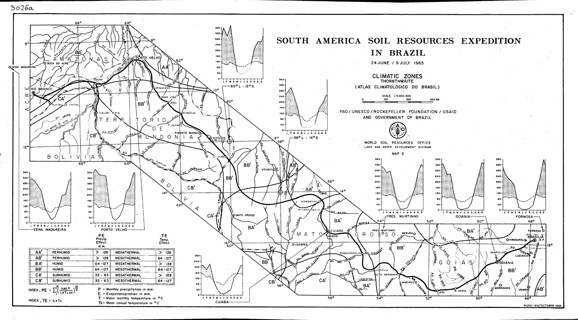
'bolßa.
SENA MAOUREIRA
SOUTH AMERICA SOIL RESOURCES EXPEDITION IN BRAZIL 24 JUNE / 9 JULY 1965
CLIMATIC ZONES THORNTHWAITE
(ATLAS CLIMATOLOGICO DO BRASIL)
SCALE 1 : 3 . 0 0 0 . 0 0 0 200 300 KM.
FAO/UNESCO/ROCKEFELLER FOUNDATION / USAID AND GOVERNMENT OF BRAZIL
AA' PERHUMID > 128 MEGATHERMAL > 128
AB' PERHUMID > 128 MESOTHERMAL 64 - I27~l
BA' HUMID 6 4 - 1 2 7 MEGATHERMAL > 128
BB' HUMID 6 4 - 1 2 7 MESOTHERMAL 6 4 - 1 2 7
> 128 CA' SUBHUMID 3 2 - 63 MEGATHERMAL
6 4 - 1 2 7
> 128
CB' SUBHUMID 32 - 6 3 MESOTHERMAL 6 4 - 1 2 7
,NDEX 'PEiS^Si)9
INDEX, T E - 5.4To
P - Monthly precipitation in mm. E = Evapotranspirotion in mm. T = Mean monthly temperature in ° C To : Mean annual temperature in ° C CUIABA-
4 8 °
WSR0-5I5/0CT0BER 1965

Lü
cc o <
j o °
I2C
R\O o?
* • : ,v°? J « !
B 0 L I V
GUAJARA MlRIM
T E R R
v60°
T 0 R I j O ^ 3 / P. HERJaljS^
D-sE R 0 N CT*0-M
i
£_£[0 . « ^
«8»
/RONDÓNIA \ '
66c 64° 2fr
<9
,4o> <
*\!f/ARA
«&-
/ -
CZD
N
EQUATORIAL RAINFOREST
DECIDUOUS AND SEMI - DECIDUOUS TROPICAL FOREST
CERRADO
NATURAL GRASSLAND
PANTANAL COMPLEX
62e /
I BARAÖWE \MELGACO_
SOUTH AMERICA SOIL RESOURCES EXPEDITION IN BRAZIL 24 JUNE / 9 JULY 1965
VEGETATION MAP ACCORDING TO IBGE - C.N.G - BIOGEOGRAPHY SECTION
WITH ALTERATIONS AFTER FIELDOBSERVATIONS DURING THE EXPEDITION
FAO/UNESCO/ROCKEFELLER FOUNDATION / U S A I D AND GOVERNMENT OF BRAZIL
WORLD SOIL RESOURCES OFFICE LAND AND WATER DEVELOPMENT DIVISION
SCALE 1:5.000.000
100 £00 300 KM.
\ 5
i r \ \ 5 6 ° \30\
MAP 3
sJ
I
(I £{ <«
OIAMANTINOO
3 R 0 S A R I 0 / 0 E S T E / t f 2
60°
M A-XvO; 5 > 3
^54° 52° 50 e
CUIABAi feNG R CVS S 0
^
58c
3 / V 2 ^RONDONÓPOLIsTj-JttS-jfoM
3
I ,-ORRENTES
56°
48°
W;
r2 )IANI'A
54° 52° 50c 48 e
W S R 0 - 5 I 4

OlGc
SOUTH AMERICA SOIL RESOURCES EXPEDITION IN BRAZIL 24 JUNE / 9 JULY 1965
HYPSOMETRIC MAP INCLUDING ALTITUDES MEASURED
DURING THE EXPEDITION
FAO/UNESCO/ROCKEFELLER FOUNDATION /USAID AND GOVERNMENT OF BRAZIL
48°
WSRO-5I3/OCTQ8ER 1965

3o2é d
CSG
SOUTH AMERICA SOIL RESOURCES EXPEDITION IN BRAZIL 24 JUNE / 9 JULY 1965
GEOLOGICAL MAP
FAO/UNESCO/ROCKEFELLER FOUNDATION / U S A I D AND GOVERNMENT OF BRAZIL
HOLOCENE NOT CONSOLIDATED SEDIMENTS PLEISTOCENE NOT CONSOLIDATED SEDIMENTS TERTIARY SEDIMENTS ^ - p BARREIRAS AND RIO BRANCO FORMATIONS I { CRETACEOUS BAURU SERIE: FLUVIATILE J SANDSTONES TRIASSIC BOTUCATU FORMATION T AEOLIAN SANDSTONE ' MESOZOIC UNDIVIDED-PARECIS SERIES M i « I I* / - a . » , , r A SANDSTONES ^ L WOV-AM ^ ( ^ « U U / V ^ PERMIAN FORMATIONS OIAMANTINO, SEPOTUBA, RAIZAMA, SERIES PASSA DOIS. " P ^ " ^ . "ttva* »»&»•» ©5 «l*!<0 , SILTITES - SANDSTONES - CALCAREOUS SHALES AND SILEX ÏZUËJCUM9k, dxaJ* UPPER CARBONIFEROUS - AQUIOAUANA SERIES / SANDSTONES-TILLITES-CONGLOMERATES-SILTITES ANO CLAY (_,*> SILURIAN-BAMBUI SERIES R ARKOZES AND CALCAREOUS ROCKS O LOWER DEVONIAN - CHAPAOA SERIES SANOSTONES-CONGLOMERATIC SANDSTONES - SILTITES ANO SHALES CAMBRO-ORDOVICIAN • ARARAS SERIES -OOLOMITES - CALCITIC CALCAREOUS ROCKS - FINE DETRITIC SEDIMENTS QQ
M r T ü v Ä T l PRE-CAMBRIAN (A) - ITACOLOMI SERIES _ , .> p\ J P^y*! | SERICITIC OUARTZITES - SERICITIC SCHISTES AND QUARTZO PHYLTITES ^ L " J aft I o € / g ) I PRE-CAMBRIAN (B)-CUIABA SERIES - \ i
Q 60
g^ |p€(CD)
fe[fc|
PRE-CAMBRIAN (B)-CUIABA SERIES PHYLLITES -OUARTZITES AND SERICITIC OUARTZITES PRE-CAMBRIAN (CD) GNEISSES OF VARIOUS TEXTURES , MIGMATITES , PHYLLITES , SCHISTES BASIC IGNEOUS ROCK (RETIC) -BASALTS j j ^ ( i >
ACID IGNEOUS ROCK GRANITES , GRANO-DIORITES , QUARTZO-OIORITES AND ALCALI - GRANITES
48°
WSRO-5I6/0CT0BER 1963

•3026 <a
SOUTH AMERICA SOIL RESOURCES EXPEDITION IN BRAZIL 24 JUNE / 9 JULY 1965
SOIL ASSOCIATIONS
FAO/ UNESCO /ROCKEFELLER FOUNDATION / USAID AND GOVERNMENT OF BRAZIL
DYSTROPHIC AND EUTROPHIC GRAVELLY REO YELLOW POOZOLIC SOILS
RED YELLOW SANDS AND SANDY RED YELLOW LATOSOLS
RED YELLOW POOZOLIC SOILS (EUTROPHIC) DARK RED LATOSOLS
CONCRETIONARY LATERITIC SOILS WITH ARGILLIC (TEXTURAL) 8-HORIZON
OARK REO LATOSOLS AND SANDY DARK RED LATOSOLS
REO AND YELLOW SANDS
OUSKY RED LATOSOL (LATOSOL ROXO)
REO YELLOW LATOSOLS AND DARK RED LATOSOLS 48°
WSRO-517/OCTOBER 1965

4-
SOUTH AMERICA SOIL RESOURCES EXPEDITION IN BRAZIL 24 JUNE / 9 JULY 1965
PRODUCTIVITY MAP (TRADITIONAL FARMING)
FAO/ UNESCO /ROCKEFELLER FOUNDATION / USAID
AND GOVERNMENT OF BRAZIL
CLASS - LEVEL OF PRODUCTIVITY
• . . 1 1 1 1 * ii
MEDIUM
• • • •
VERY LOW OR NIL
56° 54° 48°
WSRO-512/OCTOBER 1963

3 o 2 6
SOUTH AMERICA SOIL RESOURCES EXPEDITION IN BRAZIL 24 JUNE / 9 JULY 1965
POTENTIALITY MAP (MODERN FARMING)
FAO/ UNESCO /ROCKEFELLER FOUNDATION / USAID AND GOVERNMENT OF BRAZIL
CLASS - LEVEL OF POTENTIALITY
* • • • n * <L>i> *
HIGH FOR ANNUAL - AND TREECROPS
MEDIUM FOR ANNUAL CROPS , HIGH FOR TREECROPS
MEDIUM FOR ANNUAL - AND TREECROPS
MEDIUM FOR ANNUAL CROPS , LOW FOR TREECROPS
LOW FOR ANNUAL - AND TREECROPS
VERY LOW OR NIL FOR ANNUAL - AND TREECROPS
48°
WSRO-327/OCTOBER 1965
