scientific advisory committee (sac) review: 2010
TRANSCRIPT
SScientific cientific AAdvisory dvisory CCommittee ommittee (SAC) Review: 2010(SAC) Review: 2010
SScientific cientific AAdvisory dvisory CCommittee ommittee (SAC) Review: 2010(SAC) Review: 2010
Characterization of “Atmospheric Boundary Layer” with the aid of Numerical Atmospheric Models
and Field Experiments:
Research Highlights (2009-2010)
Characterization of “Atmospheric Boundary Layer” with the aid of Numerical Atmospheric Models
and Field Experiments:
Research Highlights (2009-2010)
D. Bala SubrahamanyamBoundary Layer Physics and Atmospheric Modelling
Space Physics Laboratory, VSSC, Thiruvananthapuram
D. Bala SubrahamanyamBoundary Layer Physics and Atmospheric Modelling
Space Physics Laboratory, VSSC, Thiruvananthapuram

2
Organization of the PresentationOrganization of the Presentation
HRM Simulations in support of GSLV/PSLV
TOTAL SOLAR ECLIPSE:Response of ABL
MOKSHA Field Experiment:
ABL Response to SW-Monsoon
W-ICARB: New Insights

3
W-ICARB Field Experiment: New InsightsWinter Phase - Integrated Campaign for Aerosols, gases and Radiation Budget
W-ICARB Field Experiment: New InsightsWinter Phase - Integrated Campaign for Aerosols, gases and Radiation Budget
4
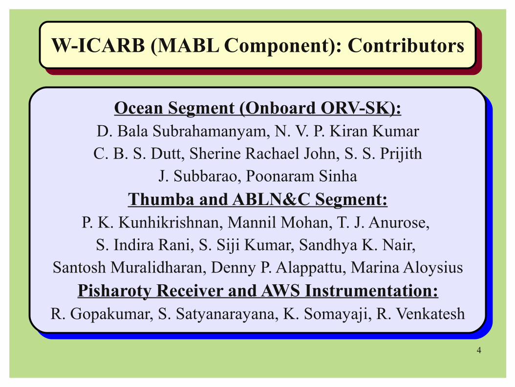
W-ICARB (MABL Component): ContributorsW-ICARB (MABL Component): Contributors
Ocean Segment (Onboard ORV-SK):D. Bala Subrahamanyam, N. V. P. Kiran KumarC. B. S. Dutt, Sherine Rachael John, S. S. Prijith
J. Subbarao, Poonaram Sinha
Thumba and ABLN&C Segment:P. K. Kunhikrishnan, Mannil Mohan, T. J. Anurose,
S. Indira Rani, S. Siji Kumar, Sandhya K. Nair, Santosh Muralidharan, Denny P. Alappattu, Marina Aloysius
Pisharoty Receiver and AWS Instrumentation:R. Gopakumar, S. Satyanarayana, K. Somayaji, R. Venkatesh

5
(W-ICARB: MABL Component)(W-ICARB: MABL Component)Objectives and Plan-ExecutionObjectives and Plan-Execution
(W-ICARB: MABL Component)(W-ICARB: MABL Component)Objectives and Plan-ExecutionObjectives and Plan-Execution
Objectives/Requirements Plan ExecutionNorth-South Latitudinal Gradients in the
Air-Sea Interaction ParametersCruise Track was designed in accordance.
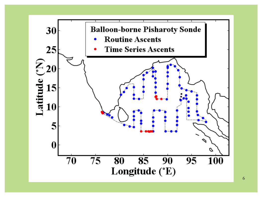
Vertical Structure of the MABLSystematic ascents of 108 Balloon-borne
GPS Pisharoty Sondes
Diurnal Variability in the
Air-Sea Interaction Parameters
Three Time-Series Measurements
(~ 18 Hrs each)
Offshore structure of the
Sea/Land Breeze Circulation and TIBL
Concurrent Measurements from ORV-SK
and Thumba
ABL Structure over Land vs. OceanConcurrent Measurements from ORV-SK
and ABLN&C Network Stations
6

7
W-ICARB Data AnalysisW-ICARB Data Analysis
Air-Sea Interaction Processes over the Bay of Bengal(DATABASE)
(Meteorological Sensors mounted on a retractable boom)+
(Manual Measurements of SST and other meteorological fields)+
(GPS aided position of the ship, its speed and head angle)
Air-Sea Interaction Processes over the Bay of Bengal(DATABASE)
(Meteorological Sensors mounted on a retractable boom)+
(Manual Measurements of SST and other meteorological fields)+
(GPS aided position of the ship, its speed and head angle)
Vertical Structure of the MABL over the Bay of Bengal(DATABASE)
(Upper air meteorological observations obtained from Balloon-borne Pisharoty GPS Sondes)
Vertical Structure of the MABL over the Bay of Bengal(DATABASE)
(Upper air meteorological observations obtained from Balloon-borne Pisharoty GPS Sondes)

8
Meteorological Instruments Mounted on
Retractable Boom
Meteorological Instruments Mounted on
Retractable Boom

9
Estimation of Air-Sea Interaction Parameters(Iterative Bulk Aerodynamic Algorithm)#
Estimation of Air-Sea Interaction Parameters(Iterative Bulk Aerodynamic Algorithm)#
SSTSSTATAT
RHRHWSWS
PRESPRES
LHFLHFSHFSHF MFMF
INPUTS
OUTPUTS
#Subrahamanyam et al., (Ann. Geophy., 2007; Bound.Layer.Met., 2008; Atmos.Res., 2009)

10
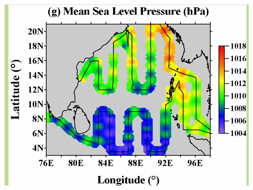
Spatial Heterogeneity in Air-Sea Interaction Parameters
over the Bay of Bengal during W-ICARB
Spatial Heterogeneity in Air-Sea Interaction Parameters
over the Bay of Bengal during W-ICARB

11

12

13

14
15

16

17

18

19

20
Barring Wind Speed, rest of the
meteorological parameters had a
distinct North-South latitudinal gradient;However it was not so prominent in the case of surface layer turbulent fluxes of heat, moisture and
momentum.
Barring Wind Speed, rest of the
meteorological parameters had a
distinct North-South latitudinal gradient;However it was not so prominent in the case of surface layer turbulent fluxes of heat, moisture and
momentum.

21
Diurnal Variability in Air-Sea Interaction Parameters
over the Bay of Bengal during W-ICARB:
How does the 24 Hrs evolution look like ?What are the timings when a parameter peaks ?
Diurnal Variability in Air-Sea Interaction Parameters
over the Bay of Bengal during W-ICARB:
How does the 24 Hrs evolution look like ?What are the timings when a parameter peaks ?

22

23
SHF High during Night and Low during Noon Hrs!!!

24
Unusual Nocturnal Peaks !!!Unusual Daytime Peak !!!

25

26
Defining a “New Index” to quantify the diurnal variabilities....

27
Statistical Interpretation of Data distribution in terms of
Skewness and Kurtosis
Statistical Interpretation of Data distribution in terms of
Skewness and Kurtosis

28

29

30
Balloon-borne Pisharoty GPS
Ascents (108 Nos.)
Balloon-borne Pisharoty GPS
Ascents (108 Nos.)

31
Balloon-borne Pisharoty GPS Sonde Data Analysis (Quality Checks and Data Processing)
(Raw Data → Sigma Filter → Running Mean → Regridding)
Balloon-borne Pisharoty GPS Sonde Data Analysis (Quality Checks and Data Processing)
(Raw Data → Sigma Filter → Running Mean → Regridding)

32
Time-Series Measurements during W-ICARB: Mixed Layer Height Evolution

33
Third Time Series Measurements closer to Thumba: Formation of “Thermal Internal Boundary Layer”

34
Vertical profiles of VPT over Thumba
corresponding to 1323 LT showed formation
of TIBL, which gradually changed to
Residual Layer by 2016 LT profile.
Over Ocean, such clear formation of any
internal boundary layer was not
prominent and MABL showed a weak diurnal
evolution.

35
Magnitudes of Sea Breeze Component (SBC) was marginally higher over Thumba.
Evolution of compensating return flow at higher altitudes (1 – 3 kms) was clear over Thumba as well as over the Ocean.
OVER TO NEXT THEME: TOTAL SOLAR ECLIPSE --->

36
““Atmospheric Boundary Layer” Atmospheric Boundary Layer” Response to the Response to the Total Solar EclipseTotal Solar Eclipse
Event on January 15, 2010 Event on January 15, 2010

37
Automatic Weather Station(Atmospheric Surface Layer Measurements)
(Round the Clock)
Balloon-borne Pisharoty GPS Ascents(14-15 January 2010)
(Upper Air Meteorological Measurements)
0800 LT1000 LT1230 LT1430 LT
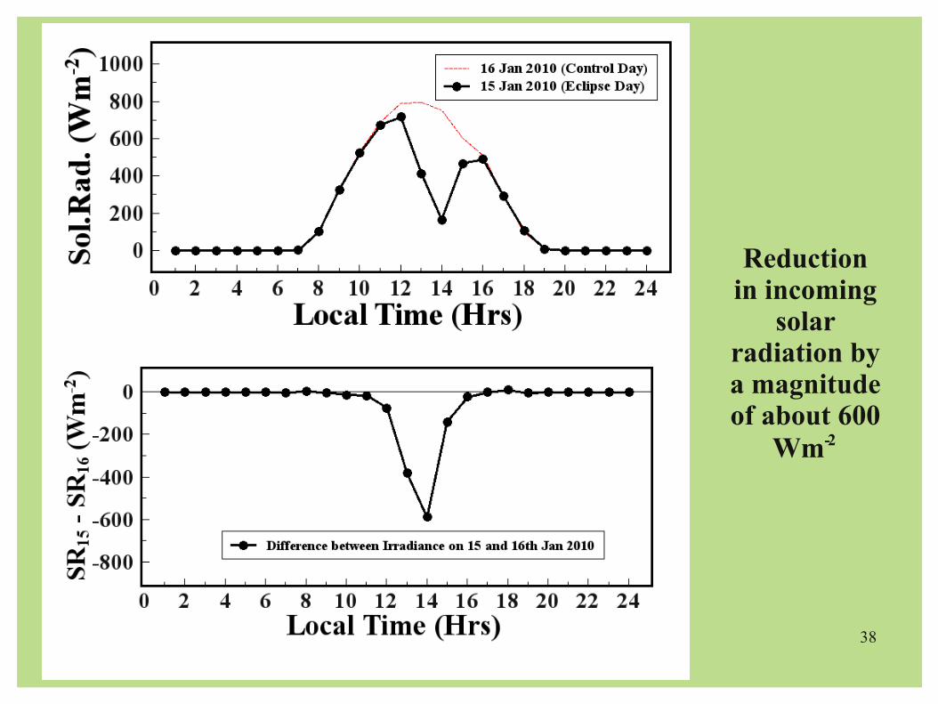
38
Reduction in incoming
solar radiation by a magnitude of about 600
Wm-2

39
40

41
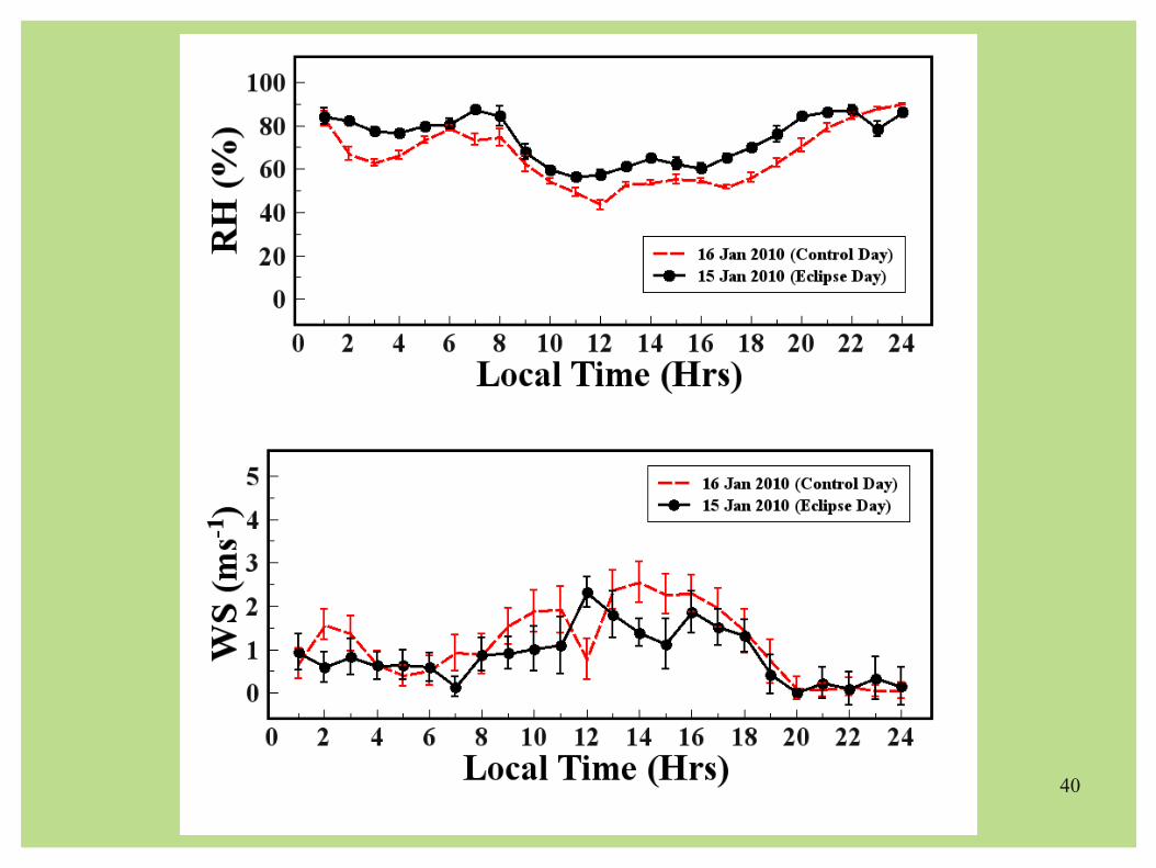
Delayed Onset of Sea Breeze on TSE Day !!!
42
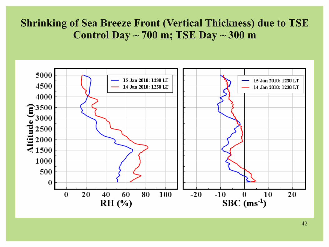
Shrinking of Sea Breeze Front (Vertical Thickness) due to TSEControl Day ~ 700 m; TSE Day ~ 300 m

43
Shrinking of Sea Breeze Front (Vertical Thickness) due to TSE gradually vanished after the eclipse
Control Day ~ 500 m; TSE Day ~ 400 m

44
Rapid Fall in the altitude of maximum convection (corresponding to minimum in delta theta)
OVER TO NEXT THEME: MOKSHA ---->

45
Monsoon Onset over Kerala through Systematic Horizontal Advection
(MOKSHA)
Monsoon Onset over Kerala through Systematic Horizontal Advection
(MOKSHA)
46
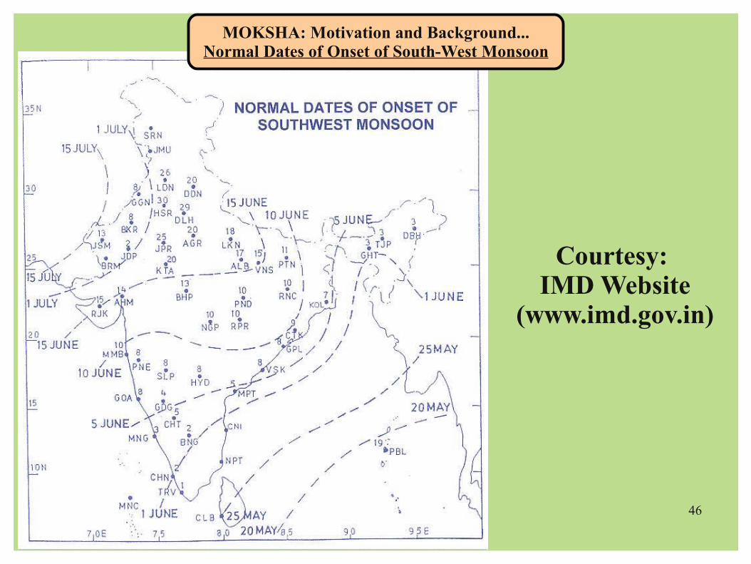
MOKSHA: Motivation and Background...Normal Dates of Onset of South-West Monsoon
Courtesy: IMD Website
(www.imd.gov.in)

47
MOKSHA: Motivation and BackgroundMOKSHA: Motivation and Background
Courtesy: IMD Website
(www.imd.gov.in)

48
MOKSHA: Motivation and Background...Advancement of Indian South-West Monsoon
MOKSHA: Motivation and Background...Advancement of Indian South-West Monsoon

49
MOKSHA: Motivation and Background...Advancement of Indian South-West Monsoon
MOKSHA: Motivation and Background...Advancement of Indian South-West Monsoon

50
MOKSHA: Objectives ...MOKSHA: Objectives ...
➢What is the response of “Atmospheric Boundary Layer” to the Indian Summer Monsoon during its onset phase over Kerala ?
➢Whether the intrusion of moisture within the ABL from neighboring oceans during the onset phase of SW-monsoon is really systematic resulting into subsequent rainfalls (As shown through onset dates !!!)
➢What could be the possible role of ABL dynamics in SW-monsoon associated precipitation and whether both have got any feedback mechanism governing the rainfall intensities ?
....
Essentially MOKSHA does not aim at prediction of Monsoon !!!!

51
MOKSHA: Science Plan Conceived ...MOKSHA: Science Plan Conceived ...
Preliminary Earmarked Objectives:-
➢Investigation in modulations in mixed layer heights and ABL characteristics over the Kerala Coast with the onset of SW-monsoon.
➢Study of spatial homogeneity/heterogeneity in rainfall during onset phase of SW-monsoon over Kerala.
➢Quantitative Investigation of intrusion of moisture from Oceans to landmass (Kerala) during onset phase of SW-monsoon with the aid of Regional Atmospheric Models.
➢Generation (Gathering) of ABL measurements database during onset phase of SW-monsoon.

52
MOKSHA: Pilot Phase (2009)MOKSHA: Pilot Phase (2009)
Database:May 20 – June 01, 2009:One Pisharoty Sonde per day simultaneously from TERLS (Thumba) and SNOM (Cochin)
May 15 – Sept 15, 2009:Surface layer meteorological observations from about 37 ISRO AWS stations within Kerala under PRWONAM Network
++ All other ABL instruments at ATS, TERLS.

53
How systematic was the horizontal advection of moisture and associated rainfall over Kerala in SW-monsoon (2009) !!!
How systematic was the horizontal advection of moisture and associated rainfall over Kerala in SW-monsoon (2009) !!!

54
How systematic was the horizontal advection of moisture and associated rainfall over Kerala in SW-monsoon (2009) !!!
How systematic was the horizontal advection of moisture and associated rainfall over Kerala in SW-monsoon (2009) !!!
Formal Date of SW-Monsoon Onset: 23 May 2009

55
How systematic was the horizontal advection of moisture and associated rainfall over Kerala in SW-monsoon (2009) !!!
How systematic was the horizontal advection of moisture and associated rainfall over Kerala in SW-monsoon (2009) !!!

56
Rainfall Vs. Mixed Layer Heights
OVER TO NEXT THEME: HRM ---->

57
High-resolution Regional Model (HRM) Simulations in support of GSLV-D3 and
PSLV-C14 Launch:
Towards improvements in Model Simulations
Anurose T. J. and D. Bala Subrahamanyam
High-resolution Regional Model (HRM) Simulations in support of GSLV-D3 and
PSLV-C14 Launch:
Towards improvements in Model Simulations
Anurose T. J. and D. Bala Subrahamanyam

58
End Users
Provided for HRM by DWD
Topographical Data
Initial data (Analysis)
Lateral Boundary Data
ModelProducts
RegionalNWP
System: HRM
General Structure of Regional NWP System: High-resolution Regional Model (HRM): An Overview
General Structure of Regional NWP System: High-resolution Regional Model (HRM): An Overview
59
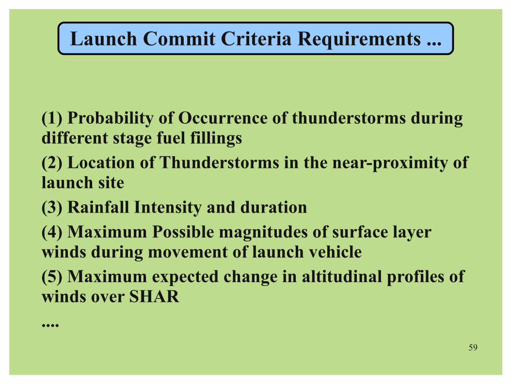
Launch Commit Criteria Requirements ...
(1) Probability of Occurrence of thunderstorms during different stage fuel fillings(2) Location of Thunderstorms in the near-proximity of launch site(3) Rainfall Intensity and duration (4) Maximum Possible magnitudes of surface layer winds during movement of launch vehicle(5) Maximum expected change in altitudinal profiles of winds over SHAR....

60
+18 Hrs Forecast

61
+24 Hrs Forecast

62
HRM Predictions Vs. NCEP/NCAR Reanalysis

63
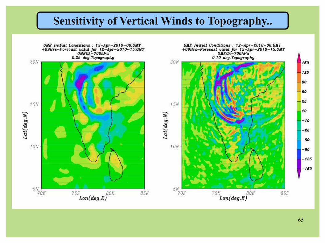
Impact of high-resolution topography in Regional Atmospheric Models....
Two Different Cases: Case 1: HRM Orography is higher than the GME Orography
(A mountain's realistic elevation is under-estimated in Global Model)
Case 2: HRM Orography is lower than the GME Orography(A Flat ground is over-estimated as an elevated mountain in Global Model)
ps1HRM
psGME
psGME
ps1HRM
Case1: (No Problem) Case2: Just assumptions !!!

Mean height difference (m) GME - HRM: -0.0329
Minimum height difference (m) GME - HRM: -638.8944 Minimum at gridpoint j1: 82 j2: 107
Maximum height difference (m) GME - HRM: 507.7585 Maximum at gridpoint j1: 83 j2: 107
Impact of high-resolution topography in Regional Atmospheric Models....
65
Sensitivity of Vertical Winds to Topography..

66
Tiedtke Convective Scheme Bechtold Convective Scheme
Sensitivity of Precipitation to Convective Schemes..

67
Experiences Gained:
Choice of Model Domain: How to avoid Steep topography ??
Choice of Topography (Expense: Model Run Time): Global Model to Regional Models
Choice of Convective Schemes: Widespread rainfall over isolated rainfall ?
Choice of Grid Size (and Model Time Step): As per Users' Need

68
FUTURE PROJECTIONS ....HRM Verification studies with three different topographical datasets (0.25, 0.10 and 0.0625 deg. resolutions)
Data Assimilation (TEMP, SYNOP + Satellite Observations) in HRM for improving the forecast quality...
Continuation of Sea/Land Breeze Circulation Study (Observations + Model) with special emphasis on the dynamics of formation of the return flow (++ AACCR)
MOKSHA – Next Phase (++ ADB)
Indigestion of Field Experiments Database into the Model
69
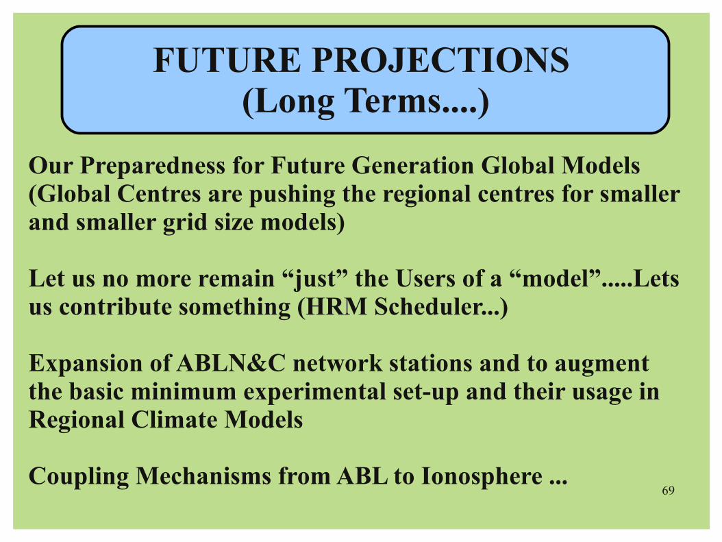
FUTURE PROJECTIONS (Long Terms....)
Our Preparedness for Future Generation Global Models (Global Centres are pushing the regional centres for smaller and smaller grid size models)
Let us no more remain “just” the Users of a “model”.....Lets us contribute something (HRM Scheduler...)
Expansion of ABLN&C network stations and to augment the basic minimum experimental set-up and their usage in Regional Climate Models
Coupling Mechanisms from ABL to Ionosphere ...