searsport harbor searsport, maine - new england … study and the improvement project non-federal...
TRANSCRIPT
Feasibility Report and Environmental Assessment for Navigation Improvement Project
Searsport Harbor Searsport, Maine
US ARMY CORPS OF ENGINEERS New England District
April 2013
PUBLIC REVIEW DRAFT

_________________________________________________________________________
Searsport Harbor Draft Feasibility Report Navigation Improvement Study Public Review Draft
SEARSPORT HARBOR SEARSPORT, MAINE
NAVIGATION IMPROVEMENT PROJECT
Draft Feasibility Report & Environmental Assessment
Finding of No Significant Impact
Section 404(b)(1) Evaluation
April 2013
_________________________________________________________________________
Searsport Harbor Draft Feasibility Report Navigation Improvement Study Public Review Draft
(This page intentionally left blank.)
_________________________________________________________________________Searsport Harbor i Draft Feasibility Report
Navigation Improvement Study Public Review Draft
Executive Summary
The purpose of the study is to examine whether navigation improvements to the existing Federal navigation project at Searsport Harbor (Mack Point) are warranted and in the Federal interest. Currently, Searsport Harbor has inadequate depth in the Federal channel, which results in significant tidal delays for larger vessels, some light loading of vessels, and restrictions in the size of vessels which can be used to bring cargo to the port. This report presents the feasibility study analysis and recommendation. The report consists of an executive summary, main report, and supporting appendices. A draft Environmental Assessment (EA) and supporting documents are also provided with the report. The U.S. Army Corps of Engineers (Corps) was authorized to conduct a study of Searsport Harbor by the House Committee on Transportation and Infrastructure by Resolution adopted 26 July 2000. Specific Resolution language is provided below.
Resolved by the Committee on Transportation and Infrastructure of the United States House of Representatives, that the Secretary of the Army is requested to review the report of the Chief of Engineers on Searsport Harbor, Maine, published as House Document 500, 87th Congress, 2nd Session, and other pertinent reports, with a view to determine whether modifications to the recommendations contained therein are advisable in the interest of navigation, including the advisability of deepening the existing 35-feet channel and turning basin.
The Maine Department of Transportation (ME DOT) is the non-Federal partner for the feasibility study and the improvement project non-Federal sponsor. The Searsport Harbor navigation improvement study began in August 2004 with preparation of the Reconnaissance Report that identified the Federal interest in continuing to the Feasibility Phase. The cost sharing agreement for the Feasibility Phase with Maine Department of Transportation was signed in December 2005 and the Feasibility Phase initiated in 2006. The Feasibility Phase is cost shared 50 percent Federal and 50 percent non-Federal. This report provides the findings of the Feasibility Phase.
Searsport Harbor is in the town of Searsport, in Waldo County and is about 27 miles south
of Bangor and 91 miles northeast of Portland, Maine. Searsport is located mid-way along
the coast of Maine on Penobscot Bay. The deep draft port at Searsport Harbor is known as
Mack Point.
_________________________________________________________________________Searsport Harbor ii Draft Feasibility Report
Navigation Improvement Study Public Review Draft
The existing Federal navigation project at Mack Point, authorized by Congress in 1962,
includes a channel that is 35 feet deep (mean lower low water) and 500 feet wide. The
channel extends from deep water in Penobscot Bay to the terminal berths at Mack Point,
for a total length of 3,500 feet, and widens to 1,500 feet off the terminals to provide a
turning basin. The piers are the State of Maine’s public general purpose cargo pier (two
berths) and the Sprague Energy liquid pier (two berths) used by Sprague and Irving Oil
Company.
Commodities received at the port include petroleum and petroleum products and various bulk and break-bulk commodities. The port currently handles mostly imports, although the State of Maine is working to increase exports from the port. Oil and gasoline are the dominant imports at the port, generally making up 70 to 80 percent of the total tonnages. Of the bulk and break-bulk commodities, the most common imports are road salt, wood pulp, clay, chemicals, and gypsum. Alternative improvement plans analyzed and compared in the feasibility study included channel depths from 37 to 42 feet. Additional channel width and turning area were also considered in the design. The tentatively recommended navigation improvement plan (project) identified in the feasibility study would deepen the existing Federal navigation project from a depth of -35 feet to -40 feet mean lower low water (MLLW) and would include a maneuvering area adjacent to the east side of the State Pier. The tentatively recommended plan is the plan that reasonably maximizes the net annual benefits and is the National Economic Development (NED) plan. The benefit to cost ratio for the recommended plan (base case analysis-no growth in annual volume) calculated at the FY13 Federal interest rate for water projects of 3-3/4 % percent is 2.5 to 1 with net annual benefits of $845,000. The other alternative plans considered contribute to the national economy but to a lesser extent. Approximately 892,000 cy of improvement material would be removed for the navigation improvement project. Material removed from the project would be disposed of at an open water disposal site. The disposal site selected is a deep water site in Penobscot Bay. The disposal site is about six miles from the project area. At the time of construction of the navigation improvement project about 37,100 cy of Federal maintenance material would be removed from the existing Federal navigation project. The sum of the improvement material and maintenance material is 929,100 cy.
_________________________________________________________________________Searsport Harbor iii Draft Feasibility Report
Navigation Improvement Study Public Review Draft
In addition to the improvement project, two berths (one at the liquid pier and one at the cargo pier) would also be dredged to -43 feet MLLW to accommodate deeper draft vessels and provide 3 feet of underkeel clearance in the berths. The tentatively recommended plan is supported by the non-Federal sponsor, Maine Department of Transportation. The tentatively recommended navigation improvement project estimated first cost is $11,200,000 (Federal program year 2014, effective price level date October 2013). The Federal cost share would be 75 percent and the non-Federal Cost share would be 25 percent of the navigation improvement project cost. Once construction is completed the non-Federal sponsor would be required to pay an additional 10 percent of the cost of construction over a period not to exceed 30 years. In addition the non-Federal project sponsor would also be responsible for 100 percent of the cost to deepen the berths, one at the State Pier and one at the liquid pier. The Federal government would be responsible for 100 percent of Federal navigation project maintenance.
_________________________________________________________________________Searsport Harbor iv Draft Feasibility Report
Navigation Improvement Study Public Review Draft
(This page intentionally left blank.)
_________________________________________________________________________Searsport Harbor v Draft Feasibility Report
Navigation Improvement Study Public Review Draft
Table of Contents
1.0 INTRODUCTION .............................................................................................................................. 1
1.1 STUDY PURPOSE .......................................................................................................................................... 1
1.2 STUDY AND PROJECT SPONSORSHIP ................................................................................................................. 1
1.3 STUDY AREA ............................................................................................................................................... 1
1.4 STUDY AUTHORITY ....................................................................................................................................... 4
1.5 PRIOR AUTHORIZATIONS ............................................................................................................................... 4
1.6 PAST STUDIES ............................................................................................................................................. 4
1.7 CORPS FEASIBILITY STUDY PROCESS ................................................................................................................. 5
1.8 ENVIRONMENTAL OPERATING PRINCIPLES ........................................................................................................ 7
1.9 USACE CAMPAIGN PLAN .............................................................................................................................. 8
2.0 EXISTING CONDITIONS .................................................................................................................... 9
2.1 GEOGRAPHICAL SETTING ............................................................................................................................... 9
2.2 GENERAL HISTORY OF MACK POINT .............................................................................................................. 11
2.3 EXISTING FEDERAL NAVIGATION PROJECT ....................................................................................................... 11
2.3.1 Piers and Berths ............................................................................................................................ 12
2.3.2 Land Based Facilities ..................................................................................................................... 14
2.3.3 Rail Access .................................................................................................................................... 14
2.3.4 Commodities ................................................................................................................................. 14
2.3.5 Current Vessel Usage .................................................................................................................... 16
2.4 SOCIO‐ECONOMIC SETTING ......................................................................................................................... 18
2.5 PHYSICAL ENVIRONMENT ..................................................................................................................... 19
2.5.1 Geological Setting ......................................................................................................................... 19
2.5.2 Meteorological Conditions ............................................................................................................ 19
2.5.3 Tidal Conditions ............................................................................................................................. 20
2.5.4 Water Quality ................................................................................................................................ 21
2.5.5 Air Quality ...................................................................................................................................... 22
2.6 BIOLOGICAL RESOURCES ............................................................................................................................. 22
2.6.1 Eelgrass ......................................................................................................................................... 22
2.6.2 Benthic Resources .......................................................................................................................... 23
2.6.3 Shellfish Resources ........................................................................................................................ 23
2.6.4 Finfish Resources ........................................................................................................................... 23
2.6.5 Essential Fish Habitat .................................................................................................................... 25
2.7 ENDANGERED AND THREATENED SPECIES ........................................................................................... 25
2.7.1 Federally Listed Endangered and Threatened Species .................................................................. 25
2.7.2 Federally Listed Candidate and Species of Special Concern ........................................................... 27
2.7.3 State Listed Species ....................................................................................................................... 28
2.8 CULTURAL RESOURCES ................................................................................................................................ 28
_________________________________________________________________________Searsport Harbor vi Draft Feasibility Report
Navigation Improvement Study Public Review Draft
3.0 PLAN FORMULATION .................................................................................................................... 31
3.1 NAVIGATION INEFFICIENCIES ......................................................................................................................... 31
3.2 PLANNING OBJECTIVE.................................................................................................................................. 31
3.3 PLANNING CONSTRAINTS ............................................................................................................................. 31
3.4 NAVIGATIONS IMPROVEMENT MEASURES ....................................................................................................... 32
3.5 SUBSURFACE INVESTIGATIONS ....................................................................................................................... 32
3.6 NAVIGATION FEATURES .............................................................................................................................. 33
3.7 DREDGED MATERIAL DISPOSAL SUITABILITY DETERMINATION ............................................................................ 34
3.8 DREDGED MATERIAL MANAGEMENT MEASURES ............................................................................................. 35
3.8.1 Upland Disposal and Beneficial Use ............................................................................................. 35
3.8.2 Beach Nourishment and Wetland Creation .................................................................................. 36
3.8.3 Waterfront Development ............................................................................................................. 36
3.8.4 Cap Material ................................................................................................................................. 36
3.8.5 Landfill Disposal ............................................................................................................................ 37
3.8.6 Ocean Disposal (Marine Protection, Research, and Sanctuaries Act) ........................................... 37
3.8.7 Disposal Sites (Clean Water Act) ................................................................................................... 38
4.0 ALTERNATIVES .............................................................................................................................. 41
4.1 FUTURE WITHOUT PROJECT ......................................................................................................................... 41
4.2 ALTERNATIVE PLANS................................................................................................................................... 41
4.3 ALTERNATIVE PLAN QUANTITY ESTIMATES ...................................................................................................... 44
4.4 COST ESTIMATES FOR ALTERNATIVE PLANS ...................................................................................................... 47
5.0 EVALUATION AND COMPARISON OF ALTERNATIVES ..................................................................... 50
5.1 ECONOMIC ANALYSIS .................................................................................................................................. 50
5.1.1 Benefits Analysis ............................................................................................................................ 50
5.1.2 Sensitivity Analysis, Commerce Volumes ....................................................................................... 52
5.1.3 Sensitivity Analysis, Tanker Loading .............................................................................................. 52
5.1.4 Annual Economic Project Costs ..................................................................................................... 54
5.2 DETERMINATION OF NED PLAN .................................................................................................................... 56
5.3 REGIONAL ECONOMIC DEVELOPMENT AND OTHER SOCIAL EFFECTS BENEFITS ........................................................ 58
5.4 ENVIRONMENTAL IMPACTS ........................................................................................................................... 58
5.4.1 Water Quality Impacts .................................................................................................................. 59
5.4.2 Biological Impacts .......................................................................................................................... 61
5.4.3 Essential Fish Habitat .................................................................................................................... 62
5.4.4 Endangered and Threatened Species ............................................................................................ 67
5.5 CULTURAL RESOURCES ................................................................................................................................ 68
5.6 PLAN SELECTION ........................................................................................................................................ 70
5.7 RISK AND UNCERTAINTY............................................................................................................................... 70
6.0 DESCRIPTION OF TENTATIVELY RECOMMENDED PLAN .................................................................. 71
6.1 PLAN COMPONENTS ................................................................................................................................... 71
6.1.1 General Navigation Features ......................................................................................................... 71
_________________________________________________________________________Searsport Harbor vii Draft Feasibility Report
Navigation Improvement Study Public Review Draft
6.1.2 Local Service Facilities ................................................................................................................... 71
6.1.3 Design and Construction Considerations ....................................................................................... 71
6.2 ECONOMICS OF RECOMMENDED PLAN ........................................................................................................... 73
6.3 PROJECT COST BREAKDOWN ......................................................................................................................... 73
6.4 ENVIRONMENTAL MITIGATION ...................................................................................................................... 76
6.5 REAL ESTATE & UTILITIES ............................................................................................................................. 76
6.6 OPERATION AND MAINTENANCE ................................................................................................................... 76
6.7 SEA LEVEL CHANGE .................................................................................................................................... 77
6.8 INSTITUTIONAL REQUIREMENTS ..................................................................................................................... 80
6.9 STATUS OF LEGAL REVIEW ............................................................................................................................ 80
6.10 AGENCY TECHNICAL REVIEW DOCUMENTATION ............................................................................................. 80
6.11 COMPLIANCE WITH NEPA, KEY STATUES AND REGULATIONS ............................................................................ 80
6.12 AGENCY COORDINATION ............................................................................................................................ 81
6.13 PUBLIC REVIEW AND COMMENT .................................................................................................................. 83
6.14 STATUS OF SPONSOR SUPPORT ................................................................................................................... 83
7.0 RECOMMENDATION ..................................................................................................................... 84
REFERENCES
ENVIRONMENTAL ASSESSMENT AND RELATED DOCUMENTS Draft Environmental Assessment Finding of No Significant Impact Record of Non-Applicability (RONA) and Emissions Calculations Clean Water Act Section 404(b)(1) Evaluation
_________________________________________________________________________Searsport Harbor viii Draft Feasibility Report
Navigation Improvement Study Public Review Draft
List of Tables Table 1. Total Commodity Volumes, 1995-2008, Searsport Harbor .................................. 15 Table 2. Historical Petroleum and Petroleum Product Volumes, Searsport Harbor ........... 15 Table 3. Recent Bulk and Break Bulk Commodity Volumes Searsport Harbor ................. 16 Table 4. Vessel Trips by Draft, 2005 – 2008 ...................................................................... 17 Table 5. Population Statistics for the Searsport Harbor Region, Maine ............................. 18 Table 6. Tidal Elevations and Datums, Searsport Harbor, Searsport, Maine ..................... 21 Table 7. List of Alternative Plans ....................................................................................... 42 Table 8. Quantity Estimate for Alternative Plans ............................................................... 44 Table 9. Local Service Facilities, Berth Dredge Quantities ................................................ 46 Table 10. Alternatives Cost Estimates - Penobscot Disposal Site ...................................... 48 Table 11. Alternatives Cost Estimates - Rockland Disposal Site ....................................... 49 Table 12. Waterborne Transportation Costs, Base Case, Searsport Harbor ....................... 51 Table 13. Annual Benefits to Channel Dredging, Base Case, Searsport Harbor ................ 52 Table 14. Average Annual Benefits, Commerce Growth Sensitivity ................................. 52 Table 15. Oil Tanker Transportation Costs, Base Case vs Tanker Loading Sensitivity ..... 53 Table 16. Average Annual Benefits, Tanker Loading Sensitivity ...................................... 54 Table 17. Annual Cost of Alternatives, Penobscot Disposal Site ....................................... 55 Table 18. Annual Costs of Alternatives, Rockland Disposal Site....................................... 55 Table 19. Benefit-Cost Analysis for Improvement Alternatives, Searsport Federal
Navigation Project, Searsport, Maine, Penobscot Bay Disposal Site .......................... 56 Table 20. Net Annual Benefits for 40-Foot vs. 41-Foot Improvement ............................... 57 Table 21. Benefit-Cost Analysis for Improvement Alternatives, Searsport Federal
Navigation Project, Searsport, Maine, Rockland Disposal Site ................................... 57 Table 22. Tentatively Selected Plan, Project Cost and Benefits ......................................... 73 Table 23. Tentatively Selected Plan, Program Year Cost ................................................... 74 Table 24. Estimated GNF Improvement Project, Funds Allocation Table ......................... 75 Table 25. Federal and State Agencies Coordination ........................................................... 82
_________________________________________________________________________Searsport Harbor ix Draft Feasibility Report
Navigation Improvement Study Public Review Draft
List of Figures Figure 1. Location Map ......................................................................................................... 2 Figure 2. Existing Federal Navigation Project ...................................................................... 3 Figure 3. Map of Maine ........................................................................................................ 9 Figure 4. Towns Located Near Searsport, Maine ............................................................... 10 Figure 5. Mack Point, Searsport, Maine ............................................................................. 13 Figure 6. Wind Direction in Penobscot Bay, Rockland Buoy. ........................................... 20 Figure 7. Maneuvering Area Near State Pier ...................................................................... 34 Figure 8. Sediment Sample Locations ................................................................................ 35 Figure 9. Alternative Disposal Site Locations .................................................................... 39 Figure 10. Recommended Improvement Project ................................................................ 72 Figure 11. Sea level curves based upon USACE EC-1165-2-211, Portland, ME .............. 79 Figure 12. Historical sea level change trend for Portland, ME – Provided by NOAA. ...... 79
_________________________________________________________________________Searsport Harbor x Draft Feasibility Report
Navigation Improvement Study Public Review Draft
List of Appendices Appendix A Public & Agency Involvement & Pertinent Correspondence
Appendix B Dredged Material Disposal Suitability Determinations
Appendix C Benthic Resource Data
Appendix D Essential Fish Habitat Life History
Appendix E Economics Appendix
Appendix F Coastal Engineering Appendix
Appendix G Geotechnical Appendix
Appendix H Engineering Appendix
Appendix I Cost Estimates and Cost Schedule Risk Analysis for Tentatively Selected Plan
List of Supporting Documents (included on CD) 1. Marine Geophysical Investigation, Channel Deepening Project Searsport, Maine,
July 16, 2007, prepared by Oceans Surveys, Inc.
2. Marine Archaeological Survey, Searsport Harbor, Maine, July 2007, prepared by David Robinson and submitted by Public Archaeology Laboratory.
3. Field Sampling and Sediment Testing, Searsport Harbor, Federal Navigation Project, Searsport, Maine, September 30, 2008, prepared by Battelle
4. Preliminary Assessment, Searsport Harbor Shipwreck, Searsport, Maine, November 2008, prepared by Public Archaeology Laboratory.
5. ADCP and Tide Data Collections Searsport Harbor, Searsport, Maine, December 2009, prepared by Woods Hole Group Inc.
_________________________________________________________________________ Searsport Harbor 1 Draft Feasibility Report
Navigation Improvement Study Public Review Draft
1.0 INTRODUCTION
1.1 STUDY PURPOSE
The purpose of the study is to examine whether navigation improvements to the existing Federal navigation project at Searsport Harbor (Mack Point) are warranted and in the Federal interest. Searsport Harbor is authorized at a channel depth of 35 feet mean lower low water (MLLW). This report considers the feasibility of navigation improvements and presents the feasibility study process, analysis, and recommendation. The report consists of an executive summary, main
report and supporting appendices. A draft Environmental Assessment (EA) and supporting documents are also provided with the report.
1.2 STUDY AND PROJECT SPONSORSHIP
The Maine Department of Transportation (ME DOT) is the non-Federal partner for the feasibility study and the project non-Federal sponsor. The Searsport Harbor navigation improvement study began in August 2004 with preparation of the Reconnaissance Report that identified the Federal interest in continuing to the Feasibility Phase. The cost sharing agreement for the Feasibility Phase with Maine Department of Transportation was signed in December 2005 and the Feasibility Phase initiated in 2006. The Feasibility Phase is cost shared 50 percent Federal and 50 percent non-Federal. This report provides the findings of the Feasibility Phase.
1.3 STUDY AREA
Searsport Harbor is in the town of Searsport, in Waldo County. Searsport Harbor is about 27
miles south of Bangor and 91 miles northeast of Portland, Maine. The harbor is located mid-way
along the Maine coast in the northwest portion of Penobscot Bay. The bay stretches from the
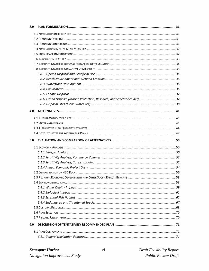
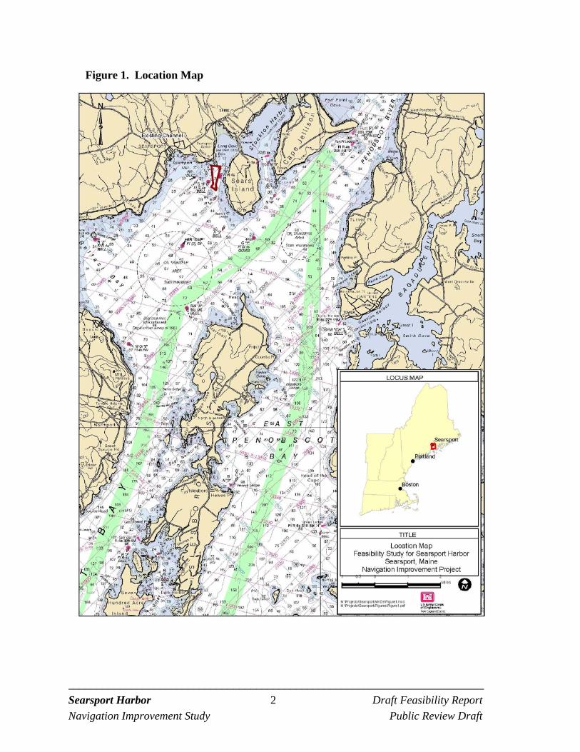
mouth of the Penobscot River to the Atlantic Ocean. The general location is shown in Figure 1.
The deep draft port called Mack Point is located to the east of the town center. The municipal
landing and mooring areas for the local commercial fishing fleet and seasonal recreational fleet
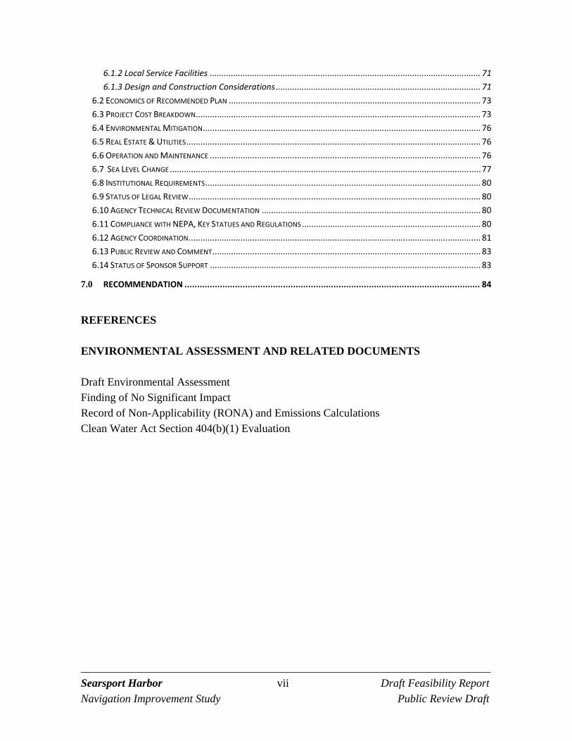
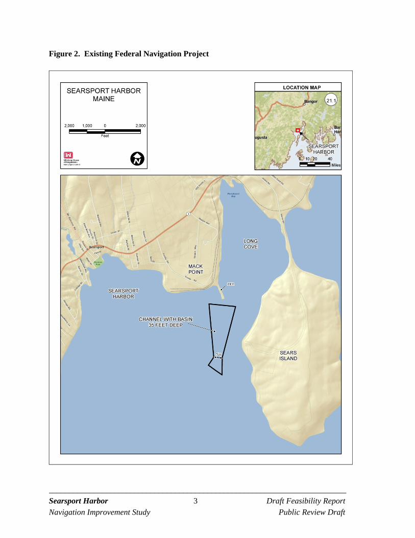
are located near the town center. Figure 2 shows the location of existing Federal navigation
project at Mack Point.
The existing Federal navigation project at Mack Point, authorized by Congress in 1962, includes
a channel depth of 35 feet mean lower low water (MLLW), extending from Penobscot Bay to the
two piers at Mack Point. The piers are the State of Maine’s public general purpose cargo pier
(two berths) and the Sprague Energy liquid pier (two berths) used by Sprague and Irving Oil
Company.
_________________________________________________________________________ Searsport Harbor 2 Draft Feasibility Report
Navigation Improvement Study Public Review Draft
Figure 1. Location Map
_________________________________________________________________________ Searsport Harbor 3 Draft Feasibility Report
Navigation Improvement Study Public Review Draft
Figure 2. Existing Federal Navigation Project
_________________________________________________________________________ Searsport Harbor 4 Draft Feasibility Report
Navigation Improvement Study Public Review Draft
1.4 STUDY AUTHORITY
The U.S. Army Corps of Engineers (Corps) was authorized to conduct a study of Searsport Harbor by the House Committee on Transportation and Infrastructure by Resolution adopted 26 July 2000. Specific Resolution language is provided below. The study was initiated at the request of the State of Maine, Department of Transportation, the study sponsor, using funds added to the Fiscal Year 2004 Energy and Water Development Appropriations Bill.
Resolved by the Committee on Transportation and Infrastructure of the United States House of Representatives, that the Secretary of the Army is requested to review the report of the Chief of Engineers on Searsport Harbor, Maine, published as House Document 500, 87th Congress, 2nd Session, and other pertinent reports, with a view to determine whether modifications to the recommendations contained therein are advisable in the interest of navigation, including the advisability of deepening the existing 35-feet channel and turning basin.
1.5 PRIOR AUTHORIZATIONS
1962 Authorization -River & Harbor Act of October 23, 1962. This Act authorized the Searsport Navigation Project. The Act referenced the Chief of Engineers report (House Document Number 500) plan of improvement. The plan of improvement was a channel –35 feet MLLW, 500 feet wide from near the Mack Point piers a distance of 3,500 feet with a 1,500-foot wide turning basin in front of the piers. 1999 Authorization -Water Resources Development Act of August 17, 1999. Section 365(a)(8)of the Act deauthorized a triangular area across the northern limit of the project to accommodate expansion of the public terminal at Mack Point.
1.6 PAST STUDIES
1962: Chief of Engineers Report. This report found that the general navigation features at Searsport Harbor in 1962 were inadequate and that benefits were sufficient to warrant Federal improvement. The report resulted in the 1962 Congressional authorization of the existing Federal navigation project at Searsport Harbor, Maine. 1980: Reconnaissance Report. This study was conducted to determine if a breakwater (near the Town landing area) was of Federal interest. It was concluded that there was insufficient justification to proceed further.
_________________________________________________________________________ Searsport Harbor 5 Draft Feasibility Report
Navigation Improvement Study Public Review Draft
2000: Survey at a Candidate Disposal Site near Steels Ledge in Penobscot Bay, Maine. An area located in Penobscot Bay, near Steels Ledge, was selected for a technical investigation as a potential dredged material disposal site. This site was investigated under the Corps New England District’s Disposal Area Monitoring System (DAMOS) Program. The report includes information on the bathymetry, sediment, and benthic community in the study area. 2004: Reconnaissance Report, General Investigation 905(b) Analysis, August 31, 2004. This study examined deepening the existing project from -35-feet to -40 feet MLLW, with some widening of the channel and basin to accommodate larger bulk and petroleum carriers. The report was approved by the Corps North Atlantic Division on September 24, 2004. The recommendation in the report was economic justification favorable for continuing with a feasibility study. 1.7 CORPS FEASIBILITY STUDY PROCESS
The Corps planning and evaluation for water resource projects is based on the “Economic and Environmental Principles & Guidelines (P&G) for Water and Related Land Resources Implementation Studies” approved in 1983. The P&G was implemented under the authority of the Water Resources Planning Act of 1965. In accordance with the P&G the Federal objective of a water resource project is to contribute to the national economic development consistent with protecting the nation’s environment. The P&G are the drivers for the Corps planning process. The Corps regulation that describes the process is the Planning Guidance Notebook; Engineering Regulation 1105-2-100 dated April 22, 2000 and subsequent revisions. The Corps planning process follows a six step iterative process as described in the Planning Guidance Notebook and includes the following steps:
1. Specification of water and related land resources, problems, and opportunities
2. Inventory, forecast, and analysis of existing and future conditions
3. Formulation of alternative plans
4. Evaluation of the effects of the alternative plans
5. Comparison of alternative plans
6. Selection of a recommended plan
_________________________________________________________________________ Searsport Harbor 6 Draft Feasibility Report
Navigation Improvement Study Public Review Draft
The process considers the four criteria of completeness, effectiveness, efficiency, and acceptability in the screening of alternative plans. Completeness is the extent to which the plan accounts for all necessary investment or actions. For example plans that rely on activity by others to be successful may not be complete if the activity to be completed by others is unlikely to occur. Effectiveness is the degree to which an alternative plan contributes to the attainment of the planning objective. An efficient plan is the extent to which an alternative plan is most cost-effective means of attaining the objective. Acceptability measures the workability of a plan and compatibility with existing laws, regulations, and public policy. During the feasibility study alternatives are formulated and evaluated to determine which alternative reasonably maximizes the net economic benefit consistent with protection of the environment. The economic benefits calculated for this study are National Economic Development (NED) benefits. NED benefits are contributions to national economic development that increase the value of the national output of goods and services. For deep-draft navigation projects, the most common type of NED benefit is transportation cost savings, typically waterborne transportation cost savings. The NED benefits are estimated by comparing the transportation costs without the project to the transportation costs with the project. Any decrease in total transportation costs resulting from the project equal the benefits of the project. The benefits are then subtracted from the project costs to determine the net benefits. The alternative that maximizes the net benefits, consistent with protection of the environment is the Corps identified NED plan. Projects may deviate from the NED plan if requested by the non-Federal sponsor and approved by Assistant Secretary of the Army for Civil Works. For example a non-Federal sponsor may not be able to afford or otherwise support the NED Plan. Plans requested by the non-Federal sponsor that deviate from the NED plan are identified as the Locally Preferred Plan (LPP). The Corps feasibility study process also contains an Environmental Assessment. The Environmental Assessment (EA) is prepared in accordance with compliance requirements of National Environmental Policy Act (NEPA). NEPA requirements are outlined in the Council on Environmental Quality (CEQ) Regulations (40 CFR 1500-1508) and the U.S. Army Corps of Engineers Regulation 200-2-2, “Procedures for Implementing NEPA". The EA is designed to serve as a concise public document that briefly provides sufficient evidence and analysis for determining whether to prepare an environmental impact statement or a finding of no significant impact; and to aid the Corps of Engineers in compliance with the NEPA, when an environmental impact statement is not necessary. The EA includes a brief discussion of the need for the project, the environmental impacts of the proposed action and alternatives, and a listing of agencies and persons consulted.
_________________________________________________________________________ Searsport Harbor 7 Draft Feasibility Report
Navigation Improvement Study Public Review Draft
1.8 ENVIRONMENTAL OPERATING PRINCIPLES
The Corps has reaffirmed its commitment to the environment in a set of "Environmental Operating Principles". These principles foster unity of purpose on environmental issues and reflect a positive tone and direction for dialogue on environmental matters. By implementing these principles within the framework of Corps regulations, the Corps continues its efforts to evaluate the effects of its projects on the environment and to seek better ways of achieving environmentally sustainable solutions in partnership with stakeholders. The seven “Environmental Operating Principles” are as follows:
1. Strive to Achieve Environmental Sustainability: An environment maintained in a healthy, diverse, and sustainable condition is necessary to support life.
2. Consider Environmental Consequences: Recognize the interdependence of life and the
physical environment. Proactively consider environmental consequences of Corps programs and act accordingly in all appropriate circumstances.
3. Seek Balance and Synergy: Seek balance and synergy among human development
activities and natural systems by designing economic and environmental solutions that support and reinforce one another.
4. Accept Responsibility: Continue to accept corporate responsibility and accountability
under the law for activities and decisions under our control that effect human health and welfare and the continued viability of natural systems.
5. Mitigate Impacts: Seek ways and means to assess and mitigate cumulative impacts to the
environment; bring systems approaches to the full life cycle of our processes and work.
6. Understand the Environment: Build and share an integrated scientific, economic, and social knowledge base that supports a greater understanding of the environment and affects of our work.
7. Respect Other Views: Respect the views of individuals and groups interested in Corps
activities, listen to them actively, and learn from their perspective in the search to find innovative win-win solutions to the Nation’s problems that also protect and enhance the environment.
_________________________________________________________________________ Searsport Harbor 8 Draft Feasibility Report
Navigation Improvement Study Public Review Draft
1.9 USACE CAMPAIGN PLAN
The U.S. Army Corps of Engineers (Corps) Campaign Plan guides Corps policy decisions on how we organize, train, and equip our personnel; how we plan, prioritize, and allocate resources; and how we respond to emerging requirements and challenges. Implementation of the goals and objectives from this Campaign Plan will lead to actual change in the Corps organization moving the Corps from “good to great.” The Corps strategic plan effort towards improvement began in August 2006 with the “12 Actions for Change” and has evolved to four goals and associated objectives. Although the effort originally developed with a focus on missions that seek to manage risk associated with flooding and storm damage, the Campaign Plan Goals and Objectives are applied to all aspects of the Corps including the navigation mission. USACE Campaign Plan Goals and Objectives are derived, in part, from the Commander’s Intent, the Army Campaign Plan, and Office of Management and Budget guidance. The two goals and associated objectives related to the feasibility study are: Goal 2: Deliver enduring and essential water resource solutions through collaboration with partners and stakeholders.
Objective 2a: Deliver integrated, sustainable, water resources solutions. Objective 2b: Implement collaborative approaches to effectively solve water resource problems.
Objective 2a and 2b. The study considers the harbor as a physical and economic system with general navigation features, local service facilities, port facilities, and shippers and consideration of the environmental. The recommended plan will consider the likelihood and potential for gain in economic benefits related to the project improvements. The public is involved through the NEPA review process.
Goal 4: Build and cultivate a competent, disciplined, and resilient team equipped to deliver high quality solutions.
Objective 4b: Communicate strategically and transparently.
Objective 4b. The study provides opportunities for agency technical review and involvement of the Corps established Center of Expertise, and technical and policy expertise available though the vertical chain of command at the New England District, North Atlantic Division, and Corps Headquarters, Washington D.C., Office of Water Policy Review.
_________________________________________________________________________ Searsport Harbor 9 Draft Feasibility Report
Navigation Improvement Study Public Review Draft
2.0 EXISTING CONDITIONS
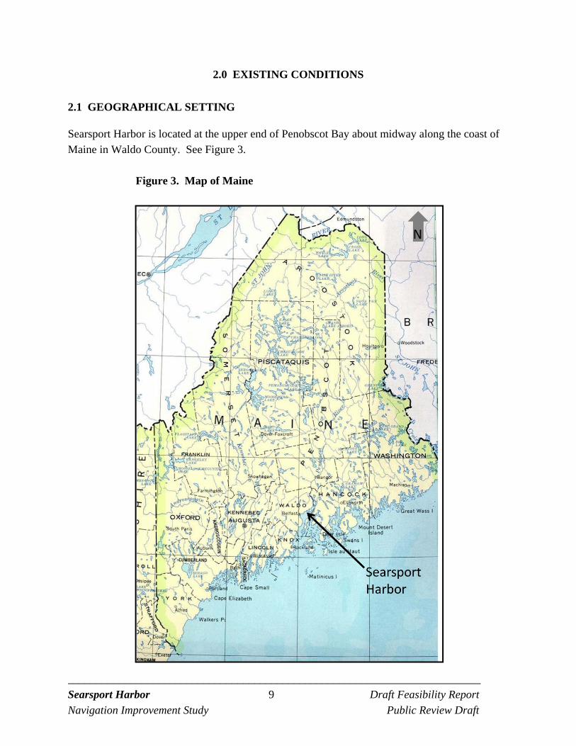
2.1 GEOGRAPHICAL SETTING
Searsport Harbor is located at the upper end of Penobscot Bay about midway along the coast of Maine in Waldo County. See Figure 3.
Figure 3. Map of Maine
_________________________________________________________________________ Searsport Harbor 10 Draft Feasibility Report
Navigation Improvement Study Public Review Draft
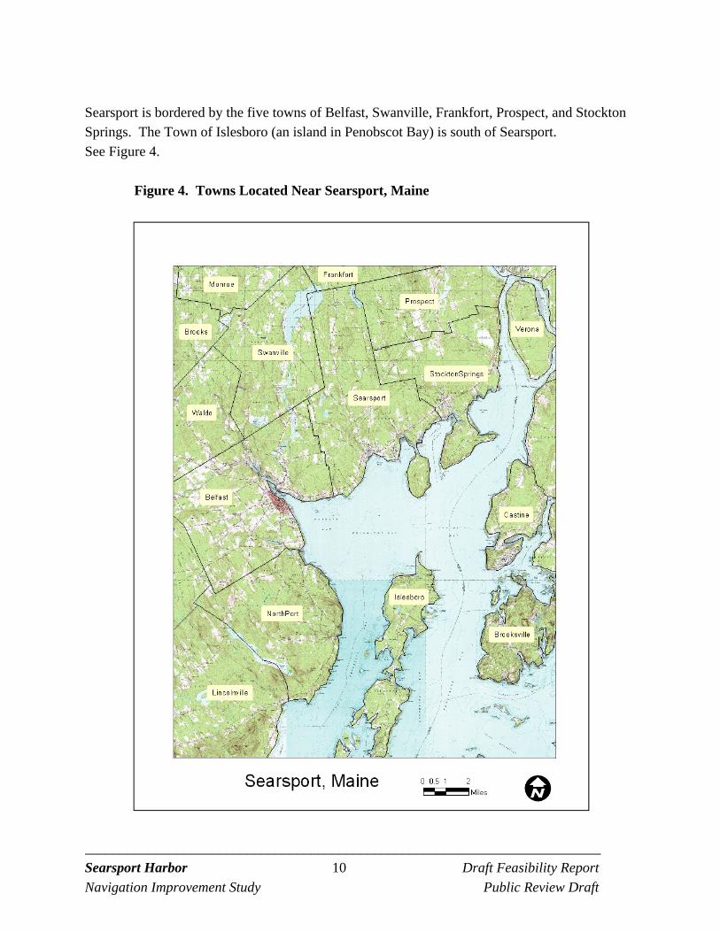
Searsport is bordered by the five towns of Belfast, Swanville, Frankfort, Prospect, and Stockton Springs. The Town of Islesboro (an island in Penobscot Bay) is south of Searsport. See Figure 4.
Figure 4. Towns Located Near Searsport, Maine
_________________________________________________________________________ Searsport Harbor 11 Draft Feasibility Report
Navigation Improvement Study Public Review Draft
2.2 GENERAL HISTORY OF MACK POINT
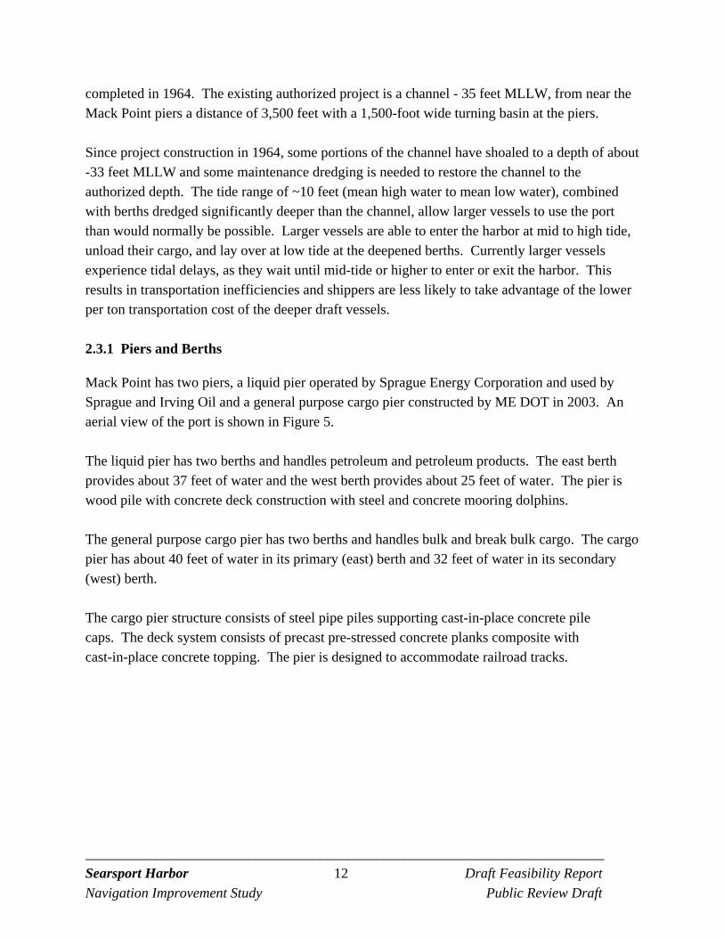
Searsport’s proximity to the Penobscot River estuary and the region’s rich natural resources of timber and fish initially drove the town’s commercial and industrial interests. Euro-American colonists first settled in the Searsport area in about 1760 and Searsport was officially incorporated as a town in 1845. Foremost among the town’s early industries was shipbuilding and although the town had a rich shipbuilding and fishing history the port at Mack Point was primarily developed in the 1900s for industrial and trade purposes. In about 1903 the Bangor and Arrostock (B&A) railroad’s decided to establish a seaport railroad and terminal at Mack Point in Searsport. The initial purpose of a seaport railroad was to accommodate anticipated new freight traffic projected to come out of northern Maine and to promote the growth of this new traffic by opening the way for the region’s products to reach distant markets by ship. However, it was the port’s coal trade that came to dominate the area. As part of the port at Mack Point a coal wharf was built and operated by the Penobscot Coal and Wharf Company, a subsidiary of C. H. Sprague and Son of Boston, who were an important distributor of industrial coals throughout New England. For almost 50 years coal was the most important commodity (in terms of volume) shipped into Mack Point. Other bulk commodities included dry sulfur, fertilizer, potatoes, scrap metal, chemicals, and munitions. Over time the port experienced a decline in the volume of coal traffic, while the receipts of petroleum products rose steadily and eventually replaced coal as the port’s leading import. This trend was not unique to Searsport and reflected a nationwide transition toward an increased use of petroleum-based fuel oil and gasoline. During the course of this period, shipping services at Mack Point were expanded to include large chemical and fertilizer processing plants, petroleum storage tanks and their associated piers, and a truck terminal. Today Mack Point remains an important port handling close to two million tons per year with petroleum products remaining a significant percentage of the volume. [Above information is summarized from the Technical Report entitled “Preliminary Assessment, Searsport Harbor Shipwreck, Searsport, Maine”, November 2008 prepared by Public Archaeology Laboratory.]
2.3 EXISTING FEDERAL NAVIGATION PROJECT
The system of Federal general navigation features (GNF) at Mack Point includes an entrance channel and turning basin. The project was authorized in October 1962 and construction was
_________________________________________________________________________ Searsport Harbor 12 Draft Feasibility Report
Navigation Improvement Study Public Review Draft
completed in 1964. The existing authorized project is a channel - 35 feet MLLW, from near the Mack Point piers a distance of 3,500 feet with a 1,500-foot wide turning basin at the piers. Since project construction in 1964, some portions of the channel have shoaled to a depth of about -33 feet MLLW and some maintenance dredging is needed to restore the channel to the authorized depth. The tide range of ~10 feet (mean high water to mean low water), combined with berths dredged significantly deeper than the channel, allow larger vessels to use the port than would normally be possible. Larger vessels are able to enter the harbor at mid to high tide, unload their cargo, and lay over at low tide at the deepened berths. Currently larger vessels experience tidal delays, as they wait until mid-tide or higher to enter or exit the harbor. This results in transportation inefficiencies and shippers are less likely to take advantage of the lower per ton transportation cost of the deeper draft vessels.
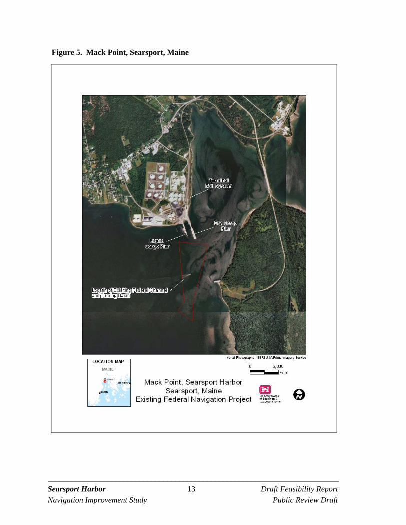
2.3.1 Piers and Berths
Mack Point has two piers, a liquid pier operated by Sprague Energy Corporation and used by Sprague and Irving Oil and a general purpose cargo pier constructed by ME DOT in 2003. An aerial view of the port is shown in Figure 5. The liquid pier has two berths and handles petroleum and petroleum products. The east berth provides about 37 feet of water and the west berth provides about 25 feet of water. The pier is wood pile with concrete deck construction with steel and concrete mooring dolphins. The general purpose cargo pier has two berths and handles bulk and break bulk cargo. The cargo pier has about 40 feet of water in its primary (east) berth and 32 feet of water in its secondary (west) berth. The cargo pier structure consists of steel pipe piles supporting cast-in-place concrete pile caps. The deck system consists of precast pre-stressed concrete planks composite with cast-in-place concrete topping. The pier is designed to accommodate railroad tracks.
_________________________________________________________________________ Searsport Harbor 13 Draft Feasibility Report
Navigation Improvement Study Public Review Draft
Figure 5. Mack Point, Searsport, Maine
_________________________________________________________________________ Searsport Harbor 14 Draft Feasibility Report
Navigation Improvement Study Public Review Draft
2.3.2 Land Based Facilities
Land based facilities at the site include warehouses, a new access road and gate facility that provides secured site access, multiple bulk material yards, a fuel tank farm, and railroad yard. Facilities are listed below.
310,000 square feet of available storage area on 7 pads
101,000 square feet of inside warehouse storage in 3 buildings
Certified truck scales (2)
4,420 feet of rail siding on Montreal, Maine, and Atlantic Railroad with access to Canadian Pacific railroad and CN railroad.
On site trackmobile (A rail car mover is a road-rail vehicle, capable of travelling on both roads and rail tracks, fitted with couplers for moving small numbers of railroad cars around.)
On site 120 ton mobile harbor crane
2.3.3 Rail Access
The port has direct rail access, with railway operated by the Montreal, Maine, and Atlantic Railway (MM&A) providing access to the loading and storage areas of the port. The rail link provides rail access to points throughout the US and Canada, including direct linkages to eight other railroad lines. Paper and forest products account for about 60 percent of the MM&A’s annual cargo volume (www.mmarail.com).
2.3.4 Commodities
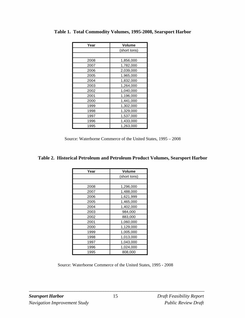
A summary of the total commodity volumes landed at Searsport Harbor since 1995 is shown in Table 1. Commodities received at the port include petroleum and petroleum products and various bulk and break-bulk commodities. Oil and gasoline are the dominant imports at the port. Historical volumes of petroleum and petroleum products are shown in Table 2. A listing of the major bulk and break-bulk commodities brought into the port in recent years is shown in Table 3. Total volumes average 400,000 tons per year since 2004, after completion of the State dry cargo pier. This is a near doubling of the typical bulk volumes from prior years.
_________________________________________________________________________ Searsport Harbor 15 Draft Feasibility Report
Navigation Improvement Study Public Review Draft
Table 1. Total Commodity Volumes, 1995-2008, Searsport Harbor
Year Volume(short tons)
2008 1,856,0002007 1,782,0002006 2,039,0002005 1,965,0002004 1,832,0002003 1,264,0002002 1,040,0002001 1,196,0002000 1,441,0001999 1,302,0001998 1,329,0001997 1,537,0001996 1,433,0001995 1,263,000
Source: Waterborne Commerce of the United States, 1995 – 2008
Table 2. Historical Petroleum and Petroleum Product Volumes, Searsport Harbor
Year Volume(short tons)
2008 1,296,0002007 1,488,0002006 1,621,9992005 1,465,0002004 1,402,0002003 984,0002002 883,0002001 1,060,0002000 1,129,0001999 1,005,0001998 1,013,0001997 1,043,0001996 1,024,0001995 808,000
Source: Waterborne Commerce of the United States, 1995 - 2008
_________________________________________________________________________ Searsport Harbor 16 Draft Feasibility Report
Navigation Improvement Study Public Review Draft
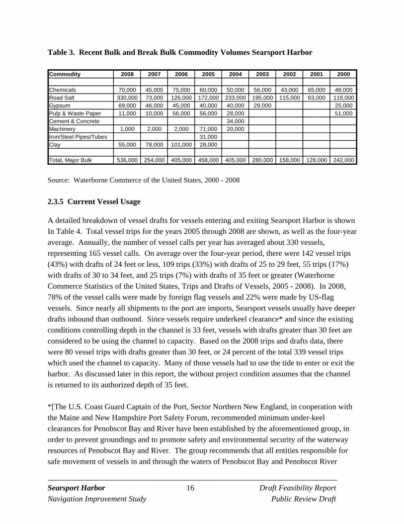
Table 3. Recent Bulk and Break Bulk Commodity Volumes Searsport Harbor Commodity 2008 2007 2006 2005 2004 2003 2002 2001 2000
Chemicals 70,000 45,000 75,000 60,000 50,000 56,000 43,000 65,000 48,000Road Salt 330,000 73,000 126,000 172,000 233,000 195,000 115,000 63,000 118,000Gypsum 69,000 46,000 45,000 40,000 40,000 29,000 25,000Pulp & Waste Paper 11,000 10,000 56,000 56,000 28,000 51,000Cement & Concrete 34,000Machinery 1,000 2,000 2,000 71,000 20,000Iron/Steel Pipes/Tubes 31,000Clay 55,000 78,000 101,000 28,000
Total, Major Bulk 536,000 254,000 405,000 458,000 405,000 280,000 158,000 128,000 242,000
Source: Waterborne Commerce of the United States, 2000 - 2008
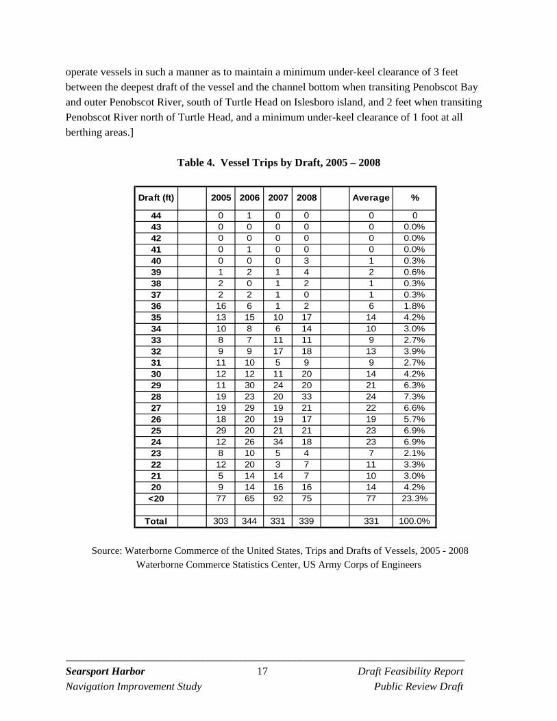
2.3.5 Current Vessel Usage
A detailed breakdown of vessel drafts for vessels entering and exiting Searsport Harbor is shown In Table 4. Total vessel trips for the years 2005 through 2008 are shown, as well as the four-year average. Annually, the number of vessel calls per year has averaged about 330 vessels, representing 165 vessel calls. On average over the four-year period, there were 142 vessel trips (43%) with drafts of 24 feet or less, 109 trips (33%) with drafts of 25 to 29 feet, 55 trips (17%) with drafts of 30 to 34 feet, and 25 trips (7%) with drafts of 35 feet or greater (Waterborne Commerce Statistics of the United States, Trips and Drafts of Vessels, 2005 - 2008). In 2008, 78% of the vessel calls were made by foreign flag vessels and 22% were made by US-flag vessels. Since nearly all shipments to the port are imports, Searsport vessels usually have deeper drafts inbound than outbound. Since vessels require underkeel clearance* and since the existing conditions controlling depth in the channel is 33 feet, vessels with drafts greater than 30 feet are considered to be using the channel to capacity. Based on the 2008 trips and drafts data, there were 80 vessel trips with drafts greater than 30 feet, or 24 percent of the total 339 vessel trips which used the channel to capacity. Many of those vessels had to use the tide to enter or exit the harbor. As discussed later in this report, the without project condition assumes that the channel is returned to its authorized depth of 35 feet. *[The U.S. Coast Guard Captain of the Port, Sector Northern New England, in cooperation with the Maine and New Hampshire Port Safety Forum, recommended minimum under-keel clearances for Penobscot Bay and River have been established by the aforementioned group, in order to prevent groundings and to promote safety and environmental security of the waterway resources of Penobscot Bay and River. The group recommends that all entities responsible for safe movement of vessels in and through the waters of Penobscot Bay and Penobscot River
_________________________________________________________________________ Searsport Harbor 17 Draft Feasibility Report
Navigation Improvement Study Public Review Draft
operate vessels in such a manner as to maintain a minimum under-keel clearance of 3 feet between the deepest draft of the vessel and the channel bottom when transiting Penobscot Bay and outer Penobscot River, south of Turtle Head on Islesboro island, and 2 feet when transiting Penobscot River north of Turtle Head, and a minimum under-keel clearance of 1 foot at all berthing areas.]
Table 4. Vessel Trips by Draft, 2005 – 2008
Draft (ft) 2005 2006 2007 2008 Average %
44 0 1 0 0 0 043 0 0 0 0 0 0.0%42 0 0 0 0 0 0.0%41 0 1 0 0 0 0.0%40 0 0 0 3 1 0.3%39 1 2 1 4 2 0.6%38 2 0 1 2 1 0.3%37 2 2 1 0 1 0.3%36 16 6 1 2 6 1.8%35 13 15 10 17 14 4.2%34 10 8 6 14 10 3.0%33 8 7 11 11 9 2.7%32 9 9 17 18 13 3.9%31 11 10 5 9 9 2.7%30 12 12 11 20 14 4.2%29 11 30 24 20 21 6.3%28 19 23 20 33 24 7.3%27 19 29 19 21 22 6.6%26 18 20 19 17 19 5.7%25 29 20 21 21 23 6.9%24 12 26 34 18 23 6.9%23 8 10 5 4 7 2.1%22 12 20 3 7 11 3.3%21 5 14 14 7 10 3.0%20 9 14 16 16 14 4.2%
<20 77 65 92 75 77 23.3%
Total 303 344 331 339 331 100.0%
Source: Waterborne Commerce of the United States, Trips and Drafts of Vessels, 2005 - 2008 Waterborne Commerce Statistics Center, US Army Corps of Engineers
_________________________________________________________________________ Searsport Harbor 18 Draft Feasibility Report
Navigation Improvement Study Public Review Draft
2.4 SOCIO-ECONOMIC SETTING
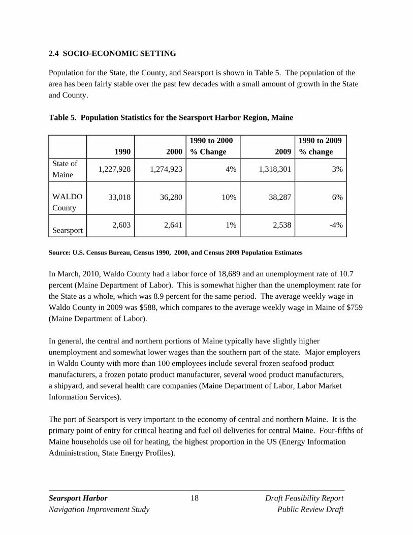
Population for the State, the County, and Searsport is shown in Table 5. The population of the area has been fairly stable over the past few decades with a small amount of growth in the State and County.
Table 5. Population Statistics for the Searsport Harbor Region, Maine
1990 20001990 to 2000 % Change 2009
1990 to 2009 % change
State of Maine
1,227,928 1,274,923 4% 1,318,301 3%
WALDO County
33,018 36,280 10% 38,287 6%
Searsport 2,603 2,641 1% 2,538 -4%
Source: U.S. Census Bureau, Census 1990, 2000, and Census 2009 Population Estimates In March, 2010, Waldo County had a labor force of 18,689 and an unemployment rate of 10.7 percent (Maine Department of Labor). This is somewhat higher than the unemployment rate for the State as a whole, which was 8.9 percent for the same period. The average weekly wage in Waldo County in 2009 was $588, which compares to the average weekly wage in Maine of $759 (Maine Department of Labor). In general, the central and northern portions of Maine typically have slightly higher unemployment and somewhat lower wages than the southern part of the state. Major employers in Waldo County with more than 100 employees include several frozen seafood product manufacturers, a frozen potato product manufacturer, several wood product manufacturers, a shipyard, and several health care companies (Maine Department of Labor, Labor Market Information Services).
The port of Searsport is very important to the economy of central and northern Maine. It is the primary point of entry for critical heating and fuel oil deliveries for central Maine. Four-fifths of Maine households use oil for heating, the highest proportion in the US (Energy Information Administration, State Energy Profiles).
_________________________________________________________________________ Searsport Harbor 19 Draft Feasibility Report
Navigation Improvement Study Public Review Draft
2.5 PHYSICAL ENVIRONMENT
2.5.1 Geological Setting
The Penobscot Bay extends from the mouth of the Penobscot River to the Atlantic Ocean. There are several islands located in Penobscot Bay. Glacial geological forces have shaped the basic geometry of the Penobscot Bay /Searsport Harbor Area. These include: the effect of the advance and retreat of the Laurentide Ice Sheet (about 30,000 to 10,000 years ago) including transport of material by glacial melt-water; vertical land rebounding following retreat of the glaciers; and subsequent coastal inundation as sea level rose due to melting of glaciers. The geological setting of the area is discussed in more detail in the Geotechnical Appendix and provides background as to subsurface conditions of the area. Researchers have identified various layers below the surface of the seafloor in Searsport Harbor related to this geological history including glacially eroded bedrock, glacial till, glacio-marine muds, and inundated ancient stream channels.
2.5.2 Meteorological Conditions
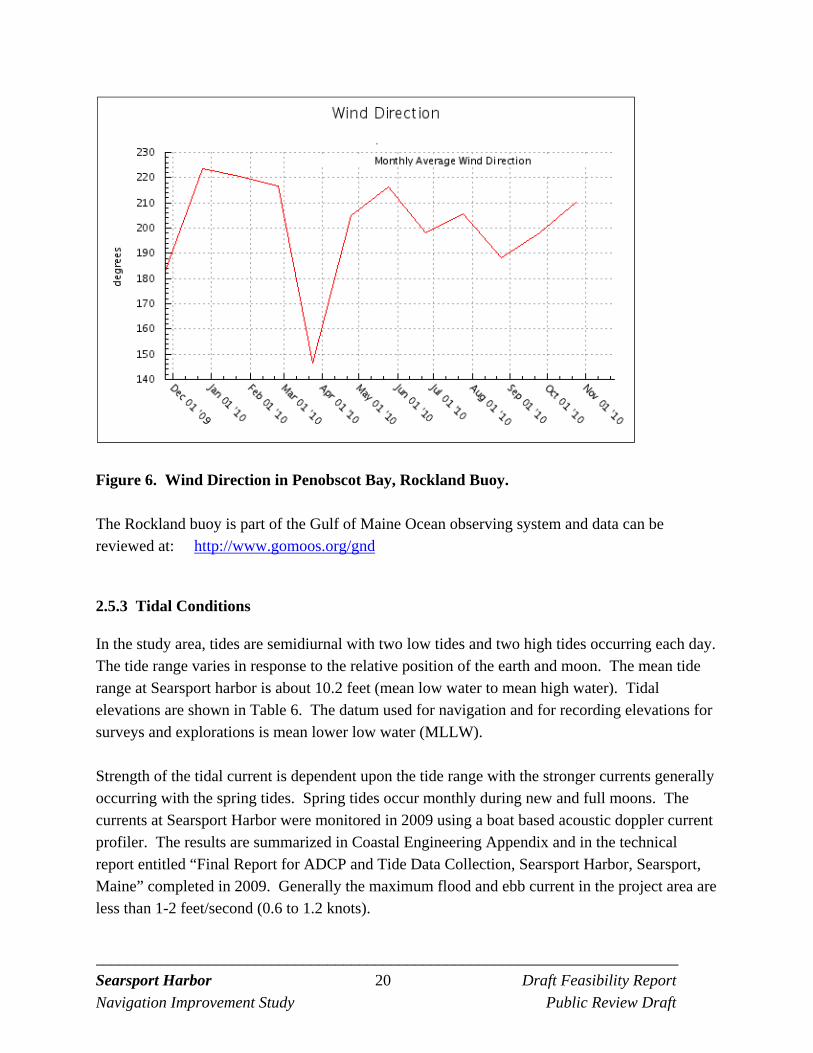
Searsport climate is mild during summer when temperatures (Fahrenheit) tend to be in the 60's and cold during winter when temperatures tend to be in the 20's. Mean annual precipitation is about 47 inches. Temperature and rainfall data from for the nearby Belfast, Maine weather station is available at: http://cdo.ncdc.noaa.gov/cgi-bin/climatenormals/climatenormals.pl Fog is common in July and August but can occur at any time during the year. The prevailing wind in the summer is generally from the southwest. However, the daily wind direction is variable as is the weather. In the winter northeast winds can be related to winter storms. The closest ocean monitoring buoy is at Rockland, Maine at the entrance to Penobscot Harbor. Monthly average wind direction data, 2009 to 2010 from the buoy at Rockland is included below in Figure 6. Winds are a factor that pilots consider when preparing to guide a ship to Mack Point.
_________________________________________________________________________ Searsport Harbor 20 Draft Feasibility Report
Navigation Improvement Study Public Review Draft
Figure 6. Wind Direction in Penobscot Bay, Rockland Buoy. The Rockland buoy is part of the Gulf of Maine Ocean observing system and data can be reviewed at: http://www.gomoos.org/gnd
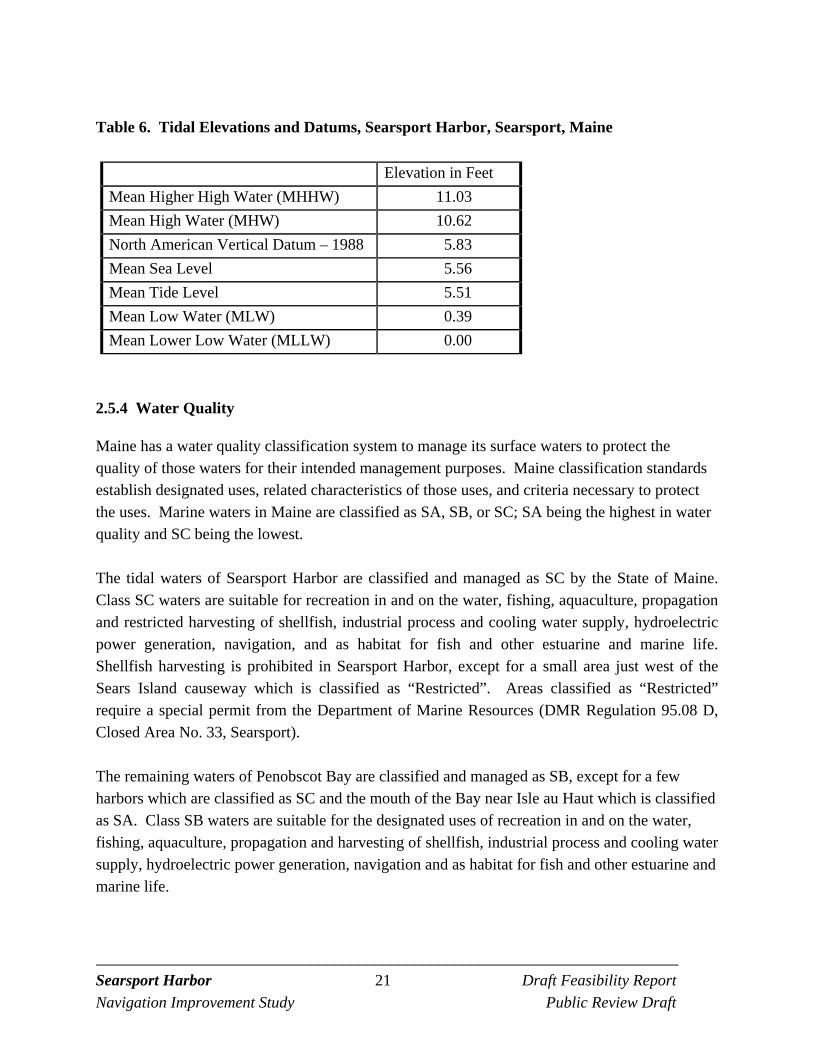
2.5.3 Tidal Conditions
In the study area, tides are semidiurnal with two low tides and two high tides occurring each day. The tide range varies in response to the relative position of the earth and moon. The mean tide range at Searsport harbor is about 10.2 feet (mean low water to mean high water). Tidal elevations are shown in Table 6. The datum used for navigation and for recording elevations for surveys and explorations is mean lower low water (MLLW). Strength of the tidal current is dependent upon the tide range with the stronger currents generally occurring with the spring tides. Spring tides occur monthly during new and full moons. The currents at Searsport Harbor were monitored in 2009 using a boat based acoustic doppler current profiler. The results are summarized in Coastal Engineering Appendix and in the technical report entitled “Final Report for ADCP and Tide Data Collection, Searsport Harbor, Searsport, Maine” completed in 2009. Generally the maximum flood and ebb current in the project area are less than 1-2 feet/second (0.6 to 1.2 knots).
_________________________________________________________________________ Searsport Harbor 21 Draft Feasibility Report
Navigation Improvement Study Public Review Draft
Table 6. Tidal Elevations and Datums, Searsport Harbor, Searsport, Maine
Elevation in Feet
Mean Higher High Water (MHHW) 11.03
Mean High Water (MHW) 10.62
North American Vertical Datum – 1988 5.83
Mean Sea Level 5.56
Mean Tide Level 5.51
Mean Low Water (MLW) 0.39
Mean Lower Low Water (MLLW) 0.00
2.5.4 Water Quality
Maine has a water quality classification system to manage its surface waters to protect the quality of those waters for their intended management purposes. Maine classification standards establish designated uses, related characteristics of those uses, and criteria necessary to protect the uses. Marine waters in Maine are classified as SA, SB, or SC; SA being the highest in water quality and SC being the lowest. The tidal waters of Searsport Harbor are classified and managed as SC by the State of Maine. Class SC waters are suitable for recreation in and on the water, fishing, aquaculture, propagation and restricted harvesting of shellfish, industrial process and cooling water supply, hydroelectric power generation, navigation, and as habitat for fish and other estuarine and marine life. Shellfish harvesting is prohibited in Searsport Harbor, except for a small area just west of the Sears Island causeway which is classified as “Restricted”. Areas classified as “Restricted” require a special permit from the Department of Marine Resources (DMR Regulation 95.08 D, Closed Area No. 33, Searsport). The remaining waters of Penobscot Bay are classified and managed as SB, except for a few harbors which are classified as SC and the mouth of the Bay near Isle au Haut which is classified as SA. Class SB waters are suitable for the designated uses of recreation in and on the water, fishing, aquaculture, propagation and harvesting of shellfish, industrial process and cooling water supply, hydroelectric power generation, navigation and as habitat for fish and other estuarine and marine life.
_________________________________________________________________________ Searsport Harbor 22 Draft Feasibility Report
Navigation Improvement Study Public Review Draft
2.5.5 Air Quality
Air Quality like the weather can vary from day to day. Air quality is influenced by local emissions and long range transport. EPA has developed the National Ambient Air Quality Standards (NAAQS) for air pollutants, with the NAAQS setting concentration limits that determine the attainment status in a region for each criteria pollutant. The six criteria air pollutants are ozone, carbon monoxide, nitrogen dioxide, sulfur dioxide, particulate matter (PM), and lead. Two pollutants of interest in Maine are ozone and particulates. Waldo County is in attainment for both ozone and the 24-hour PM2.5 standards established by EPA. Additional information on existing air quality conditions in Maine is available at the link below. http://www.airnow.gov/index.cfm?action=airnow.local_state&stateid=20&tab=0
2.6 BIOLOGICAL RESOURCES
Penobscot Bay provides habitat for a variety of biological resources including almost all of the seventy commercially harvested species of fish and shellfish landed in the Gulf of Maine. In addition the shoreline surrounding the Bay provide habitat for wildlife that interact with the marine environment.
2.6.1 Eelgrass
Eelgrass (Zostera marina) is a flowering plant that occurs world-wide and along the east coast of North America from North Carolina to Labrador. Eelgrass beds form an important habitat for shellfish, wildlife and other vertebrate and invertebrate species. Along the Maine coast, it is found in shallow, protected intertidal and subtidal areas. Since 1992, the State of Maine has mapped the distribution of eelgrass. Current mapping of eelgrass in the Searsport Harbor area indicates that eelgrass beds may be found along the west coast of Sears Island and a small patch along the west coast of Long Cove. None of the mapped eelgrass beds are located within the footprint of the proposed navigation improvement project. This was confirmed by underwater video surveillance in August 2007 in the Long Cove area where improvement of the maneuvering area adjacent to the State Pier is proposed. No eelgrass was observed during this visual inspection. Depths in the project area are generally too deep for light penetration to support eelgrass beds.
_________________________________________________________________________ Searsport Harbor 23 Draft Feasibility Report
Navigation Improvement Study Public Review Draft
2.6.2 Benthic Resources
Benthic sampling was conducted in the project area on August 14, 2007 by Corps biologists. Taxonomic analysis show a benthic community primarily dominated by polychaete species (segmented marine worms), with a much smaller number of arthropod and mollusk species. Samples were collected from the existing project and navigation improvement areas. Samples were also collected from the proposed Penobscot Bay Disposal Site. All of the samples contained fine sediments (mud, silt, and/or clay), except for one sample located in Long Cove, which contained rock, gravel and sand. Appendix C lists benthic species identified in the project area by class, genus and species, and sampling location. One hundred and four benthic species were identified in the subtidal ranges of the project area. Sixty-three species were polychaetes, while only 10 species were arthropods (crustaceans). Most stations had a small to modest number of species; a few stations had a much higher number of species.
2.6.3 Shellfish Resources
Penobscot Bay is one of the richest lobster grounds in the world (Ellis and Cowan, 1999). However, the upper Penobscot Bay does not support habitat for high density larval lobsters in the intertidal zone (Ellis and Cowan, 1999) or the subtidal zone (Wilson, pers. comm.). These low larval density levels are not expected to change much with the recent increase in the lobster population (Wilson, pers. comm.). Relative to the rich density of lobsters in the lower Penobscot Bay, the juvenile and adult lobster population in the upper Penobscot Bay is low (Wilson, pers. comm.). A large number of lobster pots, however, were noted in Belfast Bay during the Corps benthic sampling field trip in August 2007. No other significant shellfish or crustaceans were found during benthic sampling by the Corps in the project area. Only green crabs (Carcinus maenas) and the sevenspine bay shrimp (Crangon septemspinosa) were observed in the shallow areas of Long Cove (Lazzari and Tupper, 2002), and rock crabs (Cancer irrotatus), green crabs, and scallop (Placopecten magellanicus) at Mack Point/Long Cove (ME DOT, 1987).
2.6.4 Finfish Resources
The fish fauna of the Gulf of Maine have been well described by Bigelow and Schroeder (1953). Finfish utilize the coastal waters of the Gulf of Maine and upper Penobscot Bay as year-round residents and for spawning and nursery areas. Penobscot Bay plays an important role in the early life history of fish inhabiting the central coast of Maine by offering habitat for larval fish.
_________________________________________________________________________ Searsport Harbor 24 Draft Feasibility Report
Navigation Improvement Study Public Review Draft
Twenty-six species of fish larvae were identified during spring surveys in Penobscot Bay in 1997 and 1998 (Lazzari, 2001). The most commonly occurring larvae (>35% of the samples) were Atlantic seasnail (Liparis atlanticus), winter flounder (Pseudopleuronectes americanus), radiated shanny (Ulvaria subbifurcata), sand lance (Ammodytes spp.), American plaice (Hippoglossoides platessoides), rock gunnel (Pholis gunnellus), sea raven (Hemitripterus americanus), longhorn sculpin (Myoxocephalus octodecimspinosus), and grubby (M. aenaeus). Densities of sand lance were highest in the upper bay and mid-bay stations in 1997 and 1998 respectively (Lazzari, 2001). Winter flounder have their greatest abundance in the mid-bay area (Lazzari, 2001). Larvae from demersal eggs dominated the catch from late winter through spring, but not in early summer collections (Lazzari, 2001). Larvae of taxa that spawn from late winter through early spring, such as sculpins, sand lance, and rock gunnel were dominant in Penobscot Bay in March and April. Larvae of spring to early spawners such as winter flounder, Atlantic seasnail, and radiated shanny were abundant in May and June (Lazzari, 2001). The Environmental Assessment provided with this feasibility study provides the list of adult finfish species that were collected in the upper Penobscot Bay by the Central Maine Power company (ME DOT, 1987). The most common pelagic fish were the Atlantic herring (Clupea harengus), Atlantic menhaden (Brevoortia tyrannus), and spiny dogfish (Squalus acanthias). Other important pelagic species include the blueback herring (Alosa aestivalis), alewife (Alosa pseudoharengus), Atlantic mackerel (Scomber scombrus) and rainbow smelt (Osmerus mordax) (ME DOT, 1987). Atlantic herring have been found throughout the year in the upper Penobscot Bay, with the highest densities in June. The alewife and blueback herring typically are very numerous in April/May (alewives) and June (blueback herring) (ME DOT, 1987). Winter flounder is the most common demersal species, representing almost half of the total catch in the upper Penobscot Bay (ME DOT, 1987). Winter flounder is a year around resident of the Gulf of Maine and spawns in late winter and early spring. Longhorn sculpin, windowpane flounder (Scophthalmus aquosus), white hake (Urophysis tenuis), and the rainbow smelt (Osmerus mordax) represented the higher abundance of caught demersal fish (ME DOT, 1987). White hake is collected year around in the lower regions of Penobscot Bay, but is absent from the upper bay from January through April (ME DOT, 1987). White hake densities appeared to be highest from late summer through early fall. Sampling in shallow regions in the vicinity of Sears Island revealed an abundance of Atlantic silversides (Menidia menidia), threespine stickleback (Gasterosteus aculeatus), blackspotted stickleback (Gastersteus wheatlandi) and American sand lance (Ammodytes americanus) (ME DOT, 1987). These species, along with the smelt, alewife and blueback herring are common shoreside species in the Gulf of Maine. Additional species collected from the shallow areas of
_________________________________________________________________________ Searsport Harbor 25 Draft Feasibility Report
Navigation Improvement Study Public Review Draft
Long Cove from April through October in 1997 and/or 1998 included the Atlantic herring, sand lance, lumpfish, windowpane flounder and winter flounder (Lazzari and Tupper, 2002). The Penobscot River and its tributaries, are important aquatic resources that have supported or currently support a variety of anadromous (lives in saltwater and enters fresh water to spawn), and catadromous (lives in freshwater and enters saltwater to spawn) fish species. These species include the Atlantic salmon (Salmo salar), American shad (Alosa sapidissima), river herring, rainbow smelt, striped bass (Morone saxatilis), tomcod (Microgadus tomcod), sea lamprey (Petromyzon marinus), Atlantic and shortnose sturgeon (Acipenser spp.) and American eel (Anguilla rostrata) (penobscotriver.org). The Penobscot Indian Nation and environmental groups including the Atlantic Salmon Federation, Natural Resources Council of Maine, Trout Unlimited, American Rivers, and Maine Audubon are working collaboratively with others to restore the sea-run fisheries of Penobscot River (www.penobscotriver.org).
2.6.5 Essential Fish Habitat
The National Marine Fisheries Service (NMFS) has designated specific areas as Essential Fish Habitat (EFH) in accordance with the Magnuson-Stevens Fishery Conservation Act, as amended by the Sustainable Fisheries Act of 1996. The Sustainable Fisheries Act includes requirements for evaluating fish habitat loss and protection of fisheries identified as essential fisheries. “Essential Fish Habitat” are those waters and substrate necessary to fish for spawning, breeding, feeding, or growth to maturity (50 CFR Part 600). The proposed project occurs in designated EFH habitat areas managed by the New England Fishery Management Council. Appendix D lists life history profiles for the 16 EFH designated fisheries. The fisheries in Penobscot Bay are: Atlantic salmon, Atlantic cod, pollock, whiting, red hake, white hake, winter flounder, yellowtail flounder, windowpane flounder, American plaice, ocean pout, Atlantic sea scallop, Atlantic sea herring, bluefish, Atlantic mackerel, and bluefin tuna.
2.7 ENDANGERED AND THREATENED SPECIES
2.7.1 Federally Listed Endangered and Threatened Species
Fish There are three species of fish that have been listed under the Endangered Species Act (ESA) that may occur in the project area and inhabit all or portions of the lower Penobscot River and the upper portion of Penobscot Bay during part of the year. These species include the Gulf of
_________________________________________________________________________ Searsport Harbor 26 Draft Feasibility Report
Navigation Improvement Study Public Review Draft
Maine Distinct Population Segment (GOM DPS) for Atlantic salmon (Salmo salar), listed as endangered in 2000, the shortnose sturgeon (Acipenser brevirostrum), listed as endangered in 1967, and the GOM DPS for Atlantic sturgeon (Acipenser oxyrinchus oxyrinchus) listed as threatened in 2012. Critical habitat was designated for Atlantic salmon in 2009. Based on the 2009 final rule, critical habitat designated for Atlantic salmon that is located closest to our project area is from the mouth of the Penobscot River (located on the east side of Sears Island) upstream and including tributaries.
Atlantic salmon have a complex life history. Their life history begins from territorial rearing in rivers to extensive feeding migrations on the high seas [74 Fed. Reg. 29,300 at 29,315 (June 19, 2009)]. Adult Atlantic salmon return to rivers from the sea and migrate to their natal stream to spawn. In Maine, the majority of Atlantic salmon enters freshwater between May and mid-July. After spawning in the fall, the Atlantic salmon may either return to sea immediately or remain in fresh water until the following spring before returning to the sea. After one to three years in the river, naturally reared smolts enter the sea during May to begin their first ocean migration. The spring migration of post-smolts out of the coastal environment is generally rapid, within several tidal cycles and follows a direct route. Post-smolts generally travel out of coastal systems on the ebb tide and may be delayed by flood tides. Post-smolts live mainly on the surface of the water column. The shortnose sturgeon inhabits rivers and estuaries. It is an anadromous fish that spawns in the coastal rivers along the east coast of North America from the St. John River in Canada to the St. Johns River in Florida. It prefers the nearshore marine, estuarine and riverine habitat of large river systems. Shortnose sturgeon, unlike other anadromous species in the region such as shad or salmon, does not appear to make long distance offshore migrations. They are benthic feeders. Juveniles are believed to feed on benthic insects and crustaceans. Mollusks and large crustaceans are the primary food of adult shortnose sturgeon. Atlantic sturgeons are distributed along the entire East Coast of the U.S. Many Atlantic sturgeon populations, including those found in Maine rivers, have undergone drastic declines in abundance since the late 1800s. Spawning Atlantic sturgeon adults migrate upriver in spring, beginning in February-March in the south and May-June in Canadian waters. Spawning occurs in flowing water between the salt front and the fall line of large rivers. Following spawning, males may remain in the river or lower estuary until fall; females typically exit the rivers within four to six weeks. Adults forage on benthic invertebrates (mussels, worms, shrimp). Juveniles move downstream into brackish waters for a few months; and at about 30-36 inches they move into coastal waters. Tagging data indicate that immature Atlantic sturgeon travel widely once they emigrate from their birth rivers www.nmfs.noaa.gov/pr/pdfs/species/atlanticsturgeon.
_________________________________________________________________________ Searsport Harbor 27 Draft Feasibility Report
Navigation Improvement Study Public Review Draft
No Federally-listed species under the jurisdiction of the U.S. Fish and Wildlife Service are known to occur in the project area, except for the joint listing of the Atlantic salmon by NMFS and U.S. Fish and Wildlife Service.
Whales and Sea Turtles Several listed species of whales and sea turtles seasonally occur in Maine waters, including Penobscot Bay. These include the: endangered humpback whale (Megastore novaeangliae), fin whale (Balaenoptera physalus), and North Atlantic whale (Eubalaena glacialis); the threatened loggerhead turtle (Caretta caretta), and the endangered Kemp’s ridley (Lepidochelys kempii) and leatherback (Dermochelys coriacea) turtles. Listed sea turtles are generally present in Maine waters from June through October of any year. Listed whales are generally present in Maine waters from April 15 to November 1 of any year. However, these species are unlikely to be present in Searsport Harbor or the upper portion of Penobscot Bay where the dredging and disposal is to occur.
2.7.2 Federally Listed Candidate and Species of Special Concern
Species of Concern are those species which NMFS has some concerns regarding the status and threats, but for which insufficient information is available to indicate a need to list the species under the ESA. "Species of Concern" status does not carry any procedural or substantive protections under the ESA. Species of Concern can also be candidate species if they were petitioned for ESA listing or if a status review was initiated after they became Species of Concern. That is, any species being considered by the Secretary (of the Department of Commerce or Interior) for listing under the ESA as an endangered or a threatened species, but is not yet the subject of a proposed rule (see 50 CFR 424.02). NMFS' candidate species also qualify as species of concern.
Fish listed as a Species of Concern by NMFS include the anadromous alewife, blueback herring and rainbow smelt. Alewife and blueback herring (also known collectively as river herring) are also listed as candidate species. The area of concern for alewife is from Newfoundland to North Carolina, for the blueback herring Cape Breton, Nova Scotia to St. John’s River, Florida, and for the rainbow smelt Labrador to New Jersey. These species ascend coastal rivers in the spring to spawn. River herring adults migrate quickly downstream after spawning and little is known about their life history while in the marine environment; however they are believed to be capable of migrating long distances. Blueback herring young-of-the-year are found in fresh and brackish rivers, and juveniles remain in these nursery areas until they reach about two inches. Smelt east of Penobscot Bay stay in the rivers, bays and harbors all summer.
_________________________________________________________________________ Searsport Harbor 28 Draft Feasibility Report
Navigation Improvement Study Public Review Draft
2.7.3 State Listed Species
A bald eagle nest has been spotted on the southeast shore of Sears Island (U.S. Fish and Wildlife Service letter dated September 27, 2006). The bald eagle is listed as a threatened species under the Maine Endangered Species Act. However, in January 2009, the Commissioner of the Maine Department of Inland Fisheries and Wildlife (MDIFW) recommended removal of the bald eagle (Haliaeetus leucocephalus) from Maine’s list of endangered and threatened species. State and Federal law first recognized the bald eagle as an endangered species in Maine and 42 other states in 1978. Subsequent recovery of eagle populations led to reclassification as a threatened species in 1995. Further improvements prompted the Federal government to remove bald eagles from its list of endangered and threatened species in 2007. However, the bald eagles remain listed as a threatened species under Maine’s Endangered Species Act (MESA). Federal delisting does not automatically trigger a State delisting in Maine. To remove the bald eagle from Maine’s list, the Commissioner of MDIFW must recommend its removal to Maine’s Legislature, who has the final authority for listing and delisting, but only upon the recommendation of the Commissioner. American eel and laughing gull are both listed as species of special concern (www.maine.gov/ifw/wildlife/species/endangered_species/specialconcern) by the State of Maine. Species of special concern are not protected by endangered species statutes and have no special legislative protection. However, they are believed to be vulnerable and could easily become threatened or endangered because of restricted distribution, low or declining numbers, specialized habitat needs or limits, or other factors. They include species suspected of being threatened or endangered or likely to become so, but for which insufficient data are available.
2.8 CULTURAL RESOURCES
Pre-Contact. Review of the available archaeological literature for the Penobscot Bay area indicates that the State’s central coastline contains the oldest known coastal pre-contact archaeological sites in Maine, and more sites older than 4,000 BP than any other coastal section of the State. There is ample evidence within the central coast of Maine of a nearly 5,000 year continuum of human habitation extending from circa 5,290 BP through the contact period. This continuum exhibits a dual marine-terrestrial exploitation pattern consisting of habitation sites that are all located on or very near to the present shoreline. Although the location of the Searsport Harbor project area fits the predictive model as an area that would be attractive for pre-contact land use from the Archaic through contact periods, no National Register or National Register-eligible archaeological properties or Maine site survey archaeological sites are recorded in Searsport Harbor or the project’s underwater study area.
_________________________________________________________________________ Searsport Harbor 29 Draft Feasibility Report
Navigation Improvement Study Public Review Draft
Post-Contact. Available information for the Searsport area’s contact/post-contact period history documents an extensive 400-year history of native and non-native fishing, shipbuilding, and maritime commerce in and around Penobscot Bay and Searsport Harbor. The town of Searsport reached its commercial zenith during the mid-19th Century, as Maine became the “foremost builder of wooden ships in the country.” Between 1792 and 1892, Searsport had been home to 286 vessel masters and eight different shipyards at the height of the town’s wooden shipbuilding era (1840s-1850s). Together, Searsport shipyards produced 232 vessels between 1792 and 1892. Shipwreck database research conducted for this study produced only three documented vessel casualties within Searsport Harbor. One of these casualties is the charted shipwreck located to the west of the navigation channel at Mack Point. Surveys conducted. Recognizing that the Searsport Harbor project study area has an archaeological sensitivity for containing sunken contact/post-contact period vessels and/or pre-contact resources surveys was undertaken in the study area. The results are detailed in the following Technical Reports.
Marine Archaeological Survey, Searsport Harbor, Maine, July 2007, prepared by David Robinson and submitted by Public Archaeology Laboratory.
Preliminary Assessment, Searsport Harbor Shipwreck, Searsport, Maine, November 2008 prepared by Public Archaeology Laboratory.
The surveys confirmed the location of a previously identified shipwreck to the west of the Federal channel and tentatively identified the remains of the coal schooner-barge known as the Cullen No. 18. This barge was built in Bath, Maine in 1900 and lost in 1938 after discharging coal at the pier at Mack Point. The barge was lost due to a boiler room explosion on board and subsequent fire. The survey also identified what appeared to be a subsurface paleo-channel (a potential sensitive pre-contact feature) on the west side of Long Cove. This paleo-channel and the shipwreck are outside of the proposed project area.
_________________________________________________________________________ Searsport Harbor 30 Draft Feasibility Report
Navigation Improvement Study Public Review Draft
(This page intentionally left blank.)
_________________________________________________________________________ Searsport Harbor 31 Draft Feasibility Report
Navigation Improvement Study Public Review Draft
3.0 PLAN FORMULATION
3.1 NAVIGATION INEFFICIENCIES
The purpose of Corps deep draft navigation projects is to lower transportation costs. This is usually done through providing conditions that allow for better utilization of present vessels, or by use of larger, more efficient vessels. Currently, Searsport Harbor has inadequate depth in the Federal channel, which results in significant tidal delays for larger vessels, some lightloading of vessels, and restrictions in the size of vessels which can be used to bring cargo to the port. Irving Oil lightloads some of its vessels to arrive at the port at drafts of 33 feet, even though their vessels have the capacity to be loaded to 35 feet. With drafts of 33 feet, vessels are able to access the harbor through most of the tidal cycle, using the tide for underkeel clearance when necessary. Sprague Energy does not lightload its vessels as regularly, nor do the bulk cargo shippers. When larger vessels with deeper drafts are used, they can experience significant tidal delays of up to 12 hours, depending on when they arrive in the tidal cycle.
3.2 PLANNING OBJECTIVE
The objective for the Searsport Harbor improvement project is to decrease navigation inefficiencies for vessels calling on the port at Mack Point at Searsport Harbor.
3.3 PLANNING CONSTRAINTS
Planning constraints are restrictions that limit the planning process and the available scope of solutions to the identified problems, or that limit consideration of opportunities. Alternative plans should be formulated in a manner that meets the planning objectives while avoiding the planning constraints. Planning constraints may be physical (bridges, landmasses, utilities), institutional (legal or legislative), economic, environmental, or cultural resources. The following constraint was considered during the plan formulation and evaluation process.
• The focus of the potential improvement project is Mack Point, the location of Searsport Harbor existing Federal Navigation Channel. The study was limited to improvements to the existing Federal Navigation project at the deep draft port at Mack Point.
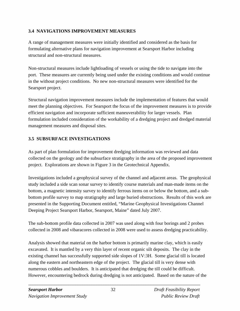
_________________________________________________________________________ Searsport Harbor 32 Draft Feasibility Report
Navigation Improvement Study Public Review Draft
3.4 NAVIGATIONS IMPROVEMENT MEASURES
A range of management measures were initially identified and considered as the basis for formulating alternative plans for navigation improvement at Searsport Harbor including structural and non-structural measures. Non-structural measures include lightloading of vessels or using the tide to navigate into the port. These measures are currently being used under the existing conditions and would continue in the without project conditions. No new non-structural measures were identified for the Searsport project.
Structural navigation improvement measures include the implementation of features that would meet the planning objectives. For Searsport the focus of the improvement measures is to provide efficient navigation and incorporate sufficient maneuverability for larger vessels. Plan formulation included consideration of the workability of a dredging project and dredged material management measures and disposal sites.
3.5 SUBSURFACE INVESTIGATIONS As part of plan formulation for improvement dredging information was reviewed and data collected on the geology and the subsurface stratigraphy in the area of the proposed improvement project. Explorations are shown in Figure 3 in the Geotechnical Appendix. Investigations included a geophysical survey of the channel and adjacent areas. The geophysical study included a side scan sonar survey to identify course materials and man-made items on the bottom, a magnetic intensity survey to identify ferrous items on or below the bottom, and a sub-bottom profile survey to map stratigraphy and large buried obstructions. Results of this work are presented in the Supporting Document entitled, “Marine Geophysical Investigations Channel Deeping Project Searsport Harbor, Searsport, Maine” dated July 2007. The sub-bottom profile data collected in 2007 was used along with four borings and 2 probes collected in 2008 and vibaracores collected in 2008 were used to assess dredging practicability. Analysis showed that material on the harbor bottom is primarily marine clay, which is easily excavated. It is mantled by a very thin layer of recent organic silt deposits. The clay in the existing channel has successfully supported side slopes of 1V:3H. Some glacial till is located along the eastern and northeastern edge of the project. The glacial till is very dense with numerous cobbles and boulders. It is anticipated that dredging the till could be difficult. However, encountering bedrock during dredging is not anticipated. Based on the nature of the
_________________________________________________________________________ Searsport Harbor 33 Draft Feasibility Report
Navigation Improvement Study Public Review Draft
material to be dredged, it is planned that a water borne mechanical dredging plant would be utilized for both the maintenance and improvement dredging at the site.
3.6 NAVIGATION FEATURES
Entrance Channel. The method used to determine the entrance channel width was the Permanent International Association of Navigation Congresses (PIANC) method (PIANC, 1997). This method considers vessel maneuvering capabilities with additional factors such as winds and currents that can impact a vessel in a channel. Based on engineering calculations the design width for the Searsport channel was determined to be 650 feet. (See Engineering Appendix). Turning Basin. A turning radius of 1.5 times the length of the design vessel (800 feet) was used to evaluate the size of the turning basin. The selection of the turning radius factor of 1.5 considered the pilots input and the potential wind effect on high riding vessels. The analysis determined that a 1,200-feet wide turning radius located at the upper end of the channel adjacent to the berth area is adequate for the larger vessels. This turning radius is compatible with the currently authorized dimension of the turning basin. Therefore, the turning basin was maintained at the current authorized dimensions. (See Engineering Appendix). Maneuvering Area. A larger berth was constructed by the State of Maine in 2003 along the east side of the new State Pier. The extension of the turning basin to include a maneuvering area adjacent to the Pier was sized for the larger vessels plus their tugs which are located perpendicular to the vessel and used to assist with docking operations. The maneuvering area is about 400-feet wide, about 875-feet long on the west side, and 1,066-feet long on the east side. Turning of the vessels would take place in the Turning Basin. The improved maneuvering area is shown in Figure 7 and discussed in the Engineering Appendix.
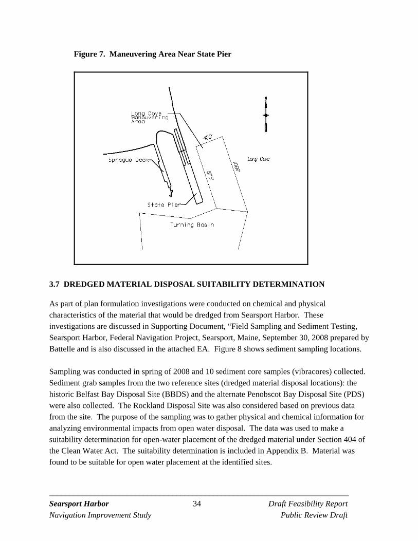
_________________________________________________________________________ Searsport Harbor 34 Draft Feasibility Report
Navigation Improvement Study Public Review Draft
Figure 7. Maneuvering Area Near State Pier
3.7 DREDGED MATERIAL DISPOSAL SUITABILITY DETERMINATION
As part of plan formulation investigations were conducted on chemical and physical characteristics of the material that would be dredged from Searsport Harbor. These investigations are discussed in Supporting Document, “Field Sampling and Sediment Testing, Searsport Harbor, Federal Navigation Project, Searsport, Maine, September 30, 2008 prepared by Battelle and is also discussed in the attached EA. Figure 8 shows sediment sampling locations. Sampling was conducted in spring of 2008 and 10 sediment core samples (vibracores) collected. Sediment grab samples from the two reference sites (dredged material disposal locations): the historic Belfast Bay Disposal Site (BBDS) and the alternate Penobscot Bay Disposal Site (PDS) were also collected. The Rockland Disposal Site was also considered based on previous data from the site. The purpose of the sampling was to gather physical and chemical information for analyzing environmental impacts from open water disposal. The data was used to make a suitability determination for open-water placement of the dredged material under Section 404 of the Clean Water Act. The suitability determination is included in Appendix B. Material was found to be suitable for open water placement at the identified sites.
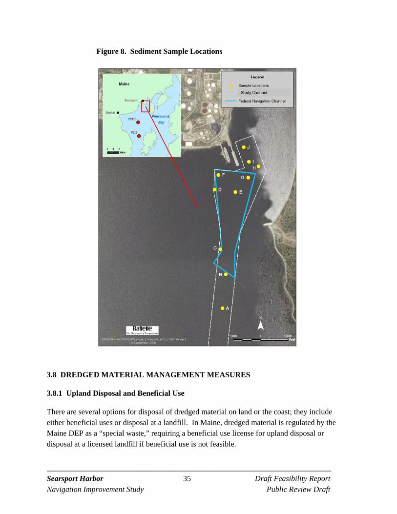
_________________________________________________________________________ Searsport Harbor 35 Draft Feasibility Report
Navigation Improvement Study Public Review Draft
Figure 8. Sediment Sample Locations
3.8 DREDGED MATERIAL MANAGEMENT MEASURES
3.8.1 Upland Disposal and Beneficial Use
There are several options for disposal of dredged material on land or the coast; they include either beneficial uses or disposal at a landfill. In Maine, dredged material is regulated by the Maine DEP as a “special waste,” requiring a beneficial use license for upland disposal or disposal at a licensed landfill if beneficial use is not feasible.
_________________________________________________________________________ Searsport Harbor 36 Draft Feasibility Report
Navigation Improvement Study Public Review Draft
Beneficial use of dredged material is encouraged where a need for such use exists, the dredged material is suitable for that use, and any additional cost associated with that method of disposal is justified by the benefit. Beneficial uses include beach nourishment through direct placement or nearshore placement, environmental uses such as wetland creation or bottom habitat development, along-shore fill in support of waterfront development, or use in capping, or as construction fill.
3.8.2 Beach Nourishment and Wetland Creation
One of the most common forms of beneficial use is beach nourishment e.g. using suitable sandy dredged materials on beaches adjacent to the harbor being dredged. Review of the material proposed to be dredged at Searsport shows that sand is only a small fraction of the material, that the material is predominantly silt and clay and therefore is not suitable as beach nourishment material. Therefore, beach nourishment was dropped as a suitable disposal alternative. Although the dredge material may be suitable for wetland creation, this measure was also dropped from further consideration as no sites were identified that need the material for wetland creation or that could accommodate the large volume of material.
3.8.3 Waterfront Development
At the initial coordination site meeting, the possibility of creating additional upland terminal area along the waterfront at Mack Point (possibly between the two piers or Long Cove) was discussed. In these cases, intertidal and or shallow subtidal lands are diked with a bulkhead and then filled. After filling, drying, and consolidation, the created land is then adapted for its intended use. Constructing a bulkhead with fill at Mack Point would permanently displace intertidal and shallow subtidal habitat located along the waterfront. The resources area impacted would depend on the volume to be placed but for discussion purposes say placement might involve about two acres of fill and this may accommodate about 30,000 to 50,000 cy of dredged material. As there were other less damaging disposal alternatives available this measure was dropped from further consideration.
3.8.4 Cap Material
Another beneficial use of the dredged material would be to dewater the material on site at Mack Pont and then use the dried material as capping or construction material. This type of beneficial use was applied in 2002 with dredged material from the State Pier deepening project. Material was first dredged and placed on a barge to allow some settling and dewatering. The material
_________________________________________________________________________ Searsport Harbor 37 Draft Feasibility Report
Navigation Improvement Study Public Review Draft
from the scow was then placed into dump trucks at the pier and then dumped at a pad at Mack Point facility where it could be mixed with cement kiln dust. After mixing with cement kiln dust the material was loaded on to trucks and transported to the Sprague Terminal in Bucksport where it was used to restore an old tank farm. This cost of this option is estimated at about $30/cy, not including trucking to Bucksport and dredging costs. This option may be useful for dredged material from deepening the berths at Mack Point, but would not be cost-effective for the large volume of dredged material to be generated from the deepening of the entrance channel, turning basin, and maneuvering area.
3.8.5 Landfill Disposal
Discussions with Maine Department of Environmental Protection (Maine DEP) Bureau of Remediation and Waste Management, Division of Solid Waste Management revealed that in Maine dredged material is handled as special waste. Material that cannot be used beneficially can go to licensed special waste landfills. There were two landfills considered to accept dredged material free of contamination. They were the Crossroads Landfill in Norridgewock and the Juniper Ridge Landfill Maine in West Old Town. The West Old Town site is about 50 miles from Searsport and the Norridgewock site is about 60 miles from Searsport. Cost to dispose of dredged material at the landfills would include dewatering at Mack Point, testing, truck transport, and tipping fees. This method was not considered practical or cost effective for the large volume of material to be dredged at Searsport Harbor from the channel, turning basin, and maneuvering area. However, this alternative may be useful for disposal of material from berth dredging by local interests if no other beneficial use option is cost-effective or available.
3.8.6 Ocean Disposal (Marine Protection, Research, and Sanctuaries Act)
There are three regional dredged material disposal sites located in Maine waters. Two of the three disposal sites, the Portland Disposal Site (PDS), located directly east of Cape Elizabeth, and the Cape Arundel Disposal Site (CADS), located just south of Kennebunkport, Maine are subject to Section 103 of the Marine Protection, Research, and Sanctuaries Act, also known as the Ocean Dumping Act. The other regional disposal site, the Rockland Disposal Site, located inside Penobscot Bay, is subject to Section 404 of the Clean Water Act only and is discussed in more detail in the next section. The PDS was designated by the U.S. Environmental Protection Agency (EPA) as a dredged material disposal site on October 16, 1987 However, the material from Searsport Harbor was not tested for suitability for disposal at the PDS because it is located more than 96 miles by sea from
_________________________________________________________________________ Searsport Harbor 38 Draft Feasibility Report
Navigation Improvement Study Public Review Draft
Searsport Harbor. This distance is too far to be considered a practicable disposal location; therefore this site was dropped from further consideration. In 1992, Congress added a new provision to the Marine Protection Research and Sanctuaries Act (MPRSA - the Ocean Dumping Act). For the first time, a time limit was established on the availability of Corps selected sites for disposal activity in waters seaward of the mean low water or territorial sea baseline. The provision allowed a selected site to be used for two five-year periods; beginning with the first disposal activity after the effective date of the provision, which was October 31st, 1992. The second five-year period began with the first disposal act commencing after completion of the first five-year period. Use of the dredged material disposal site, however, could be extended for long-term use if the site is designated by EPA. Thus, the Corps can select disposal sites only for short-term limited use; whereas, Congress authorized EPA to undertake long-term site designations subject to ongoing monitoring requirements to ensure that the sites remain environmentally sound. However, no funding was provided to support the studies needed to designate the CADS as a long-term dredged material disposal site. As a result, CADS no longer remained available for dredged material disposal after January 2010 because it was not designated by EPA as a long-term dredged material disposal site.
3.8.7 Disposal Sites (Clean Water Act)
Three potential disposal sites (located in and subject to Clean Water Act [CWA] guidelines, i.e. inshore of the Territorial Sea Baseline, which is located at the mouth of the Penobscot Bay for this project area) were investigated to determine if these sites would meet the Federal standard for a dredged material disposal site. The three disposal sites are the Belfast Bay Disposal Site, the Penobscot Bay Disposal Site, and the Rockland Disposal Site. See Figure 9. The Rockland Disposal Site, located in lower Penobscot Bay offshore of Owls Head, is an active disposal site selected for dredged material under Section 230.80 of the CWA. Only dredged material that meets the CWA guidelines is suitable for disposal at this site. This disposal site had been used for several decades prior to the Corps of Engineers identifying the site as a disposal site under the CWA guidelines. The Rockland site has been periodically monitored for about 30 years under the Disposal Area Monitoring System (DAMOS) Program. The DAMOS program was developed by Corps, New England District in 1977 in response to the recognized need for the management of dredged sediments from the many ports and harbors in the New England Region. The DAMOS program currently surveys ten open water disposal sites along coastal New England. Information on the sites and program is located at: http://www.nae.usace.army.mil/Missions/DisposalAreaMonitoringSystem(DAMOS).aspx
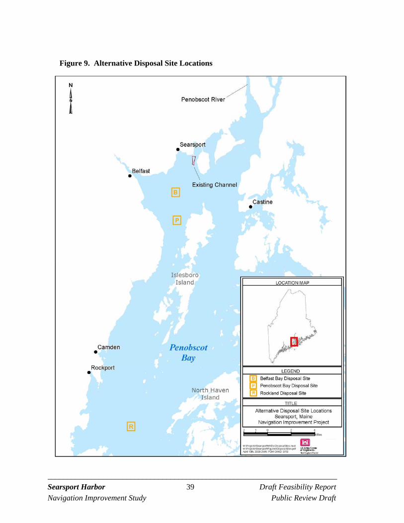
_________________________________________________________________________ Searsport Harbor 39 Draft Feasibility Report
Navigation Improvement Study Public Review Draft
Figure 9. Alternative Disposal Site Locations
_________________________________________________________________________ Searsport Harbor 40 Draft Feasibility Report
Navigation Improvement Study Public Review Draft
Although it was determined that the material would be suitable for disposal at the Rockland site, it is 25 miles from the project area to Rockland compared to the other two disposal sites that are within six miles of the project area. The travel distance for the scows to the Rockland Disposal Site make this alternative less cost efficient. Traveling the additional miles to dispose of the dredged material would likely result in cost increases. However, this site was retained for further evaluation as an alternative to the closer disposal sites. The Belfast Bay Disposal Site is a historic dredged material disposal area which was last used in 1964 for disposal of dredged material from Searsport Harbor. It is also located within a State and U.S. Coast Guard designated oil transfer area (SAIC, 2000). Although this is a previously used disposal site, it is also located in and near an area that is currently fished by lobstermen and supports lobster habitat. The lobster habitat in this area makes this site less environmentally acceptable as a dredged material disposal site. The Penobscot Bay Disposal Site is located just two miles further south than the Belfast Bay Disposal Site. It is located in a deep area in the western area of the Bay identified by local interests as having less lobster activity and as having received dredged material from past projects. Dredged material is also suitable for disposal at this site. As this site does not contain unique or exceptional biological resources, this site would be preferred versus the Belfast Bay site and was selected for further evaluation in the alternatives analysis.
_________________________________________________________________________ Searsport Harbor 41 Draft Feasibility Report
Navigation Improvement Study Public Review Draft
4.0 ALTERNATIVES
4.1 FUTURE WITHOUT PROJECT
The future without project alternative or no-action alternative is the condition expected to occur in the project area in the future should no-action be taken by the Federal government to improve the existing Federal navigation project at Mack Point. The future without project conditions is compared to the with project conditions to identify project benefits and environmental effects of the alternatives. The base year of the analysis is 2015 and a 50 year period of analysis is used. In the future without project condition it is assumed that the port at Mack Point will continue to operate and that cargo volumes will be similar to current levels. (See Economic Appendix). The future without a navigation improvement project assumes that the existing channel would be maintained at the authorized depth of -35 feet MLLW. The Federal project was originally constructed in 1964 and has not been dredged since 1964. Some shoaling has occurred to reduce the depth in some areas. The removal of shoaled areas to the authorized depth would make harbor operations more efficient. The tidal delays currently experienced by some vessels would be reduced. The light loading of many vessels to 33 feet would no longer be necessary. There would continue to be navigation inefficiencies for larger vessels, since vessels with drafts up to 39 feet currently call on the port. Without an improvement project, shippers would continue to be limited in the size of vessel they can use to call on the port, leaving them unable to achieve the economies of scale of larger vessels. Many shippers, particularly of bulk commodities, prefer to use larger vessels with lower overall costs per ton, particularly for trips over long distances (from South America or Europe). Without a project, the degree to which commodities brought to Searsport can be shipped on the most cost-effective vessels would be limited by the 35-foot authorized channel depth. In the future without project alternative it is likely that natural resources in the study area will continue to be present as described in the existing conditions section of this report.
4.2 ALTERNATIVE PLANS
Navigation improvement measures and dredged material disposal measures discussed above were combined to form alternative plans. All the alternatives include the same project features; that is, the entrance channel, the turning basin and the State Pier maneuvering area in Long Cove. The Alternatives are listed in Table 7. The turning basin and maneuvering area are based on the design requirements of the vessels that access the berths at Mack Point. The turning basin dimensions are the same as the authorized dimensions. The maneuvering area is necessary for
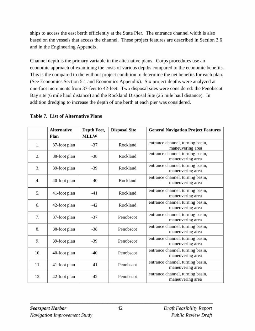
_________________________________________________________________________ Searsport Harbor 42 Draft Feasibility Report
Navigation Improvement Study Public Review Draft
ships to access the east berth efficiently at the State Pier. The entrance channel width is also based on the vessels that access the channel. These project features are described in Section 3.6 and in the Engineering Appendix. Channel depth is the primary variable in the alternative plans. Corps procedures use an economic approach of examining the costs of various depths compared to the economic benefits. This is the compared to the without project condition to determine the net benefits for each plan. (See Economics Section 5.1 and Economics Appendix). Six project depths were analyzed at one-foot increments from 37-feet to 42-feet. Two disposal sites were considered: the Penobscot Bay site (6 mile haul distance) and the Rockland Disposal Site (25 mile haul distance). In addition dredging to increase the depth of one berth at each pier was considered.
Table 7. List of Alternative Plans
Alternative Plan
Depth Feet, MLLW
Disposal Site General Navigation Project Features
1. 37-foot plan -37 Rockland entrance channel, turning basin, maneuvering area
2. 38-foot plan -38 Rockland entrance channel, turning basin,
maneuvering area
3. 39-foot plan -39 Rockland entrance channel, turning basin,
maneuvering area
4. 40-foot plan -40 Rockland entrance channel, turning basin,
maneuvering area
5. 41-foot plan -41 Rockland entrance channel, turning basin,
maneuvering area
6. 42-foot plan -42 Rockland entrance channel, turning basin,
maneuvering area
7. 37-foot plan -37 Penobscot entrance channel, turning basin,
maneuvering area
8. 38-foot plan -38 Penobscot entrance channel, turning basin,
maneuvering area
9. 39-foot plan -39 Penobscot entrance channel, turning basin,
maneuvering area
10. 40-foot plan -40 Penobscot entrance channel, turning basin,
maneuvering area
11. 41-foot plan -41 Penobscot entrance channel, turning basin,
maneuvering area
12. 42-foot plan -42 Penobscot entrance channel, turning basin,
maneuvering area
_________________________________________________________________________ Searsport Harbor 43 Draft Feasibility Report
Navigation Improvement Study Public Review Draft
The plans were formulated in consideration of the Corps formulation criteria of completeness, effectiveness, efficiency, and acceptability. (See below). All 12 plans are similar, meet the criteria and were carried forward for further evaluation. Completeness. The plans are complete as they include all necessary investments including consideration of the entrance channel, turning basin, and maneuvering area, and local service facilities (LSF) dredging and disposal. Effectiveness. The plans are effective as they all contribute to varying degrees to the planning objective to decrease existing and future navigation inefficiencies for vessels calling on the port at Mack Point. Efficiency. The plans are cost-effective means of attaining the objective. Initial screening considered various dredge material disposal measures including upland disposal and open water disposal in Penobscot Bay. Open water disposal is less expensive then upland disposal. Acceptability. The alternative plans are workable from a construction point of view and can be implemented in compliance with existing laws regulations, and public policy. .
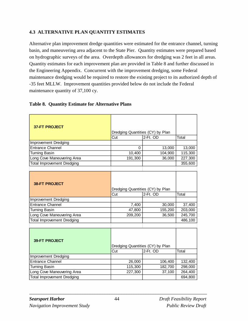
_________________________________________________________________________ Searsport Harbor 44 Draft Feasibility Report
Navigation Improvement Study Public Review Draft
4.3 ALTERNATIVE PLAN QUANTITY ESTIMATES
Alternative plan improvement dredge quantities were estimated for the entrance channel, turning basin, and maneuvering area adjacent to the State Pier. Quantity estimates were prepared based on hydrographic surveys of the area. Overdepth allowances for dredging was 2 feet in all areas. Quantity estimates for each improvement plan are provided in Table 8 and further discussed in the Engineering Appendix. Concurrent with the improvement dredging, some Federal maintenance dredging would be required to restore the existing project to its authorized depth of -35 feet MLLW. Improvement quantities provided below do not include the Federal maintenance quantity of 37,100 cy.
Table 8. Quantity Estimate for Alternative Plans
Dredging Quantities (CY) by PlanCut 2-Ft. OD Total
Improvement Dredging Entrance Channel 0 13,000 13,000Turning Basin 10,400 104,900 115,300Long Cove Maneuvering Area 191,300 36,000 227,300Total Improvement Dredging 355,600
Dredging Quantities (CY) by PlanCut 2-Ft. OD Total
Improvement Dredging Entrance Channel 7,400 30,000 37,400Turning Basin 47,800 155,200 203,000Long Cove Maneuvering Area 209,200 36,500 245,700Total Improvement Dredging 486,100
Dredging Quantities (CY) by PlanCut 2-Ft. OD Total
Improvement Dredging Entrance Channel 26,000 106,400 132,400Turning Basin 115,300 182,700 298,000Long Cove Maneuvering Area 227,300 37,100 264,400Total Improvement Dredging 694,800
37-FT PROJECT
38-FT PROJECT
39-FT PROJECT
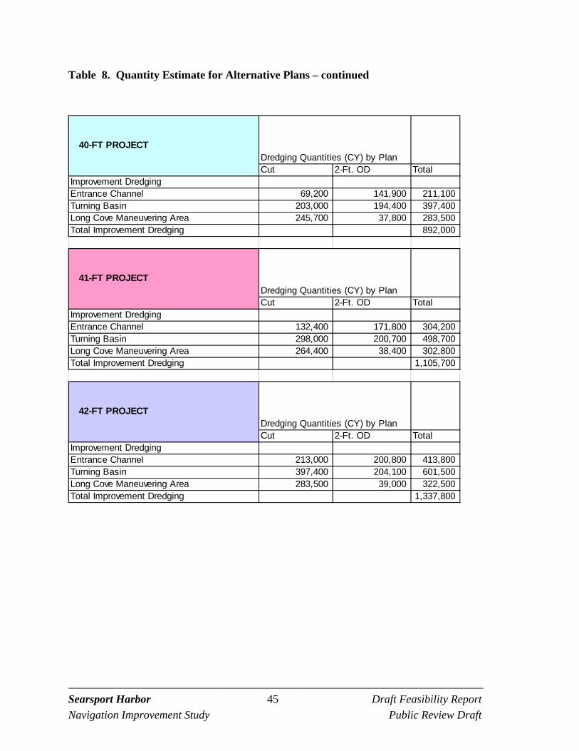
_________________________________________________________________________ Searsport Harbor 45 Draft Feasibility Report
Navigation Improvement Study Public Review Draft
Table 8. Quantity Estimate for Alternative Plans – continued
Dredging Quantities (CY) by PlanCut 2-Ft. OD Total
Improvement Dredging Entrance Channel 69,200 141,900 211,100Turning Basin 203,000 194,400 397,400Long Cove Maneuvering Area 245,700 37,800 283,500Total Improvement Dredging 892,000
Dredging Quantities (CY) by PlanCut 2-Ft. OD Total
Improvement Dredging Entrance Channel 132,400 171,800 304,200Turning Basin 298,000 200,700 498,700Long Cove Maneuvering Area 264,400 38,400 302,800Total Improvement Dredging 1,105,700
Dredging Quantities (CY) by PlanCut 2-Ft. OD Total
Improvement Dredging Entrance Channel 213,000 200,800 413,800Turning Basin 397,400 204,100 601,500Long Cove Maneuvering Area 283,500 39,000 322,500Total Improvement Dredging 1,337,800
40-FT PROJECT
41-FT PROJECT
42-FT PROJECT
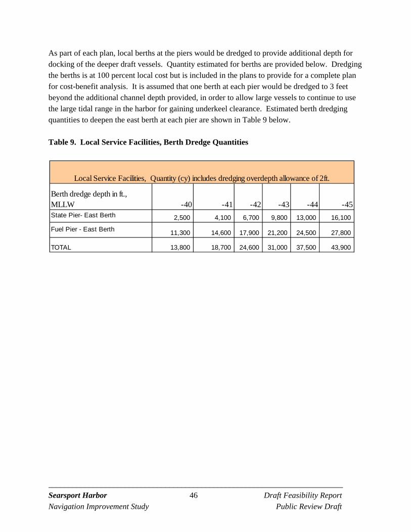
_________________________________________________________________________ Searsport Harbor 46 Draft Feasibility Report
Navigation Improvement Study Public Review Draft
As part of each plan, local berths at the piers would be dredged to provide additional depth for docking of the deeper draft vessels. Quantity estimated for berths are provided below. Dredging the berths is at 100 percent local cost but is included in the plans to provide for a complete plan for cost-benefit analysis. It is assumed that one berth at each pier would be dredged to 3 feet beyond the additional channel depth provided, in order to allow large vessels to continue to use the large tidal range in the harbor for gaining underkeel clearance. Estimated berth dredging quantities to deepen the east berth at each pier are shown in Table 9 below.
Table 9. Local Service Facilities, Berth Dredge Quantities
-40 -41 -42 -43 -44 -45
2,500 4,100 6,700 9,800 13,000 16,100
11,300 14,600 17,900 21,200 24,500 27,800
13,800 18,700 24,600 31,000 37,500 43,900TOTAL
Local Service Facilities, Quantity (cy) includes dredging overdepth allowance of 2ft.
Berth dredge depth in ft., MLLWState Pier- East Berth
Fuel Pier - East Berth
_________________________________________________________________________ Searsport Harbor 47 Draft Feasibility Report
Navigation Improvement Study Public Review Draft
4.4 COST ESTIMATES FOR ALTERNATIVE PLANS
Cost estimates for the alternative plans were developed for each plan for both the Penobscot and Rockland disposal sites. Cost estimates include dredging and disposal costs, planning, engineering and design, construction supervision and administration. Cost estimates were also developed for local berth dredging. Costs are presented in Table 10 and 11. Cost estimates are at December 2011 price level. Construction Costs. Construction cost estimates were developed using the Corps of Engineers Dredge Estimating Program (CEDEP). CEDEP estimates include costs for mobilization and demobilization, construction plant (dredge, scows, tugs), cost of fuel, labor, insurance, materials, overhead, bond and profit. CEDEP inputs include consideration of the type of material to be dredged, efficiency of dredging operation, and haul distance. Design Phase Costs. Cost estimates include design phase planning and engineering, preparation of plans and specifications, costs for reviews, pre-construction contracting, and project management. Supervision and Administration Costs (including EDC). Cost estimates include project management, contract administration, construction supervision and inspection, engineering during construction (EDC) and pre-dredge and after-dredge surveys. Real Estate Costs. No real estate interests are required for the Federal project. The area to be dredged and the open water disposal area required for construction are below the ordinary high watermark of the navigable watercourse. Therefore, navigational servitude applies and would be invoked for the project. Berth access for survey and work boats and tugs would be provided at Mack Point by Maine Department of Transportation. As the berths and piers are subject to navigation servitude no credit would be due the non-Federal sponsor for this use. Interest During Construction. The estimated cost of the project is increased for interest during construction (IDC) to account for the lost opportunity cost of construction funds over the period of construction, yielding the total investment cost. IDC is included for the economic analysis purposes. IDC was calculated based on the Office of Budget and Management (OMB) rate for Federal water projects for FY13 of 3-3/4 percent. Aids to Navigation. No new aids to navigation are planned for the alternatives. There are three markers in the area, Red Nun 4, Red Nun 6, and G8-bell buoy. The navigation aids are maintained by the United States Coast Guard (USCG). A letter was sent to USCG on February 12, 2012 and it was confirmed that no new aids would be needed for the improvement project.
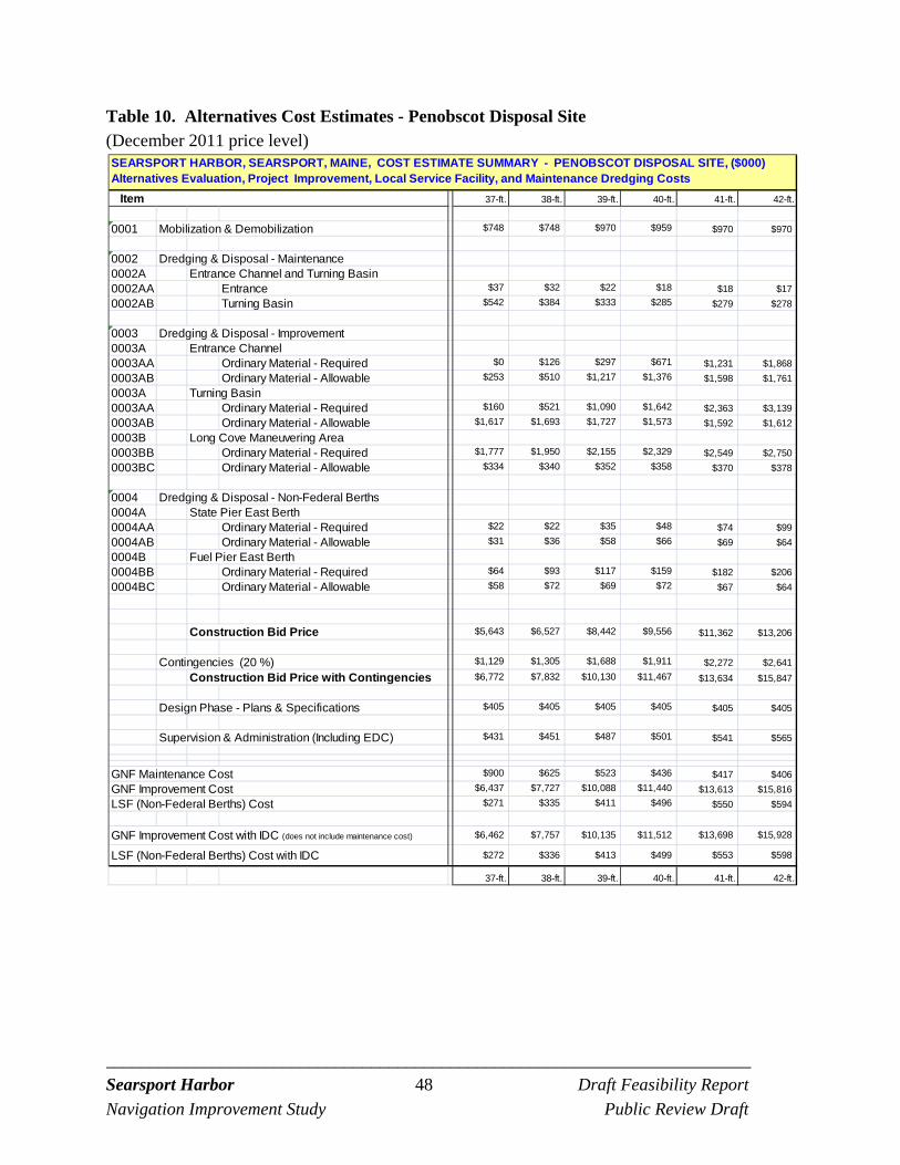
_________________________________________________________________________ Searsport Harbor 48 Draft Feasibility Report
Navigation Improvement Study Public Review Draft
Table 10. Alternatives Cost Estimates - Penobscot Disposal Site (December 2011 price level)
37-ft. 38-ft. 39-ft. 40-ft. 41-ft. 42-ft.
0001 Mobilization & Demobilization $748 $748 $970 $959 $970 $970
0002 Dredging & Disposal - Maintenance0002A Entrance Channel and Turning Basin0002AA Entrance $37 $32 $22 $18 $18 $17
0002AB Turning Basin $542 $384 $333 $285 $279 $278
0003 Dredging & Disposal - Improvement0003A Entrance Channel 0003AA Ordinary Material - Required $0 $126 $297 $671 $1,231 $1,868
0003AB Ordinary Material - Allowable $253 $510 $1,217 $1,376 $1,598 $1,761
0003A Turning Basin0003AA Ordinary Material - Required $160 $521 $1,090 $1,642 $2,363 $3,139
0003AB Ordinary Material - Allowable $1,617 $1,693 $1,727 $1,573 $1,592 $1,612
0003B Long Cove Maneuvering Area0003BB Ordinary Material - Required $1,777 $1,950 $2,155 $2,329 $2,549 $2,750
0003BC Ordinary Material - Allowable $334 $340 $352 $358 $370 $378
0004 Dredging & Disposal - Non-Federal Berths0004A State Pier East Berth0004AA Ordinary Material - Required $22 $22 $35 $48 $74 $99
0004AB Ordinary Material - Allowable $31 $36 $58 $66 $69 $64
0004B Fuel Pier East Berth0004BB Ordinary Material - Required $64 $93 $117 $159 $182 $206
0004BC Ordinary Material - Allowable $58 $72 $69 $72 $67 $64
Construction Bid Price $5,643 $6,527 $8,442 $9,556 $11,362 $13,206
Contingencies (20 %) $1,129 $1,305 $1,688 $1,911 $2,272 $2,641
Construction Bid Price with Contingencies $6,772 $7,832 $10,130 $11,467 $13,634 $15,847
Design Phase - Plans & Specifications $405 $405 $405 $405 $405 $405
Supervision & Administration (Including EDC) $431 $451 $487 $501 $541 $565
GNF Maintenance Cost $900 $625 $523 $436 $417 $406
GNF Improvement Cost $6,437 $7,727 $10,088 $11,440 $13,613 $15,816
LSF (Non-Federal Berths) Cost $271 $335 $411 $496 $550 $594
GNF Improvement Cost with IDC (does not include maintenance cost) $6,462 $7,757 $10,135 $11,512 $13,698 $15,928
LSF (Non-Federal Berths) Cost with IDC $272 $336 $413 $499 $553 $598
37-ft. 38-ft. 39-ft. 40-ft. 41-ft. 42-ft.
Item
SEARSPORT HARBOR, SEARSPORT, MAINE, COST ESTIMATE SUMMARY - PENOBSCOT DISPOSAL SITE, ($000) Alternatives Evaluation, Project Improvement, Local Service Facility, and Maintenance Dredging Costs
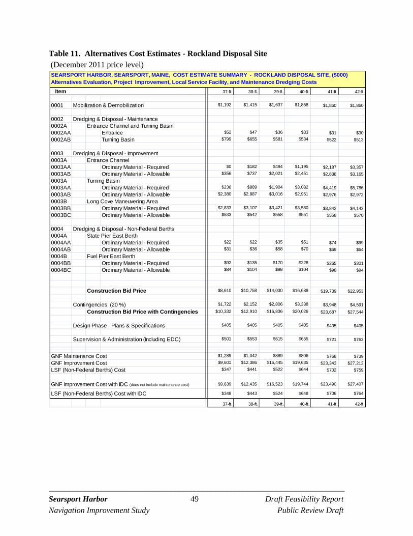
_________________________________________________________________________ Searsport Harbor 49 Draft Feasibility Report
Navigation Improvement Study Public Review Draft
Table 11. Alternatives Cost Estimates - Rockland Disposal Site (December 2011 price level)
37-ft. 38-ft. 39-ft. 40-ft. 41-ft. 42-ft.
0001 Mobilization & Demobilization $1,192 $1,415 $1,637 $1,858 $1,860 $1,860
0002 Dredging & Disposal - Maintenance0002A Entrance Channel and Turning Basin0002AA Entrance $52 $47 $36 $33 $31 $30
0002AB Turning Basin $799 $655 $581 $534 $522 $513
0003 Dredging & Disposal - Improvement0003A Entrance Channel 0003AA Ordinary Material - Required $0 $182 $494 $1,195 $2,187 $3,357
0003AB Ordinary Material - Allowable $356 $737 $2,021 $2,451 $2,838 $3,165
0003A Turning Basin0003AA Ordinary Material - Required $236 $889 $1,904 $3,082 $4,419 $5,786
0003AB Ordinary Material - Allowable $2,380 $2,887 $3,016 $2,951 $2,976 $2,972
0003B Long Cove Maneuvering Area0003BB Ordinary Material - Required $2,833 $3,107 $3,421 $3,580 $3,842 $4,142
0003BC Ordinary Material - Allowable $533 $542 $558 $551 $558 $570
0004 Dredging & Disposal - Non-Federal Berths0004A State Pier East Berth0004AA Ordinary Material - Required $22 $22 $35 $51 $74 $99
0004AB Ordinary Material - Allowable $31 $36 $58 $70 $69 $64
0004B Fuel Pier East Berth0004BB Ordinary Material - Required $92 $135 $170 $228 $265 $301
0004BC Ordinary Material - Allowable $84 $104 $99 $104 $98 $94
Construction Bid Price $8,610 $10,758 $14,030 $16,688 $19,739 $22,953
Contingencies (20 %) $1,722 $2,152 $2,806 $3,338 $3,948 $4,591
Construction Bid Price with Contingencies $10,332 $12,910 $16,836 $20,026 $23,687 $27,544
Design Phase - Plans & Specifications $405 $405 $405 $405 $405 $405
Supervision & Administration (Including EDC) $501 $553 $615 $655 $721 $763
GNF Maintenance Cost $1,289 $1,042 $889 $806 $768 $739
GNF Improvement Cost $9,601 $12,386 $16,445 $19,635 $23,343 $27,213
LSF (Non-Federal Berths) Cost $347 $441 $522 $644 $702 $759
GNF Improvement Cost with IDC (does not include maintenance cost) $9,639 $12,435 $16,523 $19,744 $23,490 $27,407
LSF (Non-Federal Berths) Cost with IDC $348 $443 $524 $648 $706 $764
37-ft. 38-ft. 39-ft. 40-ft. 41-ft. 42-ft.
Item
SEARSPORT HARBOR, SEARSPORT, MAINE, COST ESTIMATE SUMMARY - ROCKLAND DISPOSAL SITE, ($000) Alternatives Evaluation, Project Improvement, Local Service Facility, and Maintenance Dredging Costs
_________________________________________________________________________ Searsport Harbor 50 Draft Feasibility Report
Navigation Improvement Study Public Review Draft
5.0 EVALUATION AND COMPARISON OF ALTERNATIVES
5.1 ECONOMIC ANALYSIS
This economic analysis was conducted in accordance with current Corps of Engineers guidance for deep draft navigation projects. The purpose of the economic analysis is to determine the potential benefit a plan would have on the national economy. The Corps uses the National Economic Development (NED) account to analyze the economic benefits of a project. NED benefits are contributions to national economic development that increase the value of the national output of goods and services. For deep-draft navigation projects, the most common type of NED benefit is waterborne transportation cost savings. The NED benefits are estimated by comparing the transportation costs without the project to the transportation costs with the project. Any decrease in total transportation costs resulting from the project equal the benefits of the project. The economic analysis conducted for the Searsport study is based on detailed waterborne commerce statistics data from the Corps of Engineers Waterborne Commerce Statistics Center, as well as on information provided by the Maine Department of Transportation, the operators and users of the terminals at Mack Point, and the Searsport Harbor Pilots. Benefits and project costs are compared in annual terms, and are converted to average annual equivalents using the FY 2013 Federal interest rate for water resources projects of 3-3/4 percent. The base year of the analysis is 2015 and a 50 year period of analysis is used. Both the without and with project conditions are forecast over the period of analysis. A detailed explanation of the economic analysis and results including data, assumptions and methodology is provided in the Economics Appendix. Findings of the economics analysis are briefly summarized below. Hourly vessel operating costs as developed by the Army Corps of Engineers, Institute for Water Resources, in Economic Guidance Memorandum #11-05, Deep-Draft Vessel Operating Costs FY 2011, were used in the economic analysis.
5.1.1 Benefits Analysis
In the without project condition, it is assumed that the existing channel will be dredged to the authorized depth of 35 feet. It is assumed the maintenance dredging, bringing the channel back to the authorized depth of 35 feet, would reduce some navigation inefficiencies at Searsport Harbor. (The project was constructed in 1964 and maintenance dredging has not occurred resulting in some shoaling in the channel reducing the depth to less than the 35-foot authorized depth). The benefits due to the maintenance dredging are not claimed as benefits for the deepening project. Without a deepening project, shippers will continue to be limited in the size
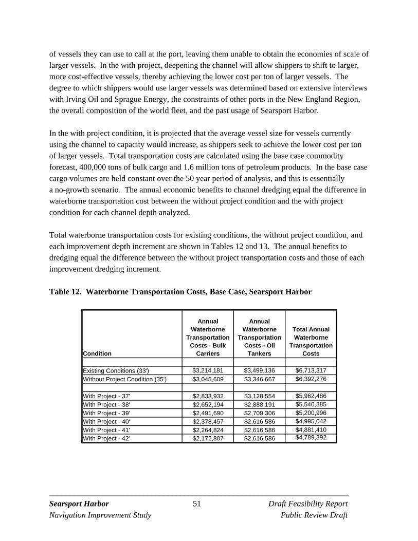
_________________________________________________________________________ Searsport Harbor 51 Draft Feasibility Report
Navigation Improvement Study Public Review Draft
of vessels they can use to call at the port, leaving them unable to obtain the economies of scale of larger vessels. In the with project, deepening the channel will allow shippers to shift to larger, more cost-effective vessels, thereby achieving the lower cost per ton of larger vessels. The degree to which shippers would use larger vessels was determined based on extensive interviews with Irving Oil and Sprague Energy, the constraints of other ports in the New England Region, the overall composition of the world fleet, and the past usage of Searsport Harbor. In the with project condition, it is projected that the average vessel size for vessels currently using the channel to capacity would increase, as shippers seek to achieve the lower cost per ton of larger vessels. Total transportation costs are calculated using the base case commodity forecast, 400,000 tons of bulk cargo and 1.6 million tons of petroleum products. In the base case cargo volumes are held constant over the 50 year period of analysis, and this is essentially a no-growth scenario. The annual economic benefits to channel dredging equal the difference in waterborne transportation cost between the without project condition and the with project condition for each channel depth analyzed. Total waterborne transportation costs for existing conditions, the without project condition, and each improvement depth increment are shown in Tables 12 and 13. The annual benefits to dredging equal the difference between the without project transportation costs and those of each improvement dredging increment.
Table 12. Waterborne Transportation Costs, Base Case, Searsport Harbor
Condition
Annual Waterborne
Transportation Costs - Bulk
Carriers
Annual Waterborne
Transportation Costs - Oil
Tankers
Total Annual Waterborne
Transportation Costs
Existing Conditions (33') $3,214,181 $3,499,136 $6,713,317
Without Project Condition (35') $3,045,609 $3,346,667 $6,392,276
With Project - 37' $2,833,932 $3,128,554 $5,962,486
With Project - 38' $2,652,194 $2,888,191 $5,540,385
With Project - 39' $2,491,690 $2,709,306 $5,200,996
With Project - 40' $2,378,457 $2,616,586 $4,995,042
With Project - 41' $2,264,824 $2,616,586 $4,881,410
With Project - 42' $2,172,807 $2,616,586 $4,789,392
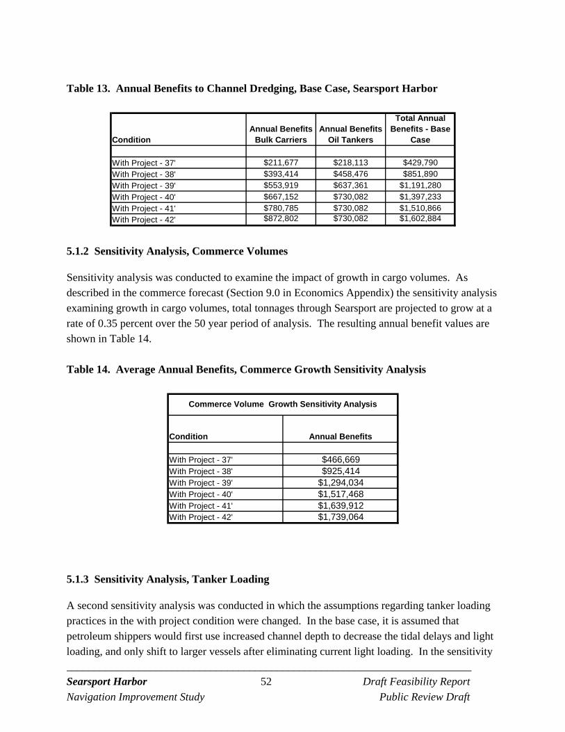
_________________________________________________________________________ Searsport Harbor 52 Draft Feasibility Report
Navigation Improvement Study Public Review Draft
Table 13. Annual Benefits to Channel Dredging, Base Case, Searsport Harbor
ConditionAnnual Benefits
Bulk CarriersAnnual Benefits
Oil Tankers
Total Annual Benefits - Base
Case
With Project - 37' $211,677 $218,113 $429,790
With Project - 38' $393,414 $458,476 $851,890
With Project - 39' $553,919 $637,361 $1,191,280
With Project - 40' $667,152 $730,082 $1,397,233
With Project - 41' $780,785 $730,082 $1,510,866
With Project - 42' $872,802 $730,082 $1,602,884
5.1.2 Sensitivity Analysis, Commerce Volumes
Sensitivity analysis was conducted to examine the impact of growth in cargo volumes. As described in the commerce forecast (Section 9.0 in Economics Appendix) the sensitivity analysis examining growth in cargo volumes, total tonnages through Searsport are projected to grow at a rate of 0.35 percent over the 50 year period of analysis. The resulting annual benefit values are shown in Table 14.
Table 14. Average Annual Benefits, Commerce Growth Sensitivity Analysis
Condition Annual Benefits
With Project - 37' $466,669With Project - 38' $925,414With Project - 39' $1,294,034With Project - 40' $1,517,468With Project - 41' $1,639,912With Project - 42' $1,739,064
Commerce Volume Growth Sensitivity Analysis
5.1.3 Sensitivity Analysis, Tanker Loading
A second sensitivity analysis was conducted in which the assumptions regarding tanker loading practices in the with project condition were changed. In the base case, it is assumed that petroleum shippers would first use increased channel depth to decrease the tidal delays and light loading, and only shift to larger vessels after eliminating current light loading. In the sensitivity

_________________________________________________________________________ Searsport Harbor 53 Draft Feasibility Report
Navigation Improvement Study Public Review Draft
analysis, it is assumed that some light loading of oil tankers occurs for reasons not related to channel depth, and so some light loading would likely occur in the future even with increased channel depth. In this sensitivity analysis, it is assumed that petroleum shippers move to larger vessels at slightly lesser channel depths than in the base case. As a result, the benefits shift slightly from the greater channel depths to the lesser channel depths, but the overall effect is minor. There is no change to benefits derived from bulk cargo. A comparison of the annual transportation costs for oil shipments between the base case and the tanker loading sensitivity analysis is shown below in Table 15. It can be seen that total transportation costs in the sensitivity analysis are similar to those of the base case at channel depths of 33 and 35 feet, decrease more quickly in the sensitivity analysis at 37 and 38 feet, and then converge with the base case at 40 feet. Similarly, it can be seen in Table 16 that the annual benefits in the sensitivity analysis exceed those of the base case at channel depths of 37 and 38 feet, and then are slightly lower than the base case at channel depths of 39 feet and greater.
Table 15. Oil Tanker Transportation Costs, Base Case vs Tanker Loading Sensitivity Analysis
Condition
Annual Transportation Costs - Base
Case (Oil Tankers)
Annual Transportation
Costs - Sensitivity Analysis (Oil
Tankers)
Existing Condition (33') $3,499,136 $3,499,136Without Project (35') $3,346,667 $3,275,309
With Project - 37' $3,128,554 $3,005,657With Project - 38' $2,888,191 $2,837,707With Project - 39' $2,709,306 $2,736,140With Project - 40' $2,616,586 $2,616,586With Project - 41' $2,616,586 $2,616,586With Project - 42' $2,616,586 $2,616,586
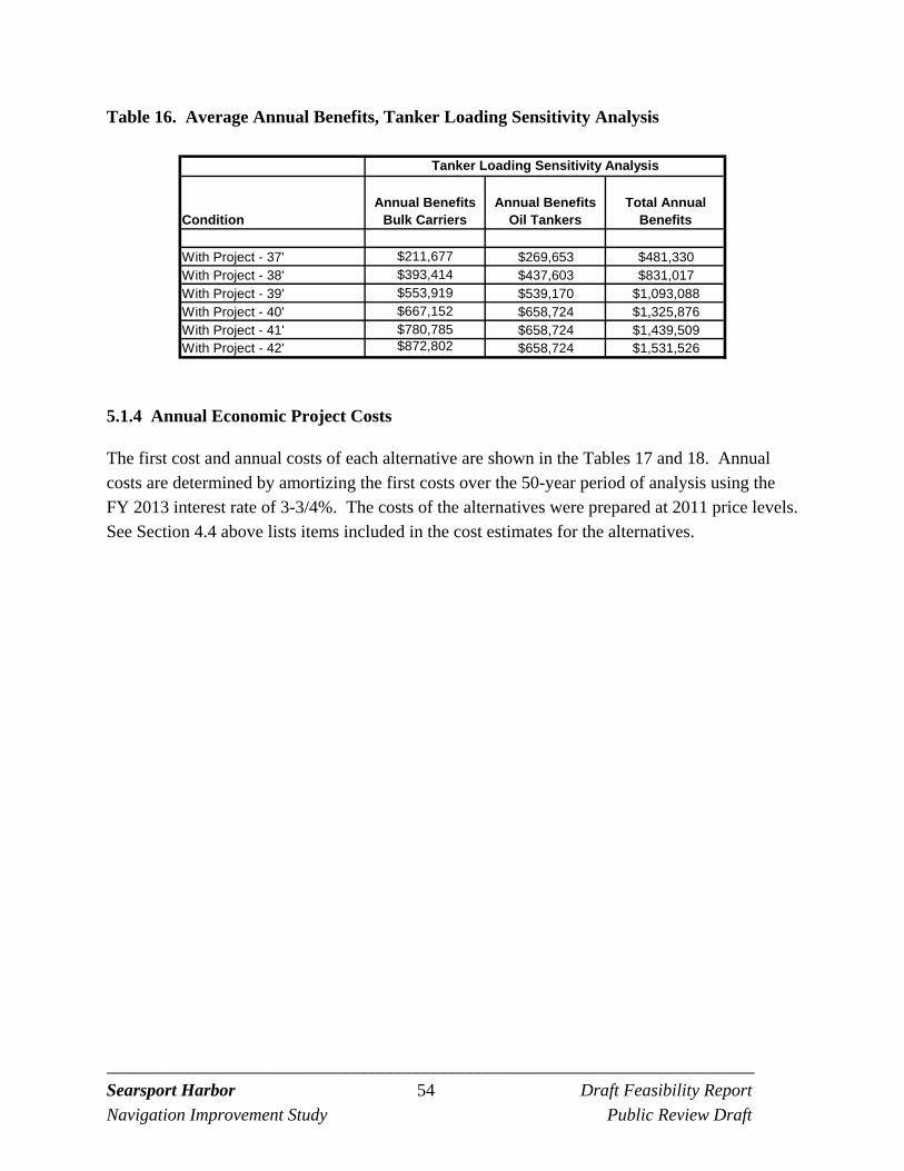
_________________________________________________________________________ Searsport Harbor 54 Draft Feasibility Report
Navigation Improvement Study Public Review Draft
Table 16. Average Annual Benefits, Tanker Loading Sensitivity Analysis
ConditionAnnual Benefits
Bulk CarriersAnnual Benefits
Oil TankersTotal Annual
Benefits
With Project - 37' $211,677 $269,653 $481,330With Project - 38' $393,414 $437,603 $831,017With Project - 39' $553,919 $539,170 $1,093,088With Project - 40' $667,152 $658,724 $1,325,876With Project - 41' $780,785 $658,724 $1,439,509With Project - 42' $872,802 $658,724 $1,531,526
Tanker Loading Sensitivity Analysis
5.1.4 Annual Economic Project Costs
The first cost and annual costs of each alternative are shown in the Tables 17 and 18. Annual costs are determined by amortizing the first costs over the 50-year period of analysis using the FY 2013 interest rate of 3-3/4%. The costs of the alternatives were prepared at 2011 price levels. See Section 4.4 above lists items included in the cost estimates for the alternatives.
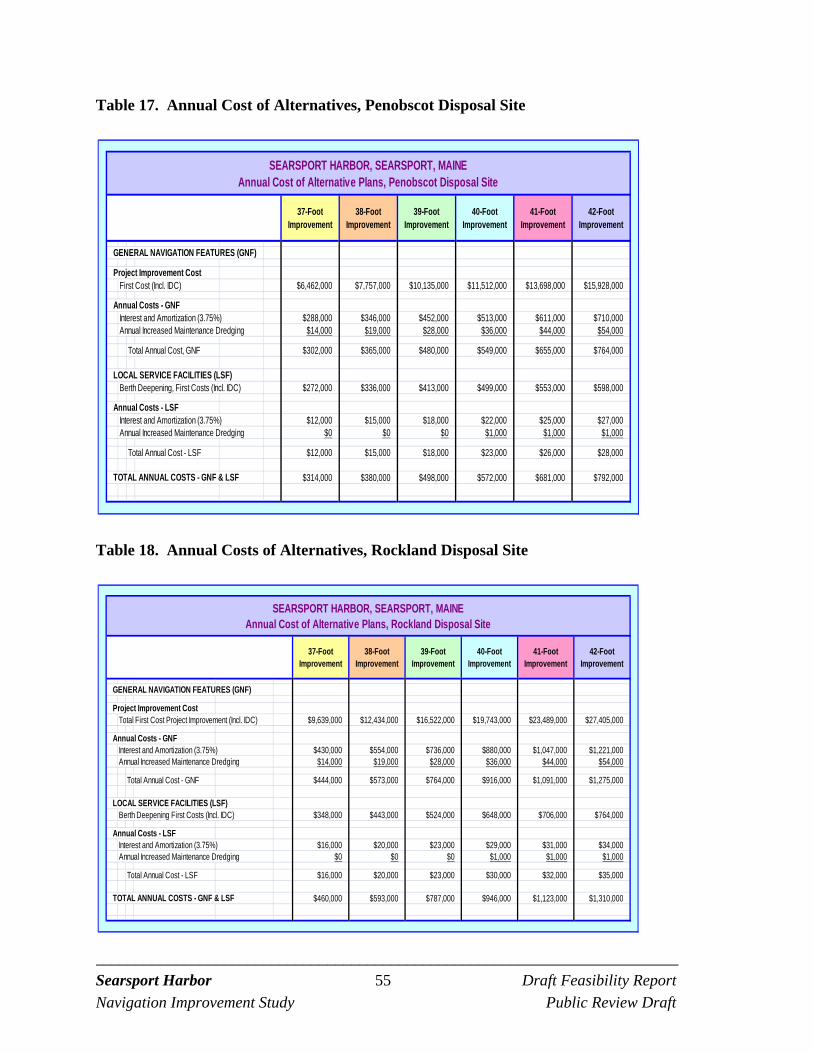
_________________________________________________________________________ Searsport Harbor 55 Draft Feasibility Report
Navigation Improvement Study Public Review Draft
Table 17. Annual Cost of Alternatives, Penobscot Disposal Site
Table 18. Annual Costs of Alternatives, Rockland Disposal Site
37-Foot Improvement
38-Foot Improvement
39-Foot Improvement
40-Foot Improvement
41-Foot Improvement
42-Foot Improvement
GENERAL NAVIGATION FEATURES (GNF)
Project Improvement Cost First Cost (Incl. IDC) $6,462,000 $7,757,000 $10,135,000 $11,512,000 $13,698,000 $15,928,000
Annual Costs - GNFInterest and Amortization (3.75%) $288,000 $346,000 $452,000 $513,000 $611,000 $710,000Annual Increased Maintenance Dredging $14,000 $19,000 $28,000 $36,000 $44,000 $54,000
Total Annual Cost, GNF $302,000 $365,000 $480,000 $549,000 $655,000 $764,000
LOCAL SERVICE FACILITIES (LSF)Berth Deepening, First Costs (Incl. IDC) $272,000 $336,000 $413,000 $499,000 $553,000 $598,000
Annual Costs - LSFInterest and Amortization (3.75%) $12,000 $15,000 $18,000 $22,000 $25,000 $27,000Annual Increased Maintenance Dredging $0 $0 $0 $1,000 $1,000 $1,000
Total Annual Cost - LSF $12,000 $15,000 $18,000 $23,000 $26,000 $28,000
TOTAL ANNUAL COSTS - GNF & LSF $314,000 $380,000 $498,000 $572,000 $681,000 $792,000
SEARSPORT HARBOR, SEARSPORT, MAINEAnnual Cost of Alternative Plans, Penobscot Disposal Site
37-Foot Improvement
38-Foot Improvement
39-Foot Improvement
40-Foot Improvement
41-Foot Improvement
42-Foot Improvement
GENERAL NAVIGATION FEATURES (GNF)
Project Improvement CostTotal First Cost Project Improvement (Incl. IDC) $9,639,000 $12,434,000 $16,522,000 $19,743,000 $23,489,000 $27,405,000
Annual Costs - GNFInterest and Amortization (3.75%) $430,000 $554,000 $736,000 $880,000 $1,047,000 $1,221,000Annual Increased Maintenance Dredging $14,000 $19,000 $28,000 $36,000 $44,000 $54,000
Total Annual Cost - GNF $444,000 $573,000 $764,000 $916,000 $1,091,000 $1,275,000
LOCAL SERVICE FACILITIES (LSF)Berth Deepening First Costs (Incl. IDC) $348,000 $443,000 $524,000 $648,000 $706,000 $764,000
Annual Costs - LSFInterest and Amortization (3.75%) $16,000 $20,000 $23,000 $29,000 $31,000 $34,000Annual Increased Maintenance Dredging $0 $0 $0 $1,000 $1,000 $1,000
Total Annual Cost - LSF $16,000 $20,000 $23,000 $30,000 $32,000 $35,000
TOTAL ANNUAL COSTS - GNF & LSF $460,000 $593,000 $787,000 $946,000 $1,123,000 $1,310,000
SEARSPORT HARBOR, SEARSPORT, MAINEAnnual Cost of Alternative Plans, Rockland Disposal Site
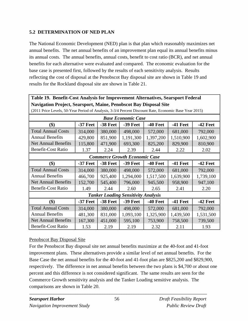
_________________________________________________________________________ Searsport Harbor 56 Draft Feasibility Report
Navigation Improvement Study Public Review Draft
5.2 DETERMINATION OF NED PLAN
The National Economic Development (NED) plan is that plan which reasonably maximizes net annual benefits. The net annual benefits of an improvement plan equal its annual benefits minus its annual costs. The annual benefits, annual costs, benefit to cost ratio (BCR), and net annual benefits for each alternative were evaluated and compared. The economic evaluation for the base case is presented first, followed by the results of each sensitivity analysis. Results reflecting the cost of disposal at the Penobscot Bay disposal site are shown in Table 19 and results for the Rockland disposal site are shown in Table 21.
Table 19. Benefit-Cost Analysis for Improvement Alternatives, Searsport Federal Navigation Project, Searsport, Maine, Penobscot Bay Disposal Site (2011 Price Levels, 50-Year Period of Analysis, 3-3/4 Percent Discount Rate, Economic Base Year 2015)
Base Economic Case ($) -37 Feet -38 Feet -39 Feet -40 Feet -41 Feet -42 Feet
Total Annual Costs 314,000 380,000 498,000 572,000 681,000 792,000 Annual Benefits 429,800 851,900 1,191,300 1,397,200 1,510,900 1,602,900 Net Annual Benefits 115,800 471,900 693,300 825,200 829,900 810,900 Benefit-Cost Ratio 1.37 2.24 2.39 2.44 2.22 2.02
Commerce Growth Economic Case ($) -37 Feet -38 Feet -39 Feet -40 Feet -41 Feet -42 Feet
Total Annual Costs 314,000 380,000 498,000 572,000 681,000 792,000 Annual Benefits 466,700 925,400 1,294,000 1,517,500 1,639,900 1,739,100 Net Annual Benefits 152,700 545,400 796,000 945,500 958,900 947,100 Benefit-Cost Ratio 1.49 2.44 2.60 2.65 2.41 2.20
Tanker Loading Sensitivity Analysis ($) -37 Feet -38 Feet -39 Feet -40 Feet -41 Feet -42 Feet
Total Annual Costs 314,000 380,000 498,000 572,000 681,000 792,000 Annual Benefits 481,300 831,000 1,093,100 1,325,900 1,439,500 1,531,500 Net Annual Benefits 167,300 451,000 595,100 753,900 758,500 739,500 Benefit-Cost Ratio 1.53 2.19 2.19 2.32 2.11 1.93
Penobscot Bay Disposal Site For the Penobscot Bay disposal site net annual benefits maximize at the 40-foot and 41-foot improvement plans. These alternatives provide a similar level of net annual benefits. For the Base Case the net annual benefits for the 40-foot and 41-foot plan are $825,200 and $829,900, respectively. The difference in net annual benefits between the two plans is $4,700 or about one percent and this difference is not considered significant. The same results are seen for the Commerce Growth sensitivity analysis and the Tanker Loading sensitive analysis. The comparisons are shown in Table 20.
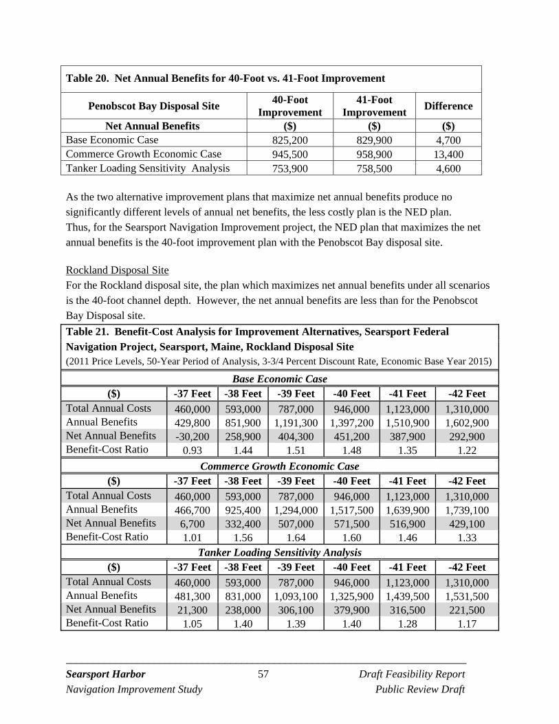
_________________________________________________________________________ Searsport Harbor 57 Draft Feasibility Report
Navigation Improvement Study Public Review Draft
Table 20. Net Annual Benefits for 40-Foot vs. 41-Foot Improvement
Penobscot Bay Disposal Site 40-Foot
Improvement 41-Foot
Improvement Difference
Net Annual Benefits ($) ($) ($) Base Economic Case 825,200 829,900 4,700 Commerce Growth Economic Case 945,500 958,900 13,400 Tanker Loading Sensitivity Analysis 753,900 758,500 4,600 As the two alternative improvement plans that maximize net annual benefits produce no significantly different levels of annual net benefits, the less costly plan is the NED plan. Thus, for the Searsport Navigation Improvement project, the NED plan that maximizes the net annual benefits is the 40-foot improvement plan with the Penobscot Bay disposal site. Rockland Disposal Site For the Rockland disposal site, the plan which maximizes net annual benefits under all scenarios is the 40-foot channel depth. However, the net annual benefits are less than for the Penobscot Bay Disposal site.
Table 21. Benefit-Cost Analysis for Improvement Alternatives, Searsport Federal Navigation Project, Searsport, Maine, Rockland Disposal Site (2011 Price Levels, 50-Year Period of Analysis, 3-3/4 Percent Discount Rate, Economic Base Year 2015)
Base Economic Case ($) -37 Feet -38 Feet -39 Feet -40 Feet -41 Feet -42 Feet
Total Annual Costs 460,000 593,000 787,000 946,000 1,123,000 1,310,000 Annual Benefits 429,800 851,900 1,191,300 1,397,200 1,510,900 1,602,900 Net Annual Benefits -30,200 258,900 404,300 451,200 387,900 292,900 Benefit-Cost Ratio 0.93 1.44 1.51 1.48 1.35 1.22
Commerce Growth Economic Case ($) -37 Feet -38 Feet -39 Feet -40 Feet -41 Feet -42 Feet
Total Annual Costs 460,000 593,000 787,000 946,000 1,123,000 1,310,000 Annual Benefits 466,700 925,400 1,294,000 1,517,500 1,639,900 1,739,100 Net Annual Benefits 6,700 332,400 507,000 571,500 516,900 429,100 Benefit-Cost Ratio 1.01 1.56 1.64 1.60 1.46 1.33
Tanker Loading Sensitivity Analysis ($) -37 Feet -38 Feet -39 Feet -40 Feet -41 Feet -42 Feet
Total Annual Costs 460,000 593,000 787,000 946,000 1,123,000 1,310,000 Annual Benefits 481,300 831,000 1,093,100 1,325,900 1,439,500 1,531,500 Net Annual Benefits 21,300 238,000 306,100 379,900 316,500 221,500 Benefit-Cost Ratio 1.05 1.40 1.39 1.40 1.28 1.17
_________________________________________________________________________ Searsport Harbor 58 Draft Feasibility Report
Navigation Improvement Study Public Review Draft
5.3 REGIONAL ECONOMIC DEVELOPMENT AND OTHER SOCIAL EFFECTS BENEFITS
The improved efficiencies at the port would also have positive regional economic effects (RED benefits). The transportation costs savings of the NED benefit analysis would be seen in lower costs of bringing products to Maine manufacturers and consumers. Fuel costs to residents with the dredging project could be somewhat lower compared to the without project condition. Lower costs of transporting inputs to the region’s paper and other manufacturing businesses could make these businesses more efficient and more cost-competitive relative to businesses in other regions. This could increase local business activity which in turn could increase employment. If channel deepening promotes increased use of Searsport Harbor by importers and exporters, this could also result in increased employment in the region. Employment could increase at the harbor itself, as increased shipments require additional dock workers, truckers, and other workers. Employment could increase at businesses located in the region which receive inputs at the harbor if they are able to become more competitive in the marketplace and obtain greater market share. If employment in the region increases, incomes and tax revenues in the region would also increase. These types of positive effects would be RED benefits to channel deepening. In the Other Social Effects (OSE) category, the most significant benefit from channel deepening identified would be the improved safety and reliability of oil and gasoline shipments that would be achieved with the project. Channel deepening would help ensure continued reliable and efficient deliveries of oil and gas to the region, deliveries which are of critical importance to the residents and businesses of northern and central Maine. Increased channel depth would improve the safety of navigation for vessels using the port, and would allow shipments to be brought on larger, more cost-effective vessels. The improved safety and efficiency of critical energy shipments would improve the energy security of the region.
5.4 ENVIRONMENTAL IMPACTS
The environmental impacts of both the with and without project condition are temporary and occur during the dredging and disposal activities associated with maintaining and deepening the existing Federal Navigation project. For the with-out project condition dredging and disposal is required to return the project to the authorized depth of 35 feet MLLW. For the with project condition additional dredging and disposal is required to deepen the Federal project (alternatives of 37 to 42 feet). The length of construction varies from about 2 months to 5 months depending on the volume of dredged material. To avoid environmental impacts, dredging and disposal will
_________________________________________________________________________ Searsport Harbor 59 Draft Feasibility Report
Navigation Improvement Study Public Review Draft
occur only between the period of November 8 through April 9 under both the with and without project conditions.
5.4.1 Water Quality Impacts
Dredging and disposal will create a temporary increase in turbidity in the water column. However, no long-term changes in water quality are expected from the construction of the alternatives. The discussion below briefly summarizes the results of various turbidity plume studies conducted during dredging and disposal of dredged material. The results of these studies indicate the type of turbidity plume and the behavior of the disposed dredged material that may be expected from the alternatives. More detail is provided in the Environmental Assessment.
Dredging Impacts
In the summer of 1977, the extent and duration of the impacts from dredging the Thames River/New London Harbor channels were studied (Bohlen, et. al., 1979). Bohlen (1979), estimated that 1.5% to 3.0% of the volume of substrate (fine-grained sands and silts) contained in an open clamshell dredge bucket is introduced into the water column. The conclusions of this study defined the plume extending 700 meters downstream. Analysis of the composition and concentration of the plume indicated that the majority of material suspended occurred within 300 meters of the dredge. Suspended material concentrations closest to the dredge ranged from 200 mg/l to 400 mg/l. However, a number of operational variables, such as bucket size and type (open or enclosed), prohibiting scow overflow, volume of sediment dredged per cycle, operator experience, hoisting speed, and hydrodynamic conditions in the dredging area can significantly affect the quantity of material suspended (LaSalle, 1988; Lunz et al., 1984). Sediment resuspension from clamshell dredges can be reduced by using an enclosed clamshell bucket or by slowing the raising or lowering of the bucket through the water column. However, the latter reduces the production rate of the dredge. Monitoring of dredge induced suspended sediment concentrations was conducted at New Haven Harbor to address concerns relative to winter flounder spawning grounds near the Federal channel (Corps, 1996). Dredging at New Haven Harbor was conducted with an enclosed bucket. The two major objectives of the New Haven monitoring were to 1) establish the background suspended solids concentration before and after dredging, and 2) document the movement of the dredge plume relative to fisheries resource areas such as winter flounder spawning grounds.
_________________________________________________________________________ Searsport Harbor 60 Draft Feasibility Report
Navigation Improvement Study Public Review Draft
The results of the acoustic survey revealed that the dredge-induced sediment plume did protrude into the shoal areas to the east and west of the navigation channel. These excursions onto the shoals only occurred when the dredge was in the immediate vicinity. The DAISY (Disposal Area In-Situ System), which was deployed on the eastern end of the winter flounder spawning area, also showed elevated suspended materials concentrations attributable to the dredge operating in the upper reaches of the harbor. The time series of the DAISY data showed numerous aperiodic short duration spikes of 100 mg/L. The observed concentrations were an order of magnitude higher than the preceding background concentrations. However, in the last half of the deployment, while the dredge was located well south of the DAISY site, there were several long duration (1-3 days), and very high perturbations. During these events concentrations reached 700 mg/L that could not be related to the dredging operation. Evidence from the meteorological data and wastewater effluent records indicate that these events are likely the result of winds and wind-generated waves, alone or in combination with discharges from wastewater treatment plant outfalls. An enclosed bucket was used to dredge the material unsuitable for open water disposal (silt) during the Boston Harbor navigation improvement project. Monitoring results from this dredging operation showed that the plume was confined to the navigation channel and returned to background levels between 600 and 1,000 feet downstream (ENSR, 2002). Additional dredge plume monitoring in Boston Harbor in 2008, continued to support the evidence that the plume is strongest near the dredge, highest concentrations are generally located near the bottom of the water column, and are typically confined to the navigation channel (although low concentration plume filaments [<5 NTU; <12 mg/L] were observed on two occasions (Battelle, 2009). The highest turbidity readings within 500 feet of the dredge were less than 20 NTU above background and suspended sediments were less than 40 mg/l (Battelle, 2009). The above results show that a turbidity plume can be produced during dredging but returns to background levels within 1,500 feet of the dredge and generally stays confined to the navigation channel. Use of a Cable Arm bucket can reduce the amount of suspended solids in the water column. However, that type of bucket may not be capable of removing the parent glacial improvement materials required for this project because it does not have teeth to dig into the material. The dredging for the Searsport alternatives are of a short duration (five months or less) and would be performed in the winter months due to construction windows to protect biological resources. Although the material is fined grained silt and clay (generally transitioning from
_________________________________________________________________________ Searsport Harbor 61 Draft Feasibility Report
Navigation Improvement Study Public Review Draft
clayey silt to silty clay with depth) the material to be dredged is consolidated (has been compacted over time). Information and photographs of the core samples collected are provide in Field Sampling and Sediment Testing Report prepared by Battelle in September 2008. Turbidity affects water column biological production by decreasing light penetration, clogging fish gills, or otherwise disturbing organisms. Based on the consolidated nature of the material, resuspension of the material during dredging is expected to occur to a lesser extent and where resuspension does occur the material is expected to settle within the dredge and channel areas. If a short duration plume were generated during dredging of the sediments, no significant biological impacts are anticipated. Construction will be accomplished in the winter when water temperatures are low and biological productivity is at a minimum, thus no significant biological impacts are anticipated if a short term turbidity plume were to occur during dredging.
Disposal Impacts
Dredged material is released from scows operating on the surface and passes through several phases as it travels to the seafloor at the disposal site. Several factors influence the behavior of the descending plume, including the properties of the sediment (e.g., silt, sand, clumps, etc.), water depth, water column stratification, and the interplay of the descending sediment with the water through which it passes. Studies reviewed in the Environmental Assessment demonstrate that only a small amount of sediment remains in the water column after a disposal event. In general, the material is rapidly diluted and dispersed and is not easily discernible after two to three hours.
5.4.2 Biological Impacts
Dredging and disposal activities will have temporary negative impacts on some of the biological resources in the area which are described below. See Environmental Assessments for additional information.
Benthic Resources
The benthos at the dredge site and disposal site will be temporarily impacted from construction activities. Sessile benthic organisms inhabiting the shoal areas to be dredged would be destroyed by the dredging. Unaffected organisms inhabiting the substrate outside of the dredged areas, however, should recolonize the disturbed areas. The loss of forage for predators such as crabs and finfish would be temporary due to recolonization of the benthic organisms. Deepening of the 400-foot wide maneuvering area adjacent to the State Pier in Long Cove, currently between about 20 to 30 plus feet deep (except for the northwest corner that is less than 20 feet) to 40 feet
_________________________________________________________________________ Searsport Harbor 62 Draft Feasibility Report
Navigation Improvement Study Public Review Draft
deep, will not change the depth in the area substantially. Also the substrate may change over time from coarse grained to fine-grained due to deposition in the deeper depths. The area would be expected to be similar to the benthic areas currently in the project area. Benthos at the disposal site will be buried by material as a result of disposal activities. Since the material to be disposed is similar in nature to the soft sediment at the disposal site, recolonization is expected to occur fairly rapidly. In a study performed in Chesapeake Bay where dredged material thickness was less than < 15 cm, the effect can be minimal on recovery of soft sediment macrobenthos (Schaffner, 2010). It can take up to 1 and ½ years if disposal material thickness is greater than 15 cm for the rate of macrobenthic recovery to reach ambient community levels (Schaffner, 2010). It may be possible for the same rate of recovery to occur in Penobscot Bay, as disposal will be completed just before the spawning of many benthic organisms.
Fisheries Resources
Dredging and disposal activities will temporarily disrupt the immediate project areas. Mobile finfish would be expected to leave the area of disturbance. However, for some species, the temporary loss of benthic habitat will mean that the area will not be available for food source or nursery habitat for a certain period of time. For other species, the newly formed disposal mound may attract animals such as crabs to the food-rich sediments (O’Donnell, et. al., 2007). This area is expected to return to near normal levels of density and diversity a few years after construction ceases. The area of disruption is small compared to the remaining Penobscot Bay. However, opportunistic benthic species would be expected to recolonize the area within months.
5.4.3 Essential Fish Habitat
Of the 16 EFH managed species listed for Penobscot Bay, only one species, the winter flounder (life stages: eggs, larvae, juvenile young-of-year, and spawning adults) may be expected to occur in the shallower dredge area. The following EFH species (and their life stages) may be expected to occur in the deeper waters of the disposal site, and not in the shallower dredge areas: Atlantic cod (larvae), whiting (juveniles and adults), American plaice (eggs, larvae, juveniles, and adults), Atlantic halibut (juveniles), and Atlantic sea herring (larvae, juveniles, and adults). The following managed EFH species (and their life stages) may be found in both the dredge and disposal areas: Atlantic salmon (adults and smolts transiting the area), pollock (juveniles), white hake (juveniles and adults), winter flounder (juveniles: age 1+ and adults), windowpane flounder (eggs, larvae, juveniles, adults, and spawning adults, American plaice (spawning adults), ocean pout (adults), Atlantic halibut (eggs, larvae, spawning adults), bluefish (juveniles and adults), and Atlantic mackerel (juveniles and adults). The remaining EFH species and/or life stages are
_________________________________________________________________________ Searsport Harbor 63 Draft Feasibility Report
Navigation Improvement Study Public Review Draft
not expected to occur in the project area due to incorrect (shallow) water depths, or type of bottom substrate. No significant long-term impacts to EFH habitat or EFH species are expected from maintenance and deepening dredging of the entrance channel and turning basin. The benthos that inhabits the existing Federal navigation project should not change significantly considering that the physical nature of the substrate should not change dramatically given the similar sediment characteristics and the depth change will be comparatively minor. Full recolonization should occur within a couple of years due to the cooler climate in Maine. The shallower subtidal area to be dredged adjacent to the State Pier in Long Cove is coarser grained than the rest of the project area and has a slightly different benthic composition. The area may become similar to the rest of the project area in benthic composition. Long Cove would most likely be used by species that prefer habitat that is slightly deeper and finer sediment than the current habitat. Improvement dredging of the entrance channel and turning basin for Searsport Harbor and disposal activities is not expected to impede the progress of the fish (salmon, Atlantic sturgeon) transiting the harbor or bay due to the wide area for fish to maneuver around the dredge, the dredge equipment (mechanical), and the time of year proposed for construction. Overall changes to the disposal site are not expected to have long-term significant impact to EFH species. A temporary impact to benthos would occur but they are expected to recolonize the site within a couple years. This is not significant considering the area of the disposal site compared to the area of Penobscot Bay. The peak spawning time for winter flounder in Maine would be later than in Massachusetts Bay which is February and March. Spawning along the coast of Maine would continue into May (Pereira, et.al., 1999). To avoid sensitive time periods for spawning adults, construction activities will not occur after April 9 or before November 8 of any given year.
After spawning, adults tend to leave inshore waters, although some remain year-round. The eggs, larvae, and young-of-year are found in shallow inshore depths. Juveniles appear in deeper depths. Adult may be found in varying depths of up to 30 meters inshore, but in shallower depths when spawning (from less than five meters to more than 45 meters on Georges Bank). Much of the project area is already deeper than five meters, the area winter flounder spawn, except for a small corner of Long Cove. This area would be deepened and may no longer be suitable as potential spawning habitat. However, the amount of area that would be deepened is slight.
_________________________________________________________________________ Searsport Harbor 64 Draft Feasibility Report
Navigation Improvement Study Public Review Draft
Atlantic cod larvae are most often present in the spring, in the pelagic waters of the Gulf of Maine. As construction will occur after November 8 or before April 9, and any disposal impacts are temporary, no significant impacts to the Atlantic cod larvae are expected.
Whiting juveniles and adults may be in the disposal site area during construction activities. They have been found at depths between 20 and 325 meters. Although it is possible a few juveniles and adults may occur at the disposal site during construction, no significant impacts to the whiting juvenile and adult population are expected as they would be able to move away from the disturbance. American plaice eggs and larvae can be found in the surface waters of the Gulf of Maine and in a wide range of salinities. The peak distribution time is in April and May. Juveniles and adults are found in bottom habitats consisting of fine-grained sediment or a substrate of sand or gravel. The proposed disposal site has fine grained sediment. Some eggs and larvae may be in the project area during construction, but not during the peak distribution. Also juveniles and adults would be expected to move away from the area of disturbance during a disposal event. No significant impact to this species is expected from the project. Atlantic halibut juveniles may be in the disposal area during construction activities. They prefer water depths of 20-60 meters. It is expected that any impacts to this species would be minimal as they would be expected to move away from the area during disposal events. The larvae of Atlantic sea herring are found in the pelagic waters of the Gulf of Maine at water depths of 50 to 90 meters. Larvae are observed between August and April, with peaks in September through November. The juveniles and adults are found in the pelagic waters and bottom habitat in the Gulf of Maine with water depths of between 15 and 135 meters and 20 to 130 meters respectively. Juveniles undergo seasonal inshore-offshore migrations and are abundant in shallow, inshore waters during the warmer months of the year, while adults (3+) migrate south from the summer/fall spawning grounds in the Gulf of Maine and Georges Bank to overwinter in southern New England and the Mid-Atlantic (Atlantic States Marine Fisheries Commission). Although some of the life stages may be present in the disposal area, the time of year restriction for this project would limit impacting this species during their peak time in Penobscot Bay. Also, impacts are expected to be minimal as the juveniles and adults would also be expected to move from the construction activities. The majority of adult salmon that migrate upstream to spawn in the freshwater of the Penobscot River will ascend the river primarily between May and mid-July (NMFS and USFWS, 2005). Most of the adult salmon will overwinter in the river and return to sea the following spring. In
_________________________________________________________________________ Searsport Harbor 65 Draft Feasibility Report
Navigation Improvement Study Public Review Draft
Maine rivers, the salmon eggs will hatch in March or April. Smolts will then begin their downstream migration to the ocean primarily from mid-April through mid-June (Baum 1997, in NMFS and USFWS, 2005). Based on this data, it appears that impacts to salmon would be minimal due to the time of year that dredging would occur (i.e. outside the migration time). Pollock juveniles may be in the project area during construction activities. They have been captured at depths of 0 to 250 meters, but are more commonly found at 25 to 75 meter depths. Although it is possible a few juveniles may occur at the construction site, no significant impacts to the pollock juvenile population are expected as they would be able to move away from the disturbance. White hake juveniles and adults may be found in the project area. They have been found in water depths of 5 to 225 meters and 5 to 325 meters respectively. The disturbance from construction would be expected to minimal, as the juveniles and adults would be expected to move from the project area. Windowpane flounder inhabit nearshore waters north of Cape Cod, and their occurrence in estuaries is not well documented (Chang, et.al., 1999). They generally inhabit shallow waters (< 110 meters) with sand to sand/silt or mud substrates; but they are most abundant from depths of 1-2 meters to <56 meters. Spawning begins in February or March in inner shelf waters, peaks in the Middle Atlantic Bight in May, and extends onto Georges Bank during the summer. Juvenile windowpanes were most abundant at depths of 7 to 17 meters. Adults in the Gulf of Maine use nearshore waters in the spring and autumn, while juveniles have low densities in nearshore areas in spring and autumn. Few eggs or larvae are expected in the project area. Juveniles may be in the project area June through October, but not when construction will occur. Adults and/or spawning adults could be in the project area during construction, but would be expected to avoid the dredge plume. American plaice spawning adults migrate from deeper depths onto shoaled grounds before spawning in the Gulf of Maine (Johnson, 2004). Adults spawn and fertilize their eggs at or near the bottom. The eggs then drift into the upper water column after they are released. In the Gulf of Maine, the spawning season extends from March through the middle of June, with peak spawning activity in April and May. Temporary and local interference with spawning American plaice might occur from project activities. This is not expected to result in any significant impact to the overall resource due to the limited project area relative to the Gulf of Maine and the time of year restriction for the project.
_________________________________________________________________________ Searsport Harbor 66 Draft Feasibility Report
Navigation Improvement Study Public Review Draft
Adult ocean pout are demersal and are commonly collected at depths < 100 meters in coastal waters of New England and in saline estuaries during most months (Steimle, et.al., 1999). Adult ocean pout occur on most sediment types, including shell patches. However, there appears to be a seasonal variability in the use of certain habitats. In the winter and spring, adults are found in sand and gravel substrates, while in the summer and at other seasons, they were found in rock and hard substrates such as artificial reefs and wrecks in the New York Bight. Although adult ocean pout may be found in the project area their presence would be limited by the substrate type (silt) found in the project area. Any adults in the area would be expected to move from any construction disturbances. Adult Atlantic halibut are thought to spawn on the slopes of the continental shelf and on the offshore banks, at depths of at least 183 meters over rough or rock bottom. Spawning occurs during late winter and early spring (Cargnelli, et.al., 1999). Eggs are found at depths as deep as 700 meters and on harder substrates of sand, gravel and clay. The larvae are pelagic, floating within 50 meters of the surface. The project area is less than ideal as the spawning and nursery habitat for Atlantic halibut. Consequently, any impacts that might occur from project construction are expected to be minor. Bluefish juveniles and adults are highly migratory fish, appearing in Maine waters in early to mid-June and staying through late summer. Juveniles exhibit similar seasonal migration. While juveniles spend much of their time inshore in estuaries, adult bluefish usually spend only the late spring, summer, and fall months in close proximity to the shore and are only infrequent visitors to the enclosed inshore waters (McBride, 2004). Adult and juvenile Atlantic mackerel are common in Penobscot Bay between June through September. Adults and juveniles are rarely abundant in October (NOAA/NMFS, 1999). Most juveniles were observed at depths of 20 to 50 meters in the summer and fall. In general, the adult fish are commonly found at depths of 50-70 meters in the summer and in the fall at 60-80 meters, with a broader depth range for all individuals (Studholme, et.al., 1999). As the project will not be constructed in the summer months, no impacts to this species are expected. To avoid spawning winter flounder, transiting Atlantic salmon, and windowpane flounder, dredging and disposal will occur only between the period of November 8 through April 9. This will avoid any significant impacts to EFH habitat.
_________________________________________________________________________ Searsport Harbor 67 Draft Feasibility Report
Navigation Improvement Study Public Review Draft
5.4.4 Endangered and Threatened Species
Federally Listed or Proposed Endangered or Threatened Species
Federally listed species that have the potential to be in the project area are the Atlantic salmon, and the Atlantic and shortnose sturgeon. Dredging and disposal for all alternatives would occur between November 8 and April 9 to avoid impacts to these species. Results from a 2001 and 2002 post-smolt trawl survey in Penobscot Bay and the nearshore waters of the Gulf of Maine indicate that Atlantic salmon post-smolts are prevalent in the upper water column throughout this area in mid- to-late May (Russell Brown, NOAA Fisheries, personal communication in NMFS and USFWS, 2005). Other Special Status Species
The bald eagle is a State listed species. A nest has been observed on the southeast shore of Sears Island and is not expected to be impacted by the dredging and disposal activities associated with the alternatives. Even if a nest was observed on the west side of the island, ships already use the project and there is terminal activity on Mack Point. The dredge would not be expected to add to the disturbances in the area that currently exists. American eel and laughing gull are both listed as Maine species of special concern. The American eel (Anguilla rostrata) has a catadromous life cycle, that is, it spawns in the ocean and migrates to fresh water to grow to adult size. As adult eels mature, they leave the brackish/freshwater growing areas in the fall and migrate to the Sargasso Sea (east of the Bahamas and south of Bermuda) and spawn in the Sargasso Sea during the late winter. Ocean currents help transport the larvae back to ocean waters off of the North American continent. As glass eels (an eel in its transparent postlarval stage) leave the open ocean to re-enter estuaries and ascend rivers they are known as elvers. This migration generally occurs in late winter, early spring, and throughout the summer months. Some elvers may remain in brackish waters while others ascend rivers far inland. Eels may stay in growing areas from 8-25 years before migrating back to sea to spawn. The peak upstream migration occurs primarily from late April to June in Maine, which is outside the construction window. A slight overlap with the out migration of adult eels may occur in the late fall when the project is under construction; but would not be expected to occur during peak migration. Therefore, no significant impacts to this species are expected. Laughing gulls are not expected to be impacted by the dredge and disposal activities as no direct impact to this species or to their habitat would occur. In addition, noise disturbance would not
_________________________________________________________________________ Searsport Harbor 68 Draft Feasibility Report
Navigation Improvement Study Public Review Draft
be expected to be a concern as they would be expected to be adjusted to similar impacts from ongoing ship and terminal activities. Fish listed as a Species of Concern by NMFS include the anadromous alewife, blueback herring and rainbow smelt. Alewife and blueback herring (also known collectively as river herring) are also listed as candidate species. River herring are a managed species under the ASMFC Interstate Fisheries Management Plan. Two species of river herring (blueback herring and alewives) live in large schools in the ocean and swim up freshwater rivers (usually in mid-late May in the Penobscot basin) to spawn in rivers, ponds, and lakes in the spring. The species ranges from Newfoundland to South Carolina. Blueback herring spawn later than alewives in the moving currents of rivers and streams. Adults migrate back downstream shortly after spawning and juveniles also leave for the ocean in summer and fall. Construction between November 8 and April 9 should not impact spawning river herring. At six to eight inches long, rainbow smelt are the smallest of Maine's anadromous fish. They range from Labrador to New Jersey and migrate into the Penobscot in April, cued by the lengthening days. Some smelt remain in harbors and streams of the lower river through the fall. They are harvested in spring with dip nets placed in tributaries of the Penobscot. Smelt feed on zooplankton, shrimps, worms, and small fish; they in turn are eaten by striped bass, bluefish, and birds. Dredging and disposal activities between November 8 and April 9 should not impact rainbow smelt.
5.5 CULTURAL RESOURCES
Public Archaeology Laboratory, Inc. (PAL) completed a remote sensing archaeological survey of a proposed navigation improvement project in Searsport Harbor during the summer of 2007, consisting of archival research and field investigations. The survey documented the wreck of the historic schooner-barge Cullen No. 18, as well as a buried relict fluvial geomorphic feature with archaeological sensitivity for potentially containing pre-Contact period archaeological deposits. Based on these results, additional archaeological investigations within the Searsport Harbor project area were recommended to include:
a. a limited program of vibratory coring to determine the presence or absence of archaeologically sensitive paleosols, and
b. visual inspection of the Cullen No. 18 shipwreck for purposes of determining preliminary eligibility to the National Register of Historic Places.
Coordination of the results and recommendations from the PAL remote sensing archaeological survey with the Maine State Historic Preservation Officer (ME SHPO) was completed in accordance with Section 106 of the National Historic Preservation Act (NHPA). Due to the
_________________________________________________________________________ Searsport Harbor 69 Draft Feasibility Report
Navigation Improvement Study Public Review Draft
clarity and detail of the side scan sonar images, David Robinson of PAL informally recommended that the existing remote sensing data be utilized, along with more detailed archival and historical research, in place of the visual inspection of the shipwreck. It was felt that this was a reasonable conclusion and would eliminate the need for a costly underwater site inspection that may not provide any additional information than what was available in existing data. A scope of work was developed for this follow-up “wreck assessment”. The scope of work and the original survey data were included in coordination with the ME SHPO. Comments on the survey report and scope for the wreck assessment were received from the ME SHPO by letter dated February 28, 2008. Although SHPO did agree with the original survey recommendations for additional coring and inspection of the wreck, they did not concur with the approach recommended by PAL, namely substituting the visual inspection with additional archival and data interpretation. A conference call was held with Dr. Arthur Spiess and Lee Cranmer of ME SHPO along with Corps and PAL staff on June 13, 2008 to further refine the scope of the wreck assessment. Rather than discard the data already obtained, it was decided to complete the wreck assessment as planned and to coordinate the results with SHPO. At that time, further coordination would be conducted based upon the results. Following these discussions, PAL completed a preliminary assessment of a large wooden-hulled shipwreck identified during the 2006 remote sensing archaeological survey for a proposed Corps navigation improvement project in Searsport Harbor (Robinson, et al., 2008). The goals of the assessment were to further interpret and define the wreck site and its boundaries and develop research contexts for future assessment of its National Register eligibility. These goals were met through a combination of additional post-processing of remote sensing data recorded at the site and supplemental archival research. The supplemental archival research focused on Searsport’s maritime trade during the first half of the 20th Century, and the role of schooner barges in the history of North American ship design and technology, maritime commerce, and Maine’s shipbuilding industry. Based on the results of this study and consultation with ME SHPO, it was recommended that a comprehensive site examination be completed consisting of diver-based archaeological documentation, subsurface testing, and supplemental archival research to conclusively confirm the shipwreck’s identity, to assess in detail the condition and integrity of the remains, and to fully evaluate the site’s National Register eligibility. During the initial stages of project planning, it was thought that the shipwreck was located within the area of potential effect for proposed navigation improvements. However, the proposed
_________________________________________________________________________ Searsport Harbor 70 Draft Feasibility Report
Navigation Improvement Study Public Review Draft
channel alignment for the harbor shows that the wreck falls outside this area and would not be impacted by project improvements. Therefore, the current project should not impact the shipwreck and the further archaeological investigations summarized above are not required at this time. However, should the channel alignment change during final project design in such a manner as to encroach upon the wreck, the Corps would resume coordination efforts with the ME SHPO and conduct the additional recommended work. Therefore, as the proposed navigation improvement project at Searsport Harbor should have no effect upon any structure or site of historic, architectural or archaeological significance as defined by Section 106 of the National Historic Preservation Act of 1966, as amended, and the implementing regulations of 36 CFR 800, no further action is required. On March 9, 2009, the ME SHPO concurred with this determination. See Appendix A for a copy of the letter from the Corps dated January 28, 2009 to SHPO and SHPO’s concurrence stamp provided on March 9, 2009 at the bottom of provided letter.
5.6 PLAN SELECTION
Identification of the tentatively selected plan from the array of alternatives (37-foot improvement plan to the 42-foot improvement plan) is based on Corps planning guidance that specifies that the alternative plan that reasonably maximizes net economic benefits consistent with protecting the Nation's environment, the NED plan, is to be the selected plan. As described in this report, the 40-foot plan with the Penobscot disposal site is the plan that maximizes the net economic benefits. The environmental impacts discussion summarized in this report and additional information provided in the attached EA demonstrates that the alternative can be implemented in a manner that is consistent with protecting the Nations environment. The tentatively selected plan, the 40-foot plan is supported by the non-Federal sponsor.
5.7 RISK AND UNCERTAINTY
For a navigation improvement project the risk is related to the probability that the potential for economic benefit would either be greater or less than that projected for the tentatively selected plan. Uncertainty is related to those things we do not know now such as future commodity volumes and future shipping practices. The economic benefit analyses used a no growth in commodity volume scenario for the base case analysis. In order to consider the probability of some growth in commodity volume, a low growth in volume scenario was also assessed. In addition a tanker loading sensitivity analysis was performed to test the sensitivity to light loading assumptions. In both cases the plan which maximizes net annual benefits remained the 40-foot plan and in all cases the net economic benefits remained positive.
_________________________________________________________________________ Searsport Harbor 71 Draft Feasibility Report
Navigation Improvement Study Public Review Draft
6.0 DESCRIPTION OF TENTATIVELY RECOMMENDED PLAN
6.1 PLAN COMPONENTS
6.1.1 General Navigation Features
The navigation improvement project at Searsport Harbor (Mack Point), Searsport, Maine would deepen both the existing Federal navigation entrance channel and turning basin from -35 feet to -40 feet (MLLW). In addition, the entrance channel would be widened from its current 500 feet at the narrowest point, to 650 feet, and the turning basin would include a maneuvering area adjacent to the east side of the State Pier. See Figure 10. Approximately 892,000 cy of improvement material would be removed. Material removed from the project would be disposed of at a deep water disposal site. The disposal site selected is a deep water site in Penobscot Bay. This disposal site is about six miles from the project area. The tentatively recommended improvement project accomplishes the objective to decrease navigation inefficiencies at Searsport Harbor (Mack Point) Searsport, Maine.
6.1.2 Local Service Facilities
In addition to the Federal navigation improvement project, two berths (one tanker berth and one bulk carrier berth) would be dredged to -43 feet (plus allowable contract overdepth). This would allow the port to better accommodate deeper draft vessels. Approximately 31,000 cy of material would be dredged.
6.1.3 Design and Construction Considerations
A mechanical dredge (bucket or clamshell) would be employed on the job. The dredges would remove the material from the bottom and place the material in split-hull scows for transport to the disposal site. Each dredge would require a minimum of two scows and one ocean-going tug, so that one scow may be filled while the other is in transit to and from the disposal site. The contractor is also expected to employ smaller harbor tugs to help position the equipment, work boat for crew and supply transfer, and a survey boat. It is anticipated that the dredging operation would take about 5 months to complete. No scow overflow would be allowed and would minimize any turbidity impacts. Construction would occur between November 8 and April 9 to protect migrating Atlantic salmon and other natural resources in Penobscot Bay.
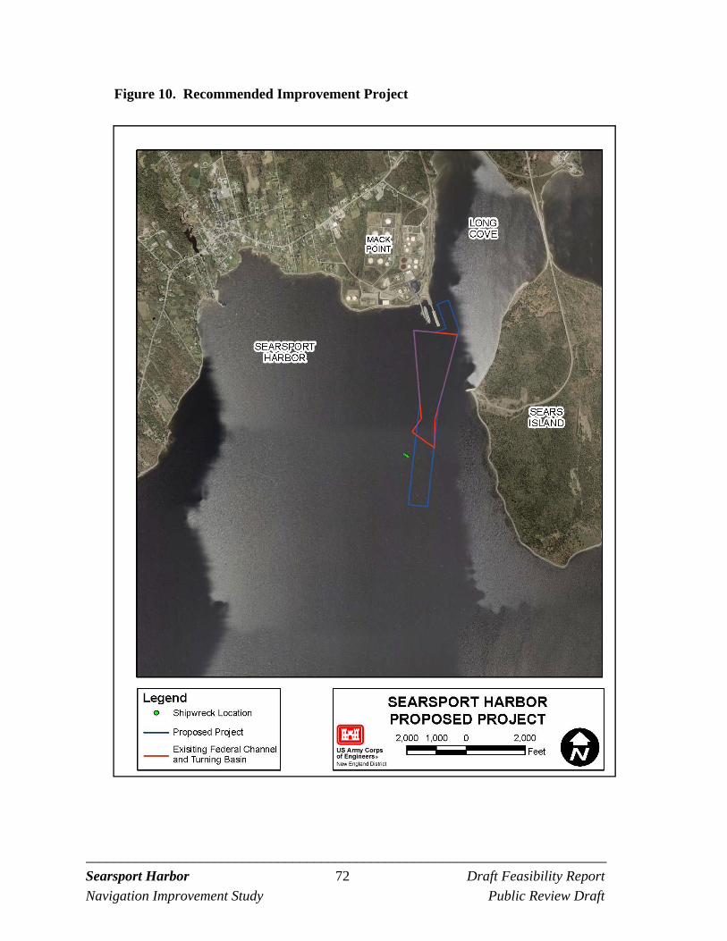
_________________________________________________________________________ Searsport Harbor 72 Draft Feasibility Report
Navigation Improvement Study Public Review Draft
Figure 10. Recommended Improvement Project
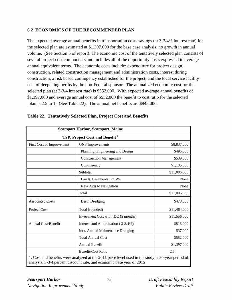
_________________________________________________________________________ Searsport Harbor 73 Draft Feasibility Report
Navigation Improvement Study Public Review Draft
6.2 ECONOMICS OF THE RECOMMENDED PLAN
The expected average annual benefits in transportation costs savings (at 3-3/4% interest rate) for the selected plan are estimated at $1,397,000 for the base case analysis, no growth in annual volume. (See Section 5 of report). The economic cost of the tentatively selected plan consists of several project cost components and includes all of the opportunity costs expressed in average annual equivalent terms. The economic costs include: expenditure for project design, construction, related construction management and administration costs, interest during construction, a risk based contingency established for the project, and the local service facility cost of deepening berths by the non-Federal sponsor. The annualized economic cost for the selected plan (at 3-3/4 interest rate) is $552,000. With expected average annual benefits of $1,397,000 and average annual cost of $552,000 the benefit to cost ratio for the selected plan is 2.5 to 1. (See Table 22). The annual net benefits are $845,000.
Table 22. Tentatively Selected Plan, Project Cost and Benefits
Searsport Harbor, Searsport, Maine
TSP, Project Cost and Benefit 1
First Cost of Improvement GNF Improvements $8,837,000
Planning, Engineering and Design $495,000
Construction Management $539,000
Contingency $1,135,000
Subtotal $11,006,000
Lands, Easements, ROWs None
New Aids to Navigation None
Total $11,006,000
Associated Costs Berth Dredging $478,000
Project Cost Total (rounded) $11,484,000
Investment Cost with IDC (5 months) $11,556,000
Annual Cost/Benefit Interest and Amortization ( 3-3/4%) $515,000
Incr. Annual Maintenance Dredging $37,000
Total Annual Cost $552,000
Annual Benefit $1,397,000
Benefit/Cost Ratio 2.5
1. Cost and benefits were analyzed at the 2011 price level used in the study, a 50-year period of analysis, 3-3/4 percent discount rate, and economic base year of 2015
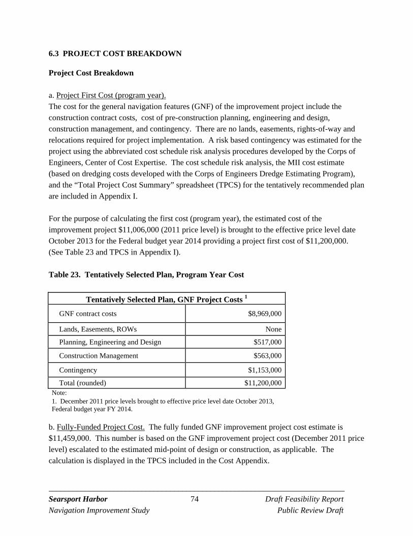
_________________________________________________________________________ Searsport Harbor 74 Draft Feasibility Report
Navigation Improvement Study Public Review Draft
6.3 PROJECT COST BREAKDOWN
Project Cost Breakdown a. Project First Cost (program year). The cost for the general navigation features (GNF) of the improvement project include the construction contract costs, cost of pre-construction planning, engineering and design, construction management, and contingency. There are no lands, easements, rights-of-way and relocations required for project implementation. A risk based contingency was estimated for the project using the abbreviated cost schedule risk analysis procedures developed by the Corps of Engineers, Center of Cost Expertise. The cost schedule risk analysis, the MII cost estimate (based on dredging costs developed with the Corps of Engineers Dredge Estimating Program), and the “Total Project Cost Summary” spreadsheet (TPCS) for the tentatively recommended plan are included in Appendix I. For the purpose of calculating the first cost (program year), the estimated cost of the improvement project $11,006,000 (2011 price level) is brought to the effective price level date October 2013 for the Federal budget year 2014 providing a project first cost of $11,200,000. (See Table 23 and TPCS in Appendix I).
Table 23. Tentatively Selected Plan, Program Year Cost
Tentatively Selected Plan, GNF Project Costs 1
GNF contract costs $8,969,000
Lands, Easements, ROWs None
Planning, Engineering and Design $517,000
Construction Management $563,000
Contingency $1,153,000
Total (rounded) $11,200,000 Note: 1. December 2011 price levels brought to effective price level date October 2013, Federal budget year FY 2014.
b. Fully-Funded Project Cost. The fully funded GNF improvement project cost estimate is $11,459,000. This number is based on the GNF improvement project cost (December 2011 price level) escalated to the estimated mid-point of design or construction, as applicable. The calculation is displayed in the TPCS included in the Cost Appendix.
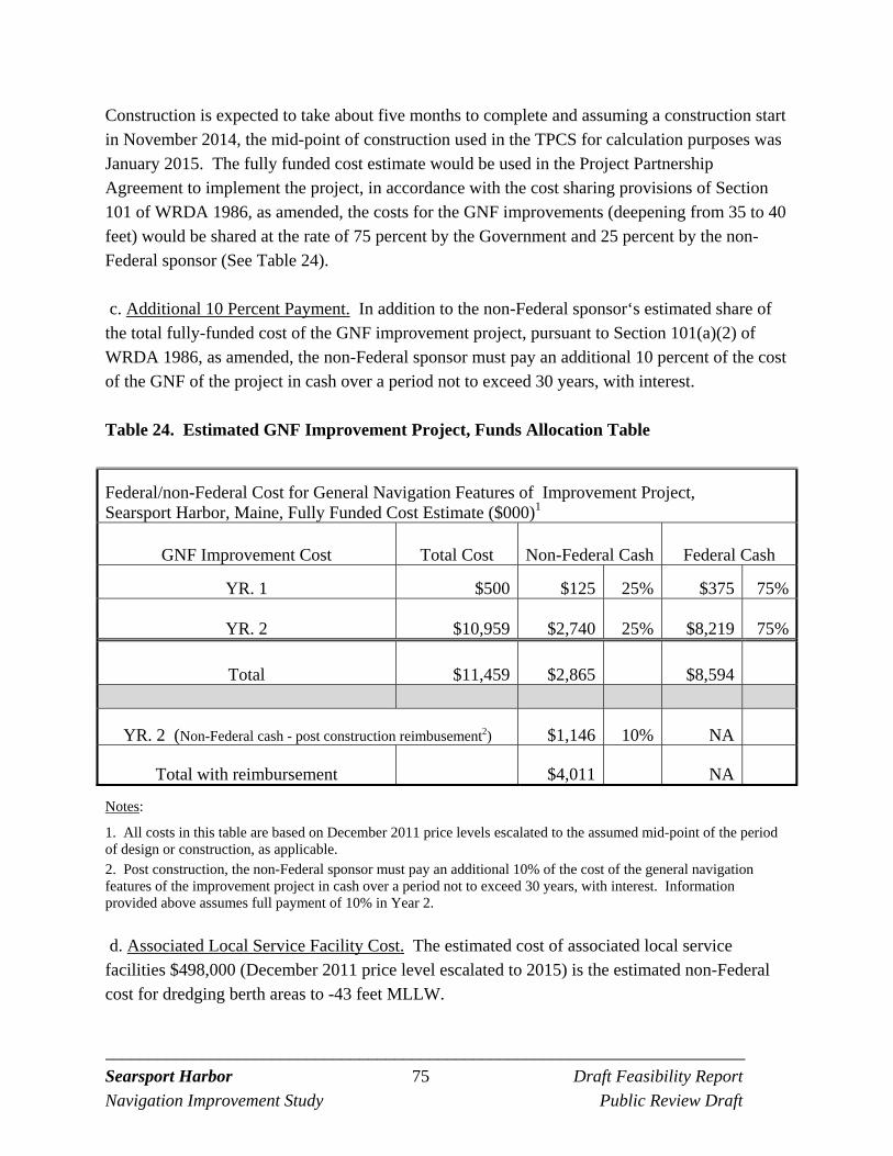
_________________________________________________________________________ Searsport Harbor 75 Draft Feasibility Report
Navigation Improvement Study Public Review Draft
Construction is expected to take about five months to complete and assuming a construction start in November 2014, the mid-point of construction used in the TPCS for calculation purposes was January 2015. The fully funded cost estimate would be used in the Project Partnership Agreement to implement the project, in accordance with the cost sharing provisions of Section 101 of WRDA 1986, as amended, the costs for the GNF improvements (deepening from 35 to 40 feet) would be shared at the rate of 75 percent by the Government and 25 percent by the non-Federal sponsor (See Table 24). c. Additional 10 Percent Payment. In addition to the non-Federal sponsor‘s estimated share of the total fully-funded cost of the GNF improvement project, pursuant to Section 101(a)(2) of WRDA 1986, as amended, the non-Federal sponsor must pay an additional 10 percent of the cost of the GNF of the project in cash over a period not to exceed 30 years, with interest.
Table 24. Estimated GNF Improvement Project, Funds Allocation Table
Federal/non-Federal Cost for General Navigation Features of Improvement Project, Searsport Harbor, Maine, Fully Funded Cost Estimate ($000)1
GNF Improvement Cost Total Cost Non-Federal Cash Federal Cash
YR. 1 $500 $125 25% $375 75%
YR. 2 $10,959 $2,740 25% $8,219 75%
Total $11,459 $2,865 $8,594
YR. 2 (Non-Federal cash - post construction reimbusement2) $1,146 10% NA
Total with reimbursement $4,011 NA
Notes:
1. All costs in this table are based on December 2011 price levels escalated to the assumed mid-point of the period of design or construction, as applicable. 2. Post construction, the non-Federal sponsor must pay an additional 10% of the cost of the general navigation features of the improvement project in cash over a period not to exceed 30 years, with interest. Information provided above assumes full payment of 10% in Year 2. d. Associated Local Service Facility Cost. The estimated cost of associated local service facilities $498,000 (December 2011 price level escalated to 2015) is the estimated non-Federal cost for dredging berth areas to -43 feet MLLW.
_________________________________________________________________________ Searsport Harbor 76 Draft Feasibility Report
Navigation Improvement Study Public Review Draft
e. Real Estate Costs. All work will be in areas seaward of mean high water and will entail work by waterborne plant. There will be no lands, easements or rights of way required for the project. There are no utility relocations required for the project. f. Aids to Navigation. There are no additional costs for aids to navigation as coordination with the US Coast Guard concluded that no new aids are required. Relocating and resetting existing aids to facilitate construction would be required for maintenance dredging even if no improvement dredging was planned.
6.4 ENVIRONMENTAL MITIGATION
As described above in environmental impacts Section 5.4 and in the EA the tentatively recommended plan would have only temporary environmental impacts. Measures to minimize effects of the proposed action include measures to minimize turbidity and seasonal restrictions on dredging. Dredging and disposal would occur between November 8 and April 9 to protect migrating Atlantic salmon and other natural resources in Penobscot Bay and no overflow from the scows during dredging would be allowed to minimize any turbidity impacts.
6.5 REAL ESTATE & UTILITIES
No lands, easements, rights-of way are required for improvement project implementation. No utility relocations are required for project implementation. The area to be dredged and the open water disposal area required for construction are below the ordinary high watermark of the navigable watercourse. Therefore, navigational servitude applies and would be invoked for the project. Berth access for survey and work boats and tugs would be provided at Mack Point by Maine Department of Transportation. As the berths and piers are subject to navigation servitude no credit would be due the non-Federal sponsor for this use.
6.6 OPERATION AND MAINTENANCE
The existing project for Searsport Harbor was constructed in 1964 and no maintenance dredging has occurred or been required at the project until recently. Currently some areas of the authorized Federal Navigation Project require maintenance dredging to return the project to the authorized depth. The calculated maintenance dredging quantity after over 40 years is about 37,100 cy. The improvement of the existing channel is not expected to increase shoaling or maintenance frequency, and maintenance of the improved GNF will not likely be required for more than 20 years after construction.
_________________________________________________________________________ Searsport Harbor 77 Draft Feasibility Report
Navigation Improvement Study Public Review Draft
Future maintenance of the improved Federal project is expected to be minimal. Hydrographic surveys of the area would be conducted by the Corps Survey Boat about every 10 years to monitor the depths at the project. When maintenance dredging is required to reestablish the authorized channel depth it is anticipated that the open water dredged material disposal site would be used. The disposal site selected for this project in Penobscot Bay has more than sufficient capacity for the project’s needs for the entire 50-year project life and beyond. Alternatively the Rockland Disposal Site at the mouth of Penobscot Bay also has sufficient capacity.
6.7 SEA LEVEL CHANGE
The approach was to address the potential impact of sea level rise on a navigation project at Mack Point, Searsport, Maine by considering sea level change (SLC) calculated for the area and apply this information qualitatively to assess the risk to future project performance. In general the types of navigation components that may be affected by sea level rise are jetties and breakwaters affected by increase wave heights, infrastructure at the port, clearance under bridge crossings, and shoaling related to changes in inlet configurations. The existing and proposed Federal Navigation project does not include breakwaters or jetties or bridge crossings, so this is not a concern. The site is not an inlet so changes in shoaling related to inlet configuration changes are not a concern. There is infrastructure at the port, piers and land side terminal facilities and depending on the magnitude of SLC there may be a potential impact to these facilities. There is the potential for SLC to provide a potential benefit to the future depth of water at the navigation project.
Sea Level Change Projection As described in the Sea Level Change (SLC) EC 1165-2-211, USACE is required to use three projected SLC curves for a project area. These curves are; the historic rate of SLC at the project area, an intermediate SLC curve (modified NRC Curve I), and a high SLC curve (modified NRC Curve III). Formulation of the NRC curves from a defined starting date, and for localized subsidence was also provided in the EC which allows for SLC to be calculated for specific project time frames and for specific geographic areas. This is critical since SLC along the coast varies due to local subsidence, uplift, water body movement, etc. Using Equation 11-1 below, which is equation 3 from the EC, Figure 11 was developed for Portland, ME. Portland, ME was used since it is 100 miles south along the Maine coast, and has available historic SLC information from NOAA. Figure 12 shows the long term sea level trend for Portland, ME.
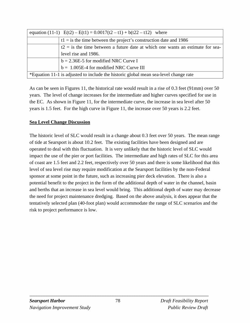
_________________________________________________________________________ Searsport Harbor 78 Draft Feasibility Report
Navigation Improvement Study Public Review Draft
equation (11-1) E(t2) – E(t1) = 0.0017(t2 – t1) + b(t22 – t12) where
t1 = is the time between the project’s construction date and 1986
t2 = is the time between a future date at which one wants an estimate for sea-level rise and 1986.
b = 2.36E-5 for modified NRC Curve I b = 1.005E-4 for modified NRC Curve III
*Equation 11-1 is adjusted to include the historic global mean sea-level change rate
As can be seen in Figures 11, the historical rate would result in a rise of 0.3 feet (91mm) over 50 years. The level of change increases for the intermediate and higher curves specified for use in the EC. As shown in Figure 11, for the intermediate curve, the increase in sea level after 50 years is 1.5 feet. For the high curve in Figure 11, the increase over 50 years is 2.2 feet.
Sea Level Change Discussion The historic level of SLC would result in a change about 0.3 feet over 50 years. The mean range of tide at Searsport is about 10.2 feet. The existing facilities have been designed and are operated to deal with this fluctuation. It is very unlikely that the historic level of SLC would impact the use of the pier or port facilities. The intermediate and high rates of SLC for this area of coast are 1.5 feet and 2.2 feet, respectively over 50 years and there is some likelihood that this level of sea level rise may require modification at the Searsport facilities by the non-Federal sponsor at some point in the future, such as increasing pier deck elevation. There is also a potential benefit to the project in the form of the additional depth of water in the channel, basin and berths that an increase in sea level would bring. This additional depth of water may decrease the need for project maintenance dredging. Based on the above analysis, it does appear that the tentatively selected plan (40-foot plan) would accommodate the range of SLC scenarios and the risk to project performance is low.
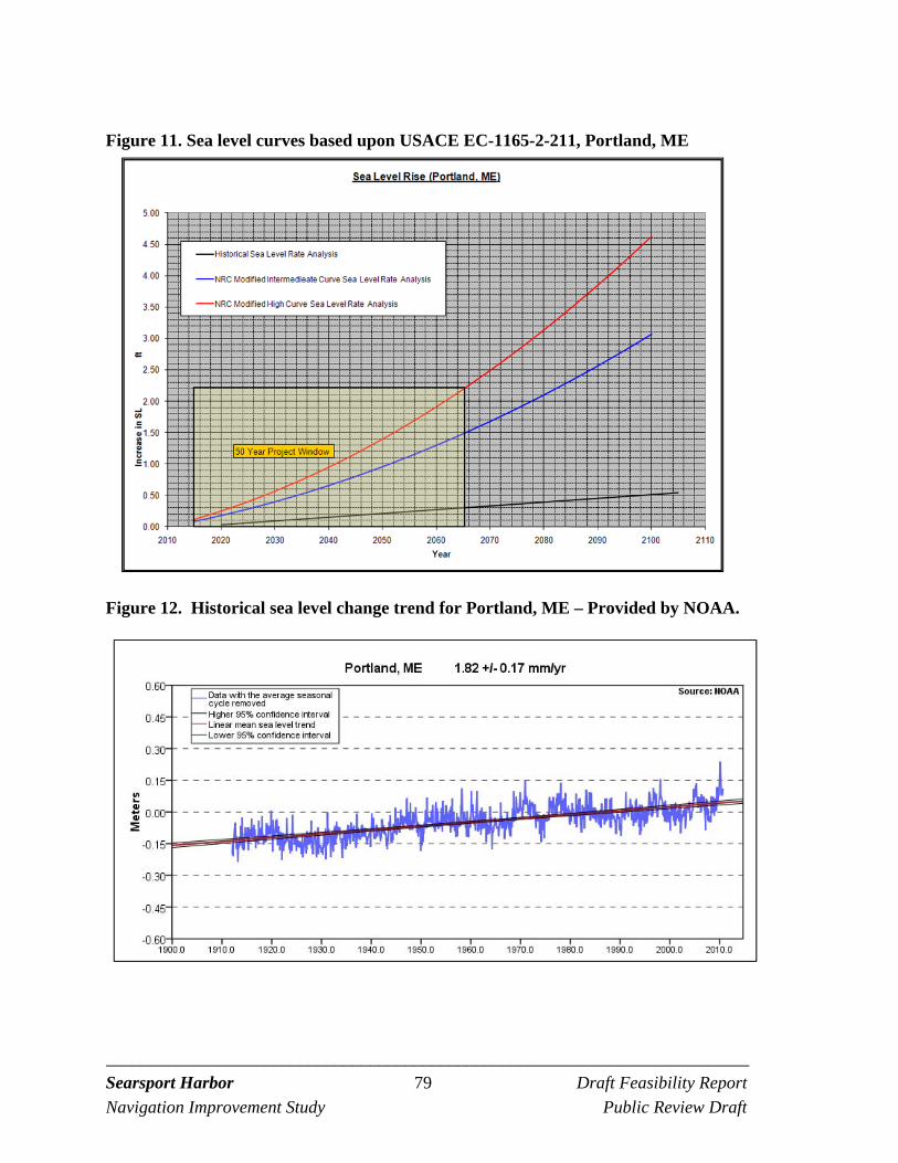
_________________________________________________________________________ Searsport Harbor 79 Draft Feasibility Report
Navigation Improvement Study Public Review Draft
Figure 11. Sea level curves based upon USACE EC-1165-2-211, Portland, ME
Figure 12. Historical sea level change trend for Portland, ME – Provided by NOAA.
_________________________________________________________________________ Searsport Harbor 80 Draft Feasibility Report
Navigation Improvement Study Public Review Draft
6.8 INSTITUTIONAL REQUIREMENTS
In order to implement the navigation improvement project the U.S. Congress would both authorize the project and once authorized provide Federal funds for the navigation improvement project. The Maine Department of Transportation would seek funding for the non-Federal share of the project costs. Project implementation would require both parties to enter into two Corps Project Partnership Agreements, one for the design phase and one for the construction phase.
6.9 STATUS OF LEGAL REVIEW
The draft report and EA is reviewed by Office of Counsel, New England District prior to public release. The District and Division Legal Counsel would also review the Project Partnership Agreements for the project. It is anticipated that the Corps “model” Project Partnership Agreements would be used for design and construction.
6.10 AGENCY TECHNICAL REVIEW DOCUMENTATION
Agency technical review (ATR) was completed for the Corps internal agency formulation briefing (AFB) submittal in July 2011 in accordance with the review plan for the study dated January 2008, as updated December 2012. The Planning Center of Expertise for Deep Draft Navigation was involved in the ATR process. The Corps Cost Engineering Mandatory Center of Expertise will review and certify the recommended project costs prior to the Civil Works Review Board.
6.11 COMPLIANCE WITH NEPA, KEY STATUES AND REGULATIONS
The following paragraphs summarize the relationship of the navigation improvement project to the some of the more pertinent statutes and regulations. The EA includes additional information on project compliance with additional applicable statutes and regulations. A Draft Environmental Assessment (EA) has been prepared for the proposed project and documents compliance with NEPA and other environmental laws, regulations, and policies. Following public review of the Draft EA it anticipated that the outcome would be a Finding of No Significant Impact. Water Quality. Section 401 Water Quality Certificate under the Clean Water Act of 1977 ( P.L. 95-217), as amended, is applicable to the navigation project. The Corps submits a request for a State Water Quality Certification for project construction.
_________________________________________________________________________ Searsport Harbor 81 Draft Feasibility Report
Navigation Improvement Study Public Review Draft
Section 404(b)(1) of the Clean Water Act requires evaluation of the effects associated with the discharge of material in the water of the United States. A 404(b)(1) evaluation has been prepared for the navigation project and is included in pages CWA-1 to CWA-6. Coastal Zone Management. Coastal Zone Management Act of 1982, as amended, 16 U.S.C. 1451 et seq is applicable to the navigation project and is handled by the Maine Coastal Program Office. The Corps submits and obtains Coastal Zone Consistency Determination for the navigation project. Cultural Resources. Pursuant to Section 106 of the National Historic Preservation Act of 1966, as amended, 16 U.S.C. 470 et seq. effects on historic, architectural and archaeological resources are to be evaluated. A marine geophysical investigation and marine archaeological surveys were completed in the study area. The project has been coordinated with the Maine State Historic Preservation Officer and they have provided a letter occurring with the Corps determination that the project should have no effect on resources protected under this Act.
Biological Resources. Laws include:
Fish and Wildlife Coordination Act, as amended, 16 U.S.C. 661 et seq. Magnuson-Stevens Act, as amended, 16 U.S.C. 1801 et seq. Endangered Species Act of 1973, as amended, 16 U.S.C. 1531 et seq.
A USFWS Final Coordination Act Report (FCAR) has been requested from USFWS. Coordination with the National Marine Fisheries Service has determined that the preparation of an Essential Fish Habitat (EFH) Assessment is required and this is included in the EA and was provided to NMFS for review. The Corps has developed its determination regarding endangered species in the EA and this was provided to NMFS for review.
6.12 AGENCY COORDINATION
Federal, State and local agencies and companies were invited to an initial coordinated site visit in Searsport on August 24, 2006. The purpose of the invitation was to solicit comments, concerns, and information from the appropriate resources. See the attached meeting minutes in Appendix A. The study has been discussed at the New England District’s quarterly dredging task force meetings with local, state and Federal agencies. Coordination with agencies assisted in identifying biological resources to include in the Environmental Assessment prepared for the study. Agencies are provided an opportunity to comment on the DFR/EA during the 30-day public review period.
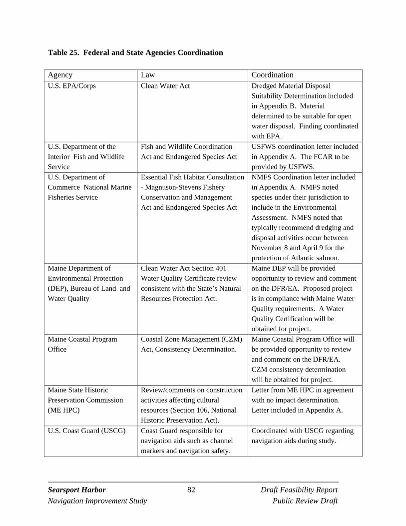
_________________________________________________________________________ Searsport Harbor 82 Draft Feasibility Report
Navigation Improvement Study Public Review Draft
Table 25. Federal and State Agencies Coordination
Agency Law Coordination U.S. EPA/Corps Clean Water Act Dredged Material Disposal
Suitability Determination included in Appendix B. Material determined to be suitable for open water disposal. Finding coordinated with EPA.
U.S. Department of the Interior Fish and Wildlife Service
Fish and Wildlife Coordination Act and Endangered Species Act
USFWS coordination letter included in Appendix A. The FCAR to be provided by USFWS.
U.S. Department of Commerce National Marine Fisheries Service
Essential Fish Habitat Consultation - Magnuson-Stevens Fishery Conservation and Management Act and Endangered Species Act
NMFS Coordination letter included in Appendix A. NMFS noted species under their jurisdiction to include in the Environmental Assessment. NMFS noted that typically recommend dredging and disposal activities occur between November 8 and April 9 for the protection of Atlantic salmon.
Maine Department of Environmental Protection (DEP), Bureau of Land and Water Quality
Clean Water Act Section 401 Water Quality Certificate review consistent with the State’s Natural Resources Protection Act.
Maine DEP will be provided opportunity to review and comment on the DFR/EA. Proposed project is in compliance with Maine Water Quality requirements. A Water Quality Certification will be obtained for project.
Maine Coastal Program Office
Coastal Zone Management (CZM) Act, Consistency Determination.
Maine Coastal Program Office will be provided opportunity to review and comment on the DFR/EA. CZM consistency determination will be obtained for project.
Maine State Historic Preservation Commission (ME HPC)
Review/comments on construction activities affecting cultural resources (Section 106, National Historic Preservation Act).
Letter from ME HPC in agreement with no impact determination. Letter included in Appendix A.
U.S. Coast Guard (USCG) Coast Guard responsible for navigation aids such as channel markers and navigation safety.
Coordinated with USCG regarding navigation aids during study.
_________________________________________________________________________ Searsport Harbor 83 Draft Feasibility Report
Navigation Improvement Study Public Review Draft
6.13 PUBLIC REVIEW AND COMMENT
A public notice on the availability of the DFR/EA will be issued and e-mailed to interested and appropriate stakeholders including agencies, organizations, and individuals. The issuance of a DFR/EA will initiate a 30-day public review period.
6.14 STATUS OF SPONSOR SUPPORT
Maine Department of Transportation is the non-Federal sponsor for improvement project. Maine fully supports the proposed improvement project and views the proposed improvement project to be crucial to the Port’s existing and future operation. The non-Federal sponsor understands its responsibilities under the future Project Partnership Agreements required to design and implement the project. The non-Federal sponsor understands that they will need to sign and submit a non-Federal Sponsor’s Self-Certification of Financial Capability. This will be signed by the chief financial officer or an equivalent official of the non-Federal sponsor and would be provided no more than 90 days prior to the date that the final decision document is submitted to the Corps Division and Headquarters vertical team for review.
_________________________________________________________________________ Searsport Harbor 84 Draft Feasibility Report
Navigation Improvement Study Public Review Draft
7.0 RECOMMENDATION
Place Holder to be finalized after Public Review - As the District Engineer I have considered the environmental, social, and economic effects, the engineering and technical elements, and the comments received from other resource agencies and the public during the Searsport Harbor Feasibility Study and Environmental Assessment. Based upon the sum of the information, I am recommending the -40-feet MLLW Navigation Improvement project be authorized, with such modifications as in the discretion of the Chief of Engineers may be advisable, as it reasonably maximizes net benefits and is consistent with protecting the Nation’s environment. This recommendation is subject to the non-Federal sponsor agreeing to comply with all applicable Federal laws and policies, including that the non-Federal sponsor must agree with the following requirements prior to project implementation. a. Provide 10 percent of the total cost of construction of the GNFs attributable to dredging to a depth not in excess of 20 feet; plus 25 percent of the total cost of construction of the GNFs attributable to dredging to a depth in excess of 20 feet but not in excess of 45 feet; plus 50 percent of the total cost of construction of the GNFs attributable to dredging to a depth in excess of 45 feet as further specified below:
(1) Provide 25 percent of design costs allocated by the Government to commercial navigation in accordance with the terms of a design agreement entered into prior to commencement of design work for the project; (2) Provide, during the first year of construction, any additional funds necessary to pay the full non-Federal share of design costs allocated by the Government to commercial navigation; (3) Provide, during construction, any additional funds necessary to make its total contribution for commercial navigation equal to 10 percent of the total cost of construction of the GNFs attributable to dredging to a depth not in excess of 20 feet; plus 25 percent of the total cost of construction of the GNFs attributable to dredging to a depth in excess of 20 feet but not in excess of 45 feet; plus 50 percent of the total cost of construction of the GNFs attributable to dredging to a depth in excess of 45 feet.
_________________________________________________________________________ Searsport Harbor 85 Draft Feasibility Report
Navigation Improvement Study Public Review Draft
b. Provide all lands, easements, and rights-of way (LER), including those necessary for the borrowing of material and the disposal of dredged or excavated material, and perform or assure the performance of all relocations, including utility relocations, all as determined by the Federal Government to be necessary for the construction or operation and maintenance of the GNFs; c. Pay with interest, over a period not to exceed 30 years following completion of the period of construction of the GNFs, an additional amount equal to 10 percent of the total cost of construction of the GNFs less the amount of credit afforded by the Government for the value of the LER and relocations, including utility relocations, provided by the Sponsor for the GNFs. If the amount of credit afforded by the Government for the value of LER, and relocations, including utility relocations, provided by the Sponsor equals or exceeds 10 percent of the total cost of construction of the GNFs, the Sponsor shall not be required to make any contribution under this paragraph, nor shall it be entitled to any refund for the value of LER and relocations, including utility relocations, in excess of 10 percent of the total cost of construction of the GNFs; d. Provide, operate, and maintain, at no cost to the Government, the local service facilities in a manner compatible with the project’s authorized purposes and in accordance with applicable Federal and State laws and regulations and any specific directions prescribed by the Federal Government; e. Provide 50 percent of the excess cost of operation and maintenance of the project over that cost which the Federal Government determines would be incurred for operation and maintenance if the project had a depth of 45 feet; f. Give the Federal Government a right to enter, at reasonable times and in a reasonable manner, upon property that the Sponsor owns or controls for access to the project for the purpose of completing, inspecting, operating and maintaining the GNFs; g. Hold and save the United States free from all damages arising from the construction or operation and maintenance of the project, any betterments, and the local service facilities, except for damages due to the fault or negligence of the United States or its contractors; h. Keep, and maintain books, records, documents, and other evidence pertaining to costs and expenses incurred pursuant to the project, for a minimum of 3 years after completion of the accounting for which such books, records, documents, and other evidence are required, to the extent and in such detail as will properly reflect total cost of the project, and in accordance with the standards for financial management systems set forth in the Uniform Administrative
_________________________________________________________________________ Searsport Harbor 86 Draft Feasibility Report
Navigation Improvement Study Public Review Draft
Requirements for Grants and Cooperative Agreements to State and local governments at 32 CFR, Section 33.20; i. Perform, or ensure performance of, any investigations for hazardous substances that are determined necessary to identify the existence and extent of any hazardous substances regulated under the Comprehensive Environmental Response, Compensation, and Liability Act (CERCLA), 42 USC 9601–9675, that may exist in, on, or under LER that the Federal government determines to be necessary for the construction or operation and maintenance of the GNFs. However, for lands, easements, or rights-of-way that the Government determines to be subject to the navigation servitude, only the Government shall perform such investigations unless the Federal Government provides the Sponsor with prior specific written direction, in which case the Sponsor shall perform such investigations in accordance with such written direction; j. Assume complete financial responsibility, as between the Federal Government and the Sponsor, for all necessary cleanup and response costs of any hazardous substances regulated under CERCLA that are located in, on, or under LER that the Federal Government determines to be necessary for the construction or operation and maintenance of the project; k. To the maximum extent practicable, perform its obligations in a manner that will not cause liability to arise under CERCLA; l. Comply with Section 221 of Public Law 91-611, Flood Control Act of 1970, as amended, (42 U.S.C. 1962d-5b) and Section 101(e) of the WRDA 86, Public Law 99-662, as amended, (33 U.S.C. 2211(e)) which provide that the Secretary of the Army shall not commence the construction of any water resources project or separable element thereof, until the Sponsor has entered into a written agreement to furnish its required cooperation for the project or separable element; m. Comply with the applicable provisions of the Uniform Relocation Assistance and Real Property Acquisition Policies Act of 1970, Public Law 91-646, as amended, (42 U.S.C. 4601-4655) and the Uniform Regulations contained in 49 CFR Part 24, in acquiring lands, easements, and rights-of-way necessary for construction, operation, and maintenance of the project including those necessary for relocations, the borrowing of material, or the disposal of dredged or excavated material; and inform all affected persons of applicable benefits, policies, and procedures in connection with said act; n. Comply with all applicable Federal and State laws and regulations, including, but not limited to: Section 601 of the Civil Rights Act of 1964, Public Law 88-352 (42 U.S.C. 2000d),
_________________________________________________________________________ Searsport Harbor 87 Draft Feasibility Report
Navigation Improvement Study Public Review Draft
and Department of Defense Directive 5500.11 issued pursuant thereto; Army Regulation 600-7, entitled “Nondiscrimination on the Basis of Handicap in Programs and Activities Assisted or Conducted by the Department of the Army”; and all applicable Federal labor standards requirements including, but not limited to, 40 U.S.C. 3141-3148 and 40 U.S.C. 3701-3708 (revising, codifying and enacting without substantive change the provisions of the Davis-Bacon Act (formerly 40 U.S.C. 276a et seq.), the Contract Work Hours and Safety Standards Act (formerly 40 U.S.C. 327 et seq.), and the Copeland Anti-Kickback Act (formerly 40 U.S.C. 276c); o. Provide the non-Federal share of that portion of the costs of mitigation and data recovery activities associated with historic preservation, that are in excess of 1 percent of the total amount authorized to be appropriated for the project; and p. Not use funds from other Federal programs, including any non-Federal contribution required as a matching share therefore, to meet any of the Sponsor’s obligations for the project unless the Federal agency providing the Federal portion of such funds verifies in writing that such funds are authorized to be used to carry out the project. The recommendations contained herein reflect the information available at this time and current policies governing formulation of individual projects. They do not reflect program and budgeting priorities inherent in the formulation of a National Civil Works construction program nor the perspective of higher review levels within the Executive Branch. Consequently, the recommendations may be modified before they are transmitted to the Congress as proposals for authorization and implementation funding. However, prior to transmittal to the Congress, the non-Federal sponsor, the Maine Department of Transportation and other parties would be advised of any modifications and would be afforded an opportunity for further comment. ______________ ________________________ Date Charles P. Samaris Colonel, Corps of Engineers District Commander
_________________________________________________________________________ Searsport Harbor 88 Draft Feasibility Report
Navigation Improvement Study Public Review Draft
REFERENCES Barnhardt, W.A., D.A. Belknap, A.R. Kelley, J.T. Kelley, S.M. Dickson. 1996. Surficial
Geology of the Maine Inner Continental Shelf, Rockland to Bar Harbor, Maine. Geological Map No. 96-11. Published by Department of Conservation, Maine Geological Survey.
Battelle. 2009. Final Summary Report, Plume Monitoring, Boston Harbor Inner Harbor
Maintenance Dredging Project. Submitted to: New England District, U.S. Army Corps of Engineers, 696 Virginia Rd, Concord, MA.
Baum, E. T. 1997. Maine Atlantic Salmon: A National Treasure. Atlantic Salmon Unlimited.
224 pp. Bigelow, H.B. and W.C. Schreder. 1953. Fishes of the Gulf of Maine. U.S Fish and Wildlife
Service. Fisheries Bulletin 53: 1-477. Bohlen, F.W., D.F. Cundy, and J.M. Tramontano. 1979. Suspended Material Distributions in the
Wake of Estuarine Channel Dredging Operations. Estuarine and Coastal Marine Science 9:699-711.
Brandsma, M.G. and D.J. Divoky. 1976. Development of Models for Prediction of Short-Term
Fate of Dredged Material Discharge in the Estuarine Environment. Contract Report D-76-5. U.S. Army Corps of Engineers, Waterways Experiment Station, Vicksburg, MS.
Chang, S., P.L. Berrien, D.L. Johnson, and W.W. Morse. 1999. Essential Fish Habitat Source
Document: Windowpane Scophthalmus aquosus, Life History and Habitat Characteristics. NOAA Technical Memorandum NMFS-NE-137. National Oceanic and Atmospheric Administration, National Marine Fisheries Service, Northeast Fisheries Science Center, Woods Hole, MA.
Corps. 1986. Fate of Dredged Material during Open-Water Disposal. U.S. Army Corps of
Engineers, Waterways Experiment Station. EEPD-01-2, September 1986, http://www.wes.army.mil/el/dots/eedptn.html. 12p.
Ellis, S.A. and D.F. Cowan. 1999. Final Report: Intertidal Lobster Monitoring Program
Penobscot Bay Lobster Collaborative, 1998 and 1999. Submitted to the Island Institute.
_________________________________________________________________________ Searsport Harbor 89 Draft Feasibility Report
Navigation Improvement Study Public Review Draft
ENSR International. 2002. Boston Harbor Navigation Improvement Project: Phase 2 Summary Report. Prepared for U.S. Army Corps of Engineers, New England District and Massachusetts Port Authority. Document No. 9000-178-000. Contract No. DACW33-96-D-004, Task Order 51. May 2002.
Hales, L.Z. 1996. Analysis of Dredged Material Disposed in Open Water: Summary Report for
Technical Area 1. U.S. Army Corps of Engineers Dredging Research Program, Vicksburg, MS. Technical Report DRP-96-4.
Johnson, D.L. 2004. Essential Fish Habitat Source Document: American Plaice
Hippoglossoides platessoides, Life History and Habitat Characteristics. NOAA Technical Memorandum NMFS-NE-187. National Oceanic and Atmospheric Administration, National Marine Fisheries Service, Northeast Fisheries Science Center, Woods Hole, MA.
Kelley, J.T., Dickson, S.M, Belknap, D.F., Barnhardt, W.A., and Henderson, M. 1994. Giant
Sea-bed Pockmarks: Evidence for Gas Escape from Belfast Bay, Maine. Geology, vol. 22, pp. 59-62.
Kelley, J.T., W.A. Barnhardt, D.F. Belknap, S.M. Dickson, A.R. Kelley, and L. Ward. 1996.
The Seafloor Revealed: The Geology of the Northwestern Gulf of Maine Inner Continental Shelf. Maine Geological Survey, Natural Resources information and Mapping Center, Open-File Report 96-06.
Lazzari, M. 2001. Dynamics of Larval Fish Abundance in Penobscot Bay, Maine. Fisheries
Bulletin, vol. 99, pp. 81-93. Lazzari, M. and Tupper. 2002. Importance of Shallow Water Habitats for Demersal Fishes and
Decapod Crustaceans in Penobscot Bay, Maine. Environmental Biology of Fishes, vol. 63, no. 1, pp. 57-66.
Maine Department of Transportation (ME DOT). 1987. Sears Island Dry Cargo Terminal and
Access Road, Searsport, Waldo, County, Maine. Final Environmental Impact Statement. U.S. Department of Transportation, Federal Highway Administration and Maine Department of Transportation
_________________________________________________________________________ Searsport Harbor 90 Draft Feasibility Report
Navigation Improvement Study Public Review Draft
McBride, R. 2004. Bluefish Life History. Written by Richard McBride, Florida Marine Research Institute April 12, 2004, edited by Paul Caruso, Massachusetts Division of Marine Fisheries.
National Marine Fisheries Service and U.S. Fish and Wildlife Service (NMFS and USFWS).
2005. Recovery Plan for the Gulf of Maine Distinct Population Segment of Atlantic Salmon (Salmo salar). National Marine Fisheries Service, Silver Spring, MD.
NOAA/NMFS. 1999. Essential Fish Habitat Designations within the Northeast Region (Maine
to Virginia), Working Copy. O’Donnell, K.P., R.A. Wahle, M. Bell, and M. Dunnington. 2007. Spatially Referenced Trap
Arrays Detect Sediment Disposal Impacts on Lobsters and Crabs in a New England Estuary. Marine Ecology Progress Series, vol. 348, pp. 249-260.
Pereira, J.J., R. Goldberg, J.J. Ziskowski, P.L. Berrien, W.W. Morse, and D.L. Johnson. 1999.
Essential Fish Habitat Source Document: Winter Flounder Pseudopleuronectes americanus, Life History and Habitat Characteristics. NOAA Technical Memorandum NMFS-NE-138. National Oceanic and Atmospheric Administration, National Marine Fisheries Service, Northeast Fisheries Science Center, Woods Hole, MA.
Permanent International Association of Navigation Congresses (PIANC). June 1997. Report.
Robinson, David S. (with contributions by Jeffrey D. Gardner). 2007. Marine Archaeological Survey, Searsport Harbor, Searsport, Maine. Submitted by: Public Archaeology Laboratory (PAL), Pawtucket, Rhode Island, PAL Report No. 2019, Contract No. DACW33-03-D-0002 IDIQ, Task Order No. 12. Submitted to: USACE, New England District, Concord, Massachusetts.
Robinson, David S. (with contributions by: Jeffrey D. Gardner, Margaret H. Sano, and Jeffrey J.
Hall). 2008. Preliminary Assessment, Searsport Harbor Shipwreck, Searsport, Maine. Submitted by: PAL, Pawtucket, Rhode Island, Report No. 2019, Contract No. DACW33-03-D-0002 IDIQ, Task Order No. 12, Optional Task No. 9. Submitted to: USACE, New England District, Concord, Massachusetts.
Ruggaber, G.J. and E.E. Adams. 2000a. Dynamics of Particle Clouds Related to Open-Water Sediment Disposal: 2. Loss of Material during Convective Descent in: Conference on
_________________________________________________________________________ Searsport Harbor 91 Draft Feasibility Report
Navigation Improvement Study Public Review Draft
Dredged Material Management: Options and Environmental Consideration. MIT Sea Grant College Program. Cambridge, MA.
Ruggaber, G.J. and E.E. Adams. 2000b. Dynamics of Particle Clouds Related to Open-Water
Sediment Disposal: Sediment Trap Experiments in: Conference on Dredged Material Management: Options and Environmental Consideration. MIT Sea Grant College Program. Cambridge, MA.
Scanlon, K.M. and Knebel, H.J. 1989. Pockmarks in the Floor of Penobscot Bay, Maine. Geo-
Marine Letters 9:53-58.
Science Applications International Corporation (SAIC). 1988. Seasonal Monitoring Cruise at the Western Long Island Sound Disposal Site, August 1986. DAMOS Contribution No. 61. U.S. Army Corps of Engineers, New England Division, Waltham, MA. 20 pp.
SAIC. 2000. Survey at a Candidate Disposal Site near Steels Ledge in Penobscot Bay, Maine. Submitted to: New England District, U.S. Army Corps of Engineers, 696 Virginia Rd, Concord, MA.
Studholme, A.L., D.B. Packer, P.L. Berrien, D.L. Johnson, C.A. Zetlin, and W.W. Morse. 1999.
Essential Fish Habitat Source Document: Atlantic Mackerel Scomber scombrus, Life History and Habitat Characteristics. NOAA Technical Memorandum NMFS-NE-141. National Oceanic and Atmospheric Administration, National Marine Fisheries Service, Northeast Fisheries Science Center, Woods Hole, MA.
Wilson, Carl. April 22. 2009. Personal Communication, Maine Department of Marine
Resources.

PUBLIC REVIEW DRAFT Environmental Assessment
Finding of No Significant Impact &
Clean Water Act § 404 (b) (1) Evaluation
SEARSPORT HARBOR NAVIGATION IMPROVEMENT PROJECT
SEARSPORT, MAINE
APRIL 2013

EA-i Public Review Draft
Searsport Harbor Searsport, Maine
Navigation Improvement Project General Investigation
TABLE OF CONTENTS PAGE NUMBER 1.0 INTRODUCTION 1
1.1 PROJECT AREA DESCRIPTION, HISTORY AND BACKGROUND 1 1.2 PURPOSE AND NEED FOR THIS PROJECT 5 1.3 PURPOSE AND SCOPE OF THIS ENVIRONMENTAL 5 ASSESSMENT 1.4 PUBLIC REVIEW AND COMMENT 6 1.5 PROJECT AUTHORITY 6 1.6 PERMITS, APPROVALS, AND REGULATORY 7
REQUIREMENTS
2.0 ALTERNATIVES 10 2.1 GENERAL 10 2.2 NO ACTION ALTERNATIVE 10 2.3 EVALUATED ALTERNATIVES 10
2.3.1 Navigation Improvement Alternatives 10 2.3.2 Dredged Material Disposal Alternatives 12
2.3.2.1 Beneficial Use and Upland Disposal 12 2.3.2.2 Aquatic Disposal 14
3.0 DESCRIPTION OF PROPOSED PROJECT 17
3.1 Federal Project 17 3.2 Non-Federal Project 19
4.0 AFFECTED ENVIRONMENT 20
4.1 GEOLOGY 20 4.2 PROJECT SEDIMENTS 20 4.3 WATER RESOURCES 27
4.3.1 Penobscot River Watershed 27 4.3.2 Marine Water Quality 27
4.4 BIOLOGICAL RESOURCES 27 4.4.1 General 27 4.4.2 Eelgrass 28 4.4.3 Benthic Resources 28 4.4.4 Shellfish Resources 32 4.4.5 Finfish Resources 32 4.4.6 Essential Fish Habitat 34
4.5 ENDANGERED AND THREATENED SPECIES 34 4.5.1 Federally Listed Endangered and Threatened Species 34 4.5.2 Federally Listed Candidate and Species of Special Concern 36 4.5.3 State Listed Species 37
4.6 AIR QUALITY 37
EA-ii Public Review Draft
4.7 CULTURAL RESOURCES 38 4.7.1 Pre-Contact Period Archaeological Assessment and Sensitivity 38 4.7.2 Contact and Post-Contact Archaeological Assessment and Sensitivity 39
4.8 SOCIOECONOMICS 40 5.0 ENVIRONMENTAL CONSEQUENCES 41
5.1 GEOLOGY 41 5.2 PHYSICAL and WATER QUALITY IMPACTS 42
5.2.1 Dredging Impacts 42 5.2.2 Disposal Impacts 44
5.3 CHEMICAL IMPACTS 46 5.4 BIOLOGICAL IMPACTS 47
5.4.1 General 47 5.4.2 Benthic Resources 48 5.4.3 Fisheries Resources 48 5.4.4 Essential Fish Habitat 48
5.5 ENDANGERED AND THREATENED SPECIES 53 5.5.1 Federally Listed or Proposed Endangered or 53
Threatened Species 5.5.2 Other Special Status Species 53
5.6 AIR QUALITY 54 5.7 CULTURAL RESOURCES 55 5.8 ENVIRONMENTAL JUSTICE AND PROTECTION OF CHILDREN 57
6.0 CUMULATIVE IMPACT 58
7.0 ACTIONS TO MINIMIZE ENVIRONMENTAL IMPACTS 59
8.0 COMPLIANCE WITH FEDERAL ENVIRONMENTAL STATUTES, 60 EXECUTIVE ORDERS AND EXECUTIVE MEMORANDUM 9.0 REFERENCES 64
10.0 LIST OF PREPARERS 69 FINDING OF NO SIGNIFICANT IMPACT (FONSI) RECORD OF NON-APPLICABILITY (RONA) AND EMISSIONS CALCULATIONS CLEAN WATER ACT SECTION 404 (b) (1) EVALUATION
EA-iii Public Review Draft
FIGURES Figure EA-1. Searsport Harbor Federal Navigation Project Location 2 Figure EA-2. Existing Federal Navigation Project 3 Figure EA-3. Mack Point, Searsport Harbor, Maine 4 Figure EA-4. Dredged Material Disposal Site Locations 16 Figure EA-5. Existing and Proposed Federal Navigation Project 18 Figure EA-6. Sediment Sample Locations 21 Figure EA-7. Eelgrass Video Transects in Long Cove 29 Figure EA-8. Benthic Sample Locations 30 Figure EA-9. Benthic Sample Locations – Penobscot Bay Disposal Site 31 Figure EA-10. Station C-Photograph of Top of Vibracore 44 Figure EA-11. Long Cove Maneuvering Area 49
TABLES
Table EA-1. Major Environmental Permits and Reviews for the Sears Island Navigation Improvement Project 7
Table EA-2. Dredged Material Quantities (CY) for Each Navigation Improvement Depth 11 Table EA-3. Benefit-Cost Analysis for Alternative Searsport Harbor Navigation Deepening Plans 12 Table EA-4. Federal Maintenance and Improvement Dredged Material Quantities (CY) 17 Table EA-5. Non-Federal Berth Dredged Material Quantities (CY) 19 Table EA-6. Sample Stations, Cross-Reference for Station ID and Individual Sample ID 23 Table EA-7. List of Parameters Analyzed and Laboratory Achieved Detection Limits 24 Table EA-8. Summary of Geotechnical Results for Sediment Cores and Reference Samples 25 Table EA-9. Summary of Sediment Organic Contaminant (µg/Kg dry weight) and Metals (µg/g dry weight) Data 26 Table EA-10. Fish Species in the Area of Sears Island, CMP Fish Survey (ME DOT, 1987) 33 Table EA-11. Average Annual Employment for Searsport by Industry (2005-2009) 40
Table EA-12. Summary of Dredging and Disposal Impacts 41 APPENDICES
Appendix A: Public and Agency Involvement and Pertinent Correspondence Appendix B: Dredged Material Disposal Suitability Determination Appendix C: Benthic Resource Data Appendix D: Essential Fish Habitat Life History

EA-iv Public Review Draft
(This page intentionally left blank.)

EA-1 Public Review Draft
ENVIRONMENTAL ASSESSMENT Searsport Harbor, Searsport, Maine
Navigation Improvement Project General Investigation
1.0 INTRODUCTION
This Environmental Assessment (EA) has been prepared by staff from the U.S. Army Corps of Engineers (USACE), New England District. The EA evaluates the environmental impacts of the Federal action to improve the existing navigation project in Searsport Harbor, Searsport, Maine. The Federal navigation project includes an entrance channel and turning basin which ends at Mack Point (see Figure EA-1). Two terminals are located on Mack Point to accommodate ships transferring goods to and from Maine. One terminal is owned and managed by Sprague Energy (the Liquid Cargo Pier) and the other terminal by the Maine Port Authority (the Dry Cargo Pier).
This report meets the requirements for compliance with the National Environmental Policy Act (NEPA) of 1969 and all applicable Federal environmental regulations and laws, and Federal executive orders, including an evaluation for meeting the requirements of Section 404 (b) (1) of the Clean Water Act. Normally, the USACE prepares an Environmental Impact Statement (pursuant to 33 Code of Federal Regulations (CFR) 230.6) for Federal actions that require a Feasibility Report for authorization and construction of major projects. However, the District commander may consider the use of an EA for particular actions if early studies and coordination show that a particular action is not likely to have a significant impact on the quality of the human environment (33 CFR 230.6). Methods used to evaluate the impacts to environmental resources of the area include field evaluations, review of available environmental data, historical knowledge and evaluations, and extensive coordination with Federal, State, and local environmental resource agencies and private individuals. Early coordination indicated that protected resources can be easily avoided by using environmental windows. Also, the vast majority of the material to be dredged is parent material (not exposed to anthropogenic contamination). Most of the dredged material would be removed from a previously disturbed area and disposed at deep open water disposal site in Penobscot Bay. No significant impacts on the quality of the human environment are expected. 1.1 PROJECT AREA DESCRIPTION, HISTORY, AND BACKGROUND
The proposed project is located at the head of Penobscot Bay in the coastal community of Searsport, Maine. The Penobscot River empties into Penobscot Bay to the east of Searsport. A small commercial fishing harbor is located near the center of town to the west of Mack Point, while the deep-draft commercial cargo port is located on Mack Point to the east of the center of town. Searsport Harbor is one of three commercial ports developed to meet the deepwater marine transportation needs of Maine. The other ports are Portland Harbor to the south and Eastport Harbor to the north.
The Federal navigation project in Searsport Harbor consists of a 500-foot wide and 3,500
feet long entrance channel and a turning basin at the end with a maximum width of 1,500 feet. The existing channel includes a widened flare at its seaward end to ease approach to the harbor. The entrance channel is located just west of Sears Island and is 35 feet deep at mean lower low water (MLLW; all depths are in MLLW). See Figure EA-2. The turning basin, adjacent to the
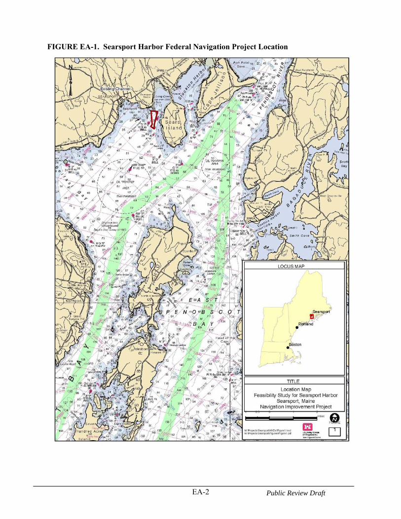
EA-2 Public Review Draft
FIGURE EA-1. Searsport Harbor Federal Navigation Project Location
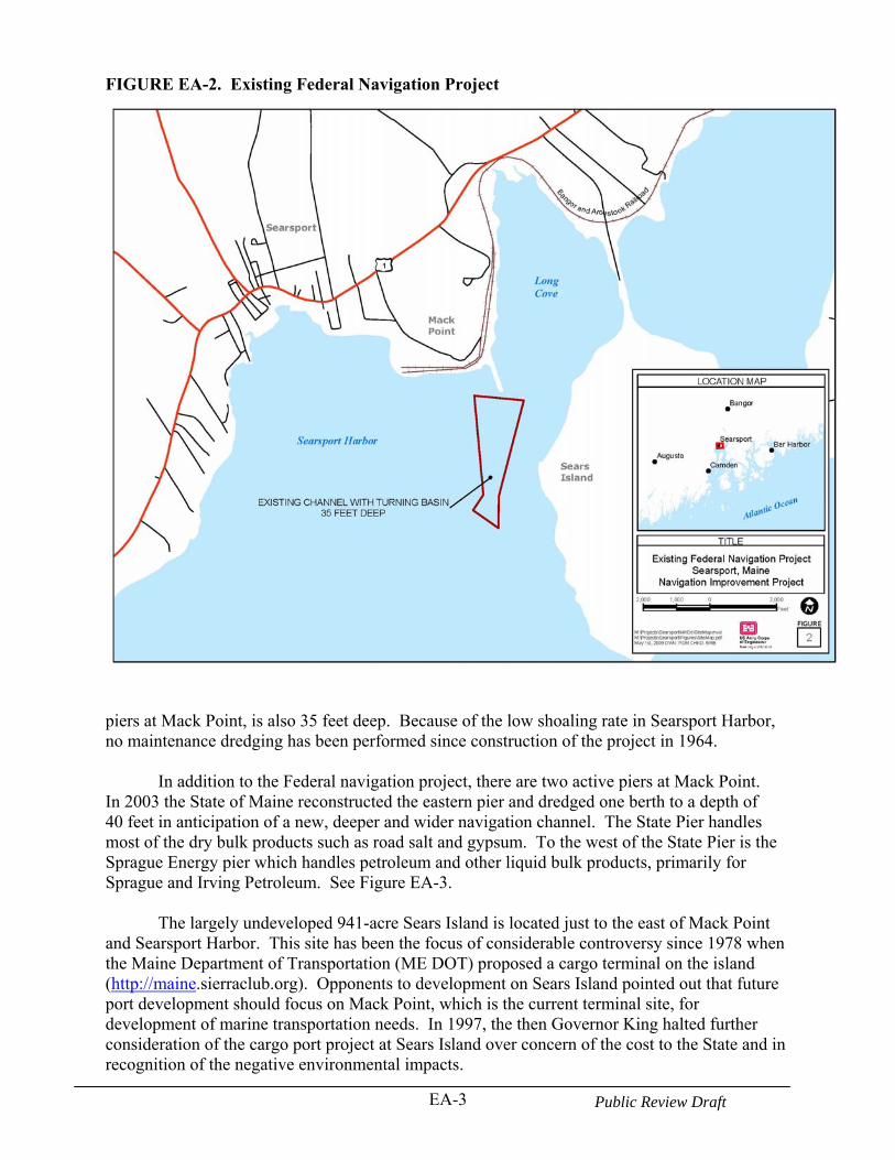
EA-3 Public Review Draft
FIGURE EA-2. Existing Federal Navigation Project
piers at Mack Point, is also 35 feet deep. Because of the low shoaling rate in Searsport Harbor, no maintenance dredging has been performed since construction of the project in 1964.
In addition to the Federal navigation project, there are two active piers at Mack Point. In 2003 the State of Maine reconstructed the eastern pier and dredged one berth to a depth of 40 feet in anticipation of a new, deeper and wider navigation channel. The State Pier handles most of the dry bulk products such as road salt and gypsum. To the west of the State Pier is the Sprague Energy pier which handles petroleum and other liquid bulk products, primarily for Sprague and Irving Petroleum. See Figure EA-3.
The largely undeveloped 941-acre Sears Island is located just to the east of Mack Point and Searsport Harbor. This site has been the focus of considerable controversy since 1978 when the Maine Department of Transportation (ME DOT) proposed a cargo terminal on the island (http://maine.sierraclub.org). Opponents to development on Sears Island pointed out that future port development should focus on Mack Point, which is the current terminal site, for development of marine transportation needs. In 1997, the then Governor King halted further consideration of the cargo port project at Sears Island over concern of the cost to the State and in recognition of the negative environmental impacts.
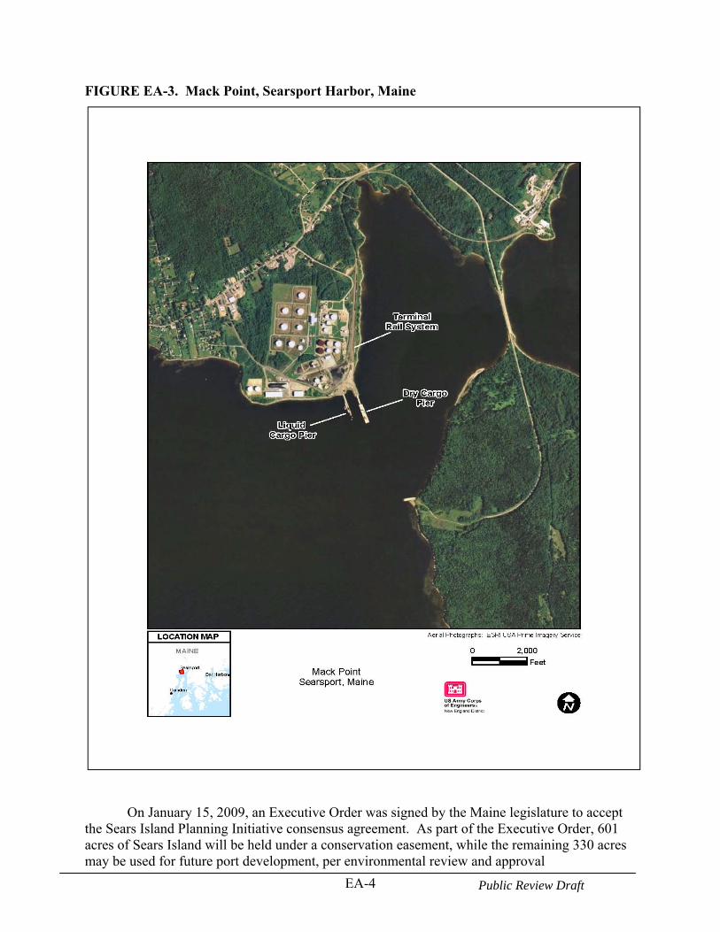
EA-4 Public Review Draft
FIGURE EA-3. Mack Point, Searsport Harbor, Maine
On January 15, 2009, an Executive Order was signed by the Maine legislature to accept
the Sears Island Planning Initiative consensus agreement. As part of the Executive Order, 601 acres of Sears Island will be held under a conservation easement, while the remaining 330 acres may be used for future port development, per environmental review and approval
EA-5 Public Review Draft
(www.maine.sierraclub.org/sears_island). The development of a new port at Sears Island remains as an item of debate among local stakeholders and is not considered under this proposed navigation improvement project which is limited to the port needs at Mack Point. 1.2 PURPOSE AND NEED FOR THE PROJECT
Searsport Harbor at Mack Point is the largest deep draft commercial port north of Portland, Maine. The State Pier handles aggregates, forest products and other bulk cargos. The Sprague Energy terminal is located to the west of the State Pier. Since completion of the new State Pier, and upgrades to the petroleum terminals, the size of ships calling on Mack Point/Searsport Harbor has increased. As a consequence, the existing controlling depths in the Searsport channel are inadequate for existing and projected future vessel traffic. While the current fleet can access the Mack Point berths, a number of navigational inefficiencies exist due to the existing depths, which results in higher transportation costs. Among these inefficiencies are: tidal delays, light loading of vessels, the inability to switch to larger vessels, the inability to attract liner cargo service, and limits to future imports and exports at Searsport due to channel depths restricting the size of prospective vessels. In addition, the navigation pilots stated that the constriction mid-way between the channel entrance and the turning area requires widening to support the maneuvering of larger vessels. Without channel improvements, the commercial potential of the new State Pier will not be realized and existing navigational inefficiencies will continue. Project improvements will also provide more room to maneuver the larger ships that use the port.
The primary purpose of the proposed project is to reduce transportation costs incurred by shippers from navigation inefficiencies. The preferred alternative is identified based on USACE water resources planning regulations as described in ER1105-2-100, “Planning Guidance Notebook” and in compliance with other applicable laws, policies, and regulations. In general, alternatives are formulated and then evaluated to determine which alternative provides the greatest net economic benefit. The economic benefits calculated for this study are National Economic Development (NED) benefits.
NED benefits are contributions to national economic development that increase the value
of the national output of goods and services. For deep-draft navigation projects, the most common type of NED benefit is transportation cost savings, typically waterborne transportation cost savings. The NED benefits are estimated by comparing the transportation costs without the project to the transportation costs with the project. Any decrease in total transportation costs resulting from the project equal the benefits of the project. The benefits are then subtracted from the project costs to determine the alternative net benefits. The alternative that maximizes the net benefits, while minimizing environmental impacts is the USACE NED plan and generally the proposed project (action).
1.3 PURPOSE AND SCOPE OF THIS ENVIRONMENTAL ASSESSMENT
This EA is designed to serve as a concise public document that briefly provides sufficient evidence and analysis for determining whether to prepare an environmental impact statement or a finding of no significant impact. An EA also aids the USACE in compliance with the National Environmental Policy Act (NEPA), when an environmental impact statement is not necessary. The document includes brief discussions of the need for the proposal and the alternatives as
EA-6 Public Review Draft
required by NEPA, the environmental impacts of the proposed action and alternatives, and a listing of agencies and persons consulted. 1.4 PUBLIC REVIEW AND COMMENT
Federal, State and local agencies and companies were invited to an initial coordinated site visit on August 24, 2006 in Searsport, ME. The purpose of the invitation was to solicit comments, concerns, and information from the appropriate resources on the proposed project. See the attached meeting minutes in Appendix A for additional details.
A Public Notice on the availability of the draft environmental assessment will be issued and mailed to interested and appropriate individuals, organizations, and corporations. The issuance of a draft environmental assessment will initiate a 30-day public review period in accordance with the Council of Environmental Quality regulations (40 CFR Parts 1500-1508). Several State and Federal natural resource agencies were also coordinated with in the development of this environmental assessment. 1.5 PROJECT AUTHORITY
The General Investigation (USACE) program represents a vehicle for State and local government to pursue Federal assistance through Congressional initiative. Congress may call for an investigation through legislation or a committee resolution. Work identified under these existing authorities can be extensive. Typically the budget cycle results in a 1-2 year process for the identification of a proposed investigation and initial funding of that work.
This study of Searsport Harbor was authorized by a House Committee on Transportation
and Infrastructure Resolution that was adopted on July 26, 2000. The Searsport Harbor study was initiated at the request of the State of Maine, Department of Transportation, the study sponsor, using funds added to the Fiscal Year 2004 Energy and Water Development Appropriations Bill. The authorizing study language is as follows:
Resolved by the Committee on Transportation and Infrastructure of the United States House of Representatives, that the Secretary of the Army is requested to review the report of the Chief of Engineers on Searsport Harbor, Maine, published as House Document 500, 87th Congress, 2nd Session, and other pertinent reports, with a view to determine whether modifications of the recommendations contained therein are advisable in the interest of navigation, including the advisability of deepening the existing 35-foot channel and turning basin. A reconnaissance investigation (905(b) report) is conducted first to determine if a Federal
interest exists. The reconnaissance investigation is 100 percent Federally funded and is generally completed within twelve months of their initiation. If additional study is approved, then a Feasibility investigation is initiated and is cost-shared with a non-Federal sponsor. The sponsor provides 50 percent of the cost of the Feasibility study. The local match can be a combination of cash and in-kind services. Congress must specifically authorize construction of any project resulting from a General Investigation (USACE) study, typically through a Water Resources Development Act. The non-Federal cost-share for implementation of a proposed project varies dependent on the project purposes and for navigation projects, the project depth. A reconnaissance investigation was finalized and the report approved in August 2004. This

EA-7 Public Review Draft
Feasibility study was initiated in 2006. The Maine Department of Transportation is the non-Federal sponsor. 1.6 PERMITS, APPROVALS, AND REGULATORY REQUIREMENTS
In addition to compliance with the National Environmental Policy Act, the USACE must ensure that projects completed under its authority comply with all other applicable Federal laws. For example, compliance with the Endangered Species Act, the Fish and Wildlife Coordination Act, the National Historic Preservation Act, the Clean Water Act, etc., is always mandatory for Federal actions.
Table EA-1 outlines the major environmental permits and reviews (Federal and State) for the Searsport Harbor Navigation Improvement Project. Section 8 of this EA, Compliance with Environmental Laws and Regulations, summarizes the project’s compliance with applicable Federal laws, regulations, Executive Orders, and Executive Memorandum.
TABLE EA-1Major Environmental Permits and Reviews for the
Sears Island Navigation Improvement Project Agency Permit/Review Federal U.S. Department of the Army Corps of Engineers
Clean Water Act Section 404 (b) (1) Evaluation.
U.S. Department of the Interior Fish and Wildlife Service
Endangered Species Act Section 7 Consultation. Fish and Wildlife Coordination Act.
U.S. Department of Commerce National Marine Fisheries Service
Essential Fish Habitat Consultation - Magnuson-Stevens Fishery Conservation and Management Act (MSFCMA). Endangered Species Act Section 7 Consultation. Fish and Wildlife Coordination Act.
State of Maine Department of Environmental Protection Bureau of Land and Water Quality
CWA Section 401 Water Quality Certificate reviewed consistent with the State’s Natural Resources Protection Act.
Office of State Planning Coastal Zone Management Consistency Determination.
Historic Preservation Commission Review/comments on construction activities affecting cultural resources (Section 106, NHPA).
Clean Water Act (CWA)
Federal requirements of the CWA include compliance with Sections 401 and 404. The Federal government (U.S. EPA) has delegated jurisdiction of Section 401 (Water Quality Certification - WQC) to the State of Maine. A WQC will be applied for by the USACE with the Maine Department of Environmental Protection prior to construction. Under Section 404, the discharge of dredged or fill material associated with the construction of project is administered by the USACE. Since the USACE does not issue permits to itself for its own activities, the
EA-8 Public Review Draft
USACE completes an evaluation of the proposed project’s compliance with Section 404 of the CWA (see Section 404 (b) (1) Evaluation), which is included in this project’s NEPA document. Coastal Zone Management Act
The Federal Coastal Zone Management Act (CZMA) establishes a Federal-State partnership and the related legal framework for management of the nation's coastal resources. The CZMA grants Maine, and other coastal States with a Federally approved coastal management program, the authority to review Federal activities, and Federally licensed and funded activities. This is to ensure that those Federal actions meet the "enforceable policies" of the State's coastal program to the maximum extent practicable. The Maine State Planning Office (SPO) serves as a coordinator and point of contact for Federal consistency review (Maine Coastal Program, 2004a).
As a Federal agency, the Corps is obligated to obtain from the State of Maine a Federal consistency determination for activities that involve dredging, channel works, breakwaters, other navigation works, erosion control structures, beach replenishment and dams (Maine Coastal Program, 2002). Endangered Species Act
The U.S. Army Corps of Engineers is required to ensure compliance with Section 7 of the Endangered Species Act (ESA) and amendments. Section 7 of the Endangered Species Act (Act) [16 U.S.C. 1531 et seq.] outlines the procedures for Federal interagency cooperation for the conservation of species listed as endangered or threatened (listed species) and to ensure that a Federal agency’s actions are not likely to jeopardize the continued existence of any listed species, or result in the destruction or adverse modification of the critical habitat of such species.
The USACE is required to consult with the U.S. Fish and Wildlife Service (FWS) and National Marine Fisheries Service (NMFS) to determine whether any Federally listed endangered or threatened species or their designated critical habitat occur in the vicinity of the project. If, upon review of existing data, the USACE and FWS or NMFS determines that these species or habitats may be affected by the project, the USACE is required to consult with FWS and/or NMFS. Through this consultation, the USACE may prepare a biological assessment. A biological assessment would identify the nature and extent of adverse impact, and recommend mitigation measures that would avoid the habitat and/or species or that would reduce potential impact to acceptable levels. This biological assessment is provided to NMFS and/or FWS for their review and their biological opinion on the likelihood of jeopardy to the species or adverse modification of critical habitat. The biological opinion can include an incidental take statement, and reasonable and prudent measures that FWS and/or NMFS considers necessary to minimize the impact upon listed species. If NMFS and/or FWS determine that no Federally-listed endangered or threatened species or their designated critical habitat would be adversely affected by the project, no further action is necessary. Section 106 of the National Historic Preservation Act (NHPA)
Section 106 of the NHPA requires the USACE to take into account the effects of its undertakings on any prehistoric or historic sites, districts, buildings, structures, objects, and/or properties of traditional religious or cultural importance to Native Americans listed on or eligible for listing on the National Register of Historic Places (NRHP). In addition, the Advisory
EA-9 Public Review Draft
Council on Historic Preservation (ACHP) is afforded an opportunity to comment on the undertaking. In accordance with the ACHP procedures, the USACE is required to consult with the appropriate State Historic Preservation Officers (SHPOs) and Tribal Historic Preservation Officers (THPOs) regarding the NRHP eligibility of cultural resources and the potential effects of the proposed undertaking on those NRHP-listed or -eligible cultural resources. Essential Fish Habitat Consultation under the Magnuson-Stevens Fisheries Conservation Act The consultation requirements in the Magnuson-Stevens Act direct Federal agencies to consult with NMFS when any of their activities may have an adverse effect on Essential Fish Habitat (EFH). The EFH regulations define an adverse effect as “any impact which reduces quality and/or quantity of EFH... [and] may include direct (e.g. contamination or physical disruption), indirect (e.g. loss of prey, reduction in species’ fecundity), site-specific or habitat wide impacts, including individual, cumulative, or synergistic consequences of actions.” EFH consultations can be incorporated into interagency procedures previously established such as the National Environmental Policy Act. An “EFH Assessment” is a review of the proposed project and its potential impacts to EFH which is prepared by the Federal action agency. As set forth in the regulations, EFH Assessments must include (1) a description of the proposed action; (2) an analysis of the effects, including cumulative effects, of the action on EFH, the managed species, and associated species by life history stage; (3) the Federal agency’s views regarding the effects of the action on EFH; and (4) proposed mitigation, if applicable. The regulations require NMFS to provide EFH Conservation Recommendations in a timely manner. These recommendations may include measures to avoid, minimize, mitigate, or otherwise offset adverse effects on EFH. Federal agencies are required to respond to EFH Conservation Recommendations in writing within 30 days. An EFH assessment is included as part of this EA.
EA-10 Public Review Draft
2.0 ALTERNATIVES 2.1 GENERAL
This section presents the environmental impacts of the proposal and the alternatives in comparative form, thus sharply defining the issues and providing a clear basis for choice among options by the decision maker and the public. The intent of this section is to explore and objectively evaluate reasonable alternatives, and briefly discuss the reasons for which some alternatives were eliminated from detailed study.
Several alternatives were evaluated to determine if these solutions would be feasible, environmentally acceptable, and could meet the project’s objectives to provide safe and efficient travel for ships using Searsport Harbor. Several navigation channel depth and width improvement alternatives were initially considered. In addition, several dredged material disposal alternatives were reviewed for cost effectiveness, and environmental acceptability. 2.2 NO ACTION ALTERNATIVE
The No Action Alternative is required for review and comparison to other proposed alternatives according to NEPA (40 CFR Part 1502.14(d)). Under the No Action Alternative, the Federal government would not deepen or expand the existing channel to Mack Point. This would eliminate any short- and long-term environmental impacts to the Maine coastal environment and the existing marine habitat. No Federal funding would be spent to improve the existing Federal navigation project. The area would remain in its current state and the State and local government agencies and local citizens would be the sole proponent of any navigation improvements.
The disadvantage of this alternative is that the navigation channel would not meet the needs of the current and future shipping needs. In the without project condition, it is assumed that the existing channel will be maintained to its authorized depth of 35 feet. The removal of shoaled areas and the restoration of the 35-foot deep channel will make harbor operations somewhat more efficient. The significant tidal delays currently experienced by some vessels will be reduced and the light loading of many Irving Oil vessels to a 33-foot draft will no longer be necessary. However, there will continue to be some tidal delays for larger vessels, since vessels with deeper drafts call on the port, and three feet of underkeel clearance is generally needed. Without a deepened project, shippers will continue to be limited in the size of vessel they can use to call the port, leaving them unable to achieve the economies of scale of larger vessels. Many shippers, particularly of bulk commodities, prefer to use larger vessels with lower overall costs per ton, particularly for trips over long distances (from South America or Europe). Without a project, the degree to which commodities brought to Searsport can be shipped on the most cost-effective vessels will be limited by the current 35-foot deep Federally authorized navigation channel depth. 2.3 EVALUATED ALTERNATIVES
2.3.1 Navigation Improvement Alternatives
Navigation improvement alternatives were evaluated to determine the alternative with the maximum net annual benefits. All the alternatives include the same project features; that is, the entrance channel, the turning basin and the State Pier maneuvering area in Long Cove. A brief
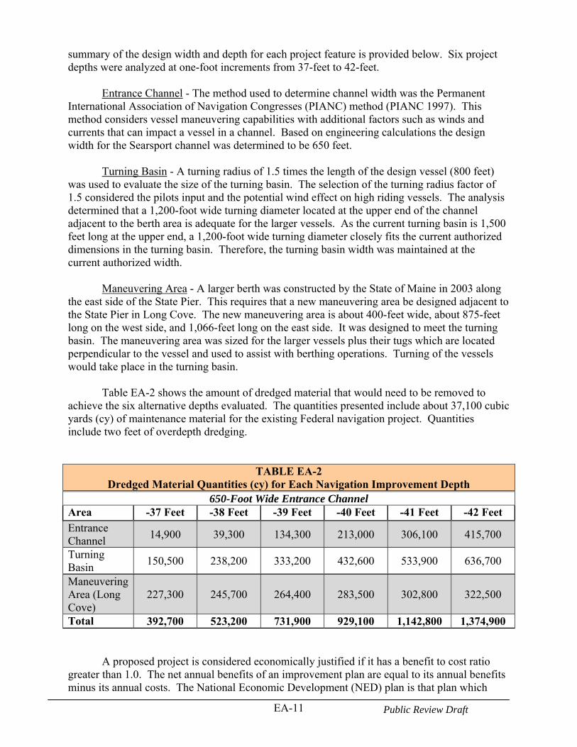
EA-11 Public Review Draft
summary of the design width and depth for each project feature is provided below. Six project depths were analyzed at one-foot increments from 37-feet to 42-feet.
Entrance Channel - The method used to determine channel width was the Permanent
International Association of Navigation Congresses (PIANC) method (PIANC 1997). This method considers vessel maneuvering capabilities with additional factors such as winds and currents that can impact a vessel in a channel. Based on engineering calculations the design width for the Searsport channel was determined to be 650 feet.
Turning Basin - A turning radius of 1.5 times the length of the design vessel (800 feet) was used to evaluate the size of the turning basin. The selection of the turning radius factor of 1.5 considered the pilots input and the potential wind effect on high riding vessels. The analysis determined that a 1,200-foot wide turning diameter located at the upper end of the channel adjacent to the berth area is adequate for the larger vessels. As the current turning basin is 1,500 feet long at the upper end, a 1,200-foot wide turning diameter closely fits the current authorized dimensions in the turning basin. Therefore, the turning basin width was maintained at the current authorized width.
Maneuvering Area - A larger berth was constructed by the State of Maine in 2003 along the east side of the State Pier. This requires that a new maneuvering area be designed adjacent to the State Pier in Long Cove. The new maneuvering area is about 400-feet wide, about 875-feet long on the west side, and 1,066-feet long on the east side. It was designed to meet the turning basin. The maneuvering area was sized for the larger vessels plus their tugs which are located perpendicular to the vessel and used to assist with berthing operations. Turning of the vessels would take place in the turning basin.
Table EA-2 shows the amount of dredged material that would need to be removed to achieve the six alternative depths evaluated. The quantities presented include about 37,100 cubic yards (cy) of maintenance material for the existing Federal navigation project. Quantities include two feet of overdepth dredging.
TABLE EA-2Dredged Material Quantities (cy) for Each Navigation Improvement Depth
650-Foot Wide Entrance Channel Area -37 Feet -38 Feet -39 Feet -40 Feet -41 Feet -42 Feet
Entrance Channel
14,900 39,300 134,300 213,000 306,100 415,700
Turning Basin
150,500 238,200 333,200 432,600 533,900 636,700
Maneuvering Area (Long Cove)
227,300 245,700 264,400 283,500 302,800 322,500
Total 392,700 523,200 731,900 929,100 1,142,800 1,374,900 A proposed project is considered economically justified if it has a benefit to cost ratio
greater than 1.0. The net annual benefits of an improvement plan are equal to its annual benefits minus its annual costs. The National Economic Development (NED) plan is that plan which
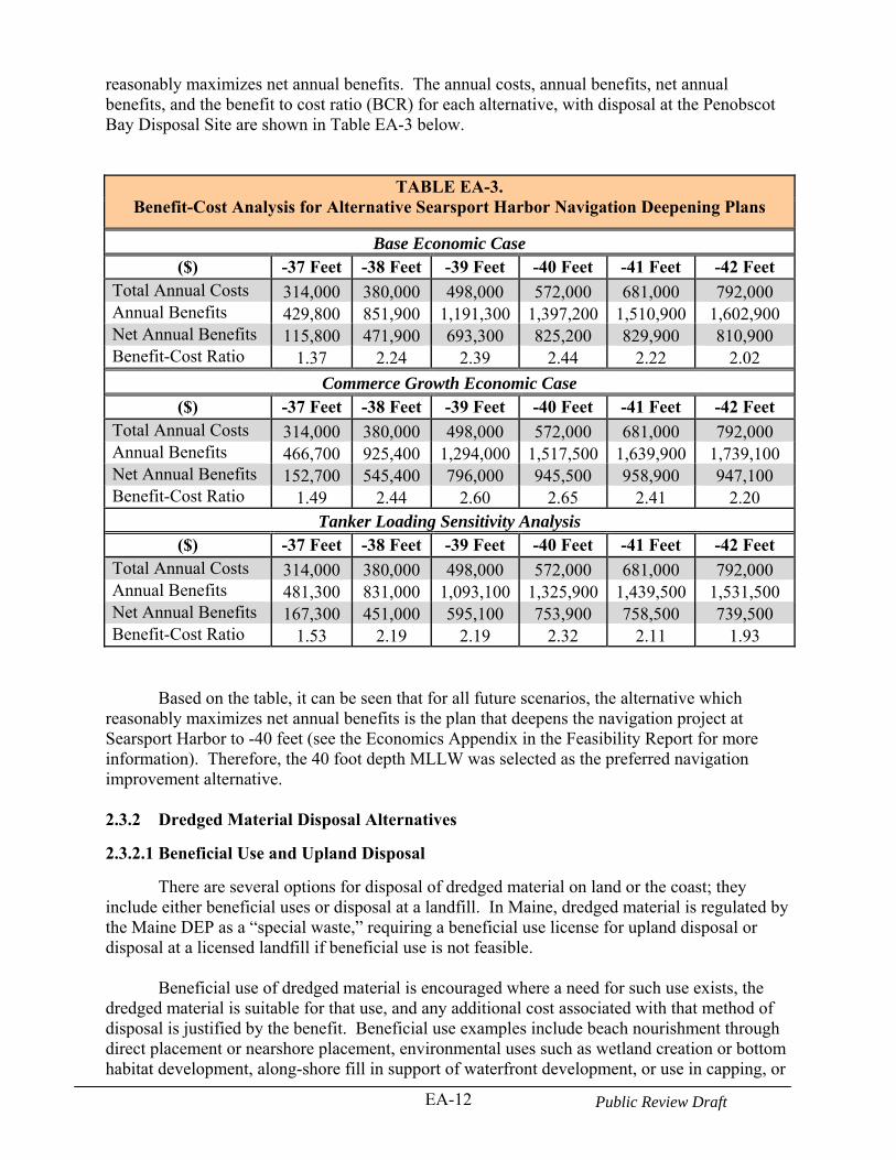
EA-12 Public Review Draft
reasonably maximizes net annual benefits. The annual costs, annual benefits, net annual benefits, and the benefit to cost ratio (BCR) for each alternative, with disposal at the Penobscot Bay Disposal Site are shown in Table EA-3 below.
TABLE EA-3. Benefit-Cost Analysis for Alternative Searsport Harbor Navigation Deepening Plans
Base Economic Case ($) -37 Feet -38 Feet -39 Feet -40 Feet -41 Feet -42 Feet
Total Annual Costs 314,000 380,000 498,000 572,000 681,000 792,000 Annual Benefits 429,800 851,900 1,191,300 1,397,200 1,510,900 1,602,900 Net Annual Benefits 115,800 471,900 693,300 825,200 829,900 810,900 Benefit-Cost Ratio 1.37 2.24 2.39 2.44 2.22 2.02
Commerce Growth Economic Case ($) -37 Feet -38 Feet -39 Feet -40 Feet -41 Feet -42 Feet
Total Annual Costs 314,000 380,000 498,000 572,000 681,000 792,000 Annual Benefits 466,700 925,400 1,294,000 1,517,500 1,639,900 1,739,100 Net Annual Benefits 152,700 545,400 796,000 945,500 958,900 947,100 Benefit-Cost Ratio 1.49 2.44 2.60 2.65 2.41 2.20
Tanker Loading Sensitivity Analysis ($) -37 Feet -38 Feet -39 Feet -40 Feet -41 Feet -42 Feet
Total Annual Costs 314,000 380,000 498,000 572,000 681,000 792,000 Annual Benefits 481,300 831,000 1,093,100 1,325,900 1,439,500 1,531,500 Net Annual Benefits 167,300 451,000 595,100 753,900 758,500 739,500 Benefit-Cost Ratio 1.53 2.19 2.19 2.32 2.11 1.93
Based on the table, it can be seen that for all future scenarios, the alternative which reasonably maximizes net annual benefits is the plan that deepens the navigation project at Searsport Harbor to -40 feet (see the Economics Appendix in the Feasibility Report for more information). Therefore, the 40 foot depth MLLW was selected as the preferred navigation improvement alternative. 2.3.2 Dredged Material Disposal Alternatives
2.3.2.1 Beneficial Use and Upland Disposal
There are several options for disposal of dredged material on land or the coast; they include either beneficial uses or disposal at a landfill. In Maine, dredged material is regulated by the Maine DEP as a “special waste,” requiring a beneficial use license for upland disposal or disposal at a licensed landfill if beneficial use is not feasible.
Beneficial use of dredged material is encouraged where a need for such use exists, the
dredged material is suitable for that use, and any additional cost associated with that method of disposal is justified by the benefit. Beneficial use examples include beach nourishment through direct placement or nearshore placement, environmental uses such as wetland creation or bottom habitat development, along-shore fill in support of waterfront development, or use in capping, or
EA-13 Public Review Draft
as construction fill.
Beach Nourishment and Wetland Creation - One of the most common forms of beneficial use is beach nourishment; that is, using suitable sandy dredged materials on beaches adjacent to the harbor being dredged. Review of the grain size data for the material proposed to be dredged at Searsport shows that sand is only a small fraction of the material (see Table EA-8), that the material is predominantly silt and clay and is therefore is not suitable as beach nourishment material. Therefore, beach nourishment was dropped as a suitable disposal alternative.
Although the dredged material may be suitable for wetlands creation, this measure was
also dropped from further consideration as no sites were identified that need the material for wetland creation or could accommodate the large volume of material.
Waterfront Development - At the initial coordination site meeting (see Appendix A), the possibility of creating additional upland terminal area along the waterfront at Mack Point (possibly between the two piers or Long Cove) was discussed. In these cases, intertidal and or shallow subtidal lands are diked with a bulkhead and then filled. After filling, drying, and consolidation, the created land is then adapted for its intended use.
Constructing a bulkhead with fill at Mack Point would permanently displace intertidal and shallow subtidal habitat located along the waterfront. The resources area impacted would depend on the volume to be placed but for discussion purposes assume placement may involve about two acres of fill and this may accommodate about 30,000 to 50,000 cy of dredged material. As there are other less permanently damaging disposal alternatives available, this alternative was dropped from further consideration.
Cap Material - Another potential beneficial use alternative of the dredged material would be to dewater the material on site at Mack Point and then use the dried material as cap material or for construction purposes. This type of beneficial use was selected in 2002 for some of the dredged material from the liquid pier maintenance deepening project. Material was dredged and then placed on a barge to allow for settling and dewatering. The material from the scow was placed into dump trucks at the pier and then transported and placed on a pad at Mack Point facility where it was then mixed with cement kiln dust. The material was then loaded on to trucks and transported to the Sprague Terminal in Bucksport where it was used to restore an old tank farm. This cost of this option is estimated at about $30/cy, not including trucking to Bucksport and dredging costs. This option may be useful for dredged material from deepening the berths at Mack Point, if the material is unsuitable for open water disposal, but would not be cost-effective for the large volume of dredged material to be generated from the deepening of the entrance channel, turning basin, and maneuvering area.
Landfill Disposal - Discussions with Maine Department of Environmental Protection (Maine DEP) Bureau of Remediation and Waste Management, Division of Solid Waste Management revealed that in Maine dredged material is handled as special waste. Material that cannot be used beneficially can go to licensed special waste landfills. There are two landfills that are available in Maine to accept dredged material free of contamination. They are the Crossroads Landfill in Norridgewock and the Juniper Ridge Landfill Maine in West Old Town.
The West Old Town site is located approximately 50 miles from Searsport and the Norridgewock site is about 60 miles from Searsport. The total cost to dispose of dredged material at the landfills would include dewatering at Mack Point, chemical and physical testing,
EA-14 Public Review Draft
truck transport, and tipping fees. This alternative was not considered practical or cost effective for the large volume of material to be dredged at Searsport Harbor from the channel turning basin and maneuvering area. However, this alternative may be useful for disposal of potential unsuitable material from berth dredging by local interests if no other beneficial use option is cost-effective or available. 2.3.2.2 Aquatic Disposal
There are three active or previously active regional dredged material disposal sites located in Maine waters. Two of the three disposal sites, the Portland Disposal Site (PDS) located directly east of Cape Elizabeth, and the Cape Arundel Disposal Site (CADS) located just south of Kennebunkport, Maine, are subject to Section 103 of the Marine Protection, Research, and Sanctuaries Act (MPRSA), also known as the Ocean Dumping Act. The other regional disposal site, the Rockland Disposal Site, located inside Penobscot Bay, is subject to Section 404 of the Clean Water Act only.
Ocean Disposal (Marine Protection, Research, and Sanctuaries Act)
The PDS was designated by the U.S. Environmental Protection Agency (EPA) as a dredged material disposal site on October 16, 1987 However, the material from Searsport Harbor was not tested for suitability for disposal at the PDS because it is located more than 96 miles by sea from Searsport Harbor. This distance is too far to be considered a practicable disposal location; therefore this site was dropped from further consideration.
In 1992, Congress added a new provision to MPRSA. For the first time, a time limit was established on the availability of USACE selected sites for disposal activity in waters seaward of the mean low water or territorial sea baseline. The provision allowed a selected site to be used for two five-year periods; beginning with the first disposal activity after the effective date of the provision, which was October 31st, 1992. The second five-year period began with the first disposal act commencing after completion of the first five-year period. Use of the dredged material disposal site, however, could be extended for long-term use if the site is designated by EPA. Thus, the USACE can select disposal sites only for short-term limited use; whereas, Congress authorized EPA to undertake long-term site designations subject to ongoing monitoring requirements to ensure that the sites remain environmentally sound. However, no funding was provided to support the studies needed to designate the CADS as a long-term dredged material disposal site. As a result, CADS no longer became available for dredged material disposal after January 2010 because it was not designated by EPA as a long-term dredged material disposal site. Therefore, this ocean disposal option was also removed from additional consideration.
Nearshore Disposal (Clean Water Act)
Three potential nearshore disposal sites (located inshore of the territorial sea, and therefore subject to Clean Water Act [CWA] guidelines rather than MPRSA) were investigated to determine if one of these three sites would meet the Federal standard (least costly alternative(s) consistent with sound engineering practices and meeting the environmental standards established by the CWA Section 404[b] [1] evaluation process or ocean dumping criteria) for a dredged material disposal site. The three disposal sites are the Belfast Bay Disposal Site, the Penobscot Bay Disposal Site and the Rockland Disposal Site. See Figure EA-4.
The Rockland Disposal Site, located in lower Penobscot Bay offshore of Owls Head, is
EA-15 Public Review Draft
the only active disposal site selected for dredged material under Section 230.80 of the CWA. Only dredged material that meets the CWA guidelines is suitable for disposal at this or any other nearshore disposal site. This disposal site had been used for several decades prior to the USACE identifying the site as a disposal site under the CWA guidelines. The site has been occasionally monitored for approximately the last 30 years for any adverse long term effects. The site receives dredged material most years. Although it was determined that the material to be dredged for this project would be suitable for disposal at this site, it is located a distance of 25 miles from the project area. The other disposal sites considered (Belfast Bay and Penobscot Bay) are located approximately six miles from the project area. Consequently, the increased travel distance to the Rockland Disposal Site make this alternative less cost efficient resulting in significantly greater cost to the overall project. Unit costs for the disposal of dredge material at the Belfast Bay and Penobscot Disposal sites are estimated to be approximately $12/cy as compared to $20/cy for the Rockland Disposal site. The Belfast Bay Disposal Site is a historic dredged material disposal area which was last used in 1964 for disposal of dredged material from Searsport Harbor. It was also likely used for disposal of material from Belfast Harbor in the 1800s and 1900s. It is also located within a State and U.S. Coast Guard designated oil transfer area (SAIC, 2000). Although this is a previously used disposal site, it is located within and adjacent to an area that is currently commercially fished by lobstermen. Based on physical and chemical testing, the material to be dredged and disposed from this project was found to be suitable for open water disposal; however, the lobster resources and associated fishing activity in the area makes this site less attractive for the purposes of dredged material disposal. The Penobscot Bay Disposal Site is located two miles further south than the Belfast Bay Disposal Site. See Figure EA-4. It is located in a deep hole in the western area of the Bay, and was identified by local interests as having less lobster activity and as having received dredged material from past projects. Dredged material from the proposed project is also suitable for disposal at this site. As this site does not contain unique or exceptional biological resources (see Section 4 below), this site was selected as the preferred disposal site for material from Searsport Harbor.
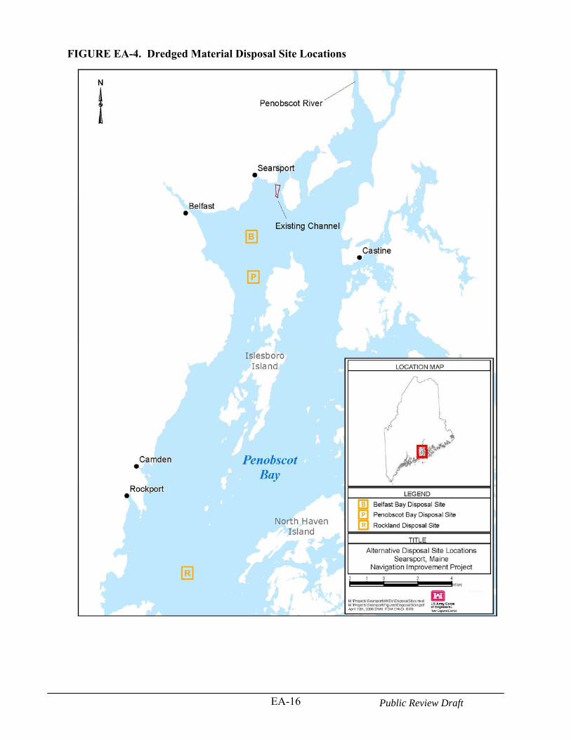
EA-16 Public Review Draft
FIGURE EA-4. Dredged Material Disposal Site Locations
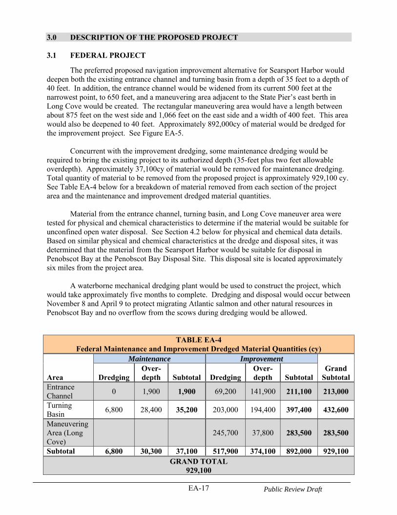
EA-17 Public Review Draft
3.0 DESCRIPTION OF THE PROPOSED PROJECT 3.1 FEDERAL PROJECT
The preferred proposed navigation improvement alternative for Searsport Harbor would deepen both the existing entrance channel and turning basin from a depth of 35 feet to a depth of 40 feet. In addition, the entrance channel would be widened from its current 500 feet at the narrowest point, to 650 feet, and a maneuvering area adjacent to the State Pier’s east berth in Long Cove would be created. The rectangular maneuvering area would have a length between about 875 feet on the west side and 1,066 feet on the east side and a width of 400 feet. This area would also be deepened to 40 feet. Approximately 892,000cy of material would be dredged for the improvement project. See Figure EA-5.
Concurrent with the improvement dredging, some maintenance dredging would be required to bring the existing project to its authorized depth (35-feet plus two feet allowable overdepth). Approximately 37,100cy of material would be removed for maintenance dredging. Total quantity of material to be removed from the proposed project is approximately 929,100 cy. See Table EA-4 below for a breakdown of material removed from each section of the project area and the maintenance and improvement dredged material quantities.
Material from the entrance channel, turning basin, and Long Cove maneuver area were tested for physical and chemical characteristics to determine if the material would be suitable for unconfined open water disposal. See Section 4.2 below for physical and chemical data details. Based on similar physical and chemical characteristics at the dredge and disposal sites, it was determined that the material from the Searsport Harbor would be suitable for disposal in Penobscot Bay at the Penobscot Bay Disposal Site. This disposal site is located approximately six miles from the project area.
A waterborne mechanical dredging plant would be used to construct the project, which would take approximately five months to complete. Dredging and disposal would occur between November 8 and April 9 to protect migrating Atlantic salmon and other natural resources in Penobscot Bay and no overflow from the scows during dredging would be allowed.
TABLE EA-4 Federal Maintenance and Improvement Dredged Material Quantities (cy)
Area
Maintenance Improvement Grand
Subtotal Dredging Over-depth Subtotal Dredging
Over-depth Subtotal
Entrance Channel
0 1,900 1,900 69,200 141,900 211,100 213,000
Turning Basin
6,800 28,400 35,200 203,000 194,400 397,400 432,600
Maneuvering Area (Long Cove)
245,700 37,800 283,500 283,500
Subtotal 6,800 30,300 37,100 517,900 374,100 892,000 929,100 GRAND TOTAL
929,100
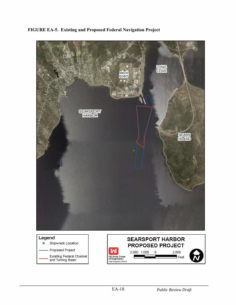
EA-18 Public Review Draft
FIGURE EA-5. Existing and Proposed Federal Navigation Project
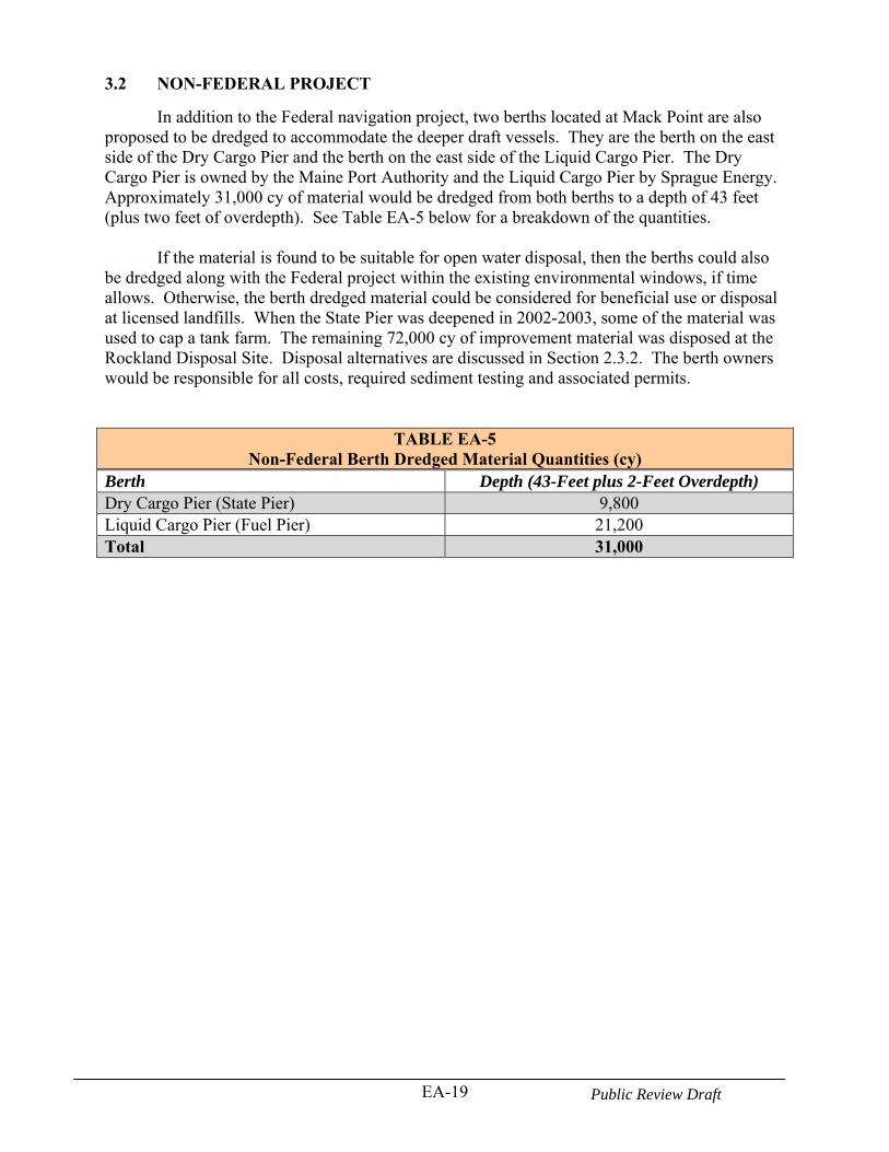
EA-19 Public Review Draft
3.2 NON-FEDERAL PROJECT
In addition to the Federal navigation project, two berths located at Mack Point are also proposed to be dredged to accommodate the deeper draft vessels. They are the berth on the east side of the Dry Cargo Pier and the berth on the east side of the Liquid Cargo Pier. The Dry Cargo Pier is owned by the Maine Port Authority and the Liquid Cargo Pier by Sprague Energy. Approximately 31,000 cy of material would be dredged from both berths to a depth of 43 feet (plus two feet of overdepth). See Table EA-5 below for a breakdown of the quantities.
If the material is found to be suitable for open water disposal, then the berths could also
be dredged along with the Federal project within the existing environmental windows, if time allows. Otherwise, the berth dredged material could be considered for beneficial use or disposal at licensed landfills. When the State Pier was deepened in 2002-2003, some of the material was used to cap a tank farm. The remaining 72,000 cy of improvement material was disposed at the Rockland Disposal Site. Disposal alternatives are discussed in Section 2.3.2. The berth owners would be responsible for all costs, required sediment testing and associated permits.
TABLE EA-5 Non-Federal Berth Dredged Material Quantities (cy)
Berth Depth (43-Feet plus 2-Feet Overdepth) Dry Cargo Pier (State Pier) 9,800 Liquid Cargo Pier (Fuel Pier) 21,200 Total 31,000
EA-20 Public Review Draft
4.0 AFFECTED ENVIRONMENT
4.1 GEOLOGY
Bedrock geology defines the overall shape of the Maine coastline by controlling the location and orientation of islands, bays, and peninsulas. The coast of Maine and New Hampshire may be subdivided into several geomorphic compartments, largely defined by bedrock (Kelly, J.T., W.A. Barnhardt, D.F. Belknap, S.M. Dickson, A.R. Kelley, and L. Ward, 1996).
Penobscot Bay is included in the Island-Bay Coast compartment, which extends from Port Clyde in Knox County, Maine to Cross Island in Washington County, Maine (Kelly, J.T., W.A. Barnhardt, D.F. Belknap, S.M. Dickson, A.R. Kelley, and L. Ward, 1996). The Island-Bay Coast is shaped by numerous, granitic islands sheltering broad embayments. Seaward of the muddy tidal flats of the Island-Bay Coast compartment, are muddy nearshore basins. Nearshore basins are concentrated off central Maine where they are sheltered from waves and occur over local linear depressions in bedrock that are mapped as faults in parts of Casco, Sheepscot, Penobscot, Muscongus, Oak, and Cobscook Bays. As a result, nearly 80% of the nearshore basins are floored by mud, with about 20% rock and gravel and almost no sand (Kelly, J.T., W.A. Barnhardt, D.F. Belknap, S.M. Dickson, A.R. Kelley, and L. Ward, 1996). Rock exposures are common along the margins of nearshore basins and outcrops commonly punctuate the smooth seafloor. Nearshore basins contain sediment coarser than mud where bedrock constrictions accelerate tidal currents, especially in shallow nearshore passages.
Belfast Bay and the nearby surrounding region of Penobscot Bay have a relatively unique geologic feature consisting of large pockmarks on the seafloor (Kelley et al., 1994). Pockmarks are circular “crater-like” depressions in the seafloor with well-defined morphologies and steep slopes (>20°) which may be relatively common in shallow-water areas. In the bay, the pockmarks range from 10 to 300 m in diameter and are found only in Holocene sediments (Scanlon and Knebel 1989). The pockmarks are generated by the escape and release of interstitial, biogenic natural gas and pore water (Kelley et al., 1994). The pockmarks appear to form linear chains that parallel regions of glacial till and may correspond with fractures or fault zones. In general, the size of the pockmarks in Penobscot Bay tends to increase with water depth. The largest depressions in the Belfast Bay region occur at depths exceeding 70 feet, between the mainland and Islesboro Island, as indicated by the results of a multibeam bathymetric survey performed by NOAA in the northern region of Penobscot Bay during the summer of 1999. 4.2 PROJECT SEDIMENTS
On April 30 and May 1, 2008, 10 sediment core samples were collected in Searsport Harbor within the proposed project area ( see Figure EA-6). The purpose of the sampling was to gather physical and chemical information for analyzing environmental impacts from open water disposal. At each of the 10 sample locations, a vibracore or push core was driven to the target project depth. Sediment grab samples from the two reference sites (dredged material disposal locations): the historic Belfast Bay Disposal Site (BBDS) and the alternate Penobscot Bay Disposal Site (PDS) were also collected to serve as a basis for comparison. The Rockland Disposal Site was also evaluated based on previously existing data from the site. The data was used to make a suitability determination for the purposes of open-water placement of the dredged material under Section 404 of the Clean Water Act. The suitability determination is included in Appendix B.
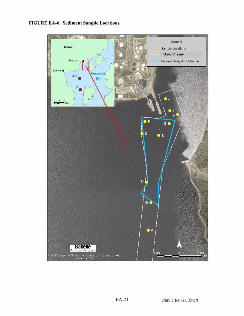
EA-21 Public Review Draft
FIGURE EA-6. Sediment Sample Locations
EA-22 Public Review Draft
Sediment samples from the 10 Searsport Harbor stations (Stations A through J; Figure EA-6) were analyzed for grain size. Based on the results of the grain size analysis and sample location, similar samples were identified and composited. Table EA-6 indicates which samples were located within or outside the existing Federal navigation channel, which samples were composited and the sample type. The composite and reference site sediment samples were then analyzed for full grain size distribution, water content, and visual classification. Composite harbor and reference site sediment samples were also analyzed for total organic carbon (TOC). Results are reported on a percent dry-weight basis.
The four composite harbor and six reference site (2 locations x 3 replicates) sediment samples were extracted and analyzed for polycyclic aromatic hydrocarbons (PAHs), pesticides and polychlorinated biphenyls (PCBs) (Table EA-7). Total PCB is reported as two times the sum of the target congeners; one half the method detection limit (MDL) was used for non-detects. Sediment samples were re-extracted in the laboratory for PAHs because some quality control (QC) results were unacceptable. The percent recovery of selected low molecular weight (LMW) surrogate compounds was near or below the lower acceptable limit of 30% (Table EA-7). In addition, results from the SRM analysis indicated a number of compounds that were under-recovered compared to the certified value. QC results from the re-extracted samples were acceptable and the re-extract data are provided in this report.
The four composite sediment and six reference site samples were also analyzed for eight metals: arsenic (As), cadmium (Cd), chromium (Cr), copper (Cu), lead (Pb), mercury (Hg), nickel (Ni), and zinc (Zn). Detection limits for each metal are provided in Table EA-7. Samples were freeze-dried and homogenized using a ball-mill prior to digestion according to Battelle SOP MSL-C-003, Percent Dry Weight and Homogenizing Dry Sediment, Soil and Tissue. Sediment samples were digested in accordance with Battelle SOP MSL-I-006, Mixed Acid Sediment Digestion. Grain Size Results
Grain size data for three of the four harbor composite samples showed that sediments were fine-grained, comprised predominantly of silt and clay (>90%) with smaller amounts of fine and medium sands (Table EA-8). Sediment at Station J was coarser, with roughly equal distributions of medium and fine sands, silt, and clay fractions. This station was located farthest outside the existing navigation project limits and was the most inshore of all stations. The BBDS and PDS reference station samples were comprised predominately of silt (42-45%) and clay (55-56%). Total Organic Carbon (TOC) Results
The harbor composite and reference samples contained moderate levels of TOC, ranging from 0.97% to 2.74%. As expected, sediment grain size generally corresponded well with TOC for the four harbor composite and BBDS and PDS reference sediment samples. For example, most of the composites with predominantly fine-grained sediments contained higher percentages of TOC, while composite 4 which contained mostly gravel and sand had a much lower percentage of TOC. Station J (composite 4) had the lowest TOC values and BBDS had the highest TOC values
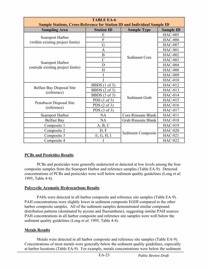
EA-23 Public Review Draft
TABLE EA-6 Sample Stations, Cross-Reference for Station ID and Individual Sample ID
Sampling Area Station ID Sample Type Sample ID
Searsport Harbor (within existing project limits)
E
Sediment Core
HAC-005 F HAC-006 G HAC-007
Searsport Harbor (outside existing project limits)
A HAC-001 B HAC-002 C HAC-003 D HAC-004 H HAC-008 I HAC-009 J HAC-010
Belfast Bay Disposal Site (reference)
BBDS (1 of 3)
Sediment Grab
HAC-012 BBDS (2 of 3) HAC-013 BBDS (3 of 3) HAC-014
Penobscot Disposal Site (reference)
PDS (1 of 3) HAC-015 PDS (2 of 3) HAC-016 PDS (3 of 3) HAC-017
Searsport Harbor NA Core Rinseate Blank HAC-011 Belfast Bay NA Grab Rinseate Blank HAC-018 Composite 1 A, B, C
Sediment Composite
HAC-019 Composite 2 D, F HAC-020 Composite 3 E, G, H, I HAC-021 Composite 4 J HAC-022
PCBs and Pesticides Results
PCBs and pesticides were generally undetected or detected at low levels among the four composite samples from the Searsport Harbor and reference samples (Table EA-9). Detected concentrations of PCBs and pesticides were well below sediment quality guidelines (Long et al. 1995; Table 4-4). Polycyclic Aromatic Hydrocarbons Results
PAHs were detected in all harbor composite and reference site samples (Table EA-9). PAH concentrations were slightly lower in sediment composite EGHI compared to the other harbor composite samples. All of the sediment samples demonstrated similar compound distribution patterns (dominated by pyrene and fluoranthene), suggesting similar PAH sources. PAH concentrations in all harbor composite and reference site samples were well below the sediment quality guidelines (Long et al. 1995, Table 4-4). Metals Results
Metals were detected in all harbor composite and reference site samples (Table EA-9). Concentrations of most metals were generally below the sediment quality guidelines, especially at harbor locations (Table EA-9). For example, metals concentrations were below the sediment
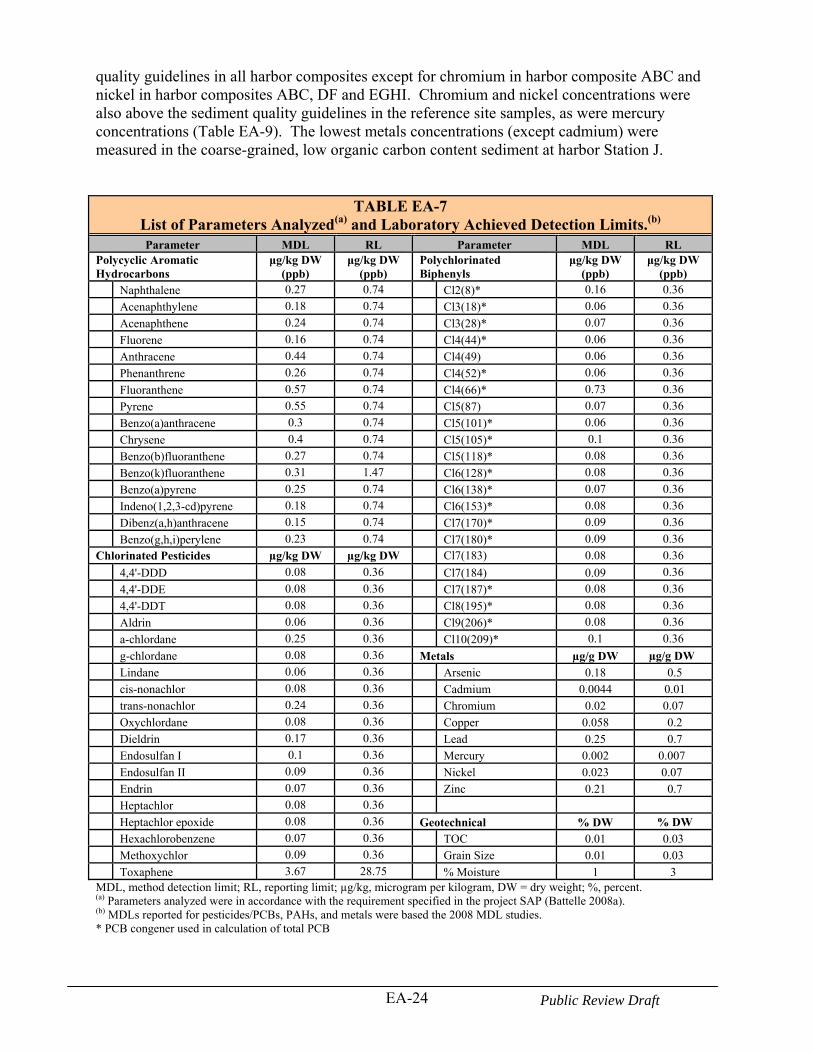
EA-24 Public Review Draft
quality guidelines in all harbor composites except for chromium in harbor composite ABC and nickel in harbor composites ABC, DF and EGHI. Chromium and nickel concentrations were also above the sediment quality guidelines in the reference site samples, as were mercury concentrations (Table EA-9). The lowest metals concentrations (except cadmium) were measured in the coarse-grained, low organic carbon content sediment at harbor Station J.
TABLE EA-7 List of Parameters Analyzed(a) and Laboratory Achieved Detection Limits.(b) Parameter MDL RL Parameter MDL RL
Polycyclic Aromatic Hydrocarbons
μg/kg DW (ppb)
μg/kg DW (ppb)
Polychlorinated Biphenyls
μg/kg DW (ppb)
μg/kg DW (ppb)
Naphthalene 0.27 0.74 Cl2(8)* 0.16 0.36
Acenaphthylene 0.18 0.74 Cl3(18)* 0.06 0.36
Acenaphthene 0.24 0.74 Cl3(28)* 0.07 0.36
Fluorene 0.16 0.74 Cl4(44)* 0.06 0.36
Anthracene 0.44 0.74 Cl4(49) 0.06 0.36
Phenanthrene 0.26 0.74 Cl4(52)* 0.06 0.36
Fluoranthene 0.57 0.74 Cl4(66)* 0.73 0.36
Pyrene 0.55 0.74 Cl5(87) 0.07 0.36
Benzo(a)anthracene 0.3 0.74 Cl5(101)* 0.06 0.36
Chrysene 0.4 0.74 Cl5(105)* 0.1 0.36
Benzo(b)fluoranthene 0.27 0.74 Cl5(118)* 0.08 0.36
Benzo(k)fluoranthene 0.31 1.47 Cl6(128)* 0.08 0.36
Benzo(a)pyrene 0.25 0.74 Cl6(138)* 0.07 0.36
Indeno(1,2,3-cd)pyrene 0.18 0.74 Cl6(153)* 0.08 0.36
Dibenz(a,h)anthracene 0.15 0.74 Cl7(170)* 0.09 0.36
Benzo(g,h,i)perylene 0.23 0.74 Cl7(180)* 0.09 0.36
Chlorinated Pesticides µg/kg DW µg/kg DW Cl7(183) 0.08 0.36
4,4'-DDD 0.08 0.36 Cl7(184) 0.09 0.36
4,4'-DDE 0.08 0.36 Cl7(187)* 0.08 0.36
4,4'-DDT 0.08 0.36 Cl8(195)* 0.08 0.36
Aldrin 0.06 0.36 Cl9(206)* 0.08 0.36
a-chlordane 0.25 0.36 Cl10(209)* 0.1 0.36
g-chlordane 0.08 0.36 Metals µg/g DW µg/g DW
Lindane 0.06 0.36 Arsenic 0.18 0.5
cis-nonachlor 0.08 0.36 Cadmium 0.0044 0.01
trans-nonachlor 0.24 0.36 Chromium 0.02 0.07
Oxychlordane 0.08 0.36 Copper 0.058 0.2
Dieldrin 0.17 0.36 Lead 0.25 0.7
Endosulfan I 0.1 0.36 Mercury 0.002 0.007
Endosulfan II 0.09 0.36 Nickel 0.023 0.07
Endrin 0.07 0.36 Zinc 0.21 0.7
Heptachlor 0.08 0.36
Heptachlor epoxide 0.08 0.36 Geotechnical % DW % DW
Hexachlorobenzene 0.07 0.36 TOC 0.01 0.03
Methoxychlor 0.09 0.36 Grain Size 0.01 0.03
Toxaphene 3.67 28.75 % Moisture 1 3 MDL, method detection limit; RL, reporting limit; µg/kg, microgram per kilogram, DW = dry weight; %, percent. (a) Parameters analyzed were in accordance with the requirement specified in the project SAP (Battelle 2008a). (b) MDLs reported for pesticides/PCBs, PAHs, and metals were based the 2008 MDL studies. * PCB congener used in calculation of total PCB
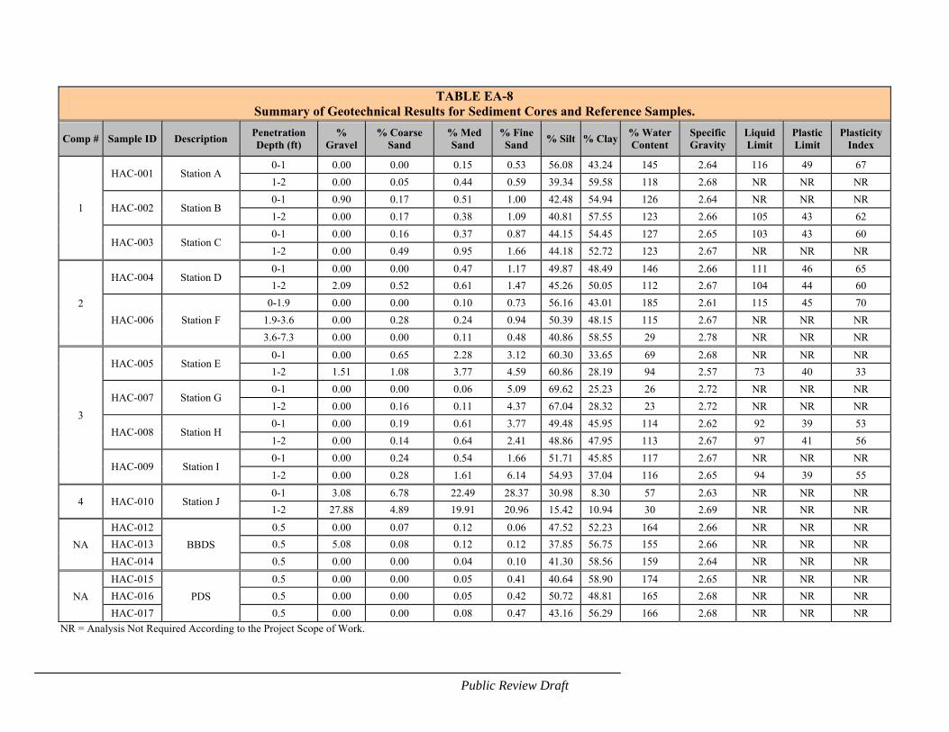
EA-25Public Review Draft
TABLE EA-8 Summary of Geotechnical Results for Sediment Cores and Reference Samples.
Comp # Sample ID Description Penetration Depth (ft)
% Gravel
% Coarse Sand
% Med Sand
% Fine Sand
% Silt % Clay% Water Content
Specific Gravity
Liquid Limit
Plastic Limit
Plasticity Index
1
HAC-001 Station A 0-1 0.00 0.00 0.15 0.53 56.08 43.24 145 2.64 116 49 67
1-2 0.00 0.05 0.44 0.59 39.34 59.58 118 2.68 NR NR NR
HAC-002 Station B 0-1 0.90 0.17 0.51 1.00 42.48 54.94 126 2.64 NR NR NR
1-2 0.00 0.17 0.38 1.09 40.81 57.55 123 2.66 105 43 62
HAC-003 Station C 0-1 0.00 0.16 0.37 0.87 44.15 54.45 127 2.65 103 43 60
1-2 0.00 0.49 0.95 1.66 44.18 52.72 123 2.67 NR NR NR
2
HAC-004 Station D 0-1 0.00 0.00 0.47 1.17 49.87 48.49 146 2.66 111 46 65
1-2 2.09 0.52 0.61 1.47 45.26 50.05 112 2.67 104 44 60
HAC-006 Station F
0-1.9 0.00 0.00 0.10 0.73 56.16 43.01 185 2.61 115 45 70
1.9-3.6 0.00 0.28 0.24 0.94 50.39 48.15 115 2.67 NR NR NR
3.6-7.3 0.00 0.00 0.11 0.48 40.86 58.55 29 2.78 NR NR NR
3
HAC-005 Station E 0-1 0.00 0.65 2.28 3.12 60.30 33.65 69 2.68 NR NR NR
1-2 1.51 1.08 3.77 4.59 60.86 28.19 94 2.57 73 40 33
HAC-007 Station G 0-1 0.00 0.00 0.06 5.09 69.62 25.23 26 2.72 NR NR NR
1-2 0.00 0.16 0.11 4.37 67.04 28.32 23 2.72 NR NR NR
HAC-008 Station H 0-1 0.00 0.19 0.61 3.77 49.48 45.95 114 2.62 92 39 53
1-2 0.00 0.14 0.64 2.41 48.86 47.95 113 2.67 97 41 56
HAC-009 Station I 0-1 0.00 0.24 0.54 1.66 51.71 45.85 117 2.67 NR NR NR
1-2 0.00 0.28 1.61 6.14 54.93 37.04 116 2.65 94 39 55
4 HAC-010 Station J 0-1 3.08 6.78 22.49 28.37 30.98 8.30 57 2.63 NR NR NR
1-2 27.88 4.89 19.91 20.96 15.42 10.94 30 2.69 NR NR NR
NA
HAC-012
BBDS
0.5 0.00 0.07 0.12 0.06 47.52 52.23 164 2.66 NR NR NR
HAC-013 0.5 5.08 0.08 0.12 0.12 37.85 56.75 155 2.66 NR NR NR
HAC-014 0.5 0.00 0.00 0.04 0.10 41.30 58.56 159 2.64 NR NR NR
NA
HAC-015
PDS
0.5 0.00 0.00 0.05 0.41 40.64 58.90 174 2.65 NR NR NR
HAC-016 0.5 0.00 0.00 0.05 0.42 50.72 48.81 165 2.68 NR NR NR
HAC-017 0.5 0.00 0.00 0.08 0.47 43.16 56.29 166 2.68 NR NR NR
NR = Analysis Not Required According to the Project Scope of Work.
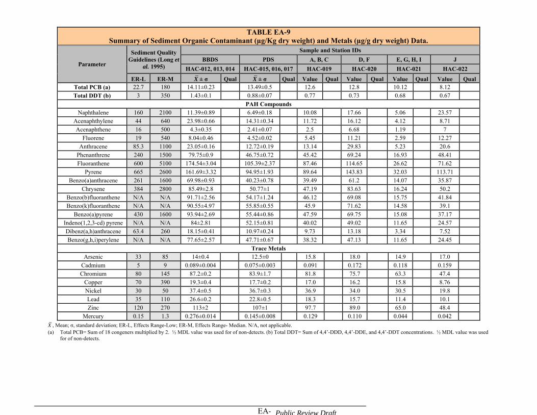
EA-26Public Review Draft
TABLE EA-9 Summary of Sediment Organic Contaminant (µg/Kg dry weight) and Metals (µg/g dry weight) Data.
Parameter
Sediment Quality Guidelines (Long et
al. 1995)
Sample and Station IDs
BBDS PDS A, B, C D, F E, G, H, I J
HAC-012, 013, 014 HAC-015, 016, 017 HAC-019 HAC-020 HAC-021 HAC-022
ER-L ER-M X̄ ± σ Qual X̄ ± σ Qual Value Qual Value Qual Value Qual Value Qual Total PCB (a) 22.7 180 14.11±0.23 13.49±0.5 12.6 12.8 10.12 8.12
Total DDT (b) 3 350 1.43±0.1 0.88±0.07 0.77 0.73 0.68 0.67
PAH Compounds Naphthalene 160 2100 11.39±0.89 6.49±0.18 10.08 17.66 5.06 23.57
Acenaphthylene 44 640 23.98±0.66 14.31±0.34 11.72 16.12 4.12 8.71
Acenaphthene 16 500 4.3±0.35 2.41±0.07 2.5 6.68 1.19 7
Fluorene 19 540 8.04±0.46 4.52±0.02 5.45 11.21 2.59 12.27
Anthracene 85.3 1100 23.05±0.16 12.72±0.19 13.14 29.83 5.23 20.6
Phenanthrene 240 1500 79.75±0.9 46.75±0.72 45.42 69.24 16.93 48.41
Fluoranthene 600 5100 174.54±3.04 105.39±2.37 87.46 114.65 26.62 71.62
Pyrene 665 2600 161.69±3.32 94.95±1.93 89.64 143.83 32.03 113.71
Benzo(a)anthracene 261 1600 69.98±0.93 40.23±0.78 39.49 61.2 14.07 35.87
Chrysene 384 2800 85.49±2.8 50.77±1 47.19 83.63 16.24 50.2
Benzo(b)fluoranthene N/A N/A 91.71±2.56 54.17±1.24 46.12 69.08 15.75 41.84
Benzo(k)fluoranthene N/A N/A 90.55±4.97 55.85±0.55 45.9 71.62 14.58 39.1
Benzo(a)pyrene 430 1600 93.94±2.69 55.44±0.86 47.59 69.75 15.08 37.17
Indeno(1,2,3-cd) pyrene N/A N/A 84±2.81 52.15±0.81 40.02 49.02 11.65 24.57
Dibenz(a,h)anthracene 63.4 260 18.15±0.41 10.97±0.24 9.73 13.18 3.34 7.52
Benzo(g,h,i)perylene N/A N/A 77.65±2.57 47.71±0.67 38.32 47.13 11.65 24.45
Trace Metals Arsenic 33 85 14±0.4 12.5±0 15.8 18.0 14.9 17.0
Cadmium 5 9 0.089±0.004 0.075±0.003 0.091 0.172 0.118 0.159
Chromium 80 145 87.2±0.2 83.9±1.7 81.8 75.7 63.3 47.4
Copper 70 390 19.3±0.4 17.7±0.2 17.0 16.2 15.8 8.76
Nickel 30 50 37.4±0.5 36.7±0.3 36.9 34.0 30.5 19.8
Lead 35 110 26.6±0.2 22.8±0.5 18.3 15.7 11.4 10.1
Zinc 120 270 113±2 107±1 97.7 89.0 65.0 48.4
Mercury 0.15 1.3 0.276±0.014 0.145±0.008 0.129 0.110 0.044 0.042
X̄ , Mean; σ, standard deviation; ER-L, Effects Range-Low; ER-M, Effects Range- Median. N/A, not applicable. (a) Total PCB= Sum of 18 congeners multiplied by 2. ½ MDL value was used for of non-detects. (b) Total DDT= Sum of 4,4’-DDD, 4,4’-DDE, and 4,4’-DDT concentrations. ½ MDL value was used
for of non-detects.
EA-27 Public Review Draft
4.3 WATER RESOURCES
4.3.1 Penobscot River Watershed
At 350 miles long, the Penobscot River is the largest river in Maine, and the second largest river (after the Connecticut River) in New England. The west branch of the Penobscot River rises near Penobscot Lake on the Maine/Quebec border; the east branch of the Penobscot River begins at the East Branch Pond near the headwaters of the Allagash River. The mainstem of the river begins at the confluence of the East and West Branches at Medway and empties into Penobscot Bay near the town of Bucksport.
The Penobscot River drains a watershed approximately 8,592 square-mile large, roughly one-quarter of the State's land area. Another watershed estimate is 8,570 square miles, depending on where one draws the line between the "river" and the "bay". This watershed is forested with extensive bogs, marshes and wooded swamps and is sparsely populated. Average daily discharge is about 382,000 m3/day, peaking in March-April with a second peak in November-December (www.penboscot.loboviz.com). The river is tidal from the base of the Veazie Dam, which is located north of Bangor, to the river’s mouth near Bucksport (approximately 25 miles). (The tide may move slightly inland with the scheduled removal of the Veazie Dam to begin in 2013). The river is brackish from the mouth upstream to the town of Hampden (approximately 12 miles). 4.3.2 Marine Water Quality
The tidal waters of Searsport Harbor are classified as SC by the State of Maine, the third highest classification. Class SC waters are suitable for recreation in and on the water, fishing, aquaculture, propagation and restricted harvesting of shellfish, industrial process and cooling water supply, hydroelectric power generation, navigation, and as habitat for fish and other estuarine and marine life. Shellfish harvesting is prohibited in Searsport Harbor, except for a small area just west of the Sears Island causeway which is classified as “Restricted”. “Restricted” areas require a special permit from the Department of Marine Resources (DMR Regulation 95.08 D, Closed Area No. 33, Searsport).
The remaining waters of Penobscot Bay are classified as SB, except for a few harbors which are classified as SC and the mouth of the Bay near Isle au Haut which is classified as SA. SB waters are the second highest classification. Class SB waters are suitable for the designated uses of recreation in and on the water, fishing, aquaculture, propagation and harvesting of shellfish, industrial process and cooling water supply, hydroelectric power generation, navigation and as habitat for fish and other estuarine and marine life. This habitat must be characterized as unimpaired. 4.4 BIOLOGICAL RESOURCES
4.4.1 General
From Marshall Point at Port Clyde to Naskeag Point in Brooklin, Penobscot Bay’s coastline is longer than 1,000 miles and includes more than 1,800 islands. Its marine life
EA-28 Public Review Draft
is most influenced by the cold Gulf of Maine seawater currents. Subtidal circulation in Penobscot Bay is influenced by winds, fresh water discharge from the Penobscot River, and the southwestward Maine Coastal Current flowing pass the mouth of the Bay (Xue, et.al., 2000). Cold water holds more oxygen and supports more nutrients than warm water. Like fertile soil, the nutrient-rich waters in Penobscot Bay support healthy and abundant growth. Penobscot Bay is a home for almost all of the seventy commercially harvested species of fish and shellfish landed in the Gulf of Maine www.penobscotbayhistory.org). It is this rich resource that attracted early seventeenth century fishermen to the Penobscot Bay area (www.penobscotbayhistory.org/section/ show_page/69). 4.4.2 Eelgrass
Eelgrass (Zostera marina) is a flowering plant that occurs world-wide and along the east coast of North America from North Carolina to Labrador. Eelgrass beds form an important habitat for shellfish, wildlife and other vertebrate and invertebrate species. Along the Maine coast, it is found in shallow, protected intertidal and subtidal areas.
Since 1992, the State of Maine has mapped the distribution of eelgrass (MEGIS). Current mapping of eelgrass in the Searsport Harbor area indicates that eelgrass beds may be found along the west coast of Sears Island and a small patch along the west coast of Long Cove. None of the mapped eelgrass beds appear to be located within the footprint of the proposed navigation improvement project. This was confirmed by underwater video surveillance in August 2007 in the Long Cove area where expansion of the maneuvering area into the shallower areas is proposed (see Figure EA-7). No eelgrass was observed during this visual inspection. Depths in the project area are generally too deep for light penetration to support eelgrass beds. 4.4.3 Benthic Resources
Benthic sampling was conducted in the project area on August 14, 2007 by USACE biologists. Taxonomic analysis show a benthic community primarily dominated by polychaete species (segmented marine worms), with a much smaller number of arthropod and mollusk species. Samples were collected with a VanVeen grab from the existing project and navigation improvement area (see Figure EA-8) and the Penobscot Bay Disposal Site (see Figure EA-9), for a total of 17 samples. All of the samples contained fine sediments (mud, silt, and/or clay), except for sample #17 located in Long Cove, which contained rock, gravel and sand. Appendix C lists the number of benthic species identified in the project area by class, genus and species, and sampling location. One hundred and four benthic species were identified in the subtidal ranges of the project area. Sixty-three species were polychaetes, while only 10 species were arthropods (crustaceans). Diversity values were low with a mean of 2.15. Most stations had a small to modest number of species; a few stations had a much higher number of species. The number of species per station showed a range from a low of four to a high of 53 with a mean of 17 species per station. Densities varied from 300 to 51,520 per m2 with a mean of 7,327 per m2.
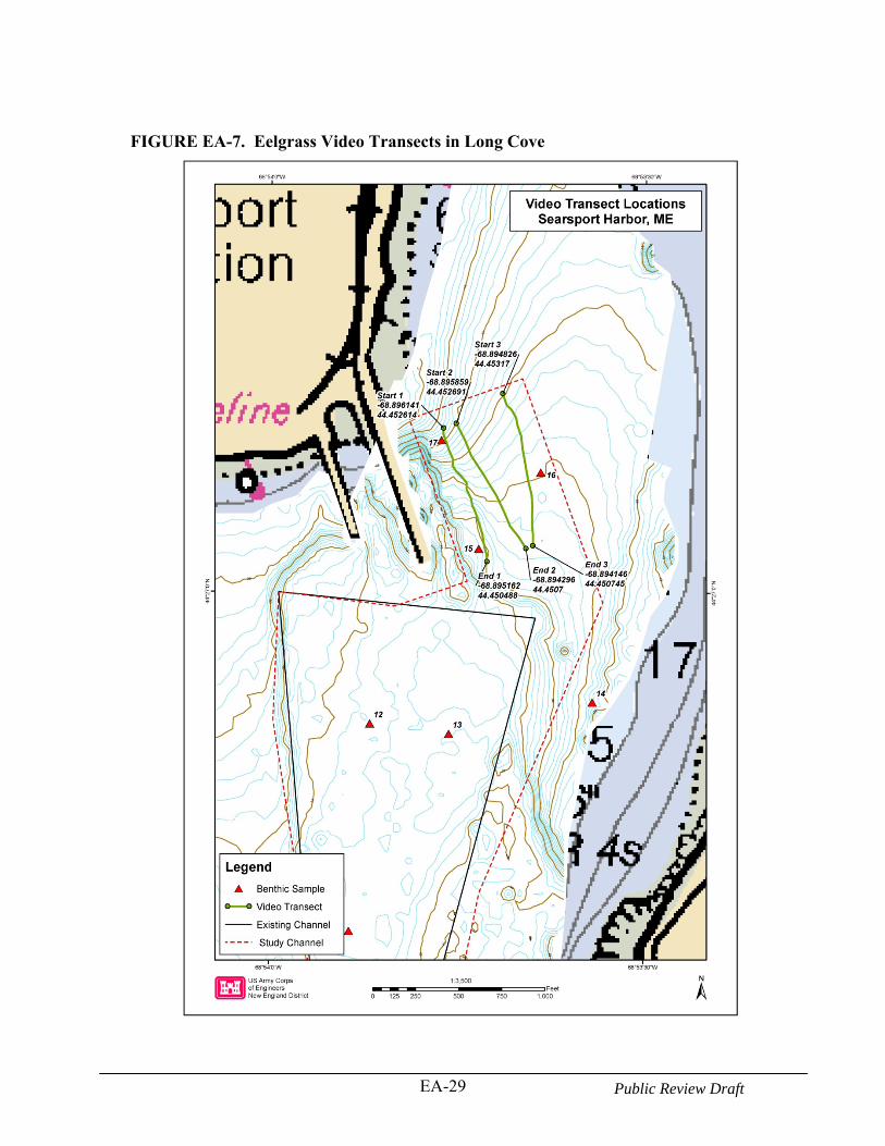
EA-29 Public Review Draft
FIGURE EA-7. Eelgrass Video Transects in Long Cove
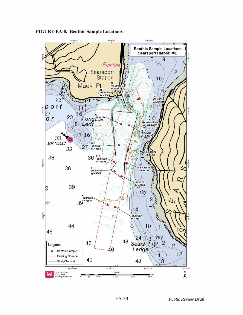
EA-30 Public Review Draft
FIGURE EA-8. Benthic Sample Locations
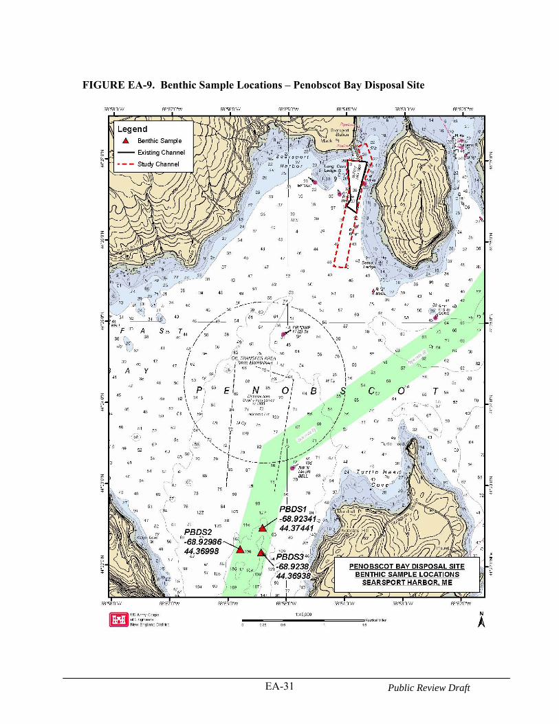
EA-31 Public Review Draft
FIGURE EA-9. Benthic Sample Locations – Penobscot Bay Disposal Site
EA-32 Public Review Draft
4.4.4 Shellfish Resources
Penobscot Bay is one of the richest lobster grounds in the world (Ellis and Cowan, 1999). However, the upper Penobscot Bay does not support habitat for high density larval lobsters in the intertidal zone (Ellis and Cowan, 1999) or the subtidal zone (Wilson, pers. comm.). These low larval density levels are not expected to change much with the recent increase in the lobster population (Wilson, pers. comm.). Relative to the rich density of lobsters in the lower Penobscot Bay, the juvenile and adult lobster population in the upper Penobscot Bay is low (Wilson, pers. comm.). A large number of lobster pots, however, were noted in Belfast Bay during the USACE benthic sampling field trip in August 2007.
No other significant shellfish or crustaceans were found during benthic sampling by the USACE in the project area. Only green crabs (Carcinus maenas) and the sevenspine bay shrimp (Crangon septemspinosa) were observed in the shallow areas of Long Cove (Lazzari and Tupper, 2002), and rock crabs (Cancer irrotatus), green crabs, and scallop (Placopecten magellanicus) at Mack Point/Long Cove (ME DOT, 1987). 4.4.5 Finfish Resources
The fish fauna of the Gulf of Maine have been well described by Bigelow and Schroeder (1953). Finfish utilize the coastal waters of the Gulf of Maine and upper Penobscot Bay as year-round residents and for spawning and nursery areas. Penobscot Bay plays an important role in the early life history of fish inhabiting the central coast of Maine by offering habitat for larval fish. Twenty-six species of fish larvae were identified during spring surveys in Penobscot Bay in 1997 and 1998 (Lazzari, 2001). The most commonly occurring larvae (>35% of the samples) were Atlantic seasnail (Liparis atlanticus), winter flounder (Pseudopleuronectes americanus), radiated shanny (Ulvaria subbifurcata), sand lance (Ammodytes spp.), American plaice (Hippoglossoides platessoides), rock gunnel (Pholis gunnellus), sea raven (Hemitripterus americanus), longhorn sculpin (Myoxocephalus octodecimspinosus), and grubby (M. aenaeus). Densities of sand lance were highest in the upper bay and mid-bay stations in 1997 and 1998 respectively (Lazzari, 2001). Winter flounder have their greatest abundance in the mid-bay area (Lazzari, 2001). Larvae from demersal eggs dominated the catch from late winter through spring, but not in early summer collections (Lazzari, 2001). Larvae of taxa that spawn from late winter through early spring, such as sculpins, sand lance, and rock gunnel were dominant in Penobscot Bay in March and April. Larvae of spring to early spawners such as winter flounder, Atlantic seasnail, and radiated shanny were abundant in May and June (Lazzari, 2001).
Table EA-10 provides the list of adult finfish species that were collected in the upper Penobscot Bay by the Central Maine Power Company (ME DOT, 1987). The most common pelagic fish were the Atlantic herring (Clupea harengus), Atlantic menhaden (Brevoortia tyrannus), and spiny dogfish (Squalus acanthias). Other important pelagic species include the blueback herring (Alosa aestivalis), alewife (Alosa pseudoharengus), Atlantic mackerel (Scomber scombrus) and rainbow smelt (Osmerus mordax) (ME DOT, 1987). Atlantic herring have been found throughout the year in the upper Penobscot Bay,
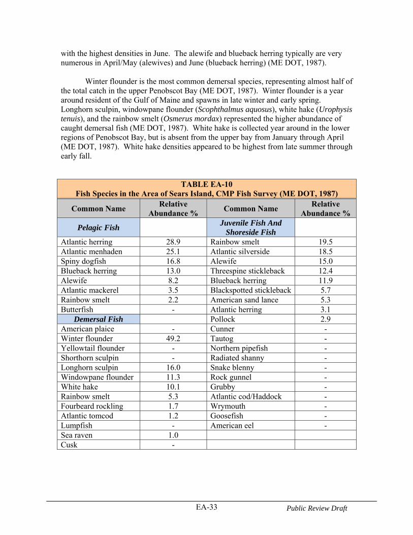
EA-33 Public Review Draft
with the highest densities in June. The alewife and blueback herring typically are very numerous in April/May (alewives) and June (blueback herring) (ME DOT, 1987).
Winter flounder is the most common demersal species, representing almost half of the total catch in the upper Penobscot Bay (ME DOT, 1987). Winter flounder is a year around resident of the Gulf of Maine and spawns in late winter and early spring. Longhorn sculpin, windowpane flounder (Scophthalmus aquosus), white hake (Urophysis tenuis), and the rainbow smelt (Osmerus mordax) represented the higher abundance of caught demersal fish (ME DOT, 1987). White hake is collected year around in the lower regions of Penobscot Bay, but is absent from the upper bay from January through April (ME DOT, 1987). White hake densities appeared to be highest from late summer through early fall.
TABLE EA-10 Fish Species in the Area of Sears Island, CMP Fish Survey (ME DOT, 1987)
Common Name Relative
Abundance % Common Name
Relative Abundance %
Pelagic Fish Juvenile Fish And
Shoreside Fish
Atlantic herring 28.9 Rainbow smelt 19.5 Atlantic menhaden 25.1 Atlantic silverside 18.5 Spiny dogfish 16.8 Alewife 15.0 Blueback herring 13.0 Threespine stickleback 12.4 Alewife 8.2 Blueback herring 11.9 Atlantic mackerel 3.5 Blackspotted stickleback 5.7 Rainbow smelt 2.2 American sand lance 5.3 Butterfish - Atlantic herring 3.1
Demersal Fish Pollock 2.9 American plaice - Cunner - Winter flounder 49.2 Tautog - Yellowtail flounder - Northern pipefish - Shorthorn sculpin - Radiated shanny - Longhorn sculpin 16.0 Snake blenny - Windowpane flounder 11.3 Rock gunnel - White hake 10.1 Grubby - Rainbow smelt 5.3 Atlantic cod/Haddock - Fourbeard rockling 1.7 Wrymouth - Atlantic tomcod 1.2 Goosefish - Lumpfish - American eel - Sea raven 1.0 Cusk -
EA-34 Public Review Draft
Sampling in shallow regions in the vicinity of Sears Island revealed an abundance of Atlantic silversides (Menidia menidia), threespine stickleback (Gasterosteus aculeatus), blackspotted stickleback (Gastersteus wheatlandi) and American sand lance (Ammodytes americanus) (ME DOT, 1987). These species, along with the smelt, alewife and blueback herring are common shoreside species in the Gulf of Maine. Additional species collected from the shallow areas of Long Cove from April through October in 1997 and/or 1998 included the Atlantic herring, sand lance, lumpfish, windowpane flounder and winter flounder (Lazzari and Tupper, 2002).
The Penobscot River and its tributaries, are important aquatic resources that have or currently support a variety of anadromous (lives in saltwater and enters fresh water to spawn), and catadromous (lives in freshwater and enters saltwater to spawn) fish species. These species include the Atlantic salmon (Salmo salar), American shad (Alosa sapidissima), river herring, rainbow smelt, striped bass (Morone saxatilis), tomcod (Microgadus tomcod), sea lamprey (Petromyzon marinus), Atlantic and shortnose sturgeon (Acipenser spp.) and American eel (Anguilla rostrata) (www.penobscotriver.org). The Penobscot Indian Nation and the environmental groups Atlantic Salmon Federation, Natural Resources Council of Maine, Trout Unlimited, American Rivers, and Maine Audubon, are working collaboratively with others to restore the sea-run fisheries of Penobscot River (www.penobscotriver.org). By 2015 an additional 1,000 miles of river habitat will provide access to these fish when the demolition or fish bypass on the lower three dams along the Penobscot River is complete. 4.4.6 Essential Fish Habitat
The National Marine Fisheries Service (NMFS) has designated specific areas as Essential Fish Habitat (EFH) in accordance with the Magnuson-Stevens Fishery Conservation Act, as amended by the Sustainable Fisheries Act of 1996. The Sustainable Fisheries Act includes requirements for evaluating fish habitat loss and protection of fisheries identified as essential fisheries. “Essential Fish Habitat” are those waters and substrate necessary to fish for spawning, breeding, feeding, or growth to maturity (50 CFR Part 600).
The proposed project occurs in designated EFH habitat areas managed by the New England Fishery Management Council. Appendix D lists life history profiles for the 16 EFH designated fisheries. The fisheries in Penobscot Bay are: Atlantic salmon, Atlantic cod, pollock, whiting, red hake, white hake, winter flounder, yellowtail flounder, windowpane flounder, American plaice, ocean pout, Atlantic sea scallop, Atlantic sea herring, bluefish, Atlantic mackerel, and bluefin tuna. 4.5 ENDANGERED AND THREATENED SPECIES
4.5.1 Federally Listed Endangered and Threatened Species
Fish There are three species of fish that have been listed under the Endangered Species
Act (ESA) that may occur in the project area and inhabit all or portions of the lower
EA-35 Public Review Draft
Penobscot River and the upper portion of Penobscot Bay during part of the year. These species include the Gulf of Maine Distinct Population Segment (GOM DPS) for Atlantic salmon (Salmo salar), listed as endangered in 2000, the shortnose sturgeon (Acipenser brevirostrum), listed as endangered in 1967, and the GOM DPS for Atlantic sturgeon (Acipenser oxyrinchus oxyrinchus) listed as threatened in 2012. Critical habitat was designated for Atlantic salmon in 2009. Based on the 2009 final rule, critical habitat designated for Atlantic salmon that is located closest to our project area is from the mouth of the Penobscot River (located on the east side of Sears Island) upstream and including tributaries.
Atlantic salmon have a complex life history. Their life history begins from
territorial rearing in rivers to extensive feeding migrations on the high seas [74 Fed. Reg. 29,300 at 29,315 (June 19, 2009)]. Adult Atlantic salmon return to rivers from the sea and migrate to their natal stream to spawn. In Maine, the majority of Atlantic salmon enters freshwater between May and mid-July. After spawning in the fall, the Atlantic salmon may either return to sea immediately or remain in fresh water until the following spring before returning to the sea. In Maine, after one to three years in the river, naturally reared smolts enter the sea during May to begin their first ocean migration. The spring migration of post-smolts out of the coastal environment is generally rapid, within several tidal cycles and follows a direct route. Post-smolts generally travel out of coastal systems on the ebb tide and may be delayed by flood tides. Post-smolts live mainly on the surface of the water column.
The shortnose sturgeon inhabits rivers and estuaries. It is an anadromous fish that
spawns in the coastal rivers along the east coast of North America from the St. John River in Canada to the St. Johns River in Florida. It prefers the nearshore marine, estuarine and riverine habitat of large river systems. Shortnose sturgeon, unlike other anadromous species in the region such as shad or salmon, does not appear to make long distance offshore migrations. They are benthic feeders. Juveniles are believed to feed on benthic insects and crustaceans. Mollusks and large crustaceans are the primary food of adult shortnose sturgeon.
On June 30, 1978, a shortnose sturgeon was captured in the Penobscot River estuary (Northport, Maine) during a Maine Department of Marine Resources sampling program (Squiers and Smith, 1979). Until recently, few, if any, shortnose sturgeons were found in the Penobscot River or estuary. Since spring of 2006, University of Maine researchers have documented over 400 shortnose sturgeon in the Penobscot River, the first confirmed captures since 1978. In addition, close to 80 Atlantic sturgeons have also been caught and released (www.penobscotriver.org).
The extent of the shortnose sturgeon’s range in the Penobscot is likely from the lower estuary up to the area just downstream of the Veazie Dam. Of note, is a variation that has been documented (www.penobscotriver.org) since 2007 of the typical sturgeon behavioral pattern. The movements of some individuals (both shortnose and Atlantic sturgeon) have been observed between the Penobscot River and the Kennebec River. This differs from the current behavioral theory that shortnose sturgeons do not leave the
EA-36 Public Review Draft
river they are hatched. They were believed to move into the estuaries of those rivers, but never to make coastal migrations.
Current data from the Penobscot River shows that shortnose sturgeon move to a well-defined area of the river in mid-October and stay throughout the winter. In April, when water temperature in the river rises above 70 C, sturgeon, if ready to reproduce, move upstream to their spawning location.
Atlantic sturgeons are distributed along the entire East Coast of the U.S. Many
Atlantic sturgeon populations, including those found in Maine rivers, have undergone drastic declines in abundance since the late 1800s. Spawning Atlantic sturgeon adults migrate upriver in spring, beginning in February-March in the south and May-June in Canadian waters. Spawning occurs in flowing water between the salt front and the fall line of large rivers. Following spawning, males may remain in the river or lower estuary until fall; females typically exit the rivers within four to six weeks. Adults forage on benthic invertebrates (mussels, worms, shrimp). Juveniles move downstream into brackish waters for a few months; and at about 30-36 inches they move into coastal waters. Tagging data indicate that immature Atlantic sturgeon travel widely once they emigrate from their birth rivers www.nmfs.noaa.gov/pr/pdfs/species/atlanticsturgeon.
No Federally-listed species under the jurisdiction of the U.S. Fish and Wildlife Service are known to occur in the project area; except for the joint listing of the Atlantic salmon by NMFS and U.S. Fish and Wildlife Service. Whales and Sea Turtles
Several listed species of whales and sea turtles seasonally occur in Maine waters, including Penobscot Bay. These include the: endangered humpback whale (Megastore novaeangliae), fin whale (Balaenoptera physalus), and North Atlantic whale (Eubalaena glacialis); the threatened loggerhead turtle (Caretta caretta), and the endangered Kemp’s ridley (Lepidochelys kempii) and leatherback (Dermochelys coriacea) turtles. Listed sea turtles are generally present in Maine waters from June through October of any year. Listed whales are generally present in Maine waters from April 15 to November 1 of any year. However, these species are unlikely to be present in Searsport Harbor or the upper portion of Penobscot Bay where the dredging and disposal is to occur. 4.5.2 Federally Listed Candidate and Species of Special Concern
Species of Concern are those species which NMFS has some concerns regarding the status and threats, but for which insufficient information is available to indicate a need to list the species under the ESA. "Species of Concern" status does not carry any procedural or substantive protections under the ESA. Species of Concern can also be candidate species if they were petitioned for ESA listing or if a status review was initiated after they became Species of Concern. That is, any species being considered by the Secretary (of the Department of Commerce or Interior) for listing under the ESA as an endangered or a threatened species, but is not yet the subject of a proposed rule (see 50 CFR 424.02). NMFS' candidate species also qualify as species of concern.
EA-37 Public Review Draft
Fish listed as a Species of Concern by NMFS include the anadromous alewife,
blueback herring and rainbow smelt. Alewife and blueback herring (also known collectively as river herring) are also listed as candidate species. The area of concern for alewife is from Newfoundland to North Carolina, for the blueback herring Cape Breton, Nova Scotia to St. John’s River, FL, and for the rainbow smelt Labrador to New Jersey. These species ascend coastal rivers in the spring to spawn. River herring adults migrate quickly downstream after spawning and little is known about their life history while in the marine environment; however they are believed to be capable of migrating long distances. Blueback herring young-of-the-year are found in fresh and brackish rivers, and juveniles remain in these nursery areas until they reach about two inches. Smelt east of Penobscot Bay stay in the rivers, bays and harbors all summer. 4.5.3 State Listed Species
A bald eagle nest has been spotted on the southeast shore of Sears Island (U.S. Fish and Wildlife Service letter dated September 27, 2006). The bald eagle is listed as a threatened species under the Maine Endangered Species Act. However, in January 2009, the Commissioner of the Maine Department of Inland Fisheries and Wildlife (MDIFW) recommended removal of the bald eagle (Haliaeetus leucocephalus) from Maine’s list of endangered and threatened species. State and Federal law first recognized the bald eagle as an endangered species in Maine and 42 other states in 1978. Subsequent recovery of eagle populations led to reclassification as a threatened species in 1995. Further improvements prompted the Federal government to remove bald eagles from its list of endangered and threatened species in 2007. However, the bald eagles remain listed as a threatened species under Maine’s Endangered Species Act (MESA). Federal delisting does not automatically trigger a State delisting in Maine. To remove the bald eagle from Maine’s list, the Commissioner of MDIFW must recommend its removal to Maine’s Legislature, who has the final authority for listing and delisting, but only upon the recommendation of the Commissioner.
American eel and laughing gull are both listed as species of special concern (www.maine.gov/ifw/wildlife/species/endangered_species/specialconcern) by the State of Maine. Species of special concern are not protected by endangered species statutes and have no special legislative protection. However, they are believed to be vulnerable and could easily become threatened or endangered because of restricted distribution, low or declining numbers, specialized habitat needs or limits, or other factors. They include species suspected of being threatened or endangered or likely to become so, but for which insufficient data are available. 4.6 AIR QUALITY
U.S. Army Corps of Engineers guidance on air quality compliance is summarized in Appendix C of the USACE Planning Guidance Notebook (ER1105-2-100, Appendix C, Section C-7, pg. C-47). Section 176 (c) of the Clean Air Act (CAA) requires that Federal agencies assure that their activities are in conformance with Federally-approved CAA State Implementation Plans (SIP) for geographic areas designated as nonattainment
EA-38 Public Review Draft
and maintenance areas under the CAA. The U.S. Environmental Protection Agency (EPA) General Conformity Rule to implement Section 176 (c) is found at 40 CFR Part 93.
The EPA has developed the National Ambient Air Quality Standards (NAAQS) for certain air pollutants, with the NAAQS setting concentration limits that determine the attainment status for each criteria pollutant. The six criteria air pollutants are ozone, carbon monoxide, nitrogen dioxide, sulfur dioxide, particulate matter (PM), and lead.
Waldo County, which includes the town of Searsport, is currently in attainment for both ozone and the new 24-hour PM2.5 standards established in 2006. EPA approved (Federal Register, vol. 71, No. 2237, Dec. 11, 2006) an ozone redesignation request and a SIP revision submitted by the State of Maine for Portland, Maine and the Hancock, Knox, Lincoln and Waldo Counties (also known as the Midcoast area).
These counties were previously in nonattainment areas for the 8-hour ozone
NAAQS. This redesignation and maintenance plan became effective on January 10, 2007 (http://www.epa.gov/ozonedesignations/redesig/documents/EPA-R01-OAR-2006-0226-0017.pdf).
The EPA green book with links to current attainment designations is located at (http://www.epa.gov/airquality/greenbook/gmcs.html#MAINE). 4.7 CULTURAL RESOURCES
The following cultural context and assessment is taken from the Marine Archaeological Survey, Searsport Harbor, Searsport, Maine technical report prepared by the Public Archaeology Laboratory, Inc. (PAL) under contract to the USACE (Robinson and Gardner, 2007). 4.7.1 Pre-Contact Period Archaeological Assessment and Sensitivity
The Searsport Harbor project study area’s location is in a resource-rich, protected coastal setting on the northwestern shore of the head of Penobscot Bay. Penobscot Bay is the drowned southern end of the Penobscot River valley, which was inundated by rising sea level and coastal subsistence. Together, the river and embayment form Maine’s largest estuary and would have been a particularly attractive area for settlement during the pre-contact period.
Review of the available archaeological literature for the Penobscot Bay area indicates that the State’s central coastline contains the oldest known coastal pre-contact archaeological sites in Maine, and more sites older than 4,000 Before Present (BP) than any other coastal section of the State. There is ample evidence within the central coast of Maine of a nearly 5,000 year continuum of human habitation extending from circa 5,290 BP through the Contact period. This continuum exhibits a dual marine-terrestrial exploitation pattern consisting of habitation sites that are all located on or very near to the present shoreline.
EA-39 Public Review Draft
Although the location of the Searsport Harbor project area fits the predictive
model as an area that would be attractive for pre-Contact land use from the Archaic through Contact periods, no National Register or National Register-eligible archaeological properties or Maine site survey archaeological sites are recorded in Searsport Harbor or the project’s underwater study area. This absence is probably more attributable to the negligible amount of underwater archaeological research on the pre-Contact period conducted to date, rather than a conclusive indicator of the potential for such sites to exist.
Based on contemporary modeling of pre-Contact archaeological site locations in coastal Maine and in northern coastal environments elsewhere in the world, the strong correlation between nearby water and site presence, and the erosional effects of the harbor’s wind-generated waves and tide currents, the Searsport Harbor study area is considered to possess moderate potential for containing formerly terrestrial archaeological deposits dating from circa 11,500 to 2,500 BP. Any pre-Contact Native American archaeological deposits present in the Searsport Harbor project area, such as those associated with the nearby coastal sites described above, would likely be of a maritime nature (i.e., watercraft or fishing weirs). 4.7.2 Contact and Post-Contact Archaeological Assessment and Sensitivity
Available information for the Searsport area’s Contact/post-Contact period history documents an extensive 400-year history of native and non-native fishing, shipbuilding, and maritime commerce in and around Penobscot Bay and Searsport Harbor. The town of Searsport reached its commercial zenith during the mid-19th Century, as Maine became the “foremost builder of wooden ships in the country.” Between 1792 and 1892, Searsport had been home to 286 vessel masters and eight different shipyards at the height of the town’s wooden shipbuilding era (1840s-1850s). Together, Searsport shipyards produced 232 vessels between 1792 and 1892.
Shipwreck database research conducted for this study produced only three documented vessel casualties within all of Searsport Harbor. Only one of these casualties is the charted shipwreck located within the southwestern end of the project study area.
Recognizing the region’s extremely long history of maritime activity and that most vessel casualties went unrecorded, as well as the relatively protected nature of the project study area, the Searsport Harbor project study area has a moderate archaeological sensitivity for containing sunken Contact/post-Contact period vessels and/or coastal structures. 4.8 SOCIOECONOMICS
In 2009, the population of Searsport, Maine was 2,583. The average median household income was $47,701 between the years 2005-2009. The average annual labor force was 1,442, of which 1,336 were employed, 157 were unemployed, and 622 were not in the labor force (Source: U.S. Census Bureau, 2005-2009 American Community Survey).
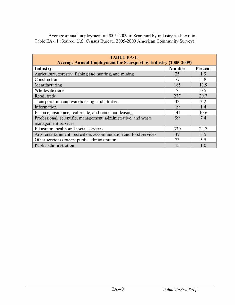
EA-40 Public Review Draft
Average annual employment in 2005-2009 in Searsport by industry is shown in Table EA-11 (Source: U.S. Census Bureau, 2005-2009 American Community Survey).
TABLE EA-11 Average Annual Employment for Searsport by Industry (2005-2009)
Industry Number Percent Agriculture, forestry, fishing and hunting, and mining 25 1.9 Construction 77 5.8 Manufacturing 185 13.9 Wholesale trade 7 0.5 Retail trade 277 20.7 Transportation and warehousing, and utilities 43 3.2 Information 19 1.4 Finance, insurance, real estate, and rental and leasing 141 10.6 Professional, scientific, management, administrative, and waste management services
99 7.4
Education, health and social services 330 24.7 Arts, entertainment, recreation, accommodation and food services 47 3.5 Other services (except public administration 73 5.5 Public administration 13 1.0
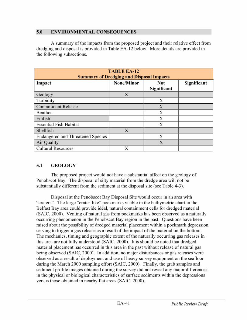
EA-41 Public Review Draft
5.0 ENVIRONMENTAL CONSEQUENCES A summary of the impacts from the proposed project and their relative effect from dredging and disposal is provided in Table EA-12 below. More details are provided in the following subsections.
TABLE EA-12Summary of Dredging and Disposal Impacts
Impact None/Minor Not Significant
Significant
Geology X Turbidity X Contaminant Release X Benthos X Finfish X Essential Fish Habitat X Shellfish X Endangered and Threatened Species X Air Quality X Cultural Resources X 5.1 GEOLOGY
The proposed project would not have a substantial affect on the geology of Penobscot Bay. The disposal of silty material from the dredge area will not be substantially different from the sediment at the disposal site (see Table 4-3).
Disposal at the Penobscot Bay Disposal Site would occur in an area with “craters”. The large “crater-like” pockmarks visible in the bathymetric chart in the Belfast Bay area could provide ideal, natural containment cells for dredged material (SAIC, 2000). Venting of natural gas from pockmarks has been observed as a naturally occurring phenomenon in the Penobscot Bay region in the past. Questions have been raised about the possibility of dredged material placement within a pockmark depression serving to trigger a gas release as a result of the impact of the material on the bottom. The mechanics, timing and geographic extent of the naturally occurring gas releases in this area are not fully understood (SAIC, 2000). It is should be noted that dredged material placement has occurred in this area in the past without release of natural gas being observed (SAIC, 2000). In addition, no major disturbances or gas releases were observed as a result of deployment and use of heavy survey equipment on the seafloor during the March 2000 sampling effort (SAIC, 2000). Finally, the grab samples and sediment profile images obtained during the survey did not reveal any major differences in the physical or biological characteristics of surface sediments within the depressions versus those obtained in nearby flat areas (SAIC, 2000).
EA-42 Public Review Draft
5.2 PHYSICAL AND WATER QUALITY IMPACTS
Dredging and disposal will create a temporary increase in turbidity in the water column. However, no long-term changes in water quality are expected from the construction of the proposed project. The discussion below describes the results of various turbidity plume studies conducted during dredging and disposal of dredged material. The results of these studies indicate the type of turbidity plume and the behavior of the disposed dredged material that may be expected from the proposed project. 5.2.1 Dredging Impacts
In the summer of 1977, the extent and duration of the impacts from dredging the Thames River/New London Harbor channels were studied (Bohlen, et. al., 1979). Bohlen (1979), estimated that 1.5% to 3.0% of the volume of substrate (fine-grained sands and silts) contained in an open clamshell dredge bucket is introduced into the water column. The conclusions of this study defined the plume extending 700 meters downstream. Analysis of the composition and concentration of the plume indicated the majority of material suspended occurred within 300 meters of the dredge. Suspended material concentrations closest to the dredge ranged from 200 mg/l to 400 mg/l.
However, a number of operational variables, such as bucket size and type (open or enclosed), prohibiting scow overflow, volume of sediment dredged per cycle, operator experience, hoisting speed, and hydrodynamic conditions in the dredging area can significantly affect the quantity of material suspended (LaSalle, 1988; Lunz et al., 1984). Sediment resuspension from clamshell dredges can be reduced by using an enclosed clamshell bucket or by slowing the raising or lowering of the bucket through the water column. However, the latter reduces the production rate of the dredge (Hayes, 1986).
Monitoring of dredge induced suspended sediment concentrations was conducted at New Haven Harbor to address concerns relative to winter flounder spawning grounds near the Federal channel (USACE, 1996). Dredging at New Haven Harbor was conducted with an enclosed bucket. The two major objectives of the New Haven monitoring were to 1) establish the background suspended solids concentration before and after dredging, and 2) document the movement of the dredge plume relative to fisheries resource areas such as winter flounder spawning grounds.
The results of the acoustic survey revealed that the dredge-induced sediment plume did protrude into the shoal areas to the east and west of the navigation channel. These excursions onto the shoals only occurred when the dredge was in the immediate vicinity. The DAISY (Disposal Area In-Situ System), which was deployed on the eastern end of the winter flounder spawning area, also showed elevated suspended materials concentrations attributable to the dredge operating in the upper reaches of the harbor. The time series of the DAISY data showed numerous aperiodic short duration spikes of 100 mg/L. The observed concentrations were an order of magnitude higher than the preceding background concentrations. However, in the last half of the deployment, while the dredge was located well south of the DAISY site, there were several long duration (1-
EA-43 Public Review Draft
3 days), and very high perturbations. During these events concentrations reached 700 mg/L that could not be related to the dredging operation. Evidence from the meteorological data and wastewater effluent records indicate that these events are likely the result of winds and wind-generated waves, alone or in combination with discharges from wastewater treatment plant outfalls.
An enclosed bucket was used to dredge the material unsuitable for open water disposal (silt) during the Boston Harbor navigation improvement project (BHNIP). Monitoring results from this dredging operation showed that the plume was confined to the navigation channel and returned to background levels between 600 and 1,000 feet downstream (USACE, 2002).
Additional dredge plume monitoring in Boston Harbor in 2008, continued to support the evidence that the plume is strongest near the dredge, highest concentrations are generally located near the bottom of the water column, and are typically confined to the navigation channel (although low concentration plume filaments [<5 NTU; <12 mg/L] were observed on two occasions (Battelle, 2009). The highest turbidity readings within 500 feet of the dredge were less than 20 NTU above background and suspended sediments were less than 40 mg/l (Battelle, 2009). The above results show that a turbidity plume can be produced during dredging but returns to background levels within 1,500 feet of the dredge and generally stays confined to the navigation channel. Use of a Cable Arm bucket can reduce the amount of suspended solids in the water column. However, that type of bucket may not be capable of removing the parent glacial improvement materials required for this project because it does not have teeth to dig into the material.
The dredging for the Searsport project is of a short duration (five months) and would be performed in the winter months due to construction windows to protect biological resources. Although the material is fined grained silt and clay (generally transitioning from clayey silt to silty clay with depth) the material to be dredged is consolidated (has been compacted over time) as can seen in the photograph below. (Additional photographs of the core samples are provide in Field Sampling and Sediment Testing Report prepared by Battelle in September 2008.)
Turbidity affects water column biological production by decreasing light penetration, clogging fish gills, or otherwise disturbing organisms. Based on the consolidated nature of the material, resuspension of the material during dredging is expected to occur to a lesser extent and where resuspension does occur the material is expected to settle within the dredge and channel areas. If a short duration plume were generated during dredging of the sediments, no significant biological impacts are anticipated. Construction will be accomplished in the winter when water temperatures are low and biological productivity is at a minimum, thus no significant biological impacts are anticipated if a short term turbidity plume were to occur during dredging.

EA-44 Public Review Draft
FIGURE EA-10. Station C- Photograph of Top of Vibracore
5.2.2 Disposal Impacts
Dredged material is released from scows operating on the surface and passes through several phases as it travels to the seafloor at the disposal site. The Penobscot Bay Disposal Site is located in waters approximately 100 feet deep. Several factors influence the behavior of the descending plume, including the properties of the sediment (e.g., silt, sand, clumps, etc.), water depth, water column stratification, and the interplay of the descending sediment with the water through which it passes. In general, the behavior of the plume can be described as occurring in three phases: convective descent, dynamic collapse, and passive diffusion. The three phases are discussed in more detail below.
Convective descent -The first phase of the plume following release of the dredged material from the barge into the water column is the convective descent. This phase begins with the release of the material from the transport device (disposal scow). During this phase, the material descends through the water column under the influence of gravity, generally maintaining its identity as a single mass (Brandsma and Divoky, 1976). During its descent, the area occupied by the plume expands as the local water is entrained into the descending mass of dredged material. In addition, the suspended sediment concentration was reduced by turbulence and dilution with the surrounding water mass. The duration of this phase depends on the depth of water, lasting from seconds in relatively shallow areas to minutes in waters over 984 feet. Field and laboratory studies indicate that approximately 1 to 5 percent of the sediment discharged from a barge remains in the water column following the convective descent phase (Ruggaber and Adams, 2000a; Ruggaber and Adams, 2000b; Tavolaro, 1984; USACE, 1986).
Dynamic Collapse – This phase occurs when the descending plume impacts the
bottom or reaches a neutrally buoyant position in the water column and diffuses horizontally under its own momentum. In areas with strong stratified water columns, particularly in water columns of several thousand feet, this process is complicated because portions of the plume may attain neutral buoyancy before hitting the seafloor. In those situations, a portion of the descending mass loses its
EA-45 Public Review Draft
downward momentum and comes to reside as a plume at its neutrally buoyant depth. The plume can oscillate around the depth of neutral buoyancy, creating a vertical oscillation of material. The residence of the materials within such an oscillation results in increased turbulence in the water column and increases the speed with which the plume dilutes and spreads horizontally as it comes into hydrostatic equilibrium. Studies have shown that this condition does not occur in water less than 262 feet, such as those at the sites considered for the Searsport project. This is because the sediment impacts the bottom regardless of the water stratification. This is due to the fact that the initial momentum and specific gravity are too great to be overcome by plume buoyancy. Gordon (1974) found that a well-defined surge resulting from the disposal of up to 3,000 cy of sediment (60-90% silt/clay) in waters up to 65 feet deep spread 100 to 400 feet upon impact. The consolidated material may have sufficient momentum to travel laterally for a couple hundred feet upon impacting the bottom (Hales, 1996).
Passive diffusion - Passive diffusion refers to the transport and dispersion of the
disposed material by the ambient oceanographic conditions (currents and turbulence) rather than the hydrodynamics occurring during the descent of the plume body. This phase results in the dispersion and transport of the suspended sediments and may last for several hours. Numerous field studies have confirmed that plumes are transient features of dredged material disposal from barges (Dragos and Lewis, 1993; Dragos and Peven, 1994; SAIC, 1988).
Verification of Dredged Material Disposal Plume Dynamic – During the
disposal operation, a portion of the dredged material released (generally a fraction of any fine silt and clay particles present) may remain in the water column as a turbid plume for several hours, where it will drift with the current. Dredged material plume dynamics for offshore operations have been verified at several sites in New England and in other locations in the United States. For example: o 500 to 5,000 cy of dredged material released in shallow depths of 50 to 66 feet
in the Gulf of Mexico (Krause, 1991) had an associated plume spread (widening) of 110 to 220 yards during the convective descent phase.
o Increased turbidity from the plumes in the water column has been documented
for up to two hours after disposal of 4,000 to 6,000 cy of dredged material in the New York Bight (water depth approximately 92 feet) (Dragos and Lewis, 1993; Dragos and Peven, 1994). Dilution of the dredged material within 2 ½ hours of disposal had achieved ratios of 3,000:1 to 600,000:1 (based on total suspended solids (TSS) analyses of water samples). Observed plume spreading at the time was generally less than 550 yards, and local currents carried the plumes up to about 0.6 mile from the discharge point, which was consistent with the current velocities at the time of the survey. Turbidity profiles collected throughout the disposal site and surrounding areas before and after disposal events did not find elevated turbidity in the vicinity of the
EA-46 Public Review Draft
disposal site that could be attributed to dredged material disposal (Dragos and Lewis, 1993; Dragos and Peven, 1994).
o Plume transport at the Rockland Disposal Site in Maine was limited to
approximately 500 yards from the point of discharge for a 1,900 cy disposal event (SAIC, 1988). However, the plume from a larger barge volume (3,640 cy) was transported approximately 1 mile from the disposal point over a two hour period, with suspended solids concentrations decreasing by 99 percent of those initially measured (~1,500 mg/L, decreasing to 14 mg/L).
o Studies at the Massachusetts Institute of Technology (MIT) (Ruggaber and
Adams, 2000a; Ruggaber and Adams, 2000b) used “flow visualization” devices in a laboratory setting to confirm that a small percentage of sediment remains in the water column after a disposal event. This laboratory study evaluated how plumes form and how sediment particle characteristics affect the plume formation. The study was also designed to determine how much material is incorporated into the descending cloud and how much is lost during convective descent. The study estimated that less than one percent of the original mass exiting the barge separates from the material contained within the collapse phase during the discharge and remains in the water column. This is consistent with the lower range reported from field studies (Tavolaro, 1984; USACE, 1986).
The above studies show that only a small amount of sediment remains in the
water column after a disposal event. In general, the material is rapidly diluted and dispersed and is not easily discernible after two to three hours.
The topography of the site will change slightly with the addition of a dredged material mound. The material to be dredged is generally fine-grained material. This is similar to the material at the disposal site, therefore no significant changes to the physical nature of the overall substrate is expected. The location of the Penobscot Bay Disposal Site (PBDS) in deeper water (about a 100 feet deep) and located landward of the Penobscot Bay opening, should protect the site from the effects of major storms. The fine grained sediment at the disposal site would indicate that this area is a depositional site and not an erosive site. 5.3 CHEMICAL IMPACTS
The concern about the small amount of material that remains in the water column pertains to potential impacts from (1) reduced light penetration induced by the residual sediment in the water column, which may reduce photosynthesis, and (2) the possible release of nutrients or contaminants from the sediments during the descent phase. Reduction in light penetration is usually short in duration (on the order of hours). Studies of the nutrient and other contaminant releases from the descending dredged materials show that the release is limited with no toxicity to sensitive marine organisms as determined through biotoxicity testing (ENSR, 2002). The incremental addition of nutrients or contaminants from dredged material disposal, relative to other sources such
EA-47 Public Review Draft
as rivers, wastewater treatment facilities and nonpoint sources is small and inseparable from ambient conditions (USACE, 1982). The intermittent nature of the disposal operations, the short time period that material stays in the water column (usually less than two to three hours), along with rapid dilution and settling further limit any potential effects.
Other fine-grained dredging projects have monitored the biological resources to determine if release of chemicals during dredging and disposal can cause adverse effects to organisms. For the Boston Harbor Navigation Improvement Project, a limited amount of biological testing was conducted using the sea urchin (for the fertilization test), mysid shrimp (for the chronic endpoint test), and blue mussels for bioaccumulation of metals and organics to determine if down current impacts occur from disposal activities. The results of the mysid shrimp test revealed at or near 100% survival for all samples and no difference in growth between the reference site and the site down current of disposal activities. For the sea urchin test, fertilization was approximately 90% for all samples in the 1999 test (the 2000 test showed impacts to both reference and down current site, indicating an unrelated project impact). Bioaccumulation results in the blue mussel were varied indicating either unrelated project impacts or the investigation was not wide enough to identify project-specific impacts (ENSR, 2002). All of the monitored dredged and disposed material discussed above is composed primarily of silt, with higher levels of contaminants, and from harbors larger than Searsport Harbor. Based on the above findings, dredging and dredged material disposal induced sediment resuspension is a minor perturbation when compared to the much longer duration, larger amplitude events associated with wind and wind-waves. The effects of dredge related spikes in suspended sediments on the winter flounder spawning grounds outside the project area, and the regional water quality, in general, appear limited in duration and of relatively low amplitude, especially outside the navigation channels. In addition, the level of sediment contaminants is much less at Searsport Harbor than the larger urban harbors described above. Water quality impacts are expected to be minor and short-lived. Since the material to be dredged generally contains low to moderate levels of contaminants, and most of the material to be dredged is improvement material (i.e. below the exposed maintenance material), no significant release of contaminants is expected. The amount of material expected to be released during dredging is low, see Section 5.2 above for details. 5.4 BIOLOGICAL IMPACTS
5.4.1 General
The deepening and widening of the navigation channel at Searsport Harbor and disposal of dredged material will have temporary negative impacts on some of the biological resources in the area which are described below.
EA-48 Public Review Draft
5.4.2 Benthic Resources
The benthos at the dredge site and disposal site will be temporarily impacted from construction activities. Sessile benthic organisms inhabiting the shoal areas to be dredged would be destroyed by the dredging. The number of species and number of benthic organisms inhabiting Searsport Harbor is rather large for a small area (see Appendix C). Unaffected organisms inhabiting the substrate outside of the dredged areas, however, should recolonize the disturbed areas. The loss of forage for predators such as crabs and finfish would be temporary due to recolonization of the benthic organisms. Deepening of the 400-foot wide maneuvering area adjacent to the State Pier in Long Cove, currently between about 20 to 30 plus feet deep (except for the northwest corner that is less than 20 feet) to 40 feet deep, will not change the depth in the area substantially. Also the substrate may change over time from coarse grained to fine-grained due to deposition in the deeper depths. The area would be expected to be similar to the benthic areas currently in the project area. Benthos at the disposal site will be buried by material as a result of disposal activities. Since the material to be disposed is similar in nature to the soft sediment at the disposal site, recolonization is expected to occur fairly rapidly. In a study performed in Chesapeake Bay where dredged material thickness was less than < 15 cm, the effect can be minimal on recovery of soft sediment macrobenthos (Schaffner, 2010). It can take up to 1 and ½ years if disposal material thickness is greater than 15 cm for the rate of macrobenthic recovery to reach ambient community levels (Schaffner, 2010). It may be possible for the same rate of recovery to occur in Penobscot Bay, as disposal will be completed just before the spawning of many benthic organisms. 5.4.3 Fisheries Resources
Dredging and disposal activities will temporarily disrupt the immediate project areas. Mobile finfish would be expected to leave the area of disturbance. However, for some species, the temporary loss of benthic habitat will mean that the area will not be available for food source or nursery habitat for a certain period of time. For other species, the newly formed disposal mound may attract animals such as crabs to the food-rich sediments (O’Donnell, et. al., 2007). This area is expected to return to near normal levels of density and diversity a few years after construction ceases. The area of disruption is small compared to the remaining Penobscot Bay. However, opportunistic benthic species would be expected to recolonize the area within months. 5.4.4 Essential Fish Habitat
Of the 16 EFH managed species listed for Penobscot Bay, only one species, the winter flounder (life stages: eggs, larvae, juvenile young-of-year, and spawning adults) may be expected to occur in the shallower dredge area. The following EFH species (and their life stages) may be expected to occur in the deeper waters of the disposal site, and not in the shallower dredge areas: Atlantic cod (larvae), whiting (juveniles and adults), American plaice (eggs, larvae, juveniles, and adults), Atlantic halibut (juveniles), and Atlantic sea herring (larvae, juveniles, and adults). The following managed EFH species
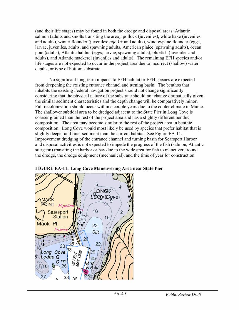
EA-49 Public Review Draft
(and their life stages) may be found in both the dredge and disposal areas: Atlantic salmon (adults and smolts transiting the area), pollock (juveniles), white hake (juveniles and adults), winter flounder (juveniles: age 1+ and adults), windowpane flounder (eggs, larvae, juveniles, adults, and spawning adults, American plaice (spawning adults), ocean pout (adults), Atlantic halibut (eggs, larvae, spawning adults), bluefish (juveniles and adults), and Atlantic mackerel (juveniles and adults). The remaining EFH species and/or life stages are not expected to occur in the project area due to incorrect (shallow) water depths, or type of bottom substrate. No significant long-term impacts to EFH habitat or EFH species are expected from deepening the existing entrance channel and turning basin. The benthos that inhabits the existing Federal navigation project should not change significantly considering that the physical nature of the substrate should not change dramatically given the similar sediment characteristics and the depth change will be comparatively minor. Full recolonization should occur within a couple years due to the cooler climate in Maine. The shallower subtidal area to be dredged adjacent to the State Pier in Long Cove is coarser grained than the rest of the project area and has a slightly different benthic composition. The area may become similar to the rest of the project area in benthic composition. Long Cove would most likely be used by species that prefer habitat that is slightly deeper and finer sediment than the current habitat. See Figure EA-11. Improvement dredging of the entrance channel and turning basin for Searsport Harbor and disposal activities is not expected to impede the progress of the fish (salmon, Atlantic sturgeon) transiting the harbor or bay due to the wide area for fish to maneuver around the dredge, the dredge equipment (mechanical), and the time of year for construction.
FIGURE EA-11. Long Cove Maneuvering Area near State Pier
LONGCOVE
MACKPOINT
EA-50 Public Review Draft
Overall changes to the disposal site are not expected to have long-term significant
impact to EFH species. A temporary impact to benthos would occur but they are expected to recolonize the site within a couple years. This is not significant considering the area of the disposal site compared to the area of Penobscot Bay.
The peak spawning time for winter flounder in Maine would be later than in Massachusetts Bay which is February and March. Spawning along the coast of Maine would continue into May (Pereira, et.al., 1999). Near Boothbay, which is located south of Penobscot Bay, spawning commences about March 1 and continues until about May 15, with the chief production of eggs usually taking place from March 30 to April 20 (www.gma.org/fogm/P_americanus). To avoid sensitive time periods for spawning adults, construction activities will not occur after April 9 or before November 8 of any given year.
After spawning, adults tend to leave inshore waters, although some remain year-
round. The eggs, larvae, and young-of-year are found in shallow inshore depths. Juveniles appear in deeper depths. Adult may be found in varying depths of up to 30 meters inshore, but in shallower depths when spawning (from less than five meters to more than 45 meters on Georges Bank). Much of the project area is already deeper than five meters, the area winter flounder spawn, except for a small corner of Long Cove. This area would be deepened and may no longer be suitable as potential spawning habitat. However, the amount of area that would be deepened is slight.
Atlantic cod larvae are most often present in the spring, in the pelagic waters of the Gulf of Maine. As construction will occur after November 8 or before April 9, and any disposal impacts are temporary, no significant impacts to the Atlantic cod larvae are expected.
Whiting juveniles and adults may be in the disposal site area during construction activities. They have been found at depths between 20 and 325 meters. Although it is possible a few juveniles and adults may occur at the disposal site during construction, no significant impacts to the whiting juvenile and adult population are expected as they would be able to move away from the disturbance. American plaice eggs and larvae can be found in the surface waters of the Gulf of Maine and in a wide range of salinities. The peak distribution time is in April and May. Juveniles and adults are found in bottom habitats consisting of fine-grained sediment or a substrate of sand or gravel. The proposed disposal site has fine grained sediment. Some eggs and larvae may be in the project area during construction, but not during the peak distribution. Also juveniles and adults would be expected to move away from the area of disturbance during a disposal event. No significant impact to this species is expected from the project. Atlantic halibut juveniles may be in the disposal area during construction activities. They prefer water depths of 20-60 meters. It is expected that any impacts to
EA-51 Public Review Draft
this species would be minimal as they would be expected to move away from the area during disposal events. The larvae of Atlantic sea herring are found in the pelagic waters of the Gulf of Maine at water depths of 50 to 90 meters. Larvae are observed between August and April, with peaks in September through November. The juveniles and adults are found in the pelagic waters and bottom habitat in the Gulf of Maine with water depths of between 15 and 135 meters and 20 to 130 meters respectively. Juveniles undergo seasonal inshore-offshore migrations and are abundant in shallow, inshore waters during the warmer months of the year, while adults (3+) migrate south from the summer/fall spawning grounds in the Gulf of Maine and Georges Bank to overwinter in southern New England and the Mid-Atlantic (Atlantic States Marine Fisheries Commission). Although some of the life stages may be present in the disposal area, the time of year restriction for this project would limit impacting this species during their peak time in Penobscot Bay. Also, impacts are expected to be minimal as the juveniles and adults would also be expected to move from the construction activities. The majority of adult salmon that migrate upstream to spawn in the freshwater of the Penobscot River will ascend the river primarily between May and mid-July (NMFS and USFWS, 2005). Most of the adult salmon will overwinter in the river and return to sea the following spring. In Maine rivers, the salmon eggs will hatch in March or April. Smolts will then begin their downstream migration to the ocean primarily from mid-April through mid-June (Baum 1997, in NMFS and USFWS, 2005). Based on this data, it appears that impacts to salmon would be minimal due to the time of year that dredging would occur (i.e. outside the migration time). Pollock juveniles may be in the project area during construction activities. They have been captured at depths of 0 to 250 meters, but are more commonly found at 25 to 75 meter depths. Although it is possible a few juveniles may occur at the construction site, no significant impacts to the pollock juvenile population are expected as they would be able to move away from the disturbance. White hake juveniles and adults may be found in the project area. They have been found in water depths of 5 to 225 meters and 5 to 325 meters respectively. The disturbance from construction would be expected to minimal, as the juveniles and adults would be expected to move from the project area. Windowpane flounder inhabit nearshore waters north of Cape Cod, and their occurrence in estuaries is not well documented (Chang, et.al., 1999). They generally inhabit shallow waters (< 110 meters) with sand to sand/silt or mud substrates; but they are most abundant from depths of 1-2 meters to <56 meters. Spawning begins in February or March in inner shelf waters, peaks in the Middle Atlantic Bight in May, and extends onto Georges Bank during the summer. Juvenile windowpanes were most abundant at depths of 7 to 17 meters. Adults in the Gulf of Maine use nearshore waters in the spring and autumn, while juveniles have low densities in nearshore areas in spring and autumn. Few eggs or larvae are expected in the project area. Juveniles may be in the
EA-52 Public Review Draft
project area June through October, but not when construction will occur. Adults and/or spawning adults could be in the project area during construction, but would be expected to avoid the dredge plume.
American plaice spawning adults migrate from deeper depths onto shoaled grounds before spawning in the Gulf of Maine (Johnson, 2004). Adults spawn and fertilize their eggs at or near the bottom. The eggs then drift into the upper water column after they are released. In the Gulf of Maine, the spawning season extends from March through the middle of June, with peak spawning activity in April and May. Temporary and local interference with spawning American plaice might occur from project activities. This is not expected to result in any significant impact to the overall resource due to the limited project area relative to the Gulf of Maine and the time of year restriction for the project. Adult ocean pout are demersal and are commonly collected at depths < 100 meters in coastal waters of New England and in saline estuaries during most months (Steimle, et.al., 1999). Adult ocean pout occur on most sediment types, including shell patches. However, there appears to be a seasonal variability in the use of certain habitats. In the winter and spring, adults are found in sand and gravel substrates, while in the summer and at other seasons, they were found in rock and hard substrates such as artificial reefs and wrecks in the New York Bight. Although adult ocean pout may be found in the project area their presence would be limited by the substrate type (silt) found in the project area. Any adults in the area would be expected to move from any construction disturbances. Adult Atlantic halibut are thought to spawn on the slopes of the continental shelf and on the offshore banks, at depths of at least 183 meters over rough or rock bottom. Spawning occurs during late winter and early spring (Cargnelli, et.al., 1999). Eggs are found at depths as deep as 700 meters and on harder substrates of sand, gravel and clay. The larvae are pelagic, floating within 50 meters of the surface. The project area is less than ideal as the spawning and nursery habitat for Atlantic halibut. Consequently, any impacts that might occur from project construction are expected to be minor. Bluefish juveniles and adults are highly migratory fish, appearing in Maine waters in early to mid-June and staying through late summer. Juveniles exhibit similar seasonal migration. While juveniles spend much of their time inshore in estuaries, adult bluefish usually spend only the late spring, summer, and fall months in close proximity to the shore and are only infrequent visitors to the enclosed inshore waters (McBride, 2004). Adult and juvenile Atlantic mackerel are common in Penobscot Bay between June through September. Adults and juveniles are rarely abundant in October (NOAA/NMFS, 1999). Most juveniles were observed at depths of 20 to 50 meters in the summer and fall. In general, the adult fish are commonly found at depths of 50-70 meters in the summer and in the fall at 60-80 meters, with a broader depth range for all individuals (Studholme, et.al., 1999). As the project will not be constructed in the summer months, no impacts to this species are expected.
EA-53 Public Review Draft
To avoid spawning winter flounder, transiting Atlantic salmon, and windowpane flounder, dredging and disposal will occur only between the period of November 8 through April 9. This will avoid any significant impacts to EFH habitat. 5.5 ENDANGERED AND THREATENED SPECIES
5.5.1 Federally Listed or Proposed Endangered or Threatened Species
Federally listed species that have the potential to be in the project area are the Atlantic salmon, and the Atlantic and shortnose sturgeon. Dredging and disposal would occur between November 8 and April 9 to avoid impacts to these species.
Results from a 2001 and 2002 post-smolt trawl survey in Penobscot Bay and the nearshore waters of the Gulf of Maine indicate that Atlantic salmon post-smolts are prevalent in the upper water column throughout this area in mid- to-late May (Russell Brown, NOAA Fisheries, personal communication in NMFS and USFWS, 2005). 5.5.2 Other Special Status Species
The bald eagle is a State listed species. A nest has been observed on the southeast shore of Sears Island and is not expected to be impacted by the dredging and disposal activities of the proposed project (U.S. Fish and Wildlife Service letter, 2006). Even if a nest was observed on the west side of the island, ships already use the project and there is terminal activity on Mack Point. The dredge would not be expected to add to the disturbances in the area that currently exists. American eel and laughing gull are both listed as Maine species of special concern. The American eel (Anguilla rostrata) has a catadromous life cycle, that is, it spawns in the ocean and migrates to fresh water to grow to adult size. As adult eels mature, they leave the brackish/freshwater growing areas in the fall (August to November), migrate to the Sargasso Sea and spawn during the late winter. As glass eels (an eel in its transparent postlarval stage) leave the open ocean to enter estuaries and ascend rivers they are known as elvers. This migration occurs in late winter, early spring, and throughout the summer months. Some elvers may remain in brackish waters while others ascend rivers far inland. Eels may stay in growing areas from 8-25 years before migrating back to sea to spawn. The proposed project would not occur during the out migration of the adult eels and the elvers would be expected to avoid disruptions from noise or turbidity associated with dredging. The peak upstream migration occurs primarily from late April to June in Maine, which is outside the construction window. A slight overlap with the out migration of adult eels may occur when the project is under construction; but would not be expected to occur during peak migration. Therefore, no significant impacts to this species are expected (www.pearl.maine.edu/windows/penobscot/synthesis_fisheries.htm#eel). Laughing gulls are not expected to be impacted by the dredge and disposal activities as no direct impact to this species or to their habitat would occur. In addition,
EA-54 Public Review Draft
noise disturbance would not be expected to be a concern as they would be expected to be adjusted to similar impacts from ongoing ship and terminal activities.
In 2004, the National Oceanic and Atmospheric Administration listed the rainbow smelt as a Federal Species of Concern. River herring are a managed species under the ASMFC Interstate Fisheries Management Plan. NMFS is concerned about river herring and rainbow smelt. Two species of river herring (blueback herring and alewives) live in large schools in the ocean and swim up freshwater rivers (usually in mid-late May in the Penobscot basin) to spawn in ponds and lakes in the spring. The species ranges from Newfoundland to South Carolina. Blueback herring spawn later than alewives in the moving currents of rivers and streams. Adults migrate back downstream shortly after spawning and juveniles also leave for the ocean in summer and fall. Spawning runs continue in the Souadabscook Stream and other tributaries of the Penobscot. Construction between November 8 and April 9 should not impact spawning river herring (www.pearl.maine.edu/windows/penobscot/synthesis).
At six to eight inches long, rainbow smelt are the smallest of Maine's anadromous fish. They range from Labrador to New Jersey and migrate into the Penobscot in April, cued by the lengthening days. Some smelt remain in harbors and streams of the lower river through the fall. They are harvested in spring with dip nets placed in tributaries of the Penobscot. Smelt feed on zooplankton, shrimps, worms, and small fish; they in turn are eaten by striped bass, bluefish, and birds. Construction between November 8 and April 9 should not impact spawning river herring. (www.pearl.maine.edu/windows/penobscot/synthesis_fisheries). 5.6 AIR QUALITY
Clean Air Act compliance, specifically with U.S. Environmental Protection Agency’s (EPA) General Conformity Rule, requires that all Federal agencies, including the Department of the Army, review new actions and decide whether the actions would worsen an existing National Ambient Air Quality Standards (NAAQS) violation, cause a new NAAQS violation, delay the State Implementation Plan (SIP) attainment schedule of the NAAQS, or otherwise contradict the State’s SIP.
The general conformity rule was designed to ensure that Federal actions do not impede local efforts to control air pollution. It is called a conformity rule because Federal agencies are required to demonstrate that their actions "conform with" (i.e., do not undermine) the approved SIP for their geographic area. Federal agencies make this demonstration by performing a conformity review. The conformity review is the process used to evaluate and document project-related air pollutant emissions, local air quality impacts and the potential need for emission mitigation. A conformity review must be performed when a Federal action generates air pollutants in a region that has been designated a non-attainment or maintenance area for one or more NAAQS. Non-attainment areas are geographic regions where the air quality fails to meet the NAAQS.
The State of Maine is authorized by the EPA to administer its own air emissions permit program, which is shaped by its SIP. The SIP sets the basic strategies for
EA-55 Public Review Draft
implementation, maintenance, and enforcement of the NAAQS. The SIP is the Federally enforceable plan that indentifies how the State will attain and/or maintain the primary and secondary NAAQS established by the EPA (U.S. Environmental Protection Agency, 2004). In Maine, Federal actions must conform to the Maine SIP or Federal implementation plan. For non-exempt activities, the USACE must evaluate and determine if the proposed action (construction and operation) will generate air pollution emissions that aggravate a non-attainment problem or jeopardize the maintenance status of the area for ozone. When the total direct and indirect emissions caused by the operation of the Federal action/facility are less than threshold levels established in the rule (40 C.F.R. § 93.153), a Record of Non-applicability (RONA) is prepared and signed by the facility environmental coordinator. Construction and Operation
The proposed project is located in Waldo County, Maine. Waldo County was
recently redesignated to be in attainment for all criteria pollutants and is now a maintenance area (http://www.epa.gov/air/oaqps/greenbk/ancl3).
Dredging would occur over a total period of about five months, with work being
done in the fall and winter. During construction, equipment operating in Searsport Harbor will emit pollutants that contribute to increased levels of criteria pollutants such as carbon monoxide, nitrogen oxides, and ozone. Based on the type of equipment expected to construct the project, and the duration of construction, emissions for NOx and VOC were calculated. The total direct and indirect emissions for Long Cove, the turning basin, and the entrance channel are below the 100 tons/year for NOx and 50 tons/year for VOC (see RONA evaluation included with this EA) for air maintenance areas. The emissions for construction vehicles and related equipment will have an insignificant impact to local air quality.
In order to minimize air quality effects during construction, all construction operations would comply with applicable provisions of the State of Maine air quality control regulations pertaining to dust, odors, construction, noise, and motor vehicle emissions.
Direct and indirect increases or other changes in local or regional air quality likely to occur with construction of the proposed project are expected to conform to the SIP. See the RONA evaluation and General Conformity Determination included with this EA. 5.7 CULTURAL RESOURCES
Public Archaeology Laboratory, Inc. (PAL) completed a remote sensing archaeological survey of a proposed navigation improvement project in Searsport Harbor during the summer of 2007, consisting of archival research and field investigations. The survey documented the wreck of the historic schooner-barge Cullen No. 18, as well as a buried relict fluvial geomorphic feature with archaeological sensitivity for potentially containing pre-Contact period archaeological deposits. Based on these results, additional
EA-56 Public Review Draft
archaeological investigations within the Searsport Harbor project area were recommended to include:
a. a limited program of vibratory coring to determine the presence or absence of archaeologically sensitive paleosols, and
b. visual inspection of the Cullen No. 18 shipwreck for purposes of determining preliminary eligibility to the National Register of Historic Places.
Coordination of the results and recommendations from the PAL remote sensing
archaeological survey with the Maine State Historic Preservation Officer (ME SHPO) was completed in accordance with Section 106 of the National Historic Preservation Act (NHPA). Due to the clarity and detail of the side scan sonar images, David Robinson of PAL informally recommended that the existing remote sensing data be utilized, along with more detailed archival and historical research, in place of the visual inspection of the shipwreck. It was felt that this was a reasonable conclusion and would eliminate the need for a costly underwater site inspection that may not provide any additional information than what was available in existing data. A scope of work was developed for this follow-up “wreck assessment”. The scope of work and the original survey data were included in coordination with the ME SHPO. Comments on the survey report and scope for the wreck assessment were received from the ME SHPO by letter dated February 28, 2008.
Although SHPO did agree with the original survey recommendations for additional coring and inspection of the wreck, they did not concur with the approach recommended by PAL, namely substituting the visual inspection with additional archival and data interpretation. A conference call was held with Dr. Arthur Spiess and Lee Cranmer of ME SHPO along with USACE and PAL staff on June 13, 2008 to further refine the scope of the wreck assessment. Rather than discard the data already obtained, it was decided to complete the wreck assessment as planned and to coordinate the results with SHPO. At that time, further coordination would be conducted based upon the results.
Following these discussions, PAL completed a preliminary assessment of a large wooden-hulled shipwreck identified during the 2006 remote sensing archaeological survey for a proposed USACE navigation improvement project in Searsport Harbor (Robinson, et al., 2008). The goals of the assessment were to further interpret and define the wreck site and its boundaries and develop research contexts for future assessment of its National Register eligibility. These goals were met through a combination of additional post-processing of remote sensing data recorded at the site and supplemental archival research. The supplemental archival research focused on Searsport’s maritime trade during the first half of the 20th Century, and the role of schooner barges in the history of North American ship design and technology, maritime commerce, and Maine’s shipbuilding industry.
Based on the results of this study and consultation with ME SHPO, it was recommended that a comprehensive site examination be completed consisting of diver-based archaeological documentation, subsurface testing, and supplemental archival
EA-57 Public Review Draft
research to conclusively confirm the shipwreck’s identity, to assess in detail the condition and integrity of the remains, and to fully evaluate the site’s National Register eligibility.
During the initial stages of project planning, it was thought that the shipwreck was located within the area of potential effect for proposed navigation improvements. However, the proposed channel alignment for the harbor indicates that the wreck falls outside of this area and would not be impacted by project improvements (see Figure EA-5). Therefore, the current project should not impact the shipwreck and the further archaeological investigations summarized above are not required at this time. However, should the channel alignment change during final project design in such a manner as to encroach upon the wreck, the USACE would resume coordination efforts with the ME SHPO and conduct the additional recommended work.
Therefore, as the proposed navigation improvement project at Searsport Harbor should have no effect upon any structure or site of historic, architectural or archaeological significance as defined by Section 106 of the National Historic Preservation Act of 1966, as amended, and the implementing regulations of 36 CFR 800, no further action is required. On March 9, 2009, the ME SHPO concurred with this determination. See Appendix A for a copy of the letter from the USACE dated January 28, 2009 to SHPO and SHPO’s concurrence stamp provided on March 9, 2009 at the bottom of provided letter. 5.8 ENVIRONMENTAL JUSTICE AND PROTECTION OF CHILDREN
Executive Order 12898, “Federal Actions to Address Environmental Justice in Minority Populations and Low-Income Populations” requires Federal agencies to identify and address disproportionately high and adverse human health or environmental effects of its program, policies, and activities on minority and low-income populations in the U.S., including Native Americans. Executive Order 13045, “Protection of Children from Environmental Health Risks and Safety Risks,” requires Federal agencies to identify and assess environmental health risks and safety risks that may disproportionately affect children.
No significant adverse impacts to children, minority or low income populations
are anticipated as a result of this project. Ninety-nine percent of the population is white and only 19% of the population is under 18 years old within the town of Searsport, Maine (Source: U.S. Census Bureau, 2005-2009 American Community Survey). Approximately 7% of families or 10.5% of individuals, living within the town of Searsport are below the poverty level (U.S. Census Bureau, Poverty Status in the Past 12 Months, 2005-2009 American Community Survey).
The proposed project is designed to enhance navigation efficiency at Mack Point.
The construction of the project and increased navigational efficiency may have a positive economic impact on the local and surrounding communities. Potential environmental effects of this project are expected to be temporary and minor. Therefore any potential environmental effects on minorities, low-income people, or children are expected to be small.
EA-58 Public Review Draft
6.0 CUMULATIVE IMPACTS Cumulative impacts are those resulting from the incremental impact of the proposed action when added to other past, present, and reasonably foreseeable future actions. Past and recent activities in Searsport Harbor include the original dredging of the Federal channel and turning basin, upgrades to the marine terminals and piers, ship traffic through the channel, and construction of the causeway to nearby Sears Island. Reasonably foreseeable future actions, besides the proposed improvement dredging and the 31,000 cy proposed to be removed from the two berths at Mack Point, include the continuation of maintenance dredging of the Federal Navigation project about once every 30 years.
Our base case analysis projects that shippers currently using the channel to
capacity will move to larger ship sizes with the project, which will slightly reduce the number of ship calls overall. For example, the affected oil products could be brought in on six fewer vessels annually with the 40-foot deep project, and the affected bulk products on three or four fewer vessels. The base case is based on current cargo volumes and current vessels, so is the "most likely" case. Using a sensitivity analyses, increased cargo volumes are added over time to see how the benefits change. However, those increased volumes are the result of increasing demand and would occur with or without the project, and are not the result of the channel deepening project.
A new liquid propane tank facility is proposed for the area north of the Mack
Point existing facility area. The increased ship traffic related to the proposed tank would occur with or without the navigation improvement project, and is not a result of the channel deepening project.
The effects of the previous, existing and future dredging actions are generally
limited to infrequent disturbances of the benthic communities in the dredged areas and disposal areas. None or minimal impacts to winter flounder eggs or young of year are expected from this dredging event given the time of year restrictions for construction. However, a slight reduction in available winter flounder habitat may occur with the deepening of the maneuvering area at Long Cove. Water quality, air quality, hydrology, and other biological resources are generally not significantly affected by these actions. The direct effects of navigation improvement project are not anticipated to add significant impacts from other actions in the area.
The silty material removed during improvement dredging of Searsport Harbor and
disposed at the disposal site will have a temporary impact on water quality and biological resources as a result. Temporary impacts include burial and removal of benthic organisms and slight reduction in habitat for other species such as finfish until the benthic community returns. Therefore, no significant adverse cumulative impacts are projected as a result of this project because of: 1) the low frequency of dredging (once every 30 years), 2) operation windows are utilized to restrict dredge activities during fish spawning seasons, 3) the use of best management practices are utilized to reduce significant impacts to water quality and biological resources, and 4) sediment is tested to ensure
EA-59 Public Review Draft
compliance with the Clean Water Act prior to disposal.
7.0 ACTIONS TO MINIMIZE ENVIRONMENTAL IMPACTS The following actions will be taken to minimize project impacts on the environment:
1. Dredging and disposal will occur between November 8 and April 9 to protect migrating Atlantic salmon and other biological resources.
2. No scow overflow will be allowed to minimize turbidity at the dredge site.

EA-60 Public Review Draft
8.0 COMPLIANCE WITH FEDERAL ENVIRONMENTAL STATUTES, EXECUTIVE ORDERS AND EXECUTIVE MEMORANDA
FEDERAL STATUTES
1. Archaeological Resources Protection Act of 1979, as amended, 16 USC 470 et seq.
Compliance: Issuance of a permit from the Federal land manager to excavate or remove archaeological resources located on public or Indian lands signifies compliance. Not applicable. 2. Preservation of Historic and Archeological Data Act of 1974, as amended, 16 U.S.C. 469 et seq.
Compliance: The project has been coordinated with the Maine State Historic Preservation Officer. 3. American Indian Religious Freedom Act of 1978, 42 U.S.C. 1996.
Compliance: Not applicable. 4. Clean Air Act, as amended, 42 U.S.C. 7401 et seq.
Compliance: Public notice of the availability of this report to the Environmental Protection Agency is required for compliance pursuant to Sections 176c and 309 of the Clean Air Act and completion of a Record of Non-applicability. 5. Clean Water Act of 1977 (Federal Water Pollution Control Act Amendments of
1972) 33 U.S.C. 1251 et seq.
Compliance: Clean Water Act Section 404(b) (1) Evaluation and Compliance Review has been incorporated into the project report. An application will be filed for State Water Quality Certification pursuant to Section 401 of the CWA. 6. Coastal Zone Management Act of 1982, as amended, 16 U.S.C. 1451 et seq.
Compliance: A Coastal Zone Consistency Determination will be acquired from the State of Maine prior to construction of the proposed project. 7. Endangered Species Act of 1973, as amended, 16 U.S.C. 1531 et seq.
Compliance: The project has been coordinated with the U.S. Fish and Wildlife Service (USFWS) and the National Marine Fisheries Service (NMFS). The USACE has made a preliminary determined that no formal consultation requirements pursuant to Section 7 of the Endangered Species Act are needed. However, final determination will be made after release of the draft Environmental Assessment. 8. Estuarine Areas Act, 16 U.S.C. 1221 et seq.
EA-61 Public Review Draft
Compliance: This report is being submitted to Congress. 9. Federal Water Project Recreation Act, as amended, 16 U.S.C. 4601-12 et seq.
Compliance: Public notice of availability to the project report to the National Park Service (NPS) and Office of Statewide Planning relative to the Federal and State comprehensive outdoor recreation plans signifies compliance with this Act. 10. Fish and Wildlife Coordination Act, as amended, 16 U.S.C. 661 et seq.
Compliance: Coordination and full consideration of comments from the U.S. FWS, NMFS, and Maine fish and wildlife agencies have been incorporated into the draft EA. A U.S. Fish and Wildlife Service’s Final Coordination Act Report (FCAR) will be obtained upon approval for public release of the document and will signify compliance with the Fish and Wildlife Coordination Act. 11. Land and Water Conservation Fund Act of 1965, as amended, 16 U.S.C. 4601-4 et seq.
Compliance: Public notice of the availability of this report to the National Park Service (NPS) and the Office of Statewide Planning relative to the Federal and State comprehensive outdoor recreation plans signifies compliance with this Act. 12. Marine Protection, Research, and Sanctuaries Act of 1971, as amended, 33 U.S.C.
1401 et seq.
Compliance: Not Applicable. The proposed project does not involve the transportation or disposal of dredged material in ocean waters pursuant to Sections 102 and 103 of the Act, respectively. 13. National Historic Preservation Act of 1966, as amended, 16 U.S.C. 470 et seq.
Compliance: Coordination with the State Historic Preservation Office signifies compliance. 14. The American Graves Protection and Repatriation Act (NAGPRA), 25 U.S.C. 3000-3013, 18 U.S.C. 1170
Compliance: Regulations implementing NAGPRA will be followed if discovery of human remains and/or funerary items occur during implementation of this project. 15. National Environmental Policy Act of 1969, as amended, 42 U.S.C 4321 et seq.
Compliance: Preparation of the Environmental Assessment signifies partial compliance with NEPA. Full compliance shall be noted at the time the Finding of No Significant Impact is signed by the District Engineer. 16. Rivers and Harbors Act of 1899, as amended, 33 U.S.C. 401 et seq.
Compliance: This proposed project will be submitted to Congress for authorization.
EA-62 Public Review Draft
17. Watershed Protection and Flood Prevention Act as amended, 16 U.S.C 1001 et seq.
Compliance: Floodplain impacts have been considered in project planning. The project will not result in the loss of floodplain. 18. Wild and Scenic Rivers Act, as amended, 16 U.S.C 1271 et seq.
Compliance: Not applicable. 19. Magnuson-Stevens Act, as amended, 16 U.S.C. 1801 et seq.
Compliance: Coordination with the National Marine Fisheries Service has determined that the preparation of an Essential Fish Habitat (EFH) Assessment is required. Preparation and response to NMFS EFH recommendations will signify compliance with the EFH provision of the Act.
EXECUTIVE ORDERS
1. Executive Order 11593, Protection and Enhancement of the Cultural Environment, 13 May 1971
Compliance: Coordination with the Maine Historic Preservation Officer signifies compliance. 2. Executive Order 11988, Floodplain Management, 24 May 1977 amended by
Executive Order 12148, 20 July 1979.
Compliance: Public notice of the availability of this report or public review fulfills the requirements of Executive Order 11988, Section 2(a) (2). 3. Executive Order 11990, Protection of Wetlands, 24 May 1977.
Compliance: Public notice of the availability if this report for public review fulfills the requirements of Executive Order 11990, Section 2 (b). 4. Executive Order 12114, Environmental Effects Abroad of Major Federal Actions,
4 January 1979.
Compliance: Not applicable to projects located in the United States geographical boundaries. 5. Executive Order 12898, Environmental Justice, 11 February 1994.
Compliance: The project will not have a significant impact on minority or low-income population, or any other population in the United States. 6. Executive 13007, Accommodation of Sacred Sites, 24 May 1996

EA-63 Public Review Draft
Compliance: Not applicable. This project is not on Federal lands. 7. Executive Order 13045, Protection of Children from Environmental Health Risks and Safety Risks. 21 April 1997.
Compliance: Not applicable. The project would not create a disproportionate environmental health or safety risk for children. 8. Executive Order 13175, Consultation and Coordination with Indian Tribal Governments, 6 November 2000.
Compliance: Consultation with Indian Tribal Governments, where applicable, and consistent with executive memoranda, DoD Indian policy, and USACE Tribal Policy Principles signifies compliance.
EXECUTIVE MEMORANDUM
1. Analysis of Impacts on Prime or Unique Agricultural Lands in Implementing NEPA, 11 August 1980.
Compliance: There are no impacts to prime agricultural lands on the project. 2. White House Memorandum, Government-to-Government Relations with Indian
Tribes, 29 April 1994.
Compliance: Consultation with Federally Recognized Indian Tribes, where appropriate, signifies compliance.
EA-64 Public Review Draft
9.0 REFERENCES Barnhardt, W.A., D.A. Belknap, A.R. Kelley, J.T. Kelley, S.M. Dickson. 1996. Surficial
Geology of the Maine Inner Continental Shelf, Rockland to Bar Harbor, Maine. Geological Map No. 96-11. Published by Department of Conservation, Maine Geological Survey.
Battelle. 2009. Final Summary Report, Plume Monitoring, Boston Harbor Inner Harbor
Maintenance Dredging Project. Submitted to: New England District, U.S. Army Corps of Engineers, 696 Virginia Rd, Concord, MA.
Baum, E. T. 1997. Maine Atlantic Salmon: A National Treasure. Atlantic Salmon
Unlimited. 224 pp. Bigelow, H.B. and W.C. Schreder. 1953. Fishes of the Gulf of Maine. U.S Fish and
Wildlife Service. Fisheries Bulletin 53: 1-477. Bohlen, F.W., D.F. Cundy, and J.M. Tramontano. 1979. Suspended Material
Distributions in the Wake of Estuarine Channel Dredging Operations. Estuarine and Coastal Marine Science 9:699-711.
Brandsma, M.G. and D.J. Divoky. 1976. Development of Models for Prediction of
Short-Term Fate of Dredged Material Discharge in the Estuarine Environment. Contract Report D-76-5. U.S. Army Corps of Engineers, Waterways Experiment Station, Vicksburg, MS.
Cargnelli, L.M., S.J. Griesbach, and W.W. Morse. 1999. Essential Fish Habitat Source
Document: Atlantic Halibut Hippoglossus hippoglossus, Life History and Habitat Characteristics. NOAA Technical Memorandum NMFS-NE-125. National Oceanic and Atmospheric Administration, National Marine Fisheries Service, Northeast Fisheries Science Center, Woods Hole, MA.
Chang, S., P.L. Berrien, D.L. Johnson, and W.W. Morse. 1999. Essential Fish Habitat
Source Document: Windowpane Scophthalmus aquosus, Life History and Habitat Characteristics. NOAA Technical Memorandum NMFS-NE-137. National Oceanic and Atmospheric Administration, National Marine Fisheries Service, Northeast Fisheries Science Center, Woods Hole, MA.
Dragos, P. and D. Lewis. 1993. Plume Tracking/Model Verification Project. Prepared
under EPA Contract No. 68-C8-0105. 49 pp plus appendix. Dragos, P. and C. Peven. 1994. Plume Tracking of Dredged Material Containing
Dioxin, Final Report. Prepared under EPA Contract No. 68-C2-0134. 49 pp plus appendix.
EA-65 Public Review Draft
Ellis, S.A. and D.F. Cowan. 1999. Final Report: Intertidal Lobster Monitoring Program Penobscot Bay Lobster Collaborative, 1998 and 1999. Submitted to the Island Institute.
ENSR International. 2002. Boston Harbor Navigation Improvement Project: Phase 2
Summary Report. Prepared for U.S. Army Corps of Engineers, New England District and Massachusetts Port Authority. Document No. 9000-178-000. Contract No. DACW33-96-D-004, Task Order 51. May 2002.
Gordon, R.B. 1974. Dispersion of Dredge Spoil Dumped in Near-shore Waters.
Estuarine and Coastal Marine Science, vol. 2, pp. 349-358. Gosner, K.L. 1978. A Field Guide to the Atlantic Seashore: Invertebrates and Seaweeds
of the Atlantic Coast from the Bay of Fundy to Cape Hatteras. Houghton Mifflin Co., Boston. 329 pp.
Hales, L.Z. 1996. Analysis of Dredged Material Disposed in Open Water: Summary
Report for Technical Area 1. U.S. Army Corps of Engineers Dredging Research Program, Vicksburg, MS. Technical Report DRP-96-4.
Hayes, D.F. 1986. Guide to Selecting a Dredge for Minimizing Resuspension of
Sediment. Environmental Effects of Dredging Technical Notes: EEDP-09-1. U.S. Army Corps of Engineers, Waterways Experiment Station, Vicksburg, MS.
Johnson, D.L. 2004. Essential Fish Habitat Source Document: American Plaice
Hippoglossoides platessoides, Life History and Habitat Characteristics. NOAA Technical Memorandum NMFS-NE-187. National Oceanic and Atmospheric Administration, National Marine Fisheries Service, Northeast Fisheries Science Center, Woods Hole, MA.
Kelley, J.T., Dickson, S.M, Belknap, D.F., Barnhardt, W.A., and Henderson, M. 1994.
Giant Sea-bed Pockmarks: Evidence for Gas Escape from Belfast Bay, Maine. Geology, vol. 22, pp. 59-62.
Kelley, J.T., W.A. Barnhardt, D.F. Belknap, S.M. Dickson, A.R. Kelley, and L. Ward.
1996. The Seafloor Revealed: The Geology of the Northwestern Gulf of Maine Inner Continental Shelf. Maine Geological Survey, Natural Resources information and Mapping Center, Open-File Report 96-06.
Kraus, N.C. 1991. Mobile, Alabama, Field Data Collection Project, 18 August – 2
September 1989. Report 1: Dredged Material Plume Survey Data Report. U.S. Army Corps of Engineers, Dredging Research Program. USACE Tech. Report No. DRP-91-3, Washington, D.C.
LaSalle, M.W. 1988. Physical and Chemical Alterations Associated with Dredging: An
Overview of Effects of Dredging on Anadromous Pacific Coast Fishes: Workshop
EA-66 Public Review Draft
Proceedings, Seattle, September 8-9, 1988. U.S. Army Corps of Engineers Waterways Experiment Station, Vicksburg, MS.
Lazzari, M. 2001. Dynamics of Larval Fish Abundance in Penobscot Bay, Maine.
Fisheries Bulletin, vol. 99, pp. 81-93. Lazzari, M. and Tupper. 2002. Importance of Shallow Water Habitats for Demersal
Fishes and Decapod Crustaceans in Penobscot Bay, Maine. Environmental Biology of Fishes, vol. 63, no. 1, pp. 57-66.
Long, E.R., D.D. MacDonald, S.L. Smith, and F.D. Calder. 1995. Incidence of Adverse
Biological Effects within Ranges of Chemical Concentrations in Marine and Estuarine Sediments. Environmental Management 19(1): 81-97.
Lunz, J.D. D.G. Clarke, and T.J. Fredette. 1984. Seasonal Restrictions on Bucket
Dredging Operations. Reprinted from the Proceedings of the Conference Dredging ’84, Waterway, Port,Coastal and Ocean Division ASCE/Nov. 14-16, 1984, Clearwater Beach, FL.
Maine Department of Transportation (ME DOT). 1987. Sears Island Dry Cargo
Terminal and Access Road, Searsport, Waldo, County, Maine. Final Environmental Impact Statement. U.S. Department of Transportation, Federal Highway Administration and Maine Department of Transportation
McBride, R. 2004. Bluefish Life History. Written by Richard McBride, Florida Marine
Research Institute April 12, 2004, edited by Paul Caruso, Massachusetts Division of Marine Fisheries.
National Marine Fisheries Service and U.S. Fish and Wildlife Service (NMFS and
USFWS). 2005. Recovery Plan for the Gulf of Maine Distinct Population Segment of Atlantic Salmon (Salmo salar). National Marine Fisheries Service, Silver Spring, MD.
NOAA/NMFS. 1999. Essential Fish Habitat Designations within the Northeast Region
(Maine to Virginia), Working Copy. O’Donnell, K.P., R.A. Wahle, M. Bell, and M. Dunnington. 2007. Spatially Referenced
Trap Arrays Detect Sediment Disposal Impacts on Lobsters and Crabs in a New England Estuary. Marine Ecology Progress Series, vol. 348, pp. 249-260.
Pereira, J.J., R. Goldberg, J.J. Ziskowski, P.L. Berrien, W.W. Morse, and D.L. Johnson.
1999. Essential Fish Habitat Source Document: Winter Flounder Pseudopleuronectes americanus, Life History and Habitat Characteristics. NOAA Technical Memorandum NMFS-NE-138. National Oceanic and Atmospheric Administration, National Marine Fisheries Service, Northeast Fisheries Science Center, Woods Hole, MA.
EA-67 Public Review Draft
Permanent International Association of Navigation Congresses (PIANC). June 1997
Report. Rhoads, D.C. 1994. Analysis of the Contribution of Dredged Material to Sediments and
Contaminant Fluxes in Long Island Sound. Contribution 88. Disposal Area Monitoring System (DAMOS) Report. Prepared for the U.S. Army Corps of Engineers, New England Division, Waltham, MA.
Robinson, David S. (with contributions by Jeffrey D. Gardner). 2007. Marine
Archaeological Survey, Searsport Harbor, Searsport, Maine. Submitted by: Public Archaeology Laboratory (PAL), Pawtucket, Rhode Island, PAL Report No. 2019, Contract No. DACW33-03-D-0002 IDIQ, Task Order No. 12. Submitted to: USACE, New England District, Concord, Massachusetts.
Robinson, David S. (with contributions by: Jeffrey D. Gardner, Margaret H. Sano, and
Jeffrey J. Hall). 2008. Preliminary Assessment, Searsport Harbor Shipwreck, Searsport, Maine. Submitted by: PAL, Pawtucket, Rhode Island, Report No. 2019, Contract No. DACW33-03-D-0002 IDIQ, Task Order No. 12, Optional Task No. 9. Submitted to: USACE, New England District, Concord, Massachusetts.
Ruggaber, G.J. and E.E. Adams. 2000a. Dynamics of Particle Clouds Related to Open-
Water Sediment Disposal: 2. Loss of Material during Convective Descent in: Conference on Dredged Material Management: Options and Environmental Consideration. MIT Sea Grant College Program. Cambridge, MA.
Ruggaber, G.J. and E.E. Adams. 2000b. Dynamics of Particle Clouds Related to Open-
Water Sediment Disposal: Sediment Trap Experiments in: Conference on Dredged Material Management: Options and Environmental Consideration. MIT Sea Grant College Program. Cambridge, MA.
Schaffner, Linda. 2010. Patterns and Rates of Recovery of Macrobenthic Communities
in a Polyhaline Temperate Estuary Following Sediment Disturbance: Effects of Disturbance Severity and Potential Importance of Non-local Processes. Estuaries and Coasts 33: 1300-1313.
Scanlon, K.M. and Knebel, H.J. 1989. Pockmarks in the Floor of Penobscot Bay, Maine.
Geo-Marine Letters 9:53-58. Science Applications International Corporation (SAIC). 1988. Seasonal Monitoring
Cruise at the Western Long Island Sound Disposal Site, August 1986. DAMOS Contribution No. 61. U.S. Army Corps of Engineers, New England Division, Waltham, MA. 20 pp.
EA-68 Public Review Draft
SAIC. 2000. Survey at a Candidate Disposal Site near Steels Ledge in Penobscot Bay, Maine. Submitted to: New England District, U.S. Army Corps of Engineers, 696 Virginia Rd, Concord, MA.
Squiers, T.S., and M. Smith. 1979. Distribution and abundance of shortnose sturgeon in
the Kennebec River estuary. Final Report to the National Marine Fisheries Service, Gloucester, MA.
Steimle, F.W., W.W. Morse, P.L. Berrien, D.L. Johnson, and C.A. Zetlin. 1999.
Essential Fish Habitat Source Document: Ocean Pout Macrozoarces americanus, Life History and Habitat Characteristics. NOAA Technical Memorandum NMFS-NE-129. National Oceanic and Atmospheric Administration, National Marine Fisheries Service, Northeast Fisheries Science Center, Woods Hole, MA.
Studholme, A.L., D.B. Packer, P.L. Berrien, D.L. Johnson, C.A. Zetlin, and W.W. Morse.
1999. Essential Fish Habitat Source Document: Atlantic Mackerel Scomber scombrus, Life History and Habitat Characteristics. NOAA Technical Memorandum NMFS-NE-141. National Oceanic and Atmospheric Administration, National Marine Fisheries Service, Northeast Fisheries Science Center, Woods Hole, MA.
Tavalaro, J. 1984. A Sediment Budget Study of Clamshell Dredging and Ocean
Disposal Activities in the New York Bight. Environmental Geology 6: 133-140. USACE (U.S. Army Corps of Engineers). 1982. Draft Environmental Impact Statement,
Improvement Dredging, Fall River Harbor, Massachusetts and Rhode Island. U.S. Army Corps of Engineers, New England Division, Waltham, MA.
USACE. 1986. Fate of Dredged Material during Open-Water Disposal. U.S. Army
Corps of Engineers, Waterways Experiment Station. EEPD-01-2, September 1986, http://www.wes.army.mil/el/dots/eedptn.html. 12p.
USACE. 1996. An Investigation of the Dispersion of Sediments Resuspended by
Dredging Operations in New Haven Harbor, November 1996. Disposal Area Monitoring System, Contribution 112. Prepared by W. Frank Bohlen, M.M. Horward-Strobel, David R. Cohen, Erik T. Morton, SAIC. Prepared for the U.S. Army Corps of Engineers, New England Division.
Whitlatch, R.B. 1982. The Ecology of New England Tidal Flats: A Community Profile.
U.S. Fish and Wildlife Service, Biological Service Program, Washington, D.C. FWS/OBS-81/01. 125 pp.
Wilson, Carl. April 22. 2009. Personal Communication, Maine Department of Marine
Resources.
EA-69 Public Review Draft
Xue, H., Y. Xu, D. Brooks, N. R. Pettigrew, and J. Wallinga. 2000. Modeling the Circulation in Penobscot Bay, Maine. Proceedings of the 6th International Conference on Estuarine and Coastal Modeling. Pp 1112-1127.
EA-70 Public Review Draft
10.0 LIST OF PREPARERS Paiva, Marcos A. - Archaeologist/Tribal Liaison
B.A. - History, University of Massachusetts, Dartmouth, 1989. M.A. - History/Historical Archaeology, University of Massachusetts, Boston, 1993. Ph.D. Candidate - Anthropology, Brandeis University, present.
Rogers, Catherine J. – Ecologist (Regional Expert)
B.S. - Plant and Soil Science, University of Massachusetts, 1980. M.S. - Ecological and Evolutionary Biology/Coastal Zone Study, University of West Florida, 1986.
FONSI-1
FINDING OF NO SIGNIFICANT IMPACT
The proposed navigation maintenance and improvement project would restore the project’s authorized 35-foot depth and deepen both the existing Federal navigation entrance channel and turning basin in Searsport Harbor, Searsport, Maine from -35-feet to -40 feet mean lower low water (MLLW). In addition, the entrance channel would be widened from its current 500 feet at the narrowest point, to 650 feet, and a maneuvering area in Long Cove located adjacent to the State Pier at Mack Point would be created. The maneuvering area would be a rectangle adjacent to the pier about 875 feet (west side) and 1,066 feet (east side). The maneuvering area would be 400 feet wide, and deepened to -40 feet MLLW.
Approximately 37,100 cy of maintenance material and 892,00 cy of improvement
material would be removed for a total of approximately 929,100 cy of material to be dredged to improve Searsport Harbor. Material removed from the Searsport Harbor could be disposed in deep water in Penobscot Bay at the Penobscot Bay Disposal Site. This disposal site is about six miles from the project area. A waterborne mechanical dredging plant would be used to construct the project, which would take approximately four months to complete.
In addition to the Federal navigation project, two berths located at Mack Point, the State Pier east berth and the Sprague Energy Pier east berth would also be dredged to accommodate the deeper draft vessels. Approximately 31,000 cy of material would be dredged from both berths to a depth of -43 feet (plus two feet of allowable overdepth). I find that based on the evaluation of environmental effects discussed in this document, the decision on this application is not a major federal action significantly affecting the quality of the human environment. Under the Council on Environmental Quality (“CEQ”) NEPA regulations, “NEPA significance” is a concept dependent upon context and intensity (40 C.F.R. § 1508.27.) When considering a site-specific action like the proposed project, significance is measured by the impacts felt at a local scale, as opposed to a regional or nationwide context. The CEQ regulations identify a number of factors to measure the intensity of impact. These factors are discussed below, and none are implicated here to warrant a finding of NEPA significance. A review of these NEPA “intensity” factors reveals that the proposed action would not result in a significant impact—neither beneficial nor detrimental--to the human environment.
Impacts on public health or safety: The project is expected to have no effect on public health and safety. Unique characteristics: There are no unique characteristics associated with this project. Controversy: The proposed project is not controversial. State and Federal resource agencies agree with the USACE impact assessment.
FONSI-2
Uncertain impacts: The impacts of the proposed project are not uncertain, they are readily understood based on past experiences the USACE has had with similar projects, such as the New Haven Harbor and Boston Harbor dredging projects. Precedent for future actions: The proposed project is a navigation maintenance and improvement dredging project, with the improvement increment to be authorized by Congress. Cumulative significance: As discussed in the EA, to the extent that other actions are expected to be related to project as proposed, these actions will provide little measurable cumulative impact. Historic resources: The project will have no known negative impacts on any pre-contact, contact, or post-contact archaeological sites recorded by the State of Maine. An archaeological investigation was requested by the ME SHPO and subsequently performed under contract for the USACE. The investigation did not reveal any historical properties in accordance with Section 106 of the National Historic Preservation Act of 1966, as amended, and implementing regulations 36 CFR 800 that would require mitigation. Endangered species: The project will have no known positive or negative impacts on any State or Federal threatened or endangered species. Potential violation of state or Federal law: This Federal action would not violate Federal or State law.
Measures to minimize adverse environmental effects of the proposed action are discussed in Section 7 of the EA. These include measures to minimize turbidity and seasonal restrictions. Construction will occur between November 8 and April 9 to protect migrating Atlantic salmon and other natural resources in Penobscot Bay. No scow overflow will be allowed to minimize any turbidity impacts. Based on my review and evaluation of the environmental effects as presented in the Environmental Assessment, I have determined that the navigation improvement dredging project at Searsport Harbor, Searsport, Maine is not a major Federal action significantly affecting the quality of the human environment. Therefore, this action is exempt from requirements to prepare an Environmental Impact Statement. _____________________ _______________________________ DATE Charles P. Samaris Colonel, Corps of Engineers District Engineer
RECORD OF NON-APPLICABILITY (RONA) AND
EMISSIONS CALCULATIONS
Emissions Calculations for:
Searsport Harbor Navigation Improvement Project Searsport, Maine
GENERAL CONFORMITY - RECORD OF NON-APPLICABILITY
Project/Action Name: Searsport Harbor Navigation Improvement Project, Searsport, Maine
Point of Contact: Jay Mackay, Chief Environmental Resources Section Phone: 978-318-8142
General Conformity under the Clean Air Act, Section 176 has been evaluated for the project described above according to the requirements of 40 CFR 93, Subpart B. The requirements of this rule are not applicable to this project/action because: Total direct and indirect emission from this project/action are estimated at less than 100 tons for Ozone, and are below the conformity threshold value established at 40 CFR 93.153(b) of 100 tons/year of Ozone; AND The project/action is not considered regionally significant under 40 CFR 93.153(i). Supporting documentation and emissions estimates are:
(1) ATTACHED (2) APPEAR IN THE NEPA DOCUMENTATION (Section 6.8)
SIGNED___________________________________________ Jay Mackay, Evaluation Branch
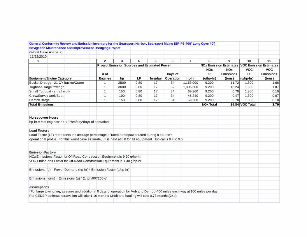
General Conformity Review and Emission Inventory for the Searsport Harbor, Searsport Maine (SP-P6 400' Long Cove 40')Navigation Maintenance and Improvement Dredging Project(Worst Case Analysis) 11/22/2010
1 2 3 4 5 6 7 8 9 10 11Project Emission Sources and Estimated Power NOx Emission Estimates VOC Emission Estimates
NOx NOx VOC VOC # of Days of EF Emissions EF Emissions
Equipment/Engine Category Engines hp LF hrs/day Operation hp-hr (g/hp-hr) (tons) (g/hp-hr) (tons)Bucket Dredge - 21 CY Bucket/Crane 1 2500 0.80 17 34 1,156,000 9.200 11.72 1.300 1.66Tugboat - large towing* 1 3000 0.80 17 32 1,305,600 9.200 13.24 1.300 1.87Small Tugboat - small work 1 150 0.80 17 34 69,360 9.200 0.70 1.300 0.10Crew/Survey work Boat 1 100 0.80 17 34 46,240 9.200 0.47 1.300 0.07Derrick Barge 1 150 0.80 17 34 69,360 9.200 0.70 1.300 0.10Total Emissions NOx Total 26.84 VOC Total 3.79
Horsepower Hourshp-hr = # of engines*hp*LF*hrs/day*days of operation
Load FactorsLoad Factor (LF) represents the average percentage of rated horsepower used during a source'soperational profile. For this worst case estimate, LF is held at 0.8 for all equipment. Typical is 0.4 to 0.6
Emission FactorsNOx Emissions Factor for Off-Road Construction Equipment is 9.20 g/hp-hrVOC Emissions Factor for Off-Road Construction Equipment is 1.30 g/hp-hr
Emissions (g) = Power Demand (hp-hr) * Emission Factor (g/hp-hr)
Emissions (tons) = Emissions (g) * (1 ton/907200 g)
Assumptions*For large towing tug, assume and additional 8 days of operation for Mob and Demob-400 miles each way at 100 miles per dayPer CEDEP estimate excavation will take 1.16 months (34d) and hauling will take 0.78 months(24d)
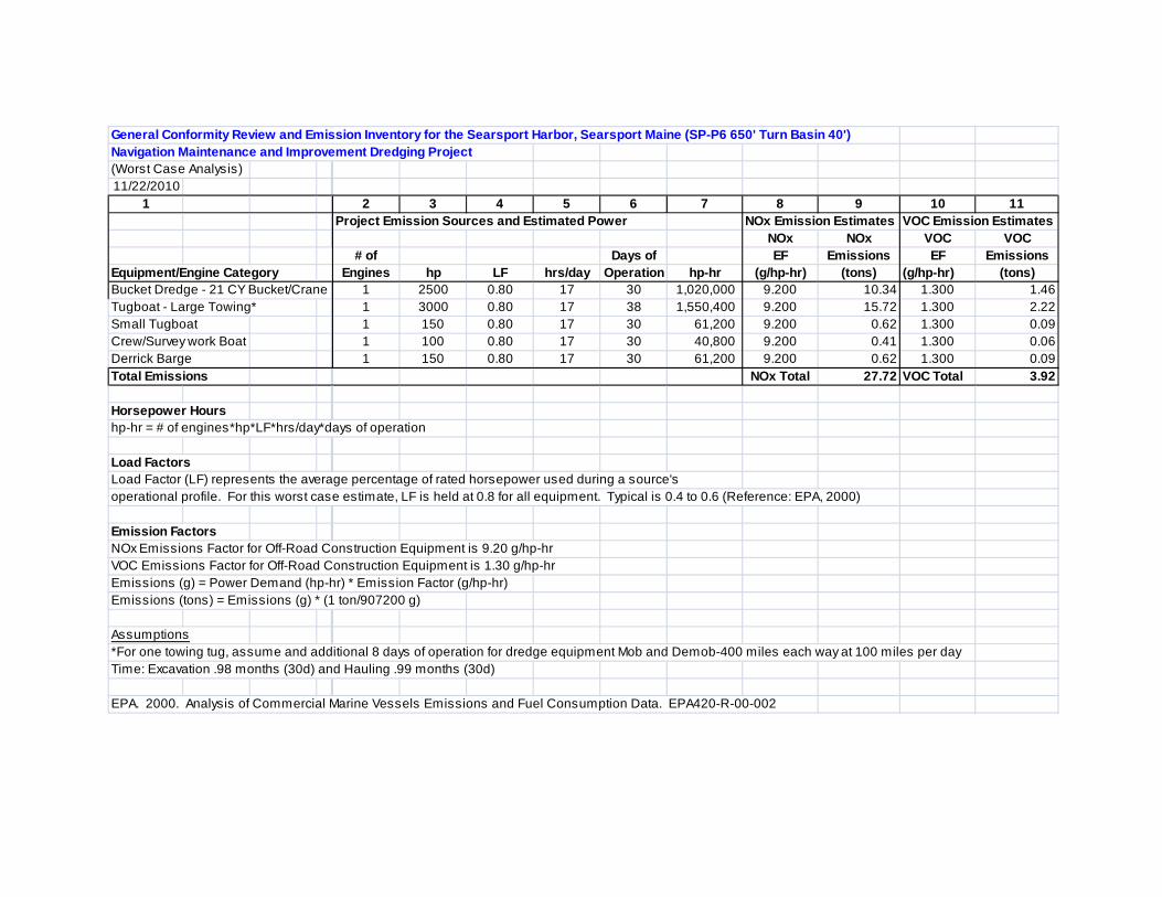
General Conformity Review and Emission Inventory for the Searsport Harbor, Searsport Maine (SP-P6 650' Turn Basin 40')Navigation Maintenance and Improvement Dredging Project(Worst Case Analysis) 11/22/2010
1 2 3 4 5 6 7 8 9 10 11Project Emission Sources and Estimated Power NOx Emission Estimates VOC Emission Estimates
NOx NOx VOC VOC # of Days of EF Emissions EF Emissions
Equipment/Engine Category Engines hp LF hrs/day Operation hp-hr (g/hp-hr) (tons) (g/hp-hr) (tons)Bucket Dredge - 21 CY Bucket/Crane 1 2500 0.80 17 30 1,020,000 9.200 10.34 1.300 1.46Tugboat - Large Towing* 1 3000 0.80 17 38 1,550,400 9.200 15.72 1.300 2.22Small Tugboat 1 150 0.80 17 30 61,200 9.200 0.62 1.300 0.09Crew/Survey work Boat 1 100 0.80 17 30 40,800 9.200 0.41 1.300 0.06Derrick Barge 1 150 0.80 17 30 61,200 9.200 0.62 1.300 0.09Total Emissions NOx Total 27.72 VOC Total 3.92
Horsepower Hourshp-hr = # of engines*hp*LF*hrs/day*days of operation
Load FactorsLoad Factor (LF) represents the average percentage of rated horsepower used during a source'soperational profile. For this worst case estimate, LF is held at 0.8 for all equipment. Typical is 0.4 to 0.6 (Reference: EPA, 2000)
Emission FactorsNOx Emissions Factor for Off-Road Construction Equipment is 9.20 g/hp-hrVOC Emissions Factor for Off-Road Construction Equipment is 1.30 g/hp-hrEmissions (g) = Power Demand (hp-hr) * Emission Factor (g/hp-hr)Emissions (tons) = Emissions (g) * (1 ton/907200 g)
Assumptions*For one towing tug, assume and additional 8 days of operation for dredge equipment Mob and Demob-400 miles each way at 100 miles per dayTime: Excavation .98 months (30d) and Hauling .99 months (30d)
EPA. 2000. Analysis of Commercial Marine Vessels Emissions and Fuel Consumption Data. EPA420-R-00-002
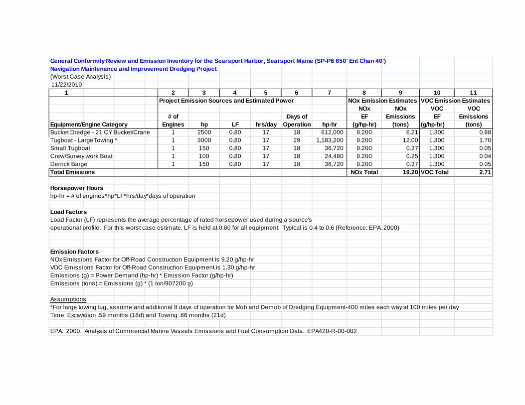
General Conformity Review and Emission Inventory for the Searsport Harbor, Searsport Maine (SP-P6 650' Ent Chan 40')Navigation Maintenance and Improvement Dredging Project(Worst Case Analysis)11/22/2010
1 2 3 4 5 6 7 8 9 10 11Project Emission Sources and Estimated Power NOx Emission Estimates VOC Emission Estimates
NOx NOx VOC VOC# of Days of EF Emissions EF Emissions
Equipment/Engine Category Engines hp LF hrs/day Operation hp-hr (g/hp-hr) (tons) (g/hp-hr) (tons)Bucket Dredge - 21 CY Bucket/Crane 1 2500 0.80 17 18 612,000 9.200 6.21 1.300 0.88Tugboat - LargeTowing * 1 3000 0.80 17 29 1,183,200 9.200 12.00 1.300 1.70Small Tugboat 1 150 0.80 17 18 36,720 9.200 0.37 1.300 0.05Crew/Survey work Boat 1 100 0.80 17 18 24,480 9.200 0.25 1.300 0.04Derrick Barge 1 150 0.80 17 18 36,720 9.200 0.37 1.300 0.05Total Emissions NOx Total 19.20 VOC Total 2.71
Horsepower Hourshp-hr = # of engines*hp*LF*hrs/day*days of operation
Load FactorsLoad Factor (LF) represents the average percentage of rated horsepower used during a source'soperational profile. For this worst case estimate, LF is held at 0.80 for all equipment. Typical is 0.4 to 0.6 (Reference: EPA, 2000)
Emission FactorsNOx Emissions Factor for Off-Road Construction Equipment is 9.20 g/hp-hrVOC Emissions Factor for Off-Road Construction Equipment is 1.30 g/hp-hrEmissions (g) = Power Demand (hp-hr) * Emission Factor (g/hp-hr)Emissions (tons) = Emissions (g) * (1 ton/907200 g)
Assumptions*For large towing tug, assume and additional 8 days of operation for Mob and Demob of Dredging Equipment-400 miles each way at 100 miles per dayTime: Excavation .59 months (18d) and Towing .66 months (21d)
EPA. 2000. Analysis of Commercial Marine Vessels Emissions and Fuel Consumption Data. EPA420-R-00-002

(This page intentionally left blank.)
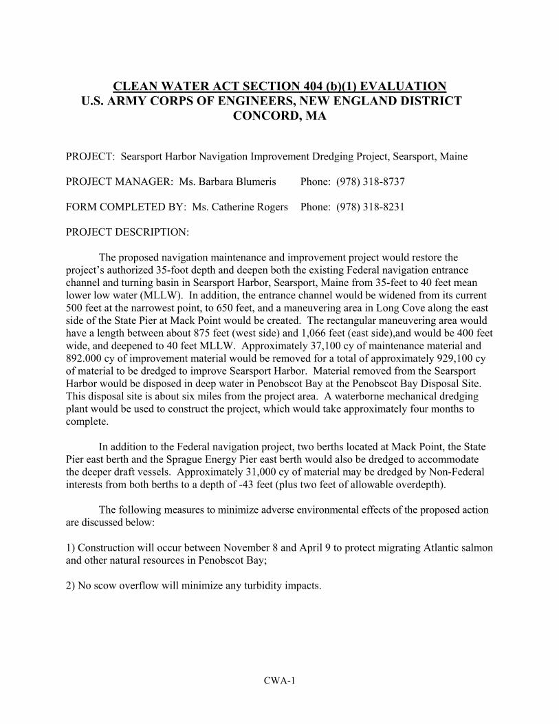
CWA-1
CLEAN WATER ACT SECTION 404 (b)(1) EVALUATION U.S. ARMY CORPS OF ENGINEERS, NEW ENGLAND DISTRICT
CONCORD, MA
PROJECT: Searsport Harbor Navigation Improvement Dredging Project, Searsport, Maine PROJECT MANAGER: Ms. Barbara Blumeris Phone: (978) 318-8737 FORM COMPLETED BY: Ms. Catherine Rogers Phone: (978) 318-8231 PROJECT DESCRIPTION:
The proposed navigation maintenance and improvement project would restore the project’s authorized 35-foot depth and deepen both the existing Federal navigation entrance channel and turning basin in Searsport Harbor, Searsport, Maine from 35-feet to 40 feet mean lower low water (MLLW). In addition, the entrance channel would be widened from its current 500 feet at the narrowest point, to 650 feet, and a maneuvering area in Long Cove along the east side of the State Pier at Mack Point would be created. The rectangular maneuvering area would have a length between about 875 feet (west side) and 1,066 feet (east side),and would be 400 feet wide, and deepened to 40 feet MLLW. Approximately 37,100 cy of maintenance material and 892.000 cy of improvement material would be removed for a total of approximately 929,100 cy of material to be dredged to improve Searsport Harbor. Material removed from the Searsport Harbor would be disposed in deep water in Penobscot Bay at the Penobscot Bay Disposal Site. This disposal site is about six miles from the project area. A waterborne mechanical dredging plant would be used to construct the project, which would take approximately four months to complete.
In addition to the Federal navigation project, two berths located at Mack Point, the State Pier east berth and the Sprague Energy Pier east berth would also be dredged to accommodate the deeper draft vessels. Approximately 31,000 cy of material may be dredged by Non-Federal interests from both berths to a depth of -43 feet (plus two feet of allowable overdepth). The following measures to minimize adverse environmental effects of the proposed action are discussed below: 1) Construction will occur between November 8 and April 9 to protect migrating Atlantic salmon and other natural resources in Penobscot Bay; 2) No scow overflow will minimize any turbidity impacts.
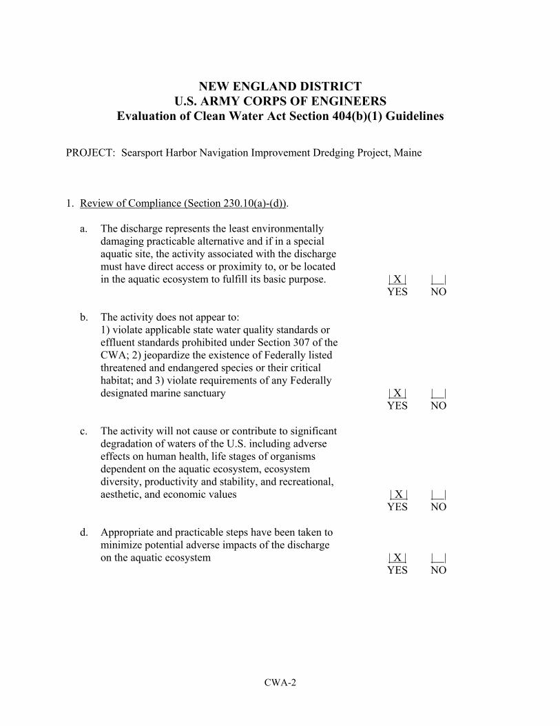
CWA-2
NEW ENGLAND DISTRICT U.S. ARMY CORPS OF ENGINEERS
Evaluation of Clean Water Act Section 404(b)(1) Guidelines PROJECT: Searsport Harbor Navigation Improvement Dredging Project, Maine 1. Review of Compliance (Section 230.10(a)-(d)). a. The discharge represents the least environmentally damaging practicable alternative and if in a special aquatic site, the activity associated with the discharge must have direct access or proximity to, or be located in the aquatic ecosystem to fulfill its basic purpose. | X | | | YES NO b. The activity does not appear to: 1) violate applicable state water quality standards or effluent standards prohibited under Section 307 of the CWA; 2) jeopardize the existence of Federally listed threatened and endangered species or their critical habitat; and 3) violate requirements of any Federally designated marine sanctuary | X | | | YES NO c. The activity will not cause or contribute to significant degradation of waters of the U.S. including adverse effects on human health, life stages of organisms dependent on the aquatic ecosystem, ecosystem diversity, productivity and stability, and recreational, aesthetic, and economic values | X | | | YES NO d. Appropriate and practicable steps have been taken to minimize potential adverse impacts of the discharge on the aquatic ecosystem | X | | | YES NO

CWA-3
2. Technical Evaluation Factors (Subparts C-F). Not Signif- Signif- N/A icant icant* a. Potential Impacts on Physical and Chemical Characteristics of the Aquatic Ecosystem (Subpart C). 1) Substrate. | | | X | | | 2) Suspended particulates/turbidity. | | | X | | | 3) Water. | | | X | | | 4) Current patterns and water circulation. | | | X | | | 5) Normal water fluctuations. | | | X | | | 6) Salinity gradients. | X | | | | | b. Potential Impacts on Biological Characteristics of the Aquatic Ecosystem (Subpart D). 1) Threatened and endangered species. | X | | | | | 2) Fish, crustaceans, mollusks and other aquatic organisms in the food web. | | | X | | | 3) Other wildlife. | | | X | | | c. Potential Impacts on Special Aquatic Sites (Subpart E). 1) Sanctuaries and refuges. | X | | | | | 2) Wetlands. | X | | | | | 3) Mud flats. | X | | | | | 4) Vegetated shallows. | X | | | | | 5) Coral reefs. | X | | | | | 6) Riffle and pool complexes. | X | | | | | d. Potential Effects on Human Use Characteristics (Subpart F) 1) Municipal and private water supplies. | X | | | | | 2) Recreational and commercial fisheries. | | | X | | | 3) Water related recreation. | | | X | | | 4) Aesthetics. | | | X | | | 5) Parks, national and historic monuments, national seashores, wilderness areas, research sites, and similar preserves. | X | | | | |
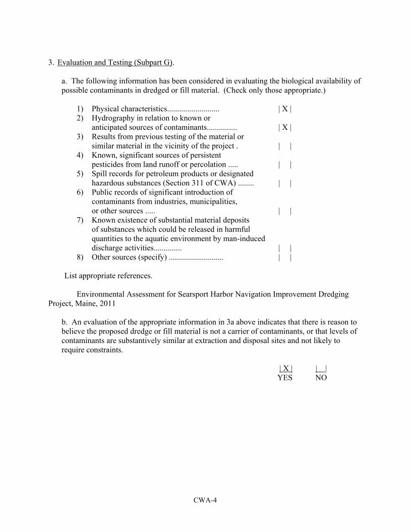
CWA-4
3. Evaluation and Testing (Subpart G).
a. The following information has been considered in evaluating the biological availability of possible contaminants in dredged or fill material. (Check only those appropriate.)
1) Physical characteristics.......................... | X | 2) Hydrography in relation to known or anticipated sources of contaminants............... | X | 3) Results from previous testing of the material or similar material in the vicinity of the project . | | 4) Known, significant sources of persistent pesticides from land runoff or percolation ..... | | 5) Spill records for petroleum products or designated hazardous substances (Section 311 of CWA) ........ | | 6) Public records of significant introduction of contaminants from industries, municipalities, or other sources ..... | | 7) Known existence of substantial material deposits of substances which could be released in harmful quantities to the aquatic environment by man-induced discharge activities.............. | | 8) Other sources (specify) ........................... | | List appropriate references. Environmental Assessment for Searsport Harbor Navigation Improvement Dredging Project, Maine, 2011
b. An evaluation of the appropriate information in 3a above indicates that there is reason to believe the proposed dredge or fill material is not a carrier of contaminants, or that levels of contaminants are substantively similar at extraction and disposal sites and not likely to require constraints.
| X | | | YES NO
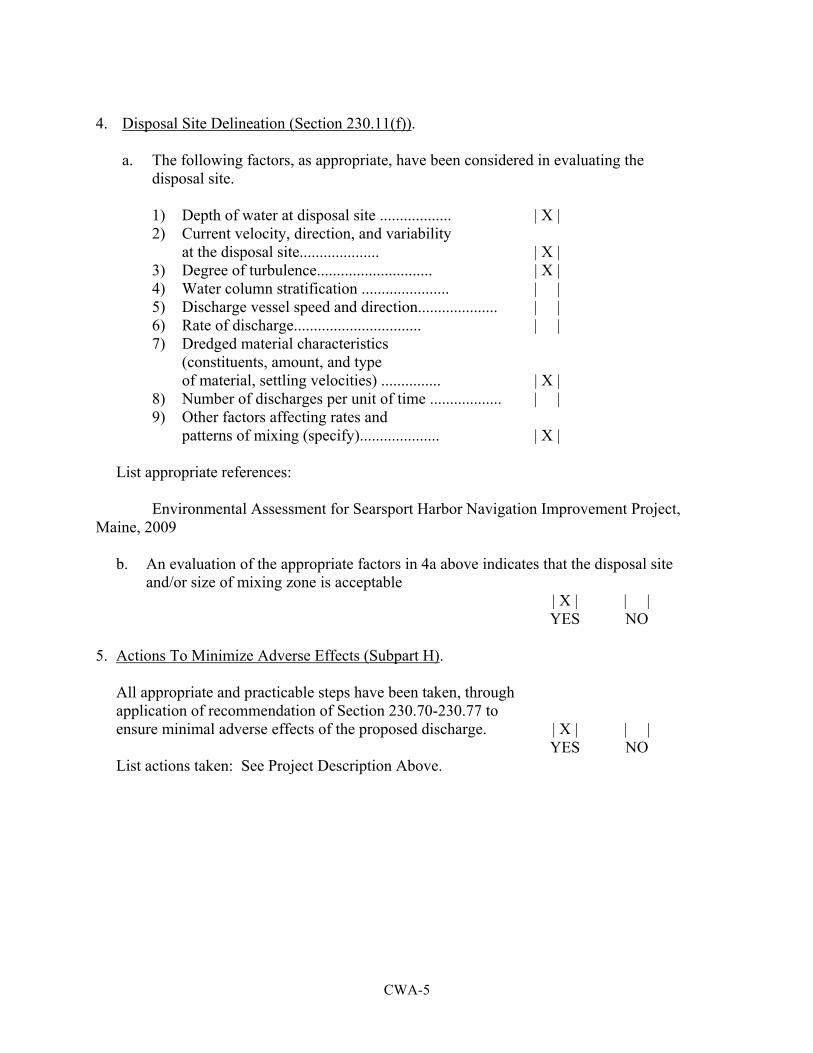
CWA-5
4. Disposal Site Delineation (Section 230.11(f)). a. The following factors, as appropriate, have been considered in evaluating the disposal site. 1) Depth of water at disposal site .................. | X | 2) Current velocity, direction, and variability at the disposal site.................... | X | 3) Degree of turbulence............................. | X | 4) Water column stratification ...................... | | 5) Discharge vessel speed and direction.................... | | 6) Rate of discharge................................ | | 7) Dredged material characteristics (constituents, amount, and type of material, settling velocities) ............... | X | 8) Number of discharges per unit of time .................. | | 9) Other factors affecting rates and patterns of mixing (specify).................... | X | List appropriate references: Environmental Assessment for Searsport Harbor Navigation Improvement Project, Maine, 2009 b. An evaluation of the appropriate factors in 4a above indicates that the disposal site and/or size of mixing zone is acceptable | X | | | YES NO 5. Actions To Minimize Adverse Effects (Subpart H). All appropriate and practicable steps have been taken, through application of recommendation of Section 230.70-230.77 to ensure minimal adverse effects of the proposed discharge. | X | | | YES NO List actions taken: See Project Description Above.
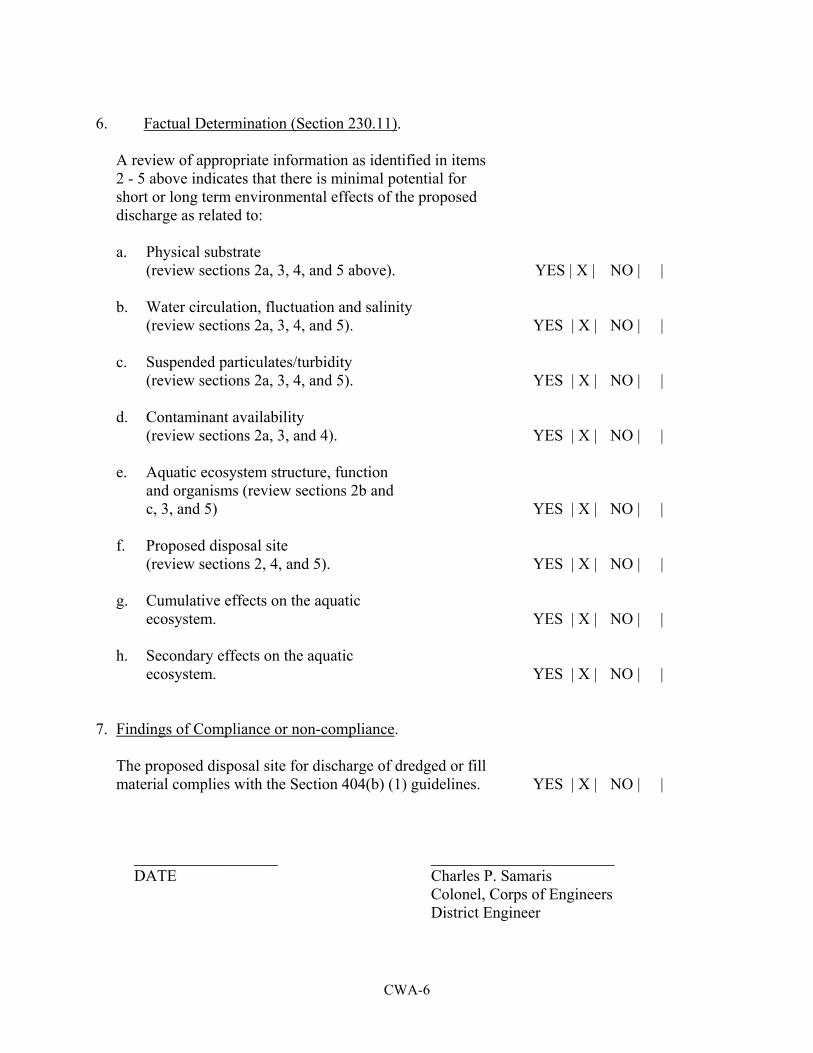
CWA-6
6. Factual Determination (Section 230.11). A review of appropriate information as identified in items 2 - 5 above indicates that there is minimal potential for short or long term environmental effects of the proposed discharge as related to: a. Physical substrate (review sections 2a, 3, 4, and 5 above). YES | X | NO | | b. Water circulation, fluctuation and salinity (review sections 2a, 3, 4, and 5). YES | X | NO | | c. Suspended particulates/turbidity (review sections 2a, 3, 4, and 5). YES | X | NO | | d. Contaminant availability (review sections 2a, 3, and 4). YES | X | NO | | e. Aquatic ecosystem structure, function and organisms (review sections 2b and c, 3, and 5) YES | X | NO | | f. Proposed disposal site (review sections 2, 4, and 5). YES | X | NO | | g. Cumulative effects on the aquatic ecosystem. YES | X | NO | | h. Secondary effects on the aquatic ecosystem. YES | X | NO | | 7. Findings of Compliance or non-compliance. The proposed disposal site for discharge of dredged or fill material complies with the Section 404(b) (1) guidelines. YES | X | NO | | __________________ _______________________ DATE Charles P. Samaris Colonel, Corps of Engineers District Engineer