short report on attendance and activities at isaes …
TRANSCRIPT

SHORT REPORT ON ATTENDANCE AND ACTIVITIES AT ISAES 2019, INCHEON, KOREA
By Dr. G.H. Grantham (SANC Earth sciences representative)
The conference was attended by 415 persons. South African delegates present were Dr. W. Nel (Fort
Hare), G.H. Grantham (UJ), Mr. C Groenewald (CGS, UJ) and Dr. T. Dhansay (CGS). The presence of Dr. T.
Dhansay from Council for Geoscience (Mapping Manager, CGS) was to facilitate and gain insights into
Earth Science research in Antarctica and evaluation of a possible role for CGS going forward.
Presentations by SANAP researchers
Oral Presentations.
A072 Session05:
The Neoproterozoic to Cambrian Orogenies and their precursors in Antarctica and adjacent continental
blocks.
THE CAMBRIAN UPLIFT HISTORY OF W. DRONNING MAUD LAND, ANTARCTICA : NEW 40AR/39AR AND
SR AND ND DATA.
Geoffrey Grantham1 † , Jan Kramers1 , Bruce Eglington2 , Erasmus Burger3
1Dept. of Geology, University of Johannesburg, Auckland Park, South Africa, 2Saskatchewan Isotope
Laboratory, Department of Geological Sciences, University of Saskatchewan, Saskatoon, Saskatchewan,
Canada, 3Department of Geology, University of Pretoria, Pretoria, South Africa.
NEW GEOCHEMICAL DATA FROM CENTRAL DRONNING MAUD LAND: IMPLICATIONS FOR GONDWANA
RECONSTRUCTION. Conrad Groenewald1,2 † , Geoffrey Grantham2 , Petrus Le Roux3 . 1Council for
Geoscience, Silverton, Pretoria, South Africa, 2Department of Geology, University of Johannesburg,
Auckland Park, Johannesburg, South Africa, 3Department of Geological Sciences, University of Cape
Town, Cape Town, South Africa, South Africa.
Poster Presentations
A223 Session05:
The Neoproterozoic to Cambrian Orogenies and their precursors in Antarctica and adjacent continental
blocks The structural evolution of the Straumsnutane and western Sverdrupfjella areas, western
Dronning Maud Land, Antarctica – implications for the amalgamation of Gondwana. Adam Bumby1 ,
Geoffrey Grantham2 † , Neogracious Moabi3 1Dept. of Geology, University of Pretoria, Pretoria, South
Africa, 2Dept. of Geology, University of Johannesburg, Auckland Park., South Africa, 3Council for
Geoscience, P/Bag X112, Silverton, Pretoria, South Africa

A439 Session05: The Neoproterozoic to Cambrian Orogenies and their precursors in Antarctica and
adjacent continental blocks Sri Lanka - Correlation with N. Mozambique and Antarctica at the heart of
Gondwana: North and South. Geoffrey Grantham1 † , Sanjeewa Malaviarachchi2 , Dilshan Bandara2 ,
Bruce Eglington3 , P. Dharmapriya2 1University of Johannesburg, South Africa, 2University of
Peradeniya, Sri Lanka, 3University of Saskatchewan, Canada.
A074 Session13: Past Climate Variability of the Southern Ocean and its Global Teleconnections
Classifying synoptic air circulation patterns over the Southern Indian Ocean: Observations from Marion
Island on recent change and current landscape impacts.
Werner Nel1 †
Possible involvement in Indian Antarctica Geology Initiative
At the end of May, I received an invitation to express an interest in an Indian Antarctic Geology
initiative. The initiative proposes an international collaborative program studying the geology within a
~400km radius of the two Indian Bases, Maitri and Bharati. From a SANAP perspective, the area within
the sphere of access from Maitri is of geological interest in terms of the current Gondwana
Amalgamation and Correlation Project. Initial discussions have indicated that international partners
would be expected to fund access from Cape Town to Novolarevskaya where Maitri is located, after
which the Indian Program would be responsible for logistics and support.
I submitted a proposal at the end of July (see attached), expressing interest in SANAP involvement and
identified five priority areas and a proposed scientific approach to the study. A local conference in Goa,
India, where the headquarters of the Indian Antarctica Program is located is planned for 20-22nd August,
where discussions on the way forward are to be discussed. It was planned that I attend this, having
submitted an abstract to the conference with a view to be present on 22nd August after the SANC and
DST meetings in Cape Town on 19-20 August. Regrettably, my application for a visa was rejected. The
rejection was a result of the application being submitted as for business. This avenue was chosen on the
advice of the visa administration service, because I was not in a position to apply for a conference visa
because the conference organisors had not acquired political clearance in India, the conference being
directed predominantly for local Indian participants.
It has been indicated to the proposers of this initiative, that from a SANAP perspective, that an
indication of formal procedures for potential involvement be provided in advance of the anticipated call
for new proposals due next year.
Possible Future SCAR Research Program
In response to the presentation by the President of SCAR, Prof. Stephen Chown at the SCAR SANC
meeting in Stellenbosch with regard to the potential for new SCAR research programs recognising that
most of the current programs will terminate in 2020, informal discussions with a view to a new Earth
Science program was initiated with Prof. Pant (India), following his distribution of a call for expressions
of interest in “Development of a scientific program in campaign mode in east Antarctica”.
Subsequently, discussions were held with Prof. J. Jacobs (Bergen University, Norway), leader of the CGG
(Combining Geology and Geophysics) action group in SCAR, regarding a possible new SCAR research
program.
The consequence of the above discussions was that an informal short meeting was convened on the last
day of the ISAES 2019 meeting between scientists from USA, Russia, India, Italy, Germany, Norway,
Australia, South Africa, Spain and Brazil as well as the group leaders for SCAR Geosciences Chief
Officer: Jesús Galindo-Zaldivar and Deputy Chief Officer: Naresh C Pant and Professor Jerónimo López-
Martínez (SCAR President 2012-2016). It was agreed that at the SCAR executive meeting held 30 July,
2019, in Bulgaria, the Geosciences Chief Officer would report on our intent to submit a proposal for a
project planning group at the SCAR meeting in Hobart 2020. An initial document was compiled within
the group and submitted by Prof. Jacobs to the Geosciences Chief Officer for SCAR, Jesús Galindo-
Zaldivar for presentation and noting at the SCAR executive meeting held 30 July, 2019, in Bulgaria . The
group has six months to prepare a document in support of a Program Planning Group for submission to
the SCAR meeting in Hobart 2020.
____________________________________
Dr. G.H. Grantham
17 August 2019
Proposal of a geology-geophysics based focussed mapping and research
campaign around Maitri Base and surrounds, Schirmacher Oasis, and Bharati
Base and surrounds, East Antarctica
Geological Background
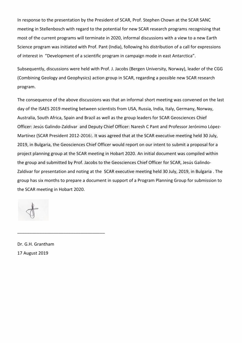
Antarctica lies at the heart of the supercontinent Gondwana which fragmented ~180-200Ma
to form the separate crustal blocks of Antarctica, India, Africa, Australia, Sri Lanka,
Seychelles, Madagascar and South America; the latter three blocks not having had direct
contact with Antarctica prior to continental breakup (Figure 1). Correlation of the geology
between adjacent continental blocks along with ocean floor studies now provide a widely
accepted configuration of Gondwana prior to breakup.
With the accepted configuration of Gondwana, attention can then be turned toward gaining
an understanding of the evolutionary processes which resulted in the amalgamation of
Gondwana, recognised as having occurred ~500-600Ma ago. Three orogenies have largely
been inferred as contributing to the amalgamation during this time namely the Ross (Gunn
and Warren, 1962), East African Antarctic (EAAO) ( Stern, 1994, Jacobs et al., 1998) and
Kuunga (KO) Orogenies (Meert 2003) (Figure 1).
Figure 1. Reconstruction of Gondwana showing the broad distribution of the EAAO, KO
and Ross Orogenic belts in Antarctica, as well as the location of Maitri and Bharati Bases in
Antarctica.

In a spatial sense, the Ross Orogeny is recognised along the “southern” margin of Gondwana
and its extent is widely accepted as extending from South America, through South Africa,
through the Transantarctic Mountains, to eastern Australia with the widely accepted plate
tectonic setting of a continent-island arc subduction setting (Figure 1).
In contrast, the roles of the EAAO and KO in the amalgamation of Gondwana along its
“northern” margin are still the source of significant debate, involving the alternatives of E-W
collision between East and West Gondwana (EAAO) and N-S collision between North and
South Gondwana respectively(Figure 1). Whereas the 600-900Ma East African Orogeny
(Stern 1994) extending from Saudi Arabia to N. Mozambique, is widely accepted, its
extension into western Dronning Maud Land is a source of debate. Meert (2003) defined the
~550Ma-490Ma Kuunga Orogeny on geochronological grounds and inferred its extent from
the Damara Belt in Namibia, through the Zambesi Belt and Lurio Orogenies, through Sri
Lanka and east Antarctica to western Australia (Figure 1). Both the EAAO and KO are
inferred to have involved continent-continent collision plate tectonic settings. Both Indian
Antarctic bases, Maiti and Bharati, are located within reasonable distance of key areas to
understand aspects of the Kuunga Orogeny in Antarctica whereas the EAAO is accessible
only from Maitri.
Recent developments over the last decade involving the acquisition, interpretation and
publication of aerogeophysical and seismic data from Antarctica, combined with improved
geochronological methods, have provided preliminary data which can be used to gain better
insights into the sub-glacial geology of Antarctica, recognising that <1% of the bedrock of
Antarctica is exposed at surface. Consequently research focussed on the geology of exposed
areas, identified as being underlain by bedrock containing significant geophysical signatures,
can contribute to an improved understanding of the broader bedrock tectonic units of sub-
glacial Antarctica.
Indian Strategic advantage
The Indian bases are strategically located to access significant exposures in the Dronning
Maud Land and Lambert Glacier area (Figure 2). Access to the area between 14oE (SE of
Maitri) and 2oE (Troll Base) is particularly good within the 400km radius requirement in the
call for expressions of interest, with extensive exposure evident.
The less accessible, by distance, portion of this area is perhaps the least well known area of
considerable exposure in Antarctica with only the GeoMaud expedition providing the most
recent and reliable information on the area. Knowledge of the area is summarised briefly
below in a section detailing the available geochronology, whole rock geochemistry,
metamorphic studies, structure and geophysics.

Figure 2. Map showing the locations of Maitri and Bharati bases in Antarctica with ~400km radius circles showing the areas of interest.
PROPOSAL – INVESTIGATION OF THE OROGENIC HISTORY OF DRONNING MAUD LAND,
ANTARCTICA FROM MAITRI BASE - (EAAO and Kuunga Orogenies in Dronning Maud Land,
Antarctica)
Introduction
The proposed focus area is located between 14oE (SE of Maitri) and 2oE (Troll Base). The
reason for selecting this area is based on the following reasons:-
The area has relatively easy access from, and includes the geology underlying, Maitri
Base.
A reasonable body of data comprising, geochronology and geochemistry (major and
trace element and radiogenic isotopes) exists at the eastern and western ends,
supported by aeromagnetic and aerogravity data over the whole area. Limited whole
rock major, trace and radiogenic isotope data from granitoids in the centre of the
area are also available (Roland 2004)
Current knowledge of the geology shows that it is transected by the Orvinfjella Shear
zone, whose possible extension to the south west is seen as the Forster Magnetic
anomaly, linking Central Dronning Maud Land with Heimefrontfjella in the south

west. Possible extensions of this shear zone have been inferred as continuing as the
Namama Shear Zone in Mozambique (Cadoppi et al., 1987; Grantham et al., 2003).
Brief review of existing tectonic models for the orogeny of the area
The two basic orogeny models comprise the East African Antarctic Orogeny and Kuunga
Orogeny. Understanding and differentiating between these models is important to gain
insights into the final amalgamation of Gondwana from ~650Ma to 450Ma.
East African Antarctic Orogeny
The East African Antarctic Orogeny (EAAO) was originally proposed by Jacobs et al. (1998,
2003a and b) and supported by many co-workers. Its fundamental basis involves a
continent-continent collision between East and West Gondwana extending from Saudi
Arabia in the north to Heimefrontfjella in the south (Figure 1). It is an extension of the EAO,
originally proposed by Stern (1992) who described it as a ~600-900Ma Wilson cycle event,
geographically located between Saudi Arabia and N. Mozambique. Jacobs et al. (1998, 2003
a and b) extended it to Heimefrontfjella and broadened the time range to ~500Ma. Support
for the EAO has also been described by Roy et al., 2018. The Wilson cycle inferred in the
EAO involved initial breakup of Rodinia between ~900-1000Ma involving the opening of the
Mozambique Ocean and its subsequent closure in the amalgamation of Gondwana 650-
450Ma. Fundamental to this model is the extension of the Mozambique Ocean from Saudi
Arabia to through Heimefrontfjella. This extension beyond the Lurio Belt of northern
Mozambique to Heimefrontfjella is questioned by various authors including Grantham et al.
(2008, 2013), Hokada et al., (2019) and Collins and Pizarevsky (2005).
Kuunga Orogeny
The Kuunga Orogen was initially proposed by Meert (2003), based on a study of available
geochronology. Meert suggested that in northern Mozambique the East African Orogeny
was overprinted by a marginally younger event between ~500-600Ma, extending from the
Damara in Namibia, through the Zambesi belt into Mozambique comprising the Lurio Belt,
continuing through Sri Lanka and Droning Maud Land, Antarctica and through to western
Australia. Grantham et al., (2008), in a correlation exercise between southern Africa,
Dronning Maud Land and Sri Lanka, inferred a collision model involving a mega-nappe
structure with collision between N and S Gondwana, with N Gondwana in the hanging wall.
Grantham et.al. (2008) compared lithological, structural, geochronology and metamorphic
P-T aspects in developing the model. A critical component of this model is the recognition of
erosional klippen comprising (from East to West) the Naukluft Nappes (Namibia), Urungwe
Klippen and Mavhuradona Complex (Zimbabwe), Monapo and Mugeba Complex (Namibia)
and Kataragama Klippen (Sri Lanka).
Proposed focus of this study on dissecting the EAAO and KO in Dronning Maud Land,
Antarctica.
Besides improving insights into the geology of the proposed study area involving basic
mapping and sampling for geochemistry, geochronology, petrology and structural studies,
recognising the time frame involved in Gondwana of ~450-650Ma, it is proposed that a
special focus of this study should involve structural kinematics and associated chronology,
chemistry and source charactersitics of magmatism during this period. This need for this
approach is apparent from the summary of existing knowledge described below.
Summary of existing knowledge
Geology, Structure and Geophysics
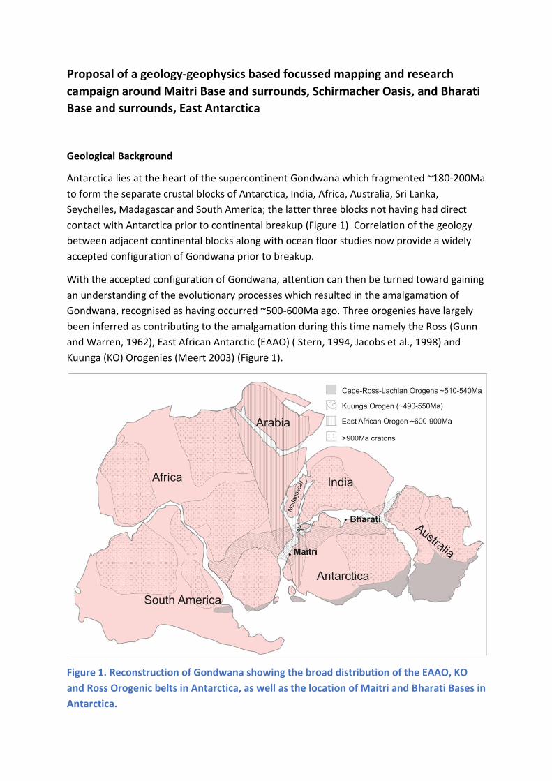
The geology of the area between ~4oE and ~14oE is dominated by medium to high grade
metamorphic rocks of Neo- to Mesoproterozoic age which are intruded by Neoproterozoic
anorthosites in the Gruber Berge (Wolthardt Massif) in the east and by granitic and
charnockitic syenitic intrusions dominantly of Cambrian age (Figure 3). In addition localised
subordinate intrusive metagabbroic and lamprophyres are seen. Two significant shear zones
are recognised namely the sinistral Orvinfjella Shear Zone between 8-11oE and the
Gjelsvikfjella Thrust in the west (Jacobs et al., 1998; Baba et al., 2008, 2015). The Orvinfjella
Shear Zone may be an extension of the Forster Magnetic Anomaly (Figure 3, Figure 4).
Figure 3. Simplified geological map of central Dronning Maud Land showing the lithological and structural units.
Comparison of the broad geological units in Figure 3 with the available aeromagnetic and
aerogravity geophysical data shown in Figures 4 and 5 permit the following conclusions.

Figure 4. Aeromagnetic anomaly map from Riedel et al. (2012 ) over central Dronning Maud Land.
Figure 5. Aerogravity map over central Dronning Maud Land. Data from Riedel et al., (2013). Note the contours indicating thick crust > 44km over the whole area.

Most of the area of interest is characterised by low magnetic intensity with occasional near
circular high anomalies in the south, the sources of which are not clear. Low magnetic
intensities are typical of high grade metamorphic terrains in which metamorphism typically
results in the consumption of Fe2+ into silicate lattices as Fe2+ which are typically less
magnetic than more oxidised magnetite- bearing medium grade assemblages. Strong linear
magnetic anomalies are seen in relation to the Gjelsvikfjella Shear zone and the
Sverdrupfjella Thrust Fault belt (not shown) to the east of Gjelsvikfjella. In Sverdrupfjella,
extensive retrogressive hydration of high grade assemblages is inferred (Groenewald, 1995),
resulting in the strong magnetic anomaly. This observation, by analogy, may be used to infer
that the Forster Magnetic anomaly has similarly resulted from shearing. In addition the ice
covered area south of the area of interest here, is transacted by numerous linear anomalies
with orientations similar to that of the Gjelsvikfjella Thrust in the east which may also
suggest that they are tectonically related, potentially separating thrust fault slices of
different age, analogous to the Cabo Delgado Nappe complex of northern Mozambique
(Viola et al,2008 ; Bingen et al., 2009).
A significant feature of the aerogravity map (Figure 5) is the thickness of the crust inferred
over the whole area of interest. The crustal thickness inferred over this area is >~44km. This
is particularly significant in that, metamorphic P-T studies over this whole area mostly
indicate isothermal decompression paths from relatively great depths of ~10-14kb indicating
that a substantial volume of rock has already been removed, post metamorphic
equilibration in the studied assemblages, with a substantial thickness remaining. This is
consistent with a continent-continent collision setting. An aim of this project should be to
identify the origin of the extraordinary thick crust in the area which extends to the
Gamburtsev Mountains.
Geochronology
A reasonable body of existing zircon geochronological data is available from most of the
area with a significant gap evident between ~4oE and 7oE (Figure 6). The range of
crystallisation ages varies between ~1200Ma in the east in Sverdrupfjella to ~490Ma. It is
evident that ages between ~600Ma - ~800Ma are restricted to the east except for one
sample in the west at Hogstabben.
Recognising the emphasis on the timing of Gondwana amalgamation, the areas with
crystallisation ages between 400-650Ma are shown in Figure 7 from which it is apparent
that ages between ~535 and 650 Ma are largely restricted to the east with one sample in
the west from Hogstabben.
A reasonable body of existing metamorphic zircon geochronological data is available from
most of the area with a significant gap evident between ~4oE and 7oE (Figure 8).
Metamorphic zircon ages vary typically between ~520Ma and ~1100Ma. The latter older
ages are largely restricted to the western end of the area of interest with one age reported
from the east near Conrad Berge (Figure 8).

Figure 6. Summarised available crystallisation ages geochronology over central Dronning Maud Land.
Figure 7. Summarised available crystallisation ages between 400-650Ma over central Dronning Maud Land.

Figure 8. Summarised metamorphic ages over central Dronning Maud Land.
Figure 9. Summarised metamorphic ages 400-650 Ma over central Dronning Maud Land.

Metamorphic ages between 400Ma and 650Ma show that the marginally younger ages are
only seen in the center to western part of the area with marginally older ages seen largely in
the east with subordinate samples in the west (Figure 9).
Besides the metamorphic geochronology described above, a number of P-T and to a lesser
extent P-T-t studies have been described from the broad area of interest. Almost all the
studies describe isothermal decompression loops (ITD) from relatively high pressures of ~10-
14GPa/Kbar at relatively high temperatures bordering in Ultrahigh temperature conditions
>950oC. Most of these studies could be improved with temporal and structural constraints,
recognising the time window of 400-650Ma involved in Gondwana amalgamation. A well
constrained P-T-t loop is described by Pauly et al., (2016) from Brattskarvet, marginally west
of the area of interest. Pauly et al., (2016) describe an ITD loop with peak pressures of
~1.5GPa and temperatures of ~850-900oC at ~570Ma followed by rapid uplift to
~0.7GPa/750-800oC at ~540Ma. Similarly Palmieri et al., (2018) report P-T estimates of 1-
5.1-7Gpa at ~950oC from central Dronning Maud Land.
Gaps of current knowledge in relation to distinguishing between the EAO and Kuunga
Orogeny
A critical aspect necessary to distinguish between the EAO and Kuunga Orogenies is related
to determining what deformational trajectories were involved during the specific time of
interest – namely ~600Ma to 450Ma. Whereas geochronological data and P-T-t studies
from the broad area of interest are individually available along with descriptions of whole
rock chemistry and lithologies, none of the published studies integrate structural studies.
Various levels of deformational interpretations are described from the area of interest but
geochronological constraints on the deformation episodes are absent. These are critical in
that such late deformation phases from ~600-450Ma should be structurally consistant with
either an E-W amalgamation (EAO orogeny) or a ~N over ~S collision (Kuunga Orogeny). Syn
tectonic magmatism which is structurally constrained, geochronologically constrained and
chemically characterised with major and trace element as well as radiogenic isotope
chemistry are the necessary tools to distinguish between the EAO and Kuunga Orogenies.
The radiogenic isotope chemistry of the phases is essential to understand the sources of the
various young magmatic events recognising that juvenile magmatic underplating is inferred
in EAO models in contrast to partial melting in an older nappe complex footwall is inferred
in a collisional Kuunga model.

Insights from adjacent areas in Gondwana
Mozambique
Recognising that northern Mozambique, specifically the Nampula Terrane, was juxtaposed
against Dronning Maud Land prior to Gondwana breakup, useful insights into the evolution
of CDML can be gained from the available geochronological data from northern
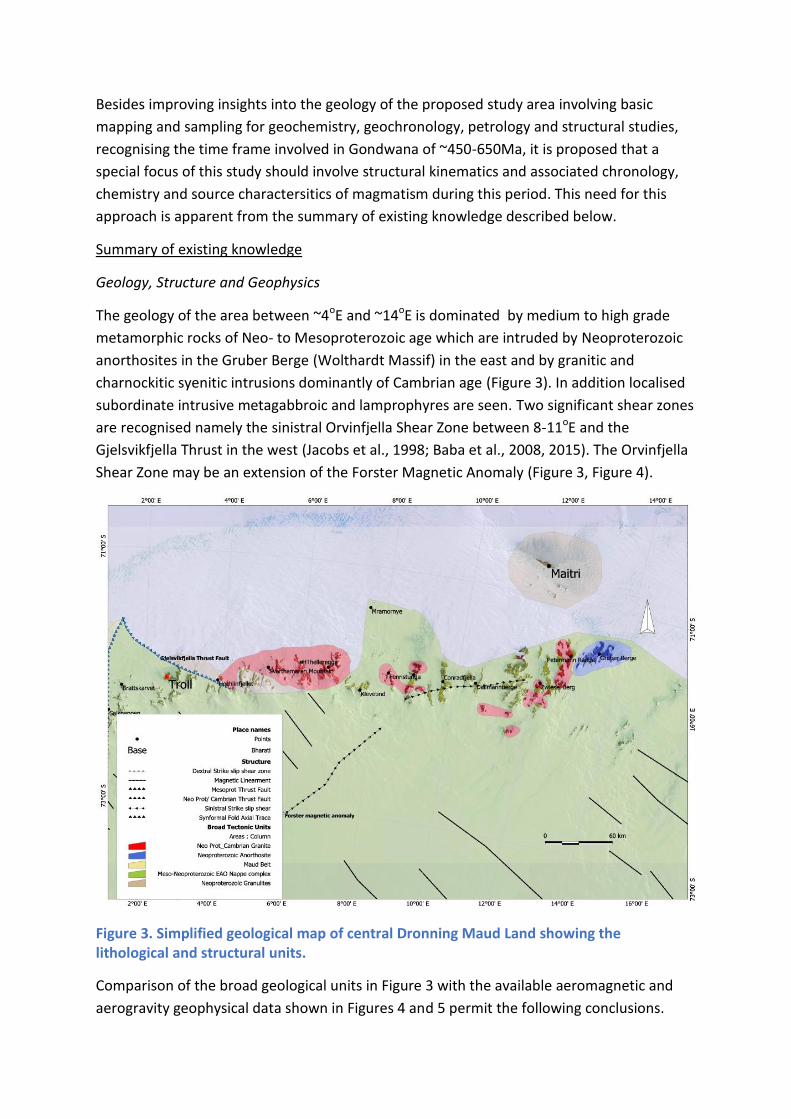
Mozambique. These are summarised below in Figures 10 - 13. Figures 10 and 11 show
crystallisation ages with figure 10 summarising all the available data and Figure 11 only the
data with ages between ~400-650Ma.
An aspect apparent in Figure 10 is that ages >1100Ma are largely confined to the area south
of the Lurio Belt. In Figure 11, it is apparent that crystallisation ages between ~535Ma are
largely confined to the area N of the Lurio Belt whereas ages between 400-650Ma are
distributed throughout the area. Similarly, Figures 12 and 13 show that older
metamorphism >~1000Ma is restricted to the Nampula Terrane south of the Lurio Belt. In
addition metamorphism ~535Ma is mostly confined to the areas north of the Lurio Belt and
in the Monapo and Mugeba klippen.
Figure 10. Map of distribution of zircon crytallisation ages in northern Mozambique.
Figure 11 Map of distribution of zircon crytallisation ages between 400 and 650Ma in northern Mozambique
Figure 12 Map of zircon metamorphic ages from northern Mozambique.
Comparison of the age patterns described in Figures 6-13, shows that in the area of
proposed focus in this document in CDML, are comparable to the area north of the Lurio
belt in northern Mozambique with which Grantham et al. (2008, 2013) and Ravikant et al.,

(202, 2004, 2007, 2018) have reported apparent correlations. These observations are in
contrast to Sverdrupfjella, western Dronning Maud Land, described below.
Figure 13 Map of zircon metamorphic ages between 400 and 650Ma from northern Mozambique.
Figure 14 Zircon crystalisation ages from Sverdrupfjella (left ) and zircon crystallisation ages between 400 and 650Ma from Sverdrupfjella (Right).

Western Dronning Maud, Land (Sverdrupfjella)
The available published crystallisation and metamorphic ages from Sverdrupfjella, west of
the area of interest are summarised in Figures 14 and 15 above and below. Crystallisation
ages are dominantly between ~1200-1000Ma and ~400-535Ma. It may be significant that
ages in the ~535Ma-1000Ma are absent. These limited data suggest that CDML and
northern Mozambique, are dissimilar to western Sverdrupfjella, possibly indicating a crustal
boundary between W. Sverdrupfjella and E. Sverdrupfjella + Gjelsvikfjella.
Proposed Scientific Program for this study.
Besides conducting basic geological mapping (lithology distribution and relationships,
structural observations and measurements, sample collection for rock composition and age
determinations) within the priority areas, a focus on those structures and lithologies related
to the orogenic amalgamation of Gondwana are proposed. Much of the data sought are
related to syn-tectonic intrusions of varying ages. Examples of this are shown below. In
Figure (16) below from Bucher and Frost (2006, J. of Petrol), a number of vein phases
hosted in ~550Ma granite are seen on which the chemistry is described but no
geochronology and related structural analysis. The veins, hosted in a ~550Ma granite,
provide insights into processes related to Gondwana amalgamation. All veins depicted in the
figure are of significance, but the most significant are inferred to be the youngest alkali-
feldspar granites because of their inferred age at ~490Ma, inferred structural geometry and
their syntectonic nature, evident from displacements in relation to other veins.
Figure 15. Zircon metamorphic ages from Sverdrupfjella
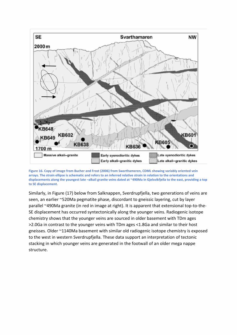
Figure 16. Copy of image from Bucher and Frost (2006) from Swarthameren, CDML showing variably oriented vein arrays. The strain ellipse is schematic and refers to an inferred relative strain in relation to the orientations and displacements along the youngest late –alkali granite veins dated at ~490Ma in Gjelsvikfjella to the east, providing a top to SE displacement.
Similarly, in Figure (17) below from Salknappen, Sverdrupfjella, two generations of veins are
seen, an earlier ~520Ma pegmatite phase, discordant to gneissic layering, cut by layer
parallel ~490Ma granite (in red in image at right). It is apparent that extensional top-to-the-
SE displacement has occurred syntectonically along the younger veins. Radiogenic isotope
chemistry shows that the younger veins are sourced in older basement with TDm ages
>2.0Ga in contrast to the younger veins with TDm ages <1.8Ga and similar to their host
gneisses. Older ~1140Ma basement with similar old radiogenic isotope chemistry is exposed
to the west in western Sverdrupfjella. These data support an interpretation of tectonic
stacking in which younger veins are generated in the footwall of an older mega nappe
structure.

Figure 17. Two generations of granitic veins at Salknappen. Person at lower right for scale.
Specific localities of interest for field study components
Five priority field areas are suggested and numbered 1 to 5 in Figure 18 below.
Figure 18 . Map of the area of interest showing the 5 priority interest areas.
Priority area 1 - central CDML
This area is the largest and is given a high priority because virtually no geochronological,
lithological and structural data are available from it. Limited data suggest it is largely
underlain by granites with subordinate basement gneisses. The focus in this area would

largely focus on the age, whole rock major and trace element chemistry and radiogenic
isotope chemistry of the granites as well vein intrusive phases into the granites. This
approach recognises the strain regime recorded by the veins represents the strain during
the timing of Gondwana amalgamation with earlier structures not being present in the
granites, assuming their age is ~530- 550Ma, as suggested by limited data from adjacent
areas. The eastern edge of this priority area is also transacted by the Orvinfjella Shear Zone.
The nature of the shear zone is uncertain. Speculation is that it is an extension of the Forster
Magnetic Anomaly and in Mozambique, it continues in the Namama Shearzone. Further
speculation is that it represents the boundary between the Kalahari Craton at depth
(west/north of the shearzone) and juvenile metamorphic terranes to the east. Radiogenic
isotope chemistry of appropriate phases can provide insight into these considerations.
Priority area 2 - Mryamorne nunataks
The Mryamorne nunataks have been mapped in detail during the GeoMaud expedition
however no geochronology from the strongly sheared gneisses are available, recognising the
geographical location of area. The area is underlain by strongly sheared gneisses intruded by
some pegmatites. Significantly, rocks at this locality, dip northwards, similar to rocks in the
hanging wall of the Gjelsvikfjella Thrust in the west. Small late granitic intrusions are
reported and their structure, age and chemistry should be determined.
Priority area 3 – Maitri environs
A significant body of lithological, petrological and geochronological (whole rock and single
zircon) data are available from the Maitri area, with crystallisation and metamorphic ages
reported typically in the range of ~600Ma to 800Ma with these rocks being correlated with
similar rocks in northern Mozambique. The ages largely predate the amalgamation of
Gondwana however maps of the Maitri area, show pegmatitic veins which cut the gneisses
and granulites. No age data or structural data from the younger intrusions are available.
Such data will provide insights to the timing and kinematics of younger intrusions and
potential insight into Gondwana amalgamation processes.
Priority area 4- Payer mountains
This area, the Payer Mountains, is located over a linear magnetic high anomaly.
Investigation of the rocks overlying the anomaly will provide insight into the potential cause
of the anomaly, to ascertain if it is perhaps shear related. Limited geochronology is available
from the rocks SE of Maitri. Consequently systematic mapping and sampling of these
nunataks will provide valuable new data and insight into the different orogenic models for
the area.
Priority area 5 – southern Zwiesel Mountains.
This area is prioritised due to the paucity of information on it with regard to lithology,
geochronology and structural geology in the literature.

Anticipated outcomes of the project
1. Improved knowledge of the basement geology of the area will contribute to the
GeoMap intiative.
2. Improved knowledge over these mostly poorly studied areas in relation to their
geophysical characteristics may establish the relationship between geology and
geophysics, contributing to the CGG SCAR action Group and planned SCAR Research
program.
3. Understanding the geophysics along with new combined structure, geochronological
and magmatism studies will contribute to distinguishing between the EAO and
Kuunga Orogenic events, particularly with a focus on features generated in the 400-
650Ma time period, similar to those shown above from Swartharen (CDML) and
Salknappen, Sverdrupfjella.
4. Correlation of the information gained described in 1-3 above, will facilitate
correlation with structures and geology in adjacent continental blocks in southern
Africa and Sri Lanka.
Potential Participants from South Africa
Dr. G.H. Grantham and Dr. H. van Niekerk (University of Johannesburg)
Personnel from Council for Geoscience (Geological survey of South Africa)
Prof. M. Satish-Kumar (Niigata University, Niigata, Japan).
References
The references reflected below do not include many geochronological, lithological and
metamorphic data sources available in the literature for Antarctica and Mozambique.
Baba S., Owada M., and Shiraishi K. (2008) Contrasting metamorphic P-T path between Schirmacher
Hills and Muhlig-Hoffman fjella, Central Dronning Maud Land, East Antarctica Geodynamic
Evolution of East Antarctica:a Key to the East-West Gondwana Connection. eds M Satish-
Kumar, Y Motoyoshi, Y Osanai, Y Hiroi and K Shiraishi, Geol. Soc. of London Spec. Publ., 308,
Baba,S., Horie,K., Hokada, T., Owada, M., Adachi, T. and Shiraishi, K. (2015) Multiple Collisions in the
East African–Antarctica Orogen: Constraints from Timing of Metamorphism in the
Filchnerfjella and Hochlinfjellet Terranes in Central Dronning Maud Land The Journal of
Geology, 123, p. 55–78.
Bingen, B. , Jacobs, J., Viola, G. , Henderson, I.H.C., Skår, Ø., Boyd, R., Thomas, R.J., Solli, A., Key
R.M. and Daudi E.X.F. (2009) Geochronology of the Precambrian crust in the Mozambique
belt in NE Mozambique, and implications for Gondwana assembly Precambrian Research,
170, Pages 231-255.
Bucher M. and Frost B. R. (2006) Fluid Transfer in High-grade Metamorphic Terrains Intruded by
Anorogenic Granites: The Thor Range, Antarctica Journal of Petrology 47, 567-593.

Cadoppi, P., Costa, M. and Sacchi, R. (1987) A cross section of the Namama Thrust belt
(Mozambique). Journal of African Earth Sciences, 6, 493-504.
Collins, A.S. and Pizarevsky S.A. (2005) Amalgamating eastern Gondwana: the evolution of the
Circum-Indian Orogens Earth-Sci. Rev., 71 (2005), pp. 229-270
Grantham, G.H., Maboko, M. and Eglington, B.M. (2003) A review of the evolution of the
Mozambique Belt and implications for the amalgamation of Rodinia and Gondwana. pp401 -
426 in Proterozoic East Gondwana: Supercontinent Assembly and Breakup. Yoshida M.,
Windley B.F. and Dasgupta S.(eds), Geol. Soc. Lond. Spec. Publ. 206.
Grantham, G.H., Macey, P.H., Horie,K., Kawakami, T., Ishikawa, I., Satish-Kumar M., Tsuchiya N.,
Graser P. and Azevedo S. (2013) Comparison of the metamorphic history of the Monapo
Complex, northernMozambique and Balchenfjella and Austhameren areas, Sør Rondane,
Antarctica:Implications for the Kuunga Orogeny and the amalgamation of N and
S.Gondwana Precambrian Research 234 (2013) 85–135
Grantham, G.H., Macey, P.H., Ingram, B.A., Roberts, M.P., Armstrong, R.A., Hokada, T., Shiraishi, K.,
Jackson, C., Bisnath, A. and Manhica, V. (2008) Terrane Correlation between Antarctica,
Mozambique & Sri Lanka; Comparisons of Geochronology, Lithology, Structure and
Metamorphism and possible implications for the geology of southern Africa and Antarctica
Geodynamic Evolution of East Antarctica:a Key to the East-West Gondwana Connection. eds
M Satish-Kumar, Y Motoyoshi, Y Osanai, Y Hiroi and K Shiraishi, Geol. Soc. of London Spec.
Publ., 308, p91-119.
Groenewald, P.B. (1995) The geology of northern H.U. Sverdrupfjella and its bearing on crustal
evolution in Dronning Maud Land, Antarctica. Unpublished PhD thesis, University of Natal
(Pietermaritzburg). 315pp.
GUNN. B.M. and WARREN. G., (1962) Geology of Victoria Land between the Mawson and Mulock
Glaciers. Antarctica. Geol. Sun-. N.Z.. Bull., 71.
Hokada T., Grantham G.H, Arima M., Saito S. Shiraishi K., Armstrong R.A., Eglington B., Misawa K.
and Kaiden H. (2019 in press) Stenian A-type granitoids in the Namaqua-Natal Belt,southern
Africa, Maud Belt, Antarctica and Nampula Terrane, Mozambique: Rodinia and Gondwana
amalgamation implications. Geoscience Frontiers
Jacobs, J. Bauer W. Fanning C.M. (2003c) Late Neoproterozoic/Early Paleozoic events in central
Dronning Maud Land and significance for the southern extension of the East African Orogen
into East Antarctica Precambrian Research 126, 27-53.
Jacobs, J. Fanning C.M., Henjes-Kunst F., Olesch M., and Paech H.J. (1998) Continuation of the
Mozambique Belt into East Antarctica: Grenville age metamorphism and Polyphase Pan-
African high grade events in Central Dronning Maud Land. Journal of Geology, 106, 385-406.
Jacobs, J. Klemd R., Fanning C.M. Bauer W. & Colombo F. (2003b) Extensional collapse of the late
Neoproterozoic-early Paleozoic East African-Antarctic Orogen in Central Dronning Maud
Land, East Antarctica. pp271-287 in Proterozoic East Gondwana: Supercontinent Assembly
and Breakup. Yoshida M., Windley B.F. and Dasgupta S.(eds), Geol. Soc. Lond. Spec. Publ.
206.

Palmeri R., Godard G. , Di Vincenzo G., Sandroni S and Talarico F.M. (2018) High-pressure granulite-
faciesmetamorphismin central Dronning Maud Land (East Antarctica): Implications for
Gondwana assembly Lithos 300–301 (2018) 361–377
Pauly J., Marschall H.R., Meyer H-P., Chatterjee, N. and Brian Monteleone B. (2016) Prolonged
Ediacaran–Cambrian Metamorphic History and Short-lived High-pressure Granulite facies
Metamorphism in the H.U. Sverdrupfjella, Dronning Maud Land (East Antarctica): Evidence
for Continental Collision during Gondwana Assembly. Journal of Petrology, 2016, Vol. 57, No.
1, 185–228
Ravikant V., Buhn B. and Pimentel M. (2018) Zircon U-Pb age constraints for Tonian-early Cryogenian
deposition of metasedimentary rocks from the Schirmacher Oasis, East Antarctica:
Implications for correlations across the Mozambique Ocean. Polar Science, Volume 18, 39-
47.
Ravikant V., Laux J.H., and Pimentel M. (2007) Sm-Nd and U-Pb isotopic constraints for crustal
evolution during Late Neoproterozoic from rocks of the Schirmaker Oasis, East Antarctica:
geodynamic development co-eavl with the East African Orogeny. in conference proceedings
of International Symposium on Antarctic Earth Sciences, Santa Barbara, California. August,
(2007).
Ravikant, V, Bhaskar Rao, Y.J., Gopalan K.. (2004) Schirmacher Oasis as an extension of the
Neoproterozoic East African Orogen into Antarctica: New Sm-Nd Isochron Age Constraints.
Journal of Geology, 112, 607-616.
Ravikant, V, Bhaskar Rao, Y.J., Gopalan K.. (2002) P-T-t history of granulites from the Schirmacher
Oasis, East Antarctica. Geochim. Cosmochim. Acta, 66, 15A, p793. 12th Annual V.M.
Goldschmidt Conference Abstracts.
Riedel S., Jokat, W. and Steinhage D. (2012) Mapping tectonic provinces with airborne gravity and
radar data in Dronning Maud Land, East Antarctica Geophysical Journal International, 189,
414–427.
Riedel S., Jacobs J. and Jokat W. (2013) Interpretation of new regional aeromagnetic data over
Dronning Maud Land, (East Antarctica). Tectonophysics. 585, 161–171.
Roland, N.W. (2004) Pan-African Granite–Charnockite Magmatism in Central Dronning Maud Land,
East Antarctica: Petrography, Geochemistry and Plate Tectonic Implications In: Paech, H.-J.
(Ed.), International GeoMaud Expedition of the BGR to central Dronning Maud Land in
1995/96. Geol. Jahrbuch, B, vol. 96, pp. 187–231.
ROY, S. K. PANT N. C., KUNDU A., DHARWADKAR A., KUMAR P. K. , JOSHI S, RAGHURAM, SADIQ M. 1
& PANDEY MAYURI (2017) Geological studies in the Baalsrudfjellet nunatak between the
Schirmacher Oasis and the Wohlthat Mountains to establish the continuation of the East
African Orogen (EAO) in central Dronning Maud Land, East Antarctica Pant, N. C. &
Dasgupta, S. (eds) Crustal Evolution of India and Antarctica: The Supercontinent
Connection.Geological Society, London, Special Publications, 457,
https://doi.org/10.1144/SP457.3
Stern R.J. (1994) Arc assembly and continental collison in the Neoproterozoic East African Orogen:
Implications for the consoildation of Gondwanaland. Annual Reviews Earth Science, 22, 319-
351.