small islands spatial data infrastructure · to instill cooperation and collaboration in spatial...
TRANSCRIPT
28 June 2009 | GEOconnexion International Magazine
GIS for spatial data infrastructure (SDI) is used throughout the worldto instill cooperation and collaboration in spatial data to betteraddress social, economic and environmental issues. It seems logicalthat large countries like the United States have invested in SDI, suchas the GeoSpatial One-Stop and unions come together to share dataand resources via the Infrastructure for Spatial Information in Europe(INSPIRE). Does SDI make sense for smaller countries and communi-ties? Arguably, even smaller nations benefit from land ownershipbeing carefully mapped, public works and utilities documented,environments and biodiversity protected, and resources assess andstrategic planning completed.
Thanks to special funding through the joint United KingdomForeign Office/Department for International Development (DFID)Environment Programme, a group of UK Overseas Territories and theOrganization of Eastern Caribbean States are able to rely on GIS for SDI;using the solution for data quality and control, information sharing anddelivering finished products for use between governmental agenciesand private organizations. Calling themselves ‘tiny SDI’, these smallislands use ArcGIS as the backbone for spatial data sharing.
Most islands were using ESRI GIS software products in some formor fashion before SDI was implemented. As Alan Mills, Principal withAlan Mills Consulting, Ltd. and one of the brainchildren behind usingSDI to help manage smaller islands explains it, “We realized there wassynergy in sharing the same add-on applications developed with
ArcGIS across the islands. Along with the backup support from ESRI,the GIS managers on these remote places would feel a sense ofcommunity and have a place to go when they needed help. This isimportant when you live on a small island in the middle of the oceanthree days boat ride from the nearest airport, and you have to be theexpert in GPS, databases, cartography, digitizing and changing the inkin the plotter. “
Ascension Island Discovers Benefit in Data SharingOne island that has many unique needs housed in a small space is UKOverseas Territory (UKOT) Ascension Island, situated in the sea half waybetween Africa and Brazil. Only 34 square miles in area (approximately91 square kilometers), the island is inhabited by about 1000 people. Arelatively recent volcanic emergence close to the Mid Atlantic Ridge,there is little natural vegetation except for a few species of ferns andspurge, a plant that exudes a bitter milky juice. The island became arefuge for a wide variety of marine species and is the second largestAtlantic nesting site for green turtles.
Humans discovered the island in the 1500s and since that time, theisland’s ecology has changed significantly; invasive plant species haverun rampant over parts of the island, rats and cats have decimated thebird populations. The bird and turtle populations have ocean wideimpact on biodiversity and the Conservation Department establishedby the small Ascension Island Government is mandated to protect and
KAREN RICHARDSON ASKS WHETHER SDI MAKE SENSE FOR SMALLER COUNTRIES ANDESPECIALLY ISLAND COMMUNITIES
SMALL ISLANDS SPATIALDATA INFRASTRUCTURE
GEOInt_June 2009.qxd:Layout 1 15/5/09 10:33 Page 28

www.geoconnexion.com 29
enhance the crucial nesting sites, as well as conserving the local plants,crabs and invertebrates.
Since 2005, GIS has been used to synthesize disparate databases anddatasets and create new maps and images for environmental manage-ment. GIS also assists with other applications including theEnvironmental Health Department’s mapping rat control and document-ing the eclectic set of historical sites such as the guns of the sunk HMSHood, Dampiers Drip (the original fresh water source), and concretewater catchments in the mountainside that collected scarce cloud waterfor the population pre-desalination plant.
Using ArcView, a component of ArcGIS Desktop, the system workswell. “The software is easy enough to be handled by non-experts. ArcGISalso has a flexible framework that accepts new monitoring data and canintegrate new datasets from a wide variety of sources and types,” says Dr.Edsel Daniel, Professor, Vanderbilt University in Nashville, Tennessee, theGIS manager at Ascension Island and a colleague of Mills.
ArcView integrates all the data necessary for the government tomake informed planning decisions to balance environmental, amenityand infrastructural priorities. Clear protocols and procedures have beendetermined to pass data from the field to the end user. “The key to thissystem to function in such a small area so economically with greatbenefit is the fact that data gathered for one purpose can be shared inmany applications,” says Alan Mills, Director, Alan Mills Consulting Ltd.
St Helena Finds Cooperation is the Key St Helena, about 750 miles southeast of Ascension cannot be reached byair. Instead, a visitor must take the Royal Mail Ship (RMS) St. Helena whichploughs between Capetown, St. Helena and Ascension each month.3,500 hardy settlers live on the island, many up above the precipitouscliffs or in a narrow canyon where the well-preserved Georgian capital of
Jamestown nestles, near landscapes of rocky desert, rolling pastures, andeucalyptus and pine plantations. On the coast, humped-back whalemothers and calves shelter themselves and thousands of seabirds clingto cliff edges and stacks.
At first GIS was used to determine the best locations to place freshwa-ter boreholes. In 2004, other projects began, the largest being building theisland’s cadastre. The Agriculture and Natural Resources Department(ANRD) along with the St. Helena National Trust (SHNT) implementedArcView and a Microsoft Access database to monitor clearance of invasiveflax and other plants and manage the growth of endemic cabbage treesand tree ferns. “The emergence of a map showing the recolonization ofendemics over a ten year period gave other departments the idea to linktheir monitoring data with the mapping being accomplished,” says LenColeman, GIS manager, St. Helena.
A single system was then designed to minimize duplication of effortand share the burden of data collection and management. The Legal,Lands, and Planning Department (LLPD) was keen on expanding on theirnew cadastral GIS and database and working together with ANRD meantenvironmental concerns were known by the planning unit for bothstrategic plans and the development control process. Sharing resourcesalso makes it easier for training sessions to be organized and held foroccasional users of GIS. Data are not duplicated and there is betterquality control and attribution when it is used for multiple applications.Visiting scientists and consultants can search the data catalogue andhave a recognized way of contributing information back into the systemin a structured manner once their project is completed.
GIS Maps Resources on Rodrigues Island to Sustain HumanActivity Rodrigues is a partly autonomous island found 650 kilometers east ofMauritius. One of the more populated islands in this grouping, 40,000
Boat is the only way to visit some of these islands. Hop aboard the Royal MailShip (RMS) St. Helena to travel to the island once or twice a month.
The Ascension Island Conservation team monitoring the spurge plants on clifftops.
The St. Helena National Trust and Government’s Agriculture and NaturalResources Department work together on Diana’s Peak to monitorendemic tree ferns and threatening weeds.
GEOInt_June 2009.qxd:Layout 1 15/5/09 10:33 Page 29

30 June 2009 | GEOconnexion International Magazine
people live off reef and subsistence farming, having few support servicesand only a fledgling tourism industry.
SHOALS, a non-governmental organization (NGO) working closelywith the island’s government, the Regional Assembly, conducts marineresearch, education and training about the extensive reef area, whichextends over twice the size of the land itself. One major activity is assess-ing the extent and health of the marine resources, including the corals,seagrasses and mangroves. With the support of the Universities ofNewcastle and Bangor in the United Kingdom, SHOALS created a map ofthe basic reef structure using supervised classification of LandsatEnhanced Thematic Mapper (ETM) data, with an eye to using QuickBirdsatellite imagery in the near future for the more detailed map of the
resources, as well as being used in educational work and in governmen-tal planning.
GIS Keep People and Mountain Chickens Safe onMonteserrat
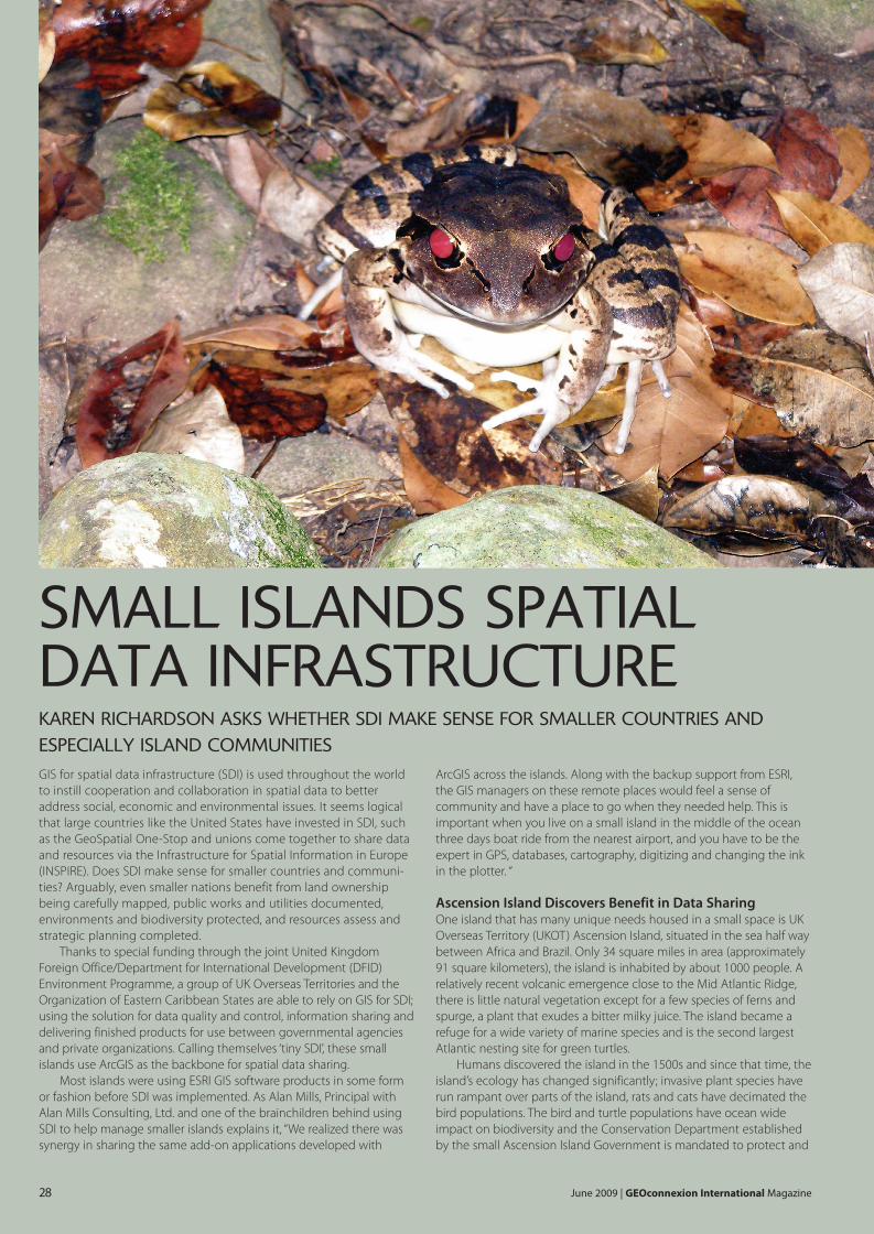
In the Eastern Caribbean Sea, Montserrat is another UK OverseasTerritory, 20 kilometers west of Antigua. After a volcanic eruption in 1997,the population dwindled from 11,000 to 3500 and is now settled in onlyone third of the island. These few people on the island are in need ofGIS to assist them in mapping safe zones and planning for permanenthomes and services away from the danger area around the volcano. GISis also used to map endangered species in the Center Hills area, includ-ing the curiously named Mountain Chicken, a frog that is a local delicacyand has been unfortunately decimated by a fungal disease. (see bannerimage to this article)
Led by GIS manager Lavern Rogers-Ryan who works in the PhysicalPlanning Department, the GIS team uses ArcGIS to cover the requests ofclients on the island, including updating the land cadastre, mapping fornatural disasters and environmental protection. “Assisting theDepartment of the Environment in mapping their data opened our eyesto the spatial comparisons across the island,” says Rogers-Ryan
Alan Mills assisted in developing a database and training field staff inhow to make simple maps. “This assistance helped me better structuremy data to provide wider services to several government departmentswithout being overwhelmed by the work,” Rogers-Ryan says.
GIS used to evaluate land resources for St. Kitts in a postsugar eraSt. Kitts (also called St. Christopher) is part of an independent twin islandfederal state with the island of Nevis. Both islands achieved theirindependence in 1983 from the British making them the smallestindependent state in the western hemisphere. St. Kitts has a land area of168 km2 with extremely fertile soils used primarily for sugar productionfor the past 350 years.
Fluctuating commodity prices and reduced European Union tradepreferences have made the island’s reliance on single crop agriculture aneconomic vulnerability. To address such vulnerabilities, in 2005 theGovernment of St. Kitts and Nevis (GoSKN) made the decision to closethe sugar industry and vigorously pursue its economic diversification byplacing emphasis on more viable alternatives, such as tourism and non-sugar agriculture including field crops and livestock. One of the majorchallenges of this effort is adopting careful planning which ensures thatthe island’s land resources previously utilized by the sugar cane crops areoptimized for the long term economic, social and environmental sustain-ability of the country.
After the closing of the sugar industry, the Physical PlanningDepartment (PPD) and Department of Agriculture (DoA) spearheadedthe planning for the agricultural transition. A land resource analysis studywas conducted identifying the most suitable lands for six non-sugaragriculture crops. “While specific areas have been quantified based onsuitability, an added benefit of this study was the ability to identify,compare and quantify areas for uses beyond agriculture; we were able toevaluate future land use such as housing for tourism, industrial andresidential along with suitable lands for tree crops. Using GIS we wereable to see the bigger picture of how to develop areas for the benefit ofthe community.”
Article by Alan Mills, an independent GIS consultant based in Kent, UK([email protected]). Alan has worked for over 18 years in geographi-cal research and consultancy in developing countries and has particularinterest in small island developing states. He served for over 2 years asNational GIS coordinator in the British Virgin Islands and works in theCaribbean, South Atlantic and Indian Ocean, as well as for MapAction, whouse GIS to assist humanitarian relief operations post disasters(www.mapaction.org).
The shallow Rogrigues lagoon is twice the size of the island itself and a keyresource which SHOALS of Rodrigues helps monitor and maintain.
The Mountain Chicken of Montserrat
Alan Mills with Jervaine Greenaway and Lavern Rogers-Ryan, GIS Manager in theGIS Office, Town and Country Planning Department, Brades, Monteserrat
GEOInt_June 2009.qxd:Layout 1 15/5/09 10:33 Page 30

Copyright © 2009 ESRI. All rights reserved. ESRI, the ESRI globe logo, @esri.com, and www.esri.com are trademarks, registered trademarks, or service marks of ESRI in the United States, the European Community, or certain other jurisdictions. Other companies and products mentioned herein may be trademarks or registered trademarks of their respective trademark owners.
Contact ESRI
1-800-GIS-XPRT (1-800-447-9778)
Phone: 909-793-2853
Fax: 909-793-5953
www.esri.com
Offices worldwide
www.esri.com/locations
ESRI 380 New York Street
Redlands, California
92373-8100 USA