soil science unit, activities report - 2006 · soil science unit, activities report - 2006 soil,...
TRANSCRIPT

FAO/


i
Soil Science Unit, Activities Report - 2006
Executive Summary
The Soil Science Unit (SSU) and the Soil Water Management and Crop Nutrition (SWMCN) Section of the Joint FAO/IAEA Division develops nuclear and related technologies and assist national institutes in developing Member States to use the technologies to improving crop production, soil/water management and enhancing environmental security. The SSU implemented work in support of several Coordinated Research Projects. In terms of research and development the main emphasis during 2006 was on the development of methodology for the use of fallout radionuclides to measure soil erosion/sedimentation. Experiments were conducted to develop and test isotope methodologies for evaluating crop plants for their tolerance to abiotic stress, which will also receive major emphasis in the future as well as improving water management. The spatialization of soil movement in the landscape and the mapping of areas that are vulnerable to soil degradation are first steps towards an efficient resource management policy and to a targeted and successful implementation of conservation practices. In this context the spatial distribution of fallout radionuclide (137Cs) and soil movements were analyzed using geostatistics concept. The study illustrated the advantage of the use of geostatistics to process data from fallout radionuclides to assess soil erosion/sedimentation processes and to establish a sediment budget and a sediment delivery ratio at the field scale. The results also confirm that the 137Cs technique, in combination with geostatistics and variography, can be a useful complement to more conventional methods for assessing erosion and sedimentation. The 13C isotope discrimination (∆) technique, which is used as a research tool to evaluate the impact of water and salt stress on cereal crops, was found in preliminary pot experiments with maize and rice to be influenced by nutritional stress. This indicates that appropriate caution should be taken when using the ∆ as a selection tool for greater water use efficiency in breeding programs in nutrient-stressed environments. A rapid, simple and cost-effective method to determine the inorganic 15N fraction in the soil-plant continuum using the micro-diffusion optical emission spectrometry was developed as an alternative to the mass spectrometry method. This method has potential advantages in developing countries that may not have access to the more expensive mass spectrometers. The SSU trained 23 fellows from Algeria, Haiti, Jordan, Kenya, Mongolia, Namibia, Sierra Leone, Syria, Turkey and Uganda in the use of nuclear techniques for crop nutrition and soil/water management as well as isotope analytical methods. More fellows were trained during 2006 than in the previous years. Two Group Training Sessions (i) crop nutrition and water management for research fellows and (ii) isotope analyses and quality assurance for fellows who work in analytical laboratories. The SSU furthermore received ten scientific visitors from Algeria, Cameron, Eritrea, Sierra Leone and Tajikistan. All the training activities were implemented to support Technical Cooperation Projects or the Manpower Development in the countries mentioned above. The SSU conducted 13500 stable isotope measurements during 2006 for CRPs, TCPs and training and research activities at the Seibersdorf laboratory. Thirty percent of the measurements were on
ii
Soil Science Unit, Activities Report - 2006
samples enriched in 15N, 9% of 15N at natural abundance, 52% of 13C at natural abundance and 8% of 18O at natural abundance. There is a clear trend of increased requirement for natural abundance measurements of 13C and 18O in the last few years. The SSU implemented also the annual proficiency test (PT) “IAEA-SSU-2006-01” for the measurement of 15N- and 13C isotopic abundance and total nitrogen- and carbon concentration in plant materials. The principal aim of this PT was to assess laboratory performance against established criteria, to assist participants in meeting the formal requirements, to monitor and demonstrate improvements in accuracy and precision in order to achieve international comparability of analytical data and to demonstrate competence of the participating laboratory. Most of the participating laboratories, i.e. 11 of 18 (61%) showed proficiency in the analysis of plant materials for 15N abundance and 4 of 8 (50%) of the laboratories that have a mass spectrometer at their disposal and therefore the possibility to analyse 13C, showed proficiency in the analysis of plant materials for 13C abundance. In 2006, SSU staff published three peer-reviewed articles in scientific journals, nine abstracts in conference presentations and four IAEA publications. Mr. S Borovit of the SSU and Ms. E Swoboda of the SSU and the Plant Breeding Unit received merit awards during 2006 for their outstanding performances. The Unit staff coordinated eleven Technical Cooperation Projects in Chile, China, Libya, Kenya, Madagascar, Mali, Mongolia, Slovenia, Sierra Leone, Yemen and one Coordinated Research Project. Also, all CRPs of the soil subprogramme are supported through individual contribution and isotopes analysis.

iii
Soil Science Unit, Activities Report - 2006
TABLE OF CONTENTS
1. INTRODUCTION…………………………………………………………………………………………… 1 1.1 Objectives …………………………………………………………………………………………………….. 1 1.2 Organizational Chart and Unit Staff ...……………………………………………………………………... 2 1.3 Staff Movements ..……………………………………………………………………………………………. 4 1.4 Working Groups 2006 ….……………………………………………………………………………………. 6
2. RESEARCH AND DEVELOPMENT…………………………………………………………………. 6 2.1 The use of geostatistics in environmental sciences to spatialise fallout radionuclides to assess soil erosion/sedimentation - Geostatistics concepts .……………………………………………………… 6
2.1.1 Introduction …………………………………..……………………………………………………. 6 2.1.2 Geostatistics and variography concepts ………..………………………………………………….. 7 2.1.3 Data interpolation …………………………………..……………………………………………... 8
2.2 Spatial variability of erosion and soil organic matter content estimated from 137Cs measurements and geostatistics …………………………………………………………….…………………………………….. 10
2.2.1 Introduction ……………………………………………………………………………………….... 10 2.2.2 Materials and methods …………………………………………………………………………….. 11
2.2.2.1 Site location and soil sampling procedure ………………………………………………. 11 2.2.2.2 Laboratory determinations and geostatistics used ……………………………………….. 12
2.2.3 Results and discussion ……………………………………………………………………………... 13 2.2.3.1 Univariate statistics and correlation analysis ……………………………………………. 13 2.2.3.2 Semivariance analysis and spatial dependence of the variables …………………………. 14 2.2.3.3 Soil movement analysis …………………………………………………………………. 15
2.2.4 Conclusions ………………………………………………………………………………………... 17 2.3 Impact of the soil sample intensity on soil erosion estimation using 137Cs methodology………………. 18 2.4 Can soil nutrient stress influence the use of 13C isotope discrimination technique as a potential tool to evaluate maize and rice for tolerance to drought and salinity? …………………….. 19 2.5 Partitioning of 13C-labelled photo-assimilates by common bean and soybean isotope at varying nitrogen and phosphorus availability ………………………………………………………………………. 20 2.6 Optical emission spectrometry (OES) can be used to determine inorganic nitrogen-15 in soil samples... 21 2.7 External collaborations and partnerships ………………………………………………………………….. 21 2.8 Analytical services ……………………………………………………………………………………………. 22 2.9 The annual proficiency test (PT) for the measurement of 15N- and 13C isotopic abundance and total N and C concentration in plant materials …………………………………………………………………... 23
3. TRAINING AND FELLOWSHIP ………………………………………………………………………. 26 3.1 Training ………………………………………………………………………………………………………. 26 3.2 Fellows ………………………………………………………………………………………………………... 26
3.2.1 Individual fellowship training ………………………………………………………………………. 27 3.2.2 Scientific Visits ………………………………………………………………………………………. 30
3.3 Workshop on data analysis and interpretation related to isotopic dilution experiments at Seibersdorf on 18 October 2006 …………………………………………………………………………………………… 31
4. PUBLICATIONS ……………………………………………………………………………………………. 32 4.1 Journal Articles ………………………………………………………………………………………………. 32 4.2 Conference Proceedings/Abstracts ………………………………………………………………………….. 32 4.3 IAEA Reports/Newsletters ……………………………………………………………………………... 33 4.4 Publications accepted/in press ………………………………………………………………………………. 34
5. SCIENTIFIC MEETINGS AND STAFF TRAVELS .……………………………………………. 35 5.1 Scientific meetings ……………………………………………………………………………………………. 35 5.2 Staff travels …………………………………………………………………………………………………… 38 5.3 Technical Cooperation Projects and Coordinated Research Projects ……………………………………. 39 5.4 New TC Projects ……………………………………………………………………………………………... 42
6. IAEA GENERAL CONFERENCE DISPLAY BY THE SOIL SCIENCE UNIT ………... 43


1
Soil Science Unit, Activities Report - 2006
Soil, water and nutrients are the basic resources in agriculture for food and environmental security. The rapid decline in quality and quantity of global natural resources due to degradation and uncontrolled resource consumption in many countries, especially the developing countries is a threat to sustainable agriculture and environmental security. Adoption of a more holistic approach with a strong focus on the integration of soil-plant-water-nutrient by maintaining an appropriate balance between the use and conservation of soil nutrients and water resources for sustainable agricultural and environmental security is a new challenge. Nuclear and related techniques are precise and specific tools that provide a more efficient way for understanding and manipulating the processes that underpin the production and transformation of the soil, nutrient and water resources into crop and fibre production while conserving and sustainably using the natural resources. The Soils sub-programme comprising the Soil Water Management and Crop Nutrition (SWMCN) section and the Soil Science Unit (SSU) develops nuclear and related technologies and assist Member States to use the technologies for improving crop production, conserving natural resources and enhancing environmental security.
The overall objective of the Soil Science Unit is to develop methodologies and guidelines related to the use of nuclear techniques in the field of soil fertility, water management and soil erosion-sedimentation, to assist Member States in the use of these technologies through technology exchange and capacity building. Specific objectives include developing methodologies for:
• Measuring sediment budget and soil movements – erosion and sedimentation – in the landscape, and assessing impacts of soil conservation practices on soil-water resources
• Evaluating and selection of food crop genotypes with improved response to abiotic (nutrient, salinity and water) stress and with superior resource use efficiency
• Tracking and quantifying off-site water and nutrient fluxes with the aim to provide better strategies to improve crop- water-nutrient productivity beyond the plant rooting zone in water-limited environments
• Quantifying biological nitrogen fixation and improving productivity of legumes in cropping systems
In addition the Soil Science Unit:
• Promotes research and development through the training of technical staff and scientists from Member States in the analyses of stable isotopes and the use of nuclear and related techniques
• Provides isotope analyses to projects where analytical facilities are not available • Provides quality assurance services to Member States
1. INTRODUCTION
1.1 Objectives

2
Soil Science Unit, Activities Report - 2006
1.2. Organizational Chart and Unit Staff
Name Title E-Mail Address Extension Erik BUSCH-PETERSEN
Head, FAO/IAEA Agriculture and Biotechnology Laboratory
[email protected] 28267
Name Title E-Mail Address Extension Gudni HARD-ARSON
Head of the Unit [email protected] 28277
Lionel MABIT Soil Scientist [email protected] 28271 Joseph ADU-GYAMFI
Soil Scientist/ Plant Nutritionist
[email protected] 28263
Martina AIGNER Senior Laboratory Technician (50%)
28212
Leopold MAYR Senior Laboratory Technician
[email protected] 28305
José Luis ARRILLAGA
Senior Laboratory Technician
[email protected] 28306
Maria HEILING Laboratory Technician (50%) [email protected] 28272
Doris GLU-DOVACZ
Laboratory Technician (TA, 50%) *
[email protected] 28272
Arsenio TOLOZA
Laboratory Technician [email protected] 28203
Maitane MELERO UR-ZAINQUI
Laboratory Technician (TA)
Stefan BOROVITS
Laboratory Attendant
Norbert JAGODITSCH
Technical Attendant [email protected] 28422
Elisabeth SWOBODA
Secretary [email protected] 28281
Joint FAO/IAEA Programme of Nuclear Techniques in Food and Agriculture FAO/IAEA Agriculture & Biotechnology Laboratory
Soil Science Unit
Name Title E-Mail Address Extension Gabriele Voigt Director [email protected] 28200
Agency’s Laboratories
* Temporary Assistant

3
Soil Science Unit, Activities Report - 2006
Gudni HARDARSON
Lionel MABIT Joseph ADU-GYAMFI Leopold MAYR Jose Luis ARRILLAGA
Stefan BOROVITS Norbert JAGODITSCH
Elisabeth SWOBODA
Martina AIGNER
Maria HEILING
Arsenio TOLOZA
Smitha KIZHAKKEKARA
Gabriele VOIGT Erik BUSCH-PETERSEN Director
Agency’s Laboratories Head FAO/IAEA Agriculture & Biotechnology Laboratory
4
Soil Science Unit, Activities Report - 2006
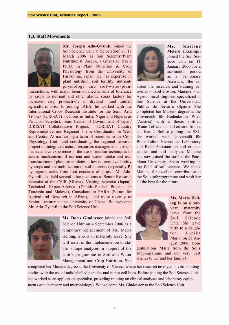
1.3. Staff Movements Mr. Joseph Adu-Gyamfi, joined the Soil Science Unit at Seibersdorf on 15 March 2006 as Soil Scientist/Plant Nutritionist. Joseph, a Ghanaian, has a Ph.D. in Plant Nutrition & Crop Physiology from the University of Hiroshima, Japan. He has expertise in plant nutrition, soil fertility, nutrient-physiology and soil-water-plant
interactions, with major focus on mechanisms of tolerance by crops to nutrient and other abiotic stress factors for increased crop productivity in dryland and rainfed agriculture. Prior to joining IAEA, he worked with the International Crops Research Institute for the Semi Arid Tropics (ICRISAT) locations in India, Niger and Nigeria as Principal Scientist, Team Leader of Government of Japan/ ICRISAT Collaborative Project, ICRISAT Country Representative, and Regional Theme Coordinator for West and Central Africa leading a team of scientists in the Crop Physiology Unit and coordinating the regional research project on integrated natural resources management. Joseph has extensive experience in the use of nuclear techniques to assess mechanisms of nutrient and water uptake and use, translocation of photo-assimilates at low nutrient availability by crops and the mobilization of soil nutrients (especially P) by organic acids from root exudates of crops. Mr Adu-Gyamfi also held several other positions as Senior Research Scientist at the CSIR (Ghana), Visiting Scientist (Japan), Technical Expert/Advisor (Danida–funded Projects in Tanzania and Malawi), Consultant to FARA (Forum for Agricultural Research in Africa), and more recently as Senior Lecturer at the University of Ghana. We welcome Mr. Adu-Gyamfi to the Soil Science Unit.
Ms. Mai tane Melero Urzainqui joined the Soil Sci-ence Unit on 11 January 2006 for a six-month period as a Temporary Assistant. She as-
sisted the research and training ac-tivities on soil erosion. Maitane is an Agronomical Engineer specialized in Soil Science at the Universidad Pública de Navarra (Spain). She completed her Masters degree at the Universität für Bodenkultur Wien (Austria) with a thesis entitled ‘Runoff effects on soil erosion from a silt loam’. Before joining the SSU she worked with Universität für Bodenkultur Vienna as Laboratory and Field Assistant on soil erosion studies and soil analyses. Maitane has now joined the staff at the Pam-plona University, Spain working in the field of soil science. We thank Maitane for excellent contribution to the Soils subprogramme and wish her all the best for the future.
Ms. Maria Heil-ing is on a one-year maternity leave from the Soil Science Unit. She gave birth to a daugh-t e r , Ann ik a Maria, on 28 Au-gust 2006. Con-
gratulations Maria from the Soils subprogramme and our very best wishes to her and her family!
Ms. Doris Gludovacz joined the Soil Science Unit on 4 September 2006 as a temporary replacement of Ms. Maria Heiling, who is on maternity leave. She will assist in the implementation of sta-ble isotope analyses in support of the Unit’s programme in Soil and Water Management and Crop Nutrition. She
completed her Masters degree at the University of Vienna, where her research involved in vitro binding studies with the use of radiolabelled peptides and tumor cell lines. Before joining the Soil Science Unit she worked as an application specialist, providing training on clinical analyses and laboratory equip-ment (wet chemistry and microbiology). We welcome Ms. Gludovacz to the Soil Science Unit.

5
Soil Science Unit, Activities Report - 2006
Mr. Stefan Borovits joined the Soil Science Unit on 1 July 1970. His main responsibilities have been to implement stable isotope analyses including routine analyses of 15N, 13C and 18O samples from CRPs and TCPs as well as research and training work in the Soil Science Unit. Without his
excellent supportive work the Unit would not have been able to complete more than 15 000 measurements each year for the past twenty years. He has always been very eager to understand and improve all analytical protocols used in the Soil Science Unit. Mr. Borovits has also provided general support for the implementation of greenhouse and field experiments. He has always been a very dedicated staff member performing outstanding work for the Unit both in terms of the quality and quantity of the work outputs. It has been a pleasure for the staff of the Soils subprogramme to work with Mr. Borovits, who was greatly appreciated for his open minded and pleasant personality. He retired on 31 October 2006 after more than 35 years of dedicated service to the Soil Science Unit. Mr. Borovits received a Merit Award in 2006. Colleagues in the Soils subprogramme would like to thank Mr. Borovits for his excellent work and wish him and his family all the very best for the future.
Mr. Arsenio Toloza joined the Soil Science Unit on 1 September 2006 as a Laboratory Technician. He assists and reinforces the research and training activities in soil erosion and sedimentation using fallout radionuclides and is
supervised by Mr. Lionel Mabit in support to the Soils subprogramme. Mr. Toloza has a B.Sc. in Biology from the Far Eastern University, Manila (Philippines). Prior to joining the Soil Science Unit, he has been working for ten years at the FAO/IAEA Agriculture and Biotechnology Laboratory in Seibersdorf, initially as a technician in the Plant Breeding Unit (1998 to 2003) gaining experience in banana improvement by in vitro mutagenesis, the rapid detection of aneuploidy in bananas using flow cytometry and developing disease-tolerance in bananas. Later he received five years of technical experience in mass rearing and quality control of the Mediterranean fruit fly in the Entomology Unit. The team welcomes Mr. Toloza into the Soils group.
Mr. Norbert Jagoditsch joined the Soil Science Unit on 24 April 2006 as a Technical Attendant. Norbert has 15 years of experience at the FAO/IAEA Seibersdorf Laboratories, first in the Soil Science Unit (1990-2000) and later in the Entomology Unit (2001-2006), both at the FAO/IAEA Agriculture & Biotechnology Laboratory. Norbert will support the implementation of greenhouse and field experiments for the Soils subprogramme. The team welcomes Norbert back into the SSU.
6
Soil Science Unit, Activities Report - 2006
1.4. Working Groups 2006 The Unit has constituted five Working Groups (WG) to meet the outcomes of the objectives with the Unit Head as the overall supervisor. The allocation of staff to the Working Groups is as follows:
Working Group on Soil Conservation (Erosion) Lionel Mabit and Arsenio Toloza
Working Group on Water Management. Joseph Adu-Gyamfi, Jose Luis Arrillaga and Norbert Jagoditsch.
Working Group on Abiotic Stress and Crop Nutrition Joseph Adu-Gyamfi, Gudni Hardarson, Jose Luis Arrillaga, Maria Heiling (part time,
maternity leave after July 2006), and Norbert Jagoditsch
Working Group on Routine Stable Isotope Analyses Leo Mayr, Martina Aigner, Doris Gludovacz and Stefan Borovits retired in 2006.
External Quality Assurance Martina Aigner and Leo Mayr
2. RESEARCH AND DEVELOPMENT
2.1 The use of geostatistics in environmental sciences to spatialise fallout radionuclides to assess soil erosion/sedimentation - Geostatistics concepts
2.1.1 Introduction 137Cs and other fallout radionuclides (FRN) methodologies have been used all over the world for more than 40 years. However, some aspects of the methodology (e.g., data modeling, the transformation of 137Cs activity into soil movements and the sampling strategy) need to be improved and still require additional research and development. Radiocesium is highly variable in space and knowledge of that variability is important for understanding and predicting processes like erosion and deposition. Geostatistics can help researchers to evaluate and interpret the 137Cs data in particular to map activities over a whole field or the landscape were only limited number of samples have been taken. The geostatistics concept was introduced during the Third FAO/IAEA Research Coordination Meeting on the ‘Assessment of the Effectiveness of Soil Conservation Techniques for Sustainable Watershed Management Using Fallout Radionuclides’ held in Vienna, Austria, 27-30 March 2006 to improve the spatialization of FRN punctual data for the production of improved maps. The introduction of these techniques in FRN-based studies could also help to improve soil sampling strategies and the accuracy of soil movement budgets established from FRN spatial redistribution. To edit and produce a map we need sufficient numbers of samples and a validated sampling strategy to ensure a good interpolation in unsampled area. Geostatistics in conjunction with variography have proved to be a useful tool over the traditional statistical methods to study and use information

7
Soil Science Unit, Activities Report - 2006
regarding the spatial dependence of the data, i.e. to give values to a whole area based on the limited number of samples taken. In order to familiarize our readers with some of the specific vocabulary and the geostatistics concept including data interpolation, some technical information are provided below. 2.1.2 Geostatistics and variography concepts Soils parameters are not distributed in the landscape randomly there is a spatial correlation that can explain the spatial distribution of their magnitudes. To represent this spatial correlation of variables, called the structure, geostatistics analyses have to be use through one specific tool the variogram. Geostatistical methods provide a set of statistical tools for incorporating spatial and temporal coordinates of observations in data processing. Geostatistics are largely based on the concept of random function and soil properties are regarded as a set of spatially dependent random variables. Geostatistics is a technology for estimating the values of properties (at unsampled places) that vary in space from more or less sparse sample data. It is particularly useful to quantify an unknown value when producing a map and when validating and improving sampling strategy. It became a science field in the 1960s, and was used in the mining industry and later it was extended to many other fields like geomorphology, geology, hydrology and geography. Geostatistical analysis has been used in large areas of several kilometers for mapping of soils, soils properties, nutrient variation and for producing fertilizer recommendation. Despite that geostatistics approaches were developed 50 years ago, the technology seems not to have reached the people for whom it was intended, namely the land managers, surveyors and consultants, soil scientist and agronomist. In the field of resource assessment, geostatistics is mainly used to characterize the spatial behaviour of a variable under study and to use this information to predict the value of this variable between sample points, while minimizing the error of estimation and also to improve and validate sampling survey. Variogram is the basic tool of the spatial structural analysis. Structural analysis involves describing and modeling the estimated variogram. The variogram is a mathematical description of the relationship (structure) between the variance of pairs of observations (data points) and the distance separating these observations (h). It describes the between-population variance within a distance class (y-axis) according to the geographical distance between pairs of populations (x-axis). The fitted curve minimizes the variance of the errors. The variogram model is used to define the weights of the Kriging function and the semivariance is an autocorrelation statistic defined as:
(1) Where g (h) is the semivariance for interval distance class or lag interval h, N(h) the total number of sample couples or pairs of observations separated by a distance h, Z(xi) the measured sample value at point i and Z(xi+h) the measured sample value at point i+h. The variographic model can be described through different parameters: the sill (C + Co), the nugget variance (Co), the scale (C) and the range (A). The most important part of a variogram
∑=
+=)(
1
2ii h)} (x Z)(x {Z)(2
1)(hN
ihNhγ
8
Soil Science Unit, Activities Report - 2006
is its shape near the origin as the closest points/or group of pairs are given more weight in the interpolation process. The sill corresponds to the model asymptote (scale and the nugget variance) and should be equal to the variance of the data set. The range is the value of h at which y attains the maximum value where the sill occurs and so represents the separation distance over which no more spatial dependence is apparent. The nugget variance represents the y intercept for g when h=0. It is a non-zero value produced by various sources of unexplained error (e.g. measurement error, sampling error, inter-sample error and unexplained and inherent variability) for g when h = 0. It represents an indication of short distance variation. To build a reliable variogram different steps have to be respected. Different lag distances have to be tested until a reliable and enough number of pairs to represent the model is found. Four representative groups of pairs are enough to represent a relevant variogram with a significant R2 and a good ratio nugget/sill for soils parameter. The effective lag distance can’t be more than half of the maximum distance between data. Directional dependence has to be tested in the spatial autocorrelation. The isotrope (no directional dependence) or anisotrope (directional dependence) characteristic of the variogram have to be determinate. If no anisotropy is found, it means that the value of the variable varies similarly in all directions and the semivariance depends only on the distance between sample points. The best variogram model (spherical, linear, ..) and its parameters (nugget, sill, scale, range….) have to be determined in order to obtain the best validity of the modelling of the spatial autocorrelation through variogram’s parameter optimisation. In order to evaluate the validity of this model we should use two major indicators: the coefficient of correlation (indication of how well the model fit to the variogram data) and the ratio Scale on Sill (C/(C+Co)). This ratio has to approach 1. It means that Co should approach zero and so that the y intercept is close to the origin. Some authors use also the ratio of the nugget to the sill (Co/(Co+C)), and then this ratio have to approach 0. If the ‘nugget-to-sill’ ratio is less than 25%, then the variable can be considered to have a strong spatial dependence. Some approaches to take into account the distance between the group of pairs and the fitted model called the Residual Sums of Squares (RSS). The RSS is very useful as it allow the comparison of different elaboration of variogram. To summarize, the number of pair at each lag distance have ideally to be greater than 30, coefficient of correlation (R2) should be greater than 0.8 and the ratio scale on sill should approach 1, it means that the nugget variance have to be as close as possible to the origin. Obviously, the variogram with the best RSS reduction have to be selected to represent the autocorrelation between the data. 2.1.3 Data interpolation Using two-dimensional space, the spatial structure of a variable can be visualized using maps by interpolating the values at unsampled locations. A spatial correlation between the data, commonly referred to as ‘‘Kriging’’is a method of interpolation. Kriging, which has become useful in the field of geostatistics, is based on the assumption that the parameter being interpolated can be treated as a localize variable, the ‘‘regionalised variable theory’’. Kriging interpolation provides an optimal interpolation estimate for a given coordinate location and to obtain interpolations from observed values and their spatial relationships, as inferred from the variography. Kriging use nearby points weighted by distance from the interpolate location and the degree of autocorrelation or spatial structure for those distances, and calculate optimum weights at each sampling.
9
Soil Science Unit, Activities Report - 2006
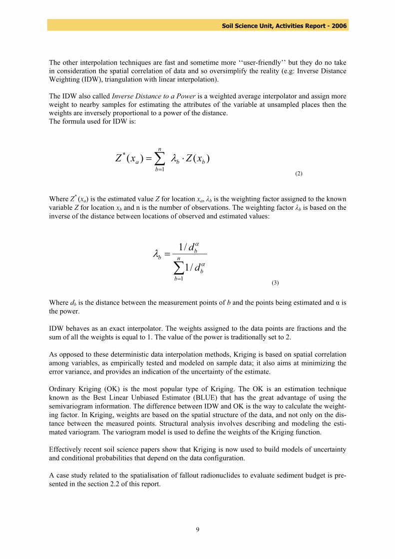
The other interpolation techniques are fast and sometime more ‘‘user-friendly’’ but they do no take in consideration the spatial correlation of data and so oversimplify the reality (e.g: Inverse Distance Weighting (IDW), triangulation with linear interpolation). The IDW also called Inverse Distance to a Power is a weighted average interpolator and assign more weight to nearby samples for estimating the attributes of the variable at unsampled places then the weights are inversely proportional to a power of the distance. The formula used for IDW is:
(2)
Where Z* (xa) is the estimated value Z for location xa, λb is the weighting factor assigned to the known variable Z for location xb and n is the number of observations. The weighting factor λb is based on the inverse of the distance between locations of observed and estimated values:
(3) Where db is the distance between the measurement points of b and the points being estimated and α is the power. IDW behaves as an exact interpolator. The weights assigned to the data points are fractions and the sum of all the weights is equal to 1. The value of the power is traditionally set to 2. As opposed to these deterministic data interpolation methods, Kriging is based on spatial correlation among variables, as empirically tested and modeled on sample data; it also aims at minimizing the error variance, and provides an indication of the uncertainty of the estimate. Ordinary Kriging (OK) is the most popular type of Kriging. The OK is an estimation technique known as the Best Linear Unbiased Estimator (BLUE) that has the great advantage of using the semivariogram information. The difference between IDW and OK is the way to calculate the weight-ing factor. In Kriging, weights are based on the spatial structure of the data, and not only on the dis-tance between the measured points. Structural analysis involves describing and modeling the esti-mated variogram. The variogram model is used to define the weights of the Kriging function. Effectively recent soil science papers show that Kriging is now used to build models of uncertainty and conditional probabilities that depend on the data configuration. A case study related to the spatialisation of fallout radionuclides to evaluate sediment budget is pre-sented in the section 2.2 of this report.
)()(1
*bb
n
ba xZxZ ⋅=∑
=
λ
∑=
= n
bb
bb
d
d
1/1
/1α
α
λ

10
Soil Science Unit, Activities Report - 2006
2.2 Spatial variability of erosion and soil organic matter content estimated from 137Cs measurements and geostatistics 2.2.1 Introduction Soil movement mapping is complex. Rills and gullies can be easily located and their volumes estimated but more diffuse processes like sheet erosion are difficult to quantify. Although monitoring of soil movement is often carried out during relatively long periods within a year, results remain representative measurement of the period only, due to drastic short-term changes in climatic events. Rills can also be masked by tillage operations. The use of 137Cs as a soil redistribution marker, coupled with geostatistics can complement the conventional measurement approaches. 137Cs is highly variable in its distribution, and characteristics of that variability are important for understanding and predicting processes like erosion and deposition. Spatialisation and output linked to the interpolation methods have not been optimized or used on a routine basis for fallout radionuclides (FRN). To date, few reports on the use of geostatistics and variographic tools (experimental variogram and a fitted model) to spatialise soil movement from 137Cs data or to spatialise 137Cs contamination have been reported . The production of a map and the budgeting of the spatialisation of data are important components in soil and environmental sciences. Soil properties are usually evaluated on transects, grids or patterns which presumes to represent the unsampled neighbourhood. It should be possible to reduce the costs of large-scale studies involving 137Cs measurements by increasing the dimensions of the sampling grid without a significant loss of information. The micro and overall topography should always be taken into account prior to establishing a sampling strategy. Soil sampling could be significantly reduced in areas where slope is rather uniform but should be increased in the case of a more rolling topography. Depending on the scale of investigation, haphazard and judgment sampling could be more appropriate in a sloping landscape if large areas are to be sampled. It is therefore possible to balance the scientific objectives with economic constraints. The objective of sampling for pattern development, is to ensure an adequate number of samples for interpolation, and then attribute values for areas not exhaustively sampled. If classical statistical approaches are unable to adequately address the spatial aspect of data, variography allows one to quantify and to model the spatial correlation among sample locations and to characterize the spatial behaviour of the data. It is possible to model the relationship between the sample values and the distance that separates them. Geostatistics can be used to characterize the spatial behaviour and spatial distribution of a parameter and to use this information to predict the value of this variable between sampled points and to minimise estimation error. Elaboration and development of variography is an important and necessary step for finding and modelling spatial structures in the data. The concept of geostatistics and interpolation through Kriging is presented and applied to an original case study. Emphasis is placed on the use of geostatistics as a tool to assess soil redistribution, as indicated by 137Cs measurements, and its spatial relationship with selected soil parameters, particularly OM content in a typical field in Eastern Canada. The objectives of this investigation were to determine the structure of spatial dependence of different soil chemical properties, to map the baseline of soil movement by geostatistical analysis and to establish a sediment budget using the information provided by the geostatistical approach.
11
Soil Science Unit, Activities Report - 2006
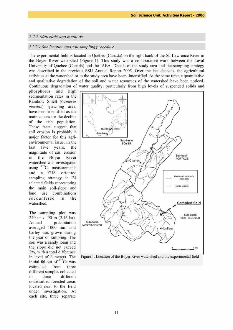
2.2.2 Materials and methods 2.2.2.1 Site location and soil sampling procedure The experimental field is located in Québec (Canada) on the right bank of the St. Lawrence River in the Boyer River watershed (Figure 1). This study was a collaborative work between the Laval University of Quebec (Canada) and the IAEA. Details of the study area and the sampling strategy was described in the previous SSU Annual Report 2005. Over the last decades, the agricultural activities at the watershed or in the study area have been intensified. At the same time, a quantitative and qualitative degradation of the soil and water resources of the watershed have been noticed. Continuous degradation of water quality, particularly from high levels of suspended solids and phosphorus and high sedimentation rates in the Rainbow Smelt (Osmerus mordax) spawning area, have been identified as the main causes for the decline of the fish population. These facts suggest that soil erosion is probably a major factor for this agri-environmental issue. In the last five years, the magnitude of soil erosion in the Boyer River watershed was investigated using 137Cs measurements and a GIS oriented sampling strategy in 24 selected fields representing the main soil-slope and land use combinations encountered in the watershed.
Figure 1. Location of the Boyer River watershed and the experimental field
The sampling plot was 240 m x 90 m (2.16 ha). Annual precipitation averaged 1000 mm and barley was grown during the year of sampling. The soil was a sandy loam and the slope did not exceed 2%, with a total difference in level of 6 meters. The initial fallout of 137Cs was estimated from three different samples collected in three different undisturbed forested areas located next to the field under investigation. At each site, three separate
12
Soil Science Unit, Activities Report - 2006
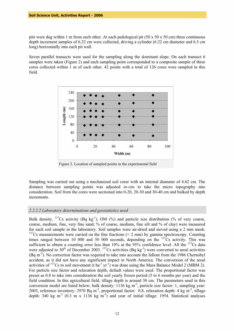
pits were dug within 1 m from each other. At each pedological pit (50 x 50 x 50 cm) three continuous depth increment samples of 6.22 cm were collected, driving a cylinder (6.22 cm diameter and 6.5 cm long) horizontally into each pit wall. Seven parallel transects were used for the sampling along the dominant slope. On each transect 6 samples were taken (Figure 2) and each sampling point corresponded to a composite sample of three cores collected within 1 m of each other. 42 points with a total of 126 cores were sampled in this field. Sampling was carried out using a mechanized soil corer with an internal diameter of 4.62 cm. The distance between sampling points was adjusted in-situ to take the micro topography into consideration. Soil from the cores were sectioned into 0-20, 20-30 and 30-40 cm and bulked by depth increments.
Figure 2. Location of sampled points in the experimental field
2.2.2.2 Laboratory determinations and geostatistics used Bulk density, 137Cs activity (Bq kg-1), OM (%) and particle size distribution (% of very coarse, coarse, medium, fine, very fine sand; % of coarse, medium, fine silt and % of clay) were measured for each soil sample in the laboratory. Soil samples were air-dried and sieved using a 2 mm mesh. 137Cs measurements were carried on the fine fractions (< 2 mm) by gamma spectroscopy. Counting times ranged between 10 000 and 50 000 seconds, depending on the 137Cs activity. This was sufficient to obtain a counting error less than 10% at the 95% confidence level. All the 137Cs data were adjusted to 30th of December 2003. 137Cs activities (Bq kg-1) were converted to areal activities (Bq m-2). No correction factor was required to take into account the fallout from the 1986 Chernobyl accident, as it did not have any significant impact in North America. The conversion of the areal activities of 137Cs to soil movement (t ha-1 yr-1) was done using the Mass Balance Model 2 (MBM 2). For particle size factor and relaxation depth, default values were used. The proportional factor was preset as 0.8 to take into consideration the soil yearly frozen period (5 to 6 months per year) and the field condition. In this agricultural field, tillage depth is around 30 cm. The parameters used in this conversion model are listed below; bulk density: 1136 kg m-3, particle size factor: 1, sampling year: 2003, reference inventory: 2970 Bq m-2, proportional factor: 0.8, relaxation depth: 4 kg m-2, tillage depth: 340 kg m-2 (0.3 m x 1136 kg m-3) and year of initial tillage: 1954. Statistical analyses
13
Soil Science Unit, Activities Report - 2006
including the one and two tailed tests for the significance of the different correlations were carried out with the Systat 11 software. The spatial distribution of 137Cs, OM content and soil movement were analyzed and described using geostatistics and variography concepts. Geostatistical and spatial correlation analyses were performed using the GS+ version 7 software. Afterwards, variogram models were established with the same dedicated software. The different variographic parameters and fitted models were then introduced in the GIS software Surfer 8.00. A map of the spatial distribution of the soil movement was produced using the ordinary Kriging approach for data interpolation. On the basis of the resulting map, a sediment budget was also produced, using the Surfer 8 package.
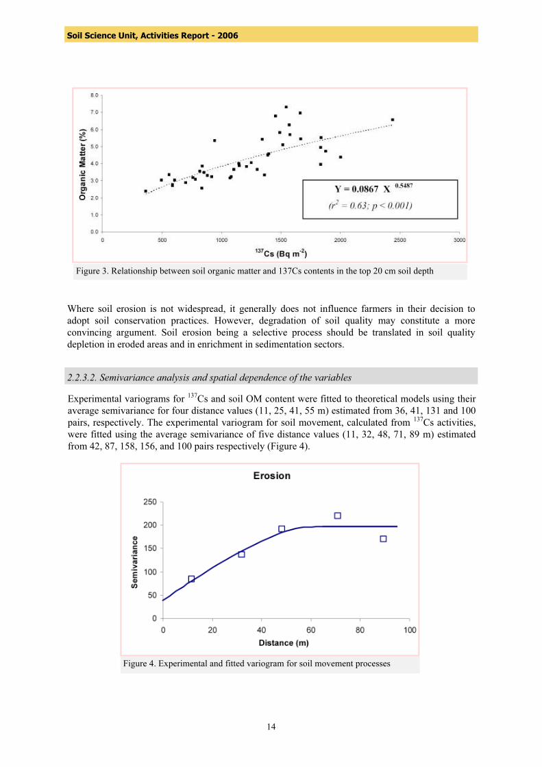
2.2.3 Results and discussion 2.2.3.1 Univariate statistics and correlation analysis The soil OM content ranged from 2.3 to 7.3%, for an average of 4.3 ± 0.4% (average ± 95% confidence interval). The mean value of the 137Cs reference sites was estimated at 2970 ± 110 Bq m-2 with a coefficient of variation of 4 % (n = 9). The 137Cs activity in the agricultural field varied from 531 to 4180 Bq m-2 (values adjusted to December 2003), with a mean value of 2034 ± 745 Bq m-2
(Mean ± SD). On the average, around 65% of the total inventory of 137Cs, in Bq m-2, was concentrated in the 0-20 cm depth increment, 25% in the 20-30 cm and less than 10% in the last increment (30-40 cm) under the plough layer. The lack of significant correlation between 137Cs and most of the texture parameters suggests that the particle selectivity effect which is normally associated with soil movement was not important enough in this field to induce significant changes in surface soil texture. As water and snowmelt erosion are surface processes, another test was made using 137Cs values for the top 20 cm only. Then, a highly significant correlation at the 0.001 level (t value = 7.104; 95% confidence interval of r = 0.573 to 0.856) between organic matter and 137Cs surface inventory was found (Equation 1):
Y = 0.0867 X 0.5487 (1) (n = 42; r2 = 0.63; p < 0.001)
Where Y = Soil OM content (%) X = 137Cs areal activity (Bq m-2) A high erosion rate, indicated by a low 137Cs inventory, is associated with a high loss of OM. On the other hand, depositional areas show an accumulation of organic matter. This explains why a positive power correlation was found between the 137Cs surface areal activity and the OM content, highlighting the relation between soil erosion and soil fertility (Figure 3). Similar results were reported by several authors, working in different environments. This confirms that physical degradation of soils through erosion is coupled with a biochemical degradation that will decrease soil productivity. To summarize, if erosion risk areas could be identified and soil conservation practices on these areas be implemented, it will result not only in erosion control but also in maintaining soil OM level. Erosion/sedimentation is a redistribution process that influences the productivity of agricultural systems in the medium to long term.
14
Soil Science Unit, Activities Report - 2006
Where soil erosion is not widespread, it generally does not influence farmers in their decision to adopt soil conservation practices. However, degradation of soil quality may constitute a more convincing argument. Soil erosion being a selective process should be translated in soil quality depletion in eroded areas and in enrichment in sedimentation sectors.
Figure 3. Relationship between soil organic matter and 137Cs contents in the top 20 cm soil depth
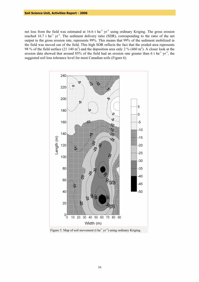
2.2.3.2. Semivariance analysis and spatial dependence of the variables Experimental variograms for 137Cs and soil OM content were fitted to theoretical models using their average semivariance for four distance values (11, 25, 41, 55 m) estimated from 36, 41, 131 and 100 pairs, respectively. The experimental variogram for soil movement, calculated from 137Cs activities, were fitted using the average semivariance of five distance values (11, 32, 48, 71, 89 m) estimated from 42, 87, 158, 156, and 100 pairs respectively (Figure 4).
Figure 4. Experimental and fitted variogram for soil movement processes

15
Soil Science Unit, Activities Report - 2006
Data transformation was not required to stabilize the spatial variance. For all variograms, each group of pairs was representative and relevant, since it included more than 30 pairs of points. Four groups of pairs are adequate to represent a relevant variogram with a significant r2 value and a good nugget/sill ratio for soils parameter. No anisotropy was found for any of the variables, suggesting that they vary similarly in all directions and that the semivariance depended only on the distance between sampling points. The geo-statistical and key parameters determined by the Variogram-analysis for soil OM, 137Cs and soil movement are presented in Table 1.
Table 1. Spatial dependence and key parameters of the different variograms. Soil parameters Active lag
distance Lag
interval Type of model
Range Sill
(C)
Nugget
(Co)
r2 C/(C+Co)
137Cs activity 70 m 16 m IS* 30 m 408 KBq m-2 17 KBq m-2 0.91 0.96 OM (0-20 cm) 70 m 16 m IS* 38 m 1.99 % 0.362 % 0.95 0.7 Soil movement 100 m 20 m IS* 65 m 197 t ha-1 yr-1 39 t ha-1 yr-1 0.87 0.8
IS* = Isotropic Spherical
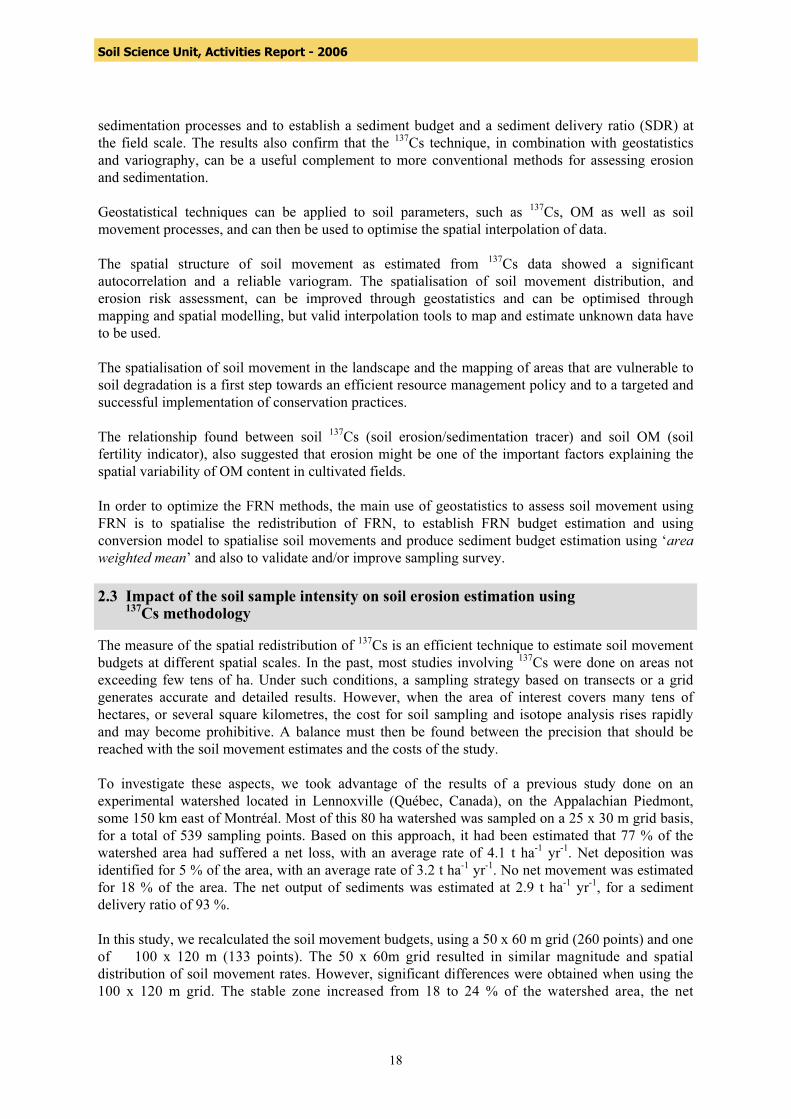
For all three parameters, the semivariograms were well structured. They showed a good autocorrelation and a small nugget effect with r2 values near or over 0.9 and a nugget-to-sill ratio ≤ 0.8; the nugget-to-sill ratio defines the spatial dependence property. The geostatistical analysis indicated that the OM and 137Cs activity showed similar spatial continuity (bounded spherical models) with a strong spatial dependence of the variables. The reduced nugget variance could result from the sampling strategy. Effectively each sampling point corresponded to a composite sample of three cores that could integrate the short micro-variance. Different authors, reported on the sampling strategy for FRN and associated soil movement, suggested that there could have been some reduction in the sampling density without a serious impact on the quantification of soil redistribution and spatial location, or on the extent of the different soil movement classes. It was not possible, however, to assess the validity of the sampling survey or to evaluate the number of samples needed to map and calculate soil redistribution budgets. Only the use of geostatistics and variography can be an indicator in validating sampling survey. In the present study, the semivariograms of 137Cs, soil OM content and soil movement showed that the sampling strategy adopted was adequate, and adapted to reveal the spatial structures of the three parameters under investigation. 2.2.3.3 Soil movement analysis The estimated soil movement rates for individual sampling points ranged from a loss of 62 t ha-1 yr-1 to a deposition of 17 t ha-1 yr-1. Using the average bulk density of 1136 kg m-3 for the 42 samples, these values corresponded to a maximum removal rate of 5.5 mm yr-1 (27 cm on the study periods 1954-2003) and a maximum deposition rate of 1.5 mm yr-1 (7.5 cm during the study periods 1954-2003). Contours maps of soil movement are shown in Figure 5. After interpolation and taking into account the structure of the data, a complete soil movement budget was calculated for the whole field. The
16
Soil Science Unit, Activities Report - 2006
net loss from the field was estimated at 16.6 t ha-1 yr-1 using ordinary Kriging. The gross erosion reached 16.7 t ha-1 yr-1. The sediment delivery ratio (SDR), corresponding to the ratio of the net output to the gross erosion rate, represents 99%. This means that 99% of the sediment mobilized in the field was moved out of the field. This high SDR reflects the fact that the eroded area represents 98 % of the field surface (21 140 m2) and the deposition area only 2 % (460 m2). A closer look at the erosion data showed that around 85% of the field had an erosion rate greater than 6 t ha-1 yr-1, the suggested soil loss tolerance level for most Canadian soils (Figure 6).
Figure 5. Map of soil movement (t ha-1 yr-1) using ordinary Kriging

17
Soil Science Unit, Activities Report - 2006
Figure 6. Proportion of soil movement rates in the agricultural field
For comparison purposes, the soil loss was also estimated using the Universal Soil Loss Equation (USLE). The rain erosivity factor was set at 1500 MJ mm ha-1 h-1. The soil erodibility (K factor) and the effect of slope (LS factor) were calculated from soil characteristics and slope measurements in the field. Soil K varied from 0.0019 to 0.0321 t ha h ha-1 MJ-1 mm-1. The slope factor, calculated for each individual transect, ranged between 0.08 and 0.23. The soil loss estimated with the USLE for individual transects thus amounted to 1.5 to 4.7 t ha-1 yr-1, which is much less than suggested by the 137Cs data. However, the USLE does not take into account snow melt erosion which can represent 80% of the soil losses in Quebec. The USLE is thus likely to underestimate soil erosion under Quebec conditions. During the erosive phase, the fine and 137Cs-rich particles are more easily transported, while a larger proportion of coarse and 137Cs-poor particles will settle when the carrying capacity of runoff is reduced or exceeded. To reflect this, a correction factor for soil particle size should thus be introduced in conversion models. If selectivity of erosion is not taken into consideration, it should also be considered that 137Cs data may overestimate the spatial extent and rates of net soil loss and underestimate the importance of deposition. In this study, no attempt was made to estimate such a factor. 2.2.4 Conclusions Geostatistics and geographic information system (GIS) were used for graphical interpretation of soil physical (texture) and chemical properties (soil OM content and 137Cs) in order to understand their variation in relation to soil erosion-sedimentation processes. This study also illustrated the advantage of the use of geostatistics to process data from fallout radionuclides (FRN) to assess soil erosion/
18
Soil Science Unit, Activities Report - 2006
sedimentation processes and to establish a sediment budget and a sediment delivery ratio (SDR) at the field scale. The results also confirm that the 137Cs technique, in combination with geostatistics and variography, can be a useful complement to more conventional methods for assessing erosion and sedimentation. Geostatistical techniques can be applied to soil parameters, such as 137Cs, OM as well as soil movement processes, and can then be used to optimise the spatial interpolation of data. The spatial structure of soil movement as estimated from 137Cs data showed a significant autocorrelation and a reliable variogram. The spatialisation of soil movement distribution, and erosion risk assessment, can be improved through geostatistics and can be optimised through mapping and spatial modelling, but valid interpolation tools to map and estimate unknown data have to be used. The spatialisation of soil movement in the landscape and the mapping of areas that are vulnerable to soil degradation is a first step towards an efficient resource management policy and to a targeted and successful implementation of conservation practices. The relationship found between soil 137Cs (soil erosion/sedimentation tracer) and soil OM (soil fertility indicator), also suggested that erosion might be one of the important factors explaining the spatial variability of OM content in cultivated fields. In order to optimize the FRN methods, the main use of geostatistics to assess soil movement using FRN is to spatialise the redistribution of FRN, to establish FRN budget estimation and using conversion model to spatialise soil movements and produce sediment budget estimation using ‘area weighted mean’ and also to validate and/or improve sampling survey. 2.3 Impact of the soil sample intensity on soil erosion estimation using 137Cs methodology The measure of the spatial redistribution of 137Cs is an efficient technique to estimate soil movement budgets at different spatial scales. In the past, most studies involving 137Cs were done on areas not exceeding few tens of ha. Under such conditions, a sampling strategy based on transects or a grid generates accurate and detailed results. However, when the area of interest covers many tens of hectares, or several square kilometres, the cost for soil sampling and isotope analysis rises rapidly and may become prohibitive. A balance must then be found between the precision that should be reached with the soil movement estimates and the costs of the study. To investigate these aspects, we took advantage of the results of a previous study done on an experimental watershed located in Lennoxville (Québec, Canada), on the Appalachian Piedmont, some 150 km east of Montréal. Most of this 80 ha watershed was sampled on a 25 x 30 m grid basis, for a total of 539 sampling points. Based on this approach, it had been estimated that 77 % of the watershed area had suffered a net loss, with an average rate of 4.1 t ha-1 yr-1. Net deposition was identified for 5 % of the area, with an average rate of 3.2 t ha-1 yr-1. No net movement was estimated for 18 % of the area. The net output of sediments was estimated at 2.9 t ha-1 yr-1, for a sediment delivery ratio of 93 %. In this study, we recalculated the soil movement budgets, using a 50 x 60 m grid (260 points) and one of 100 x 120 m (133 points). The 50 x 60m grid resulted in similar magnitude and spatial distribution of soil movement rates. However, significant differences were obtained when using the 100 x 120 m grid. The stable zone increased from 18 to 24 % of the watershed area, the net
19
Soil Science Unit, Activities Report - 2006
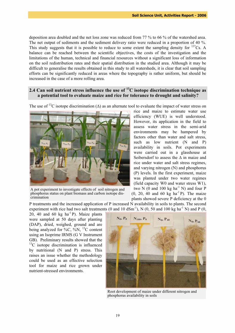
deposition area doubled and the net loss zone was reduced from 77 % to 66 % of the watershed area. The net output of sediments and the sediment delivery ratio were reduced in a proportion of 40 %. This study suggests that it is possible to reduce to some extent the sampling density for 137Cs. A balance can be reached between the scientific objectives, the costs of the investigation and the limitations of the human, technical and financial resources without a significant loss of information on the soil redistribution rates and their spatial distribution in the studied area. Although it may be difficult to generalise the results obtained in this study to all watersheds, it is clear that soil sampling efforts can be significantly reduced in areas where the topography is rather uniform, but should be increased in the case of a more rolling area. 2.4 Can soil nutrient stress influence the use of 13C isotope discrimination technique as a potential tool to evaluate maize and rice for tolerance to drought and salinity? The use of 13C isotope discrimination (∆) as an alternate tool to evaluate the impact of water stress on
rice and maize to estimate water use efficiency (WUE) is well understood. However, its application in the field to assess water stress in the semi-arid environments may be hampered by factors other than water and salt stress, such as low nutrient (N and P) availability in soils. Pot experiments were carried out in a glasshouse at Seibersdorf to assess the ∆ in maize and rice under water and salt stress regimes, and varying nitrogen (N) and phosphorus (P) levels. In the first experiment, maize was planted under two water regimes (field capacity W0 and water stress W1), two N (0 and 100 kg ha-1 N) and four P
(0, 20, 40 and 60 kg ha-1 P). The maize plants showed severe P deficiency at the 0
P treatments and the increased application of P increased N availability in soils to plants. The second experiment with rice had two salt treatments (0 and 10 dSm-1), N (0, 50 and 100 kg ha-1 N) and P (0, 20, 40 and 60 kg ha-1 P). Maize plants were sampled at 50 days after planting (DAP), dried, weighed, ground and are being analyzed for %C, %N, 13C content using an Isoprime IRMS (G V Instrument GB). Preliminary results showed that the 13C isotope discrimination is influenced by nutritional (N and P) stress. This raises an issue whether the methodology could be used as an effective selection tool for maize and rice grown under nutrient-stressed environments.
A pot experiment to investigate effects of soil nitrogen and phosphorus status on plant biomass and carbon isotope dis-crimination
Root development of maize under different nitrogen and phosphorus availability in soils

20
Soil Science Unit, Activities Report - 2006
Optimizing photosynthesis and the partitioning of a large part of the photosynthates into grains is vital for increasing productivity and resource use efficiency in legumes. Soybean and common bean were grown in pots at three P levels (0, 10 and 30 kg ha-1 P). At 35 DAP, plants were divided into 2 groups. The first group of plants was used for whole plant labeling and the second group for leaf labeling. For the whole labeling, plants were allowed to assimilate 13C generated from NaH13CO3 and lactic acid in an airtight chamber for 90 min under natural light conditions. In the second group, leaves below the fully expanded flag leaves were fed with 13C for 90 min. Half of the plants in the first group were sampled immediately after feeding and the rest allowed to grow till physiological maturity. Plants were separated into labeled leaves, leaves above and below labeled leaves, stems above and below labeled leaves, and pods above and below labeled leaves. For the whole plant labeling, plants were separated into flag leaves, other leaves, stem, pods, and roots, chopped into small pieces and ground. The analysis of the 13C content in the various plant parts which is currently in progress, would help understand the mechanisms of carbon translocation and re-distribution under varying P levels and provide an insight into the mechanisms of tolerance of common bean and soybean to low P available soils.
2.5 Partitioning of 13C-labelled photo-assimilates by common bean and soybean isotope at varying nitrogen and phosphorus availability
A glasshouse experiment on the partitioning of C-13-labelled photoassimilates by soybean and common bean
21
Soil Science Unit, Activities Report - 2006
2.6 Optical emission spectrometry (OES) can be used to determine inorganic nitrogen- 15 in soil samples To measure biological nitrogen transformations, such as gross N mineralization or nitrification, in the soil-plant-atmosphere continuum, the tracer 15N is essential. However routine analysis of these most fundamental processes has been restricted due to the limited access to isotope ratio mass spectrometry and the time consuming nature of the sample preparation methods, such as steam distillation, for 15N analysis. A faster and simpler way to determine the inorganic nitrogen fraction is a combination of the micro diffusion technique and the use of optical emission spectrometry (OES). The principle of the micro diffusion technique is that ammonia is liberated from the KCl soil extract by increasing the pH of the solution by the addition of magnesium oxide, which is then collected on an acidified quartz or glass fibre filter disc enclosed in a PTFE (polytetrafluoroethylene) envelope. The trapped ammonium sulphate is then washed off the disc to be analysed by OES. Nitrate is sequentially analysed from the same sample; by reduction to ammonium on addition of Devarda’s alloy and using the same acid trapping procedure. Experiments were carried out at Seibersdorf and in Chile to assess the feasibility and accuracy of these preparation procedures compared to traditional steam distillation and mass spectrometric methods. The micro-diffusion OES combination proved to be a suitable method for process studies of this kind. Considering the savings in costs and time, this finding offers an alternative to scientists in developing countries who cannot afford to buy mass spectrometers, to study these essential processes. Further details are shown in Preparation of ammonium-15N and nitrate-15N samples by micro-diffusion for isotope-ratio analysis by optical emission spectrometry in Communications in Soil Science and Plant Analysis, 37: 1–10, 2006 by M. Heiling, J. Arrillaga, R. Hood-Nowotny and X. Videla 2.7 External collaborations and partnerships Effective collaborations and partnerships are essential for up-and out-scaling of the research activities of the SSU. The Unit established collaborations with the following Institutions:
− Universität für Bodenkultur Wien, Department für Wasser-Atmosphäre-Umwelt, Institut für Hydraulik und landeskulturelle Wasserwirtschaft, Vienna, Austria.
− Chemistry Unit, Agency’s Laboratories, Seibersdorf, Austria. − GSF Forschungszentr.f.Umwelt und Gesundheit GMBH, Oberschleissheim, Germany. − Center for Agricultural Land Management and Agrohydrology Department for Agronomy,
Biotechnical Faculty, Ljubljana, Slovenia.
Collaborations on the validation of FRN methodology and geostatistics concept development: − Atomic Energy Commission of Syria, Damascus, Syria. − Ministère de l’Agriculture, des Pêcheries et de l’Alimentation du Québec, Québec, Canada. − Institut de recherche et de développement en agroenvironnement, Sainte-Foy, Québec, Can-
ada. − Département des sols et de génie agroalimentaire, Université Laval, Sainte-Foy, Québec,
Canada. − Department of Geography and Resource Management, The Chinese University of Hong
Kong, Hong Kong. Collaborations on testing of FRN approach at different scale:

22
Soil Science Unit, Activities Report - 2006
− Istanbul Technical University, Institute of Energy, Istanbul Turkey. − Istanbul University, Department of Geography, Istanbul, Turkey.
Collaborations on research activities linked to CRP D1.50.08 on “Assess the effective-ness of soil conservation measures for sustainable watershed management using fallout radionuclides”:
Collaboration on the enhancement of biological nitrogen fixation in grain legumes and endophytic fixation on cereals:
− Phaseomics project, University of Geneva, Swiss − EMBRAPA, Brazil − Microbiology laboratory (Centro de Invetigaciones Biologicas Clemente Estable), Uruguay.
2.8 Analytical services The Soil Science Unit continues to provide stable isotope analyses for CRPs, TCPs and for the other FAO/IAEA regular activities. The following table summarises the analytical services provided during 2006.
CRP TC Seib Contract Total Samples received 3286 25 2103 61 5475 Requested analyses
15N enriched 1368 25 907 61 2361 15N nat. ab. 276 0 425 0 701 13C nat. ab. 2194 0 1768 0 3962 18O nat. ab. 0 0 60 0 60 Total 3838 25 3160 61 7084
Measure-ments car-ried out
15N enriched 2590 39 1497 0 4126
15N nat. ab. 487 37 747 0 1271 13C nat. ab. 4117 0 2940 0 7057 18O nat. ab. 0 0 29 1016 1045 Total 7194 76 5213 1016 13499
30% of the measurements were on samples enriched in 15N, 9% of 15N at natural abundance, 52% of 13C at natural abundance and 8% of 18O at natural abundance. There is a clear trend of increased requirement for natural abundance measurements of 13C and 18O in the last few years. 13C and 18O at natural abundance were mostly done in duplicates.
Summary of analytical services during 2006

23
Soil Science Unit, Activities Report - 2006
2.9 The annual proficiency test (PT) for the measurement of 15N- and 13C isotopic abundance and total N and C concentration in plant materials The section 2.9 summarizes the results of the annual proficiency test IAEA-SSU-2006-01 on the analysis of three different plant materials for the isotopic abundance of stable isotopes 15N and 13C as well as the total element concentration of nitrogen (N) and carbon (C). Nitrogen and carbon are two major constituents of plant materials and their two stable isotopes, 15N and 13C, are commonly used as tracers in agricultural research. Isotope dilution studies are carried out in various fields of agriculture, for instance the use of 15N-enriched tracers in biological nitrogen fixation and fertilizer use efficiency studies and 13C at the natural abundance level in organic matter turnover and water use efficiency studies. Accurate analysis of these two isotopes is essential to draw the right conclusions from greenhouse- and field experiments. Therefore the implementation of a quality system in isotope analytical laboratories is essential and the regular participation in PT provides a good opportunity for the laboratory to check and improve the accuracy and precision of their applied analytical methods and the sustainability of performance over the years. This annual PT is organized and conducted by the SSU. It is free of charge and especially tailored to the needs of agricultural research laboratories in developing Member States working with stable isotopes. Three plant materials with different 15N- and 13C isotopic abundances and N and C contents were distributed to the participating laboratories in April 2006. The plant test materials were produced by the SSU and the assigned values and associated uncertainties were determined by application of a primary method (Isotope Ratio Mass Spectrometry, IRMS) for 15N- and 13C isotopic abundance determination. Laboratories were requested to analyze the 15N / total N- and/or the 13C / total C- content in the three different plant samples. Additionally a questionnaire on the implemented quality system had to be completed. The deadline was set at the end of October 2006. Eighteen of the 23 laboratories originally registered reported to the IAEA.
Geographical distribution of participants in IAEA-SSU-2006-01Number of labs (percentage)
Asia8 (44%)
Europe4 (22%)
Latin America3 (17%)
Africa3 (17%)
Figure 1. Geographical distribution of the laboratories that reported analytical results.

24
Soil Science Unit, Activities Report - 2006
Applied methods:
Region Numberof participants
15N by OES
15N by-IRMS
Ntotal by Kjeldahl
Ntotal by dry comb.
13C by IRMS
Ctotal by-dry comb.
Africa 3 1 2 1 2 2 2 Asia 8 4 4 5 3 4 4 Europe 4 2 2 2 2 2 2 Latin Amer-ica 3 3 - 3 - - - TOTAL 18 10 8 11 7 8 8
The results were evaluated by statistical methods for assessing laboratory analytical performance by the “z-score test”. The standard deviation for proficiency assessment was set at a value corresponding ‘to the level of performance that the PT-organizer wishes the laboratories to be able to achieve’. Results received the status “acceptable”, when the calculated z-score was smaller or equal to the value of ± 2 , a “warning” was given, if the z-score was between ±2 and ±3, the results received the status “not acceptable”, when the calculated z-score was exceeding the value of ±3. Participants were given a confidential code letter to assure anonymity and received a short report including the reference values of the three test samples and the ‘z-scores’ of all participants in December 2006. Certificates of participation are provided to all laboratories, a 'successful participation' is only stated to laboratories who showed proficiency in both, the isotope- and the total element concentration for one or both combined analyses. Individual assessments on sources of possible errors and proposed improvements of the applied methods were provided to each participant. The combined analysis 15N / total N was analyzed correctly by 61 percent of the participating laboratories (Fig. 2). The number of laboratories also analyzing 13C / total C increased from 5 to 8 compared to the previous year. As noted below the 13C / total C results still indicate some analytical weakness in half (50%) the participating laboratories (Fig. 3).
acceptable11 (61%)warning
2 (11%)
not acceptable5 (28%)
Figure 2. Overall performance on the combined analysis of 15N / total N
Table 1: Summary of applied methods and instrumentation listed per region (OES = optical emission spectrometry, IRMS = isotope ratio mass spectrometry).

25
Soil Science Unit, Activities Report - 2006
acceptable4 (50 %)
warning1 (12.5%)
not acceptable3 (37.5%)
Figure 3. Overall performance on the combined analysis of 13C / total C
The results of the PT demonstrate that initial appropriate steps towards quality assurance and quality control implementation had been taken by most participating laboratories. However to ensure the sustainability of these comprehensive quality management processes, a proactive management commitment must be equally ensured.
Laboratory code
overall performance in the com-bined analysis
sustainability of high quality data in three consecutive years
15N / total N 13C / total C 15N / total N 13C / total C 1 acceptable warning yes no 3 warning acceptable no yes 5 acceptable - yes - 6 acceptable acceptable 2nd participation 8 acceptable not acceptable no no 9 not acceptable - no - 10 acceptable - no - 11 not acceptable not acceptable newcomer 12 not acceptable - no - 13 acceptable - yes - 14 not acceptable - no - 16 acceptable acceptable newcomer 17 acceptable - yes - 18 not acceptable - no - 21 warning - no - 22 acceptable - no - 24 acceptable acceptable newcomer 25 acceptable not acceptable no newcomer
Table 2. Summary of overall performance and sustainability of high analytical quality of the partici-pating laboratories.
26
Soil Science Unit, Activities Report - 2006
The SSU is also supportive of Member States by hosting several scientific visitors and fellows, for their training, so they can beneficiate from the expertise of the SSU’s and SWMCN’s staff and from the equipments and research facilities in the Agency’s laboratories in Seibersdorf. Most of the training is on the use of nuclear techniques in crop nutrition, soil/water management, erosion and water conservation measurements, isotope analyses and quality assurance. The SSU trained more fellows during 2006 than ever before with 23 fellows trained for a total of 40 man-months. Furthermore the SSU received 10 scientific visitors during the year.
3. TRAINING AND FELLOWSHIP
3.2. Fellows During April-May 2006, the SSU conducted a group training session for 14 IAEA fellows from 7 different countries
Mr. Alkhader, Asad (JOR/05011) Ms. Baast, Bayarsaikhan (MON/05009) Ms. Bongosuren, Delgermaa (MON/06007) Mr. Duvivier, Predner (HAI/06001) Mr. Ergul, Faki (TUR/06005) Mr. Irekti, Hocine, (ALG/06001) Ms. Kale, Sema (TUR/06004) Mr. Kislal, Hakan (TUR/06001) Mr. Nam, Murat (TUR/06002) Mr. Onaran, Huseyin (TUR/06003) Mr. Opio Julius (UGA/06001) Mr. Sirin, Hamsa (TUR/06006) Mr. Sumah, Foday (SIL/05010) Ms. Tseeren, Odontungalag (MON/06006)
The training session covered crop nutrition and water management. Lectures and practical demonstrations were given by NAAL and NAFA staff with two external lecturers assisting with the implementation, i.e. Dr. Pierre Moutonnet, who gave lectures and practical exercises on the use of nuclear techniques in irrigation and water management and Dr. Felipe Zapata, who covered the field of fertilizer use efficiency and crop nutrition During November 2006, the SSU conducted also a second training session for 7 fellows from Kenya and Naminbia:
Mr. Maingi, Stanley Wambua (KEN/06015) Mr. Kinyua, James Kibiru (KEN/06013) Mr. Muchukuri, Kennedy (KEN/06014) Mr. Gawa-Nab, Werner (NAM/06005) Mr. Wakabe, Peter (KEN/06006) Mr. Muchere, Frederick N W (KEN/06055) Ms. Dausas, Albertha Elizabeth (NAM/06004)
3.1 Training

27
Soil Science Unit, Activities Report - 2006
The training session included theoretical and hand on training on stable and radioactive isotope analyses. The following main topics have been covered:
− Save handling of radioactive isotopes. Measurement of beta emitters (32P, 14C) by liquid scintilation counting
− Digestion of plant and soil samples (Kjeldahl) and measurement of 15N atom% by emission spectrometer (NOI-6, NOI-7).
− Determination of stable isotopes ratios (C, N, O) by isotope ratio mass spectrometry. − Quality assurance of analytical results. −
The institute in Kenya (KARI) has a NOI-6 emission spectrometer and a 20-20 mass spectrometer, which both were not working since some time. Therefore focus of the training was on troubleshooting and maintenances of these two equipments. 3.2.1 Individual fellowship training Mr. Mohsen Makhlouf (SYR/03044) from the Atomic Energy Commission of Syria, Department of Agriculture, Division of Soil and Plant Nutrition, was trained for three months (July-September 2006) on erosion/sedimentation process assessment using fallout radionuclides under the supervision of Mr. Lionel Mabit. Related to the IAEA technical co-operation project RAS/0/042 (Human Resource Development and Nuclear Technology Support) his training covered the following areas: erosion/sedimentation process, use of fallout radionuclides isotopes to estimate erosion/sedimentation, field training for soil sampling, soil samples pre-treatment for gamma analysis, transformation of fallout radionuclides areal activity into soil movement through conversion models, software training for spatialisation and mapping, introduction to geostatistical analysis, interpretation of data and sediment budget assessment.
M. Makhlouf and L. Mabit (SSU) during the special exhibit celebrating the 50th General conference of the IAEA (Photo: L. Mabit)

28
Soil Science Unit, Activities Report - 2006
During the training period, he participated as co-author in the presentation at the international symposium SOPHYWA in Vienna and due to his valuable contribution he was also involved in the production of a paper on the spatial variability of erosion and organic matter content as investigated from 137Cs measurements and geostatistics. He was also chosen by the Director of the IAEA Seibersdorf laboratories to represent Seibersdorf fellows in a special exhibit celebrating the 50th General Conference of the International Atomic Energy Agency. The Nuclear technologies for the Environment: Protecting Air, Earth and Oceans. 19-22 September 2006. Austria Center in Vienna, Austria. This training will improve his capability to analyse the data collected with Dr. Fares Asfary and Mr. Abdle Aziz Aba to evaluate erosion rates and sediment budget in the Khanasser Valley in Syria.
M. Makhlouf and A. Toloza (SSU) during soil sampling in Mistelbach (Photo: L. Mabit)
Mr. Ochirbat Batkhishig (MON/06005), Head of the Soil Science Laboratory, Institute of Geography, Mongolian Academy of Sciences, Ulaanbaatar, Mongolia was trained for one month (November 2006) on the use of FRN to assess erosion and sedimentation rates at different scale under the supervision of Mr. Lionel Mabit. Related to the IAEA technical co-operation project MON/5014 (Application of Isotopes in Soil and Plant Studies) his one month training covered the following areas: introduction to erosion process, use of isotopes to estimate erosion, sampling strategy at the field and watershed scale, sample preparation for gamma analysis, introduction to geostatistical analysis, mapping, analysis and interpretation of data and use of conversion models. The training will be very useful for him as he will be working on the new technical co-operation project MON/5/015 (Implementation of the Fallout Radionuclide Technique for Erosion Measurement). The objective of this project is to develop technical ability in the application of nuclear techniques to assess soil erosion and improve the management of arable and pasture land in Mongolia.

29
Soil Science Unit, Activities Report - 2006
Mr. Asad Alkhader (JOR/05011) was trained for two weeks on isotope techniques for studying P dynamics and evaluating the effectiveness of P fertilizers. Mr. Alkhader was supervised by Mr. Joseph Adu-Gyamfi. Ms. Baast, Bayarsaikhan (MON/05009), Ms. Bongosuren, Delgermaa (MON/06007), Ms. Tseeren, Odontungalag (MON/06006), Mr. Irekti, Hocine (ALG/06001) and Mr. Opio Julius (UGA/06001) received a three-month training each in the use of the 15N isotope dilution technique for the quantification of biological nitrogen fixation in grain legumes, including inoculate production, rhizobial inoculation, soil sampling for erosion assessment, greenhouse experimentation using stable isotopes as well as collection of data and reporting of results. The training of these fellows was under the overall supervision of Mr. Gudni Hardarson. Mr. Foday Sumah (SIL/05010) was trained for four months on 13C isotope discrimination in maize and rice under water and salt stress at varying N and P availability and the partitioning, and translocation of 13C-labeled photo-assimilates by soybean and common bean at low P levels under the supervision of Mr. Joseph Adu-Gyamfi and with the assistance of Mr. Jose Luis Arrillaga.
A fellow from Sierra Leone conducting an experiment at the glasshouse

30
Soil Science Unit, Activities Report - 2006
Mr. Hakan Kislal (TUR/06001) received training for three months on “Crop production practices and changes in physio-chemical and isotopic composition of groundwater at Seibersdorf (in collaboration with ARC- Mr. P Hacker). A field experiment involving the installation of access tubes for moisture measurements using the neutron probe and tensiometers to monitor the composition of 18O and 15N in soil water was supervised by Mr. Joseph Adu-Gyamfi and Mr. Long Nguyen.
3.2.2 Scientific Visits The following IAEA scientific visitors received training at the Soil Science Unit during 2006:
Mr. Ambassa Kiki, L.R. (CMR/06004V), 3 to 7 April Mr. Birang, M. (CMR/06005V), 3 to 7 April Mr. Johnson, S.D. (SIL/05008V), 4 to 7 April Mr. Assami, T. (ALG/06004V), 6 to 16 June Ms. Mefti, H. (ALG/06005V), 6 to 16 June Mr. Sanginov, S. (TAD/06007V) 13 June Mr. Gebrehiwot, K.A. (ERI/06001V), 2 to 6 October Mr. Gonfo, O.J. (ERI/06004V), 2 to 6 October Mr. Baggie, I (SIL/05001V) 2 to 13 October Mr. Benamar, A. (ALG/06003V), 13 to 17 November
A fellow from Turkey investigates the effect of crop production practices on monitor soil water and nitrate movement in the soil
31
Soil Science Unit, Activities Report - 2006
3.3 Workshop on data analysis and interpretation related to isotopic dilution experiments at Seibersdorf on 18 October 2006 As part of the activities related to the 1st research coordinated meeting (CRP) on the “Selection and evaluation of food (cereal and legume) crop genotypes tolerant to low nitrogen and phosphorus soils through the use of isotopic and nuclear-related techniques”, a one-day workshop was organized by the Soil Science Unit of the Agency’s Laboratory at Seibersdorf with the participation of staff from the Section and Unit. The workshop attended by 17 participants from 17 countries was aimed to (i) brief the participants on the laboratory activities related to the use of isotope techniques for nutrient dynamics and nutrient efficiency (ii) discuss data analysis and interpretation of data related to isotopic dilution experiments and (iii) examine sample preparation techniques and analysis related to the CRP. During the opening session, a representative of the Director of NAAL, Mr C Schmitzer welcomed the participants and presented an overview of the Agency’s Laboratories research mandate and current activities. Presentations at the workshop included (i) general introduction of isotopes (ii) isotope techniques in N studies: theory, applications and data interpretation (iii) isotope techniques for studying P dynamics and evaluating agronomic effectiveness of P fertilizers: theory, application and problem set. The participants later visited the analytical laboratory and were briefed on sample preparation and the principles underlying the operation of the mass spectrometer for the analysis of 15N, 13C and 18O in plant, soil and water samples.

32
Soil Science Unit, Activities Report - 2006
4. PUBLICATIONS A list of articles from Soils subprogramme staff published in scientific journals and Conference Pro-ceedings are available also on SWMCN Section website at
http://www.iaea.org/programmes/nafa/d1/public/d1_pbl_1.html
• Adu-Gyamfi, J.J, Myaka, F.A., Sakala, W.D., Odgaard, R., Vesterager, J.M. and Jensen, H.H. (2007). Biological nitrogen fixation and nitrogen and phosphorus budgets in farmer-managed intercrops of maize-pigeonpea in semi-arid southern and eastern Africa. Plant and Soil 295:127-136.
• Dang, T.H., Cai, G.X., Guo, S.L., Hao, M.D. and Heng, L.K. (2006). Effect of nitrogen
management on yield and water use efficiency of rainfed wheat and maize in Northwest China. Pedosphere, 16, 495-504.
• Heiling, M., Arrillaga, J., Hood-Nowotny, R. and Videla, X. (2006). Preparation of
ammonium -15N and nitrate-15N samples by micro-diffusion for isotope-ratio analysis by optical emission spectrometry in Communications in Soil Science and Plant Analysis, 37, 1-10.
• Helinski, M.E.H., Hood-Nowotny, R., Mayr L. and Knols, B.G.J. (2007). Stable isotope-
mass spectrometric determination of semen transfer in malaria mosquitoes. The Journal of Experimental Biology, 210, 1266-1274.
• Myaka, FA., Sakala, W.D., Adu-Gyamfi, J.J., Kamalongo, D., Ngwira, A., Odgaard, R.,
Nielsen, N.E. and Jensen, H.H. (2006). Yields and accumulations of N and P in farmer-managed intercrops of maize-pigeonpea in semi-arid Africa. Plant and Soil, 285, 207-220
4.1 Journal Articles
4.2 Conference Proceedings/Abstracts • Bernard, C., Mabit, L. and Laverdière, M.R. (2006). The use of radio isotopic tracers to
study erosion at different spatial and temporal scales (Utilisation des marqueurs radioisotopiques pour l'étude de l'érosion à diverses échelles spatiales et temporelles). pp. 159-166. In : Érosion et gestion conservatoire de l'eau et de la fertilité des sols. Actes des journées scientifiques du Réseau érosion et GCES de l'Agence Universitaire de la Francophonie. Editions scientifiques GB.
• Bernard, C., Mabit, L. and Laverdière, M.R. (2006). Assessment of soil erosion and
sediment production at the watershed scale using fallout radionuclide 137Cs. In: The 14th Conference of International Soil Conservation Organization – Water Management and Soil Conservation in Semi-Arid Environments’’. Final Program and Book of Abstracts. Edition INRA 2006. ISBN: 9954-0-6653-5. Page 247 & CD-Rom of the proceedings in .pdf format extended summary of 4 pages.
• Fulajtar E., Mabit, L. and Bernard C. (2006). Assessing erosion-sedimentation processes
and efficiency of soil conservation practices using radio-isotope techniques. In: Abstracts of the International Sediment Initiative Conference (ISIC). pp. 79-80 + CD-Rom. UNESCO Chair in Water Resources. 12-15 November 2006, Khartoum, Sudan.

33
Soil Science Unit, Activities Report - 2006
• Hardarson, G., Heng, L., Mabit, L., Serraj, R., Bernard, C. and Nguyen., L. (2006). An Overview of the Recent Soil-Water-Plant Research and Technical Activities of the FAO/IAEA Programme. 18th World Congress of Soil Science, Frontier of Soil Science: Technology and the Information Age. 9-15 July 2006, Philadelphia, Pennsylvania, USA. In: Abstracts (CD-Rom) 18th World Congress of Soil Science, SESSION 172 (172-1,2301b), Soil Science and International Organizations, D:/techprogram/P11476.htm, 1 page
• Klik, A. and Melero Urzainqui M. (2006). Interrill erosion processes along a hillslope. In:
Geophysical Research Abstracts (CD-Rom), Volume 8, European Geosciences Union - General Assembly 2006, ISSN: 1029-7006. Abstract EGU06-J-06877. pdf, 1 page.
• Mabit. L., Bernard. C. and Melero Urzainqui M. (2006). Test of 134Cs as soil erosion
tracer under rainfall simulation. In: Geophysical Research Abstracts (CD-Rom), Volume 8, European Geosciences Union - General Assembly 2006, ISSN: 1029-7006. Abstract EGU06-J-01245. pdf, 2 pages
• Mabit. L., Bernard. C. and Melero Urzainqui M. (2006). Impact of the soil sample
intensity on soil erosion estimation using 137Cs methodology. In: Geophysical Research Abstracts (CD-Rom), Volume 8, European Geosciences Union - General Assembly 2006, ISSN: 1029-7006. Abstract EGU06-J-01246. pdf, 2 pages.
• Mabit, L. and Bernard, C. (2006). Spatial variability of erosion as evidenced from 137Cs
and organic matter content measurements and some soil parameters at the field scale in the Boyer River watershed (Canada). In: The 14th Conference of International Soil Conservation Organization – Water Management and Soil Conservation in Semi-Arid Environments’’. Final Program and Book of Abstracts. Edition INRA 2006. ISBN: 9954-0-6653-5. Page 241 & CD-Room of the proceedings in .pdf format extended summary of 4 pages.
• Mabit, L., Bernard, C., Melero Urzainqui M. and Makhlouf, M. (2006). Application of
geostatistics concept in agri-environmental sciences: A case study addressing soil and organic matter redistribution by erosion processes to assess soil fertility and establish sediment budget. p. 183-186. In: G. Kammerer and F. Kastanek (eds.). Soil Physics and Rural Water Management-Progress, Needs and Challenges. Proceedings of the International Symposium SOPHYWA. 28-29 September 2006. Vienna, Austria.
4.3 IAEA Reports/Newsletters • Adu-Gyamfi, J J. (2006). 13C isotope discrimination in maize and rice under water and
salt stress at varying nitrogen and phosphorus availability. In: IAEA-Soils Newsletter, Vol. 29(2), Laboratory Activities-Research: p. 23.
• Adu-Gyamfi, J J. (2006). Partitioning of 13C-labelled photo-assimilates by common bean
and soybean at varying nitrogen and phosphorus availability. In: IAEA-Soils Newsletter, Vol. 29(2), Laboratory Activities-Research: p. 23.
• Aigner, M., Shakhashiro, A. and Trinkl, A. (2006). Final Report on the Annual
Proficiency Test ‘EQA 2005’ for Measurement of 15N and 13C Isotopic Abundance and Total Nitrogen- and Carbon Concentration in Plant Materials, IAEA, 105 pages.
34
Soil Science Unit, Activities Report - 2006
• Mabit, L. and Bernard, C. (2006). Test of 134Cs as soil tracer under rainfall simulation. In: IAEA-Soils Newsletter, Vol. 28(2), Laboratory Activities-Research: p. 22.
• Mabit, L., Bernard, C. and Laverdière, M.R. (2006). Sediment production using 137Cs and
GIS in an agricultural watershed. In: IAEA-Soils Newsletter, Vol. 29(1), Laboratory Activities-Research: p. 16-18.
• Mabit, L. and Melero Urzainqui M. (2006). Study of 137Cs redistribution at the field scale
using geostatistics. In: Third Research Co-ordination Meeting of the Co-ordinated Research Project D1.50.08 “Assess the effectiveness of soil conservation techniques for sustainable watershed management using fallout radionuclides”. IAEA, Vienna International Centre, CD-Rom, ppt. presentations no 23.
4.4 Publications accepted/in press • Heng, L.K., Asseng, S., Mejahed, K. and Rusan, M. (2007). Optimizing wheat
productivity in two rain-fed environments of the West Asia - North Africa region using a simulation model. European J. Agronomy (Accepted).
• Mabit L., Bernard C. and Laverdière M.R. (2007). Assessment of erosion in the Boyer
River watershed (Canada) using a GIS oriented sampling strategy and 137Cs measurements. CATENA (In press).
• Mabit, L., Bernard, C. and Laverdière, M.R. (2007). Water erosion measurement at the
watershed level by the Cs137 method. (Étude de la dégradation des sols par l’érosion hydrique à l’échelle des bassins versants en utilisant la méthode du Cs137). Agrosolution (In press).
• Mabit, L and Fulajtar, E. (2007). The use of 137Cs to assess soil erosion and sedimentation
processes: advantages and limitations. In: Book of the extended Synopses of the International Conference on Environmental Radioactivity: From Measurements and Assessments to Regulation. (In press).
• Mabit, L., Li, L., Toloza, A. and Bernard, C. (2007). Soil erosion processes and soil
quality variability evaluated using fallout radionuclides. In: Geophysical Research Abstracts, European Geosciences Union - General Assembly 2007. (In press).
35
Soil Science Unit, Activities Report - 2006
5. SCIENTIFIC MEETINGS AND STAFF TRAVELS 5.1 Scientific meetings General Assembly of the European Geosciences Union, 02-07 April 2006, Vienna, Aus-tria.
14th Conference of the International Soil Conservation Organisation (ISCO) – Water Management and Soil Conservation in Semi-Arid Environments, 14-19 May 2006, Marrakech, Morocco.
The Assembly of the European Geosciences Union (EGU) in 2006 took place in Vienna. The meeting brought together several thousands of researchers all around the world. Three contributions from the Soils subprogramme were presented under the Dryland Hydrology Section co-organized by the Soil System Sciences Section of the Assembly. L. Mabit, C. Bernard (SWMCN) M. Melero Urzainqui had two contributions entitled Test of 134Cs as soil erosion tracer under rainfall simulation and Impact of the soil sample intensity on soil erosion estimation using 137Cs methodology and M. Melero Urzainqui had an additional contribution in collaboration with Prof. A. Klik from Boku University entitled “Interrill erosion processes along a hillslope”.
Under the auspices of the High Commissioner for Water, Forestry and Desertification Control, the Moroccan Network of Soil and Water Conservation, the Moroccan Association of Soil Sciences and the Moroccan Association of Geomorphology, the 14th Conference of ISCO on Water Management and Soil Conservation in Semi-Arid Environments was organized in Morocco. The meeting was held in the Palais des Congrès de Marrakech from 14 to 19 May 2006. Presentations were made in 38 sessions with around 400 oral and poster presentations and more than 600 participants. A total of 240 oral presentations were made on different agro-environmental topics related to soil and water resource management. The IAEA special session (19 May) entitled “Use of fallout radionuclides for erosion/sedimentation studies” was chaired by Lionel Mabit. This session included presentations by seven scientists, on studies in six different countries (Austria, Canada, Chile, Morocco, Russian Federation and USA). A poster session was also organized for additional contribution. It became clear that one of the major gaps in soil degradation knowledge is the lack of use of spatialisation tools and methodologies to map erosion/sedimentation to target conservation action at the watershed scale. For more information on this meeting and the proceedings of previous ISCO meetings please visit: http://www.tucson.ars.ag.gov/isco/. The main activities of the Soil and Water Management & Crop Nutrition section and the Soil Science unit in the field of soil and water conservation were also publicized during this meeting. Lionel Mabit gave an oral presentation entitled “Spatial variability of erosion as evidenced from 137Cs and organic matter content measurements and some soil parameters at the field scale”. A second presentation was made in collaboration with Dr. Claude Bernard and Prof. Marc Laverdière from IRDA Québec/Canada on “Assessment of soil erosion and sediment production at the watershed scale using fallout radionuclide 137Cs”.

36
Soil Science Unit, Activities Report - 2006
Soil degradation close to the Atlas Mountain (Photo: L. Mabit)
International Soil Conservation Organization Meeting 2006 (Photo: L. Mabit)
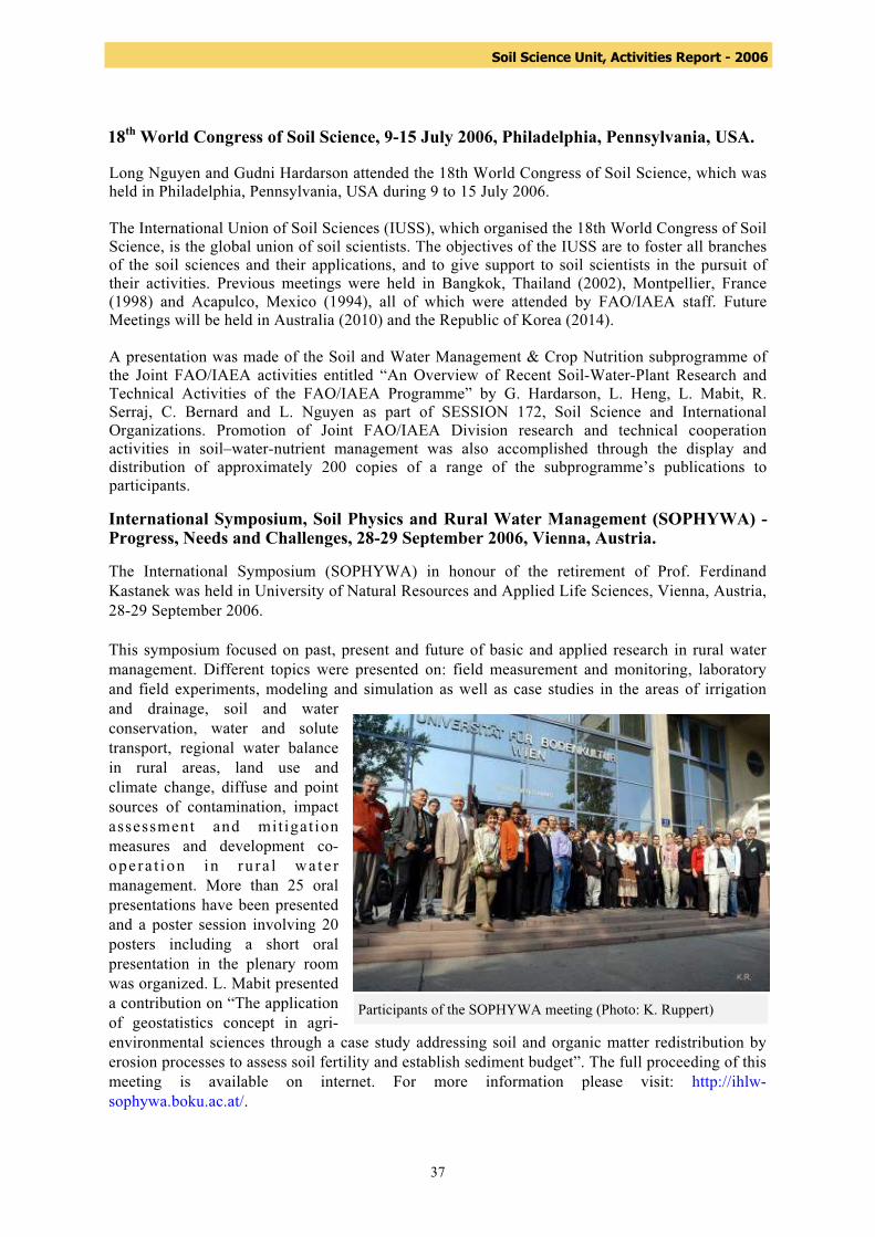
37
Soil Science Unit, Activities Report - 2006
18th World Congress of Soil Science, 9-15 July 2006, Philadelphia, Pennsylvania, USA. Long Nguyen and Gudni Hardarson attended the 18th World Congress of Soil Science, which was held in Philadelphia, Pennsylvania, USA during 9 to 15 July 2006. The International Union of Soil Sciences (IUSS), which organised the 18th World Congress of Soil Science, is the global union of soil scientists. The objectives of the IUSS are to foster all branches of the soil sciences and their applications, and to give support to soil scientists in the pursuit of their activities. Previous meetings were held in Bangkok, Thailand (2002), Montpellier, France (1998) and Acapulco, Mexico (1994), all of which were attended by FAO/IAEA staff. Future Meetings will be held in Australia (2010) and the Republic of Korea (2014). A presentation was made of the Soil and Water Management & Crop Nutrition subprogramme of the Joint FAO/IAEA activities entitled “An Overview of Recent Soil-Water-Plant Research and Technical Activities of the FAO/IAEA Programme” by G. Hardarson, L. Heng, L. Mabit, R. Serraj, C. Bernard and L. Nguyen as part of SESSION 172, Soil Science and International Organizations. Promotion of Joint FAO/IAEA Division research and technical cooperation activities in soil–water-nutrient management was also accomplished through the display and distribution of approximately 200 copies of a range of the subprogramme’s publications to participants. International Symposium, Soil Physics and Rural Water Management (SOPHYWA) - Progress, Needs and Challenges, 28-29 September 2006, Vienna, Austria. The International Symposium (SOPHYWA) in honour of the retirement of Prof. Ferdinand Kastanek was held in University of Natural Resources and Applied Life Sciences, Vienna, Austria, 28-29 September 2006. This symposium focused on past, present and future of basic and applied research in rural water management. Different topics were presented on: field measurement and monitoring, laboratory and field experiments, modeling and simulation as well as case studies in the areas of irrigation and drainage, soil and water conservation, water and solute transport, regional water balance in rural areas, land use and climate change, diffuse and point sources of contamination, impact assessment and mit igat ion measures and development co-opera t ion in ru ra l wa te r management. More than 25 oral presentations have been presented and a poster session involving 20 posters including a short oral presentation in the plenary room was organized. L. Mabit presented a contribution on “The application of geostatistics concept in agri-environmental sciences through a case study addressing soil and organic matter redistribution by erosion processes to assess soil fertility and establish sediment budget”. The full proceeding of this meeting is available on internet. For more information please visit: http://ihlw-sophywa.boku.ac.at/.
Participants of the SOPHYWA meeting (Photo: K. Ruppert)
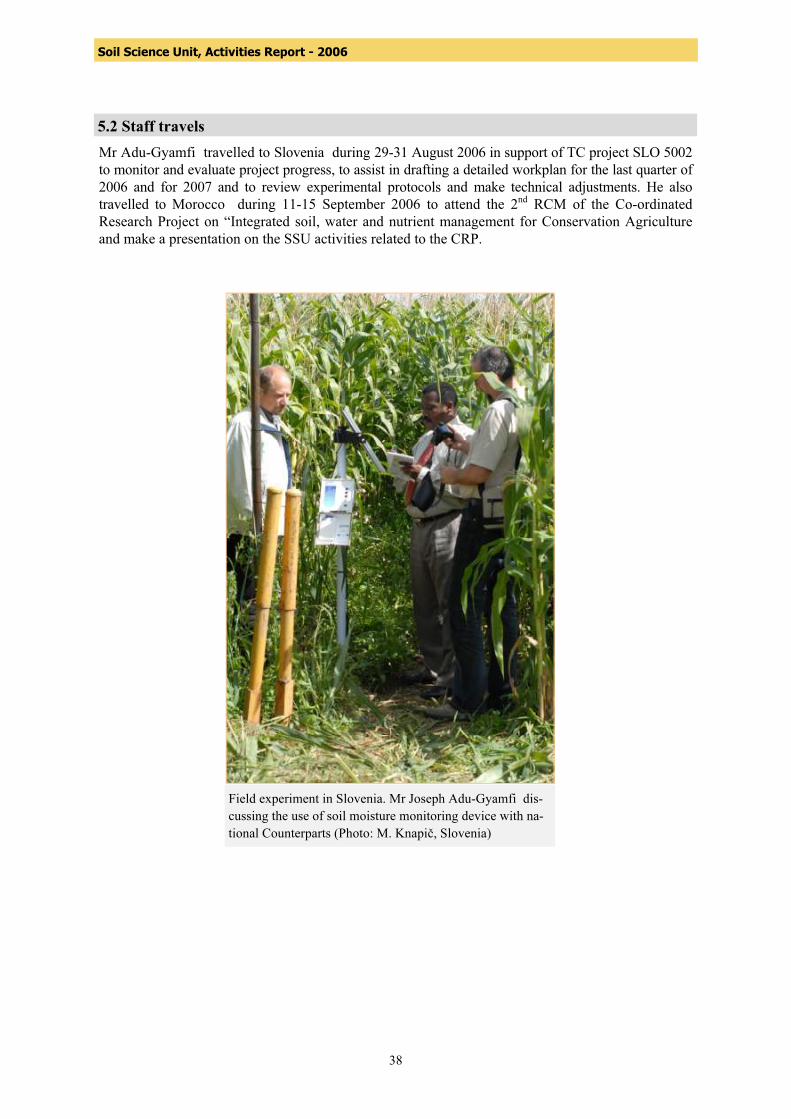
38
Soil Science Unit, Activities Report - 2006
5.2 Staff travels Mr Adu-Gyamfi travelled to Slovenia during 29-31 August 2006 in support of TC project SLO 5002 to monitor and evaluate project progress, to assist in drafting a detailed workplan for the last quarter of 2006 and for 2007 and to review experimental protocols and make technical adjustments. He also travelled to Morocco during 11-15 September 2006 to attend the 2nd RCM of the Co-ordinated Research Project on “Integrated soil, water and nutrient management for Conservation Agriculture and make a presentation on the SSU activities related to the CRP.
Field experiment in Slovenia. Mr Joseph Adu-Gyamfi dis-cussing the use of soil moisture monitoring device with na-tional Counterparts (Photo: M. Knapič, Slovenia)

39
Soil Science Unit, Activities Report - 2006
5.3 Technical Cooperation Projects and Coordinated Research Projects Technical support of the activities in the Co-ordinated Research Project (D1.50.08) The overall aim of the projects conducted under this CRP from the FAO/IAEA Joint Division on “Assess the effectiveness of soil conservation measures for sustainable watershed management using fallout radionuclides” is to develop diagnostic tools for assessing soil erosion and sedimentation processes and effective soil conservation measures for sustainable watershed management. The specific research objectives are: to further develop FRN methodologies, with particular emphasis on the combined use of 137Cs, 210Pbex and 7Be for measuring soil erosion over several spatial and time scales; to establish standardized protocols for the combined application of the above techniques, and to utilize these techniques to assess the impact of short-term changes in land use practices and the effectiveness of specific soil conservation measures. The third RCM of this CRP was held from 27 to 30 March 2006 at IAEA’s Headquarters in Vienna, Austria. The objectives of this meeting were to review the progresses achieved by the participants in the implementation of their respective objectives and work plan and to discuss and agree on the follow-up of experimental work until the fourth and final RCM. During the meeting L. Mabit made a presentation on the use of geostatistics to improve the spatialization of FRN punctual data and thus produce improved maps of FRN redistribution, which can be translated into maps of soil movements. The introduction of these techniques in FRN-based studies could also help to improve soil sampling strategies and the accuracy of soil movement budgets established from FRN spatial redistribution. For more information on this third RCM please visit:
http://www-naweb.iaea.org/nafa/swmn/crp/D15008-3RCM-Report.pdf
First RCM of the CRP entitled “Selection and Evaluation of Food Crop Genotypes Tol-erant to Low Nitrogen and Phosphorus Soils Through the Use of Isotopic and Nuclear-related Techniques” (D1.50.10) The first RCM of the CRP on Selection and Evaluation of Food Crop Genotypes Tolerant to Low Nitrogen and Phosphorus Soils Through the Use of Isotopic and Nuclear-related Techniques was held at IAEA during 16 to 20 October 2006. Scientific Secretaries were Joseph Adu-Gyamfi and Phillip Chalk. A one-day workshop was organized at the FAO/IAEA Agriculture and Biotechnology Laboratory in Seibersdorf to (i) brief the participants on the laboratory activities related to the use of isotope techniques for nutrient dynamics and nutrient efficiency, (ii) discuss data analysis and interpretation of data related to isotopic dilution experiments and (iii) examine sample preparation techniques and analyses related to the CRP. During the opening session, a representative of the Director of NAAL, Mr. C. Schmitzer welcomed the participants and presented an overview of the Agency’s Laboratories’ research mandate and current activities. Presentations at the workshop included: (i) general introduction of isotopes (ii) isotopic techniques in N studies: theory, applications and data interpretation and (iii) isotopic techniques for studying P dynamics and evaluating agronomic effectiveness of P fertilizers: theory, application and problem sets. The participants later visited the analytical laboratory and were briefed on sample preparation and the principles underlying the operation of the mass spectrometer for the analysis of 15N, 13C and 18O in plant, soil and water samples.

40
Soil Science Unit, Activities Report - 2006
Management of Technical Cooperation Projects The staff of the Soil Science Unit is looking after the following TCPs: Lionel MABIT is the Technical Officer for: CHI 5048 in Chile: Integrated Watershed Management for the Sustainability of Agricultural Lands. The project which received a 1 year extension during 2007 had an implemtation rate of 99%. One scientific visitor and 2 fellows were trained during 2006. An expert mission was initiated at the end 2006 and will be completed in January 2007. All Equipment was procured to upgrade the facilities of the Counterpart. MLI 5022 in Mali: Assessment of Erosion and Sedimentation in the Niger Watershed with the Use of Radioisotopes, Phase-1. Status: active 01/2007. The objectives are to quantify soil erosion and sedimentation and estimate suspended matters in the Bani sub-basin of the Niger River basin in order to develop appropriate strategies for the safeguard of the Niger River and its tributaries. The concept note evaluation (MLI2006001) was done during the last two quarter 2006. Joseph Adu-Gyamfi is the Technical Officer for: LIB 5010 “Establishing a Drip Irrigation-fertigation System Using Nuclear Techniques” in Libya. The objective of this project is to make drip irrigation and fertigation a well adapted common practice on light-textured soils of the coastal belt in Libya, reduce the water use and nitrogen fertilizer expenses of the farmers, and reduce nitrogen pollution and prevent depletion of groundwater. The current sprinkler system that is the dominant irrigation systems, is not economically and environmental sustainable because it results in high losses of water and the applied nitrogen from the crop root zone. There is a need for promoting a novel irrigation management strategies (drip irrigation and fertilization system) commonly referred to as
Participants at the first RCM in Vienna
41
Soil Science Unit, Activities Report - 2006
fertigation) where water and fertilizer are targeted to the needs of the plants to improve crop-water productivity and fertilizer use efficiency. The counterpart institutions are the Biotechnology Research Centre, Agriculture Research Centre and Tajoura Nuclear Research Centre. Expert mission to assist the counterpart in planning and setting up field experiments on fertigation, installing and calibrating soil moisture measuring equipment. One fellow was trained in soil science, irrigation and plant nutrition. There was procurement of equipments and supplies such as soil moisture neutron probes, tensiometers, and soil/water samplers, nitrogen-15 labelled fertilizer and proportional liquid injector Dosatron that was used to assess and monitor the nitrate pollutants at specific sites and to determine whether good agricultural practices could help reduce the level of nitrates in groundwater. The project which ended in December 2006 has improved the counterparts capability to monitor nitrate and water loss and to improve water and nitrogen use efficiency. SLO 5002 “Protecting Groundwater and Soil against Pollutants Using Nuclear Techniques” in Slovenia. This project aims at using nuclear and related techniques to investigate how "good soil and water management practices" can minimize losses of agricultural pollutants (nitrate and pesticide) into drinking water at benchmark sites through a TC Project "Protecting groundwater and soil against pollutants using nuclear techniques. Soil water and pollutant monitoring devises were installed at two experimental sites (Sneberje and Moskanici). During the year 2006, significant progress were made to demonstrate that good agricultural practices could help reduce the level of nitrate and other pollutants into the groundwater. Another achievement is the use of local 'champions/nucleus farmers' to scale-up/out the on-going work. An expert mission was organized to train Counterparts on data interpretation ansd analysis of near real-time soil monitoring. It was proposed to increase the current monitoring devises from two (2) to four (4). Two Scientists received training in UK for 5 days on vulnerability maps, risk assessments. The project, which was extended for one year will end in December 2007. YEM 5002 Drip Irrigation and Fertigation for improved Agricultural Productivity in Yemen. The objective of this project is to increase crop yields through the use of improved fertigation technologies and develop strategies for increasing water and fertilizer efficiency in Yemen. Procurements were made during 2006. The Project ended in December 2006. SIL 8002 Improved Water Managements Technologies in the Inland Valley Agro-Ecology in Sierra Leone. The project aims to conduct field studies on Watershed water balance using nuclear techniques. The project helped to improve Counterparts capability to use nuclear techniques to assess surface and subsurface water flows, water retention, and moisture probe use in hydromorphic zone and the valley bottoms of inland valley swamp The Project, which ended in December 2006 resulted in upgrading infrastructure and enhanced laboratory and field expertise in managing irrigation and soil water. It also helped improved water management and soil conservation strategies and provided a simple cost-effective irrigation schedules for smallholder farmers. Seven fellows were trained during the entire project period. KEN 5026 “Isotope Techniques for Assessment of Water and Nitrogen Use Efficiency in Cowpea and Maize Intercropping Systems in Kenya. This is a Foot Note A sponsored project with funds provided by the Government of the China Peoples Republic. The objectives of the project are (i) to study the effects of tied-ridges on water conservation (soil water storage) with the aim to develop suitable and sustainable integrated rainwater harvesting and nutrient management options that can be used by the farming community for maize and cowpea intercropping systems to improve crop production and (ii) to popularize, through on-farm demonstration trials, the use of biofertilizers to sustain seed production and improve soil nitrogen fertility in smallholder farming systems. Two fellows and one scientific visitor were trained during 2006. An expert mission in 2006 helped to train the Counterparts on the use of N-15 to estimate nitrogen use efficiency by crops.
42
Soil Science Unit, Activities Report - 2006
Gudni Hardarson is the Technical Officer for MON5014 in Mongolia entitled “Application of Isotopes in Soil and Plant Studies”. The objective of the project is to provide an easy method of tracing soil fertility dynamics and to determine the formation and mineralization of soil organic matter as well as the plant uptake coefficient of major nutrients from soil and fertilizer through the application of tracers (nitrogen-15, phosphorous-32, carbon-13) of major soil types used in Mongolia for crop production. The project has trained 6 fellows, made 2 scientific visits, two expert visits and procurement of equipment. The project is to be completed in 2007. SIL5008 in Sierra Leone entitled “Contribution of Nitrogen Fixing Legumes to Soil Fertility in Rice-based Cropping Systems”. The objective of the project is to evaluate and select high-yielding legumes as companion crops in rice-based cropping systems; to quantify biological nitrogen fixation in the legumes found suitable as companion crops in rice-based cropping systems; and to evaluate the nitrogen contribution of legumes to rice. The project has trained two fellows and one scientific visit has been made as well as one expert visit. CPR5014 in China entitled “Increasing the Productivity of Crop/Livestock Production System. The objective of the project was to increase livestock production in Northwest China using appropriate feed supplementation strategies coupled with achieving a sustainable increase in wheat and rice production through the application of biofertilizers. The project was completed in 2006 with four fellowships, two scientific visits, 7 expert missions and numerous equipment purchased.
5.4 New TC Projects TOs were assigned to the following new Projects approved for 2007 Joseph Adu-Gyamfi: ERI 5004, BGD 5026 and SUD 5030 Gudni Hardarson: IVC5008 and ANG5005 Lionel Mabit: MAG 5014 and MLI 5022

43
Soil Science Unit, Activities Report - 2006
6. IAEA General Conference Display by the Soil Science Unit
The 50th Genereal Conference of the IAEA was held during the week of 18 to 22 September 2006. Staff of the SWMCN subprogramme manned the Nuclear Application (NA) Department display booth during the week, and on Monday, 18 September (NAFA theme day) they manned the NAFA display booth, which included publications and promotional material (printed and audio-visual) from all NAFA subprogrammes. In addition, a special display was organized by the Soil Science Unit to demonstrate support for the newly launched CRP on the selection and evaluation of food crop genotypes tolerant to low nitrogen and phosphorus soils through the use of isotopic and nuclear-related techniques, which has identified the need for rapid screening techniques of root traits (primary root elongation, lateral roots, seminal root branching, root whorls and lateral root branching) conferring P and N acquisition efficiencies. The root system is the organ that is directly exposed to various soil stress conditions and its development is therefore essential for selecting useful management practices to improve crop productivity, especially under water- and nutrient-stressed conditions. The Soil Science Unit mounted a display during the General Conference to demonstrate the influence of different soils with different physico-chemical properties on root system development and the root architecture of legumes and cereals. Root boxes with a glass surface (that allows the roots to be viewed) were filled with different soil types with a range of fertility status (low, medium and high). Common bean, maize and rice were grown in the root boxes with the transparent surface for 30 days. The three crops showed different root architecture and branching in the different soils clearly visible from the transparent portion of the root box. The root box system could be a useful technique for an in-depth study of root traits that may be associated with crops’ ability to tolerate low nutrient and moisture availability in soils. Staff of the SWMCN also attended the various meetings organized by the TC Department with representatives of Member States to review technical issues associated with on-going and planned TC projects in the 2007–2008 biennium.


http:/
/www
-nawe
b.iae
a.org
/nafa/
swmn
/inde
x.htm
l