solarsonic natural resources remote scanning technology
TRANSCRIPT

IPAST Natural Resources
Image Penetration And Stimulation Technology
(IPAST) , (SSQFIT ) & (CWT) TECHNOLOGIES CONTRIBUTE TO ALL OF THE UNDERLYING RESULTS

IPAST International Inc. is a visionary company with a core technology called the Matrix Effect.
Our primary mission is to facilitate the rapid expansion of a multitude of vertical technologies and markets based on the
Matrix Effect.
(IPAST) , (SSQFIT ) & (CWT) TECHNOLOGIES CONTRIBUTE TO ALL OF THE UNDERLYING RESULTS

(IPAST) , (SSQFIT) & (CWT) TECHNOLOGIES CONTRIBUTE TO ALL OF THE UNDERLYING RESULTS
A Paradigm Changing TechnologyA Paradigm Changing Technology

(IPAST) , (SSQFIT) & (CWT) TECHNOLOGIES CONTRIBUTE TO ALL OF THE UNDERLYING RESULTS
GEOTECH is a division of IPAST that manages all Natural Resource applications emerging from the Matrix Effect.
The Matrix Effect provides a variety of vertical applications for the natural resources industry to include:
Remote scanning for oil and gas reserves
Seismographic data enhancement
Oil and Gas Collaborative Ventures

(IPAST) , (SSQFIT) & (CWT) TECHNOLOGIES CONTRIBUTE TO ALL OF THE UNDERLYING RESULTS
•Remote scanning for oil and gas reserves
•Seismographic data enhancement
•Oil and Gas Collaborative Ventures
Our oil and gas scanning technology is second to none. We currently have the ability to scan any parcel of land remotely and pinpoint oil and gas hot spots, fracture data and migration behavior.
By combining conventional geology, remote sensing techniques and IPAST proprietary frequency signature imaging we can precisely identify hot spots with incredible accuracy.

(IPAST) , (SSQFIT) & (CWT) TECHNOLOGIES CONTRIBUTE TO ALL OF THE UNDERLYING RESULTS
•Remote scanning for oil and gas reserves
•Seismographic data enhancement
•Oil and Gas Collaborative Ventures
IPAST can provide significant data enhancement of 2D and 3D seismic studies.
We are currently developing powerful methods of integrating IPAST frequency imaging technology directly with the seismographic data collection process.
Additionally we are developing methods to enhance and utilize Ground Penetrating Radar to acquire detailed data, hundreds of feet beyond conventional capabilities.

(IPAST) , (SSQFIT) & (CWT) TECHNOLOGIES CONTRIBUTE TO ALL OF THE UNDERLYING RESULTS
•Remote scanning for oil and gas reserves
•Seismographic data enhancement
•Oil and Gas Collaborative Ventures
Because of our unique ability to pre-scan and locate oil and gas reserves, IPAST can provide a significant industry advantage.
The addition of IPAST technology to any oil and gas business scenario creates extraordinary profit potentials.
Conventional Model New Model with IPAST Scanning

(IPAST),(SSQFIT)&(CWT) TECHNOLOGIES CONTRIBUTE TO ALL OF THE UNDERLYING RESULTS
Our ability to pinpoint oil, gas, and industrial / precious minerals creates innumerable opportunities that have not existed before now.
•How much land in the world has never been examined for potential natural resources?
•How much land in the world has old seismic data that is too inaccurate to proceed with extraction?
•How much land has been leased by oil and gas companies that is sitting and waiting for further determination of potential?
•How much private land is untouchable because a landowner is not aware of the land’s potential?
•How many capped wells are sitting on deeper reserves, waiting for reactivation?

(IPAST) , (SSQFIT) & (CWT) TECHNOLOGIES CONTRIBUTE TO ALL OF THE UNDERLYING RESULTS
IPAST / GEOTECH is poised to assemble a team of seismologists, geologists and drilling operators, with the goal of providing a unique product and service and reaping the benefits of Joint Revenue Sharing.
Our Mass Area Scanning provides solutions for all of these scenarios.
This business entity will provide a comprehensive array of services to include:
• Prescan land to locate lucrative oil and gas opportunities.
• Negotiating with landowners and Lessees’ of potential hotspot areas.
• Provide seismic and geological analysis of hotspots.
• Arrange for drilling operations.• Create collaborative agreements that provide Net Revenue Sharing.

(IPAST) , (SSQFIT) & (CWT) TECHNOLOGIES CONTRIBUTE TO ALL OF THE UNDERLYING RESULTS
Consider the following scenario:
A landowner has a large parcel of land he suspects may provide oil and gas but has no idea where the hotspots are.
IPAST / GEOTECH approaches landowner and offers a package of services to include:
•Prescanning
•Seismic and geological analysis
•Drilling operations
•Partnership / Joint Revenue Sharing
•Operations Management

(IPAST) , (SSQFIT) & (CWT) TECHNOLOGIES CONTRIBUTE TO ALL OF THE UNDERLYING RESULTS
Collaborative agreements are setup between landowner and GEOTECH
What differentiates this business model from any other model is the ability to prescan land and pinpoint potential hotspots.
We prescan the land and identify all potential oil and gas sources.
Then we identify the “best” spots for profitable extraction.
Seismic studies are completed for selected zones, cutting initial costs.

(IPAST) , (SSQFIT) & (CWT) TECHNOLOGIES CONTRIBUTE TO ALL OF THE UNDERLYING RESULTS
•IPAST / GEOTECH Oil and Gas scanning can also provide significant benefits for the millions of acres that are being bought up and leased by large exploration companies.
•The ability to pinpoint the “best” areas for extraction on large tracts of land represent a capability that can transform how exploration is done.

(IPAST) , (SSQFIT) & (CWT) TECHNOLOGIES CONTRIBUTE TO ALL OF THE UNDERLYING RESULTS
•Our scanning capability relies on thirty years of R&D and comprises of elements of Remote Sensing, Radiography, and the introduction of proprietary frequency pattern infusion.

(IPAST) , (SSQFIT) & (CWT) TECHNOLOGIES CONTRIBUTE TO ALL OF THE UNDERLYING RESULTS
•Our scanning technology involves many levels and processes and essentially involves the manipulation of imagery.
•By utilizing satellite imagery we perform several layers of filtering of spectral and other frequency bands.
•Once this is done we infuse and combine our unique frequency arrays with the satellite signal.
(IPAST) , (SSQFIT) & (CWT) TECHNOLOGIES CONTRIBUTE TO ALL OF THE UNDERLYING RESULTS
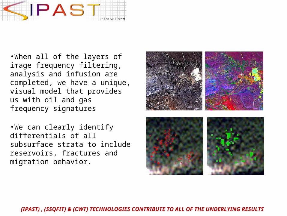
•When all of the layers of image frequency filtering, analysis and infusion are completed, we have a unique, visual model that provides us with oil and gas frequency signatures
•We can clearly identify differentials of all subsurface strata to include reservoirs, fractures and migration behavior.

We hope that the viewer of this presentation can see, as we do, the full power of our natural resources scanning ability and how it represents a multitude of lucrative business opportunities that have never existed before in the oil and gas industry.
It is our goal to attract partners to collaborate and utilize our powerful technology to create a winning solution for all.
Please contact us for more detailed information about collaborative opportunities.
(IPAST) , (SSQFIT) & (CWT) TECHNOLOGIES CONTRIBUTE TO ALL OF THE UNDERLYING RESULTS