south burlington pud strategies: phase i project …d1a8a14e-f9a2-40be-a701-417111f9426b...south...
TRANSCRIPT

South Burlington PUD Strategies:Phase I Project Report
August 2016
Funding for this project provided by the Municipal Planning Grant Program, as administered by the Vermont Department of Housing and Community Development and the City of South Burlington

Intentionally Left Blank

Table of ContentsI. Introduction: A City in Transition 1
Regulatory Framework 2
Call for Balanced Flexibility and Guidance 2
Municipal Planning Grant:” PUD Project” 3
II. Guided Flexibility: Options under the LDRs 4
III. Planned Development By Design 11
Overview: Planned Unit Development in Vermont 11
Planned Unit Development as a Design Tool 14
IV. PUD Typology 16
V. Recommendations 38
Discretionary (DRB) Review: Purpose, Conditions of Review 38
Regulatory Relief: Variances, Waivers 38
Planned Unit Development: Design-Based Regulatory Flexibility 39
City Center FBC District: Regulatory Flexibility under FBCs 40
Master Plans 40
VI. Appendices24 VSA § 4471 Planned Unit Development
PUD Resources
Traditional Neighborhood Development: Initial Considerations

Intentionally Left Blank

June 2016
South Burlington Staff
Cathyann LaRose, AICP City Planner, Project LeadPaul Conner, AICP Director of Planning and ZoningRaymond Belair Administrative OfficerLindsey Britt Development Review PlannerMadeline Brumberg GIS Technician
South Burlington Planning Commission
Jessica Louisos, Chair Tracey Harrington, Vice-ChairBernie Gagnon, ClerkDuncan MacdonaldArt Klugo Sophie Quest Ted Riehle
Project Consultants Front Porch
Community Planning & Design Sharon Murray, AICP
Mark Kane, ASLALiz GradesAll graphics by Liz Grades except where noted.
AcknowledgmentsThis report summarizes research and work completed to date under Phase I of South Burlington’s “PUD/Master Plan Project” to evaluate options for introducing additional flexibility under the city’s development regulations. This work was funded in large part by a 2015 Municipal Planning Grant from the Vermont Department of Housing and Community Development.
Intentionally Left Blank

| 1
I. Introduction: A City in Transition South Burlington, as one of Vermont’s more developed municipalities, is clearly a city in transition. Once a rural farming community, the city experienced a post-war housing boom between 1950 and 1970 that nearly tripled its population, and created new neighborhoods served by local elementary schools. This relatively compact form of single family housing heralded an emerging pattern of suburban development, but one that retained many of the amenities found in nearby urban neighborhoods. This period also marked the start of commercial strip development along the city’s major thoroughfares, including Williston and Shelburne Roads.
A second phase of more conventional suburban development lasting through the 1990s – and in some cases still evident – resulted in a more dispersed, auto-dependent pattern of residential, commercial, office and industrial park development within an expanding urban fringe. Examples include the University Mall, a regional shopping center constructed in 1978, and more recent “leap frog” subdivisions in rural areas of the city.
By 1973, the density of development around Burlington supported scheduled bus service, under the management of the Chittenden County Transit Authority (now Green Mountain Transit). Bus lines have since expanded outward to serve more densely populated areas of South Burlington, including its major commercial and employment centers.
Since 2000 the city has once again seen an increase in its annual rate of growth, accompanied by new forms of higher density development. This includes mid-rise office and apartment buildings – many of which are located on bus routes near commercial centers. The housing market is changing, producing new types of housing for people who want to live near where they work and shop – including millennial generation renters and downsizing baby boomers. Commercial markets are also changing in response to consumer demand, driving the redevelopment of former malls and retail outlets into more attractive, vibrant, community centers – as now proposed for the University Mall and Burlington’s Town Center.
After decades of growth, South Burlington is one of the very few Vermont communities to display a full range (or “transect”) of development forms – from remaining farms and open fields in the southeastern part of the city, edged by more recent suburban development; to increasingly urban forms of higher density, mixed use development around the city’s existing and planned commercial centers.
South Burlington has actively planned since the 1980s to create a vibrant urban core, in an area served by infrastructure and public transit; and also to conserve much of its remaining open land. To date these efforts have included:
▪ Regular updates of the city’s Comprehensive Plan and Land Development Regulations (LDRs)– to reflect changing community objectives, and desired types and densities of development.
▪ State designation of the planned city center as a “new town center” (2010/2016) and two adjoining “neighborhood development areas” (2014/2016), intended to capitalize on state program incentives;

2 |South Burlington PUD Strategies: Phase I Project Report | Draft June 2016
and a state-approved “City Center TIF District” (2012/2015), one of only eleven in the state, to help finance planned public improvements.
▪ A maximum density on overall development within the Southeast Quadrant (SEQ), and a mechanism to transfer density within this area to create a new village center surrounded by conserved open land, including much of the city’s remaining farmland.
▪ Several related inventories and planning studies – including affordable housing, transportation, open space, and sustainable agriculture studies developed under interim zoning, which informed recent plan and bylaw updates.
Regulatory Framework
Underpinning the transformation of South Burlington, as envisioned in its comprehensive plan, are the city’s development codes – embodied in the South Burlington Land Development Regulations (LDRs), its official map, and related ordinances and standards.
South Burlington’s development regulations have evolved over time into a “hybrid” code that includes a variety of conventional zoning districts directing the type and density of development allowed within each; several overlay districts (e.g., scenic, traffic, transit) that address special areas of concern; and, as amended in 2016, a City Center “Form Based Code District” that regulates the form of development within the designated city center.
The new City Center Form Based Code (or FBC) is “transect-based,” defining the form of development by mapped transect zones (T-Zones)
– in this context ranging from “T3” (Neighborhood) to “T5” (Urban) forms of development. The form based code is highly prescriptive; it includes detailed standards for the design of streets, blocks and building envelopes within each zone. This is intentional – to allow for an easy, administrative approval process, and thereby promote development within the city center. Given the anticipated benefits of form-based codes (emphasis on form, clear standards, expedited review) there has also been discussion about enacting a form based code citywide.
Call for Balanced Flexibility and Guidance
Form based codes, as well as more conventional zoning district standards under the LDRs, offer limited regulatory flexibility. They trade the flexibility afforded by more discretionary review processes for standards that can be applied administratively by staff, without a public hearing or the need to seek additional community input in project design.
The LDRs incorporate allowed forms of discretionary review, conducted by the city’s development review board (DRB) – including subdivision, site plan and conditional use review, and variances on appeal - all of which require public notice and hearing. These types of review, however, do not allow for significant deviation from underlying zoning requirements; nor do they generally apply under a form based code. The LDRs also include a potentially more flexible, negotiated review process for larger “planned unit developments” (PUDs) except within the City Center Form Based Code District. City staff have also identified the need for additional guidance and direction under the LDRs for planned unit development and master plans.

| 3
South Burlington’s development community, including those most affected by the form based code, directly participated in its development. During the adoption process and even more recently, however, several local developers have asked for more flexibility under the regulations – at minimum “to work out the tweaks,” and more expansively to allow for larger, master-planned development, both within and outside of the city center. In response, the planning commission agreed to research a “master plan tool” and reserved a space for this under the new regulations. Outside of the city center the Planning Commission has expressed an interest in providing creativity in accordance with clear community objective.
Municipal Planning Grant:” PUD Project”
Anticipating some of these concerns, the city applied for and received a 2015 Municipal Planning Grant from the Vermont Department of Housing and Community Development to research options for guided flexibility under the Land Development Regulations. The grant provided funding to hire project consultants –Front Porch Community Planning & Design and SE Group – to:
Review existing tools under the LDRs, especially those used to address larger projects (e.g., PUDs, master plans); and any related recommendations from recently completed studies and reports.
▪ Evaluate an array of potential approaches for consideration by the planning commission, including types of review authorized by statute.
▪ Prepare an outline of different PUD/master plan types for consideration by the planning commission.
▪ Prepare PUD design criteria for a preferred PUD type, identified by the planning commission, including representative design considerations and graphics.
▪ Present findings and models for public review and comment, to be considered in developing proposed bylaw amendments.
This “PUD Project Report” represents the summary of work completed to date under Phase I (MPG grant) of what is now viewed by the city as a two phase project. Initial findings and recommendations included in this report are those of the project consultants, developed in consultation with the planning commission and city staff. This report and associated recommendations will be presented for public review and comment – and for more deliberative consideration by the planning commission – in advance of Phase II. The next phase includes drafting PUD and master plan bylaw amendments that incorporate feedback received from the planning commission, local developers, and the community at large.
In sum, this report presents:
▪ Findings from our review of the city’s current LDRs, particularly with regard to PUD and master plan requirements (Section II).
▪ An overview of Planned Unit Development as a regulatory design tool – and a form of discretionary review that may offer additional flexibility under the regulations (Section III).
▪ A “PUD Typology” highlighting the use of PUDs as a design tool, within a variety of development contexts found in the city (Section IV), and example design criteria (Appendix).
▪ A preliminary set of options and recommendations for further consideration under Phase II (Section V).

4 |South Burlington PUD Strategies: Phase I Project Report | Draft June 2016
II. Guided Flexibility: Options under the LDRsSouth Burlington has enacted a full complement of bylaws and ordinances that regulate the location, pattern, type, density and form of development in the city. These include:
▪ The South Burlington Land Development Regulations (LDRs), incorporating unified zoning and subdivision regulations and the City Center Form Based Code;
▪ An “official map” that identifies the location of planned public facilities and infrastructure; and
▪ Other related ordinances and codes affecting development – including impact fee and stormwater ordinances, public works standards and fire codes.
For this project, the LDRs were reviewed with regard to the amount of regulatory flexibility they provide, particularly as applied to larger development projects. The consultant team was asked by the city to perform a review and analysis of the tools the community has presently adopted related to flexibility, to identify areas where such tools could be strengthened and provide more guidance, and where different options might exist to use in the context of a planned, or master planned project.
All land use regulations adopted by the city, including the LDRs, are subject to statutory requirements and limitations under the Vermont Planning and Development Act (24 V.S.A., Chapter 117). Planning statutes dictate the types of administrative (staff) and more flexible discretionary (DRB) review that can be applied to proposed
development. Chapter 117 also outlines required review processes and standards for each; but generally allows (or requires) the adoption of locally-defined review standards that are specific to the community – that conform to and implement its comprehensive plan. Options for offering regulatory relief or flexibility – representing deviations from adopted bylaw standards – usually require some form of discretionary review by the DRB that includes public notice and hearing. This affords neighbors and other interested parties the opportunity to participate in the process – and to appeal local decisions to the Environmental Division of Superior Court.
The Vermont Supreme Court has also weighed in on the relevance of having clear, unambiguous standards under local regulations – particularly as applied to discretionary DRB review1 Under the court’s “vagueness doctrine” standards that are too vague or offer too much flexibility – that give a DRB unlimited or “unbridled” discretion in applying them – will be overturned (voided) on appeal, as a violation of constitutional rights under the regulations.
Options under the planning statutes for varying or modifying the regulations, as currently applied under the city’s LDRs, are and summarized in the accompanying table , and presented in more detail on the following pages.
1Most notably In re Appeal of JAM Golf, LLC, 2008 VT 110 , a Vermont Supreme Court opinion that reversed a South Burlington DRB decision, and has had an affect statewide on how bylaw standards are developed, interpreted and applied. In this case, the Supreme Court determined that the city’s zoning “provided no guidance as to what may be fairly expected of landowners …. who wish to develop their property into a PRD.” It then struck part of the bylaw, stating that “Such standardless discretion violates property owners’ due process rights.”

| 5
OPTIONS FOR REGULATORY FLEXIBILITY 4/12/2106
Option Application Statutes [24 V.S.A. Chapter 117] South Burlington LDRs Dimensional Variances §4469
• Nonconformities (hardships)
DRB may grant (technically on appeal) relief for hardship: • Find all statutory criteria – including hardship criteria–are met • Allow only minimum variance that will afford relief–must
represent “least deviation possible” from bylaw, plan
• DRB; incorporated entirely by general reference to 24 V.S.A. Chapter 117 (Section 17.01)
Dimensional Waivers/ Reductions § 4414(8)
• Nonconformities (lots, structures)
• New Development (as specified, e.g., in relation to site/development constraints)
DRB/AO may reduce dimensional requirements, per adopted bylaw standards that conform to the plan. Standards may: • Allow mitigation through design, screening or other remedy • Allow for structures that provide accessibility, fire safety, etc. • Provide for energy conservation, renewable energy structures Review/appeal process must be specified in bylaws (AO, DRB)
• Height waiver–including structures w/in PUD or Master Plan in specified zoning districts, DRB (Section 3.07)
• Scenic View Protection Overlay District, DRB (Section 10.03) • Parking waiver, DRB (Section 13.01) • Site plan field adjustments (minor), administrative (Section 14.05) • Modification of standards, DRB (except in FBC District) (14.07)
Subdivision Modifications § 4418
• Required improvements (roads, infrastructure, etc.)
DRB may waive, modify (subject to conditions), improvements that: • Are not requisite for public safety, health and welfare, or • Are inappropriate due to lack of connecting facilities
• Scenic View Protection Overlay District– subdivisions (Section 10.03) • Roadway standard modifications–PUDs, non-Transect Zone
subdivisions (Section 15); Transect Zone Street Typologies (Section 11) Planned Unit Development § 4417 Modifications as specified, e.g.:
Density Siting Structures Uses Facilities Infrastructure Parking Open Space
• Planned Development • Major Redevelopment _______
Variations on a theme –PUDs may also be referred to or include (based on location, design): • Planned Residential
Development (PRD) • Master Planned Development • Infill Development/
Redevelopment • Clustered/Conservation/Open
Space Development • Traditional Neighborhood
Development (TND) • Transit-Oriented Development
(TOD) • Campus, Industrial, Office Park
Development Bylaws may specify more than one type of PUD…
DRB, per bylaws, may allow flexible design to encourage: • Compact, pedestrian-oriented development/redevelopment; mix
of residential and/or nonresidential uses (downtown, village center, neighborhood)
• Compatible rural development (countryside) • Affordable housing • Efficient use of public facilities, infrastructure • Flexibility in site layout, design, provision of infrastructure,
parking– to conform w/plan , integrate w/site, surroundings • Conservation of open space, resources • Energy efficient development/redevelopment, May apply (optional v. mandatory) as specified to: • Single or multiple properties • Parcels of minimum size; minimum # of units • Specified zoning districts • Projects of a specified type or scale Bylaws must include: • Purpose statement • Review process (conditional use and/or subdivision review) • Application requirements • Review standards –for varying intensity, density, use etc.
[Note: LDRs provide for “unified” subdivision, PUD process, and related master plan provisions under Article 15]
PUD Purpose: Provide relief from strict dimensional standards to encourage innovation in design and layout; efficient use of land; viability of infill development/redevelopment in City’s Core Area, as defined in plan Applicability: • Subdivision – PUDs require major subdivision review • Master plan–master plan review in conjunction w/PUD; binding sub-
part of PUD approval. • PUDs are allowed in all districts, except the City Center FBC District • PUDs are required (mandated) in: o R12, AIR-I, I-O Districts; o I-A , C1 and PR Districts for specified uses (e.g., educational facilities) o SEQ District (except for 1 and 2-family dwellings on existing lots) o All applications involving a total area of land of 10+acres
Modifications: • Modification of LDRs by DRB is permitted subject to conditions,
standards under Article 15, related criteria under Section 15.18 (and under relevant zoning districts)
• Statement of requested waivers and other relief required for PUD applications (Section 15.04)

6 |South Burlington PUD Strategies: Phase I Project Report | Draft June 2016
Administrative review by staff requires literal interpretation and application of the regulations (§ 4448). The ability of staff to provide administrative relief is statutorily limited. In this context flexibility must be provided in the regulations themselves – typically through quantitative, numeric standards defined as minimums or maximums that allow for some variation as applied on the ground. As noted earlier, the benefits of prescriptive standards – for use by both the developer in designing a project, and by staff in its review – is a relatively quick and easy review process; though zoning permits and other administrative decisions can be appealed to the DRB.
South Burlington’s LDRs provide some flexibility under current zoning district standards, including the City Center Form Based Code, by defining minimums, maximums, or a range of acceptable options for the siting and design of particular project. The LDRs also allow for administrative approval of “field changes” representing minor adjustments to DRB-approved site or subdivision plans during construction that are necessary for technical or engineering reasons. In keeping with statute, however, DRB review is required for anything beyond prescribed limits – including any variation from adopted standards, or any type of development that warrants more discretionary review (e.g., subdivision, site plan or conditional use review) – including most larger development projects.
Variances issued by the DRB (§ 4469) are intended to provide relief in the event that dimensional requirements (e.g., setbacks) present a hardship for an applicant that is not of the applicant’s making. This normally involves improvements to structures or lots that predate zoning and therefore can’t be developed in strict conformance with the regulations (nonconformities). Variance provisions, as required under
local bylaws, have existed in statute since first enacted, to provide relief from uniform zoning as applied to existing, not so uniform, development.
Statutory variance requirements are incorporated in the LDRs by reference (Section 17.01), but are rarely invoked. In order to issue a variance, the DRB must find that all criteria – including hardship criteria – have been met; and the variance, if granted, represents “the least deviation possible” from zoning requirements. Meeting variance criteria is supposed to be difficult, to ensure that the regulations are not undermined. If too many variances have been granted under the regulations, the regulations may not be a good fit, if the intent is to maintain or extend the existing pattern of development. If the intent is instead to alter the existing pattern” then nonconformities should be phased out over time.
Dimensional waivers, rather than variances, may also be issued by a DRB, as specified under the regulations. Sometimes referred to as the “common sense clause,” this provision in statute (§ 4414) was added later, in recognition that some modifications to required dimensional standards may be reasonable, even if variance criteria cannot be met. This allows a DRB to reduce dimensional requirements under standards and procedures specified in the regulations, rather than in statute. Waiver provisions can be used, for example, to reduce the impacts of development through siting, to accommodate accessibility improvements, or to or to allow ground-mounted solar panels within required setback areas. Given that waivers may more generally apply and are easier to justify, they have in many cases supplanted or replaced variances as the primary way to afford limited regulatory relief under the regulations, especially for smaller projects.

| 7
South Burlington’s LDRs include the following waiver provision under Section 14.07 (Specific Review Standards), applied by the DRB in association with site plan or conditional use review – as normally required for larger projects. This waiver provision as stated, however, does not apply to development within the City Center Form Based Code District:
E. Modification of Standards. Except within the City Center Form Based Code District, where the limitations of a site may cause unusual hardship in complying with any of the standards above and waiver therefrom will not endanger the public health, safety or welfare, the Development Review Board may modify such standards as long as the general objectives of Article 14 [Site Plan and Conditional Use Review] the City’s Comprehensive Plan are met. However, in no case shall the DRB permit the location of a new structure less than five (5) feet from any property boundary and in no case shall be the DRB allow land development creating a total site coverage exceeding the allowable limit for the applicable zoning district in the case of new development, or increasing the coverage on sites where the pre-existing condition exceeds the applicable limit.
Waiver provisions in other sections of the LDRs also provide a degree of flexibility, as applicable to a particular project, subject to DRB review and approval – e.g., with regard to application requirements, district height limitations, parking requirements, buffer requirements and scenic overlay district standards. City staff reported that a large proportion of projects seek some form of waiver through PUD or other processes.
Subdivision Review (§ 4418) is required under the LDRs for any project that involves the subdivision of land – that alters or maintains the overall pattern of development. The planning statutes allow the DRB, under subdivision review, to broadly “waive or modify, subject to appropriate conditions, the provisions of any or all improvements and
requirements” – if the board finds that required improvements either are not needed, in the interest of public health and safety, or are not appropriate, given the lack of connecting facilities near the subdivision. Such waivers typically apply to required infrastructure improvements. Under the LDRs, they appear to be referenced only with regard to required road standards. Other waiver provisions under the LDRs however, may apply to projects that require site plan or conditional use review in addition to subdivision review.
Planned Unit Development (PUD) provisions under the Planning and Development Act (§ 4417), as amended in 2003 (and discussed in more detail later in this report), potentially offer a much greater degree of regulatory flexibility for larger, master-planned development. The statutory intent of planned unit development bylaws is to provide the flexibility needed to promote (or require) integrated, well-designed development that meets community goals and objectives. PUD standards may even supersede underlying zoning, as specified in the regulations:
Planned unit development bylaws may provide for… the authorization of uses, densities and intensities that do not correspond with or not otherwise expressly permitted by the bylaws for the area in which a planned unit development is located, provided that the municipal plan contains a policy that encourages mixed use development, development at higher overall development intensities, or both [§4417(d)].
The stated purpose of planned unit development under the city’s LDRs is more limiting, to:
…provide for relief from the strict dimensional standards for individual lots in these Regulations in order to encourage innovation in design and layout, efficient use of land, and the viability of infill development and redevelopment in the City’s Core Area, as defined in the Comprehensive Plan (15.01 Purpose).

8 |South Burlington PUD Strategies: Phase I Project Report | Draft June 2016
South Burlington LDRs: PUD ProvisionsDefinition. One or more parcels of land to be developed as a single entity, the plan for which may propose any authorized combination of density or intensity transfers or increases, as well as the mixing of land uses. This plan, as authorized, may deviate from bylaw requirements that are otherwise applicable to the area in which it is located with respect to the area, density or dimensional requirements or allowable number of structures and uses per lot as established in any one or more districts created under the provisions of these regulations. The specific requirements of a PUD and the area, density and dimensional provisions that may be modified are defined in each district in which PUDs are allowed.
Purpose. To provide relief from the strict dimensional standards for individual lots, to encourage innovation in design and layout, the efficient use of land, and the viability of infill development and redevelopment in the City’s Core area.
Application. ▪ Required if involved land is 10 or more acres; prohibited on < 2 acres in
specified districts. ▪ Allowed in R1 and R2 (>5 acres), R1-PRD (R12), R1-Lakeshore, R1-Lakeview ▪ Encouraged in C1 District. ▪ Required in R12 District, Airport District, Industrial-Open Space District,
Institutional-Ag District (educational facilities), Park and Rec District (specified uses) and SEQ District (except for single- and two-family)
▪ Prohibited within the City Center Form-Based Code District.
Uses. As specified for the underlying zoning district.
Density. Overall density (units/acre, floor area ratio) as specified for the underlying zoning district(s), though density may be transferred within the project area (in relation to district boundaries). Density bonuses are considered only for affordable housing development.
Design. As specified for the underlying zoning district (e.g., the SEQ).
Under the LDRs, PUD review is required in certain zoning districts, and for any development on 10 or more acres – except within the City Center Form Based Code District, in which planned unit development is expressly prohibited.
PUD provisions under the LDRs cite, and largely reflect, earlier (pre-2003) statutes. They essentially are used to modify or waive underlying district requirements – most often to modify subdivision or site layout and development density in relation to physical site constraints. Zoning district and subdivision standards generally apply to all PUDs, except as modified or waived by the DRB. The density of development, determined based on the underlying zoning, may be transferred within a project area (in relation to district boundaries), but density increases (bonuses) may be considered only for affordable housing development.
No particular types of PUD, or associated design standards, are defined in the regulations. The few PUD design standards found in the LDRs are also specified by zoning district – most notably for planned development within the Southeast Quadrant. The broader regulatory and design flexibility afforded planned unit development in statute – for projects designed to meet community goals and objectives – is not evident under the LDRs. There is little guidance regarding the desired form of planned development – e.g., for connectivity, walkable neighborhoods, public amenities, or the conservation of functional open space – as envisioned in the comprehensive plan. Planned unit development as defined in the LDRs, however, could be more broadly applied as a design tool – to allow innovative project designs that conform to the comprehensive plan, that may not otherwise be allowed under the zoning regulations.

| 9
Plan and Bylaw AmendmentsUltimately, there is also the opportunity to request or petition for a change the regulations to accommodate proposed development, through plan and bylaw amendments. This more involved legislative process, also prescribed in statute, requires review and public hearings by the planning commission and city council prior to council adoption. In order to avoid “spot zoning” – and to make sure that proposed bylaw amendments conform to the comprehensive plan – it’s often necessary to also amend the plan concurrently with the bylaws, especially for any proposed zoning district (map) amendments.
Williston’s “Specific Plan” ProvisionIn recent discussions with local developers around introducing more regulatory flexibility under the LDRs, it was suggested that the city take a look at Williston’s regulations for “Specific Plans”– adopted in 2009 to replace their existing PUD/PRD bylaws.
The purpose of this option is to “encourage and permit the creative redesign and redevelopment of commercial areas.” It may also be applied in other areas to realize the objectives of the town plan – but only when the planning commission determines that there will be a substantial benefit to the town (e.g., dedicated open space, housing, infrastructure, town center development, jobs, transit).
A “specific plan” is a set of proposed amendments to both the town’s comprehensive plan and its bylaws, prepared by one or more landowners working with the planning commission and public (through an appointed advisory committee), at the landowner’s expense. It may include the submission of a master plan, as also submitted to the District Environmental Commission for Act 250 review. As described, a specific plan provides detailed performance standards for the area to be developed. It can also result in the creation of new zoning districts. The plan is adopted using the same process required for all plan and bylaw amendments, but also includes an initial community meeting.
Master plans, though not specifically required for planned unit development under Chapter 117, provide the framework for “master planned” communities as envisioned for planned unit development – especially for larger, more complicated projects constructed in phases. Under the LDRs, a master plan is defined as: “A plan intended to guide the arrangement of developed and undeveloped areas and streets within a land development project.” Typically a master plan lays out required rights-of-way and infrastructure improvements needed to support the type and density of proposed development (e.g., streets, water, sewer, stomwater) in connection with the surrounding area and identified site constraints. It also provides a more general indication of the types and densities of development planned for each phase of development, and at full buildout. Master plans may be reviewed and approved separately by the DRB, or in association with preliminary site plan or subdivision review (Section 15.07). Currently, master plans are required only for development in the Southeast Quadrant involving more than 10 units, and for development in the R-1 Lakeshore District involving more than 10 units over a five-year period. An applicant has the option to submit a master plan as part of the review process for a subdivision or planned unit development involving 10 or more contiguous acres. It appears that the primary function of a master plan is to define and coordinate the level of DRB review required for subsequent phases of a development. It has also been used by the DRB to establish basic thresholds/parameters on traffic, open space, and density. There are no standards specific to master plans under the LDRs, apart from submission requirements. City staff have indicated that waivers have been issued with master plan approval. Master plans do not in themselves offer regulatory flexibility, but once approved define rights under the regulations for subsequent phases of development.

10 |South Burlington PUD Strategies: Phase I Project Report | Draft June 2016
Regulatory Flexibility under Form Based Codes
The earliest form based codes evolved out of the PUD process, as the only zoning tool available that offered the flexibility needed for innovative design. More prescriptive models were developed as a reaction to the uncertainties of planned unit development – as a way to achieve the same ends (well-designed, pedestrian-friendly, mixed use neighborhoods) – through clear standards that could be applied administratively, to avoid the pitfalls of more discretionary review. As a result, form based codes are often more rigid in their requirements than the conventional zoning they replace. They may afford some regulatory relief – especially for existing nonconformities through standard variance or waiver provisions– but generally preclude more deliberative review processes.
Form based codes regulate the “form” of development in relation to the “public realm”– including the layout of streets, blocks, lots, buildings and civic space, and associated building envelopes. Most codes, including the City Center Form Based Code, incorporate design flexibility by offering a schedule (or typology) of design options for each that can be applied within a particular transect zone, to meet the underlying standards. For example, the LDRs were amended in association with the City Center Form Based Code (under Article 8) to also reference new “Transect Zone Street Typologies” (under Article 11), and open space types (in the appendices) – each providing a menu of design options for required improvements. 2
2It was also noted in our review that, in addition to new street typologies, the LDRs as amended over time also include separate street design standards under the subdivision regulations (Article 15) and for development within the Southeast Quadrant (Article 9). These could be consolidated under one set of street standards that would vary in their application depending on the context.
Form based codes typically include few specific use standards – assuming function will be defined by form (or available space) – and therefore also offer more flexibility than conventional zoning with regard to types of uses that may be allowed.
The adopted “regulating plan” under a form-based code functions as both the zoning map and master plan for development within a particular transect zone. In the absence of a detailed regulating plan, a master plan that incorporates required infrastructure (e.g., street grids, pedestrian connections) may be required, but generally cannot deviate from underlying transect zone standards with regard to street types, block lengths, building placement, etc.
Often the only way to substantially modify the requirements of a form-based code as applied to a particular development – including the regulating or master plan – is through the bylaw amendment process. There are however, some emerging model form based codes that define “community types”– resembling forms of planned unit development – that are designed to accommodate infill or retrofit projects (e.g., mall redevelopment). Given that the city’s current form based code was carefully calibrated to meet community goals the use of such models would have to be carefully considered
Proposed redevelopment of the University Mall, currently in the design phase, will be governed by the city’s recently enacted City Center Form Based Code. One expressed concern is how the code – conceived to apply mainly to greenfield development within the planned City Center – will apply to this type of greyfield development that includes infill and retrofits of previously developed property. Project consultants have been asked to explore this further in discussions with affected property owners.

| 11
III. Planned Development By Design Overview: Planned Unit Development in Vermont
Municipalities are authorized under the Vermont Planning and Development Act (24 V.S.A. Chapter 117) to adopt conventional zoning and subdivision regulations – including zoning districts in which “all provisions shall be uniform for each class of uses or structures within each district” (§ 4411); as well as more innovative regulatory tools, including various forms of planned unit development. As noted, the LDRs include both.
The planning statutes as enacted in 1967 addressed only planned residential developments (PRDs). For a PRD, the planning commission (and later, development review board) was allowed to modify zoning regulations simultaneously with the approval of a subdivision plan – to promote the most appropriate use of land, to facilitate the economical provision of facilities and services, and to preserve the natural and scenic qualities of open space. This section also allowed for density bonuses up to 50%, specifically for affordable housing development.
Planned unit development provisions – to more generally encourage new communities, innovation in design, and efficient use of land – were added in 1981; but again allowed only the modification of zoning regulations simultaneously with the approval of a subdivision plat. The PUD section also authorized the adoption of separate rules or regulations to supplement PUD zoning standards. Uses allowed within a PUD (by statute) included any type of dwelling, any nonresidential use,
Planned Unit DevelopmentForm of Development Form of Review
▪ Planned (master plan) ▪ Varied types and densities of development, defined by purpose, context
▪ Integrated project design – including mix of uses, amenities, open space
▪ Designed to meet community objectives (conform to municipal plan)
▪ Defined in regulations ▪ Integrates zoning and
subdivision regulations ▪ May incorporate, modify or
supersede underlying zoning district regulations
▪ Flexible, to achieve a negotiated outcome (within specified limits, standards)
▪ Allows for community input in project design and review
public and private educational facilities, and industrial uses and buildings. Density could be transferred within a project area (to allow clustering and the set aside of open space); density bonuses, however were allowed only for affordable housing (again up to 50%).
Many PUD provisions in local bylaws – including South Burlington’s regulations – date from this period. Not surprisingly, given the scale and pace of development in Vermont, most PUDs to date have been variations of planned residential development. A few communities have also defined and regulated other forms of planned development – for example industrial parks – under the broader authority granted for planned unit development.
Vermont’s PUD statutes were overhauled in 2003, in response to new and emerging forms of planned development, as part of a larger package of regulatory reforms. As a result, PUD bylaws may now incorporate flexible design standards to encourage (or require):

12 |South Burlington PUD Strategies: Phase I Project Report | Draft June 2016
Planned Unit Development in Concept: A Brief HistoryMost zoning regulations in Vermont, and from around the country, are based on enabling legislation modeled after the “Standard State Zoning Enabling Act” issued by the U.S. Department of Commerce in 1924. At the time, zoning was touted as the answer to a variety of urban ills, including overcrowding, poor housing conditions and urban blight. These conditions could be alleviated by segregating incompatible uses – by separating residential from commercial and industrial zones – and by imposing a more orderly and efficient pattern of development.
This common form of regulation, often referred to as conventional or “Euclidean” zoning, resulted in the creation of single-use zoning districts characterized by uniform lot sizes and densities of development. As applied to post-WWII development, and adapted to accommodate (and promote) our growing reliance on the automobile, conventional zoning also established the basis for suburban sprawl, characterized by large tracts of monotonous, cookie-cutter housing (the Levitttowns of a previous era), industrial parks on the edge of town, and commercial strips along major highways. Under conventional zoning, dimensional standards dictate design – with little consideration for site conditions, project design, public amenities, open space or the preservation of community character.
Planned Unit Development (PUD) – which represents both a regulatory tool and a form of negotiated review – evolved out of the “New Town Movement” that began in Britain and was imported to the US in the 1950s and 60s, in response to prevailing patterns of suburban development. The intent was to define a process, and a set of design standards ( or “custom zoning”) that allowed for master-planned communities – for the creation of new towns that resembled more traditional towns and villages, with residential neighborhoods served by community centers. One of the most well-known planned communities from this era is Reston, Virginia, founded in 1964.
The PUD concept was first codified in model enabling language published by the Urban Land Institute in 1965. This was adapted for inclusion in Vermont’s Planning and Development Act, as enacted in 1967. The stated purpose of model legislation was to:
Integrate subdivision (platting, design) and zoning (use, bulk) regulations, for review by one agency or board.
Allow a local review board to operate in a more ad hoc, discretionary manner, subject to standards and strict accountability.
Incorporate standards for common open space in project design, and for its ongoing maintenance and management..
The intent was not to supplant conventional zoning, as applied to areas that had already been developed; but rather to authorize new techniques of land development deemed appropriate by the municipality. Early planned unit developments were primarily residential (planned resident developments), but the concept has evolved over time, as in Vermont, to allow a variety of planned development. Resources listed in the appendix provide more information about the evolution of PUDs in concept and application.
Leavittown, PA: Source: Vanderbuilt Museum

| 13
Source: VT DHCD, Plan Implementation Manual (2007)
▪ Compact, pedestrian-oriented, mixed use development and redevelopment in urban areas, including downtowns, village centers new town centers, and associated neighborhoods;
▪ Preservation of large tracts of productive farm and forest land, and compatible forms of development that retain rural character;
▪ Conservation of natural and scenic resources, outdoor recreation area and other open spaces identified in the municipal plan;
▪ Energy efficient forms of development and redevelopment (e.g., solar-oriented subdivisions or solar ready design), and
▪ Development that achieves other plan objectives, including but no longer limited to the creation of affordable housing.
The statutes no longer differentiate between planned residential and other forms of planned development. A variety of PUD types are now authorized, as defined under local bylaws in conformance with the municipal plan. As noted, these may also include planned development that supersedes underlying zoning – incorporating uses, densities or intensities of development that do not correspond with, or are not otherwise permitted for the area or district in which the development is proposed. As constituted, PUD bylaws can function as “floating zones” to be applied to individual parcels as they come up for development based on location, zoning district designation, or the type and magnitude of the proposed development (e.g., acreage, number of units).
More recent PUD provisions are broadly enabling – and may apply to single or multiple, contiguous or noncontiguous properties. There also are no longer any statutory limits or restrictions on the incentives that may be offered for preferred types of development. In addition to
affordable housing, incentives could also be considered, for example, in return for dedicated open space, public amenities, shared parking and transit facilities, solar ready subdivisions, and development that incorporates universal design for aging in place.

14 |South Burlington PUD Strategies: Phase I Project Report | Draft June 2016
The new statutes also come with an expanded list of requirements. PUD bylaws must now include:
▪ A statement of purpose, in conformance with the municipal plan, including relevant design objectives.
▪ The review process to be used – which may include conditional use review, subdivision review, or both, as specified in the bylaws.
▪ Specifications for applications and plan drawings (e.g., master plan, site plan or subdivision plan requirements) specific to PUDs.
▪ Standards for the review of PUDs.
▪ Standards for required public and nonpublic improvements, including the payment of impact fees where applicable.
▪ Provisions for the phasing of development, in accordance with the municipal plan and any adopted capital improvement program.
▪ Provisions for coordinating PUD review with other required review processes, including subdivision and/or conditional use review (e.g., through sequenced or concurrent review).
PUD bylaws may also authorize or include:
▪ Uses, densities and intensities of development that do not correspond with or are not otherwise expressly permitted by the bylaws for the area in which the PUD is located.
▪ Standards for the reservation or dedication of common land or other open space – including the dedication and acceptance of land for public use.
▪ The establishment of an organization or trust for the maintenance of open space or other facilities that are held in common.
The development review board may continue to prescribe rules and regulations that supplement, and are consistent with the bylaws – but ultimately must also find, prior to any approval, that a proposed PUD conforms to the municipal plan.
New forms of planned unit development have yet to be widely adopted or applied in Vermont, in part due to the slow pace of development statewide. Vermont, until very recently, has had little experience with larger, mixed-use development projects that are often more challenging to design, finance and build. Timing and economics, including prevailing market conditions, are critical considerations in PUD design and phasing.
Planned unit development is also often established (or perceived) as a more complex and onerous review process, in which any benefits to a developer – including density bonuses – are not sufficient to offset increased application and development costs, and project delays (including court appeals) that may also affect the overall cost of development. Developers can, however, benefit from the flexibility offered by PUD review, including vested rights conveyed with approved master plans, cost sharing to help finance proposed improvements (e.g., through local partnerships and development agreements), and allowing phased development to be adjusted or amended under each phase, to respond to changing market conditions, while still meeting community goals and objectives.
Planned Unit Development as a Design ToolUnder current PUD statutes it is clearly possible to identify a variety of PUD “types” (or typologies) for incorporation under local regulations, largely in relation to their stated purpose or intent. Two key

| 15
Rural Conservation PUD Planned Agricultural Development Suburban Planned Residential Development Campus/Park Development Urban Traditional Neighborhood Development
Neighborhood Center Development Transit Oriented Development
Transitional Infill Development Retrofit/Redevelopment
considerations in applying planned unit development as a design tool are the development context – where and how a particular type of PUD type should apply – and the design context – what design standards will be needed to achieve the desired type and pattern of development, in conformance with the comprehensive plan.
The purpose of a PUD is defined largely in relation to its development context. For rural PUDs the focus is generally on conserving rural resources, including large, contiguous tracts of undeveloped farm or forest land, while allowing for compatible forms of low density residential and agricultural development. In suburban areas the focus may be on providing incentives – for affordable housing, the dedication of public amenities, or more energy efficient design. In urban areas the focus is typically on “walkability” – accommodating higher density, pedestrian-friendly mixed use development within a “pedestrian shed” defined by a ¼- to ½-mile radius (an easy walking distance) centered on a proposed development “node” (e.g., a green, intersection or transit stop). In transition areas that are undergoing infill or redevelopment, the focus is on appropriate ways to introduce new forms of development within areas (e.g., former parking lots or “greyfields”) that are underdeveloped, or no longer economically viable.
PUD provisions, while intended to provide a significant amount of regulatory flexibility in return for community benefits – must also incorporate clear design standards and guidance for application under the regulations. This often takes the form of design standards in the regulations, supplemented by related guidance (e.g., PUD handbooks or guides) that can be used to interpret and apply the standards.
Research under the planning grant included a review and classification
of PUD types found in Vermont and elsewhere that could be adapted for local use. Identified types were initially categorized in relation to their general development context – each potentially applicable within areas of South Burlington, given the city’s broad range and pattern of development:
Development Types:
Listed PUD types, described in more detail in the following section, were presented for discussion and initial screening by the planning commission with regard to their potential use in South Burlington. The planning commission was also asked to identify a specific type – selecting “Traditional Neighborhood Development” – for use in researching related design considerations in more detail.
These are highlighted in the appendices to this report.

16 |South Burlington PUD Strategies: Phase I Project Report | Draft June 2016
IV. PUD TypologyPUDs come in a variety of forms reflecting rural, suburban and urban contexts. Given South Burlington’s diversity of development patterns, a full range of PUD types is presented on the following pages for further consideration. Graphic representations of each PUD type outline and depict the general purpose and design considerations associated with each.Important considerations depicted in this array of PUD forms include connectivity –how they relate and respond to the surrounding context (shaded background); the function of incorporated open space; how density and a mix of uses (residential and commercial) are addressed; how existing transportation and transit systems are integrated in project design; and what form of development they represent.For each typology the graphics and supporting notes illustrate these key points. Of particular note – with increasing urban density, open space generally becomes less focused on land or open space conservation in favor of more active public/private spaces that support quality of life. Similarly, parking trends from individual onsite parking to serve use-based needs, to the incorporation of more shared and structured parking, focusing design instead on creating a more walkable, pedestrian-friendly environment.The influence of transit in more urban PUD types should not be understated. As development become more intensive and urban, the role that good transit solutions play in supporting these densities and reducing the burden of surface parking is vital. Graphics depict in concept an evolving parking strategy, with the inclusion of structured parking in denser, urban PUD forms, especially in areas severed by public transit.All of these conceptual graphics are based on a 30-acre parcel (shown
on pg. 17). For each type the featured design incorporates or modifies various existing conditions: farm fields, neighborhoods, urban streets. These concepts are not indicative of any specific location in the city, but are meant as models to demonstrate key principles for each PUD form.Within this conceptual 30-acre parcel, base conditions include access to a major roadway, a large mapped wetland complex, a stream or brook that bisects the parcel and an existing regional trail. Each type of PUD addresses these underlying conditions in relation to its purpose –based on the form of development it is intended to promote. Representative “rural” PUDs reflect an emphasis on conserving most of the parcel as open space. As these evolve into more developed forms, the development envelope is broadened to incorporate increasingly urban patterns of higher density, mixed use development.The last two graphics are slightly different. The “Infill” and “Reuse” forms of planned unit development can incorporate variations of other PUD forms that complement existing development. For example, a vacant (or undeveloped) part of an existing residential neighborhood might be “infilled” with new cottage housing that also incorporates a neighborhood park. Similarly, a large, underused commercial property might be redeveloped at a higher density through adaptive reuse and the addition of gridded, residential streets, to improve access and the mix of uses.For each graphic a key is provided highlighting important elements. A sliding scale is also provided for each indicating the level of density expected (low to high) and the mix of uses (residential to commercial, or mix).The final graphic summarizes each of these forms as a reference.
DensityLow High
Use Mix: Residential Mixed Commercial
Expected Range

| 17
Legend1
1
4 7 10
10
7
4
3
3
6 9
96
2
2
5 8
8
5
Wetland Forested Area Local Road Walkability Radius
Regional Trail Major Road Parcel BoundaryStream Trees Existing Building
PUD Type: Existing Conditions Original Graphic: Liz Grades
18 |South Burlington PUD Strategies: Phase I Project Report | Draft June 2016
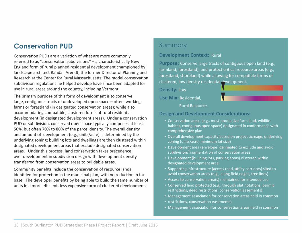
SummaryDevelopment Context: Rural Purpose: Conserve large tracts of contiguous open land (e.g., farmland, forestland), and protect critical resource areas (e.g., forestland, shoreland) while allowing for compatible forms of clustered, low density residential development.
Density: Low
Use Mix: Residential,
Rural Resource
Design and Development Considerations: ▪ Conservation areas (e.g., most productive farm land, wildlife
habitat, contiguous open space) designated in conformance with comprehensive plan
▪ Overall development capacity based on project acreage, underlying zoning (units/acre, minimum lot size)
▪ Development area (envelope) delineated to exclude and avoid subdivision/fragmentation of conservation areas
▪ Development (building lots, parking areas) clustered within designated development area
▪ Supporting infrastructure (access road, utility corridors) sited to avoid conservation areas (e.g., along field edges, tree lines)
▪ Access to conservation area(s) maintained for intended use ▪ Conserved land protected (e.g., through plat notations, permit
restrictions, deed restrictions, conservation easements) ▪ Management association for conservation areas held in common ▪ restrictions, conservation easements) ▪ Management association for conservation areas held in common
Conservation PUD Conservation PUDs are a variation of what are more commonly referred to as “conservation subdivisions” – a characteristically New England form of rural planned residential development championed by landscape architect Randall Arendt, the former Director of Planning and Research at the Center for Rural Massachusetts. The model conservation subdivision regulations he helped develop have since been adapted for use in rural areas around the country, including Vermont.The primary purpose of this form of development is to conserve large, contiguous tracts of undeveloped open space – often working farms or forestland (in designated conservation areas); while also accommodating compatible, clustered forms of rural residential development (in designated development areas). Under a conservation PUD or subdivision, conserved open space typically comprises at least 50%, but often 70% to 80% of the parcel density. The overall density and amount of development (e.g., units/acre) is determined by the underlying zoning; building lots and dwellings are then clustered within designated development areas that exclude designated conservation areas. Under this process, land conservation takes precedence over development in subdivision design with development density transferred from conservation areas to buildable areas. Community benefits include the conservation of resource lands identified for protection in the municipal plan, with no reduction in tax base. The developer benefits by being able to build the same number of units in a more efficient, less expensive form of clustered development.

| 19
Legend1
1
4
4
4
7
7
3
3
6
6
6
2
2
5
5
8
8
Existing Farm Buildings Trail/Connectivity Market Garden
Community Garden Existing AgricultureResidential Development Solar Array Development Envelope
Type: Conservation PUD | Rural Original Graphic: Liz Grades

20 |South Burlington PUD Strategies: Phase I Project Report | Draft June 2016
SummaryDevelopment Context: Rural (On-Farm), Greenfield, Infill
Purpose: Allow a variety of on-farm rural enterprises that support viable farming operations –including value added production and agricultural tourism – while also conserving farm land, minimizing associated impacts, and maintaining rural character.
Density: Low
Use Mix: Rural Resource CommercialDesign and Development Considerations:
▪ Located on regularly maintained public highway ▪ Designed to minimize and limit the area to be developed, within a
designated development area (envelope) ▪ Development area sited to avoid productive farmland; near existing
farm complex ▪ Buildings, public facilities, improved parking areas confined,
clustered within designated development area ▪ Shared highway access (farm, public); functional access to farm
fields maintained ▪ Designated overflow/event parking areas (e.g., adjacent field) ▪ Incorporates vernacular, rural architectural building design, layout,
scale, materials ▪ Maintains rural character – site layout, site elements, building
setbacks, landscaping, screening, etc. ▪ Thresholds established (e.g., lot coverage, parking, vehicle trips,
number of events, noise, etc.) to minimize impacts to community facilities, adjoining properties
Planned Agricultural DevelopmentPlanned agricultural development – an emerging form in Vermont – reflects a regulatory response to the evolution of western vineyards as both production wineries and major tourist destinations. In this context, strict rural or agricultural zoning did not anticipate the type and magnitude of on-farm facilities, uses and activities that developed in support of viable vineyard and winery operations – including industrial-scale storage, processing and packaging facilities, retail outlets, and public facilities for hosting and housing guests, group tours, events, tastings and farm-to-table dining. Planned agricultural development is intended to allow – and to address the associated impacts – of new forms of agricultural development. Such regulations may require the designation of a development envelop that excludes productive farmland, and defines and sets limits on the area to be developed: to regulate access; to cluster associated buildings, facilities, and improved parking areas; to require compatible building layout, designs and materials that maintain rural character; and to set thresholds on the overall density of development, lot coverage, traffic generation rates, etc. This type of PUD is not yet found in Vermont, in part due to state rules that allow a certain amount of on-farm production and sales by right, as exempt from local regulation. These rules, however, do not cover expanded forms of on-farm activity associated with agritourism and Vermont’s emerging winery, brewery and cidery industry. Planned agricultural development offers a mechanism to modify zoning (where appropriate) to allow for this

| 21
Legend1
1
4
4
4
4
7
7
9
3
3
6
6
2
22
2
5
5
89
8
Existing Farm Buildings Parking Agriculture/Vineyard/Orchard
Development Envelope Solar ArrayNew Development Overflow/Event Parking Existing Agriculture
Trail/Connectivity
Type: Planned Agricultural Development PUD | Rural Original Graphic: Liz Grades

22 |South Burlington PUD Strategies: Phase I Project Report | Draft June 2016
SummaryDevelopment Context: Suburban, Urban Fringe, Infill
Purpose: Promote desired forms of residential development that address comprehensive plan goals, objectives; and to offer incentives (density bonuses, waivers) in return for preferred types of development, the conservation of resources or public amenities.
Density: Moderate
Use Mix: Residential, Civic
Design and Development Considerations: ▪ Located adjacent to regularly maintained public highway; may
incorporate one or more access points ▪ Connects to adjoining road, trail networks (may be limited
depending on location) ▪ Promotes walkability with the PUD (interconnected sidewalk, path
network) ▪ Incorporates a mix of housing types in response to local market
conditions and identified community needs ▪ Incorporates shared functional open space (neighborhood park,
playground, ball field, community garden) ▪ May incorporate shared community facilities (community building,
recreation facility) ▪ Incentives offered for public benefits, amenities identified in plan
(e.g., affordable housing, public park, neighborhood solar)
Planned Residential Development Planned Residential Development (PRD) was the first form of planned development authorized in Vermont, and is consequently the most common type of PUD allowed under local bylaws.PRD provisions are intended to modify (or waive) underlying zoning district dimensional standards to promote more creative residential subdivision design – to promote walkability, provide open space, and allow a mix of lot sizes, densities and housing types. In practice, PUD provisions are often used simply to maximize a site’s development capacity in relation to physical constraints – to waive underlying zoning requirements or transfer density without the benefit of good design or additional amenities. Good design standards are critical to realize intended benefits. One of the principal benefits of PRDs is the ability to grant density bonuses in return for preferred types of residential development – including affordable housing and public amenities. Bonuses in this context should at minimum be sufficient to offset associated costs to the developer. Vermont communities increasingly are using PRD regulations and incentives as intended, to promote (or require) preferred forms of residential development – including, energy efficient, solar ready, food-friendly, mixed income neighborhoods with local parks, paths and other shared amenities.

| 23
Legend1
1
4
44
3
3
3
3
3
6
6
6
2
2
5
5
5
Community Garden Duplex/Multi Family
Trail/Connectivity Open Space/Linear ParkCommunity Solar Single Family
Type: Planned Residential Development PUD| Suburban Original Graphic: Liz Grades

24 |South Burlington PUD Strategies: Phase I Project Report | Draft June 2016
SummaryDevelopment Context: Suburban, Urban Fringe
Purpose: Promote an integrated, pedestrian-friendly campus-form of institutional, office or industrial park development that incorporates common, unifying design elements, shared facilities and open space, and an interconnected path network.
Density: Moderate
Use Mix: Commercial, Civic InstitutionalDesign and Development Considerations:
▪ Located adjacent to regularly maintained public highway ▪ Maintains or establishes connectivity with existing, planned
transportation, regional trail, and transit networks – for public and employee access
▪ Principal buildings arranged around a central quad, green or other dominant feature; clustered to take advantage of shared parking, access and service (loading) areas
▪ Walkable – all buildings, parking areas, common areas connected by walkways, integrated path network
▪ Unifying design elements may include architectural styles, building materials, colors, signage, outdoor lighting
▪ May incorporate institutional, employee housing ▪ Incorporates shared support facilities, services (utilities,
maintenance, day care, dining, recreation facilities) ▪ Landscaped open space incorporates natural site features, green
infrastructure as amenities; enhances the design orientation of the campus, and may also serve larger, surrounding area
▪ Shared satellite parking, limited, integrated onsite parking, structured parking
Campus/Park PUDCampus/Park Development is a PUD form that, like Planned Residential Development, has had a long history, particularly outside of Vermont. Locally, it’s reflected in college campus and some forms of office park development. South Burlington’s LDRs, for example, allow exceptions for the siting of parking in office park settings, in order to promote a more campus-style form of development.Under this PUD type, the primary design objective is the organization of institutional, office or light industrial uses in a landscaped campus or park-like setting, around common, unifying elements (road networks, pedestrian connections, outdoor spaces), while also maintaining some connectivity with neighboring properties. It is served by a common road network and service access, and typically includes other shared onsite support facilities or services. The organization of a Campus/Park PUD is often centered on shared open space (e.g., a central quad, square or green) or other dominant element. Landscaped open space is an integral part of the design – to include green infrastructure that retains natural features and incorporates stormwater management facilities (ponds, rain gardens, etc.) as amenities. It may also incorporate dedicated public space and facilities that support broader public access where appropriate (e.g., a transit facility, parking for a regional trail network). Another key objective is to promote pedestrian accessibility and internal walkability – all buildings and parking areas are connected by walking paths. Parking may include both satellite and smaller, integrated surface parking, broken up to reduce scale, provide shading, or structured parking decks. Parking should be “scalable” to grow or shrink in response to a phased buildout and the availability of existing or planned transit services.

| 25
Legend1
1
4
4
3
3
3
6
6
6
2
2
2
2
2
2
2
2
5
5
Central Green Rooftop Solar
Bus Stop Internal Walkability NetworkSatellite Parking Stormwater Pond
7
7
7
89
9
8
Shared Service Road/AccessRooftop Garden/Terrace SeatingCampus/Technology/ Light Industrial
10
10
Residential
Type: Campus / Park PUD | Suburban Original Graphic: Liz Grades

26 |South Burlington PUD Strategies: Phase I Project Report | Draft June 2016
SummaryDevelopment Context: Urban Fringe, Urban, Infilll
Purpose: Promote a compact, walkable, form of higher density, primarily residential development that incorporates a highly interconnected street network, a mix of housing types, a central green or square, neighborhood parks and playgrounds, and limited neighbor-hood commercial development
Density: Moderate to High
Use Mix: Residential, Civic, Neighborhood Commercial
Design and Development Considerations: ▪ Located adjacent to regularly maintained public highway ▪ Fully integrated with surrounding area; maximizes street, sidewalk,
bike path connectivity ▪ Gridded street network to maximize walkability, promote use of
non-motorized vehicles ▪ Predominantly residential, but may include a limited amount of
neighborhood commercial and civic uses ▪ Includes a diverse mix of housing types (single, duplex, townhouse,
low/mid-rise multi-story, cottage) ▪ Often organized around a central green or square; incorporates
neighborhood parks, playgrounds, community gardens, civic spaces ▪ Includes on-site, on-street and shared parking that is recessed,
located behind buildings or screened; structured parking to support higher density, multifamily residential
▪ Integrates or incorporates access to existing or planned transit stops located within ½ mile
Traditional Neighborhood DevelopmentTraditional Neighborhood Development (TND) introduces, or replicates, a more traditional, urban form of residential development that includes a gridded street network, often organized around a central green or square. This form of development is fully integrated within the surrounding (or emerging) urban fabric. While the emphasis is on providing a mix of higher density residential uses (single family, townhouse, multifamily) – the incorporation of local parks, playgrounds and civic uses – all within easy walking distance – enhances more densely developed neighborhoods. Commercial uses within a TND are commonly limited to a small percentage of the overall development, and are intended primarily to serve the surrounding neighborhood (corner store, bank, salon, etc.); though they are often located near the main access road to improve visibility and accessibility. The integration of pedestrian and non-motorized transportation systems (sidewalks, trails, bike paths, etc.) – and access to existing or planned transit stops (within ½ mile) – into the fabric of the TND is critical to promote overall connectivity with the surrounding area. Parking within a TND typically includes onsite, on-street and some shared parking that is recessed, located behind buildings or screened from view. Structured parking may be needed to support higher densities of development. In the planning commission’s initial review of PUD types, Traditional Neighborhood Development, as more specifically outlined in report appendices, generated the most interest for potential application in South Burlington.

| 27
Legend1
1
4
4
3
3
6
6 6
6
2
2
2 2
22
5
5
Community Garden Commercial
Playground Multi-Family/DuplexOpen Space Community Building
7
7 7
8
8
8
9
9
Single FamilyTrail/ConnectivitySidewalk
10
11
11
10
Bus StopRooftop Solar
Type: Traditional Neighborhood Development PUD | Urban Original Graphic: Liz Grades

28 |South Burlington PUD Strategies: Phase I Project Report | Draft June 2016
SummaryDevelopment Context: Urban Fringe, Urban, Infilll
Purpose: Promote a compact, walkable form of higher density, primarily commercial or mixed use development, centered on a major street intersection that complements, serves and is functionally integrated with adjoining residential neighbor-hoods within ¼ to ½ mile.
Density: Moderate to High
Use Mix: Mixed Commercial, Residential, Civic
Design and Development Considerations: ▪ Located at intersection with major highway ▪ Fully integrated with surrounding area, adjoining neighborhoods;
maximizes street, sidewalk, bike path connectivity ▪ Gridded, interconnected street network to maximize walkability,
promote use of non-motorized vehicles ▪ Predominantly commercial/mixed use, but may incorporate higher
density multi-family and mixed use (upper story) residential, civic uses, adjoining residential neighborhood(s)
▪ Incorporates a more urban form of multiple, mixed use development (small lots, reduced setbacks, building lines, two to four story
▪ Incorporates more formal, civic open spaces (plaza, square, pocket park, outdoor seating); often organized around a central square or plaza
▪ Includes on-street parking, shared parking located behind buildings or screened; structured parking for higher density development
▪ Integrates or incorporates access to existing or planned transit stops located within ½ mile
Neighborhood Center Development Neighborhood Center Development (NCD), like a TND, is established through a well-integrated, gridded street network, but places a much greater emphasis on commercial and mixed use development at its core. This type of PUD is often located at a key intersection – a commercial node – that incorporates a clustered or block (versus strip) form of mixed use development that is integrated with and serves adjoining residential neighborhoods. The key to a well-designed NCD is a gridded, pedestrian and bicycle friendly street network that also provides access to and serves commercial businesses. In building this network, a key objective is maximizing street, sidewalk and bike path (or lane) connectivity within and outside of the NCD –and incorporating, or providing access to existing or planned transit.At its core, a neighborhood center exhibits a higher density, more urban form of development that accommodates a mix of commercial, multifamily and upper story residential uses. Buildings are often two- to four stories, arranged in blocks and oriented along the street, and are served by on-street or shared parking (surface or structured) located to the rear. Service access is designed to accommodate multiple buildings and businesses, where feasible.

| 29
Legend1
1
11
4
4
3
3
6
6
6
6
2
2 2
2
2
2
5
5
Community Garden
Parking GarageSenior Housing
ParkingOpen SpaceHotel
7
7
8
8
8
9
9
Rooftop SolarTrail/Connectivity
Mixed-Use10
10
10
12
12
15
16
16
15
11
11
13
13
14
14
Multi Family/Duplex
Commercial
Bus StopSingle Family
Bike Lanes
Future Bus StopSidewalks
Type: Neighborhood Center Development PUD | Urban Original Graphic: Liz Grades

30 |South Burlington PUD Strategies: Phase I Project Report | Draft June 2016
SummaryDevelopment Context: Urban Fringe, Urban, Infilll
Purpose: Promote a compact, walkable form of higher density mixed use development within ¼ - ½ mile of an existing or planned transit stop (transit node) at densities that support planned transit services, to reduce vehicle trips and traffic congestion along existing and planned transit routes.
Density: Moderate to High
Use Mix: Commercial, Civic, Mixed ResidentialDesign and Development Considerations:
▪ Located adjacent to regularly maintained public highway, on an existing or planned transit route
▪ Centered on a transit node (stop, station); defined by ¼ to ½ mile walkable, pedestrian shed for pedestrian mobility, access
▪ Fully integrated with surrounding area, adjoining neighborhoods; maximizes transit, street, sidewalk, bike path connectivity
▪ Gridded, interconnected street network to maximize walkability, promote use of non-motorized vehicles
▪ Predominantly commercial/mixed use, but may incorporate higher density multi-family and mixed use (upper story) residential, civic uses, adjoining residential neighborhood(s)
▪ Core incorporates more urban form of higher density mixed use development (small lots, reduced setbacks, building lines, multistory)
▪ Incorporates more formal, civic open spaces (plaza, square, pocket park, outdoor seating)
▪ Includes on-street parking, shared parking located behind buildings or screened; structured parking and bicycle parking in core area to support commuter transit and higher densities of development
Transit - Oriented DevelopmentAs the name implies, the focus of Transit Oriented Development is on forms of development that support existing and planned transit service. Green Mountain Transit, serving the greater Chittenden County area, has called for transit-oriented development along all its major routes – a key strategy in its long-range planning. The minimum density of residential development typically required to support scheduled bus service is 8 units/acre. Higher density mixed use development is needed to support more frequent service. The foundation for siting transit-oriented development in South Burlington may already exist under the city’s “Transit Overlay District,” initially established under the LDRs to ensure that medical services and congregate care facilities are located on public transit routes. Similar to NCD, the focus of a TOD is on higher density mixed use development at its core which, in the case of a TOD is defined and served by a transit facility (transit node). A TOD more specifically addresses transportation-related development objectives – increased bus service; reduced vehicle trips, traffic congestion, and required parking; and more energy efficient, climate-friendly forms of getting around. A larger transit center (e.g., a sub-regional hub) that includes bike and /or commuter parking is often the centerpiece of the design. The development of associated transit facilities is often done through a public-private partnership, reflecting their broader public benefits.In design, a TOD is very similar to NCD, but greater emphasis is placed on transit connectivity and pedestrian mobility. A TOD typically includes higher density mixed use development at its core, but may also incorporate lower density residential neighborhoods within a ½-mile radius. The mix and density depends in large part on the type and level of transit it supports.
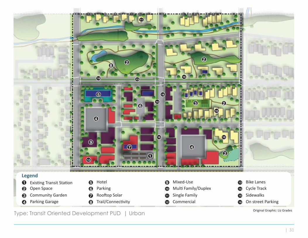
| 31
Legend1
1
4
4
4
3
3
6
6
2
22
2
2
5
5
Existing Transit Station
Parking GarageCommunity Garden
ParkingOpen SpaceHotel
7
7
8
8
9
9
Rooftop SolarTrail/Connectivity
Mixed-Use10
10
10
12
12
15
16
16
16
16 15
11
11
13
13
14
14
Multi Family/Duplex
Commercial
Cycle TrackSingle Family
Bike Lanes
SidewalksOn street Parking
Type: Transit Oriented Development PUD | Urban Original Graphic: Liz Grades

32 |South Burlington PUD Strategies: Phase I Project Report | Draft June 2016
SummaryDevelopment Context: Previously Developed Areas
Purpose: Integrate existing or new forms of development compatible with their surrounding context within previously developed, underused areas; and, where appropriate, allow an increase in the density, intensity or diversity of development to meet local needs or to achieve other community goals and objectives.
Density: Varies
Use Mix: Varies
Design and Development Considerations:
▪ Compatible in type, pattern and density of development with neighboring properties, surrounding area
▪ Connections to and from adjoining, existing development are preserved or enhanced
▪ Form and character complements existing development, use mix but is not necessarily identical; some variation or diversity may be appropriate to meet community objectives
▪ Maintains or incorporates walkability, accessibility to open space and trail networks, transit, where available
▪ Addresses infrastructure capacity, stormwater management, etc. commensurate with level of infill
▪ Parking provided in relation to development context, proposed uses; may incorporate shared parking with neighboring properties, where sufficient
Infill PUD As a community evolves there will be remnant or underutilized land within previously developed areas in which existing or new, compatible forms of development can be introduced. Infill PUDs provide the flexibility needed to replicate existing patterns of development within areas that predate current zoning; or to allow for the orderly introduction of new forms of development within an established context. Examples of this type of development locally include new forms of cottage and higher density multifamily housing in previously established residential neighborhoods. An infill PUD often resembles a more limited version of one of the other PUD types that has been adapted and designed to fit within its particular setting. While the specific form of an infill PUD may vary widely depending on the development context (infill can happen in rural, suburban and urban areas), the tenets of appropriate infill development emphasize neighborhood compatibility, strong integration with existing uses and patterns of development, and the promotion of specific community objectives (e.g., for open space, housing, neighborhood revitalization). For example, an infill PUD can be used to encourage more housing diversity, increase the availability of residential or commercial space, support transit integration or enable greater connectivity to regional transportation systems.

| 33
Legend1
4
3
625Existing Transit Station
Parking GarageCommunity Garden
ParkingOpen SpaceHotel
7
8
9
Rooftop SolarTrail/Connectivity
Mixed-Use10
12
15
16
11
13
14Multi Family/Duplex
Commercial
Cycle TrackSingle Family
Bike Lanes
New Infill DevelopmentOn street Parking
1
4
4
36
2 2
2
2
5
7
8
910
10
12
16
16
16
15 15
11
13
14
Type: Infill PUD | Previously Developed Areas Original Graphic: Liz Grades

34 |South Burlington PUD Strategies: Phase I Project Report | Draft June 2016
SummaryDevelopment Context: Previously Developed Suburban, Urban Fringe
Purpose: Integration of new development on a previously developed property that is compatible with and integrated into the surrounding area, and that offers a type and density of development, including a mix of uses, that promotes viable, economic use of the property, and meets associated community goals and objectives.
Density: Moderate to High
Use Mix: Varies; Civic, Mixed Commercial, ResidentialDesign and, Development Considerations:
▪ Adapted to site conditions, constraints; incorporates, modifies or redevelops existing properties
▪ Compatible with the existing or planned pattern and density of development in the vicinity
▪ Re-establishes, maintains or enhances connectivity with surrounding area (streets, bike paths/lanes, sidewalks, transit, trail networks)
▪ Type, form and character of development, including mix of uses, complements existing development; adds diversity, vitality
▪ Project design may incorporate, adapt historic forms, but allow for contemporary expression
▪ Preserves key (e.g., historic) buildings and critical infrastructure while supporting the removal or adaptive reuse of underutilized ones.
▪ Incorporates pedestrian and bicycle friendly network of streets, sidewalks or walkways
▪ Integrates functional open space in project design (square, green, plaza, courtyard, pocket park, outdoor seating areas)
▪ Addresses infrastructure capacity, stormwater management, etc. commensurate with level of redevelopment
▪ Incorporates on-street, shared parking, parking structures for higher density development
Adaptive Redevelopment PUDSimilar to an Infill PUD, an Adaptive Redevelopment PUD – more commonly termed “greyfield” development – involves using the flexibility afforded PUDs to introduce new forms of development within previously developed areas – in this case on underused or underperforming properties identified for redevelopment. An emerging example, noted earlier, is the conversion or retrofit of suburban malls with expansive parking areas into more vibrant, higher density commercial or mixed use centers. This form of adaptive redevelopment most often occurs on the urban fringe – in areas that are transforming from suburban to more urban forms – and where the pattern of ownership allows wholesale redevelopment activities. Successful redevelopment requires adapting project design to address the local development context – including existing site conditions and constraints, market conditions, and legal encumbrances – that determine what infrastructure and buildings must be maintained, what can be modified or adapted for new use, and what can be redeveloped. Flexible standards also provide opportunities to better integrate new development with its surroundings – to re-establish grids and connections with neighboring properties, and to improve pedestrian and transit access and walkability within the PUDAdaptive redevelopment can also be applied to further community goals and objectives – e.g., to introduce residential uses, civic facilities and more open space in areas dominated by underused commercial properties, or to introduce transit services, where absent. Achieving these objectives can be realized through regulatory incentives and/or requirements.

| 35
Legend1
1
1
4
4
3
3
6
6
6
6
2
2
5
5 5
Existing Development
New ResidentialNew Mixed-Use
ParkingNew CommercialParking Garage
7
7
8
8
8
9
9
New Transit StationOpen space
Community Garden10
10
10
12
12 12
11
11
13
13
14
14
15
15
Trail/Connectivity
Re-Connected Road
Rooftop solarLimit of RedevelopmentSidewalk
Bike Lanes
Original Condition
Type: Adaptive Redevelopment PUD | Urban Original Graphic: Liz Grades

36 |South Burlington PUD Strategies: Phase I Project Report | Draft June 2016
PUD Typology
CONSERVATION PUD PLANNED AGRICULTURE PLANNED RESIDENTIAL CAMPUS/PARK
Development Context
RURAL SUBURBAN
Density LOW LOW MODERATE MODERATE
Use Mix RURAL RESOURCERESIDENTIAL
RURAL RESOURCECOMMERCIAL
RESIDENTIALCIVIC
INSTITUTIONAL, COMMERCIAL
CIVIC
ConnectivityACCESS TO
OPEN SPACE AND RESOURCE LANDS
REGIONAL CONNECTIONS
ACCESS TO OPEN SPACE AND RESOURCE LANDS
REGIONAL CONNECTIONS
CONNECTIONS TO ADJACENT PROPERTIES
REGIONAL CONNECTIONS
INTERNAL CONNECTIONS
CONNECTIONS TO ADJACENT PROPERTIES
REGIONAL CONNECTIONS
Parking LOW - USE SERVING LOW - USE SERVINGINCLUDING EVENTS LOW - USE SERVING MODERATE - USE SERVING PLUS
SATELLITE PARKING
Transit LOW LOW LOW MODERATE - SUPPORT ACCESS IF ON TRANSIT ROUTE
Open SpaceLARGE BLOCKS THAT RETAIN CONSERVATION/ RESOURCE
FUNCTION
LARGE BLOCKS THAT RETAIN CONSERVATION/ RESOURCE
FUNCTION
MIX OF MORE PASSIVE (NATU-RAL) AND FORMALIZED (PARK,
GARDENS)
MIX OF MORE PASSIVE (NATU-RAL) AND FORMALIZED (PARK,
GARDENS, GREENS)
PUD Typology: At-A-Glance

| 37
TRADITIONAL NEIGHBOR-HOOD DEVELOPMENT
NEIGHBORHOOD CENTER DEVELOPMENT TRANSIT ORIENTED DESIGN INFILL ADAPTIVE
REDEVELOPMENT
URBAN PREVIOUSLY DEVELOPED AREAS
MODERATE - HIGH MODERATE - HIGH MODERATE - HIGH VARIES MODERATE - HIGH
RESIDENTIALNEIGHBORHOOD COMMERCIAL
CIVIC
MIXED USE COMMERCIALRESIDENTIAL
CIVIC
COMMERCIALCIVIC
MIXED RESIDENTIALVARIES
VARIESMIXED COMMERCIAL,
RESIDENTIAL, CIVIC
INTERNALCONNECTIONS
INTEGRATION WITH ADJACENT CIRCULATION SYSTEMS
REGIONAL CONNECTIONS
MULTI-MODAL CONNECTIONS
INTEGRATION WITH ADJACENT CIRCULATION SYSTEMS
REGIONAL CONNECTIONS
MULTI-MODAL CONNECTIONS
INTEGRATION WITH ADJACENT CIRCULATION SYSTEMS
REGIONAL CONNECTIONS
INTERNALCONNECTIONS
INTEGRATION WITH ADJACENT CIRCULATION SYSTEMS
REGIONAL CONNECTIONS
INTERNAL RECONNECTIONSINTEGRATION WITH ADJACENT
CIRCULATION SYSTEMSREGIONAL CONNECTIONS
LOW-MODERATE - USE SERVING WITH COMMERCIAL PARKING
MODERATE - HIGH / USE SERVING - STRUCTURED PARKING, SHARED PARKING
MODERATE - HIGH / USE SERVING - STRUCTURED PARKING, PUBLIC PARKING
VARIESSHARED PARKING, ON-STREET OR
PUBLIC PARKING
MODERATE-HIGHPUBLIC PARKING, STRUCTURED
PARKING, ON-STREET
MODERATE - SUPPORT ACCESS IF ON TRANSIT ROUTE
MODERATE - SUPPORT ACCESS IF ON TRANSIT ROUTE
HIGH - TRANSIT CENTER AND/OR LOCAL HUB
VARIES - RESPOND TO CONTEXT, PROVIDE TRANSIT INTEGRATION
IF NEEDED
RESPOND TO CONTEXT AND PROMOTE TRANSIT
INTEGRATION
MIX OF PASSIVE (NATURAL) AND FORMALIZED (GREENS, PARKS,
GARDENS)
MIX OF PASSIVE (NATURAL) AND FORMALIZED (GREENS, POCKET
PARKS, GARDENS)
MIX OF PASSIVE (NATURAL) AND FORMALIZED (GREENS, POCKET
PARKS, GARDENS)
FOCUSED ON NEEDS OF INFILL AND/OR EXTENSION OF EXISTING
OPEN SPACESVARIES

38 |South Burlington PUD Strategies: Phase I Project Report | Draft June 2016
“Cars to People”: Related Project Findings The following findings, consistent with our review of the LDRs, were referenced in 2010 “Cars to People” project memos submitted by BFJ Planning, project consultants:
Structures that are part of a PUD or master plan are not subject to any objective limitation. This is an unusually permissive waiver.
The existing LDR language does not provide enough guidance on the purpose behind granting waivers, or the criteria that the DRB is to use in assessing a waiver request.
The zoning text needs to create reasonable and predictable outcomes for applicants and their neighbors … “where the private benefit derived is either harmless or actively benefits the public character of the immediate area.”
V. RecommendationsThe following represent the initial recommendations of project consultants for planning commission consideration, developed in consultation with planning staff, which are based on research and work completed to date, a review of the existing LDRs and related studies, and preliminary discussions with interested property owners. These are intended to inform discussion in advance of Phase II work, to develop related bylaw amendments.
Discretionary (DRB) Review: Purpose, Conditions of Review
Discretionary review by the DRB, under adopted bylaw standards, is required by law in order to modify or waive zoning requirements, or to allow for the more expansive regulatory flexibility afforded planned unit development. This discretionary authority is generally well defined under the LDRs. However, the use of planned unit development provisions in particular to waive building height and setback requirements – in the absence of any stated intent and with few associated requirements – has been highlighted as a concern by staff, and in reviewed reports.
1. Evaluate, and clarify as needed, existing discretionary DRB authority under the LDRs to grant waivers or modifications of required standards – including the intent and public purpose of such waivers or modifications, and associated conditions of DRB approval. Ensure that the level of regulatory relief or flexibility afforded does not undermine the purpose of the underlying (base) regulations, interrupt the overall pattern of development, or adversely affect neighboring properties.
Regulatory Relief: Variances, Waivers
Variances offer minimal relief from the dimensional requirements of the regulations, under statutory hardship criteria. Waiver provisions, as defined under the regulations, offer more flexibility in their application, but also are intended only to allow modifications or reductions of dimensional requirements for purposes defined in the regulations, in conformance with the comprehensive plan. The LDRs currently incorporate statutory variance criteria by reference. Waivers under the LDRs are addressed mainly through existing PUD waiver provisions.
2. At minimum consolidate and update existing PUD waiver provisions (e.g., for building heights and setbacks), define the intent of allowed waivers, and establish associated conditions of DRB approval – e.g., to include additional height restrictions, and to ensure that consistent front setbacks (building lines) are maintained, to ensure that development is compatible with

| 39
neighboring properties developed in conformance with the regulations. 3. Consider a waiver provision (tool) separate from PUD review and approval to be applied in association with DRB review under other applicable review processes (site plan, conditional use, subdivision review) – subject to related conditions of approval specific to the issuance of waivers. Associated provisions should clarify the intent and public purpose of such waivers.4. Consider consolidating all waiver and variance provisions intended to provide regulatory relief – including required DRB review processes, and associated conditions of approval – in one place in the regulations (one section), that can be cross-referenced elsewhere as appropriate.
Planned Unit Development: Design-Based Regulatory Flexibility
Planned unit development offers the regulatory flexibility needed to allow (or require) integrated, well-designed, development that meets community goals and objectives. PUD bylaws may modify or supersede underlying zoning requirements, as specified under the regulations. Current PUD provisions under the LDRs, however, are much more limiting – used primarily to waive or modify zoning (height, setback) requirements – with little justification in relation to conferred public benefits, and few standards of review.
5. Redefine and establish planned unit development under the LDRs as a tool to promote (or require) integrated, innovative project design that meets community objectives, in conformance with the city’s comprehensive plan.6. Consolidate PUD requirements under a new article, separate from subdivision review, to establish the framework for more
comprehensive PUD bylaws under the LDRs, to clarify use of planned unit development as a design tool that may apply to a variety of defined development types that include single or multiple properties.7. Review, select and adapt presented PUD types for incorporation under the LDRs as appropriate, in conformance with related comprehensive plan policies and objectives.8. For each type of PUD selected, define clear purpose statements, and related design and development standards in relation to the proposed development context, including connectivity and compatibility with existing or planned development in the surrounding area (e.g., adjoining properties, pedestrian-shed, etc.).
9. Consider the application of certain PUD types as “floating zones” as applied to a proposed parcel, or development based on its type, location and size or magnitude. 10. Require master plans for all types of planned unit development – and especially for phased development. Allow for reasonable site plan modifications or amendments in association with each phase of development, consistent with the master plan, as necessary to accommodate changing market conditions, site constraints, etc. 11. Provide a schedule of PUD design options (guides, typologies) to meet required design standards, referencing existing standards or guidelines under the LDRs (e.g., for streets, building envelopes, open space, walkability) where applicable. Define a menu of housing types (as recommended in the 2013 Affordable Housing Report). Review and consolidate all related design standards under the LDRs (e.g., street/road standards found under the subdivision regulations, form based code typology, and for development within the SEQ).

40 |South Burlington PUD Strategies: Phase I Project Report | Draft June 2016
12. Provide a schedule of PUD incentives or offsets (e.g., density bonuses, height increases, parking reductions) for preferred forms of development that provide public benefits (e.g., affordable housing, energy-efficient development, transit facilities, or dedicated open space) identified in the comprehensive plan.
13. Review, update and add definitions under the LDRs as may apply to PUD types (e.g. “walkability,” “pedestrian-shed,” “node”).
City Center FBC District: Regulatory Flexibility under FBCs
Form based codes are intended to be prescriptive and rigid in their application, while also allowing for expedited administrative review. Discretionary forms of review by the DRB are intentionally limited or pre-empted, to ensure that the overall form of development is maintained – that individual projects fall within the design parameters established under the regulations, in conformance with an overall “regulating” plan. Under the LDRs, the regulating plan is defined by city center transect zones, and associated design standards. Some flexibility is inherent in the standards, and in the options provided to meet them.
14. Develop additional guidance – e.g. a handout or schedule (matrix) – summarizing adjustments, waivers and modifications currently allowed under the City Center Form-Based Code District.
15. Consider additional administrative and discretional (DRB) adjustments or modifications to standards where appropriate, based on discussions with staff, and input from affected developers.
16. Require project master plans (or “regulating” plans) for major subdivisions within transect zones that conform to transect zone requirements. Consider allowing limited modifications, subject to DRB review and conditions of approval, particularly for infill and redevelopment projects under the form based code.
17. Consider PUD-related “community types” and processes (e.g., traditional neighborhood and transit-oriented development) – as defined under emerging form based codes designed to accommodate infill and redevelopment (suburban retrofits) – for possible application under the City Center Form Based Code District.
Master Plans
A master plan provides the framework for subsequent development. Planned unit development in particular is intended as a form of “master-planned” development. Well-crafted master provisions within the LDRs are critical to establish or retain connectivity with surrounding areas, and to guide development constructed in phases. Currently there are few standards in the LDRs for the review of master plans, apart from submission requirements. Defining standards under the LDRs, and specifically for PUDs, can strengthen the foundation for more complex forms of phased development, clarify the rights of the developer, and afford the ability to modify or adjust plans in response to changing circumstances.
18. Clarify the purpose and application of master plans within the LDRs, including associated standards of review, for major subdivisions and specifically for planned unit development.
19. Develop master plan design standards that address a diversity of PUD typologies (and transect-based subdivisions), and that also incorporate or dovetail with existing community design standards.
20. Establish stronger connectivity requirements for master plans – particularly for roads, transit, and pedestrian infrastructure.
21. Consider requiring, in association with a PUD master plan, the submission of a Master Plan Guide (or “Plan Book”) that defines critical design considerations particular to the site (e.g., stormwater

| 41
management, wetland protection, etc.) and common design elements. This could include for example, typical lot configurations, street types, housing types, open space types, etc. specific to the PUD, governing subsequent phases of development.
22. Clarify the submission requirements for a phased review process, to include master plans that provide a more conceptual allocation of uses and density – to be defined more specifically under site plan or subdivision review for each phase of development, in conformance with the master plan and guide.
23. Review and update master plan amendment provisions to include amendments to the Master Plan Guide. Identify what elements can and cannot be amended, and the mechanisms by which amendments are addressed (administrative, DRB).
24. Review and clarify vested rights associated with master plan approval, particularly for phased development, to reasonably protect the interests of the developer under subsequent bylaw amendments.
25. Require PUD development and maintenance associations to coordinate PUD development, and the operation and maintenance of land and facilities held in common.
26. Review and clarify requirements for development agreements, e.g., with regard to cost-sharing arrangements under public-private partnerships), scheduling required improvements, infrastructure capacity allocation, etc.; and to ensure that any public dedications or accommodations to meet city needs are preserved through transitions of ownership.

42 |South Burlington PUD Strategies: Phase I Project Report | Draft June 2016
VI. Appendices 24 VSA § 4417 Planned Unit Development
PUD Resources
Traditional Neighborhood Development: Initial Considerations

24 V.S.A. Chapter 117: Vermont Planning and Development Act
§ 4417. Planned unit development
(a) Any municipality adopting a bylaw should provide for planned unit developments to permit flexibility in the application of land development regulations for the purposes of section 4302 of this title and in conformance with the municipal plan. The following may be purposes for planned unit development bylaws:
(1) To encourage compact, pedestrian-oriented development and redevelopment, and to promote a mix of residential uses or nonresidential uses, or both, especially in downtowns, village centers, new town centers, and associated neighborhoods.
(2) To implement the policies of the municipal plan, such as the provision of affordable housing.
(3) To encourage any development in the countryside to be compatible with the use and character of surrounding rural lands.
(4) To provide for flexibility in site and lot layout, building design, placement and clustering of buildings, use of open areas, provision of circulation facilities, including pedestrian facilities and parking, and related site and design considerations that will best achieve the goals for the area as articulated in the municipal plan and bylaws within the particular character of the site and its surroundings.
(5) To provide for the conservation of open space features recognized as worthy of conservation in the municipal plan and bylaws, such as the preservation of agricultural land, forest land, trails, and other recreational resources, critical and sensitive natural areas, scenic resources, and protection from natural hazards.
(6) To provide for efficient use of public facilities and infrastructure.
(7) To encourage and preserve opportunities for energy-efficient development and redevelopment.
(b) The application of planned unit development bylaws to a proposed development may:
(1) Involve single or multiple properties and one owner or multiple owners. Procedures for application and review of multiple owners or properties under a common application, if allowed, shall be specified in the bylaws.
(2) Be limited to parcels that have a minimum area specified in the bylaws or a minimum size or number of units.
(3) Be mandatory for land located in specified zoning districts or for projects of a specified type or magnitude as provided in the bylaws.
(c) Planned unit development bylaws adopted pursuant to this section at a minimum shall include the following provisions:

(1) A statement of purpose in conformance with the purposes of the municipal plan and bylaws.
(2) The development review process to be used for review of planned unit developments to include conditional use or subdivision review procedures, or both, as specified in the bylaws.
(3) Specifications, or reference to specifications, for all application documents and plan drawings.
(4) Standards for the review of proposed planned unit developments, which may vary the density or intensity of land use otherwise applicable under the provisions of the bylaws in consideration of and with respect to any of the following:
(A) The location and physical characteristics of the proposed planned unit development.
(B) The location, design, type, and use of the lots and structures proposed.
(C) The amount, location, and proposed use of open space.
(5) Standards requiring related public improvements or nonpublic improvements, or both; and the payment of impact fees, incorporating by reference any development impact fee ordinance adopted pursuant to chapter 131 of this title.
(6) Provisions for the proposed planned unit development to be completed in reasonable phases, in accordance with the municipal plan and any capital budget and program.
(7) Provisions for coordinating the planned unit development review with other applicable zoning or subdivision review processes, specifying the sequence in which the various review standards will be considered.
(8) Reviews that are conducted in accordance with the procedures in subchapter 10 of this chapter.
(d) Planned unit development bylaws may provide for, as part of the standards described in subdivisions (c)(4) and (c)(5) of this section, the authorization of uses, densities, and intensities that do not correspond with or are not otherwise expressly permitted by the bylaws for the area in which a planned unit development is located, provided that the municipal plan contains a policy that encourages mixed use development, development at higher overall densities or intensities, or both.
(e) Standards for the reservation or dedication of common land or other open space for the use or benefit of the residents of the proposed planned unit development shall include provisions for determining the amount and location of that common land or open space, and for ensuring its improvement and maintenance.
(1) The bylaws may provide that the municipality may, at any time,

accept the dedication of land or any interest in land for public use and maintenance.
(2) The bylaws may require that the applicant or landowner provide for and establish an organization or trust for the ownership and maintenance of any common facilities or open space, and that this organization or trust shall not be dissolved or revoked nor shall it dispose of any common open space, by sale or otherwise, except to an organization or trust conceived and established to own and maintain the common open space, without first offering to dedicate the same to the municipality or other governmental agency to maintain those common facilities or that open space.
(f) The approval of a proposed planned unit development shall be based on findings by the appropriate municipal panel that the proposed planned unit development is in conformance with the municipal plan and satisfies other requirements of the bylaws.
(g) The appropriate municipal panel may prescribe, from time to time, rules and regulations to supplement the standards and conditions set forth in the zoning bylaws, provided the rules and regulations are not inconsistent with any municipal bylaw. The panel shall hold a public hearing after public notice, as required by section 4464 of this title, prior to the enactment of any supplementary rules and regulations. (Added 2003, No. 115 (Adj. Sess.), § 95.)

ResourcesThe following materials, publications and websites were referenced in developing this report. Several offer additional information on planned unit development as it has evolved in concept and application.
City, County Documents
Affordable Housing Report (Apr 2013)
Cars to People to People Project Materials (2009-10)
Open Space Report (Apr 2014)
South Burlington Comprehensive Plan (Feb 2016)
South Burlington Land Development Regulations (Jun 2016)
South Burlington Official Map (Apr 2016)
South Burlington Impact Fee Ordinance (May 2014)
Sustainable Agriculture Report (Apr 2013)
CCTA Transit Development Plan (2010)
Planned Unit Development
Planned Unit Developments (1994)
Mary McMaster, Planning Commissioners Journal, No. 15, (pp. 14, 15)
Planned Unit Development, (2007)
Michael Munson, Sharon Murray, Plan Implementation Manual, No. 22
VT Dept. Housing and Community Affairs.
Planning Implementation Tools: Planned Unit Development (2006)
Miskowiak,D. and L. Stoll Center for Land Use Education, University of Wisconsin.
A Guide to Planned Unit Development, (2005)
NYS Legislative Commission on Rural Resources, NY Dept. of State
Guides, Bylaws
Conservation Subdivision Design Handbook (No Date)
NC State University, Cooperative Extension Service.
Guidebook to Hamlets, Conservation Subdivisions, and Traditional Neighborhood
Development (Jul 2013)
Franklin, Tennessee
The Infill Design Toolkit (2008)
City of Portland, OR
Malls into Main Streets (2006)
Congress for New Urbanism, US Environmental Protection Agency.
A Model Ordinance for a Traditional Neighborhood Development (No Date)
Massachusetts Office of Energy and Environmental Affairs
A Model Ordinance for a Traditional Neighborhood Development (2001)
Brian W. Ohm, James A. LaGro, Jr., Chuck Strawser, University of Wisconsin Ext.
Neighborhood Development Areas: Application Guidelines (Apr 2014)
VT Dept. Housing and Community Affairs
Planned Agricultural District (2001)
San Mateo County, California
Regulations for Planned Agricultural Commercial and Rural Commercial Center
Development (1991)
Fresno, California.
Traditional Neighborhood Development Design Guidelines (2002)
Winston-Salem and Forsyth County, NC

Traditional Neighborhood Development Handbook (2011)
Florida Dept. of Transportation
Traditional Neighborhood Development Infill District (2016)
Staunton, VA
Traditional Neighborhood Development Ordinance Handbook (2009)
York-Adams Regional Smart Growth Coalition, Town Planning and Design Associates
Transit Oriented Development: Best Practices Handbook (Jan 2004)
City of Calgary, Reconnecting America
Transit-Oriented Design for Chittenden County (2002)
Wilbur Smith Associates, Chittenden County Regional Planning Commission
Form Based Codes
Applying Form-Based Codes in the Real World (2013)
Don Elliot, Janet Lorn, John Russell, Esq., Chuck Voss, Pace Law (Conference)
Bradenton Form-Based Code – Infill (2012)
Bradenton, FL, Form-Based Codes Institute
Neighborhood Conservation Code: A Transect-Based Infill Code for Planning and
Zoning (2010)
Sandra Sorlien, Smart Code Local (bungalowstudio.org).
Restructuring the Commercial Strip A Practical Guide for Planning the Revitalization of
Deteriorating Strip Corridors (2010)
US Environmental Protection Agency
Sprawl Repair Smart Code Module (No Date)
Galina Tahchieva, DPZ & Co. Center for Applied Transect Studies
Transit Oriented Development Smart Code Model (2015)
Hank Dittmar and Laura Pinzon Prince’s Foundation for the Built Environment, Center
for Transit-Oriented Development
Websites
Center for Transit Oriented Development (www.ctod.org)
Center for Applied Transect Studies (http://transect.org/)
Chittenden County/Green Mountain Transit Authority (http://cctaride.org/)
Form-Based Codes Institute (http://formbasedcodes.org/)
Reconnecting America (www.reconnectingamerica.org)
Transit Oriented Development Institute (www.tod.org)
Published References
Arendt, R. (1999). Growing Greener: Putting Conservation into Local Plans and
Ordinances. Washington, DC: Island Press.
Arendt, R. et al. (1996). Conservation Design for Subdivisions: A Practical Guide to
Creating Open Space Networks. Washington, DC: Island Press.
Babcock, Richard F. (1965) An Introduction to the Model Enabling Act for Planned
Residential Development. University of Pennsylvania Law Review, Vol 114:136 .
Freilich, Robert H., S. Mark White, Kate Murray (2008). 21st Century Land Development
Code. Washington, DC: American Planning Association.
Sendich Emina, ed. (2006). Planning and Urban Design Standards. American Planning
Association, NJ: John Wiley & Sons, Inc.

Traditional Neighborhood Development: Initial Considerations [Presented for Planning Commission Discussion 5/24/16]
Development Context
oZoning Districts—underlying zoning, overlay districts; floating zone (application/triggers)oDesignated Areas (state) – City Center/TIF District, Neighborhood Development AreasoOfficial MapoRelationship to existing/planned neighborhoods, commercial centers oConnections, links – pedestrian, bicycle, transit, highway (surrounding, w/in ¼ to ½ mile)oInfrastructure capacity – water, wastewater, stormwateroHighway/traffic capacity – Traffic Overlay DistrictoMarket considerations
Design Considerations (Standards v. Guidelines)
oMinimum acreage requirement (currently PUD review required for 10+acres)Note: Typically 30+ acres for full TND (based on pedestrian shed); less for TND infill
oDevelopment/site limitations – natural/scenic areas, buffers, other constraints oMinimum development density– existing, district, planned, min. for state designation
Note: DHCD/Neighborhood Development Area Min - 4 DU/A; Min. bus transit (7+ DU/A)oLayout–central (e.g., civic/park, commercial node), neighborhoods (residential), edge (integration w/neighboring properties, uses; transition/
buffers) oWalkability–internal, integrated street, sidewalk, path network (e.g., modified grid) oAllowed uses (housing, civic, neighborhood commercial uses) in relation to context (compatible, complementary)oRecommended mix (%) of use types–commercial generally less than 10%
Note: Min.75-80% residential, 15-20% open space, 5-10% civic/commercial oBuilding Standards (Articles 8, 9)—e.g., T3/T3+ Neighborhood BES; SEQ Regulating Plan Note: See attached graphicsoStreet types (Article 11) – e.g., lane, neighborhood streets, commercial way, support street, commercial street, pedestrian pass, path, alley oHousing types —also see Affordable Housing Report
oCivic/open space types (Article 9, Appendix F) – e.g., plaza/square, green, pocket/mini-park, playground, outdoor seating; otheroIntegrated stormwater management (low impact; infrastructure, features/amenities
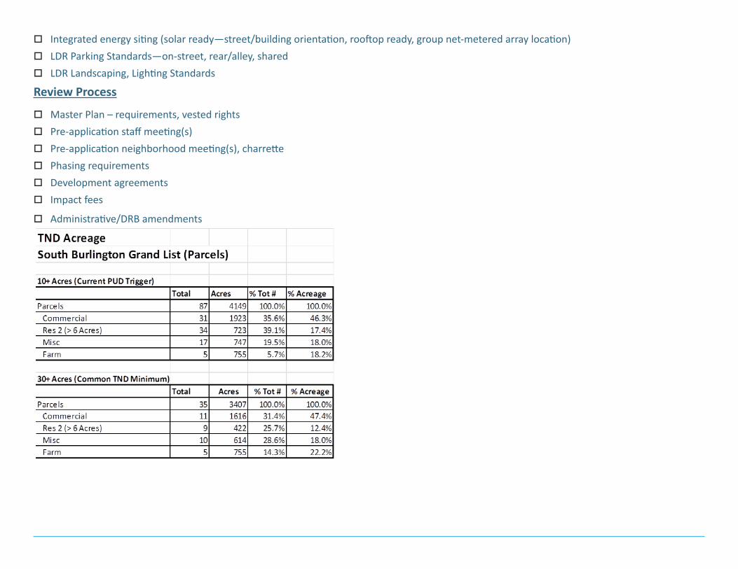
oIntegrated energy siting (solar ready—street/building orientation, rooftop ready, group net-metered array location) oLDR Parking Standards—on-street, rear/alley, sharedoLDR Landscaping, Lighting Standards
Review Process
oMaster Plan – requirements, vested rightsoPre-application staff meeting(s)oPre-application neighborhood meeting(s), charretteoPhasing requirementsoDevelopment agreementsoImpact fees
oAdministrative/DRB amendments

Current LDR Definitions (others may also apply):
Building Envelope Standards (BES). Standards for the design of structures and related site features within these Regulations.
Floating zone. An unmapped zoning district. Requirements are contained in the relevant article. The floating zone is fixed on the map only when an application for development, meeting the zone requirements, is approved.
Master plan. A plan intended to guide the arrangement of developed and undeveloped areas and streets within a land development project.
Planned unit development (PUD). One or more parcels of land to be developed as a single entity, the plan for which may propose any authorized combination of density or intensity transfers or increases, as well as the mixing of land uses. This plan, as authorized, may deviate from bylaw re-quirements that are otherwise applicable to the area in which it is located with respect to the area, density or dimensional requirements or allow-able number of structures and uses per lot as established in any one or more districts created under the provisions of these regulations. The specific requirements of a PUD and the area, density and dimensional provisions that may be modified are defined in each district in which PUDs are al-lowed.
Shared Parking Plan. An agreement for sharing of parking needs or requirements among two or more proximate land owners reflecting their com-plementary parking needs (e.g., different peak use hours, occasional or sporadic use, etc.) as part of a development scheme to satisfy the general parking requirements and achieve greater efficiencies.
Street Type. Title, function and requirements for design of street rights-of-way.
Walkable mixed-use development [SEQ]. Such development shall be designed as part of a planned unit development or master plan and shall have the following components: (A) a mix of residential and commercial uses and densities, with institutional and municipal uses encouraged; (B) proxim-ity to public transportation (ideally within one-half mile); (C) a connected street network with relatively short blocks, sidewalks and crosswalks, pe-destrian-scaled lighting, street trees, and/or recreation paths and bicycle paths; and (D) a compact design characterized, for example, by lots smaller than typically required in commercial districts in these land development regulations, and streets narrower than typically required, and housing and businesses oriented towards the street rather than parking areas.

