spur downtown strategy 2040 eir nop comments · 2015-11-14 · microsoft word - spur downtown...
TRANSCRIPT
November 10, 2015 Mr. David Keyon and Mr. Darryl Boyd Planning, Building and Code Enforcement 200 E. Santa Clara St. San Jose, CA 95113 Re: Downtown Strategy 2040 Project Dear Mr. Keyon and Mr. Boyd, SPUR appreciates the opportunity to provide comments on the scope of work outlined in the Notice of Preparation for the Downtown Strategy 2040 Project. The Downtown Strategy 2000 EIR provides area-wide environmental clearance to accommodate new development in downtown San Jose. We are glad that the city of San Jose is updating the EIR to continue facilitating growth downtown while acknowledging policy changes at the city and state since 2000. Our hope is that the EIR update process will align with the urban aspirations of the Envision 2040 General Plan and make the most of the combined billions of dollars of transit investments coming to downtown. Transportation Mitigations and Improvements Since the Downtown Strategy 2000 was adopted, a sea change has occurred in the practice of analyzing the transportation impacts of new development. Previously, transportation impact analyses focused almost exclusively on auto delay, with intersection level of service (LOS) as the critical metric. Senate Bills 375 (2008) and 743 (2014) move away from this metric and signaled the state of California’s commitment to encouraging land use and transportation decisions that reduce greenhouse gas emissions and vehicle miles traveled (VMT). We appreciate that the traffic impact analysis will measure the transportation impacts of new development based on the reduction of greenhouse gas emissions and their impacts on a multimodal transportation network. Not only will this reaffirm San Jose’s adopted policies, such as the Envision 2040 General Plan, which outlines robust VMT and mode-share targets, but it will also help achieve the state’s goals. Because of this sea change, coupled with the combined billions of dollars in transit investments coming to downtown, we recommend that mitigation projects and improvement projects proposed in the Downtown Strategy 2000 EIR be re-evaluated. The Downtown Strategy 2000 EIR measured both LOS and VMT due to the city’s protected intersection policy. However, many of the traffic mitigations and improvements that were identified are very auto-oriented and are geared towards improving intersection level of service (e.g., TRAF-3, TRAF-6, TRAF-8, TRAF-9). Some of these projects make it easier to drive through downtown, which directly contradicts the city’s 2011 General Plan stated goals of reducing vehicle miles traveled and encouraging non-auto modes of travel. Re-assessing proposed mitigation projects according to more sustainable transportation metrics may help the city invest its transportation dollars wisely.
2
Amending the Development Capacity We recommend that the EIR’s project description make development assumptions clearer. For instance, we encourage the city to define the number of residential units that would be covered by the new EIR. One reason that the city is updating the EIR for downtown is to provide environmental clearance for new development, saving developers time and money. To date, it has been a strong incentive for downtown residential development. The Downtown Strategy 2040 Project would environmentally clear a total of 10,360 residential units on a project-level basis by 2025. Currently, the city is nearing its 5,500 unit Phase I cap, and there are already several thousand more units that the have been identified in the pipeline. It would be beneficial to identify the number of additional residential units the Downtown Strategy 2040 EIR would allow for before hitting the 10,360 cap once those projects in the pipeline are accounted for. We also encourage the city to evaluate the project-level impacts of 14,360 residential units in its early analysis to evaluate what types improvements might be needed. Maximizing Development In SPUR’s report, The Future of Downtown San Jose, we argue that it is critical to make maximum use of the development opportunities within a half-mile, or about a 10-minute walk, of regional transit. In this broader geography, we are agnostic about use and more interested in seeing that the city achieves significant density. In the Future of Downtown San Jose, SPUR found that downtown has the capacity to double its employment and population base if development averaged 10.0 FAR east of Highway 87 and 6.0 FAR around Diridon station (including parking) and did not exceed minimum parking requirements. To that end, we recommend analyzing the impacts of minimum density requirements within a 1/2-mile of regional transit. Assuming a greater concentration of higher density development —for all uses—within a half-mile of BART provides certainty that a high-density project is allowable under the EIR. However, as we are seeing more market interest for both residential and commercial development, this is a good time to think about how to encourage more employment uses near the future BART stations. We recommend maximizing the number of jobs within a quarter-mile of regional transit. There are two reasons for this. The first is that regional transit works best when it is located close (1/4 mile) to jobs. Studies show that there is a greater likelihood that people will use transit if their workplace is close to transit.1,2 The second reason is that many employers recognize that proximity to regional transit is an increasingly important factor in selecting a business location. Downtown San Jose is relatively small geographically and it has significant development constraints from the airport height limits and continuous high parking demand so it is important to think carefully about how the use of each parcel supports BART and the additional regional transit lines that meet at Diridon station. While incentive-based approaches are generally preferable to regulation, we are supportive of identifying possible locations for jobs priority areas and analyzing the impacts of potential development in those areas. We encourage the city to evaluate the impacts of the following approaches to encourage job growth downtown. We give three suggestions to allow the greatest flexibility for determining any future policies. There are at least three ways to approach this in the traffic impact or alternatives analyses: 1 Cervero, Robert. 2008. Residential Self Selection and Rail Commuting: A Nested Logit Analysis: www.uctc.net/papers/604.pdf 2 Transit Cooperative Research Program. 2014. Report 167: Making Effective Fixed-Guideway Transit Investments: Indicators of Success. http://onlinepubs.trb.org/onlinepubs/tcrp/tcrp_rpt_167.pdf
3
1. Buffer Approach The transportation impact analysis could assume the maximum concentration of high-density employment uses in the Traffic Analysis Zones or parcels within 1/4 mile of future regional stations. San Jose can help make regional rail successful by projecting a higher concentration of commercial growth within 1/4 mile of future regional rail stations.
2. Site-by-Site Approach
Another option that could be assessed in the alternatives analysis is maximizing the office and commercial capacity on sites that can accommodate a 30,000 square foot building. We caution that a site-by-site approach could still be based on proximity to transit in order to encourage ridership on BART—up to 1/2 mile of future regional transit stations.
3. Target Share Approach Establish a target share or future percent of total new floor area for office or employment uses. The target share could be applied to all sites within 1/4 mile of BART stations. By establishing a target share, it is clear that mixed-use is an appropriate strategy for transit oriented development while ensuring that a substantial amount of new development is reserved for jobs near transit. If the analysis finds that a target share approach is an appropriate solution for downtown San Jose, the city might also consider review its zoning and municipal code to identify changes that could bring mixed-use development and jobs near transit.
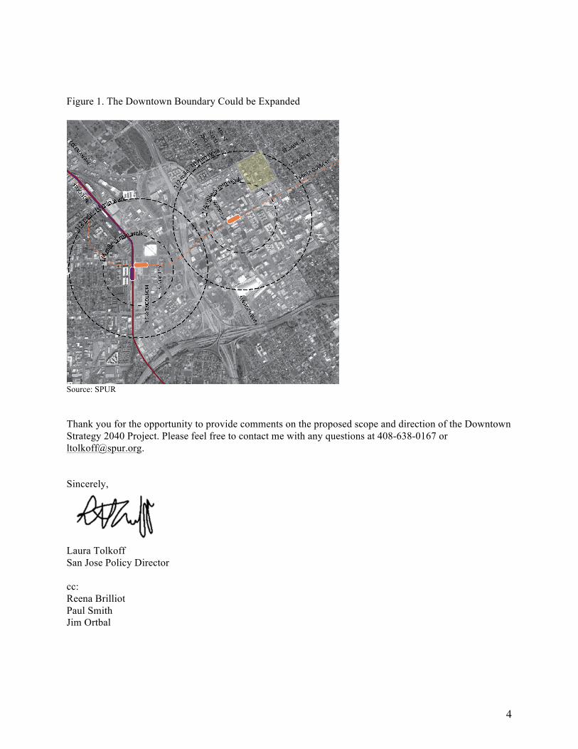
Expanding Downtown Boundaries The Downtown boundaries in the General Plan and Downtown Strategy should align with the boundaries presented in the EIR scoping document. It may also make sense to expand the Downtown boundaries to areas near San Jose State University and along key corridors and close to future regional transit. For instance, expanding east of St. James Park—between N.4th and N.7th streets to the east and between Julian St. to the north and St. John to the south (see Figure 1)—could allow for higher intensity development in areas that are still within a ten-minute walk to the future downtown BART station and that are close to concentrations of market demand.
4
Figure 1. The Downtown Boundary Could be Expanded
Source: SPUR Thank you for the opportunity to provide comments on the proposed scope and direction of the Downtown Strategy 2040 Project. Please feel free to contact me with any questions at 408-638-0167 or [email protected]. Sincerely,
Laura Tolkoff San Jose Policy Director cc: Reena Brilliot Paul Smith Jim Ortbal