st helens greenway policy review · the european greenways association defines greenways as...
TRANSCRIPT
St Helens Greenway Policy Review
Final Report February 2015

2
Content
Section Content Page Introduction
1 Current Position
3
2 Changing Circumstance –The Context for The Greenways Policy Review
6
2.1 Definitions of Greenways 6
2.2 Current Policy Context 6
2.3 Policy Review
9
2.4 Network Review
8
3 Greenways and Multifunctionality
12
3.1 Greenways Functionality and Needs assessment 13
4 Conclusions
4.1 Planning Policy Review 19
4.2 Green Infrastructure
22
Annexe 1 River Corridors and Core Biodiversity Assets within 10m of main river
Annexe 2 River Corridors and Core Biodiversity Assets and Open Space 23
Annexe 3 Publicly Accessible Greenspace within 10m of the river catchment
23
Annexe 4 Publicly Accessible Greenspace within10m of Main River
24
Annexe 5 Key Local Sustainable Transport Routes / Public Rights of Way Along and Linking to River Corridors
24
Annexe 6 Green Infrastructure Functions
25
Annexe 7 Thresholds for Identification of Need
29

3
Introduction As part of the development of the St Helens Local Plan this paper sets out the process used and the conclusions of a review into the St Helens Greenway network and the planning policy needed to support the protection of the network. In the light of current guidance objectives of the review were: 1. To assess the current Greenway Protection Policy against any changes in policy
guidance, 2. To assess the current network against the sub-regional Green Infrastructure Framework
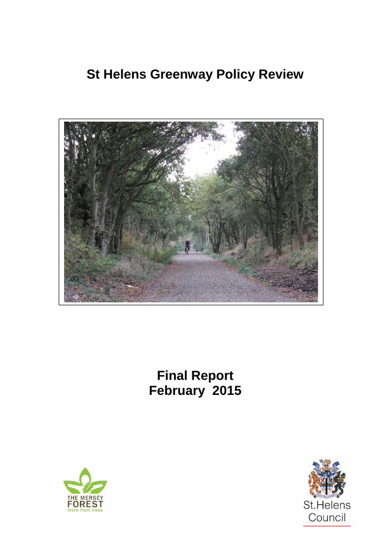
Section 1: Current Position The current Greenway network (Figure 1) was defined in the Council’s Unitary Development Plan (UDP) and supported by Policy ENV 3 Greenways which states: “ (a) A strategic network of greenways, as shown on the Proposals Map, will be
safeguarded, in order to;
(i) secure a landscape structure based on the physical characteristics specific to St Helens;
(ii) give additional definition and protection to the network of wildlife corridors, historic and archaeological resources;
(iii) provide a recreational resource easily accessible to the main concentrations of population and priority areas capable of assisting the development of footpath, cycle and bridleway routes within the Borough and linking with surrounding countryside;
(iv) complement the Borough’s economic initiatives by improving the appearance of the area;
(b) Development proposals within the Greenways will only be accepted if they satisfy all of the following:
(i) they do not prejudice the appearance of the Greenway and the contribution it makes to the landscape structure of the area;
(ii) they would not prejudice the establishment of an access link; (iii) they would not destroy the integrity of the Greenway network, in terms
of linkages, character and amenity; (iv) they would not destroy or impair the integrity of the Greenway as a
wildlife corridor”
In the formulation of ENV 3, private land with limited or no public access was included in the network if there was a significant landscape or wildlife value.
4
The Greenways network is strongly overlapped by the Borough’s Strategic Footpath and Cycleway network (Figure 2), which is supported by UDP Policy REC 5 and states “The Council will:
(i) not grant permission for any development which would prejudice the recreation route, unless specific arrangements are made for a suitable alternative linkage; give due weight to development proposals which would provide new links in the network or improve existing links.
(ii) give due weight to developments which would provide new links into the
network or improve existing links” UDP Policy ENV 3 Greenways sets out the Council’s original policy approach to protection and enhancement of Greenways within the Borough. This saved policy continues to have validity and material weight. In October 2012 the St Helens Local Plan Core Strategy was adopted. Paragraph 16.1 Safeguarding and Enhancing Quality of Life in St Helens defines Green Infrastructure as an integrated network of open space (including water) within the countryside and urban areas, having a wide range of functions and value, for recreation and tourism, public access, health, education biodiversity, land and water management, mitigation of climate change, enhancement of landscape, regeneration and green economic values.” Policy CQL 1 Green Infrastructure states “The Council will protect, manage, enhance and where appropriate, expand Green Infrastructure in the following ways:

5
(1) Identify the network and prepare detailed policies in the Sustainable Development and Allocations DPDs, for its protection, taking account of standards for open space provision derived from the Open Space Study.
(2.) Reinforce the protection of greenways and linkages between sites.” Supporting paragraph 16.10 identifies the following key open space sites as priorities for action:
Bold Forest Park
Stanley Bank, Carr Mill Dam and Billinge Hill Corridor
The former Lyme and Wood Pits
Sankey Valley Park, between St Helens and Warrington
The former Ibstocks Quarry

6
Section 2. Changing Circumstance - The Context for The Greenways Policy Review 2.1 Definitions of Greenways? The European Greenways Association defines Greenways as “communications routes” reserved exclusively for non-motorised journeys, developed in integrated manners which enhance both the environment and the quality of life of the surrounding area”1. The Countryside Agency defined Greenways as“shared-use, car-free off-road routes for a range of users and journey purposes2” Natural England has not revised this definition. National Cycling Charity Sustrans define Greenways as “traffic-free routes, which are attractive, generally well separated from traffic and continuous over obstacles and through road junctions”3. Importantly, Sustrans also note that Greenways should be viewed as wildlife resources and that they offer the opportunity for creating continuous wildlife corridors, of linking together diverse pieces of land, woods, parks and open spaces, and they offer the chance for the public to have easy, but defined access to wildlife and natural spaces, both in and beyond urban areas. Whilst recognising multi-functionality, all three definitions have fundamental characteristics of public accessibility and being “off-road” routes.
2. 2 Current Policy Context 2.2.1 National Planning Policy Framework Published in 2012 The National Planning Policy Framework (NPPF) sets out a revised set of planning policy guidelines with a presumption for Sustainable Development at its core. The NPPF paragraph 17 sets out Core Planning Principles for the delivery of sustainable development including recognizing that some open land can perform many functions such as for wildlife habitat, recreation, flood risk mitigation, carbon storage or food production. Another Core Principle is to actively manage patterns of growth to make the fullest possible use of public transport, walking and cycling. NPPF Section 4 Promoting sustainable transport, states that transport policies have an important role to play in facilitating sustainable development but also in contributing to wider sustainability and health objectives. Paragraph 30 states “ Encouragement should be given to solutions which support reductions in greenhouse gas emissions and reduce congestion.” NPPF Section 8 Promoting healthy communities Paragraph 75 states that planning policies should “protect and enhance public rights of way and access. Local
1 Lille Declaration. European Greenways Association 12th September 2000 2 Greenways: an initial evaluation research note CRN 58 The Countryside Agency 2003 3 The National Cycle Network, its Greenways and their Development

7
authorities should seek opportunities to provide better facilities for users, for example, by adding links to existing rights of way networks.” NPPF Section 4 Conserving and enhancing the natural environment, Paragraph 114 states that Local Planning Authorities should “Set out a strategic approach in Local Plans, planning positively for the creation, protection, enhancement and management of networks of biodiversity and green infrastructure.” NPPF paragraph 165 states, ” Planning policies and decisions should be based on up-to - date information about the natural environment and other characteristics of the area including drawing, for example, from River Basin Management Plans. Working with Local Nature Partnerships where appropriate, this should include an assessment of existing and potential components of ecological networks.” 2.2.2 Landscape Ecology The Government’s Natural Environment White Paper4 set the context for Making Space for Nature5, a review of England’s ecological network which concludes that conservation needs to re-focus away from conserving what persists to large-scale habitat restoration and recreation underpinned by the re-establishment of ecological processes and ecosystem services benefiting both wildlife and people. The emerging Liverpool City Region Ecological Framework identifies the Core Biodiversity Assets of the region which consist of:
Internationally Designated Sites;
Nationally Designated Sites;
Local Wildlife Sites, and
Habitats listed under S.41 of the Natural Environment and Rural Communities Act 2006
The Framework identifies connective features such as river corridors as key assets and also identifies Local Nature Improvement Areas (LNIA). In St Helens, the Sankey Valley forms the primary LNIA. 2.2.3 Landscape Character Geology and hydrology is a formative feature of landscape. The St Helens Landscape Character Assessment6 notes that St Helens is drained to the south-east by a number of water courses, the principal of which is the Sankey Brook. A radial pattern of tributaries feeds into the Sankey, draining the central areas of the Borough. The assessment states the network of rivers and brooks “form important landscape features”. Reclaimed former colliery spoil heaps now form distinct character types within the St Helens landscape, which as the community forestry matures, provide an increasingly strong landscape character.
4 The Natural Choice: securing the value of nature. HM Government 2011
5 Lawton, J.H., Brotherton, P.N.M., Brown, V.K., Elphick, C., Fitter, A.H., Forshaw, J.,
Haddow, R.W., Hilborne, S., Leafe, R.N., Mace, G.M., Southgate, M.P., Sutherland, W.A., Tew, T.E., Varley, J., & Wynne, G.R. (2010) Making Space for Nature: a review of England’s wildlife sites and ecological network. Report to Defra. 6 Landscape Character Assessment for St Helens Land Use Consultants 2006

8
2.2.4 Green Infrastructure Planning
Green Infrastructure is the network of green and blue spaces in and around the built environment. Green Infrastructure planning is a relatively new concept, which uses an evidence-based approach to deliver a range of benefits for people, wildlife and economy, which are essential to our lives. Green Infrastructure planning evaluates the spatial distribution of green infrastructure and how it affects, or is affected, by a range of social and economic factors.
The Local Nature Partnership for the city region has a strong role to play in promoting Green Infrastructure planning and has adopted the Liverpool City Region and Warrington Green Infrastructure Framework, ”Nature at Work”, which was prepared by The Mersey Forest, working in partnership with the local authorities and was published in 2014. It identifies “how effective planning and delivery of Green Infrastructure can help create jobs, attract investment and increase productivity; improve health and wellbeing and secure a richer, more biodiverse, resilient place to live, work and enjoy”.
The document sets out 12 key activities including:
Use the green infrastructure assets of the city region and Warrington to support increased active travel, walking and cycling for work, recreation and leisure
Create and develop green infrastructure tourism assets, for example, our coastal areas, large parks and greenways such as Sankey valley and the Forest parks
The methodology employed focuses on how green infrastructure functions and meets local needs. This policy review in subsequent sections applies the same methodology to assess the multifunctionality of the greenway proposals which is consistent with the core planning principles of the NPPF. 2.2.5 Areas of Deprivation Areas of St Helens continue to be amongst the most deprived in the country and this remains a focus for action across a range of fronts. Figure 3 shows how the proposed greenway network helps to connect areas of multiple deprivation such as Parr, Thatto Heath, Four Acre and parts of the Town Centre to areas of employment both within the Borough and to neighbouring Boroughs of Halton and Warrington, assisting with sustainable access to employment.

9
Key routes in the Mid-Mersey and St Helens Local Sustainable Transport Projects include the Sankey Valley linking to Warrington and the former Runcorn Cap Railway which links into Halton Borough.
2.3 Policy Review 2.2.6 Local Sustainable Transport Local Sustainable Transport initiatives seek to provide low-carbon modes of transport, which help to address climate change and promote health improvements and social inclusion. Alongside promotion and enhancement of public transport, the scheme seeks to provide safe cycling and walking routes that link residential areas to employment areas and to key recreation and visitor locations. The Greenway network is a key asset to provide sustainable transport routes. 2.3 Policy Review 2.3.1 Is a specific Greenway Planning Policy still required? On the following basis, a specific Greenway Policy in the Council’s Sustainable Development and Allocations Local Plan is needed: The National Planning Policy Framework Paragraph 114 states “Local Planning Authorities should set out a strategic approach in their Local Plans, planning positively for the creation, protection, enhancement and management of networks of biodiversity and green infrastructure.” Core principles of the NPPF (section 17) are to:
Encourage multiple benefits from the use of land in urban and rural areas., recognizing that some open land can perform many functions (such as for wildlife, recreation, flood risk mitigation, carbon storage or food production);

10
The UDP Greenways policy ENV 3 has a broad range of aims reflecting the general multi – functionality the network provides and its particular reflection of the local landscape character. In particular:
- secure a landscape structure based on the physical characteristics specific to St Helens;
- give additional definition and protection to the network of wildlife; - corridors, historic and archaeological resources; - provide a recreational resource easily accessible to the main concentrations
of population and priority areas capable of assisting the development of footpath, cycle and bridleway routes within the Borough and linking with surrounding countryside;
- complement the Borough’s economic initiatives by improving the appearance of the area.
Conserve heritage assets in a manner appropriate to their significance, so they can be enjoyed for their contribution to the quality of life of this and future generations. The greenway network contains a rich tapestry of important industrial heritage site such as the Sankey Canal – the catalyst for the development of St Helens as a distinctive town, Stanley Mill, Stanley Copper Works site, numerous reservoirs and reclaimed colliery sites such as Sutton Manor, Clock Face and Bold Moss which now form the basis of a new landscape in the south of the Borough. Landscape features such as the Burgy Banks reflect the glass industry for which the town is nationally notable.
Take account of and support local strategies to improve health, social and cultural wellbeing for all, and deliver sufficient community and cultural facilities and services to meet local needs.
St Helens has a significant problem of childhood obesity and coronary heart disease. The St Helens Healthy Walking Initiative, an initiative to combat this that has run a successful programme of health walks for the past decade, has regularly used parts of the Greenway network. An employment training opportunity aimed at young people not in employment, education or training (NEETS) focusing on land management of some greenway elements, is currently developing through a partnership with Groundwork Lancashire & Wigan and the Mersey Forest.
Actively manage patterns of growth to make the fullest possible use of public transport, walking and cycling and focus significant development in locations, which are or can be made sustainable.
The Greenway network provides a framework of sustainable cycling routes linking residential areas to employment areas, helping to make employment more accessible to deprived areas. The Sankey Valley is a particularly strategic corridor, linking St Helens Warrington and Widnes, allowing access to neighbouring towns. Similarly, the newly created Farnworth – Sutton Greenway can provide easy access into the Borough from Halton.

11
NPPF Paragraph (117) indicates a requirement to ”plan for biodiversity on a landscape scale across Local Authority Boundaries”.
Greenways increase connectivity and provide effective wildlife corridors within St Helens and link into cross boundary networks such as Sankey Valley and the Mineral Line. The emerging Liverpool City Region Ecological Framework recognises the Sankey Valley as a significant wildlife corridor.
In St Helens, Greenways can be crystallized into the following definition: “Greenways are publicly accessible off –road routes for walking, cycling and, where appropriate, horse riding, which can also provide wider benefits to the environment and the community.” 2.4 Network Review Derived from the various Greenway definitions, the fundamental qualities of St Helens Greenway network can be identified as accessibility, connectivity and to a greater or lesser degree multi-functionality. The landscape elements with greatest connectivity are the river corridors and these have been used as the building block of the outline network. In order to define an outline green corridor network on which to focus Green Infrastructure (GI) functionality testing and needs assessment, a range of key data was incrementally added The main river network was supplemented by:
Core Biodiversity Assets within 10m of the main rivers (Annexe 1)
Publicly Accessible greenspace within 10m of the river catchment (Annexe 2)
Significant areas of linked open spaces (Annexe 3)
Key Local Sustainable Transport development routes (Annexe 4)
Public Rights of Way along and linking to river corridors (Annexe 4)

12
The Draft Greenway network differs from that in the UDP, in that Eccleston Greenway has been removed due a lack of the basic qualities of accessibility and connectivity.
Landscape improvements programmes have enabled the addition of a number of sites, including Bold Forest Park in the south of the Borough, Carr Mill Dam and Stanley Bank in the north. All these sites have had significant investment that has improved access to allow public access for walking, cycling and horse riding.
Section 3.0 Greenways and Multifunctionality
It is a core principle of the NPPF (section 17) that local authorities should:
Encourage multiple benefits from the use of land in urban and rural areas, recognizing that some open land can perform many functions (such as for wildlife, recreation, flood risk mitigation, carbon storage or food production) Whilst Greenways are primarily access routes, guidance from central Government in the form of the NPPF, and other agencies clearly indicates that Greenways have a range of functions they can fulfil, particularly as wildlife corridors and recreational resources. The essential qualities in defining a network appear to be accessibility, connectivity and multi-functionality, although this may vary across the network.
The analysis of multi-functionality in the context of green infrastructure is a significant part of the work of The Mersey Forest7 team and a GIS based mapping methodology has been developed. The methodology involves the following main stages:
The identification of all green infrastructure into 18 types, e.g. woodland, water body, park or public garden;
The assessment of how each green infrastructure parcel performs up to 35 functions such as public recreation, noise absorption, and water interception;
The analysis of how the green infrastructure is meeting the identified needs of an area, such as increasing physical activity, improving air quality or adapting to climate change.
The methodology has been used in the preparation of the Liverpool Green Infrastructure Strategy and the Liverpool City Region Green Infrastructure Framework, as well green infrastructure studies for Telford, Ayrshire, Carlisle, Wyre, Stockport and other areas.
7 The Mersey Forest is one of England’s Community Forests and was established in 1991. It
covers 1,370km2 of Merseyside and North Cheshire. It is a partnership of seven local
authorities (Cheshire West & Chester, Halton, Knowsley, Liverpool, Sefton, St Helens and Warrington), Natural England, The Forestry Commission and the Environment Agency, along with a wider partnership of landowners, businesses and local communities. The partnership is supported by a dedicated team.

13
The approach has been applied to the review of the Greenways policy in order to understand better the multifunctionality of the greenways and to advise on their spatial definition.
3.1 Greenways Functionality and Needs Assessment
Stage 1: Multifunctionality
The first stage took a broad overview.
For each area of green infrastructure identified through the typology mapping, the 28 functions listed below were mapped (Figure 5).
Recreation – public Recreation – private
Recreation – public with restrictions Green travel route
Aesthetic Shading from the sun
Evaporative cooling Habitat for wildlife
Corridor for wildlife Soil stabilization
Heritage Cultural asset
Carbon storage Food production
Timber production Biofuels production
Wind shelter Learning
Inaccessible water storage Accessible water storage
Water interception Water infiltration
Water conveyance Pollutant removal from soil/water
Flow reduction through surface roughness
Flow reduction through surface roughness
Evaporative cooling Noise absorption
Trapping air pollutants
This was done to identify areas where there was a high level of multifunctionality and to see whether this corresponded to the proposed greenway network.
Figure 6 indicates that many parts of the greenway contain sites demonstrating a high level of multifunctionality.

14
Figure 5 Green Infrastructure
Typology Map

15
Figure 6: Multifunctionality Map

16
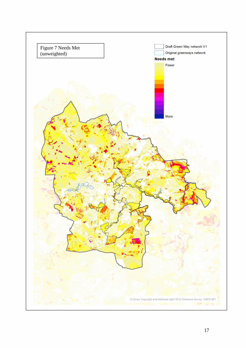
Stage 2 Needs met (unweighted)
This repeated Stage 1 but this time mapped where green infrastructure needs were being met (Figure 7) Four of the functions were omitted at this stage because they are less relevant to greenways: shading from the sun, evaporative cooling, food production and biofuels production.
The concept of needs being met (fulfilled) or not met (unfulfilled) is central to the methodology. It is recognition that the importance of an area of green infrastructure can vary dependent on the specific needs of a particular area. For example, the relative importance of green infrastructure for the function of Public recreation will be greater where there is higher level of exercise related health needs, greater concentration of children and lower level of car ownership
Similarly, the role of green infrastructure in the absorption of noise will be of greater significance in areas of high population in close proximity to motorways, A roads and railways.
The thresholds used for the identification of need were those developed for the Liverpool City Region Green Infrastructure Framework (see Annex 6). It is worth noting that these thresholds or any weighting attached to them could be varied in relation to local circumstances and priorities
The resulting map shows a scattered distribution of areas where a number of needs are being met. These tend to be concentrated in the rural areas, which is a reflection of the proportionately higher number of functions relevant to such areas such as timber production, soil stabilisation and inaccessible water storage.
Consequently, the map does not help to confirm or refine the Greenway network. Nevertheless, some parts of the Greenway network are showing higher levels of needs being met through green infrastructure functions e.g. Bold Forest Park and Stanley Bank Meadow.
Stage 3 Needs met (weighted)
In order to assist in the definition of the greenway network in relation to green infrastructure functions, it was decided to give greater weight to those functions, which are of fundamental importance
Following consideration of Greenway definitions by Natural England and Sustrans the following functions were identified as being of fundamental importance:
Recreation – public; Green travel route; and Corridor for wildlife
17
Figure 7 Needs Met
(unweighted)

18
A weighting factor of 10 was applied to these three functions and the needs
met mapping was rerun. In addition all non-publicly accessible green
infrastructure was screened out to help focus on the publicly accessible areas As a result of applying the weighting and screening the greenway network emerges more clearly (Figure 8) Figure 8 reveals the following:
Figure 8 Needs Met (weighted)
19
Figure 8 reveals the following:
i. The proposed network emerges strongly as an integrated series of linked spaces;
ii. There is a moderate level of functionality throughout the network that is meeting local needs. In places there are concentrations of functionality where a higher number of needs are being met;
iii. On the basis of functions performed and needs met, it supports the inclusion of Bold Forest park and Carr Mill Dam in the network;
iv. The function mapping suggests a boundary modification in the Sankey Valley to encompass the Southport Street Open Space Wildlife Site; and
v. From a functionality perspective there is no overriding justification to reinstate the Eccleston Greenway omitted from the proposed draft on grounds of accessibility (in parts) and lack of linkages.
Stage 4
The analysis of where green infrastructure is meeting needs assists in identifying those areas of importance for possible protection through planning policy.
Where needs are not being met may suggest areas where there is greater need for actions to increase the functionality of the greenway
A study of “ needs not met” was undertaken to establish if there was a case to extend the range of the proposed greenway network in areas where it could fulfil a need. However, this did not suggest the need for any feasible extension to the Greenway network.
4 Conclusions
4.1 Planning Review
(i) Policy guidance confirms the need for a Greenway Protection Policy .
(ii) The guidance infers that, whilst the primary function of a greenway network is access, it can and should, to a lesser or greater extent, provide a range of social and environmental benefits. This remains broadly consistent with the UDP Policy ENV3 but the change of emphasis on fundamental function of access and connectivity suggests a minor re-wording of the policy is necessary.

20
4.1.1 Draft Development Management Greenway Policy
(a) A strategic network of greenways, as shown on the Policies Map, will be safeguarded and enhanced, in order to:
(i) Provide a recreational resource capable of delivering a continuous off-road network of footpath, cycle and bridleway routes. These routes will be publicly accessible within the main urban areas and areas of deprivation, and provide linkages to the adjoining countryside;
(ii) Give additional definition and protection to the network of wildlife corridors, historic and archeological resources;
(iii) Contribute to the sub-regional network of cross boundary green infrastructure corridors; and
(iv) Compliment the Borough’s economic activities by improving the appearance of the area and providing sustainable road transport links between home and workplace.
(b) Development proposals affecting Greenways will only be accepted if they satisfy all of the following:
(i) They do not prejudice the continuity of public access;
(ii) They do not destroy the integrity of the Greenway in terms of off road, linkages, character and amenity;
(iii) They do not prejudice the appearance of the Greenway; and
(iv) They do not impair the integrity of the Greenway as a wildlife corridor.
Greenways have a long pedigree within St Helens, particularly in relation to the Sankey Valley. The establishment of the first Groundwork trust in St Helens and Knowsley in 1981 reinforced the importance of creating strong public access linkages between town and country. In 1998 The UDP gave a statutory definition to the Greenways network in St Helens for the first time.

21
Policy CQL1 of the Local Plan Core Strategy includes a commitment to “reinforce the protection of greenways and linkages between sites” This Policy has evolved from Policy ENV3 Greenways in the UDP, which has been reassessed in the context of the NPPF and the development of Green Infrastructure policy within the Liverpool City Region.
Greenways form part of the Borough’s green infrastructure network and are consistent with the approach set out in Paragraph 114 of the NPPF.
Green infrastructure does not stop at the Borough boundary and Greenways in particular, can provide strong cross boundary connections. This is recognised in the Liverpool City region Green Infrastructure Framework, in which particular reference is made to the importance of the Sankey Valley.
A key characteristic of green infrastructure is the wide range of functions it performs and benefits it delivers including recreation, health education and biodiversity. This was confirmed in relation to the greenway network in a supporting document8 The protection and enhancement of the Greenway is thus consistent with the NPPF core principle to encourage multiple benefits form the use of land in urban and rural areas.
The resulting network, as shown on the Policies Map has been defined on the basis of physically linking existing open spaces along eth major linear features of the Borough such as river valleys, canal systems and maturing woodlands. It incorporates areas of biodiversity value, features of historic and archaeological interest and in places its proximity to areas of deprivation a locally accessible resource for recreation and education. Of the network’s total length (approx 26km), 77% coincides with the main river and canal network. In accordance with Paragraph 165 of the NPPF this will provide the basis greenway policy to operate in conjunction with River Basin Management Plans.
The Greenway network is an important framework for the development of a footpath and cycleway network through the Borough. This policy overlaps with and should be applied, in conjunction with an updated Strategic Footpaths & Cycleways Policy. This will provide an important mechanism to support sustainable transport including opportunities to integrate new development with the access network.
Liverpool City Region Ecological Framework identifies Core Biodiversity Assets, which include Local Wildlife Sites and habitat of principle conservation importance, along with important linear features such as river and canal networks. Together these assets make up a network of ecological resources vital to the city region.
The Greenway network reflects this ecological value with the Sankey Valley being of particular ecological importance.
4.2 Green Infrastructure
(i) The application of the green infrastructure multifunctionality methodology complements the planning decisions, which defined the draft greenway network and confirms the logic of the network.
(ii) It has also suggested a boundary amendment to the network.
8 St Helens Greenway Policy Review Final Report December 2014 St Helens Council , The Mersey Forest

22
(iii) It confirms that the network is worthy of protection as a system delivering a number of functions meeting local needs.
It should be noted that the methodology applied is one developed for strategic planning at the sub regional level. This is not to diminish the validity of the process for this study. However it is to suggest that if further work were to be done, for example, by undertaking survey work on the ground, of how the network or individual sites within the network are functioning, that this would almost certainly confirm a greater degree of multifunctionality and the meeting of local needs.
St Helens Council Environmental Planning Team has produced this report in partnership with The Mersey Forest. The Contact Officer for this report is: Rick Rogers, Countryside Development Officer 01744 676191 [email protected]

23
River Corridors and Core Biodiversity Assets Within 10m of Main River : Annexe 1
River Corridors, Core Biodiversity Assets and Open Space : Annexe 2

24
Publicly Accessible Open Space Within 10m of the River Catchment : Annexe 3
Key Sustainable Transport Routes/ Public Rights of Way Along and Linking to River
Corridors :Annexe 4

25
:
Green Infrastructure Functions: Annexe 5
Recreation – public Anyone can use for recreational purposes (formal/informal and active/passive), without having to pay or have access to keys. Can include areas which are closed at night, on specific days, or seasonally but a judgment call will be required as to whether this restricts public use. Can include sports fields, fishing lakes, playgrounds, etc, and open access land.
Recreation – private Land, which is used for recreation but only by owners of the land or those invited by the owners to use. This includes private gardens and other privately owned green spaces to which access for the public is prohibited.
Recreation public – with restrictions Public use for recreational purposes (formal/informal and active/passive) is allowed but is restricted to those who pay or have keys. Can include sports fields, golf courses, fishing lakes, allotments, etc, but not public rights of way.
Green travel route Off road routes through greenery for pedestrians and cyclists (for recreational purposes as well as for getting between places), can include public rights of way, Sustrans, and private routes, which are not on roads. Useful in urban areas and often located close to large centres of population. Also includes the green infrastructure, which surrounds green travel routes, making them an attractive alternative route.
Aesthetic (CABE, 2005) Improves the image of an area for people as they arrive, and for those who reside there. Examples may include street trees, trees along major roads, etc. Applies equally to towns, cities and the rural landscape. Green infrastructure can make the town/village etc. a more attractive place to live and visit. The improved aesthetic which green infrastructure can provide will be reflected in surrounding property prices.
Shading from sun (Huang et al. 2006, Parker, 1981) Shading of people, buildings, and surfaces from solar radiation to reduce temperatures and increase comfort levels. Usually provided by trees and taller plants and vegetation. Particularly found in urban areas to reduce the urban heat island, this function will become more critical as we have to adapt to a changing climate. Green infrastructure, which provides shade will also be important for protecting agricultural land and other species from solar damage.
Evaporative cooling (Kramer & Kozlowaki, 1960) As plants transpire water is evaporated from their surfaces cooling their immediate locality. All types of green infrastructure can provide this function, including open water. Plants with a larger leaf area are likely to be better than those with a smaller leaf area. During a drought, irrigation is likely to be necessary to maximise this function in plants, whilst open water will continue to be valuable in its own right.
Trapping air pollutants (Hill, 1971, Beckett et al., 1998, Smith, 1990, Hewitt et al., 2005)

26
Removal of pollutants, especially ozone, nitrogen dioxide and particles from the air, through uptake via leaf stomata and deposition on leaf surfaces. Once inside the leaf, gases diffuse into intercellular spaces and may be absorbed by water films to form acids or react with inner leaf surfaces. This function is usually associated with more urban areas, especially close to travel routes. Noise absorption (Fang & Ling, 2002) Screening of noise, especially from major transport routes. Requires certain types of green infrastructure which are tall enough to incept and absorb sound waves. This function is usually associated with more urban areas, especially close to travel routes. Trees may perform this function to some extent, although a large part of their effect may be just on the ‘perception’ of noise. Landform is likely to have a greater effect.
Habitat for wildlife (Tree People, 2009) Providing a habitat for wildlife – a place to live with a source of food. Different types of green infrastructure will provide habitats for a widely different range of species. The range of species will also be dependent on other factors such as climate and disturbance.
Corridor for wildlife (Benedict & McMahon, 2006) Conduit of green and blue spaces through which wildlife can disperse to and from habitat spaces. This function will increase in importance in the future; species will need the capacity to move upwards and northwards as the climate changes. Connectivity is vital for this function. Different types of green infrastructure will provide a corridor for a widely different range of species. Range of species will also be dependent on other factors such as climate and disturbance.
Soil stabilisation (Barker, 1995) Root structures of all vegetation can help improve the strength and stability of soil, holding together the top soil and preventing it from eroding.
Heritage Historic links in the landscape (including ancient woodlands, canals, designated sites and monuments). Heritage is "that which is inherited".
Cultural asset Green space used for cultural purposes, the hosting of public art, events and festivals. Examples include international garden festivals and sculpture parks.
Carbon storage (Milne & Brown, 1995) Removing carbon from the atmosphere and storing it in plants, trees and soils. Trees and peat soils are particularly important types of green infrastructure for storing carbon. Certain types of green infrastructure are slower growing and will take longer to absorb carbon. Stored carbon in trees will stay locked away inside the wood if felled for material substitution.
Food production (TCPA, 2008) Land used for growing crops or the grazing of animals.
Timber production Growing trees and woodlands for timber. Includes for use as a substitute for other materials. Can beon a large scale for construction materials or a smaller scale for

27
smaller wood products. Stored carbon in trees will stay locked away inside the wood if felled for material substitution.
Biofuels production Using vegetation as biofuels – a form of energy production. Biofuel crops include wood from trees which may or may not be coppiced, miscanthus, rapeseed and waste from other crops.
Wind shelter Green infrastructure can provide shelter from winds at a local level by slowing or diverting currents.
Learning Opportunities for lifelong learning. Green infrastructure can provide a backdrop for outdoor classrooms and learning outside of the indoor school environment, and also a setting for learning new skills that may help adults back to work.
Inaccessible water storage Water stored in soils and vegetation. Certain types of sustainable urban drainage systems and soils will store large amounts of water. Certain soils such as clay and peat will store more water than others. This water is inaccessible for human use or for irrigation.
Accessible water storage Water stored in ponds, lakes, reservoirs and certain wetlands. This water is
accessible for human use and for irrigation should it be required.
Water interception (Centre for Urban Forest Research, 2002) Interception of rainwater before it reaches the ground, e.g. by the leaves of trees and plants. This will slow the flow of water to the ground. All types of green infrastructure will intercept water in some way, though certain types with a greater leaf area will intercept a greater amount and slow its flow to greater extent. This can help to reduce the risk of flooding.
Water infiltration Vegetation and roots aid in the movement of rainwater and floodwater into the ground. Green infrastructure will help water to drain naturally into the soil. Includes both surface infiltration and deep infiltration. Green infrastructure is a permeable surface as opposed to hard surfacing such as concrete. It aids in the natural passage of water to the ground – helping reduce the risk of flooding.
Coastal storm protection Green infrastructure can be used to protect infrastructure and agriculture close to the shore. It can protect against winds, sea spray and slow the speed and impact of waves and large tidal surges. Could include areas of woodland and marsh.
Water conveyance Green infrastructure can transport water to areas, which are in need of water and also away from areas at risk of saturation or flooding. Examples include rivers and canals. Irrigation ditches in agricultural land are another example of water conveyance.
Pollutant removal from soil/water (Barret et al. 2005) Vegetation can remove pollutants from soil and water. For example green infrastructure at the side of the road can clean contaminated road runoff (reducing

28
concentrations of pollutants such as heavy metals), and certain plants can remove pollutants from contaminated soil.
Flow reduction through surface roughness The speed and amount of water passing through a site can be reduced by vegetation. If the site has a varied green topography as opposed to hard standing, water will be retained onsite for longer, potentially helping to reduce flooding. Some types of green infrastructure perform this function more than others – for example, a woodland floor tends to be rougher than grass. References BARKER, D. 1995. Vegetation and Slopes: Stabilisation, Protection and Ecology: Proceedings of the International Conference Held at the University Museum, Oxford, 29 – 30 September 1994. Institution of Civil Engineers. Thomas Telford BARRET et al. 2005. Stormwater Pollutant Removal in Roadside Vegetated Buffer Strips. Accessed at: http://www.rbfconsulting.com/papers/radF5646.pdf BECKETT, K. et al. 1998. Urban Woodlands: Their Role in Reducing the Effects of Particulate Pollution. Environmental Pollution. 99 (347-360) BENEDICT, M & McMAHON, E. 2006. Green Infrastructure: Linking Landscapes & Communities. London: Island Press. CABE SPACE. 2005. Does Money Grow on Trees? London: CABE CENTRE FOR URBAN FOREST RESEARCH. 2002. Fact Sheet 4: Control Stormwater Run-off with Trees. Accessed At: http://www.forestsforwatersheds.org/storage/CUFR_182_UFfactsheet4.pdf FANG, C. & LING, D. 2002. Investigation of the Noise Reduction Provided by Green Belts. Landscape and Urban Planning. 63 (187-195) HEWITT, N. et al. 2005. Trees and Sustainable Urban Air Quality. Accessed at: http://www.es.lancs.ac.uk/people/cnh/UrbanTreesBrochure.pdf HILL, A. 1971. Vegetation: A Sink for Atmospheric Pollutants. Journal of Air Pollution Control Association. 21 (341-346) HUANG et al. 2006. A Fieldwork Study of the Diurnal Changes of Urban Microclimate in Four Types of Ground Cover and Urban Heat Island of Nanjing, China. Building and Environment. 43 (7-17) KRAMER, P. & KOZLOWAKI, T. 1960. Physiology of Trees. New York: McGraw Hill LI, J, et al. 2008. Landscape Corridors in Shanghai and Their Importance in Urban Forest Planning. In: CARREIRO et al. 2008. Ecology, Planning and Management of Urban Forests: International Perspectives. Pages 219 – 239. New York: Springer. MILNE, R. & BROWN, T. 1995. Carbon in the Vegetation and Soils of Great Britain. Journal of Environmental Management. 49 (413-433) PARKER, J. 1981. Use of Landscaping for Energy Conservation Department of Physical Sciences. Florida International University. Miami: FL SMITH, W. 1990. Air Pollution and Forests. New York: Springer-Verlag. 618p. TOWN & COUNTRY PLANNING ASSOCIATION. 2008. The Essential Role of Green Infrastructure: Eco Towns Green Infrastructure Worksheet. London: TCPA TREE PEOPLE. 2009. Why Trees? Accessed at: http://www.treepeople.org/vfp.dll?OakTree~getPage~&PNPK=59
Source: The Liverpool City Region and Warrington Green Infrastructure Framework
The Mersey Forest

29
Thresholds for Identification of Need : Annexe 6
Recreation - public Reverse Access to Natural greenspace Standard score. 8 or percentage
households without a car >70% or Multiple Deprivation health
score>2.5 or percentage population aged 0-15>25% or main town centre
Recreation -private Reverse Access to Natural greenspace Standard score. 8 or percentage
households without a car >70% or Multiple Deprivation health
score>2.5 or percentage population aged 0-15>25% or main town centre
Recreation –
public with
restrictions
Reverse Access to Natural greenspace Standard score. 8 or percentage
households without a car >70% or Multiple Deprivation health
score>2.5 or percentage population aged 0-15>25% or main town centre
Green travel Route Population movement Gradient >70%
Aesthetic 100m buffer of key gateways, 25mbuffer of main roads, railways and
canals.
Shading from Sun Lower layer of Super Output Areas with population density >
10,000km2
in 2008, 2014, 2024>500 population with limiting long-term
illness,>30% population aged 65+(male) or 60+ (female) ,or >25% of
population aged 0-15, 100m buffer of schools, main town centres.
Evaporative
cooling
Urban lower layer Super Output Areas with> 500 population with
limiting long-term illness, >30% population aged 65+(male) or 60+
(female), or >25% population aged 0-15
Trapping air
pollutants
Population density >5,000km2 in 2008, 2014, or 2024 and Core
Biodiversity Areas, both within 100m or motorways or A roads
Noise absorption Population density >5,000km2 in 2008,2014 or 2024 within 30m of
motorways, A roads or railways
Habitat for wildlife Core biodiversity Areas, connectivity zone
Corridor for
Wildlife
Connectivity Zone
Soil Stabilisation Slope > 4◦ or Flood Zone 3 or “sandy “ soil
Heritage 50m buffer of existing heritage functionality
Cultural Asset Population density > 7,000km2 in 2008,2014or 2024
Carbon storage Everywhere equal
Food production Best & most versatile agricultural land
Timber production 5km of potential timber station sites
Biofuels 1km of areas of energy use >50GWh/km2
Wind shelter Average wind speed> 5.5m/s at 10m above ground level.
Learning Population density > 7,000km2 in 2008,2014or 2024, 100m buffer of
educational establishments
Inaccessible water
storage
Upstream of urban historic flooding
Accessible water
storage
Upstream of urban historic flooding, 100m buffer of most
multifunctional green infrastructure, 100m buffer of best and most
versatile agricultural land.
Water interception Upstream of urban historic flooding
Water infiltration Upstream of urban historic flooding
Coastal Storm Population density> 1,000km2 in 2008,2014,2024 within 500m of the

30
protection coast
Water conveyance Downstream of urban historic flooding, best and most versatile
agricultural land
Flow reduction
through surface
roughness
Upstream of urban historic flooding
The reverse Access to Natural Green Space Standard (ANGST) score was calculated
as follows:
Estimated population figures for 2008 were obtained from the Office for
National Statistics,
Housing projection figures for 2014 and 2024 were obtained from Merseyside
Information Service and used to estimate population figures for those years,
Focal statistics calculations were run on population densities for each of the
three years to each of the four distances quoted in the ANGST documentation
(300m,2km, 5km, 10km,)
The twelve resulting datasets were added together with equal weighting.