state of vermont agency of administration location...
TRANSCRIPT
Prepared for:
David Metraux
Director of Information Technology & Performance Management
Vermont Agency of Commerce and Community Development
1 National Life Drive
Montpelier, VT
State of Vermont Agency of Administration
Location Strategy December 2015 (revised 1/15/2016)
State of Vermont - Location Strategy
i
Copyright © 2015 Esri
All rights reserved.
Printed in the United States of America.
Notice of Proprietary Information:
The information in the attached document is proprietary to Esri and contains commercial or financial information or trade secrets
that are confidential and exempt from disclosure to the public under the Freedom of Information Act. This information shall not
be disclosed outside of Customer’s organization (except for consultants under a confidentiality obligation who are involved in the
proposal evaluation process) without Esri’s prior permission, and shall not be duplicated, used, or disclosed in whole or in part
for any purpose other than to evaluate this proposal. If, however, a contract is awarded to Esri as a result of this information, the
Customer shall have the right to duplicate, use, or disclose the data to the extent provided in the contract. This restriction does not
limit the Customer’s right to use information contained in this data if it is obtained from another source without restriction.
Esri, the Esri globe logo, ArcGIS, esri.com, and other Esri marks used in this document are trademarks, service marks, or
registered marks of Esri in the United States, the European Community, or certain other jurisdictions. Other companies and
products or services mentioned herein may be trademarks, service marks, or registered marks of their respective mark owners.
State of Vermont - Location Strategy
ii
Change Log
Version Date Author Comments
1 12/16/2015 Esri Initial Draft
2 1/15/2015 Esri ACCD Revisions
State of Vermont - Location Strategy
iii
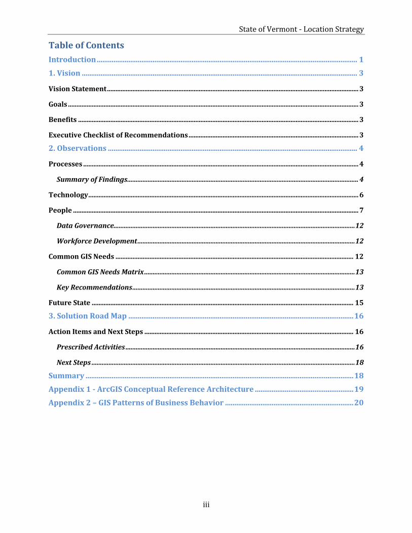
Table of Contents
Introduction ............................................................................................................................................ 1
1. Vision .................................................................................................................................................... 3
Vision Statement .................................................................................................................................................... 3
Goals ........................................................................................................................................................................... 3
Benefits ..................................................................................................................................................................... 3
Executive Checklist of Recommendations .................................................................................................... 3
2. Observations ...................................................................................................................................... 4
Processes .................................................................................................................................................................. 4
Summary of Findings ........................................................................................................................................ 4
Technology ............................................................................................................................................................... 6
People ........................................................................................................................................................................ 7
Data Governance.............................................................................................................................................. 12
Workforce Development ................................................................................................................................ 12
Common GIS Needs ............................................................................................................................................ 12
Common GIS Needs Matrix ............................................................................................................................ 13
Key Recommendations ................................................................................................................................... 13
Future State .......................................................................................................................................................... 15
3. Solution Road Map ......................................................................................................................... 16
Action Items and Next Steps ........................................................................................................................... 16
Prescribed Activities ....................................................................................................................................... 16
Next Steps ........................................................................................................................................................... 18
Summary ................................................................................................................................................ 18
Appendix 1 - ArcGIS Conceptual Reference Architecture ..................................................... 19
Appendix 2 – GIS Patterns of Business Behavior ..................................................................... 20

State of Vermont - Location Strategy
1
Introduction
The State of Vermont is a long-time user of geographic information systems (GIS), providing basic mapping and analysis to support priority initiatives that improve the quality of life for Vermonters. Over the years the State’s GIS has grown from a project-based solution to an enterprise information technology. Today, because GIS solutions can be delivered in innovative ways, and because organizations throughout the State are recognizing the business value of GIS, the demand for GIS continues to grow.
The growth of GIS has presented the State with both challenges and opportunities. One challenge is the difficulty in accessing and sharing accurate and timely information to support effective decision-making. This limits the ability to support initiatives, encourages data redundancy, and impedes the ability to deliver answers. Another challenge is related to how GIS software and expertise is distributed within the State, and how those resources are accessed. Some agencies have software, infrastructure, and subject matter experts, while others are time sharing, borrowing, or outsourcing work.
Despite these challenges, the State also has the opportunity to leverage its investments in information assets (location data), technology (location platform), and people to support the administrative priorities and operational needs of its agencies. Done well, this can help the State overcome the challenges described above and ultimately deliver a better quality of life to residents.
The State asked Esri to conduct an Envisioning Workshop to provide recommendations about how to address these challenges and opportunities. The goal was to understand how the State could most effectively utilize its investment in GIS, align its technology and supporting resources, and meet its business priorities and broader agency needs.
Esri’s Envisioning Workshop is designed to help our enterprise customers maximize their investment in GIS by understanding their business priorities, challenges, technology landscape, and future plans. To gather this information for the State of Vermont, we conducted a three-day workshop involving eleven agencies and interviewed several additional agencies via teleconference.
Our findings from the workshop identified these common themes across the agencies:
Agencies value location intelligence as a resource to help them make better decisions and communicate with the public, but they do not all have access to the required resources (expertise and tools).
There is a common desire to leverage web GIS (shared services).
GIS is viewed as a critical technology.
Agencies are looking for statewide direction/vision for GIS to help them achieve their business priorities.
Agencies are requesting GIS training so they can take advantage of tools more effectively.
There is widespread demand for the ability to have any employee be able to make maps as needed without having to go to a GIS person (self-service).
Agencies desire to integrate GIS with business systems and processes.
There are opportunities for maximizing the value through consolidation and improved access.
State of Vermont - Location Strategy
2
In this report, we’ve compiled our findings and described both a vision and a roadmap for the State’s use of GIS, complete with recommendations and proposed activities. One of the State’s goals is to establish a location platform that provides easy access to information across all levels of the State government. This vision will be achieved by developing a GIS shared services environment that allows users to discover, consume, and publish relevant geospatial information and tools.
Our recommendations focus on three primary areas: processes (business), technology, and people. The purpose of our recommendations across these areas is to establish a sustainable GIS enterprise environment, with the appropriate governance, that will support the current and future business needs of the State.
The report is divided in to three primary sections. Section 1 outlines the overall vision and goals. Section 2 reviews the departmental findings and provides recommendations on how the State can leverage GIS to support their business needs and priorities. Section 3 provides a set of activities the State can undertake to implement those recommendations.
As the State looks to gain efficiencies, maximize investments, and improve operations, it has recognized that GIS can also support the key characteristics that exemplify good government. For example, governments use GIS to support robust public services, promote safe and healthy communities, make intelligent plans and decisions, foster diverse cultural opportunities, sustain the environment, and drive a thriving economy.
As GIS technology has evolved, it has become even more pervasive. Today, GIS can be deployed across an entire organization to provide maps, information, and analysis tools to anyone who needs them. Because of these advancements, the State can more easily achieve its notion for good government by leveraging a common location platform that supports both short-term and long-term goals. GIS can help the State:
Provide shared services: A common, authoritative set of services, shared across multiple departments and business systems.
Deliver self-service mapping: Empower the State’s employees, citizens, and contractors to make, use, and share maps and geographic information.
Collaborate more effectively: Support effective cross-agency information sharing and collaboration, while reducing duplication.
Modernize workflows: Modernize departmental workflows to include capabilities like mobile editing, location enabled business systems, and dashboards.
Engage constituents: Improve and enhance transparency and the delivery of constituent services.
Esri’s location platform, which is already used by numerous Vermont agencies, supports and enables the State’s vision for collaboration, transparency, and performance improvements. Fully implemented, this platform will enable all Vermont employees to discover, use, make, and share geographic knowledge from any device, anywhere, anytime. The simple ability to manage and share authoritative content, such as municipal boundaries and address points, will be a tremendous step toward efficiency. When coupled with the use of mobile apps and workflows, configurable templates, location enabled business data, performance dashboards, and other aspects of the ArcGIS location platform, the State will be well positioned to improve the quality of life in Vermont both now and in the future.
State of Vermont - Location Strategy
3
1. Vision
Esri uses a vision statement as a high-level description of the desired future state—in other words, the way the organization will evolve to leverage location intelligence to support business in three or more years.
Vision Statement Support robust public services, promote safe and healthy communities, make intelligent plans and decisions, foster diverse cultural opportunities, sustain the environment, and drive a thriving economy.
Establishing a common location platform and programmatic leadership will enable Vermont to move toward this vision in an efficient, effective, and sustainable manner.
Goals Promote transparency in government and an engaged constituency through improved
and enhanced citizen services Provide a common and authoritative set of services to be shared across departments
and business systems Empower an efficient and effective workforce by improving and enhancing
departmental workflows Support effective cross-departmental information sharing and collaboration Implement an agile and standards-based approach for the configuration and
provisioning of apps and information products Identify opportunities for the growth and evolution of the State’s GIS governance model
Benefits Coordinated and aligned efforts across departments Increased agility in providing actionable intelligence Reduced overlaps in development efforts and data redundancy Mapping and analysis capabilities extended to non-GIS specialists Shared GIS expertise, creating a pool of skills and knowledge Enhanced connectivity, communication, and collaboration between stakeholders Reduced operating costs Improved transparency in government
Executive Checklist of Recommendations To help the State of Vermont better support current and future demand, Esri has prepared a series of recommendations to guide the State’s use of the ArcGIS platform. These recommendations are included in the Common GIS Needs section. In addition, an executive checklist for these recommendations is included in table 1.
State of Vermont - Location Strategy
4
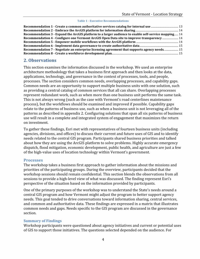
Table 1 - Executive Recommendations
Recommendation 1 - Create a common authoritative services catalog for internal use ......................................... 13 Recommendation 2 - Embrace the ArcGIS platform for information sharing ................................................................ 14 Recommendation 3 - Expand the ArcGIS platform to a larger audience to enable self-service mapping ...... 14 Recommendation 4 - Configure one Vermont ArcGIS Open Data site to improve transparency ........................ 14 Recommendation 5 - Empower mobile workflows with the ArcGIS platform ............................................................... 14 Recommendation 6 - Implement data governance to create authoritative data.......................................................... 15 Recommendation 7 - Negotiate an enterprise licensing agreement that supports agency needs. .................... 15 Recommendation 8 - Create a workforce development plan. .................................................................................................. 15
2. Observations
This section examines the information discussed in the workshop. We used an enterprise architecture methodology that takes a business first approach and then looks at the data, applications, technology, and governance in the context of processes, tools, and people, processes. The section considers common needs, overlapping processes, and capability gaps. Common needs are an opportunity to support multiple business units with one solution, such as providing a central catalog of common services that all can share. Overlapping processes represent redundant work, such as when more than one business unit performs the same task. This is not always wrong (such as the case with Vermont’s road centerlines maintenance process), but the workflows should be examined and improved if possible. Capability gaps relate to the patterns of business use, such as when a business unit is not leveraging all of the patterns as described in appendix 2. Configuring solutions that span all six patterns of business use will result in a complete and integrated system of engagement that maximizes the return on investment.
To gather these findings, Esri met with representatives of fourteen business units (including agencies, divisions, and offices) to discuss their current and future uses of GIS and to identify needs related to the central GIS program. Participants shared business priorities and talked about how they are using the ArcGIS platform to solve problems. Highly accurate emergency dispatch, flood mitigation, economic development, public health, and agriculture are just a few of the high-value uses of location technology within Vermont’s government.
Processes The workshop takes a business first approach to gather information about the missions and priorities of the participating groups. During the overview, participants decided that the workshop sessions should remain confidential. This section blends the observations from all sessions to provide a high-level view of what was discussed. The finding represent Esri’s perspective of the situation based on the information provided by participants.
One of the primary purposes of the workshop was to understand the State’s needs around a central GIS program and how Vermont might adjust the program to better support agency needs. This goal tended to drive conversations toward information sharing, central services, and common and authoritative data. These findings are expressed in a matrix that illustrates common needs and gaps. Needs specific to the GIS program are discussed in the governance section.
Summary of Findings Workshop participants were questioned about agency initiatives and current or potential uses of GIS to support those initiatives. The questions selected depended on the audience. For

State of Vermont - Location Strategy
5
example, some sessions were comprised only of GIS personnel, while others contained only line-of-business staff, or a mix of business people, decision makers, and GIS professionals. The sessions were conversations guided by common topics rather than scientific surveys.
All participants were asked if location intelligence improves state government effectiveness, and the great majority insisted that it does. What is interesting about this is that the participants and their represented agencies have a wide disparity in access to GIS. Still, people know that there are groups in the State using GIS to solve problems and that GIS is a powerful tool that supports decision making, regardless of whether they had no access or were part of a GIS program. Furthermore, many participants in a non-GIS role were able to describe in detail current or needed uses for the technology. This indicates that Vermont is broadly relying on GIS and that employees are aware of the capabilities that a GIS provides.
Another key topic in workshop sessions was that of data sharing. Most if not all participants expressed a need to share data with others and/or consume data from other agencies. Many outdated methods for data sharing create (undesirable) opportunities to use duplicate, outdated, or incorrect data as part of the decision making process. Technology improvements greatly reduce this risk while also making the process easier.
The data sharing topic can be divided into central data cataloging (for sharing authoritative data among agencies) and open data (for sharing with the public). In some cases, agencies simply need a way to securely share data and collaborate on projects. Some of the data that needs to be shared is common, such as road centerlines, address points, property boundaries, or water features. Every agency had something to share, needed something from another agency, or both. Importantly, participants expressed concern about centrally housing their sensitive data. We should reinforce the concept that any references to a central data catalog are related to making data shareable. Agencies should be responsible for decisions around which datasets are appropriate to share.
Additionally, many agencies have data to share with the public. There is an existing process for this workflow through VCGI, but participants said the process took too long or was too labor intensive, resulting in outdated data being published to the clearinghouse. Some participants are looking for alternative solutions that will allow them to share more easily. Participants also discussed the need to collaborate with the public, such as when a citizen is allowed to suggest an address location, file a complaint about a specific place, or comment on a policy (e.g., proposed zoning amendments). This type of workflow was not broadly discussed, but it did come up in several conversations as something the State should be applying more comprehensively.
Along with sharing and accessing authoritative data, many participants discussed mobile workflows. Some agencies are already using GIS-based mobile applications, some are experimenting with them, and some expressed a specific need for them. Some participants did not know that mobile GIS capabilities were available to them but indicated that these capabilities could significantly help their current workflows.
A very common workflow mentioned was spatial analysis, where location data and associated attributes are modeled to produce actionable information. Agencies with GIS groups use spatial analysis to support many decisions. Most people in a GIS role, as well as decision makers with access to GIS resources, expressed the need for more analysis. The main challenge stated was that GIS resources are busy “data wrangling” or performing other aspects of their
State of Vermont - Location Strategy
6
jobs and do not always have the time needed to apply existing methods or learn new analysis techniques. Participants from agencies without GIS teams often rely on other agencies’ experts to perform spatial analysis.
Analysis is often more complete and effective when location data is combined with attributes from external systems. Several participants brought up integration with external systems, such as using property ownership information to enrich geographic data, using elevation data as part of site analysis, or otherwise associating location with tabular data to conduct analysis. A precursor to this type of analysis is enterprise integration, where external business system data and location data are combined by bringing business data to a GIS (geocentric), by putting GIS capabilities in a business system (geo-enable), or creating a composite app that combines both types of data in a new system. The topic of enterprise integration would be more heavily discussed in an information architecture context, which was not a workshop focus, so specific examples of business systems were not captured. The need for enterprise integration is inferred from the types of analysis that participants discussed.
Though the workshop audience was largely comprised of people with direct access to GIS software or capabilities, especially in the overview session, the need to expand these capabilities to more people was clear. For those in a GIS role, location enabling the workforce meant people would be able to use authoritative information products, or make their own maps from authoritative information, which would leave GIS departments with more time to perform data management or analysis tasks. For those in a business role, having access to GIS capabilities meant getting information faster. Non-GIS personnel emphatically responded that having the ability to easily create and use maps, especially with access to authoritative data, would be very beneficial to their jobs.
The common thread of information sharing ran through the sessions. The ability to share, access, combine, and manipulate data, collaborate with others, and better leverage GIS to support the State’s key initiatives summarizes the needs expressed by participants.
Technology Technology represents the hardware, software, and network infrastructure that is the physical foundation of information systems. The workshop touched on technology such as ArcGIS for Desktop, ArcGIS for Server, ArcGIS Open Data, and ArcGIS Online. One notable trend was that some participants had access to software licensing, while others were resigned to sharing licenses or relying on other agencies to do the work. Not every agency has the expertise to fully leverage professional GIS software, but many more people could benefit from access to ArcGIS Online and contribute their effort and expertise to workflows. Agencies that do have licenses may benefit from a centralized license model, which would reduce the number of procurements and contribute to a more strategic approach to distribution and provisioning. GIS professionals should also have access to the latest versions, which introduce greater capabilities.
Several agencies are using ArcGIS for Server on-premises as part of their platform implementation. Those agencies have the ability to location enable business data, connect to external systems and services, support workflows with a suite of apps, and provide their enterprise and/or external stakeholders with geographic services. To help those agencies implement and use the platform, we have included the ArcGIS Conceptual Reference Architecture diagram as Appendix 1. Additionally, our document “Architecting the ArcGIS
State of Vermont - Location Strategy
7
Platform: Best Practices” is available on the Esri website (www.esri.com/~/media/Files/Pdfs/products/arcgis-platform/architecting-the-arcgis-platform).
A location platform represents a shift from delivering GIS capabilities in an enterprise-style thick client/server implementation to providing location, mapping, and GIS functionality through GIS services and lightweight web and mobile applications. ArcGIS includes a large number of desktop, web, and mobile applications and templates that support each of the six patterns of use. ArcGIS apps and templates expose content and capabilities and the information-sharing model, as well as geocentric and geo-enabled systems. The ArcGIS platform provides a variety of integration options as well as standards-based developer APIs for working with maps and data.
People Governance Overview One workshop goal was to identify opportunities for the growth and evolution of the State’s GIS governance model. The State has a strong foundation that consists of skilled and knowledgeable people, a culture of community, and a desire to evolve and improve the use of location for decision support.
Conceptually, governance is a framework, a cultural orientation, and a set of owned responsibilities that improve the integrity and effectiveness of the organization's use of IT. Two basic goals of governance are to maximize the value of technology investments and to minimize risks. Since the GIS domain is part of the technology landscape, IT governance should be applied to GIS.
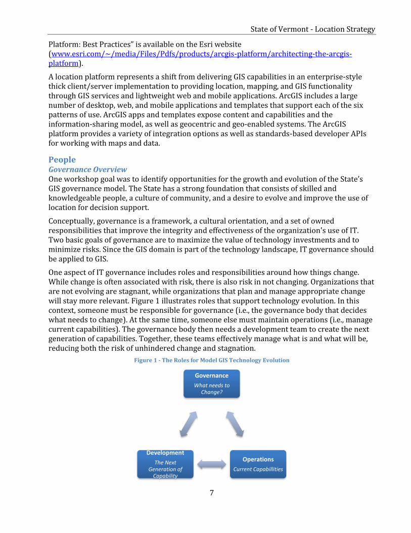
One aspect of IT governance includes roles and responsibilities around how things change. While change is often associated with risk, there is also risk in not changing. Organizations that are not evolving are stagnant, while organizations that plan and manage appropriate change will stay more relevant. Figure 1 illustrates roles that support technology evolution. In this context, someone must be responsible for governance (i.e., the governance body that decides what needs to change). At the same time, someone else must maintain operations (i.e., manage current capabilities). The governance body then needs a development team to create the next generation of capabilities. Together, these teams effectively manage what is and what will be, reducing both the risk of unhindered change and stagnation.
Figure 1 - The Roles for Model GIS Technology Evolution
Governance
What needs to Change?
Operations
Current Capabillities
Development
The Next Generation of
Capability

State of Vermont - Location Strategy
8
Governance Role The State often realizes a high return on investment from applying technology to programs that broadly impact its citizens. Benefits in improved public safety, a better economy, and healthier citizens, for example, can greatly exceed the cost of that technology, but only if the technology actually supports programs. Vermont’s E9-1-1 GIS program is a clear example of realizing great benefits from applied technology. Thanks to the technology and the people who use it, responders are able to arrive at the scene faster and more safely than ever, resulting in many lives saved. In this instance, additional quantitative measurement is probably not necessary, as most would agree that the value of human life exceeds the cost of technology.
Conversely, there may be examples of technology implementations that struggle to return value. The role of governance is meant to determine what needs to change in a way that the benefits will likely exceed the cost. The role encompasses the leadership, responsibility, and decision authority for solution portfolios and associated resource support in operations and development. This would include necessary practices, procedures, and policies, with the result being technology that better supports the business.
Operations Role The operations role manages, maintains, and uses current capabilities. It consists of resources responsible for enabling and supporting the current-state portfolio of business capabilities for the enterprise, as well as resources responsible for using the capabilities to support the mission (e.g., responders). It can be a challenge to move new capabilities out of the care of the developers, because it often requires knowledge transfer from the development team, training, and capacity to support new work. The role of operations is to apply the technology to the business need and keep it working so that it has the opportunity to return value.
Often, new solutions are acquired but not properly implemented or maintained. Failure to operationalize technology is typically a result of poor governance (e.g., when the technology does not directly support business needs), or from an under-resourced operations role. Effective governance can guard against both of these scenarios by limiting the development of new capabilities that either don’t have strong potential to return value, or that cannot be supported by operations. The governance role should recognize when operations needs additional resources and make adjustments, or delay development of new capabilities that operations will be expected to support.
Development Role The purpose of the development role is to build the next generation of capability as directed by the governance team. In the context of a State central GIS office, this role covers core services that support or enable all agencies as opposed to application development of agency specific solutions. Once completed, the development team must hand off the new capability to operations, perform the requisite knowledge transfer, and move on to the next project. The development role is challenged by a lack of operationalization and by emotional attachment to the delivered capability. Failure to operationalize is expensive due to funded, albeit unused development and because operational needs remain unfulfilled.
Current State The State of Vermont maintains a long-established GIS program, which serves as a strong support entity ensuring the continued success of GIS, both in the State’s organizational structure and the broader community. As the program evolves, it will be important to maintain
State of Vermont - Location Strategy
9
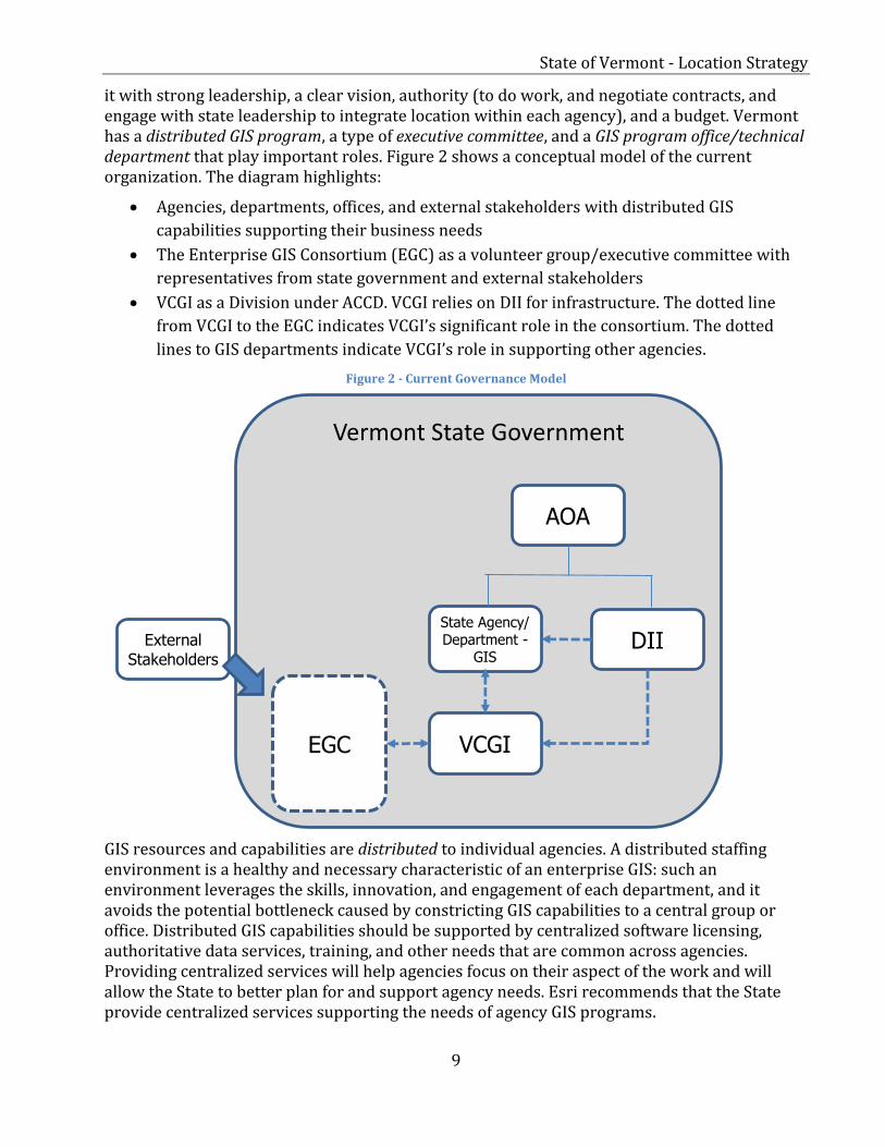
it with strong leadership, a clear vision, authority (to do work, and negotiate contracts, and engage with state leadership to integrate location within each agency), and a budget. Vermont has a distributed GIS program, a type of executive committee, and a GIS program office/technical department that play important roles. Figure 2 shows a conceptual model of the current organization. The diagram highlights:
Agencies, departments, offices, and external stakeholders with distributed GIS
capabilities supporting their business needs
The Enterprise GIS Consortium (EGC) as a volunteer group/executive committee with
representatives from state government and external stakeholders
VCGI as a Division under ACCD. VCGI relies on DII for infrastructure. The dotted line
from VCGI to the EGC indicates VCGI’s significant role in the consortium. The dotted
lines to GIS departments indicate VCGI’s role in supporting other agencies.
Figure 2 - Current Governance Model
GIS resources and capabilities are distributed to individual agencies. A distributed staffing environment is a healthy and necessary characteristic of an enterprise GIS: such an environment leverages the skills, innovation, and engagement of each department, and it avoids the potential bottleneck caused by constricting GIS capabilities to a central group or office. Distributed GIS capabilities should be supported by centralized software licensing, authoritative data services, training, and other needs that are common across agencies. Providing centralized services will help agencies focus on their aspect of the work and will allow the State to better plan for and support agency needs. Esri recommends that the State provide centralized services supporting the needs of agency GIS programs.
AOA
DII State Agency/ Department -
GIS External
Stakeholders
EGC VCGI
Vermont State Government
State of Vermont - Location Strategy
10
The Enterprise Geospatial Consortium (EGC) serves as a form of executive committee that helps drive policy and provide direction. While the EGC connects the individual agencies and has likely been responsible for many successful partnerships and accomplishments, its authority seems to reside largely in consensus. A governing body decides what needs to change and must have the authority, leadership, and budget to assign work. The academic nature of this committee gives agencies a forum for voicing needs and concerns, developing partnerships, and collaborating, all of which are of great value to the State. However, the EGC’s role as “a voluntary consortium of state government organizations” limits its ability to be a governing body. Esri recommends that the State formalize the reporting structure to allow all State agencies and stakeholders to funnel needs to the State’s GIS Program Office via the EGC or some other method.
The Vermont Center for Geographic Information (VCGI) serves as the GIS program office/technical department. VCGI has responsibilities covering policy, community, framework data (national spatial data infrastructure, or NSDI), common services, training and outreach, contract management, and data dissemination via a central portal. These capabilities are important to the agencies and contribute to the success of the State, but VCGI does not have the required authority, personnel, or budget to manage all aspects of the State’s GIS program. For example, all four employees of VCGI are members of the EGC, and they may also be responsible for developing new capabilities and managing current capabilities. The mixture of governance, development, and operations, coupled with limited authority and budget, likely impedes VCGI’s ability to be productive in the way that agencies expect. In the current state, it will be a challenge for VCGI to create, deliver, and maintain the centralized services alongside other critical responsibilities.
Future State There are many ways to structure a state GIS program office. Some states have grown organically into their model, while others seek to improve the way GIS is supported because they recognize the value of location intelligence to the business of government. The “right way” will vary with the culture and environment, but there are some characteristics shared by successful state GIS programs.
These characteristics help set the stage for an efficient and effective GIS management authority: a GIS program that can reduce redundancy, provide leadership and strategy, and support the needs of the state. Within successful state GIS programs:
GIS is viewed as enterprise technology across the organization and is governed and budgeted accordingly.
GIS as a program has executive visibility and technology direction, and it is not isolated from the business.
IT provides strong support, whether through ownership or partnership. Departments maintain professional GIS staff to support direct line-of-business
workflows. GIS is staffed and trained to meet organizational measures of success and to minimize
knowledge gaps.
The absence of one or more of these characteristics can lead to stagnation, stovepipes, redundancy, or underutilization. These are all conditions that Vermont is seeking to reduce or avoid entirely.

State of Vermont - Location Strategy
11
To support this concept, we can look at Roger Tomlinson’s1 general description of enterprise systems in a comparison of departmental, enterprise, and community systems.
GIS supports strategic business activities throughout the organization. Benefits are often measured by overall success of the organization. Centralized support for the GIS is required (multiple departments utilize shared
resources). System life cycle planning is required. Corporate (executive) management support is essential.
While Tomlinson’s enterprise system scope applies to a statewide GIS program, his description of a community of enterprises is an even better fit for Vermont as a large enterprise with existing programs.
GIS supports the common goals of a community of enterprises. Benefits often measured by overall common community good. Centralized management of services benefitting multiple enterprises. Common standards and service support agreements for resource sharing. Community support for central leadership is important.
Many agencies in Vermont have their own GIS capabilities and many are interested in leveraging the capabilities of others. Tomlinson’s concept of a community of enterprises matches very well against the needs stated by participants, who were looking for common and authoritative services, common standards, and a mechanism for more efficient sharing.
Vermont’s agencies are using GIS to support the State’s largest initiatives (such as water quality, public safety, public health, and economic development) because they recognize the value that location information contributes to their effort. Because of this high level of usage, it seems prudent to provide enterprise-level support to the agencies; this will let them focus on their business and rely on a central program office to provide common services, standards, and training.
VCGI is attempting to support agency GIS programs, external stakeholders, the EGC, and the public. However, their success is limited by their lack of authority, resources, and funding. Vermont needs a central GIS program office (GPO) to support the State’s community of enterprises. The program office must have the authority, resources, and funding to operate in the enterprise scope. The GPO must also be positioned outside of a line-of-business agency, so that agency priorities do not monopolize the GPO. If Vermont expects VCGI to be the governing entity driving the enterprise GIS program, then VCGI needs to be empowered with the appropriate authority and funding to execute the accompanying responsibilities, and VCGI must be moved out of a line-of-business agency. While Vermont’s agencies need and expect enterprise-level support from a central GIS program office, Vermont’s current governance structure doesn’t support the development of a strong enterprise GIS environment. If the State wants to realize the benefits from such an environment, then the organization needs to be restructured accordingly.
1 Roger Tomlinson, Thinking About GIS, 5th Edition (Redlands: Esri Press, 2013), 3-4
State of Vermont - Location Strategy
12
Data Governance Another aspect of governance is how the State’s data is managed, maintained, and shared. While not specifically a focus of the workshop, these topics were a natural progression of discussions around sharing, use of GIS, and future needs.
Participants spoke of numerous data sets in the context of priority initiatives. Many agencies have data that they want to share with the public and/or other agencies. Some agencies need data that others maintain. In the current environment, sharing is not as easy as it could be, especially for agencies that do not have a GIS team.
One common method of sharing is to email files, or ship on a hard drive, but file-based sharing can lead to the creation of redundant, static, and outdated data. This pattern of sharing challenges data stewards, who work hard to create and maintain authoritative data, but then lose control when static copies escape. Similarly, when a data set is updated regularly, but only officially shared once or twice per year, consumers may find unofficial ways to acquire the data. These methods are not inherently wrong. They have been effective solutions for agencies with means and access. They are, however, much less efficient than they could be if data managers were able to perform updates to authoritative data in a known or easily discoverable location.
Maintaining authoritative data requires data governance to ensure there is one steward, an appropriate quality standard, documentation in the form of metadata that consumers can evaluate, and change control. Vermont likely has governance in place for some data, such as aerial imagery, and not every dataset will be governed with the same level of rigor. Since agencies continue to find alternative and unique ways to share, perhaps the State would benefit from making the task easier and the results more consistent.
Workforce Development Most participants indicated that they could benefit from more training to better use GIS to support agency missions, expand the use of the ArcGIS platform, or maintain enterprise servers. For example, the ANR GIS Business Plan identifies career track development as a work item meant to further the agency’s strategic goals, but it is unclear how well supported the item is.
Workforce development is an investment meant to equip an organization’s most valuable asset—its people—with the knowledge and experience to proficiently use and expand the reach of the ArcGIS platform. Devoting resources towards workforce development will result in greater value achieved and a faster return on investment from the ArcGIS platform. With a trained workforce, Vermont will be able to use the ArcGIS platform efficiently and effectively, set and achieve goals, and build a culture of self-reliance and expertise.
Common GIS Needs Several common needs emerged from the compiled findings. Common needs are a good place to look for opportunities to maximize value and improve the return on investment, since many people will realize the benefits gained through process improvement. Additionally, Esri has identified some common patterns that will help to augment your understanding of how the platform can be used to support your needs. These patterns are included as the Patterns of GIS Business Use in Appendix 2.

State of Vermont - Location Strategy
13
Common GIS Needs Matrix The top row shows the organizations represented in the workshop, and the left column lists needs that were common among multiple sessions. Note that participants attempted to represent the interests of their organization, but the nature (e.g., duration, audience, topics) of the sessions may have constrained conversations. As a result, the matrix in table 2 shows general trends rather than specific needs.
Table 2 - Common GIS Need Matrix
AC
CD
AG
R
AH
S
AN
R
AO
A
AO
E
AO
T
BG
S
DII
E9
11
FP
R
RP
C
Ta
x
VC
GI
VS
AR
A
Common, Authoritative Services
Information Sharing
Self Service Mapping
Open Data
Mobile Workflows
Data Governance
Enterprise Licensing Workforce Development
Common Needs In Use Partial Needed
Key Recommendations Common Need 1 - Common, Authoritative Services
Participants said they maintain data needed by other agencies and/or rely on the data of other agencies to support workflows. Most participants expressed interest in a central source of authoritative data. Common services support the work of many, while being maintained by a few. This is not a new concept to Vermont, but participants indicated that having one destination, a catalog of current and authoritative data, would save time and improve data quality.
Recommendation 1 - Create a common authoritative services catalog for internal use
Provide a destination for all State employees to find the data they are authorized to access. A central data catalog will promote sharing and collaboration, eventually becoming a workflow inherent to everyday operations, and it will foster increased decision quality. Identity practices would allow datasets to be secure, but shareable.
Pattern Alignment: Location Enablement, Data Management, Analysis, and Operational Awareness
State of Vermont - Location Strategy
14
Common Need 2 - Information Sharing Agencies collaborate on projects, and geography is often the common aspect of the work.
Recommendation 2 - Embrace the ArcGIS platform for information sharing
Empower employees and contractors with the ArcGIS platform as an information sharing environment. The State should empower teams to collaborate and share information, works in progress, and new ideas seamlessly to make interagency projects more efficient.
Pattern Alignment: Location Enablement, Data Management, and Operational Awareness
Common Need 3 - Self-Service Mapping Many participants expressed a need to expand the power of location intelligence beyond the limited number of GIS professionals.
Recommendation 3 - Expand the ArcGIS platform to a larger audience to enable self-service mapping
The ArcGIS platform was designed specifically to enable self-service mapping and act as a system of engagement for organizations. Self-service mapping allows people, especially those not typically considered GIS users, to easily create and share maps and information products. It also relieves the pressure on GIS professionals, allowing them to spend more time on complex tasks rather than producing or tweaking maps. Leverage Portal for ArcGIS and/or ArcGIS Online to extend GIS to more people. Start by presenting some common information products that people can use, and expand privileges so that more people can make and share maps.
Pattern Alignment: Location Enablement, Data Management, Analysis, Visualization, and Field Mobility
Common Need 4 - Open Data Participants expressed the desire to share certain information to the public and maintain some level of transparency; some agencies already have ongoing initiatives.
Recommendation 4 - Configure one Vermont ArcGIS Open Data site to improve transparency
Open data allows organizations to provide citizens and external stakeholders with access to authoritative data, but it assumes that datasets are current, accurate, and easy to find. According to participants, the existing process takes too long, leaving the public with outdated data. There are also several websites where the public can go to look for data, which could lead to confusion or accuracy issues. Configure one ArcGIS Open Data site for public discovery and consumption of authoritative data, or provide easy navigation between sites. Allow all agencies to contribute and maintain their own data following guidelines developed for this purpose.
Pattern Alignment: Location Enablement, Data Management, Visualization, and Constituent Engagement
Common Need 5 - Mobile Workflows Agencies employ field workers that sometimes work in remote or disconnected environments.
Recommendation 5 - Empower mobile workflows with the ArcGIS platform
Provide agencies that perform mobile workflows with access to the ArcGIS platform, so they can configure tools that support their business. The ArcGIS platform enables these mobile workers to get information into and out of the field in real time, or in a disconnected workflow.
State of Vermont - Location Strategy
15
Participants suggested workflows (such as inspections, assessments, and field reports) that would benefit from location enabled mobile reporting.
Pattern Alignment: Location Enablement, Data Management, Visualization, and Field Mobility
Common Need 6 - Data Governance Data governance, combined with an information sharing environment will help agencies easily find and use authoritative data.
Recommendation 6 - Implement data governance to create authoritative data
Continue to develop and expand policies that identify data stewards and the processes that enable authoritative data to be created, managed, and shared.
Pattern Alignment: Location Enablement, Data Management
Common Need 7 - Enterprise Licensing An enterprise license agreement is a more cost-effective and efficient way to provide state agencies access to the ArcGIS platform.
Recommendation 7 - Negotiate an enterprise licensing agreement that supports agency needs.
Standardize access, reduce procurement overhead, and location enable the State through an enterprise license agreement.
Pattern Alignment: Location Enablement, Data Management, Analysis, Field Mobility, Visualization, and Constituent Engagement
Common Need 8- Workforce Development Workforce development consists of online courses, instructor-led training, hands-on learning, video seminars, user conferences, certification tracks, books, and more. Esri can assist Vermont with creating a workforce development plan if needed.
Recommendation 8 - Create a workforce development plan.
Help employees use and apply GIS in support of the State’s priorities.
Pattern Alignment: Location Enablement, Data Management, Analysis, Field Mobility, Visualization, and Constituent Engagement
Future State The future state considers the vision, the building blocks that can contribute to future success, and the metrics that help quantify success. One of the workshop goals was to capture the current situation, especially as it would relate to the State’s vision. The workshop, while brief, identified several common needs that are associated with priorities, and it identified strengths that can be leveraged to move toward the future state.
The vision of efficient and effective services supporting Vermont’s citizens, the economy, the environment, and other priorities requires a collaborative effort from all agencies. Collaboration is made easier by technology, but it also requires an appropriate culture.
Vermont has pockets of GIS expertise mixed with a broader culture of geocentric thinkers—people who express value in maps, location, and the intelligence that GIS can provide. This includes the GIS professionals who participated in the workshop, but the concept also extends to people who were not in a GIS role. People in a variety of roles were able to describe
State of Vermont - Location Strategy
16
workflows in terms of GIS analysis, visualization, constituent engagement, and other patterns of use. There is an opportunity for the State to leverage this thinking by extending authoritative data and tools to a larger audience. This culture extends across the domains of health, safety, economics, and the environment and touches every participant that contributed to the workshop.
In the governance section, Vermont’s GIS capabilities were described as distributed, meaning that some agencies have developed infrastructure, experience, data, and workflows to support aspects of their business. The future state of these distributed capabilities should be an interconnected or at least inter-connectable system. The future is a culture of information sharing that engages the workforce, simplifies workflows, and supports the business of the State. People will use geography to solve problems, make decisions, share knowledge, and communicate ideas.
Progress toward this future state needs to be measureable so resource adjustments can be made towards the successful implementation of items on the roadmap. Vermont will need to identify metrics to track the roadmap’s progress. Metrics might include key performance indicators (KPI) related to a State initiative, such as ways that ArcGIS contributes to the economy, crime reduction, or emergency response time. KPIs might also support system availability at the State or agency level. Operations Dashboard for ArcGIS can be used to display business KPIs, and System Monitor can track the performance and availability of the ArcGIS platform.
Vermont’s lines of business are using GIS to support their missions, as evidenced by the organic growth in GIS use that has resulted in distributed capabilities. The current distributed capabilities provide many building blocks that can be used to support the vision. An information-rich location platform is necessary to support Vermont’s future capabilities. The State can help agencies be more efficient and effective by leveraging the current culture and capabilities, even as the State works towards an interconnected system of engagement that supports the patterns of business use and the metrics needed to track progress.
3. Solution Road Map
The solution road map provides a list of activities designed to help the State accomplish its goals. This strategic roadmap identifies milestones that support the needs expressed by participants of the workshop.
Action Items and Next Steps Prescribed Activities Esri provides the following activities to help Vermont achieve long-term goals and to begin realizing early success.
Activity 1: Staff and equip the GIS Program Office with the appropriate authority, resources, and funding. A GIS Program Office with strong leadership, a clear vision, authority to do work and negotiate contracts, and budget to pay for that work will be better equipped to support Vermont’s community of enterprises. The office will need personnel to support the governance role (e.g., policy development, change management, and executive collaboration), the operations role (e.g., maintaining existing services and capabilities), and the development role (e.g., creating the new capabilities deemed necessary by governance).
State of Vermont - Location Strategy
17
Esri Accelerators: Esri, or Esri partner, resources can be used to fill short-term gaps in resourcing:
Esri Professional Services provide access to short-term or incremental help with a specific technical requirement.
Project Services allow customers to collaborate with our consultants to develop the right solution.
Enterprise Services provide assistance in identifying hardware, software, and network infrastructure requirements for an enterprise GIS.
Recommendations Supported: #6
Activity 2: Implement a central ArcGIS Open Data portal There are currently at least four open data sites provided by Vermont agencies. Agency attempts at transparency might benefit from a more strategic approach, which would allow citizens to more easily find data, make data management easier, and allow server infrastructure resources to be combined into a more robust environment. By implementing a services approach, the state agencies can expose real-time data and do not have to take valuable time and resources to duplicate data, which also makes it immediately outdated.
Esri Accelerators: Under the Esri Enterprise Advantage Program, a technical advisor can:
Coordinate the development of a robust system architecture that will help Vermont
meet its desired Service Level Agreement (SLA) for an ArcGIS Open Data portal.
Help Vermont make the ArcGIS Open Data portal a destination that promotes
transparency in government.
Recommendations Supported: #4
Activity 3: Implement an information sharing environment Participants almost universally indicated a need to share with or consume information from others. Whether sharing across agency boundaries, or across the aisle, advancements in technology have made information sharing with dynamic data easier than ever.
Esri Enablers: The ArcGIS platform as a system of engagement enables ubiquitous, but secure, identity controlled access to location intelligence, giving people the ability to discover and use geographic information as part of their daily routines. Several agencies are using ArcGIS to support their missions, but the capabilities are not yet widely distributed. Expanding access to the platform will allow users to share and collaborate.
Esri Accelerators:
Esri Professional Services can assist with system architecture, portal configuration, information product development, and other aspects of Vermont’s platform implementation.
An Enterprise License Agreement (ELA) may help the State remove licensing barriers for agencies that currently have limited or no access to GIS capabilities.
Recommendations Supported: #1,2,3, and 5
State of Vermont - Location Strategy
18
Activity 4: Develop the workforce Vermont’s staff needs to stay current on the latest methods, trends, and capabilities so they can apply modern techniques to real-world challenges. People need to understand modern analysis techniques, how to maintain on-premises servers, how to configure high-value information products, or how to develop new tools. Training, education, and knowledge transfer are key ways to help employees stay current, efficient, and effective at using location to solve problems.
Esri Enablers: Esri has a wide variety of training options available, including free and low-cost web courses, seminars, and events. Instructor-led training is also a good option for getting individuals and teams up to speed quickly.
Esri Accelerators: An Esri training coordinator can assist the State (at no charge) with developing a training plan that leverages the appropriate methods for Vermont.
Recommendations Supported: #8
Next Steps 1. Identify and prioritize the activities to be acted upon 2. Identify Esri accelerators needed to hasten the implementation of capabilities 3. Refresh the roadmap in 18 months
Summary
The State of Vermont is continuing to evolve as it looks for ways to make government more productive, responsive, and transparent. A component of that evolution is the ability to leverage location information as a State asset and to employ the State’s people, processes, and technology as building blocks for a sustainable future. To that end, Vermont partnered with Esri to conduct an Envisioning Workshop meant to identify current priorities, common and overlapping needs, opportunities for improved governance, and a strategic roadmap.
By participating in the Envisioning Workshop, Vermont has completed the first step toward a more strategically focused GIS program. While many of the State’s agencies have developed GIS capabilities, organized themselves into a coordinated body, and created collaborative teams, the organic growth is leaving many people underserved. Some agencies have little or no GIS capability, while others have a strong program that still does not reach all divisions, departments, or offices (i.e., people) within the organization. This more strategic approach will allow Vermont to evolve the building blocks of knowledge, skills, relationships, governance, and technology into an efficient, effective, and sustainable model. This approach exposes the benefits of applying location to the decision making process to all state employees, without requiring deep knowledge or experience with GIS technology.
Esri is proud to partner with the State of Vermont in this strategic effort. Vermonters share Esri’s belief that geography is at the heart of a more resilient and sustainable future. The combination of Vermont’s building blocks with Esri technology and expertise will continue to enhance the State’s economy, safe and healthy communities, education, environment, and other aspects of good government valued by Vermont.

State of Vermont - Location Strategy
19
Appendix 1 - ArcGIS Conceptual Reference Architecture
State of Vermont - Location Strategy
20
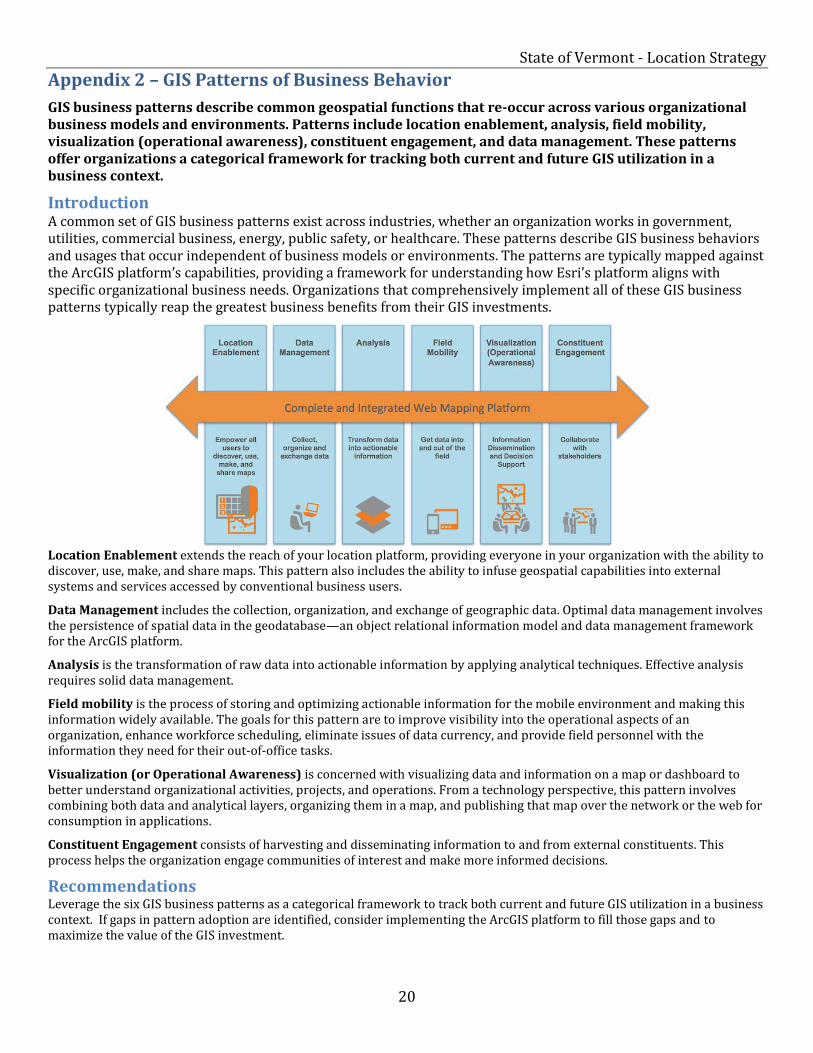
Appendix 2 – GIS Patterns of Business Behavior
GIS business patterns describe common geospatial functions that re-occur across various organizational business models and environments. Patterns include location enablement, analysis, field mobility, visualization (operational awareness), constituent engagement, and data management. These patterns offer organizations a categorical framework for tracking both current and future GIS utilization in a business context.
Introduction A common set of GIS business patterns exist across industries, whether an organization works in government, utilities, commercial business, energy, public safety, or healthcare. These patterns describe GIS business behaviors and usages that occur independent of business models or environments. The patterns are typically mapped against the ArcGIS platform’s capabilities, providing a framework for understanding how Esri’s platform aligns with specific organizational business needs. Organizations that comprehensively implement all of these GIS business patterns typically reap the greatest business benefits from their GIS investments.
Location Enablement extends the reach of your location platform, providing everyone in your organization with the ability to discover, use, make, and share maps. This pattern also includes the ability to infuse geospatial capabilities into external systems and services accessed by conventional business users.
Data Management includes the collection, organization, and exchange of geographic data. Optimal data management involves the persistence of spatial data in the geodatabase—an object relational information model and data management framework for the ArcGIS platform.
Analysis is the transformation of raw data into actionable information by applying analytical techniques. Effective analysis requires solid data management.
Field mobility is the process of storing and optimizing actionable information for the mobile environment and making this information widely available. The goals for this pattern are to improve visibility into the operational aspects of an organization, enhance workforce scheduling, eliminate issues of data currency, and provide field personnel with the information they need for their out-of-office tasks.
Visualization (or Operational Awareness) is concerned with visualizing data and information on a map or dashboard to better understand organizational activities, projects, and operations. From a technology perspective, this pattern involves combining both data and analytical layers, organizing them in a map, and publishing that map over the network or the web for consumption in applications.
Constituent Engagement consists of harvesting and disseminating information to and from external constituents. This process helps the organization engage communities of interest and make more informed decisions.
Recommendations Leverage the six GIS business patterns as a categorical framework to track both current and future GIS utilization in a business context. If gaps in pattern adoption are identified, consider implementing the ArcGIS platform to fill those gaps and to maximize the value of the GIS investment.