surface analysis tools - seek
TRANSCRIPT
Surface Analysis ToolsSurface Analysis Tools

Lesson 7 overviewLesson 7 overview
Topographic dataTopographic dataSourcesSourcesUsesUses
Topographic analysis Topographic analysis HillshadeHillshadeVisibilityVisibilityContoursContoursSlope, aspect, and curvatureSlope, aspect, and curvature
Exercise 11Exercise 11
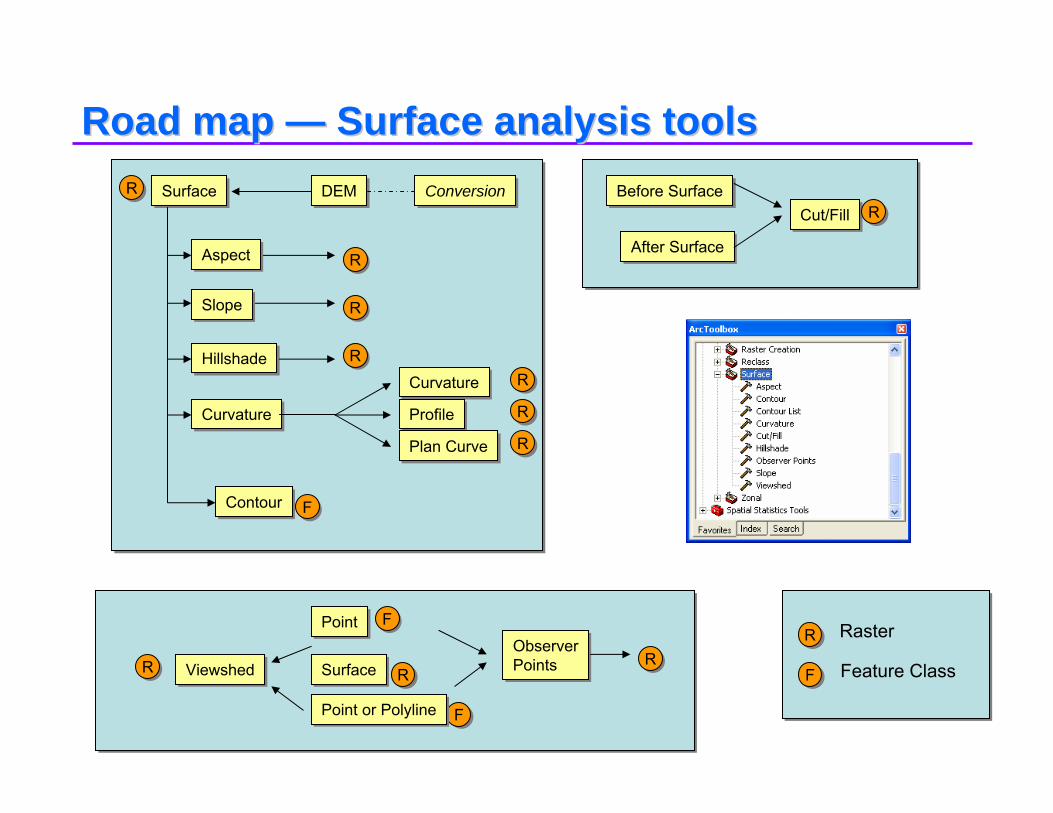
Road map Road map —— Surface analysis toolsSurface analysis toolsSurfaceSurface DEMDEM
AspectAspect
SlopeSlope
HillshadeHillshade
CurvatureCurvature
ContourContour
CurvatureCurvature
ProfileProfile
Plan CurvePlan Curve
Before SurfaceBefore Surface
After SurfaceAfter Surface
Cut/FillCut/FillConversionConversion
RR
FF
RR
RR
RR
RR
RR
RR
FF
RR
RR
Raster
Feature ClassRRRRRR
FF
FF
ViewshedViewshed
PointPoint
SurfaceSurface
Point or PolylinePoint or Polyline
ObserverPointsObserverPoints

Sources of topographic dataSources of topographic dataUS Federal GovernmentUS Federal Government
United States Geological Survey (USGS): OEMUnited States Geological Survey (USGS): OEM•• Several resolutionsSeveral resolutions
National Elevation Dataset (NED)National Elevation Dataset (NED)National Imagery and Mapping Agency National Imagery and Mapping Agency (NIMA): DTED(NIMA): DTED
± ½ of contour interval3 arc-second1 degree
± ½ of contour interval2 arc-second30 minute
± ½ of contour interval2 arc-second15 minute
± 15 meters30 meter7.5 minute
Z AccuracyZ AccuracySpacingSpacing

Surface conversionSurface conversion
Convert surface formats into rastersConvert surface formats into rastersASCII to RasterASCII to RasterDEM to Raster (Digital Elevation Model)DEM to Raster (Digital Elevation Model)DTED (Digital Terrain Elevation Data) is a direct read format DTED (Digital Terrain Elevation Data) is a direct read format for ArcGISfor ArcGIS
Output name with no extension returns a gridOutput name with no extension returns a grid

Using surfaces in ArcGIS Spatial AnalystUsing surfaces in ArcGIS Spatial Analyst
•• ArcGIS Spatial Analyst provides tools to ArcGIS Spatial Analyst provides tools to derivederive
•• Also hydrologic modelingAlso hydrologic modeling
HillshadeHillshade AspectAspect ContourContour
CurvatureCurvatureSlopeSlope
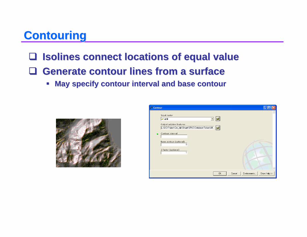
ContouringContouring
IsolinesIsolines connect locations of equal valueconnect locations of equal valueGenerate contour lines from a surfaceGenerate contour lines from a surface
May specify contour interval and base contourMay specify contour interval and base contour
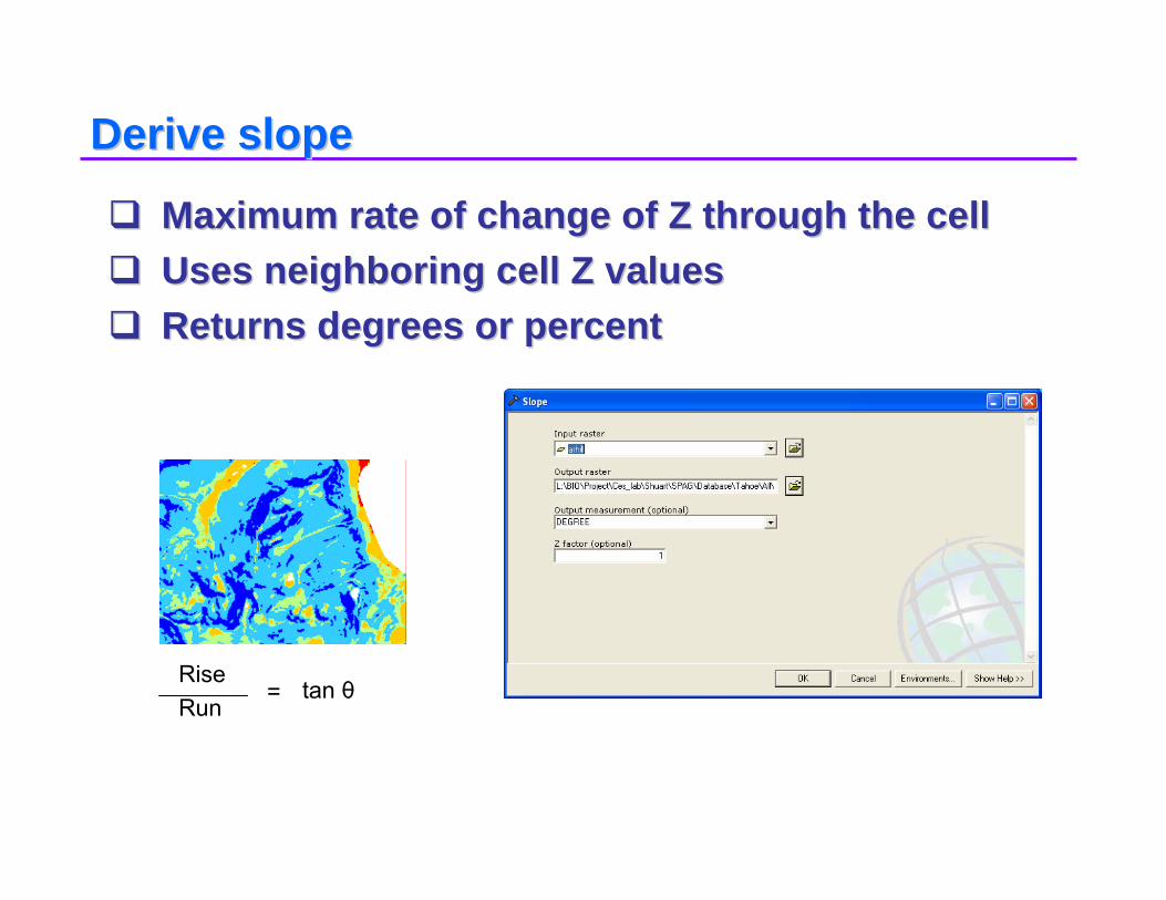
Derive slopeDerive slope
Maximum rate of change of Z through the cellMaximum rate of change of Z through the cellUses neighboring cell Z valuesUses neighboring cell Z valuesReturns degrees or percentReturns degrees or percent
RiseRun
= tan θ
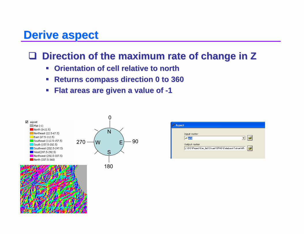
Derive aspectDerive aspect
Direction of the maximum rate of change in ZDirection of the maximum rate of change in ZOrientation of cell relative to northOrientation of cell relative to northReturns compass direction 0 to 360Returns compass direction 0 to 360Flat areas are given a value of Flat areas are given a value of --11
0
90
180
270
N
E
S
W

HillshadeHillshade
Illuminates a surfaceIlluminates a surfaceSets sun positionSets sun positionReturns gray scale 0 Returns gray scale 0 -- 255255
Cartographic and analytic usesCartographic and analytic uses

Visibility analysisVisibility analysis
Visibility of cells from observation points or Visibility of cells from observation points or lineslinesOutput attributes identify observer count or IDOutput attributes identify observer count or ID
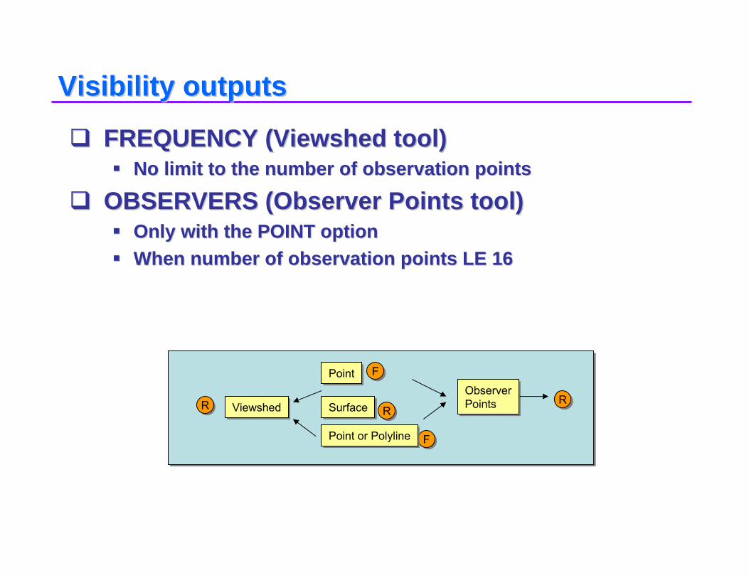
Visibility outputsVisibility outputs
FREQUENCY (Viewshed tool)FREQUENCY (Viewshed tool)No limit to the number of observation pointsNo limit to the number of observation points
OBSERVERS (Observer Points tool)OBSERVERS (Observer Points tool)Only with the POINT optionOnly with the POINT optionWhen number of observation points LE 16When number of observation points LE 16
RRRRRR
FF
FF
ViewshedViewshed
PointPoint
SurfaceSurface
Point or PolylinePoint or Polyline
ObserverPointsObserverPoints