surface location bottom hole location if different from...
TRANSCRIPT

DISTRICT I 1625 N. French Dr., Hobbs, N.M. 88240 Phone: (575) 393-6161 Fax': (575) 393-0720. DISTRICT I I 811 S. First St.; Artesia, N.M. 88210 Phone: (575) 748-1283 Fax: (575) 748-9720
DISTRICT m 1000 Rio Brazos Rd., Aztec, N.M. 87410 Phone: (505) 334-6178 Fax: (505) 334-6170
f^2™S r I ' s t V Francis Dr., Santa Fe, N.M. 87505 Phone: (505) 476-3460 Fax: (505) 476-3462
State of New Mexico Energy, Minerals & Natural Resources Department
OIL CONSERVATION DIVISION 1220 South St. Francis Dr.
Santa Fe, N.M. 87505
WELL
"AS DRILLED" LOCATION AND ACREAGE DEDICATION PLAT
Form C-102 Revised August 1, 2011
Submit one copy to appropriate District Office
RCWQCTl'14 0ILC0HS.DIU. S AMENDED REPORT
DIST.3 1 API Number
30-045-35539 8 Pool Code
97232 'Pool Name
BASIN MANCOS
'Property Code 313652
'Property Name
HEROS "Well Number
0.02H 'OGRID No.
120782 '.Operator Name
; _ WPX ENERGY PRODUCTION, LLC
' Elevation
6879 1 0 Surface Location
UX or lpt.no.
L Section
3 Township
23 N Range
8 W Lot Idn Feet from the
2268 North/South line
SOUTH Feet from the
70 ' East/West line
WEST County
SAN JUAN
" Bottom Hole Location If Different From Surface UL or lot no.
. E
Section
u Township
23 N
Range
8 W
Lot Idn Feet f rom the
1742
North/South line
NORTH
Feet from the
260
East/West line
WEST
County
SAN JUAN 1 2 Dedicated Acres 160 ACRES ' S2/N2 .. . •
"Joint or Infi l l " Consolidation Code "Order No.
NO ALLOWABLE WILL BE ASSIGNED TO THIS COMPLETION UNTIL ALL INTERESTS HAVE BEEN CONSOLIDATED . OR A NON-STANDARD UNIT HAS BEEN APPROVED BY THE DIVISION
16 BOTTOM HOLE 1742' FNL, 260" FWL LAT: 3 6 . 2 5 8 8 0 0 9 ° N LONG: 107.6951898° W NAD 83 LAT: 3 6 ° I 5 . 5 2 7 2 9 ' N LONG: I 0 7 ° 4 I . 6 7 4 6 9 ' W NAD 27
LANDING POINT 2148' FNL, 2 0 6 ' FEL LAT: 3 6 . 2 5 7 6 6 9 3 ° N LONG: 107.6787865° W NAD 83 LAT: 3 6 ? I 5 . 4 5 9 4 0 ' N LONG: I 0 7 ° 4 0 . 6 9 0 5 2 ' W NAD 27
SURFACE 2 2 6 8 ' FSL, 70 ' FWL LAT : 36 .2551894° N LONG: 107.6777876° NAD 83 LAT : 36° I5 .31060 ' N LONG: I 0 7 ° 4 0 . 6 3 0 5 9 NAD 27
W
W
S 8 9 0 5 8 ' 4 6 " W
Ss
2651.24 '
i v; •. , LOT 3
M
S 8 9 ° 5 9 ' 0 4 " W 2 6 4 9 . 7 2 '
":' i, :•. LOT 2 | LOT 1
260 ' _ i _N §5°I3J0J: W
I 4853.54 ' ~ " — h -
SECTION 4
- 4
LOT 3
S 89 °58 ' I 8 " W 5 3 0 5 . 3 3 '
LOT 2 LOT 1
SECTION 3
-4-
BEARINGS 8. DISTANCES SHOWN ARE REFERENCED TO THE NEW MEXICO COORDINATE SYSTEM, WEST ZONE, NAD 83, UNLESS OTHERWISE NOTED.
NOTE: THE COORDINATES FOR THE LANDING POINT AND:THE BOTTOM HOLE LOCATION CAME FROM THE CERTIFIED FINAL DIRECTIONAL SURVEY CONDUCTED BY CATHEDRAL ON 07/31/14.
2634.18'
LEGEND.
O = SURFACE LOCATION
® = BOTTOM HOLE LOCATION
® = FOUND 1947 U.S.G.L.O. BRASS CAP
A = LANDING POINT
1 7 OPERATOR CERTIFICATION I hereby certify thai ihe information contained harem is . true and complete to the best of my knowledge arid belief, and that .this organization either owns a working interest or unleased mineral interest in the land including the proposed bottom hole location or.hds a right to drill this well at this location pursuant to o contract with an, owner of such a mineral or working interest, or to,a voluntary pooling agreement or a compulsory pooling order heretofore entered by the dwisioru
Signaj L a r r y Higgins
Printed Name.
- l a r r v . h igg" ins@wpxenergy . com 'E-mail Address
is SURVEYOR CERTIFICATION / hereby certify that the well location shown oh this plat was plotted from 'field notes of actual surveys made by me or under my superinsion,. and that the same is true and correct to the best • of <my belief.
Certificate Number United Field Services, Inc.
P4
P E E D U R C G S L L C
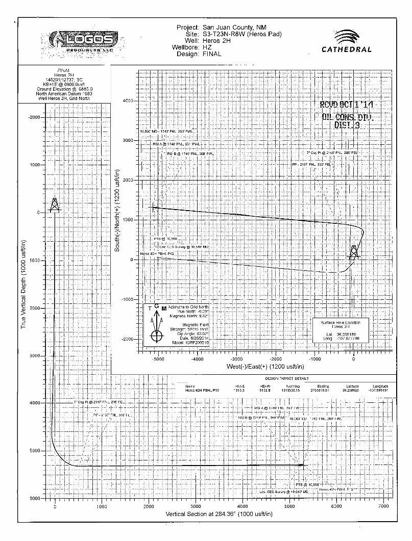
Project: San Juan County, NM Site: S3-T23N-R8W (Heros Pad) Well: Heros 2H
Wellbore: HZ Design: FINAL
CATHEDRAL
FINAL Heros 2H
145201/12737; SC KB=15' @ 6900.Ousft
Ground Elevation @ 6885.0 North American Datum 1983 Well Heros 2H, Grid North
-2000-
-1000—
0—•
05 Z>
o iooo-o o
a 15 o 0 2000—
4000—
5000 —
6000-
-4000 -3000 -2000 -1000
West(-)/East(+) (1200 usft/in)
DESIGN TARGET DETAILS
Name Heros #2H PBHLP13
+N/-S 1313.8
+E/-W Northing Easting Latitude Longitude -5132.9 1913538.15 2763818.61 36.258820 -107.695191
. 7" Csg Pt @ 2148' FNL, 206' FELL.
! PP - 2137' FNL, 335' FEL :
i /! 1/ T 'T f — ' - u
- t RSI A @ 1748' FNL, 351' F V W r r ~ i " f - t - - r T
if-+\H-T r i | -M - r - t r - RSI B @ 1749' FNL, 368' Ft/VU ' , 0 5 m - M D . 1 7 4 2 ' FNL, 260' FWL
| i I i I I I i I I | I I I i i i r~
0 1000
t PTB O 10 .590—TH^"
. Last CES Survey @ 10,540' MD„ r
! Heros #2H PBHL P13-
I I I I I i I I I I I I I I I I I I I 1 I I I I I I I I | I I I I I I 2000 3000 4000 5000
Vertical Section at 284.36° (1000 usft/in)
i i i i i i i i i i i i
6000 7000
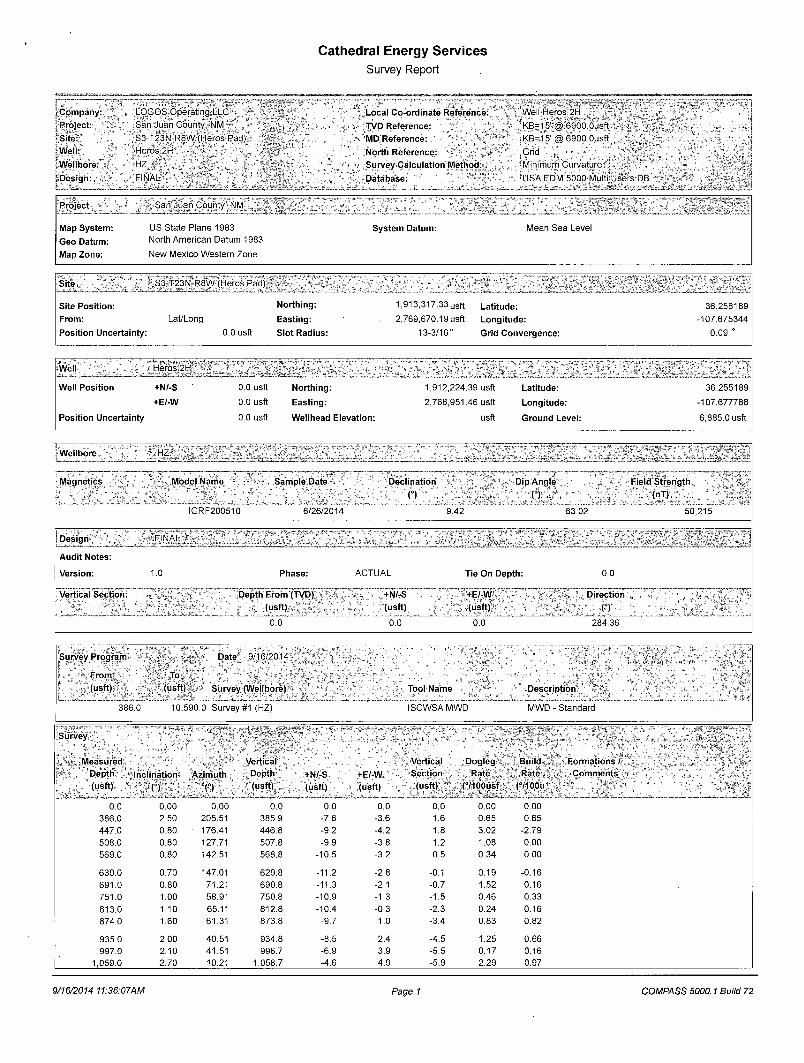
Cathedral Energy Services Survey Report
Company:; Project: Site: Well: Wellbore: * Design:
LOGOS Operatmg.LLC San Juan County, NM S3-T23N-R8W (Heros Pad) Heros 2H ^
FINAL '
Local Co-ordinate Reference: TVD Reference: MD Reference:
North Reference: Survey Calculation Method:
Database: ' ,
Well Heros 2H 'KB=15' @ 6900 Ousft \ KB=15'@ 6900 Ousft Grid Minimum Curvature
"USA EDM!5000.Multi:Users DB
Project San Juan County NM >
Map System: US State Plane 1983 System Datum: Mean Sea Level
Geo Datum: North American Datum 1983
Map Zone: New Mexico Western Zone
Site S3-T23N-R8W (Heros Pad) • J_ Site Posit ion:
From:
Posit ion Uncertainty:
Lat/Long
0.0 usft
North ing:
East ing:
Slot Radius:
1,913,317.33 u s f t
2,769,670.19 usft
13-3/16"
Lati tude:
Longi tude:
Grid Convergence:
36.258189
-107.675344
0.09 °
Well "Heros 2H _J" -__ Well Posit ion +N/-S 0.0 usft North ing: 1,912,224.39 usft Latitude: 36.255189
+E/-W 0.0 usft East ing: 2,768,951.46 usft Longi tude: -107.677788
Posit ion Uncertainty 0.0 usft Wellhead Elevat ion: usft Ground Level: 6,885.0 usft
Wellbore
i Magnetics
HZ
Model Name
IGRF200510
Sample Date
6/26/2014
Declination
(°) Dip Angle
O Field Strength
(nT)
9.42 63.02 50,215
Design
Audit Notes:
Version:
Vertical Section:
FINAL
1.0 Phase:
Depth From (TVD) (usft)
0.0
ACTUAL
+N/-S (usft)
0.0
Tie On Depth:
+E/-W (usft)
0.0~
0.0
Direction
n_ 284.36
Survey Program Date 9/16/2014
From (usft)
To
L
(usft) Survey (Wellbore)
386.0 10,590.0 Survey #1 (HZ)
Tool Name
ISCWSA MWD
Description ^
MWD - Standard
I Survey
Measured Vertical Vert ical Dogleg Build
Depth 'Inclination* Azimuth Depth +N/-S +E/-W Section Rate Rate
(usft) n O (usft) (usft) (usft) (usft) (°/100usf (°/100u
0.0 0.00 0.00 0.0 0.0 0.0 0.0 0.00 0.00
386.0 2.50 205.51 385.9 -7.6 -3.6 1.6 0.65 0.65
447.0 0.80 176.41 446.8 -9.2 -4.2 1.8 3.02 -2.79
508.0 0.80 127.71 507.8 -9.9 -3.8 1.2 1.08 0.00
569.0 0.80 142.51 568.8 -10.5 -3.2 0.5 0.34 0.00
630.0 0.70 147.01 629.8 -11.2 -2.8 -0.1 0.19 -0.16
691.0 0.80 71.21 690.8 -11.3 -2.1 -0.7 1.52 0.16
751.0 1.00 58.91 750.8 -10.9 -1.3 -1.5 0.46 0.33
813.0 1.10 65.11 812.8 -10.4 -0.3 -2.3 0.24 0.16
874.0 1.60 61.31 873.8 -9.7 1.0 -3.4 0.83 0.82
935.0 2.00 40.51 934.8 -8.5 2.4 -4.5 1.25 0.66
997.0 2.10 41.51 996.7 -6.9 3.9 -5.5 0.17 0.16
1,059.0 2.70 10.21 1,058.7 -4.6 4.9 -5.9 2.29 0.97
! Formations /> • Comments
9/16/2014 11:36:07AM Page 1 COMPASS 5000.1 Build 72

Cathedral Energy Services Survey Report
i Company:
i Project: ..-
Site:
, Well:
i Wellbore:«
(Design:
LOGOS Operating LLC
SanJuan County NM
S3-T23N-R8W (Heros Pad)
Heros 2H \
HZ v , ' ,
FINAL
Local Co-ordinate Reference:
iTVD Reference:
MD Reference:
North Reference:
Survey Calculation Method:
Database:
Well Heros 2H
KB=15'@ 6900 Ousft
^ 6 = 1 5 ' ® 6900 Ousft
.Grid " v
Minimum Curvature ,* ,'<
USA EDM 5000 Multi Users DB.
Survey
Measured Vertical: . Vertical - Dogleg Bui ld
Depth Inclination Az imuth Depth +N/-S +E/-W Section Rate Rate
(usft) O n (usft) (usft) (usft) (usft) (7100usf (71OOu
1,119.0 3.20 5.51 1,118.6 -1.5 5.3 -5.5 0.93 0.83 1,181.0 2.10 4.91 1,180.5 1.3 5.6 -5.1 1.77 -1.77
1,242.0 0.80 336.21 1,241.5 2.9 5.5 -4.6 2.38 -2.13 1,303.0 0.70 344.21 1,302.5 3.6 5.2 -4.2 0.24 -0.16
1,364.0 0.70 330.21 1,363.5 4.3 4.9 -3.7 0.28 0.00
1,425.0 0.60 311.71 1,424.5 4.8 4.5 -3.2 0.38 -0.16
1,487.0 0.70 303.21 1,486.5 5.2 3.9 -2.5 0.22 0.16
1,550.0 1.10 1.51 1,549.5 6.1 3.6 -2.0 1.50 0.63 1,612.0 1.20 17.31 1,611.5 7.3 3.8 -1.9 0.53 0.16 1,675.0 2.20 22.31 1,674.4 9.0 4.5 -2.1 1.60 1.59
1,738.0 3.10 29.51 1,737.4 11.6 5.8 -2.7 1.52 1.43
1,801.0 3.60 25.21 1,800.3 14.9 7.5 -3.6 0.89 0.79
1,864.0 4.00 16.21 1,863.1 18.8 8.9 -4.0 1.14 0.63
1,926.0 5.20 19.41 1,924.9 23.5 10.5 -4.3 1.98 1.94
1,989.0 6.90 25.61 1,987.6 29.6 13.1 -5.3 2.89 2.70
2,052.0 8.40 28.41 2,050.0 37.1 16.9 -7.2 2.45 2.38
2,114.0 10.10 25.91 2,111.2 46.0 21.4 -9.3 2.82 2.74
2,176.0 11.80 26.61 2,172.1 56.5 '26.6 -11.8 2.75 2.74
2,239.0 13.20 22.91 2,233.6 68.9 32.3 -14.2 2.56 2.22
2,301.0 14.30 17.71 2,293.8 82.7 37.4 -15.7 2.67 1.77
2,364.0 15.80 16.01 2,354.6 98.4 42.1 -16.4 2.48 2.38
2,427.0 16.30 15.31 2,415.2 115.1 46.8 -16.8 0.85 0.79
2,489.0 16.20 16.21 2,474.7 131.8 51.5 -17.2 0.44 -0.16
2,552.0 16.70 15.31 2,535.1 149.0 56.4 -17.7 0.89 0.79
2,614.0 17.00 15.61 2,594.5 166.3 61.2 -18.0 0.50 0.48
2,677.0 15.60 15.71 2,654.9 183.4 65.9 -18.4 2.22 -2.22
2,740.0 15.80 16.71 2,715.6 199.7 70.7 -19.0 0.53 0.32
2,803.0 15.10 16.51 2,776.3 215.8 75.5 -19.6 1.11 -1.11
2,866.0 14.30 17.81 2,837.2 231.1 80.2 -20.4 1.37 -1.27
2,928.0 14.70 18.81 2,897.3 245.8 85.1 -21.5 0.76 0.65
2,991.0 14.80 19.41 2,958.2 261.0 90.3 -22.8 0.29 0.16
3,053.0 14.30 19.21 3,018.2 275.7 95.5 -24.2 0.81 -0.81
3,116.0 14.90 21.31 3,079.2 290.6 101.0 -25.8 1.27 0.95
3,179.0 14.90 21.51 3,140.0 305.7 106.9 -27.8 0.08 0.00
3,242.0 14.60 21.81 3,201.0 320.6 112.8 -29.8 0.49 -0.48
3,305.0 15.30 21.51 3,261.8 335.7 118.8 -31.9 1.12 1.11
3,368.0 15.70 21.11 3,322.5 351.4 124.9 -33.9 0.66 0.63
3,430.0 15.00 20.61 3,382.3 366.7 130.8 -35.8 1.15 -1.13
3,492.0 15.40 19.81 3,442.2 381.9 136.4 -37.4 0.73 0.65
3,555.0 15.20 18.71 3,502.9 397.6 141.9 -38.9 0.56 -0.32
3,618.0 14.90 18.21 3,563.8 413.2 147.1 -40.0 0.52 -0.48
3,681.0 15.80 19.01 3,624.5 429.0 152.4 -41.3 1.47 1.43
3,744.0 15.60 19.01 3,685.2 445.1 157.9 -42.6 0.32 -0.32
3,807.0 15.20 17.61 3,745.9 461.0 163.2 -43.8 0.87 -0.63
3,870.0 15.20 18.71 3,806.7 476.7 168.3 -44.9 0.46 0.00
3,933.0 15.40 23.31 3,867.5 492.2 174.3 -46.8 1.95 0.32
3,996.0 14.60 21.11 3,928.3 507.2 180.5 -49.1 1.56 -1.27
4,059.0 15.10 21.61 3,989.2 522.3 186.4 -51.0 0.82 0.79
4,123.0 14.80 21.41 4,051.1 537.6 192.4 -53.1 0.48 -0.47
4,185.0 14.90 20.11 4,111.0 552.5 198.0 -54.9 0.56 0.16
4,248.0 15.60 20.41 4,171.8 568.0 203.8 -56.6 1.12 1.11
4,311.0 15.20 21.41 4,232.5 583.7 209.7 -58.5 0.76 -0.63
4,374.0 14.00 20.21 4,293.5 598.5 215.4 -60.3 1.96 -1.90
Formations /
Comments
9/16/2014 11:36:07AM Page 2 COMPASS 5000.1 Build 72
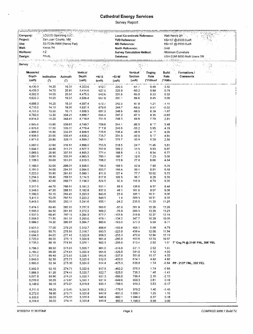
Cathedral Energy Services Survey Report
Company: LOGOS Operating LLC*. Project: San Juan County, NM Site: S3-T23N-R8W (Heros Pad) Well: Heros 2H
Wellbore: HZ Design: FINAL
Local Co-ordinate Reference: TVD Reference: MD Reference: North Reference: Survey Calculation Method: Database:
Well Heros 2H KB=15'@,6900.0usft KB=15'@6900.0usft Grid Minimum Curvature USA EDM 5000 Multi Users DB
Survey
Measured Vertical Vertical Dogleg Bui ld Depth Inclination Az imuth Depth +N/-S +E/-W Section Rate Rate
(usft) O n (usft) (usft) (usft) (usft) (7100usf (71OOu
4,436.0 14.20 19.31 4,353.6 612.7 220.5 -61.7 0.48 0.32 4,499.0 14.70 20.81 4,414.6 627.5 225.9 -63.2 0.99 0.79 4,562.0 14.90 20.61 4,475.5 642.6 231.6 -65.0 0.33 0.32 4,625.0 14.90 19.51 4,536.4 657.8 237.1 -66.6 0.45 0.00
4,688.0 14.20 18.31 4,597.4 672.7 242.3 -67.9 1.21 -1.11 4,719.0 14.10 18.91 4,627.4 679.9 244.7 -68.5 0.57 -0.32
4,751.0 13.50 10.71 4,658.5 687.3 246.6 -68.5 6.39 -1.87
4,782.0 13.30 358.21 4,688.7 694.4 247.2 -67.3 9.35 -0.65
4,814.0 14.20 348.41 4,719.8 701.9 246.3 -64.6 7.79 2.81
4,845.0 15.90 339.61 4,749.7 709.6 244.1 -60.5 9.17 5.48
4,876.0 17.20 335.01 4,779.4 717.8 240.6 -55.2 5.95 4.19
4,908.0 18.50 334.01 4,809.9 726.6 236.4 -48.9 4.17 4.06 4,939.0 20.00 330.41 4,839.2 735.7 231.6 -42.0 6.17 4.84
4,971.0 20.80 325.11 4,869.2 745.1 225.7 -33.9 6.29 2.50
5,002.0 22.60 316.81 4,898.0 753.9 218.5 -24.7 11.46 5.81
5,034.0 24.80 311.21 4,927.3 762.8 209.2 -13.5 9.83 6.87
5,065.0 26.90 307.51 4,955.2 771.4 198.8 -1.3 8.54 6.77
5,097.0 28.50 303.91 4,983.5 780.1 186.7 12.6 7.23 5.00
5,128.0 30.00 301.01 5,010.5 . 788.2 173.9 27.0 6.66 4.84
5,160.0 32.00 298.01 5,038.0 796.3 159.5 42.9 7.90 6.25
5,191.0 34.00 294.51 5,064.0 803.7 144.4 59.4 8.91 6.45
5,223.0 36.80 291.81 5,090.1 811.0 127.4 77.7 10.02 8.75
5,254.0 39.40 289.81 5,114.5 817.8 109.5 96.7 9.28 8.39
5,285.0 42.00 288.71 5,138.0 824.5 90.4 116.9 8.70 8.39
5,317.0 44.70 286.61 5,161.2 831.1 69.5 138.8 9.57 8.44
5,348.0 47.20 286.51 5,182.8 837.5 48.1 161.0 8.07 8.06
5,380.0 50.10 284.41 5,203.9 843.8 25.0 185.1 10.31 9.06
5,411.0 53.00 282.51 5,223.2 849.5 1.4 209.3 10.51 9.35
5,443.0 56.60 282.11 5,241.6 855.1 -24.2 235.5 11.30 11.25
5,474.0 60.40 282.01 5,257.8 860.6 -50.0 261.9 12.26 12.26
5,505.0 64.50 281.61 5,272.2 866.2 -76.9 289.3 13.28 13.23
5,537.0 68.40 282.11 5,284.9 872.2 -105.6 318.6 12.27 12.18
5,568.0 71.50 281.31 5,295.6 878.1 -134.2 347.7 10.29 10.00
5,599.0 74.20 280.01 5,304.7 883.6 -163.3 377.3 9.59 8.71
5,631.0 77.00 279.21 5,312.7 888.8 -193.8 408.1 9.08 8.75
5,662.0 80.70 278.81 5,318.7 893.5 -223.9 438.4 12.00 11.94
5,694.0 84.60 277.41 5,322.8 898.0 -255.3 470.0 12.94 12.19
5,725.0 88.00 275.11 5,324.8 901.4 -286.0 500.6 13.23 10.97
5,735.0 88.16 274.91 5,325.1 902.3 -296.0 510.4 2.52 1.61
5,756.0 88.50 274.51 5,325.7 904.0 -316.9 531.1 2.52 1.61
5,766.0 88.90 274.61 5,325.9 904.8 -326.9 541.0 4.12 4.00
5,777.0 89.40 275.61 5,326.1 905.8 -337.8 551.8 10.17 4.55
5,840.0 92.50 275.71 5,325.0 912.0 -400.5 614.1 4.92 4.92
5,865.0 92.34 275.30 5,324.0 914.4 -425.3. 638.8 1.74 -0.64
5,902.0 92.10 274.71 5,322.6 917.6 -462.2 675.3 1.74 -0.65
5,966.0 91.20 274.41 5,320.7 922.7 -525.9 738.3 1.48 -1.41
6,027.0 89.90 274.21 5,320.1 927.3 -586.8 798.4 2.16 -2.13
6,089.0 90.20 273.81 5,320.1 931.6 -648.6 859.3 0.81 0.48
6,149.0 90.10 273.51 5,319.9 935.4 -708.5 918.3 0.53 -0.17
6,211.0 89.20 273.41 5,320.3 939.2 -770.4 979.2 1.46 -1.45
6,272.0 89.90 273.71 5,320.8 942.9 -831.2 1,039.1 1.25 1.15
6,333.0 90.00 273.51 5,320.8 946.8 -892.1 1,099.0 0.37 0.16
6,394.0 90.00 274.11 5,320.8 950.8 -953.0 1,159.0 0.98 0.00
Formations / Comments
7" Csg Pt @ 2148' FNL, 206' FEL
PP-2137'FNL, 335' FEL
9/16/2014 11:36:07AM Page 3 COMPASS 5000.1 Build 72
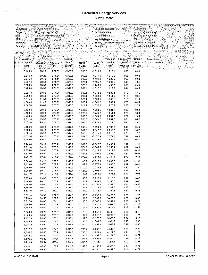
Cathedral Energy Services Survey Report
j Company. LOGOS Operating LLC [Project: 'San Juan County NM
* Site: S3-T23N-R8W (Heros Pad)' lWell: % Heros 2H j
Wellbore- HZ Design. FINAL
Survey
LocalCo-ordmateReference: TVD; Reference: MD Reference: North Reference: Survey Calculation Method: Database
Well Heros 2H
KB=15' @ 6900 Ousft ,KB=l'5 ,@6900 Ousft 'Grid Minimum Curvature 1 1
USA EDM 5000 Multi Users DB
easured Vertical Vertical - Dogleg Bui ld
Depth Inclination Azimuth Depth +N/-S +E/-W Section Rate Rate
(usft) (°) C) (usft) (usft) (usft) (usft) (7100usf (71OOu
6,455.0 90.20 274.91 5,320.7 955.6 -1,013.8 1,219.1 1.35 0.33
6,516.0 90.20 274.51 5,320.5 960.6 -1,074.6 1,279.2 0.66 0.00
6,576.0 89.70 274.41 5,320.6 965.3 -1,134.4 1,338.3 0.85 -0.83
6,637.0 90.50 274.71 5,320.5 970.1 -1,195.2 1,398.5 1.40 1.31 6,698.0 90.80 274.91 5,319.8 975.3 -1,256.0 1,458.6 0.59 0.49
6,760.0 90.50 277.01 5,319.1 981.7 -1,317.7 1,519.9 3.42 -0.48
6,821.0 89.80 277.01 5,318.9 989.1 -1,378.2 1,580.4 1.15 -1.15
6,883.0 90.30 275.81 5,318.8 996.1 -1,439.8 1,641.8 2.10 0.81
6,944.0 91.60 275.51 5,317.8 1,002.1 -1,500.5 1,702.1 2.19 2.13
7,005.0 91.40 275.91 5,316.2 1,008.1 -1,561.2 1,762.4 0.73 -0.33
7,067.0 90.00 276.61 5,315.5 1,014.9 -1,622.8 1,823.8 2.52 -2.26
7,128.0 90.00 275.51 5,315.5 1,021.3 -1,683.5 1,884.1 1.80 0.00
7,189.0 89.80 275.11 5,315.6 1,027.0 -1,744.2 1,944.4 0.73 -0.33
7,250.0 88.80 275.51 5,316.3 1,032.6 -1,804.9 2,004.6 1.77 -1.64
7,311.0 89.30 275.11 5,317.3 1,038.3 -1,865.7 2,064.8 1.05 0.82
7,371.0 90.30 274.01 5,317.6 1,043.0 -1,925.5 2,124.0 2.48 1.67
7,436.0 90.00 273.91 5,317.4 1,047.5 -1,990.3 2,187.9 0.49 -0.46
7,498.0 89.40 273.91 5,317.7 1,051.7 -2,052.2 2,248.9 0.97 -0.97
7,561.0 90.20 273.81 5,317.9 1,056.0 -2,115.0 2,310.8 1.28 1.27
7,624.0 90.20 273.11 5,317.7 1,059.8 -2,177.9 2,372.7 1.11 0.00
7,686.0 90.80 273.41 5,317.2 1,063.3 -2,239.8 2,433.5 1.08 0.97
7,749.0 90.10 273.41 5,316.7 1,067.0 -2,302.7 2,495.4 1.11 -1.11
7,812.0 90.10 275.31 5,316.6 1,071.8 -2,365.5 2,557.4 3.02 0.00
7,875.0 89.90 276.31 5,316.6 1,078.2 -2,428.2 2,619.7 1.62 -0.32
7,938.0 90.50 275.81 5,316.3 1,084.9 -2,490.8 2,682.0 1.24 0.95
8,001.0 90.20 277.61 5,316.0 1,092.2 -2,553.4 2,744.5 2.90 -0.48
8,064.0 89.20 277.01 5,316.3 1,100.2 -2,615.9 2,807.0 1.85 -1.59
8,126.0 89.70 277.21 5,316.9 1,107.9 -2,677.4 2,868.5 0.87 0.81
8,189.0 90.90 277.21 5,316.6 1,115.8 -2,739.9 2,931.0 1.90 1.90
8,252.0 90.70 277.71 5,315.7 1,124.0 -2,802.4 2,993.6 0.85 -0.32
8,315.0 90.10 277.81 5,315.2 1,132.5 -2,864.8 3,056.1 0.97 -0.95
8,378.0 89.80 276.51 5,315.3 1,140.3 -2,927.3 3,118.6 2.12 -0.48
8,440.0 90.20 275.21 5,315.3 1,146.7 -2,989.0 3,180.0 2.19 0.65
8,503.0 89.60 273.21 5,315.4 1,151.3 -3,051.8 3,242.0 3.31 -0.95
8,566.0 90.40 272.61 5,315.4 1,154.5 -3,114.7 3,303.7 1 59 1.27
8,628.0 90.10 272.11 5,315.1 1,157.0 -3,176.7 3,364.4 0.94 -0.48
8,691.0 90.90 272.01 5,314.6 1,159.3 J -3,239.6 3,425.9 1.28 1.27
8,754.0 90.50 272.71 5,313.8 1,161.9 -3,302.6 3,487.5 1.28 -0.63
8,817.0 90.00 274.11 5,313.5 1,165.6 -3,365.4 3,549.4 2.36 -0.79
8,880.0 90.80 273.91 5,313.1 1,170.0 -3,428.3 3,611.3 1.31 1.27
8,943.0 89.80 274.71 5,312.8 1,174.8 -3,491.1 3,673.4 2.03 -1.59
9,006.0 89.70 274.51 5,313.0 1,179.8 -3,553.9 3,735.5 0.35 -0.16
9,069.0 90.50 273.81 5,312.9 1,184.4 -3,616.7 3,797.5 1.69 1.27
9,132.0 90.40 275.41 5,312.4 1,189.5 -3,679.5 3,859.6 2.54 -0.16
9,195.0 88.60 274.61 5,313.0 1,195.0 -3,742.3 3,921.7 3.13 -2.86
9,257.0 88.60 274.71 5,314.5 1,200.0 -3,804.1 3,982.8 0.16 0.00
9,320.0 90.00 274.81 5,315.3 1,205.2 -3,866.8 4,044.9 2.23 2.22
9,383.0 90.80 273.91 5,314.8 1,210.0 -3,929.7 4,107.0 1.91 1.27
9,446.0 90.30 274.51 5,314.2 1,214.6 -3,992.5 4,169.0 1.24 -0.79
9,509.0 90.40 274.51 5,313.8 1,219.6 -4,055.3 4,231.0 0.16 0.16
9,572.0 89.80 274.31 5,313.7 1,224.4 -4,118.1 4,293.1 1.00 -0.95
9,635.0 90.30 273.71 5,313.7 1,228.8 -4,180.9 4,355.1 1.24 0.79
9,698.0 89.80 274.21 5,313.6 1,233.2 -4,243.8 4,417.0 1.12 -0.79
Formations / Comments;
9/16/2014 11:36:07AM Page 4 COMPASS 5000.1 Build 72

Cathedral Energy Services Survey Report
J Company: LOGOS Operating LLC Project: San Juan County, NM Site: * S3-T23N-R8W (Heros Pad)
(Well: Heros 2H ! Wellbore: HZ • Design: FINAL
Local Co-ordinate Reference: TVD Reference: MD Reference: > North Reference: Survey Calculation Method:
Database:
Well Heros 2H KB=15'@ 6900 Ousft ' KB=15'@ 6900 Ousft .* -Grid Minimum Curvature '„ , USA EDM 5000 Multi Users DB
Survey;
Measured Vertical Vertical Dogleg Build Formations / Depth Inclination Azimuth Depth +N/-S +E/-W Section Rate Rate : t Comments;: ; (usft) n o (usft) (usft) (usft) (usft) (7100usf (71OOu
9,761.0 90.40 273.71 5,313.5 1,237.5 -4,306.6 4,479.0 1.24 0.95 9,823.0 90.60 274.01 5,313.0 1,241.7 -4,368.5 4,540.0 0.58 0.32 9,886.0 89.70 274.41 5,312.8 1,246.3 -4,431.3 4,602.0 1.56 -1.43
9,949.0 90.30 275.21 5,312.8 1,251.6 -4,494.1 4,664.1 1.59 0.95 10,012.0 89.60 275.91 5,312.9 1,257.7 -4,556.8 4,726.4 1.57 -1.11 10,075.0 89.50 275.21 5,313.4 1,263.8 -4,619.5 4,788.6 1.12 -0.16 10,138.0 90.80 275.41 5,313.2 1,269.6 -4,682.2 4,850.8 2.09 2.06 10,201.0 90.30 275.51 5,312.6 1,275.6 -4,744.9 4,913.1 0.81 -0.79
10,264.0 88.60 275.41 5,313.2 1,281.6 -4,807.7 4,975.3 2.70 -2.70 10,327.0 88.50 275.21 5,314.8 1,287.4 -4,870.4 5,037.5 0.35 -0.16 10,390.0 89.30 274.51 5,316.0 1,292.8 -4,933.1 5,099.6 1.69 1.27 10,453.0 90.40 274.31 5,316.2 1,297.6 -4,995.9 5,161.7 1.77 1.75 10,482.0 90.96 274.21 5,315.8 1,299.8 -5,024.9 5,190.2 1.96 1.94 RSI B @ 1749' FNL, 368' FWL
10,499.0 91.29 274.16 5,315.5 1,301.0 -5,041.8 5,206.9 1.96 1.94 RSI A @ 1748' FNL, 351' FWL 10,515.0 91.60 274.11 5,315.1 1,302.2 -5,057.8 5,222.7 1.96 1.94 10,540.0 91.90 273.51 5,314.3 1,303.8 -5,082.7 5,247.3 2.68 1.20 Last CES Survey @ 10,540' MD 10,590.0 91.90 273.51 5,312.7 1,306.9 -5,132.6 5,296.3 0.00 0.00 PTB @ 10,590'
9/16/2014 11:36:07AM Page 5 COMPASS 5000.1 Build 72
Cathedral Energy Services Survey Report
Company: (Project: [ Site-I Well: t Wellbore: j Design:
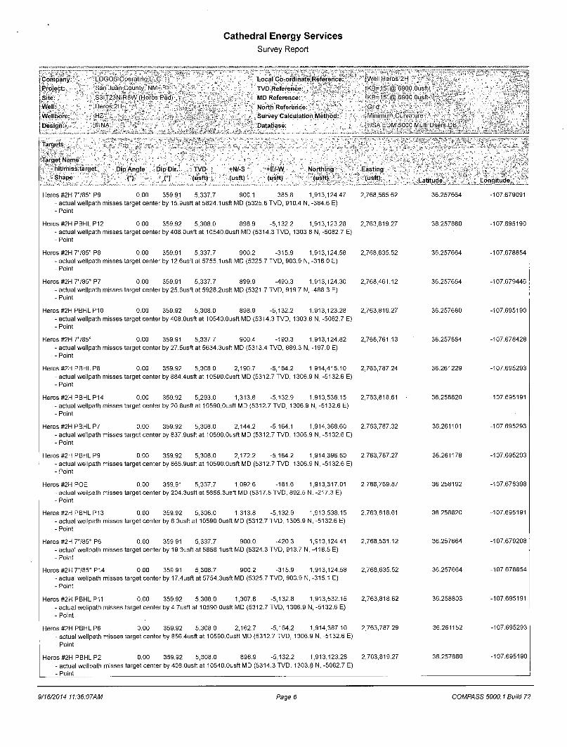
I Targets
LOGOS Operating LLC San'Juan County, NM * S3-T23N-R8W (Heros Pad) Heros 2H HZ *_ \
JFINAL
Local Co-ordinate Reference: TVD Reference: MD Reference:
North Reference: Survey Calculation Method: Database:
I'Target Name I i - hit/miss target !- . . - Shape •
Dip Angle Dip Dir. TVD
(°) (°) (usft) +N/-S (usft)
+E/-W (usft)
Northing (usft)
Heros #2H 7785° P9 0.00 359.91 5,337.7 900.1 -385.8 1,913,124.47 - actual wellpath misses target center by 15.9usft at 5824.1 usft MD (5325.6 TVD, 910.4 N, -384.6 E) - Point
Heros #2H PBHL P12 0.00 359.92 5,308.0 898.9 -5,132.2 1,913,123.28 - actual wellpath misses target center by 408.Ousft at 10540.Ousft MD (5314.3 TVD, 1303.8 N, -5082.7 E) - Point
Heros #2H 7785° P8 0.00 359.91 5,337.7 900.2 -315.9 1,913,124.58 - actual wellpath misses target center by 12.6usft at 5755.1usft MD (5325.7 TVD, 903.9 N, -316.0 E) - Point
Heros #2H 7785° P7 0.00 359.91 5,337.7 899.9 -490.3 1,913,124.30 - actual wellpath misses target center by 25.6usfl at 5928.2usft MD (5321.7 TVD, 919.7 N, -488.3 E) - Point
Heros #2H PBHL P10 0.00 359.92 5,308.0 898.9 -5,132.2 1,913,123.28 - actual wellpath misses target center by 408.Ousft at 10540.0usft MD (5314.3 TVD, 1303.8 N, -5082.7 E) - Point
Heros #2H 7785° 0.00 359.91 5,337.7 900.4 -190.3 1,913,124.82 - actual wellpath misses target center by 27.5usft at 5634.3usft MD (5313.4 TVD, 889.3 N, -197.0 E) - Point
Heros #2H PBHL P8 0.00 359.92 5,308.0 2,190.7 -5,164.2 1,914,415.10 - actual wellpath misses target center by 884.4usft at 10590.0usft MD (5312.7 TVD, 1306.9 N, -5132.6 E) - Point
Heros #2H PBHL P14 0.00 359.92 5,293.0 1,313.8 -5,132.9 1,913,538.15 - actual wellpath misses target center by 20.8usft at 10590.Ousft MD (5312.7 TVD, 1306.9 N, -5132.6 E) - Point
Heros #2H PBHL P7 0.00 359.92 5,308.0 2,144.2 -5,164.1 1,914,368.60 - actual wellpath misses target center by 837.9usft at 10590.0usft MD (5312.7 TVD, 1306.9 N, -5132.6 E) - Point
Heros #2H PBHL P9 0.00 359.92 5,308.0 2,172.2 -5,164.2 1,914,396.60 - actual wellpath misses target center by 865.9usft at 10590.0usft MD (5312.7 TVD, 1306.9 N, -5132.6 E) - Point
Heros #2H POE 0.00 359.91 5,337.7 1,092.6 -181.6 1,913,317.01 - actual wellpath misses target center by 204.3usft at 5655.3usft MD (5317.5 TVD, 892.5 N, -217.3 E) - Point
Heros #2H PBHL P13 0.00 359.92 5,308.0 1,313.8 -5,132.9 1,913,538.15 - actual wellpath misses target center by 8.3usft at 10590.Ousft MD (5312.7 TVD, 1306.9 N, -5132.6 E) - Point
Heros #2H 7785° P6 0.00 359.91 5,337.7 900.0 -420.3 1,913,124.41 - actual wellpath misses target center by 19.3usft at 5858.1usft MD (5324.3 TVD, 913.7 N, -418.5 E) - Point
Heros #2H 7785° P14 0.00 359.91 5,308.7 900.2 -315.9 1,913,124.58 - actual wellpath misses target center by 17.4usft at 5754.3usft MD (5325.7 TVD, 903.9 N, -315.1 E) - Point
Heros #2H PBHL P11 0.00 359.92 5,308.0 1,307.8 -5,132.8 1,913,532.15 - actual wellpath misses target center by 4.7usft at 10590.0usft MD (5312.7 TVD, 1306.9 N, -5132.6 E) - Point
Heros #2H PBHL P6 0.00 359.92 5,308.0 2,162.7 -5,164.2 1,914,387.10 - actual wellpath misses target center by 856.4usft at 10590.0usft MD (5312.7 TVD, 1306.9 N, -5132.6 E) - Point
Heros #2H PBHL P2 0.00 359.92 5,308.0 898.9 -5,132.2 1,913,123.28 - actual wellpath misses target center by 408.Ousft at 10540.Ousft MD (5314.3 TVD, 1303.8 N, -5082.7 E) - Point
'Well Heros 2H rKB=15'@ 6900 Ousft ' • ^ 6 = 1 5 ' ® 6900 Ousft-* »
Grid " " Minimum Curvature ' USA EDM 5000 Multi Users DB
Easting
(usft) Latitude
2,768,565.62 36.257664
2,763,819.27
2,768,635.52
2,768,461.12
2,763,819.27
2,768,761.13
2,763,787.24
2,763,818.61
2,763,787.32
2,763,787.27
2,768,769.87
2,763,818.61
2,768,531.12
2,768,635.52
2,763,818.62
2,763,787.29
2,763,819.27
36.257680
36.257664
36.257664
36.257680
36.257664
36.261229
36.258820
36.261101
36.261178
36.258192
36.258820
36.257664
36.257664
36.258803
36.261152
36.257680
Longitude
-107.679091
-107.695190
-107.678854
-107.679446
-107.695190
-107.678428
-107.695293
-107.695191
-107.695293
-107.695293
-107.678398
-107.695191
-107.679208
-107.678854
-107.695191
-107.695293
-107.695190
9/16/2014 11:36:07AM Page 6 COMPASS 5000.1 Build 72
Cathedral Energy Services Survey Report
Company: LOGOS Operating LLC ,,, Local Co-ordinate Reference: Well Heros 2 H , ' . . Project: San Juan County, NM TVD Reference: KB=15'@ 6900.Ousft Site: S3-T23N-R8W (Heros Pad) MD Reference: KB=15'@ 6900.Ousft Well: Heros 2H ' , North Reference: Grid Wellbore: ;HZ ;V ! ; . ;v; j i ( Survey Calculation Method: Minimum Curvature . Design: FINAL •', ' Database: USA EDM 5000 Multi Users DB:'
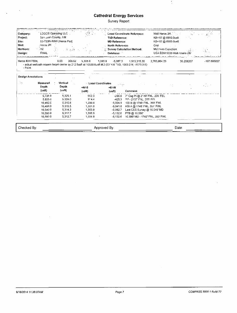
Heros #2H PBHL 0.00 359.92 5,308.0 1,090.9 -5,087.3 1,913,315.30 2,763,864.20 36.258207 -107.695037 - actual wellpath misses target center by 212.9usft at 10530.6usft MD (5314.6 TVD, 1303.2 N, -5073.3 E) - Point
Design Annotations
Measured Vertical Local Coordinates , Depth Depth +N/-S +E/-W (usft) (usft) (usft) (usft) Comment
5,735.0 5,325.1 902.3 -296.0 7" Csg Pt @ 2148' FNL, 206' FEL 5,865.0 5,324.0 914.4 -425.3 PP-2137'FNL, 335' FEL
10,482.0 5,315.8 1,299.8 -5,024.9 RSI B @ 1749' FNL, 368' FWL 10,499.0 5,315.5 1,301.0 -5,041.8 RSI A @ 1748' FNL, 351' FWL 10,540.0 5,314.3 1,303.8 -5,082.7 Last CES Survey @ 10,540' MD 10,590.0 5,312.7 1,306.9 -5,132.6 PTB @ 10,590' 10,590.0 5,312.7 1,306.9 -5,132.6 10,590' MD - 1742' FNL, 260' FWL
Checked By: Approved By: Date:
9/1672014 11:36:07AM Page 7 COMPASS 5000.1 Build 72

LOGOS Operating LLC San Juan County, NM S3-T23N-R8W (Heros Pad) Heros 2H
HZ
Design: FINAL
Survey Report - Geographic 16 September, 2014
Cathedral Energy Services Survey Report - Geographic
Company: LOGOS Operating LLC Local Co-ordinate Reference: Well Heros 2H
Project: San Juan County, NM , TVD Reference: KB--1!>'@6900 Ousft
Site: S 3 - : 2 3 V R 8 W (Heros Pad; MD Reference: ; ' K B = 1 5 r @ 6900.Ousft
Wel l : Heros 2H North Reference: Grid
Wellbore: HZ Survey Calculat ion Method: Minimum Curvature
Design: '"FINAL ' : " Database: ' USA' EDM 5dob Multi Users' DB
Project > San Juan. County, NM
Map System: US State Plane 1983 System Datum: Mean Sea Level
Geo Datum: North American Datum 1983
Map Zone: New Mexico Western Zone
Site S3-T23N : R8W (Heros Pad)
Site Posi t ion: North ing: 1,913,317.34 usft Lat i tude: 36.258189
From: Lat/Long East ing: 2,769,670.20 usft Longi tude: -107.675344
Posit ion Uncertainty: 0.0 usft Slot Radius: 13-3/16 " Grid Convergence: 0.09 °
Well Heros 2H . : " . " ' ' :'. Well Posit ion
Posit ion Uncertainty
+N/-S
+E/-W
0.0 usft
0.0 usft
0.0 usft
Nor th ing:
East ing:
Wellhead Elevation:
1,912,224.39 usft
2,768,951.47 usft
usft
Lat i tude:
Longi tude:
Ground Level:
36.255189
-107.677788
6,885.0 usft
! Wellbore HZ .' . . ... .... ,
Magnetics Model Name Sample Date Declination
(°)
Dip Angle V
(?)
Field Strength '
(nT)
IGRF200510 6/26/2014 9.42 63.02 50,215
j Design ' FINAL," ... . ...
Audi t Notes:
Version: 1.0 Phase: ACTUAL Tie On Depth: 0.0
Vertical Sect ion:
• Depth From (TVD)
(usft)
+N/-S
•,• • (usft)
+E/-W
(usft)
Direction
0.0 0.0 0.0 284.36
Survey Program Date 9/16/2014 / ~ • y . ' -^j
From To
(usft) (usft) Survey (Wellbore) . Tool Name Descript ion
386.0 10,590.0 Survey #1 (HZ) ISCWSA MWD MWD - Standard
Survey
• • -Measured Vertical Map Map
Depth Inclination Az imuth , Depth, +N/-S +E/-W • Northing Easting
(usft) n n (usft) (usft) (usft) (usft) (usft) Latitude Longi tude '
0.0 0.00 0.00 0.0 0.0 0.0 1,912,224.39 2,768,951.47 36.255189 -107.677788
386.0 2.50 205.51 385.9 -7.6 -3.6 1,912,216.79 2,768,947.84 36.255169 -107.677800
447.0 0.80 176.41 446.8 -9.2 -4.2 1,912,215.17 2,768,947.29 36.255164 -107.677802
508.0 0.80 127.71 507.8 -9.9 -3.8 1,912,214.48 2,768,947.66 36.255162 -107.677801
569.0 0.80 142.51 568.8 -10.5 -3.2 1,912,213.88 2,768,948.25 36.255161 -107.677799
630.0 0.70 147.01 629.8 -11.2 -2.8 1,912,213.23 2,768,948.72 36.255159 -107.677797
691.0 0.80 71.21 690.8 -11.3 -2.1 1,912,213.06 2,768,949.32 36.255158 -107.677795
751.0 1.00 58.91 750.8 -10.9 -1.3 1,912,213.46 2,768,950.17 36.255159 -107.677792
813.0 1.10 65.11 812.8 -10.4 -0.3 1,912,213.99 2,768,951.17 36.255161 -107.677789
874.0 1.60 61.31 873.8 -9.7 1.0 1,912,214.65 2,768,952.45 36.255163 -107.677785
935.0 2.00 40.51 934.8 -8.5 2.4 1,912,215.86 2,768,953.89 36.255166 -107.677780
997.0 2.10 41.51 996.7 -6.9 3.9 1,912,217.54 2,768,955.34 36.255171 -107.677775
9/16/2014 11:36:23AM Page 2 COMPASS 5000.1 Build 72
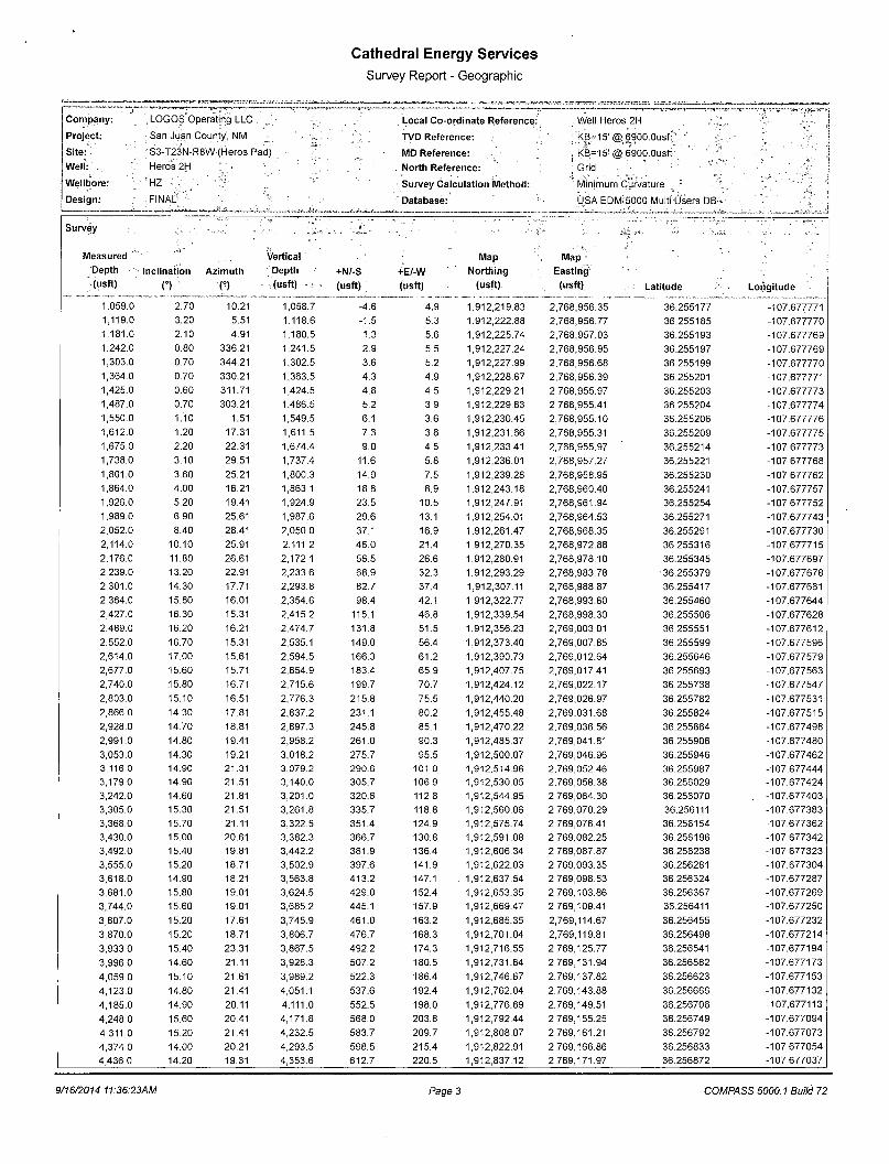
Cathedral Energy Services Survey Report - Geographic
Company: , LOGOS Operating LLC
Project: : San Juan County, NM •
Site: ' " S3-T23N-R8W (Heros Pad)
Well: V Heros 2H. .
Wellbore: ' ' • ' ''HZ '.'; V
Design: • FINAL ' '••
Local Co-ordinate Reference:
TVD Reference:
MD Reference:
North Reference:
Survey Calculation Method:
Database:
. Well Heros 2H
; KB=15' @ 6900.Ous':
KB=15! @6*900.0usft;' .' j Grid • " "
'i -HI*"! • . ' "„, . • "j Minimum Curvature _ :;
USA EDM'5000 Multi Osers DB
Survey
Measured Depth (usft)
Inclination
O * Azimuth
(•)
Vertical Depth (usft)
+N/-S (usft)
+E/-W (usft)
Map Northing
(usft)
Map -Easting (usft) Latitude Longitude
1,059.0 2.70 10.21 1,058.7 -4.6 4.9 1,912,219.83 2,768,956.35 36.255177 -107.677771 1,119.0 3.20 5.51 1,118.6 -1.5 5.3 1,912,222.88 2,768,956.77 36.255185 -107.677770 1,181.0 2.10 4.91 1,180.5 1.3 5.6 1,912,225.74 2,768,957.03 36.255193 -107.677769 1,242.0 0.80 336.21 1,241.5 2.9 5.5 1,912,227.24 2,768,956.95 36.255197 -107.677769 1,303.0 0.70 344.21 1,302.5 3.6 5.2 1,912,227.99 2,768,956.68 36.255199 -107.677770 1,364.0 0.70 330.21 1,363.5 4.3 4.9 1,912,228.67 2,768,956.39 36.255201 -107.677771 1,425.0 0.60 311.71 1,424.5 4.8 4.5 1,912,229.21 2,768,955.97 36.255203 -107.677773 1,487.0 0.70 303.21 1,486.5 5.2 3.9 1,912,229.63 2,768,955.41 36.255204 -107.677774 1,550.0 1.10 1.51 1,549.5 6.1 3.6 1,912,230.45 2,768,955.10 36.255206 -107.677776 1,612.0 1.20 17.31 1,611.5 7.3 3.8 1,912,231.66 2,768,955.31 36.255209 -107.677775 1,675.0 2.20 22.31 1,674.4 9.0 4.5 1,912,233.41 2,768,955.97 36.255214 -107.677773 1,738.0 3.10 29.51 1,737.4 11.6 5.8 1,912,236.01 2,768,957.27 36.255221 -107.677768 1,801.0 3.60 25.21 1,800.3 14.9 7.5 1,912,239.28 2,768,958.95 36.255230 -107.677762 1,864.0 4.00 16.21 1,863.1 18.8 8.9 1,912,243.18 2,768,960.40 36.255241 -107.677757 1,926.0 5.20 19.41 1,924.9 23.5 10.5 1,912,247.91 2,768,961.94 36.255254 -107.677752 1,989.0 6.90 25.61 1,987.6 29.6 13.1 1,912,254.01 2,768,964.53 36.255271 -107.677743 2,052.0 8.40 28.41 2,050.0 37.1 16.9 1,912,261.47 2,768,968.35 36.255291 -107.677730 2,114.0 10.10 25.91 2,111.2 46.0 21.4 1,912,270.35 2,768,972.88 36.255316 -107.677715 2,176.0 11.80 26.61 2,172.1 56.5 26.6 1,912,280.91 2,768,978.10 36.255345 -107.677697 2,239.0 13.20 22.91 2,233.6 68.9 32.3 1,912,293.29 2,768,983.78 •36.255379 -107.677678 2,301.0 14.30 17.71 2,293.8 82.7 37.4 1,912,307.11 2,768,988.87 36.255417 -107.677661 2,364.0 15.80 16.01 2,354.6 98.4 42.1 1,912,322.77 2,768,993.60 36.255460 -107.677644 2,427.0 16.30 15.31 2,415.2 115.1 46.8 1,912,339.54 2,768,998.30 36.255506 -107.677628
2,489.0 16.20 16.21 2,474.7 131.8 51.5 1,912,356.23 2,769,003.01 36.255551 -107.677612
2,552.0 16.70 15.31 2,535.1 149.0 56.4 1,912,373.40 2,769,007.85 36.255599 -107.677596
2,614.0 17.00 15.61 2,594.5 166.3 61.2 1,912,390.73 2,769,012.64 36.255646 -107.677579 2,677.0 15.60 15.71 2,654.9 183.4 65.9 1,912,407.75 2,769,017.41 36.255693 -107.677563
2,740.0 .15.80 16.71 2,715.6 199.7 70.7 1,912,424.12 2,769,022.17 36.255738 -107.677547
2,803.0 15.10 16.51 2,776.3 215.8 75.5 1,912,440.20 2,769,026.97 36.255782 -107.677531 2,866.0 14.30 17.81 2,837.2 231.1 80.2 1,912,455.48 2,769,031.68 36.255824 -107.677515 2,928.0 14.70 18.81 2,897.3 245.8 85.1 1,912,470.22 2,769,036.56 36.255864 -107.677498
2,991.0 14.80 19.41 2,958.2 261.0 90.3 1,912,485.37 2,769,041.81 36.255906 -107.677480
3,053.0 14.30 19.21 3,018.2 275.7 95.5 1,912,500.07 2,769,046.96 36.255946 -107.677462 3,116.0 14.90 21.31 3,079.2 290.6 101.0 1,912,514.96 2,769,052.46 36.255987 -107.677444 3,179.0 14.90 21.51 3,140.0 305.7 106.9 1,912,530.05 2,769,058.38 36.256029 -107.677424 3,242.0 14.60 21.81 3,201.0 320.6 112.8 1,912,544.95 2,769,064.30 36.256070 . -107.677403
3,305.0 15.30 21.51 3,261.8 335.7 118.8 1,912,560.06 2,769,070.29 36.256111 -107.677383
3,368.0 15.70 21.11 3,322.5 351.4 124.9 1,912,575.74 2,769,076.41 36.256154 -107.677362
3,430.0 15.00 20.61 3,382.3 366.7 130.8 1,912,591.08 2,769,082.25 36.256196 -107.677342
3,492.0 15.40 19.81 3,442.2 381.9 136.4 1,912,606.34 2,769,087.87 36.256238 -107.677323
3,555.0 15.20 18.71 3,502.9 397.6 141.9 1,912,622.03 2,769,093.35 36.256281 -107.677304
3,618.0 14.90 18.21 3,563.8 413.2 147.1 . 1,912,637.54 2,769,098.53 36.256324 -107.677287
3,681.0 15.80 19.01 3,624.5 429.0 152.4 1,912,653.35 2,769,103.86 36.256367 -107.677269
3,744.0 15.60 19.01 3,685.2 445.1 157.9 1,912,669.47 2,769,109.41 36.256411 -107.677250
3,807.0 15.20 17.61 3,745.9 461.0 163.2 1,912,685.35 2,769,114.67 36.256455 -107.677232
3,870.0 15.20 18.71 3,806.7 476.7 168.3 1,912,701.04 2,769,119.81 36.256498 -107.677214
3,933.0 15.40 23.31 3,867.5 492.2 174.3 1,912,716.55 2,769,125.77 36.256541 -107.677194
3,996.0 14.60 21.11 3,928.3 507.2 180.5 1,912,731.64 2,769,131.94 36.256582 -107.677173
4,059.0 15.10 21.61 3,989.2 522.3 186.4 1,912,746.67 2,769,137.82 36.256623 -107.677153
4,123.0 14.80 21.41 4,051.1 537.6 192.4 1,912,762.04 2,769,143.88 36.256666 -107.677132
4,185.0 14.90 20.11 4,111.0 552.5 198.0 1,912,776.89 2,769,149.51 36.256706 -107.677113
4,248.0 15.60 20.41 4,171.8 568.0 203.8 1,912,792.44 2,769,155.25 36.256749 -107.677094
4,311.0 15.20 21.41 4,232.5 583.7 209.7 1,912,808.07 2,769,161.21 36.256792 -107.677073
4,374.0 14.00 20.21 4,293.5 598.5 215.4 1,912,822.91 2,769,166.86 36.256833 -107.677054
4,436.0 14.20 19.31 4,353.6 612.7 220.5 1,912,837.12 2,769,171.97 36.256872 -107.677037
9/16/2014 11:36:23AM Page 3 COMPASS 5000.1 Build 72

Cathedral Energy Services Survey Report - Geographic
Company: . LOGOS Operating LLC Local Co-ordinate Reference: Well Heros 2H
Project : . San Juan;G6unty, NM TVD Reference: •:KB=45'(t §6900.Ousft < >•?
Site: S3-T23N-R8W (Heros Pad) MD Reference: KB=15'( i §6900.0usf t
Wel l : , Heros 2H, North Reference: Grid
Wellbore: HZ ' '• . r : - . . . 1 Survey Calculat ion Method: ' Minimum Curvature ; 1 •:* '
Design: FINAL . Database: USA EDM 5000 Multi Users DB
Survey . . y . - . ...
'•• • »•'" ^:>~: "/'H-
Measured Vertical Map Map Depth Inclination ; Az imuth Depth +N/-S +E/-W Northing • Easting
• • (usft) n n (usft) (usft) (usft) (usft) (usft) Latitude Longi tude
4,499.0 14.70 20.81 4,414.6 627.5 225.9 1,912,851.89 2,769,177.36 36.256912 -107.677018
4,562.0 14.90 20.61 4,475.5 642.6 231.6 1,912,866.94 2,769,183.05 36.256954 -107.676999
4,625.0 14.90 19.51 4,536.4 657.8 237.1 1,912,882.16 2,769,188.61 36.256995 -107.676980
4,688.0 14.20 18.31 4,597.4 672.7 242.3 1,912,897.13 2,769,193.74 36.257036 -107.676962
4,719.0 14.10 18.91 4,627.4 679.9 244.7 1,912,904.31 2,769,196.16 36.257056 -107.676954
4,751.0 13.50 10.71 4,658.5 687.3 246.6 1,912,911.67 2,769,198.12 36.257076 -107.676948
4,782.0 13.30 358.21 4,688.7 694.4 247.2 1,912,918.79 2,769,198.68 36.257096 -107.676946
4,814.0 14.20 348.41 4,719.8 701.9 246.3 1,912,926.32 2,769,197.77 36.257117 -107.676949
4,845.0 15.90 339.61 4,749.7 709.6 244.1 1,912,934.02 2,769,195.53 36.257138 -107.676956
4,876.0 17.20 335.01 4,779.4 717.8 240.6 1,912,942.16 2,769,192.11 36.257160 -107.676968
4,908.0 18.50 334.01 4,809.9 726.6 236.4 1,912,951.01 2,769,187.89 36.257185 -107.676982
4,939.0 20.00 330.41 4,839.2 735.7 231.6 1,912,960.04 2,769,183.11 36.257209 -107.676998
4,971.0 20.80 325.11 4,869.2 745.1 225.7 1,912,969.46 2,769,177.16 36.257235 -107.677018
5,002.0 22.60 316.81 4,898.0 753.9 218.5 1,912,978.32 2,769,169.93 36.257260 -107.677043
5,034.0 24.80 311.21 4,927.3 762.8 209.2 1,912,987.23 2,769,160.67 36.257284 -107.677074
5,065.0 26.90 307.51 4,955.2 771.4 198.8 1,912,995.78 2,769,150.22 36.257308 -107.677110
5,097.0 28.50 303.91 4,983.5 780.1 186.7 1,913,004.45 2,769,138.14 36.257332 -107.677150
5,128.0 30.00 301.01 5,010.5 788.2 173.9 1,913,012.57 2,769,125.36 36.257354 -107.677194
5,160.0 32.00 298.01 '5,038.0 796.3 159.5 1,913,020.67 2,769,111.01 36.257376 -107.677242
5,191.0 34.00 294.51 5,064.0 803.7 144.4 1,913,028.13 2,769,095.87 36.257397 -107.677294
5,223.0 36.80 291.81 5,090.1 811.0 127.4 1,913,035.40 2,769,078.83 36.257417 -107.677351
5,254.0 39.40 289.81 5,114.5 817.8 109.5 1,913,042.19 2,769,060.95 36.257436 -107.677412
5,285.0 42.00 288.71 5,138.0 824.5 90.4 1,913,048.85 2,769,041.86 36.257454 -107.677477
5,317.0 44.70 286.61 5,161.2 831.1 69.5 1,913,055.50 2,769,020.94 36.257472 -107.677548
5,348.0 47.20 286.51 5,182.8 837.5 48.1 1,913,061.85 2,768,999.58 36.257490 -107.677620
5,380.0 50.10 284.41 5,203.9 843.8 25.0 1,913,068.24 2,768,976.43 36.257507 -107.677699
5,411.0 53.00 282.51 5,223.2 849.5 1.4 1,913,073.88 2,768,952.82 36.257523 -107.677779
5,443.0 56.60 282.11 5,241.6 855.1 -24.2 1,913,079.45 2,768,927.28 36.257539 -107.677865
5,474.0 60.40 282.01 5,257.8 860.6 -50.0 1,913,084.97 2,768,901.44 36.257554 -107.677953
5,505.0 64.50 281.61 5,272.2 866.2 -76.9 1,913,090.59 2,768,874.54 36.257569 -107.678044
5,537.0 68.40 282.11 5,284.9 872.2 -105.6 1,913,096.62 2,768,845.83 36.257586 -107.678141
5,568.0 71.50 281.31 5,295.6 878.1 -134.2 1,913,102.53 2,768,817.31 36.257602 -107.678238
5,599.0 74.20 280.01 5,304.7 883.6 -163.3 1,913,108.01 2,768,788.21 36.257618 -107.678337
5,631.0 77.00 279.21 5,312.7 888.8 -193.8 1,913,113.18 2,768,757.65 36.257632 -107.678440
5,662.0 80.70 278.81 5,318.7 893.5 -223.9 1,913,117.94 2,768,727.62 36.257645 -107.678542
5,694.0 84.60 277.41 5,322.8 898.0 -255.3 1,913,122.41 2,768,696.20 36.257658 -107.678649
5,725.0 88.00 275.11 5,324.8 901.4 -286.0 1,913,125.78 2,768,665.46 36.257667 -107.678753
5,735.0 88.16 274.91 5,325.1 902.3 -296.0 1,913,126.65 2,768,655.51 36.257669 -107.678787
j 7" Csg Pt @ 2148' FNL, 206! FEL
5,756.0 88.50 274.51 5 325.7 904 0 -316.9 1.913.128.38 " 2,768,634.58 36 257074 -107.678858
5,766.0 88.90 274.61 5,325.9 904.8 -326.9 1,913,129.17 2,768,624.62 36.257676 -107.678892
5,777.0 89.40 275.61 5,326.1 905.8 -337.8 1,913,130.15 2,768,613.67 36.257679 -107.678929
5,840.0 92.50 275.71 5,325.0 912.0 -400.5 1,913,136.36 2,768,551.00 36.257696 -107.679141
5,865.0 92.34 275.30 5,324.0 914.4 -425.3 1,913,138.76 2,768,526.13 36.257703 -107.679226
: PP -2137 ' FNL, 335' FEL . ... 5,902.0 92.10 274.71 5,322.6 917.6 -462.2 1,913,141.98 2,768,489.30 36.257712 -107.679350
5,966.0 91.20 274.41 5,320.7 922.7 -525.9 1,913,147.07 2,768,425.53 36.257726 -107.679567
6,027.0 89.90 274.21 5,320.1 927.3 -586.8 1,913,151.65 2,768,364.71 36.257739 -107.679773
6,089.0 90.20 273.81 5,320.1 931.6 -648.6 1,913,155.98 2,768,302.86 36.257751 -107.679983
6,149.0 90.10 273.51 5,319.9 935.4 -708.5 1,913,159.81 2,768,242.98 36.257762 -107.680186
6,211.0 89.20 273.41 5,320.3 939.2 -770.4 1,913,163.55 2,768,181.10 36.257773 -107.680396
6,272.0 89.90 273.71 5,320.8 942.9 -831.2 1,913,167.34 2,768,120.22 36.257783 -107.680602
6,333.0 90.00 273.51 5,320.8 946.8 -892.1 1,913,171.17 2,768,059.34 36.257794 -107.680809
6,394.0 90.00 274.11 5,320.8 950.8 -953.0 1,913,175.23 2,767,998.47 36.257806 -107.681015
6,455.0 90.20 274.91 5,320.7 955.6 -1,013.8 1,913,180.02 2,767,937.66 36.257819 -107.681221
9/16/2014 11:36:23AM Page 4 COMPASS 5000.1 Build 72

t
Cathedral Energy Services Survey Report - Geographic
Company: LOGOS Operating LLC Local Co-ordinate Reference: Well Heros 2H
Project: . San Juan County, NM ,>,:: ; TVD Reference: KB=15' <E § 6900.Ousft .
Site: S3-T23N-R8W (Heros Pad) MD Reference: KB=15' <£ $ 6900.Ousft *
Wel l : Heros 2H North Reference: Grid
Wel lbore:" HZ •• Survey Calculat ion Method: Minimum Curvature ;
Design: FINAL Database: USA EDM 5000 Multi Users DB '
Survey ' « f i " ~ •
Measured Vertical Map Map
Depth Inclination . Az imuth Depth +N/-S +E/-W Northing Easting
* (usft) n n (usft) (usft) (usft) (usft) (usft) ' Latitude Longi tude
6,516.0 90.20 274.51 5,320.5 960.6 -1,074.6 1,913,185.03 2,767,876.87 36.257833 -107.681428
6,576.0 89.70 274.41 5,320.6 965.3 -1,134.4 1,913,189.69 2,767,817.05 36.257846 -107.681630
6,637.0 90.50 274.71 5,320.5 970.1 -1,195.2 1,913,194.54 2,767,756.25 36.257860 -107.681837
6,698.0 90.80 274.91 5,319.8 975.3 -1,256.0 1,913,199.65 2,767,695.46 36.257874 -107.682043
6,760.0 90.50 277.01 5,319.1 981.7 -1,317.7 1,913,206.09 2,767,633.81 36.257892 -107.682252
6,821.0 89.80 277.01 5,318.9 989.1 -1,378.2 1,913,213.53 2,767,573.26 36.257913 -107.682457
6,883.0 90.30 275.81 5,318.8 996.1 -1,439.8 1,913,220.45 2,767,511.65 36.257932 -107.682666
6,944.0 91.60 275.51 5,317.8 1,002.1 -1,500.5 1,913,226.46 2,767,450.96 36.257949 -107.682872
7,005.0 91.40 275.91 5,316.2 1,008.1 -1,561.2 1,913,232.53 2,767,390.28 36.257966 -107.683078
7,067.0 90.00 276.61 5,315.5 1,014.9 -1,622.8 1,913,239.28 2,767,328.66 36.257985 -107.683287
7,128.0 90.00 275.51 5,315.5 1,021.3 -1,683.5 1,913,245.72 2,767,268.00 36.258002 -107.683492
7,189.0 89.80 275.11 5,315.6 1,027.0 -1,744.2 1,913,251.36 2,767,207.26 36.258018 -107.683698
7,250.0 88.80 275.51 5,316.3 1,032.6 -1,804.9 1,913,257.01 2,767,146.53 36.258034 -107.683904
7,311.0 89.30 275.11 5,317.3 1,038.3 -1,865.7 1,913,262.65 2,767,085.80 36.258050 -107.684110
7,371.0 90.30 274.01 5,317.6 1,043.0 -1,925.5 1,913,267.42 2,767,025.99 36.258063 -107.684313
7,436.0 90.00 273.91 5,317.4 1,047.5 -1,990.3 1,913,271.90 2,766,961.15 36.258076 -107.684533
7,498.0 89.40 273.91 5,317.7 1,051.7 -2,052.2 1,913,276.13 2,766,899.29 36.258088 -107.684743
7,561.0 90.20 273.81 5,317.9 1,056.0 -2,115.0 1,913,280.37 2,766,836.44 36.258099 -107.684956
7,624.0 90.20 273.11 5,317.7 1,059.8 -2,177.9 1,913,284.17 2,766,773.55 36.258110 -107.685169
7,686.0 90.80 273.41 5,317.2 1,063.3 -2,239.8 1,913,287.69 2,766,711.66 36.258120 -107.685379
7,749.0 90.10 273.41 5,316.7 1,067.0 -2,302.7 1,913,291.44 2,766,648.77 36.258131 -107.685593
7,812.0 90.10 275.31 5,316.6 1,071.8 -2,365.5 1,913,296.22 2,766,585.95 36.258144 -107.685806
7,875.0 89.90 276.31 5,316.6 1,078.2 -2,428.2 1,913,302.60 2,766,523.28 36.258162 -107.686018
7,938.0 90.50 275.81 5,316.3 1,084.9 -2,490.8 1,913,309.25 2,766,460.63 36.258180 -107.686231
8,001.0 90.20 277.61 5,316.0 1,092.2 -2,553.4 1,913,316.61 2,766,398.07 36.258201 -107.686443
8,064.0 89.20 277.01 5,316.3 1,100.2 -2,615.9 1,913,324.62 2,766,335.58 36.258223 -107.686655
8,126.0 89.70 277.21 5,316.9 1,107.9 -2,677.4 1,913,332.29 2,766,274.06 36.258244 -107.686863
8,189.0 90.90 277.21 5,316.6 1,115.8 -2,739.9 1,913,340.19 2,766,211.56 36.258266 -107.687075
8,252.0 90.70 277.71 5,315.7 1,124.0 -2,802.4 1,913,348.37 2,766,149.10 36.258289 -107.687287
8,315.0 90.10 277.81 5,315.2 1,132.5 -2,864.8 1,913,356.88 2,766,086.68 36.258313 -107.687499
8,378.0 89.80 276.51 5,315.3 1,140.3 -2,927.3 1,913,364.73 2,766,024.17 36.258335 -107.687711
8,440.0 90.20 275.21 5,315.3 1,146.7 -2,989.0 1,913,371.05 2,765,962.50 36.258352 -107.687920
8,503.0 89.60 273.21 5,315.4 1,151.3 -3,051.8 1,913,375.68 2,765,899.67 36.258365 -107.688133
8,566.0 90.40 272.61 5,315.4 1,154.5 -3,114.7 1,913,378.87 2,765,836.75 36.258374 -107.688346
8,628.0 90.10 272.11 5,315.1 1,157.0 -3,176.7 1,913,381.42 2,765,774.81 36.258381 -107.688556
8,691.0 90.90 272.01 5,314.6 1,159.3 -3,239.6 1,913,383.68 2,765,711.85 36.258388 -107.688770
8,754.0 90.50 272.71 5,313.8 1,161.9 -3,302.6 1,913,386.28 2,765,648.91 36.258395 -107.688983
8,817.0 90.00 274.11 5,313.5 1,165.6 -3,365.4 1,913,390.02 2,765,586.02 36.258406 -107.689197
8,880.0 90.80 273.91 5,313.1 1,170.0 -3,428.3 1,913,394.42 2,765,523.18 36.258418 -107.689410
8,943.0 89.80 274.71 5,312.8 1,174.8 -3,491.1 1,913,399.16 2,765,460.36 36.258431 -107.689623
9,006.0 89.70 274.51 5,313.0 1,179.8 -3,553.9 1,913,404.22 2,765,397.56 36.258446 -107.689836
9,069.0 90.50 273.81 5,312.9 1,184.4 -3,616.7 1,913,408.79 2,765,334.73 36.258458 -107.690049
9,132.0 90.40 275.41 5,312.4 1,189.5 -3,679.5 1,913,413.85 2,765,271.94 36.258473 -107.690262
9,195.0 88.60 274.61 5,313.0 1,195.0 -3,742.3 1,913,419.35 2,765,209.18 36.258488 -107.690475
9,257.0 88.60 274.71 5,314.5 1,200.0 -3,804.1 1,913,424.38 2,765,147.41 36.258502 -107.690684
9,320.0 90.00 274.81 5,315.3 1,205.2 -3,866.8 1,913,429.60 2,765,084.63 36.258517 -107.690897
9,383.0 90.80 273.91 5,314.8 1,210.0 -3,929.7 1,913,434.39 2,765,021.81 36.258530 -107.691110
9,446.0 90.30 274.51 5,314.2 1,214.6 -3,992.5 1,913,439.01 2,764,958.99 36.258543 -107.691323
9,509.0 90.40 274.51 5,313.8 1,219.6 -4,055.3 1,913,443.97 2,764,896.18 36.258557 -107.691536
9,572.0 89.80 274.31 5,313.7 1,224.4 -4,118.1 1,913,448.81 2,764,833.37 36.258570 -107.691749
9,635.0 90.30 273.71 5,313.7 1,228.8 -4,180.9 1,913,453.21 2,764,770.53 36.258583 -107.691963
9,698.0 89.80 274.21 5,313.6 1,233.2 -4,243.8 1,913,457.56 2,764,707.68 36.258595 -107.692176
9,761.0 90.40 273.71 5,313.5 1,237.5 -4,306.6 1,913,461.91 2,764,644.83 36.258607 -107.692389
9,823.0 90.60 274.01 5,313.0 1,241.7 -4,368.5 1,913,466.08 2,764,582.97 36.258619 -107.692599
9,886.0 89.70 274.41 5,312.8 1,246.3 -4,431.3 1,913,470.70 2,764,520.14 36.258632 -107.692812
9/16/2014 11:36:23AM Page 5 COMPASS 5000.1 Build 72
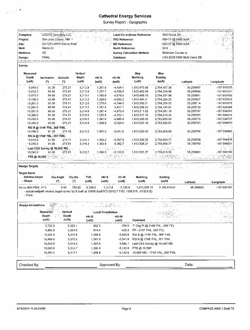
Cathedral Energy Services
Survey Report - Geographic
Company: . LOGOS Operating LLC ' Local Co-ordinate Reference: Well Heros 2H, . . . .
Project: San Juan County. NM •• ; TVD Reference: . KB=15'-i| | 69C0.Cusft '
Site: 1S3-T23N-R8W (Heros Pad) MD Reference: ' KB=15' r| g 6900.Ousft " 1 Well: Heros 2H North Reference: . Grid , ; Wellbore: HZ . Survey Calculation Method: Minimum Curvature '. : Design: FINAL Database: USA EDM 5000 Multi Users DB
Survey
Measured Vertical Map Map Depth Inclination Azimuth Depth +N/-S +E/-W Northing Easting (usft) n • . (°) (usft) (usft) (usft) (usft) (usft) Latitude Longitude
9,949.0 90.30 275.21 5,312.8 1,251.6 -4,494.1 1,913,475.98 2,764,457.36 36.258647 -107.693025 10,012.0 89.60 275.91 5,312.9 1,257.7 -4,556.8 1,913,482.08 2,764,394.66 36.258664 -107.693237 10,075.0 89.50 275.21 5,313.4 1,263.8 -4,619.5 1,913,488.19 2,764,331.96 36.258681 -107.693450 10,138.0 90.80 275.41 5,313.2 1,269.6 -4,682.2 1,913,494.01 2,764,269.23 36.258697 -107.693663 10,201.0 90.30 275.51 5,312.6 1,275.6 -4,744.9 1,913,500.01 2,764,206.52 36.258714 -107.693875 10,264.0 88.60 275.41 5,313.2 1,281.6 -4,807.7 1,913,506.00 2,764,143.81 36.258730 -107.694088 10,327.0 88.50 275.21 5,314.8 1,287.4 -4,870.4 1,913,511.82 2,764,081.10 36.258747 -107.694301 10,390.0 89.30 274.51 5,316.0 1,292.8 -4,933.1 1,913,517.16 2,764,018.34 36.258761 -107.694514 10,453.0 90.40 274.31 5,316.2 1,297.6 -4,995.9 1,913,522.00 2,763,955.53 36.258775 -107.694727 10,482.0 90.96 274.21 5,315.8 1,299.8 -5,024.9 1,913,524.16 2,763,926.61 36.258781 -107.694825
RSIB@ 1749'FNL, 368; FWL 10,499.0 91.29 274.16 5,315.5 1,301.0 -5,041.8 1,913,525.40 2,763,909.66 36.258784 -107.694882
RSIA@ 1748' FNL, 351' FWL 10,515.0 91.60 274.11 5,315.1 1,302.2 -5,057.8 1,913,526.55 2,763,893.71 36.258788 -107.694936 10,540.0 91.90 273.51 5,314.3 1,303.8 -5,082.7 1,913,528.21 2,763,868.77 36.258792 -107.695021
, Last CES Survey @ 10,540' MD
:' >•'•• • ':. . 10,590.0 91.90 273.51 5,312.7 1,306.9 " -5,132.6 1,913,531.27 2,763,818.90 36.258801 -107.695190
' PTB @ 10,590'
Design Targets ' 'X./..
Target Name - hit/miss target - Shape
Dip Angle Dip Dir. TVD O C) (usft)
+N/-S +E/-W (usft) (usft)
Northing (usft)
Easting (usft) Latitude Longitude
Heros #2H PBHL P13 0.00 359.92 5,308.0 1,313.8 -5,132.9 1,913,538.15 - actual wellpath misses target center by 8.3usft at 10590.Ousft MD (5312.7 TVD, 1306.9 N, -5132.6 E) - Point
2,763,818.61 36.258820 -107.695191
Design Annotations ' ,'
Measured . Vertical Local Coordinates Depth Depth +N/-S +E/-W (usft) (usft) (usft) (usft) Comment -
5,735.0 5,325.1 902.3 -296.0 7" Csg Pt @ 2148' FNL, 206' FEL
5,865.0 5,324.0 914.4 -425.3 PP-2137'FNL, 335' FEL
10,482.0 5,315.8 1,299.8 -5,024.9 RSI B @ 1749' FNL, 368' FWL
10,499.0 5,315.5 1,301.0 -5,041.8 RSI A @ 1748' FNL, 351' FWL
10,540.0 5,314.3 1,303.8 -5,082.7 Last CES Survey @ 10,540' MD
10,590.0 5,312.7 1,306.9 -5,132.6 PTB @ 10,590'
10,590.0 5,312.7 1,306.9 -5,132.6 10,590' MD - 1742' FNL, 260' FWL
Checked By: Approved By: Date:
9/16/2014 11:36:23AM Page 6 COMPASS 5000.1 Build 72