table of contents - alaska decdec.alaska.gov/spar/ppr/r_d/proj_57.pdfthe grp is the guide to local...
TRANSCRIPT
SHANNON & WILSON, INC.
GEOGRAPHIC RESPONSE PLAN April 1999Northern Lynn Canal, Haines to Skagway, Alaska Page iAlaska Department of Environmental Conservation Y-6121
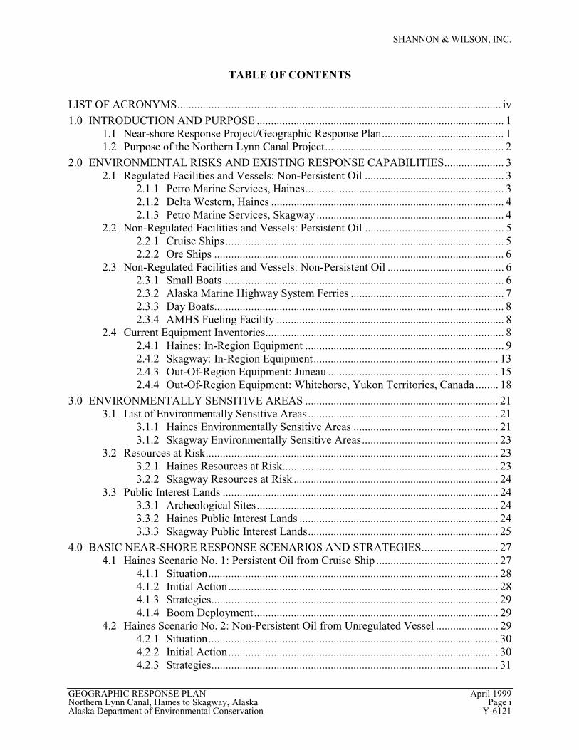
TABLE OF CONTENTS
LIST OF ACRONYMS.................................................................................................................. iv1.0 INTRODUCTION AND PURPOSE ....................................................................................... 1
1.1 Near-shore Response Project/Geographic Response Plan........................................... 11.2 Purpose of the Northern Lynn Canal Project............................................................... 2
2.0 ENVIRONMENTAL RISKS AND EXISTING RESPONSE CAPABILITIES..................... 32.1 Regulated Facilities and Vessels: Non-Persistent Oil ................................................. 3
2.1.1 Petro Marine Services, Haines...................................................................... 32.1.2 Delta Western, Haines .................................................................................. 42.1.3 Petro Marine Services, Skagway .................................................................. 4
2.2 Non-Regulated Facilities and Vessels: Persistent Oil ................................................. 52.2.1 Cruise Ships .................................................................................................. 52.2.2 Ore Ships ...................................................................................................... 6
2.3 Non-Regulated Facilities and Vessels: Non-Persistent Oil ......................................... 62.3.1 Small Boats................................................................................................... 62.3.2 Alaska Marine Highway System Ferries ...................................................... 72.3.3 Day Boats...................................................................................................... 82.3.4 AMHS Fueling Facility ................................................................................ 8
2.4 Current Equipment Inventories.................................................................................... 82.4.1 Haines: In-Region Equipment ...................................................................... 92.4.2 Skagway: In-Region Equipment................................................................. 132.4.3 Out-Of-Region Equipment: Juneau ............................................................ 152.4.4 Out-Of-Region Equipment: Whitehorse, Yukon Territories, Canada ........ 18
3.0 ENVIRONMENTALLY SENSITIVE AREAS .................................................................... 213.1 List of Environmentally Sensitive Areas ................................................................... 21
3.1.1 Haines Environmentally Sensitive Areas ................................................... 213.1.2 Skagway Environmentally Sensitive Areas................................................ 23
3.2 Resources at Risk....................................................................................................... 233.2.1 Haines Resources at Risk............................................................................ 233.2.2 Skagway Resources at Risk ........................................................................ 24
3.3 Public Interest Lands ................................................................................................. 243.3.1 Archeological Sites..................................................................................... 243.3.2 Haines Public Interest Lands ...................................................................... 243.3.3 Skagway Public Interest Lands................................................................... 25
4.0 BASIC NEAR-SHORE RESPONSE SCENARIOS AND STRATEGIES........................... 274.1 Haines Scenario No. 1: Persistent Oil from Cruise Ship ........................................... 27
4.1.1 Situation...................................................................................................... 284.1.2 Initial Action............................................................................................... 284.1.3 Strategies..................................................................................................... 294.1.4 Boom Deployment...................................................................................... 29
4.2 Haines Scenario No. 2: Non-Persistent Oil from Unregulated Vessel ...................... 294.2.1 Situation...................................................................................................... 304.2.2 Initial Action............................................................................................... 304.2.3 Strategies..................................................................................................... 31

SHANNON & WILSON, INC.
GEOGRAPHIC RESPONSE PLAN April 1999Northern Lynn Canal, Haines to Skagway, Alaska Page iiAlaska Department of Environmental Conservation Y-6121
4.2.4 Boom Deployment...................................................................................... 314.3 Skagway Scenario No. 1: Persistent Oil from Cruise Ship ....................................... 31
4.3.1 Situation...................................................................................................... 324.3.2 Initial Action............................................................................................... 324.3.3 Strategies..................................................................................................... 334.3.4 Boom Deployment...................................................................................... 33
4.4 Skagway Scenario No. 2: Non-Persistent Oil from Unregulated Vessel.................. 334.4.1 Situation...................................................................................................... 344.4.2 Initial Action............................................................................................... 344.4.3 Strategies..................................................................................................... 354.4.4 Boom Deployment...................................................................................... 35
5.0 SENSITIVE AREA SITE-SPECIFIC PROTECTION STRATEGIES................................. 375.1 Katzehin River Flats .................................................................................................. 37
5.1.1 Site Description .......................................................................................... 375.1.2 Protection Strategies ................................................................................... 375.1.3 Logistical Support....................................................................................... 375.1.4 Equipment Requirements............................................................................ 38
5.2 Chilkoot Inlet and Portage Cove................................................................................ 385.2.1 Site Description .......................................................................................... 385.2.2 Protection Strategies ................................................................................... 385.2.3 Logistical Support....................................................................................... 395.2.4 Equipment Requirements............................................................................ 39
5.3 Lutak Inlet.................................................................................................................. 395.3.1 Site Description .......................................................................................... 395.3.2 Protection Strategies ................................................................................... 395.3.3 Logistical Support....................................................................................... 405.3.4 Equipment Requirements............................................................................ 40
5.4 Taiya Inlet .................................................................................................................. 415.4.1 Site Description .......................................................................................... 415.4.2 Protection Strategies ................................................................................... 415.4.3 Logistical Support....................................................................................... 425.4.4 Equipment Requirements............................................................................ 42
5.5 Skagway Harbor ........................................................................................................ 425.5.1 Site Description .......................................................................................... 425.5.2 Protection Strategies ................................................................................... 435.5.3 Logistical Support....................................................................................... 435.5.4 Equipment Requirements............................................................................ 44
6.0 CONCLUSIONS AND RECOMMENDATIONS ................................................................ 456.1 Summary of Equipment Needs to Protect Environmentally Sensitive Areas............ 456.2 Comparison of Available Equipment to Equipment Needs....................................... 476.3 Recommendations for Additional Equipment ........................................................... 476.4 List of Recommended Upgrade Work ....................................................................... 476.5 Cost Estimate ............................................................................................................. 48
7.0 CLOSURE/LIMITATIONS................................................................................................... 518.0 REFERENCES....................................................................................................................... 53
SHANNON & WILSON, INC.
GEOGRAPHIC RESPONSE PLAN April 1999Northern Lynn Canal, Haines to Skagway, Alaska Page iiiAlaska Department of Environmental Conservation Y-6121
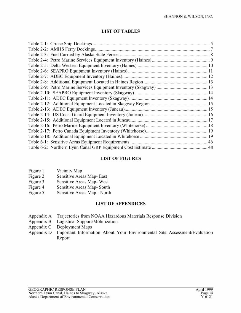
LIST OF TABLES
Table 2-1: Cruise Ship Dockings ................................................................................................... 5Table 2-2: AMHS Ferry Dockings................................................................................................. 7Table 2-3: Fuel Carried by Alaska State Ferries ............................................................................ 8Table 2-4: Petro Marine Services Equipment Inventory (Haines) ................................................. 9Table 2-5: Delta Western Equipment Inventory (Haines) ........................................................... 10Table 2-6: SEAPRO Equipment Inventory (Haines) ................................................................... 11Table 2-7: ADEC Equipment Inventory (Haines)........................................................................ 12Table 2-8: Additional Equipment Located in Haines Region ...................................................... 13Table 2-9: Petro Marine Services Equipment Inventory (Skagway) ........................................... 13Table 2-10: SEAPRO Equipment Inventory (Skagway).............................................................. 14Table 2-11: ADEC Equipment Inventory (Skagway) .................................................................. 14Table 2-12: Additional Equipment Located in Skagway Region ................................................ 15Table 2-13: ADEC Equipment Inventory (Juneau)...................................................................... 15Table 2-14: US Coast Guard Equipment Inventory (Juneau) ...................................................... 16Table 2-15: Additional Equipment Located in Juneau................................................................. 17Table 2-16: Petro Marine Equipment Inventory (Whitehorse) .................................................... 18Table 2-17: Petro Canada Equipment Inventory (Whitehorse).................................................... 19Table 2-18: Additional Equipment Located in Whitehorse ......................................................... 19Table 6-1: Sensitive Areas Equipment Requirements.................................................................. 46Table 6-2: Northern Lynn Canal GRP Equipment Cost Estimate ............................................... 48
LIST OF FIGURES
Figure 1 Vicinity MapFigure 2 Sensitive Areas Map- EastFigure 3 Sensitive Areas Map- WestFigure 4 Sensitive Areas Map- SouthFigure 5 Sensitive Areas Map - North
LIST OF APPENDICES
Appendix A Trajectories from NOAA Hazardous Materials Response DivisionAppendix B Logistical Support/MobilizationAppendix C Deployment MapsAppendix D Important Information About Your Environmental Site Assessment/Evaluation
Report
SHANNON & WILSON, INC.
GEOGRAPHIC RESPONSE PLAN April 1999Northern Lynn Canal, Haines to Skagway, Alaska Page ivAlaska Department of Environmental Conservation Y-6121
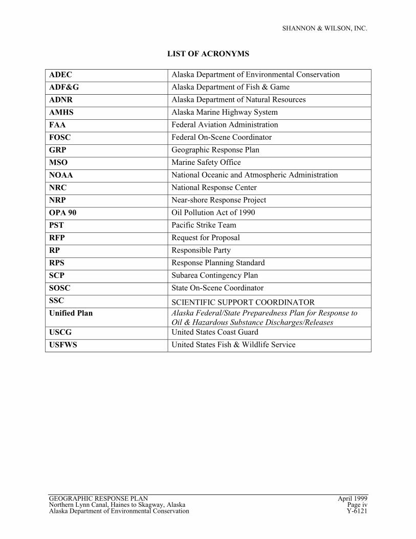
LIST OF ACRONYMS
ADEC Alaska Department of Environmental Conservation
ADF&G Alaska Department of Fish & Game
ADNR Alaska Department of Natural Resources
AMHS Alaska Marine Highway System
FAA Federal Aviation Administration
FOSC Federal On-Scene Coordinator
GRP Geographic Response Plan
MSO Marine Safety Office
NOAA National Oceanic and Atmospheric Administration
NRC National Response Center
NRP Near-shore Response Project
OPA 90 Oil Pollution Act of 1990
PST Pacific Strike Team
RFP Request for Proposal
RP Responsible Party
RPS Response Planning Standard
SCP Subarea Contingency Plan
SOSC State On-Scene Coordinator
SSC SCIENTIFIC SUPPORT COORDINATORUnified Plan Alaska Federal/State Preparedness Plan for Response to
Oil & Hazardous Substance Discharges/ReleasesUSCG United States Coast Guard
USFWS United States Fish & Wildlife Service
SHANNON & WILSON, INC.
GEOGRAPHIC RESPONSE PLAN April 1999Northern Lynn Canal, Haines to Skagway, Alaska Page 1Alaska Department of Environmental Conservation Y-6121
DRAFT GEOGRAPHIC RESPONSE PLAN
NORTHERN LYNN CANAL
HAINES TO SKAGWAY, ALASKA
1.0 INTRODUCTION AND PURPOSE
This draft Geographic Response Plan (GRP) summarizes our review of response plansand identifies the best mix of spill response equipment and strategies to protect near-shoreresources in the Northern Lynn Canal region of Southeast Alaska. The GRP was prepared forthe Alaska Department of Environmental Conservation (ADEC) under the guidance of theDivision of Spill Prevention and Response - Prevention and Emergency Response Program. Thisplan is intended to augment the existing spill response capability of regulated operators in theNorthern Lynn Canal area.
Northern Lynn Canal is located in Southeast Alaska and connects the communities ofHaines and Skagway by water, as shown in Figure 1. The nature of the Northern Lynn Canalenvironment, the conditions during which a spill response would be most likely to be required,and the type of spill most likely to occur have been taken into consideration in developing thisdocument.
1.1 Near-shore Response Project/Geographic Response Plan
The Northern Lynn Canal GRP is part of a series of plans required under the OilPollution Act of 1990 (OPA 90) and Alaska state statute. The statewide plan is the AlaskaFederal/State Preparedness Plan for Response to Oil & Hazardous SubstanceDischarges/Releases (also known as the Unified Plan). The Southeast Subarea ContingencyPlan (SCP) is one of ten subarea plans that supplement the Unified Plan, and is more specificallyfocused on the Southeast region of Alaska. The Northern Lynn Canal GRP will become aportion of the Southeast SCP and contains information that is specific to this distinct area.
The Near-shore Response Project (NRP) is a program designed to provide information tolocal communities that will enable them to protect local resources in the event a discharge is notcontained before approaching shore. The GRP is the guide to local initial response and areference to all response coordinators working in the region. Based on an examination of thepotential near-shore spill scenarios, the nature and types of potential response actions, and theenvironmental resources at risk, the GRP recommends specific strategies, tactics, equipment, andstorage and staging locations to protect near-shore resources. In developing near-shore responsetactics, consideration has been given to the type of response (i.e., offensive or defensive) thatwould most likely occur in each of the identified areas under expected environmental conditions.
SHANNON & WILSON, INC.
GEOGRAPHIC RESPONSE PLAN April 1999Northern Lynn Canal, Haines to Skagway, Alaska Page 2Alaska Department of Environmental Conservation Y-6121
Tradeoffs between protecting sensitive resources and/or attempting to recover oil on water havealso been considered.
The primary purpose of this project is to allow local responders to address spills thatescape the containment and cleanup efforts of the responsible party (RP), or spills from unknownsources where no RP has been identified. As the selected contractor, Shannon & Wilsonanalyzed the existing response capability and strategies as identified in local contingency plansin designing the response plan and developing the equipment list and response strategies.
1.2 Purpose of the Northern Lynn Canal Project
There are five goals identified for the Northern Lynn Canal NRP:
• Evaluate existing risks and current status of response readiness
• Identify and prioritize environmentally sensitive areas at risk
• Examine equipment needs for protection of prioritized sensitive areas
• Identify gaps in current locally available equipment
• Procure equipment to fill the identified gaps
The Northern Lynn Canal GRP addresses the first four of these.
SHANNON & WILSON, INC.
GEOGRAPHIC RESPONSE PLAN April 1999Northern Lynn Canal, Haines to Skagway, Alaska Page 3Alaska Department of Environmental Conservation Y-6121
2.0 ENVIRONMENTAL RISKS AND EXISTING RESPONSE CAPABILITIES
This section identifies the regulated facilities in Haines and Skagway. For each regulatedfacility, the response planning standard and potential for a spill to water is described. Thestrategies for response to spills, as reported by the facilities, are summarized.
2.1 Regulated Facilities and Vessels: Non-Persistent Oil
Non-persistent oils are those that evaporate and dissipate quickly in the environment.Non-persistent oils typically include refined petroleum products. There are three regulatedfacilities handling non-persistent oil in the Northern Lynn Canal. Two of these are located inHaines, and the third is located in Skagway.
2.1.1 Petro Marine Services, Haines
Response Planning Standards (RPS) are generally defined in ADEC regulations, 18 AAC75.430, which states the plan must demonstrate the general procedures to clean up a discharge ofany size, including the greatest possible discharge that could occur. RPS requirements for oilterminal facilities are defined in 18 AAC 75.432. The RPS for the Petro Marine Services HainesFacility is 235,200 gallons. To determine the RPS, Petro Marine used the volume of the largesttank (372,330 gallons) and volume reduction credits for a sufficiently impermeable secondarycontainment, an alcohol and drug testing program, and a prevention training program. There arethree general potential routes of spill discharge: the product transfer headers, the storage tanks,and the tank truck loading racks. A failure at the product transfer headers, which are located onthe Petro Marine Services cargo dock, would result in product reaching the water. According tothe Petro Marine Services Contingency Plan, the maximum rate of delivery is 45,000 gallons perhour, with a likely spill quantity of 252 gallons. Failures at the storage tank or at both of the tanktruck loading racks are expected to be contained before reaching the river or ocean water.
The deployment strategies for this facility include local and out-of-region equipment.Petro Marine Services trains personnel and maintains a boat and 1,000 feet of boom at theirHaines facility. This could be mobilized within 1 hour of notification. A skimmer and tanktruck are also maintained by Petro Marine in Haines. Out-of-region equipment would beavailable from Petro Marine offices in Skagway and Juneau. It would take approximately 1 hourfor equipment to arrive by air from Skagway and 1 to 2 hours for equipment to arrive by air fromJuneau. Air transport is dependent on weather. Additional equipment is also available fromSEAPRO in Juneau. (Petro Marine Services, 1996a)
SHANNON & WILSON, INC.
GEOGRAPHIC RESPONSE PLAN April 1999Northern Lynn Canal, Haines to Skagway, Alaska Page 4Alaska Department of Environmental Conservation Y-6121
2.1.2 Delta Western, Haines
The RPS for the Delta Western Haines Facility is 500,000 gallons, with an adjusted RPSof 135,375 gallons. ADEC-approved drug and alcohol testing, training programs, secondarycontainment, and appropriate leak detection are factors in the RPS reduction. The largest tank inthe facility is 500,000 gallons. There are three potential routes of spill discharge: the producttransfer headers, the storage tanks, and the tank truck loading racks. According to the DeltaWestern Contingency Plan, the estimated amount of product that would reach water if thesecondary containment were breached is approximately 40,612 gallons. A failure at the producttransfer headers, located at the Alaska Marine Highway Terminal and Haines City Dock, wouldresult in product reaching the water. The maximum rate of delivery is 60,000 gallons per hour.Up to 3 headers may be in use at one time, but an overfill is likely to be noticed within 5minutes. The Contingency Plan indicates that no more than an estimated 15,000 gallons wouldbe released to water. Spills originating at the storage tanks or at the tank truck loading racks areexpected to be contained by secondary containment structures before reaching the water.
The deployment strategies for this facility include local and out-of-region equipment.Delta Western maintains equipment and a list of trained personnel at their Haines facility.SEAPRO has additional co-op member resources in the Haines area. All equipment located inHaines can be accessed by road and can be mobilized within 30 minutes during working hoursand within 2 hours during off-hours. Out-of-region equipment is available from Delta Westernfacilities in Juneau and Wrangell, and from SEAPRO members in Juneau, Sitka, and Ketchikan.The mobilization of out-of-region equipment would be by aircraft, and is dependent on weather.Estimated times for equipment to arrive in Haines is 2 hours from Juneau, 3 hours from Sitka, 4hours from Wrangell, and 5 hours from Ketchikan under normal weather conditions. Theprimary response equipment for a discharge from the marine header is a dedicated skiff and2,500 feet of containment boom, which are ready for deployment at all times. (Delta Western,1995)
2.1.3 Petro Marine Services, Skagway
The RPS for the Petro Marine Services Skagway facility is 154,000 gallons. The volumeof the largest tank in the facility is 1,050,000 gallons. There are three general potential routes ofspill discharge: the product transfer headers, the storage tanks, and the tank truck loading racks.A failure at the product transfer headers, which are located on the Petro Marine Services cargodock and Alaska Marine Highway System (AMHS) Ferry Terminal, would result in productreaching the water. The Petro Marine Services Contingency Plan indicates a maximum rate ofdelivery of 50,000 gallons per hour, with a likely spill quantity of 840 gallons. Failures at the
SHANNON & WILSON, INC.
GEOGRAPHIC RESPONSE PLAN April 1999Northern Lynn Canal, Haines to Skagway, Alaska Page 5Alaska Department of Environmental Conservation Y-6121
storage tank or at both of the tank truck loading racks, is expected to be contained beforereaching the river or ocean water.
The deployment strategies for this facility include local and out-of-region equipment.Petro Marine Services trains personnel and maintains a boat and 1,000 feet of boom at theirSkagway facility. This could be mobilized within 1 hour of notification. An additional 500 feetof boom are available locally through SEAPRO. Out-of-region equipment would be availablefrom Petro Marine offices in Whitehorse, Yukon Territories, and Juneau. It would take 3 to fivehours for equipment to arrive by vehicle from Whitehorse and 1 to 2 hours for equipment toarrive by air from Juneau. Air transport is weather dependent. Additional equipment is alsoavailable from SEAPRO in Juneau. (Petro Marine Services, 1996b)
2.2 Non-Regulated Facilities and Vessels: Persistent Oil
Non-regulated facilities storing or using persistent oil have not been identified inNorthern Lynn Canal.
Non-regulated vessels that commonly visit the Haines and Skagway Ports include cruiseships that run during the tourist season. In the past, ore ships have operated from the SkagwayPort to transport ore from the Faro Mine. These ships carry a persistent oil for fuel.
2.2.1 Cruise Ships
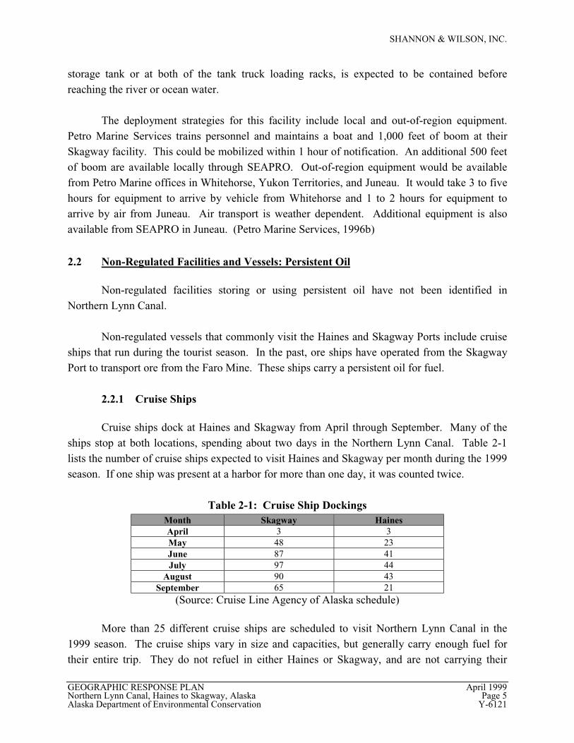
Cruise ships dock at Haines and Skagway from April through September. Many of theships stop at both locations, spending about two days in the Northern Lynn Canal. Table 2-1lists the number of cruise ships expected to visit Haines and Skagway per month during the 1999season. If one ship was present at a harbor for more than one day, it was counted twice.
Table 2-1: Cruise Ship DockingsMonth Skagway HainesApril 3 3May 48 23June 87 41July 97 44
August 90 43September 65 21
(Source: Cruise Line Agency of Alaska schedule)
More than 25 different cruise ships are scheduled to visit Northern Lynn Canal in the1999 season. The cruise ships vary in size and capacities, but generally carry enough fuel fortheir entire trip. They do not refuel in either Haines or Skagway, and are not carrying their
SHANNON & WILSON, INC.
GEOGRAPHIC RESPONSE PLAN April 1999Northern Lynn Canal, Haines to Skagway, Alaska Page 6Alaska Department of Environmental Conservation Y-6121
maximum fuel loads in these regions. Fuel capacities for ships operating in the Haines andSkagway region range from approximately 600,000 gallons to 1,000,000 gallons of Bunker Cfuel. In addition to the Bunker C fuel, other fuels on board may be present in volumes as great as70,000 gallons.
Skagway has dock space for five large cruise ships. During the cruise ship season, sixcruise ships are scheduled to be in Skagway in one day. This will require the departure of oneship and the arrival of another that day. Haines has dock space for one large cruise ship;additional ships anchor offshore. There are days where three to five ships are scheduled to be inHaines. This situation requires that either several ships anchor offshore and transport thepassengers to shore with smaller boats, or the departure and arrival of ships on the same day.
2.2.2 Ore Ships
In the past, ore ships have docked in Skagway to load and transport ore from the FaroMine. However, the Faro Mine has not been shipping ore for more than a year. No oreshipments are scheduled for the near future. (Russo, personal communication)
2.3 Non-Regulated Facilities and Vessels: Non-Persistent Oil
Non-regulated facilities storing or using non-persistent oil have not been identified inNorthern Lynn Canal.
The non-regulated vessels operating in Northern Lynn Canal include small boats thatdock at the small boat harbors in both Haines and Skagway, and the AMHS ferries, which call atboth communities. Day boats, including the Haines/Skagway Water Taxi, are also in thiscategory. The AMHS contracts its fueling to Petro Marine Services, which is a regulatedfacility.
2.3.1 Small Boats
The Small Boat Harbor in Skagway has slips for 130 local boats. Many of these boats areused on a daily basis during the summer season (generally defined as Memorial Day to LaborDay). In addition, there are an estimated 450 additional small boat arrivals during the 3-monthsummer season. These boats, on average, hold approximately 50 gallons of fuel. The estimatedmaximum fuel storage capacity for the larger of the small boats may be as much as 3,000gallons. In addition, Amak Towing keeps two tugs in the Skagway area in the summer season.Of these tugs, the Ethan B. holds 10,000 gallons of diesel and La Cheval Rouge holds 22,000gallons of diesel. (Source: Russo, personal communication)
SHANNON & WILSON, INC.
GEOGRAPHIC RESPONSE PLAN April 1999Northern Lynn Canal, Haines to Skagway, Alaska Page 7Alaska Department of Environmental Conservation Y-6121
The Haines Small Boat Harbor has slips for 140 local boats. It is estimated that nearly300 boats use the harbor during the busy summer season. The average vessel size is estimated tobe about 34 feet in length and the average fuel capacity is 100 to 150 gallons. A fueling facilityis located in the small boat harbor. It is currently contracted to Petro Marine, a regulated facility.Fuel barges bring fuel to town one to two times monthly in the summer months, and once ortwice over the winter. Fuel barges hold about 1.5 million gallons of fuel. In addition, twofreight barges stop in Haines each week. (Source: Stokely, personal communication)
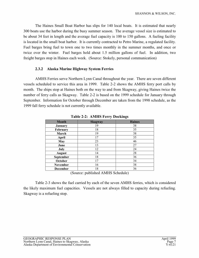
2.3.2 Alaska Marine Highway System Ferries
AMHS Ferries serve Northern Lynn Canal throughout the year. There are seven differentvessels scheduled to service this area in 1999. Table 2-2 shows the AMHS ferry port calls bymonth. The ships stop at Haines both on the way to and from Skagway, giving Haines twice thenumber of ferry calls as Skagway. Table 2-2 is based on the 1999 schedule for January throughSeptember. Information for October through December are taken from the 1998 schedule, as the1999 fall ferry schedule is not currently available.
Table 2-2: AMHS Ferry DockingsMonth Skagway Haines
January 19 38February 18 35
March 19 38April 17 35May 23 46June 13 27July 12 24
August 14 28September 18 36
October 17 34November 16 38December 18 36
(Source: published AMHS Schedule)
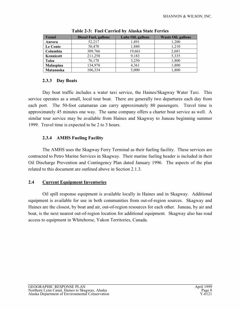
Table 2-3 shows the fuel carried by each of the seven AMHS ferries, which is consideredthe likely maximum fuel capacities. Vessels are not always filled to capacity during refueling.Skagway is a refueling stop.
SHANNON & WILSON, INC.
GEOGRAPHIC RESPONSE PLAN April 1999Northern Lynn Canal, Haines to Skagway, Alaska Page 8Alaska Department of Environmental Conservation Y-6121
Table 2-3: Fuel Carried by Alaska State FerriesVessel Diesel Fuel, gallons Lube Oil, gallons Waste Oil, gallonsAurora 52,217 1,891 1,200Le Conte 50,470 1,880 1,210Columbia 309,766 19,661 2,681Kennicott 211,258 9,183 5,335Taku 76,178 3,250 1,800Malaspina 134,978 4,361 1,800Matanuska 106,334 5,000 1,800
2.3.3 Day Boats
Day boat traffic includes a water taxi service, the Haines/Skagway Water Taxi. Thisservice operates as a small, local tour boat. There are generally two departures each day fromeach port. The 50-foot catamaran can carry approximately 80 passengers. Travel time isapproximately 45 minutes one way. The same company offers a charter boat service as well. Asimilar tour service may be available from Haines and Skagway to Juneau beginning summer1999. Travel time is expected to be 2 to 3 hours.
2.3.4 AMHS Fueling Facility
The AMHS uses the Skagway Ferry Terminal as their fueling facility. These services arecontracted to Petro Marine Services in Skagway. Their marine fueling header is included in theirOil Discharge Prevention and Contingency Plan dated January 1996. The aspects of the planrelated to this document are outlined above in Section 2.1.3.
2.4 Current Equipment Inventories
Oil spill response equipment is available locally in Haines and in Skagway. Additionalequipment is available for use in both communities from out-of-region sources. Skagway andHaines are the closest, by boat and air, out-of-region resources for each other. Juneau, by air andboat, is the next nearest out-of-region location for additional equipment. Skagway also has roadaccess to equipment in Whitehorse, Yukon Territories, Canada.
SHANNON & WILSON, INC.
GEOGRAPHIC RESPONSE PLAN April 1999Northern Lynn Canal, Haines to Skagway, Alaska Page 9Alaska Department of Environmental Conservation Y-6121
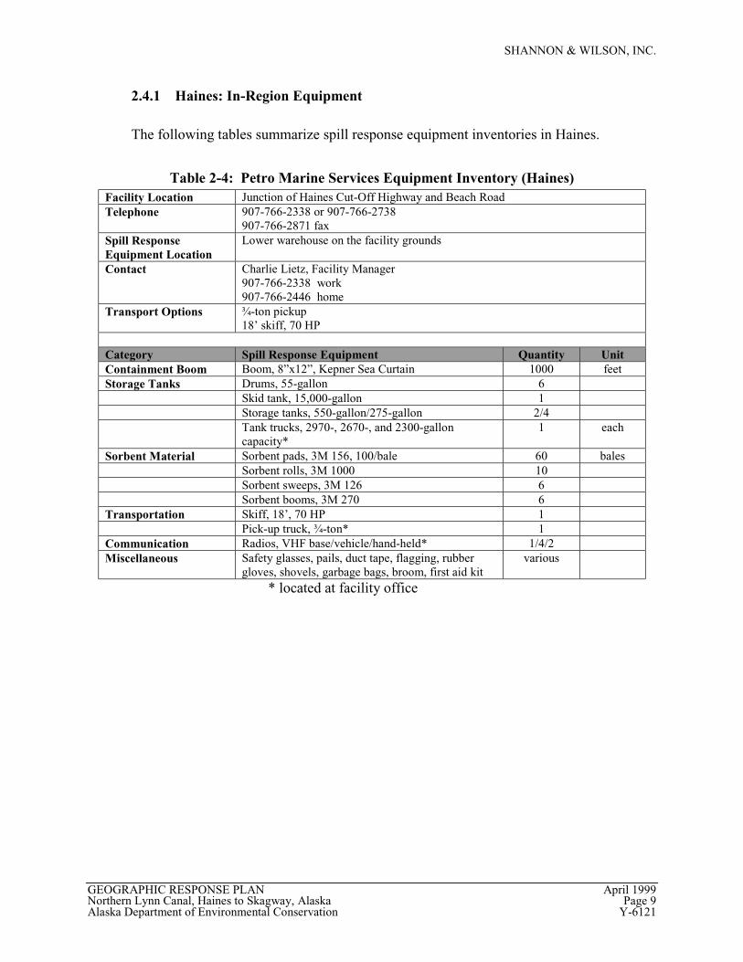
2.4.1 Haines: In-Region Equipment
The following tables summarize spill response equipment inventories in Haines.
Table 2-4: Petro Marine Services Equipment Inventory (Haines)Facility Location Junction of Haines Cut-Off Highway and Beach RoadTelephone 907-766-2338 or 907-766-2738
907-766-2871 faxSpill ResponseEquipment Location
Lower warehouse on the facility grounds
Contact Charlie Lietz, Facility Manager907-766-2338 work907-766-2446 home
Transport Options ¾-ton pickup18’ skiff, 70 HP
Category Spill Response Equipment Quantity UnitContainment Boom Boom, 8”x12”, Kepner Sea Curtain 1000 feetStorage Tanks Drums, 55-gallon 6
Skid tank, 15,000-gallon 1Storage tanks, 550-gallon/275-gallon 2/4Tank trucks, 2970-, 2670-, and 2300-galloncapacity*
1 each
Sorbent Material Sorbent pads, 3M 156, 100/bale 60 balesSorbent rolls, 3M 1000 10Sorbent sweeps, 3M 126 6Sorbent booms, 3M 270 6
Transportation Skiff, 18’, 70 HP 1Pick-up truck, ¾-ton* 1
Communication Radios, VHF base/vehicle/hand-held* 1/4/2Miscellaneous Safety glasses, pails, duct tape, flagging, rubber
gloves, shovels, garbage bags, broom, first aid kitvarious
* located at facility office
SHANNON & WILSON, INC.
GEOGRAPHIC RESPONSE PLAN April 1999Northern Lynn Canal, Haines to Skagway, Alaska Page 10Alaska Department of Environmental Conservation Y-6121
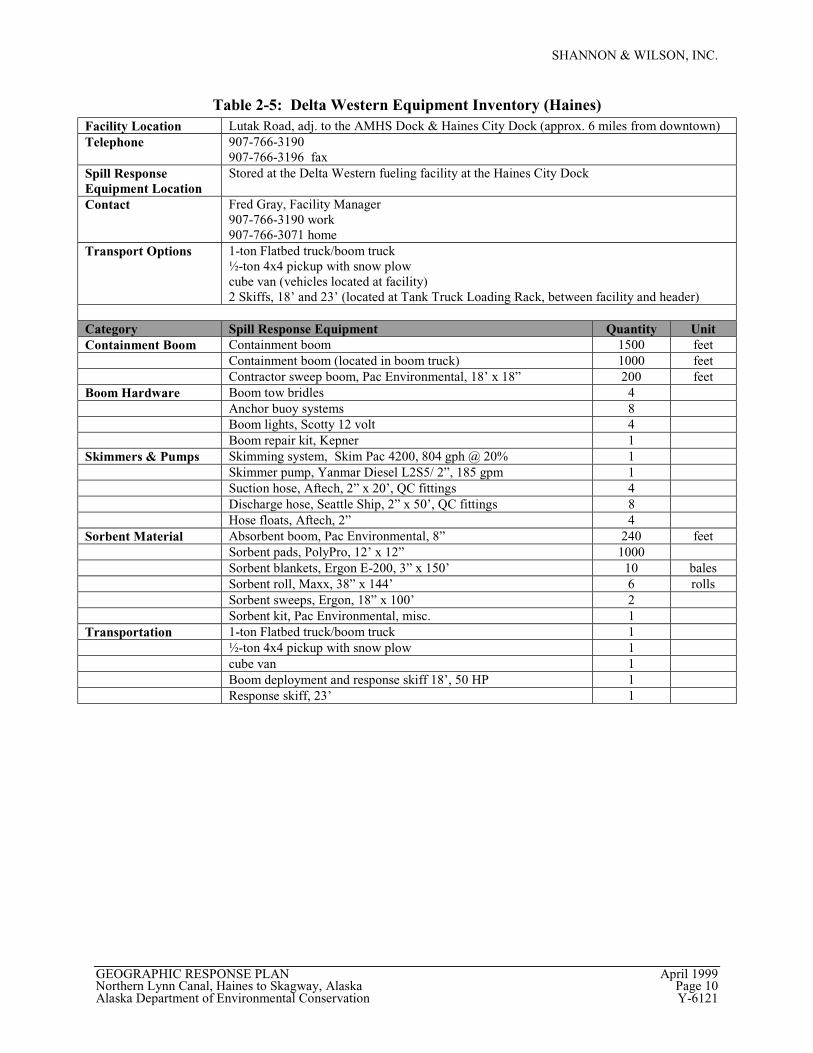
Table 2-5: Delta Western Equipment Inventory (Haines)Facility Location Lutak Road, adj. to the AMHS Dock & Haines City Dock (approx. 6 miles from downtown)Telephone 907-766-3190
907-766-3196 faxSpill ResponseEquipment Location
Stored at the Delta Western fueling facility at the Haines City Dock
Contact Fred Gray, Facility Manager907-766-3190 work907-766-3071 home
Transport Options 1-ton Flatbed truck/boom truck½-ton 4x4 pickup with snow plowcube van (vehicles located at facility)2 Skiffs, 18’ and 23’ (located at Tank Truck Loading Rack, between facility and header)
Category Spill Response Equipment Quantity UnitContainment Boom Containment boom 1500 feet
Containment boom (located in boom truck) 1000 feetContractor sweep boom, Pac Environmental, 18’ x 18” 200 feet
Boom Hardware Boom tow bridles 4Anchor buoy systems 8Boom lights, Scotty 12 volt 4Boom repair kit, Kepner 1
Skimmers & Pumps Skimming system, Skim Pac 4200, 804 gph @ 20% 1Skimmer pump, Yanmar Diesel L2S5/ 2”, 185 gpm 1Suction hose, Aftech, 2” x 20’, QC fittings 4Discharge hose, Seattle Ship, 2” x 50’, QC fittings 8Hose floats, Aftech, 2” 4
Sorbent Material Absorbent boom, Pac Environmental, 8” 240 feetSorbent pads, PolyPro, 12’ x 12” 1000Sorbent blankets, Ergon E-200, 3” x 150’ 10 balesSorbent roll, Maxx, 38” x 144’ 6 rollsSorbent sweeps, Ergon, 18” x 100’ 2Sorbent kit, Pac Environmental, misc. 1
Transportation 1-ton Flatbed truck/boom truck 1½-ton 4x4 pickup with snow plow 1cube van 1Boom deployment and response skiff 18’, 50 HP 1Response skiff, 23’ 1
SHANNON & WILSON, INC.
GEOGRAPHIC RESPONSE PLAN April 1999Northern Lynn Canal, Haines to Skagway, Alaska Page 11Alaska Department of Environmental Conservation Y-6121
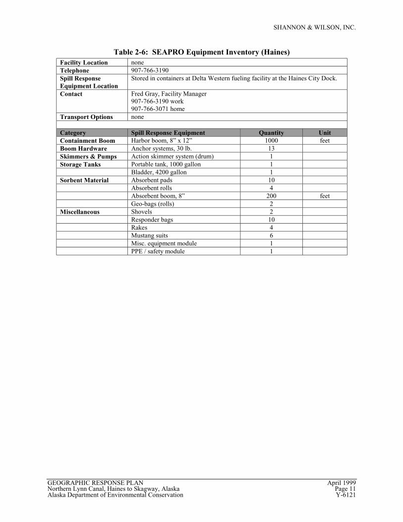
Table 2-6: SEAPRO Equipment Inventory (Haines)Facility Location noneTelephone 907-766-3190Spill ResponseEquipment Location
Stored in containers at Delta Western fueling facility at the Haines City Dock.
Contact Fred Gray, Facility Manager907-766-3190 work907-766-3071 home
Transport Options none
Category Spill Response Equipment Quantity UnitContainment Boom Harbor boom, 8” x 12” 1000 feetBoom Hardware Anchor systems, 30 lb. 13Skimmers & Pumps Action skimmer system (drum) 1Storage Tanks Portable tank, 1000 gallon 1
Bladder, 4200 gallon 1Sorbent Material Absorbent pads 10
Absorbent rolls 4Absorbent boom, 8” 200 feetGeo-bags (rolls) 2
Miscellaneous Shovels 2Responder bags 10Rakes 4Mustang suits 6Misc. equipment module 1PPE / safety module 1
SHANNON & WILSON, INC.
GEOGRAPHIC RESPONSE PLAN April 1999Northern Lynn Canal, Haines to Skagway, Alaska Page 12Alaska Department of Environmental Conservation Y-6121
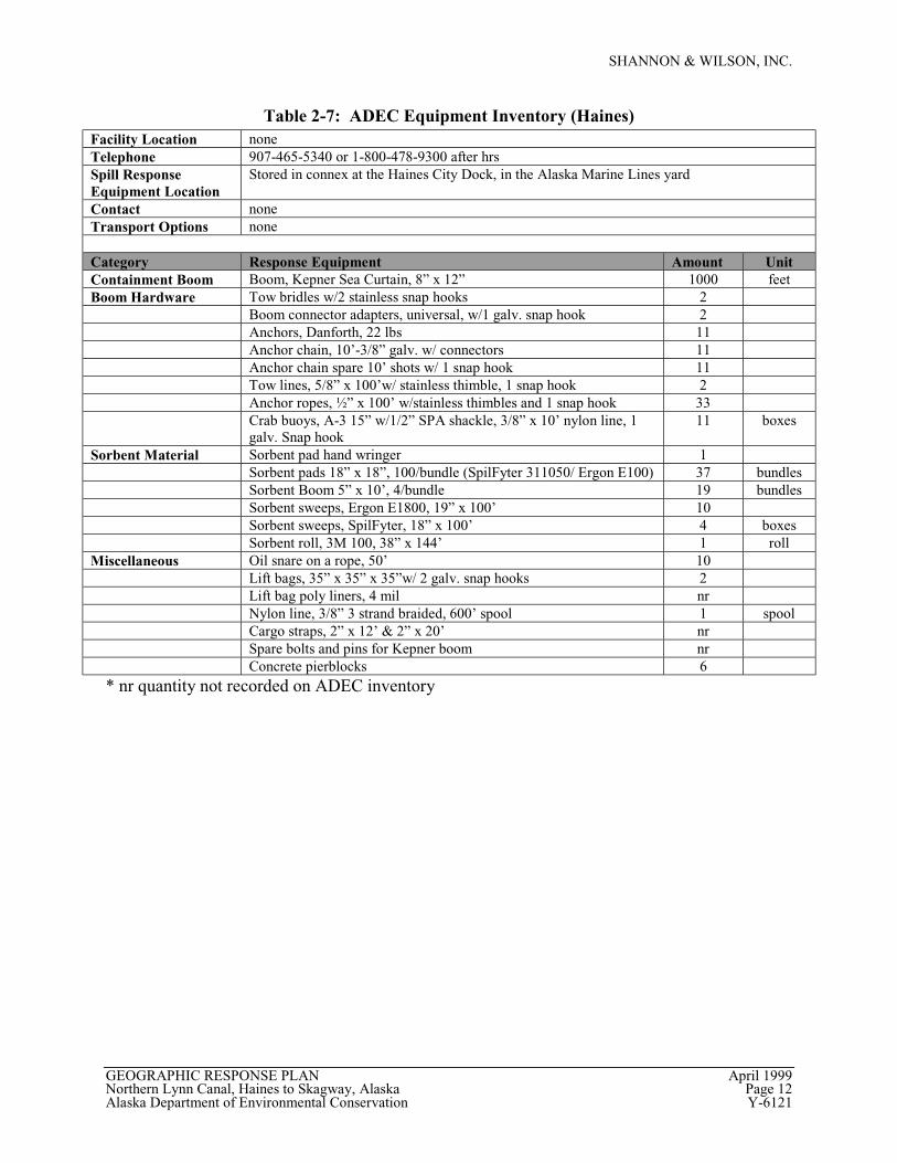
Table 2-7: ADEC Equipment Inventory (Haines)Facility Location noneTelephone 907-465-5340 or 1-800-478-9300 after hrsSpill ResponseEquipment Location
Stored in connex at the Haines City Dock, in the Alaska Marine Lines yard
Contact noneTransport Options none
Category Response Equipment Amount UnitContainment Boom Boom, Kepner Sea Curtain, 8” x 12” 1000 feetBoom Hardware Tow bridles w/2 stainless snap hooks 2
Boom connector adapters, universal, w/1 galv. snap hook 2Anchors, Danforth, 22 lbs 11Anchor chain, 10’-3/8” galv. w/ connectors 11Anchor chain spare 10’ shots w/ 1 snap hook 11Tow lines, 5/8” x 100’w/ stainless thimble, 1 snap hook 2Anchor ropes, ½” x 100’ w/stainless thimbles and 1 snap hook 33Crab buoys, A-3 15” w/1/2” SPA shackle, 3/8” x 10’ nylon line, 1galv. Snap hook
11 boxes
Sorbent Material Sorbent pad hand wringer 1Sorbent pads 18” x 18”, 100/bundle (SpilFyter 311050/ Ergon E100) 37 bundlesSorbent Boom 5” x 10’, 4/bundle 19 bundlesSorbent sweeps, Ergon E1800, 19” x 100’ 10Sorbent sweeps, SpilFyter, 18” x 100’ 4 boxesSorbent roll, 3M 100, 38” x 144’ 1 roll
Miscellaneous Oil snare on a rope, 50’ 10Lift bags, 35” x 35” x 35”w/ 2 galv. snap hooks 2Lift bag poly liners, 4 mil nrNylon line, 3/8” 3 strand braided, 600’ spool 1 spoolCargo straps, 2” x 12’ & 2” x 20’ nrSpare bolts and pins for Kepner boom nrConcrete pierblocks 6
* nr quantity not recorded on ADEC inventory
SHANNON & WILSON, INC.
GEOGRAPHIC RESPONSE PLAN April 1999Northern Lynn Canal, Haines to Skagway, Alaska Page 13Alaska Department of Environmental Conservation Y-6121
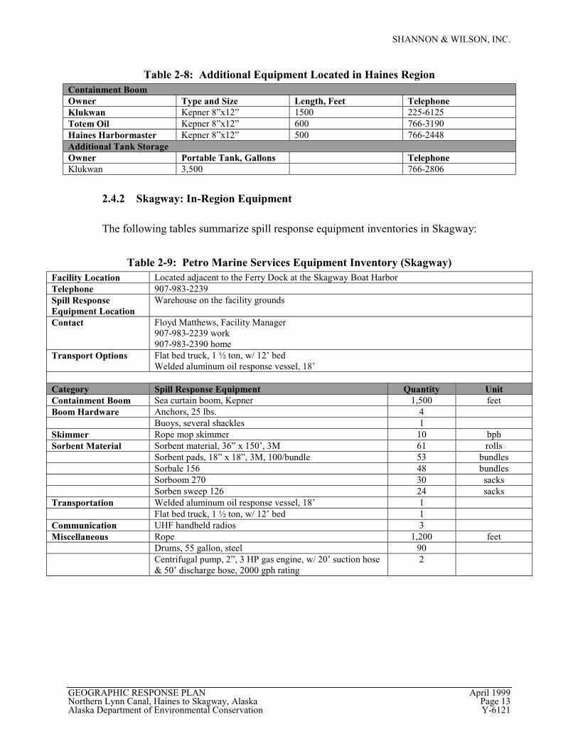
Table 2-8: Additional Equipment Located in Haines RegionContainment BoomOwner Type and Size Length, Feet TelephoneKlukwan Kepner 8”x12” 1500 225-6125Totem Oil Kepner 8”x12” 600 766-3190Haines Harbormaster Kepner 8”x12” 500 766-2448Additional Tank StorageOwner Portable Tank, Gallons TelephoneKlukwan 3,500 766-2806
2.4.2 Skagway: In-Region Equipment
The following tables summarize spill response equipment inventories in Skagway:
Table 2-9: Petro Marine Services Equipment Inventory (Skagway)Facility Location Located adjacent to the Ferry Dock at the Skagway Boat HarborTelephone 907-983-2239Spill ResponseEquipment Location
Warehouse on the facility grounds
Contact Floyd Matthews, Facility Manager907-983-2239 work907-983-2390 home
Transport Options Flat bed truck, 1 ½ ton, w/ 12’ bedWelded aluminum oil response vessel, 18’
Category Spill Response Equipment Quantity UnitContainment Boom Sea curtain boom, Kepner 1,500 feetBoom Hardware Anchors, 25 lbs. 4
Buoys, several shackles 1Skimmer Rope mop skimmer 10 bphSorbent Material Sorbent material, 36” x 150’, 3M 61 rolls
Sorbent pads, 18” x 18”, 3M, 100/bundle 53 bundlesSorbale 156 48 bundlesSorboom 270 30 sacksSorben sweep 126 24 sacks
Transportation Welded aluminum oil response vessel, 18’ 1Flat bed truck, 1 ½ ton, w/ 12’ bed 1
Communication UHF handheld radios 3Miscellaneous Rope 1,200 feet
Drums, 55 gallon, steel 90Centrifugal pump, 2”, 3 HP gas engine, w/ 20’ suction hose& 50’ discharge hose, 2000 gph rating
2
SHANNON & WILSON, INC.
GEOGRAPHIC RESPONSE PLAN April 1999Northern Lynn Canal, Haines to Skagway, Alaska Page 14Alaska Department of Environmental Conservation Y-6121
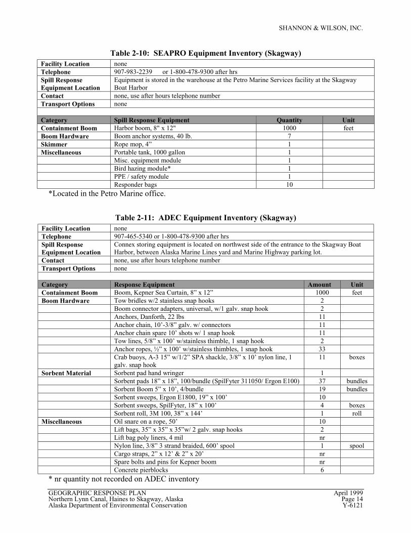
Table 2-10: SEAPRO Equipment Inventory (Skagway)Facility Location noneTelephone 907-983-2239 or 1-800-478-9300 after hrsSpill ResponseEquipment Location
Equipment is stored in the warehouse at the Petro Marine Services facility at the SkagwayBoat Harbor
Contact none, use after hours telephone numberTransport Options none
Category Spill Response Equipment Quantity UnitContainment Boom Harbor boom, 8" x 12" 1000 feetBoom Hardware Boom anchor systems, 40 lb. 7Skimmer Rope mop, 4” 1Miscellaneous Portable tank, 1000 gallon 1
Misc. equipment module 1Bird hazing module* 1PPE / safety module 1Responder bags 10
*Located in the Petro Marine office.
Table 2-11: ADEC Equipment Inventory (Skagway)Facility Location noneTelephone 907-465-5340 or 1-800-478-9300 after hrsSpill ResponseEquipment Location
Connex storing equipment is located on northwest side of the entrance to the Skagway BoatHarbor, between Alaska Marine Lines yard and Marine Highway parking lot.
Contact none, use after hours telephone numberTransport Options none
Category Response Equipment Amount UnitContainment Boom Boom, Kepner Sea Curtain, 8” x 12” 1000 feetBoom Hardware Tow bridles w/2 stainless snap hooks 2
Boom connector adapters, universal, w/1 galv. snap hook 2Anchors, Danforth, 22 lbs 11Anchor chain, 10’-3/8” galv. w/ connectors 11Anchor chain spare 10’ shots w/ 1 snap hook 11Tow lines, 5/8” x 100’ w/stainless thimble, 1 snap hook 2Anchor ropes, ½” x 100’ w/stainless thimbles, 1 snap hook 33Crab buoys, A-3 15” w/1/2” SPA shackle, 3/8” x 10’ nylon line, 1galv. snap hook
11 boxes
Sorbent Material Sorbent pad hand wringer 1Sorbent pads 18” x 18”, 100/bundle (SpilFyter 311050/ Ergon E100) 37 bundlesSorbent Boom 5” x 10’, 4/bundle 19 bundlesSorbent sweeps, Ergon E1800, 19” x 100’ 10Sorbent sweeps, SpilFyter, 18” x 100’ 4 boxesSorbent roll, 3M 100, 38” x 144’ 1 roll
Miscellaneous Oil snare on a rope, 50’ 10Lift bags, 35” x 35” x 35”w/ 2 galv. snap hooks 2Lift bag poly liners, 4 mil nrNylon line, 3/8” 3 strand braided, 600’ spool 1 spoolCargo straps, 2” x 12’ & 2” x 20’ nrSpare bolts and pins for Kepner boom nrConcrete pierblocks 6
* nr quantity not recorded on ADEC inventory
SHANNON & WILSON, INC.
GEOGRAPHIC RESPONSE PLAN April 1999Northern Lynn Canal, Haines to Skagway, Alaska Page 15Alaska Department of Environmental Conservation Y-6121
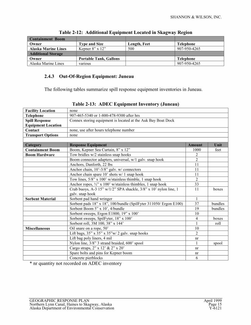
Table 2-12: Additional Equipment Located in Skagway RegionContainment BoomOwner Type and Size Length, Feet TelephoneAlaska Marine Lines Kepner 8” x 12” 500 907-950-4265Additional StorageOwner Portable Tank, Gallons TelephoneAlaska Marine Lines various 907-950-4265
2.4.3 Out-Of-Region Equipment: Juneau
The following tables summarize spill response equipment inventories in Juneau.
Table 2-13: ADEC Equipment Inventory (Juneau)Facility Location noneTelephone 907-465-5340 or 1-800-478-9300 after hrsSpill ResponseEquipment Location
Connex storing equipment is located at the Auk Bay Boat Dock
Contact none, use after hours telephone numberTransport Options none
Category Response Equipment Amount UnitContainment Boom Boom, Kepner Sea Curtain, 8” x 12” 1000 feetBoom Hardware Tow bridles w/2 stainless snap hooks 2
Boom connector adapters, universal, w/1 galv. snap hook 2Anchors, Danforth, 22 lbs 11Anchor chain, 10’-3/8” galv. w/ connectors 11Anchor chain spare 10’ shots w/ 1 snap hook 11Tow lines, 5/8” x 100’ w/stainless thimble, 1 snap hook 2Anchor ropes, ½” x 100’ w/stainless thimbles, 1 snap hook 33Crab buoys, A-3 15” w/1/2” SPA shackle, 3/8” x 10’ nylon line, 1galv. snap hook
11 boxes
Sorbent Material Sorbent pad hand wringer 1Sorbent pads 18” x 18”, 100/bundle (SpilFyter 311050/ Ergon E100) 37 bundlesSorbent Boom 5” x 10’, 4/bundle 19 bundlesSorbent sweeps, Ergon E1800, 19” x 100’ 10Sorbent sweeps, SpilFyter, 18” x 100’ 4 boxesSorbent roll, 3M 100, 38” x 144’ 1 roll
Miscellaneous Oil snare on a rope, 50’ 10Lift bags, 35” x 35” x 35”w/ 2 galv. snap hooks 2Lift bag poly liners, 4 mil nrNylon line, 3/8” 3 strand braided, 600’ spool 1 spoolCargo straps, 2” x 12’ & 2” x 20’ nrSpare bolts and pins for Kepner boom nrConcrete pierblocks 6
* nr quantity not recorded on ADEC inventory
SHANNON & WILSON, INC.
GEOGRAPHIC RESPONSE PLAN April 1999Northern Lynn Canal, Haines to Skagway, Alaska Page 16Alaska Department of Environmental Conservation Y-6121
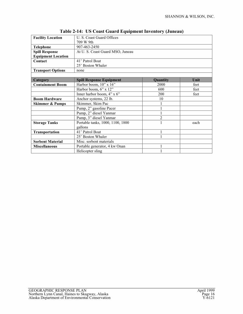
Table 2-14: US Coast Guard Equipment Inventory (Juneau)Facility Location U. S. Coast Guard Offices
709 W 9thTelephone 907-463-2450Spill ResponseEquipment Location
At U. S. Coast Guard MSO, Juneau
Contact 41’ Patrol Boat25’ Boston Whaler
Transport Options none
Category Spill Response Equipment Quantity UnitContainment Boom Harbor boom, 10” x 16” 2000 feet
Harbor boom, 6” x 12” 600 feetInner harbor boom, 4” x 6” 200 feet
Boom Hardware Anchor systems, 22 lb. 10Skimmer & Pumps Skimmer, Skim Pac 1
Pump, 2” gasoline Pacer 1Pump, 2” diesel Yanmar 1Pump, 3” diesel Yanmar 2
Storage Tanks Portable tanks, 1000, 1100, 1800gallons
1 each
Transportation 41’ Patrol Boat 125’ Boston Whaler 1
Sorbent Material Misc. sorbent materialsMiscellaneous Portable generator, 4 kw Onan 1
Helicopter sling 1
SHANNON & WILSON, INC.
GEOGRAPHIC RESPONSE PLAN April 1999Northern Lynn Canal, Haines to Skagway, Alaska Page 17Alaska Department of Environmental Conservation Y-6121
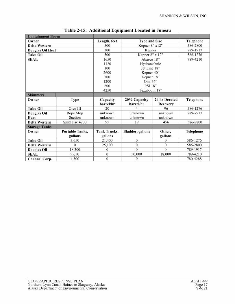
Table 2-15: Additional Equipment Located in JuneauContainment BoomOwner Length, feet Type and Size TelephoneDelta Western 500 Kepner 8" x12" 586-2800Douglas Oil Heat 300 Kepner 789-1917Taku Oil 500 Kepner 8" x 12" 586-1276SEAL 1650
1120100
2600300
1200600
4250
Abasco 18”HydrotechnicJet Line 18”Kepner 40”Kepner 18”
Omi 36”PSI 18”
Texaboom 18”
789-4210
SkimmersOwner Type Capacity
barrel/hr20% Capacity
barrel/hr24 hr Derated
RecoveryTelephone
Taku Oil Oleo III 20 4 96 586-1276Douglas OilHeat
Rope MopSuction
unknownunknown
unknownunknown
unknownunknown
789-7917
Delta Western Skim Pac 4200 95 19 456 586-2800Storage TanksOwner Portable Tanks,
gallonsTank Trucks,
gallonsBladder, gallons Other,
gallonsTelephone
Taku Oil 3,650 21,400 0 0 586-1276Delta Western 0 25,100 0 0 586-2800Douglas Oil 18,300 0 0 0 789-1917SEAL 9,650 0 50,000 18,000 789-4210Channel Corp. 4,500 0 0 780-4288
SHANNON & WILSON, INC.
GEOGRAPHIC RESPONSE PLAN April 1999Northern Lynn Canal, Haines to Skagway, Alaska Page 18Alaska Department of Environmental Conservation Y-6121
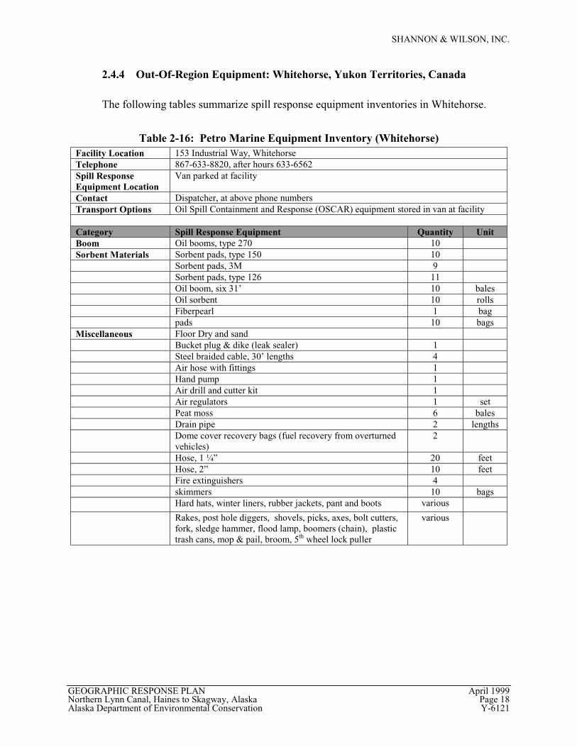
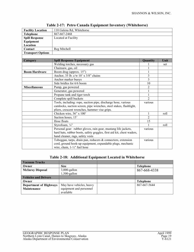
2.4.4 Out-Of-Region Equipment: Whitehorse, Yukon Territories, Canada
The following tables summarize spill response equipment inventories in Whitehorse.
Table 2-16: Petro Marine Equipment Inventory (Whitehorse)Facility Location 153 Industrial Way, WhitehorseTelephone 867-633-8820, after hours 633-6562Spill ResponseEquipment Location
Van parked at facility
Contact Dispatcher, at above phone numbersTransport Options Oil Spill Containment and Response (OSCAR) equipment stored in van at facility
Category Spill Response Equipment Quantity UnitBoom Oil booms, type 270 10Sorbent Materials Sorbent pads, type 150 10
Sorbent pads, 3M 9Sorbent pads, type 126 11Oil boom, six 31’ 10 balesOil sorbent 10 rollsFiberpearl 1 bagpads 10 bags
Miscellaneous Floor Dry and sandBucket plug & dike (leak sealer) 1Steel braided cable, 30’ lengths 4Air hose with fittings 1Hand pump 1Air drill and cutter kit 1Air regulators 1 setPeat moss 6 balesDrain pipe 2 lengthsDome cover recovery bags (fuel recovery from overturnedvehicles)
2
Hose, 1 ¼” 20 feetHose, 2” 10 feetFire extinguishers 4skimmers 10 bagsHard hats, winter liners, rubber jackets, pant and boots various
Rakes, post hole diggers, shovels, picks, axes, bolt cutters,fork, sledge hammer, flood lamp, boomers (chain), plastictrash cans, mop & pail, broom, 5th wheel lock puller
various
SHANNON & WILSON, INC.
GEOGRAPHIC RESPONSE PLAN April 1999Northern Lynn Canal, Haines to Skagway, Alaska Page 19Alaska Department of Environmental Conservation Y-6121
Table 2-17: Petro Canada Equipment Inventory (Whitehorse)Facility Location 110 Galena Rd, WhitehorseTelephone 867-667-2468Spill ResponseEquipmentLocation
Located at Facility
Contact Reg MitchellTransport Options
Category Spill Response Equipment Quantity UnitWelding torches, necessary gas 1 setChainsaw, gas, oil 1
Boom Hardware Boom drag (approx. 15”) 1Anchor, 35 lb. c/w 10’ x 3/8” chains 3Anchor marker buoys 3Side bridles for 6/6 boom 10
Miscellaneous Pump, gas powered 2Generator, gas powered 1Propane tank and tiger torch 1Complete spill buckets 2Tools, including: rope, suction pipe, discharge hose, variouscamlocks, suction screen, pipe wrenches, steel stakes, flashlight,pliers, crescent wrenches, hammer vise grips.
various
Chicken wire, 36” x 100’ 1 rollSuction hoses, 15’ 2Hose floats 15Styrofoam, ¼” 1 rollPersonal gear: rubber gloves, rain gear, mustang life jackets,hard hats, rubber boots, safety goggles, first aid kit, chest waders,hand cleaner, rags, safety vests
various
Toboggan, tarps, drain pan, reducers & connectors, extensioncord, ground hook-up equipment, expandable plugs, mechanicwire, chain, 1-½" fuel hose
various
Table 2-18: Additional Equipment Located in WhitehorseVacuum TrucksOwner Size TelephoneMcInroy Disposal 3,000-gallon
1,500-gallon867-668-4338
Vehicles and DriversOwner TelephoneDepartment of HighwaysMaintenance
May have vehicles, heavyequipment and personnelavailable
867-667-5644
SHANNON & WILSON, INC.
GEOGRAPHIC RESPONSE PLAN April 1999Northern Lynn Canal, Haines to Skagway, Alaska Page 20Alaska Department of Environmental Conservation Y-6121
(intentionally blank)
SHANNON & WILSON, INC.
GEOGRAPHIC RESPONSE PLAN April 1999Northern Lynn Canal, Haines to Skagway, Alaska Page 21Alaska Department of Environmental Conservation Y-6121
3.0 ENVIRONMENTALLY SENSITIVE AREAS
Environmentally sensitive areas are identified in the following sections to aid localresponders in implementing the near-shore protection strategy. The environmentally sensitiveareas described below are varied, and include areas with plant and animal resources sensitive tospill impacts; areas with animal species used as food sources; areas containing important culturalresources (subsistence use and sites of historic and prehistoric origins); other resources identifiedas being at high risk from a discharge; and public interest lands (such as harbors and public useareas). These areas are shown in Figures 2 and 3 for the Haines region, Figure 4 for the areasouth of Haines, and Figure 5 for the Skagway region. Information in this section has beencompiled from the Unified Plan Part 3, the Southeast SCP, the Delta Western 1995 Plan, and thePetro Marine Services 1996 Plans for Skagway and Haines.
3.1 List of Environmentally Sensitive Areas
In the following sections, environmentally sensitive areas are listed alphabetically byassociation with the towns of Skagway and Haines. Much of the rest of the coastline of NorthernLynn Canal is categorized as a rocky coastline, and as such, is not highly sensitive to a discharge.A description of location, resources of concern, and degree of sensitivity are provided for eachenvironmentally sensitive area.
3.1.1 Haines Environmentally Sensitive Areas
Alaska Chilkat Bald Eagle Preserve. The Alaska Chilkat River Bald Eagle Preserve is locatednorthwest of Haines, along the Chilkoot and Chilkat Rivers (Figure 3). The Preserve extendsalong the Chilkat River to the north end of the mudflats at the river’s mouth in Chilkat Inlet. Theregion itself is not likely susceptible to impacts from a spill, but the bald eagles that congregatein this location would likely be using coastal food sources and fall salmon runs in the river.
Chilkat River Critical Habitat Area. The Chilkat River Critical Habitat Area is along theChilkat River, northwest of Haines, between the communities of Katkwaahltu and Klukwan,adjacent to a portion of the Alaska Chilkat Bald Eagle Preserve (Figure 3). It is upstream fromthe mouth of the Chilkat River, and is not likely to be directly affected by a discharge in theInlet. However, bald eagles that congregate in this region would likely be using coastal areasand fall salmon runs in the river as food sources.
Chilkat River Flats. The Chilkat River Flats are located at the northern end of the Chilkat Inlet,at the mouth of the Chilkat River (Figures 2 and 3). This area contains a variety of fisheryresources. These include near-shore adult salmon runs, early May to late November; spawning
SHANNON & WILSON, INC.
GEOGRAPHIC RESPONSE PLAN April 1999Northern Lynn Canal, Haines to Skagway, Alaska Page 22Alaska Department of Environmental Conservation Y-6121
salmon, early August to late December; juvenile salmon out-migration and near shore rearing,early March to late September; and eulachon spawning/egg incubation, mid-March to late June.In addition, the region is a waterfowl and shorebird staging area in the spring and fall and hostsbald eagle concentrations for feeding activities in early September to late January. This area isalso used for subsistence waterfowl hunting. The area is considered highly sensitive all year.
Chilkoot River Delta. The Chilkoot River Delta is located at the northwest end of the LutakInlet, south of Chilkoot Lake (Figure 3). This region contains estuarine flats, coho and pinksalmon runs, a herring spawning area, and intertidal and subtidal resources. The area isconsidered highly sensitive all year.
Katzehin River and River Mouth. The Katzehin River runs through the Tongass NationalForest and empties into Lynn Canal south of Haines and on the east side of the Chilkoot Inlet(Figures 2 and 4). The region contains estuarine flats, harbor seal concentration and haul-outareas, salmon resources, and intertidal and subtidal resources. Subsistence gathering of clams,cockles, and limpets, and hunting of waterfowl occurs in this area. The river and delta areas areconsidered highly sensitive all year, with the most sensitive period for harbor seals running fromlate May to mid-October.
Lutak Inlet. Lutak Inlet is the northwestern branch of the Northern Lynn Canal, north of Haines(Figures 2 and 3). Areas in the Lutak Inlet are used for subsistence harvesting of salmon, harborseals, crab, and shrimp.
Mud Bay Point and Flats. Mud Bay Point and Flats are located in the Chilkat Inlet, on thesouth side of the peninsula on which Haines is located (Figure 4). This region contains estuarineflats and subtidal resources. Fishery concerns include coho and pink salmon and spring herringspawning activity. The region is highly sensitive, with special concerns during the spring.
Nukdik Point. Nukdik Point is located north of Haines on the northern point of Portage Cove(Figures 2 and 3). This area is a herring spawning area, and is considered moderately sensitive,with the period of greatest sensitivity in the spring.
Taiyasanka Harbor. Taiyasanka Harbor is a small natural harbor located between Lutak Inletand Taiya Inlet (Figures 2 and 3). It contains estuarine flats and tidal and intertidal resources.The region is important to coho and pink salmon and herring fisheries. It is considered highlysensitive all year.
SHANNON & WILSON, INC.
GEOGRAPHIC RESPONSE PLAN April 1999Northern Lynn Canal, Haines to Skagway, Alaska Page 23Alaska Department of Environmental Conservation Y-6121
Tanani Point. Tanani Point is located north of Haines, on the north end of Tanani Bay (Figures2 and 3). The area is a herring spawning area and is considered moderately sensitive, with theperiod of greatest sensitivity in the spring.
3.1.2 Skagway Environmentally Sensitive Areas
Nahku Bay. Nahku Bay is a small bay near the northern end of Taiya Inlet (Figure 5). Ananadromous fish stream flows into the north end of Nahku Bay. The bay contains tidal flats.This area is considered highly sensitive all year.
Skagway River and Flats. The Skagway River enters the Taiya Inlet after passing throughSkagway on the northwest edge of town (Figure 5). The Skagway River has Dolly Varden andminor coho salmon runs, in addition to tidal and intertidal habitats for fish and wildlife. The areahas medium sensitivity all year.
Taiya Inlet. The Taiya Inlet is the northeastern branch of the northern end of Lynn Canal(Figures 2 and 5). The town of Skagway is located on the east side of this inlet. A harbor sealconcentration is located in a cove on the west side of the inlet near the mouth. This region isconsidered highly sensitive, with special concerns in the spring.
Taiya River Mouth and Dyea Flats. The Taiya River mouth is located at the northwestern endof Taiya Inlet (Figure 5). The Dyea Flats are at the mouth of the Taiya River and are named forthe historic former gold rush settlement of Dyea. The Klondike Gold Rush National HistoricalPark is located along the river and flats in this area. The Taiya River has chum, pink, and cohosalmon spawning runs from June through September, with juveniles present all year. Additionalfishery resources include Dolly Varden and cutthroat trout. A harbor seal concentration islocated near the Dyea Flats. This area is also important for its tidal flats and historic resources.The region is considered highly sensitive all year.
3.2 Resources at Risk
3.2.1 Haines Resources at Risk
Blue Heron Sea Farm. The Blue Heron Sea Farm is located in Haines, and cultivates oysters.
Subsistence Use. Several areas in the Haines region have been identified as subsistence harvestareas. These areas include: the Chilkat River Flats for waterfowl; the Katzehin River and rivermouth for clams, cockles, limpets and waterfowl; and areas of the Lutak Inlet for salmon, harborseals, crab, and shrimp.
SHANNON & WILSON, INC.
GEOGRAPHIC RESPONSE PLAN April 1999Northern Lynn Canal, Haines to Skagway, Alaska Page 24Alaska Department of Environmental Conservation Y-6121
3.2.2 Skagway Resources at Risk
Burro Creek Hatchery. Burro Creek Farms Hatchery is located on the west side of the TaiyaInlet, to the southwest of Skagway (Figure 5). The hatchery is a non-profit hatchery for pink,coho, chinook, and chum salmon eggs.
Pullen Creek Hatchery. The Pullen Creek Hatchery is a scientific and educational permithatchery operated by Skagway City Schools for chinook and coho salmon eggs (Figure 5).
3.3 Public Interest Lands
3.3.1 Archeological Sites
A list of archeological sites and resources identified to date is maintained in the AlaskaHeritage Resources Survey at the Alaska Department of Natural Resources (ADNR) Office ofHistory and Archeology (907-269-8715). Archeological resources, both historic and prehistoric,have been identified in the intertidal zone in the Haines and Skagway regions of Northern LynnCanal (Figures 2 through 5).
Haines Archeological Resources. In the Haines area, sites have been identified at the mouth ofChilkoot Lake in the Lutak Inlet and in the Chilkat Inlet, north of Kochu Island and including themudflats of the Chilkat River. Additional archeological resources may be present in the Hainesregion, but have not yet been reported to the ADNR.
Skagway Archeological Resources. In the Skagway region, major archeological resources withintertidal components are associated with the Klondike Gold Rush National Historical Park.Archeological resources have been identified in the coastal area around Dyea Flats and the TaiyaRiver, the harbor at the edge of Skagway, and mouth of the Skagway River. Additionalarcheological resources may be present in the Skagway region, but have not yet been reported tothe ADNR.
3.3.2 Haines Public Interest Lands
Alaska Chilkat Bald Eagle Preserve. See Section 3.1.1 for a description of the Preserve. Thisarea is of high interest to tourists and people interested in bald eagles.
Chilkat State Park. This state park is located south of Haines, encompassing much of theChilkat Peninsula (Figures 2 and 4). It is approximately 6,405 acres in size. The primary land
SHANNON & WILSON, INC.
GEOGRAPHIC RESPONSE PLAN April 1999Northern Lynn Canal, Haines to Skagway, Alaska Page 25Alaska Department of Environmental Conservation Y-6121
use is recreational. The facility is managed by the Alaska Division of Parks. Whales, seals, andsea otters are present in Northern Lynn Canal and Chilkat Inlet.
Haines State Forest and Resource Management Area. Located north of Haines, the HainesState Forest and Resource Management Area encompasses approximately 250,600 acres. This isa multiple use, recreation, and forest management area. It borders the inlets and intertidal areasand mobile animal populations may be impacted by discharges.
Portage Cove. Haines public boat marina and docks are located in Portage Cove (Figures 2 and3). The town of Haines is adjacent to this cove.
Seafood Processing. Local seafood processors may be operating in the Lutak Inlet, Taiya Inlet,or Chilkoot Inlet during the salmon processing season from June 1 to September 15.Commercial, sport, and subsistence fishing also take place in these waters.
3.3.3 Skagway Public Interest Lands
Skagway Port and Pullen Creek Mouth and Hatchery. A public boat harbor and severalprivate and public docks are located in the Skagway port area. Pullen Creek also drains into theport area. The Pullen Creek Hatchery is located upstream.
Taiya River Mouth and Dyea Flats. Located at the head of Taiya Inlet is the Klondike GoldRush National Historical Park (Figure 5). The Dyea Flats are the site of the gold rush town ofDyea. Although there are little visible remains of the town, the area is an important culturalresource. Klondike Goldrush National Historic Park hosts many visitors each year.

SHANNON & WILSON, INC.
GEOGRAPHIC RESPONSE PLAN April 1999Northern Lynn Canal, Haines to Skagway, Alaska Page 26Alaska Department of Environmental Conservation Y-6121
(intentionally blank)
SHANNON & WILSON, INC.
GEOGRAPHIC RESPONSE PLAN April 1999Northern Lynn Canal, Haines to Skagway, Alaska Page 27Alaska Department of Environmental Conservation Y-6121
4.0 BASIC NEAR-SHORE RESPONSE SCENARIOS AND STRATEGIES
To facilitate operations during a cleanup, the following four near-shore response
scenarios have been created. The basic scenarios have been designed to enable the user of the
GRP to understand the goals, strategy, and the mechanism necessary to defend the identified
environmentally sensitive environment during an actual event. The scenarios are designed to
cover the basic spill response and strategy and to provide a foundation for handling real life
situations. Two scenarios each have been created for both Haines and Skagway.
These scenarios have been developed to examine the environmental risks and responsecapabilities associated with a spill of heavy bunker oil (persistent) or number 1 diesel oil (non-persistent). The scenarios are for descriptive purposes and should not be considered aperformance standard. The scenario conditions or assumptions that are associated with thisincident include: vessel, timing, weather, location, Unified Command decisions, and spillvolume.
The intent and design of the scenarios are to address spill sources that may not have beenfully considered or the magnitude of a possible release that may not have been previouslyenvisioned. The scenario details are intended to provide a response that would require near-shore - onshore cleanup.
4.1 Haines Scenario No. 1: Persistent Oil from Cruise Ship
Site Description Indian Rock/Taiya Point Area, Chilkoot Inlet, 59 16.4' N, 135 24' 0 WIndian Rock is a projection of rocks exposed at low water. IndianRock is approximately 1.5 miles south of Taiya Point and 1.75 mileseast of Tanani Point. Indian Rock forms the junction point of LutakInlet, Taiya Inlet, and Chilkoot Inlet. The shoreline is relatively steepwith the mouth of the Chilkoot River being the major beach site in thearea. The closest harbor to the grounding is Haines, 3.5 miles to thesouthwest.
Vessel Cruise Ship North StarLocation Indian Rock - 59 16.4' N, 135 24' 0 WDate June 4, 1999Time 0530Weather Day 1 Winds SE 18 knots, Visibility 1 mile, Seas < 1 foot
Day 2 Winds S 10 knots, Visibility 3 miles, Seas < 1 footDay 3 Winds S 10 knots, Visibility 10 miles, Seas < 1 foot
Oil Loss 70,000 gallons Number 6 Bunker OilScenario Duration Day 1 - 2,000 Gallons Per Hour
Day 2 - 500 Gallons Per HourDay 3 - 500 Gallons Per Hour
SHANNON & WILSON, INC.
GEOGRAPHIC RESPONSE PLAN April 1999Northern Lynn Canal, Haines to Skagway, Alaska Page 28Alaska Department of Environmental Conservation Y-6121
Oil Type Persistent Oil - Specific Gravity of 0.92Bunker Oil Capacity 3,200 Metric Tons (958,532 US gallons)Potential Trajectories See Appendix A.Logistical Support See Appendix B.
4.1.1 Situation
At 0530, June 4, 1999, the foreign-flagged cruise ship North Star runs aground afterexperiencing a main propulsion plant power failure. The vessel is carrying 21,000 barrels of No.6 bunker fuel oil. The vessel was underway to Skagway with 650 passengers aboard. Afterlosing power, the vessel is able to anchor in 20 fathoms of water. After anchoring, the vesselswings on the incoming tide and grounds on the east side of Indian Rock. The vessel sustainsdamage to its port double-bottom bunker tanks. Bunker oil is observed on the water surface aftof the vessel. High tide will occur at 0615 local time at 12.5 feet; next low tide will be 2010.The winds are light, 18 knots out of the southeast, and tide and current will move the oil in anorthwesterly direction.
4.1.2 Initial Action
Immediately after the grounding, the Master of the North Star notifies their home officewho in turn notifies the United States Coast Guard (USCG) Command center in Juneau and theADEC. The owner/operator of the vessel accepts responsibility for the spill when contacted bythe Federal On-Scene Coordinator (FOSC), Commanding Officer of the USCG Marine SafetyOffice (MSO) Juneau. A temporary Unified Command post is established at MSO Juneau until aCommand Post can be established in Haines. The makeup of the temporary Unified Commandpost is the Commanding Officer, MSO Juneau (FOSC); ADEC (State On-Scene Coordinator -SOSC); and a representative from the RP.
The USCG Command Center in Juneau dispatches vessels for any necessary Search andRescue assistance. The time frame for the evacuation of the passengers will depend on thestructural integrity and stability of the vessel.
The following additional actions are requested and taken by the Unified Command:
• Federal Aviation Administration (FAA) - Restricted air space over the vessel.• Alaska Department of Fish & Game (ADF&G) and United States Fish & Wildlife
Service (USFWS) - Dispatch for biological and marine monitoring.• Local Spill Cooperative - RP contracts to coordinate initial cleanup activities.• USCG - Local Notice to Mariners.• National Oceanic and Atmospheric Administration (NOAA) - Spill trajectories are
requested from the Scientific Support Coordinator (SSC).
SHANNON & WILSON, INC.
GEOGRAPHIC RESPONSE PLAN April 1999Northern Lynn Canal, Haines to Skagway, Alaska Page 29Alaska Department of Environmental Conservation Y-6121
• National Response Center (NRC) and Pacific Strike Team (PST) - Notified ofincident.
4.1.3 Strategies
Placement of containment and deflection boom for the protection of sensitive areas andresources is the priority under this GRP. Secondary strategies addressed under spill contingencyplans (RP, Southeast SCP, etc.) are listed below and are not addressed herein.
• Placement of containment and deflection booms to stop the spread of oil.• Open water recovery as skimmers become available.• Staging and storage requirements for the recovered oil.• Shoreline cleanup prioritization and cleanup resource requirements.
4.1.4 Boom Deployment
Response equipment for oil of this type is not readily available in the immediate area.Initially, the first objective is the identification of all readily available boom and shortfalls. Theimmediate deployment strategy of available boom should be based on the initial spill trajectoriesand in a defensive manner for the protection of sensitive areas and resources. Available boomwill be used to safeguard sensitive areas.
The trajectories provided by NOAA and included in Appendix A indicate the oil movingto the north and northwest, into Lutak Inlet and Taiyasanka Harbor. Sensitive areas (discussed inSection 3.0) that could be impacted by the spread of oil include the Alaska Chilkat Bald EaglePreserve, Chilkoot Lake and Chilkoot River Delta Archeological sites, and Lutak Inlet andTaiyasanka Harbor themselves.
Boom deployment will be arranged to divert the oil away from these sensitive areas.Boom will be deployed to divert oil away from the Chilkoot River mouth and log boom will beused for diversion protection of Taiyasanka Harbor.
4.2 Haines Scenario No. 2: Non-Persistent Oil from Unregulated Vessel
Site Description Port Chilkoot - Portage Cove, Chilkoot Inlet, 59 13.9' N, 135 26' 3 WThe closest harbor to the grounding is Haines, 0.2 mile to the north.
Vessel Towing Vessel Big Pull and Barge Northern HaulerLocation Portage Cove, 59 13.9' N, 135 26' 3 WDate June 4, 1999Time 0530Weather Day 1 Winds SE 18 knots, Visibility 1 mile, Seas < 1 foot
Day 2 Winds S 10 knots, Visibility 3 miles, Seas < 1 footOil Loss 45,000 gallons Number 1 Diesel Bunker Fuel
SHANNON & WILSON, INC.
GEOGRAPHIC RESPONSE PLAN April 1999Northern Lynn Canal, Haines to Skagway, Alaska Page 30Alaska Department of Environmental Conservation Y-6121
Scenario Duration Day 1 - 35,000 Gallons Instantaneous ReleaseDay 2 - 500 Gallons Per Hour
Oil Type Non-Persistent OilPotential Trajectories See Appendix A.Logistical Support See Appendix B.
4.2.1 Situation
At 0530, June 4, 1999, the single screw towing vessel Big Pull with the freight bargeNorthern Hauler in tow is heading in a northerly direction in Chilkoot Inlet, making finalpreparations to dock at Port Chilkoot. The towing vessel Big Pull has shifted from the previoustowing arrangement and is now on the port side of the barge. The towing vessel Big Pullexperiences a steering system failure and is unable to control the barge. The anchor on the tug isdeployed and has little affect on the situation. SE winds at 18 knots and the incoming tide pushthe barge with the tug alongside into the shore north of Port Chilkoot. The tug is between thebarge and the shore. The towing vessel Big Pull sustains extensive structural hull damage.Immediately after the grounding, oil is observed on the water surface aft of the vessel’s presentlocation. High tide will occur at 0615 local time; next low tide will be at 2010 local time. Thewinds are light at 18 knots out of the southeast and tide and current will move the oil in anortherly direction.
4.2.2 Initial Action
Immediately after the grounding, the Master of the Big Pull notifies their home officewho in turn notifies the USCG Command center in Juneau and the ADEC. The owner/operatorof the vessel accepts responsibility for the spill when contacted by the FOSC, the CommandingOffice of MSO Juneau. A temporary Unified Command post is established at MSO Juneau untila Command Post can be established in Haines. The makeup of the temporary Unified Commandpost is the Commanding Officer, MSO Juneau (FOSC), ADEC (SOSC), and a representativefrom the RP. The USCG Command Center in Juneau dispatches vessels for any necessarySearch and Rescue assistance.
The following additional actions are requested and taken by the Unified Command:
• FAA - Restricted air space over the vessel.
• ADF&G and USFWS - Dispatch for biological and marine monitoring.
• Local Spill Cooperative - RP contracts to coordinate initial cleanup activities.
• USCG - Local Notice to Mariners.
• NOAA - Spill trajectories are requested from the SSC.
• NRC and PST - Notified of incident.
SHANNON & WILSON, INC.
GEOGRAPHIC RESPONSE PLAN April 1999Northern Lynn Canal, Haines to Skagway, Alaska Page 31Alaska Department of Environmental Conservation Y-6121
4.2.3 Strategies
Placement of containment and deflection boom for the protection of sensitive areas andresources is the priority under this GRP. Secondary strategies addressed under spill contingencyplans (RP, Southeast SCP, etc.) are listed below and are not addressed herein.
• Placement of containment and deflection boom to stop the spread of oil.• Open water recovery as skimmers become available.• Staging and storage requirements for the recovered oil.• Shoreline cleanup prioritization and cleanup resource requirements.
4.2.4 Boom Deployment
Response equipment for oil of this type is readily available in this area. The primaryobjective is the identification of readily available boom. The immediate deployment strategy ofavailable boom should be based on the initial spill trajectories and in a defensive manner for theprotection of sensitive areas and resources.
The trajectories provided by NOAA and included in Appendix A indicate the oil movingto the north, past Nukdik Point, Tanani Bay, and the mouth of Lutak Inlet into TaiyasankaHarbor. Sensitive areas (discussed in Section 3.0) that could be impacted by the spread of oilinclude Nukdik Point, Portage Cove, Tanani Bay, Lutak Inlet, and Taiyasanka Harbor.
Boom deployment will be arranged to protect sensitive areas in the path of the spilltrajectory. Boom will be deployed to divert oil away from Nukdik Point and Tanani Bay and logboom will be used for diversion protection of Taiyasanka Harbor. One thousand feet of boom isavailable in the first hour with an additional 3,500 feet of boom available within 2 hours.
4.3 Skagway Scenario No. 1: Persistent Oil from Cruise Ship
Site Description Skagway Harbor, 59 26.9' N, 135 19' 4 WSkagway Harbor is a southwesterly facing harbor. Water depths anddock configurations support the mooring of multiple cruise ships at thesame time. The shoreline to the east and southeast is steep with littleexposed beach area. To the west side of the harbor is lower terrain anda wider expanse of exposed shoreline with several waterside industrialstructures. Further to the west and north are tide flats. Anadromousstreams and rivers are in the immediate area of the spill. The closestharbor to Skagway is Haines, 17 miles to the southwest.
Vessel Cruise Ship North StarLocation Skagway Harbor - 59 26.9' N, 135 19' 4 WDate June 4, 1999Time 0530
SHANNON & WILSON, INC.
GEOGRAPHIC RESPONSE PLAN April 1999Northern Lynn Canal, Haines to Skagway, Alaska Page 32Alaska Department of Environmental Conservation Y-6121
Weather Day 1 Winds SE 18 knots, Visibility 1 mile, Seas < 1 footDay 2 Winds S 10 knots, Visibility 3 miles, Seas < 1 foot
Oil Loss 35,000 gallons Number 6 Bunker OilScenario Duration Day 1 - 1000 Gallons Per Hour
Day 2 - 500 Gallons Per HourOil Type Persistent Oil - Specific Gravity of .92Bunker Oil Capacity 3,200 Metric Tons (958,532 US gallons)Potential Trajectories See Appendix A.Logistical Support See Appendix B.
4.3.1 Situation
At 0530, June 4, 1999, the foreign-flagged cruise ship North Star runs aground afterexperiencing a steering failure. The vessel is carrying 21,000 barrels of number 6 bunker fueloil. The vessel was underway to Haines with 650 passengers aboard. After losing steering, thevessel reverses engines and attempts to maneuver with thruster to avoid grounding or a collision.The anchor is deployed but fails to hold. The vessel grounds on the east side of the breakwater.The vessel sustains damage to the port forward bunker fuel tanks. Bunker oil is observed on thewater surface forward of the vessel and alongside the port side of the vessel. High tide willoccur at 0615 local time at 12.5 feet; next low tide will be 2010 local time. The winds are light,18 knots out of the southeast, and tide and current will move the oil in a northerly direction.
4.3.2 Initial Action
Immediately after the grounding, the Master of the North Star notifies their home officewho in turn notifies the USCG Command center in Juneau and ADEC. The owner/operator ofthe vessel accepts responsibility for the spill when contacted by the FOSC, Commanding Officerof MSO Juneau. A temporary Unified Command post is established at MSO Juneau until aCommand Post can be established in Skagway. The makeup of the temporary Unified Commandpost is the Commanding Officer, MSO Juneau (FOSC), ADEC (SOSC), and a representativefrom the RP.
The USCG Command Center in Juneau dispatches vessels for any necessary Search andRescue assistance. The time frame for the evacuation of the passengers will depend on thestructural integrity and stability of the vessel.
The following additional actions are requested and taken by the unified command:
• FAA - Restricted air space over the vessel.• ADFG and USFWS - Dispatch for biological and marine monitoring.• Local Spill Cooperative - RP contracts to coordinate initial cleanup activities.• USCG - Local Notice to Mariners.
SHANNON & WILSON, INC.
GEOGRAPHIC RESPONSE PLAN April 1999Northern Lynn Canal, Haines to Skagway, Alaska Page 33Alaska Department of Environmental Conservation Y-6121
• NOAA - Spill trajectories are requested from the SSC.• NRC and PST - Notified of incident.
4.3.3 Strategies
Placement of containment and deflection boom for the protection of sensitive areas andresources is the priority under this GRP. Secondary strategies addressed under spill contingencyplans (RP, Southeast SCP, etc.) are listed below and are not addressed herein.
• Placement of containment and deflection boom to stop the spread of oil.• Open water recovery as skimmers become available.• Staging and storage requirements for the recovered oil.• Shoreline cleanup prioritization and cleanup resource requirements.
4.3.4 Boom Deployment
Response equipment for oil of this type is not readily available in the immediate area.Initially, the first objective is the identification of all readily available boom and determiningshortfalls. The immediate deployment strategy of available boom should be based on the initialspill trajectories and in a defensive manner for the protection of sensitive areas and resources.Available boom will be used to safeguard sensitive areas.
The trajectories provided by NOAA and included in Appendix A indicate the oil movingto the northwest across Taiya Inlet, and north into the Skagway Boat Harbor and the SkagwayRiver, Nahku Bay and the mouth of the Taiya River. Sensitive areas (discussed in Section 3.0)that could be impacted by the spread of oil include the Skagway River and Flats, archeologicalsites in Skagway, Pullen and Burro Creeks hatcheries, Dyea Flats, Taiya River Mouth, andNahku Bay.
Boom deployment will be arranged to protect sensitive areas in the path of the spilltrajectory. Boom will be deployed to divert oil away from the mouth of Skagway River, PullenCreek, Dyea Flats, and the Taiya River Mouth. Additional boom to be transported to BurroCreek Hatchery for deployment. If available, log boom will be deployed for diversion protectionof Nahku Bay.
4.4 Skagway Scenario No. 2: Non-Persistent Oil from Unregulated Vessel
Site Description Skagway Harbor, 59 26.9' N, 135 19' 4 WSkagway Harbor is a southwesterly facing harbor. Water depths anddock configurations support the mooring of multiple cruise ships at thesame time. The shoreline to the east and southeast is steep with littleexposed beach area. To the west side of the harbor is lower terrain and
SHANNON & WILSON, INC.
GEOGRAPHIC RESPONSE PLAN April 1999Northern Lynn Canal, Haines to Skagway, Alaska Page 34Alaska Department of Environmental Conservation Y-6121
a wider expanse of exposed shoreline with several water-sideindustrial structures. Further to the west and north are tide flats.Anadromous stream and rivers are in the immediate area of the spill.The closest harbor to Skagway is Haines, 17 miles to the southwest.
Vessel Towing Vessel Big Pull and Barge Northern HaulerLocation Skagway Harbor 59 26.9' N, 135 19' 4 WDate June 4, 1999Time 0530Weather Day 1 Winds SE 18 knots, Visibility 1 mile, Seas < 1 foot
Day 2 Winds S 10 knots, Visibility 3 miles, Seas < 1 footOil Loss 20,000 gallons Number 1 Diesel Bunker FuelScenario Duration Day 1 - 15,000 gallons Instantaneous Release
Day 2 - 350 Gallons Per HourPotential Trajectories See Appendix A.Logistical Support See Appendix B.
4.4.1 Situation
At 0530, June 4, 1999, the single screw towing vessel Big Pull with the freight bargeNorthern Hauler in tow is heading in a northerly direction in Chilkoot Inlet, making finalpreparations to dock at Skagway. The towing vessel Big Pull has shifted from the previoustowing arrangement and is now on the starboard side of the barge. The towing vessel Big Pullexperiences a propulsion system failure and is unable to control the barge. The anchor on the tugis deployed and has little affect on the situation. Southeast winds at 18 knots and the incomingtide push the barge with the tug alongside into the Skagway Harbor Breakwater. The tug isbetween the barge and the breakwater. The towing vessel Big Pull sustains extensive structuralhull damage. Immediately after the grounding, oil is observed on the water on all sides of thevessel’s present location. High tide will occur at 0615 local time; next low tide will be at 2010local time. The winds are light at 18 knots out of the southeast, and tide and current will movethe oil in a northerly direction.
4.4.2 Initial Action
Immediately after the grounding, the Master of the Big Pull notifies their home officewho in turn notifies the USCG Command center in Juneau and the ADEC. The owner/operatorof the vessel accepts responsibility for the spill when contacted by the FOSC, CommandingOfficer of MSO Juneau. A temporary Unified Command post is established at the MSO Juneauuntil a command post can be established in Skagway. The makeup of the temporary UnifiedCommand post is the Commanding Officer, MSO Juneau (FOSC) ADEC (SOSC), and arepresentative from the RP. The USCG Command Center in Juneau dispatches vessels for anynecessary Search and Rescue assistance.
SHANNON & WILSON, INC.
GEOGRAPHIC RESPONSE PLAN April 1999Northern Lynn Canal, Haines to Skagway, Alaska Page 35Alaska Department of Environmental Conservation Y-6121
The following additional actions are requested and taken by the Unified Command:
• FAA - Restricted air space over the vessel.• ADFG and USFWS - Dispatch for biological and marine monitoring.• Local Spill Cooperative - RP contracts to coordinate initial cleanup activities.• USCG - Local Notice to Mariners.• NOAA - Spill trajectories are requested from the SSC.• NRC and PST - Notified of incident.
4.4.3 Strategies
Placement of containment and deflection boom for the protection of sensitive areas andresources is the priority under this GRP. Secondary strategies addressed under spill contingencyplans (RP, Southeast SCP, etc.) are listed below and are not addressed herein.
• Placement of containment and deflection boom to stop the spread of oil.• Open water recovery as skimmers become available.• Staging and storage requirements for the recovered oil.• Shoreline cleanup prioritization and cleanup resource requirements.
4.4.4 Boom Deployment
Response equipment for oil of this type is readily available in this area. The primaryobjective is the identification of readily available boom. The immediate deployment strategy ofavailable boom should be based on the initial spill trajectories and in a defensive manner for theprotection of sensitive areas and resources.
1,000 feet of boom is available in the first hour with an additional 3,000 feet of boomavailable within 1 hour. Two rope mop skimmers are also available.
The trajectories provided by NOAA and included in Appendix A indicate the oil movingto the northwest past Yakutania Point across Taiya Inlet, and north into the Skagway BoatHarbor and the Skagway River, Nahku Bay, and the mouth of the Taiya River. Sensitive areas(discussed in Section 3.0) that could be impacted by the spread of oil include the Skagway Riverand Flats, archeological sites in Skagway, Pullen and Burro Creeks hatcheries, Dyea Flats, TaiyaRiver Mouth, and Nahku Bay.
Boom deployment will be arranged to protect sensitive areas in the path of the spilltrajectory. Boom will be deployed to divert oil away from the mouth of Skagway River, PullenCreek, Dyea Flats, and the Taiya River Mouth. Additional boom to be transported to BurroCreek Hatchery for deployment. If available, log boom will be deployed for diversion protectionof Nahku Bay.

SHANNON & WILSON, INC.
GEOGRAPHIC RESPONSE PLAN April 1999Northern Lynn Canal, Haines to Skagway, Alaska Page 36Alaska Department of Environmental Conservation Y-6121
(intentionally blank)
SHANNON & WILSON, INC.
GEOGRAPHIC RESPONSE PLAN April 1999Northern Lynn Canal, Haines to Skagway, Alaska Page 37Alaska Department of Environmental Conservation Y-6121
5.0 SENSITIVE AREA SITE-SPECIFIC PROTECTION STRATEGIES
5.1 Katzehin River Flats
5.1.1 Site Description
The Katzehin River runs through the Tongass National Forest and empties into LynnCanal south of Haines and on the east side of the Chilkoot Inlet (Figure C1 in Appendix C).
5.1.2 Protection Strategies
With an exposure of more than 1.5 miles, deploying boom to protect the Katzehin RiverFlats will have a low rate of effectiveness. The defensive approach to take is one of exclusion.
• 500 feet of containment boom anchored to shore south of the exposure of the flats atlow tide and deployed in a southwesterly direction. The boom arrangement will befor oil collection.
• 300 feet of boom anchored to shore 100 yards south in the same configuration.• Three 500-foot sections of diversion boom arranged in a cascade manner to deflect
the oil across the seaward side of the flats. The arrangement of the boom will be inthe southern sector of the flats. The outflow of water from Katzehin River shouldprovide positive assistance with the deflection of oil in the northern sector.
• 300-foot section of diversion boom anchored to shore 2,500 feet north of thenavigational buoy. The boom shall be deployed in a northwesterly direction.
Appendix C includes boom deployment maps. Figure C1 shows the above boomlocations in red. Note that boom length is not to scale on the map.
5.1.3 Logistical Support
Vessels Needed:
• Six vessels to maintain the three tiers of boom used in a cascade manner. Vessels thattransport the boom to the site can be used to maintain the boom on station. Thevessel must have sufficient deck area to store and deploy the boom. Towing theboom to this location is not recommended.
• Two vessels to transport and deploy the containment boom that will be placed southof the Katzehin River Flats.
• Two vessels to deploy the deflection boom north of the Katzehin River Flats.
Aircraft Needed:
• The proper positioning of the tier boom is critical. A fixed wing aircraft can assistwith the alignment of the boom and the origination to the flow of oil.
SHANNON & WILSON, INC.
GEOGRAPHIC RESPONSE PLAN April 1999Northern Lynn Canal, Haines to Skagway, Alaska Page 38Alaska Department of Environmental Conservation Y-6121
See Appendix B for more information on logistical support.
5.1.4 Equipment Requirements
2,600 feet of containment and deflection boom:
• 1,500 feet of 30- to 40-inch boom with towing bridles.• 500 feet of 30-inch boom with anchors.• Two 300-foot sections of 30-inch boom with anchors.
Three 60-pound Danforth anchors with 600 feet of ground tackle each.
5.2 Chilkoot Inlet and Portage Cove
5.2.1 Site Description
Portage Cove is located south of Lutak and Taiya Inlets on the west side of ChilkootInlet, which is the northern portion of Lynn Canal. Haines is located on the west side of PortageCove (Figures C2 and C3).
5.2.2 Protection Strategies
Haines Small Boat Harbor: 5,300 feet of exclusion and containment boom.
• Two 350-foot sections of exclusion boom to be placed across the opening to theharbor.
• 2,000 feet of exclusion boom to be placed along the face of the breakwater. Boom tobe arranged to hold oil away from the rocks.
• 300 feet of containment boom anchored to shore 500 feet south of the harbor to theland projecting out into Portage Cove. The boom shall be arranged for the collectionof oil.
• 300 feet of containment boom anchored to shore 6,000 feet north of the harbor. Theboom shall be arranged for the collection of oil.
Cruise Ship Pier: 3,100 feet of containment boom.
• 2,000 feet of exclusion boom with each end anchored to shore. The boom will bearranged to form a barrier around the pier.
• Two 300-foot sections of containment boom. One section to be deployed north of thepier and another section to the south. The boom will be arranged to collect oil forrecovery.
• 500-foot section of containment boom deployed in a southeasterly direction at BatteryPoint.
SHANNON & WILSON, INC.
GEOGRAPHIC RESPONSE PLAN April 1999Northern Lynn Canal, Haines to Skagway, Alaska Page 39Alaska Department of Environmental Conservation Y-6121
Appendix C includes boom deployment maps. Figure C2 shows the above boomlocations, except for the boom at Battery Point, in red. Figure C3 shows the above boomlocations, including the one at Battery Point, in red. Note that boom length is not to scale on themaps.
5.2.3 Logistical Support
Vessels Needed:
• Two vessels to deploy the boom secured to shore.• Two vessels to deploy the boom across the face of the small boat harbor.• Two vessels to deploy the boom at Battery Point.
Vehicles Needed:
• Trucks to deploy the boom around the cruise ship pier.
See Appendix B for more information on logistical support.
5.2.4 Equipment Requirements
6,400 feet of exclusion and containment boom:
• 700 feet of 24-inch of rigid exclusion boom.• 5,200 feet of 20-inch boom.• 500-foot section of 30-inch boom with anchors.
Five 60-pound Danforth anchors with 200 feet of ground tackle each.
5.3 Lutak Inlet
5.3.1 Site Description
Lutak Inlet is the northwestern branch of the Northern Lynn Canal, north of Haines(Figure C4).
5.3.2 Protection Strategies
State Ferry Dock Facilities (750-foot City Pier): 1,800 feet of containment boom.
• 1,200 feet of containment boom. The ends of the boom are anchored to shore northand south of the dock. Anchors are deployed to keep the boom away from the dock.
• Two 300-foot sections of containment boom are anchored to shore, north and south ofthe dock. Oil recovery locations are established at the shore connection point.
SHANNON & WILSON, INC.
GEOGRAPHIC RESPONSE PLAN April 1999Northern Lynn Canal, Haines to Skagway, Alaska Page 40Alaska Department of Environmental Conservation Y-6121
Taiyasanka Harbor: 1,900 feet of exclusion boom, containment and shore seal boom
• 700 feet of exclusion boom placed between the narrow point across the entrance tothe harbor.
• Two 200-foot sections of shore seal boom are also anchored to shore inside of theexclusion boom. One section on each end of the exclusion boom.
• 500 feet of containment boom anchored to shore and deployed in a southerlydirection.
• 300 feet of containment boom anchored to Taiya Point and deployed in asoutheasterly direction.
• The shoreline between the two boom shore anchor points will be a sacrificial beachfor the collection and recovery of oil.
Chilkoot River: 5,900 feet containment boom and exclusion boom
• 500 feet of containment boom anchored to the shore east of Shakuseyi Creek anddeployed in a northeasterly direction.
• 500 feet of containment boom anchored to shore directly north of the ShakuseyiCreek boom and deployed on a southeasterly direction.
• 200 feet of containment boom anchored to shore 100 yards east of the north boomand deployed in a southeasterly direction.
• 4,000 feet of shore seal boom deployed north to south across the Chilkoot River flats.The boom will be secured to shore at each end.
• 200 feet of exclusion boom for deployment across the mouth of the river.• 500 feet of containment boom deployed in a southeasterly direction at Tanani Point.
Appendix C includes boom deployment maps. Figure C4 shows the above boomlocations in red. Note that boom length is not to scale on the map.
5.3.3 Logistical Support
Vessels:
• Six vessels will be required to deploy the boom at Taiya Point and TaiyasankaHarbor.
• Three vessels will be required to deploy the boom east of the Chilkoot River flats.• One shallow-draft landing craft type vessel to transport and provide a work platform
for the placement of the shore seal boom.
See Appendix B for more information on logistical support.
5.3.4 Equipment Requirements
9,600 feet of exclusion, containment, and shore seal boom:
• 3,100 feet of 24-inch boom• 2,100 feet of 30-inch boom
SHANNON & WILSON, INC.
GEOGRAPHIC RESPONSE PLAN April 1999Northern Lynn Canal, Haines to Skagway, Alaska Page 41Alaska Department of Environmental Conservation Y-6121
• 4,400 feet of shore seal boom
Five 60-pound Danforth anchors with 600 feet of ground tackle each.
5.4 Taiya Inlet
5.4.1 Site Description
Taiya Inlet is the northeastern branch of the northern end of the Lynn Canal. The town ofSkagway is located on the east side of this inlet (Figures C5 and C6).
5.4.2 Protection Strategies
Inlet Mouth: The placement of boom at this location will be difficult to manage andanchor. Wind and tides will have a tremendous affect on any boom placement. The seaward endof any boom will require a vessel to tend and adjust deployment angles as conditions warrant.
• 300 feet of containment boom with the shore end secured to Taiya Point. The boomwill be arranged in a southeasterly direction. The pump out point will be west ofTaiya Point.
• 500 feet of containment boom with the shore end secured at Low Point.• 300 feet of containment boom with the shore end secured 2,000 feet south of Low
Point.
Appendix C includes boom deployment maps. Figure C5 shows the above boomlocations in red. Note that boom length is not to scale on the map.
Dyea Flats: 4,500 feet containment and shore seal boom
• 500 feet of containment boom secured to the west side of the inlet, 6,000 feet fromthe mouth of the Taiya River (south west end of the flats).
• 500 feet of containment boom secured to the east side of the inlet, directly east of thewest side boom (southeast end of the flats).
• 500 feet of containment boom secured to the east side of the inlet, 3,000 feet south ofthe north boom.
• 1000 feet of shore seal boom. One 500-foot section will be positioned 200 feet northof the boom positioned at the south end of the flats. The shore seal boom will provideadditional protection against any oil that passes beyond the shore side anchor point(pump out points).
• 2,000 feet of viscous boom. One thousand feet of boom on each side of the inlet willbe pre-positioned between the containment boom and the shore seal boom and storedon shore until needed.
• Tides washing over the flats will make boom tending and oil recovery difficult.
SHANNON & WILSON, INC.
GEOGRAPHIC RESPONSE PLAN April 1999Northern Lynn Canal, Haines to Skagway, Alaska Page 42Alaska Department of Environmental Conservation Y-6121
Nahku Bay: 1000 feet of containment boom.
• 500 feet of containment boom secured to the south end of the unnamed peninsula.• 500 feet of containment boom secured 600 feet north of Yakutania Point.• The shoreline between the two boom shore anchor points will be a sacrificial beach
for the collection and recovery of oil.
Appendix C includes boom deployment maps. Figure C6 shows the above boomlocations in red. Note that boom length is not to scale on the map.
5.4.3 Logistical Support
Vessels Needed:
• Three vessels will be required for initial boom deployment and maintaining the boomon station at the Burro Creek Hatchery.
• One vessel to tend the boom at Taiya Point.• One landing craft type vessel to transport and provide a work platform for boom
deployment at Dyea Flats.
Aircraft Needed:• Aerial view point to assist with the placement of the boom.
See Appendix B for more information on logistical support.
5.4.4 Equipment Requirements
6,600 feet of containment and shore seal boom:
• 2,500 feet of 24-inch boom• 1,100 feet of 30-inch boom• 1,000 feet of shore seal boom• 2,000 feet of viscous sweep boom• Eight 60-pound Danforth anchors with 600 feet of ground tackle each.
5.5 Skagway Harbor
5.5.1 Site Description
Skagway Harbor is a southwesterly-facing harbor on the east side of Taiya Inlet (FiguresC7 and C8). Water depths and dock configurations support the mooring of multiple cruise shipsat the same time. The shoreline to the east and southeast is steep with little exposed beach area.To the west side of the harbor is lower terrain and a wider expanse of exposed shoreline withseveral water-side industrial structures. Further to the west and north are tide flats.
SHANNON & WILSON, INC.
GEOGRAPHIC RESPONSE PLAN April 1999Northern Lynn Canal, Haines to Skagway, Alaska Page 43Alaska Department of Environmental Conservation Y-6121
5.5.2 Protection Strategies
Small Boat Harbor: 1,550 feet of exclusion and diversion boom.• 500 feet of exclusion boom across the mouth of the harbor.• 650 feet of diversion boom along seaward side of the breakwater.• 400 feet of exclusion boom from the northwest opening of the small boat harbor to
the ferry dock.
State Ferry and Ore-Loading Dock (Pullen Creek).• 700 feet of containment boom, southeast mouth of the Skagway River to the ferry
dock.
Skagway River Mouth: 4,700 feet barrier, containment and viscous sweep boom.• 500 feet of shore seal boom from the southeast mouth of the Skagway River to
Yakutania Point.• 1,200 feet of 24-inch containment boom from the southeast mouth of the Skagway
River to Yakutania Point.• 3,000 feet of viscous sweep boom behind the containment boom.
Pullen Creek: 250 feet of exclusion boom and viscous sweep boom.• 50 feet of exclusion boom to be placed across the mouth of the creek (culvert) and
secured to shore.• 100 feet of viscous sweep boom placed inside the barrier boom and 100’ of viscous
sweep boom placed upstream of the culvert.
Burro Creek Hatchery: 3,200 feet of exclusion and deflection boom.• 200 feet of exclusion boom arranged to provide a barrier at the mouth of Burro Creek.• Deflection boom to be arranged to prevent the oil from reaching the barrier boom.
Six 500-foot sections of deflection boom, three sections north of the river mouth andthree sections south of the river mouth.
Appendix C includes boom deployment maps. Figures C7 and C8 show the above boomlocations in red. Note that boom length is not to scale on the map.
5.5.3 Logistical Support
Vessels Needed:
• Three vessels will be required for initial boom deployment and maintaining the boomon station at the Burro Creek Hatchery.
• One landing craft type vessel to transport and provide a work platform for boomdeployment at Skagway River Flats.
SHANNON & WILSON, INC.
GEOGRAPHIC RESPONSE PLAN April 1999Northern Lynn Canal, Haines to Skagway, Alaska Page 44Alaska Department of Environmental Conservation Y-6121
Vehicles Needed:
• Four vehicles (trucks) used to deploy and support boom deployment in and aroundSkagway Harbor.
Aircraft Needed:• Aerial view point to assist with the placement of the boom.
See Appendix B for more information on logistical support.
5.5.4 Equipment Requirements
10,400 feet of diversion, deflection, exclusion, containment, and shore seal boom:
• 2,750 feet of 24-inch boom• 3,000 feet of 30-inch boom• 950 feet of 24-inch exclusion boom• 500 feet of shore seal boom• 3,200 feet of viscous sweep boom
Eleven 60-pound Danforth anchors with 600 feet of ground tackle each.
SHANNON & WILSON, INC.
GEOGRAPHIC RESPONSE PLAN April 1999Northern Lynn Canal, Haines to Skagway, Alaska Page 45Alaska Department of Environmental Conservation Y-6121
6.0 CONCLUSIONS AND RECOMMENDATIONS
6.1 Summary of Equipment Needs to Protect Environmentally Sensitive Areas
Based on the priorities of protecting the environmentally sensitive areas, equipment needsfor the Haines and Skagway areas of Northern Lynn Canal have been prepared. Priority 1, adefensive strategy to protect sensitive areas and resources identified in this plan, guided thedevelopment of this list. Priorities 2 and 3 listed below, including stopping the spread of oil andcontainment at the source, as well as oil recovery, were not considered in developing thisequipment list.
Priority 1: Defensive strategy;Priority 2: Stop the spreading oil and containment of oil at the source; andPriority 3: Offensive strategy, which includes initiating recovery actions.
The priority system identified for the environmentally sensitive areas is in reverse of thepriorities established in the contingency plans of RPs. Priorities 2 and 3, their responsestrategies, and equipment lists are addressed in spill contingency plans and are not included inthis GRP.
The scenarios were developed for two types of oil, persistent and non-persistent, whichresulted in different equipment needs. Equipment needs specific to the oil type are identified inthe scenarios and are not repeated here. Due to response time frames, we determined that Hainesand Skagway should maintain separate equipment inventories. Table 6-1 summarizes theequipment requirements for complete spill response kits to handle either oil type.
The equipment listed in Table 6-1 is manufactured by Action Petroleum. The followingmodel numbers apply:
24-inch Boom AP-240130-inch Boom AP-3001Shore Seal Boom AP-SS1020-inch Boom AP-180324-inch Permanent Boom AP-24PB (identified as “rigid exclusion boom in the table)60-pound Anchor Buoy Kits AP-AS60
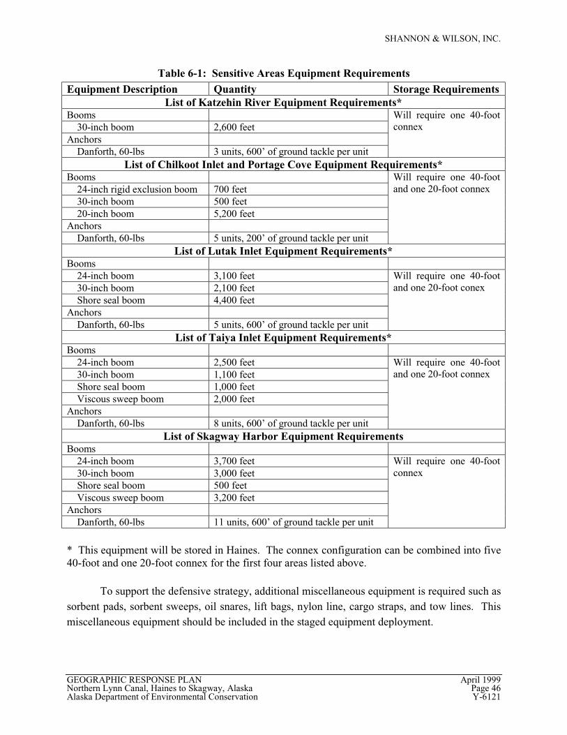
SHANNON & WILSON, INC.
GEOGRAPHIC RESPONSE PLAN April 1999Northern Lynn Canal, Haines to Skagway, Alaska Page 46Alaska Department of Environmental Conservation Y-6121
Table 6-1: Sensitive Areas Equipment Requirements
Equipment Description Quantity Storage RequirementsList of Katzehin River Equipment Requirements*
Booms 30-inch boom 2,600 feetAnchors Danforth, 60-lbs 3 units, 600’ of ground tackle per unit
Will require one 40-footconnex
List of Chilkoot Inlet and Portage Cove Equipment Requirements*Booms 24-inch rigid exclusion boom 700 feet 30-inch boom 500 feet 20-inch boom 5,200 feetAnchors Danforth, 60-lbs 5 units, 200’ of ground tackle per unit
Will require one 40-footand one 20-foot connex
List of Lutak Inlet Equipment Requirements*Booms 24-inch boom 3,100 feet 30-inch boom 2,100 feet Shore seal boom 4,400 feetAnchors Danforth, 60-lbs 5 units, 600’ of ground tackle per unit
Will require one 40-footand one 20-foot conex
List of Taiya Inlet Equipment Requirements*Booms 24-inch boom 2,500 feet 30-inch boom 1,100 feet Shore seal boom 1,000 feet Viscous sweep boom 2,000 feetAnchors Danforth, 60-lbs 8 units, 600’ of ground tackle per unit
Will require one 40-footand one 20-foot connex
List of Skagway Harbor Equipment RequirementsBooms 24-inch boom 3,700 feet 30-inch boom 3,000 feet Shore seal boom 500 feet Viscous sweep boom 3,200 feetAnchors Danforth, 60-lbs 11 units, 600’ of ground tackle per unit
Will require one 40-footconnex
* This equipment will be stored in Haines. The connex configuration can be combined into five40-foot and one 20-foot connex for the first four areas listed above.
To support the defensive strategy, additional miscellaneous equipment is required such assorbent pads, sorbent sweeps, oil snares, lift bags, nylon line, cargo straps, and tow lines. Thismiscellaneous equipment should be included in the staged equipment deployment.
SHANNON & WILSON, INC.
GEOGRAPHIC RESPONSE PLAN April 1999Northern Lynn Canal, Haines to Skagway, Alaska Page 47Alaska Department of Environmental Conservation Y-6121
6.2 Comparison of Available Equipment to Equipment Needs
A comparison to ADEC in-region equipment inventories indicated deficiencies thatwould hinder the implementation of a near-shore defensive strategy. Based on a review of theobtained equipment lists, it appears that the ADEC and USCG lack the length of necessaryboom, the skimmers, and the containers to implement the defensive strategy. The ADEC andUSCG lists do appear to contain the miscellaneous equipment, such as sorbent pads, sorbentsweeps, etc., necessary for the initial implementation of the defensive strategy. This comparisonfocused on in-region equipment. The ADEC currently maintains 1,000 feet of 8-inch by 12-inchboom in both Haines and Skagway. This boom is not sufficient to respond to the type and size ofspills identified in the scenarios in Section 4.0. This boom is more appropriately used in smallreleases, such as an overfill at the fuel docks of the small boat harbors.
6.3 Recommendations for Additional Equipment
The current equipment inventories are inadequate to implement the defensive strategyrequired by the GRP. The present equipment should be considered a supplement to theequipment vital to implement the near-shore defensive strategy. An equipment supplycontaining the items listed in Table 6-1 is recommended to successfully protect the sensitiveenvironments of Northern Lynn Canal.
6.4 List of Recommended Upgrade Work
It is recommended that the ADEC consider establishing a contracted list of vessels thatare targeted to meet the protective goals of the GRP. These vessels should be contractedexclusively to support the GRP and not be part of an RP’s contingency plan.
In reality, if a spill of significant magnitude occurred in Northern Lynn Canal, it is likelythat vessel owners would contract with the highest paying party, regardless of previous exclusivecontracts. For this reason, the purchase of response skiffs for the Skagway and Hainesharbormasters should be considered.
It should be noted that one response skiff dedicated to each community is inadequate toprovide the defensive strategies outlined in this GRP. As discussed in the protective strategies inSection 5.2 for the Haines boat harbor, two vessels are required to deploy boom across the faceof the boat harbor, and four vessels are required for implementing the GRP tactics in othersensitive areas near Haines. In Skagway, four vehicles can be used to deploy boom around andin the boat harbor. However, four vessels are needed to deploy boom at other sensitive areasaround Skagway.
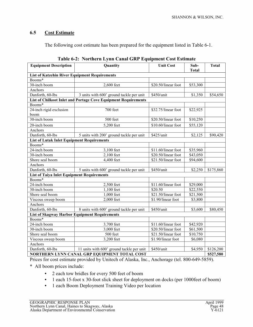
SHANNON & WILSON, INC.
GEOGRAPHIC RESPONSE PLAN April 1999Northern Lynn Canal, Haines to Skagway, Alaska Page 48Alaska Department of Environmental Conservation Y-6121
6.5 Cost Estimate
The following cost estimate has been prepared for the equipment listed in Table 6-1.
Table 6-2: Northern Lynn Canal GRP Equipment Cost EstimateEquipment Description Quantity Unit Cost Sub-
TotalTotal
List of Katzehin River Equipment RequirementsBooms*30-inch boom 2,600 feet $20.50/linear foot $53,300AnchorsDanforth, 60-lbs 3 units with 600’ ground tackle per unit $450/unit $1,350 $54,650List of Chilkoot Inlet and Portage Cove Equipment RequirementsBooms*24-inch rigid exclusionboom
700 feet $32.75/linear foot $22,925
30-inch boom 500 feet $20.50/linear foot $10,25020-inch boom 5,200 feet $10.60/linear foot $55,120AnchorsDanforth, 60-lbs 5 units with 200’ ground tackle per unit $425/unit $2,125 $90,420List of Lutak Inlet Equipment RequirementsBooms*24-inch boom 3,100 feet $11.60/linear foot $35,96030-inch boom 2,100 feet $20.50/linear foot $43,050Shore seal boom 4,400 feet $21.50/linear foot $94,600AnchorsDanforth, 60-lbs 5 units with 600’ ground tackle per unit $450/unit $2,250 $175,860List of Taiya Inlet Equipment RequirementsBooms*24-inch boom 2,500 feet $11.60/linear foot $29,00030-inch boom 1,100 feet $20.50 $22,550Shore seal boom 1,000 feet $21.50/linear foot $21,500Viscous sweep boom 2,000 feet $1.90/linear foot $3,800AnchorsDanforth, 60-lbs 8 units with 600’ ground tackle per unit $450/unit $3,600 $80,450List of Skagway Harbor Equipment RequirementsBooms*24-inch boom 3,700 feet $11.60/linear foot $42,92030-inch boom 3,000 feet $20.50/linear foot $61,500Shore seal boom 500 feet $21.50/linear foot $10,750Viscous sweep boom 3,200 feet $1.90/linear foot $6,080AnchorsDanforth, 60-lbs 11 units with 600’ ground tackle per unit $450/unit $4,950 $126,200NORTHERN LYNN CANAL GRP EQUIPMENT TOTAL COST $527,580Prices for cost estimate provided by Unitech of Alaska, Inc., Anchorage (tel. 800-649-5859).* All boom prices include:
• 2 each tow bridles for every 500 feet of boom• 1 each 15-foot x 30-foot slick sheet for deployment on docks (per 1000feet of boom)• 1 each Boom Deployment Training Video per location
SHANNON & WILSON, INC.
GEOGRAPHIC RESPONSE PLAN April 1999Northern Lynn Canal, Haines to Skagway, Alaska Page 49Alaska Department of Environmental Conservation Y-6121
This total cost estimate is significantly higher than the $200,000 ADEC identified as themaximum amount in the Request for Proposal (RFP) for this project. This cost estimateindicates that a larger budget should be considered for the response equipment needed to protectsensitive areas in Northern Lynn Canal.
The estimate is broken into the five sensitive areas described in Section 5.0 and identifiedin the RFP by the ADEC as the areas to consider for this project. Each of the estimates for thefive areas exceeds the $40,000 average that would be allowed for each area under the originalADEC estimate. This breakdown should help ADEC to prioritize the five areas so thatequipment may be purchased to protect a lesser number of sensitive areas that are individuallydetermined to be more sensitive or more significant than other locations, should additionalmonies be unavailable.

SHANNON & WILSON, INC.
GEOGRAPHIC RESPONSE PLAN April 1999Northern Lynn Canal, Haines to Skagway, Alaska Page 50Alaska Department of Environmental Conservation Y-6121
(intentionally blank)
SHANNON & WILSON, INC.
GEOGRAPHIC RESPONSE PLAN April 1999Northern Lynn Canal, Haines to Skagway, Alaska Page 51Alaska Department of Environmental Conservation Y-6121
7.0 CLOSURE/LIMITATIONS
This document was prepared for the exclusive use of the client and their representatives
for evaluating the project as it relates to the aspects discussed herein. The conclusions and
recommendations contained in this report are based on information provided from document
research, personal interviews, and other conditions described herein. The data presented in this
report should be considered representative of the time of publication. Changes due to natural
processes or human activity can occur. In addition, changes in government codes, regulations, or
laws may occur. Because of such changes beyond our control, our observations and
interpretations applicable to this project may need to be revised.
Shannon & Wilson has prepared the attachments in Appendix D “Important Information
About Your Environmental Site Assessment/Evaluation Report” to assist you and others in
understanding the use and limitations of our report.
SHANNON & WILSON, INC.
Prepared By: Approved By:
Lydia Miner Robert N. Braunstein, C.P.GGeologist IV Senior Associate

SHANNON & WILSON, INC.
GEOGRAPHIC RESPONSE PLAN April 1999Northern Lynn Canal, Haines to Skagway, Alaska Page 52Alaska Department of Environmental Conservation Y-6121
(intentionally blank)
SHANNON & WILSON, INC.
GEOGRAPHIC RESPONSE PLAN April 1999Northern Lynn Canal, Haines to Skagway, Alaska Page 53Alaska Department of Environmental Conservation Y-6121
8.0 REFERENCES
The Alaska Federal/State Preparedness Plan for Response to Oil and Hazardous SubstanceDischarge/Releases (Unified Plan, Part 1), May 1994.
Alaska Marine Highway Ferries Schedule, 1998 and 1999.
Delta Western Haines Bulk Plant and Oil Terminal Facility Oil Discharge Prevention andContingency Plan, February 1995.
Cruise Line Agency of Alaska Schedule.
Haines Coastal Management Plan, October 26, 1979. Prepared by Environmental Services Ltd.
Near-shore Demonstration Report, Recommended Concepts and Components for a State Near-shore Response System, October 1994. Prepared by: Easton Environmental for theAlaska Department of Environmental Conservation, Division of Spill Prevention andResponse.
Northern Lynn Canal Near Shore Oil Spill Response Demonstration Project, Haines Borough,Haines, Alaska, January 1998 (a Proposal to the Alaska Department of EnvironmentalConservation).
Petro Marine Services Oil Discharge Prevention and Contingency Plan, Haines Alaska Bulk FuelPlant, January 1996.
Petro Marine Services Oil Discharge Prevention and Contingency Plan, Skagway Alaska BulkFuel Plant, January 1996.
Russo, Ken, Skagway Harbor Master, Personal Communication, February 1999.
SEAPRO Equipment List for Southeast Alaska Supplied by John Parson, February 1, 1999.
SEAPRO Unified Plan, Southeast Alaska, Part 1 Response Action Plan.
SEAPRO Unified Plan, Southeast Alaska, Part 3 Supplemental Information.
Site-Specific Response Plans for Sensitive Areas, A Review of Other States' Methods withRecommendations for Alaska by Tim L. Robertson, September 2, 1998 (Report toRegional Citizens' Advisory Council of Prince William Sound).
Skagway Coastal Management Program, April 1991. Prepared by the City of Skagway.
Southeast Subarea Contingency Plan For Oil and Hazardous Substance spills and Releases, ASubarea Plan for the Unified Plan for the State of Alaska, July 1997.
Stokely, Robert, Haines Harbor Master, Personal Communications, March 1999.

SHANNON & WILSON, INC.
GEOGRAPHIC RESPONSE PLAN April 1999Northern Lynn Canal, Haines to Skagway, Alaska Page 54Alaska Department of Environmental Conservation Y-6121
(intentionally blank)
APPENDIX A
TRAJECTORIES FROM
NOAA HAZARDOUS MATERIALS RESPONSE DIVISION
APPENDIX B
LOGISTICAL SUPPORT/MOBILIZATION
APPENDIX C
DEPLOYMENT MAPS
APPENDIX D
IMPORTANT INFORMATION ABOUT YOUR ENVIRONMENTAL SITE
ASSESSMENT/EVALUATION REPORT