table rock lakeshore trail - state park marina | · pdf fileto show boat branson belle...
TRANSCRIPT
!_
!_
!F
!F
!F
#*
#*
#*
#*
#*
#*
#*")
")
")
")
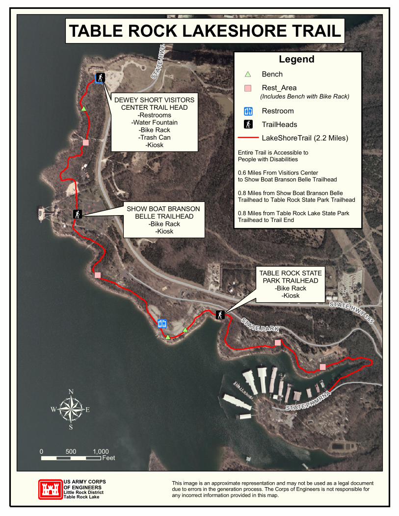
DEWEY SHORT VISITORSCENTER TRAIL HEAD
-Restrooms-Water Fountain
-Bike Rack-Trash Can
-Kiosk
SHOW BOAT BRANSON BELLE TRAILHEAD
-Bike Rack-Kiosk
TABLE ROCK STATEPARK TRAILHEAD
-Bike Rack-Kiosk
STAT E P ARK
STATE HWY 165
STATE PK MRNA
STATE
HWY
165
This image is an approximate representation and may not be used as a legal documentdue to errors in the generation process. The Corps of Engineers is not responsible forany incorrect information provided in this map.
US ARMY CORPSOF ENGINEERSLittle Rock DistrictTable Rock Lake
µ0 1,000500
Feet
TABLE ROCK LAKESHORE TRAILLegend
!F TrailHeads
#* Rest_Area(Includes Bench with Bike Rack)
LakeShoreTrail (2.2 Miles)Entire Trail is Accessible to People with Disabilities0.6 Miles From Visitiors Centerto Show Boat Branson Belle Trailhead0.8 Miles from Show Boat Branson BelleTrailhead to Table Rock State Park Trailhead0.8 Miles from Table Rock Lake State Park Trailhead to Trail End
#*
")
Bench
Restroom!_
TABLE ROCK LAKESHORE TRAIL GUIDELINES AND ETIQUETTE
• Trail open daily from dawn to dusk. • Trail open to the following non-motorized uses: pedestrian, bicycle,
skateboard, scooter, and in-line skates. Motorized wheelchairs are permitted.
• Stay on the trail. Do not disturb wildlife or vegetation. • Pets must be on a leash at all times. Keep pet waste off the trail. • RIGHT-OF-WAY: When approaching oncoming users, always move
to the right of the trail. Always pass on the left side, and make your intentions known by announcing your approach. Bicyclists should yield to pedestrians.
• Be aware of your surroundings. Report any suspicious behavior to Table Rock State Park, White River Landing or US Army Corps of Engineers staff.
• Helmets that meet or exceed Snell or ANSI standards are recommended for all bicyclists.
• Dumping and littering are prohibited. Show you care by picking up litter and depositing it in a nearby waste receptacle.
IN CASES OF EMERGENCY
Emergency Services: 911
Stone County Sheriff: 357-6116
Corps of Engineers: 334-4101
Table Rock State Park: 334-4704
White River Landing / Branson Belle: 336-7401
Missouri Water Patrol: 573-751-3333