technical assistance consultant’s report · 2016-05-17 · technical assistance consultant’s...
TRANSCRIPT
Technical Assistance Consultant’s Report
This consultant’s report does not necessarily reflect the views of ADB or the Government concerned, and ADB and the Government cannot be held liable for its contents. (For project preparatory technical assistance: All the views expressed herein may not be incorporated into the proposed project’s design.
Project Number: 42285 June 2014
Kingdom of Cambodia: Integrated Urban Environmental Management in the Tonle Sap Basin (Financed by the Technical Assistance Special Fund)
Prepared by ICF-GHK, United Kingdom, TanCons Co., Ltd., Cambodia, and Key Consultants, Cambodia
For the Ministry of Public Works and Transport

Integrated Environmental Management in the Tonle Sap Basin
ADB TA 7986 CAM
Ministry of Public Works and Transport, Phnom Penh, Cambodia
Final Report Volume 3a
Pursat Initial Environmental Examination
June 2014
KEY CONSULTANTS (CAMBODIA)
Initial Environmental Examination (draft)
Project No. XXXX March 2014
CAM: Integrated Urban Environmental Management in the Tonle Sap Basin Project - Pursat Urban Area Environment Improvements
Prepared by the Ministry of Public Works and Transport for the Asian Development Bank
i
Currency Equivalent (Official exchange rate of the National Bank of Cambodia as of 26 March 2014)
Currency Unit - Riel (KHR)
USD 1.00 = KHR 4,015 USD 0.000249 = KHR 1.00
Abbreviations
ADB Asian Development Bank AP affected person C-EMP Contractor’s Environmental Management Plan DPWT Department of Public Works and Transport EIA environmental impact assessment EIAR environmental impact assessment report EMP environmental management plan EMR environmental monitoring report ESS environmental safeguard staff GRM grievance redress mechanism IEC information, education and communication IEE initial environmental examination IEIA initial environmental impact assessment GoC Government of Cambodia HH/HHs household/s KHR Cambodian Riel MoE Ministry of Environment MPWT Ministry of Public Works and Transport MRC Mekong River Commission O&M operation and maintenance PDoE Provincial Department of Environment PMIS project management and implementation support PIU project implementation unit PMU project management unit PSC project steering committee USD United States Dollar WHO World Health Organization WWTP wastewater treatment plant
Weights and Measures
C - Celsius/centigrade
dBA - decibel audible ha - hectare/s
km kilometer/s
km2 square kilometer/s
kph kilometer/s per hour
m meter/s
m3 cubic meter/s
masl meter/s above sea level
mg/l milligram/s per liter
mm millimeter/s
ppsk person/s per square kilometer tpd tonnes per day

ii
NOTES In the report, “$” refers to US dollars, unless otherwise stated.
This initial environmental examination (draft) is a document of the borrower. The views expressed herein do not necessarily represent those of ADB’s Board of Directors, Management, or staff and may be preliminary in nature. The draft IEE and its environmental management plans will be updated during project implementation. In preparing any country program or strategy, financing any project, or by making any designation of or reference to a particular territory or geographic area in this document, the Asian Development Bank does not intend to make any judgments as to the legal or other status of any territory or area.

iii
Table of Contents
Currency Equivalent, Abbreviations, Weights and Measures i I. EXECUTIVE SUMMARY……………………………………………………………………… 1 II. POLICY, LEGAL & ADMINISTRATIVE FRAMEWORK………………………………….. 5 A. Policy and Legal Framework 5 B. Administrative Framework 7 C. International Environmental Agreements 8 III. DESCRIPTION OF THE SUBPROJECT…………………………………………………… 9 A. Justification and Rationale 9 B. Pursat Urban Area Environment Improvements 11
C. Subprojects’ Areas of Influence 15 D. Category and Requirements 15
IV. DESCRIPTION OF THE ENVIRONMENT………………………………………………….. 18 A. Physical/Chemical Environment 18 B. Biological Environment 22 C. Economic Environment 23 D. Socio-economic Environment 24 E. Physical Cultural Environment 25 V. ANTICIPATED ENVIRONMENTAL IMPACTS AND MITIGATION MEASURES……… 26 A. Positive Environmental Impacts and Benefits 26 B. Screening of Potential Impacts/Issues/Concerns 26 C. Impacts/Issues/Concerns and Mitigation Measures Relative to Siting, Planning
and Design 27
D. Impacts and Mitigation Measures during Construction 29 E. Impacts and Mitigation Measures during Operation 32 F. Impacts and Mitigation Measures during Decommissioning of Open Dumps 33 G. Indirect, Induced and Cumulative Impacts 33 H. Unanticipated Impacts during Construction and Operation 34 VI. INFORMATION DISCLOSURE, CONSULTATION & PARTICIPATION……………..… 34 VII. GRIEVANCE REDRESS MECHANISM…………………………………………………….. 35 A. Proposed Set-Up 35 B. Access to the Mechanism 36 C. GRM Steps and Timeframe 36 VIII. ENVIRONMENTAL MANAGEMENT PLAN………………………………………………... 38 A. Mitigation 38 B. Monitoring and Reporting 38 C. Implementation Arrangements 39 D. Performance Indicators 41 IX. CONCLUSION & RECOMMENDATION……………………………………………………. 41 Sources of Information........................................................................................................... 54 Annexes...................................................................................................................................
A Environmental Quality Standards Applied in the IEE 56 B Check on Pond Sizes and Load Removal 59 C Solid Waste Generation/Quantity Projections, Cell Staging and Staged
Development Strategy 60
D Environmental Audit Report – Existing Open Dumps 62 E Notes of Consultation 71 F Environmental Mitigation and Monitoring Plans - Riverbank Protection 79

iv
G Environmental Mitigation and Monitoring Plans - Drainage System Improvements 92 H Environmental Mitigation and Monitoring Plans - Solid Waste Management 104 I Draft Outline for PMU’s Environmental Monitoring Report 120 J Draft Outline Terms of Reference for PMIS Environmental Specialist 122
Figures III-1 Location of Embankment revetment (Strengthening0 Works 11 III-2 Location of Groynes for Embankment Protection 12 III-3 Layout Plan of proposed Drainage System Improvements 13 III-4 Layout Plan of Wastewater Stabilization Ponds 13 III-5 Pursat Controlled Landfill – Location Plan and Layout 16 III-6 Pursat Controlled Landfill – Sections 17 IV-1 Sampling Locations 20
Tables
II-1 Other Relevant Laws, regulations and Guidelines in Cambodia 6 II-2 The GoC Environmental Impact Assessment Report Preparation, Appraisal,
Approval and Implementation Process 8
III-1 Potentially Affected Resource/s in Subprojects’ Areas of Influence 17 III-2 Identified Potentially Affected Resources in the Main Areas of Influence 18 III-3 Indicative Timeline for the Compliance with GoC EA Requirements 18 IV-1 Monthly and Annual Rainfall, Pursat, 2008-2012 19 IV-2 Pursat River Water Quality Monitoring Results, 2013 20 IV-3 Natural Hazards in Cambodia 21 IV-4 Summary of Natural Disasters in Cambodia, 1987-2007 21 IV-5 Protected Areas and Type of Wetland in Subproject Sites 22 V-1 Environmental Positive Impacts and Benefits 26 V-2 Spoils Management 28 VI-1 Environmental Safeguard Public Meeting 35 VIII-1 Environmental Management Implementation Schedule 40 VIII-2 Institutional Responsibilities 43 VIII-3 Proposed Topics for Capacity Building/Training 45 VIII-4 Preliminary Costs for EMP Implementation 46 VIII-5 Performance Indicators 47

1
I. EXECUTIVE SUMMARY A. Purpose of the Report 1. This report gives an account of the initial environmental examination (IEE) of the proposed subprojects under the Pursat Urban Area Environment Improvements Output of the Integrated Urban Environmental Management in the Tonle Sap Basin Project. The IEE was conducted as part of the subproject preparation to primarily: (i) identify and assess potential impacts arising from the implementation of the proposed Subproject on the physical, biological, socio-economic and physical cultural environment; and (ii) recommend measures to avoid, mitigate, and compensate for adverse impacts. The IEE was carried out following the Safeguard Policy Statement (2009) of the Asian Development Bank (ADB) and with reference to the Law on Environmental Protection and Natural Resource Management (1996), Sub-decree on EIA Process (1999) and Declaration on General Guideline for Initial Environmental Impact Assessment (IEIA) and Environmental Impact Assessment (EIA) Reports (2009) of the Government of Cambodia. Several relevant reports/documents, sites reconnaissance, and consultations with communities and relevant government agencies have provided bases to the IEE.
B. Integrated Urban Environmental Management in the Tonle Sap Basin Project 2. The proposed Integrated Urban Environmental Management in the Tonle Sap Basin Project (or, Project) will assist and facilitate towns in the Tonle Sap Basin to realize their development potential to support the growth of the economy and services. It will help to improve the climate change resilience of Tonle Sap Basin towns through urban and environmental infrastructure improvement and stronger urban management capacity. It will have five outputs:
Output 1: Kampong Chhnang Urban Area Environment Improvements Output 2: Pursat Urban Area Environment Improvements Output 3: Community Mobilization and Environmental Improvements Output 4: Strengthened Sector Development and Coordination Output 5: Strengthened Capacity for Project Implementation, Operation and Maintenance
3. The Ministry of Public Works and Transport (MPWT) is the executing agency of the Project. The Project Management Unit (PMU) of the MPWT will be the implementing agency. Project Implementation Units (PIUs) will be set up in each town to manage subproject implementation. C. Pursat Urban Area Environment Improvements 4. Pursat Town will benefit from the proposed investment to deliver Outputs 2, 3, 4 and 5 above. The subprojects for Pursat Urban Area Environment Improvements are the subject of this IEE:
Riverbank protection, improving a section of the embankment and stabilizing the embankment in two locations upstream
Drainage system improvements, installing sewer pipes and constructing a pumping station and wastewater stabilization pond; and
Solid waste management, developing a controlled landfill, providing collection and landfill equipment, and remediating open dumps.
D. Summary of Impacts and Mitigation Measures 5. Positive Impacts and Environmental Benefits. When completed, the subprojects will bring about the following benefits, impacts and outcomes:
Riverbank protection: (i) the benefit of a protected riverbank; (ii) relief from flooding from embankment failure, reduced embankment erosion and river sedimentation, reduced health and safety risks, and safe mobility/access during heavy rains or storms, as positive impacts; and (iii) safe, climate change-resilient communities/town as outcome.
Drainage system improvements: (i) the benefit of improved storm- and wastewater management in the town center; (ii) relief from flooding, improved sanitation, reduced health and safety risks, and improved and safe mobility/access during heavy rains or storms, as positive impacts; and (iii) improved urban environment and safe and climate change-resilient communities/town as outcomes.

2
Solid waste management: (i) the benefit of improved solid waste collection and disposal; (ii) reduced/potentially eliminated open and indiscriminate dumping and burning of solid wastes and relief from associated issues, e.g., fumes/uncontrolled gas emissions, odor, nuisance, water contamination and health and safety risks, as positive impacts; and (iii) improved urban environment and safe communities/town as the outcomes.
6. Overall, the subprojects will bring about improved urban environment and climate change-resilience, significantly contributing to a qualitative improvement in the lives of Pursat Town residents. 7. Relative to Siting, Planning and Design. The screening process revealed the following salient siting concerns: (i) sensitiveness of the Pursat River and its resources to impacts during construction, and in case of embankment failure during operation; (ii) urban development and settlements in the town center will be impacted on during drainage system improvements and embankment protection works; (iii) site of the existing non-functioning wastewater treatment plant (WWTP) is waterlogged during the rainy season; (iv) existing utility lines and crossing drains within the road rights-of-way in the town center that should be considered in design and during construction of drainage system improvements; and (v) conditions of access roads to the sites that will be subject to pressures from use by construction vehicles and equipment during construction and from use by waste collection trucks during operation of the controlled landfill. 8. Relative to design, the salient concerns would be the inadequate consideration/incorporation in the respective designs of the above-mentioned siting concerns and the following, among others:
for the embankment protection works: (i) climate change and its impact on the hydrology of Pursat River; and (ii) capability of the operating institution for maintenance and repair;
for the drainage system improvement works: (i) climate change and its impact on the stormwater runoff that will be combined with wastewater, and on wastewater treatment; (ii) sensitiveness of groundwater and soil in the WWTP vicinity, and (iii) capability of the operating institution for efficient operation, maintenance and repair (OM&R);
for the controlled landfill: (i) climate change and its impacts on landfill operations, (ii) sensitiveness/vulnerability of the soil and groundwater in the vicinity, (iii) closure plan to restore (or at least mitigate the disturbance to and blend with) the landscape, (iv) adaptation measures for access and internal roads, water supply and buffer area; (v) capability of the operating institution to sustain an effective OM&R, and (vi) remediation plan for the dump sites;
demand for, and availability of and sources for, fine and coarse aggregates;
vulnerability to damages during natural hazard events; and
existing utility lines and infrastructures in the sites. 9. In the preparation of the feasibility study and this IEE, some of the measures taken to minimize the subprojects’ environmental and social impacts include, among others:
The subprojects were prepared within a highly consultative and participatory process through workshops, socio-economic survey (SES) and focus group discussions.
The IEE has incorporated the existing socio-economic and environmental conditions, issues and concerns raised in the SES.
A resettlement plan has been formulated in a highly consultative, participatory manner.
Preliminary design for the embankment protection has studied and/or considered: (i) Pursat River’s hydrology and how it has been/is/going to be impacted on by climate change; (ii) existing barrages and past, ongoing and proposed relevant interventions; and (iii) existing settlements on top of the embankment and avoided involuntary resettlement.
Preliminary design for the drainage system improvements has: (i) considered climate change impacts on stormwater flows in the Town center and on wastewater treatment; (ii) specified adaptation options such as the upgraded design and fabrication standards for the reinforced concrete (RC) sewer pipes and parts, design standard for the cushion base, and the cement material for the RC pipes; and (iii) considered the potential inadequate capability of the operating institution for OM&R.
Preliminary design for the controlled landfill has: (i) included the appropriate leachate and gas management strategy and clay liner to protect groundwater and soil; (ii) recommended for a hydro-geological investigation during detailed design; (iii) considered

3
climate change issues; (iv) proposed for the upgrade of the access road; (v) proposed for the greening of completed/capped waste cells and landscaping of the site; and (vi) recommended the institutional set-up for operations and its training.
The proposed remediation of open dumps has considered the protection of the groundwater and soil, climate change issues, greening of completed/capped waste cells; and dealing with existing fumes and open burning as a priority.
10. During Construction. The identified direct impacts with potential moderate to high significance are: (i) dust and noise; (ii) potential soil erosion during embankment works and impacts on the Pursat River and its resources; (iv) temporary disturbance to the landscape; (v) impacts on vegetation beyond the subprojects’ footprints; (vi) impacts on the socio-economic environment and resources from traffic, blocked/constricted accesses, accidental damages of utility lines and damages from use of existing access roads; and (vii) health and safety hazards. Potential indirect, induced and cumulative impacts are discussed in Section V-F. A detailed set of mitigation measures are presented in the Environmental Management Plans (EMPs) in Annexes F, G and H.
11. During Operation. Direct impacts will mainly relate to the operation of the waste stabilization ponds (WSPs) and controlled landfill. In the operations of all subprojects, unsustained effectiveness of their services will result from inefficient operations, maintenance and repair. Potential salient impacts from the operation of the WSPs include: (i) odor and gas emissions, pests from ineffective treatment process; (ii) groundwater and soil contamination from overflow of untreated or inadequately treated wastewater and/or seepage of untreated wastewater due to ineffective liners or unattended cracked liners; and (iii) health and safety hazards of WSP workers. 12. The anticipated salient concerns from controlled landfill operations include: (i) air pollution from dust, gas, fumes and odor ; (ii) ground water and soil contamination from leachate and gas migration; (iii) impact on the landscape; (iv) pests/rodents/vermin, attraction of birds & stray animals; (vi) wind-blown litters; (vii) fire/explosion; (viii) health and safety hazards of, & nuisance for, community along the access road; and (ix) workers health and safety hazards. Inefficiently maintained pumping station associated with the improved drainage system would generate higher noise level, a health hazard to workers. Deferred repair of the pumping station would cause overflow of the WSPs. The anticipated salient concerns from the operation of the improved waste collection fleet and equipment include: (i) leachate drippings during collection, temporary storage in hook lift bins and haulage; (ii) odor, flies and pests at hook lift bins and their stations, pushcarts, open tipping trucks from lack of keeping the premises and equipment clean; and (iii) mud spread with fleet movement to and from the landfill. 13. Potential indirect, induced and cumulative impacts are discussed in Section V-F. A detailed set of mitigation measures are presented in the EMPs in Annexes F, G and H.
E. Information Disclosure, Consultation and Participation 14. The process in engaging stakeholders and affected people involved workshops, household socio-economic survey and safeguards-specific consultations. Workshops, which had the active involvement of representatives from national ministries and agencies, the six provinces and six municipalities, were held in April and June 2013 to obtain stakeholders agreement/confirmation on several aspects of project preparation. A Socio-Economic Survey (SES) was conducted on 19-22 July 2013. Environmental safeguard-specific consultations included: (i) formal discussions/meetings with relevant government institutions; (ii) some brief informal interviews with randomly picked relevant persons during site visits; and (iii) an environmental safeguard public meeting held on 24 October 2013 at the Peal Gnaek Pagoda, Pursat Municipality. Annex E 15. Stakeholder consultations will continue through subprojects implementation and operation. The PMU, PIU Contractors and/or Operators will be open to contact by the public on matters concerning the progress of the subprojects, adverse impacts, mitigation measures and environmental monitoring and grievances. To date, information have been disclosed during the environmental safeguard public meeting on 24 October 2013 at the Peal Gnaek Pagoda, Pursat Municipality: (i) Subproject descriptions, locations and components; (ii) environmental benefits, positive impacts and outcomes; (iv) potential salient environmental impacts and mitigation measures during construction and operation; (v) environmental monitoring that is open to community participation; (vi) general features of the proposed grievance redress mechanism; and (vii) status of compliance with GoC and ADB

4
safeguards requirements. The IEE (in both English and Khmer), and the MoE-approved IEIA/EIA Reports (in Khmer), will be available at the PMU and PIU offices for consultation by stakeholders. Copies may be made available upon request. The IEE and environmental monitoring reports will be disclosed on the websites of the ADB and MPWT/PMU.
F. Grievance Redress Mechanism
16. The MPWT, as executing agency of the IUEMTSBP will establish the project-specific grievance redress mechanism (GRM). The GRM will accommodate both informally- and formally-lodged, but Project-related, valid grievances. Informally, an affected person (AP) can lodge complaint directly to the Contractor during construction or Operator during operation. Formally, the AP can lodge con lodge complaint with the PIU, village or sangkat resettlement sub-committee, or IRC working group. the formal approach comprises of four stages. In the first stage, complaint is dealt with at the subproject-level by the: (i) PIU for environmental complaints; or (ii) village or sangkat resettlement sub-committee or IRC working group for social complaints. In second, third and fourth stages, complaint can be raised to the District Office, Provincial Grievance Redress Committee, and Provincial Court, respectively. G. Environmental Management Plan 17. The EMPs for each subproject have been formulated and are featured herein as Annexes G, H and I. The EMPs will be updated by the Project Management Unit (PMU) based on the detailed design, with technical assistance from the Environmental Specialists of the Project Management and Implementation Support (PMIS) Team that will be engaged under the Project’s Output 5. EMPs will be implemented by the PMU, PIU, Detailed Design Consultants, Contractors for civil works, and the Operators of completed works. The marginal costs for implementing the EMPs are initially estimated to involve:
USD 6,040 (or KHR 24.25 million) for securing approved IEIA/EIA Report;
USD 49,400 (or KHR 198.3 million) of fixed costs to cover environmental monitoring prior to, and during, construction; and
USD 36,700 (or KHR 147.5 million) annually for environmental monitoring during operation of the waste stabilization pond.
18. The estimated costs: (i) include taxes and contingencies for deficiencies in assumed unit costs, but exclude inflation; (ii) exclude the salaries of the ESS and his/her counterpart in the PIU, as they will be existing MPWT and DPWT staff seconded to the PMU and PIU, respectively; (iii) exclude the cost of USD 84,350 for technical assistance from, and “hands-on” training” by, Environmental Specialists that will be part of the PMIS Team for the both of Kampong Chhnang and Pursat Towns. H. Conclusion 19. The IEE concludes that the proposed subprojects in Pursat Town are not environmentally critical. Except for the Embankment Protection on Pursat River, which by the nature of its intervention will be undertaken on the banks of the Pursat River, the two other subprojects are not within or adjacent to environmentally sensitive areas. With adequate mitigation measures, impacts will have lower significance. 20. The few impacts of high magnitude (without mitigation) will not be unprecedented and distinct. The extent of adverse impacts is expected to be local, confined within the subprojects’ immediate and/or main areas of influence. With mitigation measures in place and ensuring that the bulk of works are completed (or at least almost complete) prior to the onset of the rainy season, the potential adverse impacts during construction would be highly/more site-specific.
21. The few adverse impacts of high significance during construction will be temporary and short-term (i.e., most likely to occur only during peak construction period). These will not be sufficient to threaten or weaken the surrounding resources. The preparation and implementation of a Contractor’s EMP that would address as minimum the requirements of the SPS-compliant Subproject EMP will mitigate the impacts and lower their residual significance to at least “moderate” levels. . Simple/uncomplicated mitigation measures, basically integral to socially and environmentally

5
responsible construction practices, are commonly used at construction sites in urban settings and are known to Contractors. Hence, mitigation measures would not be difficult to design and institute.
22. Direct impacts during operation will come from the wastewater treatment plant, controlled landfill, pumping station and waste collection, mainly from the first two facilities. Guided by Operation Manuals and strengthened by continuing capacity building program, wastewater treatment and controlled landfill operations are not expected to have long-term, persistent, permanent/irreversible adverse impact on human health and safety, air quality, water quality, soil quality, the biological environment, as well as the lifestyle and means of subsistence of nearest local communities. Indirect, induced and cumulative impacts during operation will be mainly positive than adverse.
23. The proposed subprojects will bring about the benefits of: (i) protected embankment on Pursat River, (ii) improved storm- and wastewater management in the town center, and (iii) improved solid waste collection and disposal. Positive impacts include: (i) relief from flooding from embankment failure and inadequate drainage system; (ii) improved sanitation with wastewater management; (iii) reduced or eradicated open and indiscriminate dumping of solid wastes and relief from associated issues, e.g., fumes and uncontrolled gas emissions, odor and nuisance, contamination of water resource and clogging of drains/sewers; and (iv) reduced health and safety risks Collectively, the subprojects will bring about improved urban environment and increased climate-change resilience, significantly contributing to a qualitative improvement in the lives of residents in Pursat Town.
24. Based on the above conclusions, although the subprojects may have some adverse environmental impacts, the preparation of an IEE would be sufficient to identify and address these impacts. No further special study or detailed EIA needs to be undertaken to comply with ADB’s Safeguard Policy Statement. Under GoC policy, an IEIA Report for each subproject is required to start the environmental impact assessment process. The IEIA Reports will be based on this IEE.
II. POLICY, LEGAL & ADMINISTRATIVE FRAMEWORK
A. Policy and Legal Framework
25. The overarching policy on the protection of the environment and balance of abundant natural resources is set out in the 1993 Constitution of the Kingdom of Cambodia. Proceeding from, and conformable to, the Constitution, the Government of Cambodia has enacted a series of environmental laws, regulations and standards. Among these, the basic laws/policies that provide the framework within which environmental assessment is carried out in Cambodia are the:
The Law on Environmental Protection and Natural Resource Management (Preah Reach Kram/NS-PKM-1296/36), enacted on 18 November 1996, requires the conduct of environmental impact assessment on every private and public project. (Articles 6 and 7) Sub-decree No. 72 ANRK.BK, dated 11 August 1999, the Sub-decree on EIA Process, provides the detailed guidelines for implementation of the EIA Process. Its Annex requires the conduct of IEIA/EIA on the following activities under the Project: (i) waste processing, burning activities, all sizes; (ii) wastewater treatment plants, all sizes; and (iii) drainage systems, >5,000 ha. The Sub-decree has no stipulations on environmental assessment requirements for flood protection dykes, riverbank protection and local roads. Declaration on General Guideline for Preparing Initial Environmental Impact Assessment (IEIA) and EIA Report, a declaration issued by the Ministry of Environment in 2009, specifying the basic contents of IEIA/EIA Reports to include: (i) introduction; (ii) legal framework; (iii) project description; (iv) description of the existing environment; (v) public participation; (vi) assessment of, and mitigation measures for, significant environmental impacts; (vii) environmental management plan; (viii) cost-benefit analysis; and (ix) conclusion and recommendation. Declaration on the Delegation of Power of Decision-Making on Project Development to the Provincial Department of Environment, 2005, providing for the PDoE to be the reviewing and approving authority of IEIA/EIA reports of projects costing below USD 2 Million.

6
Joint Declaration between the MEF) and the MoE on the Determination of Service Fee for EIA Reviewing and Monitoring, 2012, specifying five levels of fee with a minimum of USD 500 and a maximum of USD 1,750.
26. Other laws, regulations and guidelines that provide general context/guide in the environmental assessment of subprojects are given in Table II-1. The key environmental quality standards applied in this IEE are: (i) Ambient Air Quality Standard, 2000; (ii) Maximum Standard of Noise Level Allowable in the Public and Residential Areas, 2000; (iii) Water Quality Standards for Public Waters for the Purpose of Biodiversity Conservation, 1999; (iv) Water Quality Standards for Public Waters and Health, 1999; (v) Drinking Water Quality Standards, 2004; and (vi) Effluent Standard for Discharged Wastewater to Public Water Areas or Sewers, 1999, applicable also to landfills. Annex A Table II-1 Other Relevant Laws, Regulations and Guidelines in Cambodia
Law/Regulation/Guideline Year Brief Description
Royal Decree on the Protection of Natural Areas
1993 Has classified the 23 protected areas in Cambodia into four categories, namely: (i) natural parks; (ii) wildlife sanctuaries; (iii) protected landscapes; and (iv) multiple-use areas. Designated the Tonle Sap (316,250 ha) as a multiple-use area or area necessary for the stability of the water, forestry, wildlife and fishery resources, for entertainment/ tourism, and for conservation of long-term existing natural resources with a view to assure sustainable economic development.
Law on the Protection of Cultural Heritage (NS/RKM/0196/26)
1996 Regulates the protection of national cultural heritage and cultural property in general against illegal destruction, modification, alteration, excavation, alienation, exportation or importation. Its Article 37 stipulates that in case of chance find of a cultural property during construction, work should be stopped and the person who found the property should immediately make a declaration to the local police, who shall, in turn, transmit the property to the Provincial Governor without delay.
Sub-decree on Water Pollution Control (Sub-decree No. 27 ANRK/BK)
1999 Regulates activities that cause pollution in public water areas in order to sustain good water quality so that the protection of human health and the conservation of biodiversity are ensured. Its Annexes 2, 4 and 5 provide the industrial effluent standards, including effluent from wastewater stabilization ponds, water quality standards for public waters for the purpose of biodiversity conservation, and water quality standards for public waters and health, respectively.
Sub-decree on SW Management (Sub-decree No. 36 ANK/BK),
1999 Regulates solid waste management to ensure the protection of human health and the conservation of biodiversity.
Sub-decree on Control of Air Pollution and Noise Disturbance (Sub-decree No. 42 ANK/BK
2000 Regulates air and noise pollution from mobile and fixed sources through monitoring, curb and mitigation activities to protect the environmental quality and public health. It contains the following relevant standards: (i)) ambient air quality standard (Annex 1); and (ii) maximum allowable noise level in public and residential areas (Annex 6).
Law on Land 2001 Provides that: (i) unless it is in the public interest, no person may be deprived of ownership of his immovable property; and (ii) ownership deprivation shall be carried out according to legal forms and procedures and after an advanced payment of fair and just compensation. (Article 5)
Royal Decree on the Establishment and Management of Tonle Sap Biosphere Reserve (Royal Decree No. NS/RKT/0401/070)
2001 Establishes the Tonle Sap Biosphere Reserve (TSBR) in accordance with the statutory framework of the World Network of Biosphere Reserves. Divides the TSBR into 3 zones: (i) core areas; (ii) buffer zone and (iii) flexible transition zone.
Environmental Guidelines on Solid Waste Management
2006 Contains a Landfill Ordinance that regulates landfill requirements to: (i) reduce as far as possible the adverse effects of waste disposal on the environment; (ii) preserve groundwater, surface water & air quality & to reduce emissions of greenhouse gases (iii) ensure waste is not harmful to human, natural & animal health during operation & decommissioning; and (iv) provide information and technical recommendation on the construction, operation and closing/follow-up management of landfills to ensure public health and safety and environmental protection.
Law on Water Resources Management
2007 Requires license/permit/written authorization for the: (i) abstraction & use of water resources other than for domestic purposes, watering for animal husbandry, fishing & irrigation of domestic gardens and orchards; (ii) extraction of sand, soil & gravel from the beds & banks of water courses, lakes, canals & reservoirs; (iii) filling of river, tributary, stream, natural lakes, canal & reservoir; and (iv) discharge, disposal or deposit of polluting substances that are likely to deteriorate water quality and to endanger human, animal and plant health. (Articles 12 & 22) Its Article 24 stipulates that MOWRAM, in collaboration with other concerned agencies, may designate a floodplain area as flood retention area.

7
Law/Regulation/Guideline Year Brief Description
Protected Areas Law (Royal Decree No. NS/RKM/0208/007)
2008 Defines the framework of management, conservation & development of protected areas to ensure the conservation of biodiversity, & sustainable use of natural resources in protected areas. It divides the protected area into 4 zones namely, core zone, conservation zone, sustainable use zone & community zone. Article 36 strictly prohibits all types of public infrastructure in the Core Zone & Conservation Zone; & allows development of public infrastructures in the Sustainable Use Zone & Community Zone with approval from the Royal Government at MoE’s request. Article 41 provides for the protection of each protected area against destructive/harmful practices, e.g., destroying water quality in all forms, poisoning, using chemical substances, disposing of solid and liquid wastes into water or on land.
Expropriation Law 2010 Defines the principles, mechanisms, and procedures of expropriation, and defining fair and just compensation for any construction, rehabilitation, and public physical infrastructure expansion project for the public and national interests and development of Cambodia.
Sub-Decree on Demarcation of 647,406 Hectare Flooded Forest Domain in Six Provinces adjacent to Tonle Sap Lake (Sub-decree No. 197 ANKr/BK)
2011 Stipulates a zoning system for the area between the national highways and the Tonle Sap Lake system and the nature of agriculture activities that are permitted and banned in each zone.
B. Administrative Framework 27. The Ministry of Environment (MoE) through its EIA Department supervises over and regulates the EIA Process. The MoE is responsible for: (i) review and approval of EIA reports in collaboration with other concerned ministries and (ii) monitors the EMP implementation of Project Proponents/Owners throughout the different project phases. MoE operates at the municipal and provincial levels through its Provincial Department of Environment (PDoE). 28. The Sub-Decree on EIA Process prescribes a period of 30 working days for review of IEIA report from the date of registration and another 30 working days for review of revised IEIA or EIA Report from receipt of report. If MoE fails to respond its findings and recommendations within the prescribed periods, it will be assumed that the submitted report is compliant. By virtue of MoE’s Declaration on the Decentralization for Provincial Department of Environment, 2005, projects with a capital investment cost below USD 2 Million shall be reviewed and approved by the PDoE. (Table II-2)
29. From consultation with the MoE through the Deputy Director of the EIA Department, on 26 June 2013, it was learned that:
1
For projects comprising of subprojects, such as the IUEMTSB Project: (i) Subprojects that are mentioned in the Annex of Sub-decree No. 72 ANRK.BK, will require individual IEIA Reports; and (ii) Subprojects that are not mentioned in the Annex of Sub-decree No. 72 ANRK.BK can be covered in one IEIA Report.
The IEEs prepared by the ADB PPTA Team, following ADB’s SPS 2009, can be accepted as IEIA Reports.
30. In another consultation with the MoE Deputy Director held on 17 October 2013
2, it was pointed
out that the final completion report is needed before any conclusion on requirements can be made. Proponent is to undergo screening to determine the type of report to be prepared, an IEIA
or EIA. Sufficient details on the subprojects will facilitate screening process. Depending on the screening results, MoE’s EIA Department will: (i) recommend for individual report for each subproject or for some subprojects to be covered under one report; and (iii) determine IEIA or EIA requirement.
For EIA Report, primary data for key receptors, social impact assessment, pre-FS Report will be required and should be in Khmer. This will be submitted by the MPWT as the official project proponent.
1 Consultation of PPTA National Environmental Specialist with Mr. Danh Serei, Deputy Director, EIA-MoE, on 26 June 2013. 2
Consultation of PPTA National Environmental Specialist and ADB Mission Member with Mr. Danh Serei, Deputy Director, EIA-MoE, on 17 October 2013.

8
Review process for IEIA is a maximum of 30 working days; for EIA, a maximum of 30 working days. However, the process could take almost a year for an EIA, including preparation, revision or additional requirements and review.
C. International Environmental Agreements
31. Cambodia is party to the following relevant international environmental agreements: (i) UNESCO World Heritage Convention, 1991; (ii) Convention on Biodiversity, 1995; (iii) UN Framework Convention on Climate Change, 1995; (iv) Washington Convention on International Trade in Endangered Species of Wild Fauna and Flora (CITES), 1997; (v) Ramsar Convention on Wetlands of International Importance, especially as Waterfowl Habitat, 1999; (vi) Basel Convention on the Control of Transboundary Movements of the Hazardous Wastes and Their Disposal, 2001; (vii) Vienna Convention for the Protection of the Ozone Layer and its Montreal Protocol on Substances that Deplete the Ozone Layer, 2001, and all Amendments, 2007; and (viii) Climate Change Kyoto Protocol, 2002. 32. Cambodia joined the UNESCO Network of Biosphere Reserves in 1997. It is committed to the Millennium Development Goals, the seventh goal of which is to “ensure environmental sustainability”. It is among the 168 Governments that adopted the Hyogo Framework for Action 2005-2015, a 10-year global footprint for disaster risk reduction efforts, in January 2005. At the regional level, it ratified the following ASEAN Agreements: (i) on Transboundary Haze Pollution in 2006; and (ii) on Disaster Management and Emergency Response (AADMER), which entered into force in 2009. At the sub-regional level, Cambodia, along with Lao PDR, Thailand and Viet Nam, signed the “Agreement on the Cooperation for the Sustainable Development of the Mekong River Basin” (or the Mekong Agreement) in April1995. Table II-2 The GoC Environmental Impact Assessment Report Preparation, Appraisal,
Approval and Implementation Process *
Steps in the Process Responsible Entity
Preparation of Environmental Examination Application (EEA) & Initial Environmental Impact Assessment (IEIA) Report, and submission to the MoE together with a Pre-Feasibility Study (PFS) Report.
Project Proponent
Review of IEIA Report
MoE
Review period is a maximum of 30 working days, from date of registration of IEIA Report and PFS Report. If MoE fails to respond its findings and recommendations within the prescribed period, it will be assumed that the IEIA Report is compliant.
Review conclusion could either be any of the following: A. IEIA Report is approved. B. IEIA needs revision. C. An EIA Report is required.
Revision of IEIA Report or preparation of an EIA Report and submission to MoE together with a FS Report.
Project Proponent
During EIA preparation, public involvement typically occurs during scoping, may also occur at any other stage in the preparation.
Review & Approval of Revised IEIA & EIA Reports
MoE
Review period is a maximum of 30 working days from receipt of revised IEIA Report or EIA Report and PFS Report. If MoE fails to respond its findings and recommendations within the prescribed period, it will be assumed that the Revised IEIA Report or EIA Report is compliant.
Public involvement occurs during review.
Acknowledgement of findings & recommendations of approved IEIA &/or EIA Reports before project implementation.
Project Proponent
Implementation of approved IEIA or EIA Reports & its EMP
Project Proponent
Monitoring of project implementation if compliant with the approved IEIA or EIA Reports and its EMP.
MoE and PDoE
* Applicable to IUEMTSB Project

9
III. DESCRIPTION OF THE SUBPROJECTS
A. Justification and Rationale 33. Urbanization in Cambodia and in the Tonle Sap Basin. Urbanization in Cambodia is taking place with minimal coordination, inadequate infrastructure and insufficient regard for the environmental impacts of development. The results include disorganized growth, inefficient land use, damage and loss of natural resources, and inadequate access to urban services. The problems can be attributed to poor urban management, little strategic spatial planning, poor connectivity between urban planning and environmental management, and insufficient investment in infrastructure and community services. 34. The Tonle Sap Basin covers about one third of Cambodia. Within the Basin are six main urban centers, the capital towns of the six provinces around the Tonle Sap Lake, i.e., Kampong Chhnang, Pursat, Battambang, Serei Saophan, Siem Reap and Steung Saen. These urban centers are the focal points of economic growth in, and will be crucial to the development of, the Tonle Sap Basin as a whole. At the same time, they can have potentially adverse impacts on the Tonle Sap Lake and the environment surrounding it. The Lake’s abundant resources have supported large human settlements throughout history. The Tonle Sap Basin is an important region for socio-economic development in Cambodia, but urban growth and developments over past decades have caused rapid degradation of the natural resource base that is essential for livelihood support.
35. Pursat Town. Pursat Town was selected as one of the two towns that the proposed Project would focus interventions on.
It is situated within 25 km from the western edge of the Tonle Sap Lake,
on the banks of the Pursat River. The part of the town east of National Road 5 (NR5) is situated in the “flexible transition area” of the Tonle Sap Biosphere Reserve. Government agencies of Pursat list poor environmental sanitation, i.e., a combination of flood, wastewater removal and solid waste management, as the Towns’ biggest issue. 36. Flooding A major issue in Pursat is flooding. The town center lies in a depression and the natural slope of the town is away from the river. This was probably created by the training of the Pursat River and raising of embankments that have distorted the river’s natural flow. There are issues with drainage and high water levels that cause annual flooding from both the Pursat River and rainfall. Flooding can last up to a few weeks. The worst affected area are the town center and along the river banks as the existing embankments are not high enough to protect the town and sandbags are required to protect roads and properties. The river level was reported as being particularly high during the last two years and damaged embankments. The embankment level is 4.90 m above datum and flood level reached 5.35 in 2011; in most years, reaches around 5.1 or 5.2 m. Hence, flood levels still overtop the embankment. The Municipality estimates that 12 km of embankment on the town side and 10 km on the other side of the river need immediate improvement to address the overtopping of the embankment, which is tending to be an annual event. 37. Pursat’s topography does not lend itself to drainage and many of the natural drainage have been blocked as the town developed. Old small retention ponds have been filled in for development, reducing attenuation of storm flows. There is no properly planned drainage system. Drains have been built to alleviate some flooding. However, the issue of flooding remains and moves from one place to another. Only around 20%of the town roads have drains (NR5); while other main roads lack side drains. During heavy rains or storms, the town center floods, affecting some 80% of its resident population. Preventing flooding in Pursat town, therefore, requires combined interventions in strengthening the embankments to avoid the river flooding and improving the overall drainage system to prevent flooding during heavy rains or storms. 38. Wastewater. Designed to deal with stormwater, the existing drainage system functions as a combined sewerage system. Many of the system’s manholes have household connections and receive wastewater, i.e., sullage and sewage. With large drains and shallow gradients, the velocity of the flow is low. During dry weather, with flow as mostly household wastewater, low velocity allows solids to settle and build up in the drains, blocking the flows. The accumulated solids can generate gas, particularly hydrogen sulphide (H2S), which when mixed with water becomes acidic and can corrode the cement in the drains and cause them to fail. H2S migration to houses is hazardous to health, safety and life. When inhaled, it can cause a range of health effects. It is also a highly

10
flammable and explosive gas. In the absence of wastewater treatment, people are exposed to contact with raw sewage during flooding; and communities, exposed to rise in water-borne diseases. Combined interventions to resolve flooding and to manage wastewater would highly improve environmental sanitation in the town proper.
39. Solid Waste. In Pursat solid waste collection is limited and the method of final disposal is open dumping. Indiscriminately thrown solid wastes are common sights in open areas, drainage channels and water bodies. This situation has blocked the flows in the limited combined drainage system, thus contributing to flooding; and has led solid wastes to Pursat River in addition to those directly dumped onto it, thus harming the water resource. 40. Accurate waste generation data in Cambodia is very limited. No quantitative waste audits have been completed in Pursat Town to date. There is no waste data recording done on dumpsite operations as well. Based on PPTA Team’s study, the town is estimated to generate 0.51 kg/person/day or 35 tpd in 2014. Based on PPTA Team’s inspection, the waste stream is composed of 50-65% organic matter of which 35% is green waste, 10-15% plastic, 4-6% glass, 2-6% metal, 2-4% textiles, 1-2% wood, and 10-15 others e.g., coconut husks, disposal napkins.
41. It is further estimated that only about 30% or 10 tpd is collected daily at present. There are two dumps in Pursat, a closed dump and the currently active dump. The Toul Makak Lech dump was commissioned in 2001 and was closed in 2004 in response to many neighborhood complaints. During the rainy season, the waste cells are under mud and water. In the dry season, some burnt wastes are exposed, but the cells are impounded with water and/or covered with regrowth. There are scattered litters in the road track access to the dump site. The existing Srah Srang dump site was commissioned in 2004. The approximately 1.5-ha land belongs to the private service provider, but reportedly will be transferred to the Municipality in 2024. Wastes have been burnt. At the time of inspection by the PPTA Team in May (dry season) there was active combustion; in August (wet season), the dump site was not burning but swarmed with flies and birds. 42. In addition to the obvious environmental damage caused by waste fires, uncontrolled burning represents a serious health and safety risk. Incomplete combustion of the various plastic types at the dump can result in the formation of carcinogenic by-products such as dioxins. These airborne pollutants are being breathed in by the truck drivers and waste pickers at the site, as well as by the farmers working in the adjacent rice fields. Odor, flies and sometimes litters from waste collection trucks are the complaints of households along the access roads. The Province, Municipality, as well as PDoE and DPWT, have expressed the priority need to improve solid waste management in the town. Augmenting the solid waste collection fleet and upgrading the method of final disposal should thus be another valuable intervention for improved urban environment in Pursat.
43. The Integrated Urban Environmental Management in the Tonle Sap Basin Project. By addressing the top two priority development issues and infrastructure needs of Pursat Town and building the institutional capacity of local authorities, the Project will help to improve the climate change resilience of, and flood protection and environmental sanitation in, Pursat, thus supporting the Country in realizing its Green Growth Vision and implementing its National Development Strategic Plan. The Project will help develop the town to complement agricultural and industrial development and become a support center for the proliferation of the rural economy, trade, and industrial value chain development. It will promote sustainable urban development in the Tonle Sap Basin. 44. The subprojects proposed under the Project are in consonance with the areas of intervention included in the ADB Country Partnership Strategy (CPS) 2011-2013, and will contribute to the achievement of the country’s MDG7 targets, particularly in improved sanitation in urban areas. It will deliver the following outputs:
Pursat Urban Area Environment Improvements: (i) embankment protection on Pursat River; (ii) drainage system improvements; and (ii) solid waste management through the development of a controlled landfill, provision of collection and landfill equipment and remediation of closed and existing dump sites.
Community Mobilization and Environmental Improvements to include to include community-led improvements/upgrading in; (i) drainage; (ii) sanitation; (iii) access road; and (iv) solid waste management.

11
Strengthened Sector Development and Coordination through capacity building in urban planning and management
Strengthened Capacity for Project Implementation, Operation and Maintenance through project implementation support.
B. Pursat Urban Area Environment Improvements
45. The Pursat Urban Area Environment Improvements is the subject of this IEE. The Community Mobilization and Environmental Improvements will be subject to IEE as its activities are proposed and developed.
46. Riverbank Protection. The proposed embankment protection works has two components. One is to complement the ongoing works at the Provincial Governor’s Office and improve the embankment at this location (Figure III-1). The other is to stabilize the embankment in two locations on the south bank upstream of the railway bridge (Figure III-2). 47. The works at the Provincial Governor’s Office also aims to demonstrate improved embankment protection that can then be used as a model for future works. The 200-m section of embankment will be made of concrete, similar to the ongoing works, with the level of the top of the embankment at 16.90 masl, which provides a freeboard of around 400 mm from the previous highest flood level. However, the embankment works will also include reinforced concrete piles and geotextiles, with armor rock protection at the toe of the embankment. 48. Two areas upstream that are in danger of collapsing due to erosion will be protected by the construction of groynes. These areas have previously been protected by wooden groynes, which have been washed away. Thus, the project will place gabion groynes at 30 m intervals into the river at each of these two locations. As shown in Figure III-2, Point A will have five groynes, while Point B requires eight groynes due to its longer length.
Figure III-1 Location of Embankment Revetment (Strengthening) Works

12
Figure III-2 Location of Groynes for Embankment Protection
49. Drainage System Improvements. The proposed drainage system improvements will involve the installation of 9.89 km of 600, 1,000, 1,500 and 1,750 mm diameter sewer pipes in the town center to accommodate both stormwater and household wastewater and is designed for a return period of 20 years. Adequate slopes will be maintained to ensure self-cleansing velocities are reached, i.e., adopting a gradient 1 in 500. This means that over the 2.5 km length of the longest sewer, the depth will be up to 8 m at some points, but at the outfalls the maximum depth will be 6 m and 4 m at the wastewater treatment plant (WWTP). Thus, the wastewater will be pumped from this point. To minimize pumping, three stormwater overflow structures will be constructed where the main storm drains meet an existing irrigation channel to divert excess stormwater. 50. The existing unused wastewater treatment facility will be rehabilitated. Basic treatment will be provided to the wastewater, using waste stabilization ponds (WSPs). The ponds will be preceded by preliminary treatment to screen large solids from the wastewater. Two types of pond are proposed: (i) 4-m deep anaerobic ponds, providing two-days’ retention; and (ii) 1.5-m deep facultative ponds, providing 20-days’ retention. The WSPs will require about 1.5 ha of the 2.2-ha site. It is proposed, however, to optimize the use of the site for the development of the ponds to accommodate increases in wastewater flows and ensure a final effluent that would comply with national standards (Annex B). The location of the site is shown in Figure III-3. Sometime after 2025, this site will need to be expanded or mechanical treatment provided.
51. Figure III-3 illustrates the existing and proposed drainage system in the Pursat Town Center. Figure III-4 presents the layout of the waste stabilization ponds. The drainage system improvement works can be implemented throughout the year, and is estimated to start in Q1 of 2016 and to be completed by end of 2017. 52. Solid Waste Management. This subproject will: (i) develop Stage 1 of the proposed controlled landfill; (ii) procure waste collection and landfill equipment; and (iii) remediate the closed and existing dump sites. 53. The proposed controlled landfill will be developed at a site in Toul Makak Keut Village, Roleab Commune, Sampov Meas District, Pursat Municipality. The site is some 7 km east of the town center and about 1 km south of the NR5. The site is far from habitation, with the nearest house as over 700 m away, and is surrounded by fields. Access to the site from NR5 is through an existing road that is in very poor condition, without any true road structure and with the last 500 m as privately owned. Some land swap agreement had been made between DoE/Municipality and the land owner. This road will need to be augmented with a new road of 220 m to reach the landfill site proper.

13
Figure III-3 Layout Plan of Proposed Drainage System Improvements
Figure III-4 Layout Plan of Waste Stabilization Ponds

14
54. The site consists of mainly sandy silt soil, with some areas exhibiting slight surficial cracking indicating some clay content, plasticity that is required to achieve low permeability necessary for the liner system. Local excavations indicated areas of gravel are present at depth. On the depth to water table, local landowners confirmed that wells need to be sunk to 30 m to achieve a reasonable water yield. Wells at depth of 10 m remain completely dry. Hence, it may be assumed that any excavation required in the construction of the landfill will still remain many meters above the water table as required. This will be confirmed as part of the hydrogeological assessment at detailed design. 55. The site does not have any major drainage issues. There is no water course crossing, or in close proximity to, the site. The site is reportedly free from flooding. The site is presently covered with brush and small shrubs, and surrounded by fields which are being prepared for rice paddies. Overall, the site is considered suitable for a long-term controlled landfill; provides appropriate buffers to sensitive developments; and has suitable hydrogeological profile, indicating some clay content. 56. The controlled landfill is proposed to be developed in four main stages, adopting a cell staging approach and staged development strategy (Annex C) that will attain a capacity sufficient for the landfill to operate for about 30 years. The four stages will occupy an area of about 6 ha, excluding any allowance for some small buildings, roads, recycling put down area and any buffers around the waste mound as shown in Figures III-5 and III-6.
57. Under the Project, only Stage 1 (one of the four stages) will be developed, providing an air space of 134,800 m3, enough for about 5 years of operation, to include:
a 120 m by 120 m initial cell (Cell 1) of the proposed four cell system required for the 30-year development, including associated bulk earthworks and compacted clay liner system;
the cell liner, costed as a compacted clay liner, with the clay to either be sourced on-site and reworked or imported from local clay pits;
various buildings required, including a reception/gatekeepers hut, ablution blocks, meeting rooms, storage room, generator building, etc;
access roads both internal and external to the site necessary to reach Cell 1
areas to allow processing and stockpiling of recyclables;
leachate pipe collection systems and pumping stations, together with re-injection and irrigation systems; (A leachate treatment plant is not required reducing both CAPEX and OPEX as well as operational complexity.)
ground monitoring wells, 1 unit at each of 3 sides;
stormwater drainage systems;
potable and non-potable water supply; and
ancillary works, such as landscaping, weighbridge, lighting and fencing. 58. Surface water management will include site’s stormwater drainage system, ensuring effective slopes in waste cells, and providing sump pumps temporarily in the lower area of the cell to remove any impounded uncontaminated stormwater during significant rain event.
59. Leachate management will adopt the approach of minimizing generation and either re-injecting into the waste cell or irrigating/watering areas with clay liners. Leachate will be collected in the drains located in the bottom of the cells. From there, it will flow into a pumping station to allow the leachate to be returned to the top of the cell for reinjection or sprayed on the external batters (of waste cells) to encourage vegetation growth in dry weather. An area can be set aside in the site layout for future leachate treatment facilities. A leachate water balance has been completed to demonstrate that the expected leachate volume can be managed through reinjection and irrigation of previously worked cells, and future cell development areas if needed, without recourse to treatment and is presented in the Technical Appendices of the PPTA’s Final Report – Solid Waste Management in Pursat. Considering climate change issues, Section 14 of the same report recommends the: (i) appropriate slopes for external batters, maintained vegetation on external batters, and appropriate sizes of peripheral drains to account for higher rainfall intensities; and (ii) a conscious plan to irrigate the vegetation on external batters during hotter and drier summers.
60. Groundwater quality will be monitored through monitoring wells that will be situated one at each of three sides, hydrogeologically upslope and downslope of the landfill cells. The volume of gas that

15
will be produced during Stage 1, or even after the final overtopping following Cell 4 completion, is going to be too small. There is no need at this stage to make a final decision on landfill gas management. (More details, including gas generation estimates, as well as recommended gas treatment and controls that can be implemented at a later date when necessary, are presented in the same Technical Appendices mentioned above.) 61. For Stage 1 landfill operations, some 20,160 m
3 of soil cover material will be needed. This will
come from the balanced cut-to-fill excavation program during cell development as described in the cell staging and staged development strategy presented in Annex C. One unit each of dozer, excavator, dump truck and water tank with pump will be provided for the landfill operations. 62. The following collection equipment will be procured to address the current deficiencies in waste collection: (i) two units of 20 m3 and 5 m3 compactor trucks; (ii) one unit of hook lift truck; (iii) 30 units of hook lift bins; (iv) one unit of 10-wheeler tipping dump truck; (v) two units of small motorized carts; and (vi) forty units of pushcarts. 63. The Toul Makak Lech and Srah Srang Dump Sites will be remediated on site. For the closed Toul Makak Lech Dump Site, preliminary engineering recommends only the: (i) covering of waste cells without disturbing the perimeter bunds; and (ii) installation of two groundwater monitoring wells at appropriate locations (the need for these will be validated during detailed design). For the currently active Srah Srang dump site, remediation will involve extinguishing fire/s first before closure and after which closure will follow normal landfill operating procedures. Annex D
64. Remediation works will be undertaken by the Contractor simultaneously with the construction of the controlled landfill. In the meantime, while Project is undergoing approvals and remediation works is yet to be designed and procured, some actions should be commenced at once in order to arrest the intensification of present environmental issues/concerns and reduce remediation costs. (Annex D)
C. Subprojects’ Areas of Influence 65. The environments that will be potentially affected by the subprojects can be classified into: (i) “main project areas of influence”, covering component sites (footprints) and areas within 200 m from their edges,
considering the potential reach of noise, dust and socio-economic impacts; and (ii)
”extended areas of influence” to include borrow areas/quarry sites, waste disposal sites, access routes to and from component sites and the resources in close proximity to them, sources of water for construction use, workers campsites and their immediate surroundings, and sources of labor. Based on review of satellite and land use maps and from sites visit, the potentially affected resources (excluding air, groundwater and soil) within the main areas of influence were identified. These include natural and artificial resources. Tables III-1 and III-2
D. Category and Requirements 66. Under ADB classification, the Project is a Category B undertaking and an initial environmental examination (IEE) is required. 67. Under GoC policy and from consultation with MoE:
3 (i) projects listed in the Annex of the Sub-
decree on EIA Process require individual IEIA Reports; projects not listed may be combined under one IEIA Report; (ii) the ADB IEE Report may serve as the IEIA Report; and IEIA/EIA reports from the Project will be appraised and approved by the Ministry of Environment (MoE). “Waste processing” and “wastewater treatment activities” of all sizes are listed in the Annex of the Sub-decree on EIA Process. Hence, three separate IEIA Reports (one for each subproject) will be required from the Pursat Urban Area Environment Improvements Output. For the prompt implementation of the Project according to its timeline, GoC approvals of IEIA Reports should have been secured at the earliest prior to procurement and at the latest one (1) month prior to Notice of Award of Civil Works Contract. Table III-3
3 Consultation of PPTA National Environmental Specialist with Mr. Danh Serei, Deputy Director, EIA-MoE, on 26 June 2013.

16
Figure III-5 Pursat Controlled Landfill – Location Plan and Layout

17
Figure III-6 Pursat Controlled Landfill – Sections
Table III-1 Potentially Affected Resource/s in Subproject’s Area/s of Influence
Area of Influence
Potentially Affected Resources
Soil, Ground, Geology
Water Resources Air
Land Use, Socio-econ. Resources
Other Ecological
Resourcesa
1 Component sites & vicinities ■ ■ ■ ■ -
within at least 200 m from their edges
b
2 Borrow areas/quarry sites & ■ - ■ - ■ their areas of influence
c
3 Waste disposal sites c ■ - ■ - -
4 Access routes - To/from sources of ■ ■ ■ ■ -
chemicals for construction use & disposal sites
d
- Used by construction- - - ■ ■ - associated vehicles
5 Sources of water for use in - ■ - ■ ■
construction & their downstream stretches
6 Workers’ campsites & immediate ■ ■ ■ ■ -
surroundings (if outside 200 m from edges of component sites)
e
7 Sources of labor for construction - - - ■ - a Areas of influence of borrow areas/quarry sites could have migratory species at certain periods of the year.
b Noise levels generated by construction equipment decrease at a rate of approximately six decibels (dB) per doubling of
distance away from the source; (ii) the maximum noise level for receptors less than 5 m could be 93-95 dB; and (iii) within 200 m from a noise source, noise level exceeds WHO guideline of 50 dB.
c Expects that the following have no water resource to affect: (i) legally permitted borrow areas/quarry sites & Town’s waste
disposal sites; and (ii) potential Government project & other sites that would avail of the residual soil for filling. d Water resources that are crossed by, adjacent to, or close to access routes (including effective downstream stretches).
“Close to”, say within 50 m without any form of physical barrier in between water resource and access route. e From poor sanitation practices, additional demand for water within the community, use of stove for heating and cooking, & if
applicable, transport to and from component sites.
18
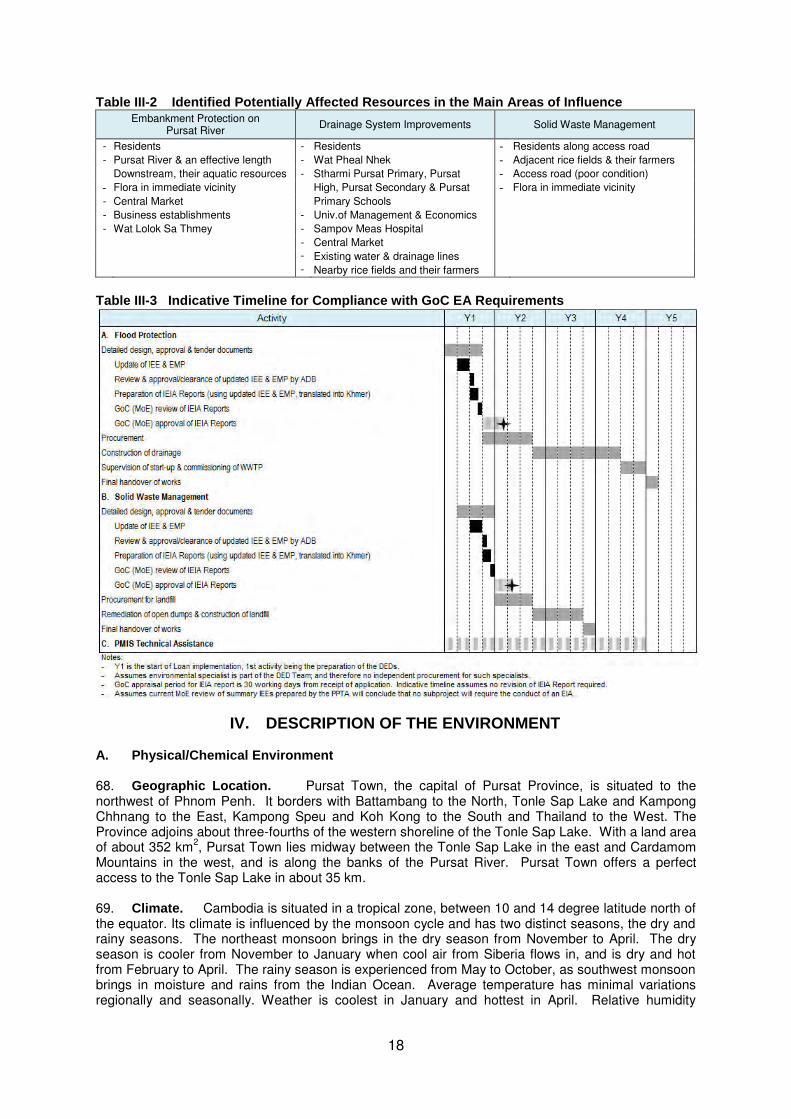
Table III-2 Identified Potentially Affected Resources in the Main Areas of Influence Embankment Protection on
Pursat River Drainage System Improvements Solid Waste Management
- Residents - Residents - Residents along access road
- Pursat River & an effective length - Wat Pheal Nhek - Adjacent rice fields & their farmers
Downstream, their aquatic resources - Stharmi Pursat Primary, Pursat - Access road (poor condition)
- Flora in immediate vicinity High, Pursat Secondary & Pursat - Flora in immediate vicinity
- Central Market Primary Schools
- Business establishments - Univ.of Management & Economics
- Wat Lolok Sa Thmey - Sampov Meas Hospital
- Central Market
- Existing water & drainage lines
- Nearby rice fields and their farmers
Table III-3 Indicative Timeline for Compliance with GoC EA Requirements
IV. DESCRIPTION OF THE ENVIRONMENT A. Physical/Chemical Environment 68. Geographic Location. Pursat Town, the capital of Pursat Province, is situated to the northwest of Phnom Penh. It borders with Battambang to the North, Tonle Sap Lake and Kampong Chhnang to the East, Kampong Speu and Koh Kong to the South and Thailand to the West. The Province adjoins about three-fourths of the western shoreline of the Tonle Sap Lake. With a land area of about 352 km
2, Pursat Town lies midway between the Tonle Sap Lake in the east and Cardamom
Mountains in the west, and is along the banks of the Pursat River. Pursat Town offers a perfect access to the Tonle Sap Lake in about 35 km. 69. Climate. Cambodia is situated in a tropical zone, between 10 and 14 degree latitude north of the equator. Its climate is influenced by the monsoon cycle and has two distinct seasons, the dry and rainy seasons. The northeast monsoon brings in the dry season from November to April. The dry season is cooler from November to January when cool air from Siberia flows in, and is dry and hot from February to April. The rainy season is experienced from May to October, as southwest monsoon brings in moisture and rains from the Indian Ocean. Average temperature has minimal variations regionally and seasonally. Weather is coolest in January and hottest in April. Relative humidity

19
ranges between 65-70% in March and 85-90% in September. The rainy season accounts for about 80-90% of the annual rainfall, varying between 1,200 and 2,000 mm across the country. October is the wettest month; January/February, with the least rainfall or driest. Mean wind speed in Cambodia is low at about 2 m/s. December is known as the month of strong steady wind from the north. Typhoons, which often devastate coastal Vietnam, rarely cause damage in Cambodia. Annual evaporation is from 2,000 to 2,200 mm, i.e., highest in March and April at 200 mm to 240 mm and lowest in September-October at 120 mm to 150 mm.
4
` 70. Throughout the Tonle Sap Basin: (i) temperatures are fairly uniform; and (ii) annual rainfall varies between 800 and 2,000 mm. Records in the Pursat Rainfall Station (Pursat Town) in the past five years, 2008-2012, show an average annual rainfall of 1,500 mm.
Table IV-1 Monthly and Annual Rainfall, Pursat, 2008-2012
Year Monthly Rainfall, mm
Total Jan Feb Mar Apr May Jun Jul Aug Sep Oct Nov Dec
2008 13.5 7.0 77.0 164.2 237.2 189.9 188.8 324.3 210.1 301.9 228.2 6.0 1,948.1 2009 1.6 28.4 56.2 117.9 108.0 126.0 146.1 185.6 175.2 162.7 34.9 0.0 1,142.6 2010 0.0 26.7 30.1 107.9 86.8 238.4 196.0 237.6 167.1 273.8 25.4 0.0 1,389.8 2011 0.0 0.7 62.7 51.3 114.3 106.1 201.0 214.9 206.1 418.1 69.2 44.0 1,488.4 2012 12.1 26.3 156.4 161.5 170.6 57.8 252.6 155.8 248.1 209.5 189.5 0.0 1,640.2
Average 1521.8 Source: Provincial Department of Water Resources and Meteorology of Pursat Province
71. Climate Change. In the past 40 years (1971 to 2010), the northwest provinces of Cambodia, which include Kampong Chhnang, had been experiencing: (i) increasing trend in drought frequency and duration; (ii) a steady heat level in the initial decade of 1971-1980, decreasing trend in heat in 1980 till 1990, and a rising heat thereafter; (iii) increasing trend in flood frequency and duration in the initial 35 years and a decreasing trend in the period 2005-2010; and; (iv) steady rise in rainfall frequency and intensity. Climate change projections indicate a rise in temperature of 0.3-0.6
oC by
2025, delayed onset of monsoon, increase of wet season rainfall, decrease of dry season rainfall and more intense flood pulses.
5
72. Topography, Geology and Soils. The Tonle Sap Basin-Mekong Lowlands is the largest topographic region, covering about 75% of the country. It consists mainly of plains with generally less than 100 masl elevations. Terrain is rolling and dissected as elevation rises. Pursat Town, its northern half lies in the vast plain of this region. Its southern half rises to higher elevations of nearly 450 masl midway and declines to about 100 masl approaching its southeast border. Underlain with rock of quaternary age, as most of Cambodia, Pursat Town consists of floodplains, deltaic deposits, alluvial fans and granite. The Town Proper, where subprojects will be implemented, is in relatively flat deltaic deposits at altitude between 12 and 16 masl. Soils consist of a mixture of often organic-rich silt, sand, clay and clay stones, such as alluvial soils, grey and cultural hydromorphics, acid lithosols, and red-yellow podzols. The alluvial soils are fresh, deposited annually, relatively young/recent, highly fertile and largely grown with rice. Grey hydromorphics are highly fertile; while cultural hydromorphics are moderately fertile. The red-yellow podzols developed from chemical weathering/decomposition of underlying parent material, generally have low fertility and are used for upland rice and non-rice crops. 73. Surface Water. Pursat River, one of the few rivers in Pursat Province, has its catchment area in the upland and mountainous areas of the Cardamom Mountain in the west, cuts through the Pursat Province and Pursat Town and empties into the Tonle Sap Lake in the east. It is about 250 km long. Downstream at Veal Commune (boundary of Pursat Town with Kandieng District), flow is less than that upstream at Bac Trakuon due to water diversion at Damnak Ampil Weir for irrigation. During the 12-year period of 1997-2008, average annual flow at Veal Commune was 2,132 MCM; at Bac Trakuon, 2,580 MCM. 74. Pursat River provides mainly amenity value for the Town, as well as its main source of drinking water and of irrigation water for the surrounding agricultural areas. Most recent water quality monitoring results of samples taken from SE of the NR5 Bridge over Pursat River (shown in table IV-
4 Cambodia Environment Outlook. Ministry of Environment and UNEP. 2009. 5 Strategic Program for Climate Resilience in Cambodia. A presentation to the PPCR Sub-Committee by T. Chankresna
(MEF), M. Sophal (MoE) and the Royal Government of Cambodia. Cape Town. 28 June 2011.

20
2) reveal exceedances in total coliform level over the standard limit during the dry season; and total suspended solids in the wet season. Due to low flow during the dry season, the low dilution of discharges from sanitation facilities would cause total coliform level to be high. In the wet season, runoff from the catchment areas in the upland and lowland would cause the level of suspended solids to rise. Figure IV-1 shows that the samples were taken upstream of the Town Proper. With more untreated urban wastewater being discharged downstream, levels of total coliform is expected to be higher downstream of the Town Proper. Table IV-2 Pursat River Water Quality Monitoring Results, 2013
Parameter Unit Result Standard/Guideline
04 Apr 2013 24 Jul 2013 Cambodian MRC TSS mg/l 78.00 198.00 25 – 100 - BOD mg/l 2.65 1.35 1 – 10 - COD mg/l 3.74 3.72 - < 4 Total Coliform MPN/100 ml 4.6 x 10
4 4.3 x 10
2 < 5000 -
Source: Ministry of Environment. Department of Pollution Control. Laboratory Office.
Figure IV-1 Sampling Location
75. Groundwater. Groundwater depth in the Tonle Sap Basin varies considerably. The water table changes with rainfall, specific local geomorphologic conditions, and the distance to the permanent water of the Tonle Sap Lake. Based on a preliminary investigation on groundwater resources in the Tonle Sap Basin
6, overall, the Tonle Sap Basin presents high yield and quality water
supply. Its exploitation is somewhat minimal, except in the Siem Reap area. The Great Lake basin is dominated by recent alluvium covering the "Lake Proper" and surrounding areas extending between 5 to 30 km beyond the NR5 and NR6 ring roads, including Pursat Town. Extensive well-sorted sand and gravel, younger alluvium aquifers are good; their average depths range from less than 1 m to 50 m. Water quality is commonly fresh with high iron content near to the lake shores.
7
6 As subcomponent of the Tonle Sap Rural Water Supply and Sanitation Sector Project (ADB-Grant 0018-CAM-SF).
7 Profile of Tonle Sap Sub-Area (SA-9C). Basin Development Plan Programme. Cambodia National Mekong Committee.
February 2012.

21
76. Manganese is reported to be found in the groundwater in concentrations that might cause some consumer inconvenience (e.g., staining of laundry and sanitary ware, taste), though it is not believed to have any negative health effects. Although arsenic concentrations are found in the groundwater throughout Cambodia, they commonly do not pose a problem.
8 Most of domestic water supply wells
are concentrated along the NR5 and NR6 where there is high population. 77. Air Quality. No ambient air quality monitoring has been conducted in Pursat Town. Ambient air quality can only be described based on field observations on current sources of emissions, i.e., dust when strong winds blow over un-surfaced roads and when the low transport volume passes over un-surfaced roads during the dry season, smoke emissions from the existing dumpsites and smoke emissions from domestic cooking and burning of wastes. There are no industries located in the Town. Ambient air quality and noise level are typical to low density secondary towns and concentration levels are assessed to be within the national standard limits.
78. Natural Hazards.
9 Cambodia is exposed to floods, drought, storms, earthquakes, landslides
and forest fires. Flood and drought are the main physical hazards, their regular occurrence often within the same year. For the period 1987-2007, floods had been more destructive. Storms are occasional events; earthquakes are of low intensities; landslides are rain-triggered; and forest fires are not very common. Forest fires, however, could become a serious threat if current rate of forest degradation continues, coupled with increasing events of drought and hotter days. Flooding is also expected to increase in terms of frequency, severity and duration with climate change. Table IV-3 Natural Hazards in Cambodia
Earthquake Flood Landslide Drought Storm /
Typhoon Volcano Eruption
Forest Fire Tsunami
X XXX X XX X - X -
Extracted from Table A.1.1. Disaster Matrix By Country (1970-2009). ASEAN: Advancing Disaster Risk Financing and Insurance in ASEAN Member States: Framework and Options for Implementation. Volume 2: technical Appendices. April 2012. World Bank, GFDRR, ISDR & ASEAN. Source of data is DRMI, 2010:59. Disaster incidence ranges relative from XXX ‘high” to X ‘low”. Table IV-4 Summary of Natural Disasters in Cambodia, 1987-2007
Natural Disaster Number of
Events Persons Cost
Killed Injured Homeless Total Affected (‘000 USD)
Flood Total 12 1,125 53 275,805 9,514,614 327,100 Average per event 94 4 22,984 792,885 27,258
Drought Total 5 0 0 0 6,550,000 138,000 Average per event 0 0 0 1,310,000 27,600
Lifted from: Strategic National Action Plan for Disaster Risk Reduction, 2008-2013. National Committee for Disaster Management and Ministry of Planning. Source of data is EM-DAT: The OFDA/CRED International Disaster Database – www.emdat.be, Université Catholique de Louvain, Brussels (Belgium).
79. Floods There are two major types of flood in Cambodia: (i) Mekong River flood and (ii) flash floods. Mekong River flood occurs with cumulative rainfall in the upper catchments throughout the rainy season, causing a slow but steady rise in water levels lasting for several days. This causes the Tonle Sap River to reverse its flow, expanding the Tonle Sap Lake to six times its dry season size. This event is worsened with heavy rains around the Tonle Sap Lake, affecting the provinces around the lake and the southern provinces. This event is most severe when heavy rains coincide with a tropical depression and storm. 80. Flash flood results with repeated heavy rainfall in the mountainous areas. Flash flood lasts for only a few days but often cause severe damages to crops and infrastructures, particularly in tributaries around the Tonle Sap Lake. Pursat is one of the Provinces that have been, and are prone to be, affected by flash floods. According to a map obtained from the Strategic National Action Plan for Disaster Risk Reduction, the flood-prone Pursat communes along Tonle Sap Lake are among the second priority flood-prone commune/s.
8 Technical Note 10: Impacts on the Tonle Sap Ecosystem. Assessment of Basin-wide Development Scenarios. Basin
development Plan Programme, Phase 2. Mekong River Commission. June 2010. 9
Largely lifted from the Strategic National Action Plan for Disaster Risk Reduction, 2008-2013, National Committee for Disaster Management and Ministry of Planning.

22
81. Drought There are four characteristics of drought in the country (i) unpredictable delays in the onset of rainfall in the early part of the wet season; (ii) erratic variations in wet season rainfall onset, amount, and duration across different areas; (iii) early end of rainfall during the wet season; and (iv) occurrence of mini-droughts of three weeks or more during the wet season, which can damage or destroy rice crops without irrigation. Localized drought is also becoming increasingly apparent and significant in many areas, including areas that are also flood-affected. During the monsoon season of the year 2012, Cambodia experienced drought and flash flood. The drought affected 14 provinces. Pursat Provincewas moderately affected, between 5,000 and 10,000 ha of rice field impacted. The Strategic National Action Plan for Disaster Risk Reduction, 2008-2013, has no identified drought-prone commune in Pursat. 82. Storms Sheltered by surrounding mountain ranges, storms or typhoons affect Cambodia occasionally. During storms, damages are largely caused by floods. Damage is most severe when storms come during September and October when seasonal discharge of the Mekong River is high and a second significant peak to annual flood is generated (MRC 2007).
83. Earthquake. Based on the Seismic Hazard Map of Southeast Asia, produced by the Seismic Hazard Assessment Program (GSHAP), 1999, Cambodia lies within middle-low seismic hazard zone, with peak ground acceleration of 0.2-0.4 m/s
2 (or 0.02-0.04 g), 10% chance of exceedance in 50
years. From a correlation with the modified Mercalli scale, intensity IV earthquake has a PGA range of 0.03 g and below. The Earthquake Intensity Risk Zones Map of the UN International Strategy for Disaster Reduction (ISDR) shows Cambodia to be within the earthquake intensity I-V zone. The observed effects of intensity V earthquake would include earthquake being felt by nearly everyone; some glasses/windows broken; unstable objects overturned; and pendulum clocks may stop. B. Biological Environment
10
84. Cambodia has many diverse ecosystems, all supporting a variety of plants and animals. Its landscape includes extensive lowlands, including the alluvial plains surrounding the Tonle Sap Lake, where human population is largely rural and where most natural vegetation has been replaced by agricultural crops, particularly rice. Other major crops include maize, soybeans, mung beans, vegetables, groundnuts, and sesame. The Tonle Sap Lake and its wetlands and seasonally inundated forests, are part of the country’s water systems that provide habitats harboring high levels of biodiversity. Protected areas found within Pursat Province include: (i) Phnom Aural, a wildlife sanctuary which lies east of Cardamom Mountains and occupies an area of 254,485 ha in the Provinces of Pursat, Kampong Chhnang and Kampong Speu; (ii) Tonle Sap Biosphere Reserve (TSBR), consisting of the Tonle Sap Lake and its floodplain, covering an area of about 1.48 million ha in the Provinces of Kampong Chhnang, Pursat, Battambang, Banteay Meanchey, Siem Reap and Kampong Thom; and (iii) Central Cardamom Protected Forest, a 401,300-ha area in Central Cardamom Mountains, extending in the Provinces of Pursat, Koh Kong and Kampong Speu. Pursat Town is far from Phnom Aural Wildlife Sanctuary and Central Cardamom Protected Forest. It is partly within the transition zone of the TSBR, where the construction of some physical infrastructure is allowed. Pursat River, its tributaries and rice fields are the wetlands within Pursat Municipality. The protected area and type of wetland relative to the subproject sites are presented in Table IV-5. The subproject sites and their main areas of influence are not habitats of rare species of flora and fauna.
Table IV-5 Protected Area and Type of Wetland in Subproject Sites
Subproject Protected Area Wetland Riverbank Protection Within the transition zone of the TSBR,
where some physical infrastructure is allowed
Pursat River
Drainage Partly within the transition zone of the TSBR, where some physical infrastructure is allowed
-
Solid Waste Management Controlled landfill - -
10
This Section is lifted from the Cambodia Tropical Forestry and Biodiversity (118/119) Assessment. February 2011. USAID Cambodia.

23
C. Economic Environment 85. Economy.
11 Most of the economic activities around the Tonle Sap are based on fisheries or
agriculture. Fish processing is widespread, while agriculture focuses on rice production in most places. Infrastructure facilities are largely absent, particularly in the floating or stilted villages. The few access roads are mostly in poor condition. Ports and landing sites lack basic infrastructure; however, contribute effectively to livelihood generation. The lake is used for transportation of people and goods, including petroleum products and fish. Most of the people transported are foreign tourists. Low water levels in the dry season limit the size and traffic of boats.
12
86. The capital of Pursat Province, Pursat Municipality is easily accessible from and to Phnom Penh via the National Road 5 and the national railway. It lies along the GMS Southern Corridor. Agriculture and fisheries, services and small-and medium-scale businesses and tourism and traditional handicrafts make up the economic sector of the Municipality at present. Projects to upgrade National Road No.5 and the railway will further enhance the town’s attractiveness for investors. 87. Land Use and Urban Development. In 2003, the general land use of Pursat Municipality consists of agricultural land (mainly rice land), forest covers in the south, shrubland, water (largely the Pursat River) some grassland and urban/built up areas, which has gone beyond the Municipal boundaries to the north along the Pursat River. The proposed drainage system improvement and riverbank protection works will be implemented in the urban area, the latter along the Pursat River. The proposed controlled landfill will be in the agricultural land. 88. Infrastructure Development. Road and Transport The national and provincial roads within the Pursat Municipality are bitumen-surfaced; while the municipal roads are a combination of bitumen, a few concrete but mainly laterite surfacing and unformed roads. The Municipality reports that only around 16% of the municipal roads are surfaced as shown in Table IV-7, although most of the roads in the core urban area are surfaced. Upgrading of roads, including residential roads, is in the process. Many of the roads lack roadside drains; while existing roadside drains are often silted up or blocked with solid waste. With relatively low traffic on municipal roads, in general, municipal road conditions are reasonable. The main issue is flooding of the roads during the wet season and dust and mud on un-surfaced roads during the dry and wet seasons, respectively. There is no formal street sweeping; while streetlights are present only along the NR5. The national railway passes through Pursat Town. Like Phnom Penh, local public transport mode is the tuk-tuk.
89. Water Supply Originally built in the 1930s, the water supply system was upgraded under an ADB-assisted project in 2006 that provided a new intake (at Pursat River and about 3 km upstream of the old one which was closed) and a water treatment plant adjacent to the new source with an installed capacity of 5,700 m3 per day but currently delivers 4,500 m3 daily. New primary mains were installed and existing ones replaced. The distribution system comprises around 96 km of ductile iron pipe, of which JICA completed about 9.44 km in the main urban area by early 2013, and UN HABITAT funded 17.164 km in 2013 to supply water to poor areas in the west of town along NR5 and along Pursat River. However, these extensions have possibly had an impact on system pressure and there is a need for additional overhead tanks to increase pressures towards the ends of the system. The Department of Industry, Mining and Energy has proposed for: (i) two overhead tanks near NH5 towards Battambang and downstream on the Pursat River to increase pressure towards the ends of the distribution system; and two main lines of 1 km and another 5 km to serve unserved areas. Records for late 2012 show that of the 10,700 households, 5,600 (or 52%) were connected to the system; 1,900 (or 18%) were covered by tube wells; and 3,200 (or 30%) remained unserved.
90. Drainage and Sanitation There are two combined drainage systems in the town that meet near a non-functioning wastewater treatment plant (WWTP) in the northwest of the town away from the river. The existing WWTP was built on a 10-ha site in 2001 but has not been functioning due to blocked and broken inlets. Hence the dry weather flow diverts all the flow into a nearby irrigation
11
Pursat Krong Data Book 2009. Pursat Province. October 2009. National Committee for Sub-National Democratic Development (NCDD).
12 Lifted from the Technical Note 10: Impacts on the Tonle Sap Ecosystem. Assessment of Basin-wide Development
Scenarios. Basin Development Plan Programme, Phase 2. Mekong River Commission. June 2010.

24
ditch. All flow is by gravity with no pumping. The Provincial Government has been incrementally constructing drains. By the end of September 2013, a total of 5.64 km have been constructed. 91. Flood Protection The existing embankment along Pursat River is no longer high enough to protect the town. At a level of 4.90 m above datum, flood levels usually reaching around 5.1 or 5.2 m (in 2011, 5.35 m) overtop the embankment; hence, requiring sandbags to be placed along the embankment. The high flood levels during the past two years also caused damages to the embankments. The Municipality estimates 12 km of embankment on the town side and 10 km on the other side of the river as needing improvement. Various barrages have been built across the river both upstream and downstream of the town. While most of these barrages have fallen into disuse or, or in one case, bypassed by the river changing course, two barrages remain operational. Both these barrages were constructed as part of irrigation programs in the 1990s and use automatic flap gates to cope with flood flows. With no means to regulate the flow of water in the river through the town during floods, these barrages could be an additional cause of flooding. Although The Greater Mekong Subregion (GMS) Project proposes to divert some flow from the Pursat River for irrigation, some embankment improvement works are still deemed necessary, but could be shorter.
92. Solid Waste Current waste collection is done by a fleet of two old vehicles with capacity of 11.5 m3. On average, the trucks combined haul 3.5 loads per day. Assuming the loads are 90% full, at a typical uncompacted raw waste density of 250-330 kg/m3, the total volume of solid waste hauled daily would be about 9 to 11 tpd. There is a third much smaller truck that does not haul waste daily. Current waste collection efficiency is about 30% of solid wastes generated in the town core. Presently, collected solid wastes are disposed of at Srah Srang dumpsite, about 5 km from the town center. D. Socio-economic Environment
93. Population. In 2011, Pursat Municipality had a total population of 63,773 persons. The total population included many rural villages within the Municipality. The PPTA Team has estimated the urban population within the Municipality to be only 42,085 and the total population of the urban agglomeration area, 49,044, in 2011. The 200-m embankment protection and drainage improvement works will take place in the town center where population density s highest.
94. Ethnic Minorities. The District Data Book 2009 reported that there was no family belonging to ethnic minority group present in Pursat Municipality in 2008. All 126 households surveyed in the PPTA’s Socio-Economic Survey (SES) in 2013 were Khmers. 95. Employment, Poverty and Vulnerable Households. Of the 126 households surveyed in the SES, majority (nearly 45%0 of male household heads were not employed, followed by 17% as engaged in agriculture. In contrast, most of the surveyed female household heads, nearly 63%, were primarily engaged in wholesale or retail trade (62.5%), followed by about 13% as engaged in agriculture. Overall, the proportion of those employed in the primary sector, i.e., agriculture (16.7%), fishing (2.4%), forestry (1.6%), in Pursat Municipality appeared much lower than provincial figures. 96. Based on the World Food Programme’s identification of poor households survey in August 2012, poverty rates in the six municipalities around Tonle Sap Lake ranged from 22.6 to 31.8% in 2012. Pursat Municipality had the highest percentage of poor families, 31.8%. Based on Ministry of Planning’s poverty threshold for urban areas apart from Phnom Penh, i.e., 132,386 KHR monthly per capita (or approximately 661,930 KHR per household of 5 members), the majority (59.5%) of households surveyed in Pursat are well above the poverty threshold. It should be noted, however, that around a fifth (21.4%) of the households are still below the poverty line, and 19.0% are only just above the poverty threshold and could thus still be vulnerable to shocks. 97. Of the 126 households surveyed in the SES, 13.5% were female-headed; (11% were headed by disabled persons; and 10% were headed by an elderly (over 65 years old). The SES data revealed half of the surveyed female-headed households with incomes just at or below the poverty
line, underscoring the vulnerability of a proportion of female-headed households in the Project area.
98. Security of Tenure and Housing. According to the District Data Book 2009, in 2008: (i) of the total 12,859 households, 1,232 or nearly 9.5% were living on public land and 43 persons were without permanent housing; (ii) 37% of houses had zinc/fibro roof, 32% had tile roof and 28% had

25
thatched roof; and (iii) 43% of houses had electricity. Of the 126 households surveyed in the SES, 94% own the house they live in; 88% own the lot they occupy; and the rest are either renting or not renting the houses and/or lots they live in/occupy.
99. Access to/Levels of Basic Services. Education In 2008, the ratios of primary students to class, classroom and teacher were lower than the national average ratios in the urban area. The ratios for total secondary students to class, classroom and teacher were above the national average ratios in the urban area. Based on the PPTA’s SES, access to higher education among the heads of surveyed household appeared to have been fairly limited. The highest educational attainment of about 21% of them was primary level; of 18%, secondary level; and of 16%, high school graduate. Most of the surveyed male household heads (19%) attained secondary level of education; while most of the surveyed female household heads attained only primary level (nearly 38%). 100. Health Care. Pursat Province is divided into two health operational districts, one of which is based in Pursat Municipality (Sampov Meas Commune). A health operational district differs from administrative district boundaries. Hence, the Sampov Meas Health Operational District has operational jurisdiction beyond its administrative boundary. According to the District Data Book 2009, the said Health Operational District had 21 health centers and 4 health posts in 2008. Among these, 2 health centers were within the Pursat Municipality. The Sampov Meas Health Operational District served 378,450 persons in 2004-2005 with 2 doctors, 5 medical assistants, 148 nurses and 77 midwives. Ratios of persons: (i) to a doctor was 189,225; (ii) to a nurse was 2,557. The Pursat Provincial Hospital, located in Pursat Town, had 125 beds for patients with general disease and 37 beds for patients with tuberculosis. Ratio of persons to a bed for general diseases was 3,028. 101. Water Supply According to the District Data Book 2009, in 2008, only 27% of the total households in the Municipality had access to piped water supply. Rivers, lake, natural pond and/or reservoirs were the sources of potable water for 25%; ring wells and open dug wells by 22%; pumped/mixed wells by 12%; normal pond by 10%; and rain water by the remaining 3%, of the total
households. Some 14-92% of households in the communes were using water from unsafe sources during the dry season in 2008. Of the 126 households surveyed in the SES, 64% sourced drinking water from piped water supply connected to their houses; 10% from rivers/streams/springs; 9% used rain water; 8% from piped water supply in their compounds; 3% from protected dug wells; and the rest used water from boreholes, unprotected dug wells, 5-gallon containers and others. 102. Sanitation According to the Municipality, in 2012, 61% of the population had access to latrines. Of the 126 households surveyed in the SES, 80% had flush/pour flush toilets; 10%d pit latrines with septic tank; 3.2% had pit latrines without septic tank; and 6% had no latrines and used other’s latrine. The remaining households had other form of sanitation facility or disposal method. 103. Drainage. Of the 126 households surveyed in the SES, 75% had no access to drains; 13% had access to earth drains; and the remaining 12% had access to closed and cement-lined open drains. About 75% said their communes flood during heavy rains and/or during river overflow. Of those served by drains, 79% reported drains to be too small; and about 11% reported their drains as clogged with sediments and/or solid wastes. 104. Solid Waste Collection In 2008, the percentage of households with access to solid waste collection by commune ranged from 0% in Chamraeun Phal, Lolok Sa, Svat At and Banteay Dei to 1.9% in Prey Nhi, 4.9% in Roleab and 29% in Phteah Prey. Of the 126 households surveyed in the SES, 11% had access to solid waste collection services while 81% burned their garbage. Some of the remaining would bury their garbage; some would throw their garbage anywhere. 105. Power Supply In 2008, the number of households that were connected to the power supply grid was 6,274 (or nearly 49% of total households in the Municipality. (This total does not include homes powered by generators or batteries.) E. Physical Cultural Environment
106. There are no physical cultural resources that will be affected by the proposed subprojects. According to the Municipality, no chance finds of archaeological/historical relics have yet been experienced or reported.

26
V. ANTICIPATED ENVIRONMENTAL IMPACTS AND MITIGATION MEASURES
A. Positive Environmental Impacts and Benefits
107. The subprojects will bring about improved urban environment and climate change-resilience, significantly contributing to a qualitative improvement in the lives of residents in Pursat Town; and thus: (i) will help the country attain its Green Growth Vision in increased access to sanitation and increased climate change resilience; (ii) will support the National Development Strategic Plan toward enhanced environmental protection at the sub-national level; and (iii) will contribute to the achievement of the country’s MDG7 targets, particularly in improved sanitation in urban areas. It will help promote the implementation of the Tonle Sap Urban Areas Development Framework, which will guide future urban development in the Tonle Sap Basin (under preparation). Table V-1 presents the environmental benefits, positive impacts and outcomes of the proposed subprojects. Table V-1 Environmental Benefits, Positive Impacts and Outcomes
Aspect
Subprojects Embankment Protection on
Pursat River Drainage System
Improvements Solid Waste Management Benefits
Protected embankment on Pursat River
Improved storm- and wastewater management
Improved solid waste collection and disposal
Positive impact Relief from flooding from embankment failure
Reduced erosion, reduced sedimentation of Pursat River
Reduced health & safety risks Improved, safe mobility during
heavy rains or storms
Relief from flooding Improved sanitation Reduced health and safety
hazards Improved, safe mobility in the
rainy season
Reduced/eradicated open & indiscriminate dumping & burning of SW & relief from its associated issues (fumes & uncontrolled gas emissions, odor, nuisance, contamination of water resources, clogging of drains, health & safety risks)
Outcome Improved urban environment Safe, climate-resilient
communities and Town
Improved urban environment Safe, climate-resilient
communities and Town
Improved urban environment Safe communities and Town
B. Screening of Potential Impacts/Issues/Concerns
108. The screening process revealed the following salient siting concerns: (i) sensitiveness of the Pursat River and its resources to impacts during construction, and in case of embankment failure during operation; (ii) urban development and settlements in the town center will be impacted on during drainage system improvements; (iii) site of the existing unused WWTP is waterlogged during the rainy season; (iv) existing utility lines and crossing drains within the road rights-of-way in the Town center that should be considered in design and during construction of drainage system improvements; and (v) the states of the access roads to the sites that will be subject to pressures from use by construction vehicles and equipment during construction of all works and from use by waste collection trucks during operation of the controlled landfill.
109. Relative to design, the salient concerns would be the inadequate consideration/incorporation in the respective designs of the above-mentioned siting concerns, capability of operating institutions in OM&R, generated spoils, and the following:
for the riverbank protection works, impacts climate change on the hydrology of Pursat River;
for the drainage system improvement works: (i) impacts of climate change on the stormwater runoff that will be combined with wastewater and on wastewater treatment, (ii) sensitiveness of groundwater and soil in the vicinity of the WSPs’ site to wastewater stabilization operations, and (iii) provisions for groundwater monitoring well at strategic locations near the WSP based on direction of groundwater flow and gradient;
for the controlled landfill: (i) climate change and its impacts on landfill operations, (ii) potential sensitiveness/vulnerability of the soil and groundwater at the site and in the vicinity, (iii) closure/environmental restoration plan to restore (or at least mitigate the disturbance to and blend with) the landscape, and (iv) remediation plan for the dump sites existing in Pursat Town.

27
110. The identified direct impacts with potential moderate to high significance during construction are: (i) dust and noise; (ii) impacts on the Pursat River and its resources; (iii) soil erosion during embankment protection works; (iv) impacts of the construction of the controlled landfill on the existing landscape; (v) impacts on vegetation beyond the subprojects’ footprints, particularly along the banks of Pursat River and at the controlled landfill and its access road; (vi) impacts on the socio-economic environment and resources from traffic, blocked/constricted accesses, accidental damages of utility lines and other infrastructures within and adjacent to the drainage system improvement works, damages from use of existing access roads; and (vi) public and workers’ health and safety hazards. 111. The potential indirect and induced impacts during construction with moderate and high magnitude and significance include: (i) contamination of Pursat River and impact on its resources from wastes, sediments, hazardous substances during heavy rains/flooding or collapse of exposed/unstable slopes or newly completed embankment protection works; (ii) traffic build up and extension during peak hours, increasing travel time and road safety hazards, in the town center during drainage system improvement works; and (iii) clogging of existing drainage system in the Town center with wastes and sediments from drainage system improvements works during heavy rains or flooding, exacerbating flooding in the town center and increasing health and safety hazards. 112. Considering the many planned projects in Pursat Town, the cumulative impacts during construction would be magnified levels of: (i) dust, noise, traffic, blocked accesses, health and safety hazards in the town center, (ii) potential risks to contamination of Pursat River and its resources; and (iii) dust, noise, traffic and road safety hazard at the junction of NR5 and the main access road to the landfill.
113. During operation, potential direct impacts mainly relate to the operation of the wastewater stabilization ponds and controlled landfill and the salient impacts/concerns are:
Elevated levels of odor, gas emissions, pests from inefficient O&M of the wastewater stabilization ponds, e.g., from inadequate management of produced sludge, floating scum, screenings, grit and other accumulated solids.
Groundwater and soil/land pollution from overflow of wastewater treatment plant and/or seepage/migration of wastewater due to ineffective pond liners or deferred action on cracked liners.
Overflow of wastewater treatment plant and noise from inefficient operation and maintenance and deferred repair of pumping station.
Leachate, air emissions, groundwater contamination, litters/pests/odor/dust, health and safety hazards with inefficient operation and maintenance of the new solid waste management facilities.
Health and safety hazards of workers in the operation, maintenance and repair of completed drainage improvements and controlled landfills and newly acquired waste management equipment.
C. Impacts/Issues/Concerns and Mitigation Measures Relative to Siting, Planning and
Design
114. In the preparation of the feasibility study, resettlement plan and this IEE, measures were taken to minimize some of the aforementioned siting and design issues and concerns and the subprojects’ other potential environmental and social impacts:
The subprojects have been prepared within a highly consultative and participatory process through workshops, socio-economic survey (SES) and community focus group discussions to: (i) inform stakeholders about the proposed Project; (ii) obtain the priority needs and concerns; and (iii) agree on the subprojects.
The proposed riverbank protection works have taken into consideration the existing settlements on top of the embankment and have significantly avoided displacement and involuntary resettlement.
All proposed works estimated the spoils that will be generated and to be managed. The excavated soils from drainage works will be reused as compacted backfill. The controlled landfill will use excavated soils as soil cover material for the entire life of Cell (Stage) 1.

28
Table V-2. Spoils Management
Subprojects Excavated
Soil Excavated
Rock Removed Refuse
Demolition waste
Other
Riverbank Protection Cut/excavated 0 0 0 0 0 Used as compacted backfill 0 0 0 0 0 Residual 0 0 0 0 0
Drainage System Improvements Cut/excavated 40,000 0 0 0 0 Used as compacted backfill 40,000 0 0 0 0 Residual 0 0 0 0 0
Controlled Landfill Cut/excavated 20,200 0 0 0 0 Used as cover material 20,200 0 0 0 0 Used as compacted backfill 0 0 0 0 0 Residual 0 0 0 0 0
Obtained from the PPTA Engineers.
The IEE has incorporated the existing socio-economic and environmental conditions, issues and concerns raised in the SES.
A resettlement plan has been formulated in a highly consultative, participatory manner.
An environmental safeguard public meeting was held to present/disclose the IEE and existence of EMPs for implementation.
In project preparation, preliminary design and IEE, other planned and programmed projects have been taken into consideration.
Preliminary design for the riverbank protection has studied and considered Pursat River’s hydrology and how it has been/is/going to be impacted on by climate change, existing barrages and past, ongoing and proposed relevant interventions.
Preliminary design for the drainage system improvements has: (i) considered climate change impacts on stormwater flows in the Town center and on wastewater treatment; (ii) specified adaptation options such as the upgraded design and fabrication standards for the reinforced concrete (RC) sewer pipes and parts, design standard for the cushion base, and the cement material for the RC pipes; and (iii) considered the potential inadequate technical and financial capability of the operating institution.
Preliminary design for the controlled landfill has: (i) included the appropriate leachate and gas management strategy, proposed groundwater monitoring wells and clay liner to protect groundwater and soil; (ii) recommended for a hydro-geological investigation during detailed design; (iii) considered climate change issues; (iv) proposed for the upgrade of the access road; (v) proposed for the greening\ of completed/capped waste cells and landscaping of the site to somehow blend with the existing landscape in the area; and (vi) recommended the institutional set-up for operations and its training.
The proposed remediation of open dumps have considered the protection of the groundwater and soil, climate change issues, greening of completed/capped waste cells; and dealing with existing fumes and open burning as a priority.
115. During detailed design, the above initial mitigation measures will be carried on and/or validated. Consultations will be held and feedback should be taken into account. The potential impacts, issues and concerns that could arise during construction and operation can be avoided or, at least, mitigated with sufficient incorporation/consideration of the following during the detailed design stage:
The demand for, and availability of and sources for, fine and coarse aggregates to be assessed carefully during detailed design not only to mitigate delays in construction progress and avoid prolonged exposure of open or disturbed surfaces but also to avoid haphazard (and illegal) extraction of these materials. An Aggregates Management Plan (AMP) to be prepared during detailed design will serve as framework for the preparation of Contractor Aggregates Management Plan in the Contractor’s EMP (C-EMP).
Town’s vulnerability to damages from other natural hazard events, existing utility lines and infrastructures in the sites, relevant feedback/suggestions obtained during stakeholder consultations, and adaptation measures for other integral components of the controlled landfill, such as access and internal roads (flexible pavement, granular protection/bedding, optimum compaction, appropriate gradient), water supply (collect and store rainwater), buffer area/landscaping (use submergence and drought tolerant plants).

29
Construction schedules and, if relevant, designs of other ongoing and planned projects in Pursat Town to mitigate cumulative impacts.
Appropriate environmental mitigation and monitoring measures are included in the EMP. To attract more environmentally responsible bidders, the SPS-compliant EMP will be part of the bidding document. Selected Contractor will be required to prepare a detailed C-EMP that will address as minimum the requirements of the EMP. The C-EMP will be quantitatively and qualitatively evaluated against the EMP by the PMU and cleared by the ADB prior to the commencement of any work on site. The Contract for civil works will explicitly stipulate the obligation of Contractor (and his/her Sub-contractors) to institute the mitigation measures properly and carry out environmental monitoring according to the ADB-cleared C-EMP. The Contract for civil works will stipulate some tie-up of progress payment and collection of performance bond with the performance in C-EMP implementation.
D. Impacts and Mitigation Measures during Construction 116. Impacts on Air Quality. Dust and noise will be salient during construction. Moderate increase of sulphur oxides and nitrogen oxides levels in the ambient air quality will be expected intermittently, such as when VOC-emitting activities are undertaken and when there is peak movement/operation of construction vehicles and equipment. Unmitigated vibration could lead to health consequences and permanent damages of sensitive structures. These issues/impacts will be temporary but, if not mitigated, will have potentials to result in long-term consequences in the health of the affected communities and the construction workers. Some measures to mitigate are: (i) apply segmentation of works; (ii) water stockpiles & exposed surfaces at least twice a day, or as necessary; (iii) enforce slower maximum speed (40 kph) en route to sites & (30 kph) in subproject access roads and sites; (iv) minimize drop heights & spray water when loading/unloading aggregates; (v) ensure trucks hauling cement, aggregates and spoils to have cover and maintain a minimum of 2 ft freeboard; (vi) locate VOC-emitting processes away from receptors, (vii) undertake prompt maintenance of vehicles/equipment; (viii) encase generators and locate them away from receptors; (ix) limit noisy operations at daytime; and use least noisy and least vibrating equipment and tools. 117. Impacts on Water Resources. Pursat River will be at risk of pollution from the proposed embankment protection works caused by: (i) poorly managed construction sediments, wastes/spoils and hazardous substances; and (ii) poor sanitation practices of construction workers. Polluted Pursat River will be detrimental to the aquatic resources of the Pursat, which some households downstream rely on for food, as well as to the health of people relying mainly on the river and streams as sources of water for domestic uses. 118. There is no surface water body in, or near to, the controlled landfill and WSP sites. Groundwater table at the controlled landfill site is reportedly at 30 m below the ground surface and soil at the landfill site is sandy silt but clayey, indicating slow soil permeability rate and sufficient protection of the groundwater resource from any contamination during construction. Hydrogeological and soil investigations during the detailed design stage will confirm/validate the groundwater and soil conditions at the controlled landfill site and provide information of the same at WSP site.
119. Some mitigation measures: (i) use sediment traps, fences, nets, sand bags and/or earth berms;; (ii) store aggregates, spoils and wastes away from Pursat River and main surface drainage routes; (iii) dispose of spoils and wastes promptly; (iv) provide adequate sanitation facilities at work sites; (iv) enforce upon workers good sanitation practices; (v) implement proper solid and hazardous waste management; and (vi) complete riverbank protection works prior to the onset of the rainy season.
120. Impacts on Soil. Erosion of unstable sections of the embankment along Pursat River, near to the embankment improvement works, may be caused by construction works and/or vibration from movement and operation of construction vehicles/equipment. Soil removed by erosion may become airborne, creating dust, and/or be transported away by water into water bodies and pollute them. With guided land disturbance and coordinated activities, soil erosion will be mitigated.
121. The concern for possible indiscriminate borrow operations for aggregate materials is considered to be minimal. However, as preventive measure, the magnitude of this concern will be confirmed during detailed design and carefully addressed through the formulation of an Aggregates

30
Management Plan as framework for the Contractor’s EMP and requiring Contractor’s to obtain aggregates only from sources with environmental clearance and license to operate and that still have high ratio of extraction capacity over loss of natural state.
122. Impact on the Landscape. The controlled landfill will be constructed in the middle of rice fields and shrubland. Excavations, removed trees and shrubs, indiscriminately parked construction vehicles and equipment, stockpiles of construction wastes/spoils and aggregates and other construction materials, storage structures, sanitation facilities and pits will disturb the existing landscape. This could be mitigated with planned and enforced orderly placement of construction amenities and stockpiles and observance of vehicle and equipment parking. 123. Impacts on the Biological Environment. The proposed subproject sites are not within or in close proximity to any protected area. The proposed riverbank protection works, however, will be implemented on the banks of Pursat River. The health of the aquatic life in Pursat River will be at risk with a contaminated Pursat River. Measures to manage solid wastes, stockpiles of aggregates and residual soils and storage and use of hazardous substances and the strict enforcement of good sanitation practices by construction workers will address this concern. 124. Shrubs, trees within the subprojects’ footprints will be removed. A plan to replace the removed trees can be one of the detailed design outputs. Vegetation outside the footprints, particularly at the sites for embankment protection works and along the access roads to the controlled landfill site, will be potentially subject to trampling or hit by the movement and parking of construction vehicles/equipment, stockpiles of aggregates/excavated and residual soils/wastes, storage structures and movement of workers. This can be mitigated through the: (i) definition, during detailed design, of the land required for work easement; (ii) inclusion of this required land in the resettlement plan as temporary disturbance/loss, as appropriate; (iii) installation of adequate physical demarcation during construction mobilization to ensure confinement of construction activities within the subproject footprint and work easement areas. 125. Impacts on the Socio-Economic Environment. Traffic volume in Pursat Town is currently low. Traffic flow at the town center during the peak hours will experience some congestion. Delivery of people, goods and services will experience some stretch in travel time. Road users and the clients/patrons of the businesses and market and users of social institutions will be exposed to more road safety hazards. With mitigation measures in place such as segmentation of works, prior consultation/ coordination/collaboration with concerned local authorities, and adequate prior public information, traffic impacts would be moderated. 126. Blocking of accesses to houses, properties, business establishments, the central market and social institutions cannot be avoided win horizontal construction such as the drainage system improvement works, Excavations, storage of RC pipes for installations, loading and unloading activities, stockpiles of wastes/spoils and aggregates, storage of other construction materials, and indiscriminate parking of construction vehicles/equipment will create obstructions to accesses, give inconvenience and nuisance, disrupt daily domestic and economic activities and pose safety hazards. To mitigate: (i) agree on safe accesses to provide with affected households and local authorities; (ii) post clear signage (reflectorized) at active junctions/sections; and (iii) provide adequate lighting at active works sites and provide safe accesses. 127. In the main area of influence of the drainage system improvements, existing water supply lines, drainage system and possibly, some power supply poles will be exposed to potential accidental damage. In case of accidentally damage, service interruptions will be experienced and domestic, social and economic activities will be disrupted. Currently in a very poor state, further damage will be caused by construction trucks on the access road from NR5 to the controlled landfill site. To mitigate impacts: (i) during mobilization, contractor should consult/coordinate with relevant utility companies on/for the exact locations, planned relocation & set contact arrangements in case of damage/s; (ii) consult/coordinate with local road authorities regarding proposed actions to take in case of damaged roads; (iii) in case of accidental damage, immediately inform the concerned company and/or the PIU and PMU; (iv) give at least 1 week prior notice on planned service interruption due to relocation of power supply poles; and (v) plan to provide interim services/actions for damaged utilities/community infrastructures, e.g., scheduled power supply using generators, for street lighting, interim re-surfacing of damaged access roads.

31
128. The health and safety of the community/public and construction workers will be at high risk during construction. These people will be directly and indirectly exposed to crosscutting threats from construction’s impacts on air quality; noise and vibration, traffic; blocked accesses to home, work, markets and social services, among others; open excavations; poorly managed construction wastes, wastewater and spoils; indiscriminate stockpiles of aggregates; hazardous substances transported to and stored on site; accidental spills of hazardous substances; reckless drivers of construction-associated vehicles; potential fire and explosion; and lack of awareness on the hazards posed by subproject implementation on health and safety. Communicable and transmittable diseases may potentially be brought into the community by construction workers; and/or construction workers may also be potentially exposed to communicable and transmittable diseases in the community and in the workforce. The adequate conduct of community IEC and pre-mobilization orientation for workers will raise the awareness and prepare both stakeholders of the health and safety risks during construction. Responsible C-EMP/EMP implementation by contractors will mitigate the cross-cutting threats during construction. Contractors shall set up a first-response team linked to an ultimate-emergency response team. 129. Inadequate supply of safe/potable water in construction sites; inadequate sanitation facilities; poor sanitation practices on site; poor housing conditions; the handling and operation of construction equipment; handling of hazardous substances; exposure to extreme weather and non-observance of health and safety measures, pose additional threats to the health and safety of construction workers. The Contractors shall ensure: (i) accommodations for workers are safe and adequate and sufficiently supported with basic services; (ii) workers are provided with protective wears and observe the enforced use of these during work. 130. Impacts on the Sustainability of Works. During construction, seismic or extreme weather event may occur, causing damage or movement to unsettled/unfinished/uncured structures and affecting their structural integrity. After every event, conduct an engineering investigation of built structures & implement the necessary corrective measures without delay. Prepare written report on the investigation findings & if applicable, the planned or implemented corrective measures 131. Assessment Summary. Impacts during construction will be temporary and are expected to be local, confined within the active work sites and their immediate vicinities. Except during windy days, heavy rainfall and/or extreme weather event, dust, fine aggregates, sediments and wastes/ would not be the transported beyond these sites. With proper mitigation measures in place, such as: (i) special care taken at sensitive locations, e.g., riverbank protection sites along the Pursat River, works close to health care and educational institutions; and (ii) ensuring that, when practicable, works are properly phased, segmented and organized so that the bulk of works are completed (or at least almost complete) prior to the commencement of another phase/segment, the potential adverse impacts during construction would be minimized and kept highly site-specific. These impacts will not be sufficient to threaten or weaken the surrounding resources. 132. Measures to keep construction impacts to the minimum or acceptable levels are mostly good engineering and construction practices. A detailed set of mitigation measures are presented in the EMPs (Annexes F, G and H). The effective conduct of the following are crucial mitigation measures as well: (i) construction management by the Contractor; (ii) supervision of C-EMP implementation by the Contractor’s Environmental Management Engineer; (iii) construction supervision by the PMU; (iv) monitoring of C-EMP implementation by the PMU; (v) observance of the Grievance Redress Mechanism by all concerned parties; and (vi) the participation of concerned communities in the monitoring of C-EMP implementation.
133. In case of chance find of buried physical cultural resource: (i) construction work or any activity should stop immediately; (ii) finder should make a declaration to the local police, who shall communicate it to the Provincial Governor at once; (iii) Governor shall in turn inform the competent authority and ensure protection of the found object/s and the site; (iv) competent authority shall, within 30 days from date of declaration, announce temporary suspension of works and the safeguarding measures to take; and (v) if no such measures are announced within 30 days, temporary suspension shall no longer apply and the competent authority shall decide on the permanent measures to take. 134. In case of chance find of UXO during construction: (i) Construction work should be immediately stopped and area, immediately secured. (ii) The local police should be immediately contacted for

32
ensured security of the area and for them to communicate with the Cambodian Mine Action and Victim Assistance Authority (CMAA). (iii) PIU should immediately inform the PMU, which being based in Phnom Penh, could also coordinate the matter with the CMAA.
E. Impacts and Mitigation Measures during Operation
135. During operation, direct impacts will mainly relate to the operations of the WSPs and controlled landfill. In all three subprojects, inefficient operations, maintenance and repair will lead to unsustained effectiveness of their operations and services. 136. Wastewater Stabilization Ponds (WSPs). Potential impacts of high significance include: (i) odor and gas emissions, pests from ineffective treatment and potentially, noise from any mechanical equipment from inefficient operation/maintenance/repair; (ii) groundwater and soil contamination from events of overflow of un- or inadequately treated wastewater and/or seepage/migration of untreated wastewater due to ineffective liners or unattended cracked liners; (iii) health and safety hazards of workers.
137. Some mitigation measures include: (i) conduct prompt routine maintenance, e.g., clearing/disposal of sludge, floating scum, screenings, grit, other accumulated solids to maximize effectiveness of the processes, pruning/removing grasses growing near the ponds to prevent them from falling and adding solids into the ponds, and/or spraying clean water or the removed floating scum from the facultative ponds on the surface of the anaerobic ponds; (ii) if volume allows or if feasible, capture emitted gases for some possible use in plant operation; (iii) fence in the WSPs and plant insect/pest-repellent trees/shrubs around at adequate distance from the ponds; (iv) undertake prompt maintenance of mechanical equipment; (v) monitor qualities of effluent and groundwater as prescribed in the EMP; (vi) keep the WSPs and pumping station premises clean; (vii) provide workers with protective wears and enforce observance of wearing them while at work; and conduct 138. Controlled Landfill. Potential impacts of high magnitude include: (i) air pollution from dust, gas, fumes and odor ; (ii) ground water contamination from leachate and gas migration; (iii) soil contamination from leachate and gas migration; (iv) impact on the landscape from scattered wastes, pests, fumes; (v) pests/rodents/vermin, bird & stray animal attraction; (vi) wind-blown litters; (vii) fire/explosion; (viii) health and safety hazards of, & nuisance for, community along the access road; and (ix) workers health and safety hazards.
139. Some mitigation measures include the: (i) application of soil cover; (ii) watering of access and internal roads and stockpiles of soil cover material; (iii) monitoring of groundwater and gas migration; (iv) implementation of the gas collection and flaring as soon as necessary; (v) recovering of recyclable materials that will emit volatile organics; (vi) leachate monitoring and maintenance of the leachate re-circulating system; (vii) using of litter fence around tipping area; (viii) open garbage trucks to have tarpaulin cover over hauled waste and to maintain 1.5 ft freeboard; (ix) setting up of a first-response team; (x) enforcing upon workers the use of protective wears provided them; (xi) conduct of regular training of landfill staff; and (xii) the conduct of engineering investigation after every seismic or extreme weather event & implementation of the necessary corrective measures without delay. 140. Drainage Network and Pumping Station. Inefficiently maintained drainage would emit gas and odor and would reduce capacity of drains. Inefficiently maintained pumps would generate higher noise level, which is a health hazard to workers, and would potentially cause overflow of WSPs during heavy rains or storms. To mitigate; (i) promptly retrieve accumulated solids from sewers; and (ii) observe regular routine maintenance and prompt repair of pumps.
141. Improved Waste Collection Fleet and Equipment. The anticipated salient concerns include: (i) leachate drippings during collection, temporary storage in hook lift bins and haulage; (ii) odor, flies and pests at hook lift bins and their stations, pushcarts, open tipping trucks from lack of keeping the premises and equipment clean; (iii) mud spread with fleet movement to and from the landfill; and health and safety hazards of, & nuisance for, community along the access road and households near to the bin stations. The main measures to mitigate these concerns/impacts are ensuring cleanliness and technical maintenance of equipment and cleanliness of their parking/garage/station areas, as well as wetting or cleaning of tires prior to leaving the landfill particularly during the rainy season.

33
142. Broad Mitigation Measures of Direct Impacts during Operation. The magnitude of direct impacts arising from the operation of completed works will highly depend on the degree of environmental considerations made from the start of subproject development through to operation. Some basic measures are as follows: (i) effective supervision of detailed design and construction, and performance monitoring by the PMU; (ii) quality construction by the Contractors; (iii) sufficient provisions in the annual budget for operation, maintenance and repair, as well as for emergency response; (iv) undertaking the recommended environmental effects monitoring during operation; (v) prompt action to raised issues/concerns/ grievances; (vi) Operators to engage/designate a staff to oversee EMP implementation and prepare the required environmental monitoring reports; and (vii) conduct of engineering investigation after every natural hazard event, and prompt action on damages. A detailed set of mitigation measures are presented in Annexes F, G and H. F. Impacts and Mitigation Measures during Decommissioning of Open Dumps
143. The salient impacts from remediated dumps are leachate and gas. Soil cover and capping, peripheral drains, adequate side slopes of mounds, groundwater quality monitoring and vigilance on gas migration and prompt actions on groundwater contamination and gas migration are the main mitigation measures.
G. Indirect, Induced and Cumulative Impacts 144. During Construction. The proposed embankment protection and drainage improvement works will be the main generator of indirect and induced impacts; the controlled landfill works, to a lesser extent. During intensive rains or storms or in case of flooding or collapse of exposed slopes or newly completed protection works, construction wastes, sediments and hazardous materials would be brought to the Pursat River, polluting the river and posing risks to its resources. During heavy rains or storm and/or flooding, existing drainage systems in the Town center would face risks of being clogged with sediments and wastes from the drainage improvement works thus, exacerbating flooding. The volume of vehicle movements that will be generated and the likely closure/blocking of some roads/lanes leading to the construction sites will cause traffic to build-up in an extended length and choke points in the town center. There will be slower mobility, longer travel time; slower delivery of goods, people and services than usual. A greater number of people will be exposed to safety hazards from traffic and constricted road space. Apart from the applicable mitigation measures recommended in Table V-5, proper coordination with the relevant commune and village authorities, social service institutions and business associations should further mitigate indirect and induced impacts. 145. Cumulative Impacts. The screening of cumulative impacts considered the recently completed, planned and programmed projects known as of project preparation. The construction of the access road to the controlled landfill site will generate cumulative impacts of dust, noise, traffic and road safety hazards at the junction of NR5 in line with the extension of water supply line along NR5. The cumulative impacts of both of the embankment protection and drainage improvement works on air quality (dust and noise) and the socio-economic environment (traffic, blocked accesses, accidental damages to utility lines and infrastructure, damage on access roads, public and workers’ health and safety) will be high in magnitude and significance. Potential risks of contamination of Pursat River and its resources will be of moderate magnitude and high significance. The magnification of the direct impacts during construction will be due to the possibility of simultaneous construction with at least four to five projects in overlapping areas of influence. 146. To bring cumulative impacts down to acceptable levels:
Project proponents/implementers must agree to mitigate the magnification of direct impacts through responsible implementation of their respective EMPs.
There must be adequate consultations with stakeholders and local traffic authorities and coordination among project proponents/implementers for a unified traffic management scheme and public information/disclosure.
Provide temporary bypass routes in consultation with affected stakeholders and local authorities. This route must first be prepared (e.g., conditioned to accept the traffic spill, installed with signage) and maintained regularly as agreed on by the concerned projects.
The grievance redress mechanism should be disclosed (through public meetings, display at strategic places and media) to the communities affected by the cumulative impacts.

34
147. During Operation. Indirect, induced and/or cumulative impacts will be the long-term positive benefits of protection and relief from flooding and improved wastewater and solid waste management, leading to improved urban environment, public health and safety and climate change-resilience, and ensuring an urban growth that proceeds sustainably. H. Unanticipated Impacts during Construction and Operation 148. In the event, unanticipated impacts become apparent during project implementation, the borrower will: (i) inform and seek ADB’s advice; (ii) assess the significance of such unanticipated impacts; (iii) evaluate the options available to address them; and (iv) update the IEE including EMP. ADB will help the borrower mobilize the resources required to mitigate any adverse unanticipated impacts or damage.
VI. INFORMATION DISCLOSURE, CONSULTATION AND PARTICIPATION 149. Stakeholder consultation and participation was an essential process in project preparation. The process in engaging stakeholders and affected people involved workshops, socio-economic survey and safeguards-specific consultations. 150. Workshops, which had the active involvement of representatives from national ministries and agencies, the six provinces and six municipalities, were held to obtain stakeholders agreement/ confirmation on several aspects of project preparation, including the set of criteria for town prioritization and the selection of priority towns and subprojects. The Inception Workshop of 25 April 2013 resulted, among others, in: (i) a stakeholders’ agreement to focus current investments on two towns; (ii) the incorporation of stakeholder’s feedback on the set of criteria for town prioritization; and (iii) arriving at the selection of Kampong Chhnang and Pursat for the current project preparation, based on the town prioritization scoring exercise and recommendation of the executing agency. In the Interim Workshop of 24 June 2014, the stakeholders, among others: (i) confirmed the proposed subprojects for further design and feasibility; and (ii) provided their capacity development needs. 151. A Socio-Economic Survey (SES) was conducted on 19-22 July 2013. It has incorporated environmental queries recommended by the Environmental Specialists of the PPTA, such as those concerning access to and satisfaction/problems with the existing basic services, experiences with natural hazards, priority environmental issues, and perceived benefits from and adverse impacts of the Project. The survey covered 126 households, representing 5% of the total households in villages in which the proposed subprojects will be implemented. Most findings from the survey are presented in the description of socio-economic environment (Section IV-D); others are presented in Annex E. 152. Environmental safeguard-specific consultations included: (i) formal discussions/meetings with relevant government institutions; (ii) some brief informal interviews with randomly picked relevant persons during site visits; and (iii) an environmental safeguard public meeting. Annex E
153. In the environmental safeguard public meeting held on 24 October 2013 at the Peal Gnaek Pagoda, Pursat Municipality, attended by forty-nine (49) persons representing the population in the subproject sites, the following were presented: (i) general overview of the subprojects; (ii) subproject benefits, positive impacts and outcomes; (iii) potential salient environmental impacts from the subprojects; (iv) proposed measures to mitigate them; (v) existence & implementation of environmental management plans (EMPs) that include environmental mitigation and monitoring; (vi) existence and observance of a grievance redress mechanism during project implementation; and (vii) compliance with Government and ADB environmental safeguard policies. No question, issue or concern was raised during the public meeting.

35
Table VI-1 Environmental Safeguard Public Meeting
Date Consultation
Venue Consulted Group
No. of Participants Issues raised / Discussions / Responses /
Outcomes Total M F
24 Oct 2013 Peal Gnaek Pagoda, Pursat Municipality
Representatives from Subprojects’
villages
51 21 28 No question, issue, concern raised.
154. Stakeholder consultations will continue through subprojects implementation and operation. All stakeholders must be invited and encouraged to participate in community consultations. To facilitate the engagement of stakeholders, the PMU and PIU will maintain good communication and collaboration with Commune Councils and Village Leaders. The PMU, PIU Contractors and/or Operators will be open to contact by the public on matters concerning the progress of the subprojects, adverse impacts, mitigation measures and environmental monitoring and grievances. Future stakeholder consultations will include the following:
During detailed design, if there would be a major change in design/alignment/location, warranting an update of the IEE, at least one public consultation meeting early on in the IEE update should be held to solicit perceived impacts, issues, concerns and recommendations from affected communities.
Prior to construction, the PMU and PIU will conduct an intensive information, education and communication (IEC) campaign to ensure sufficient level of awareness/information among the affected communities regarding the upcoming construction, its anticipated impacts, the grievance redress mechanism, contact details and location of the PMU and PIU, and status of compliance with Government’s environmental safeguard requirements, among others, are attained/provided. Billboards about the subprojects, implementation schedule and contact details of the executing agency, PMU, PIU and Contractors will have been set up at strategic locations within the subprojects’ main areas of influence. The grievance redress procedure and details will have been posted at the offices of the PMU, PIU, Municipality and concerned Commune Councils and at the residences of concerned Village Leaders.
During construction, regular random interviews will be conducted by the PMU and PIU every month to monitor environmental concerns of subproject communities.
During operation and for a certain period during decommissioning of open dumps,, periodic random interviews will be conducted by the PMU and PIU and Operators to monitor the environmental concerns of communities.
155. To date, the following information have been disclosed during an environmental safeguard public meeting held on 24 October 2013 at the Peal Gnaek Pagoda, Pursat Municipality: (i) Sub-project/sub-component descriptions, locations and activities; (ii) environmental benefits, positive impacts and outcomes of the subprojects; (iv) potential salient environmental impacts and mitigation measures, particularly during construction and operation; (v) environmental monitoring that is open to active community participation; (vi) general features of the proposed environmental grievance redress mechanism; and (vii) status of compliance with GoC and ADB safeguards requirements.
156. The IEE (in both English and Khmer), as well as the MoE-approved IEIA/EIA Reports (in Khmer), will be available at the offices of the PMU and PIU for consultation by stakeholders. Copies may be made available upon request. The IEE and environmental monitoring reports will be disclosed on the website of the ADB and MPWT/PMU.
VII. GRIEVANCE REDRESS MECHANISM A. Proposed Set-Up
157. The MPWT, as executing agency of the IUEMTSBP will establish the GRM, and its support system, including the setting up of the Grievance Redress Committee (GRC) at the subproject (provincial) level. The GRC will comprise of local sangkat or village leaders, representatives of the Municipality (involved in social and environmental concerns), and PIU social and environmental safeguard counterparts. The PMU’s social and environmental safeguard staff will oversee the GRM implementation. Their counterparts in the PIUs will ensure the GRM implementation at the town level and will be responsible for keeping the PMU informed. Contractors and Operators will be required to

36
designate their respective counterpart GRM staff. The village leaders, sangkat leaders and social and environmental safeguard staff of the Municipality will serve as grievance access points for APs preferring to approach their local leaders/government. 158. The GRM will accommodate both informally- and formally-lodged, but Project-related, valid grievances. The PMU, PIU and GRC will maintain records of all grievances received, whether informally- or formally-lodged, valid or invalid, and appealed. The PIU will immediately inform the PMU, as necessary, particularly when APs resort to appeal. The PMU will in turn immediately inform the ADB of the same. GRM implementation will be reported by the: (i) PIU in the Subproject’s monthly progress reports, semi-annual monitoring reports during construction and annual monitoring reports during operation; and (ii) PMU in the Project’s monthly progress report, semi-annual monitoring reports during construction and annual monitoring during operation. 159. Sufficient support system, including well GRM-oriented staff of Contractors and Operators, access point persons at the Municipality, villages and sangkats, communication facilities, documentation/recording, and reporting system, funds, posters declaring contact details and displayed at strategic locations, among others, will be in place to sustain the effective implementation of the mechanism.
B. Access to the Mechanism 160. Any person who has environmental concerns/issues pertaining to the subprojects during detailed design, construction and operation phases will have access to the mechanism free of charge. The PMU, through its social and environmental safeguard staffs and their counterparts in the PIUs, will ensure that:
the public, especially the residents and regular passers-by, in the main areas of influence of the subprojects, are aware of their rights to access, and will have access to, the GRM free of administrative and legal charges; and
the GRM is fully disclosed prior to construction: (a) in public consultations and IECs or social/community preparations, (b) through posters displayed in the offices of the PMU, PIU, Municipality and concerned Villages/Sangkats and at strategic places within the main areas of influence of subprojects (posters to include names and contact details of the head and social and environmental safeguard staffs of the PMU and PIU.
C. GRM Steps and Timeframe
161. Informal Approach. Informally, an affected person (AP) can lodge complaint directly to the Contractor during construction or Operator during operation. Contractor/Operator will immediately document and screen the complaint. If screening reveals the complaint as Project-related and valid, the Contractor/Operator will act within three days from receipt of complaint. Otherwise, the Contractor/ Operator will direct the AP with non-Project-related and/or invalid complaint to the PIU for the formal approach. The Contractor/Operator will secure a confirmation of completion of action from the AP. For at least a week after confirmation of completion, the PIU will monitor the effectiveness of the action/resolution taken. After which, PIU will secure a written confirmation of satisfaction from the AP. The Contractor/Operator shall report to the PIU all complaints received, eligible or ineligible, actions agreed on and taken, and confirmation of completed action. 162. Formal Approach. If informally lodged complaint is valid but is not acted on within three days from receipt of complaint, or if AP is not satisfied with the resolution undertaken by the Contractor/Operator, AP can access the formal mechanism, which comprises of four stages.
First Stage. (Day 1) Complaint is filed at the subproject (town) level, verbally or in writing, with the PIU, village or sangkat resettlement sub-committee, or IRC working group. Complaint is screened if project-related and valid, and AP is immediately informed of the screening results. An AP with complaint screened as non-Project-related and/or invalid will be advised that he/she can raise his/her complaint to the second stage; and receiving agent will formally forward the complaint to the District Office. Project-related and valid will be attended to as follows: For social complaints, by the village or sangkat resettlement sub-committee or IRC
working group. (Presented in the Resettlement Plan Kampong Chhnang.)

37
For environmental complaint, by the PIU; and the steps and timeframe involved in addressing environmental complaint at the first stage are presented below.
Step 1 Investigation, Discussion and Agreement (Day1/Day2) PIU, together with the Contractor/Operator and AP, will investigate and discuss the complaint at the site within 2 days from filing of complaint. Agreement on actions and measures and time involved will be made with the AP. Agreement will be properly documented and filed; PIU, AP, Contractor/Operator will have copies. Step 2 Implementing the Agreed-on Resolution - If required action is minor, i.e., not requiring further investigation and would be quick and easy to implement,
the Contractor/Operator will immediately implement the agreed action. (starting Day2/Day3) - If required action is major, i.e., requiring further investigation and/or procurement of supplies/parts, the
Contractor/Operator will: (i) immediately provide the most suitable interim measure to reduce the magnitude of the impact (starting Day 2/Day 3); and (ii) start work on the major action within 5 days from discussion (or not later than Day 8 since receipt of complaint).
AP will be advised by the PIU that his/her complaint may be raised to the second level of the GRM, if he/she so prefers when: (i) minor action is not implemented within 2 days from discussion; (ii) interim measure prior to major action is not implemented within 2 days from discussion; or (iii) major action is not started within 5 days from discussion. Step 3 Confirmation of Completed Action Contractor/Operator will secure a written confirmation of completed action from the AP and furnish the PIU a copy. Step 4 Confirmation of Satisfaction (1 week after confirmation of completed action) The PIU will monitor the effectiveness of the resolution for at least a week after receipt of confirmation of completed action from the Contractor/Operator. After which, PIU will secure a written confirmation of satisfaction from the AP.
Second Stage. For actions not taken within the agreed timeframe and when AP is dissatisfied with the action taken at the First Stage, AP can raise his/her complaint to the District Office. The District Office has 15 days within which to resolve the complaint to the satisfaction of all concerned. If the complaint cannot be solved at this stage, the District Office will bring the case to the Provincial Grievance Redress Committee. Third Stage. The Provincial Grievance Redress Committee meets with the aggrieved party and tries to resolve the complaint. The Committee may ask for a review by an external monitor (EMO). Within 30 days of the submission of the grievance, the Committee must make a written decision and submit copies to the MPWT, EMO, PRS/IRC and the AP. Fourth Stage. If the aggrieved AP does not hear from the Provincial Grievance Redress Committee or is not satisfied with the decision, he/she can bring the case to Provincial Court. This is the final stage for adjudicating complaints. The Court will make a written decision and submit copies to MPWT, EMA, PRS/IRC and the AP. If any party is still unsatisfied with the Provincial Court judgment, he/she can bring the case to a higher-level court. The RGC will implement the decision of the Court.
163. The Project’s GRM should not impede access to the country’s jurisdiction or administrative remedies. Accessing to both of the country’s legal system and GRM can be done at the same time. If efforts to resolve disputes using the grievance procedures remain unresolved or unsatisfactory, AP has the right to directly discuss his/her concern/complaint with the ADB’s Urban Development and Water Division, Southeast Asia Department through the ADB Cambodia Resident Mission (CARM). If AP is still not satisfied with the responses of CARM, he/she can directly contact the ADB Office of the Special Project Facilitator. The Office of the Special Project Facilitator procedure can carry on based on the accountability mechanism in parallel with the project implementation. 164. The PMU, PIU and GRC will keep records of all lodged and documented/referenced complaints, actions/resolutions taken, AP’s written confirmations of completed action and satisfaction, complaints raised to higher levels, lessons learned. The number of grievances recorded and resolved and the outcomes will be displayed at the offices of PIU, PMU and Municipality and reported in the monthly progress reports, semi-annual monitoring reports during construction and annual monitoring reports during operation, submitted to ADB. 165. The PMU will do periodic review of the effectiveness of the GRM in each town and record information on the effectiveness of the mechanism, especially on the project’s ability to prevent and address complaints. All costs involved in resolving complaints (meetings, consultations, communication and reporting/information dissemination) will be borne by the PMU. In cases where AP does not have the writing skills or are unable to express their grievances verbally, he//she may seek third-party assistance of his/her choice.
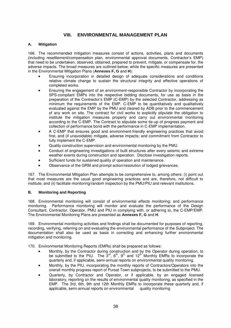
38
VIII. ENVIRONMENTAL MANAGEMENT PLAN A. Mitigation 166. The recommended mitigation measures consist of actions, activities, plans and documents (including resettlement/compensation plan, environmental approval documents, Contractor’s EMP) that need to be undertaken, observed, obtained, prepared to prevent, mitigate, or compensate for, the adverse impacts. The broad measures are outlined below; while the specific measures are presented in the Environmental Mitigation Plans (Annexes F, G and H):
Ensuring incorporation in detailed design of adequate considerations and conditions relative climate change to sustain the structural integrity and effective operations of completed works.
Ensuring the engagement of an environment-responsible Contractor by incorporating the SPS-compliant EMPs into the respective bidding documents, for use as basis in the preparation of the Contractor’s EMP (C-EMP) by the selected Contractor, addressing as minimum the requirements of the EMP. C-EMP to be quantitatively and qualitatively evaluated against the EMP by the PMU and cleared by ADB prior to the commencement of any work on site. The contract for civil works to explicitly stipulate the obligation to institute the mitigation measures properly and carry out environmental monitoring according to the C-EMP. The Contract to stipulate some tie-up of progress payment and collection of performance bond with the performance in C-EMP implementation.
A C-EMP that ensures good and environment-friendly engineering practices that avoid first, and (if unavoidable) mitigate, adverse impacts; and commitment from Contractor to fully implement the C-EMP.
Quality construction supervision and environmental monitoring by the PMU.
Conduct of engineering investigations of built structures after every seismic and extreme weather events during construction and operation. Disclose investigation reports.
Sufficient funds for sustained quality of operation and maintenance.
Observance of the GRM and prompt action/resolution of lodged grievances.
167. The Environmental Mitigation Plan attempts to be comprehensive to, among others: (i) point out that most measures are the usual good engineering practices and are, therefore, not difficult to institute; and (ii) facilitate monitoring/random inspection by the PMU/PIU and relevant institutions. B. Monitoring and Reporting 168. Environmental monitoring will consist of environmental effects monitoring; and performance monitoring. Performance monitoring will monitor and evaluate the performance of the Design Consultant, Contractor, Operator, PMU and PIU in complying with, or adhering to, the C-EMP/EMP. The Environmental Monitoring Plans are presented as Annexes F, G and H. 169. Environmental monitoring activities and findings shall be documented for purposes of reporting, recording, verifying, referring on and evaluating the environmental performance of the Subproject. The documentation shall also be used as basis in correcting and enhancing further environmental mitigation and monitoring.
170. Environmental Monitoring Reports (EMRs) shall be prepared as follows:
Monthly, by the Contractor during construction and by the Operator during operation, to be submitted to the PIU. The 3
rd, 6
th, 9
th and 12
th Monthly EMRs to incorporate the
quarterly and, if applicable, semi-annual reports on environmental quality monitoring.
Monthly, by the PIU, incorporating the monthly reports of Contractors/Operators into the overall monthly progress report of Pursat Town subprojects, to be submitted to the PMU.
Quarterly, by Contractor and Operator, or if applicable, by an engaged licensed laboratory, reporting on the results of environmental quality monitoring, as specified in the EMP. The 3rd, 6th, 9th and 12th Monthly EMRs to incorporate these quarterly and, if applicable, semi-annual reports on environmental quality monitoring

39
Semi-annually during construction and annually during operation until loan closure or as agreed, by the PMU to be submitted to the ADB to fulfill the environmental agreement in the loan.
171. A draft outline for the Semi-Annual and Annual EMR is presented as Annex I. The monthly EMRs by the Contractor, Operator and PIU may adopt the outline, as applicable, to facilitate the preparation of the Semi-Annual and Annual EMRs.
C. Implementation Arrangements
172. Implementation Schedule. Environmental management will be implemented from the detailed design phase through to procurement, construction and operation. Table VIII-1 presents the indicative time frame of key EMP activities in relation to Subproject implementation schedule. 173. Institutional Responsibilities. The institutions that will have major and minor roles in environmental management include the Ministry of Public Works and Transport (MPWT), Department of Public Works and Transport (DPWT), Project Steering Committee (PSC), Project Management Unit (PMU), Project Implementation Unit (PIU), Project Management and Implementation Support (PMIS) Team’s Environmental Specialists; the ADB, Design Consultant, Contractor, Operator, (if applicable) Licensed Laboratory, MoE/PDoE, Municipality of Pursat and the relevant Commune Councils. As executing agency, the MPWT will assign a qualified staff to the PMU to serve as full time Environmental Safeguard Staff (ESS). The DPWT will assign a qualified staff to the PIU to serve as full-time counterpart of the ESS at the town level. The PSC, headed by the MPWT, will be responsible for deciding on environmental management matters that will require action from the senior-management level. The PMU will manage the day-to-day activities of the Subproject. Its ESS will oversee and monitor the implementation of EMP. The PIU will provide technical support to the ESS in carrying out the environmental management responsibilities at the town level. The PMIS Team will include Environmental Specialists, who will impart technical advice, guidance, support and “hands-on training” to the PMU and PIU in subproject environmental management, at least in the first two-three years of implementation. The ADB will undertake reviews of relevant environmental documents for clearance purposes, and carry out periodic environmental review missions. 174. More specific responsibilities are presented in Table VIII-2. “Prior to construction” period covers the detailed design period until prior to awarding of civil works contract. Construction period covers the period after obtaining ADB’s clearance for the C-EMP until commissioning for operation. Operation period commences at commissioning of the completed Subproject.
175. Capacity Development. Considering the limited capability of the Project’s key players in environmental management, technical assistance from environmental specialists and capacity development during loan implementation will be needed. Capacity development will consist of hands-on training in implementing the responsibilities in EMP (as well as CMEI-EARF) implementation, complemented with a short-term series of lectures/seminars on relevant topics. It will be carried out through the environmental specialists that will be engaged as part of the Project Management and Implementation Support (PMIS) Team under the Strengthened Capacity for Project Implementation and Operation and Maintenance Output. (Annex J) 176. While carrying out technical assistance, the environmental specialists will ensure that the EMP and CMEI-EARF implementation proceeds as a “hands-on” training for the PMU, particularly its environmental safeguard staff, as well as the PIUs, and will conduct lectures/seminars relevant to EMP and EARF implementation. External experts will be invited under the Capacity Development Plan to conduct on other environmental management topics such as those suggested in Table VIII-3 and/or other topics that would be requested later on by the MPWT, PMU and PIU. The cost requirement for the conduct of the courses and seminars by external experts is included in the overall budget for Capacity Development Plan. 177. Preliminary Costs. The marginal costs for implementing the EMP are initially estimated to involve: Table VIII-4
USD 6,040 (or KHR 24.25 million) for securing approved IEIA/EIA Report;
USD 49,400 (or KHR 198.3 million) of fixed costs to cover environmental monitoring prior to, and during, construction; and

40
USD 36,700 (or KHR 147.5 million) annually for environmental monitoring during operation of the waste stabilization pond.
178. The estimated costs: (i) include taxes and contingencies for deficiencies in assumed unit costs, but exclude inflation; (ii) exclude the salaries of the ESS and his/her counterpart in the PIU, as they will be existing MPWT and DPWT staff seconded to the PMU and PIU, respectively; and (iii) exclude the cost of USD 84,350 for technical assistance from, and “hands-on” training” by, the Environmental Specialists of the PMIS Team for the both of Kampong Chhnang and Pursat. Table VIII-1 Environmental Management Implementation Schedule A. Riverbank Protection and Drainage System Improvements
Activity Indicative Time Frame
SUBPROJECT IMPLEMENTATION Detailed Design & Bidding Documents Q1 - Q3 Y1 Procurement (until award of contract) Q4 Y1 – Q3 Y2 Construction Q4 Y2 – Q2 Y4 Supervision of Start-up & Commissioning of WWTP Q3-Q4 Y4 Final Handover Q1 Y5
ENVIRONMENTAL MANAGEMENT Overall
1. Project Management and Implementation Support (PMIS)- Mobilization of Envi’l Specialist
Starting Q1 Y1 (for 3-4 yrs of intermittent inputs)
2. PMU's submission of Environmental Monitoring Report (EMR) - Quarterly EMR for Subproject's Quarterly Progress Report - 15th day after effective quarter
- Semi-Annual EMR during construction for submission to ADB - 15th day after effective 6-mo. period
- Annual EMR during operation for submission to ADB - 15th day after effective year
Prior to Construction Mobilization 1. Finalization of EMP, (if applicable) revision of IEE Q2 Y1
2. ADB review & approval of revised IEE & EMP. Q3 Y1
3. Obtaining IEIA/EIA Report approval Q1 Y2 (at the latest)
4. Community preparation (including disclosure of Final IEE & its EMP) Q3 Y2
5. Establishment of baseline data (as set out in the EMP) Q1-Q2 Y2 (shall have been done prior to award of contract)
6. Preparation of C-EMP by selected Contractor, review of C-EMP Q3 Y2, before start of works on site against SPS-compliant EMP. or establishment of construction-
related facilities. Construction Period Mobilization to Demobilization 1. Implementation of mitigation measures and conduct of environmental
effects monitoring following the C-EMP. Q4 Y2 – Q2 Y4
2. Submission of Environmental Monitoring Report (EMR) Q4 Y2 – Q2 Y4 - Quarterly, by Contractor(including that of Licensed Laboratory, if
applicable) 15th day after effective quarter
Operation Period (potentially could start even before DLP is over) 1. Implementation of mitigation measures & monitoring activities as Starting Q3-Q4 Y4 specified in the EMP 2. Submission of EMR Starting Q3-Q4 Y4 - Quarterly, by Operator (including that of Licensed Laboratory, if
applicable) 15th day after effective quarter

41
B. Solid Waste Management
Activity Indicative Time Frame
SUBPROJECT IMPLEMENTATION Detailed Design & Bidding Documents Q2 – Q4 Y1 Procurement (until award of contract) Q1 – Q4 Y2 Construction Q4 Y2 – Q3 Y3 Final Handover Q4 Y3
ENVIRONMENTAL MANAGEMENT Overall
1. Project Management and Implementation Support (PMIS)-Engagement of Envi’l Specialist
Q1 Y1 (for 3-4 yrs of intermittent inputs)
2. PMU's submission of Environmental Monitoring Report (EMR) - Quarterly EMR for Subproject's Quarterly Progress Report - 15th day after effective quarter
- Semi-Annual EMR during construction for submission to ADB - 15th day after effective 6-mo. period
- Annual EMR during operation for submission to ADB - 15th day after effective year
Prior to Construction Mobilization 1. Finalization of EMP, (if applicable) revision of IEE Q3 Y1
2. ADB review & approval of revised IEE & EMP. Q4 Y1
3. Obtaining IEIA/EIA Report approval Q2 Y2 (1st month at the latest)
4. Community preparation (including disclosure of Final IEE & its EMP) Q3 Y2
5. Establishment of baseline data (as set out in the EMP) Q2 Y2 (shall have been done prior to award of contract)
6. Compensation/replacements due to land/ ROW acquisition c/o Resettlement Plan
7. Preparation of C-EMP by selected Contractor, review of C-EMP Q3 Y2, before start of works on site against SPS-compliant EMP. or establishment of construction-
related facilities. Construction Period Mobilization to Demobilization 1. Implementation of mitigation measures and conduct of environmental
effects monitoring following the C-EMP. Q4 Y2 – Q3 Y3
2. Submission of Environmental Monitoring Report (EMR) Q4 Y2 – Q3 Y3 - Quarterly, by Contractor(including that of Licensed Laboratory, if
applicable) 15th day after effective quarter
Operation/Decommissioning Period (potentially could start even before DLP is over)
1. Implementation of mitigation measures & monitoring activities as Starting Q3 Y3 (remediated dumps) specified in the EMP Starting Q4 Y3 (controlled landfill) 2. Submission of EMR Starting Q3 Y3 - Quarterly, by Operator (including that of Licensed Laboratory, if
applicable) 15th day after effective quarter
D. Performance Indicators
179. The preliminary set of environmental performance indicators is meant to evaluate the effects of subprojects’ implementation on the environment, i.e., whether or not it is enhancing, sustaining or deteriorating the state of the environment. The indicators are directed on two environmental areas that will be impacted on: (i) the natural resources and (ii) health and safety of the concerned people. The selected indicators are limited to only those that can be measured/gauged from activities during subprojects’ implementation and that can be tracked over a defined period. (Table VIII-5)
IX. CONCLUSION AND RECOMMENDATIONS 180. The IEE concludes that:
The proposed subprojects in Pursat Town are not environmentally critical. Except for the Embankment Protection on Pursat River, which by the nature of its
intervention will be undertaken on the banks of the Pursat River, the two other subprojects are not within or adjacent to environmentally sensitive areas. Preventive and

42
mitigation measures must be taken to ensure protection of Pursat River from contamination and sedimentation.
The few impacts of high magnitude (without mitigation) will not be unprecedented and distinct. The closest comparable projects in the past would be the ADB-assisted water supply project completed in 2006 under the Provincial Towns Improvement Project and the JICA-assisted Project for Replacement and Expansion of Water Distribution Systems, completed in mid 2013.
The extent of adverse impacts is expected to be local, confined within the subprojects’ immediate and/or main areas of influence, quarry sites, waste disposal sites, and the routes to and from these sites. Except during windy days, heavy rainfall and extreme weather event, fugitive dust, fine aggregates, sediments and/or wastes would not be the transported beyond the aforementioned sites. With mitigation measures in place and ensuring that the bulk of works are completed (or at least almost complete) prior to the onset of the rainy season, the potential adverse impacts during construction would be highly/more site-specific.
The few adverse impacts of high significance during construction will be temporary and short-term (i.e., most likely to occur only during peak construction period). These will not be sufficient to threaten or weaken the surrounding resources. The preparation and implementation of a Contractor’s EMP that would address as minimum the requirements of the SPS-compliant Subproject EMP will mitigate the impacts and lower their residual significance to at least “moderate” levels. . Simple/uncomplicated mitigation measures, basically integral to socially and environmentally responsible construction practices, are commonly used at construction sites in urban settings and are known to Contractors. Hence, mitigation measures would not be difficult to design and institute.
The proposed subprojects will be optimally engineered to avoid and/or minimize adverse impacts. As of preliminary design/feasibility study stage, measures have been respectively incorporated to initiate mitigation. (See Section V-C.)
Direct impacts during operation will come from the wastewater treatment plant, controlled landfill, pumping station and waste collection, mainly from the first two facilities. Guided by Operation Manuals and strengthened by continuing capacity building program, the operations of controlled landfill and waste stabilization ponds are not expected to have long-term, persistent, permanent/irreversible adverse impact on human health and safety, air quality, water quality, soil quality, the biological environment, as well as the lifestyle and means of subsistence of nearest local communities.
The indirect, induced and cumulative impacts during operation will be mainly positive than adverse.
The proposed Subprojects will bring about the benefits of: (i) protected embankment on Pursat River, (ii) improved storm- and wastewater management in the Town center, and (iii) improved solid waste collection and disposal. Positive impacts include: (i) relief from flooding from embankment failure and inadequate drainage system; (ii) improved sanitation from wastewater management and treatment; and (iii) reduced or eradicated open and indiscriminate dumping of solid wastes and relief from its associated issues of fumes and uncontrolled gas emissions, odor and nuisance, contamination of water resources, health and safety risks and clogging of drains/sewers.
Collectively, the three subprojects will bring about improved urban environment and increased climate-change resilience, significantly contributing to a qualitative improvement in the lives of residents in Pursat Town.
181. Based on the above conclusions, although the Subproject may have some adverse environmental impacts, the preparation of an IEE would be sufficient to identify and address these impacts. No further special study or detailed EIA needs to be undertaken to comply with the Safeguard Policy Statement of the ADB. Under GoC policy, an IEIA Report each for the solid waste management and drainage system improvements subprojects is required. Hence, three separate IEIA Reports will need to be prepared and submitted to the MoE to start the government environmental impact assessment process. The IEIA Reports will be based on this IEE.

43
Table VIII-2 Institutional Responsibilities
Institution Prior to Construction During Construction During Operation and Decommissioning
MPWT
▪
Firm up the necessary collaboration with the MoE for the Subproject’s compliance with GoC’s environmental safeguard requirements on IEIA/EIA and EMP implementation.
DPWT
▪
Firm up the necessary collaboration with PDoE & relevant provincial agencies on matters concerning the environmental management of the Subproject.
PSC
▪
Decide on environmental management matters
▪
Decide on environmental management matters
▪
Decide on environmental management matters
that will require action from the senior-management level.
that will require action from the senior-management level.
that will require action from the senior-management level.
▪ Ensure the allocation and timely disbursement of adequate resources for the conduct of
environmental quality monitoring activities by the PMU prior to construction as required in the Environmental Monitoring Plan.
PMU
▪
Update IEE & EMP, as necessary.
▪
Conduct inspections and spot checks to monitor the
▪
Conduct inspections and spot checks to monitor the
▪ Coordinate with Design Consultant to ensure the incorporation of updated findings & mitigation
performance of the Contractor in implementing the C-EMP/EMP
performance of the Operator in implementing the EMP.
measures in design & bidding documents. ▪ Review Monthly EMRs of Contractor. ▪ Review Monthly & Annual EMRs of Operator. ▪ Ensure EMP is part of the bidding documents,
EMP clauses are incorporated in bidding documents, contracts.
▪ Prepare the Project’s Semi-Annual EMRs for submission to ADB.
▪ Prepare the Project’s Annual EMR for submission to ADB, until loan closure or as agreed.
▪ Ensure MoE approval of IEIA/EIA Report has been secured prior to awarding of civil works.
▪ Review Contractor’s EMP (C-EMP) against EMP. PIU
▪
Coordinate and collaborate relevant provincial agencies, as necessary.
▪
Collate and review monthly EMRs of Contractor, and submit to the PMU.
▪
Collate and review monthly EMRs of Operator, and submit to the PMU.
▪ Conduct IEC, disclose updated IEE and EMP. ▪ If a licensed laboratory will be engaged to do ▪ Prepare the draft Annual EMR and submit to the PMU
▪ Establish the baseline environmental quality independent environmental quality monitoring, for finalization and incorporation to the Project’s through the conduct (by itself or by an engaged oversee & manage the quarterly conduct of the Annual EMR. licensed laboratory) of the environmental quality environmental effects monitoring . Review results. ▪ Ensure/manage the observance of the GRM monitoring as prescribed in the EMP ▪ Prepare the draft Semi-Annual EMR and submit to the ▪ Establish health & safety baseline conditions PMU for finalization and incorporation to the Project’s in affected villages. Semi-Annual EMR. ▪ Prepare draft Semi-Annual EMR. Submit to PMU
for finalization for Project’s EMR. ▪ Ensure/manage the observance of the GRM
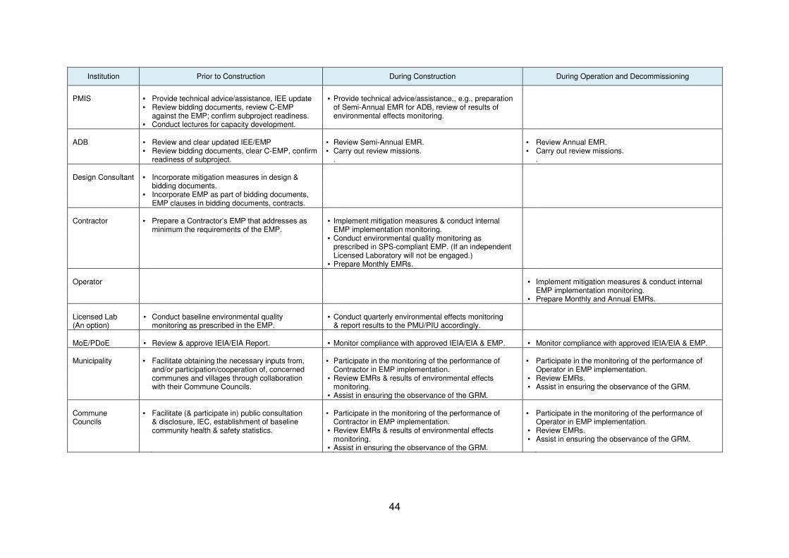
44
Institution Prior to Construction During Construction During Operation and Decommissioning
PMIS
▪
Provide technical advice/assistance, IEE update
▪
Provide technical advice/assistance,, e.g., preparation
▪ Review bidding documents, review C-EMP against the EMP; confirm subproject readiness.
of Semi-Annual EMR for ADB, review of results of environmental effects monitoring.
▪ Conduct lectures for capacity development. ADB
▪
Review and clear updated IEE/EMP
▪
Review Semi-Annual EMR.
▪
Review Annual EMR.
▪ Review bidding documents, clear C-EMP, confirm readiness of subproject.
▪ Carry out review missions. .
▪ Carry out review missions. .
Design Consultant
▪
Incorporate mitigation measures in design &
bidding documents. ▪ Incorporate EMP as part of bidding documents, EMP clauses in bidding documents, contracts. Contractor
▪
Prepare a Contractor’s EMP that addresses as
▪
Implement mitigation measures & conduct internal
minimum the requirements of the EMP. EMP implementation monitoring. ▪ Conduct environmental quality monitoring as
prescribed in SPS-compliant EMP. (If an independent Licensed Laboratory will not be engaged.)
▪ Prepare Monthly EMRs. Operator
▪
Implement mitigation measures & conduct internal
EMP implementation monitoring. ▪ Prepare Monthly and Annual EMRs. Licensed Lab
▪ Conduct baseline environmental quality
▪ Conduct quarterly environmental effects monitoring
(An option) monitoring as prescribed in the EMP. & report results to the PMU/PIU accordingly. MoE/PDoE ▪ Review & approve IEIA/EIA Report. ▪ Monitor compliance with approved IEIA/EIA & EMP. ▪ Monitor compliance with approved IEIA/EIA & EMP. Municipality
▪
Facilitate obtaining the necessary inputs from, and/or participation/cooperation of, concerned
▪
Participate in the monitoring of the performance of Contractor in EMP implementation.
▪
Participate in the monitoring of the performance of Operator in EMP implementation.
communes and villages through collaboration ▪ Review EMRs & results of environmental effects ▪ Review EMRs. with their Commune Councils. monitoring. ▪ Assist in ensuring the observance of the GRM. ▪ Assist in ensuring the observance of the GRM. Commune Councils
▪
Facilitate (& participate in) public consultation & disclosure, IEC, establishment of baseline
▪
Participate in the monitoring of the performance of Contractor in EMP implementation.
▪
Participate in the monitoring of the performance of Operator in EMP implementation.
community health & safety statistics. ▪ Review EMRs & results of environmental effects ▪ Review EMRs. monitoring. ▪ Assist in ensuring the observance of the GRM. ▪ Assist in ensuring the observance of the GRM.

45
Table VIII-3 Proposed Topics and Estimated Cost for Capacity Building/Training
Topic Target
Timing Duration Estimated Cost (US$)
Participants Lecturer Venue &
Attendance 1. By PMIS Environmental Specialists 1.1 Legal Framework PMU, PIUs Early stage 1 day c/o PMIS-TA * 1,600 ▪ Relevant national laws, regulations & standards PDoE, others of PMIS on environmental assessment & management Interested ▪ ADB SPS 2009 (min 4, max 10) ▪ Environmental assessment & review procedure under the CMEI-EARF 1.2 Environmental Assessment ▪ Rapid environmental assessment ▪ Initial environmental examination
1.3 Some Aspects of EA Process & Environmental Management
▪ Meaningful consultation & info disclosure ▪ Grievance redress mechanism ▪ Environmentally responsible procurement ▪ Occupational & community health and safety 1.4 EMP Implementation, part 1 PMU, PIUs, Early stage 1 day c/o PMIS-TA * 1,600 ▪ Institution arrangements & responsibilities PDoE, others of PMIS ▪ Environmental quality monitoring interested ▪ Emergency response (min 4, max 10) 1.5 EMP Implementation, part 2 ▪ Performance monitoring & indicators ▪ Environmental monitoring report
2. By External Experts
2.1 Other relevant topics, such as: MPWT, DPWT, During 2-3 days ^ 1,500 ** 14,000 A Good engineering and construction practices as PIUs, PMU Project’s (4-5 lecturers) mitigation measures Others Capacity B Climate change adaptation (applicable to eligible Interested Devt. activities/works under the Project) (max 30) Program B.1 Climate change impacts on infrastructure B.2 CC-proofing of infrastructures C Other relevant topics that may be requested by the the MPWT/PMU/PIUs
Sub-Total 1,500 17,200 Grand Total 18,700
* Estimated max. $150 per participant, to cover: (i) $100 for venue & meals; (ii) $60 for --- $30 per diem, $20 allowance for attendance, and 2-way share taxi transport --- participants coming from outside the venue city/town; and (iii) $20 allowance for attendance of participants from the venue city/town. Assumes at least 2 participants from venue city/town.
** Assumes at least 10 participants or one-third of max. no. of participants are from the venue city/town. ^ Includes fee, per diem and transport

46
Table VIII-4 Preliminary Costs for EMP Implementation

47
Table VIII-5 Performance Indicators A. Riverbank Protection

48
B. Drainage System Improvements

49
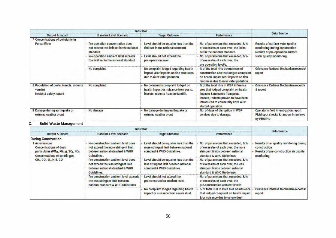
50
C. Solid Waste Management

51

52

53

54
Sources of Information Documents
Cambodia Environment Outlook. Ministry of Environment and UNEP. 2009. Cambodia’s National Mine Action Strategy, 2010-2019 Cambodia Tropical Forestry and Biodiversity (118/119) Assessment. February 2011. USAID-Cambodia. Climate Change Impacts and Vulnerability. A presentation in Siem Reap on 01 August 2012 by K. Keo. Environment and Energy Unit. UNDP Cambodia. Construction Equipment Noise Ranges. Noise from Construction Equipment and Operations, Building Equipment and Home Appliances. US-EPA. 31 December 1971. Disaster Matrix by Country (1970-2009). ASEAN: Advancing Disaster Risk Financing and Insurance in ASEAN Member States: Framework and Options for Implementation. Volume 2: technical Appendices. April 2012. World Bank, GFDRR, ISDR & ASEAN. EM-DAT: The OFDA/CRED International Disaster Database – www.emdat.be, Université Catholique de Louvain, Brussels (Belgium). European Digital Archive of Soil Maps (EuDASM), http://eusoils.jrc.ec.europa.eu Identification of Poor Households. World Food Programme. August 2012. Initial Environmental Examination of the Proposed Logistics Development Project. Mongolia. 2011. JICA GIS Data Set, 2003 Pursat Krong Data Book 2009. Pursat Province. October 2009. National Committee for Sub-National Democratic Development (NCDD). Law on Environmental Protection and Natural Resource Management (Preah Reach Kram/NS-PKM-1296/36). 18 November 1996. Member Report, Cambodia. Forty-fifth Session of the ESCAP/WMO Typhoon Committee. 29 January-1 February 2013. Hong Kong, China. Profile of Tonle Sap Sub-Area (SA-9C). Basin Development Plan Programme. Cambodia National Mekong Committee. February 2012. Strategic Program for Climate Resilience in Cambodia. A presentation to the PPCR Sub-Committee by T. Chankresna (MEF), M. Sophal (MoE) and the Royal Government of Cambodia. Cape Town. 28 June 2011. Strategic National Action Plan for Disaster Risk Reduction, 2008-2013. National Committee for Disaster Management and Ministry of Planning. Sub-decree on EIA Process (Sub-decree No. 72 ANRK.BK). 11 August 1999. Technical Note 10: Impacts on the Tonle Sap Ecosystem. Assessment of Basin-wide Development Scenarios. Basin Development Plan Programme, Phase 2. Mekong River Commission. June 2010. The Earthquake Intensity Risk Zone Map. 10 April 2008. UN/ISDR. Available: www.preventionweb.net.

55
The Seismic Hazard Map of Southeast Asia . GSHAP 1999. UN/International Decade of Natural Disaster Reduction. Available: http://geology.about.com. UNDP Climate Change Country Profile – Cambodia - McSweeney, C., New, M. & Lizcano, G. 2010. UNDP Climate Change Country Profiles:
Cambodia. Available: http://country-profiles.geog.ox.ac.uk/ [Accessed 30 June 2013]. - McSweeney, C., New, M., Lizcano, G. & Lu, X. 2010. The UNDP Climate Change Country
Profiles Improving the Accessibility of Observed and Projected Climate Information for Studies of Climate Change in Developing Countries. Bulletin of the American Meteorological Society, 91, 157-166
Institutions and Organizations
Conservation International Cambodia. 2008. Department of Pollution Control Laboratory Office. MoE. Department of Public Works and Transport – Pursat Indigenous Community Support Organisation Pursat Municipality Provincial Department of Planning UN Office for the Coordination of Humanitarian Affairs
Websites http://country-profiles.geog.ox.ac.uk http://eusoils.jrc.ec.europa.eu http://geology.about.com www.cambodiaatlas.com/map www.cambodia.climatemps.com www.emdat.be www.preventionweb.net

56
Annex A. Environmental Quality Standards Applied in the IEE (Note: International Guidelines are presented, where applicable, to show comparison and will be useful if
evaluation of quality monitoring results include checking of how subproject’s environmental performance fare with international standards.)
A.1 Ambient Air Quality Standards
A.2 Noise Level Standards
A.3 Surface Water Quality Standards for Biodiversity Conservation

57
A.4 Surface Water Quality Standards for Public Health Protection
A.5 Groundwater Quality Standards

58
A.6 Effluent Quality Standards

59
Annex B. Check on Pond Sizes and Load Removal Item Description Unit Quantity Comments
1 INFLUENT FLOW & CHARACTERISTICS
1.1 Design Flow - Wastewater m3/d 1,110
Wastewater Contribution per capita l/cap.d 65
Equivalent Population No. 17,077
BOD Contribution per capita g/cap.d 45
Total Organic Load kg/d 768
Reduction in BOD for existing septic tanks % 30
Adjusted Total Organic Load kg/d 538
Influent BOD Concentration mg/l 485
1.2 Design Flow - Septage m3/d 5
Influent BOD Concentration mg/l 5,000
Organic Load kg/d 25
1.3 Influent Bacterial Concentration (Typical) million./100 ml 100
Reduction in fecal coliforms from Septic Tanks used
in Sewer System
% 50
Adjusted fecal coliform concentration million./100 ml 50
1.4 Minimum Temperature degrees C 25
2 ANAEROBIC PONDS' CHECK
2.1 Anaerobic Pond Loading and Design Hydraulic Retention Time
Design Organic Loading (WW+septage) kg/d 563
BOD Concentration of Influent mg/l 505
Maximum Volumetric Loading to avoid odor
problems
g/m3.d 400
Design Volumetric Loading g/m3.d 300
Minimum Required Volume m3 1,876
Check Hydraulic Residence Time (HRT) d 2 Minimum is 1.25
Thus OK Volume of aerobic ponds m3 2,220
2.2 Estimated BOD Removal in Anaerobic Ponds
Estimated BOD removal in anaerobic Ponds % 60 Range 50 - 70%
Selected Value for BOD Removal mg/l 202
3 FACULTATIVE PONDS' CHECK
3.1 Pond Loading and Required Surface Area
Surface BOD Loading - Primary kg/ha.d 380
Surface BOD Loading - Secondary kg/ha.d 440
Selected Surface Loading kg/ha.d 350
Influent BOD to Facultative ponds mg/l 202
Minimum total surface area required m2 6,405
3.2 Pond Sizing
Design Depth m 2
Number of ponds No. 4
Minimum ssurface area of each pond m2 1,601
Surface area of proposed ponds m2 3,125 Thus OK
3.3 Estimated BOD Concentration in Effluent
Estimated BOD Removal in Facultative Ponds % 70
Effluent BOD mg/L 61 Less than 80 thus OK
Obtained from PPTA Engineer’s Final Report on Drainage and Embankment, January 2014

60
Annex C. Solid Waste Generation/Quantity Projections, Cell Staging and Staged Development Strategy
C.1 Population, Waste Mass and Controlled Landfill Volume Projections
C.2 Cell Staging 1. The first cell airspace is 134,800 cubic metres which is enough for about 5 years of operation.
The second cell in isolation will provide a similar number of years of operation.
2. The next stage of landfilling will be over-topping both the first and second cells to develop a unified single cell which will provide a total of about 12 years capacity, going to a maximum height of approximately 30 metres above the base.

61
3. The excavation depths for the first cell were based on a number of factors; the desire to maximize the separation between the base of the controlled landfill and the
water table thereby requiring the excavation depths to be minimised the need to provide a balanced cut to fill design such that there would not be excess soil
at the completion of Cell 1 nor would there be a need for significant importation of cover material
4. In the end, the adopted excavation depth was approximately 1.4 metres on average. This will
provide some 20,200 cubic metres of soil which can be used for cover material for the life of Cell 1.
5. After some 10 years of operation, the excavation levels can then be decided for Cells 3 and 4 to provide the right amount of soil cover based on operational experience to date, as well as protecting the ground water table. This decision does not have to be made until better information is available on actual waste generation rates and local hydrogeology.
6. The capacity of the completed controlled landfill incorporating over-topping of all four cells is some 1,466,900 cubic metres. This will be sufficient capacity for about 30 years of operation. The total mass taken to the site is expected to increase from an estimated 26 tonnes per day in 2016 to over 103 tons per day 30 years later.
7. This cell staging approach is appropriate as most controlled landfills develop the first cells to provide about 5 years of operation and the ultimate site to provide at least 30 years capacity.
C.3 Staged Development Strategy 1. A possible staged excavation and filling program would be as follows;
excavate and prepare Stage 1 for filling. fill Stage 1 to the levels shown, while excavating and preparing Stage 2 for filling. fill Stage 2 to the levels shown fill the infill area above Cells 1 and 2 while excavating and preparing Stage 3 for filling. fill Stage 3 to the levels shown. fill the infill area above Cells 1, 2 and 3 while excavating and preparing Stage 4 for filling. fill Stage 4 to the levels shown fill the final infill areas to levels shown on as the final landform
2. The design balances the need for cover material over the life of the landfill with approximately
15% of the airspace consumed as cover. The volume of cover available may be increased or decreased by several means: raising or lowering the base of the future landfill cell areas. varying the slope of the base between a minimum of 1 per cent and a maximum of 10 per
cent. varying the thickness of daily cover between 100mm and 150mm depending upon the
effectiveness/performance of the waste compaction operation. winning cover from previously placed temporary (internal) batters when placing new
waste against them.

62
Annex D. Environmental Audit Report – Existing Open Dumps 1 The ADB SPS 2009 provides that when the project involves existing activities or facilities, environmental audits will be performed to determine the existence of any areas where the project may cause or is causing environmental risks or impacts. In proposing for the development of a controlled landfill, the associated facilities that will pose environmental risks are the: (i) “closed” dumpsite in Toul Makak Lech Village; and (ii) the existing open dumpsite in Srah Srang Village. This annex, therefore, presents an environmental audit or due diligence of the two open dumpsites and recommends actions for their remediation. Site Audit/Due Diligence Procedure
2 The site audit/due diligence was carried out using information obtained from (i) key informant interviews; (ii) few brief random interviews; (iii) site visit by the PPTA Environmental Specialists, and (iv) largely from site investigation by the PPTA Solid Waste Specialists. 3 Key informant interviews were conducted during meetings of the Solid Waste Specialists (in May) and Environmental Specialists (in August) with the Municipality and Provincial Department of Environment (PDoE). Brief random interviews were conducted by the Environmental Specialists with: (i) one of the nearest households to the closed dumpsite; (ii) a scavenger couple present at the existing dumpsite during the site visit; and (iii) the household staying within the existing dumpsite as permitted by the owner of the site. Site visit was conducted by the Environmental Specialists in August during the rainy season. Site investigation was conducted by the Solid Waste Specialists in May during the dry season.
4 The main limitations of the audit/due diligence are the: (i) absence of environmental quality monitoring information that would have supported the findings and observations of the site visit and investigation; (ii) absence of a site plan showing the extent, dimensions and locations of areas with waste deposits that would have provided basis for estimating remediation costs; and (iii) lack of opportunity to go back to the sites, local authorities and land owner, for discussion and obtain feedback on the findings and areas of concern and recommended actions for remediation and their proposed funding source/s.
5 The audit/due diligence assumes that even though the waste disposal operations in the existing dump site is on private land, the Municipality and the PDoE have some responsibility over the environmental risks involved in such operations, considering that:
It is the Municipality that benefits from the operations, i.e., its wastes being collected, hauled and disposed of.
The Sub-decree on Solid Waste Management rests the responsibility of: (i) establishing guidelines on, and monitoring of, solid waste management on the MoE; and (ii) collecting, transporting, storing, recycling, minimizing and dumping of wastes upon the local administrative authorities --- with the objective of ensuring the protection of human health and the conservation of biodiversity.
Applicable Laws, Regulations and Standards
6 The national laws, regulations, standards, policy and guideline that are applicable and/or relevant to solid waste management are briefly discussed below.
Law on Environmental Protection and Natural Resource Management (Preah Reach Kram/NS-RKM-1296/36) 1996
Article12 - MoE to collaborate with concerned ministries to establish an inventory list indicating: (i) sources, types & quantities of pollutants & wastes that are imported, generated, transported, recycled, treated, stored, disposed, or released into the airspace, water, land or on land surface; (ii) sources, types & quantities of all toxic & hazardous substances that are imported, produced, transported, stored, used, generated, treated, recycled, disposed, or released into airspace, water, land or on land surface; & (iii) sources, types & extent of disturbances by noise & vibrations.
Sub-decree on EIA Proces (Sub-decree No. 72 ANRK.BK) 1999
The detailed guidelines for implementation of the EIA Process. Its Annex requires the conduct of IEIA/EIA on “waste processing, burning activities of all sizes”.
Sub-decree on Solid Waste Management (Sub-decree No. 36 ANRK/BK) 1999
Regulates solid waste management to ensure the protection of human health & conservation of biodiversity. This Sub-decree applies to all activities related to disposal, storage, collection, transportation, recycling, dumping of garbage & hazardous waste. Article 4 - (i) MoE to establish guidelines on disposal, collection, transport, storage, recycling, minimizing & dumping of household waste in provincial & city areas in order to ensure that the management of household waste in a safe

63
manner; & on which (ii) authorities in the provinces & cities to formulate their waste management plans for short, medium & long-term implementation. Article 5 – responsibility of collection, transport, storage, recycling, minimizing & dumping of wastes rests on provincial & city authorities. Article 6 - MoE to monitor the disposal, collection, transport, storage, recycling of household wastes. Article 7 – strictly prohibits waste disposal in public areas or any unauthorized site.
Sub-decree on The Joint Declaration Min. of Interior and Min. of Environment on Solid Wastes & Litter Management in Cambodia
Provides a mechanism for joint cooperation & responsibility among relevant agencies to effectively manage solid wastes & litter at provincial & municipal levels aimed at protecting public health, environmental quality & biodiversity. Specifies penalties of between USD2.5 & USD25 for illegal disposal.
Environmental Guidelines on Solid Waste Management, 2006
Applies to all activities related to discarding, storage, collection, transport, recycling, treatment, composting & disposal of all kinds of solid waste. Contains: (i) guideline in the formulation of a solid waste management plan; (ii) a landfill ordinance; (iii) composting ordinance; (iv) guideline in medical waste management; & (v) guideline on environmental education. Landfill Ordinance requires landfills to: (i) reduce as far as possible the adverse effects of waste disposal on the environment; (ii) preserve groundwater, surface water & air quality & to reduce emissions of GHGs (iii) ensure waste is not harmful to human, natural & animal health during operation & decommissioning; & (iv) provide information & technical recommendation on the construction, operation & closing/follow-up management of landfills.
Sub-decree on Water Pollution Control (Sub-decree No. 27 ANRK/BK), 1999
Regulates activities that cause pollution in public water areas in order to sustain good water quality so that the protection of human health and the conservation of biodiversity are ensured. Article 2 – Sub-decree applies to all sources of pollution & all activities that cause pollution of the public water areas. Article 8 - strictly prohibits disposal of solid waste or any garbage or hazardous substances into public water areas or into a public drainage system; & storage or disposal of solid waste or any garbage & hazardous substances leading to pollution water of the public waters. Annexes 2, 4 & 5 provide the standards for industrial effluent applicable to effluent from leachate treatment facilities, water quality for public waters for biodiversity conservation, & water quality for public waters & health, respectively.
Sub-decree on Control of Air Pollution and Noise Disturbance (Sub-decree No. 42 ANK/BK, 2000
Regulates ambient air quality (Annex 1), hazardous substances in the air (Annex 2), pollution substances in ambient air from stationary sources (Annex 3), gas emissions from mobile sources (Annex 4), noise emission from vehicles on public roads (Annex 5), noise emission in public and residential areas (Annex 6), & noise control at workplaces (Annex 7). Annexes 1, 2, 3 & 7 are relevant to landfill operations. Annexes 4, 5 & 6 are relevant to waste collection operations.
The National 3R Strategy in Cambodia
Intends to establish an efficient solid waste management system to build on the 3Rs giving jobs, incomes to people, reducing waste amount at dumpsites, without causing severe risks & hazards to the environment, biodiversity & public health. The Strategy states two target years, 2015 & 2020, for the country’s 3R achievement.
7 The environmental quality standards applicable to the remediation of the dumps are the: (i) Ambient Air Quality Standard, 2000; (ii) Maximum Standard of Noise Level Allowable in the Public and Residential Areas, 2000; (iii) Drinking Water Quality Standards, 2004; and (vi) Effluent Standard for Discharged Wastewater to Public Water Areas or Sewers, 1999, applicable to landfills. Description of the Existing Open Dumps 8 Toul Makak Lech Dump Site. The “closed” dump site is referred to as the Toul Makak Lech Dump Site. It is situated in Toul Makak Lech Village, Roleab Commune, Sampov Meas District (Pursat Municipality) and is about 4 km E of the Town center and S of the National Road 5. It was commissioned in 2001 and was closed in 2004 in response to many neighborhood complaints. The site is public land, originally a total of 2 ha in area, but has become small when parcels of the land were distributed to the households that had informally settled within. 9 Based on the site investigation by the PPTA Solid Waste Management Specialist:
The dump site consists of 2 cells both approximately 50 m x 15 m, and formed by pushing up a soil bund 1 to 2 m high, and then filling with waste.
There are also small piles of waste and windblown litter around the site. All exposed waste, apart from the windblown litter, has been burnt which will obviously
greatly reduce the organic content and liberate most volatiles. One cell is filled to bund level and covered with regrowth including bramble and grass.
There were no signs of leachate leaching out of the encircling bund. Other cell is filled in a meter or so of encircling bund top, has ponded water and hyacinth
plus water tolerant grasses. There are signs of cattle access into this cell to either drink the water or eat the vegetation. The impounded water was relatively clear and not exhibiting organic contamination from waste leading to anaerobic conditions and

64
gasification. There was no typical leachate odor. One cell end is extended at the level of the bund top with a mixture of soil and waste, covered with bramble and thorn regrowth.
The local soil is a sandy silt but with some clay content. Some local dams were full of water which was impounded stormwater not groundwater. Some of the excavations showed clay slicks, thus confirming the clay content of the soil.
Figure 1. Locations of the Closed and Existing Dump Sites
10 During rainy season, the waste cells are under mud and water as shown in Photo 1. In the dry season as related above from the site investigation of the Solid Waste Specialists in May, there are some exposed burnt wastes, but the cells are impounded with water and/or covered with regrowth. In both seasons, therefore, the wastes are no longer noticeable. There are scattered litters in the road track (access to the dump site), which can be easily collected by the Commune or Municipality using a small cart. There are other scattered wastes elsewhere around the site from fly-dumping. (Photo 2)
Photo 1. Toul Makak Lech Dump Site
Site in the rainy season. No sign of solid waste. This photo was taken in August.
11 According to one nearest household, they have not experienced problems with the water from their open dug well. At the time when the dump site was still in operation, odor and flies were their complaints. She has not heard of any complaint on groundwater problems in the village.
Photo 2. Litters in the Access Road Track of Toul Makak Lech Dump Site

65
12 Srah Srang Dump Site. The existing dump site is referred to as the Srah Srang Dump Site. It is situated in Srah Srang Village, Prey Nhi Commune, Sampov Meas District (Pursat Municipality), and is about 5 km E of the Town center, N of National Road 5. It was commissioned in 2004. The land, about 1.5 ha in area, belongs to the private service provider, but will be transferred to the Municipality in 2024. The service provider delivers three truck loads of waste to the site daily, Monday to Sunday. Access to the site is through a rutted laterite road. There is no natural water course in or near to the site. The drain along it is a former borrow pit. The site and its vicinity do not flood, according to the Municipality. 13 Waste is located predominantly in a U shaped area that is 100 m long by 70 m wide. The dumped waste is approximately 20 m wide and two m high around the U shaped disposal area. A further disposal area continues along for another 70 m and again is approximately 20 m wide and up to two m high. Wastes are also dumped on both sides of an old road alignment that is severely environmentally degraded. There is also the evidence of illegal fly dumping along the access road at more than 10 locations. Waste has been previously burnt and there was active combustion at the time of inspection in May (dry season). During the site visit in August (rainy season), the dump site was not burning, but swarmed with flies and birds. 14 The drain adjacent to the site contained water that had obvious leachate stains, but not to the extent of making the water anaerobic and resulting in gasification. There was no obvious leachate odour from the drain. The drain also exhibited signs of surficial cracking indicating substantial clay content. This was confirmed by the presence of slide marks from the excavator bucket along the drain slopes. Given the significant amount of clay in the local soils, it would not be expected that leachate would migrate vertically into the water table below. 15 According to the interviewed scavenger couple, there are 30 scavengers, young and old, operating at the dump site. Most of them are from the Sra Srang Village. The scavenger couple said they operate from 9:00 AM to 6:00 PM with a break during lunchtime and earn USD 50 monthly. During the dry season, when the dump site is burning, they have coughs. 16 Four households, working for the service provider, reside at the dump site. They source water for drinking from an open dug well across their place, outside the dump site. In the dry season, they boil the water from the open dug well for drinking. In the wet season, they collect rain water. They experience skin diseases and frequently have diarrhea. The children do attend school, but have to walk for about 4 to 5 km each way.
Photo 3. Srah Srang Dump Site
Water course (not natural). It is a site drainage channel, a former borrow pit.

66
Findings and Areas of Concern 17 The salient areas of concern include uncontrolled waste fires and smoke particularly in the dry season, unmanaged leachate, and populations of vermin, flies and birds particularly in the wet season. The following discussion is part of Solid Waste Management of the Final Report and is based on site investigation conducted by the Solid Waste Specialists in May 2013 (at the end of the dry season). Findings from the sites visit of the Environmental Specialists in the wet season are added in (in italics). 18 Existing Fires. In addition to the obvious environmental damage caused by waste fires, uncontrolled burning represents a serious health and safety risk. Incomplete combustion of the various plastic types at the dump site can result in the formation of carcinogenic by-products such as dioxins. These airborne pollutants are being breathed in by the waste truck drivers, waste pickers, four households staying at the site and farmers of adjacent/nearby rice fields. There are also many safety issues associated with such fires at the disposal site. There may be pressure vessels (gas tanks, pressure cans, etc.) deposited at the site which can explode at the elevated temperatures associated with combustion. Any heavy smoke also presents a major safety problem by severely limiting sight distances. As a result, there is a much greater risk of collisions between vehicles or vehicles and people at the site. The presence of the fire, and also the associated intensity of smoke generation, appears to have been accepted by the local community as a normal aspect of waste management. This is not the case and urgent effort will be required to address this perception problem prior to attempting to remediate the site. 19 In summary, urgent action is required to prevent new fires starting and to stop ongoing. The surface fires should be extinguished and then deeper fires progressively excavated and extinguished as part of the initial activities leading to eventual full remediation.
20 During the site visit in August in the rainy season, there was no waste fire or smoke. The seasonal occurrence of waste fire and smoke should not be a reason to defer action to prevent waste fire and smoke and to continue exposing the waste haulers, waste pickers, four households staying at the site and farmers of adjacent rice fields to the associated health and safety hazards. 21 Existing Leachate. A number of drains and contiguous water courses were inspected in and around the dumping site. While there was some obvious leachate contamination of the water in drain, the visual extent of the leachate contamination appeared only minor. The water was not black and anaerobic with gasification occurring, but rather just showed some colouration of the water column. Some of the nearby water ponds appeared aerobic/oxic and were visually uncontaminated by leachate. As it was the end of the dry season at the time of inspection, leachate migration from the waste piles would be minimal unless the mound was fully saturated. It is also noted that most of the organics at the site have either degraded due to natural decomposition processes or been incinerated. Therefore, there is very little organic material in the refuse mounds to produce a high biological strength leachate. Whilst the leachate may be weak organically, it may still of course contain inorganics such as heavy metals and biocides. In general, the amount of leachate flow and peripheral contamination was apparently low for such uncontrolled facilities but this is no reason to accept this ongoing pollution. 22 Photo 3 shows the extent of leachate contamination of the water in the drain in the month of August (rainy season). The water is not murky black, indicating weak leachate contamination as of August. However, regardless of the strength of leachate contamination, it is still leachate contamination and should be addressed. 23 Other Existing Environmental Issues. Very few vermin were observed on the sites, probably because of the extent and intensity of the fires. There were a number of birds present, but the infestation was not of grave concern. Flies were generally at fairly low densities for such uncontrolled dumping, again due to the burning of putrescible organics such as food scraps. 24 During the site visit in August, the level of odor was not disturbing. Vermin was not in large population to be noticed easily. Flies were swarming, and birds were in noticeably large population.

67
Summary
25 Based on these various impacts, as well as the aesthetic and public health issues, the dump sites require either in-situ (on-site) remediation or hauling to the proposed controlled landfill site.
Remediation Plan 26 The following discussion is part of Solid Waste Management of the Final Report and is based on site investigation conducted by the Solid Waste Specialists in May 2013 (end of the dry season).
27 Recommended Management Option. There are two options for managing the dumps:
One option is through on-site remediation by pushing the previously deposited wastes into a suitable mounded shape, compacting the waste and then covering it with soil, applicable to dumping areas that are small and remote from sensitive areas such as water courses.
The other option is by excavating and extinguishing the waste, loading it onto trucks and hauling it to the controlled landfill once it is operational, applicable to dumping areas with significant amount of waste and that are potentially environmentally and socially damaging.
28 For both the Toul Makak Lech and Srah Srang Dump Sites, on-site remediation is recommended due to the following reasons, opportunities and/or constraints:
The volumes of waste are relatively small. The Toul Makak Lech Dump Site operated for 3 years only for the Town market’s wastes and household wastes around the market. The Srah Srang Dump Site has been operating for about 9 years but is estimated to have been receiving only 30% of the total waste generated daily in the Municipality.
The wastes have been burnt so the leachate will be of lower strength organically. There is no hazardous industry in the Municipality, which would result in heavy metals
and biocides in the waste, leading to a hazardous leachate potential. The soil profile contains some clay, thus limiting leachate migration and providing
attachment sites for any heavy metals in the leachate. Rainwater infiltration leading to leachate generation could be mitigated by pushing the
wastes to suitable mounded shape, compacting the wastes, covering the wastes with soil. The Sra Srang Dump Site is flood free. The Toul Makak Lech Dump Site is almost totally covered with mud, water and regrowth.
29 On-Site Remediation. The proposed Solid Waste Management Subproject has included the remediation of old dump sites in the scope of physical works to be designed in detail and constructed. It has indicated the remediation works to be simultaneously undertaken with the construction of the controlled landfill. The most recent proposed arrangement is that the dump sites will be closed by the contractor appointed to build the controlled landfill. It will be overseen by the PMU and PIU. The Government and private land owner of the existing dump site have signified in their intention for the closure of the dump sites through a letter sent to the PPTA Team. The subsequent discussions refer to the option of on-site remediation of existing waste deposits. 30 Closure Protocols In most cases unless the waste pile is extensive and causing local environmental, social or aesthetic concern, it should just be shaped, compacted and covered with soil as per normal landfill operating procedures. A key factor in limiting on-going leachate generation from any remediated secondary dumping sites will be providing reasonable slopes for the final mound shape. The external batters should be graded at the usual 1V:2.5H and the crown should still have a minimum of 5% slope. This will allow for differential settlement throughout the waste mass over time, which can result in ponding of rain water in settled areas if the surface is flat, resulting in excessive infiltration and subsequent leachate formation. Applying cover material is essential. The decision on whether to remediate on site or haul the waste to the landfill will be decided on a case by case basis. 31 Landfill Gas Systems Most remediated dumps just allow landfill gas to escape passively through the cap. This is a very common approach and has few drawbacks in terms of safety or environment. This does not present a safety risk as methane concentrations are minimal in the open atmosphere even relatively close to the final cap. Landfill gas is toxic to tree growth and so if vegetation such as large trees have roots penetrating through the cover material into the waste mass,

68
then they will be stunted or even die. A common alternative to a gas interception system is to provide an extra depth of soil over the impermeable layer for any locations where large trees are proposed.
32 One option for gas management includes installing a rubble layer on the top 1/3 of the final mound surface to facilitate landfill gas migration to passive vents. The gas would then be freely vented to atmosphere through a number of six metre high passive stacks. This system facilitates a path for methane rich landfill gas to vent to atmosphere, which has climate change considerations. However most of the organics in the landfill have already been removed by fire so the quantities of landfill gas to be emitted will not be large.
33 Overall, the inclusion of a gas blanket is not considered necessary as:
The site is very small The gas quantities will be relatively small because of the fires on site to date have
removed most of the historically-deposited waste organics; There will not be any buildings with basements constructed on the site which could lead
to explosive gas pockets forming, and The growing media plus clay cap will provide sufficient root depth for grasses and small
shrubs to survive. If larger trees are to be planted, a localised thickening of the surface growth media will provide sufficient root protection against landfill gas impacts on tree vitality.
34 Leachate Management The proposed final cover design and batter slopes will minimise rainfall infiltration and therefore, leachate generation. Given that the soil has extensive clay content, and the dumping site is very small, it is considered appropriate not to require the installation of a liner under the entire waste mound. Retrospectively installing such a liner would require that all waste is removed and then replaced. This will be a huge cost for what is considered to be of little environmental benefit. To minimise the amount of leachate entering the water table under the site, it is important to minimise the leachate forming within the mound. This is firstly done by profiling the mound and providing suitable final cover, which minimises the volume of leachate generated. 35 An option for further reducing the leachate head would be to provide a peripheral leachate interceptor drain. However this would usually only be required for large dumps and not the locally small size. The interceptor would usually consist of a gravel filled drain under the toe of the final cover. Within the gravel drain would be a 200mm diameter slotted pipe laid at grade. The pipe may be encased with geotextile to limit the intrusion of silt. The pipe would drain to one or more leachate pumping stations. The leachate pumping stations would lift the leachate to irrigate newly planted areas in the dry weather encouraging vegetation cover. This would involve running a permanent pipe to the top of the mound and then having a relocatable pipe attached to this outlet. The relocatable pipe would be moved around the areas to be irrigated as required.
36 Escaping landfill gas is fully saturated and this also passively removes leachate. Given the relatively small size of the sites, it is recommended that compaction, shaping and application of soil cover should be sufficient without the need for leachate interceptors and pumping stations.
37 Fire Control Fires at waste disposal sites are extremely hard to manage. Small areas of surface combustion can be controlled with water and subsequent application of the soil cover material. However, areas that are smoking due to underground combustion cannot be extinguished just by applying water at the location of smoke egress. Landfills are anisotropic and the smoke plumes resulting from fires at depth often surface some distance laterally from the actual subsurface fire source. Therefore, no matter how much water is applied at the point of smoke emission, there is no guarantee that this water will reach the combustion source. The only way to extinguish subsurface fires is to excavate until the combustion source is reached. The combusting material can then be removed, spread and watered until the fire is extinguished, and the waste then returned to the cell only once it has returned to ambient temperature. Even for small spot fires, this can be a very time consuming and expensive activity. 38 This fire control program will also need to include an education component to remove any belief that merely applying soil as final cover will extinguish all fires in the long term, especially in the upper parts of the waste piles. Any new fires starting in the fresh waste piles, or restarting in the previously worked areas, should be immediately and fully extinguished as the highest priority. This may require

69
the preparation of a temporary cleared area or intermediately covered existing waste area for placement and management of excavated burning waste. 39 Environmental Management To support such a remediation scheme for a large closure activity, it will usually be necessary be necessary to install a number of groundwater monitoring wells. Such wells may have to be installed for the existing sites but this is unlikely given the small size of the dumping sites. They would be located in such a way as to provide hydrogeologically appropriate upslope and downslope sampling locations for the final mound footprint.
40 If the sampling indicates that groundwater contamination is occurring, then deleaching wells can be installed retrospectively within the waste mound. Groundwater contamination is considered extremely unlikely if the waste is placed correctly, compacted, shaped appropriately, covered and equipped with leachate interceptors systems, in accordance with the general specifications above.
41 Given the small size of the site involved, and the future installation of monitoring wells for the controlled landfill, these additional monitoring wells are not considered necessary.
42 Climate Change Issues The climate change predictions for, and the criteria used in conceptualizing the climate resilience measures for other infrastructure investments in, Cambodia were considered. Locally, the main effect of climate change on solid waste management will be hotter drier summers and more intense rainfall events in the wet season. The hotter and drier summers means that grass and other vegetation planted on waste mounds die due to lack of water and heat stress. This will be overcome by a conscious plan to irrigate the greens. The more extreme wet weather events will be managed by ensuring that the: (i) external batters are protected against erosion resulting from the higher rainfall intensities, e.g., through vegetation, sufficient compaction and slope; and (ii) top of the mound or the plateau area has sufficient grade to lead stormwater away from it. As appropriate, peripheral drainage infrastructure may have to be provided to account for higher rain fall intensities to collect the stormwater runoff on mound sides and divert it away. Immediate Actions Required 43 While Project is undergoing approvals and remediation works is yet to be designed and procured, some actions should be commenced at once in order to arrest the intensification of present environmental issues/concerns and reduce mitigation costs:
Toul Makak Lech Dump Site - The Municipality to provide waste collection service in the Toul Makak Lech Village to
stop fly-dumping in the vicinity of the dump site, and to require the Commune Council to enforce the provisions of the Joint Declaration Ministry of Interior and Ministry of Environment on Solid Wastes and Litter Management.
- The Municipality to collect the wind-blown litters in the access road track and the wastes from fly-dumping around the site and place them within the partially full cell.
- The Municipality and Commune Council to collaborate with the households living around the dump site in ensuring “no more fly-dumping” in the area and vicinity.
Srah Srang Dump Site - The Province and Municipality to advise the Operator of Srah Srang Dump Site that:
(i) fires and smoke are unacceptable; (ii) ongoing fires should be extinguished immediately and prevented to re-ignite; and (iii) new fires should not be allowed to start. The Municipality and Province to provide the Operator assistance. Extinguish ongoing fires immediately - For small area of surface combustion, through watering and subsequent soil cover. - For sub-surface combustion, progressively excavate until the combustion source is
reached. Cart the combusting material to a prepared area and spread, water to extinguish the fire. Once it has returned to ambient temperature, reload the waste to the cell or transfer it to the active cell and then apply intermediate cover soil to prevent it from re-igniting.
- Remove and extinguish any burning tyre or other large items on fire. Do not allow new fires to start - Compact the wastes (at least 3 passes) in all previously worked areas which are
not smoking or burning. Then, apply intermediate cover soil (300mm thick) over the compacted waste.

70
Collaboration of the Province and Municipality and Operator - Parties to agree on areas/aspects where the assistance of local authorities would
be needed. - Local authorities could provide the operators with some soil cover material,
spreading equipment, water truck, excavator and dozer. - Operator to be responsible for the act of extinguishing ongoing fires and preventing
new fires to start, and for providing some soil cover material and labor.
Remediation of Toul Makak Lech Dump Site 44 For the Toul Makak Lech Dump Site, preliminary engineering recommends the following works, which should be validated during detailed design from detailed site investigation:
Cover of the waste cells with 600 mm think of soil with low permeability and profiled to result in a minimum 5% slope. Do not disturb the perimeter bund of both the full and partially full cells.
Install two groundwater monitoring wells, situated as appropriate based on the direction of groundwater flow and gradient.
Remediation of the Srah Srang Dump Site
45 For the Srah Srang Dump Site, extinguish fires and smoke first before closure as described above. Close the waste cell or dumping area as follows:
Load and haul the waste deposited outside the U-Shaped dumping area for placement within the U-shaped dumping area.
Push the waste forming the U-shaped dumping area over the top of the waste hauled from the external areas, including all the fly dumping waste along the access roads and other isolated patches of waste, to form one consolidated waste mound. Profile the consolidated mound to have a minimum of 5% fall on the plateau area, and 1V:2.5H slopes around the resulting perimeter bund.
Compact the waste as per normal controlled landfill operations, at least 3 passes. Cap the final mound with an impermeable layer of 600 mm of compacted clay. Install a 600 mm thick layer of growing media (loam or compost) on top of the
impermeable clay cap. Installation at least two groundwater monitoring wells, strategically situated in such a way
as to provide hydrogeologically upslope and downslope sampling locations for the final mound footprint, as appropriate based on groundwater flow direction and gradient. If sampling indicates that groundwater contamination is occurring, deleaching wells can be installed retrospectively within the waste mound.

71
Annex E. Notes of Consultations E.1 Formal Discussions/Meetings with Relevant Government Institutions
Date Institution Person/s Met Key Points
29 May 2013 Pursat PDPWT
Mr. Kang Penghak, Director Mr. King Kong, Deputy Director
The Director said that PDPWT is not involved with environmental issues. Generally, environmental issue such as SWM is under the Pursat Town & PDoE.
The PDPWT deals with wastewater only. In his opinion, the main environmental
concern is insufficient drainage system in the town.
Willing to assist in project activities, if needed.
29 May 2013 Pursat PDoE
Mr. Thay Chantha, Director The main environmental issues are SWM, wastewater management and lack of drainage system, and lack of proper landfill site.
Proposed to have a good landfill site study.. 29 May 2013 Pursat
Town Mr. Chnay Matinal, Governor Mr. Ngin Mien, Deputy Governor
Governor welcomes the Project. The environmental concerns at present are
SWM & lack of proper landfill site. He expects town’s environmental issues to
be solved with the implementation of the Project.
23 June 2013 EIA Dept. of MoE
Mr. Danh Serei, Deputy Director For projects comprising of subprojects, such as the IUEMTSB Project: (i) Subprojects that are mentioned in the Annex of Sub-decree No. 72 ANRK.BK, will require individual IEIA Reports; and (ii) Subprojects that are not mentioned in the Annex of Sub-decree No. 72 ANRK.BK can be covered in one IEIA Report.
The IEEs prepared by the ADB PPTA Team, following ADB’s SPS 2009, can be accepted as IEIA Reports.
15 Aug 2013 Pursat Town
Mr. Ngin Mien, Deputy Governor and Town staff
Closed dumpsite - About 5.5 km from the town center. - Commissioned in 2001, decommissioned
in 2004. - Disposed volume of 1 truck daily, 7 days a
week. - Serviced area was only the market, but
HHs living near the market disposed of their SW in the market area.
- Site is public land, 2 ha. - Now the site has decreased in size
because informal settlers have come to settle on the land.
- Only 1 cell, about 30 m x 30 m, about 4-5 m deep.
- Site used to be forested but informal settlers cut down the trees in order to settle.
- In the vicinity, there are open dug wells for domestic uses
- No incidence of diseases, or fire/explosion incident.
Existing dumpsite - About 5 km from town center - Commissioned in 2004 - Disposed volume is 3 trucks daily, 7 days
a week. - Land is 3 ha, of which 1 ha is owned by
the Municipality, & 2 ha is private land, owned by the SW collection service provider.
- 2 HHs working for the provider stay on site, source water from an open dug well.
- About 30 scavengers operating at the site. During the rainy season only few of them operate.

72
Date Institution Person/s Met Key Points
15 Aug 2013 PDoE of Pursat
Director of PDoE Subprojects’ EA requirements: - Embankment protection on Pursat River
would require an EIA, since subproject will impact on the river and livelihood.
- Controlled landfill would require an EIA as it will be a long-term activity.
- Drainage would require an IEIA. People living along the Pursat River depend
on the river water for food (fish) and livelihood.
Old dumpsite was closed because people opposed to the operation and closed the road leading to the dumpsite. Not much waste dumped on the site.
After meeting with the Governor of the Province, the existing site was evaluated and found to be better than the old/closed site.
17 Oct 2013 EIA Dept. of MoE
Mr. Danh Serei, Deputy Director GoC report requirement: - Proponent to undergo screening to
determine the type of report to be prepared, an IEIA or EIA. On this, the agreement made in order to hasten the screening process was for a description (with sufficient details to allow proper screening) to be submitted to his office by Friday, 18 October 2013.
- GoC requires individual report for each subproject. On this, depending on the screening results, the EIA Dept. will recommend to the MoE, possibly: (i) for individual report for each subproject; (ii) for some subprojects may be covered together under one report; and/or (iii) determination of IEIA or EIA requirement. EIA Dept. to submit its recommendations by Wednesday, 23 Oct 2013.
GoC’s requirement for EIA Report: - primary data for key recptors - social impact assessment - Pre-FS Report - to be submitted in Khmer - MPWT as the official project proponent
Review process - IEIA review, maximum 30 working days - EIA review, maximum 30 working days
He informed that the process would take almost a year for an EIA, including preparation, revision or additional requirements and review. On the length of the process, the EIA Dept. will cooperate to expedite the process.
Mr. Serei said that he is normally consulted by donors on environmental safeguard requirement. However, seldom do these projects go through the process, as prescribed by Law. On this, he was assured that ADB requires compliance with national requirements. GoC’s environmental clearance would be secured prior to loan finalization.

73
E.2 Some Brief Informal Random Interviews with Affected Persons/Beneficiaries
Date Persons Interviewed Relevant Notes
30 May 2013
Mrs. Hin Korn Spean Thmar Village , Prey Nhi Commune
▪
Has not heard about the Project, nor aware that some improvements will be made in the area.
▪ Willing to participate in public consultations to get more information about the Project.
30 May 2013 Mr. Chhneang Sitha Spean Thmar Village
▪
Has not heard about the Project, nor aware that some improvements will be made in the area.
Prey Nhi Commune ▪ Willing to participate in public consultations. (No photo taken.)
14 Aug 2013
Mr. Im Main (Scavenger) Srah Srang Village, Prey Nhi Commune
▪
Started waste picking at the existing dumpsite 5 years ago.
▪ He and his family live in the same village as the dumpsite, but they live outside the dumpsite.
▪ They earn $50 per month with scavenging cardboards, cans and hard plastic. Operate from 9:00 AM till 6:00 PM with lunch break in between.
▪ There are 30 scavengers operating at the site, including young and old.
▪ Dump site is burning/smoking in the dry season.

74
Date Persons Interviewed Relevant Notes
14 Aug 2013
HHs living at the existing dumpsite
▪
There are 4 families living within the existing dump site, working for the SW collection service provider.
▪ Have lived here for 7 years. ▪ Get water from an open dug well across the site (not
within the site). ▪ In the dry season, they boil the water taken from this open
dug well for drinking. In the rainy season they collect rain water.
▪ They suffer from skin diseases, frequently have diarrhea; when the dump is smoking, have coughs.
▪ The children go to school that is about 4-5 km from where they are living.
15 Aug 2013
Mrs. Un Chanthorn Toul Makak Lech Village Roleab Commune
▪
She belongs to the HH that is 2nd nearest to the closed dump site, specifically situated at the junction of the main road and dump site access road. Her HH has been living here for 10 years and was here when the dump site was still operating.
▪ During operation of the dump site, odor and flies were the complaints. Many people would get sick now and then. So people had demonstrations on the road demanding for the closure of the dump site.
▪ Now that the dump site is closed, no complaint has been heard from the villagers. The village environment is better.
▪ Her HH’s sources of water are pond (in front of her house for washing & general cleaning) & rainwater. Rainwater or water from the dug well of nearby neighbor is for drinking (but boiled) and cooking.
E.3 Socio-Economic Survey The PPTA’s Socio-Economic Survey (SES), conducted on 19-22 July 2013, had environmental questions recommended by the Environmental Specialists incorporated into the survey questionnaire. The relevant survey inquiries are those about access to and satisfaction with the existing basic

75
services, satisfaction level with current social and environmental conditions, and priority environmental and infrastructure issues. The SES involved 126 households, or 5% of total households in villages in which the proposed subprojects will be implemented. Of the 126 respondents, 59 (47%) were male; 67 (53%) were female.
Table 1 Surveyed Households in Pursat Town
Indicator Number Proportion (%)
HH size 1-3 Persons 22 17.5 4-6 Persons 84 66.7 7-9 Persons 16 12.7 10 Persons & Above 4 3.2 Total 126 100.0 Sex of HH head Female 17 13.5 Male 109 86.5 Total 126 100.0 Age of HH head >65 years old 13 10.3 65 years old and below 113 89.7 Total 126 100.0 Ethnicity of HH head Khmer 126 100.0 Vietnamese 0 0.0 Chinese 0 0.0 Cham 0 0.0 Total 126 100.0 HH monthly income Less than 65$ 6 4.8 65$-99$ 3 2.4 100$-299$ 62 49.2 300$-499$ 25 19.8 500$-699$ 16 12.7 700$-899$ 5 4.0 900$-1099$ 1 0.8 1100$ & More 8 6.3 Total 126 100.0
Some relevant findings from the household survey are presented in the description of socio-economic environment (Section IV). Featured in this Annex are the summary of some observed conditions of surroundings of houses of surveyed households, their top ten priority environmental issues, level of awareness among them about the proposed IUEMTSB Project, their perceived Project benefits and adverse impacts, and their willingness to participate in public consultations.
Table 2 Observed Conditions of Surroundings of Houses of Surveyed Households
Observed Conditions Number Proportion (%)
Very narrow passages between houses 52 41.3 Too many power connections to neighborhood’s main supply line 13 10.3 No access at all 2 1.6 Many astray animals roaming around 24 19.0 None of the above 43 34.1 Total 126 100.0
Table 3 Top Ten Priority Environmental Issues – Pursat Town
Environmental Issue Number Proportion (%)
Dust 82 65.1 Gas emission ( burning, vehicle emission) 69 54.8 Noise 47 37.3 Polluted Rivers 41 32.5 Low level of water in rivers/drying out of rivers 7 5.6 Poor access to potable water 42 33.3 Deteriorating groundwater quality 11 8.7 Depleting groundwater level 8 6.3 Dry Spell/drought 18 14.3 Soil pollution 54 42.9

76
Environmental Issue Number Proportion (%)
Soil erosion/landslide 19 15.1 Flooding 88 69.8 Need to improve sanitation facilities 83 65.9 Inadequate solid waste management 69 54.8 Poor roads 72 57.1 Lack of roads 60 47.6 Inadequate public transportation 46 36.5 Unreliable power supply 54 42.9 Need to improve primary health care facilities 79 62.7 Secondary health care facilities too far 60 47.6 Inadequate primary education facilities 60 47.6 Need to improve educational facilities 53 42.1 Need access to adequate secondary educational facilities 37 29.4 Others 5 4.0 Total 1,164 100.0
Table 4 Awareness of, Perceived Benefits from, and Adverse Impacts of, the Project
Particulars Number Proportion (%)
Aware of the Project Aware 25 19.8 Not aware 101 80.2 Total 126 100.0 Perceived benefits from Project Preventing virus & diseases 38 32.5 Do not have bad smell/garbage 33 28.2 Landslide prevention 13 11.1 Flood prevention 27 23.1 Promoting the view 5 4.3 Make good social order 11 9.4 Have clean water 6 5.1 Have smooth roads 4 3.4 Good living standard 10 8.5 Helpful for the next generation 1 0.9 Preventing the bad water 2 1.7 Attract foreign visitors here 2 1.7 None 3 2.6 Don’t know 0 0.0 Total 117 100.0 Perceived Project’s adverse Will affect house and roads 24 19.0 impacts Will affect agricultural land 26 20.6 Have floods during wet season 1 0.8 Will pollute the environment 3 2.4 Will affect fish habitat 6 4.8 Will expend too much money 2 1.6 Will make noise to people 1 0.8 None 38 30.2 Don’t know 25 19.8 Total 126 100.0
Table 5 Willingness to Participate in Project’s Public Consultations
Willing to Participate Not Willing to Participate
No. Proportion
(%) Reasons No.
Proportion (%)
Reasons
117 92.9 Have knowledge about society 9 7.1 Have health problem To understand about the Project No one informed Have good environment Busy at work/house work Have good order to throw garbage It far away from workshop place Helpful for the next generation Share information to other people Village can be developed

77
E.4 Environmental Safeguard Public Meeting

78

79
Annex F. (Draft) Environmental Mitigation and Monitoring Plans – Riverbank Protection Environmental Mitigation Plan

80

81

82

83

84

85

86

87
a No marginal costs. During construction, most costs on Contractors are included in preliminaries. During operation, costs are integral part of annual budget of Operator.
* Preliminarily, PMIS Envi Sp will be provided by combined 8 man-months only in the first 3-4 years of Project implementation. After PMIS period, monitoring is assumed to be done thru ADB Review Missions until loan closure.

88
Environmental Monitoring Plan

89

90

91

92
Annex G. (Draft) Environmental Mitigation and Monitoring Plans – Drainage System Improvements Environmental Mitigation Plan

93
Page 2/8

94

95

96

97
P

98

99
a No marginal costs. During construction, most costs on Contractors are included in preliminaries. During operation, costs are integral part of annual budget of Operator.
* Preliminarily, PMIS Envi Sp will be provided by combined 8 man-months only in the first 3-4 years of Project implementation. After PMIS period, monitoring is assumed to be done thru ADB Review Missions until loan closure.

100
Environmental Monitoring Plan

101

102

103
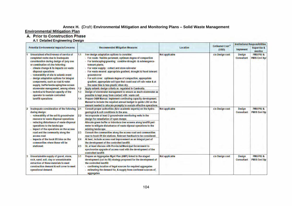
104
Annex H. (Draft) Environmental Mitigation and Monitoring Plans – Solid Waste Management Environmental Mitigation Plan

105

106

107

108

109

110

111

112
a No marginal costs. During construction, most costs on Contractors are included in preliminaries. During operation, costs are integral part of annual budget of Operator.
* Preliminarily, PMIS will be provided by combined man-months only in the first 2-3 years of Project implementation. After PMIS period, monitoring assumed to be done thru ADB Review Missions until loan closure.

113
Environmental Monitoring Plan

114

115

116

117

118

119
Annex I. Draft Outline for the PMU’s Environmental Monitoring Report This outline and the performance assessment and rating are mainly suggested and will be finalized according to applicability during the detailed design stage. The level of detail and comprehensiveness would depend on the degree of complexity of social and environmental impacts.
1. Introduction 1.1 Purpose of the Report
1.2 Project Overview
1.3 Physical Progress of the Project
2. Environmental Requirements in Project Loan Agreement & Subproject Contractual
Arrangements
3. Conformance to the EARF (This section reports on CMEI Output’s conformance to the EARF.)
4. Environmental Mitigation a (This section reports on the implementation of the Environmental Mitigation Plan.)
5. Environmental Monitoring b (This section reports on the implementation of the Environmental Monitoring Plan.) 5.1 Environmental Impacts Monitoring
5.2 Environmental Performance Monitoring
6. Grievance Redress c
(This section reports on the number of grievances received and acted on, and the performance in observing the GRM.)
7. Emergency Response d
(This section reports on the incidence of emergency situation, emergency response level, and, if applicable, the casualties encountered.)
8. Preparation and Submission of EMRs e (This section reports on the performance in reporting by respective parties.)
9. Overall Environmental Performance f
10. Summary of Key Issues, Actions and Lessons Learned 10.1 Key Issues Identified
10.2 Actions Taken/To be Taken
10.3 Lesson Learned
11. Conclusion & Recommendations
Annexes
A Environmental Impacts Monitoring Results
B Performance Monitoring/Inspection Reports (To include regular site monitoring/inspection and unannounced spot check reports, random informal public
consultations on site, photographs)
C Other supporting documents/information
a
Assessment of/rating for:
(i) performance in mitigation measures implementation 5 Very good 100% of required mitigation carried out
4 Good 76-99% of required mitigation carried out
3 Fair 51-75% of mitigations carried out
2 Poor 26-50% of mitigations carried out
1 Very poor 0-25% of mitigations carried out
(ii) effectiveness of implemented mitigation *

120
5 Very good 100% effective
4 Good 76-99% effective
3 Fair 51-75% effective
2 Poor 26-50% effective
1 Very poor 0-25% effective
* Use state of received grievances, findings from regular monitoring/inspections, unannounced spot checks,
informal random public consultations on site, state of workers health and safety, and (every quarter) the
results of environmental impacts monitoring --- as bases for assessing effectiveness.
b
Assessment of/rating for:
(i) performance in environmental impacts monitoring 5 Very good 100% of required environmental impacts monitoring carried out
4 Good 76-99% of required environmental impacts monitoring carried out
3 Fair 51-75% of environmental impacts monitoring carried out
2 Poor 26-50% of environmental impacts monitoring carried out
1 Very poor 0-25% of environmental impacts monitoring carried out
(ii) results environmental impacts monitoring 5 Very good within the more stringent value between international and national standards
4 Good within the less stringent value between international and national standards
3 Fair in excess of the less stringent value between international and national standards, but equal
or less than the baseline value
2 Poor 1-3% in excess of the baseline value
1 Very poor >3% in excess of the baseline value
(iii) performance monitoring 5 Very good All target regular site monitoring/inspections, unannounced spot checks, informal public
consultations carried out
3 Fair Not all target regular site monitoring/inspections, unannounced spot checks, informal public
consultations carried out
1 Very poor No regular site monitoring/inspections, unannounced spot checks, informal public
consultations carried out
c
Assessment of/rating for:
(i) performance in grievance redress 5 Very good 100% closed promptly
4 Good 76-99% closed promptly
3 Fair 51-75% closed promptly, no appeal
2 Poor 26-50% closed promptly, 1-3 appeals
1 Very poor 0-25% closed promptly, >3 appeals
(ii) number of grievances received 5 Very good 0 or no valid grievance received
4 Good 1-3 valid grievance/s received
3 Fair 4-5 valid grievances received
2 Poor 6-10 valid grievances received
1 Very poor >10 valid grievances received
d
Assessment of/rating for emergency response:
5 Very good no emergency case, no emergency response necessary
4 Good 1st response, no injury, no casualty
3 Fair 1st response/ultimate response, 1-3 injured
2 Poor 1st response/ultimate response, >3 injured, no casualty
1 Very poor 1st response/ultimate response, with casualty
e
Assessment of/rating for EMR preparation/submission: 5 Very good submitted promptly on prescribed deadline
3 Fair submitted after prescribed deadline, but before overall Project Progress Report submission
1 Very poor not submitted and therefore not incorporated in Project Progress Report
f
Overall performance could be described in qualitative terms by subproject, city and Project. Or, rating
system could be applied. This would require weights to be assigned to each indicator, each subproject
and each city to arrive at the overall Project performance.

121
Annex J. Draft Outline Terms of Reference for PMIS Environmental Specialist
1. This ToR applies to a collective effort of the international and national environmental specialists, for a total of at least twenty months (5 and 15 man months, respectively) spread over four years of Project implementation. 2. The Environmental Specialist will provide technical assistance and support to the Project Management Unit (PMU) in: (i) conducting environmental assessment of the activities under the Community Mobilisation and Environmental Improvements (CMEI) Output, following the SPS-compliant EARF; (ii) carrying out its responsibilities in EMP implementation; and (iii) overseeing and monitoring the EMP implementation by other key project players. The Environmental Specialist shall ensure that while performing his/her tasks, capacity development in environmental management is carried out. Capacity development shall be highly focused in training the PMU, particularly its Environmental Safeguard Staff (ESS) and his/her counterparts in the Project Implementing Units (PIUs). Training shall be highly “hands-on”, allowing the ESS/PMU/PIUs to learn while implementing the EARF and EMPs. His/her responsibilities include, but not limited to, the following:
Project Preparation TA for the CMEI Activities Assess the capacity of the PMU and its ESS and the PIUs and ESS’ counterparts in
environmental assessment, management, monitoring and reporting. Provide training lectures on subjects relevant to the EARF. Recommend the additional measures for capacity development.
Review, finalize and confirm the results of the REA and categorization undertaken by the ESS.
Support the ESS in the conduct of appropriate environmental assessment and preparation of the appropriate report for compliance with the EARF
Implementation of the Subprojects under the Kampong Chhnang and Pursat Urban Area Environment Improvements Prior to construction:
- Together with the ESS, finalize/update the IEEs and EMPs, as necessary, based on the detailed engineering designs, and ensuring consistency, where applicable, with the other safeguard plans.
- Support the ESS in: (i) ensuring the incorporation of relevant mitigation measures in the detailed designs; (ii) ensuring coordinated public consultations and disclosure/ information dissemination with the social/ resettlement team; (iii) ensuring that GoC’s environmental assessment requirements will not cause delay in the commencement of the construction phase; (iv) preparing for procurement, i.e., ensuring that the SPS-compliant EMP is part of the tender documents; incorporation of environmental criteria, scoring and weight in the evaluation of bids; (v) preparing for the activation of the grievance redress mechanism, e.g., materials for dissemination, posting, documentation and communication systems, etc.; (vi) undertaking pre-construction environmental quality monitoring as recommended in the EMP; and (vii) reviewing/evaluating Contractor’s EMPs if fully responsive to the SPS-compliant EMPs.
- Provide training lectures/seminars on the EMP and its implementation - Design a tool or system to facilitate effective consultations, monitoring/inspection and
reporting by the ESS. During construction
- Guide the ESS in supervising, monitoring and reporting EMP implementation. - Assess the operation/observance of the grievance redress mechanism, and
recommend improvement/s. - Together with the ESS, review the results of the environmental effects monitoring.
Recommend investigations and corrective actions, as necessary. During the entire engagement period
- Review draft quarterly and semi-annual environmental monitoring reports (EMRs) prepared by the ESS. Together with the ESS, finalize EMRs, i.e., quarterly EMR for input to the PMU’s quarterly progress report and semi-annual EMR for submission to the ADB.
122
- Recommend measures to ensure effective EARF and EMP compliance/ implementation, as necessary.
- Prepare the necessary report that will be required from him/her as part of the PMIS Team, e.g. progress report on his/her technical assistance.
- Perform other tasks that are relevant to his/her position but are not mentioned above. 3. The Environmental Specialist will meet the following minimum qualification requirements:
International Environmental Specialist - Master’s degree in environmental science/engineering/planning or equivalent; - 10 years of professional experience in environmental impact assessment, and in
managing the environmental performance including environmental monitoring and environmentally responsible procurement, of infrastructure projects for basic urban services, preferably with project experience on donor-funded projects, and
- 5 years of relevant experience with ADB-funded projects in Southeast Asia, preferably in the Mekong Region.
National Environmental Specialist - Master’s degree in environmental science/engineering/planning or equivalent; - 10 years of professional experience in environmental impact assessment and in
managing the environmental performance including environmental monitoring, of donor-financed urban infrastructure projects in Cambodia; and
- a good command of written and spoken English and experienced in preparing reports in English and Cambodian.