terrestrial vegetation monitoring handbook 2006
TRANSCRIPT

Draft Terrestrial Vegetation Monitoring Handbook Update
1
NATIONAL PARK SERVICE CHANNEL ISLANDS NATIONAL PARK
TECHNICAL REPORT 06-XX
TERRESTRIAL VEGETATION
MONITORING HANDBOOK
2006
Dirk Rodriguez
Channel Islands National Park
1901 Spinnaker Drive
Ventura, CA 93001
Voice 805-658-5751
Fax 805-658-5798
E-mail [email protected]

Draft Terrestrial Vegetation Monitoring Handbook Update
2
Background
First created in 1938, Channel Islands
National Monument was initially
comprised of three islands – Santa
Barbara Island, Anacapa Island, and San
Miguel Island. In 1980, the Monument
achieved National Park status and in
1987, Santa Rosa Island was
incorporated into the park. This was
followed by the acquisition of
approximately 6200 acres of Santa Cruz
Island in 1997 and another 8700 acres in
2000. The park’s enabling legislation
(PL 96-99) required the park to develop
a natural resources study including 1) an
inventory of all species in the park, 2) an
assessment of the present conditions and
probable future trends of populations,
and 3) recommendations for actions that
should be considered to better protect the
natural resources of the park.
The park soon recognized that protection
and restoration of its resources would
require a permanent monitoring
program. Ideally this program would
help guide management of the park and
assess the effectiveness of any
restoration efforts.
The current terrestrial vegetation
monitoring program was initially
designed and implemented in 1984 but
incorporated elements of earlier
monitoring efforts by various
researchers. Vegetation monitoring was
still limited to those three islands when
the original Terrestrial Vegetation
Monitoring Handbook was published.
The original handbook provided an
overview of the program including plant
communities, transect locations,
monitoring protocol, and sampling
methods. However, since then two
additional islands – Santa Rosa Island
and Santa Cruz Island - have been
incorporated into the park and there have
been modifications in field
methodology, data entry and analysis,
and reporting. In addition, a formal
review of the vegetation monitoring
program in December 2000 resulted in
several recommendations to further
improve the program. All these factors
have necessitated a revision of the
original monitoring handbook.
Monitoring Environment
Nearly all the plant vegetation
communities within the park have been
altered by past land use practices. Large
non-native herbivores such as sheep,
cattle, rabbits, horses, and burros were
introduced onto the various islands
beginning in the mid-1800s. Most of
these animals have been removed from
the islands although feral pigs, deer, and
elk are still present. Non-native plant
species have also been introduced onto
various islands within the park either
intentionally or accidentally. As a result
non-native plants are a significant
component of the park’s flora and even
dominate some of the island vegetation
communities. There are nearly 800 plant
taxa (including subspecies, varieties, and
forms) currently known to occur on the
islands in the park. Of these, almost 200
are considered non-native to California
and are believed to have been introduced
after initial European contact.
Islands
As mentioned previously there are five
islands within Channel Islands National
Park. Four of the islands - Santa

Draft Terrestrial Vegetation Monitoring Handbook Update
3
Barbara, Anacapa, Santa Rosa, and San
Miguel - are wholly managed by the
National Park Service (NPS). The fifth
island, Santa Cruz Island is divided into
ownership between The Nature
Conservancy (TNC) and NPS. TNC
owns and manages the bulk of the island
(approximately 76%) while the rest is
owned by the United States and
managed by NPS. The islands range in
size from the smallest, Santa Barbara
Island, at 260 hectares, to the largest,
Santa Cruz Island, at approximately
25,090 hectares.
Four of the five islands – Anacapa, Santa
Cruz, Santa Rosa, and San Miguel,
comprise what is called the northern
Channel Islands. These islands are
oriented along an east to west trending
axis. Santa Barbara Island is considered
one of the four southern Channel
Islands. It is the only southern Channel
Island within the Park.
Vegetation Communities
In the first monitoring protocol
handbook (Halvorson et al 1988), 15
plant communities were described as
being representative of the vegetation
found on the three islands then within
the Park. These 15 communities were
divided into four broad life-form
classifications – grassland/herb-land,
shrub-land, introduced iceplant, and
woodland.
Grassland/herb-land
Wild oats
Barley
Annual iceplant
Shrubland
Sand dunes
Sea cliff scrub
Caliche scrub
Coreopsis scrub
Coastal sage scrub
Maritime cactus scrub
Sea-blite scrub
Boxthorn scrub
Haplopappus scrub
Island chaparral
Introduced Iceplant
Perennial iceplant
Woodland
Island woodland
With the addition of Santa Rosa Island
and a portion of Santa Cruz Island
however, additional vegetation
communities were added to the parks
total. Changes have also been made to
the islands’ plant community
nomenclature. Today the park now
monitors 22 plant communities. The
table below shows the original
communities monitored and the present
equivalent communities monitored as
well as new communities brought into
the park from the acquisition of Santa
Cruz and Santa Rosa Islands.
Island Hectares
Santa Barbara 260
Anacapa 298
San Miguel 4047
Santa Rosa 21,853
Santa Cruz 25,090*
*Of these hectares, approximately 6070 are
managed by NPS.
Draft Terrestrial Vegetation Monitoring Handbook Update
4
Community Descriptions
Perennial Iceplant
Within the park, this community is
found only on the east islet of Anacapa
Island. There perennial iceplant
(Malephora crocea) was deliberately
introduced by the coast guard as an
erosion control measure. It now
dominates large areas on the east islet.
Occasional native species such as sand-
lettuce (Dudlyea caespitosa) and
gumplant (Grindelia camporum var.
bracteosum) occur within these areas.
Both physical removal and the use of
herbicides have been used in a low-level
but continuous effort to eradicate the
plant from the island.
Coastal Bluff/Sea cliff Scrub
This vegetation community is found on
steep ocean cliffs, which surround
portions of all the islands. Due to the
inaccessibility of these bluffs this
community has remained largely intact
and unaffected by the grazing impacts
felt on other parts of the island. The
plant species, which comprise this
community, are slightly different on
each island and even within an island,
depending on topographical parameters.
Common species found within this
community include: coastal sage brush,
yarrow (Achillea millefolium),
maidenhair fern (Adiantum jordanii),
Nutall’s snapdragon (Antirrhinum
nutallianum), San Miguel Island
locoweed (Astragalus miguelensis),
giant coreopsis (Coreopsis gigantea),
live forever (Dudleya spp.), Santa Cruz
Island buckwheat (Eriogonum
arborescens), island buckwheat
(Eriogonum grande var. grande), red
buckwheat (E. grande var. rubescens –
on SRI) seaside daisy (Erigeron
glaucus), golden yarrow (Eriophyllum
confertiflorum), seaside woolly
sunflower (E. staechadifolium), and
northern island hazardia (Hazardia
detonsa). Interestingly both E.
confertiflorum and E. staechadifolium
are missing on Santa Barbara Island and
in their place is silver lace (Eriophyllum
nevinii), a species endemic to the
southern Channel Islands.
Valley and foothill grassland
This is a widespread plant community
and is found on all the islands.
Introduced annual grasses are the most
common plant species within this
community, although patches of native
perennial bunchgrasses - which are
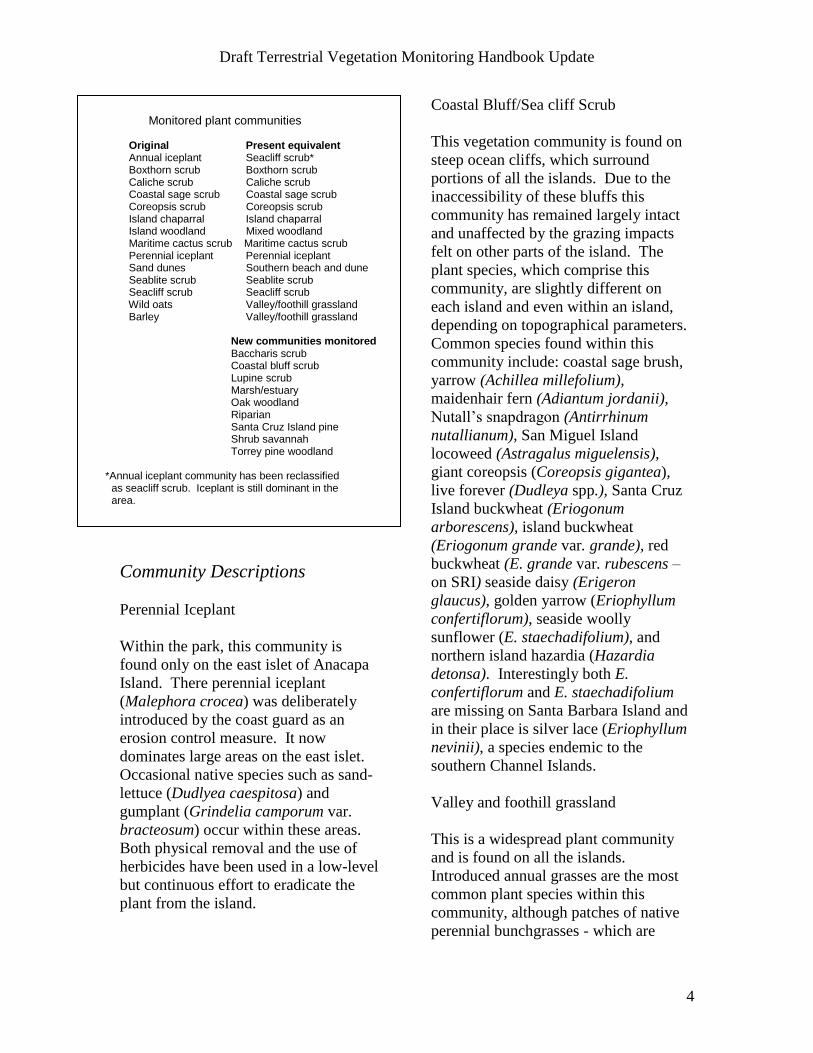
Monitored plant communities Original Present equivalent Annual iceplant Seacliff scrub* Boxthorn scrub Boxthorn scrub Caliche scrub Caliche scrub Coastal sage scrub Coastal sage scrub Coreopsis scrub Coreopsis scrub Island chaparral Island chaparral Island woodland Mixed woodland Maritime cactus scrub Maritime cactus scrub Perennial iceplant Perennial iceplant Sand dunes Southern beach and dune Seablite scrub Seablite scrub Seacliff scrub Seacliff scrub Wild oats Valley/foothill grassland Barley Valley/foothill grassland New communities monitored Baccharis scrub Coastal bluff scrub Lupine scrub Marsh/estuary Oak woodland Riparian Santa Cruz Island pine Shrub savannah Torrey pine woodland *Annual iceplant community has been reclassified
as seacliff scrub. Iceplant is still dominant in the area.

Draft Terrestrial Vegetation Monitoring Handbook Update
5
dominant in some areas - do occur. This
community can be found on coastal
terraces and all slopes where extensive
grazing has occurred. The more
prevalent exotic annual grasses include
rip-gut brome (Bromus diandrus), soft
chess (Bromus hordeacous), wild oats
(Avena fatua), slender wild oats (Avena
barbata), Italian rye grass (Lolium
multiflorum), red brome (Bromus
madritensis ssp. rubens), and foxtail
(Hordeum murinum). Native forbs and
perennial bunchgrasses also occur within
this community and these species
include golden stars (Bloomeria crocea
ssp crocea), wild hyacinth
(Dichelostemma capitatum), gold fields
(Lasthenia californica), tidy tips (Layia
platyglossa), California buttercup
(Ranunculus californicus), blue-eyed
grass (Sisyrinchium bellum), purple
needlegrass (Nasella pulchra), and
meadow barley (Hordeum
brachyantherum ssp. californicum).
Occasionally, on Santa Cruz and Santa
Rosa Islands, solitary native shrubs such
as lemonade berry (Rhus integrifolia),
manzanita (Arctostaphylos spp.), and
oaks (Quercus spp.) are found in the
middle of these large annual grasslands.
Their presence is an indication that
native shrub communities may have
previously existed in those areas. On
the east end of Santa Cruz Island the
common occurrence of these isolated
shrubs has led to the creation of a new
plant community called disturbed shrub
savannah. In some areas on Santa Rosa
Island and San Miguel Island this
grassland community has been invaded
by coyote brush (Baccharis pilularis).
As the coyote brush cover increases in
these areas it may be more appropriate to
classify them as baccharis scrub
communities.
Island Chaparral
Island chaparral is found on the three
larger islands within the park – Santa
Cruz, Santa Rosa, and San Miguel.
Although similar to chaparral found on
the mainland, there are some differences
both structurally and floristically.
Structurally, the dominant, island
chaparral species are taller and more
arborescent resulting in an open
woodland appearance. This may be due
in part to climatic differences, a lower
fire frequency, or the effects of long-
term, intensive grazing. Floristically,
mainland manzanita and oak species are
replaced by island endemic species. On
SCI, this community is comprised of
species such as chamise (Adenostoma
fasciculatum var. fasciculatum),
prostrate chamise (A. fasciculatum var.
prostratum), Santa Cruz Island
manzanita (Arctostaphylos insularis),
island ceanothus (Ceanothus arboreus),
toyon (Heteromeles arbutifolia), and
mountain mahogany (Cercocarpus
betuloides var. blancheae) among other
species. Towards the east end of SCI
and on the isthmus, Santa Cruz Island
manzanita is replaced by McMinn’s
manzanita (Arctostaphylos viridissima).
On SRI, the species that tend to occur in
this community are A. fasciculatum var.
prostratum, Santa Rosa Island manzanita
(Arctostaphylos confertiflora), H.
arbutifolia, and Q. pacifica. On San
Miguel Island, this community is
extremely depauperate. The most
common plants that occur in it there are
Baccharis pilularis, Isocoma menziesii,
and Lupinus albifrons.
Coastal Sage Scrub

Draft Terrestrial Vegetation Monitoring Handbook Update
6
The coastal sage scrub community
occurs on all the islands and is more
common on the southern, drier areas on
each island. This community was
heavily impacted by grazing on each of
the islands, although some relatively
large intact areas do occur on SCI and
SRI. In these “intact” areas nearly
impenetrable thickets of shrubs
approximately 3-4 ft tall are found.
Dominant species within this community
include coastal sagebrush (Artemisia
californica), island sagebrush (Artemisia
nesiotica - on SBI), island paintbrush
(Castilleja lanata ssp. hololeuca), bush
sunflower (Encelia californica), Santa
Cruz Island buckwheat (Eriogonum
arborescens), lemonade berry (Rhus
integrifolia), goldenbush (Isocoma
menziesii), coastal prickly pear (Opuntia
littoralis), black sage (Salvia mellifera),
and Brandegee’s sage (Salvia
brandegeei – on SRI). The heavily
disturbed areas of coastal sage scrub are
dominated by exotic annual grasses with
occasional coastal sage scrub species
scattered throughout. On SCI, coastal
sage scrub intergrades with grasslands
on gentle slopes with deeper soils and
with island chaparral on north-facing
slopes. On San Miguel Island, coastal
sage scrub frequently intermixes with
sea cliff scrub on the southern
escarpments.
Southern Beach and Dune
This community occurs only on the three
larger islands – Santa Cruz, Santa Rosa,
and San Miguel. These dune areas are
generally not as expansive as those
found on the mainland due to the steep
coastal bluffs, which surround most of
the islands. Plant species found in these
“limited” dune communities include
sticky-sand verbena (Abronia maritima),
silver beach-bur (Ambrosia chamissonis,
sea rocket (Cakile maritima), beach
evening-primrose (Camissonia
cheiranthifolia ssp. cheiranthifolia), salt
grass (Distichlis spicata), California
saltbush (Atriplex californica), and
Australian saltbush (Atriplex
semibaccata). In the more stable dune
areas, the native plants: prostate coastal
goldenbush (Isocoma menziesii var.
sedoides and silver lupine (Lupinus
albifrons ssp. douglasii) also occur.
Riparian
Perennial stream courses are found only
on SCI, SRI, and SMI. The quality of
the native vegetation within these stream
courses can range from high to
extremely depauperate. Most have been
impacted to a large degree by past
grazing practices. In many areas, on
SCI and SRI, the native riparian plant
species have been locally extirpated and
non-native weedy plants and grasses
occupy the riparian zone. However,
even prior to the introduction of alien
herbivores, these areas were probably
less diverse than comparable
communities on the mainland.
Mainland riparian dominants such as,
white alder (Alnus rhombifolia),
sycamore (Plantanus racemosa), and
California bay (Umbellularia
californica) do not occur on the islands
(Junak et al, 1995). The more common
plant species found in the island riparian
areas include California maidenhair
(Adiantum jordanii), Agrostis viridis,
sticky baccharis (Baccharis douglasi),
rushes (Juncus spp.), common monkey
flower (Mimulus guttatus), carex (Carex
spp.), sharp bullrush (Scirpus pungens),
and cattail (Typha domingensis). Woody
species can also be found along
permanent streams. On SCI, big-leaf

Draft Terrestrial Vegetation Monitoring Handbook Update
7
maple (Acer macrophyllum), arroyo
willow (Salix lasiolepis), black
cottonwood (Populus balsamifera ssp.
trichocarpa), and coast live oak
(Quercus agrifolia are the species that
occur most frequently. On SRI and
SMI, the dominant, woody tree species
is arroyo willow, although elderberry
(Sambucus mexicana) and black
cottonwood also occur.
Bishop pine woodland
Bishop pine which occurs on Santa Cruz
and Santa Rosa islands is patchily
distributed along the coast as far north as
Humboldt County and down into Baja
California. On SCI, large occurrences
of Bishop pine are found on north-facing
slopes in the upper reaches of Canada
Christy, near Pelican Bay, and south of
China Harbor. Smaller occurrences of
Bishop pine are found in the upper
portion of Canada de los Sauces, on
Sierra Blanca ridge, and on the south
side near China Harbor. On SRI, the
Bishop pine groves are less extensive
and are currently in poor condition
although recent recruitment and
establishment of seedlings and juvenile
plants has been observed. Occasional
over-story species mixed within the
Bishop pine community include: island
ironwood (Lynothamnus floribundus ssp.
aspleniifolius, coast live oak (Quercus
agrifolia), and island oak (Q.
tomentella). Understory species include:
chamise, coyote brush, globe lantern
(Calochortus albus), toyon, smooth
mouse ears (Hypochaeris glabra), island
deerweed (Lotus dendroideus var.
dendroideus), island monkeyflower
(Mimulus flemingii), chaparral current
(Ribes malvaceum var. malvaceum),
poison oak (Toxicodendron
diversilobum), canyon sunflower
(Venegasia carpesioides), and the rare
island barberry (Berberis pinnata ssp.
insularis). This community has also
been called Santa Cruz Island pine
woodland.
Mixed Woodland
This vegetation community can be found
on SCI on the north-facing slopes,
ravines, and canyons, particularly at the
higher elevations (Junak et al., 1995).
Many of the dominant trees and shrubs
in this community are endemic to one or
more of the islands. Over-story species
can vary from a mixture of island
endemics to pure stands of oak (Quercus
spp.) or ironwood (Lyonothamnus
floribundus). Other dominant species
include toyon (Heteromeles arbutifolia),
and island cherry (Prunus ilicifolia ssp.
lyonii). The oak species found in this
community are canyon live oak
(Quercus chrysolepis), Macdonald’s oak
(Quercus macdonaldii) and island oak
(Q. tomentella). This community
intergrades with island chaparral on dry,
rocky slopes while turning into savannas
on the deeper soils of the flats and more
gentle slopes. The current extent of the
savannas may be an artifact of the
islands grazing history. Understory
species include bent grass (Agrostis
pallens), coyote-brush (Baccharis
pilularis), bedstraw (Galium spp.), wild-
cucumber (Marah macrocarpus var.
major), island monkeyflower (Mimulus
flemingii), lemonade berry (Rhus
integrifolia), death camas (Zigadenus
fremontii), and California polypody
(Polypodium californicum).

Draft Terrestrial Vegetation Monitoring Handbook Update
8
Southern Coastal Oak Woodland
The dominant species within this
community is coast live oak (Q.
agrifolia) and it occurs on north-facing
slopes and shaded canyons in the Central
Valley and on the north side of the
island. On the slopes, the more common
understory species include toyon, wood
mint (Stachys bullata), creeping
snowberry (Symphoricarpos mollis), and
poison oak (Toxicodendron
diversilobum). In the canyon bottoms,
common understory species include
honeysuckle (Lonicera hispidula var.
vacillans), manroot, blackberry (Rubus
ursinus), milkmaids (Cardamine
californica var. californica), and
climbing penstemon (Keckiella
cordifolia).
Coastal Marsh and Estuary
Coastal salt marshes are restricted to the
upper inter-tidal zone of protected
shallow bays, estuaries, and coastal
lagoons (Barbour and Major 1977).
Within the park, coastal marsh is found
only on SCI and SRI. Santa Cruz Island
has small marshes or wetlands at the
estuaries of several canyons including
Prisoner's Harbor, Cañada de los Sauces,
Cañada de Malva Real, and Scorpion
Canyon. On SRI, two marshes can be
found at the east-end of the island. The
physical condition of these marshes is
dominated by the tides and the duration
of tidal flooding. At times, the more
shallow estuaries may undergo periodic
closure - sometimes seasonal or longer -
from the ocean inlets (Barbour and
Major 1977). The one species that
seems to be present at all the marshes on
SCI and SRI is Distichilis spicata or
salt-grass (Junak 1995). Other native
species that can be found at one or more
of the marshes include California
bulrush (Scirpus californicus), cat tails
(Typha domingensis), arroyo willow
(Salix lasiolepis), sticky baccharis
(Baccharis douglasii), seep-willow
(Baccharis salicifolia), pickle weed
(Salicornia virginica), sea-blite (Suaeda
taxifolia), and California saltbush
(Atriplex californica). Introduced exotic
species also occur at one or more of the
marshes or wetlands. These include
Australian saltbush (Atriplex
semibaccata), brass buttons (Cotula
coronopifolia), kikuya grass
(Pennisetum clandestinum), curly dock
(Rumex crispus), and foxtail (H.
murinum). The wetlands at Scorpion
Harbor and Prisoner’s Harbor on SCi
were directly impacted by human
activity during the ranching era. Large
areas of the wetlands were filled in with
off-site soil – especially at Prisoner’s
Harbor - and portions of the drainages
feeding the wetlands were rerouted and
channelized. Some of the marshes or
wetlands on SCI were also extensively
used by the feral sheep that once roamed
the island. Since the removal of the
sheep, vegetative cover, duration of
flooding, and the depth of standing water
has increased dramatically, especially in
the estuaries on the south side of the
island (Junak et al 1995).
Coyote-brush Scrub
This vegetation community is
widespread on SCI at elevations below
500 ft, where it intergrades with coastal
sage scrub. According to Clark (1990),
it is found primarily on moderate slopes
and flats with loam to sandy clay loam
soils. Beyond the coyote brush
(Baccharis pilularis) which

Draft Terrestrial Vegetation Monitoring Handbook Update
9
characterizes the community, many
species that occur in it are weedy non-
native plants, particularly the annual
grasses. Typical alien plant species
include wild oats (Avena spp.), rip-gut
brome (Bromus diandrus), soft-chess
(Bromus hordeaceus), and red brome
(Bromus madritensis var. rubens). Other
herbaceous species include filaree
(Erodium spp.), Carolina cranesbill
(Geranium carolinianum – SCI), cutleaf
geranium (G. dissectum – SRI), fairy
mist (Pterostegia drymariodes), bur
clover (Medicago polymorpha), cleavers
(Galium aparine), and various other
clovers (Trifolium spp.). Black mustard
(Brassica nigra), yellow starthistle
(Centaurea solstitialis) and fennel
(Foeniculum vulgare), all invasive non-
native plants, are also found in this
community on SCI. On SRI coyote-
brush scrub occurs in large patches
throughout the island. It also occurs on
San Miguel Island but to a much smaller
extent.
Torrey Pine Woodland
Torrey pine is an extremely rare conifer
species found only on Santa Rosa Island
and on the mainland near San Diego.
On Santa Rosa Island, it is confined to
two groves on the northeast side of the
island. Within the larger grove, Torrey
pine occurs in monotypic stands but
intergrades with island chaparral in some
areas. Underneath the dense overstory,
there is a thick duff layer with
occasional annuals such as chickweed
(Stellaria media), common sow thistle
(Sonchus oleraceaus), and ripgut brome
(Bromus diandrus) being present.
Perennial understory species include
June grass (Koeleria macrantha), San
Diego needlegrass (Achnatherum
diegoense), and chaparral zigadene
(Zigadenus fremontii). Where Torrey
pine intergrades with island chaparral,
the overstory is more open and woody
species such as toyon (H. arbutifolia),
island cherry (P. ilicifolia ssp. lyonii),
lemonade berry (Rhus integrifolia), and
island manzanita (A. confertiflora) co-
occur.
Sea-blite scrub
Within the park this community is found
solely on Santa Barbara Island. It is
found in limited areas in the west and
north areas of the island. Typically it
consists of scattered sea-blite (Sueda
taxifolia) surrounded by annual
grassland (B. diandrus, B. madritensis
ssp. rubens, H. murinum, etc). Other
species present include A. intermedia, P.
drymaroides, and S. oleraceus.
Coreopsis scrub
Although the dominant species in this
community – Coreopsis gigantea - is
found on all the islands, the community
type is found only on Santa Barbara
Island, Anacapa Island and San Miguel
Island. The overstory is composed of
giant coreopsis (Coreopsis gigantea)
while the understory is dominated by a
mixture of annual grasses and herbs.
These usually consist of rip-gut brome,
soft chess, red brome, miner’s lettuce,
and fairly mist. Where this community
occurs in canyons on Santa Barbara
Island additional species such as coast
range melic (Melica imperfecta), and
fiesta flower (Pholistoma auritum var.
auritum can also occur.
Boxthorn scrub
Within the park, this community is
confined to Santa Barbara Island. There

Draft Terrestrial Vegetation Monitoring Handbook Update
10
it occurs in scattered patches on the east
side of the island. It is like sea-blite
scrub in that the species that
characterizes the community, in this case
Lycium fremontii, is found scattered
throughout a matrix of annual grassland.
Associated species include rip-gut
brome, red brome, soft chess, pygmy
weed (Crassula connata), prickly
lettuce, and miner’s lettuce.
Disturbed shrub savannah
This community is thought to be an
artifact of intensive grazing and occurs
only on the east end of Santa Cruz
Island. It is characterized by isolated
large, native, woody shrubs surrounded
by extensive acres of annual grassland.
The remaining isolated shrubs are
thought to be the remnant individuals of
what once was extensive island
chaparral. The remaining large native
shrubs are usually lemonade berry,
toyon, or island scrub oak. The
grassland component is dominated by
rip-gut brome or wild oats. Additional
species include red brome, soft chess,
prickly lettuce, fiddleneck, popcorn
flower, smooth cat’s ear (Hypochaeris
glabra), and various other native and
introduced herbaceous species. False
brome (Brachypodium distachyon) is
another introduced annual grass that can
be found in this community. Perennial
native grasses such as purple needlegrass
(N. pulchra) and creeping wild rye
(Leymus triticoides) also occur within
the annual grassland component and
even dominate some areas.
Caliche scrub
This community is found on the western
ends of both Santa Rosa and San Miguel
Islands. It occurs on calcium carbonate
soils that have been exposed by erosion.
Dominant plants in this community are
the prostrate goldenbush (I. menziesii
var. sedoides), San Miguel locoweed
(Astragalus miguelensis), and annual
grasses – predominately rip-gut (B.
diandrus) and red brome (B. madritensis
ssp. rubens). These dominant species
are similar to those found in the Isocoma
scrub community but caliche scrub has a
much more open character and is more
depauperate in the number of species it
contains.
Isocoma scrub
On the islands, this community is found
only on Santa Rosa Island where it
occurs on the north side coastal terraces.
It is dominated by prostrate goldenbush
but San Miguel locoweed and California
saltbush (Atriplex californica) are also
common. Meadow barley (Hordeum
brachyantherum) and sand-dune
bluegrass (Poa douglasii) are important
grass components. This community is
not currently monitored under the
terrestrial vegetation monitoring
program.
Lupine scrub
Lupine scrub is found on both Santa
Rosa and San Miguel Islands on sandy
soils. Silver bush lupine (Lupinus
albifrons) or yellow bush lupine (L.
arboreus) are the dominant shrub
species. Surrounding the lupine is a
matrix of annual grasses - primarily rip-
gut brome, creeping wild-rye (Leymus
triticoides) and Carex pansa. Other
species include wild heliotrope
(Phacelia distans and common
fiddleneck (Amsinkia menziesii var.
intermedia).

Draft Terrestrial Vegetation Monitoring Handbook Update
11
Maritime cactus scrub
This community is found on Santa
Barbara Island. Within the park it is
characterized by the heavy presence of
coastal prickly pear (Opuntia littoralis),
tall prickly pear (O. oricola), or coastal
cholla (O. prolifera). Surrounding the
cactus is a mix of native and non-native
annuals and perennials such as red-
brome (B. madritensis ssp. rubens), wild
oats (Avena spp.) common fiddleneck
(A. menziesii var. intermedia), southern
island morning glory (Calystegia
macrostegia ssp. amplissima, wild-
cucumber (Marah macrocarpus var.
major), and little-seed muhly
(Muhlenbergia microsperma). This
community is confined primarily to the
south or west facing slopes of three
drainages on the island. According to
Junak (1995), a stretch of the coastal
bluff community on the south side of
Santa Cruz Island is dominated by O.
prolifera and resembles the maritime
cactus community found on the Southern
Channel Islands.
Objectives and Design
Rationale
In the first terrestrial vegetation
monitoring handbook the purpose of
vegetation monitoring was “…..to assure
preservation of distinct assemblages of
species and subspecies that have evolved
as a result of isolation from the mainland
and other islands…….and to measure
natural recovery and the effectiveness of
management actions to restore island
vegetation.” More specifically the goals
were to 1) describe the major plant
communities on the islands, 2) determine
the levels of natural variability, 3)
identify long-term trends with a 90%
chance of detecting 40% change at the
10% significance level, and 4) show
patterns and rates of change among plant
communities. To achieve these goals the
program combined annual transect
monitoring and periodic vegetation
mapping. The annual transect
monitoring would detect changes within
plant communities and the periodic
mapping would capture changes in plant
community distribution across the
islands. Although these overarching
goals remain essentially the same, an
increase in land managed by the park,
and effective decreases in budget, and
staffing have necessitated changes in the
monitoring program. It should also be
noted that the program was not designed
to monitor individual rare or invasive
plant species.
Site Selection
In 1979, vegetation maps were made for
Anacapa, Santa Barbara, and San Miguel
Islands, as part of the first
comprehensive natural resources study
of the park. The maps were made using
1:24,000 scale color infrared aerial
photographs. In 1984, semi-quantitative
community relevé data were collected to
on Santa Barbara and San Miguel
Islands as a check on the accuracy of the
maps before community monitoring
transects were installed. With a few
minor exceptions the 1979 maps were
accepted as accurate and were used as
the basis for transect establishment. The
transects were then located subjectively
across the three islands, with the
objective of representing typical
examples of the island vegetation
(McEachern 2001). Three years after
long-term vegetation monitoring began

Draft Terrestrial Vegetation Monitoring Handbook Update
12
on the three smaller islands, Santa Rosa
Island was acquired by the park. Long-
term monitoring for that island began in
1990. The eastern 10% of Santa Cruz
Island was purchased in 1990 and long-
term vegetation monitoring there began
in 1998. For Santa Rosa Island and the
east end of Santa Cruz Island, vegetation
maps were drawn from aerial
photographs with follow-up relevé
sampling to check accuracy and to
describe plant community distribution
and composition (McEachern 2001).
Transect locations on both islands were
stratified by topography but the transects
on Santa Rosa Island were placed in
representative examples of the major
plant communities in their best
condition, away from community
boundaries (Halvorsen in McEachern
2001), while the locations for the
transects on the east-end of Santa Cruz
Island were chosen by a stratified
random method (McEachern 2001).
Field Methods
Periodic Vegetation Mapping
Vegetation communities are to be
mapped every three to five years to
detect changes in plant community
patterns. If monitoring shows that
vegetation patterns are not changing
rapidly enough, then a longer mapping
period perhaps 10 years may be more
appropriate. Mapping should be based
on aerial photographs taken in summer.
Vegetation mapping should be
accomplished through interpretation of
9-inch format, false color infra-red
transparencies at an approximate scale of
1:12,000 with complete stereoscopic
coverage. Comparisons can then be
made between previous vegetation maps
and present conditions. Any changes in
plant community boundaries should be
highlighted on the new vegetation map.
Permanent Transects
A point-line intercept method is used to
sample the vegetation at the transect
locations (Bonham 1989). Transects are
30 meters long and data is recorded
every 30 cm resulting in 100 point
transects. At each point species present
and the height of the tallest individual
are recorded. The data collected are
quantified to show species composition,
species frequency, height, and percent
cover.
Schedule
Data are to be collected annually at
every transect location unless peer
reviewed analysis of the data suggests
that less frequent monitoring would be
as effective. Shortages in personnel,
budget shortfalls, or inclement weather
can also determine the number of
transects read in a single year. For those
years when transect monitoring efforts
may be limited priority should be given
to those islands where vegetation
changes are occurring most rapidly. All
sites should be monitored during the
growing season, usually from mid- to
late-February to mid-June. Santa
Barbara Island should normally be
visited first, then Anacapa, Santa Cruz,
Santa Rosa, and San Miguel. It is best to
follow this progression as this is usually
the order in which the island vegetation
begins to dry and senesce. Santa
Barbara Island is farther south than the
others and the vegetation tends to dry
out there first. For the northern Channel
Islands, as one travels from east to west,
Draft Terrestrial Vegetation Monitoring Handbook Update
13
the vegetation tends to mature later and
stay greener longer.
Santa Barbara Island – There are 22
transects on this island. Some transects
have not been read for several years
usually because of pelican nesting. Four
of the transects – 8, 9, 10, and 12 were
incorporated from other monitoring
efforts and are longer than 30 meters.
Three of these transects – 8, 9, and 10 –
have been split approximately in half
and each half has been given an N or S
designation. Transect 9N has not been
read since 1994 because of dense cactus
growth. However slides should still be
taken of this transect every year. With
two people, it is possible to read all the
transects in one week.
Anacapa Island – Anacapa is comprised
of three small islets usually referred to as
East Anacapa (EAI), Middle Anacapa
(MAI), and West Anacapa (WAI). Each
of the islets has 5 permanent transects.
Access to Middle and West Anacapa can
be a problem as there is no regularly
scheduled transportation to those islets.
Either park transportation or the park’s
boat concessionaire may make a special
stop upon request. In recent years, West
Anacapa has been off-limits due to
pelican nesting. East Anacapa is the
most easily accessible of the islets.
Allow 3 – 4 long days to read all 15
transects or one long day apiece for each
of the islets.
Santa Cruz Island – There are currently
26 transects in place at the east end of
Santa Cruz Island in the original 6000
acres purchased by the park. The terrain
on SCI is rugged and can be quite steep.
Access to some transects can be
somewhat arduous. With the use of a
vehicle, it should take two people
approximately 7-8 days to read all the
transects. Without the use of a vehicle
an additional week will likely be needed
to read all the transects. The isthmus
portion of the island (approximately
8000 acres) was donated from TNC to
the park in 2000. There are 34
vegetation transects on this part of the
island, which were originally established
by TNC. At some point in the future
some or all of these transects may be
incorporated into the Park’s monitoring
program. Successful incorporation of
these transects will probably require
additional funding and personnel.
Markers for these transects are located
on the road-side and all are fairly close
to an existing road.
Santa Rosa Island – There are 86
transects located on this island. Each
transect is 30 meters long. This is the
most accessible island by vehicle and
most of the transects can be reached
easily. Expect two people to take 3 to 5
full weeks to complete all the SRI
transects, less time if only the base
protocol is done, more if the tree or
shrub protocol monitoring must be done.
San Miguel Island – There are 16
transects on this island. Access to them
is by hiking only. Three of the transects
are on the west side of the island.
Hiking to the west end of the island
takes approximately 2-3 hours (it is 7
miles one way) depending on your pace.
With an early start, these three transects
can be read in one day. Expect two
people to be able to read all 16 transects
in five to six days.
Although there are statistical advantages
to using permanent transects there are
some disadvantages that the field
Draft Terrestrial Vegetation Monitoring Handbook Update
14
monitor needs to be aware of. The
stakes marking each end of the transect
are susceptible to loss or damage from
vandalism, animal impacts, or shifting
ground surfaces. There are negative
impacts associated with returning to the
same site every year as the vegetation is
repeatedly trampled. Transect markers
have been damaged or uprooted in past
by people, pigs, cattle, deer, and elk.
They have also been used as scratching
posts and have been bent clear to the
ground on occasion. Using short stakes
alleviates some of these problems but
this can make locating an individual
transect more difficult, especially in
areas of dense vegetation. In dune areas
markers have been completely covered
by shifting sand. The photos taken
annually at each of the transects can be
helpful in relocating or re-establishing
“lost” transects. All transect locations
have also been GPS’ed. Accuracy of the
given coordinates will vary depending
on the gps unit, satellite acquisition at
the time the coordinates were obtained,
and land-terrain features.
Personnel
Ideally two people should read each
transect. One person must be able to
identify plants to the subspecies or
variety level. As this person “reads” the
transect, the second person records the
data. If both people are knowledgeable
with the plant species, then turns can be
taken in reading and recording.
Transects can be read by one person
using a tape recorder but this is less than
ideal and at some point the “spoken”
data needs to be transcribed onto a
datasheet.
Sampling Equipment and
Materials
Equipment and material that will be
needed to conduct the monitoring as it is
currently set up includes:
Data forms – paper or electronic
format (Appendix **)
Pencils
Tatum or clipboard
Park species list with codes
Taxonomic field guide
Compass
3 - 50 m measuring tapes (one for
the basic monitoring protocol and
two for the tree or shrub monitoring
protocol)
1m or taller measuring pole marked
in 5 cm increments
Digital camera
Densiometer – to measure tree
canopy hits
Binoculars (can be quite helpful in
locating transects)
Plant press or plastic baggies (for
unknown specimens).
Site maps (Appendix **)
Personal Gear
Hiking boots
Day pack
Rain and/or wind gear
Sun glasses
Hat
Sunscreen lotion
Flashlight
Notebook
Water bottles (at least 2)
Lunch/snacks
Gaiters (when grasses are seeding
out)
Park radio
First aid kit

Draft Terrestrial Vegetation Monitoring Handbook Update
15
Sampling Procedures
After locating both ends of the transect
line, determine which is the A end and
which is the B end (this is usually
stamped on the inside edge of the stake)
and run out the measuring tape from A
to B. The stakes are usually set a little
longer than 30 meters so make sure you
have both ends identified properly.
Place the tape taut and close to the
ground. This ensures that the same line
is read every year and minimizes
movement of the tape on windy days.
The following rules have been
developed to ensure consistency when
collecting data. For transects on slopes,
always read the uphill side of the
transect line; if on level ground, the
transect is usually read from right to left.
Exceptions will be noted on the site map
page for each transect. If the transect
line is in a shrub dominated community
the tape should be run under the shrubs
not over. This may not be practical in
densely shrub covered communities.
Take the measuring pole and starting at
30 cm call out the species that touch the
front line of the pole at every point and
the height of the tallest species that
touches the line at every point. If a
shrub species is hit but it is not the tallest
plant at an individual point, record the
height number under the Max Shrub
Height category on the datasheet. In
addition, call out the substrate hit for
every point, not just those points that
have no vegetation hits. As the reader
calls out the data, the recorder writes
down the information on the data sheet
in the appropriate place or enters the
information in the handheld computer.
Species are recorded on the data sheet
from lowest to tallest species. Only one
hit per species is recorded at each point.
If the same species is hit more than once
on a single point only record one hit for
that species. Read and record the data
every 30 cm until 30 meters is reached
and you have 100 points. While the tape
is still rolled out, photograph the transect
looking from A to B and from B to A.
This step can be done prior to
monitoring the transect to record an
“undisturbed” view of the transect area.
Record the slide number on the data
sheet for each view (this step is not
necessary if using a digital camera – but
the digital files will need to be renamed).
When taking the picture use a horizontal
orientation so you get as much landscape
view as possible. The current camera is
a Nikon D-100 35 mm digital with a 24
– 85 mm zoom lens. Transect photos are
taken with the lens set at 24 mm. The
focal length used needs to be the same
from year to year. This makes
comparing photos from different years
much simpler. For digital photo files,
the nomenclature should be as follows –
year_island_transect_viewdirection. For
transects in shrub or tree dominated
habitat, follow the shrub and tree
monitoring protocol as described by
Tree and Shrub Community Monitoring
Protocol for Channel Islands National
Park, California (McEachern 2000).
Generally the tree and shrub monitoring
protocol is to be done every 2 years for
shrub transects and every 4 years for tree
dominated transects. In the comments
section of the data sheet, note any
outstanding or unusual features
involving the transect or the surrounding
vegetation community.
Recording the data
In most years since the monitoring has
been conducted the data have been

Draft Terrestrial Vegetation Monitoring Handbook Update
16
recorded on paper field sheets. In 1995
an attempt was made to record some of
the data into a handheld computer
device. This practice was abandoned the
following year and paper data sheets
were again used until 2004 when data
was again entered into a handheld
computer device (PalmPilot M500). It is
likely that electronically recording the
data will be the preferred method from
this point forward. As with any method
there are advantages and disadvantages
with the use of electronic recording.
Advantages
Reduction in paper usage
Eliminates need for housing of
field data sheets
Small handheld is more portable
than carrying around clipboard
and data sheets.
Transferring data from handheld
into Access database much faster
than entering data by hand
Disadvantages
Handheld needs to be protected
from the elements – primarily
dirt and moisture
Handheld computer may not
stand up to years of rugged field
use.
Computer malfunction may lead
to loss of recorded data before it
can be downloaded.
Recording data into handheld not
as quick as writing on field
datasheet (this could potentially
be overcome with a barcode
scanner set up).
Need to have access to laptop
computer to download collected
data each evening.
Whether the data are entered on paper
field sheets or into a handheld computer
device, they should be reviewed after
each monitoring effort and at the end of
the day to look for possible error entries.
Errors can arise from writing down or
entering the wrong code, entering the
data on the wrong line, or accidentally
skipping a data entry line. Reviewing
the recorded data allows you to make
corrections while the monitoring event is
still fresh in your mind.
Species Identification
When monitoring at least one person
needs to be familiar with island species
identification. Superficial similarities
between species can easily lead to
misidentification especially early or late
in the field season. Species should only
be identified to a taxonomic level of
which the identifier has high confidence.
Specimens of unknown plants should be
collected for later identification either by
use of a floral key or by a taxonomic
expert in island flora. Specimens that
are to be part of the Channel Island’s
permanent herbarium collection should
dried and then placed in a freezer for
three days to eliminate pests prior to
mounting on archival herbarium sheets.
The park’s herbarium collection is
accessioned and maintained by the Santa
Barbara Botanic Garden.
Data Management
The collected data is stored and
summarized with ACCESS software by
Microsoft. The raw data is entered into
ACCESS where it is stored in the raw
data table. Linked tables that summarize
the data have been created. Written
general queries are also in place to help
analyze the data. These can be modified
to provide specific analyses of one island
or certain plant communities.

Draft Terrestrial Vegetation Monitoring Handbook Update
17
Modification of the pre-formulated
queries is done in design mode. When
closing out of the query you will be
prompted to save or cancel your design
changes. If you will be using your
redesigned query repeatedly, use the
“save as” option and change the name of
the query to something else. The new
name should contain your name or a part
thereof and a descriptive element of the
query (e.g. schaney_spprichsbi). Your
name will tell other people that you are
the author of the query. This may help
prevent your query being accidentally
deleted. These types of temporary
queries proliferate quite readily and
periodic housecleaning (i.e. deleting of
temporary queries) is essential. The
descriptive element will help you to
remember the purpose of the query.
New queries can also be created from
scratch. If you are unfamiliar with
Access, you should use the assistance of
the design query wizard.
ACCESS is a table-based relational
database that includes forms for entering
data. There are three forms for entering
data – the Sites Form, the Transect
Form, and the Events Form. Transect
locations and metadata are entered into
the database through the “Sites” form.
Any newly established transect must
have its location and metadata entered
before any data from that transect will be
accepted. Data collected from a transect
is entered through the Transects Form.
An event code (A, B, C, D, etc.) is
associated with each data gathering trip.
These codes are recycled every year.
For each event that is set up in ACCESS,
the starting and ending dates of the trip,
the island that was visited, and the
primary collector of the trip must be
entered in the Events Form.
Prior to entering into Access, the data
should be proofed for errors. Once
corrected and entered the data needs to
be proofed again in Access to catch any
transcription errors. Errors should be
corrected through the form interface and
not in the table itself. After the data
have been checked and all errors
corrected, then the “Transect Macro
Summary” macro and the “Relative
Frequency Generate” macros need to be
run. The Relative Frequency Generate
macro calculates relative frequency from
the raw data table and places it in the
temporary file zzRelative Frequency
Summary. The Transect Macro
Summary macro summarizes the
vegetation data for various reports.
Annual Report
Once the data have been entered and
summarized they are to be presented in
an annual report format. The format for
the report is presented below. The
purpose of the annual report is to present
the data. In-depth analyses of the data
looking at changes, trends, statistical
significance of changes should be
presented in 5 or 10 year trend analysis
reports.
Annual report format
1. Executive Summary
2. Table of Contents
3. Introduction
4. Park Overview
5. Transect Locations
6. Vegetation Communities
sampled
7. Field year History and
Observations
8. Taxonomy
9. Weather year

Draft Terrestrial Vegetation Monitoring Handbook Update
18
10. Recommendations
11. Species list
12. Data

Draft Terrestrial Vegetation Monitoring Handbook Update
19
Literature Cited
Barbour, M.G. and Jack Major. 1977. Terrestrial Vegetation of California. Wiley and
Sons. New York, New York. 1002 pp.
Bonham, C. D. 1989. Measurements for Terrestrial Vegetation. Wiley and Sons. New
York, New York. 338 pp.
Junak, S., Ayers, T., Scott, R., Wilken, D., and D.Young. 1995. A Flora of Santa
Cruz Island. Santa Barbara Botanic Garden. Santa Barbara, California. 397 pp.
Halverson, W.L., Veirs, S.D., Clark, R.A., and D. D. Borgais. 1988. Terrestrial
Vegetation Monitoring Handbook, Channel Islands National Park, California.
National Park Service. 81 pp.
Hickman, J.C., et al. 1993. The Jepson Manual – Higher Plants of California.
University of California Press. 1400 pp.
McEachern, K.M. 2000. Tree and Shrub Community Monitoring Protocol for Channel
Islands National Park, California. U.S. Geological Survey, Open-File Report 00-74.
9 pp.
McEachern, K.M. 2001. Vegetation Monitoring Program Review for Channel Islands
National Park.
Munz, P.A., and D.D. Keck. 1968. A California Flora and Supplement. University of
California Press. 1905 pp.

Draft Terrestrial Vegetation Monitoring Handbook Update
20
Appendix A: Species Recorded During Monitoring by Island
Anacapa Island
A
Achillea millefolium
Amblyopappus pusillus
Amsinckia menziesii
Artemisia californica
Atriplex semibaccata
Avena barbata
Avena fatua
Avena sp.
B
Bromus carinatus
Bromus diandrus
Bromus hordeaceus
Bromus madritensis
Bromus sp.
C
Calandrinia ciliata
Chenopodium murale
Coreopsis gigantea
Crassula connata
Cryptantha clevelandii
D
Daucus pusillus
Delphinium parryi
Dichelostemma capitatum
Distichlis spicata
Dudleya caespitosa
E
Encelia californica
Eriogonum arborescens
Eriogonum grande
Erodium cicutarium
Eucrypta chrysanthemifolia
F
Frankenia salina
G
Galium aparine
Grindelia camporum
H
Hemizonia clementina
Hordeum intercedens
Hordeum murinum
I
Isocoma menziesii
L
Lamarckia aurea
Lavatera cretica
Lepidium oblongum
Leymus triticoides
Lotus dendroideus
M
Malephora crocea
Malva parviflora
Marah macrocarpus
Medicago polymorpha
Melilotus indicus
Mesembryanthemum crystallinum
Mesembryanthemum nodiflorum
N
Nasella pulchra
O
Opuntia prolifera
P
Phacelia distans
Phalaris minor
Poa secunda
Pterostegia drymarioides
S
Sanicula arguta

Draft Terrestrial Vegetation Monitoring Handbook Update
21
Silene laciniata
Sonchus asper
Sonchus oleraceus
U
Unknown grass
V
Vulpia bromoides
Vulpia sp.
Z
Zigadenus fremontii

Draft Terrestrial Vegetation Monitoring Handbook Update
22
San Miguel Island
A
Abronia umbellata
Achillea millefolium
Agoseris grandiflora
Allium praecox
Amblyopappus pusillus
Ambrosia chamissonis
Amsinckia menziesii
Artemisia californica
Astragalus curtipes
Astragalus miguelensis
Atriplex californica
Atriplex coulteri
Atriplex semibaccata
Avena barbata
Avena fatua
Avena sp.
B
Baccharis pilularis
Bromus carinatus
Bromus diandrus
Bromus hordeaceus
Bromus madritensis
Bromus sp.
C
Cakile maritima
Calandrinia ciliata
Calystegia macrostegia
Camissonia sp.
Carpobrotus chilensis
Castilleja lanata
Cerastium glomeratum
Chenopodium californicum
Cirsium occidentale
Claytonia perfoliata
Conyza canadensis
Coreopsis gigantean
D
Daucus pusillus
Dichelostemma capitatum
Distichlis spicata
Dudleya greenei
E
Erigeron glaucus
Eriogonum grande
Eriogonum grande
Eriophyllum confertiflorum
Erodium cicutarium
Erodium moschatum
Erodium sp.
Erysimum capitatum
Eschscholzia californica
Eschscholzia ramose
F
Frankenia salina
G
Galium aparine
Gnaphalium bicolor
Gnaphalium purpureum
Gnaphalium sp.
Gnaphalium stramineum
H
Hordeum brachyantherum
Hordeum murinum
Hordeum sp.
I
Isocoma menziesii
L
Lactuca serriola
Lamarckia aurea
Lasthenia californica
Lessingia filaginifolia
Leymus triticoides
Lotus dendroideus
Lotus salsuginosus
Lupinus albifrons
Lupinus arboreus
Lupinus bicolor

Draft Terrestrial Vegetation Monitoring Handbook Update
23
Lupinus sp.
Lupinus succulentus
M
Malacothrix incana
Malacothrix saxatilis
Marah macrocarpus
Medicago polymorpha
Melilotus indicus
Mesembryanthemum nodiflorum
N
Nasella cernua
Nasella pulchra
O
Opuntia littoralis x oricola
P
Parapholis incurva
Phacelia distans
Polypogon monspeliensis
Pterostegia drymarioides
S
Senecio vulgaris
Silene gallica
Sisyrinchium bellum
Sonchus oleraceus
Sonchus sp.
Spergularia macrotheca
Stellaria media
U
Unknown herb
V
Vulpia myuros
Vulpia sp.

Draft Terrestrial Vegetation Monitoring Handbook Update
24
Santa Barbara Island
A
Achillea millefolium
Amblyopappus pusillus
Amsinckia menziesii
Aphanisma blitoides
Artemisia californica
Atriplex californica
Atriplex semibaccata
Avena barbata
Avena fatua
Avena sp.
B
Bromus arizonicus
Bromus diandrus
Bromus hordeaceus
Bromus madritensis
Bromus sp.
Bromus trinii
C
Calystegia macrostegia
Chenopodium californicum
Chenopodium murale
Claytonia parviflora
Claytonia perfoliata
Coreopsis gigantea
Crassula connata
Cryptantha clevelandii
D
Dichelostemma capitatum
E
Eriogonum giganteum
Erodium cicutarium
Erodium moschatum
G
Galium aparine
H
Hemizonia clementina
Hordeum murinum
L
Lasthenia californica
Lycium californicum
M
Malacothrix foliosa
Malva parviflora
Marah macrocarpus
Medicago polymorpha
Melica imperfecta
Mesembryanthemum crystallinum
Mesembryanthemum nodiflorum
O
Opuntia oricola
Opuntia prolifera
P
Parietaria hespera
Phalaris minor
Pholistoma auritum
Pholistoma racemosum
Pterostegia drymarioides
S
Sonchus oleraceus
Suaeda taxifolia
T
Trifolium palmeri
Trifolium willdenovii
U
Unknown grass
Unknown herb
V
Vulpia myuros

Draft Terrestrial Vegetation Monitoring Handbook Update
25
Santa Cruz Island
A
Allium sp
Amblyopappus pusillus
Amsinckia menziesii
Arctostaphylos viridissima
Artemisia californica
Astragalus miguelensis
Atriplex californica
Atriplex semibaccata
Avena barbata
Avena fatua
B
Bowlesia incana
Brachypodium distachyon
Brassica nigra
Bromus carinatus
Bromus diandrus
Bromus hordeaceus
Bromus madritensis
Bromus sp.
C
Calochortus albus
Ceanothus arboreus
Centaurea melitensis
Cerastium glomeratum
Cirsium occidentale
Clarkia epilobioides
Claytonia parviflora
Claytonia perfoliata
Comarostaphylis diversifolia
Coreopsis gigantea
Cotula australis
Crassula connata
Cryptantha clevelandii
Cryptantha sp.
D
Dichelostemma capitatum
Dudleya caespitosa
Dudleya sp.
E
Eremocarpus setigerus
Eriogonum arborescens
Eriogonum grande
Eriophyllum staechadifolium
Erodium cicutarium
Erodium moschatum
Erodium sp.
Eucrypta chrysanthemifolia
G
Galium
Galium angustifolium
Galium aparine
Galium nuttallii
Gastridium ventricosum
Geranium carolinianum
Gnaphalium californicum
Gnaphalium canescens
Gnaphalium sp.
H
Hesperocnide tenella
Heteromeles arbutifolia
Hordeum brachyantherum
Hordeum intercedens
Hordeum murinum
Hordeum sp.
Hypochaeris glabra
L
Lolium multiflorum
Lotus argophyllus
Lotus dendroideus
Lotus sp.
Lupinus bicolor
Lyonothamnus floribundus
M
Malacothrix saxatilis
Marah macrocarpus
Medicago polymorpha
Micropus californicus
Mimulus flemingii

Draft Terrestrial Vegetation Monitoring Handbook Update
26
N
Nasella pulchra
P
Pectocarya linearis
Phalaris minor
Poa annua
Prunus ilicifolia
Pterostegia drymarioides
Q
Quercus agrifolia
Quercus agrifolia x Q. parvula
Quercus macdonaldii
Quercus pacifica
R
Ranunculus californicus
S
Sanicula arguta
Selaginella bigelovii
Sidalcea malviflora
Silene gallica
Silybum marianum
Sonchus oleraceus
Spergularia macrotheca
Spergularia villosa
Stellaria media
T
Torilis nodosa
Trifolium microcephalum
U
Unknown grass
Unknown Herb
Urtica urens
V
Viola pedunculata
Vulpia bromoides
Vulpia myuros
Vulpia sp.

Draft Terrestrial Vegetation Monitoring Handbook Update
27
Santa Rosa Island
A
Abronia maritima
Abronia umbellata
Achillea millefolium
Achnatherum diegoense
Achyrachaena mollis
Adenostoma fasciculatum
Adiantum jordanii
Agoseris grandiflora
Agrostis pallens
Agrostis viridis
Ambrosia chamissonis
Amsinckia menziesii
Anagallis arvensis
Arctostaphylos confertiflora
Arctostaphylos tomentosa
Artemisia californica
Astragalus miguelensis
Astragalus sp.
Astragalus trichopodus
Atriplex californica
Atriplex semibaccata
Avena barbata
Avena fatua
B
Baccharis douglasii
Baccharis pilularis
Bowlesia incana
Brassica nigra
Bromus arizonicus
Bromus carinatus
Bromus diandrus
Bromus hordeaceus
Bromus madritensis
C
Calandrinia ciliata
Calochortus albus
Calystegia macrostegia
Camissonia cheiranthifolia
Camissonia sp.
Cardamine californica
Cardionema ramosissimum
Carex globosa
Carex pansa
Carex praegracilis
Carex sp.
Carpobrotus chilensis
Castilleja exserta
Castilleja lanata
Centaurea melitensis
Cerastium glomeratum
Chaenactis glabriuscula
Cheilanthes clevelandii
Chenopodium californicum
Cirsium occidentale
Clarkia davyi
Claytonia parviflora
Claytonia perfoliata
Conyza canadensis
Cotula coronopifolia
Crassula connata
Cressa truxillensis
Cryptantha clevelandii
Cuscuta salina
Cynodon dactylon
D
Daucus pusillus
Dichelostemma capitatum
Distichlis spicata
E
Eleocharis acicularis
Eleocharis macrostachya
Epilobium canum
Equisetum laevigatum
Erigeron foliosus
Erigeron sanctarum
Eriogonum grande
Eriophyllum confertiflorum
Erodium botrys
Erodium cicutarium
Erodium moschatum
Erodium sp.
Eschscholzia californica

Draft Terrestrial Vegetation Monitoring Handbook Update
28
F
Filago californica
Filago gallica
Frankenia salina
G
Galium
Galium angustifolium
Galium aparine
Galium nuttallii
Galium porrigens
Gastridium ventricosum
Geranium dissectum
Gilia clivorum
Gnaphalium bicolor
Gnaphalium californicum
Gnaphalium canescens
Gnaphalium luteo-album
Gnaphalium purpureum
Gnaphalium sp.
Grindelia camporum
H
Hainardia cylindrica
Hazardia squarrosa
Helianthemum scoparium
Hemizonia increscens
Heteromeles arbutifolia
Hordeum brachyantherum
Hordeum intercedens
Hordeum marinum
Hordeum marinum
Hordeum murinum
Hordeum sp.
Hypochaeris glabra
I
Isocoma menziesii
J
Jaumea carnosa
Juncus balticus
Juncus mexicanus
Juncus phaeocephalus
Juncus sp.
K
Keckiella cordifolia
L
Lactuca saligna
Lactuca serriola
Lamarckia aurea
Lasthenia californica
Layia platyglossa
Lepidium nitidum
Lepidium sp.
Lessingia filaginifolia
Leymus condensatus
Leymus pacificus
Leymus triticoides
Lolium multiflorum
Lolium sp.
Lolium temulentum
Lomatium caruifolium
Lotus dendroideus
Lotus sp.
Lotus strigosus
Lotus wrangelianus
Lupinus albifrons
Lupinus arboreus
Lupinus bicolor
Lupinus sp.
Lupinus succulentus
Luzula comosa
Lyonothamnus floribundus
M
Malacothrix incana
Marah macrocarpus
Medicago polymorpha
Melica imperfecta
Melilotus indicus
Mesembryanthemum crystallinum
Microseris douglasii
Microseris heterocarpa
Mimulus flemingii
Mimulus guttatus
Minuartia douglasii

Draft Terrestrial Vegetation Monitoring Handbook Update
29
N
Nasella cernua
Nasella lepida
Nasella pulchra
Nasella sp.
O
Opuntia littoralis
P
Parapholis incurva
Pellaea andromedifolia
Pentagramma triangularis
Phacelia distans
Phalaris minor
Pinus muricata forma remorata
Pinus torreyana
Plantago erecta
Platystemon californicus
Poa douglasii
Poa secunda
Polypogon interruptus
Polypogon monspeliensis
Prunus ilicifolia
Pterostegia drymarioides
Q
Quercus agrifolia
Quercus macdonaldii
Quercus pacifica
Quercus tomentella
R
Ranunculus californicus
Rhus integrifolia
Rubus ursinus
Rumex crispus
S
Salicornia virginica
Salix lasiolepis
Salix sp.
Salvia brandegeei
Sambucus mexicana
Sanicula arguta
Scirpus pungens
Selaginella bigelovii
Sidalcea malviflora
Silene gallica
Sisyrinchium bellum
Solanum douglasii
Sonchus asper
Sonchus oleraceus
Spergularia macrotheca
Spergularia villosa
Stachys bullata
Stellaria media
Stellaria nitens
Stephanomeria virgata
Stylocline gnaphalioides
Stylomecon heterophylla
T
Thysanocarpus laciniatus
Torilis nodosa
Trifolium depauperatum
Trifolium fucatum
Trifolium gracilentum
Trifolium macraei
Trifolium sp.
Trifolium willdenovii
Triodanis biflora
Typha domingensis
U
Unknown grass
Unknown herb
Uropappus lindleyi
Urtica urens
V
Vaccinium ovatum
Verbena lasiostachys
Vicia americana
Vicia sp.
Viola pedunculata
Vulpia bromoides
Vulpia myuros
Vulpia sp.

Draft Terrestrial Vegetation Monitoring Handbook Update
30
Z
Zigadenus fremontii

Draft Terrestrial Vegetation Monitoring Handbook Update
31
Appendix B: Data Management
Forms Section
All data should be entered in the Transect form. Do not enter data directly into the raw
data table. The transect form has been structured to minimize the entry of errors through
the use of drop down lists. The form will not accept inappropriate entries. Entering the
data directly into the raw data table bypasses these built in safeguards. The Transect
form, the SetupEvents form, and the SpeciesList form are used most often with Landveg
data. To access the form for entering the data, click on the forms tab on the left side
menu. Double click on the form labeled transect.
Screen print of the Forms section of the Landveg database.

Draft Terrestrial Vegetation Monitoring Handbook Update
32
Form View
This is the form where collected data is entered into the Access database. To open up the
proper form to enter data for a particular transect follow the steps below.
Screen print of form for entering vegetation point-line intercept data into Access:
1. Select year
2. Enter event code (A, B, C, D, etc.)
3. Enter two letter island code (SB, AN, SC, SR, SM)
4. Enter transect number (Note: Anacapa Island transects have an alphanumeric code
-1E, 2E,….1M, 2M,….1W, 2W,…etc. All the other islands have simple numeric
codes)
5. Click the “Add 100 Points” button to populate the form with the correct number
of data points.
6. Scroll through the data using the arrows at the bottom of each sub-form.
7. Collected tree and shrub data are also entered into this form.
8. To open up the shrub data sub-form click on the “Open Shrub Form” button.

Draft Terrestrial Vegetation Monitoring Handbook Update
33
LandVeg Tables
To access this section of the database select Tables under the Objects list and then select
Landveg under the Groups subsection. All of these tables are also listed in the general
tables section. However that section is also populated with tables for the Plant Sightings
database as well as other project specific tables.
Open up a particular table by double clicking on it. You won’t be able to limit or change
the information shown as most of the tables in the tables section are linked to other tables
and can’t be modified in the design view.
Screen print of the landveg group of tables in the LandVeg database.
Draft Terrestrial Vegetation Monitoring Handbook Update
34
Queries
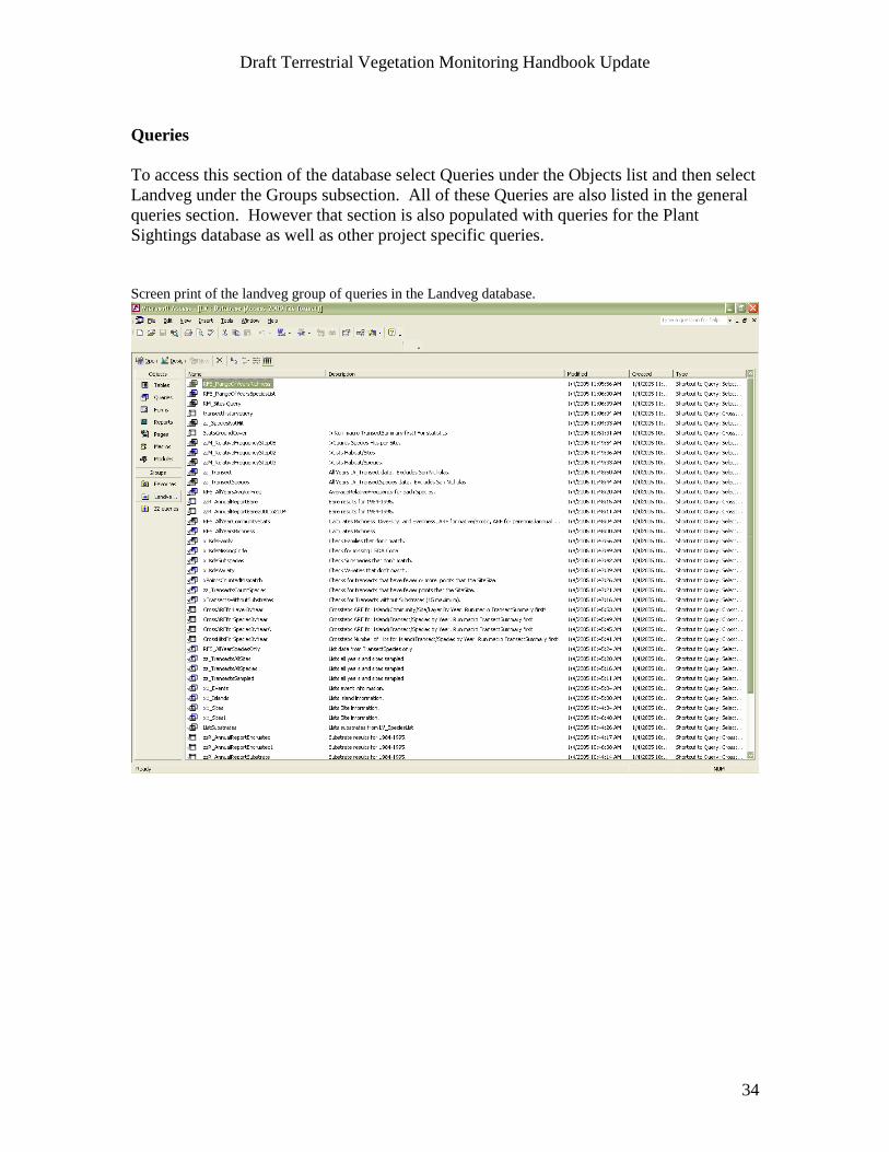
To access this section of the database select Queries under the Objects list and then select
Landveg under the Groups subsection. All of these Queries are also listed in the general
queries section. However that section is also populated with queries for the Plant
Sightings database as well as other project specific queries.
Screen print of the landveg group of queries in the Landveg database.

Draft Terrestrial Vegetation Monitoring Handbook Update
35
Query table design view
Open up a particular query by double clicking on it. To refine the amount of data shown
prior to opening the query, click once on the query of interest and then click on the design
button above the Objects list. Type in the criteria of interest under the appropriate field
heading. For example, to limit that data shown to one island, in the criteria section under
the field heading of island type in SR and hit enter. When you open up the query in the
table view only data collected for Santa Rosa Island will be displayed. To further limit
the data shown to one or more transects, type in the transect number in the criteria section
under the Sitecode field heading. To limit the query to a particular year, type in the year
of interest in the criteria section of the year column.
Screen print of a query design view

Draft Terrestrial Vegetation Monitoring Handbook Update
36
Reports Section
Presentation of the vegetation data in an appropriate form for the annual report is
generated in this section. Pre-designed charts presenting community diversity,
community richness, and community evenness are generated in this section as well.
Screen print of the Reports section of the Landveg database.

Draft Terrestrial Vegetation Monitoring Handbook Update
37
Appendix C: Sample field data sheets
Electronic Field Form
LV Data Form # 1 Photo #s: none
Island: SRI Date: 10 May 2003 Transect #: 46
Spp. ID by: D. Rodriguez Data Recorded by: J. Johnstone
Comments: Additional spp. within 1 meter: MEIN, DAPU
Lowest Highest
L (cm) Point # Substrate Sp 1 Sp 2 Sp 3 Sp 4 Sp 5 Sp 6 Max Ht.
30 1 litt brdi 14
60 2 litt ceme brdi 20
90 3 litt ceme isme brdi 21
120 4 litt isme brdi 20
150 5 litt brdi ceme 35
180 6 litt brdi 20
210 7 litt hobr brdi 16
240 8 litt isme brdi 25
270 9 litt brdi isme hobr 21
300 10 litt mepo jume brdi hobr 25
330 11 litt mepo brdi 25
360 12 litt brdi 2
390 13 litt brdi avba 20
420 14 litt brdi 24
450 15 litt brdi 5
480 16 litt brdi 22
510 17 litt brdi 30
540 18 litt brdi 20
570 19 litt brdi 30
600 20 litt brdi 20
630 21 litt brdi 5
660 22 litt brdi 2
690 23 litt brdi jume 14
720 24 litt brdi ceme avba jume 31
750 25 litt jume brdi 6
780 26 litt brdi ceme hobr 7

Draft Terrestrial Vegetation Monitoring Handbook Update
38
810 27 litt brdi hobr jume avba 5
840 28 litt xxxx 0
870 29 litt brdi 1
900 30 litt brdi 15
930 31 litt mepo brdi avba 45
960 32 litt brdi 16
990 33 litt brdi 5
1020 34 litt mepo brdi 20
1050 35 litt brdi 26
1080 36 litt brdi 22
1110 37 litt brdi mepo 6
1140 38 litt mepo brdi 15
1170 39 litt brdi 20
1200 40 litt brdi 20
1230 41 litt ceme brdi 20
1260 42 litt brdi avba 35
1290 43 litt brdi avba 40
1320 44 litt brdi 17
1350 45 litt ceme brdi 15
1380 46 litt brdi avba 29
1410 47 litt ceme avba 10
1440 48 litt ceme avba 24
1470 49 litt brdi avba 40
1500 50 litt avba 25
1530 51 litt ceme brdi avba 36
1560 52 litt avba brdi 21
1590 53 litt brdi 16
1620 54 litt sima brdi avba 25
1650 55 litt brdi napu 17
1680 56 litt napu avba 36
1710 57 litt mepo 5
1740 58 litt ceme brdi 11
1770 59 litt brdi avba 55
1800 60 litt brdi avba 40
1830 61 litt ceme avba 30
1860 62 litt ceme hobr avba 30
1890 63 litt avba 31
1920 64 litt avba 40
1950 65 litt brdi avba 45
1980 66 litt avba 25
2010 67 litt avba 25
2040 68 litt brdi avba 35
2070 69 litt avba 30
2100 70 litt brdi avba 37
2130 71 litt ceme brdi 20
2160 72 litt brdi avba 35

Draft Terrestrial Vegetation Monitoring Handbook Update
39
2190 73 litt brdi avba 40
2220 74 litt brdi 17
2250 75 litt ceme brdi 15
2280 76 litt brdi avba 29
2310 77 litt ceme avba 10
2340 78 litt ceme avba 24
2370 79 litt brdi avba 40
2400 80 litt avba 25
2430 81 soil xxxx 0
2460 82 litt sool brho brdi 11
2520 84 litt mepo brdi 10
2550 85 litt brdi 10
2580 86 litt brdi avba 35
2610 87 litt brdi 2
2640 88 soil xxxx 0
2670 89 litt brdi 17
2700 90 litt xxxx 0
2730 91 litt ceme brdi avba 36
2760 92 litt avba brdi 21
2790 93 litt brdi 16
2820 94 litt sima brdi avba 25
2850 95 litt brdi napu 17
2880 96 litt napu avba 36
2910 97 litt mepo 5
2940 98 litt ceme brdi 11
2970 99 litt brdi avba 55
3000 100 litt brdi avba 40

Draft Terrestrial Vegetation Monitoring Handbook Update
40
Appendix D: Vegetation Transect Site Descriptions
This appendix contains specific information on each monitoring transect including site
descriptions, common species recorded at each site, and detailed maps for finding the
marker stakes at each site. An island-wide map precedes the transect site descriptions for
each island to provide general locations.