the almeria-nijar basin
TRANSCRIPT

The Almeria-Nijar Basin
Geological Features

Juan C. Braga - José M. Martín
23
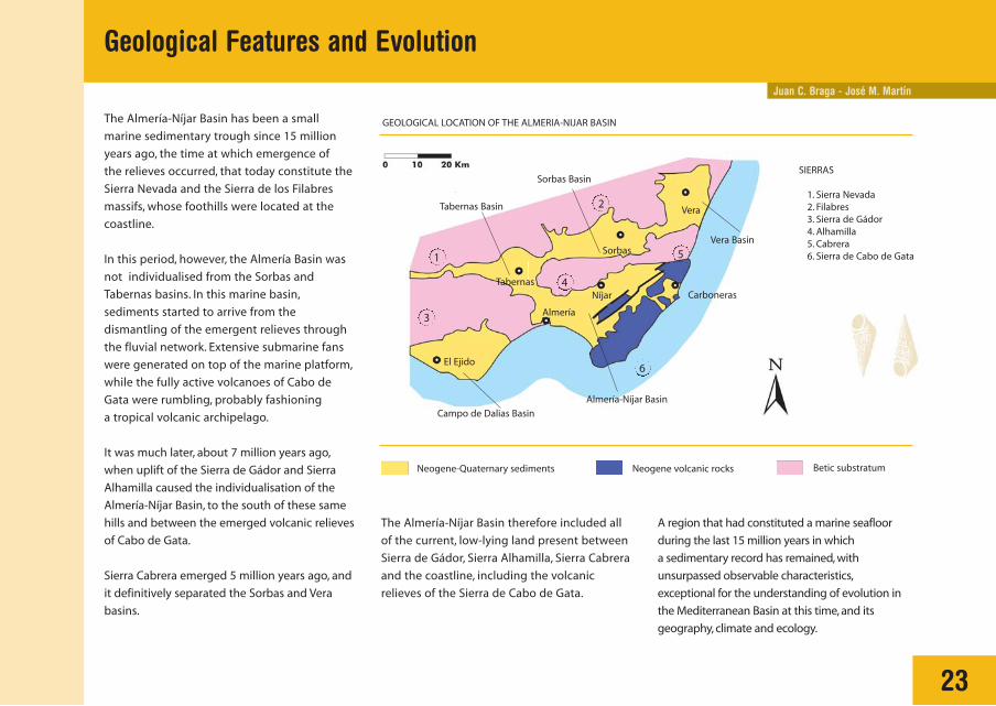
The Almería-Níjar Basin has been a small
marine sedimentary trough since 15 million
years ago, the time at which emergence of
the relieves occurred, that today constitute the
Sierra Nevada and the Sierra de los Filabres
massifs, whose foothills were located at the
coastline.
In this period, however, the Almería Basin was
not individualised from the Sorbas and
Tabernas basins. In this marine basin,
sediments started to arrive from the
dismantling of the emergent relieves through
the fluvial network. Extensive submarine fans
were generated on top of the marine platform,
while the fully active volcanoes of Cabo de
Gata were rumbling, probably fashioning
a tropical volcanic archipelago.
It was much later, about 7 million years ago,
when uplift of the Sierra de Gádor and Sierra
Alhamilla caused the individualisation of the
Almería-Níjar Basin, to the south of these same
hills and between the emerged volcanic relieves
of Cabo de Gata.
Sierra Cabrera emerged 5 million years ago, and
it definitively separated the Sorbas and Vera
basins.
Geological Features and Evolution
GEOLOGICAL LOCATION OF THE ALMERIA-NIJAR BASIN
Neogene-Quaternary sediments
SIERRAS
1. Sierra Nevada2. Filabres3. Sierra de Gádor4. Alhamilla5. Cabrera6. Sierra de Cabo de Gata
Neogene volcanic rocks Betic substratum
The Almería-Níjar Basin therefore included all
of the current, low-lying land present between
Sierra de Gádor, Sierra Alhamilla, Sierra Cabrera
and the coastline, including the volcanic
relieves of the Sierra de Cabo de Gata.
A region that had constituted a marine seafloor
during the last 15 million years in which
a sedimentary record has remained, with
unsurpassed observable characteristics,
exceptional for the understanding of evolution in
the Mediterranean Basin at this time, and its
geography, climate and ecology.
1
2
3
4
5
6El Ejido
Almería
Sorbas
Níjar
Vera
Vera Basin
Sorbas Basin
Almería-Níjar Basin
Tabernas Basin
Campo de Dalias Basin
CarbonerasTabernas

Geological Features and Evolution
24
SIMPLIFIED GEOLOGICAL MAP OF THE ALMERIA BASIN
Sierra de Gádor
Sierra de Alhamilla
Sierra
de C
abo de G
ata
Níjar
Almería
Sª Alhamilla
Old Quaternary terrain(Pleistocene: 1.8 Ma to 10,000 yrs)
Recent Quaternary (Holocene) formations, from 10,000 years agoto present
Pliocene terrain (5.2 to 1.8 Ma) Fluvial deposits
Alluvial fans
Littoral barries and/or fringes
Albuferas(saltpans)
Travertines
Dunefields
Deltas
Miocene terrain (23.7 to 5.2 Ma)
Miocene volcanicformations (15.7 to 7.9 Ma)
Ancient basement
Sª Alhamilla
Níjar Pozo de Los Frailes
Alquián
Sea level
Sea level
Cabo de GataRoquetas de mar
According to Zazo and J. L. Goy

MAGMAS AND MAGMATIC ROCKS
Magmas are formed through the partial melting
and emplacement of rocks at high temperature
in the interior of the Earth. They consist of a
mixture of liquid, dissolved gases (water vapour
and carbon dioxide) and minerals.
Magmas that come directly from the partial
melting of rocks at depth are called primary
magmas. Sometimes they reach the surface
straight away, however, it is more common that
they remain static at different levels within
the mantle and the continental crust, forming
magmatic chambers. In such a situation the
magmas may partly crystallize, assimilate
the country rock and suffer other modifications,
the final result of which is a series of derived
magmas of different compositions. This process
is known as magmatic differentiation.
Magmas are generally less dense than the
material within which they are forming, and,
therefore, they tend to climb up through the
mantle and continental crust, until they cool and
crystallize, giving place to intrusive rocks.
Magmas that solidify slowly underneath the
terrestrial surface form bodies of intrusive
rocks. Cooling happens very slowly, so that the
minerals may crystallise in an ideal manner,
creating rocks with large-sized crystals such as
granites.
When the magma reaches the surface, it gives
way to volcanic or eruptive activity. The results
are volcanic rocks and so-called volcanic
features. Cooling is very rapid, so that the rocks
do not crystallise well, forming a vitreous
matrix or a very fine crystal size. Within this
VOLCANIC EPISODES Origin of magmatic processes and volcanic features
MELTING OF PRIMARYMAGMAS
matrix a proportion of small minerals of larger
size (phenocrysts) may be present, which had
crystallised previously in the magma chamber.
At times, during its ascent, the magma is
injected into fissures, forming dykes. These are
also known as hypabyssal rocks.
Parasitic cone Main cone
Lava flow
Plutonic rocks
Dykes
Derivedmagma
Partial meltingof the crust
CRUST
MANTLE
Magmachamber
25
Juan M. Fernández

MAGMAS AND PLATE TECTONICS
Although there are a great variety of types
and compositions of magmas, the three most
important generic types are the basaltic group
(or basic, 50% of silica), the siliceous group
(or acid, 65 to 70% of silica), and the andesitic
group (or intermediate) such as those of Cabo
de Gata.
The origin of magma is related to the dynamics
of the lithospheric plate margins:The majority of
basaltic magmas originate through partial
melting of the mantle in divergent plate
boundaries (mid-oceanic ridges). Andesitic and
siliceous magmas are generated in subduction
zones by partial melting of both the oceanic plate
and the continental crust.
The origin of Cabo de Gata volcanism is
complex, and under discussion at present.
In whatever case, it is related with the orogenic
process of crustal thickening in this area,
the Alborán domain, due to the collision of the
African and European plates; and afterwards
their thinning through phenomena of
extensional or transtensional character.
Island arc Trench Trench Rift valley
CONTINENTAL CRUST OCEANIC CRUST
Plateaubasalts
Lithosphericmantle
Continentalcrust
Oceaniccrust Upper mantle
(asthenosphere)
Mid-oceanic ridge
26
Origin of magmatic processes and volcanic features

27
ACTIVITY AND VOLCANIC FEATURES
The type of eruption and the products resulting
from volcanic activity depend, above all, on two
important aspects: the viscosity of the lava,
which determines fluidity, and the gas content
of the lava.
Basaltic magmas, poor in silica, are fluid. At the
surface they flow rapidly, forming lava flows
that at times travel great distances (this type of
volcanism is known as effusive). If the basaltic
lava is rich in gas, it is released with ease by
means of intermittent explosions, creating
pyroclastic types of cone (also known as cinder
cones). The alternation of lava flows and
pyroclastic episodes fashions another type of
volcanic edifice known as the Stratocone
volcano.
Acidic magmas, on the other hand, rich in
silica, are much more viscous. Upon exiting
onto the surface, they cannot flow easily, and
form accumulations around the eruptive
mouth (domes), or flow very slowly forming
lava flows over short distances (this type of
volcanism is called extrusive).
BASALTIC MAGMAS
ACIDIC MAGMAS
PYROCLASTIC CONE OR CINDER CONE STRATOCONELava flows
Pyroclasticlevels
Pelean Dome Cumulate Dome Crypto-dome
DOMES OF SILICEOUS MAGMA
SOME TYPES OF DOME
Origin of magmatic processes and volcanic features
Origin of magmatic processes and volcanic structures
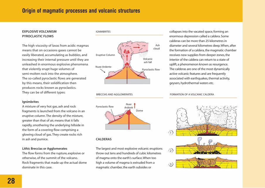
EXPLOSIVE VOLCANISM
PYROCLASTIC FLOWS
The high viscosity of lavas from acidic magmas
means that on occasions gases cannot be
easily liberated, accumulating as bubbles, and
increasing their internal pressure until they are
unleashed in enormous explosive phenomena
that violently erupt huge volumes of
semi-molten rock into the atmosphere.
The so-called pyroclastic flows are generated
by this means, their solidification then
produces rocks known as pyroclastics.
They can be of different types:
Ignimbrites
A mixture of very hot gas, ash and rock
fragments is launched from the volcano in an
eruptive column. The density of the mixture,
greater than that of air, means that it falls
rapidly, smothering the underlying hillside in
the form of a covering flow comprising a
glowing cloud of gas. They create rocks rich
in ash and pumice.
Lithic Breccias or Agglomerates
The flow forms from the rupture, explosive or
otherwise, of the summit of the volcano.
Rock fragments that made up the actual dome
dominate in this case.
CALDERAS
The largest and most explosive volcanic eruptions
throw out tens and hundreds of cubic kilometres
of magma onto the earth's surface.When too
high a volume of magma is extruded from a
magmatic chamber, the earth subsides or
collapses into the vacated space, forming an
enormous depression called a caldera. Some
calderas can be more than 25 kilometres in
diameter and several kilometres deep.When, after
the formation of a caldera, the magmatic chamber
receives new supplies from deeper zones, the
interior of the caldera can return to a state of
uplift, a phenomenon known as resurgence.
The calderas are one of the most dynamically
active volcanic features and are frequently
associated with earthquakes, thermal activity,
geysers, hydrothermal waters etc.
28
IGNIMBRITES
BRECCIAS AND AGGLOMERATES FORMATION OF A VOLCANIC CALDERA
Ashcloud
Nuee Ardente Pyroclastic flow
Pyroclastic flow Nuee
Ardente Dome
Eruptive Column
Volcanicash fall
1
2
3
Juan M. Fernández
29
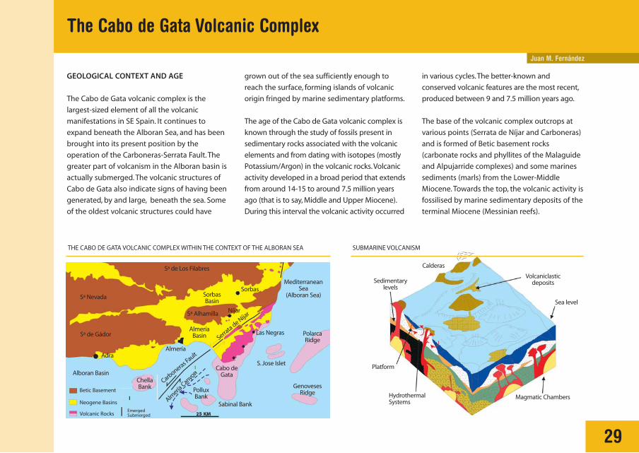
GEOLOGICAL CONTEXT AND AGE
The Cabo de Gata volcanic complex is the
largest-sized element of all the volcanic
manifestations in SE Spain. It continues to
expand beneath the Alboran Sea, and has been
brought into its present position by the
operation of the Carboneras-Serrata Fault. The
greater part of volcanism in the Alboran basin is
actually submerged. The volcanic structures of
Cabo de Gata also indicate signs of having been
generated, by and large, beneath the sea. Some
of the oldest volcanic structures could have
grown out of the sea sufficiently enough to
reach the surface, forming islands of volcanic
origin fringed by marine sedimentary platforms.
The age of the Cabo de Gata volcanic complex is
known through the study of fossils present in
sedimentary rocks associated with the volcanic
elements and from dating with isotopes (mostly
Potassium/Argon) in the volcanic rocks.Volcanic
activity developed in a broad period that extends
from around 14-15 to around 7.5 million years
ago (that is to say, Middle and Upper Miocene).
During this interval the volcanic activity occurred
The Cabo de Gata Volcanic Complex
in various cycles.The better-known and
conserved volcanic features are the most recent,
produced between 9 and 7.5 million years ago.
The base of the volcanic complex outcrops at
various points (Serrata de Níjar and Carboneras)
and is formed of Betic basement rocks
(carbonate rocks and phyllites of the Malaguide
and Alpujarride complexes) and some marines
sediments (marls) from the Lower-Middle
Miocene. Towards the top, the volcanic activity is
fossilised by marine sedimentary deposits of the
terminal Miocene (Messinian reefs).
Betic Basement
Alboran Basin
Adra
SorbasBasin
AlmeríaBasin
PolluxBank
ChellaBank
Cabo deGata
Las Negras
S. Jose Islet
PolarcaRidge
SUBMARINE VOLCANISMTHE CABO DE GATA VOLCANIC COMPLEX WITHIN THE CONTEXT OF THE ALBORAN SEA
Calderas
Sedimentarylevels
Volcaniclasticdeposits
Sea level
Magmatic Chambers HydrothermalSystems
Platform
MediterraneanSea
(Alboran Sea)
GenovesesRidge
Sabinal Bank
Almería
Sorbas
Níjar
Serrata de N
íjar
Carboneras F
ault
Almería
Canyon
Sª Alhamilla
Sª Nevada
Sª de Los Filabres
Sª de Gádor
Neogene Basins
Volcanic Rocks Emerged Submerged

30
La Serrata de Nijar is a zone of volcanic origin, associated with the Carboneras
Fault. The rocks, concealed beneath the sedimentary filling of the Campo de
Níjar, have been uplifted and project outwards at the surface of La Serrata
because they are caught up between different fractures in the fault zone.
El Cerro de Garbanzal is a unique volcanic structure, almost circular in plan,
formed by the extrusion of a massive dome-flow. The geometry of this type of
structure is known in some places as fortified domes or 'tortas'. Quite eroded,
it is preserved as a ceiling above marine sedimentary remains.
RELIEF FEATURES OF THE CABO DE GATA VOLCANIC COMPLEX
PlioQuaternary
Miocene
Basement
Volcanic Complex
Nijar-AlmeriaBasin
Serrata deNijar
Carboneras Fault
Miocene sediments
Cabo de Gata
Barronal
San José
LA ISLETA
Las Negras
Agua AmargaCarboneras Fault
Serrata de Níja
r
Mesa Roldán
Carboneras
Los lobos
RodalquilarRodalquilar
Caldera
Los FrailesCaldera
White ignimbrites Ancient massive rocks
Del Garbanzal Dome-Flow
Sierra deCabo de Gata
A
C
E
D
A
B
B
The Cabo de Gata Volcanic Complex

31
Mesa Roldan (and Los Lobos) are excellent examples of volcanic structures
fossilised by marine sedimentary rocks and crowned by terminal Miocene
coral reefs. It may be characterised by an andesitic lava dome, enclosed by
fragmented rocks (dome breccias), produced by submarine eruptions with
little or no explosiveness. Linked with the Los Frailes volcano, they are the
most recent volcanic emissions in Cabo de Gata.
The Rodalquilar Caldera, one of the most notable volcanic features, was generated
because of the collapse of the caldera floor into the underlying magma chamber in
a series of highly explosive volcanic processes, producing the deposition of various
pyroclastic rock units (ignimbrites). The later hydrothermal alteration of these rocks
gave place to the characteristic mineral deposits of this area, especially gold.
The Los Frailes Volcano formed around 8 million years ago above older rocks (more than 10-12 ma)
that extended towards the southern limit of the Sierra de Cabo de Gata. In this case, the volcanic
activity did not give place to typical central volcanoes, but to an extensive landscape of more or less
dispersed volcanic domes. Levels of fossiliferous marine sediments were deposited between the phases
of eruption of the different domes that serve as guide levels. Additionally, they produced some highly
explosive eruptive processes (ignimbrites), related to the collapse of calderas.
Volcanic Ashes Massive Nucleus
Caldera
Los Frailes Caldera Rodalquilar
Complex FrailesPyroxene Andesites
Lighthouse
White Rhyolites Amphibole Andesites
Pre-CalderaRocks
MAGMATIC CHAMBER
Rodalquilar Complex
Sediments (Messinian and Pliocene)
Dome Breccias
MessinianCarbonates Conglomerates
(reworked breccias)
D
E
C
The Cabo de Gata Volcanic Complex
RECENT SEDIMENTS
MESSINIAN CARBONATES
MIOCENE SEDIMENTS
LA SERRATA SEQUENCES
PYROXENE ANDESITES
LAS NEGRAS AND CARBONERAS SEQUENCE
ESTRADA DOME, PANIZA DOME, ETC.
GARBANZAL DOME RODALQUILAR DOME
SEDIMENTS AND ALLUVIUM ANDESITESWHITE RHYOLITES
BETIC BASEMENT
Post-VolcanicSediments
VolcanicSequences
Substratum

Juan M. Fernández
32
HYDROTHERMAL SYSTEMS
The hydrothermal systems associated with the
volcanic complex of Cabo de Gata has
generated important mineralization of
economic interest whose profits have left a
marked impression in the history and upon
the countryside of this district. Without doubt,
the most acclaimed deposits are gold from
Rodalquilar, exploited until very recent times.
Exploitation of other lesser metals has existed,
however, such as lead and zinc, copper and
manganese.
Other non-metallic mineralization of
commercial interest has also been generated in
association with this system. Bentonites are
actually the most important. Long ago the area
had benefited from alunite, a mineral
(aluminium sulphate and sodium or potassium)
that was concentrated in yellow-coloured virgin
seams cutting the white-coloured and
pulverised looking, altered volcanic rock. It has
numerous industrial applications, amongst
others it is used as a source for the production
of alum, for the tanning of leather, etc.
Hydrothermal processes are a frequent
phenomenon in volcanic areas. They are
produced when a magmatic body cannot reach
the surface, cooling slowly at hundreds of
metres or a few kilometres of depth. In these
conditions, the sub-volcanic body supplies heat
to the surrounding area, that can reach
temperatures of around 400-500 C, and emits
gases and acid-rich fluids, such as hydrochloric
or sulphurous (between 200 and 350 C).
These hydrothermal fluids rise up through the
intruded rocks, transforming them
(hydrothermal alteration) and cleaning many
chemical components out of them (lixiviation),
such as gold and many other metals that were
originally very dispersed in the rocks. Upon
arriving in more surficial zones the fluids cool
and mix with water of subterranean or marine
origin, which provokes the metals and other
Hydrothermal Alteration and Mineralization of the Volcanic Complex
disassociated components to precipitate in
fissures and fractures, forming hydrothermal
deposits, such as the famous Rodalquilar gold.
In Cabo de Gata, the main hydrothermal gold
deposits are located in the Rodalquilar complex
of calderas, associated with an intense zone of
hydrothermal alteration. This alteration zone is
produced by intrusion and cooling, beneath the
calderas, of a magmatic body. The hydrothermal
fluids carried by this body wash out the gold at
depth and utilised the various fractures existing
in the caldera to circulate and deposit the gold
in more superficial zones. The formation age of
the deposits is estimated at around 10.4 million
years.
A. GEOLOGICAL SKETCH B. HYDROTHERMAL SYSTEM
Rodalquilar Caldera
Magma Degassing from Magma
Sim
plif
ied
fro
m A
rrib
as e
t al
.,19
95
MagmaticVapours
(SO2, HCl, etc.)
MeteoricWaters
FumerolesCinto Los Tolles

33
Hydrothermal Alteration and Mineralization of the Volcanic Complex
LOCATION OF MINERALIZATION THROUGHOUT CABO DE GATA
Hydrothermal breccia of whitechalcedony with native gold(Photo Arribas).
Smelting works of Los Alemanes Nuevos, tothe west of San José, for the recovery of leadand zinc (photo J. M. Alonso).
Exploitation of alunite fromgalleries in the proximity of
Rodalquilar.Themineralization corresponds
to yellow-coloured veins(lodes).
Bluish and greenish colourationcorresponding to superficial alterationminerals of copper and lead sulphides.
Overview of typical sceneryin bentonite clays: white-coloured powdered masses,greasy to the touch and veryplastic.
Exploitation of Manganesefrom Cerro del Garbanzal.Mineralization corresponds tothe dark zone.
MINERALIZATION
El Cabo de Gata
El Barranquete
Fernán Pérez
Las Hortichuelas
Rodalquilar
Los Escullos
San José
Bentonites
Alunite
Gold
Galena and Blende
Copper
Manganese
El Pozo delos Frailes
Las Negras
Agua Amarga
La Islica
El Llano de D. AntonioCarboneras
INDUSTRIAL MINERALS
METALLIC MINERALS

Carlos Feixas
THE DISCOVERY
(End of the 19th century - 1939)
The existence of gold in the Almerian district of
Rodalquilar was casually discovered at the end
of the 19th century. Gold was detected in lead
smelting works of Cartegena and Mazarron, that
utilised quartz coming from the lead mines
of Cabo de Gata as a flux. The Mazarron smelters
sought out the gold-bearing quartz, and with its
scarce gold content they financed the cost of
transport.
In an authentic state of gold fever many
concessions were registered in this era
that gave way to a multitude of litigation that
delayed the mine consolidation throughout the
whole of the 20th century.
This first stage of discovery of gold from
Rodalquilar, and the development of the first
mines, coincided with the great Almerian
economic crisis. This involved emigration
of workers to Algeria, and subsequently to
America, a decline in lead mining and later in
iron mining, and a crisis in the grape market.
The Rodalquilar Gold
34
Old lodes economic for lead at the end of the 19th century inquartz dykes, from some of which the existence of gold wasdetected in Rodalquilar (Photo, Col. Evaristo Gil Picón). Extraction workers in the Los Ingleses Mine (around 1930)
(Photo, Col. Evaristo Gil Picón).
Ruins from the first treatment plant installed around 1915 inthe Ma Josefa mine, in El Madronal (Rodalquilar) (Photo, Col.Evaristo Gil Picon).
The English company Minas de Rodalquilar
handled a total of 107,000 tons of mineralized
rocks until 1939, obtaining 1,125.5 kg of gold.
Of these only 39 tons corresponded to the
period 1936-1939.

The Rodalquilar Gold
THE DREAM (1940-1966)
In 1940, the state decreed the seizure of the
mines, entrusting the task of investigation to
the Spanish Institute for Geology and Mining
(IGME), that looked at the old lodes that had
been exploited without favourable results. Until
1942, the date at which this seizure ended, a
total of 37 kg of gold was recovered.
At the end of 1942 the National Institute of
Industry (INI), through the Adaro National
Enterprise for Mineral Investigation (ENADIMSA),
amplified and intensified investigations,
abandoning the lodes and concentrating in the
'El Ruso’, first transport lorry for the Rodalquilar mines(around 1940) (Photo, Col. Evaristo Gil Picon).
May 1956.The head of state at that time attends the productionof one of the gold ingots, with all of the propaganda exhibitedby the regime (Photo, Col. Evaristo Gil Picón).
Drilling workers in the open cast mines opened during theENADIMSA period of exploitation (Photo, Col. Evaristo GilPicon).
Cerro del Cinto area, where mineralisation
appeared in a disseminated form in the acidic
volcanic rock body, determining a 4000 ton
mass of mineralised rock with 4.5 grams of gold
per ton.
Until 1966 Rodalquilar lived its golden dream.
Its population came to reach 1400 inhabitants.
It was furnished with infrequent services for this
time in rural populations, cinema, social club,
administration buildings, school, etc.

In the first years of activity from this period
in the order of 700 manual labourers worked in
Rodalquilar, the greater part of them dedicated
to the construction of infrastructure and
workings. At the end of this, between 200 and
300 workers were permanently involved in the
exploitation. ENADIMSA continued, in principle,
with the subterranean system of extraction
that had been emplaced by the English.
In1961, however, the first open cast workings
were undertaken in the Cerro del Cinto.
During this period the bulk of gold production
in Spain shifted to Rodalquilar, with more than
90% of the total production. However this
dream only lasted a while. Investment exerted
pressure to make new workings, and salary
rises in the 70's decade considerably increased
the production costs in a deposit already so
difficult because of the irregular distribution of
economic reserves. All of this forced the
closure of the workings in 1966.
The Rodalquilar Gold
36
REALITY (1967-1990)
The closure of the mines in 1966 put an end to
the period of splendour. A little afterwards the
population declined very abruptly to 75
inhabitants, in summary nearly identical to that
of today.
After exploitation was carried out by ENADIMSA
in the previous period, the concessions and
licences returned to their owners. Even though
investigation had been forgotten in this period,
so often realised by national mineral concerns,
including, to a greater degree, foreign ones.
This period is characterised by intensive
investigation of the Rodalquilar mining district,
but having emphasis on genetic models of gold
mineralisation.
In spite of all this reality prevailed, although it is
estimated that that around 3 tons of gold
reserves are awaiting recovery, their exploitation
is not possible because of the complexity of the
deposit.
Mining town of Rodalquilar (photo Evaristo Gil Picón).

Juan C. Braga - José M. Martín
37
SEDIMENTARY BASINS IN THE VOLCANIC ARCHIPELAGOSedimentary Episodes
From the first volcanic episodes and
subsequent to the last, the sea invaded the
volcanic relieves generating an extensive
archipelago. In the marine basins between
volcanic relieves marine sedimentary
deposits were produced. Five sedimentary
episodes can be recognised:
1. In an early episode sediments were
deposited upon the first volcanic rocks.
Their age is Lower Tortonian (between
9 and 8.7 million years). They are mainly
bioclastic carbonates.
2. In a second phase sediments formed above
rocks of the last volcanic event. Their age is
Upper Tortonian to Messinian (between
5.5 and 6.5 million years ago). They are also
bioclastic carbonates, and marls, that
accumulated in deeper zones.
3. Above the previous episode, a series of
related units characterised by the presence
of reef bodies were deposited. Their age is
Messinian (around 6 million years old).
Neogene Sediments
Sierra de Filabres
Sierra de Gádor
Alhamilla
Almería
Níjar
Sorbas
Vera
Cabrera
Betic Substratum
TERTIARY BASINS IN THE SOUTHEASTERN PENINSULA GEOLOGICAL MAP OF THE CABO DE GATA AREA
Neogene Volcanic Rocks
Carboneras
Fernán Pérez
Cabo de Gata
San José
Rodalquilar
Las Negras
Carboneras
Serrata
Almería BasinCabo de Gata
Key in the following page >>>

4. After the deposition of the reefs a
phenomenon known as the Mediterranean
Messinian Salinity Crisis took place.The
Mediterranean dried out 5.5 million years ago
as a consequence of its disconnection with the
Atlantic. During this period material around
the borders underwent partial erosion and in
the central area of the large Mediterranean
Basin, and in its marginal basins, important
38
thicknesses of gypsum and other salts were
deposited. Above these, or above the eroded
surface, carbonate sediments typical of warm
seas were deposited: oolites and stromatolites.
5. A last marine episode that passes into
continental deposition half way through
(in the Pliocene, between 5 and 2 million
years ago).
SEDIMENTARY EPISODES
STRATIGRAPHY OF THE CABO DE GATA AREA
1º
2º
3º
4º
5º
Undifferentiated Recent detritus
Conglomerates
Bioclastic Sands
Marl, Mud and Sand
Calcareous Breccia
Carbonates with oolites and stromatolites
Gypsum
Sierra Cabrera Cabo de Gata
PLIO
CEN
EM
ESSI
NIA
NTO
RTO
NIA
N
Mill
ion
s o
f yea
rs
Coastal reefs
Bioherms, patch reefs
Reef Blocks, slumps
Marls, at times with intercalated diatomites or calci-turbidites
Bioclastic carbonates, locally volcaniclastic conglomerates
Volcanic rocks of around 8 million years old
Bioclastic carbonates, locally volcaniclastic conglomerates
Volcaniclastic rocks more than 9 million years old or undifferentiated
Betic Substratum: Micaschists, Quartzites, Dolomites, Amphibolites, etc
QUATERNARY
Sedimentary Episodes
Juan C. Braga - José M. Martín
39
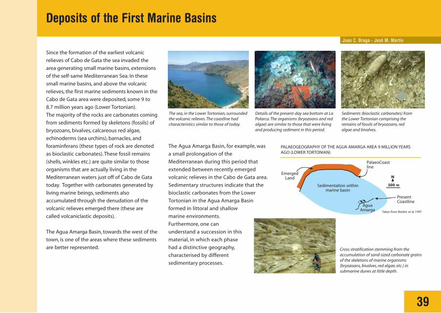
Deposits of the First Marine Basins
Since the formation of the earliest volcanic
relieves of Cabo de Gata the sea invaded the
area generating small marine basins, extensions
of the self-same Mediterranean Sea. In these
small marine basins, and above the volcanic
relieves, the first marine sediments known in the
Cabo de Gata area were deposited, some 9 to
8.7 million years ago (Lower Tortonian).
The majority of the rocks are carbonates coming
from sediments formed by skeletons (fossils) of
bryozoans, bivalves, calcareous red algae,
echinoderms (sea urchins), barnacles, and
foraminferans (these types of rock are denoted
as bioclastic carbonates). These fossil remains
(shells, winkles etc.) are quite similar to those
organisms that are actually living in the
Mediterranean waters just off of Cabo de Gata
today. Together with carbonates generated by
living marine beings, sediments also
accumulated through the denudation of the
volcanic relieves emerged there (these are
called volcaniclastic deposits).
The Agua Amarga Basin, towards the west of the
town, is one of the areas where these sediments
are better represented.
The sea, in the Lower Tortonian, surroundedthe volcanic relieves. The coastline hadcharacteristics similar to those of today.
Details of the present-day sea bottom at LaPolarca. The organisms (bryozoans and redalgae) are similar to those that were livingand producing sediment in this period.
Sediments (bioclastic carbonates) fromthe Lower Tortonian comprising theremains of fossils of bryozoans, redalgae and bivalves.
The Agua Amarga Basin, for example, was
a small prolongation of the
Mediterranean during this period that
extended between recently emerged
volcanic relieves in the Cabo de Gata area.
Sedimentary structures indicate that the
bioclastic carbonates from the Lower
Tortonian in the Agua Amarga Basin
formed in littoral and shallow
marine environments.
Furthermore, one can
understand a succession in this
material, in which each phase
had a distinctive geography,
characterised by different
sedimentary processes.
Cross stratification stemming from theaccumulation of sand-sized carbonate grainsof the skeletons of marine organisms(bryozoans, bivalves, red algae, etc.) insubmarine dunes at little depth.
Taken from Betzler et al. 1997
EmergedLand
AguaAmarga
PresentCoastline
PalaeoCoastline
Sedimentation withinmarine basin
PALAEOGEOGRAPHY OF THE AGUA AMARGA AREA 9 MILLION YEARSAGO (LOWER TORTONIAN)

Juan C. Braga - José M. Martín
40
The Re-initiation of Sedimentation After the Last Volcanic Episode
The last volcanoes in the Cabo de Gata area
were active between 8.7 and 7.5 million years
ago. In this period the domes of some of the
most characteristic relieves of the Natural Park
were formed, like those of the upper part of
Los Frailles, the Cerise de Lobos and Mesa de
Roldan. The extrusion of volcanic material
broke through the older sedimentary rocks in
some places, enclosing blocks within some of
the lavas.
On top of these new volcanoes, and on
occasions on top of older rocks, towards the
end of the Tortonian geological stage, around
7 million years ago, a shallow marine platform
was initiated that marked a renewed incursion
of the Mediterranean around the archipelago
of small islands generated by the volcanic
activity. In this shallow marine environment
mostly carbonate sediments formed from the
remains of marine fossils that were deposited,
for which reason they are called bioclastic
carbonates.
Volcanic eruptions fragmented the sedimentary rocks from the lower episode (Lower Tortonian), light pinkmaterial in the photo, and enveloped them in lavas, dark material in the photo.
Present-day marine bottom in Cabo de Gata. Theorganisms present (bryozoans, bivalves and red algae),are the carbonate producers, that accumulate on thebottom generating carbonate sediment.
Upper Tortonian bioclastic carbonates comprising thefossil remains of bryozoans, bivalves and red algae.
41
The Re-initiation of Sedimentation After the Last Volcanic Episode
Stratification and cross-lamination typicalof beach depsoits.
Sheeted fans in the Rambla de los Viruegas.Trough stratification typical of submarinedunes in shoals.
Accumulations of the remains of organismsthat produce carbonates.
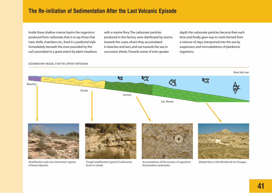
Inside these shallow marine basins the organisms
produced from carbonate, that is to say those that
have shells, chambers etc., lived in a preferred style
immediately beneath the zone pounded by the
surf, associated to a great extent by plant meadows
with a marine flora.The carbonate particles
produced in this factory were distributed by storms
towards the coast, where they accumulated
in beaches and bars, and out towards the sea, in
successive sheets.Towards zones of even greater
depth the carbonate particles became finer each
time and, finally, gave way to marls formed from
a mixture of clays, transported into the sea by
suspension, and microskeletons of planktonic
organisms.
Beaches
Shoals
Factory
Nivel del mar
Fan Sheets
SEDIMENTARY MODEL FOR THE UPPER TORTONIAN

Juan C. Braga - José M. Martín
42
Messinian Reefs
CORAL REEFS
Some 6 million years ago, in the Messinian
geological stage, and after deposition of the
temperate carbonates and marls described
previously, an increase in the water
temperature allowed the formation of coral
reefs in the SE Peninsula and, particularly, in
the Cabo de Gata region. At the present day,
coral reefs live in waters of little depth in
intertropical latitudes, where the average
winter water temperature does not fall under
20º C. In these sites huge volumes of rock and
sediment are constructed by means of their
calcareous skeletons. The presence of reefs in
our region indicates that, in the period of their
formation, the water was warmer than in the
modern Mediterranean.
In Cabo de Gata the coral reefs formed on top
of or around the volcanic relieves.
Some of the most characteristic places within
the Natural Park are found to be the reefs of
Cerro de Los Lobos, la Molata de Las Negras,
La Higueruela and Mesa de Roldan. These
relieves were islands or high sea bottoms that
were colonised by coral reefs and could be
completely covered or surrounded by reefs.
Reefs constructed from coral (light tones in the photo), fringing islands of volcanic origin in modern seas, aswould have happened 6 million years ago in Cabo de Gata.
Calcareous corals that presently live in the tropics arethe constructors of reefs.
In Mesa Roldán, 6 million years ago, a coral reef fringedand covered a volcanic dome (dark tone).
Coral reef
Volcanic Dome

Juan C. Braga - José M. Martín
43
Evaporites and Carbonates After the Recovery of the Mediterranean
In certain sectors of Cabo de Gata such as
La Molata de las Negras, Mesa Roldan and
others, above the last reefal episode an
erosion surface is observed that affects
the reef and removes the greater part of its
deposits. This erosion surface is the
expression of Messinian desiccation in
this part of the Mediterranean, known as the
Salinity Crisis.
Its age is approximately 5.5 million years
(Terminal Messinian). In effect, around this
time the Mediterranean dried-up, by closing
the communication between the Atlantic
and the Mediterranean, therefore removing
the entry of water from the former. During
this period, the reefs around the border
remained exposed to erosion, and in
the central sectors, as much in
the main marine basin, the
Mediterranean, as in the small
marginal basins that
communicated with it, like
that of Sorbas or Almería,
important massive deposits of
gypsum were formed.
Situation prior to deposition of the evaporites,with formation of reefs in the margins andmuddy-marly sediments in the basin.
Deposition of evaporites in the centre of theMediterranean while it is disconnected from theAtlantic and dries out.
Deposition of evaporites in the interior ofmarginal basins as they are being invaded bythe first pools of water in the process ofMediterranean reflooding.
SEDIMENTARY INTERPRETATION FOR THE GYPSUM IN A MEDITERRANEAN CONTEXT
Coastal reef
Normal Salinity Desiccation
Erosion Sill Marginal Basin
GypsumPrecipitation
Gypsum andother evaporites
5.9 Ma bp (5.5 Ma bp)
Field view ofgypsum banks.
Following deposition of the gypsum, both above this level and on top of the erosion surface
that reached the reefs, a sedimentary deposit formed fundamentally by carbonates with
stromatolites and oolites can be identified.
The oolites are particularly spherical, with an internal structure of concentric calcium carbonate
layers.
Field view ofstromatolitesfeatures, withtheir typicallaminarstructure.

J. Baena - C. Zazo - J. L. Goy - C. J. Dabrio
44
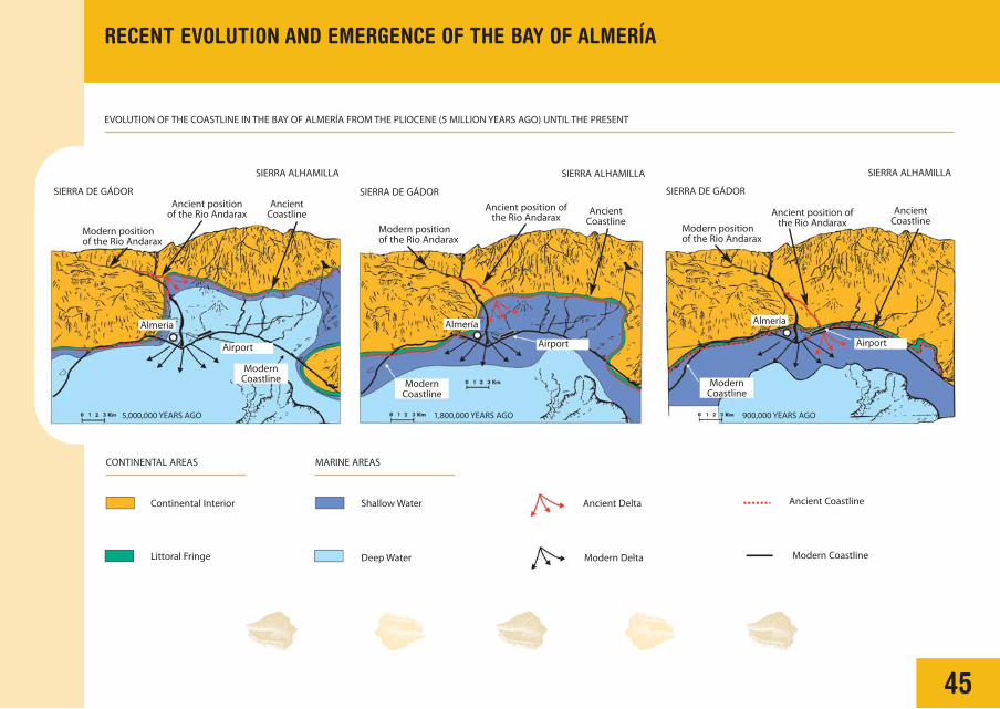
RECENT EVOLUTION AND EMERGENCE OF THE BAY OF ALMERÍA
The Bay of Almería and Andarax Valley, Campo
de Níjar and area of Roquetas del Mar
surrounding it, made up a large sedimentary
basin during the Pliocene and Quaternary (since
5.2 million years ago), with material mostly
deposited in a marine environment.
At the start of the Pliocene the sea occupied all
of the present low-lying areas: in the west up
to the slope of the Sierra de Gádor, through
the Andarax Valley reaching up to the location
of Rioja and bordering the Sierra Alhamilla,
penetrating across all of the Campo de Níjar
where only the Sierra de Cabo de Gata and
parts of the Serrata de Níjar were emerged.
The Andarax River, that presently discharges
into the sea close to Almería and in a north-
south direction, was located further to the
northeast, between Rioja and Viator, during
the Pliocene.
The high relieves that bordered the
sedimentary basin were traversed by ramblas
which, as at present, provided detrital material
(blocks, pebbles, sand) to the marine basin.
During the Plio-Quaternary uplift in the region
was initiated, leading to the displacement of the
coastline in a southerly direction.
During the Quaternary, as a consequence of
repeated climatic changes, alternating cold
glacial periods and warm interglacials, the sea
level suffered strong variations that could have
been in the order of 130 metres. These
variations were responsible for continuous
changes in the position of the coastline, and for
the distribution and abundance of the different
marine and continental deposits.
In the Bay of Almería a magnificent record of
these distinctive sedimentary environments can
be observed, ranging from continental (alluvial
fans, dune systems, etc.) to littoral and
transitional (submarine deltas in ramblas,
beaches, lagoons and littoral features, etc.).
Detail of a cemented sand beach. Remainsof a typical tropical marine fauna(Strombus bubonius) indicated by thepencil. Rambla de Amoladeras.
Marine deposits of a pebble beach coveredby continental deposits with a calcareouscrust above it. Retamar.
Deep marinedeposits in the Bayof Almería.Yellowmuddylimestones, locallycalled Marls withLeprosy.
Shallowmarinecarbonatedeposits.Whitishcalcareniteswith fauna.
Detail of a cemented pebblebeach. Retamar.
45
RECENT EVOLUTION AND EMERGENCE OF THE BAY OF ALMERÍA
EVOLUTION OF THE COASTLINE IN THE BAY OF ALMERÍA FROM THE PLIOCENE (5 MILLION YEARS AGO) UNTIL THE PRESENT
Continental Interior
CONTINENTAL AREAS MARINE AREAS
Littoral Fringe
Shallow Water Ancient Delta Ancient Coastline
Deep Water Modern Delta Modern Coastline
Airport Airport
Almería Almería
Modern positionof the Rio Andarax
Modern positionof the Rio Andarax
Ancient positionof the Rio Andarax
Ancient position ofthe Rio Andarax
AncientCoastline Ancient
Coastline
ModernCoastline Modern
Coastline
SIERRA DE GÁDOR
5,000,000 YEARS AGO 1,800,000 YEARS AGO 900,000 YEARS AGO
SIERRA ALHAMILLA
SIERRA DE GÁDOR
SIERRA ALHAMILLA
Airport
Almería
Modern positionof the Rio Andarax
Ancient position ofthe Rio Andarax
AncientCoastline
ModernCoastline
SIERRA DE GÁDOR
SIERRA ALHAMILLA

46
ILLUSTRATIVE GEOLOGICAL PROFILES OF THE STRUCTURE OF THE SEDIMENTARY FILL IN THE BAY OF ALMERÍA
Quaternary Deposits (from 1.8 million years ago to Present)
Upper Pliocene Deposits(from 3 to 1.8 million years ago)
Lower Pliocene Deposits(from 5.2 to 3 million years ago)
Miocene Deposits(from 23.7 to 5.2 million years ago)
Volcanic Terrain(from 15,7 to 6,5 million years ago)
Ancient Basement
Sea Level
Sea Level
Sea Level Pozo de los Frailes
Alquián
Níjar
Sª de Gádor Almería Basin Extension ofLa Serrata
Cabo de Gata Basin Pollux Bank
Sierra de Gádor
Sierra Alhamilla
Mediterranean Sea
Cabo de Gata
Punta del Sabinar
Aguadulce
ALMERÍA
Níjar
El Alquián
SSierrade Gata
Campo d
e Níja
r
Roquetas de Mar
Bay of Almería
El Pozo de los Frailes
Almería
Sª Alhamilla
Sª Alhamilla
Pre-NeogeneSubstratum
NeogeneVolcanic Rocks
Neogene andQuaternary Basins
RECENT EVOLUTION AND EMERGENCE OF THE BAY OF ALMERÍA
The Almeria-Nijar Basin
Didactic Itinerary
CABO DE GATA-NIJARNATURAL PARK
1

A. Martín Penela
49
1. Alluvial Dynamics of Ramblas: Las Amoladeras
A broad valley floor is exhibited, usually with a low sinuosity.
Its river bed is occupied by numerous interweaved channels
and the bottom covered by sediments organised into bars
and channel deposits.Their sediments are mostly made up of
gravel-sized particles.
The channels are very mobile, and develop as furrows
that interweave amongst themselves, adjacent to the
bars, that appear as small mounds, upon which
vegetation is frequently established. The bars, of
different form and size, change their arrangement
and morphology after each flood.
The floodplain represents a portion of the river bed
that is only inundated during important floods. In it a
great part of the fine materials that were transported
in suspension can be deposited, giving rise to deposits
that favour the development of fertile soils.
THE RAMBLAS
The Rambla de las Amoladeras is a superb
example of alluvial systems in arid zones. These
river courses, usually dry, represent channels in
which currents of short duration can flow as a
direct result of precipitation, scarcely receiving
water from other sources.
The dynamics of this alluvial system are
fundamentally controlled by the climate and the
shortage of vegetation. Seasonal rains,
frequently stormy and of short duration, create
an important surface torrent, with great erosive
power, that supplies water and sediment to
theses river beds.
Channels
10/100 m0
Bars
Floodplain occupied bywater only during thelargest flood events
Channels Bars

50
FLOODS
As a result of intense storms, the dry
riverbeds in the ramblas can be
transformed, in a short time, into violent
torrents of water loaded with sludge and
detritus. These very intensive floods, sudden
and powerful, can be unduly catastrophic
and cause great destruction in agricultural
zones and to built structures, in the river
beds of the ramblas or within the same
floodplain. The large floods take place
sporadically, tied to seasonal changes or
times of rain.
1. DRY PERIOD 2. PERIOD OF STRONG FLOODS
3. PERIOD OF DIMINISHING FLOW 4. PERIOD OF SCARCE ACTIVITY
PHASES IN A FLOOD
1. Alluvial Dynamics of Ramblas: Las Amoladeras
Damage caused by a flood .
51
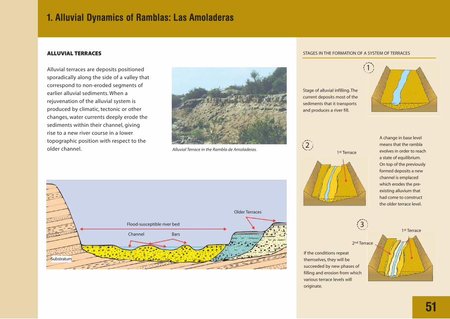
ALLUVIAL TERRACES
Alluvial terraces are deposits positioned
sporadically along the side of a valley that
correspond to non-eroded segments of
earlier alluvial sediments. When a
rejuvenation of the alluvial system is
produced by climatic, tectonic or other
changes, water currents deeply erode the
sediments within their channel, giving
rise to a new river course in a lower
topographic position with respect to the
older channel.
Flood-susceptible river bed
Older Terraces
2nd Terrace
1st Terrace
1st Terrace
BarsChannel
Substratum
Stage of alluvial infilling. The
current deposits most of the
sediments that it transports
and produces a river fill.
If the conditions repeat
themselves, they will be
succeeded by new phases of
filling and erosion from which
various terrace levels will
originate.
A change in base level
means that the rambla
evolves in order to reach
a state of equilibrium.
On top of the previously
formed deposits a new
channel is emplaced
which erodes the pre-
existing alluvium that
had come to construct
the older terrace level.
1
2
3
STAGES IN THE FORMATION OF A SYSTEM OF TERRACES
1. Alluvial Dynamics of Ramblas: Las Amoladeras
Alluvial Terrace in the Rambla de Amoladeras.

C. Zazo - J. L. Goy - C. J. Dabrio - J. Baena
52
2. Fossil Beaches of the Rambla de Las Almoladeras
The surrounding area of the Rambla de las
Amoladeras are characterised by the presence
of one of the most complete geological records
of fossil Quaternary beaches, and with the best
conditions for observation, in the Spanish
coastal zone. These marine beaches, that
fundamentally developed between the last
200,000 years and the present day, were
partially covered on the surface by a dune
system that started to form around 2500 years
ago. In the talus of the right hand margin of the
river mouth of the rambla, a mixture of deposits
consisting of well-cemented sands and pebbles
with a marine fauna can be seen, that represent
ancient beaches, and consequently, the position
of the coast at that time. Average absolute
dating (Uranium-Thorium), has obtained ages
of 180,000 years, 128-130,000 years and
95-100,000 years for the three differentiated
beach levels. All of the beaches contain fossils of
Strombus bubonius. They dominate Tyrrhenian
beaches, a name that is derived from the
Tyrrhenian Sea, for it was there that beaches
with this characteristic fauna were described for
the first time.
An interpretation of the geometry of the
outcrop allows differentiation of, from left to
right: in the first place some conglomeratic
sediments (A) corresponding to the oldest
beach, of unknown age, which contains the
remains of a fossil fauna like that which actually
lives in our coasts.
This beach is separated from those which follow
it by a deposit of cemented sand that
corresponds to a fossil dune field, that formed
when the sea descended, leaving the beach
deposits emerged and dried out, such that it
allowed the wind to accumulate sand.
The following deposits (B, C and D) consist of
cemented conglomerates rich in Strombus
bubonius. The separation between the distinct
beaches consists of erosive surfaces, generated
during falling sea level in the coldest periods.

53
2. Fossil Beaches of the Rambla de Las Almoladeras
Each position of the coastline has left behind an associated fossil beach level. In the river mouth outcrop of the Rambla de las Almoladeras, four superimposed fossil beach levels can be observed
with ages of more than 250000, 180000, 128000 and 95000 years, respectively.The latter three levels contain the remains of a marine mollusc (Strombus bubonius), that still persists in modern
tropical coasts, so that a warm, almost tropical, climatic character existed in the coast during these stages.
Fault planes Modern Beach
Sea Level
Modern Beach
Sea Level
Modern Dunes
Well
Dunes
NESO
Rambla Amoladeras
95.000 years 128.000 years 180.000 years >250.000 years
ACTUAL SECTION
INTERPRETED SECTION
SurgeChannels/Grooves
Beach Level Fault Planeor Wall
Fosil dune
D
C BA
54
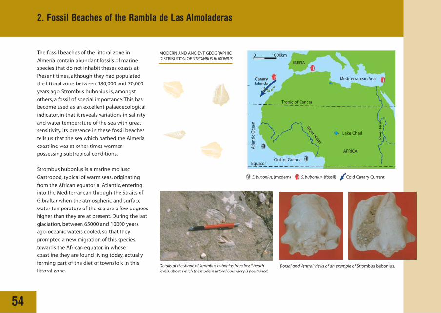
The fossil beaches of the littoral zone in
Almería contain abundant fossils of marine
species that do not inhabit theses coasts at
Present times, although they had populated
the littoral zone between 180,000 and 70,000
years ago. Strombus bubonius is, amongst
others, a fossil of special importance. This has
become used as an excellent palaeoecological
indicator, in that it reveals variations in salinity
and water temperature of the sea with great
sensitivity. Its presence in these fossil beaches
tells us that the sea which bathed the Almería
coastline was at other times warmer,
possessing subtropical conditions.
Strombus bubonius is a marine mollusc
Gastropod, typical of warm seas, originating
from the African equatorial Atlantic, entering
into the Mediterranean through the Straits of
Gibraltar when the atmospheric and surface
water temperature of the sea are a few degrees
higher than they are at present. During the last
glaciation, between 65000 and 10000 years
ago, oceanic waters cooled, so that they
prompted a new migration of this species
towards the African equator, in whose
coastline they are found living today, actually
forming part of the diet of townsfolk in this
littoral zone.
MODERN AND ANCIENT GEOGRAPHIC DISTRIBUTION OF STROMBUS BUBONIUS
Details of the shape of Strombus bubonius from fossil beachlevels, above which the modern littoral boundary is positioned.
Dorsal and Ventral views of an example of Strombus bubonius.
Mediterranean Sea
Tropic of Cancer
0 1000km
Gulf of Guinea Equator
S. bubonius, (modern) S. bubonius, (fóssil) Cold Canary Current
Lake Chad
CanaryIslands
ÁFRICA
IBERIA
Atl
anti
c O
cean
Riv
er N
ile
River Niger
2. Fossil Beaches of the Rambla de Las Almoladeras

C. Dabrio - J. L. Goy - J. Baena - C. Zazo
55
3. The Dune System in the River Mouth of Rambla Morales
FORMATION AND DEGRADATION OF THE DUNE SYSTEMS OF CABO DE GATA
Sea level
Active beach Strombus bubonius
FossilPleistocene beaches
Strombus bubonius
Westerly Winds
Sea level
Primary dune system Holocene active beach
2nd active beach episode
Modern active beach
Second dune system
111
11
11
1 12
222
21
23
1
1
On top of the fossil beaches and dunes, the first active beach
of Holocene (less than 10,000 years old) is deposited (1).
A slight fall of sea level leaves the beach, slightly more
extended, under the effects of erosion by westerly winds, that
carry along the finest elements (sand) in the form of a train of
dunes (primary system).
A new rise in sea level deposits another beach episode (2)
above the previous erosional surface. Dunes continue
advancing.
Another rapid fall in sea level causes a repetition of the same
phenomenon which forms a new train of dunes (2nd system), that
advances mixing with the previous one.
Finally the last rapid rise in sea level
emplaces the modern beach (3). The dunes
advance, but they have been disappearing
due to intensive quarrying of sand in order
to cover pastural land with sand.
Exploitation of these dune systems is
actually completely prohibited.
The dune systems that are observed in the
surroundings of the river mouth of the Rambla
Morales are produced by the action of westerly
winds, that lift up sand from the beaches and
transport it towards the river bed, accumulating
it around small bushes or topographic
irregularities in the surface. In this way dune
construction is initiated.
Fossil Pleistocene dunes
A B C
ED
The variation in sea level occurring in this coast
throughout the Pleistocene-Holocene has given
rise to various phases of dune formation.
The oldest dunes are cemented, the most recent
may be: semi-mobile, covered over by
vegetation, or mobile, which are those that
finally bury the earlier ones, in their advance
towards the land.

C. Dabrio - J. L. Goy - J. Baena - C. Zazo
View of the lagoon from the river mouth of the RamblaMorales. It can be observed how the present,topographically higher, littoral barrier causes a closingof the rambla, such that it impedes its normal drainageinto the sea. This situation persists up until when, in a state of high energy, the rambla breaks through thelittoral barrier nourishing the sea with sediments.
Aspect of the modern beach that forms part of thelittoral fringe which closes off the inlet of the rambla.
4. The Lagoon of Rambla Morales
56
In the river mouth of Rambla Molares a small
lagoon, with an almost permanent character,
has been created. Its origin stems from
interaction between the rambla system itself
with the beach. During two times of the year
(end of spring - start of autumn) the
phenomenon called gota fría is registered in
the Mediterranean coast, that comprises intense
and torrential rains concentrated in periods of
very short time (several days). During these
periods the ramblas transport a great quantity
of water and sediment, that is finally to be
deposited in the sea, eroded from the beaches
that previously closed off the river mouth,
showing a great capacity for cleaning out the
rambla (high energy stage).
These sediments are redistributed along the
length of the coastline, during periods of good
weather (low energy stage), by means of littoral
currents or drift currents, that in the case of the
Rambla Morales circulate in a southeasterly
direction, regenerating beaches and barriers once
more. As these beaches are topographically higher
than the bottom of the rambla, towards the land
they leave a small depression that fills up with
water from scarce rainfall that accumulates during
inter-storm periods.This water, not having the
strength of movement, remains stagnant creating
a lagoon in the river mouth of the rambla.
Aerial view of the river mouth of Rambla Morales.
Lagoon
RRiver Mouth ofthe Rambla deMorales
Closing barrier ofthe river mouth

57
4. The Lagoon of Rambla Morales
1. HIGH ENERGY STAGE 2. LOW ENERGY STAGE 3. NEW STAGE OF HIGH ENERGY
Littoral Barrier(Beach-Dunes)
Bars
Littoraldrift
Rambla Morales Sediments Sediments Sediments
Rambla
Ancient littoral barrier
Temporary lagoon
New littoral barrier
Littoraldrift
Littoraldrift
Lagoon
Lagoondeposits
Rambla
SIMPLIFIED SCHEME OF LAGOON FORMATION PROCESSES IN THE RIVER MOUTH OF THE RAMBLA MORALES

J. L. Goy - C. J. Dabrio - J. Baena - C. Zazo
Sierra
Lagoon Border
Bahada
RiverFloodplain
Rambla
Wind
Beach
Laguna
Littoral Drift
Waves
Oleaje
Cabo de GataBarrie
r Beach
Lagoon
AlluvialFan
58
THE NATURAL ALBUFERA
The modern salt pans (salinas) of Cabo de Gata
constitute a magnificent example of an
'albufera' or backshore lagoon system set up as
a Mediterranean salt pan by man. This type of
system is natural, and is generated thanks to a
depressed area at the back of the coastline,
where freshwater accumulates. It is
permanently separated from the sea by a
beach-barrier, forming mainly from sandy
sediments carried by the ramblas and
displaced along the length of the coastline by
littoral drift.
The lagoons receive hydrological supplies from
rainwater, from rivers that discharge into
them and, on occasions, from
subterranean aquifers and from
the sea itself.
The lagoon tends to fill with
sediments from diverse
sources. The most
important are provided by
the alluvial apparatus
that drain the
surrounding relieves of
the sierras. Sandy
sediments from the
beaches that wash over the barrier beach and
mud carried by the wind have less importance.
Evaporation, controlled primarily by direct
sunshine and by the wind, plays a very notable
part in the dynamics of these lagoons,
contributing effectively to their desiccation,
which is why they can be a suitable mechanism
for the manufacture of salt.
Aerial view of the active alluvial fan systems thatoriginate from the Sierra de Cabo de Gata relief. Inmany cases they behave as coalescing fans, in thatthey are laterally connected and superimposed oneupon another.
Evaporation
5. The Salt Pans (Salinas) of Cabo de Gata
Lagoon Active alluvial fans
Sierra de Gata
IDEALIZED GEOMORPHOLOGICAL SKETCH OF THE SALINAS

59
Alluvial Fans origina-ting from thesurrounding Relieves Rain
Currents Evaporation
Atmospheric Dust
Fine Sediments andSome Precipitates
Transfer of Water and Sediment
Infiltration
Sea
Depressed Area Groundwater
Older Lithified andCemented Barrier
Present Barrier
Reworked Littoral Fringe
Erosion Surface formedduring periods of Low Sea Level
A B
C ED
A schematic section of the lagoon
showing the diverse dynamic and
morphological elements.
The deposits of the lagoon (E) connect
with those of the alluvial fans (A) and
with those of the backshore part of the
beach (B) that obtains sediments
carried during large storms when
swells can spill over the barrier beach.
The model is only active, as at present,
during the periods which high sea level
is maintained that coincide with
interglacials. On the other hand, during
glaciation the sea level had remained
lower, placing the beach towards the
south. In these periods the zone could
remain subjected to the erosive action
of external agents (wind, currents, etc.),
forming an erosive surface (C).
When the lagoon and the littoral fringe
(strandplain) are active, during
interglacial periods, the beach grows
(progrades) towards the sea (D) and
a thick covering of sediments
accumulates in the lagoon (E).
View of the salinas from the south.
5. The Salt Pans (Salinas) of Cabo de Gata
Beach
Littoral Fringe
Salt Pans Albufera
Fan Cones Sierra de Cabo deGata
Lagoon
Alluvial FanSystem
IDEALIZED GEOMORPHOLOGICAL SKETCH OF THE SALINAS

60
WORKINGS OF A MARITIME SALT PAN
The natural lagoon systems like that of Cabo de
Gata have historically been utilised by man in
the extraction of salt: these are the
characteristic maritime Mediterranean salt pans.
Basically this consists of taking water from the
sea in a controlled process of evaporation, by
which means a progressive increase in salinity
is produced, until a stage of saturation and
precipitation of common salts (halite, NaCl) is
reached.
In each a circuit that consists of several
concentration pools (A, B, C) of broad extent and
little depth is established, fed directly by water
from the sea with a salinity of 36 grams per litre.
The seawater is introduced by a channel to
the first concentration pools (A), in which the
marine macrofauna is retained (fish,
gastropods,…) and a settling of (terrigenous)
material from suspension is produced.
Precipitation of calcium-magnesium carbonates
(upon increasing salinity from 36 to 140 grams
per litre) and the elimination of micro-
organisms (algae, bacteria,…) occurs in the
marine water upon achieving an intermediate
concentration (B). After this initial phase,
the water follows its path through different
concentrations (C), favouring the precipitation
of calcium sulphate (upon reaching a salinity
of 140 to 325 grams per litre). Once these
undesirable products have been taken out of
solution, the brine goes through crystallisation
EvaporationConcentrates Precipitates
Pumpor
basin
36 g/l 80 g/l 140 g/l 350 g/l 325 g/l 370 g/l
Sea
(Salinity in grams per litre)
BrineMg Cl2
A B C D
SALINISATION PROCESS
Floating salt(halite) layersformed in theabsence ofwind.
Aerial view of the salt pans from the east.The letters correspondto the identification of different areas of the salt pans referredto in the text.
(D) where the precipitation of common salt
(at 325-370 grams per litre) occurs, extracted for
storage, purification and finally sale.
AB
CD
5. The Salt Pans (Salinas) of Cabo de Gata
Juan M. Fernández
61
6. Volcanic domes of Punta Baja, El Faro and Vela Blanca
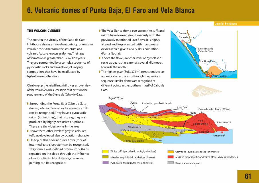
TTHE VOLCANIC SERIES
The coast in the vicinity of the Cabo de Gata
lighthouse shows an excellent outcrop of massive
volcanic rocks that form the structure of a
volcanic feature known as domes.Their age
of formation is greater than 12 million years.
They are surrounded by a complex sequence of
pyroclastic rocks and lava flows, of varying
composition, that have been affected by
hydrothermal alteration.
Climbing up the vela Blanca hill gives an overview
of the volcanic rock succession that exists in the
southern end of the Sierra de Cabo de Gata.:
◗ Surrounding the Punta Baja-Cabo de Gata
domes, white-coloured rocks known as tuffs
can be recognised. They have a pyroclastic
origin (ignimbrites), that is to say, they are
produced by highly explosive eruptions.
These are the oldest rocks in the area.
◗ Above them, other levels of greyish-coloured
tuffs are developed, also pyroclastic in character.
◗ On top of this andesitic lava flows (rock of
intermediaate character) can be recognised.
They form a well-defined promontory, that is
repeated on the slope through the influence
of various faults. At a distance, columnar
jointing can be recognised.
◗ The Vela Blanca dome cuts across the tuffs and
might have formed simultaneously with the
previously mentioned lava flows. It is highly
altered and impregnated with manganese
oxides, which give it a very dark coloration
(Punta Negra).
◗ Above the flows, another level of pyroclastic
rocks appears that extends several kilometres
towards the north.
◗ The highest peak (Bujo, 374 m) corresponds to an
andesitic dome that cuts through the previous
sequence. Similar domes are recognised at
different points in the southern massif of Cabo de
Gata.
White tuffs (pyroclastic rocks, ignimbites) Grey tuffs (pyroclastic rocks, ignimbites)
Massive amphibolitic andesites (domes) Massive amphibolitic andesites (flows, dykes and domes)
Pyroclastic rocks (pyroxene andesites) Recent alluvial deposits
White tuffs
Bujo (373 m)
Dykes Andesitic pyroclastic levels
Lava flows
FaultsCerro de vela blanca (213 m)
Punta negra
Cala Rajá
Punta Baja Dome
Alluvium
Grey tuffs Vela
Blanca Dome
Finger reef

62
VOLCANIC STRUCTURES
The dome complex of Punta Baja-El Faro-Vela
Blanca comprises several massive lava bodies
aligned in an east-west direction, probably
exploiting a fracture in this orientation as they
are extruded.
Domes are volcanic features that originated
when viscous lava, rich in silica, flowed slowly
onto the surface, and accumulated around,
solidified and plugged its own exit point.
At times the lava does not manage to exit onto
the surface, and forms an accumulation beneath
the intruded rocks, that is called a 'cryptodome'.
The complex in this area contains two principal
domes, one beneath the lighthouse and the
other at Punta Baja, in both of which a
spectacular series of characteristic volcanic
structures may be recognised:
The most pronounced is columnar jointing,
typical of massive rocks. It is produced through
the slow cooling of lava after its emplacement.
Upon cooling the volume of lava diminishes
slightly, and this contraction is accommodated
by the formation of regularly-spaced joints, in a
perpendicular arrangement with respect to the
cooling surface of the lava. The peculiar shape
of these hexagonal columns of rock, means that
they have been utilised, in this and many other
place in the Sierra de Cabo de Gata, for
obtaining paving slabs.
Other structures observed in these rocks are
lamination and flow banding. This is mostly
generated towards the margins of the domes,
and includes folds that can be formed during
the extrusion. The colour bands indicate slight
differences in the composition of the lava during
extrusion, whilst the flow lamination is produced
by resistance to flow of viscous lava around the
margins of the dome.
Country rock (white tuffs)
Nucleus
Marginal lamination
Breccia (Mónsul type) Partial emergence
Columnar jointing
Colour bands
CRYPTODOME AND ASSOCIATED STRUCTURES
6. Volcanic domes of Punta Baja, El Faro and Vela Blanca

63
White tuff at Cala Rajá, pyroclastic material (ignimbrite) in which the domes of PuntaBaja, El Faro and Vela Blanca are enclosed.
Columnar jointing in the Punta Baja dome.
Fanning of Columnar joints in Punta Baja, traditionally used for the extraction ofdecorative paving blocks.
Flow lamination on the margin of the El Faro dome in Cabo de Gata.
6. Volcanic domes of Punta Baja, El Faro and Vela Blanca

Juan M. Fernández
7. The Mónsul volcanoes
64
Mónsul inlet
Dunefield Beach
Parking
La MediaLuna inlet
Agglomerates or volcanicbreccias
Andesitic lavas withcolumnar jointing
Beaches and Dunes Debris
Feeding zone of the volcano
Sea level during the eruption
In the panorama in front, the feeder zone of
the volcano can be distinguished. It consists
of darker, andesitic lavas, and exhibits a very
characteristic structure known as columnar
jointing. These structures are produced due to
the contraction of lava upon cooling.
INTERPRETATION OF THE OBSERVED PANORAMA
RECONSTRUCTION OF GENETIC PROCESSES
TTHE MONSUL SUBMARINE VOLCANOES
The steep volcanic cliffs surrounding the area
of Mónsul consist of volcanic agglomerates
(or breccias).They are a type of rock formed from
angular blocks of (andesitic) volcanic rock, with
a diameter that ranges from millimetres to
metres, enclosed within a fine, sand-sized matrix,
also of volcanic origin.
This material takes its origin from submarine
eruptions produced around 10 to 12 million
years ago, from submerged volcanoes. The
volcanoes were located next to one another, in
a manner in which, once an explosion had
occurred, the erupted material was deposited
in stacked layers on the marine seafloor.

C. Dabrio - J. Baena - J. L. Goy - C. Zazo
65
8. The ‘barchan’ dunefield of Barronal or Mónsul
Wind carries out two fundamental processes,
erosion and accumulation, which create certain
morphological features; dunes are amongst these.
The term 'dune' is used in a broad sense to
designate the majority of accumulation features, of
sand deposits.
In the dunefields of the Almería littoral zone the
dominant types, according to their morphology in
TYPES OF DUNES IN CABO DE GATA
BARCHAN DUNES
LINEAR (SEIF) DUNES
PARABOLIC DUNES
DUNES ACCUMULATING DUE TO VEGETATION
Mónsul barchan dunefield.
Movement of sand in favour of the winddirection in the Mónsul dunefield.
VegetationCrest
Corner (horn)
Wind
Wind
Wind
Depression
Lunite
WindDune
Volcanic substratum
Leeward face Windward face
2. Migration of the Barchan and increase in size
1. Accumulation of sanddue to vegetation
Wind
plan view, are: barchans, or half-moon dunes, with
their corners or points facing in the same
direction as the wind; parabolic dunes, with the
corners (horns) facing in the opposite direction
to the wind; linear (seif ) dunes, produced when
a flat zone, with sandy material covering its floor,
exists close to a relief orientated almost
perpendicular to the dominant wind direction.
Wind
Wind

Juan M. Fernández
9. The Los Frailes Volcano
66
LOWER UNIT:
AMPHIBOLITIC ANDESITES
The lower unit of Los Frailes constitutes the
collapsed floor of a magma chamber that was
vacated during an individual or several very
intense eruptions. In these eruptions a great
volume of magmatic material left the surface
through rapid and very explosive phenomena,
and the roof of the magma chamber collapsed
giving rise to a chaotic mixture of rock
fragments, associated with dome remains and
lava flows, that constitute the most common
material in this lower unit. The explosive intervals
are marked by intervals of pyroclastic rock (tuffs)
of different types, that are found intercalated
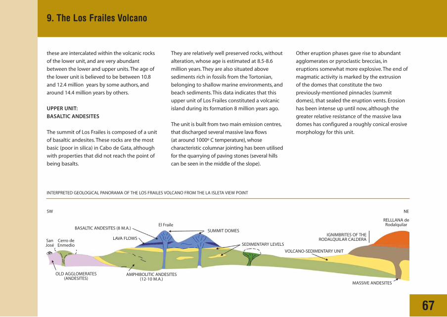
GEOLOGICAL PANORAMA OF THE LOS FRAILES VOLCANO FROM THE LA ISLETA VIEW POINT
Morrón de Mateo
SW NE
Bentonite quarries
Cerro de Santa Cruz
Sacristáncaves Sedimentary levels
El Fraile (493 m)El Fraile Chico
San Felipecastle Rambla
SEDIMENTARY UNIT LA ISLETA DOMES
ALLUVIAL FANS
DACITES
BASALTIC ANDESITES
AMPHIBOLITIC ANDESITES
Summit domes
Fossil beach of Los Escullos
The Los Frailes hill (473 m), is one of the most
distinctive elements of the volcanic Complex.
It consists of two readily distinguishable units
a lower unit of amphibolitic andesites and an
upper unit of dark basaltic andesites, that
correspond to the two main summits (El Fraile
and the more recent El Fraile Chico). Both of the
Los Frailes rest upon andesites, strongly altered
by hydrothermal processes, that make up the
southern volcanic massif of Cabo de Gata.
between the units of chaotic breccias. In
numerous places layers of sedimentary rocks are
found in addition, pertaining to beach and
shallow marine environments, rich in fossils;
67
9. The Los Frailes Volcano
these are intercalated within the volcanic rocks
of the lower unit, and are very abundant
between the lower and upper units. The age of
the lower unit is believed to be between 10.8
and 12.4 million years by some authors, and
around 14.4 million years by others.
UPPER UNIT:
BASALTIC ANDESITES
The summit of Los Frailes is composed of a unit
of basaltic andesites. These rocks are the most
basic (poor in silica) in Cabo de Gata, although
with properties that did not reach the point of
being basalts.
INTERPRETED GEOLOGICAL PANORAMA OF THE LOS FRAILES VOLCANO FROM THE LA ISLETA VIEW POINT
SanJosé
Cerro deEnmedio
El FraileRELLLANA de
Rodalquilar
OLD AGGLOMERATES(ANDESITES)
AMPHIBOLITIC ANDESITES(12-10 M.A.)
MASSIVE ANDESITES
IGNIMBRITES OF THERODALQUILAR CALDERA
VOLCANO-SEDIMENTARY UNIT
SEDIMENTARY LEVELS
SUMMIT DOMES BASALTIC ANDESITES (8 M.A.)
LAVA FLOWS
SW NE
They are relatively well preserved rocks, without
alteration, whose age is estimated at 8.5-8.6
million years. They are also situated above
sediments rich in fossils from the Tortonian,
belonging to shallow marine environments, and
beach sediments. This data indicates that this
upper unit of Los Frailes constituted a volcanic
island during its formation 8 million years ago.
The unit is built from two main emission centres,
that discharged several massive lava flows
(at around 1000º C temperature), whose
characteristic columnar jointing has been utilised
for the quarrying of paving stones (several hills
can be seen in the middle of the slope).
Other eruption phases gave rise to abundant
agglomerates or pyroclastic breccias, in
eruptions somewhat more explosive. The end of
magmatic activity is marked by the extrusion
of the domes that constitute the two
previously-mentioned pinnacles (summit
domes), that sealed the eruption vents. Erosion
has been intense up until now, although the
greater relative resistance of the massive lava
domes has configured a roughly conical erosive
morphology for this unit.

C. Zazo - J. L. Goy - J. Baena - C. Dabrio
68
10. The fossil dunefield of Los Escullos
In the Almerían littoral zone there have been
three important phases dune system
development during the Quaternary: greyish
cemented dunes, formed of the fragments of
schists, volcanic rocks, and quartz grains, such as
those that are observed in Rambla Amoladeras,
and which formed at a time known to be
between 250,000 and 180,000 years ago; white-
coloured oolitic dunes, consisting of rounded
grains known as oolites, around 128,000 to
100,000 years old (last interglacial period); and
finally, greyish, uncemented dunes , that illustrate
the same coloration and composition as the first,
although in this case they were not cemented,
formed from around 6,000 years ago to the
Present.
In the Los Escullos cove, beneath the San Felipe
castle, we can observe, without doubt, the best
exposure corresponding to white, oolitic dunes
in the Natural Park. However, other exposures
exist in the Rodalquilar and Los Genoveses
beaches.
These ancient dune systems are excellent
indicators, not only of the position of the
coastline at the time of its formation, but of the
ecological and environmental conditions.
In effect, the oolitic dunes were generated due
to the movement of old oolitic beach sediments
by the wind, formed in a warmer environment
than at present. This is knowwn through the
existence of an associated fauna (Strombus
bubonius)that belongs to warm seas, and by the
ooliths themselves. Through the microscope it
can be observed that the ooliths are composed
of a nucleus of quartz grains or rock fragments
or faecal pellets and a coretex that shows
concentric layers of aragonite. Oolites actually
form in the infralittoral zone, at a few metres
depth, on the seafloor of warm waters that are
saturated in carbonate and highly agitated by
waves.
The San Felipe castle of Los Escullos sits on top of aspectacular fossil oolitic dunefield.Without doubt the bestrecord of this type of deposit in the area of the Natural Park.
In the Cabo de Gata Natural Park area, fossil ooliticdunefields exist in other places: here the exposures of LosGenoveses may be observed.
San Felipe castle of los Escullos
Ooliticdunefield
Isleta del Moro
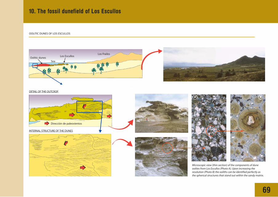
69
10. The fossil dunefield of Los Escullos
Microscopic view (thin section) of the components of duneoolites from Los Escullos (Photo A). Upon increasing theresolution (Photo B) the ooliths can be identified perfectly asthe spherical structures that stand out within the sandy matrix.
OOLITIC DUNES OF LOS ESCULLOS
DETAIL OF THE OUTCROP
INTERNAL STRUCTURE OF THE DUNES
Oolitic dunes Los Escullos
Los Frailes
Dirección de paleovientos
Sea
OOoliths BA

J. L. Goy - C. Zazo - C. Dabrio - J. Baena
70
11. Alluvial fans of the La Isleta-Los Escullos coastal plain
The Sierra de Cabo de Gata exhibits an abrupt
relief, with strong slopes, that contrasts with the
gentle morphology of the littoral depressions
(coastal plains).The abrupt change of slope that
is produced in the courses of small barrancos as
they exit from the mountain relieves, and enter
the depression, provokes a fall in their capacity to
transport and the consequent accumulation
(deposition) of the sediments (blocks, pebbles,
silts, etc.) which they moved towards the most
low-lying areas. An open alluvial fan in thus
formed.
SIMPLIFIED GEOLOGICAL SCHEME OF THE QUATERNARY DEPOSITS IN THE LA ISLETA-LOS ESCULLOS AREA
Phase 6 (c)
Alluvial fandeposits
Ho
loce
ne
Plei
sto
cen
eQu
ater
nar
y
Channel deposits ofterraces and rivers
Gravity deposits Marine deposits Aeoliandeposits
Present river Beach
Aeolian dunes
Colluvium andundifferenciatedslope deposits
Fluvial deposits Slope deposits Littoral deposits
2nd Terrace
1st Terrace
Abandonedriver
Phase 6 (b) Littoral barrier
Phase 6 (a)
Phase 5
Phase 4
Phase 3
Phase 2
Phase 1
Volcanic rocks Miocene

71
A fall in sea level, linked to the slow uplift of
the relief, caused incision of the initial
barranco (primary river course) in the
deposits of the older open fan, upon whose
surface soils were already able to develop.
The formation of subsequent fans, during the
initiation of a new rise in sea level, gives way
to incised fans at a lower altitude to the
previous one.
In the area of La Isleta-los Escullos, several
incised surfaces (roofs of fans), inclined
gently towards the sea are observed, that
represent distinct phases of fan formation
throughout the Quaternary. Theses are due
to changes in the climatic conditions,
tectonics and eustacy (oscillations of sea
level), and their study provides very
interesting information about such
conditions.:
11. Alluvial fans of the La Isleta-Los Escullos coastal plain
PROCESSES OF DEPOSITION AND INCISION IN ALLUVIAL FANS
OPEN FAN
Sierra de Cabo de Gata
Sea level
Fan formation phase 1
Paleosuelo
Slow uplift
Fan formation phase 2
Aerial view of La Isleta-Los Escullos in which phase 2 alluvial fans may be observed, with a schematic overlay.
Sea level
Sierra de Cabo de Gata
INCISION
La IsletaLos Escullos

72
PANORAMA FROM THE LA ISLETA VIEWING POINT AND INTERPRETATION OF THE ALLUVIAL FAN SYSTEM
Cerro de Los Filabres
Los Escullos
BeachesOolitic dunes
Undifferentiated slope deposits Beaches
Fossil oolitic dunes
Phase 3 alluvial fans
Phase 2 alluvial fans
Phase 1 alluvial fans
Volcanic rocks
Phase 3alluvial fan
Phase 1alluvial fan
Phase 2alluvial fan
Alluvial fanentrenchment
LA ISLETA VIEWING POINT
11. Alluvial fans of the La Isleta-Los Escullos coastal plain

Juan M. Fernández
73
12. Rodalquilar volcanic calderas
One of the most significant volcanic structures
of the Cabo de Gata Volcanic Complex are the
Rodalquilar calderas, from the centre of which
known gold deposits are located. Rodalquilar
shows the superposition or nesting of two
successive calderas; the larger is the
Rodalquilar caldera, and inside it the La Lomilla
caldera is located (thus named after La Lomilla
de Las Palas). Theses calderas are collapse
structures produced by highly explosive
eruptions, that gave place to tow large units of
pyroclastic rock, known as the Cinto
ignimbrites and the Lázaras Ignimbrites,
respectively. Calderas are collapse features that
are produced when, during an explosion of
great magnitude, the magma chamber is very
INTERPRETED GEOLOGICAL SKETCH OF THE RODALQUILAR VOLCANIC CALDERA
rapidly vacated and its roof collapses, leaving
behind a roughly circular depression.
Detail of the Cinto collapse breccias. Concentrationof (dark) blocks within a pumice flow (light-coloured).
Detail of the Cintopumice flows. The dark
stippled areacorresponds to large
quartz crystals.
Collapse breccias
Domes of thecaldera margin
Pre-calderarocks
Caldera de RodalquilarSE NW
600400200Sea level -200-400-600-800 m
Caldera de la Lomilla
Lázaras ignimbriteCerro del Cinto
MinesLa Rellana
La Isleta
Cinto ignimbrite Unaltered andesitic intrusions Altered andesiticintrusions

74
GEOLOGICAL HISTORY
The Rodalqular Caldera and the Cinto
Ignimbrite
The Rodalquilar Caldera is the larger, with a 4km
by 8km width and an oval shape. Its origin is
related to the thick pyroclastic unit of the Cinto
Ignimbrite, which formed 11 million years ago,
on top of a mass of older mass of andesitic
flows (A), due to collapse of the magmatic
chamber.
Since the collapse of the Rodalquilar Caldera
and formation of the Cinto Ignimbrite (B), the
magmatic chamber refilled itself, and the
ignimbrites filling the caldera bulged outwards,
making way for the present Cerro del Cinto
(a resurgent dome). This phenomenon is very
common during caldera formation processes,
and is called resurgence (C).
La Lomilla Caldera and the Lázaras
Ignimbrite
A new episode of intense eruptive activity gives
way to the formation of the Lázaras Ignimbrite,
simultaneously with the collapse of the La
Lomilla Caldera 9D). this caldera is 2 km in
diameter and is nestled in the Rodalquilar
Caldera.
FORMATION OF THE MAGMATIC CHAMBER
B. FORMATION OF THE RODALQUILAR CALDERA
C. RESURGENCE
The system of fractures generated during
the collapse were later infilled through the
development of a hydrothermal system and by
mineral deposits.
Thin layers of sedimentary and volcanic rocks
were deposited on top of the planar surface of
the Lázaras Ignimbrite.
Rodalquilar Caldera
Filling of the caldera
Cinto Ignimbrite
Collapsebreccias
Ringdome
Resurgent dome
Resurgence
Pre-caldera volcano
Pre-caldera andesites
Magma chamber
12. Rodalquilar volcanic calderas
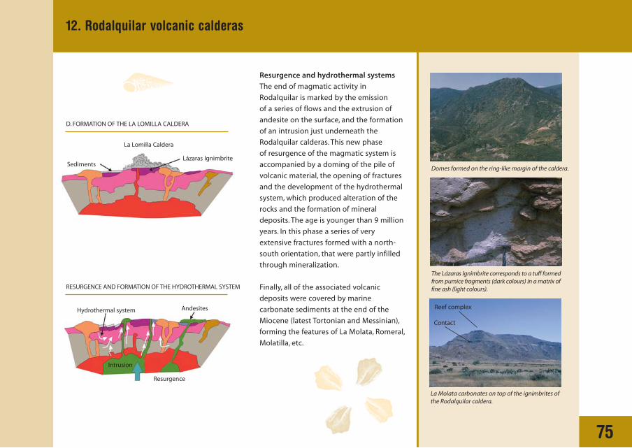
75
Resurgence and hydrothermal systems
The end of magmatic activity in
Rodalquilar is marked by the emission
of a series of flows and the extrusion of
andesite on the surface, and the formation
of an intrusion just underneath the
Rodalquilar calderas. This new phase
of resurgence of the magmatic system is
accompanied by a doming of the pile of
volcanic material, the opening of fractures
and the development of the hydrothermal
system, which produced alteration of the
rocks and the formation of mineral
deposits. The age is younger than 9 million
years. In this phase a series of very
extensive fractures formed with a north-
south orientation, that were partly infilled
through mineralization.
Finally, all of the associated volcanic
deposits were covered by marine
carbonate sediments at the end of the
Miocene (latest Tortonian and Messinian),
forming the features of La Molata, Romeral,
Molatilla, etc.
Domes formed on the ring-like margin of the caldera.
The Lázaras Ignimbrite corresponds to a tuff formedfrom pumice fragments (dark colours) in a matrix offine ash (light colours).
La Molata carbonates on top of the ignimbrites ofthe Rodalquilar caldera.
RESURGENCE AND FORMATION OF THE HYDROTHERMAL SYSTEM
D. FORMATION OF THE LA LOMILLA CALDERA
La Lomilla Caldera
Intrusion
Resurgence
AndesitesHydrothermal system
SedimentsLázaras Ignimbrite
Reef complex
Contact
12. Rodalquilar volcanic calderas

Carlos Feixas
13. Mining and metallurgical processes in Rodalquilar
76
MINING IN RODALQUILAR
Exploitation of gold in Rodalquilar has been
carried out by means of two very different
methods, such that it relates to extraction as
much as to the retrieval of precious metal.
Mining in the 19th century and at the start of
the 20th century, was carried out by internal
exploitation of high-grade quartz veins through
means of shafts and galleries. On the other
hand, mining took a new path from 1956
through the National Company ADARO,
characterised by combined exploitation; interior
workings with high grade material (over 5
g/ton), and cutting or quarries on the outside,
with lower grade material (1 to 1.5 g/ton)> the
mixture of these products allowed intermediate
grades of 3 g/ton to be obtained, optimal for
the type of extraction plant that was working it.
In the last decades of the 19th century and the
start of the 20th century, the recovery of gold
was carried out through means of smelting
furnaces obtaining a lead blende rich in
gold and silver. In the second half of the 20th
century, recovery was carried out through the
operation of electric furnaces, after
concentrating by means of washing with
cyanide solutions.
Mine entrance of 'Lode 340' during the period of maximumactivity in the mining district of Rodalquilar. Thephotograph is taken roughly in the 50's decade (Photo,Evaristo Gil Picón).
Opening of the track that connected the Cerro del Cintomine workings with the grading and concentration plant.This infrastructure already meant an enormous advancethat opened up the possibility of mechanising the quarryingsystem (Photo, Evaristo Gil Picón).
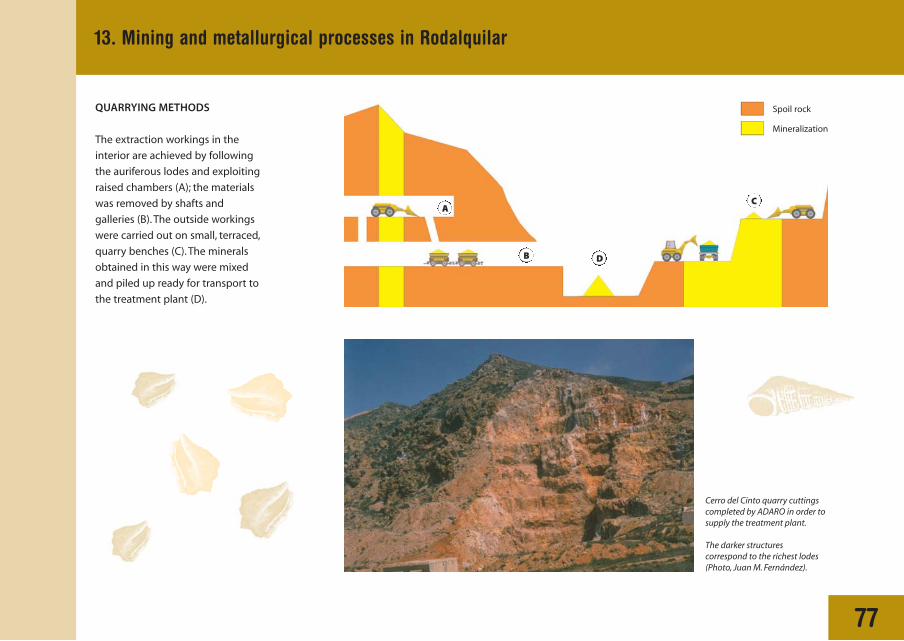
77
13. Mining and metallurgical processes in Rodalquilar
QUARRYING METHODS
The extraction workings in the
interior are achieved by following
the auriferous lodes and exploiting
raised chambers (A); the materials
was removed by shafts and
galleries (B). The outside workings
were carried out on small, terraced,
quarry benches (C). The minerals
obtained in this way were mixed
and piled up ready for transport to
the treatment plant (D).
Cerro del Cinto quarry cuttingscompleted by ADARO in order tosupply the treatment plant.
The darker structurescorrespond to the richest lodes(Photo, Juan M. Fernández).
Spoil rock
Mineralization
DB
AC
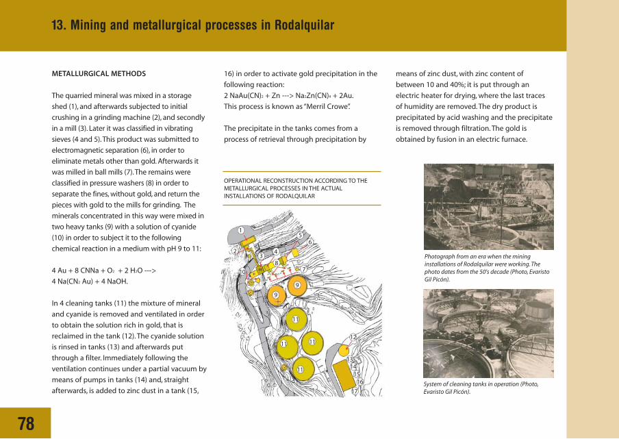
78
METALLURGICAL METHODS
The quarried mineral was mixed in a storage
shed (1), and afterwards subjected to initial
crushing in a grinding machine (2), and secondly
in a mill (3). Later it was classified in vibrating
sieves (4 and 5).This product was submitted to
electromagnetic separation (6), in order to
eliminate metals other than gold. Afterwards it
was milled in ball mills (7).The remains were
classified in pressure washers (8) in order to
separate the fines, without gold, and return the
pieces with gold to the mills for grinding. The
minerals concentrated in this way were mixed in
two heavy tanks (9) with a solution of cyanide
(10) in order to subject it to the following
chemical reaction in a medium with pH 9 to 11:
4 Au + 8 CNNa + O2 + 2 H2O --->
4 Na(CN2 Au) + 4 NaOH.
In 4 cleaning tanks (11) the mixture of mineral
and cyanide is removed and ventilated in order
to obtain the solution rich in gold, that is
reclaimed in the tank (12). The cyanide solution
is rinsed in tanks (13) and afterwards put
through a filter. Immediately following the
ventilation continues under a partial vacuum by
means of pumps in tanks (14) and, straight
afterwards, is added to zinc dust in a tank (15,
16) in order to activate gold precipitation in the
following reaction:
2 NaAu(CN)2 + Zn ---> Na2Zn(CN)4 + 2Au.
This process is known as “Merril Crowe”.
The precipitate in the tanks comes from a
process of retrieval through precipitation by
means of zinc dust, with zinc content of
between 10 and 40%; it is put through an
electric heater for drying, where the last traces
of humidity are removed. The dry product is
precipitated by acid washing and the precipitate
is removed through filtration. The gold is
obtained by fusion in an electric furnace.
OPERATIONAL RECONSTRUCTION ACCORDING TO THEMETALLURGICAL PROCESSES IN THE ACTUALINSTALLATIONS OF RODALQUILAR
Photograph from an era when the mininginstallations of Rodalquilar were working. Thephoto dates from the 50's decade (Photo, EvaristoGil Picón).
System of cleaning tanks in operation (Photo,Evaristo Gil Picón).
1
23
4
56
78
10
9
9
11
11 11
11
12
1314
1516
17
13. Mining and metallurgical processes in Rodalquilar

Juan C. Braga - José M. Martín
79
Field view ofbryozoans andfossil bivalvesthat formed thelimestoneof Unit A.
The remains of calcareous algae and bryozoansthat presently live on the seafloor of the Cabo deGata platform produce a sediment similar to thatwhich formed the limestone of Unit A.
14. The Post-volcanic sediments of La Molata de las Negras
In La Molata de Las Negras sedimentary rocks
are present that record the geological history of
the Cabo de Gata region since the volcanic
activity. Above the volcanic basement a series
of sedimentary units may be observed that
correspond to deposits formed in a small basin
(an inlet or bay), connected with the
Mediterranean, and presently emerged, uplifted
UNIT A
Consists of bioclastic limestones; rocks composed
of the remains of bryozoan skeletons, bivalves, red
algae, starfish, sea urchins and foraminiferans.
These organisms lived in the small marine basin of
Las Negras, joined to the Mediterranean in the
Upper Tortonian-Lower Messinian, around 7
million years ago.The organisms whose remains
form these rocks are similar to those that today
live, and produce sediment, in the marine platform
surrounding Cabo de Gata.The climate in the
region during this period would have been similar
to present or slightly warmer. A small proportion of
above the present sea level. The presence of
coral reefs and oolitic limestones indicates that
during the formation period of units B, C and D
(Messinian), the climate of the western
Mediterranean was warmer than at the present
day and similar to that of tropical latitudes at
present.
theses rocks comprises clasts and grains coming
from the erosion of the volcanic relieves.
ABC
BiohermLa Joya
La Molata
Volcánics
D

80
UNIT B. CORAL REEFS
TAfter deposition of the bioclastic limestones
there was a stage of uplift and deformation of the
basin seafloor, in such way that before
the following unit (unit B) was deposited, the
bioclastic limestones were inclines and
underwent erosion (observed in the panorama
and view point from the central part of the
hillside).
In Unit B, formed during the Messinian around
6 million years ago, coral reefs stand proud in
the form of isolated pinnacles (bioherms), such
Tarbellastrea coral colony, one of the components of the UnitB bioherms.Slumped blocks of bioherms intercalated between fine-grained sediments in the basin
B.Scattered distribution of bioherms in the platform
A. Diagram of a reef mound(bioherm)
Breccias and calcarenites
Hemispherical colonies Sticks
10 m
100 m
Basin Slope Platform
Laminar colonies
as that which stand out in the panorama, easily
appreciable from this perspective. These reefs
are mainly formed through the in situ
accumulation of the calcareous skeletons of
corals belonging to several genera (Porites,
Tarbellastrea and Siderastrea). Between the coral
colonies and around the pinnacles, algae and
invertebrates lived, whose skeletons also
contributed to the formation of carbonate
sediment. Blocks derived from these reefs, such
as that observed to the left of the large pinnacle,
fell down slope and became mixed with the
marls and mud that were being deposited in the
sea offshore, in deeper regions, situated towards
our left. Marls formed through the settling of silt
from suspension in seawater, and through the
accumulation of the skeletons of planktonic
micro-organisms such as foraminifers, unicellular
algae, and at times diatoms.
DISTRIBUTION AND STRUCTURE OF BIOHERMS IN THE REEF STRUCTURE
14. The Post-volcanic sediments of La Molata de las Negras

81
Microscopic view of ooliths thatformed the carbonates of Unit D.
Field view of stromatolites, with theirtypical laminated structure.
UNIT C
Corresponds to a fringing reef that was
advancing from our right towards our left.
Here the corals are almost exclusively Porites
and the coral colonies are surrounded by
foraminifers and encrusting red algae; that in
turn are covered by stromatolites, that is to say,
carbonates that are precipitated (or bound)
by the action of micro-organisms, mainly
UNIT D
Rests on an erosion surface that had an effect on
the reef (Unit C) and removed a large part of its
deposits. This erosion surface is the expression of
the Messinian desiccation of the Mediterranean at
this locality, known as the salinity crisis. Its age is
end Messinian (around 5.5 million years ago).
Unit D is fundamentally formed from stromatolites
and oolitic carbonates. The latter are made up of
microscopic, spherical particles, called ooliths, with
an internal structure of concentric layers of calcium
carbonate. Oolites are presently forming in the
shallow, agitated waters of tropical seas.
Stromatolites are domes or irregular constructions
formed by miilimetre-thick (or less) layers of
carbonate.
DIAGRAM SHOWING ONE PHASE OF REEF GROWTH
cyanobacteria.Towards the sea (towards the
left), the reef gave way to a slope where debris
coming from its destruction accumulated.
The grain size of this debris is segregated
downslope, in a way that it continually
becomes finer. Between the reef debris, other
organisms grew, such as calcareous green
algae (Halimeda) and bivalves.
N-S
Distal slope
Lagoon Bioclastic breccias 10 m
0 10 m
Calcirudites
Calcarenites
CalcilutitesCoral blocksand breccias
Reef crestCoral thicket Coral pinnacles
Proximal slope Talusslope
Reefframework
laguna
14. The Post-volcanic sediments of La Molata de las Negras

Carlos Feixas
15. Bentonites of cabo de Gata
82
GENESIS AND NATURE
OF BENTONITES
Bentonite is a rock composed of minerals
from the clay group. Their internal structure
of superimposed layers of different chemical
composition defines their key characteristic:
their capacity to absorb a quantity of water
several times greater than their own volume.
This is produced through storage of fluid
in the spaces that exist between the different
layers.
Bentonites originate from the alteration
of volcanic rocks, also through processes of
hydrothermal alteration (rise of hot solutions
through fractures) or also through weathering
alteration (due to the action of meteoric
water).
The special composition of the Cabo de Gata
volcanic complex means that within it the
greatest concentration of bentonite deposits in
Spain formed. In fact, they constitute the only
exploited industrial minerals that exist within
the Natural Park.
The Cabo de Gata bentonites are by nature
around 75% to 95% Calcium-Sodium-
Magnesium types, and the rest of the rock
consists of other types of clays and small
quantities of other minerals originating from
volcanic rocks. They display various colours,
from reds, greens, yellows and blacks, to whites.
The deposits have an irregular and stratified
morphology.
200 m
200 m
Volcanic rock
Descent of cold meteoric water
Increased heat
Ascent of hot hydrothermal solutions
Bentonite
Alteration of volcanicrocks to bentonite
Increased heat
SIMPLIFIED DIAGRAM OF BENTONITE FORMATION

83
15. Bentonites of cabo de Gata
Bentonite quarry exploited in an intermittent fashion in theSerrata de Níjar. The bentonite masses that display somecolouration hold less commercial interest than those that arewhite.
Quarrying of white bentonite in the area of Morrón de Mateo.
The main areas of quarrying within Cabo deGata are found in:
Cantera de Los Trancos (A)Cortijo de Archidona (B)El Morrón de Mateo (C)
Undifferentiated Recent detritus
Pliocene sand and conglomerate
Marls, clay, sand and carbonate
Gypsum
Carboneras
Las Negras
Rodalquilar
Fernán Pérez
B
C
A
San José
Cabo de Gata
5 Km
Serrata
Fringing reef, marl and bioclastic carbonate
Bioclastic carbonate
Volcanic rocks
Betic substratum
DISTRIBUTION OF QUARRYING. GEOLOGICAL MAP OF THE CABO DE GATA AREA

84
Bentonite mining is carried out through an
open cast quarry method. In a modern quarry
the following activities are undertaken:
◗ Conditioning and preparation
The discovery of productive layers takes place
with the help of excavating machines or
mechanized tractors.
◗ Extraction
Once the surface is cleaned off, quarrying is
carried out by cutting down benches
lengthwise along the face, with a height of
about 10 metres and a length close to 50
metres.
◗ Drying and classification
The material quarried in this way is spread out
across large areas or “heaps”, cleaned of
impurities and classified by qulaity according
to the use for which it is destined.
◗ Storage
The dried and classified material is stored in
large uncovered piles ready for transport to
treatment plants or for direct sale.
The mineralized body might be covered by non-mineralizedrocks that need to be removed for quarrying.
Los Trancos quarry is the principal bentonite mining concernin the park. The extent of the quarry benches can be observed,taking the lorries as a scale.
Volcanic rock Bentonite
Extraction Pile
Drying Classification
Conditioningand preparation
15. Bentonites of Cabo de Gata

85
USES AND APPLICATIONS
Bentonite clays, due to their physical properties,
are utilised in many industrial fields.
◗ In the smelting industry they are used, along
with siliceous sand, to prepare the mould of
manufacture parts, in that they are capable
of fusing together the sand, without altering
the composition of the cast.
◗ Addition to cements allows mortars to remain
fluid for a longer period of time, for which its
use is essential in special cements.
◗ As an integral part of drilling mud. Due to its
addition, the viscosity of the drilling mud
increases and is capable of pulling out broken
components more easily. Additionally, it is
capable of covering and keeping the walls of
the borehole intact when drilling of the
borehole finishes.
◗ Its addition to powdered irons minerals means
that they can be recovered in a profitable way
from smelting.
◗ Their capacity for absorbing water and ionic
exchange means that they can serve as
cleansing aids and fertilizers, also as
discolourants and clarifiers of wines and oils.
◗ Properly compacted it is an excellent
impermeable material, used to this end for
holding back and securing residues in storage
containers and potentially contaminant
substances.
Characteristic field viewof bentonite clays: white-coloured powderedmasses, greasy to thetouch and very plastic.
15. Bentonites of Cabo de Gata
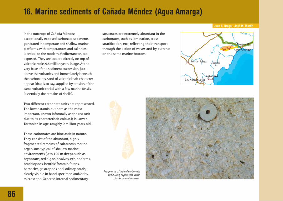
Juan C. Braga - José M. Martín
86
In the outcrops of Cañada Méndez,
exceptionally exposed carbonate sediments
generated in temperate and shallow marine
platforms, with temperatures and salinities
identical to the modern Mediterranean, are
exposed. They are located directly on top of
volcanic rocks 9.6 million years in age. At the
very base of the sediment succession, just
above the volcanics and immediately beneath
the carbonates, sand of volcaniclastic character
appear (that is to say, supplied by erosion of the
same volcanic rocks) with a few marine fossils
(essentially the remains of shells).
Two different carbonate units are represented.
The lower stands out here as the most
important, known informally as the red unit
due to its characteristic colour. It is Lower
Tortonian in age, roughly 9 million years old.
These carbonates are bioclastic in nature.
They consist of the abundant, highly
fragmented remains of calcareous marine
organisms typical of shallow marine
environments (0 to 100 m deep), such as
bryozoans, red algae, bivalves, echinoderms,
brachiopods, benthic foraminiferans,
barnacles, gastropods and solitary corals,
clearly visible in hand specimen and/or by
microscope. Ordered internal sedimentary
16. Marine sediments of Cañada Méndez (Agua Amarga)
structures are extremely abundant in the
carbonates, such as lamination, cross-
stratification, etc., reflecting their transport
through the action of waves and by currents
on the same marine bottom.
Fragments of typical carbonateproducing organisms in the
platform environment.

87
16. Marine sediments of Cañada Méndez (Agua Amarga)
SEDIMENTARY RECORD,
PALAEOGEOGRAPHICAL EVOLUTION
AND SEDIMENTARY MODEL
OF THE AGUA AMARGA BASIN
The sedimentary record in this area allows us to
reconstruct the palaeogeography of the
Agua Amarga Basin during the Lower Tortonian
based on the interpretation of its distinct
environments of deposition. Its
palaeogeography was essentially that of a small
bay, open towards the south, with a small
submarine high (ridge) situated right at its
entrance, especially notorious for determining
episodes in its history. The basin was filled by
different packages of sediments in successive
phases.
PHASE 1: In the initial phase ramblas reached
the bay, extending into the sea in the form of
submarine fans. The underlying volcaniclastic
sands correspond to deposits of the distal part
of these sand fans, coming from the destruction
of volcanic relieves.
Platform carbonates are positioned immediately
above. By means of the dominant sedimentary
structures it is possible to differentiate four units
in the interpreted section:
PHASE 1
PHASE 3 PHASE 4
PHASE 2
100 m 100 m
100 m
PalaeocoastlinePalaeocoastline
Present coastline
Agua amarga
Palaeocoastline
Present coastline
Agua amarga
Palaeocoastline
Present coastline
Taken from Betzler et al., 1997
Agua amarga
50 m
Present coastline
Agua amarga
600 m

88
PHOTO A. Field view of layers with tabularcross-stratification, tied to storm fans.
PHOTO B. Field view of trough cross-stratification produced by the migration ofsub-aquatic dunes.
PHOTO C. Low-angled parallel laminationcorresponding to episodes of beachprogradation.
PHOTO D. Mud levels (soft sediments)formed in coastal lagoons.
PHASE 2: A lower unit in which the most
characteristic features are layers of cross-
stratification (of rectilinear appearance, Photo
A), separated by very low-lying (almost
horizontal), sharp and continuous surfaces.
They are the deposits of storm-generated fans,
deposited on the protected side of a high or
submarine volcanic ridge located to the south.
PHASE 3: An intermediate phase with
abundant trough cross-stratification (in curves,
Photo B). They are interpreted as marine dunes
that migrated parallel to the coast.
PHASE 4: An upper phase in which the most
characteristic sedimentary structures are low-
angled parallel lamination (Photo C), this
corresponds to typical beach sediments.
Laterally, and superimposed on the previous
deposits, a last unit composed of fine sands with
high-angled, poorly-developed, and/or
unconsolidated muds without evident
sedimentary structures (Photo D). These are
interpreted as coastal aeolian dunes and
lagoons, respectively.
INTERPRETATION OF THE OBSERVED PANORAMA
ACTUAL PANORAMA OF THE INTERPRETED FIELD SECTION
Volcanicsubstratum
Uppercarbonate unit
Volcaniclassticrocks
Sub-aquaticdunefield
Storm fans Beaches
CoastalLagoon
Debris
16. Marine sediments of Cañada Méndez (Agua Amarga)

José Vicente Coves - José Antonio Gómez
89
17. The Quay at Agua Amarga
The extensive development of mining
activity during the 19th century and first
decades of the 20th century in Almería
Province furnished the existence of a
mining railway network of which only the
vestiges are preserved at the present day.
One of the routes is that from Lucainena
to Agua Amarga. Across the Natural Park
parts of the railway can still be seen and
are preserved, and the mine workings
quay at Agua Amarga although very
deteriorated. This constitutes, along with
Rodalquilar, one of the 2 most interesting
archaeo-industrial elements of the
Natural Park.
The plans of work were decided, in March 1894
the project wording was finalised and signed off
by D. Cayetano Fuentes, and on the 18th of
February 1895 the concession was granted by
royal order. This was for an economic railroad,
without any government grant and for a period
of 99 years. Nevertheless, in September 1894,
work on the construction of the railway had
already started, and, one month later, the
Biscayan company announced the purchase of
63,000 oak sleepers.
The works were progressing and,
by the middle of 1895, the
quayside-unloading bay had
been completed. Finally, in
March 1896 the work ended.
In May the first shipment of
minerals accumulated in the
Agua Amarga storage facilities
boarded the steamboat ALBIA.
The cost of installing the
railway was 3,500,000 pts, the
mineral storage area was
credited with a cost of 60,000
pts and the quay 265,000 pts. The total
investment for establishment was around
3,675,000 pts with an average investment cost
of 100,000 pts/km.
In 1901 the transport of minerals by railway
was attributed a cost of 0.025 pesetas per ton
per kilometre, and the loading cost was 0.123
pesetas per ton.
Locomotive LUCAINENA (Nasmyth Wilson 464/95), one ofthe machines used on the mineral transport line fromLucainena to Agua Amarga. The photo dates from theend of the 19th century (Photo, Col. J.M. SánchezMolina).
GENERAL VIEW OF LUCAINENA - AGUA AMARGA
LUCAINENA
RamblaHonda
Pte. Rafaela
PERALEJOSPte. Molinillo
Collado dePolopillos
Collado de Albacete
AGUA AMARGA
LA PALMEROSA
NATURAL PARK
CARBONERASRío Alías
Línea de ferrocarril
Vera-Alm
ería ro
ad
Mediterra
nean Sea
Sierra
Alhamilla
Sierra de G
ata
Mesa Roldán
Venta del Pobre CAMARILLAS
NÍJAR
Bco. del Valenciano

90
Although the mining venture company
maintained a good level of activity in the first
decade of the 20th century, in the second the
second the marked started to no longer be
favourable. In the years that followed the First
World War, a grave iron industry crisis which
took place in Europe and Spain, meant a tough
trial for national mining of iron. In 1919 and
1920 the Agua Amarga storage facilities were
completely full of a mineral that no one
bought. These difficulties were compounded
by competition from North-African mines,
salary rises that started to be introduced
around this date, and included the loss of
personnel due to the strong migratory
movement recorded in Almería Province
during this period.
The company endured a marked decline until
in 1931, and faced with the impossibility of
exporting its iron, it was forced to temporarily
suspend operation of the railway. Operation
was sporadically renewed, but in 1930, with the
state of civil war, the situation worsened.
During the three years of struggle the mines
and railway remained in the hands of its own
workforce, although without great activity.
In 1939 transport by rail was restarted until
activity finally ceased in 1942, the date in
which the steamboat Bartolo loaded for the
last time in Agua Amarga. A little later the
mining installations and railroad started to be
dismantled. The locomotives, the bridges and
the railway were taken apart and transported
in lorries to Almería.
RECONSTRUCTION OF THE INSTALLATIONS OF THEMINING QUAY AT AGUA AMARGA
Agua Amarga
17. The Quay at Agua Amarga

91
Present state of the mining installations in the mineral working quay of Agua Amarga. To the right a general view of the installations canbe observed: in the background the Sierra Alhamilla, place of iron exploitation and origin for the transport network; in the foreground, thelarge inclined plane through which the wagons carrying minerals could descend to the silos. On the left, the remains of the said 'silos' usedfor mineral storage prior to final loading (Photographs, M. Villalobos).
The boat BARTOLO receiving the last cargo shipped out of Agua Amarga from theLucainena mines. With it, a page in the history of mining in Almería closed.
Locomotive LUCAINENA (Nasmyth Wilson 464/95), one of the machines used on themineral transport line from Lucainena to Agua Amarga. The photo dates from the endof the 19th century (Photo, Col. J.M. Sánchez Molina).
17. The Quay at Agua Amarga
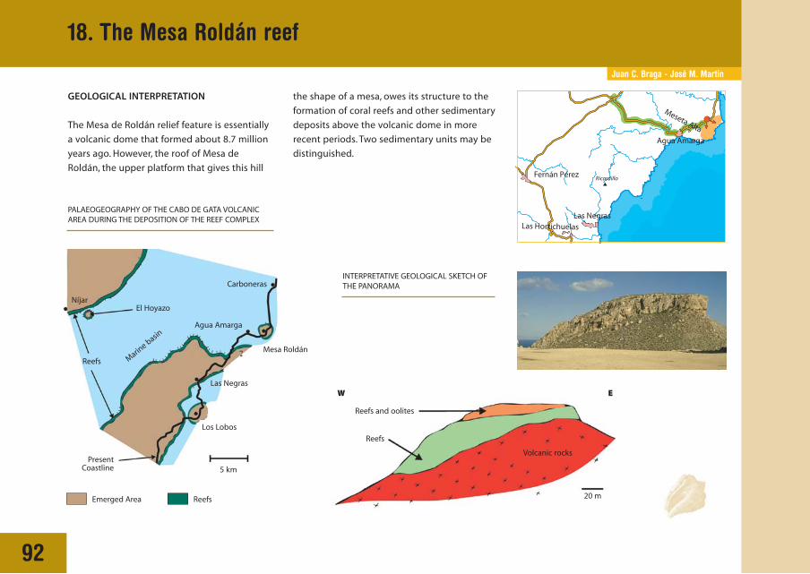
Juan C. Braga - José M. Martín
18. The Mesa Roldán reef
92
GEOLOGICAL INTERPRETATION
The Mesa de Roldán relief feature is essentially
a volcanic dome that formed about 8.7 million
years ago. However, the roof of Mesa de
Roldán, the upper platform that gives this hill
Los Lobos
Las Negras
El Hoyazo
Emerged Area
Níjar
5 km
Marine basin
Mesa Roldán
Reefs and oolites
Reefs
W E
20 m
Volcanic rocks
Carboneras
Agua Amarga
Reefs
PresentCoastline
the shape of a mesa, owes its structure to the
formation of coral reefs and other sedimentary
deposits above the volcanic dome in more
recent periods. Two sedimentary units may be
distinguished.
PALAEOGEOGRAPHY OF THE CABO DE GATA VOLCANICAREA DURING THE DEPOSITION OF THE REEF COMPLEX
INTERPRETATIVE GEOLOGICAL SKETCH OFTHE PANORAMA
Reefs
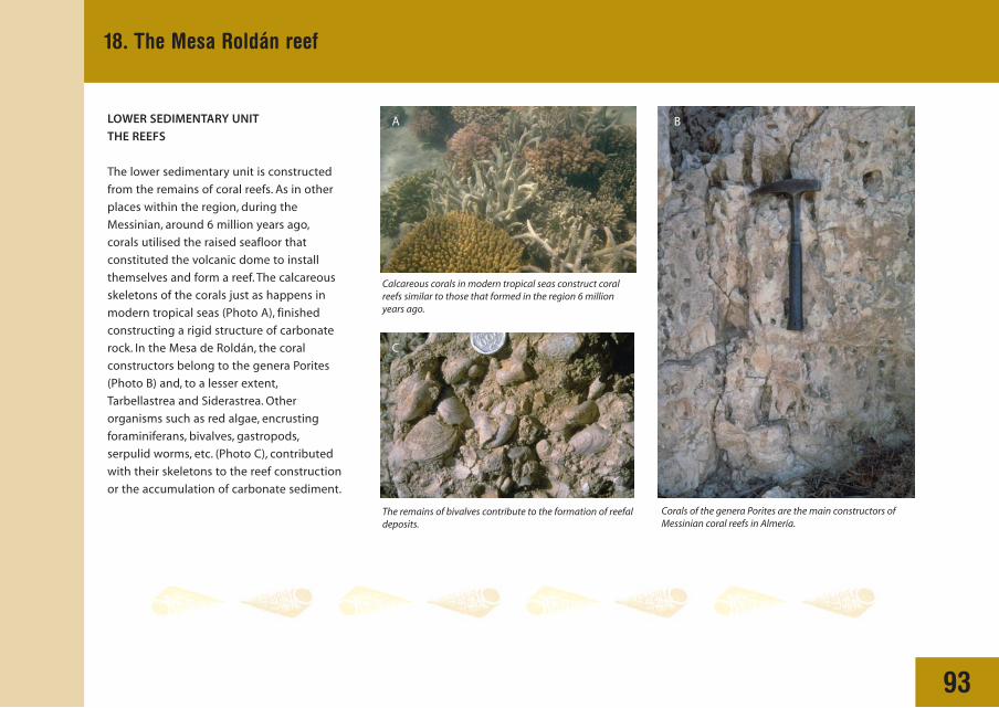
93
18. The Mesa Roldán reef
LOWER SEDIMENTARY UNIT
THE REEFS
The lower sedimentary unit is constructed
from the remains of coral reefs. As in other
places within the region, during the
Messinian, around 6 million years ago,
corals utilised the raised seafloor that
constituted the volcanic dome to install
themselves and form a reef. The calcareous
skeletons of the corals just as happens in
modern tropical seas (Photo A), finished
constructing a rigid structure of carbonate
rock. In the Mesa de Roldán, the coral
constructors belong to the genera Porites
(Photo B) and, to a lesser extent,
Tarbellastrea and Siderastrea. Other
organisms such as red algae, encrusting
foraminiferans, bivalves, gastropods,
serpulid worms, etc. (Photo C), contributed
with their skeletons to the reef construction
or the accumulation of carbonate sediment.
Calcareous corals in modern tropical seas construct coralreefs similar to those that formed in the region 6 millionyears ago.
The remains of bivalves contribute to the formation of reefaldeposits.
Corals of the genera Porites are the main constructors ofMessinian coral reefs in Almería.
A
C
B

94
UPPER SEDIMENTARY UNIT
THE PATCH REEFS
Above the lower sedimentary unit there is an
erosion surface, and, above it, a new
sedimentary unit is present. The latter, also
Messinian in age, but younger (around 5.5
million years) is again constructed from coral
reefs along with some particulate carbonate
sediments that are called oolites (lower figure).
Here the reefs have only a small dimension,
patches a few metres wide with a height of
1 or 2 metres, formed by corals of the genera
Porites (Photo D) and well-developed micritic
coatings of microbial origin (Photo E). These
reefs grew surrounded by oolitic sediments.
This type of oolitic sediment consist of small
carbonate particles with a spherical shape and
an internal structure of concentric laminations
(Photo F). At present, ooliths, as the particles
are known, are formed in shallow, agitated,
tropical seas.
The oolitic carbonates as much as the coral
reefs testify that in the western part of the
Mediterranean, on the southeast Iberian
peninsula, during the Messinian around 5.5
million years ago, at the end of the Miocene,
a tropical climate prevailed, similar to that now
found in lower latitudes, closer to the equator.
Since that period until the Present, the climate
in the region has followed a general trend of
cooling, although this tendency has suffered
strong fluctuations, especially during the last
2 million years.
Microscopic image ofoolitic sediments. Theseparticles, ooliths, constitutethe bulk of sediments inthe upper unit.
Micritic carbonatecoatings encrusting theupper part of patch reefsat the same time as thecoral colonies wereperiodically living.
Coral colonies of the genera Porites (verticalsticks), surrounded by micritic carbonatecoatings (white hue), that constitute the patchreefs of the upper unit.
E
D
F
Patch reefs and oolitic limestones appear in the upper unit.
Ooliths
Ooliths
Breccias
Reef
2 m
Previous Reef
18. The Mesa Roldán reef
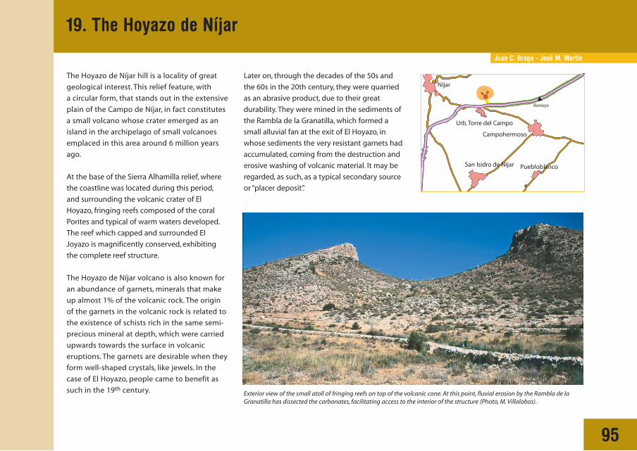
Juan C. Braga - José M. Martín
95
19. The Hoyazo de Níjar
The Hoyazo de Níjar hill is a locality of great
geological interest. This relief feature, with
a circular form, that stands out in the extensive
plain of the Campo de Níjar, in fact constitutes
a small volcano whose crater emerged as an
island in the archipelago of small volcanoes
emplaced in this area around 6 million years
ago.
At the base of the Sierra Alhamilla relief, where
the coastline was located during this period,
and surrounding the volcanic crater of El
Hoyazo, fringing reefs composed of the coral
Porites and typical of warm waters developed.
The reef which capped and surrounded El
Joyazo is magnificently conserved, exhibiting
the complete reef structure.
The Hoyazo de Níjar volcano is also known for
an abundance of garnets, minerals that make
up almost 1% of the volcanic rock. The origin
of the garnets in the volcanic rock is related to
the existence of schists rich in the same semi-
precious mineral at depth, which were carried
upwards towards the surface in volcanic
eruptions. The garnets are desirable when they
form well-shaped crystals, like jewels. In the
case of El Hoyazo, people came to benefit as
such in the 19th century.
Later on, through the decades of the 50s and
the 60s in the 20th century, they were quarried
as an abrasive product, due to their great
durability. They were mined in the sediments of
the Rambla de la Granatilla, which formed a
small alluvial fan at the exit of El Hoyazo, in
whose sediments the very resistant garnets had
accumulated, coming from the destruction and
erosive washing of volcanic material. It may be
regarded, as such, as a typical secondary source
or “placer deposit”.
Exterior view of the small atoll of fringing reefs on top of the volcanic cone. At this point, fluvial erosion by the Rambla de laGranatilla has dissected the carbonates, facilitating access to the interior of the structure (Photo, M. Villalobos).
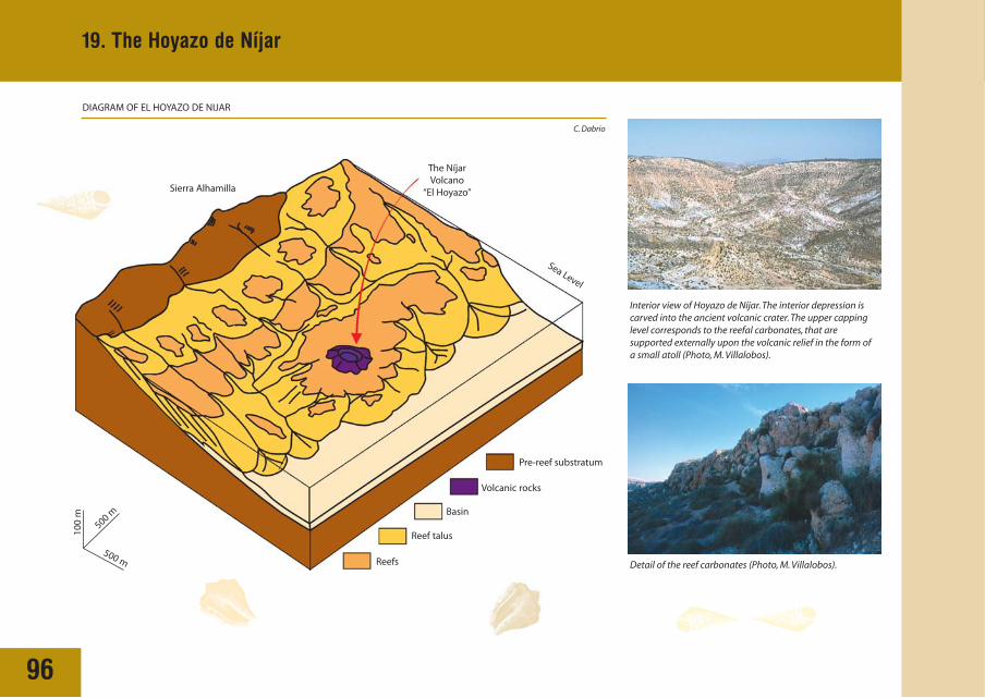
96
19. The Hoyazo de Níjar
Volcanic rocks
Basin
Reef talus
Reefs
Sea Level
Pre-reef substratum
The NíjarVolcano
“El Hoyazo”
C. Dabrio
Sierra Alhamilla
Detail of the reef carbonates (Photo, M. Villalobos).
DIAGRAM OF EL HOYAZO DE NIJAR
Interior view of Hoyazo de Níjar. The interior depression iscarved into the ancient volcanic crater. The upper cappinglevel corresponds to the reefal carbonates, that aresupported externally upon the volcanic relief in the form ofa small atoll (Photo, M. Villalobos).
100
m
500 m
500 m