the geology of the new richmond sandstone, prairie du chien …€¦ · prairie du chien group,...
TRANSCRIPT

The Geology of the New Richmond Sandstone,
Prairie du Chien Group,
Southeastern Minnesota
Cristina Robins
Senior Integrative Exercise
March 9, 2005
Submitted in partial fulfillment of the requirements for a Bachelor of Arts degree,
Carleton College, Northfield, MN, USA

The Geology of the New Richmond Sandstone,
Prairie du Chien Group, Southeastern Minnesota
Cristina Robins
Carleton College
Senior Integrative Exercise
March 9, 2004
Advisor:
Dr. Clint Cowan, Carleton College
Abstract:
This study examines the New Richmond Sandstone, a relatively unknown heterolithic
assemblage of sandstone, carbonate, and shale that is commonly considered part of the
Shakopee formation of the Prairie du Chien group. Stratigraphic columns constructed
from seven outcrops of the New Richmond in southeastern Minnesota and northeastern
Iowa show that it varies between 7 m and 20 m in thickness within the study area and
consists of two facies: the Prairie Island and the Root Valley. Previous studies found
that the New Richmond was deposited in part through eolian action. SEM studies of
individual grains did not confirm this.
Keywords: New Richmond, sandstone, Shakopee, Prairie du Chien, Ordovician,
stratigraphy, SEM data, Minnesota
i

Table of Contents
Introduction..................................................................................................................... 1
Literature Review .................................................................................................. 1
The Prairie du Chien Group .................................................................................. 4
Surrounding Lithologic Units ................................................................................ 4
Methods ........................................................................................................................... 5
Field...................................................................................................................... 5
SEM ...................................................................................................................... 5
Results ............................................................................................................................. 7
Stratigraphy .......................................................................................................... 7
Lithofacies............................................................................................................. 10
SEM ...................................................................................................................... 14
Discussion ........................................................................................................................ 14
Stratigraphy .......................................................................................................... 14
Lithofacies............................................................................................................. 16
SEM ...................................................................................................................... 18
Conclusions...................................................................................................................... 19
Acknowledgements.......................................................................................................... 19
Works Cited .................................................................................................................... 21
Appendices: ..................................................................................................................... 23
Stratigraphic Columns........................................................................................... 23
Outcrop Locations ................................................................................................. 24
ii

Introduction
The Prairie du Chien (PDC) Group, of Early Ordovician age, crops out in
southern Minnesota, northeastern Iowa, and southern Wisconsin, and extends into parts
of the subsurface of Michigan and Illinois, ranging from ~60 – 600m in thickness (Smith
et al., 1996). It is composed of three main members: the Oneota Dolostone, the New
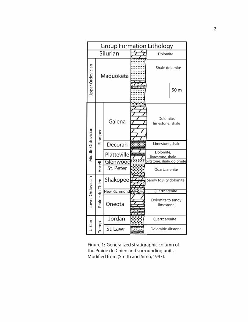
Richmond Sandstone, and the Shakopee Dolostone (Figure 1). Extensive study has been
completed on the dolostone members of the PDC (Johnson and Simo, 2002; Smith et al.,
1996; Smith and Simo, 1997). There is comparably little information available on the
New Richmond, and of the few studies available, their results are somewhat conflicting.
This study adds to the pool of information and clarifies some points about the New
Richmond, providing a broad overview of the member by using stratigraphy and
scanning electron microscopy [SEM] data to determine details of deposition and
composition.
Literature Review
In 1882 L. C. Wooster proposed that the New Richmond beds be considered an
individual member of the what was at the time called the Lower Magnesian Group (Shea,
1960; Squillace, 1979; Ulrich, 1924). H.F. Bain, in 1906, changed the name of the Lower
Magnesian Group to the Prairie du Chien Formation, later evolving into the Prairie du
Chien Group (Needham, 1932; Shea, 1960; Squillace, 1979; Ulrich, 1924). For a more
detailed history of the nomenclature of the New Richmond, see Ulrich (1924), Needham
(1932), Shea (1960), or Squillace (1979).
11
Group Formation Lithology
Maquoketa
St. Lawr
Jordan
Oneota
Shakopee
St. PeterGlenwoodPlatteville
Decorah
Galena
Silurian
Shale, dolomite
Quartz arenite
Dolomite to sandy limestone
Sandy to silty dolomite
Quartz arenite
Siltstone, shale, dolomite
Dolomite, limestone, shale
Limestone, shale
Dolomite, limestone, shale
Dolomitic siltstoneU. C
am.
Sinn
ipee
Mid
dle
Ord
ovic
ian
Low
er O
rdov
icia
n
Trem
p.Pr
airie
du
Chi
enA
ncel
l
Upp
er O
rdov
icia
n
Dolomite
50 m
Figure 1: Generalized stratigraphic column of the Prairie du Chien and surrounding units. Modified from (Smith and Simo, 1997).
New Richmond Quartz arenite
2

3
The New Richmond Member consists of a thin (maximum ~20 m) heterolithic
assemblage of sandstone, carbonate, and shale, and is often considered part of the
Shakopee Formation of the PDC Group (Davis, 1966; Johnson and Simo, 2002; Runkel,
2002; Squillace, 1979). Defining characteristics of the New Richmond include eolian
cross-bedding and sandy stromatolites (Austin, 1974; Davis, 1968; Shea, 1960; Squillace,
1979). Where present, it is occurs between the two dominantly dolomitic units of the
PDC, the Oneota and upper Shakopee. The New Richmond is thickest in southeastern
Minnesota, in the area of the Hollandale Embayment, but extends into parts of Iowa and
Wisconsin (Squillace, 1979).
The New Richmond was deposited nearshore during several highstands, with
abundant mudcracks and ripple-marks testifying to frequent exposures to subaerial
conditions (Austin, 1970; Davis, 1966; Shea, 1960; Smith et al., 1996; Squillace, 1979).
Historically, two lithofacies have been found within the New Richmond
Sandstone; the Prairie Island and the Root Valley Lithfacies (Squillace, 1979). However,
complete sequences of the New Richmond may have only one lithofacies. When both
lithofacies are present in an outcrop, the Prairie Island is always the lower lithofacies.
The Prairie Island Lithofacies consists primarily of quartz arenite that is
interbedded with dolomite, shale, and arenaceous dolostone. The Root Valley
Lithofacies is solely quartz arenite (Shea, 1960; Squillace, 1979). Both lithofacies
contain cross-bedding and vugs. Fossils (trilobite and conodont) are rare within the
sandstone, and the Root Valley Lithofacies is considered to be littoral and eolian in origin
(Austin, 1970; Smith, 1991; Squillace, 1979).

4
The Prairie du Chien Group
The Oneota Dolostone was deposited unconformably on the Jordan Sandstone
(Runkel, 1994) and is a nearly pure dolomite unit that is extensively quarried (Needham,
1932; Runkel, 2002). The Oneota and New Richmond are separated by an unconformity
(Andrews, 1955; Johnson and Simo, 2002; Needham, 1931; Ostrum, 1964) representing
an unknown length of time of surficial exposure, but the unconformity is correlated to an
Early Paleozoic conodont extinction event (Smith, 1989).
The New Richmond Sandstone and Shakopee Dolostone are considered
conformable, with the boundary between New Richmond and the Shakopee frequently
marked by a green shale bed. The entire PDC Group is characterized by oolite,
mudcracks, and ripple-marks, indicating a shallow, possibly supratidal, environment. In
the Oneota and Shakopee Dolostones, the presence of moldic nodular anhydrite suggests
a hypersaline environment (Smith and Simo, 1997).
The PDC provides an important conduit for local groundwater movement. The
PDC was exposed during several lowstands of sea level, causing extensive karsting to
develop throughout the group. The carbonate of the Oneota and Shakopee has variable
water conductivity; however, where high amounts of karsting occur, such as the upper
Oneota, or an extremely porous area, such as the New Richmond, the water conductivity
is high (Runkel et al., 2003).
Surrounding Lithologic Units
Immediately below the PDC lies the Jordan Sandstone. This sandstone is Late
Cambrian in age and was deposited as a series of progradational sequences (Runkel,

5
1994). The Jordan is a probable source for the New Richmond Sandstone, based on
proximity within the stratigraphic sequence and the large garnet percentage found in
heavy mineral studies in both the Jordan and New Richmond Members (Galarowicz,
1997; Pride, 1966; Shea, 1960; Squillace, 1979; Thiel, 1935).
The St. Peter Sandstone, a remarkably pure quartz arenite, was deposited
unconformably above the Shakopee Dolostone. This unconformity represents a large
time of subaerial exposure for most of the PDC, contributing to extensive karsting in the
Shakopee (Smith, 1991).
Methods
Field
Stratigraphic columns were constructed based on outcrops of the New Richmond
measured at seven sites along an approximate 250 kilometer northwest-southeast transect
(Figure 2). Outcrop locations were chosen based on geologic maps and previous work
(Davis, 1968; Runkel, 2002; Shea, 1960; Squillace, 1979).
Where possible, samples were gathered approximately every meter for analysis.
Special attention was paid to the borders of the New Richmond with the Shakopee and
Oneota, looking for shale boundaries and evidence of karsting.
SEM
Of the samples collected, three were selected for SEM analysis. The principal
purpose for examining the samples under the SEM was to look for evidence of eolian
markings, so only samples from the Root Valley Lithofacies were considered for
analysis.

Minnesota
12
3
6
5
4
7
Wisconsin
Lanesboro
St. Paul
Rochester
Iowa
Sample Location Map
Cannon Falls
Upper Iowa River
N
Root River
0 4020
Scale kilometers
Mississippi River
Olmstead
Fillmore
Steele
Wabasha
Houston
Goodhue
Rice
Allamakee
Modified from Squillace 1979, Pride, 1966, MN Atlas
1. Dorchester, IA2. Eitzen, MN3. Lanesboro, MN4. Whitewater State Park, MN5. Plainview, MN6. Mazeppa, MN7. Hastings, MN
Dodge
Mower
Winona
Dakota
Washington
Anoka
Ramsey
Mississippi River
Modified from http://sheff.caeds.eng.uml.edu/mapsgot.htm
Sample LocationMajor town
6
Figure 2: Map showing general study area and sample sites. Modfied from (Squillace, 1979), (Pride, 1966).

7
Grains showing signs of eolian markings are typically frosted grains with a pitted,
pocked texture (Margolis and Krinsley, 1971). All samples analyzed consisted of loose
sand. One sample from Dorchester, IA (Location 1, ~13.0 m), one from Whitewater
State Park, MN (Location 4, ~5.0 m), and one from Plainview, MN (Location 5, ~4.0 m),
were chosen.
The samples were attached to carbon foundations, which were placed on
aluminum plugs. These were then sputter coated with gold to prevent “charging,” or poor
interactions between the non-metallic sample and the electron beam. The samples were
examined at a frequency of 10kv. This low voltage was used as another preventative
measure against charging. Photos were taken of grains representative of the larger
sample as a whole. Particular emphasis was made to gather photos of grains with
cements and eolian markings.
Results
Stratigraphy
From the outcrops examined, the New Richmond varies from 7 m to 19 m in
thickness, with the formation thickest in northeast Iowa and thinning in all directions
(Figure 3). Most outcrops were predominantly sandstone, with layers of shale, dolomite
and arenaceous dolostone interbedded.
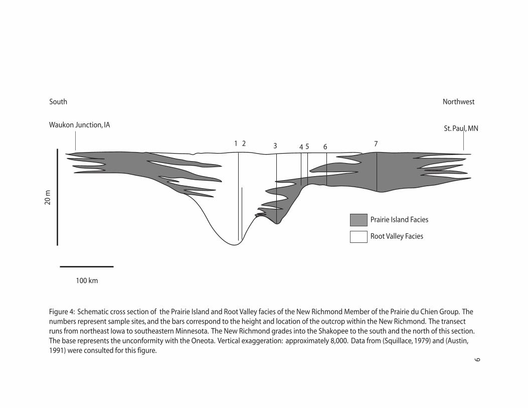
A cross-section from northeastern Iowa – St. Paul, MN, shows the distribution of
the Prairie Island and Root Valley Lithofacies and the relation between the Oneota,
Shakopee, and New Richmond (Figure 4).

63
0
9
6
3
0
15 12
9
6
9
Complete Thickness+Incomplete Thickness>
Isopach Map of the New Richmond
>5.2
+15
>6.7
+8.1
>10.6
+6.4
>9.8
+3.6
+19
+7+6
>6.7
>11.2
+7.1
+12
+15
+5.2
+6
+3.3+6
+6
0 4020
scale kilometers
contour interval 3 meters
Sample siteMajor town
>9
18
1215
12
15
9
Minnesota
Wisconsin
St. Paul
Rochester
Iowa
N
Cannon Falls
Upper Iowa River
Mississippi River
Modified from (Squillace 1979)
Mississippi River
Lanesboro
8
Figure 3. Isopach map showing relative thicknesses of the New Richmond Member based on compiled field measurements from this study and Squillace, 1979. Modified from (Squillace, 1979)
Waukon Junction, IA St. Paul, MN
100 km
20 m
1 2 76543
Figure 4: Schematic cross section of the Prairie Island and Root Valley facies of the New Richmond Member of the Prairie du Chien Group. The numbers represent sample sites, and the bars correspond to the height and location of the outcrop within the New Richmond. The transect runs from northeast Iowa to southeastern Minnesota. The New Richmond grades into the Shakopee to the south and the north of this section. The base represents the unconformity with the Oneota. Vertical exaggeration: approximately 8,000. Data from (Squillace, 1979) and (Austin, 1991) were consulted for this figure.
Prairie Island Facies
Root Valley Facies
South Northwest
9

10
Grain size throughout all outcrops was variable, but the sandstone was
predominantly medium grained. No beds could be correlated between outcrops.
Complete stratigraphic columns can be found in Appendix 1, with directions to their
locations in Appendix 2.
Lithofacies
Four of the outcrops examined contained the entire New Richmond Member
(Table 1). Both the Root Valley and Prairie Island Lithofacies were found within three
outcrops: Lanesboro, Plainview, and Mazeppa. Dorchester, Eitzen, and Whitewater
(locations 1, 2, and 4) contained only the Root Valley Lithofacies and Hastings was
comprised of the Prairie Island Lithofacies (location 7).
Dorchester, IA (Location 1) consisted entirely of the Root Valley Lithofacies;
mostly cross-bedded sand that was somewhat bioturbated in the lower half of the outcrop.
Many structures in the upper part of the outcrop had been obliterated due to recent land
slides and bird nesting (Figure 5).
Eitzen, MN (Location 2) is 24 km (15 miles) north-northeast of Dorchester, IA.
This section was not complete; the New Richmond/Shakopee boundary was not present.
The bottom two meters of this formation is covered by large (40 cm by 10 cm) calcite
chunks and was heavily weathered, obscuring the Oneota/New Richmond contact. The
remainder of the outcrop was Root Valley Lithofacies, with cross-beds and planar beds
throughout. Ripple-marks were also found at this outcrop (Figure 6).
Lanesboro, MN, is approximately 60 km (40 miles) northwest of Eitzen. Samples
were taken when accessable (up to 8 m above the Oneota/New Richmond contact). The
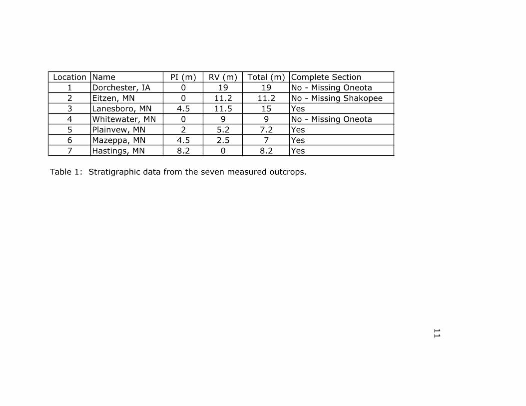
Location Name PI (m) RV (m) Total (m) Complete Section1 Dorchester, IA 0 19 19 No - Missing Oneota2 Eitzen, MN 0 11.2 11.2 No - Missing Shakopee3 Lanesboro, MN 4.5 11.5 15 Yes4 Whitewater, MN 0 9 9 No - Missing Oneota5 Plainvew, MN 2 5.2 7.2 Yes6 Mazeppa, MN 4.5 2.5 7 Yes7 Hastings, MN 8.2 0 8.2 Yes
Table 1: Stratigraphic data from the seven measured outcrops.
11

Figure 5: Outcrop at Dorchester, IA. This area represents the thickest sequence of the New Richmond, at over 19 meters. Person is 1.6 m tall.
12

Figure 6: Ripple marks in float, found at Eitzen, MN, with 1.5 m bar for scale. While they are not in place, it was clear at the outcrop that this block fell from the bed 10 m above the Oneota-New Richmond contact.
13

14
Prairie Island Lithofacies comprised the bottom third of the outcrop; the 10 m
above was the Root Valley Lithofacies. Stromatolitic layers were present within the
Prairie Island Lithofacies, and a few sand stromatolites were possibly present within the
Root Valley Lithofacies; however, verification of these sand stromatolites was not
possible.
Whitewater State Park, MN, 40 km (25 miles) north of Lanesboro, consisted of 7
m of exposed Root Valley Lithofacies. The Oneota/New Richmond contact was not
present at this outcrop. The entire outcrop consisted of large scale cross-beds (1 – 1.5 m
high), some with smaller cross-sets within them. There was a pronounced karst layer 1 m
below the New Richmond/Shakopee contact. The entire outcrop was white, friable
sandstone.
At Plainview, MN, 20 km (12 miles) north of Whitewater State Park, the entire
New Richmond section, 7 m, was present. The bottom two meters of outcrop were
stromatolitic Prairie Island Lithofacies; the remainder of the outcrop was Root Valley
Lithofacies. At the New Richmond/Shakopee border, a 20 cm layer of predominantly
green shale, with white and red sand interbedded, was present.
In Mazeppa, MN, 40 km (25 miles) northwest of Plainview, a complete section of
the New Richmond, also 7 m thick, was present. The Prairie Island Lithofacies extended
from the base of the outcrop; above that, in the Root Valley Lithofacies, there were
undulatory 0.5 m thick sand beds with no visible structures. The border between the
Prairie Island and the Root Valley varied by up to a meter due to the wavy bedding.
A sand chimney dominated one area of the Mazeppa outcrop. It extended through
the entire thickness of the exposed New Richmond and Shakopee units. The chimney
15
widened considerably at the border between the New Richmond and the Shakopee. The
sand was white and friable, with vertical layers of green shale running throughout.
Hastings, MN, 65 km (40 miles) northwest of Mazeppa, was composed of solely
the Prairie Island Lithofacies. The outcrop consisted of 8.2 m of arenaceous dolostone
and dolomite. Most of the outcrop was poorly exposed, and no bedding structures were
found within the section.
SEM
No eolian markings were found on the three samples selected for analysis.
Secondary quartz cement, however, was found growing on several grains from each of
the three samples examined (Figure 7). This cement is characterized by multiple sharp
pyramids spread over the surface of the grain.
Discussion
Stratigraphy
The isopach map (Figure 3) and lithofacies cross section (Figure 4) indicate a
basin environment with two predominant depositional areas (Locations 1 and 3). The
Root Valley Lithofacies is dominant in the paleobasins, while the Prairie Island
Lithofacies extends on either edge of the basins to grade into the Shakopee Dolostone
both north and south of this embayment.

Figure 7: SEM photomicrograph of sand grains from the Root Valley Facies of Whitewater, MN (Location 3, ~5 m). The Whitewater location shows secondary quartz cement growth on the sand grain. Sand grain shown is representative of the entire sample.
16

17
Lithofacies
The presence of only one lithofacies in Dorchester, IA, is supported by a previous
study completed by Squillace (1979), where he also found only one lithofacies present.
However, Squillace (1979) found only ~13 m of the New Richmond at Dorchester.
Nineteen meters of stratigraphic section were measured at Dorchester for this study,
which, given the predicted thickness of the New Richmond in Northeastern Iowa, 19 m of
the New Richmond Member seems a much more likely value. A reason the two
measurements are so different can be attributed to the difference in measuring methods
over an extended (300+ m horizontally) exposure.
Similarly, only the Root Valley Lithofacies was found in Eitzen, MN. Squillace
found two lithofacies at this location, with the Prairie Island changing to the Root Valley
approximately 3 m into the New Richmond Member. Unfortunately, since the
stratigraphy at the Eitzen location for this study was obscured from the Oneota contact to
~3.5 m into the New Richmond Member by heavy erosional markings and secondary
calcite mineralization, this division could not be verified. The Root Valley was present
for the entire exposed outcrop in this area.
At Lanesboro, MN, there is a complete sequence of the New Richmond. The
lithofacies division occurs approximately 5 m above the contact with the Oneota. These
data corresponds to Squillace’s findings (1979). Past studies have found sand
stromatolites in this area (Davis, 1968; Squillace, 1979); some possible sand stromatolites
were noticed in this study, but their presence could not be verified in the field. Ripple-
marks and mud cracks have also been found in the Lanesboro outcrop (Squillace, 1979),
indicating deposition occurred in a near-shore environment.

18
At Whitewater State Park, MN, only the Root Valley Lithofacies is present within
the 9 m of exposed outcrop. The contact with the Oneota is not present within this area,
so the Prairie Island could occur below the exposed Root Valley. Squillace (1979) also
found only the Root Valley Lithofacies present at Whitewater.
The roadcut at Plainview, MN, has changed significantly in the last 25 years.
Squillace (1979) was unable to locate the Oneota at the outcrop, and made the division
between the Prairie Island and Root Valley approximately 1m into the then-exposed
outcrop. Since that time, a drainage ditch has been added, exposing the top of the
Oneota. This adds another meter to the exposure of the New Richmond; however, the
boundary between the Prairie Island and Root Valley Lithofacies is still in the same
horizon, two meters above the Oneota.
At Mazeppa, MN, the Prairie Island and Root Valley Lithofacies can be divided
approximately two meters below the contact with the Shakopee (the Oneota is not
exposed at this outcrop). Squillace (1979) made a similar assessment. There are
prominent carbonate stromatolite beds in the lower part of the Prairie Island Lithofacies.
The outcrop at Mazeppa has a sand chimney from the lithofacies contact into the
Shakopee, continuing upwards until the end of the exposure. This sand chimney contains
vertical bands of green shale. This chimney possibly originally linked to the St. Peter
sandstone. The sandstone would have either filled in previously existing karst in the
PDC, or a postdepositional sinkhole developed, allowing the St. Peter entrance into the
PDC Group (Cowan, 2005; Runkel et al., 2003).
The Hastings, MN, outcrop consists solely of arenaceous dolostone and dolomite
layers, which places it in the Prairie Island Lithofacies. This assessment is supported by

19
Squillace (1979); however, Shea (1960), upon examining the outcrop, determined that it
was undifferentiated PDC. Since there is no clear quartz arenite layer in the area, this
argument has merit; however, based on the work of Squillace (1979) and Shea (1960) at
nearby outcrops, the arenaceous dolostone at Hastings should be considered part of the
New Richmond. Throughout the literature, there is much debate about whether or not the
New Richmond is present in localities north of Rochester, MN (Austin, 1970; Shea,
1960; Squillace, 1979), mainly due to an unclear definition of the characteristics of the
New Richmond Sandstone. Since there is no consensus on the definition of the New
Richmond, the distinction between New Richmond and Willow River beds of the
Shakopee is still somewhat arbitrary.
SEM
The SEM results did not indicate that the New Richmond was deposited in an
eolian environment; however, multiple past studies have found evidence within the
outcrop suggesting an eolian deposition environment (Austin, 1974; Shea, 1960;
Squillace, 1979). However, none of those studies incorporated SEM data into their
conclusions.
Since only a small number of grains from one bed from each of the three sites was
examined, the odds were slim that eolian grains would be found. Most likely, a wider
variety of samples from different outcrops and different stratigraphic sections would
produce some results indicating an eolian mode of deposition in areas of the New
Richmond.

20
Conclusions
The New Richmond is a heterolithic sandstone, shale, and arenaceous dolostone
formation within the Lower Ordovician Prairie du Chien Group. It consists of two
lithofacies: the basal Prairie Island and the Root Valley. It outcrops in a narrow band
along the banks of the Mississippi River in southeastern Minnesota, southwestern
Wisconsin, and northeastern Iowa. From outcrop exposures, the New Richmond is
concentrated in extreme southeastern Minnesota and northeastern Iowa, with the Root
Valley being the dominant lithofacies in the center of its range, grading into the Prairie
Island as the member narrows and grades into the Shakopee.
The New Richmond was deposited in a near-shore, coastal dune environment. It
is hypothesized that the Root Valley was deposited at least in part from eolian action. No
evidence was found for this from SEM studies of individual grains; however, the sample
size for this was relatively small. A larger sample could possibly yield evidence of eolian
deposition.
Acknowledgements
This project could not have been completed without the help of numerous people.
All of the following were instrumental in getting this project off of the ground. Thanks
to: Profs. Clint Cowan and Mike Smith, who acted as advisors to me for this project. An
extra thank you to Mike, as he was able to acquire and smuggle two invaluable
unpublished theses from the UW-Madison library that I otherwise would have had to do
without. Cam Davidson aided me numerous times with the SEM; I could not have done
this without his help. Tony Runkel and Bob Tipping of the Minnesota Geological Survey

21
provided information and guidance during the formulation of this project. And thanks to
my fellow seniors, who provided legions of support and hours of late night company. A
special thanks to my father, Ross Robins, who acted as a field assistant. The Carleton
Geology Department provided monetary support for this project.

22
Works Cited
Andrews, G. W., 1955, Unconformity at Base of New Richmond Sandstone, Crawford
County, Wisconsin: Bulletin of the American Association of Petroleum Geologists, v. 39, no. 3, p. 329-345.
Austin, G. S., 1970, Geology and petrology of Ordovician Shakopee Formation: Information Circular - Minnesota Geological Survey, v. 8, p. 10-11.
-, 1974, Multiple Overgrowths on Detrital Quartz Sand Grains in the Shakopee Formation (Lower Ordovician) of Minnesota: Journal of Sedimentary Petrology, v. 44, no. 2, p. 358-362.
Cowan, C., 2005, Hypotheticals/Hypotheses of Origins of Sand Chimneys in the Shakopee, in Robins, C., ed.: Northfield, MN, unpublished.
Davis, R. A., Jr., 1966, Willow River Dolomite: Ordovician Analogue of Modern Algal Stromatolite Environments: Journal of Geology, v. 74, no. 6, p. 908-923.
-, 1968, Algal stromatolites composed of quartz sandstone: Sedimentary Petrology, v. 38, no. 3, p. 953-955.
Galarowicz, A. M., 1997, Petrographic evidence for the recycling of Late Proterozoic-Early Paleozoic quartzose arenites, Southeastern Minnesota-Southwestern Wisconsin [Master thesis]: University of Minnesota.
Johnson, C. L., and Simo, J. A., 2002, Sedimentology and Sequence Stratigraphy of a Lower Ordovician Mixed Siliciclastic-Carbonate System, Shakopee Formation, Fox River Valley of East-Central Wisconsin: Geoscience Wisconsin, v. 17.
Margolis, S. V., and Krinsley, D. H., 1971, Submicroscopic Frosting on Eolian and Subaqueous Quartz Sand Grains: Geologic Society of America Bulletin, v. 82, p. 3395-3406.
Needham, C. E., 1931, A study of the New Richmond sandstone from two localities in Wisconsin: Transactions of the Illinois State Academy of Science, v. 24, no. 2, p. 363-368.
-, 1932, Contributions to the Subsurface Geology of Northern Illinois, Between the Outcrops of the St. Peter and Dresbach Formations, With Special Reference to the New Richmond Formation [Doctoral thesis]: Northwestern University, 150 p.
Ostrum, M. E., 1964, Pre-Cincinnatian Paleozoic Cyclic Sediments in the Upper Mississippi Valley: a Discussion: Kansas Geological Survey Bulletin, no. 169, p. 381-398.

23
Pride, D. E., 1966, Size and Heavy Mineral Studies of the New Richmond Sandstone of Lower Ordovician Age [Masters thesis]: University of Wisconsin, 120 p.
Runkel, A. C., 1994, Deposition of the uppermost Cambrian (Croxian) Jordan Sandstone and the nature of the Cambrian-Ordovician boundary in the Upper MIssissippi Valley: Geological Society of America Bulletin, v. 106, p. 492-506.
-, 2002, Contributions to the geology of Wabasha County, Minnesota: University of Minnesota.
Runkel, A. C., Tipping, R. G., Alexander Jr., E. C., Green, J. A., Mossler, J. H., and Alexander, S. C., 2003, Hydrogeology of the Paleozoic Bedrock in Southeastern Minnesota: University of Minnesota, 61.
Shea, J. H., 1960, Stratigraphy of the Lower Ordovician New Richmond Sandstone in the Upper Mississippi Valley [Masters thesis]: University of Wisconsin, 137 p.
Smith, G. L., 1989, Karsting and Eolian Deposition During a Pre-New Richmond (Early Ord.) Sea Level Drawdown, Prairie du Chien Group, Upper Mississippi Valley: Geologic Society of America Abstracts With Programs, v. 21, no. 6, p. A80.
-, 1991, Sequence Stratigraphy and Diagenesis of the Lower Ordovician Prairie du Chien Group on the Wisconsin Arch and in the Michigan Basin [Doctoral thesis]: University of Wisconsin, 265 p.
Smith, G. L., Byers, C. W., and Dott, R. H., Jr., 1996, Sequence stratigraphy of the Prairie du Chien Group, Lower Ordovician, Midcontinent, U.S.A. Paleozoic sequence stratigraphy; views from the North American Craton: Geological Society of America, v. 306, p. 23-33.
Smith, G. L., and Simo, J. A., 1997, Carbonate Diagenesis and Dolomitization of the Lower Ordovician Prairie du Chien Group: Geoscience Wisconsin, v. 16, p. 16.
Squillace, P. J., 1979, The Geology of the New Richmond Member of the Shakopee Formation, (Lower Ordovician) Upper Mississippi Valley [Master Thesis thesis]: University of Minnesota, 95 p.
Thiel, G. A., 1935, Sedimentary and petrographic analysis of the Saint Peter sandstone: Geological Society of America Bulletin, v. 46, no. 4, p. 559-614.
Ulrich, E. O., 1924, Notes on new names in table of formations and on physical evidence of breaks between Paleozoic systems in Wisconsin: Transactions of the Wisconsin Academy of Sciences, Arts and Letters, v. 21, p. 71-107.

0
1
2
3
4
5
6
7
8
9
10
11
Lanesboro
13
14
15
16
0
1
2
3
4
5
6
7
8
9
10
11
Dorchester
12
13
14
15
16
17
18
19
20
0
1
2
3
4
5
6
7
8
9
10
11
Eitzen
0
1
2
3
4
5
6
7
8
9
10
11
Whitewater
0
1
2
3
4
5
6
7
8
9
Plainview
0
1
2
3
4
5
6
7
8
9
10
Hastings
1 765432
RV
RVRV
RV
RV
PI
PI
PIdoloarenite shale
dolomite
crossbed
planar sand
stromatoliticunbedded sand
RV
PI
Root Valley Facies
Prairie Island Facies
Appendix 1: Stratigraphic columns of the New Richmond Member of the Prairie du Chien Group, with facies marked. Width of column denotes grainsize, with the wider columns indicating larger grains.
SHAKOPEE
ONEOTA
ONEOTAONEOTA
ONEOTA
ONEOTA
0
1
2
3
4
5
6
7
8
9
Mazeppa
RV
PI
24

25
Appendix 2
Outcrop locations
These outcrop locations were adapted from (Squillace, 1979), and proved
invaluable in locating the actual New Richmond outcrops from among many different
bluffs of southeastern Minnesota.
Location 1: Dorchester, IA
Roadcut located on A-19, approx. 0.6 km (0.4 miles) west of Dorchester, IA. (T99N, R6W, Allamakee County) 19 m of outcrop Location 2: Eitzen, MN
Roadcut located on MN Highway 76, approx. 6.5 km (4 miles) northwest of Eitzen, MN (SE 1/4, SE 1/4, Sec. 11, T101W, R6W, Houston County)
11 m of outcrop Location 3: Lanesboro, MN
Roadcut located on County Road 8, approx. 0.4 km (0.25 miles) northwest of Lanesboro, MN.
(W 1/2, Sec. 13, T103W, R10W, Fillmore County) 15 m of outcrop
Location 4: Whitewater State Park, MN
Roadcut located on the west side of MN Highway 74, near the southern entrance to Whitewater State Park, approx. 8 km (5 miles) north of St. Charles, MN. (NE 1/4, NE 1/4, SE 1/4, sec. 30, T107N, R10W, Winona County)
9 m of outcrop Location 5: Plainview, MN
Roadcut located on the south side of County Road 8, approx 6.5 km (4 miles) east of Plainview, MN.
(S 1/2, Sec. 7, T108N, R10W, Winona County) 7 m of outcrop

26
Location 6: Mazeppa, MN
Roadcut located on Wabasha County Road 1, located approx. 0.4 km (0.25 miles) west of Mazeppa, MN.
(SE 1/4, Sec. 1, T109N, R15W, Wabasha/Goodhue County Border) 7 m of outcrop
Location 7: Hastings, MN
Stream cut located approx. 0.6 km (0.4 miles) east of the US Highway 61 bridge over the Vermillion River. Outcrop is located in a rails-to-trails park, underneath a former rail bridge. Outcrop is hard to access.
(NE 1/4, SE 1/4, NW 1/4, Sec. 34, T115N, R17W, Dakota County) 8 m of outcrop