the iho s-100 standard and e-navigation · pdf filee-nav10/inf/7 2 annex a the iho s-100...
TRANSCRIPT

e-NAV10/INF/7
1
e-NAV10 Information paper
Agenda item 12
Task Number
Author(s) Raphael Malyankar, Jeppesen
Jarle Hauge, Norwegian Coastal Administration
The IHO S-100 Standard and e-Navigation Information
Concept Exploration with Ship Reporting Data and Product Specification
1 SUMMARY
The papers describe an exploration in modeling substantially non-geographic maritime information using the S-100 framework, specifically notice of arrival and pilot requests in Norway.
The Norwegian Coastal Administration is the National Competent Authority for the European SafeSeaNet (SSN) in Norway and thereby maintains a vessel and voyage reporting system intended for use by commercial marine traffic arriving and departing Norwegian ports. Data used in this system describes vessels, HAZMAT cargo, voyages, and information used in arranging pilotage.
Jeppesen and the NCA has developed a product specification (the “NOAPR product specification”) based on the S-100 standard, for a subset of information used in the abovementioned system. The product specification describes the data model for ship reporting and pilot requests. The current version is a “proof-of-concept” intended to explore the development of S-100 compatible data models for non-geographic maritime information.
The papers also discuss the use of the Geospatial Information Registry and the NOAPR Model.
1.1 Purpose of the document
The product specification [NOAPR] demonstrates the feasibility of modelling ship notice of arrival and pilot requests using the data model compatible with S-100.
2 BACKGROUND
The papers are a result of a mutual work between Jeppesen and the Norwegian Coastal Administration within the Interreg project; BLAST (http://www.blast-project.eu/index.php).
3 REFERENCES
[1] See information papers.
4 ACTION REQUESTED OF THE COMMITTEE
The Committee is requested to:
1 The Committee is invited to note the information papers provided.

e-NAV10/INF/7
2
ANNEX A THE IHO S-100 STANDARD AND E-NAVIGATION INFORMATION -CONCEPT EXPLORATION WITH SHIP REPORTING DATA
1 INTRODUCTION
The IHO S-100 standard is a framework standard intended to allow development of data models and associated product specifications for a variety of data sources, products, and customers [War2011]. Product specifications conforming to the S-100 framework are intended for one or another kind of data product, application, or service, e.g., ENCs, nautical publications, bathymetry, etc. Previous work on S-100 product specifications has focused on inherently geographic data (such as ENC data [S101, S102, MPA, PIL]) or largely geographic information (routeing guide information [DRG]). This paper describes an exploration in modeling substantially non-geographic maritime information using the S-100 framework, specifically notice of arrival and pilot requests in Norway.
2 ABBREVIATIONS AND TERMS
2.1 Abbreviations
GML Geography Markup Language IALA International Association of Marine Aids to Navigation and Lighthouse Authorities IHO International Hydrographic Organisation IMO International Maritime Organisation NCA Norwegian Coastal Administration (Kystverket) SNPWG Standardisation of Nautical Publications Working Group (IHO) TSMAD Transfer Standard Maintenance and Development Working Group (IHO) XML Extensible Markup Language
2.2 Terms
Attribute: An attribute is a characteristic of a feature. Attributes may be simple or complex attributes. An attribute has a name and type associated with it. An attribute may be a simple attribute or a complex attribute.
Cell: A subdivision of space.
Complex attribute: A complex attribute is an aggregation of other attributes, which may be either simple or complex.
Coverage: A set of data that describes a set of attribute values distributed over an area.
Feature: A feature is an abstraction of a real-world geographic phenomenon or location.
Information object: An Information object is an identifiable unit of information. It has attributes like all feature types but have no geometry of its own. Information types may reference other information types and may reference feature types. They are used to provide information pertaining to a feature or another information object.
Register: A collection of definitions of objects, attributes, and metadata, all pertaining to a specific domain (e.g., navigational charts). The IHO operates a Web-based registry that provides for registers for different domains within maritime information.
Simple attribute: A simple attribute carries a specific value from a domain, such as a date, text string, or a value chosen from an enumerated list.
3 OVERVIEW
Kystverket (Norwegian Coastal Administration) is the National Competent Authority for the European SafeSeaNet (SSN) in Norway and thereby maintains a vessel and voyage reporting system intended for use by commercial marine traffic arriving and departing Norwegian ports (SafeSeaNet Norway, http://www.shiprep.no). The system is intended as a single-window for filing Notices of Arrival, pilot requests, and other forms required of commercial shipping, and a user guide is available online1. Data used in this system describes vessels, cargo (especially hazardous
1 Ship Reporting Web Client User Guide, Kystverket Vest, Haugesund. http://www.kystverket.no

e-NAV10/INF/7
3
materials), voyages (especially port arrivals and departures), and information used in arranging pilotage.
Jeppesen and the NCA developed a product specification (the “NOAPR product specification”) based on the S-100 standard, for a subset of information used in the abovementioned system. The product specification describes the data model for ship reporting and pilot requests. The current version is a “proof-of-concept” intended to explore the development of S-100 compatible data models for non-geographic maritime information.
4 PRODUCT SPECIFICATION
The product specification [NOAPR] demonstrates the feasibility of modelling ship notice of arrival and pilot requests using the data model compatible with S-100. The current version focuses on data modelling for a simplified Notice of Arrival and Pilot Request. The application schema and feature catalogue required of S100-style product specifications are provided in detail in the NOAPR document. Other sections which are less relevant to the immediate exploration are omitted. The product specification draws on the IHO S-57 (ed. 3.1) standard and on SNPWG work on nautical publications data modelling for some object and attribute specifications. Where existing objects/attributes were unavailable, new objects and attributes were defined. The NOAPR specification is available from the authors.
4.1 Overview of data model in NOAPR
The NOAPR product specification currently (April 2011) contains 4 features, 7 information types, and 64 attributes.
The Feature objects are
1 pilot boarding places,
2 pilot service area,
3 port, and
4 radio calling-in points.
All the objects are defined in the current models (specifically, ENC and Nautical publications data models).
The information objects model comprise arrival- and departure notices, requests for pilots, contact information for pilot services and reporting authorities and their hours of operation.
The information objects, contact details and hours of operation were re-used from the Nautical Publications model and the others had to be newly defined for use in the NOAPR product specification.
The attributes include those already defined in the ENC and Nautical Publications registers for the objects re-used from those models (i.e., all 4 Features and 2 Information objects). In addition, new attributes were defined to capture the specific data items required for arrival/departure notices and pilot requests.
Relationships between objects are modelled by the application schema diagrams contained in the NOAPR product specification. For example, a voyage (Figure 1) is modelled as an object with a VoyageID attribute, associated with PortArea objects which denote the impending port of call (and optionally, the next port of call).

e-NAV10/INF/7
4
Figure 1 Model of a “voyage” (from NOAPR product specification)
4.2 Structure
This section summarizes the NOAPR approach to the structure of a data product.
Exchange sets and data sets: The basic unit for a NOAPR data product is a message between the vessel and the national competent authority. To conform to S-100 requirements, the product specification defines dataset and exchange set, building upon the “message” unit. A dataset may be comprised of one or more messages. An exchange set may contain one or more data sets.
Cells: Since the S-100 framework standard was designed for geospatial information, cell structure for conforming data sets is expected to be organised spatially in S-100 conformant datasets, e.g., the data sets cover subdivisions of space such as the cells in a latitude/longitude grid. S-100 also permits point set data, which is a set of points (which is also a spatial organisation of data). For NOAPR, whether spatial organisation is appropriate depends on whether the reporting requirements are substantially different for different regions (that is, different in whether and when reports must be filed and what information must be reported). For a single country the difference may be only in the details of the report (i.e., the authority which received the report may be different for different destination ports) and, given the introduction of single-window processing, may in practice be a single reporting address or intermediary (such as SafeSeaNet). If more than one country is covered, there may be differences in national requirements, and changes are likely to be made by national authorities. It is also convenient to separate notices and request by time, either by date of filing or time of arrival/departure or pilot service requirement. The appropriate organisation may therefore be spatio-temporal, consisting of point coverage with each cell containing the ports of a single country (or national subdivision) with uniform regulations, further subdivided by the time of filing.
Support files: Support files are expected to be unnecessary, assuming that Notices of Arrival and Pilot Requests do not need/allow for attachments to be submitted with the request. If attachments are allowed, file types, naming conventions, etc., can be added for documents, screen captures, etc., as needed, since the S-100 standard allows for support files.
Since the unit of data transfer in this domain is a message, data sets and exchange sets are relatively small (expected to be a few kilobytes at most even including XML tags). The typical “dataset” in NOAPR is likely to be a single transmission between the vessel and the competent authority.
4.3 Metadata
The S-100 standard requires several items of information in the form of metadata for datasets and other resources. The minimum requirements are given in Part 4 of S-100 V. 1.0.0. Many of the required elements (such as contact information, file identification, language, character set, topic, date stamp) are easily defined. Adaptations have been made where appropriate, to the geographic location and data quality elements, due to the fact that the concept of a “dataset” differs for a message-oriented (request/response) data model as compared to a location-oriented data

e-NAV10/INF/7
5
model (e.g., ENC, weather, or bathymetric data). The NOAPR product specification contains our concept for metadata for this particular domain.
Given the nature of a dataset in this domain, the essential metadata is likely to be limited to the identity of the sender, a time stamp, and identification of the applicable product specification, all of which are can be part of header information in the message. “Discovery” metadata is minimal (the sender, ports involved, and time stamp) and “data quality” is not relevant.
4.4 Limitations
The current product specification, being a concept exploration, does not contain all the obligatory information a ship is obliged to report on arrival/departure to a Norwegian port. Creating a comprehensive product specification for “Notifications of Arrival” is not the goal of this exercise. Neither does it define an encapsulation (given more effort, it is possible to define an XML-based encoding consistent with S-100, perhaps using GML, especially given that a different XML format for notification data already exists). Responses from the controlling authority are also mentioned but not defined in the product specification.
The S-100 standard mentions some additional sections which were omitted from the exploration (they are listed in the NOAPR document). Of these, some are trivial in the sense that corresponding sections from other standards can be carried over or adapted – e.g., co-ordinate reference systems; others (data quality, data maintenance, data capture guide) are straightforward though developing them would take some effort; yet others are not relevant (e.g., the Portrayal section). We expect the content of the omitted sections would adhere to the requirements of S-100.
5 GEOSPATIAL INFORMATION REGISTRY AND THE NOAPR MODEL
5.1 IHO Geospatial Information Registry
IHO Publication S-99 [S99] describes a registry based on ISO 19135, containing five types of registers:
Feature concept register, a dictionary of feature concepts (geographical and information, objects and attributes).
Portrayal register, a dictionary of portrayal rules and symbols.
Metadata register, a dictionary of metadata concepts items.
Product specifications register, a list of S-100 based Product Specifications, containing information about their content, purpose, versions, location, and availability.
Data producer code register, a list of codes which identify producers of data products such as Hydrographic offices and ENC producers.
Selections from the Feature Concept, Portrayal and Metadata Registers are used to define Feature and Portrayal Catalogues in individual Product Specifications.
Registers are classified as either a Main Register for items directly used in official hydrographic products, or a Supplementary Register for other types of data. This allows subdivisions corresponding to different domains of maritime data. The IHO maintains a web site (http://registry.iho.int/) with feature concept registers for ENC and nautical publications data, and supplementary registers for ice data, inland ENCs, etc. The figure below shows how information for notices of arrival/departure and pilot requests would fit into the IHO Geospatial Information (GI) registry.

e-NAV10/INF/7
6
Figure 2 Registers
These registers can be viewed by the public. The IHO has indicated its willingness to host definitions for relevant domains on the same web site in the future. The IALA could use this facility to propose a domain for notice of arrival data. A formal proposal for a new domain, including details of who would assume responsibilities for management and control of the domain would be needed and a domain control body (a group of technical experts responsible for evaluating changes to the contents of the registers) would have to be set up. IHO publication S-99 describes the management roles and procedures for the registry
5.2 NOAPR Information and the GI Registry
The feature concept dictionary for a hypothetical NOAPR domain would contain objects and attributes listed in the table in the “Summary of Types” section of the NOAPR Product Specification and labelled NOAPR in the first column of that table. The NOAPR specification re-uses objects from the nautical publications and ENC registers (labelled NPUB and HYDRO respectively); these are located in the feature concept dictionaries for the Nautical Publications and ENC domains respectively.
The registry is supposed to maintain previous versions of the objects/attribute definitions, and specifying the version date in the product specification (the last column of the table in the NOAPR product specification) ensures that an update to an object or attribute in the ENC or Publications domain need not affect the NOAPR product unless reviewed and accepted by the responsible party for the NOAPR product specification.
Note that re-use of entities defined in other registers is not an essential requirement – it is possible to define objects or attributes with similar names and characteristics in different domains. However, the general principles of information modelling discourage such re-definition because they result in difficulties in data exchange and integration of information. Maintaining data models as domains in the IHO GI registry should encourage re-use and reduce redefinition of similar concepts in different domains.
6 USE CASE
The NOAPR document includes a detailed use case, reproduced below with minor changes:
MV North Star, bound for Haugesund, is supposed to deliver an electronic Notice of arrival (NOA) 24 hours in advance. This ship is also obligated to have a pilot onboard when entering fairways and the port.
NCA operates a Web Service (WS) which handles NOAs and pilot requests. The ship has an “office” computer system in the charthouse or “back bridge”. This system is capable of monitoring ship location by means of a link with the ECDIS. It runs the necessary software for communicating with the WS, filing notices, etc.
The following actions are taken:
1 During passage planning, an alert was set to contact the WS when the ship was 26 hours from arrival in port (the 24-hour reporting requirement plus a margin for completion of the paperwork).
2 The alert goes off at the proper time.
3 The ship sends a request (in XML via the Web service) to the NCA for arrival obligations. The request is sent automatically by an application on the office computer.
Main registers Supplementary registers
ENC domain
Nautical Pubs. domain
Notices of Arrival or Departure
ICE Inland ENC
e-NAV10/INF/7
7
4 The WS replies with the mandatory information elements which must be submitted upon arrival.
5 The information sent by the WS appears on the ship’s office computer.
a. The application also shows the regulations pertaining to arrival in Norwegian waters in general and at Haugesund port in particular, if any (both national and local regulations). These regulations are extracted from the Nautical Publications (NPUB) S100-compliant dataset installed on the computer.
b. The application running on the “office computer” also displays an outline map of the area showing the relevant features (e.g., port, harbour plan, berths, pilot boarding places in the neighbourhood, radio calling-in points). This information combines selected features from the S100 ENC and NPUB datasets installed on the computer.
6 The master fills out the necessary information about ship, cargo, crew, and ETA, consulting the regulations and notes displayed by the system for explanations as needed. Information about cargo is pre-filled by the application which has the data stored in a local database, where it was entered when the ship loaded cargo.
7 The master specifies a pilot boarding place by clicking one of the Pilot Boarding Place objects in the display, and the system computes an estimate of ETA at the boarding place.
8 The notice of arrival data and pilot request are sent to the NCA via its web service.
9 The NCA WS acknowledges receipt. The ship has now submitted a NOA and requested a pilot.
Variations and improvements on the above are obviously possible, e.g., involving a ship’s agent as an intermediary to reduce the workload on board.
The use case shows how the model facilitates automation and information sharing between applications.
7 OTHER ISSUES
7.1 Model Re-use and Data Compatibility
Re-use of objects and attributes from different registers is convenient, but not necessarily required. The NOAPR product specification tries to re-use objects/attributes from existing, “standard” models wherever possible, but where necessary it defines new attributes which are similar to but not the same as other models. For example, NOAPR has a boolean (Y/N) attribute indicating whether the vessel is carrying dangerous or hazardous material; the NPUB model developed by SNPWG has an enumeration-type attribute for type of cargo (allowed value “7” corresponds to “hazardous cargo”) and a second attribute for the category of hazardous cargo (to indicate which MARPOL category the cargo belongs to). Given that systems were developed independently and are in entrenched use, such inefficiencies are probably unavoidable. As a practical matter, they complicate cross-domain data exchange between applications, and it will be necessary to either modify the NOAPR model to make it compatible with the more detailed model, or define rules for converting from one to the other.
8 CONCLUSION
This paper described an exploration of modelling non-geographic shipping-related information using the S-100 standard and data models of ENC and Nautical Publications. The results suggest that:
1 Development of compatible models under the S-100 framework is feasible for a variety of domains including some which are largely non-geographic.
2 Content can be readily modelled using S-100, but some inefficiencies in data format and product structure exist when devising a model for non-geospatial data, due to the fact that S-100 is designed for geospatial information. For IALA and IMO domains, it might be advantageous to use the content modelling portions of S-100 (feature classes, information classes, associations, spatial representations, etc.) for content, and adapt the data format,

e-NAV10/INF/7
8
transfer set structure, and metadata portions of S-100 to the special circumstances under which IMO/IALA data is transmitted or “exchanged”. Adaptations of the S-100 model should be explored with TSMAD.
a. The S-100 concepts of cells, exchange set, and data set should be adapted for message-oriented data and temporally focused data, as compared to data with a spatial focus.
b. Metadata and data quality components of S-100 can be used, but may be too complex for IMO and IALA data and should also be reviewed to make them more flexible.
3 S-100 compatible models will facilitate advanced functionality in computer applications, as demonstrated by the use case in this document.
4 For concepts which are already defined in the ENC or Nautical Publications domains, re-use of model elements (objects/attributes) should be encouraged. Data compatibility and cross-domain data integration will need to be addressed when building a data model.
5 Use of the IHO registry for creation and dissemination of data models and product specifications is encouraged.
6 Work in TSMAD and SNPWG on specifications for integration of auxiliary navigation information with ENCs and other forms of S-100 compliant data should be monitored and participated in as appropriate with the purpose of facilitating good integration of IALA or IMO data with S-100 compliant data.
9 REFERENCES
[DRG] Product specification for Digital Mariners Routeing Guide (under development). Draft at http://www.iho-ohi.net/mtg_docs/com_wg/SNPWG/SNPWG13/SNPWG13Docs.htm.
[GML] OpenGIS Geography Markup Language (GML) Encoding Standard, OGC 07-036, v. 3.2.1, ed. C. Portele, Open Geospatial Consortium Inc., 2007. Also ISO 19136:2007 Geographic Information – Geography Markup Language, International Organization for Standardization, Geneva, Switzerland.
[War2011] IHO S-100: The universal Hydrographic data Model. R. Ward and B. Greenslade, International Hydrographic Organisation. IHO Information paper, 2011. URL: http://www.iho-ohi.net/iho_pubs/standard/S-100/S-100_Info.htm
[MPA] Marine Protected Areas – Product Specification (SNPWG working document, under development). Draft at http://www.iho-ohi.net/mtg_docs/com_wg/SNPWG/SNPWG13/SNPWG13Docs.htm.
[NOAPR] Notice of Arrival and Pilot Request Specification. Contact the authors of this paper for more information.
[PIL] Pilotage product specification (SNPWG working document). Draft at http://www.iho-ohi.net/mtg_docs/com_wg/SNPWG/SNPWG11/SNPWG11Docs.htm.
[S99] Operational Procedures for the Organization and Management of the S-100 Geospatial Registry. Edition 1.0.0, International Hydrographic Bureau, Monaco, January 2011.
[S100] Universal Hydrographic Data Model, IHO Publication S-100, Edition 1.0.0, International Hydrographic Bureau, Monaco, January 2010.
[S101] Electronic Navigational Chart Product Specification, IHO Publication S-101, International Hydrographic Bureau, Monaco (under development). Draft at http://www.iho-ohi.net/mtg_docs/com_wg/DIPWG/DIPWG3/DIPWG3Docs.htm.
[S102] Bathymetric Surface Product Specification, IHO Publication S-102, International Hydrographic Bureau, Monaco (under development). Draft at http://www.iho-ohi.net/mtg_docs/com_wg/DIPWG/DIPWG3/DIPWG3Docs.htm.
[TSMAD20-18a] Requirements for the Integration of S-100 compliant auxiliary Navigational Information with S-101 ENC data. L. Patterson, D. Galton, H. Astle, C. McLeay, P.

e-NAV10/INF/7
9
Burton, E. Lewis, E. Mong, Working note TSMAD20/DIPWG2-18A. At http://www.iho-ohi.net/mtg_docs/com_wg/TSMAD/TSMAD20/TSMAD20Docs.htm.
[TSMAD20-18b] Proposed Specification for Auxiliary Information Layer Integration for use with ENC S-10x. Working note TSMAD20/DIPWG2-18B. At http://www.iho-ohi.net/mtg_docs/com_wg/TSMAD/TSMAD20/TSMAD20Docs.htm.

e-NAV10/INF/7
10
ANNEX B NOTICE OF ARRIVAL AND PILOT REQUEST SPECIFICATION
1 OVERVIEW
1.1 Introduction
Kystverket (Norwegian Coastal Administration) being the National Competent Authority for the European SafeSeaNet (SSN) in Norway and thereby maintains a vessel and voyage reporting system intended for use by commercial marine traffic arriving and departing Norwegian ports (SafeSeaNet Norway, http://www.shiprep.no). The system is intended as a single-window for filing Notices of Arrival, pilotage requests, and other forms required of commercial shipping.
The Notification of Arrival and Pilotage information product specification describes the data model used in this system. Reporting during passage to VTS centres, on arrival at radio calling-in points, and under ship reporting systems is not included.
Note: The current document is a “proof-of-concept” document that is intended to explore the feasibility of defining such specifications for maritime information other than charts, nautical publications, or similar information. It does not contain all the obligatory information a ship is obliged to report on arrival/departure. Creating a comprehensive product specification for “Notifications of Arrival” is not the goal of this exercise.
1.1 References
[ISO19115] ISO 19115:2003. Geographic information – metadata. International Standards Organisation, 2003.
[S-57] IHO Transfer Standard for Digital Hydrographic Data, Special Publication No. S-57, Edition 3.1, November 2000 (as updated by Supplement 2). International Hydrographic Bureau, Monaco.
[S-100] Universal Hydrographic Data Model. IHO Special Publication No. S-100, Edition 1.0.0, January 2010. International Hydrographic Bureau, Monaco.
[S-100U1] Draft update to Universal Hydrographic Data Model, IHO Special Publication No. S-100. (Under development, January 2011.)
[S-101] Electronic Navigational Chart Product Specification. IHO Special Publication No. 101, (Draft), International Hydrographic Bureau, Monaco.
[SW] Wiki maintained by Capt. Schröder-Fürstenberg for Standardization of Nautical Publications Working Group discussions, URL: http://www.fuerstenberg-dhg.de/mediawki/index.php
1.2 Terms, Definitions and Abbreviations
1.2 Terms and Definitions
The terms and definitions in S-100 V. 1.0.0 § 1-3 and Annex 1 apply to this document. The following additional terms are used.
Cell A cell is a geographical area where the information in a dataset applies.
1.3 Abbreviations
The abbreviations defined in S-100 V. 0.0.3 § 0-2 are used in this document. The following abbreviations are also used:
ECDIS Electronic Chart Display Information Systems
ENC Electronic Navigation Charts
GML Geography Markup Language
IHO International Hydrographic Organisation
IMO International Maritime Organisation
NCA Norwegian Coastal Administration (Kystverket)
PSC Port State Control
SNPWG Standardisation of Nautical Publications Working Group

e-NAV10/INF/7
11
TSMAD Transfer Standard Maintenance and Development Working Group
1.4 General Data Product Description
Title: Notice of Arrival and Pilotage Request Information
Abstract: Notice of Arrival and Pilotage Request Information (NO&PR) is an XML product produced for reports required of vessels arriving and departing Norwegian ports. Its primary function is for use in the Norwegian ship reporting system and related systems. The NO&PR contains the information required by regulatory requirements applying to commercial shipping within the area of coverage. It also contains information required for filing pilotage requests. Note that the NO&PR product specification does not meet all reporting requirement set out in EU and Norwegian legislation.
Content: A conformant data set may contain features associated with the information on regulations, notifications of arrival/departure, pilotage, communications, and safety information. The specific content is defined by the NO&PR Feature Catalogue and the NO&PR Application Schema.
Spatial Extent:
Description: Areas where regulations pertaining to ship reporting information for vessels arriving or departing Norwegian ports are applicable.
East Bounding Longitude: 180 West Bounding Longitude: -180 North Bounding Latitude: 90 South Bounding Latitude -90
Specific Purpose:
This document describes data that are exchanged between vessel or agent and government authorities, ports, and pilotage services in connection with arrival and departure reporting requirements, requests for pilotage, and port entry. It also includes information on pilot services, communications, reporting and other information needed for arrival/departure reports and pilotage planning.
1.5 Notice of Arrival and Pilotage Requests Information Product Specification Metadata
Title: Notice of Arrival and Pilotage Requests Information Product Specification
Version: 0.0.0
Date: 18 March 2011
Language: English
Classification: Unclassified
Contact: Jeppesen GmbH
(Address)
Telephone: + 49 …
Fax: +49 …
e-mail: [email protected]/[email protected]
URL: www.jeppesen.com
Identifier: NOAPR
Maintenance: Changes to this product specification are coordinated by the authors.
1.6 Use case/story
A ship is heading for a port in “a country”, i.e.: Haugesund/Norway. According to legislation the vessel is supposed to deliver an electronic Notice of arrival (NOA) 24 hour before arrival to the port of destination. The ship is also in some cases obligated to have a pilot onboard the ship when entering fairways and the port of destination.

e-NAV10/INF/7
12
The Norwegian Coastal Administration (NCA) is operating a Web Service (WS) which handles NOA’s and pilot requests.
The ship has an “office” computer system which is used in the charthouse or “back bridge” to avoid interference of paperwork with navigation. This system is capable of monitoring passage wither independently or by means of a link with the ECDIS and runs the necessary software for communicating with the WS, filing notices, etc.
The following actions are taken:
1 During passage planning, an alert was set to contact the WS when the ship was 24+ hours from arrival in port (the 24-hour reporting requirement plus a margin for completion of the paperwork).
2 The alert goes off at the proper time.
3 The ship sends a request (in XML via the Web service) to the NCA for arrival obligations. The request is done automatically by an application on the ship.
4 The WS replies to the ship with the mandatory information elements which must be submitted upon arrival.
5 The information sent by the WS appears on the ship’s office computer.
a. The application also shows the regulations pertaining to arrival in Norwegian waters in general and at Haugesund port in particular, if any (both national and local regulations). These regulations are extracted from the Nautical Publications (NPUB) S100-compliant dataset installed on the computer.
b. The application running on the “office computer” also displays an outline map of the area showing the relevant features (e.g., port, harbour plan, berths, pilot boarding places in the neighbourhood, radio calling-in points). This information combines selected features from the S100 ENC and NPUB datasets installed on the computer.
6 The master fills out the necessary information about ship, cargo, crew and ETA in port, consulting the regulations and notes displayed by the system for explanations as needed. Information about cargo is pre-filled by the application which has the data stored in a local database, where it was entered when the ship loaded cargo.
7 The master specifies a pilot boarding place by clicking one of the Pilot boarding Place objects in the display and the system computes an estimate of ETA at the boarding place.
8 The master verifies the information and the reply with ship/cargo/crew information, pilot boarding place and ETA at the boarding place and port is sent to the NCA via the web service.
9 The NCA WS responds OK/NotOK.
10 If OK, the ship has submitted a NOA and requested a pilot.
This user story can of course be more elaborate and detailed, and other functionality such as automatic update from a subscription service, contact with the ship’s agent, etc., can be hypothesized.
2 SPECIFICATION SCOPE
Notice of Arrival and Pilotage requests data products are homogeneous in extent and do not vary for different parts of the data. The NO&PR product specification describes one data product and requires only one scope which is described below;
Scope identification: Notice of Arrival and Pilotage Requests datasets. Hierarchical level: (TBD) Hierarchical level name: (TBD)

e-NAV10/INF/7
13
Level description: information applies to the dataset Extent: EX_GeographicExtent - Global coverage of maritime areas. EX_TemporalExtent and EX_VerticalExtent are not defined for this product specification.
3 DATA PRODUCT IDENTIFICATION
Title: NotificationOfArrival & PilotRequest
Alternative Title: NOA&PR
Abstract: When an S-10x PN is produced it must be in accordance with the rules defined in the PN product specification. S-10x details specifications intended to enable Hydrographic Offices to produce a consistent PI, and manufacturers to use that data efficiently in an ECDIS to satisfy IMO Performance Standards for ECDIS.
Topic Category: Transportation
Geographic Description: Areas where Notification Of Arrival and Pilotage Request for marine navigation is applicable.
Spatial Resolution: Display Scale
Purpose: The data shall be used with the purpose of creating a Notification Of Arrival and requesting a pilot to a National Competent Authority, and explain why use of such service is required or recommended.
Language: English, with additional languages optional.
Classification: Unclassified
Spatial Representation Type: Vector
Point of Contact: Producing Hydrographic Office
Use Limitations: Not to be used without ENC and NPUB data
4 DATA CONTENT AND STRUCTURE
4.1 Introduction
NO&PR is based on the General Feature Model (GFM) from S-100. The GFM is the conceptual model and the implementation is defined in the Feature Catalogue. A brief summary of the building blocks of the GFM follows. More information is available in the S-100 specification [S100].
A feature is an abstraction of real world phenomena, e.g., charted features such as a restricted area, harbour area, navigation aid, etc. In the S-100 model, GF_FeatureType is a metaclass that is instantiated as classes that represent individual feature types. A certain feature type is the class used for all instances of that feature type. The instances of a class that represents an individual feature type are called feature instances. Feature types are equivalent to classes and feature instances are equivalent to objects.
An information type is an identifiable object that can be associated with features in order to carry information pertaining to the associated features. A regulation pertaining to passage requirements for a fairway is an example of an information type which is associated with the geographic feature type representing the fairway. S100_GF_InformationType is the class intended to be the metaclass for information types in S-100.
Simple Attributes can be enumerations, codelists or simple types (e.g. integer or character string).
Complex attributes are properties of a feature which can be divided into multiple sub attributes and are used where objects have properties that better fit a hierarchical structure. They provide a better construct for encoding list attributes on objects such as light sectors.

e-NAV10/INF/7
14
Aggregations are used represent features that are related to each other.
A feature association is a relationship that links instances of one feature type with instances of the same or a different feature type. Each relationship has a name and two roles thus giving a more detailed representation of the real world relationships within the dataset.
An NO&PR product is a feature-based product containing objects related to filing notices of a ship’s arrival or departure and pilot requests. The features and properties are as defined in the IHO standard S-57, the IHO feature concept dictionary for S-101 and the SNPWG Nautical publications dictionary (under development at the SNPWG Wiki [SW]). Spatial objects are encoded as vector entities which are derived from the geometry element GM_Object (from the IHO S-100 framework standard and ISO 19107). Spatial objects can be of type Point, Curve (line) or surface (area). Figure 1 provides a partial overview of the domain model. The model consists of the following packages:
definitions of the spatial objects (package “Geometry”);
generalized domain classes, attributes, enumerations, and sub-packages (package “Domain Objects”);
definitions from the IHO nautical publications model (package NPUB);
definitions from the IHO ENC model (package HYDRO);
definitions for notices of arrival and departure (package “Notices”);
definitions for pilotage requests (package “Requests”).
Also shown in the figure are the complex attributes and enumerations defined in each package (only the nautical publications and ENC models define them).
Figure 1 Domain Model

e-NAV10/INF/7
15
This rest of this section contains the product Application Schema expressed in UML. The associated Feature Catalogue is given in Appendices A-C. The Feature Catalogue provides a full description of each feature type including its attributes, attribute values and relationships in the data product.
4.2 Application Schema
Figure 2 is a model of the notices of arrival and departure and pilotage request. Each notice is associated with a port area (which provides the name of the port as the objectName attribute of PortArea) as the port or arrival or departure. Association with an additional port area as the “Next Port of Call” is optional. The figure also shows a pilotage request which can optionally be linked to a pilot boarding place.
Figure 2 Notices of arrival/departure and pilotage requests
Erreur ! Source du renvoi introuvable. shows a model of a single voyage. A voyage is done by a Vessel and must have a Port of Call and Port of Departure. It may have an optional Next Port of Call. All are represented by the PortArea object from the Nautical Publications register.

e-NAV10/INF/7
16
Figure 3 Voyage
Figure 4 shows the notices and pilot request transmitted by a ship. The message consists of vessel information and an arrival notice, departure notice, or pilot request. Vessel information is required, and at least one of the notices or request must be present.
Figure 4 Messages sent by a ship
4.3 Feature Catalogue
Name: Notice Of Arrival and Pilotage Requests Feature Catalogue
Scope: Catalogue containing objects associated with notices of arrival and pilot requests.
Field of application: Marine navigation
Version Number: 0.1
Version Date: 18 March 2011
Producer: Jeppesen/NCA

e-NAV10/INF/7
17
4.3.1. Summary of Types
The table below lists the objects (feature and information types) and the attributes used in this product specification.
The “Register Dictionary” column tells where the item is defined
- HYDRO for objects/attributes which are part of ENCs
- NPUB for those which are part of nautical publications, and
- NOAPR for those defined for the NOAPR product)2.
The “Index” column states whether the entity is a geographic object (“Feature”), information object, or attribute.
Alpha code is a 6-character acronym3 assigned to the object and version date serves to identify which version of the object is used in this specification.
The table lists all the feature types first, followed by the information types and attributes.
From our point of view the Voyage is a central object. The voyage has a unique identifier and is related to a LOCATION object, in this case departure - and arrival port, sometimes also called PortOfDeparture and PortOfCall. There might in some cases be a relation towards the NextPortOfCall, which will be the next planned port after the one the ship is calling for.
In this product specification, ports LOCATIONs are represented by the Port Area geographic object defined in the Nautical Publications register.
Vessel is also considered to be an important information type. The Pilotage Request object will hold the necessary information (from a ships point view) to enable the navigator to request a pilot.
A few other geographic and information objects which may be useful in ship report messages or the overlay of this dataset with ENC or NPUB data are also included4. Examples are Pilot Boarding Place, Pilot Service, and Contact Details.
The feature catalogue is given in Appendices A-B.
Table 1 ????
Register Dict.
Index Alpha code Name Version Date
HYDRO Feature PILBOP Pilot Boarding Place 2000-11-01
NPUB Feature PLTSRV Pilot Service 2009-06-19
NPUB Feature PRTARE Port Area
HYDRO Feature RDOCAL Radio calling-in point 2000-11-01
NOAPR Feature VOYAGE Voyage
NOAPR Information ARRINF Arrival Information
NPUB Information CONDET Contact Details 2009-06-19
NOAPR Information DEPINF Departure Information
NPUB Information NWKDAY Non-standard working day
NOAPR Information PILREQ Pilotage Request
NOAPR Information VESSEL Vessel
NOAPR Attribute ACTDRF Actual Draft
NOAPR Attribute ACTHGT Actual Height
NPUB Attribute ADMDIV Administrative division 2009-06-19
NOAPR Attribute AGTNAM Billing Agent name
NPUB Attribute CALNAM Call Name 2009-06-19
HYDRO Attribute CALSGN Call Sign 2000-11-01
NPUB Attribute CATCGO Category of Cargo 2009-06-19
2 The HYDRO and NPUB registries are located at http://registry.iho.int/, the hypothetical NOAPR registry
would be similar to those and contain the information in Annexes A and B. 3 The Alpha code was recently generalized into an “Alias”, but is retained here for convenience. 4 This product specification goes slightly beyond the strict limits of current ship reporting, but including
these extras allows more interesting applications of the data.

e-NAV10/INF/7
18
Register Dict.
Index Alpha code Name Version Date
NPUB Attribute CATDHC Category of dangerous or hazardous cargo or ballast
2009-06-19
NPUB Attribute CATPLT Category of Pilot 2000-06-19
NPUB Attribute CATPBP Category of Pilot Boarding Place 2009-06-19
NPUB Attribute CATVSL Category of Vessel 2009-06-19
NPUB Attribute CITYNM City Name 2009-06-19
HYDRO Attribute COMCHA Communication Channel 2000-11-01
NPUB Attribute CONTRY Country 2009-06-19
NOAPR Attribute CONTR3 Country Code 3-character
HYDRO Attribute DATEND Date end 2000-11-01
HYDRO Attribute DATSTA Date start 2000-11-01
NPUB Attribute DELPNT Delivery Point 2009-06-19
NPUB Attribute DSTNTN Destination 2009-06-19
NOAPR Attribute DISNAM Dispatch Department Name
NPUB Attribute EMAILS Email Address 2009-06-19
NPUB Attribute NUMFAX Fax number 2009-06-19
NOAPR Attribute HELREQ Helicopter Required
NOAPR Attribute VSLIMO IMO Number
HYDRO Attribute INFORM Information 2000-11-01
NPUB Attribute ADRNET Internet Address 2009-06-19
NOAPR Attribute LOCCOD Location Code
NOAPR Attribute LOCNAM Location Name
NPUB Attribute MMSICO Maritime Mobile Service Identity (MMSI) Code
2009-06-19
NOAPR Attribute MULPLT Multiple Pilots
HYDRO Attribute NATION Nationality 2000-11-01
NPUB Attribute NUMTOR Number Telex over Radio (TOR)
NOAPR Attribute NUMCRW Number of Crew
NOAPR Attribute NUMPAS Number of passengers
HYDRO Attribute OBJNAM Object Name 2000-11-01
NPUB Attribute PRFPIL Preference of Pilot Boarding Place 2009-06-19
HYDRO Attribute PEREND Periodic Date End 2000-11-01
HYDRO Attribute PERSTA Periodic Date Start 2000-11-01
HYDRO Attribute PICREP Pictorial Representation 2000-11-01
HYDRO Attribute PILDST Pilot District 2000-11-01
NPUB Attribute PLTMOV Pilot Movement 2000-11-01
NPUB Attribute PLTQFC Pilot Qualification 2009-06-19
NPUB Attribute PLTRQS Pilot Request 2009-06-19
NOAPR Attribute PSTNAM Pilot Station Department Name
NPUB Attribute PLTVSL Pilot Vessel 2009-06-19
NPUB Attribute POSCOD Postal Code 2009-06-19
NOAPR Attribute PLTQAY Quay Information
NPUB Attribute RMTPLT Remote Pilot 2009-06-19
HYDRO Attribute SCAMAX Scale maximum 2000-11-01
HYDRO Attribute SCAMIN Scale minimum 2000-11-01
NPUB Attribute SVAPRC Service Access Procedure 2009-06-19
HYDRO Attribute SORDAT Source Date 2000-11-01
HYDRO Attribute SORIND Source Indication 2000-11-01
HYDRO Attribute STATUS Status 2000-11-01
NPUB Attribute ADRTLG Telegraph Address 2009-06-19
NPUB Attribute NUMTEL Telephone Number 2009-06-19
NPUB Attribute NUMTLX Telex number
NPUB Attribute NMTLOW Telephone Number Outside Working Hours
2009-06-19
HYDRO Attribute TXTDSC Textual Description 2000-11-01
NOAPR Attribute TOWPLT Towing Pilotage
NOAPR Attribute VSLETA Vessel’s estimated time of arrival
NOAPR Attribute VSLETD Vessel’s estimated time of departure

e-NAV10/INF/7
19
Register Dict.
Index Alpha code Name Version Date
NOAPR Attribute HAZMAT Vessel has hazardous material
NOAPR Attribute VOYGID Voyage ID
4.1 Definition Sources
IMDG International Maritime Dangerous Goods (IMDG) Code IMO A.851(20) General Principles For Ship Reporting Systems And Ship Reporting
Requirements, Including Guidelines For Reporting Incidents Involving Dangerous Goods, Harmful Substances And/Or Marine Pollutants. IMO Resolution A 851(20) adopted 27 November 1997
ISO 639-1 Codes for the representation of names of languages - Part 1: Alpha-2 code. International Standards Organisation, 2002. URL: http://www.infoterm.info/standardization/iso_639_1_2002.php retrieved 13 July 2009.
ISO 639-2 Codes for the representation of names of languages - Part 2: Alpha-3 code. International Standards Organisation, 1998. URL: http://www.loc.gov/standards/iso639-2/ retrieved 13 July 2009
ISO 3166-1 Codes for the representation of names countries and their subdivisions - Part 1: Country codes. International Standards Organisation.
MARPOL 73/78 International Convention for the Prevention of Pollution from Ships, modified by Protocol of 1978. http://www.imo.org/
4.4 Feature Types
4.4.1. Abstract feature types
Abstract feature types define classes which are used as generalizations of feature classes. Abstract types cannot have instances. The feature types derived from an abstract type inherit the properties of their parents unless explicitly overridden
4.4.2. Geographic Feature Types
NOAPR is designed to provide both spatial and non-geospatial information. The spatial information provided by routeing guides is limited to overviews of relatively large areas or stretches of the coastline, depicting the location and spatial relationships of major hazards, major navigation aids, routeing measures and traffic schemes. Non-spatial information includes text summaries of general material about areas, navigation regulations, hazards, pilotage, and ship reporting and ship routeing. This information may be associated with relatively large areas or large stretches of the coast, different administrative jurisdictions, or smaller areas or points of special interest such as ports or congested waters.
4.4.3. Aggregated Feature Types
Feature with a use type of aggregated can have multiple associations to other feature types. No aggregations are specified in this specification.
4.4.4. Information Types
Information types are identifiable pieces of information in a cell that can be shared between other features. They have attributes like all feature types but have no geometry of their own. Information types may reference other information types and may reference feature types.
5 DATA PRODUCT FORMAT
5.1 Introduction
This clause specifies the encoding of NOAPR datasets. A complete description of the data records, fields, and subfields is omitted from this exploration but in a formal specification would be provided in an Annex to this specification.

e-NAV10/INF/7
20
The clauses which follow, concerning encoding of latitude, longitude and depth are taken from the latest draft S101 product specification in order to maintain consistency with ENC data.
5.1.1. Encoding of Latitude and Longitude
Co-ordinates are stored as integers. Latitude and longitude are converted to integers using a multiplication factor held in the Data Set Structure Information field under CMFX and CMFY (Coordinate Multiplication Factor(s) for x- and y-coordinates).
These coordinate multiplication factors must be set to 10000000 (107) for all datasets.
EXAMPLE A longitude = 42.0000 is converted into X = longitude * CMFX = 42.0000 * 10000000 = 420000000.
5.1.2. Encoding of Depths
Depths are converted from decimal metres to integers by means of the Coordinate Multiplication factor for z-coordinate (CMFZ). This product limits the resolution to two decimal places and therefore the CMFZ must be set to 100.
Depths are not transmitted in NOAPR datasets.
5.2 Spatial Data
The spatial schema for spatial data shall be the same as defined in the S-100 standard and used by ENC product specification, S-101.
5.3 Cells
Notices of arrival/departure and pilotage requests are linked to ports and the previous or next port of call may be near or distant, in the same or another nation. Further, notices and pilot requests are at least as much administrative and legal data as geographic information. Under the circumstances, division of data according to the national territory (including territorial waters) of a state may be more natural and more convenient to data queries than a grid-based division of space. Further subdivisions can be made if necessary according to port locations and administrative subdivisions, corresponding, for example, to different local offices of the competent national authority, or the volume of traffic at different ports. It may also be necessary to separate notices by time or by obsolete or pending status.
The proposed cell structure is therefore spatiotemporal, based on the location of the port of arrival and the date stamp of the notice or the effective date (date of arrival, departure, or arrival at the pilot boarding place).
6 DATA PRODUCT DELIVERY
6.1 Introduction
This clause specifies the encoding and delivery mechanisms for NOAPR information. Data which conforms to this product specification must be delivered by means of an exchange set.
NOAPR products consist of an exchange set which consists of one or more data sets plus accompanying metadata. Each data set consists of one or more Notices of Arrival or Pilot Requests. The diagram below shows the components of an exchange set.

e-NAV10/INF/7
21
Figure 5 Data product components
6.2 Exchange set
NOAPR datasets will be grouped into exchange sets. Each exchange set will consist of one or more datasets with an associated XML metadata file and a single Exchange Catalogue XML file containing metadata.
Note: As of the writing of this specification, S100 appears to be internally inconsistent as to whether a dataset must always be contained in an exchange set.
Units of Delivery: Exchange Set
Transfer Size: Unlimited
Medium Name: One of the following: HTTP; FTP; Email attachment
6.2.1. Other Delivery Information:
Each exchange set has a single exchange catalogue which contains the discovery metadata for each data set.
An exchange set is encapsulated into a form suitable for transmission either on hard or soft media by a mapping called an encoding. An encoding translates each of the elements of the exchange set into a logical form suitable for writing to media and for transmission online. An encoding may also define other elements in addition to the exchange set contents (i.e. media identification, data extents etc.) and also may define commercial constructs such as encryption and compression methods.
This product specification defines a single example encoding for exchange sets which is described in clause 8. This encoding provides a file based encoding for an exchange set with no encrypted or compressed contents. This is not a complete specification of the encoding. A complete encoding would include error-detecting and data authentication elements.
The encoding encapsulates exchange set elements as follows:
NOAPR datasets – XML encoding of features/attributes and their associated geometry and metadata. Defined further in Annex [TBD].
Exchange Catalogue – the XML encoded representation of exchange set catalogue features (discovery metadata).
Note that the exchange set definition does not allow for support files, but they are considered necessary, adding them to this specification can be done exactly as envisioned in S-100 and demonstrated in the S-101 specification for ENCs.
4.2 Data set
Four kinds of data set may be contained within an exchange set:

e-NAV10/INF/7
22
New notice or pilot request: Contains new notices or requests which have not been submitted before by the filing vessel. A new notice or request must be submitted every time the vessel arrives or departs or requests a pilot.
Updated notice or pilot request: An updated notice or request updates a previously filed notice/request with new information such as a change in the arrival time. Updated notices are originated by the vessel and must refer to a previously filed notice/request.
Response: Responses to notices or pilot requests are originated by the National Competent Authority or Pilot Agency and sent to the vessel in response to a new, updated or supplemental notice or request.
Supplemental notice or pilot request: Supplemental notices or requests are submitted by the vessel in response to requests for additional information by the National Competent Authority.
Datasets shall not exceed 10MB.
A dataset is a collection of features and information objects comprising a single communication from or to a vessel and the National Competent Authority. Datasets may contain references to other datasets (for example, a supplemental notice may contain a reference to the original notice and the response received from the National Competent Authority.
6.3 Support files
Support files are not included in this specification, since they are believed to be unnecessary. Should it be necessary to add them, perhaps to allow for attachments to Notices of Arrival/Departure or Pilot Requests, they can be defined in accordance with the S-100 standard as is done in the drafts of the ENC standard S101.
6.4 Exchange catalogue
The exchange catalogue acts as the table of contents for the exchange set. The catalogue file of the exchange set must be named CATALOG.NPC. No other file in the exchange set may be named CATALOG. The contents of the exchange catalogue are described in Clause 0.
6.5 Data integrity
6.5.1. Data integrity measures
Data integrity shall be assured by means of Cyclic Redundancy Check (CRC) values computed for every file in the exchange set. The algorithm shall be the CRC-32 algorithm (a 32-bit Cyclic Redundancy Check algorithm) defined in ANSI/IEEE Standard 802.3.
6.5.2. Processing
Encoding is defined by the following generating polynomial: G(x) = x
32 + x
26 + x
23 + x
22 + x
16 + x
12 + x
11 + x
10 + x
8 + x
7 + x
5 + x
4 + x
2 + x + 1
Processing is applied to relevant files as they appear in the exchange set.
The CRC value of the file is defined by the following process:
1 The first 32 bits of the data are complemented.
2 The n bits of the data are then considered to be the coefficients of a polynomial M(x) of degree n-1.
3 M(x) is multiplied by x32 and divided by G(x), producing a remainder R(x) of degree <31.
4 The coefficients of R(x) are considered to be a 32-bit sequence.
5 The bit sequence is complemented and the result is the CRC.
e-NAV10/INF/7
23
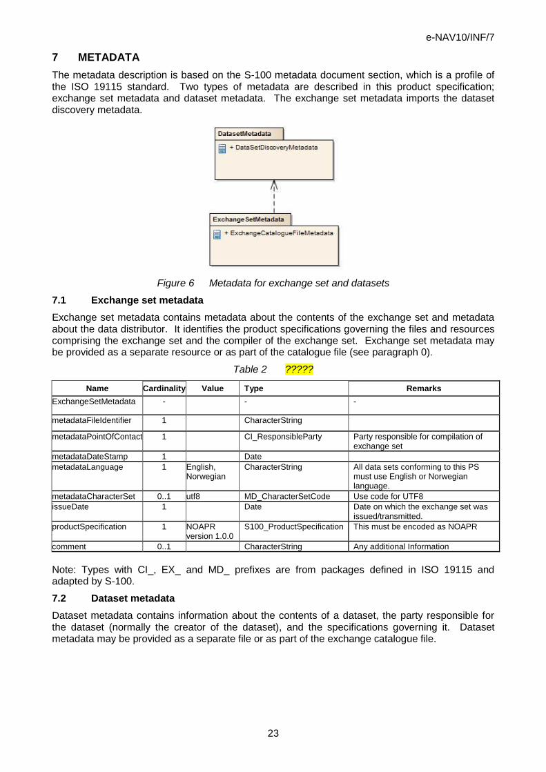
7 METADATA
The metadata description is based on the S-100 metadata document section, which is a profile of the ISO 19115 standard. Two types of metadata are described in this product specification; exchange set metadata and dataset metadata. The exchange set metadata imports the dataset discovery metadata.
Figure 6 Metadata for exchange set and datasets
7.1 Exchange set metadata
Exchange set metadata contains metadata about the contents of the exchange set and metadata about the data distributor. It identifies the product specifications governing the files and resources comprising the exchange set and the compiler of the exchange set. Exchange set metadata may be provided as a separate resource or as part of the catalogue file (see paragraph 0).
Table 2 ?????
Name Cardinality Value Type Remarks
ExchangeSetMetadata - - -
metadataFileIdentifier 1 CharacterString
metadataPointOfContact 1 CI_ResponsibleParty Party responsible for compilation of exchange set
metadataDateStamp 1 Date
metadataLanguage 1 English, Norwegian
CharacterString All data sets conforming to this PS must use English or Norwegian language.
metadataCharacterSet 0..1 utf8 MD_CharacterSetCode Use code for UTF8
issueDate 1 Date Date on which the exchange set was issued/transmitted.
productSpecification 1 NOAPR version 1.0.0
S100_ProductSpecification This must be encoded as NOAPR
comment 0..1 CharacterString Any additional Information
Note: Types with CI_, EX_ and MD_ prefixes are from packages defined in ISO 19115 and adapted by S-100.
7.2 Dataset metadata
Dataset metadata contains information about the contents of a dataset, the party responsible for the dataset (normally the creator of the dataset), and the specifications governing it. Dataset metadata may be provided as a separate file or as part of the exchange catalogue file.

e-NAV10/INF/7
24
Table 3 ????
Name Cardinality Value Type Remarks
DataSetDiscoveryMetadata - - -
metadataFileIdentifier 1 CharacterString
metadataPointOfContact 1 CI_ResponsibleParty Contact information for the vessel or authority
metadataDateStamp 1 Date When the dataset was created
metadataLanguage 1 English, Norwegian
CharacterString All data sets conforming to this PS must use English or Norwegian language
fileName 1 CharacterString Dataset file name
filePath 1 CharacterString Full path from the exchange set root directory
description 1 CharacterString One of the following: 1. Notice of arrival 2. Pilot request 3. Both notice of arrival and pilot request. NATIONAL LANGUAGE enabled
dataProtection 1 {1} to {2} CharacterString 1. Encrypted 2. Unencrypted
purpose 1 {1} to {4} CharacterString 1. New 2. Update 3. Response 4. Supplemental
specificUsage 1 {1} to {2} Integer 1, Notices of Arrival: A dataset containing a new or updated notice of arrival as required by local or national regulations 2. A new or updated request for making pilotage arrangements
editionNumber 1 {1} Integer The dataset edition. Required for s100 but not applicable to NOAPR, therefore it is set to 1 for all datasets.
updateNumber 1 CharacterString Update number 0 is assigned to a new request or notice. Subsequent updates or supplements are assigned numbers 1, 2, 3…
issueDate 1 Date Date on which the dataset was generated.
productSpecification 1 NOAPR version 1.0.0
S100_ProductSpecification This must be encoded as NOAPR
producingAgency 1 CI_ResponsibleParty Party responsible for generating the dataset.
horizontalDatum 1 WGS84 CharacterString The datum for latitude/longitude. EPSG:4326
verticalDatum 1 {1} to {30} Integer 1. Mean low water springs (29 other values)
soundingDatum 1 {1} to {30} Integer 1. Mean low water springs (29 other values)
dataType 1 other S-100_DataFormat S-100 v.1.0.0 lists only ISO8211, GML, and “other” formats
otherDataTypeDescription 0..1 CharacterString
boundingBox 0..1 EX_GeographicBoundingBox Either boundingBox or geographicDescription must be

e-NAV10/INF/7
25
Name Cardinality Value Type Remarks
given.
boundingPolygon 0..* EX_BoundingPolygon
geographicDescription 0..1 Norway EX_GeographicDescription Descriotion of the location for notices or requests, in the form of the country of the national authority. Either boundingBox or geographicDescription must be given.
comment 0..1 CharacterString Any additional Information cyclicRedundancyCheck 1 NonNegativeInteger Check value for the dataset
layerId 1 {1} integer Identifies the relationship to other S100 information on a graphical display. All NOAPR data is scale independent 1. Scale Independent
Note: Types with CI_, EX_, and MD_ prefixes are from packages defined in ISO 19115 and adapted by S-100. Types with S100_ prefix are from packages defined in S-100.
This specification retains the core elements of metadata as given in S-100 and adds elements for describing dependencies on other product specifications and verbal descriptions of the location. Elements believed to by inapplicable (e.g. ”classification” (secret, etc.)) have been removed. The metadata elements for display, optimum and minimum scales have also been removed as they are not relevant to notices or arrival/departure and pilot requests. The bounding box and bounding polygon elements are optional since they are not expected to contribute to anticipated needs for dataset discovery. It would be possible to define rules for using these metadata elements if future needs arise, for example, requiring that these values correspond to national territorial waters or administrative subdivisions.
Exchange catalogue file metadata
The catalogue file is defined in an XML schema and encoded in XML. The metadata pertaining to that file is documented below.
Table 4 ????
Name Cardinality Value Type Remarks
metadataFileIdentifier 1 CharacterString
metadataPointOfContact 1 CI_ResponsibleParty
metadataDateStamp 1 Date
metadataLanguage 1 English CharacterString All data sets conforming to this PS must use English or Norwegian language. The catalogue file must be in English.
name 1 CATALOG.NPC CharacterString Catalogue filename
abstract 1 CharacterString Description of what the exchange catalogue contains
productSpecification 1 S100_ProductSpecification NOAPR product specification Version Number
comment 0..1 CharacterString Any additional Information
Note: Types with CI_, EX_, and MD_ prefixes are from packages defined in ISO 19115 and adapted by S-100. Types with S100_ prefix are from packages defined in S-100.
8 DATA ENCODING
The encoding and exchange format for NOAPR products will be XML conforming to the schema located at [schema location URL to be provided, preferably as part of the registry]. The catalogue

e-NAV10/INF/7
26
file shall be an XML file conforming to the catalogue schema at [URL to be provided, preferably as part of the registry].
Note: Detailed descriptions of structure and XML schemas have been omitted for the sake of minimising effort expended on this exploration and in the interest of reducing the length of this document, but can easily be developed along with a formal specification. If an ISO-8211 conformant encoding must be selected, this section would be replaced by a description of that encoding instead, which would be based on Part 10 of S-100 version 1.0.0. It would be similar to the encoding under development as part of the ENC product specification S-101.
9 SECTIONS OMITTED FROM THIS PRODUCT SPECIFICATION
An S-100-style product specification would also have the following sections, omitted from this example specification for the sake or brevity or due to not being relevant:
Co-ordinate Reference Systems
Data Quality
Data Maintenance
Portrayal
Additional Information
e-NAV10/INF/7
27
ANNEX C NAMED TYPES
This annex contains the geographic objects (feature types) and information objects (information types in the feature catalogue).
1 A.1. FEATURE TYPES
Geo Object Class: Pilot boarding place Alpha code: PILBOP
Camel case: PilotBoardingPlace Abstract type: False
Definition: The meeting place to which the pilot comes out (IHO Chart Specs, M-4).
References: INT 1: IT 1.1-4; M-3: ? M-4: 491.1 2;
Remarks: No remarks. Spatial Objects: Point (GM_Point); Area (GM_Polygon)
Distinction: No distinctions.
Table 5 ????
Attribute Camel case Alpha code
Cardinality Sequential
Call Sign callSign CALSGN 1
Category of pilot boarding place
categoryOfPilotBoardingPlace CATPBP 1
Category of vessel
categoryOfVessel CATVSL 0..* False
Communication Channel
communicationChannel COMCHA 1..* False
Date, end dateEnd DATEND 0..1
Date, start dateStart DATSTA 0..1
Destination destination DSTNTN 0..* False
Notice Time noticeTime NTCTIM 0..* True
Object Name objectName OBJNAM 0..* False
Periodic date end periodicDateEnd PEREND 0..1
Periodic date start periodicDateStart PERSTA 0..1
Pilot district pilotDistrict PILDST 0..* False
Pilot movement pilotMovement PLTMOV 0..* False
Pilot request pilotRequest PLTRQS 0,,* True
Pilot vessel pilotVessel PLTVSL 0..1
Preference of pilot boarding place
preferenceOfPilotBoardingPlace PRFPIL 1
Status status STATUS 0..* False
Service access procedure
serviceAccessProcedure SVAPRC 0..* False
Information information INFORM 0..* False
Textual description
textualDescription TXTDSC 0..*

e-NAV10/INF/7
28
Geo Object Class: Pilot service Alpha code: PLTSRV
Camel case: PilotService Abstract type: False
Supertype: Abstract Feature Type Definition: The area where pilotage services are available. Pilotage is a service provided by a person who directs the movements of a vessel through pilot waters, usually a person who has demonstrated extensive knowledge of channels, aids to navigation, dangers to navigation, etc., in a particular area and is licensed for that area (adapted from IHO Dictionary, S-32, 5th Edition, 3843).
References: INT 1: not specified; M-3: Chapter C Section C 2.8; M-4: not specified;
Remarks: The name of this object may be the same as the Pilot District of the associated PILBOPs.
Spatial Objects: Area (GM_Polygon)
Distinction: No distinctions.
Table 6 ????
Attribute Camel case Alpha code
Cardinality Sequential
Category of pilot categoryOfPilot CATPLT 1..* False
Notice Time noticeTime NTCTIM 0..* False
Object Name objectName OBJNAM 0..* False
Pilot district pilotDistrict PILDST 0..* False
Pilot qualification pilotQualification PLTQFC 0..1
Pilot request pilotRequest PLTRQS 0..1
Remote pilot remotePilot RMTPLT 0..1
Service access procedure
serviceAccessProcedure SVAPRC 0..* False
Information information INFORM 0..* False
Textual description
textualDescription TXTDSC 0..* False
Table 7 ????
Information feature
Camel case Alpha code
Cardinality
Contact details ContactDetails CONDET 0..*

e-NAV10/INF/7
29
Geo Object Class: Port area Alpha code: PRTARE Camel case: PortArea Abstract type: False
Definition: The port and surrounding sea and land areas in which there are services, designated areas and facilities, such as pilotage, outer anchorages, storages yards and warehousing, all associated with shipping.
References: INT 1: IN 49; M-3: Chapter C Section C 2.8 M-4: 430.1;
Remarks: The name of this object may be the same as the Pilot District of the associated PILBOPs.
Spatial Objects: Area (GM_Polygon)
Distinction: dock area; harbour area (administrative);
Table 8 ????
Attribute Camel case Alpha code
Cardinality Sequential
Object Name objectName SRVFBG 0..1
Status status STATUS 0..* false
Information information INFORM 0..* False
Textual description
textualDescription TXTDSC 0..* False

e-NAV10/INF/7
30
Geo Object Class: Radio calling-in point Alpha code: RDOCAL
Camel case: RadioCallingInPoint Abstract type: False
Definition: Also called radio reporting points, they have been established in certain busy waterways and port approaches to assist traffic control. On passing these points or crossing a defined line defined types of vessels or vessels carrying specified cargoes are required to report on VHF to a Traffic Control Centre (adapted from IHO Chart Specifications, M-4).
References: INT 1: IM 40; M-4: 488;
Remarks: The attribute “orientation” (ORIENT) encodes the orientation of the traffic flow at that point.
Distinction: radio station; pilot boarding place;
Attributes:
Table 9 ????
Attribute Camel case Alpha code
Cardinality Sequential
Development categoryOfCargo CATCGO 0..1
Category of Vessel
categoryOfVessel CATVSL 0..1
Communications channel
comunicationsChannel COMCHA 0..*
Object Name objectName SRVFBG 0..1
Orientation orientation ORIENT 0..1
Status status STATUS 0..* false
Information information INFORM 0..* False
Textual description
textualDescription TXTDSC 0..* False

e-NAV10/INF/7
31
Geo Object Class: Voyage Alpha code: VOYAGE
Camel Case: Voyage Abstract type: False Definition: A description of a specific voyage in terms of an identifier and the ports of departure and call,
References: unspecified;
Remarks: No remarks.
Distinction: None.
Table 10 ????
Attribute Camel case Alpha code
Cardinality Sequential
Voyage ID voyageID VOYGID 1
Associated geographic features:
Table 11 ????
Feature type Camel case Alpha code
Cardinality
Port Area PortArea PRTARE 2..3
Associated Information Types:
Table 12 ????
Information feature
Camel case Alpha code
Cardinality
Vessel Vessel VESSEL 1
e-NAV10/INF/7
32
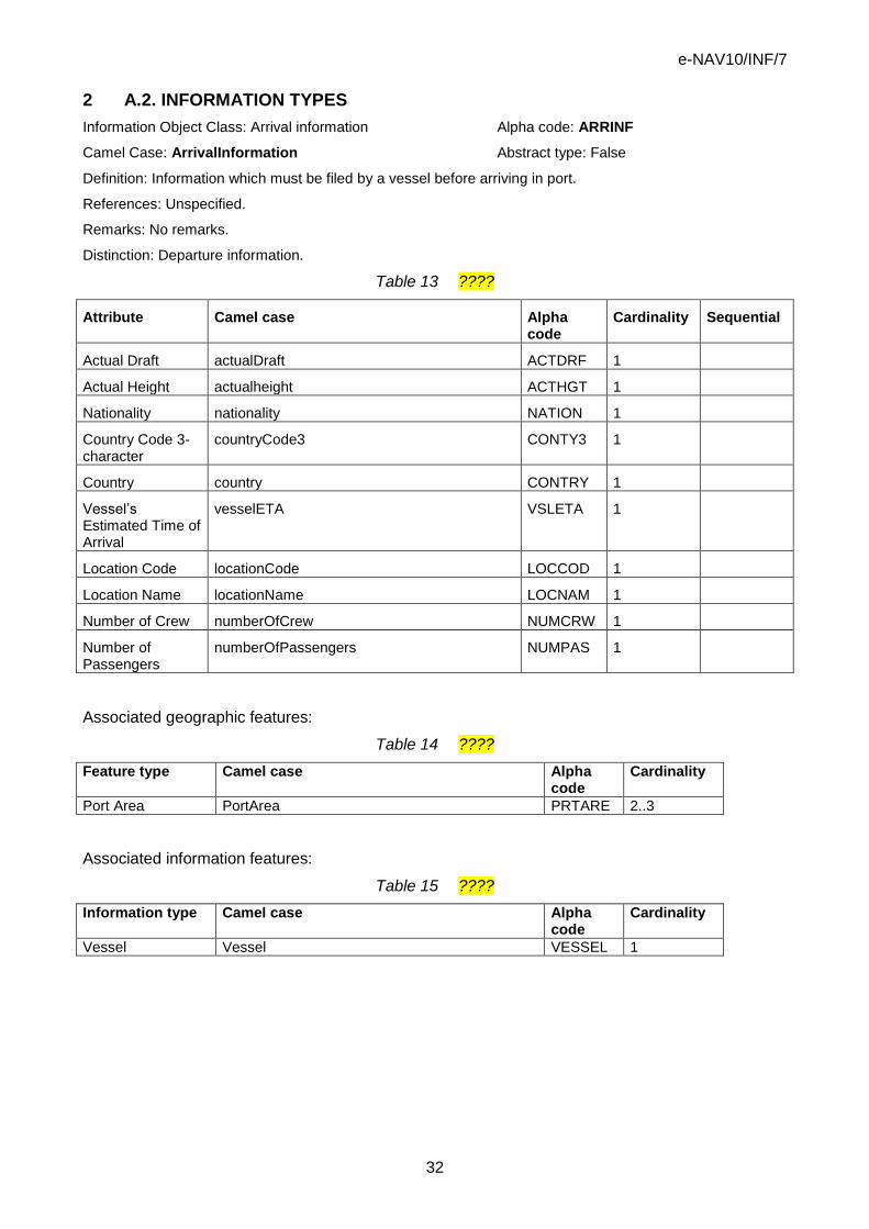
2 A.2. INFORMATION TYPES
Information Object Class: Arrival information Alpha code: ARRINF
Camel Case: ArrivalInformation Abstract type: False
Definition: Information which must be filed by a vessel before arriving in port.
References: Unspecified.
Remarks: No remarks.
Distinction: Departure information.
Table 13 ????
Attribute Camel case Alpha code
Cardinality Sequential
Actual Draft actualDraft ACTDRF 1
Actual Height actualheight ACTHGT 1
Nationality nationality NATION 1
Country Code 3-character
countryCode3 CONTY3 1
Country country CONTRY 1
Vessel’s Estimated Time of Arrival
vesselETA VSLETA 1
Location Code locationCode LOCCOD 1
Location Name locationName LOCNAM 1
Number of Crew numberOfCrew NUMCRW 1
Number of Passengers
numberOfPassengers NUMPAS 1
Associated geographic features:
Table 14 ????
Feature type Camel case Alpha code
Cardinality
Port Area PortArea PRTARE 2..3
Associated information features:
Table 15 ????
Information type Camel case Alpha code
Cardinality
Vessel Vessel VESSEL 1
e-NAV10/INF/7
33
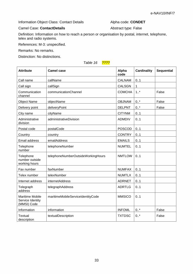
Information Object Class: Contact Details Alpha code: CONDET
Camel Case: ContactDetails Abstract type: False
Definition: Information on how to reach a person or organisation by postal, internet, telephone, telex and radio systems.
References: M-3: unspecified.
Remarks: No remarks.
Distinction: No distinctions.
Table 16 ????
Attribute Camel case Alpha code
Cardinality Sequential
Call name callName CALNAM 0..1
Call sign callSign CALSGN 1
Communication channel
communicationChannel COMCHA 1..* False
Object Name objectName OBJNAM 0..* False
Delivery point deliveryPoint DELPNT 0..* False
City name cityName CITYNM 0..1
Administrative division
administrativeDivision ADMDIV 0..1
Postal code postalCode POSCOD 0..1
Country country CONTRY 0..1
Email address emailAddress EMAILS 0..1
Telephone number
telephoneNumber NUMTEL 0..1
Telephone number outside working hours
telephoneNumberOutsideWorkingHours NMTLOW 0..1
Fax number faxNumber NUMFAX 0..1
Telex number telexNumber NUMTLX 0..1
Internet address internetAddress ADRNET 0..1
Telegraph address
telegraphAddress ADRTLG 0..1
Maritime Mobile Service Identity (MMSI) Code
maritimeMobileServiceIdentityCode MMSICO 0..1
Information information INFOML 0..* False
Textual description
textualDescription TXTDSC 0..* False

e-NAV10/INF/7
34
Information Object Class: Departure information Alpha code: DEPINF
Camel Case: DepartureInformation Abstract type: False
Definition: Information which must be filed by a vessel before departing a port.
References: Unspecified.
Remarks: No remarks.
Distinction: Arrival information
Table 17 ????
Attribute Camel case Alpha code
Cardinality Sequential
Nationality nationality NATION 1
Country Code 3-character
countryCode3 CONTY3 1
Country country CONTRY 1
Vessel’s Estimated Time of Departure
vesselETD VSLETD 1
Vessel has Hazardous Material
hasHazMat HAZMAT 1
Location Code locationCode LOCCOD 1
Location Name locationName LOCNAM 1
Associated geographic features:
Table 18 ????
Feature type Camel case Alpha code
Cardinality
Port Area PortArea PRTARE 2
Associated information features:
Table 19 ????
Information type Camel case Alpha code
Cardinality
Vessel Vessel VESSEL 1

e-NAV10/INF/7
35
Information Object Class: Pilotage request Alpha code: PILREQ
Camel Case: PilotageRequest Abstract type: False
Definition: Information which must be filed by a vessel when requesting a pilot.
References: Unspecified.
Remarks: The two values of the locationName attribute, indicates the start and end location of the pilotage in same order that the values appear in the data set.
Distinction: None
Table 20 ????
Attribute Camel case Alpha code
Cardinality Sequential
Billing Agent Name
billingAgentName AGTNAM 1
Dispatch Department Name
dispatchDepartmentName DISNAM 0..1
Helicopter Required
helicopterRequired HELREQ 1
Vessel’s Estimated Time of Arrival
vesselETA VSLETA 1
Towing Pilotage isTowingPilotage TOWPLT 1
Location Name locationName LOCNAM 2 True
Multiple Pilots moreThanOnePilot MULPLT 1
Pilot Station Department Name
pilotStationDepartmentName PSTNAM 0..1
Quay Information quayInformation PLTQAY 1
Associated geographic features:
Table 21 ????
Feature type Camel case Alpha code
Cardinality
Port Area PortArea PRTARE 1
Associated information features:
Table 22 ????
Information type Camel case Alpha code
Cardinality
Contact Details ContactDetails CONDET 1
Vessel Vessel VESSEL 1

e-NAV10/INF/7
36
Information Object Class: Vessel Alpha code: VSLINF
Camel Case: Vessel Abstract type: False
Definition: A description of the vessel.
References: unspecified.
Remarks: No remarks.
Distinction: None.
Table 23 ????
Attribute Camel case Alpha code
Cardinality Sequential
Call sign callSign CALSGN 1
IMO number vslIMONumber VSLIMO 1
Object Name objectName OBJNAM 1
Maritime Mobile Service Identity (MMSI) Code
maritimeMobileServiceIdentityCode MMSICO 1
Associated Information Types
Table 24 ????
Information feature
Camel case Alpha code
Cardinality
Arrival information ArrivalInformation ARRINF 0..1
Departure information
DepartureInformation DEPINF 0..1
Pilotage Request PilotageRequest PILREQ 0..1

e-NAV10/INF/7
37
ANNEX D PROPERTY TYPES
This annex contains the attributes.
Attribute: Actual Draft Alpha code: ACTDRF
Attribute type: simple
Camel case: actualDraft Data type: float
Definition: The actual draft of the vessel.
Units: Metres.
Resolution: 0.1.
Remarks: No remarks.
Attribute: Actual Height Alpha code: ACTHGT
Attribute type: simple
Camel case: actualHeight Data type: float
Definition: The actual height of the vessel.
Units: Metres.
Resolution: 0.1.
Remarks: No remarks.
Attribute: Administrative division Alpha code: ADMDIV
Attribute type: Simple
Camel case: administrativeDivision Data Type: text
Definition: Administrative division is a generic term for an administrative region within a country at a level below that of the sovereign state.
Remarks: admdiv is used in the context of contact details.
Distinction: ADMARE.
Attribute: Billing Agent Name Alpha code: AGTNAM
Attribute type: Simple
Camel case: locationName Data Type: String
Definition: Indicates the name of the location.
Constraints: Length must be no more than 50 characters.
References: none.
Remarks: --
Attribute: Call name Alpha code: CALNAM
Attribute type: Simple
Camel case: callName Data Type: text

e-NAV10/INF/7
38
Definition: The designated call name of a station, e.g. radio station, radar station, pilot. This is the name used when calling a radio station by radio i.e. "Singapore Pilots".
Distinction: CALSGN - The designated call-sign of a radio station i.e. "WWVB" for Fort Collins, Colorado.
References: INT 1: not specified; M-3: M-4: not specified.
Remarks: No remarks.
Attribute: Call sign Alpha code: CALSGN
Attribute type: Simple
Camel case: callSign Data Type: text
Definition: The designated call-sign of a radio station.
References: INT 1: not specified; M-4: not specified.
Remarks: No remarks.
Attribute: Category of cargo Alpha code: CATCGO
Attribute type: Simple
Camel case: categoryOfCargo Data Type: Enumeration
Values:
Table 25 ????
Code Name Definition
1 bulk Normally dry cargo which is transported to and from the vessel on conveyors
2 container One of a number of standard sized cargo carrying units, secured using standard corner attachments and bars
3 general Break bulk cargo normally loaded by crane
4 liquid Any cargo loaded by pipeline
5 passenger A fee paying traveller
6 livestock Live animals carried in bulk
7 dangerous or hazardous
Dangerous or hazardous cargo as described by the IMO International Maritime Dangerous Goods code
References: INT 1: unspecified; M-4: unspecified.
Remarks: If item 7 is used, the nature of dangerous or hazardous cargoes can be amplified with category of dangerous or hazardous cargo.
Attribute: Category of dangerous or hazardous cargo or ballast Alpha code: CATDHC
Attribute type: Simple
Camel case: categoryOfDangerousOrHazardousCargo Data Type: Enumeration
Values:
Table 26 ????
Code Name Definition
1 Class 1; Division Explosives, Division 1: substances and articles which have a mass explosion

e-NAV10/INF/7
39
1.1 hazard
2 Class 1; Division 1.2
Explosives, Division 2: substances and articles which have a projection hazard but not a mass explosion hazard
3 Class 1; Division 1.3
Explosives, Division 3: substances and articles which have a fire hazard and either a minor blast hazard or a minor projection hazard or both, but not a mass explosion hazard
4 Class 1; Division 1.4
Explosives, Division 4: substances and articles which present no significant hazard
5 Class 1; Division 1.5
Explosives, Division 5: very insensitive substances which have a mass explosion hazard
6 Class 1; Division 1.6
Explosives, Division 6: extremely insensitive articles which do not have a mass explosion hazard
7 Class 2.1 Gases, flammable gases
8 Class 2.2 Gases, non-flammable, non-toxic gases
9 Class 2.3 Gases, toxic gases
10 Class 3 flammable liquids
11 Class 4.1 flammable solids, self-reactive substances and desensitized explosives
12 Class 4.2 substances liable to spontaneous combustion
13 Class 4.3 substances which, in contact with water, emit flammable gases
14 Class 5.1 oxidizing substances
15 Class 5.2 organic peroxides
16 Class 6.1 toxic substances
17 Class 6.2 infectious substances
18 Class 7 Radioactive material
19 Class 8 Corrosive substances
20 Class 9 Miscellaneous dangerous substances and articles
21 Harmful Substances in packaged form
Harmful substances are those substances which are identified as marine pollutants in the International Maritime Dangerous Goods Code (IMDG Code). Packaged form is defined as the forms of containment specified for harmful substances in the IMDG Code. (MARPOL (73/78) Annex III)
References: International Maritime Dangerous Goods (IMDG) Code
Remarks: Substances (including mixtures and solutions) and articles subject to the provisions of the International Maritime Dangerous Goods (IMDG) Code are assigned to one of the classes 1-9 according to the hazard or the most predominant of the hazards they present. Some of these classes are subdivided into divisions. These classes or divisions are as listed in IDs 1 : 20 above. (Adapted from IMDG code www.imo.org).
Attribute: Category of pilot Alpha code: CATPLT
Attribute type: Simple
Camel case: categoryOfPilot Data Type: Enumeration
Values:

e-NAV10/INF/7
40
Table 27 ????
Code Name Definition
1 pilot pilot licenced to conduct vessels during approach from sea to a specified place which may be a handover place, an anchorage or alongside
2 deep sea pilot licenced to conduct vessels over extensive sea areas
3 harbour pilot who is licenced to conduct vessels from a specified place, such as a handover area or anchorage into a harbour
4 bar pilot licensed to conduct vessels over a bar to or from a handover with a river pilot (for example as used in USA)
5 river pilot licensed to conduct vessels from and to specified places, along the course of a river (for example as used in Rio Amazonas and Rio de La Plata)
6 channel pilot licensed to conduct vessels from and to specified places, along the course of a channel. (for example as used in Rio Amazonas and Rio de La Plata)
7 lake pilot licensed to conduct vessels from and to specified places on a great lake. (for example as used in the Lago de Maracaibo in Venezuela)
Remarks: No remarks.
Attribute: Category of pilot boarding place Alpha code: CATPBP
Attribute type: Simple
Camel case: categoryOfPilotBoardingPlace Data Type: Enumeration
Values:
Table 28 ????
Code Name Definition References
1 boarding by pilot-cruising vessel
pilot boards from a cruising vessel INT 1: IT 1.1-3; M-4: 491.1
2 boarding by helicopter pilot boards by helicopter which comes out from the shore
INT 1: IT 1.4; M-4: 491.2
3 pilot comes out from shore
pilot boards from a vessel which comes out from the shore on request
INT 1: IT 1.1-3; M-4: 491.1
References: ?
Remarks: No remarks
Attribute: Category of vessel Alpha code: CATVSL
Attribute type: Simple
Camel case: categoryOfVessel Data Type: Enumeration
Values:
Table 29 ????
Code Name Definition
1 general cargo vessel a vessel designed to carry general cargo
2 container carrier a vessel designed to carry ISO containers

e-NAV10/INF/7
41
3 tanker a vessel designed to carry bulk liquid or gas, including LPG and LNG
4 bulk carrier a vessel designed to carry bulk solid material
5 passenger vessel a vessel designed to carry passengers; often a cruise ship
6 roll-on roll-off a vessel designed to allow road vehicles to be driven on and off; often a ferry
7 refrigerated cargo vessel
a vessel designed to carry refrigerated cargo
8 fishing vessel a vessel designed to catch or hunt fish
9 service a vessel which provides a service such as a tug, anchor handler, survey or supply vessel
10 warship a vessel designed for the conduct of military operations
References: none
Remarks: none
Attribute: City name Alpha code: CITYNM
Attribute type: Simple
Camel case: cityName Data Type: text
Definition: The name of a town or city
Remarks: No remarks
Attribute: Communication channel Alpha code: COMCHA
Attribute type: Simple
Camel case: communicationChannel Data Type: text
Definition: A channel number assigned to a specific radio frequency, frequencies or frequency band.
Constraints:
Table 30 ????
Length 4
Structure Each VHF-channel should be indicated by 2 digits and up to 2 characters (A-Z)
References: INT 1: IM 40; M-4: 488;
Remarks: The attribute “communication channel” encodes the various VHF-channels used for communication. The indication of several VHF-channels is possible through use of multiplicity > 1.
Attribute: Country Alpha code: CONTRY
Attribute type: Simple
Camel case: country Data Type: text
Definition: The name of a nation.
References: Adapted from The American Heritage Dictionaries.

e-NAV10/INF/7
42
Remarks: Keep a standard for country names under review.
Attribute: Country Code 3-character Alpha code: CONTR3
Attribute type: Simple
Camel case: countryCode3 Data Type: string
Definition: The attribute “country code 3-character” indicates the nationality of the specific object.
Constraints:
Table 31 ????
Length 3
Structure The value must conform to ISO 3166
References: ISO 3166
Remarks: No remarks.
Attribute: Date end Alpha code: DATEND
Attribute type: Simple
Camel case: dateEnd Data Type: Date
Definition: The attribute “date end” indicates the latest date on which an object (e.g. a buoy) will be present.
Constraints:
Table 32 ????
Other CCYYMMDD, consisting of 4 digits for the calendar year (CCYY), 2 digits for the month (MM) (e.g. April = 04) and 2 digits for the day (DD), according to ISO 8601:1988
References: ?
Remarks: This attribute is to be used to indicate the removal or cancellation of an object at a specific date in the future. See also “periodic date end”. Example: 19961007 for 07 October 1996 as ending date.
Attribute: Date start Alpha code: DATSTA
Attribute type: Simple
Camel case: dateStart Data Type: Date
Definition: The attribute “date, start” indicates the earliest date on which an object (e.g. a buoy) will be present.
Constraints:
Table 33 ????
Other CCYYMMDD, consisting of 4 digits for the calendar year (CCYY), 2 digits for the month (MM) (e.g. April = 04) and 2 digits for the day (DD), according to ISO 8601:1988
References: ?

e-NAV10/INF/7
43
Remarks: This attribute is to be used to indicate the deployment or implementation of an object at a specific date in the future. See also “periodic date start”. Example: 19960822 for 22 August 1996 as starting date.
Attribute: Delivery point Alpha code: DELPNT
Attribute type: Simple
Camel case: deliveryPoint Data Type: text
Definition: Details of where post can be delivered such as the apartment, name and/or number of a street, building or PO Box
References: none
Remarks: This could be repeated if there is more than one address item required in addition to the city name.
Attribute: Destination Alpha code: DSTNTN
Attribute type: Simple
Camel case: destination Data Type: text
Definition: The place or general direction to which a vessel is going or directed.
References: none
Remarks: In addition to a placename of a port, harbour area or terminal, the place could include generalities such as “The north-west”, or “upriver”.
Attribute: Dispatch Department Name Alpha code: DISNAM
Attribute type: Simple
Camel case: dispatchDepartmentName Data Type: String
Definition: Indicates the name of the location
Constraints: Length must be no more than 50 characters.
References: None.
Remarks: --
Attribute: Email address Alpha code: EMAILS
Attribute type: Simple
Camel case: emailAddress Data Type: text
Definition: An address assigned to an organisation or person to send or receive electronic mail. Example: [email protected]
References: --
Remarks: No remarks.
Attribute: Fax number Alpha code: NUMFAX
Attribute type: Simple
Camel case: faxNumber Data Type: text
Definition: A number assigned to a fax machine. Example: + 49 381 4563769.

e-NAV10/INF/7
44
References: Not specified.
Remarks: The telephone number should be written according to the ITU Recommendation ITU-T E.123. Only spaces should be used to visually separate groups of numbers in international notation.
Attribute: Helicopter Required Alpha code: HELREQ
Attribute type: Simple
Camel case: helicopterRequired Data Type: Boolean (?)
Definition: Whether a helicopter is required
References: none
Remarks: --
Attribute: IMO Number Alpha code: VSLIMO
Attribute type: Simple
Camel case: vslIMONumber Data Type: int
Definition: The IMO number for a vessel.
References: none
Remarks: --
Attribute: Information Alpha code: INFORM
Attribute type: Simple
Camel case: information Data type: text
Definition: Textual information about the object in a single language.
References: INT 1: IA 16; M-4: 242.3-5;
Remarks: --
This attribute should be used, for example, to hold the information that is shown on paper charts by cautionary and explanatory notes.
No formatting of text is possible within INFORM. If formatted text is required, then the attribute TXTDSC must be used.
Attribute: Internet address Alpha code: ADRNET
Attribute type: Simple
Camel case: internetAddress Data Type: text
Definition: An Internet address (for example, http://www.hmco.com/trade/), usually consisting of the access protocol (http), the domain name (www.hmco.com), and optionally the path to a file or resource residing on that server (trade).
References: The American Heritage Dictionaries
Remarks: The address could be a website or an ftp site.
Attribute: Location Code Alpha code: LOCCOD
Attribute type: Simple

e-NAV10/INF/7
45
Camel case: locationCode Data Type: String
Definition: Indicates the code of the location.
Constraints: Length must be 5 characters.
References: None
Remarks: --
Attribute: Location Name Alpha code: LOCNAM
Attribute type: Simple
Camel case: locationName Data Type: String
Definition: Indicates the name of the location.
Constraints: Length must be no more than 50 characters.
References: None.
Remarks: --
Attribute: Maritime Mobile Service Identity (MMSI) Code Alpha code: MMSICO
Attribute type: Simple Camel case: maritimeMobileServiceIdentityCode Data Type: Integer
Definition: The Maritime Mobile Service Identity (MMSI) Code is formed of a series of nine digits which are transmitted over the radio path in order to uniquely identify ship stations, ship earth stations, coast stations, coast earth stations, and group calls. These identities are formed in such a way that the identity or part thereof can be used by telephone and telex subscribers connected to the general telecommunications network principally to call ships automatically.
Constraints:
Table 34 ????
length 9
References: Adapted from USCG which in turn adapted it from Appendix 43 of the International Telecommunications Union Radio Regulations.
Unit of measure: None
Remarks: Format: XXXXXXXXX. Example: 366777490.
Attribute: Multiple Pilots Alpha code: MULPLT
Attribute type: Simple
Camel case: moreThanOnePilot Data Type: Boolean
Definition: Whether the pilotage requires more than one pilot
References: none
Remarks: --
Attribute: Nationality Alpha code: NATION
Attribute type: Simple
Camel case: nationality Data Type: text
Definition: The attribute “nationality” indicates the nationality of the specific object.

e-NAV10/INF/7
46
Constraints:
Table 35 ????
Length 2
Structure The value must conform to ISO 3166
References: ISO 3166
Remarks: No remarks.
Attribute: Number of Crew Alpha code: NUMCRW
Attribute type: Simple
Camel case: numberOfCrew Data Type: Boolean (?)
Definition: ???
References: none
Remarks: --
Attribute: Number of Passengers Alpha code: NUMPAS
Attribute type: Simple
Camel case: numberOfPassenger Data Type: int
Definition: The number of passengers on board
References: None.
Remarks: --
Attribute: Number telex over radio (TOR) Alpha code: NUMTOR
Attribute type: simple
Camel case: numberTelexOverRadio Data type: Integer
Definition: A special number to contact a radio station via wireless telex.
Units: None.
Resolution: 1.
Remarks: No remarks.
Attribute: Object name Alpha code: OBJNAM
Attribute type: Simple
Camel case: objectName Data Type: text
Definition: The individual name of an object.
References: INT 1: ID 7, IF 19, IN 12.2-3; M-4: 371; 323.1-2; 431.2-3; 431.5.
Remarks: No remarks.
Attribute: Periodic date end Alpha code: PEREND
Attribute type: Simple
e-NAV10/INF/7
47
Camel case: periodicDateEnd Data Type: Date
Definition: The end of the active period for a seasonal object (e.g. a buoy). See also “date end”.
Constraints:
Table 36 ????
Structure The value should be encoded using 4 digits for the calendar year (CCYY), 2 digits for the
month (MM) (e.g. April = 04) and 2 digits for the day (DD).
CCYYMMDD (full date); --MMDD (same day each year); --MM (same month each year)
This conforms to ISO 8601:1988.
Other If an object has either of its PERSTA/PEREND attribute values non-null, the other must also be non-null.
References: ISO 8601:1988
Remarks: Example: --1015 for an ending date of 15 October each year
Attribute: Periodic date start Alpha code: PERSTA
Attribute type: Simple
Camel case: periodicDateStart Data Type: Date
Definition: The start of the active period for a seasonal object (e.g. a buoy). See also “date start”.
Constraints:
Table 37 ????
Structure The value should be encoded using 4 digits for the calendar year (CCYY), 2 digits for the
month (MM) (e.g. April = 04) and 2 digits for the day (DD).
CCYYMMDD (full date); --MMDD (same day each year); --MM (same month each year)
This conforms to ISO 8601:1988.
Other If an object has either of its PERSTA/PEREND attribute values non-null, the other must also be non-null.
References: ISO 8601:1988
Remarks: Example: --04 for an operation starting in April each year
Attribute: Pictorial representation Alpha code: PICREP
Attribute type: Simple Camel case: pictorialRepresentation Data Type: text
Definition: Indicates whether a pictorial representation of the object is available. The string encodes the file name of an external graphic file (pixel/vector) as permitted in the list of allowed support formats.
References: INT 1: IE 3.1-2; M-4: 456.5; 457.3;
Remarks: The “pictorial representation” could be a drawing or a photo.
Attribute: Pilot district Alpha code: PILDST
Attribute type: Simple

e-NAV10/INF/7
48
Camel case: pilotDistrict Data Type: text
Definition: The name assigned to the area within which a particular pilotage service operates.
References: INT 1: IT 1.2; M-4: 491.1-2;
Remarks: No remarks.
Attribute: Pilot movement Alpha code: PLTMOV
Attribute type: Simple
Camel case: pilotMovement Data Type: Enumeration
Definition: The embarkation or disembarkation activity of a pilot. This attribute specifies whether pilots embark and/or leave the vessel.
Values:
Table 38 ????
Code Name Definition
1 embarkation The place where vessels not being navigated according to a pilot’s instructions pick up a pilot while in transit from sea to a port or restricted waters for future navigation under pilot instructions.
2 disembarkation The place where vessels being navigated under a pilot’s instructions in transit from sea to a port or constricted waters drop the pilot and proceed without being subject to pilot instructions.
3 pilot change The place where vessels being navigated under a pilot’s instructions drop off the pilot and pick up a different pilot for future navigation under pilot’s instructions.
References: unspecified;
Remarks: If the Pilot boarding place is used at a port for embarkation and disembarkation, this attribute is not used.
Attribute: Pilot qualification Alpha code: PLTQFC
Attribute type: Simple
Camel Case: pilotQualification Data Type: Enumeration
Definition: --
Values:
Table 39 ????
Code Name Definition
1 government pilot A pilot service carried out by government pilots.
2 pilot approved by government
A pilot service carried out by pilots who are approved by government.
3 state pilot A pilot that is licensed by the State (USA) and/or their respective pilot association, required for all foreign vessels and all American vessels under registry, bound for a port with compulsory State pilotage. A federal licence is not sufficient to pilot such vessels into the port
4 federal pilot A pilot who carries a Federal endorsement, offering services to vessels that are not required to obtain compulsory State pilotage. Services are usually contracted for in advance

e-NAV10/INF/7
49
5 company pilot A pilot provided by a commercial company
6 local pilot A pilot with local knowledge but who does not hold a qualification as a pilot
7 citizen with sufficient local knowledge
A pilot service carried out by a citizen with sufficient local knowledge
8 citizen with doubtful local knowledge
A pilot service carried out by a citizen whose local knowledge is uncertain
Remarks: No remarks.
Attribute: Pilot request Alpha code: PLTRQS
Attribute type: Simple
Camel case: pilotRequest Data Type: text
Definition: Description of the pilot request procedure.
References: Unspecified.
Remarks: No remarks.
Attribute: Pilot Station Department Name Alpha code: PSTNAM
Attribute type: Simple
Camel case: pilotStationDepartmentName Data Type: String
Definition: Indicates the name of the location.
Constraints: Length must be no more than 50 characters.
References: None.
Remarks: --
Attribute: Pilot vessel Alpha code: PLTVSL
Attribute type: Simple
Camel case: pilotVessel Data Type: text
Definition: Description of the pilot vessel. The pilot vessel is a small vessel used by a pilot to go to or from a vessel employing the pilot's services (adapted from Science and Technology Dictionary).
References: Unspecified.
Remarks: No remarks.
Attribute: Postal code Alpha code: POSCOD
Attribute type: Simple
Camel case: postalCode Data Type: text
Definition: Known in various countries as a postcode, or ZIP code, the postal code is a series of letters and/or digits that identifies each postal delivery area.
References: Unspecified.
Remarks: No remarks.

e-NAV10/INF/7
50
Attribute: Preference of pilot boarding place Alpha code: PRFPIL
Attribute type: Simple
Camel case: preferenceOfPilotBoardingPlace Data Type: Enumeration
Definition: This attribute allows for boarding places to be designated as primary or alternate boarding places.
Values:
Table 40 ????
Code Name Definition
1 Primary The preferred and published pilot boarding place which is used in normal weather conditions.
2 Alternate The pilot boarding place which is used if the primary boarding place is unsuitable, for example because of weather or sea state
Attribute: Quay Information Alpha code: PLTQAY
Attribute type: Simple
Camel case: quayInformation Data Type: String
Definition: Information about the quay, for the special case where the pilot boards at a quay.
Constraints: Length must be no more than 50 characters.
References: none
Remarks: No remarks.
Attribute: Remote pilot Alpha code: RMTPLT
Attribute type: Simple
Camel case: remotePilot Data Type: Boolean
Definition: Whether remote pilotage is available.
Table 41 ????
True Remote pilot is available
Pilotage is available remotely from shore or other location remote from the vessel requiring pilotage
False Remote pilot is not available
Remote pilotage is not available
References: Unspecified.
Remarks: No remarks.
Attribute: Service access procedure Alpha code: SVAPRC
Attribute type: Simple
Camel case: serviceAccessProcedure Data Type: text
Definition: A description of the procedure to access the marine service.
References: Unspecified.
Remarks: None.

e-NAV10/INF/7
51
Attribute: Status Alpha code: STATUS
Attribute type: Simple
Camel case: status Data Type: Enumeration
Values:
Table 42 ????
Code Label Definition References
1 permanent intended to last or function indefinitely. (The Concise Oxford Dictionary, 7
th Edition)
2 occasional acting on special occasions; happening irregularly. (The Concise Oxford Dictionary, 7th Edition)
INT 1: IP 50; M-4: 473.2;
3 recommended presented as worthy of confidence, acceptance, use, etc. (The Macquarie Dictionary, 1988)
INT 1: IN 10; M-4: 431.1;
4 not in use no longer used for the purpose intended; disused. INT 1: IL 14, 44; M-4: 444.7;
5 periodic/intermittent recurring at intervals. (The Concise Oxford Dictionary, 7th Edition)
INT 1: IC 21; IQ 71; M-4: 353.3; 460.5;
6 reserved set apart for some specific use. (adapted from The Concise Oxford Dictionary, 7th Edition)
INT 1: IN 12.9;
7 temporary meant to last only for a time. (The Concise Oxford Dictionary)
INT 1: IP 54;
8 private not in public ownership or operation. INT 1: IQ 70;
9 mandatory compulsory; enforced. (The Concise Oxford Dictionary, 7th Edition)
11 extinguished no longer lit
12 illuminated lit by floodlights, strip lights, etc.
13 historic famous in history; of historical interest. (The Concise Oxford Dictionary, 7
th Edition)
14 public belonging to, available to, used or shared by, the community as a whole and not restricted to private use. (adapted from The New Shorter Oxford English Dictionary, 1993)
15 synchronized occur at a time, coincide in point of time, be contemporary or simultaneous. (The New Shorter Oxford English Dictionary, 1993)
16 watched looked at or observed over a period of time especially so as to be aware of any movement or change. (adapted from The New Shorter Oxford English Dictionary, 1993)
17 un-watched usually automatic in operation, without any permanently-stationed personnel to superintend it. (adapted from IHO Dictionary, S-32, 5th Edition, 2814)
18 existence doubtful an object that has been reported but has not been definitely determined to exist
References: --
Remarks: No remarks.

e-NAV10/INF/7
52
Attribute: Telegraph address Alpha code: ADRTLG
Attribute type: Simple
Camel case: telegraphAddress Data Type: text
Definition: The telegraphic address assigned to an organisation.
Remarks: No remarks.
Attribute: Telephone number Alpha code: NUMTEL
Attribute type: Simple
Camel case: telephoneNumber Data Type: text
Definition: A number assigned to a telephone.
References: Unspecified.
Remarks: The telephone number should be written according to the ITU Recommendation ITU-T E.123. Only spaces should be used to visually separate groups of numbers in international notation. The letters "int." are used to indicate internal number extensions. Example: + 49 381 4563764 int.254
Attribute: Telephone number outside working hours Alpha code: NMTLOW
Attribute type: Simple
Camel case: telephoneNumberOutsideWorkingHours Data Type: text
Definition: A number assigned to a service for use outside working hours.
References: Unspecified.
Remarks: The telephone number should be written according to the ITU Recommendation ITU-T E.123. Only spaces should be used to visually separate groups of numbers in international notation. The letters "int." are used to indicate internal number extensions. Example: + 49 172 4019079 int.123
Attribute: Telex number Alpha code: NUMTLX
Attribute type: Simple
Camel case: telexNumber Data Type: text
Definition: Numbers assigned to a telex machine as a unique identifier.
References: Unspecified.
Remarks: No remarks.
Attribute: Textual description Alpha code: TXTDSC
Attribute type: Simple
Camel case: textualDescription Data Type: text
Definition: The file name of an external text file that contains the text.
Remarks: The attribute “textual description” indicates that a file containing text extracted from relevant pilot books or navigational publications is available.
Attribute: Towing Pilotage Alpha code: TOWPLT

e-NAV10/INF/7
53
Attribute type: Simple
Camel case: isTowingPilotage Data Type: Boolean
Definition: Whether the pilotage is a towing pilotage (?).
References: None.
Remarks: --
Attribute: Vessel’s ETA Alpha code: VSLETA
Attribute type: Simple
Camel case: vesselETA Data Type: DateTime
Definition: Indicates the estimated time of arrival.
References: None.
Remarks: --
Attribute: Vessel’s ETD Alpha code: VSLETD
Attribute type: Simple
Camel case: vesselETD Data Type: DateTime
Definition: Indicates the estimated time of departure.
References: None.
Remarks: --
Attribute: Vessel has Hazardous Material Alpha code: HAZMAT
Attribute type: Simple
Camel case: hasHazMat Data Type: Boolean
Definition: Whether the vessel is carrying hazardous cargo as defined by … (IMDG? Norwegian authorities?)
References: None.
Remarks: --
Attribute: Voyage ID Alpha code: VOYGID
Attribute type: Simple
Camel case: voyageID Data Type: String
Definition: Unique identifier for a voyage.
References: None
Remarks: --