the impact of railway station redevelopment on station ... · railway station on the surrounding...
TRANSCRIPT
The impact of railway station redevelopment on station areas:
the case of Wuchang railway station
Chuan Zeng
A thesis
In
The Department of
Geography, Planning and Environment
Presented in Partial Fulfillment of the Requirements
for the Degree of Master of Science (Geography, Urban& Environmental Studies) at
Concordia University
Montreal, Quebec, Canada
March 2009
© Chuan Zeng, 2009
1*1 Library and Archives Canada
Published Heritage Branch
395 Wellington Street Ottawa ON K1A 0N4 Canada
Bibliotheque et Archives Canada
Direction du Patrimoine de Pedition
395, rue Wellington Ottawa ON K1A 0N4 Canada
Your file Votre inference ISBN: 978-0-494-63329-8 Our file Notre reference ISBN: 978-0-494-63329-8
NOTICE: AVIS:
The author has granted a nonexclusive license allowing Library and Archives Canada to reproduce, publish, archive, preserve, conserve, communicate to the public by telecommunication or on the Internet, loan, distribute and sell theses worldwide, for commercial or noncommercial purposes, in microform, paper, electronic and/or any other formats.
L'auteur a accorde une licence non exclusive permettant a la Bibliotheque et Archives Canada de reproduire, publier, archiver, sauvegarder, conserver, transmettre au public par telecommunication ou par Plnternet, preter, distribuer et vendre des theses partout dans le monde, a des ftns commerciales ou autres, sur support microforme, papier, electronique et/ou autres formats.
The author retains copyright ownership and moral rights in this thesis. Neither the thesis nor substantial extracts from it may be printed or otherwise reproduced without the author's permission.
L'auteur conserve la propriete du droit d'auteur et des droits moraux qui protege cette these. Ni la these ni des extraits substantiels de celle-ci ne doivent etre imprimes ou autrement reproduits sans son autorisation.
In compliance with the Canadian Privacy Act some supporting forms may have been removed from this thesis.
Conformement a la loi canadienne sur la protection de la vie privee, quelques formulaires secondaires ont ete enleves de cette these.
While these forms may be included in the document page count, their removal does not represent any loss of content from the thesis.
Bien que ces formulaires aient inclus dans la pagination, il n'y aura aucun contenu manquant.
• + •
Canada

ABSTRACT
The impact of railway station redevelopment on station areas:
the case of Wuchang railway station
Chuan Zeng
The impact of railway station redevelopment in the urban cores of China's cities is an
important and worthy research question in the present context because of a China-wide
program of station replacement and system upgrading. Following European and Japanese
precedents, Chinese railway station redevelopment will provide a catalyst for revitalizing
the station area and extending the impact of the station into the surrounding area. Until
now, station redevelopment has largely concerned the railway facilities themselves, along
with intermodal facilities. This investigation explores the current extent of the Wuchang
railway station on the surrounding area, and projects its future extent based on an analysis
of the completed transport hub. Wuchang railway station was chosen as my case study
because it is a super-large station and located in the city center. Thus, Wuchang station
redevelopment was more likely to have a local revitalization impact in the city than the
other local railway stations. Also, Wuchang railway station is one of six main hubs of the
high-speed railway network. The study found that the effect of Wuchang railway station
redevelopment is larger than what has been planned, the connection between Wuchang
station's two sites is not really addressed, and an integrated city-based public
transportation system has not yet been fully established. Based on the findings,
recommendations are offered for policymakers and administrators.
hi
Acknowledgements
I thank Concordia University for giving me a real education for real world. Many
thank to Professor John Zacharias, my supervisor. Without his constant encouragement
and guidance, this thesis could not have reached its present form. Last my thanks would
go to my beloved family for their loving considerations and great confidence in me.
IV

Table of Contents
List of Figures viii
List of Tables xi
Chapter 1 Introduction 1
1.1 China's Fast Economic Growth and Urbanization 2
1.2 Chinese Railway Station Development Background 3
1.3 Chinese Railway Station Development Problem 5
1.4 Research Question 7
Chapter 2 The Wuchang Railway Station Redevelopment 8
2.1 Background of Wuhan 8
2.2 The Wuchang Railway Station 10
2.3 The Wuchang Railway Station Redevelopment Overview 14
2.4 The Wuhan Goverment's Goal of the Wuchang Station
Redevelopment 17
2.5 The Wuchang Railway Station Redevelopment Projects 18
Chapter 3 Literature Review 28
3.1 Conceptual Framework 28
3.2 Concept Explanation 30
3.3 Theories about Railway Stations 33
3.4 The Impact of Railway Stations on Property Values 36
v

3.5 Important Factors Influencing Residential Location Choice.. .38
3.6 Conclusion 39
Chapter 4 Methodology 40
4.1 Introduction 40
4.2 Questionnaire and Interview 42
4.3 Site Survey in the Wuchang Station Surrounding Area 44
4.4 Projecting Potential for Wuchang Station Redevelopment 45
4.5 Data Used in the Study 46
Chapter 5 Questionnaire and Interview Results 48
5.1 Three Residential Quarters 48
5.2 Questionnaire Survey Results 53
5.3 Interview Results and Analysis 62
Chapter 6 Site Survey in the Station Surrounding Area 68
6.1 Wuchang Station Area's Traffic Survey Results and
Analysis 68
6.2 The Local Shops and Commercial Facilities Survey and
Analysis 82
6.3 Other New Developments in the Wuchang Station Area 88
Chapter 7 Projecting Potential for Station Area Redevelopment 90
7.1 Comparative Analysis of Railway Station Redevelopment:
vi
Cases in Europe and Asia 90
7.2 Situation Surrounding the Wuchang Railway Station 99
7.3 Projecting Potential for Wuchang Station Area
Redevelopment 104
Chapter 8 Conclusion and Discussion 116
8.1 Findings 116
8.2 Recommendations Based on the Research Findings 117
8.3 Conclusion and Discussion 120
References 125
Appendix A Questionnaire 130
Appendix B Interview for Local Shops and Commercial Facilities 131
vn

List of Figures
Figure 1. China's railway operation line 3
Figure 2. Wuhan's regional GDP 9
Figure 3. Wuhan's vehicle capacity 9
Figure 4. The Wuchang railway station (before renovation) 10
Figure 5. The Beijing to Guangzhou railway line 11
Figure 6. The old Wuchang railway station 13
Figure 7 .Three railway stations within Wuhan city 14
Figure 8. Wuchang railway station in Chinese railway network 15
Figure 9. The new Wuchang railway station 16
Figure 10. The Wuchang railway station planning 19
Figure 11 . The A-A Section in the East square of Wuchang railway station 20
Figure 12. The Wuchang railway station underground planning 21
Figure 13. The Zhongshan Road tunnel of Wuchang railway station 22
Figure 14. Wuchang railway station "One vertical three horizontal" roads 23
Figure 15. The Wuchang railway station traffic flow planning 24
Figure 16. The Wuhan rapid rail transit network planning 25
Figure 17. Subway line 4 and subway Line 5 cross at Wuchang railway station 27
Figure 18 . Appropriate mode of transportation for the different trip distance 36
Figure 19 . The study Wuchang railway station areas 47
Figure 20. The Wuchang station and three residential quarters 49
Figure 21. The JinTao Mansion residential quarter 50
viii
Figure 22. The Boguangyuan residential quarter 51
Figure 23. The City Park residential quarter 52
Figure 24. The mode choices of Wuhan residents and mode choices of three residential
quarter's residents 61
Figure 25. Traffic flow on Zhongshan Road (before station renovation) 69
Figure 26. Long-distance bus station, bus station and metro station 70
Figure 27. Traffic flow on Zhongshan Road (after station renovation) 71
Figure 28. Shouyi Road 72
Figure 29. Jingan Road 72
Figure 30. The traffic volume on Wuchang station surrounding roads 73
Figure 31. The new tunnel on Ziyangdong Road 74
Figure 32.The tunnel on Chuxiong Avenue 75
Figure 33. The public transportation proportion in Wuhan 78
Figure 34. The Hongji long -distance bus station 79
Figure 35.The Wuchang railway station underground planning 81
Figure 36.The surveyed local shops and commercial facilities 82
Figure 37. New developments in Wuchang station area 88
Figure 38.The model and plan of Jingan uptown residential quarter 89
Figure 39 .The Utrecht station area planning 91
Figure 40. Public space map, network of lanes, squares and semi-public connections... 92
Figure 41. Preliminary design Public Transport Terminal of Utrecht Centralstation 92
Figure 42 . The Utrecht Central Station (left, before renovation; right, after
renovation) 94
ix

Figure 43. The exterior of Lille Europe station 95
Figure 44. Image of Tokyo Station City from the Yaesu side 96
Figure 45. The Sapia Tower 97
Figure 46. Land use of Wuchang railway station's central area (before station renovation)
100
Figure 47 . Land use of Wuchang railway station's central area (after station renovation)
102
Figure 48. The predicted Wuchang station passenger capacity 105
Figure 49. The Wuchang railway station affected area 107
Figure 50. The potential developments in the Wuchang railway station area 109
Figure 51. Vehicle flows on Wuchang station surrounding roads I l l
Figure 52. Long-distance bus station, bus station and metro station 113
Figure 53. Pedestrian circulation in the Wuchang station area 114
x

List of Tables
Tablel. Three residential quarters overall comparison 53
Table 2. The numbers and percentage of respondents who choose answer 5 as first or top
three options in Question 2 54
Table 3. The numbers and percentage of respondents who answered convenient or not
convenient in Question 3 55
Table 4. The Respondents' preferred walking route in Question 5 56
Table 5. The numbers and percentage of respondents who reported difficulty or concern
in getting to/from the railway station in Question 6 56
Table 6. The Numbers and percentage of respondents reported reason why they prefer to
go to Wuchang station in Question 7 57
Table 7. The mode choice of the three residential quarter's resident in Question 8 57
Table 8. Respondents reported general impression of Wuchang station area 58
Table 9. Respondents reported biggest advantage of living in Wuchang station area in
Question 10 58
Table 10. Respondents reported top three biggest disadvantage of living in Wuchang
station area in Question 10 59
Table 11. The numbers of respondents who reported station area had been improved in
Question 11 60
Table 12 . The traffic volume on Wuchang station surrounding Roads (vehicle/per day)
76
Table 13 . Traffic Barriers to Walking and Cycling 76
XI
Table 14. The predicted main passenger transport mode transfer relations of Wuchang
railway station 80
Tablel5. Euralille, Kowloon, Utrecht Central Station, Shanghai South railway station
development 98
Table 16. Land use of Wuchang railway station's central area (before station renovation)
101
Table 17. Land use of Wuchang railway station's central area (after station renovation)
103
Tablel 8. The daily passengers of public transportation in the Wuchang station 106
Table 19. The floor space of potential developments around the Wuchang railway station
110
xn

Chapter 1 Introduction
Kevin Lynch said major railway stations are almost always important city nodes
(Lynch, 1960). Although their importance was declining in previous years, they are
returning to great importance in Europe, Asia and perhaps eventually in North America.
The early railway station was very simple, with a single function. Most of the railway
stations were just above the railway tracks, covered by station shelf. The railway station
currently is a major transport hub with a lot of traffic interchange. Railway network and
city network are closely connected. The railway station is moving toward the
development of providing high-speed convenient service for the passengers. It handles a
multi-transport system and various service functions in an integrated building. This type
of railway station is a new urban space; it has become one of the important features of the
contemporary city.
The transportation hub becomes increasingly important not only for the physical
infrastructure of transportation, but also for its force of improving urban economy and
influence on the real estate development around (Zheng, 2007). People prefer to live in
the vicinity of railway stations partly for the purpose of minimizing the time cost.
Moreover, in the railway station area there are more visitors. It improves the business
condition of commercial stores around the station area, induces the accumulation of retail
shops and leisure spots, and attracts more visitors and forms a good circle. This
phenomenon is easily observed in many Europe countries; there, railway station
1
development has attracted business, housing and public uses. It has become a valued
focal point.
1.1 China's Fast Economic Growth and Urbanization
Along with China's fast economic growth and urbanization, Chinese railway station
development has experienced a fifty years process of developing from simple-functional
stations to comprehensive interchange stations.
The Chinese economy has kept on a high growth since 1978 adopting reform and
opening up policy. Since 1980s, the Chinese economy's annual average growth rate is
about 9.5%. The Chinese national GDP was 3,645.2 hundred million RMB in 1978, and
it reached 135,822.8 hundred million RMB in 2003. The GDP achieved 210,871 hundred
million RMB in 2006 (China statistical yearbook 2007). Along with the economic
development, Chinese urbanization speed accelerated greatly. Chinese urbanization rate
was 28 % in 1983. In 2000, the urban population stood at 450 million, achieving a 35%
urbanization level (Peoples Republic of China Humanity Development Report 2002). In
2003, urbanization rate rose to 40.5 %; and it achieved 42.99 % in the year 2005
(National Bureau of Statistics, 2005). It is estimated that China will maintain its rapid
pace of urbanization over the next two decades.
Recent social changes such as the increasing mobility of the population and changing
lifestyles, family structure and expectations are affecting Chinese urban form. New urban
and economic development is transforming the fundamental nature and structure of
China's cities ( Gaubatz, 1999).
2

1.2 Chinese Railway Stations Development Background
Transport demands increased rapidly due to the rapid economic growth, urbanization,
and motorization. The rapid rate of urbanization has been putting great pressure on public
transportation development in cities. After the economic and living condition had been
improved, Chinese passengers set a higher request to the public transportation services.
The train journey's high speed and safety feature has attracted a large number of
passengers. As the main mode of public transportation, Chinese railway passengers
traffic increased significantly particularly over the past 10 years. The passengers flow in
the Chinese Spring Festival period increased nearly 1 billion person times every year in
the past 10 years. The total volumes of railway passenger transport reached
1,056,060,000 person times in 2002. And it achieved 1,256,560,000 person times in 2006
(China statistical yearbook, 2007). By the end of 2006, China's railway business mileage
amounted to 77083.8 kilometers, ranking first in Asia (Figure 1) (Ministry of China
Railway).
Figurel. China's railway operation line Source: Ministry of China Railway
3

Chinese railway stations development is a reflection of social changes and economy
development. It has experienced the process of developing from simple-functional
stations to the comprehensive interchange stations over the past sixty years. The history
of its development can be divided into three phases.
From 1949 to the late 20 century, simple-functional railway stations had been built to
meet the basic transportation functional requirements.
In the past ten years, simple-functional railway stations transferred to multi
functional railway stations. For economic benefits, the station incorporated a set of traffic
and commercial services in a comprehensive multi-functional building.
At present, multi-functional railway stations transfer to interchange railway stations.
Interchange railway station is a major transport hub with a lot of traffic interchange. It is
closely linked to the subway station, bus station and other transportation facilities. The
interchange railway stations provide more convenient and efficient services for
passengers.
Another character is old railway stations unable to meet the current functional
requirements; it exposed problems such as long lines of traffic flow, the limited capacity
of the station, and inconvenience of passengers' traffic transferring. Thus currently there
are many station renewal projects are under construction due to the increased needs of the
urban traffic development.
In the sixty years developing process, the target of Chinese railway stations design
has also been experiencing a change. From 1949 to late 20th century, the target of
Chinese railway stations design was "practicality, economical, and aesthetic". In
4
21 century, the target of Chinese railway stations design transfers to "functional,
systematic, advanced, and cultural" (Ministry of China Railway).
The railway passengers have brought forward higher request to the railway station.
For Chinese railway stations, its design, proposed target, reality situation and social
demand still has a gap. An ideal railway station design needs more research and practical
way to achieve it.
1.3 Chinese Railway Station Development Problems
Railway stations function as "nodes" in transport networks and "places" in an urban
environment (Bertolini, 1998). Ideally, it should balance two features within station area.
Now there are significant barriers between the railway station and the local
environment in China. Some railway stations are not as much as possible connected with
the subway, bus station and other transportation facilities; thus it cannot provide a
convenient and efficient service for passengers.
Another problem is that some railway stations only are concerned with their transport
function; station areas are lower functional, disorder environment. It has a negative
impact on the local environment. The railway station's peripheral development falls
behind the entire urban development. Some railway stations are even isolated from the
city periphery area.
The Chinese railway passenger traffic increased significantly in the past ten years. It
is estimated that it will increase a lot in the future. Without a forward looking and
reasonable plan, when the railway station develops to a certain stage, it is bound to lead
to chaotic traffic situation. Limited capacity of the station facilities cannot meet the
5
increased needs of the urban traffic development. The railway station area became a
traffic deterioration environment. It restricted and cracked the sustainable development of
the city, and eventually it destroyed the city's image.
In China, railway companies control railway station's design. City planning
department in charge of station area's planning; they do not engage in the railway
station's design. The city and urban planning department are not yet fully aware of
station design has risen in real terms as urban design. On the one hand, cites just look to
these railway station developments to revitalize local areas or city centers, station design
questions seem to relate to the station itself. On the other hand, the areas surrounding
station infrastructure projects are not now part of the planning process in China. This
unavoidably led to lack of a comprehensive planning; functional layout of station area
cannot meet the increasing demands of modern life and travel requirement. It creates
barriers and difficulties in the city.
There is variety of factors related to the connections between the city and the railway
station; it is in a complex situation. In China, public transports are still main distribution
means of transport for domestic passengers' arrival and departure railway station. The
railway station is a comprehensive transportation hub, apart from the station internal
function and traffic design, a good external traffic connection is an important factor to
ensure station function worked efficiently.
Conceptually, connecting variety transportation nodes itself, or both connecting
transportation nodes and its surrounding space has a quite different aftermath. In some
cities, railway stations and other transportation facilities are not closely connected to
form an organic transport network. Railway stations are not as much as possible
6
connected with subway and bus station. Thus it cannot provide an efficient and
convenient transport services for passengers. The railway station area is very congested.
1.4 Research Question
The redevelopment of railway station areas throughout Europe is often an important
part of urban restructuring (Bertolini and Spit, 1998). Chinese railway stations are also
moving in the direction of the development of high-speed convenient service for the
passengers. It handles an integrated transport system and various service functions in the
station area. I believe that in China, the high-density population of the station area and its
good accessibility will also attract a large number of new investments, especially
residential buildings and local commercial facilities, around the station area.
Consequently, railway station redevelopment will provide a catalyst for revitalizing the
station area and extending the impact of the station into the surrounding area.
The research question is to what extent does Wuchang railway station redevelopment
have impacts on the station surrounding area? It is important and worthy in the present
context because of a China-wide program of station replacement and system upgrading.
Until now, station redevelopment has largely concerned the railway facilities themselves,
along with intermodal facilities. The main objective of this research is to identify the
impact of railway station redevelopment on the station area. It is very important to both
create a successful railway station area and provide some planning and design guidance
for the areas surrounding these infrastructure projects, particularly since they are not now
part of the planning process.
7

Chapter 2 The Wuchang Railway Station Redevelopment
2.1 Background of Wuhan
Wuhan is the capital of Hubei Province; it is positioned at the intersection of Yangtze
River and Hanshui River, covering a total area of 8,467 square km. The rivers divide the
city into three sections: Hankou, Hanyang, and Wuchang, better known together as
Wuhan's three towns with a population of 9 million. Because of this, Wuhan is known as
the "Riverside City". Wuhan is recognized as the political, economic, financial, cultural,
and educational and transportation center of central China (Wuhan government).
The fundamentals of Wuhan are: (Wuhan government)
• The total area of the entire city: 8,467 square km
• The total population of the city: 9 million
• The GDP of the city: 259.1 billion RMB (2006)
• GDP per capita: 29,500 RMB
• The total number of vehicles: 703,000 (2006)
According to the transportation annual report, the national economy in Wuhan had
maintained sustained and rapid development in 2006, the city's regional GDP reached
259.1 billion RMB, increased by 14.8 percent over the previous year, higher than the
2006 national growth rate of 11.1% (Figure 2) .The per capita GDP was 29,500 RMB
(about 3,790 U.S. dollars) (Wuhan transportation development annual report, 2007).
8

3000
2000
1000
Wuhan's regional GDP (hundred million RMB)
11 III 1990 1995 2000 2003 2004 2005 2006
i Wuhan's regional GDP (hundred million RMB)
Figure 2. Wuhan's regional GDP
Source: the Wuhan transportation development annual report, 2007
Corresponding to the economy development, the vehicle capacity had a sustained
growth in Wuhan (Figure 3). The total number of vehicles reached 703,000 in 2006.
Compared with 2005, it increased approximately by 50,000; and the rate of increment is
7.7%. In 2006, the Wuhan personal vehicle capacity reached 455,000, representing the
city's 65 per cent of the total motor vehicles (Wuhan transportation development annual
report, 2007).
800000
700000
600000
500000
400000
300000
200000
100000
0
I Vehicle
I Private Car
2000 2001 2002 2003 2004 2005 2006
Figure 3. Wuhan's vehicle capacity
Source: the Wuhan transportation development annual report, 2007
9

2.2 The Wuchang Railway Station
The Wuchang railway station has more than 90 years of history. The Tongxiangmen
station was built in 1916; it was the predecessor of the Wuchang station. The station
changed its name from Tongxiangmen station to Wuchang station in 1957. The original
station on the present site had been built in 1969(Figure 4). The Wuchang railway station
carried on an extension project in the 1980s, built a new platform and expanded the VIP
waiting room, etc (Wuhan Railway Bureau, 2007).
Figure 4. The Wuchang railway station (before renovation)
Source: Ministry of China Railway
The Wuchang railway station is in the Wuchang district of Wuhan city. It is an
important pivot in Chinese railway connections (Figure 5).
10

Figure 5. The Beijing to Guangzhou railway line
Source: Ministry of China Railway
The Wuchang station is in the middle of the Beijing to Guangzhou railway line (Jing-
Guang railway line). The Jing-Han railway line (Beijing to Wuhan) was put in operation
on April 1906, the original distance of Jing-Han Line is 1,215 km. The Yue-Han railway
line (Guangdong to Wuhan) was put in operation on April 1936, the original distance of
Yue-Han Line is 1,096 km (Ministry of China Railway, 2007). After the Wuhan Yangtze
Bridge completed in October 1957, two railway lines, Jing-Han and the Yue-Han ,
connected and named as the Jing-Guang railway line (Beijing to Guangdong) in
November 1957 (Ministry of China Railway, 2007). This railway line was the principal
and the most important north-south railway link in China; its total length is 2,313 km
(Ministry of China Railway, 2007).
11

The Wuchang station had an important status in the national railway transportation at
that time. The railway passengers could go directly to other Chinese cities through the
Wuchang station.
Railway transport is the main mode of public transportation in China. Along with the
development of urban modernization and the rapid increase of vehicles, the Wuchang
railway station passengers' traffic increased significantly particularly over the past 10
years. For instance, the Wuchang railway station distributed 4.7 million person-time
passengers per annum in the 1980s. The Wuchang station distributed 8 million person-
time passengers totally in year 2003; and it steadily rose to 8.97 million person-time
passengers in 2005 (WPDI, 2006).
Before renovation, the Wuchang station had three waiting rooms. Its total
construction area was 4,600 square meters. It was the only one station in the Beijing-
Guangzhou railway line which had not been rebuilt (Wuhan Railway Bureau, 2007). In
the spring festival, when the passenger's peak flow overran the station's capacity, it even
built temporary open-air waiting rooms in the station square.
Variety of passengers' flows assembled to the railway station area through various
means of transportation, including long-distance bus, bus, taxis, cars, other vehicles,
bicycles, pedestrians, and so on. It caused a lot of traffic pressure to the station square
and even the whole station area.
The general depths of Chinese railway station squares are 200 meters (WPDI, 2006).
For historical reasons, the depths of the square in front of the Wuchang station were only
100 meters. It further exacerbated the traffic congestion and affected the urban landscape
of the station area. Additionally, Wuchang railway station area did not have a good
12

comprehensive planning for the historical reason. Before renovation, the station behind
site (east site) basically was the railway internal workplace and residential buildings for
railway employees. Most buildings in the east site had been built for years and were
obsolete; and there were few commercial activities in the east site. In the west site,
streams of people and vehicles accumulated, a lot of commercial activities gathered,
especially along the Zhongshan Road. Consequently, the Wuchang station and rail had
divided this area into east and west two sides; two parts did not connect and communicate
well. The city image and landscape of two sites were seriously separated. Gradually, the
east site was lagging behind the development of the west site.
Limited space, outdated facilities, small station square, chaotic vehicles, separate city
image ... the Wuchang railway station showed that it unable to meet the rapid increased
functional requirements, the widening gap between the stations' limited capacity and the
increased needs of the urban development created problems in the city. It made the
station's surrounding area a congested environment (Figure 6). The Wuchang station to
some extent even became a barrier in the city. The railway station's peripheral
development falls behind the entire urban development.
Figure 6. The old Wuchang railway station Source: WPDI
13

2.3 The Wuchang Railway Station Redevelopment Projects Overview
To form the "one city three stations" railway passengers' traffic pattern in Wuhan,
the Ministry of China Railway plans to invest 50 billion RMB in Wuhan in "11th five
year plan" period (2006-2010) (Ministry of China Railway,2007) . The project includes
the Wuchang railway station renovation, expansion of Hankou railway station, and
construction of new Wuhan railway station (Figure 7). After these constructions have
been completed, Wuhan will become the only Chinese city which has three railway
stations.
Figure 7. Three railway stations within Wuhan city:
Wuchang, Hankou, Wuhan station Source: WPDI
14

Wuhan together with Beijing, Shanghai, Guangzhou, Xi'an, and Chengdu will form
the six biggest passengers' hubs in China (Figure 8). After the completion of three
stations, through the Shanghai-Wuhan-Chengdu high-speed railway line(Huhanrong line),
or Beijing-Guangzhou high-speed railway line(Jingguang line), it only need 4-5 hours for
passengers travelling from Wuhan to Beijing, Shanghai, Guangzhou, Chengdu direction
or other places. It will form a "five hours city circle" in China (Ministry of China
Railway, 2008).
Figure 8. Wuchang railway station in Chinese railway network
Source: Ministry of China Railway
15

Under such background, the Ministry of China Railway and Wuhan government
proposed the "Wuchang railway station redevelopment projects"; it is an urban integrated
project. The investment of the station building construction and the railroad
transformation is more than 7 hundred million RMB. The transformation investment of
station peripheral city is approximately 18 hundred million RMB (Ministry of China
Railway, 2007).
The Wuhan Planning & Design Institute (WPDI) proposed the "Wuchang railway
station and the surrounding area transportation and landscape planning" followed (Figure
9). The discussion of the Wuchang railway station redevelopment projects is mainly
based on the project plans as they are presented in Wuhan Planning & Design Institute
planning documents.
Figure 9. The new Wuchang railway station Source: WPDI
16

The Wuchang railway station is a large station in terms of station typology definition,
the designed maximum passengers assembled in the new station is 8,000. According to
the designed capacity, the Wuchang railway station could send averages 23,000
passengers daily (Ministry of China Railway, 2008).
The Wuchang railway station redevelopment projects were began to build in
February 2006. The construction of west station buildings and "one vertical three
horizontal" roads have been completed; and they are currently in used. The whole
projects are under construction; they are expected to be finished in 2009.
2.4 The Wuhan Government's Goal of the Wuchang Station Redevelopment
The Wuhan government's goal of the Wuchang station redevelopment project aims
to enhance the station's service levels, improve its urban transportation hubs' transfer
function, realize the integration of transportation, and promote the city centre upgrading.
Additionally, the Wuhan government also hopes to renewal the station's peripheral city
space through transforming the old railway station (WPDI, 2006). According to the
WPDI, the passenger's traffic survey showed 80 percent of the Wuchang station's
passengers were come from the west side of the station. Accordingly, the "Wuchang
railway station and the surrounding area transportation and landscape planning" proposed
the design principle is "to mainly focus on west part, east part as a supplement". "The
west square of the station is mainly designed for the traffic function and landscape
construction; and the east square is mainly used for traffic function" (WPDI, 2006). In
the planning, two parts of the station connect by the two new designed underground
passenger tunnels. The underground level of the west station was designed for integrated
17
transport. The railway passengers can realize using bus, taxi, subway and other modes of
transport for interchange seamless.
It is expected that after the station renovation, the railway passengers would be very
convenient to choose the east or west site of the station to take trains. The station area
which was divided by the railroad in the physique and the spatial would achieve
geographical re-connect finally.
2.5 The Wuchang Railway Station Redevelopment Projects
The Wuchang station redevelopment project is an urban integrated project. It
includes: station building rebuild, build a transportation complex, build a tunnel on the
Zhongshan Road, construct new "one vertical three horizontal "roads, connect railway
station with bus station and subway line, and match the services and public facilities, etc.
The Wuchang railway station located at the downtown area. It was the threshold of
the Wuchang old part and the new developed area. The station site was bounded by the
Ziyangdong Road to the north, Jingan Road to the east, and Chuxiong Avenue to the
south. On the west side, the site abuts the Zhongshan Road. The adjacent land is
generally used for residential and commercial use (Figure 10).
18

1 .Zhongshan Road 2.Ziyang Road 3.Ziyangdong Road 4.Chuxiong Avenue 5Jingan Road 6. Zhongshan Road tunnel
Figure 10. The Wuchang railway station planning Source: WPDI
(1) Station building rebuild
According to the plan, it was proposed to dismantle the old Wuchang station building and
rebuild a new three-storey station on the original west site, build a one-storey station on
the east side, and rebuild the west square and build a new east square in the back.
In the plan, the west square of the station has three layers: the elevated layer, the
ground layer, and the underground layer (Figure 11).
19

Figure 11. The A-A Section in the east square of the Wuchang railway station (view
from north to south) Source: WPDI
The elevated layer
The construction area of the elevated layer is 20,000 square meters. The elevated layer
was designed for passenger's distribution and a sloped green square. It will connect with
the Wuchang station waiting room and Zhongshan Road; vehicles can send and pick up
passengers directly at the gate of the station waiting room (WPDI, 2006).
The ground layer
The construction area of the ground layer is 25,000 square meters. The ground layer was
designed for passengers' distribution; it is also used for commercial facility space. It is
the main entrance for the railway passengers. It links with various station waiting areas
through the central hall. The railway passengers arrive by subway, bus and long-distance
bus station can get elevated platform by various vertical transport modes in the station,
and enter into the central hall. Some passengers can choose the express way in the ground
floor and enter the station quickly. Taxi and social vehicles will be allowed direct access
to the elevated platform. The passengers can directly enter the central hall after alighting.
20
Passengers in the capacious central hall can choose to enter the respective waiting rooms
easily. The north side of the station was designed for the bus and the long-distance bus
station transfer area (WPDI, 2006).
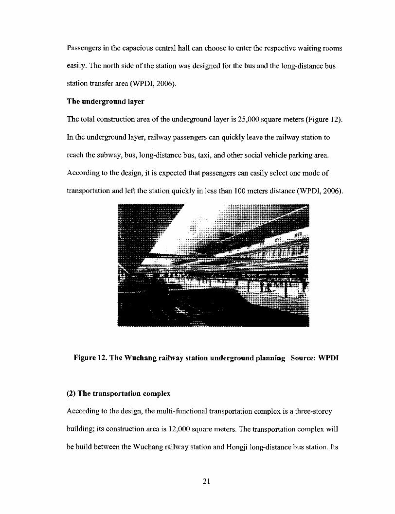
The underground layer
The total construction area of the underground layer is 25,000 square meters (Figure 12).
In the underground layer, railway passengers can quickly leave the railway station to
reach the subway, bus, long-distance bus, taxi, and other social vehicle parking area.
According to the design, it is expected that passengers can easily select one mode of
transportation and left the station quickly in less than 100 meters distance (WPDI, 2006).
Figure 12. The Wuchang railway station underground planning Source: WPDI
(2) The transportation complex
According to the design, the multi-functional transportation complex is a three-storey
building; its construction area is 12,000 square meters. The transportation complex will
be build between the Wuchang railway station and Hongji long-distance bus station. Its
21
underground layer will be connected with the subway line 4 and line 5 station halls. The
first floor of the transportation complex is designed to gather a total 11 bus lines which
are arriving or departing at the Wuchang station, realizing different kinds of mass
transit's transferring (WPDI, 2006).
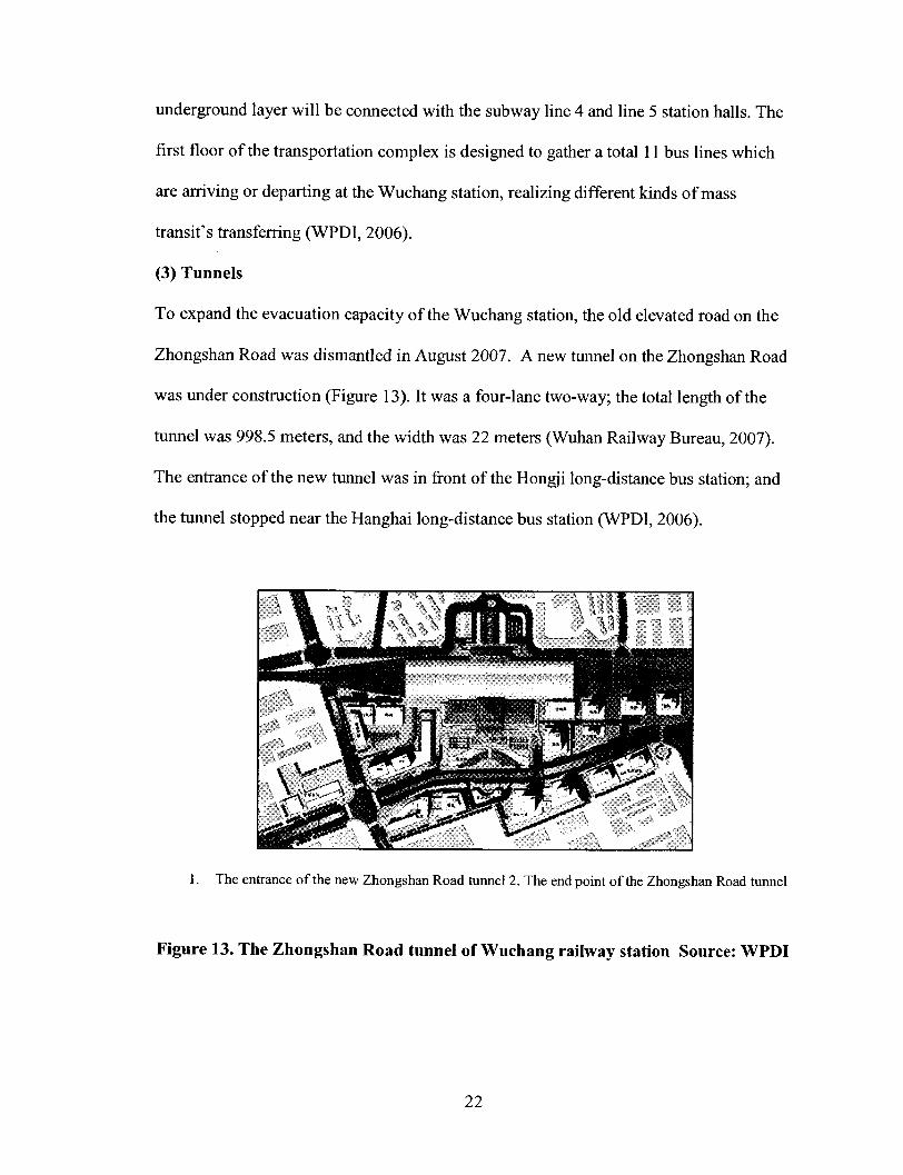
(3) Tunnels
To expand the evacuation capacity of the Wuchang station, the old elevated road on the
Zhongshan Road was dismantled in August 2007. A new tunnel on the Zhongshan Road
was under construction (Figure 13). It was a four-lane two-way; the total length of the
tunnel was 998.5 meters, and the width was 22 meters (Wuhan Railway Bureau, 2007).
The entrance of the new tunnel was in front of the Hongji long-distance bus station; and
the runnel stopped near the Hanghai long-distance bus station (WPDI, 2006).
1. The entrance of the new Zhongshan Road tunnel 2. The end point of the Zhongshan Road tunnel
Figure 13. The Zhongshan Road tunnel of Wuchang railway station Source: WPDI
22
It is expected that vehicles from Dadongmen to the Wutaizha direction would take
this underground link to go straight ahead, avoiding the vehicles and passenger's
confusion from happening in front of the Wuchang railway station. Another new tunnel
was built on the Ziyangdong Road, connecting the Ziyangdong Road and Ziyang Road
(WPDI, 2006).
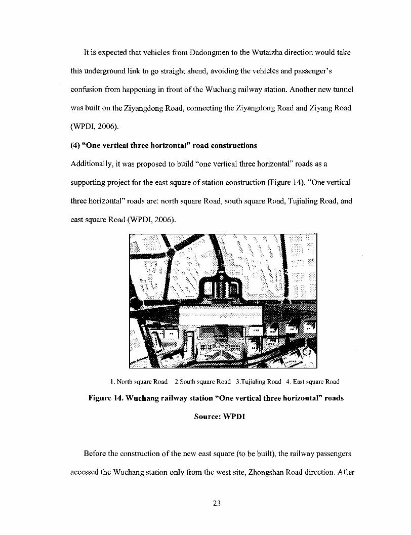
(4) "One vertical three horizontal" road constructions
Additionally, it was proposed to build "one vertical three horizontal" roads as a
supporting project for the east square of station construction (Figure 14). "One vertical
three horizontal" roads are: north square Road, south square Road, Tujialing Road, and
east square Road (WPDI, 2006).
1. North square Road 2.South square Road 3.Tujialing Road 4. East square Road
Figure 14. Wuchang railway station "One vertical three horizontal" roads
Source: WPDI
Before the construction of the new east square (to be built), the railway passengers
accessed the Wuchang station only from the west site, Zhongshan Road direction. After
23
the station renovation, railway passengers have alternatives. After the construction of the
new Ziyangdong Road and the extension of Jingan Road, railway passengers would come
to the Wuchang station from Fujiapo long-distance bus station, Sanyanqiao Road, or
Chuxiong Avenue direction; and then they would pass through the Jingan Road to get the
east square of the station, accessing the Wuchang railway station finally. It is expected
that Wuchang traffic bottleneck on the inner ring would be opened by these constructions.
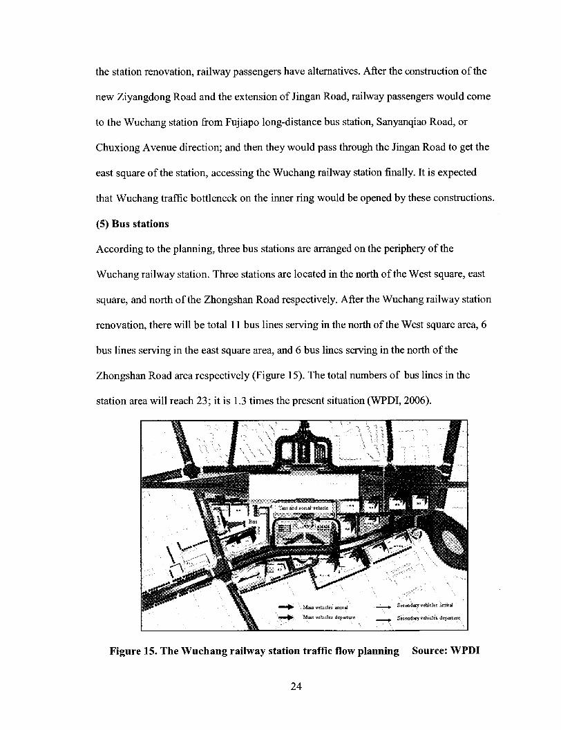
(5) Bus stations
According to the planning, three bus stations are arranged on the periphery of the
Wuchang railway station. Three stations are located in the north of the West square, east
square, and north of the Zhongshan Road respectively. After the Wuchang railway station
renovation, there will be total 11 bus lines serving in the north of the West square area, 6
bus lines serving in the east square area, and 6 bus lines serving in the north of the
Zhongshan Road area respectively (Figure 15). The total numbers of bus lines in the
station area will reach 23; it is 1.3 times the present situation (WPDI, 2006).
Figure 15. The Wuchang railway station traffic flow planning Source: WPDI
24
The existing long-distance bus terminal, Hongji bus station, was next to the Wuchang
railway station. It is at the corner of the Ziyangdong Road and Zhongshan Road. A new
underground pedestrian tunnel was designed to pass through the Ziyang Road, connecting
the west square of the Wuchang station and the Hongji bus station in the underground
level. According to the design, railway passengers and long-distance bus passengers will
be able to transfer directly underground (WPDI, 2006).
(6) Subway lines
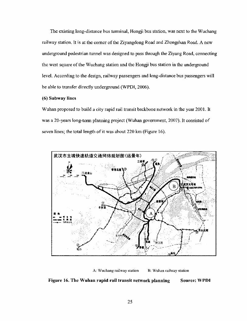
Wuhan proposed to build a city rapid rail transit backbone network in the year 2001. It
was a 20-years long-term planning project (Wuhan government, 2007). It consisted of
seven lines; the total length of it was about 220 km (Figure 16).
A: Wuchang railway station B: Wuhan railway station
Figure 16. The Wuhan rapid rail transit network planning Source: WPDI
25

It set up three lines across the Yangtze River and three channels across the Hanjiang
River. The rail transportation Line 1 started construction in 2001; and it was completed in
2004. It was expected to take seven years (2004 to 2010) to build the second phase
projects of the rail transit Line 1, the first stage projects of the Line 2, and the first stage
projects of the Line 4 (Wuhan government, 2007).
Before 2012, the Wuhan city will invest nearly 22 billion RMB to build the first stage
of rail transit Line 2, and the first stage of Line 4 (from Wuchang railway station to
Wuhan railway station) two subway lines. By then, Wuhan will form a "two vertical one
horizontal" 70 km long backbone of the track line networks (Wuhan government, 2007).
The rail transit Line 1 starts from Zongguan to Huangpu Road; its total length is
10.23 km. All the stations are overhead. It sets up 10 stations; the total investment is
about 2.2 billion RMB. Construction began in 2001; and it became operational in July
2004. From then, Wuhan became the seventh city with a rail transportation system. Rail
transit Line 2 is an underground line; it starts from Changqin Garden and goes to the
Guanggu Plaza. It passes the Hankou railway station. Its total length is 26.1 km. It sets up
23 stations; the total investment is 13.327 billion RMB. According to the plan, the Line 1
will pass urban core areas, the central area, the outlying industrial groups, and the new
living neighbourhood. The Line 2 will cross the Yangtze River and link its two banks. It
is the skeleton of the rail transit network which undertakes the largest passenger flow
(WPDI, 2006).
The subway Line 4 is a newly designed subway line. It starts from the Wuchang
railway station and goes to the Wuhan railway station. The total length of the subway
Line 4 is 17 km; it has 14 stations. It is expected to open in 2012. The total investment of
26

the Line 4 is 7.7 billion RMB. The subway Line 5 is a long term project. It starts from
Huangjiahu, and passes the Wuchang railway station; its end point is the Wuhan railway
station. The total length of the subway Line 5 is 20 km (WPDI, 2006).
As planned, the subway Line 4 and subway Line 5 cross at the Wuchang railway
station. They both connect with the Wuchang railway station in the underground level
(Figure 17) (WPDI, 2006).
Figure 17. Subway line 4 and subway Line 5 cross at Wuchang railway station
Source: WPDI
According to the design, the daily passenger capacity of the Wuchang station in the
subway Line 4 is 110,300. The subway Line 5 values according to the standard of the
Line 4 (WPDI, 2006). They will greatly improve the Wuchang station's evacuation
27

ability, and provide great convenience for passengers arriving and departing the Wuchang
railway station.
It is expected that the Wuchang railway station will eventually become a hub of
public transportation. The railway passengers and subway passengers would transfer
freely underground.
Chapter 3 Literature Review
3.1 Conceptual Framework
To better understand different points of view with regard to the impact of railway
station redevelopment on station area, a frame work must be established.
Railway stations areas are both nodes and places: they are important 'nodes' in
transportation networks; and they identify a 'place' (Bertolini, 1998). The Node-place
model ( Bertolini and Spit, 1998) can be best used to describe the position of railway
station areas within the hierarchy of the spatial and transport networks. In their
comparative study of redevelopment of railway station areas, Bertolini and Spit focus on
the concepts of node and place. They indicated that the railway station is a node of
transportation networks; the railway station is also a node of socio-economic networks.
They suggested that with a transport node the socio-economic potential is not necessarily
realized. Bertolini and Spit defined a place as "all the built and open spaces, together
with the activities they host, contained within the perimeter designed by a walkable
28

radius centred on the railway station building, as amended to take account of case-
specific phsysical-psychological, functional-historical and development features".
Bertolini and Spit identified five driving forces behind railway station area
redevelopment:
Two distinct types of public policy, namely promoting environmentally sustainable
transportation and land-use patterns on the one hand, and regenerating local
economies by restructuring the urban fabric on the other hand, positive and negative
technological change, or development of the modalities in use such as HST systems
and regional networks, institutional change, or privitization and commercialization,
the property cycle, or development of the real estate market, internationalization and
metropolitanization, in which respect station areas are related to Manuel Castells'
space of flows.
Oosten(2000) indicated that:
"The development of railway station areas not only meets requirements or wishes
with regard to the transport network and the urban situation. The exploitation of
railway infrastructure almost demands additional commercial development, it seems.
'Rail networks are geographically dispersed making it extremely difficult precisely to
define and limit the concession area, an ideal prerequisite of concessionaires, which
thus know the full extent of their commitment; lenders, too, for rather different
reasons prefer the concession to be fully carved out .The most successful rail network
developments, accordingly, involve a dedicated end-user, while the most successful
rail privitizations, like the most profitable port developments, involve transfer of the
associated infrastructure, rights of way, tracks and stations at below fair market
29
values. In addition, developers will often seek to obtain the right to develop adjacent
properties, either in support of the concession or as an independent source of project
income."
3.2 Concept Explanation
Nodes and places are the foremost concepts to understand the railway station area;
the transfer point concept is the second concept for us to evaluate the transportation
function; the third concept is the multimodal chains concept; the last concept is the multi-
functionality concept.
3.2.1 Nodes and Places
The recent empirical studies on the impact of railway station on property value treat the
node feature and the place feature separately.
Peek, Bertolini, and Hans De Jonge (2006) indicated the integration of transport and
urban development at station areas is a very complex planning challenge. Railway
stations areas are both nodes and places:
Railway stations are very peculiar locations. On one hand, they are (or may
become) important 'nodes' in emerging, heterogeneous transportation networks.
On the other hand, they identify a 'place', a both temporarily and permanently
inhabited portion of the city, an often dense and diverse assemblage of uses and
forms, that may or may not share in the life of the node (Bertolini, 1998).
Bertolini and Dijst (2003) said such place is 'mobility environments'. Their quality
depends on the features of each location, but also on the characteristics of their visitors.
30
3.2.2 Transfer Point
The performance of transfer point is a very important indicator for us to analyse the
traffic function of railway stations. "Nodal points are essential in a network. A particular
type of nodal points is formed by transfer or interchange points. In general, a transfer
point has three main functions that jointly determine its usability and efficiency. A
transfer point has to connect the links (modes) in the transport system; it has to collect
and distribute travellers. It has to concentrate travel flows to achieve economies of scale.
In addition, multimodal transfer point played a vital role in traffic function" ( Goiter,
Nijkamp, Vork, 1999).
Goiter et al. suggested:
To be competitive with unimodal transport (usually by car), a multimodal transfer
point has to ensure that the travelling time from and to the transfer point (node) is
minimized and also that interchanges take place as quickly as possible. A crucial
factor in this respect is the accessibility of the transfer point (node): the capacity and
the quality (through-flow intensity) of "feeding" and "backing" transport
infrastructure will be critical success factors for the accessibility of the transfer point.
In general, the performance of a multimodal transfer point is affected by the
accessibility of the transfer point, the facilities of the transfer point (in particular
parking), and the schedule coordination in the transfer point.
3.2.3 Multimodal Chains
Usually, trips including the public transit cannot be accomplished just by one single mode.
One or more modes are used to reach the destination. When we analyze the traffic
31
function of railway station, we should take account of the performance of multimodal
chains; it is another very important indicator.
Van der Waard (1989) found that" the average interchange between modes that is
evaluated by public transport travellers to be equal to about 6 minutes travels time in a
train. This figure reflects the loss of comfort due to an interchange".
Keijer and Rietveld (1998) suggested that "the quality of transport networks does not
only depend on the quality of the individual links and nodes, but also on the way these
nodes and links function in the context of (multimodal) networks".
They indicated that several potential advantages of multimodal chains can be listed:
(1) Multimodal chains may have better environmental and energy performance than
unimodal trips (depends strongly on load factors).
(2)Multimodal chains provide travel opportunities for segments of travellers that do
not have a unimodal alternative.
(3) Multimodal chains may be cheaper (depends on taxes and subsidies).
(4) Multimodal chains may be faster (especially in congested urban areas and in long
distance transport with high speed rail).
Two major disadvantages of multimodal transport have to be mentioned, however:
they may lead to detours and to waiting and rescheduling. Both problems concern
discontinuities, i.e., in space (detours) and in time (low frequencies imply waiting
and scheduling).
3.2.4 Multi-Functionality
Bertolini (1998) indicated that, rich, 'urban' mixtures of uses are being advocated in most
32

situations. He said "The multi-functionality is pursued because it is an essential element
of the liveability, attractiveness and security of the station area and because it improves
both public transport and property long-term exploitation prospects". Bertolini suggested
that:
But achievement of multi-functionality railway station in practice is not an easy task.
Many believe that without a high, 'urban' degree of functional mix, station areas will
never regain the centrality in urban life they have lost. Achievement of multi-
functionality in practice tends to remain highly problematic. Realizing multi-
functionality requires a difficult combination of'providing orientation' and 'letting it
happen', imaginatively catering for both profitable and less profitable elements...
Only the most innovative approaches seem capable of achieving this synthesis.
To sum up, nodes and places, transfer point, multimodal chains and multi
functionality, these four concepts, are basic frame work for us to better understand
railway station area, analyze its traffic function, and have a comprehensive understanding
of the railway station redevelopment impact.
3.3 Theories about Railway Stations
In a recent study, Bertolini (2006) described five principles of railway station design.
It gives us several indicators to evaluate the function of a railway station. The five
principles are:
(1) Multiple use, both in terms of activities and flows;
(2) Plentiful opportunities of interaction between life inside and outside buildings;
33

(3) High visibility and presence of people at all times;
(4) Enough, legible points of access to and exchange between different foci of
activity;
(5) An internal structure favouring the overlap of mobility flows in space and time;
(6) Links with the wider surroundings.
Bertolini indicated : "Multiple use is achieved by locating stations as close as
possible to existing urban facilities , by locating new urban facilities (such as hospitals
and universities) close to stations, and by providing as many points of exchange as
possible between different mobility flows". "Links with the wider surroundings are
enhanced by directly connecting pedestrian channels in the station and pedestrian
channels in the neighbourhood. Pedestrian reach is maximized both within the station and
in the surrounding neighbourhood".
According to Peek and Mark van Hagen (2002), there are three strategies to add
value to the railway station area:
Recommendations are presented for developing or redeveloping railway
station areas by creating synergy between both identities of a station—as a
node in a transport network and as an urban location. Station users want a
reliable, safe, fast, easy, comfortable, and pleasant experience in transferring to
different transport modes. Besides speed and safety, quality in the sense of
comfort and experience are added values.
Focusing on the traveler's appreciation of faster travel leads to three strategies that
can add value:
34

(1) Acceleration: making individual trips faster and eliminating hassle in transferring
to other transport modes
(2) Concentration: concentrating origins and destinations near stations and improving
the station environment
(3) Enhancement: adding facilities that enhance the comfort and experience of
transfer points
They indicated that: "Acceleration, concentration, and enhancement, three strategies
can add value to railway station, and it has a positive effect on local environment and
station area". They said:
(1) Travel-related services should be located at the center of transfer points;
acceleration is the key word here.
(2) Business facilities central to transfer points would make transfer intervals more
useful and pleasant; the emphasis is on enhancing comfort and experience.
(3) Less-travel-related activities and attractions should be concentrated in a particular
location, thus reducing travel time and hassle and enhancing the urban environment.
Synergy in station development or redevelopment can result if both transportation
and real estate factors are considered.
In the city, the different transportation way has the different suitable journey distance;
track's suitable journey is generally above 6 kilometres (Figure 18) (Ouyang, 2004).
According to Ouyang (2004), if there are no intermodal transportation with the bike and
bus, the orbital attractive radius only limit to the walk able environment, about 800
meters from the station; and this lead to lost a considerable number of potential customers.
35

Distance(km)
Mode
Walk
Bicycle
Bus
Rail
1 2 3 4 5 6 7 8 9 10 11 12 13 14 15 16
====
Figure 18 . Appropriate mode of transportation for the different trip distance
Source: Ouyang, 2004
Chang (2002) indicated that:
"For the unfamiliar, it might be quite difficult to decide which route to take.
Considering the difficulties in their route choice, it is most likely that their route
choice and decision behavior might be influenced by the presence of a high number
of people on a particular route. Although this does not mean that other factors, such
as well illustrated signs or actual visual connections with the destinations, are not
important, it does indicate that the presence of people seems to play an equally
significant role. In many cases, the mere presence of people itself seems enough to
lead the unfamiliar to the routes showing high rates of movement flow".
3.4 The Impact of Railway Stations on Property Values
1) Different types of railway stations have different levels of impact on property value
( Debrezion, Pels, Rietveld, 2003).
36

Railway stations differ from each other in terms of the level of service provided
explained terms of frequency of service, network connectivity, service coverage etc.
Debrezion et al. found that different types of railway stations have different levels of
impact on property value. Commuter railways have a relatively high impact on property
value. Railway stations also differ in the level and quality of facilities. Stations with
higher level and quality of facilities are expected to have greater impact on the
surrounding properties.
2) Railway station has both positive and negative impact on property values (Debrezion,
Pels, Rietveld, 2006).
Debrezion et al. indicated:
Recent empirical studies treat the node feature and the place feature of a station
separately. The former characteristic accounts for the accessibility effect, which is
generally positive. The latter feature accounts for externalities of the station and can
have both positive and negative effects. The accessibility and nuisance effects of a
railway station are functions of distance between the station and the house under
consideration. As the distance increases, the impact of both features on the house
price declines. The level of accessibility at a railway station is measured by the
quality of the railway network: the number of destinations that can be reached from
the station, the frequency of services at the station, and other departure station related
facilities. Stations with higher network quality (i.e. a larger number of destinations
and a higher frequency of trains) have a higher accessibility index, and are expected
to have a relatively high positive effect on the house prices.
Debrezion et al. suggested that:
37

Railway stations at the same time impose localised negative environmental effects
on house prices due to noise nuisance. An important difference between the two
effects is that the accessibility effects are concentrated around nodes (railway stations)
whereas the negative noise effects take place everywhere along the railway line.
Their research showed a negative effect of distance to railways, probably due to noise
effects: "Within the zone up to 250 meters around a railway line prices are about 5%
lower compared with locations further away than 500 meters. As a result of the two
distance effects, the price gradient starts to increase as one moves away from a station,
followed by a gradual decrease after a distance of about 250 meters"
3) Railway stations affect residential and commercial properties differently; the effect of
railway stations on commercial property value mainly takes place at short distances
(Debrezion, Pels, Rietveld, 2003).
Debrezion et al.indicated that the range of the impact area of railway stations is larger for
residential properties, whereas the impact of a railway station on commercial properties is
limited to immediately adjacent areas. Commercial properties within 1/4 mile rang are
12.2% more expensive than residential properties. Where the price gap between the
railway station zone and the rest is about 4.2% for the average residence, it is about 16.4%
for the average commercial property. At longer distances the effect on residential
property values dominate.
3.5 The Important Factors Influencing Residential Location Choice
38

Haider and Miller (2000) found that being within 1.5 km of a subway line was
positively associated with housing price, suggesting that some households make
residential location choices based in part on the opportunity to use transit.
Anas (1982) examines the probability of an individual choosing a particular property
as a function of the characteristics of that property, the characteristics of the
individual/household and characteristics of the neighbourhood in which the property is
located, including accessibility.
Pagliara and Preston (2003) indicated that house price, travel time and cost to work
appear to be important factors influencing residential location choice. ... Another
important factor is travel cost to shops, which is negative and significant, i.e. people
prefer to live close to shopping centres. The positive and highly significant value of the
quality of schools dummy means that people prefer to live in areas with good schools.
The negative and significant value of the noise dummy means that the choice of residence
is strongly influenced by the noise level of a given area. The preference is to live in quiet
areas.
3.6 Conclusion
In this framework chapter, we came up with a series of concepts, especially nodes
and places concept. To better understand the station area, we explored Bertolini's (2006)
railway station design principle. In addition, we discussed three strategies that can add
value to the railway station area. Moreover, we analysed several factors related to the
impact of railway stations on property values, discussed both positive and negative
39

impact of railway transport on property values. More importantly, we discussed
important factors influencing residential location choice.
Throughout the study, we present a comprehensive understanding of the railway
station area. Conceptually, railway stations have positive and negative impacts on
property values. All these help us to better understand the railway station area, analyze
the key element of the station area, and figure out their strength and positive effect on the
station surrounding area.
Chapter 4 Methodology
4.1 Introduction
The redevelopment of railway station areas throughout Europe is often an important
part of urban restructuring (Bertolini and Spit, 1998). In Europe, the high speed train
stations facilitate the development of an international business centre for two main
reasons: "First, it provides additional transport facilities, which are especially important
given that knowledge-intensive business still very much depends on face-to-face contact.
Second, the HST station provides an image that suits international business
( Bruinsma, et al, 2007)".
Chinese railway stations are also moving in the direction of the development of high
speed convenient service for the passengers. It handles a multi-transport system and
40

various service functions in an integrated building. The railway station area becomes a
new urban space; it has become one of the important features of the contemporary city. I
believe that in China, railway station redevelopment will also attract real estate
development, especially residential building and local commercial building around the
station area.
Following European and Japanese precedents, Chinese railway station redevelopment
will provide a catalyst for revitalizing the station area and extending the impact of the
station into the surrounding area. Until now, station redevelopment has largely concerned
the railway facilities themselves, along with intermodal facilities. This investigation
explores the current extent of the Wuchang railway station on the surrounding area, and
projects its future extent based on an analysis of the completed transport hub.
Wuchang railway station was chosen as my case study because it is a super-large
station and located in the city center. Thus, Wuchang station redevelopment was more
likely to have a local revitalization impact in the city than the other local railway stations.
Also, Wuchang railway station is one of six main hubs of the high-speed railway network.
According to the service distance, it is a long-distance railway station. Taken together,
the Wuchang station is an important railway station sample in Chinese city.
I analyzed the key element of the station area, and attempted to figure out their
strengths and positive effect on the station surrounding area. Several indicators, such as
new development in residential building, new development in commercial building, and
new development in public facilities, were used.
This chapter presents the research methods and procedures utilized in this study. A
mix of methods were used in the study: questionnaire, interview, site survey and
41

comparative analysis. The data collected from the questionnaire survey and interviews
were treated quantitatively and qualitatively.
The methodology follows the recommendation of Yin (1994) and has four stages:
1. Design the case study
2. Conduct the case study
3. Analyze the case study evidence
4. Develop the conclusions, recommendations and implications
4.2 Questionnaire and Interview
In an effort to learn about the impact of Wuchang railway station redevelopment, I
conducted questionnaire surveys and interview in three residential quarters. After the
questionnaires and interview, I attempted to get some conclusion in terms of the impact
of railway station redevelopment on the station area.
Questionnaire surveys were administered over a period of three weeks in May 2008
in three residential quarters within Wuchang railway station area. Xiao Liu, a student
from Huazhong University of Science and Technology helped me conduct the
questionnaire. I could only meet a small number of residents outside residential buildings
that were willing to do the survey. After that, I knocked on the doors floor by floor, room
by room, and asked residents to do the questionnaire. Some residents were unwilling to
co-operate. I struggled to get most of the residents' sample data this way.
In total, 38 valid questionnaire survey answers were collected: 14 samples from the
JinTao residential quarter, 12 samples from the Boguangyuan residential quarter, and 12
samples from the City Park residential quarter. There are 270 households in JinTao
42
residential quarter, 187 households in Boguangyuan residential quarter, and 1,023
households in City Park residential quarter. Assuming that each family has 3 people, the
total 38 residents account for 1% total residents in these three residential quarters.
Due to time and resource limitations and methodological constraints, a larger number
of samples could not be achieved. However, the resulting qualitative data does provide an
indication of resident perceptions regarding the impact of Wuchang station
redevelopment.
Due to time and resource limitations and methodological constraints, I was not able
to get as much comprehensive and adequate questionnaire data as I expected. In this
study, more weight is given to qualitative interviews than to the questionnaire survey. I
interviewed more than 80 people. Interviews were conducted in the same three residential
quarters. Information obtained from quality, in-depth interviews is more valuable and
indicated perceptions of residents.
The interviews for residents living in the three residential quarters were designed to
be casual and informal in order to obtain information fulfilling the criteria. Simple
random sampling was used to target residents. I knocked on the doors floor by floor,
room by room, and asked residents if they would be interested in being interviewed.
Other individual residents were approached and spoken to on the sidewalks within each
residential quarter as opportunities arose.
In total, 81 resident face-to-face, in-depth interviews were conducted in the three
residential quarters in May 2008, 27 residents in each residential quarter. A ten-question
interview template was used during the interviews.
Interview template questions
43
1. What is the main factor of your residential location choice?
2. Is it convenient for you to access the railway station? Which route option would you
use?
3. Which bus station do you use frequently? Which route option would you use?
4. Which walking route option do you use frequently in your spare time?
5. Do you have any difficulty or concern in getting to/from the railway station?
6. Could you tell me the reason why you prefer to go to railway station?
7. Could you tell me how often do you use trains (or bus, car, bicycle, walk respectively)
to do per (day, week, and month) for times?
8. What's your general impression about railway station area?
9. What is the biggest advantage of living in this residential quarter, and what is the
biggest disadvantage of it?
10. After the railway station rebuilt, were there any improvement?
4.3 Site Survey in the Wuchang Station Surrounding Area
Barton, Grant, Guise (2004) indicated: "the average walking journey is 1km; not
many people walk more than 2 km. 400 m is an accepted threshold for walking to the bus;
800 m is a suggested threshold for walking to a town centre".
I did site survey in the three residential quarters, traced the possible path from each
residential building site to the Wuchang railway station, especially in the walkable
environment.
To better understand the current traffic situation in the Wuchang station area, as part
of the study, in this walkable environment, the volume of the vehicles on the surrounding
44

roads were documented and measured. In addition, I analyzed these roads' spatial
character and linkage with the Wuchang railway station.
Moreover, I studied the local shops and commercial facilities in the Wuchang railway
station area, traced the path from each shop to the railway station. Then I analyzed its
path spatial character and its linkage with the Wuchang station, attempting to figure out
the impact of the Wuchang railway station redevelopment. I also surveyed other new
developments in the Wuchang station area.
4.4 Projecting Potential for Wuchang Station Redevelopment
In Europe, the redevelopment of railway station areas is an important part of urban
restructuring (Bertolini, Spit, 1998). There is no denying that China's urban construction
and the transportation pattern will have a big change after the construction of the "five
hours city circle". The railway station renovation and its construction play an important
role in here. Against this background, the Wuchang station rebuilding projects contain
profound meaning. To achieve seamless connectivity between station and external traffic
of the city, optimize the environment of the core zone, and enhance the quality of the city
space is an important task not only for the Wuchang station renovation but also for the
urban restructuration.
A comparative analysis regarding redevelopment around railway station was
conducted. I analyzed the European Utrecht Central station, Lille-Europe railway station,
Tokyo railway station, Kowloon Station, and Shanghai South station redevelopments,
drew some conclusions about the Wuchang railway station potential development, and
projected potential for Wuchang station area redevelopment.
45
4.5 Data Used in the Study
The Wuhan Planning & Design Institute (WPDI) proposed the "Wuchang railway
station and the surrounding area transportation and landscape planning" in 2006. The
discussion of the Wuchang railway station redevelopment projects is mainly based on the
project plans as they were presented in Wuhan Planning & Design Institute planning
documents.
In the study, I collected the mode choices data of the Wuhan residents from Wuhan's
traffic survey result in 1998 (Hu, 2003), and collected public transportation data on
passenger volume from Wuhan transportation development annual report (2007). I
collected the passenger flow forecast data from WPDI (2006) passenger flow forecast
documents. Two land use maps (before and after the station renovation) were collected
from WPDI. A digital map of Wuchang station area was collected from WPDI. Based on
these maps and walking and surveying the entire Wuchang station area, a new-map of the
Wuchang station area was created (Figure 19).
46

\ '-;>
C3 «£>
ear" .caS1.
x
% -. **»*/ *»
500m
1. Wuchang station 2.Ziyang Lake Park 3.Sai lake 4.Sheshan Park
5. Zhongshan Road 6. Wuluo Road 7.Ziyang Road 8.Ziyangdong Road
9.Chuxiong Avenue 10.Shouyi Road 11. Jingan Road 12.Railway land
Figure 19. The study Wuchang railway station areas
47
Chapter 5 Questionnaire and Interview Results
I chose Wuchang railway station redevelopment project as my case study, and
attempted to use several indicators such as new development in residential building, new
development in commercial building to figure out the impact of the railway station
redevelopment, especially in the walk able environment, which was within 2-3 kilometre
area of the railway station.
In the Wuchang station areas, I chose three residential quarters; they were developed
in the last two years. I conducted questionnaire surveys in these residential quarters. The
questionnaire survey carried on not easily. Some residents were unwilling to co-operate.
A student from Huazhong University of Science and Technology and I entered each
residential quarter and struggled to get the residents' sample data.
This survey was conducted for about three weeks. This chapter examines and
analyses all the valid answers to the questionnaire survey and personal interviews which
were conducted in the three new residential quarters.
5.1 Three Residential Quarters
The selected residential quarters were: JinTao residential quarter, Boguangyuan
residential quarter, and City Park residential quarter. The locations of three surveyed
residential quarters were shown in Figure 20 in relation to the major existing transport
infrastructure. These three residential quarters are all commercial housing development
projects, which were developed in the railway station area within recent two years.
48

A. JinTao residential quarter B. Boguangyuan residential quarter C. City Park residential quarter
1 .Wuchang station 2.Zhongshan Road 3.ZiyangRoad 4.Ziyangdong Road 5.Chuxiong Avenue
6.Shouyi Road 7.Jingan Road 8.Wuluo Road 9.Sai lake lO.Ziyang Lake Park
Figure 20. The Wuchang station and three residential quarters
The JinTao residential quarter is at the corner of the Wuluo Road and Zhongshan
Road (Figure 21). Wuluo Road is a bustling main road in Wuchang district. Northward, it
links with Yangtze Bridge. A large number of vehicles come from Hanyang district, cross
the Yangtze Bridge go to Wuchang district; and then most of them pass through the
Wuluo Road. Southward, Wuluo Road links with famous Zhongnan Road, which is one
of the most popular shopping venues in Wuchang district. Zhongshan Road is in front of
the Wuchang railway station. It passes through the center of the old town; it is another
bustling main road in Wuchang district.
49

Figure 21. The JinTao Mansion residential quarter
The JinTao residential quarter has one high-rise building. It occupies a ground space
of about 3,136 square meters. The whole construction area is about 26,820 square meters,
with about 100 parking place. Its rate of coverage in green space is about 20 percentages
(Hubei Jintao Real Estate Development Co., Ltd, 2008).
The Boguangyuan residential quarter is developed by Wuhan Urban Development
Group Limited (Figure 22). It is their second stage development project. The first stage
project is on the opposite side of the Jinan road, close to the east square of the Wuchang
station. The whole residential quarter occupies about 10,000 square meters ground space;
its construction area is about 120,000 square meters. It has about 70 parking place, and its
rate of coverage in green space is about 30 percentages (Wuhan Urban Development
Group Limited, 2008).
50
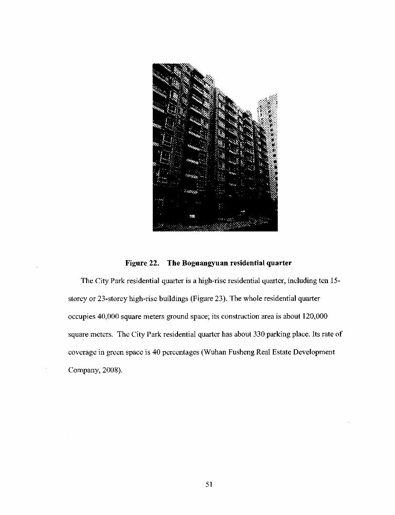
Figure 22. The Boguangyuan residential quarter
The City Park residential quarter is a high-rise residential quarter, including ten 15-
storey or 23-storey high-rise buildings (Figure 23). The whole residential quarter
occupies 40,000 square meters ground space; its construction area is about 120,000
square meters. The City Park residential quarter has about 330 parking place. Its rate of
coverage in green space is 40 percentages (Wuhan Fusheng Real Estate Development
Company, 2008).
51
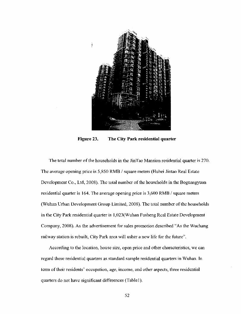
Figure 23. The City Park residential quarter
The total number of the households in the JinTao Mansion residential quarter is 270.
The average opening price is 5,850 RMB / square meters (Hubei Jintao Real Estate
Development Co., Ltd, 2008). The total number of the households in the Boguangyuan
residential quarter is 164. The average opening price is 3,600 RMB / square meters
(Wuhan Urban Development Group Limited, 2008). The total number of the households
in the City Park residential quarter is l,023(Wuhan Fusheng Real Estate Development
Company, 2008). As the advertisement for sales promotion described "As the Wuchang
railway station is rebuilt, City Park area will usher a new life for the future".
According to the location, house size, open price and other characteristics, we can
regard these residential quarters as standard sample residential quarters in Wuhan. In
term of their residents' occupation, age, income, and other aspects, three residential
quarters do not have significant differences (Table 1).
52

Tablel. Three residential quarters overall comparison
Location
Completion date
Distance to station
Ground space
Construction area
Households number
Parking place
JinTao
Zhongshan Road
September 2007
1.7km
3,136
26,820m2
270
100
Boguangyuan
Jinan Road
June 2006
0.8km
10,000
26,850m2
187
70
City Park
Jinan Road
July 2007
1.0km
40,000
120,000m2
1,023
330
5.2 Questionnaire Survey Results
Xiao Liu, a student from Huazhong University of Science and Technology and I
conducted questionnaire survey in the three residential quarters in May 2008.1 only could
meet a small number of people outside residential building that were willing to do the
questionnaire. After that, I knocked on the doors floor by floor, room by room, and asked
residents to do the questionnaire. I struggled to get most of the residents sample data this
way. Nevertheless, I still gathered a small number of samples.
Respondents in each residential quarter were asked to identify and rank the main
factors of their residential location choice according to eight categories, such as
reasonable price, house layout and environment, less travel time and cost to work, near
shopping centre, near railway station, near bus station as well as expectation of value
increase. Further details were asked about their perspective on the Wuchang railway
53

station area. By this, I hoped to identify the main factors that have an impact on
residential location choice.
The questionnaire included twelve questions (Appendix A). All distributed questions
were written in Chinese. The data collected from questionnaires were treated as
qualitative, the descriptive data were coded. The total numbers of our respondents was 38.
In addition, I interviewed 81 residents.
1) Answers to the Question 1. In response to the Question 1 of the survey, all the
respondents reported that they had lived there for one or two years.
2) Answers to the Question 2.
Table 2. The numbers and percentage of respondents who chose answer 5 as first or
top three options in Question 2.
Numbers
%
First option
10
26%
Top three
option
20
53%
Total
38
100%
In response to the Question 2 of the survey, 26 percent of the respondents chose the
answer 5 "close to railway station" as the most important factor of their residential
location choice. In detail, 43 percent of the respondents in JinTao Mansion residential
quarter ranked "close to railway station" as the most important factor of their residential
location choice. Seventeen percent of the respondents in the Boguangyuan residential
quarter and 17 percent of the respondents in the City Park residential quarter gave the
same answer respectively.
54

Fifty -three percent of the respondents put "close to railway station" in the top three
important factors of their residential location choice. In detail, 26 percent of the
respondents lived in the JinTao Mansion residential quarter, 42 percent of the
respondents lived in the Boguangyuan residential quarter, and 42 percent of the
respondents live in the City Park residential quarter chose this answer respectively.
3) Answers to the Question 3.
Table 3. The numbers and percentage of respondents who answered convenient or
not convenient in the Question 3.
Numbers
%
Convenient
33
87%
Not
convenient
5
13%
Total
38
100%
In response to the Question 3 of the survey, 87 percent of the respondents thought it
was convenient for them to go to Wuchang railway station, 13 percent of the respondents
thought it was not convenient for them to go to railway station.
4) Answers of the Question 4. The answers of the Question 4 showed that respondents
frequently use the neighbouring bus station. For residents living in the Boguangyuan
residential quarter and City Park residential quarter, they did not go to the west site of
railway station to take bus.
5) Answers to the Question 5.
55

Table 4. The respondents' preferred walking route in Question 5.
Numbers
%
Station square
5
13%
Residential
quarter
4
11%
Neighbouring
parks
8
21%
Zhongnan
Road
7
18%
Others
14
37%
Total
38
100%
In response to the Question 5 of the survey, 13 percent of the respondents chose the
square of Wuchang railway station as their preferred walking route in their spare time. 11
percent of the respondents chose walking in the residential quarter as their preferred
walking route in their spare time. These respondents are all lived in the City Park
residential quarter. Twenty-two percent of respondents chose Neighbouring parks, 18
percent of respondents chose walking to Zhongnan Road. The Wuchang station has
already become a social gathering place.
6) Answers to the Question 6.
Table 5. The Numbers and percentage of respondents who reported difficulty or
concern in getting to/from the railway station in Question 6.
numbers
%
Crossing
busy road
7
18%
Crowds of
people
6
16%
Noise
2
5%
Crossing
tunnel
1
3%
Circuitous
route
1
3%
Total
38
100%
56

In response to the Question 6 of the survey, 45% respondents reported difficulty or
concern in getting to/from the railway station, such as difficulty crossing busy road,
crowds of people as well as noise.
7) Answers to the Question 7.
Table 6. The numbers and percentage of respondents reported reason why they
prefer to go to Wuchang station in Question 7.
numbers
%
Take trains
25
66%
take bus
1
3%
facility
1
3%
walking
4
11%
others
7
17%
Total
38
100%
In response to the Question 7 of the survey, 66 percent of respondents reported for
take trains, 11 percent of respondents reported for walking, 3 percent of respondents
reported for better public facilities, 3 percent of respondents reported for take bus, and 17
percent of respondents reported for other reasons.
8) Answers to the Question 8.
Table 7. The mode choice of the three residential quarter's resident in the Question
8.
numbers
%
Bus
16
42%
Car, Taxi
7
18%
Bicycle
5
13%
Walking
8
21%
Others
1
6%
Total
38
100%
57
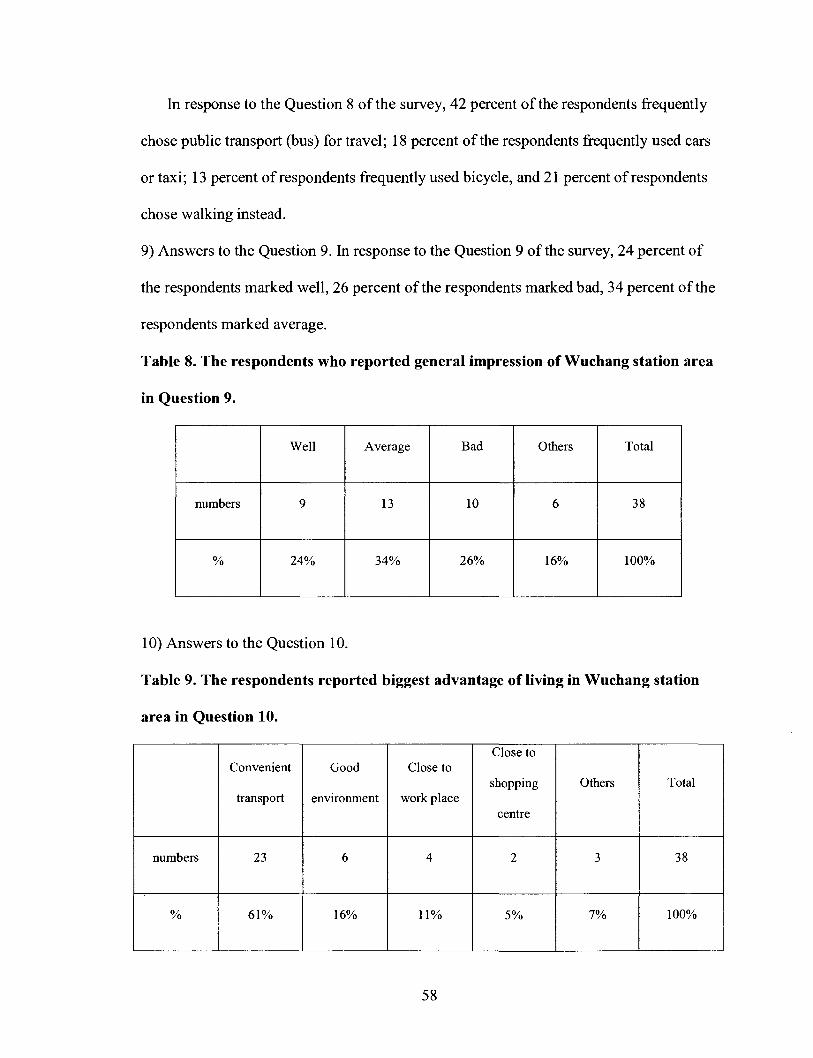
In response to the Question 8 of the survey, 42 percent of the respondents frequently
chose public transport (bus) for travel; 18 percent of the respondents frequently used cars
or taxi; 13 percent of respondents frequently used bicycle, and 21 percent of respondents
chose walking instead.
9) Answers to the Question 9. In response to the Question 9 of the survey, 24 percent of
the respondents marked well, 26 percent of the respondents marked bad, 34 percent of the
respondents marked average.
Table 8. The respondents who reported general impression of Wuchang station area
in Question 9.
numbers
%
Well
9
24%
Average
13
34%
Bad
10
26%
Others
6
16%
Total
38
100%
10) Answers to the Question 10.
Table 9. The respondents reported biggest advantage of living in Wuchang station
area in Question 10.
numbers
%
Convenient
transport
23
61%
Good
environment
6
16%
Close to
work place
4
11%
Close to
shopping
centre
2
5%
Others
3
7%
Total
38
100%
58

Table 10. The respondents reported top three biggest disadvantage of living in the
Wuchang station area in the Question 10.
numbers
%
Noise
11
29%
Inconvenient
transport
service
10
26%
Bad
environment
4
11%
Total
38
100%
In response to the Question 10 of the survey, 61 percent of the respondents answered
the biggest advantage of living in the railway station was convenient transport. In detail,
93 percent of the respondents lived in the JinTao Mansion residential quarter, 58 percent
of the respondents lived in the Boguangyuan residential quarter, 8 percent of the
respondents lived in the City Park residential quarter answered the biggest advantage of
living in the railway station were convenient transport.
Twenty-nine percent of the respondents answered that the biggest disadvantage to
living in the railway station was noise problems. Twenty-six percent of the respondents
answered inconvenient transport service, 26 percent of the respondents answered bad
environment respectively.
11) Answers to the Question 11.
59

Table 11. The numbers of respondents who reported station area had been
improved in Question 11.
numbers
%
improved
11
37%
Others
10
63%
Total
38
100%
In response to the Question 11 of the survey, 37 percent of the respondents reported
that station area had been improved after station renovation. Among these 37 percent
respondents, 36 percent of the respondents directly referred improvement to the new
planned green areas in the station area, 21 percent of the respondents directly referred
improvement to the better environment. Only 7 percent of the respondents referred
improvement to the new planned station area had realized connection between east side
and west side. In other words, only 2 percent of the whole respondents referred
improvement to the connection between the east site and west side.
12) Answers to the Question 12.
In response to the Question 12 of the survey, 86 percent of the respondents in the
JinTao Mansion residential quarter reported property value increased, 83 percent of the
respondents in the Boguangyuan residential quarter, 75 percent of the respondents in the
City Park residential quarter made the same choice respectively.
According to the Wuhan's traffic survey in 1998, it showed that the average number
of resident's trips is 1.98 times per day. In all of the travel per capita, 21.8 percent for the
use of public transport (buses and small buses), 29.1 percent for riding bicycle ,37.1
60

percent for walking, 4.2 percent for the use of company's vehicles , and the rest 7.9
percent for the use of taxis, motorcycles and other means of transportation (Hu,2003).
The questionnaire survey in these three residential quarters showed 42 percent of the
respondents frequently chose public transport (bus) for travel; 18 percent of the
respondents frequently used cars or taxi; 13 percent of respondents frequently used
bicycle, and 21 percent of respondents chose walking instead( Figure 24).
i\o^ ,o\o^ ,o\o^ ,o\o^
x<T > > . >
& c / <F ^ ^
I Wuhan local residents
I residents in three residential quarters
Figure 24. The mode choices of the Wuhan residents and mode choices of three
residential quarter's residents
As can be seen from the above figure, my survey showed that people in these three
residential quarters depend more on traditional public transport means. In other words,
people living in these three residential quarters more benefit from the public transport
system. According to my survey data, the percentage of people who frequently used
traditional public transport means in the three residential quarters was almost two times
the number which presented in Wuhan's traffic survey.
61
According to the questionnaire survey in the three residential quarters, 16 percent of
the respondents had already chosen the square of Wuchang railway station as their
preferred walking route in spare times. Forty-two percent of the respondents reported that
station area had been improved after the station renovation. Among these 40 percent
respondents, 40 percent of the respondents directly referred improvement to the new
planned green areas in the station area.
5.3 Interview Results and Analysis
Due to restriction of time and manpower, I was not able to get as much
comprehensive and adequate data as I expected. Additionally, I interviewed 81 residents.
During interview, it was felt that information obtained from quality, in-depth interviews
was more valuable and indicated perceptions of residents.
In terms of convenient transportation service, the JinTao residential quarter had its
own advantage. The residential quarter is at the corner of the Wuluo Road and
Zhongshan Road; it is next to the Dadongmen overpass. Two bus stations are located
near the overpass, along the Zhongshan Road both sides. No.4, No.6, and more than ten
other bus lines serve this area.
Only a small number of respondents in the JinTao Mansion residential quarter said
sometimes they walked to the west square of the railway station in their spare time.
Instead, most of the respondents reported that they chose to cross Wuluo Road and walk
to the neighboring Sheshan Park or Shouyi Park more frequently in their spare time.
These two parks are on the opposite side of the Wuluo Road, not far beyond the JinTao
residential quarter.
62

A bigger percentage of residents in the JinTao Mansion residential quarter said that
living close to the Wuchang station was the most important factor for them. Most of them
talked about the advantages of convenient transport gained by living there. In addition,
most of the respondents in the JinTao residential quarter thought that it was convenient
for them to access the Wuchang railway station. It only took residents five minutes to
cross the nearby pedestrian bridge, walk along Zhongshan Road, and finally get Wuchang
railway station. Zhongshan Road was always crowded and noisy in rush hour. It appears
that residents seemed to accept the side effect to get the convenience as compensation.
Of the three residential quarters, residents in the Boguangyuan had the shortest trips
to the Wuchang railway station. Compared with City Park residential quarter, a bigger
percentage of respondents in the Boguangyuan residential quarter (second stage) said that
they preferred to walk to the east square of the station in their spare time. The east square
currently is under construction; and the environment was disorder. Direct observation
revealed that to access the east square from the Boguangyuan residential quarter, the
walking path passes through the Jingan Road, along north square Road, finally
accessing the station square. The walking distance is about 0.7 km.
A significant number of respondents in the Boguangyuan said that they chose to walk
to the Zhongnan Road to go shopping or roaming. Among these respondents, most people
mentioned Zhongnan plaza as their main destination. Zhongnan Road is a famous
financial and commercial centre with flourishing streets in Wuchang district. Zhongnan
plaza is a 45- storey building, located in the central section of the Zhongnan Road; it sets
shopping malls, business suites and underground car parking. The height of plaza
building is 180 meters. And there were other high-rise shopping malls and commercial
63

shops located around it along Zhongnan Road. It is one of the most popular shopping
venues in Wuchang district.
The walking distance from the Boguangyuan residential quarter to the Zhongnan
plaza is about 2 km. Though there is a pedestrian bridge on Wuluo Road, it is still not
easy for residents to pass through the flourishing Wuluo Road and Zhongnan Road. It
takes more than thirty minutes to walk there. According to my observation, it is not an
easy and pleasant travel in terms of current traffic situation.
Most of the respondents in the Boguangyuan residential quarter said they seldom
walk to the west square of the Wuchang railway station in their spare time. There is a
new tunnel on Ziyangdong Road. To access the station, residents need to pass through the
Jingan Road and Ziyangdong Road, cross that tunnel, walk along Zhongshan Road, and
finally access the station square. The walking distance is about 1.2km. Direct observation
revealed that it was not an easy trip.
It is noteworthy that several buildings in the west parts of the City Park residential
quarter are closely located near the east square of the Wuchang station. Residents living
in these buildings complained about noise effect. They said it became more serious at
night, making it very hard for them to have a good sleep. They complained that when
they purchased the houses, they did not expect such serious noise.
In recent years, the speed of Chinese trains has increased and both the loading of
wagons and the intensity of the flow of trains have grown, leading to serious noise
pollution along the line of the railway (Gu, 2006). The most important source of railway
noise in China is the locomotive whistle. The State Environment Protection Bureau and
the Ministry of China Railway promulgated jointly a notification document on
64

"Strengthening the Prevention and Protection Work of Railway Noise Pollution" in
2001. Beijing, Shanghai, and Guangzhou imposed severe restrictions on the use of
locomotive whistles in urban areas. Since then, the LAeq along the railway boundary
(30m away from the centerline of the outer track) have been reduced by 3-5 dB at the
locations where the whistle noise is important (Gu, 2006).
Nevertheless, currently noise effect from railway station is still a noticeable negative
effect of railway station for local residents, especially for those people who live close to
the railway station. During interviews, I also got noise report from the residents who live
in the Boguangyuan residential quarter (first stage). It appeared that the noise situation in
Boguangyuan residential quarter (second stage) and JinTao Mansion residential quarter
was better. I did not got report for serious noise which directly from the railway station.
My study results correspond with the research done by Debrezionet et al (2006). His
research showed a negative effect of distance to railways, probably due to noise effects:
within the zone up to 250 meters around a railway line prices are about 5% lower
compared with locations further away than 500 meters. Thus the negative effect of
railway station can be seen.
Despite the noise effect, the City Park residential quarter had its own good character.
The landscape of courtyard space inside the residential quarter was well designed. There
were small squares, green medians, playground, and athletic field inside. I observed that a
bigger percentage of residents stayed in the residential quarter courtyard. During
interviews, not a small number of respondents in the City Park residential quarter talked
about now they did not have a walk outside frequently; they preferred to walk in the
courtyard of the residential quarter instead.
65

Respondents told me the reason why they seldom went to the Wuchang station area
was that it was not convenient. Going to the west square of the Wuchang station, they
pass through the Jingan Road and Ziyangdong Road, and then walk along Zhongshan
Road, finally accessing the station square. The walking distance is more than 2km.
Compared with the 1km, the average walking journey (Hugh Barton et al, 2004), the
walking path here was too long. In addition, there were many vehicles and people
gathered on these roads. It appeared that it was not a pleasant travel for these residents.
Although there is a new tunnel on the Ziyangdong Road, it appeared that few
respondents like to use it. Direct observation revealed that the tunnel is not a friendly
environment for people walking, and it had not been fully used, even for vehicles. There
is another tunnel on Chuxiong Avenue; it is about 1.4 kilometer far from the City Park
residential quarter. No respondents in these residential quarters mentioned it during the
interviews. The logical explanation was for residents passing through the tunnel and
accessing the Wuchang railway station, the walking distance is too far.
As Luca Bertolini said "Links with the wider surroundings are enhanced by directly
connecting pedestrian channels in the station and pedestrian channels in the
neighbourhood. Pedestrian reach is maximized both within the station and in the
surrounding neighbourhood" ( Bertolini, 2006). To organize a sustainable transport in the
city, now the railway station organically links with surrounding environment is very
important. It can connect station and surrounding environment closely, and contribute to
a sustainable transport system. I did not find these kinds of pedestrian connections in the
Wuchang railway station area survey.
66
During interviews, most respondents in the Boguangyuan and City Park residential
quarter had complained that it was not convenient to go out by bus. There is no bus line
that specially takes these local residents' travel requirements into account. For the
residents in the Boguangyuan and City Park residential quarter, it is too far for them to go
to the west site of the railway station to take bus. Moreover, the routing of other bus lines
in the station west site mainly thought about railway passengers' needs. Local residents
who go on a journey must mix up with the massive railway passengers to take the bus;
and it is always crowded in rush time. There is no bus line circularly serving resident in
the station area, for short distance travel and connecting the east site and west site of the
station. Here, the division question caused by the rail line which across the city not only
impeded transportation relation of the both side, it also created fissure of the urban space
and the physique even emotion.
According to my survey, current traffic situations in the Wuchang station area
objectively lead to an unfriendly environment for cycling and walking. Some local
residents did not prefer walking in the Wuchang station area. They even chose to walk to
the neighbouring Parks and commercial streets which were two kilometres away from the
station. For local residents, it was appeared that to ride a bicycle or walk in the station
area is not a pleasurable experience.
According to the survey, in general, close to the railway station is an important factor
for the residential location choice. Comparing with other factors such as house layout,
environment, and expectant growing value as well as near shopping centre, less travel
time and cost to work, reasonable price and near bus stations are more important factors.
Their importance in residential location choice was similar to near the railway station.
67

Chapter 6 Site Survey in the Station Surrounding Area
To better understand the current situation in the Wuchang railway station area, I
surveyed the Wuchang station surrounding area. Particularly, I studied the local shops
and commercial facilities which were located within a radius of about 2-3 km range of
the railway station, and attempted to figure out the positive impact of railway station
redevelopment on it .The current traffic volume on the surrounding roads in the Wuchang
station area was studied and analyzed. Other new developments in the station area were
studied.
6.1 Wuchang Station Area's Traffic Survey Results and Analysis
The north-south Zhongshan Road, opposite to the Wuchang station west square, is a
key main street in the Wuchang station area. It is the widest road in the Wuchang station
area, with a width of 65 metres (WPDI, 2006).
Zhongshan Road plays a unique influential role in the Wuchang station area. A large
numbers of vehicles and passengers come from various directions to the Wuchang station,
mostly depending on Zhongshan Road. Southward, Zhongshan Road links with Wutaizha
area, connecting with the Wuhan- Xianling highway and the Wuhan- Zhifang highway.
Those vehicles go to Wutaizha area and leave Wuhan must pass through Zhongshan
Road. It is the inevitable road to the south gate of Wuhan city. Started from the early
1990s, along with the economic development of Wutaizha area, the amount of vehicles
passing through the Zhongshan Road to the Wutaizha area has gradually increased. It
inevitably aggravated traffic pressure on the Zhongshan Road (Figure 25).
68

1. Zhongshan Road 2.Ziyang Road 3. Chuxiong Avenue
4. Vehicles to the Wuchang station 5. Vehicles to the Wutaizha area 6. Vehicles departure station
Figure 25 . Traffic flow on Zhongshan Road (before station renovation)
The rail divided Wuchang station area into east and west two parts. Before the
Wuchang station renovation and the construction of Ziyangdong Road, the railway
passengers could only access the Wuchang station from the west site of the station,
Zhongshan Road direction. Most of the bus stations in the Wuchang station area were
located along the both sides of the Zhongshan Road.
Passengers' arrival and departure Wuchang station centralized in the west site of the
station; they mainly evacuated by Zhongshan Road. As the vehicles and railway
passengers' flow in the Wuchang station area were continuing to increase, Zhongshan
Road became a main bottleneck, restricting the sustainable development of station area
and the peripheral areas.
69
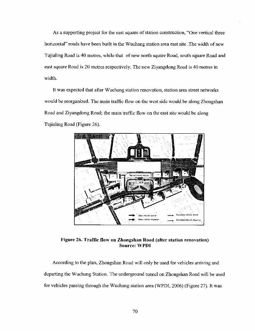
As a supporting project for the east square of station construction, "One vertical three
horizontal" roads have been built in the Wuchang station area east site .The width of new
Tujialing Road is 40 metres, while that of new north square Road, south square Road and
east square Road is 20 metres respectively. The new Ziyangdong Road is 40 metres in
width.
It was expected that after Wuchang station renovation, station area street networks
would be reorganized. The main traffic flow on the west side would be along Zhongshan
Road and Ziyangdong Road; the main traffic flow on the east site would be along
Tujialing Road (Figure 26).
Figure 26. Traffic flow on Zhongshan Road (after station renovation) Source: WPDI
According to the plan, Zhongshan Road will only be used for vehicles arriving and
departing the Wuchang Station. The underground tunnel on Zhongshan Road will be used
for vehicles passing through the Wuchang station area (WPDI, 2006) (Figure 27). It was
70

expected that Wuchang traffic bottleneck on the inner ring would be opened by these
constructions.
Figure 27. Zhongshan Road tunnel (after station renovation)
Source: WPDI
WPDI's investigation and the forecast demonstrated that that east side and west side
respectively undertook 20 percent and 80 percent railway passenger flow (WPDI, 2006).
According to my survey, after the station renovation, the traffic flow arrangements in the
Wuchang station area did not achieve a fundamental change. Vehicles and passengers
coming from various directions to the Wuchang stations are still heavily dependent on
Zhongshan Road. According to my survey in Boguangyuan residential quarter and City
Park residential quarter, passengers still do not find convenient to take the bus due to the
lack of public transport facilities in the east site.
Another north-south Road in the Wuchang station area, Shouyi Road, was located
west of the Wuchang station, approximately 0.8 kilometres far away parallel with the
71

Zhongshan Road. According to my survey, it is mainly used for local residents (Figure
28). Jingan Road is another main north-south road in the east side of the Wuchang
station, about 0.7 kilometres far away parallel with the Zhongshan Road. It also played a
minor role in Wuchang station traffic organization. I observed that a small numbers of
vehicles and passengers on the Jingan Road in the rush hour (Figure 29).
Figure 28. Shouyi Road
Figure 29. Jingan Road
72

This situation did not undergo a fundamental change before and after the Wuchang
station renovation. The main reason is that most of the public transport service and car-
parking facilities were arranged along the Zhongshan Road. There is no public transport
facility arranged on these two roads, integrating them with the Wuchang station. And the
distance from these two roads to the Wuchang station far exceeds the normal walking
distance. It was too difficult for railway passengers to walk for such a long distance.
Because of this, Shouyi Road and Jingan Road couldn't undertake more vehicles and
passengers' flow, alleviating traffic pressure on Zhongshan Road.
To better understand the current traffic situation in the station area, I measured the
traffic volume (vehicle/hour) on the surrounding Zhongshan Road, Jingan Road, Shouyi
Road, Ziyang Road, Chuxiong Avenue, Ziyang Road, and Wuluo Road (Figure 30).
The traffic volume on Wuchang station surrounding Roads 6000
5000
J> J> J: > *jf.SS r <$ <p <r <?° & .«** ^ ^ ^
. ^
l Traffic volume(vehicle/hour)
Figure 30. The traffic volume on Wuchang station surrounding roads
I collected these data on May 28, and June 1 morning, 2008. The data collected from
the traffic volume survey were treated quantitatively. In the study, I attempted to figure
73
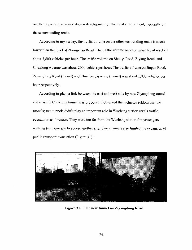
out the impact of railway station redevelopment on the local environment, especially on
these surrounding roads.
According to my survey, the traffic volume on the other surrounding roads is much
lower than the level of Zhongshan Road. The traffic volume on Zhongshan Road reached
about 3,800 vehicles per hour. The traffic volume on Shouyi Road, Ziyang Road, and
Chuxiong Avenue was about 2000 vehicle per hour. The traffic volume on Jingan Road,
Ziyangdong Road (tunnel) and Chuxiong Avenue (tunnel) was about 1,000 vehicles per
hour respectively.
According to plan, a link between the east and west side by new Ziyangdong tunnel
and existing Chuxiong tunnel was proposed. I observed that vehicles seldom use two
tunnels; two tunnels didn't play an important role in Wuchang station area's traffic
evacuation as foreseen. They were too far from the Wuchang station for passengers
walking from one site to access another site. Two channels also limited the expansion of
public transport evacuation (Figure 31).
Figure 31. The new tunnel on Ziyangdong Road
74
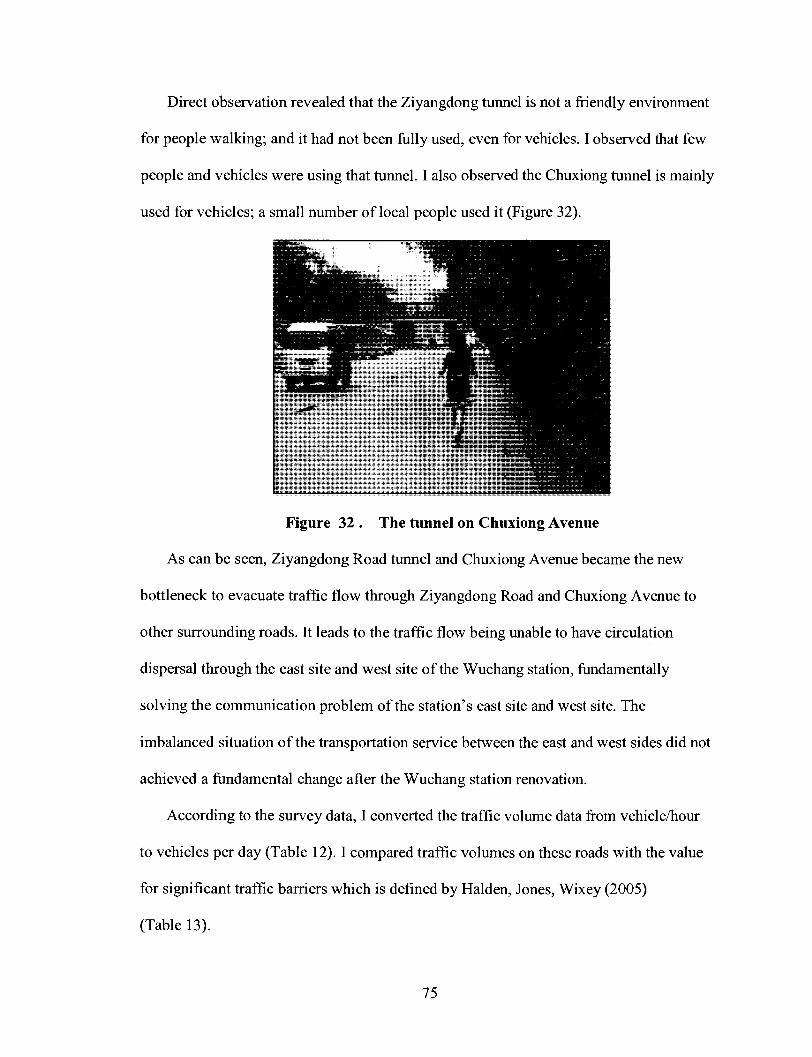
Direct observation revealed that the Ziyangdong tunnel is not a friendly environment
for people walking; and it had not been fully used, even for vehicles. I observed that few
people and vehicles were using that tunnel. I also observed the Chuxiong tunnel is mainly
used for vehicles; a small number of local people used it (Figure 32).
Figure 32 . The tunnel on Chuxiong Avenue
As can be seen, Ziyangdong Road tunnel and Chuxiong Avenue became the new
bottleneck to evacuate traffic flow through Ziyangdong Road and Chuxiong Avenue to
other surrounding roads. It leads to the traffic flow being unable to have circulation
dispersal through the east site and west site of the Wuchang station, fundamentally
solving the communication problem of the station's east site and west site. The
imbalanced situation of the transportation service between the east and west sides did not
achieved a fundamental change after the Wuchang station renovation.
According to the survey data, I converted the traffic volume data from vehicle/hour
to vehicles per day (Table 12). I compared traffic volumes on these roads with the value
for significant traffic barriers which is defined by Halden, Jones, Wixey (2005)
(Table 13).
75

Table 12 . The traffic volume on Wuchang station surrounding Roads
(vehicle/per day)
Zhongshan Road
Jingan Road
Shouyi Road
Ziyang Road
Chuxiong Avenue
Ziyangdong Road (tunnel)
Chuxiong Avenue (tunnel)
Zhongnan Road
Traffic volume (vehicle/hour)
3,840
1,050
2,460
2,220
2,100
1,140
1,020
5,220
Traffic volume (vehicle/per day)
92,160
25,200
59,040
53,280
50,400
27,360
24,480
125,280
Table 13 . Traffic Barriers to Walking and Cycling
(Source: Halden, Jones, Wixey, 2005)
Value for significant barrier
Walking
Significant traffic barrier (traffic flow)
Slight barrier
Quiet road
Above 9000 - 12,000 vehicles per day
2,000 to 9,000 vehicles per day
Below 2,000 vehicles per day
Cycling
Road considered unsafe (2 lane <3m width)
Road considered unsafe (wider road)
Road speed considered too fast (2 lane <3m width)
Road speed considered too fast (wider road)
10,000 vehicles per day
20,000 vehicles per day
40 mph limit
50 mph limit
I found that all the measured surrounding roads were significant traffic barriers for
walking. The lowest traffic volume data was collected on the Jingan Road. Its traffic
76

volume was 1,050 vehicle/hour; it equals to 25,200 vehicles per day. It was two times the
number of the significant traffic barrier data for walking. Moreover, I found that all the
measured surrounding roads were unsafe for cycling. Actually, the traffic volume
collected on the Jingan Road was more than two times the number of the significant
traffic barrier data for cycling.
Cycling is a commonly used means of transport in Chinese families. Bicycles have
been and still remain the dominant two-wheeled vehicles in Chinese cities. Being
opposite to the Wuhan's traffic survey data, it is worth noting that 13 percent of
respondents reported during interviews frequently using bicycle in their spare time. This
percentage is significantly lower than the 29 percent presented in the statistics.
According to the Wuhan transportation development annual report, in year 2006, the
passenger volume of public transportation was approximately 1,780,000,000 people in
Wuhan; it grew 18.7% more than year 2005. And the ridership of conventional public
transportation was 1,230,000,000 people, accounting for 69.11% of the total quantity;
The ridership of track transportation was 7,500,000 people, accounting for 0.42% of the
total quantity; The ridership of the small bus year passenger transport rate 1.29 hundred
million people, accounting for 7.25% of the total quantity; The ridership of taxi was 4.05
hundred million people, accounting for 22.69% of the total quantity; The ridership of the
ferry was 9,370,000 people, accounting for 0.53% of the total quantity (Figure 33). The
conventional mass transit was still the main body of Wuhan public transport (Wuhan
transportation development annual report, 2007).
77
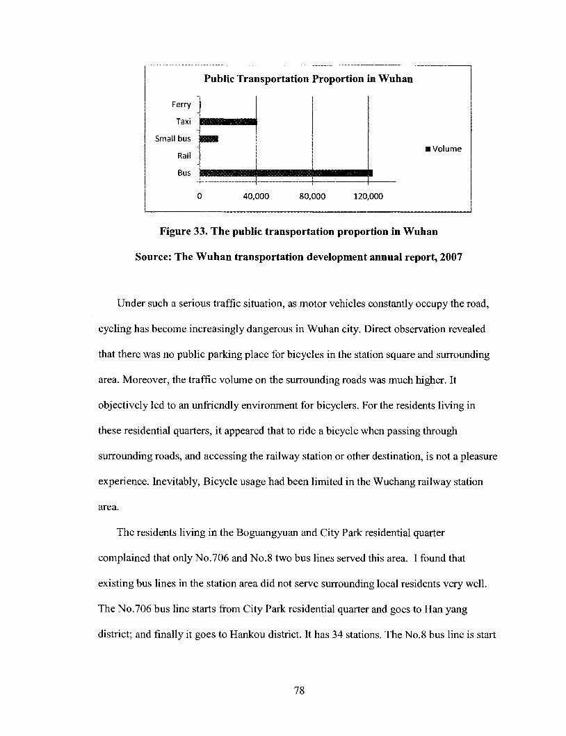
Public Transportation
Ferry
Taxi • • • •S f f lHHI
Small bus • • H
Rail
Bus ^ I M g M I M M a i M a , _
0 40,000 80,000 120,000
Figure 33. The public transportation proportion in Wuhan
Source: The Wuhan transportation development annual report, 2007
Under such a serious traffic situation, as motor vehicles constantly occupy the road,
cycling has become increasingly dangerous in Wuhan city. Direct observation revealed
that there was no public parking place for bicycles in the station square and surrounding
area. Moreover, the traffic volume on the surrounding roads was much higher. It
objectively led to an unfriendly environment for bicyclers. For the residents living in
these residential quarters, it appeared that to ride a bicycle when passing through
surrounding roads, and accessing the railway station or other destination, is not a pleasure
experience. Inevitably, Bicycle usage had been limited in the Wuchang railway station
area.
The residents living in the Boguangyuan and City Park residential quarter
complained that only No.706 and No.8 two bus lines served this area. I found that
existing bus lines in the station area did not serve surrounding local residents very well.
The No.706 bus line starts from City Park residential quarter and goes to Han yang
district; and finally it goes to Hankou district. It has 34 stations. The No.8 bus line is start
Proportion in Wuhan
• Volume
78

from Meijiashan and goes to Liyuan Road. It passes the Zhongnan Road. These two bus
lines had not fully covered the residents' travel requirement.
The Hongji long distance bus station belongs to Hubei Highway Transport CO., LTD.
It is one of the biggest long distance bus stations in Wuhan (Figure 34). The Long
Distance Bus Company and Railway Company contend for potential customer resource.
Along with the large number of highway constructions, highway passenger traffic has
been rapid developed in China. The competition between the bus and trains also led to the
scale of the Bus Terminal was continually expanding. The construction area of the Hongji
bus station reached about 28,000 square meters (Hubei Highway Transport CO., LTD,
2008).
Figure 34. The Hongji long -distance bus station
According to the passenger flow forecast, the Wuchang railway station distributes a
total number of 16,000 passengers in peak hours; of whom, the railway internal transfer,
79

transfer to long-distance bus, public transportation, rail, taxis, community vehicles, the
proportion of other ways were 11%, 20% and 26%, 12 %, 13%, 8% and 10% respectively
(Table 14). Public transport and long-distance bus passenger traffic are the main
distribution tools (WPDI, 2006).
Table 14. The predicted main passenger transport mode transfer relations of
Wuchang railway station Source: WPDI
Mode
Railway
Longdistance bus
Subway
Railway
11%
28%
17%
Longdistance bus
20%
8%
16%
bus
26%
30%
22%
subway
12%
10%
-
taxi
13%
9%
6%
vehicle
8%
4%
1%
Others
10%
11%
38%
Total
100%
100%
100%
In general, for railway passengers, one or more modes are used to reach the
destination .Usually, their trips cannot be accomplished just by one single mode. Keijer
and Rietveld (1998) suggested that "the quality of transport networks in the railway
station area does not only depend on the quality of the station's individual links and
nodes, but also on the way these nodes and links function in the context of (multimodal)
networks".
According to the planning, the underground level of the west station was designed for
integrated transport. The railway passengers were expected to use bus, taxi, subway and
other modes of transport for seamless interchange. Planning the railway station and bus
station together has its advantage; railway passengers and bus passengers can transfer
80

conveniently and directly. But it also creates huge traffic pressure to the station area. It is
not realistic to evacuate so many passengers in a limited space and time. It inevitably
aggravated the crowded situation in the Wuchang railway station area.
According to the planning, it was expected that passengers could easily select one
mode of transportation and leave the station in less than 100 meters distance (Figure 35).
Figure 35. The Wuchang Railway Station underground planning Source: WPDI
To make the railway passengers quickly evacuate the railway station is not an easy
task. In the Wuchang railway station, such a big multimodal transport system, waiting is
unavoidable for a large number of passengers. The complex stream of passengers from
railway station, bus station, and subway station will gather on the underground level. But
there is no specific waiting space planned for those passengers. If the variety of
passengers' flow could not be handled properly in such a limited space underground, it
will inevitably plunge the whole railway station into traffic chaos.
81

6.2 The Local Shops and Commercial Facilities Survey and Analysis
In an effort to figure out the impact of railway station redevelopment, I surveyed
those stores within the Wuchang station area, which were along the Zhongshan Road,
Ziyang Road, Ziyangdong Road, Chuxiong Avenue, Jingan Road, Wuluo Road and
Shouyi Road (Figure 36).
1. Wuchang station 2. Zhongshan Road 3.Ziyang Road 4.Ziyangdong Road 5.Chuxiong Avenue
6.Shouyi Road 7.Jingan Road 8.WuluoRoad 9.Sai lake lO.Ziyang Lake Park
A: hardware shops B: pesticide and seed shops C: Wuhan Aier eye Hospital D: New Beacon Hotel
E: OK 100 Casino F: Huiyuan Hotel G: Ziwei shops H: Haoyouduo fruit shop
I: Crown Hotel J: Tianan Hotel K: Gelinghaotai Hotel
Figure 36. The surveyed local shops and commercial facilities
82

Zhongshan Road is in front of the west square of the Wuchang railway station.
Before Wuchang station renovation, Zhongshan Road is the only way to the railway
station. A large number of vehicles pass through it and approach to the Wuchang station.
Improved accessibility increases the catchment area of potential customers and makes the
location a more attractive location (Brand-van Tuijn et al.2001). Zhongshan Road is a
crowded and lively street, with hundreds of local shops and commercial facilities located
in the station area along the Zhongshan Road both sides.
It's worth noting that there are more than ten hardware shops assembled one by one
on the Zhongshan Road east side (site A). On the opposite west side, there are more than
ten pesticide and seed shops assembled (site B). For historical reasons, these stores
gathered one by one near the Hongji long distance bus station for several years.
I interviewed Miss Ping yang, the manager of the Xinhuihe Agriculture Development
Company. She had done business there for several years. Miss Ping yang said that these
shops were all related to the Hongji bus station. The shopkeepers purchased seeds and
other products in the producing area, and transported them to Wuhan by long-distance
bus.
Miss Ping yang mentioned that it was heard that all these shops would be moved to
the other areas in recent years because of the station renovation. As Peek (2002) suggests,
less-travel-related activities and attractions should be concentrated in a particular location,
thus reducing travel time and hassle and enhancing the urban environment. These stores
gathered there for several years. Although it was very convenient for shopkeepers to do
business, re-planning railway station's surrounding area layout and putting all these less
83

travel-related stores in a particular location would be inevitable after the Wuchang station
renovation.
Bertolini (2006) indicated that" Multiple use is achieved by locating stations as close
as possible to existing urban facilities , by locating new urban facilities (such as hospitals
and universities) close to stations, and by providing as many points of exchange as
possible between different mobility flows". In the Wuchang station area, there are two
large scale commercial facilities along the Zhongshan Road, the Wuhan Aier eye hospital
and Wuhan Dadongmen shopping mall (site C). The Wuhan Aier eye hospital is located
north of the Wuchang station, about 1.7 km away from the Wuchang station along the
Zhongshan Road. It is at the corner of the Wuluo Road and Zhongshan Road; and the
Wuhan Dadongmen shopping mall was next to it.
I did not observe a large number of railway passengers flow gathered at these urban
facilities. The managers of the Wuhan Dadongmen shopping mall complained that their
business was not good. In the other sections of Zhongshan Road, most of the shops were
small scale, selling food and fruits. Other shops sold teas and other products.
In the survey, I found an interesting phenomenon. Along with the renovation of the
Wuchang railway station, many commercial facilities in the station area have launched
decoration and transformation projects. At the corner of the Wuluo Road and Zhongshan
Road, the New Beacon Hotel located there (site D). The New Beacon Hotel opened in
October, 1996. It is a six-storey hotel. After the station renovation project began, it was
renovated in February, 2006 (New Beacon Hotel).
The OKI00 Casino was established in 1996. It is a large-scale comprehensive
entertainment and leisure venues with entertainment, sauna, restaurant, and recreation
84
facilities (site E). It is located next to the Hongji bus station. It was renovating its interior
space and the internal facility.
Thus could be seen the impact of railway station reconstruction on the station's
peripheral trade activity and environment. The railway station reconstruction had initiated
the station's peripheral commercial development, and stimulated social economic
development.
The Huiyuan hotel is located at the center-section of the Ziyang Road, approximately
1,500 meters away from the Wuchang station (site F). It opened in year 1996, and was
renovated in year 2007. Its construction area is nearly 12,800 square meters; and it has
total number of 137 rooms. It has the advanced facility; the price of standard room is 190
Yuan (Huiyuan hotel, 2008). The Lobby manager of the Huiyuan hotel complained that
hotel was not benefited from the Wuchang railway station. She told me that their business
is not good; seldom clients come from the Wuchang railway station.
Direct observation revealed that the majority of the railway passengers were on the
Zhongshan Road. To access the Huiyuan hotel, railway passengers needed to cross the
congested Zhongshan Road with heavy baggage; it was not easy. Additionally, there was
no sign on the corners of the Zhongshan Road and Ziyang Road, as a clue for railway
passengers. Consequently, the majority of the unfamiliar passengers were led to evacuate
along Zhongshan Road. Few passengers were willing to cross Zhongshan Road and walk
along Ziyang Road to find a Hotel.
Shouyi Road was located west of the Wuchang station, 0.8 kilometers far away
parallel with the Zhongshan Road. I found that those shops along the south section of the
85
Shouyi Road were more related to the local residents. In the rush hour, I even observed
that the bus station located in the south section of the Shouyi Road was totally empty.
Moreover, I surveyed a Tea shop named Ziwei and a fruit shop at the corner of
Ziyang Road and Shouyi Road (site G). They are all located at the corner of the Ziyang
Road and Shouyi Road, the north section of the Shouyi Road. The walking distance from
that shop to the Wuchang station was about 1.3 km. The shopkeeper of the Ziwei Tea
shop reported that most of her customs come from the local residents. Her business does
not benefit from the Wuchang railway station. I also interviewed the shopkeeper of a fruit
shop which is next to Ziwei Tea shop. On the contrary, he told me that his business does
benefit from the railway station. People took the bus to go to the Wuchang railway station.
Some of them passed his shop. He thought the position of the store was a key element of
his successes.
I walked along Ziyang Road to the Wuchang railway station. I surveyed a shop
located at the corner of Ziyang Road and Zhongshan Road (site H). Its name is
Haoyouduo fresh fruit shop. The store was on the opposite side of the Zhongshan Road,
facing the west square of the railway station. The walking distance from that shop to the
Wuchang station was about 0.5 km. A sales woman in Haoyouduo shop told me:"20-30
percentages of our clients come from the railway passengers. We can get this conclusion
by talking, by their appearance and their carried baggage".
The Crown hotel was a 12-storey hotel. It was at the corner of Ziyang Road and
Zhongshan Road, approximately 600 meters away from the station, facing the station
square(site I). It opened in year 2000, and was renovated in year 2007. It had a total
number of 216 rooms (Crown hotel, 2008). The lobby manager of the Crown hotel told
86
me:"50 percentages of our clients are individual travelers; 30 percentages of our clients
come from the railway passengers". She said that during the station renovation period,
the price of the rooms did not change. But she expected to have a higher profit after the
completion of the station renovation.
The Tianan Hotel is a 6-storey hotel on the Ziyangdong Road, next to the
Ziyangdong tunnel. It is a small family hotel (site J) .The Gelinghaotai hotel is on the
Ziyangdong Road; it is a nine-storey hotel, 800 meters away from the Wuchang station
(site K). It was opened in 2008; it had total number of 154 rooms. The managers of two
Hotels reported that few railway passengers stayed in their Hotel.
The local shops and commercial facilities questionnaire and survey provided some
interesting insights. I found that for those shops located near Zhongshan Road, the impact
of railway station redevelopment was greater. Their business benefited from the
Wuchang railway station. For those shops near Ziyangdong Road, Ziyang Road, Shouyi
Road as well as Jingan Road, the positive impact of Wuchang railway station is limited.
Their businesses did not benefit from the Wuchang station.
To sum up, it appeared that railway station has a different impact on different types
of business within the Wuchang station area. The positive impact of the railway station
happened in a short distance, and almost at the place where the majority of the railway
passengers gathered or passed through. For those shops and commercial facilities near the
bus station, which related to the railway station, the positive impact could happen at a
longer distance. According to the survey, that distance was as high as 1.3 km. It greatly
exceeds normal walking distance.
87

My findings are also essentially consistent with the research of Cervero and Duncan
(2001). They found that: "the impact of railway stations on commercial properties was
greater than the impact on residential properties within a short distance of the stations"
Cervero and Duncan (2001).
6.3 Other New Developments in the Wuchang Station Area
As part of the study, I surveyed other new developments in the Wuchang station area
(Figure 37).
A. Jingan uptown residential quarter B. CD. New residential quarter (in construction)
1. Wuchang station 2. Zhongshan Road 3.ZiyangRoad 4.Ziyangdong Road 5.Chuxiong Avenue
6.Shouyi 7.Jingan Road 8.WuluoRoad 9.Sai lake lO.Ziyang Lake Park
Figure 37. New developments in the Wuchang station area
88

The original site of the City Park residential quarter contained old and obsolete
buildings for railway employees. Before the station renovation, they had been dismantled.
At present, several buildings around the east square of Wuchang station were all being
demolished due to the construction of the new east square. The Jingan uptown residential
quarter is around the east square. It is opposite to the City Park residential quarter, on the
other side of Jingan Road (Figure38).
Figure 38. The model and plan of Jingan uptown residential quarter
The Jingan uptown residential quarter occupies a ground space of 50,000 square
meters. Its construction area is nearly 120,000 square meters. It includes eight high-rise
buildings. The total number of the households is 989 (Shangwen Real Estate
Development Company). The Jingan uptown is a lakeside residential quarter; it is around
the Sai Lake. In year 2007, Wuhan city began to invest 3.1 hundred million RMB to
clean the water of the Sai Lake (Wuhan government, 2007).
89

I interviewed Mr. Jingliang Fang, who worked in the sales agency of Jingan uptown
residential quarter. He mentioned that Shangwen Real Estate Development Company will
invest money to green the area within 30 meters around the lake as a supporting project.
Mr. Jingliang Fang said that many people bought houses there; they talked about their
interest in convenient transportation. He said that being close to Wuchang railway station
was an important factor which they were concerned about. At present, the Jingan uptown
projects are under construction.
Chapter 7 Projecting Potential for Station Area Redevelopment
7.1 Comparative Analysis of Railway Station Redevelopment: Cases in Europe and
Asia
7.1.1 The Utrecht Central Station Redevelopment
Utrecht city is the capital city of the Dutch province of Utrecht. It is the fourth largest city
of the Netherlands, with a population of 288,535 (City of Utrecht). The current building
of Utrecht Central station has a capacity of 35 million passengers per year. The station
currently handles 55 million travelers per year. It was estimated that number will be
doubled in the coming twenty years (City of Utrecht). It was exceed the capacity of
current station building. The City of Utrecht, ministries of Transport and Spatial Planning,
and private companies Corio (owner shopping mall Hoog Catharijne), Jaarbeurs Utrecht
(Trade fair grounds) and NS Real Estate (Railroad Company), are "working together
towards a complete makeover of the area. The final goal is to realize a new city centre for
Utrecht by unifying the new station area and the old city" (Figure 39) (City of Utrecht).
90
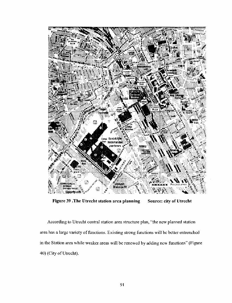
i% _ wDtmte v - - —— nwemt-
3portp*ri< "V
Figure 39 .The Utrecht station area planning Source: city of Utrecht
According to Utrecht central station area structure plan, "the new planned station
area has a large variety of functions. Existing strong functions will be better entrenched
in the Station area while weaker areas will be renewed by adding new functions" (Figure
40) (City of Utrecht).
91
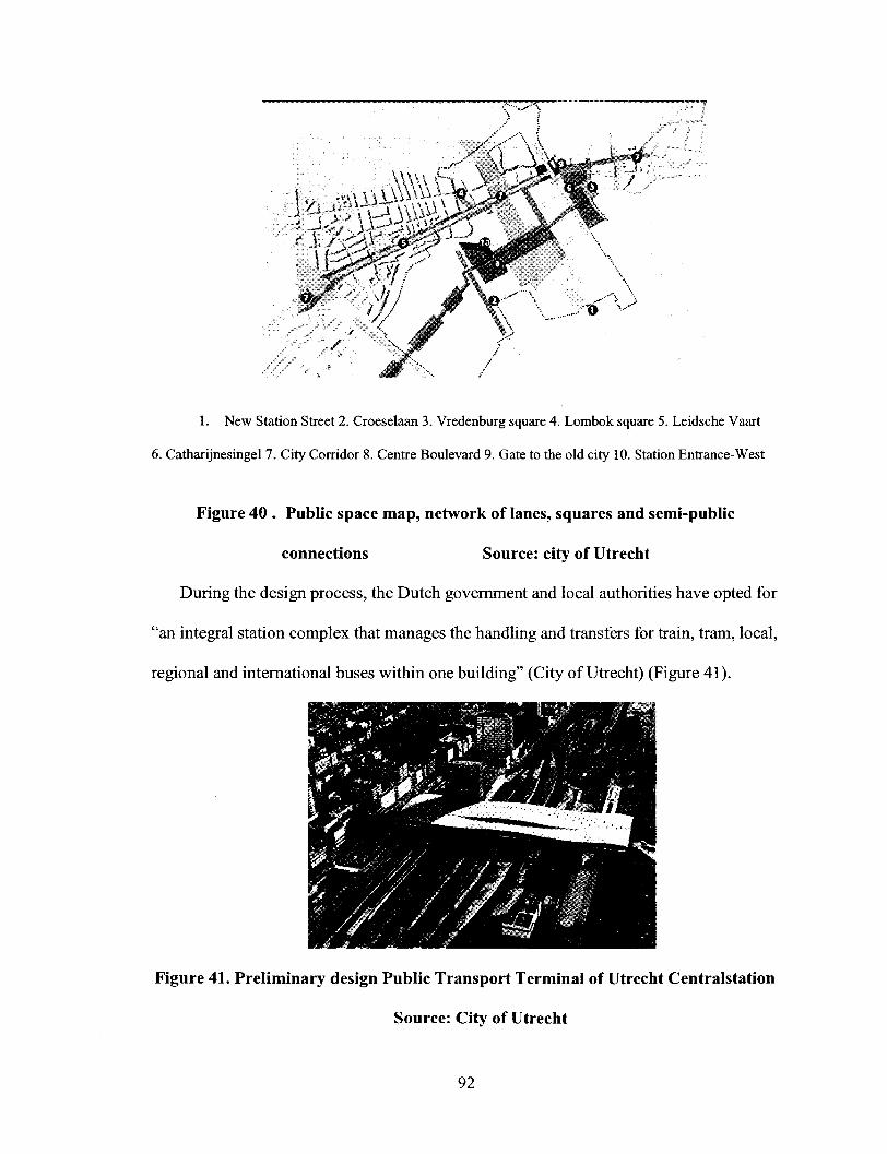
1. New Station Street 2. Croeselaan 3. Vredenburg square 4. Lombok square 5. Leidsche Vaart
6. Catharijnesingel 7. City Corridor 8. Centre Boulevard 9. Gate to the old city 10. Station Entrance-West
Figure 40 . Public space map, network of lanes, squares and semi-public
connections Source: city of Utrecht
During the design process, the Dutch government and local authorities have opted for
"an integral station complex that manages the handling and transfers for train, tram, local,
regional and international buses within one building" (City of Utrecht) (Figure 41).
Figure 41. Preliminary design Public Transport Terminal of Utrecht Centralstation
Source: City of Utrecht
92

According to the plan, "the developments in the City Corridor will match the existing
situation of the Kanaalstraat (Lombok) and Vredenburg North (old city), with the lower
construction layer (plinth) being taken up by shopping, food and beverages and desk
functions. On top of those there will be residences and offices. In the Centre Boulevard
zone the mixing of functions is more complex. Hoog Catharijne has a wide range of
functions with a certain mutual coherence: shops, food & beverage facilities, meeting
centre, cinema, offices, residences, and parking. Hoog Catharijne will be intensified, with
a lot of attention going to the plinth and the interaction with public space. On the west
side, the building complexes have a mixed function: residences, offices, hotel,
commercial entertainment, shops and food & beverage facilities. The shopping area in the
station area will be expanded by some 45,000 m2 of let table floor space. 2,100 residences
will be added to the station area. The aim is for a higher number wherever there is
sufficient environmental space and accessibility. The addition of 240,000 m2 of gross
office floor space will take place mainly at the west side of the station, which will create
an important mixed area. Functions along the City Corridor are mainly cultural and
public. Functions along the Centre Boulevard will be more along the line of leisure
facilities" (City of Utrecht) (Figure 42).
93
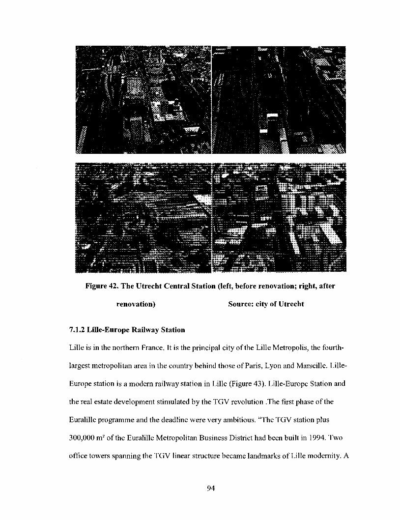
Figure 42. The Utrecht Central Station (left, before renovation; right, after
renovation) Source: city of Utrecht
7.1.2 Lille-Europe Railway Station
Lille is in the northern France. It is the principal city of the Lille Metropolis, the fourth-
largest metropolitan area in the country behind those of Paris, Lyon and Marseille. Lille-
Europe station is a modern railway station in Lille (Figure 43). Lille-Europe Station and
the real estate development stimulated by the TGV revolution .The first phase of the
Euralille programme and the deadline were very ambitious. "The TGV station plus
300,000 m2 of the Euralille Metropolitan Business District had been built in 1994. Two
office towers spanning the TGV linear structure became landmarks of Lille modernity. A
94

huge shopping mall, car park, hotel, cultural facilities, business school and housing had
been built. Station area becomes a new competitive sub-centre in itself where young
people like to meet and stroll. In the near future, the second phase of the Euralille project
will emphasize housing construction behind Lille-Europe Station to complete the
functional mix of the whole area" (Tiry, 1999).
Figure 43. The exterior of Lille Europe station Source: SNCF
7.1.3 Tokyo Railway Station Redevelopment
Tokyo Station is located in the Marunouchi business district of Chiyoda, Tokyo, Japan. It
is the busiest station in Japan in terms of number of trains per day (over 3,000), and the
eighth-busiest in Japan in terms of passenger throughput (East Japan Railway Company).
East Japan Railway Company is currently "developing Tokyo Station City as part of
a large-scale plans that will revitalize the Tokyo Station area in Japan's economic centre"
(East Japan Railway Company). According to East Japan Railway Company, the goal of
the development plan is "to make Tokyo Station the foremost railway station in the
95

world". This development plan has three major components. Two new constructions are
the Tokyo Station Yaesu Exit Twin Towers and the Nihonbashi Exit building. The
Marunouchi station building will be restored. It was expected that after station renovation,
Tokyo Station is not only a passing-through point, it become a place "where customers
could gather and have a memorable time discovering new foods and experiencing high-
quality service" (East Japan Railway Company).
The Tokyo Station redevelopment projects are currently being implemented. "The
objective is to create a new model that surpasses the conventional railway station concept,
combining railway services and many types of leisure businesses. The development plans
now under way will see Tokyo Station transformed into a city .This principle led to the
decision to name the current development Tokyo Station City" (Figure 44; Figure 45)
(East Japan Railway Company).
Figure 44. Image of Tokyo Station City from the Yaesu side Source: JR East
96
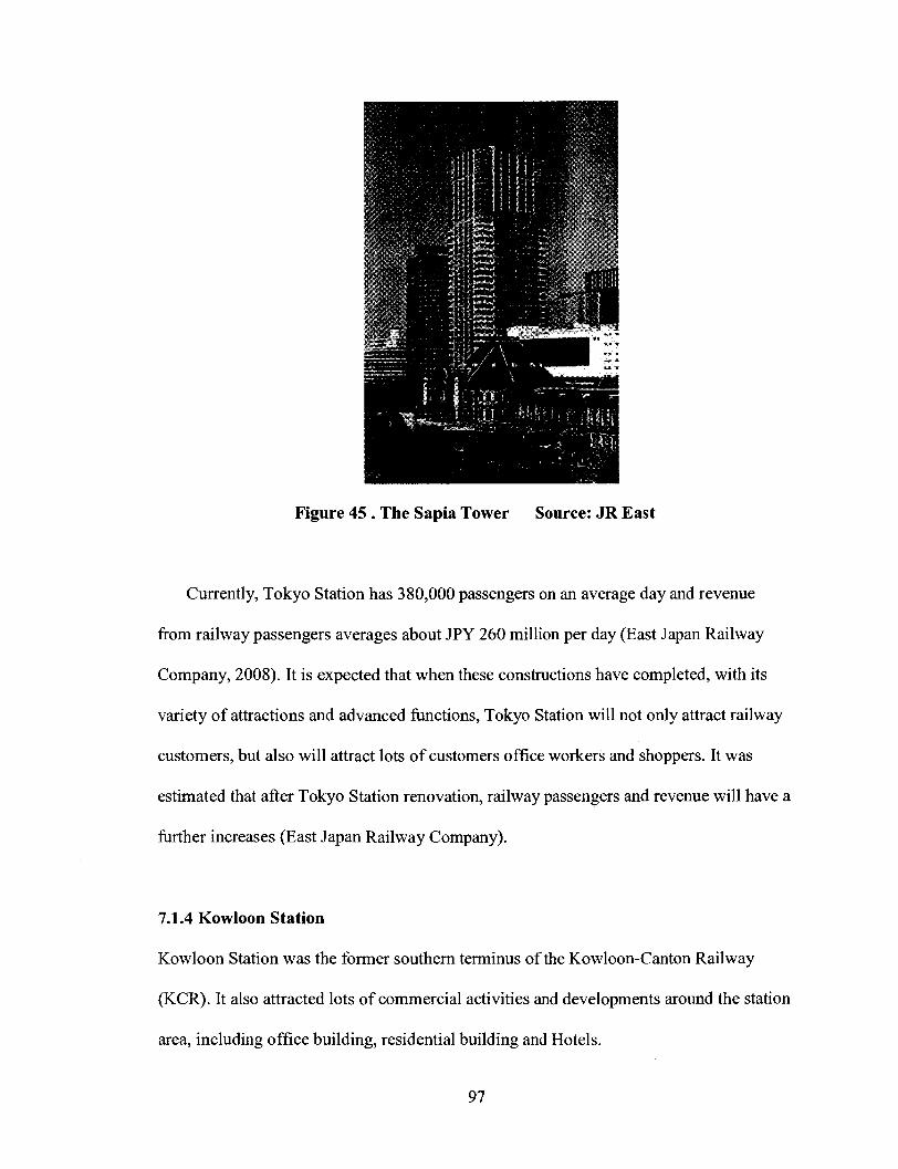
Figure 45 . The Sapia Tower Source: JR East
Currently, Tokyo Station has 380,000 passengers on an average day and revenue
from railway passengers averages about JPY 260 million per day (East Japan Railway
Company, 2008). It is expected that when these constructions have completed, with its
variety of attractions and advanced functions, Tokyo Station will not only attract railway
customers, but also will attract lots of customers office workers and shoppers. It was
estimated that after Tokyo Station renovation, railway passengers and revenue will have a
further increases (East Japan Railway Company).
7.1.4 Kowloon Station
Kowloon Station was the former southern terminus of the Kowloon-Canton Railway
(KCR). It also attracted lots of commercial activities and developments around the station
area, including office building, residential building and Hotels.
97

7.1.5 Shanghai South Station
Shanghai South railway station is in the south-west of the Xuhui District. It is the
southern gate of Shanghai city. It distributes annual 15,000,000 railway passengers. The
designed maximum people assembled in new station are 6,000. Its planned ground space
is 84h, the construction area is 3,450,000 m2 (Ministry of China railway).
The below Table 15 shows residential and commercial developments around the
Euralille station , Kowloon station , Utrecht Central Station and Shanghai South four
railway stations .
Tablel5. Euralille, Kowloon, Utrecht Central Station, Shanghai South railway station development
Source: Lu, Jiwei and Wang, Teng
Ground space
Construction area
Office building
Residential building
Hotel
Commercial entertainment
Exhibition
Bicycle
Lille-Europe
70h
273,710 m2
45,720 m2
17,600 m2
18,600 m2
46,600 m2
38,000 m2
6,100 m2
n/a
Kowloon (Hongkong)
13.5 h
1090,000 m2
231,578 m2
606,425 m2
93,548 m2
89,550 m2
n/a
6,590 m2
n/a
Utrecht Central Station
n/a
616,700 m2
360,000 m2
221,400 m2
9,600 m2
42,700 m2
n/a
11,600 m2
21,000 m2
Shanghai South
84 h
3,450,000 m2
n/a
n/a
n/a
n/a
n/a
n/a
n/a
98
7.2. Situation Surrounding the Wuchang Railway Station
The Wuchang railway station redevelopment projects began in February 2006. The
station building projects were finished at the end of 2007, and the station remained in use
throughout the redevelopment. When I did research in Wuhan in May 2008, the
construction of a new tunnel on Ziyangdong Road had finished and the tunnel was in use.
The "one vertical three horizontal" roads construction had also finished. The remaining
projects were finished in October 2008. Currently, the subway Line 4 and Line 5 are still
under construction. It is difficult to do the research in this kind of complex environment.
Due to limited access to external sources of data, such as census data, it is very difficult
to collect information and data for the research.
Until now, changes in the Wuchang station area have mainly happened in the station
central area. The total ground space of Wuchang railway station central area is 299,000
m (Figure 46). Before the station was renovated, it was used for housing, transportation,
public facility, municipal utilities, and station square.
99

,U*tWai—' «
R31. Housing R41. Housing C12. Office building C21 .Commercial
C25. Hotel T1 .Railway usage T23.Long distance bus S1 .Roads
S21. Roads, square U21 .Transportation U3. Posts and Telecommunications service
U42. Garbage
Figure 46. Land use of Wuchang railway station's central area
(before station renovation) Source: WPDI, 2006
100

Table 16. Land use of Wuchang railway station's central area
(before station renovation), m2 Source: WPDI, 2006
Housing
Public facility
Transportation
Roads, Square
Municipal
utilities
Total
Site
R31
R41
C12
C21
C25
Tl
T23
SI
S21
U21
U3
U42
Land use
Housing
Housing
Office building
Commercial
Hotel
Railway usage
Long distance bus
Roads
Roads, square
Transportation
Posts and
Telecommunicati
on
Garbage
Ground space
23,100
16,900
14,600
6,500
9,200
93,200
14,300
35,600
15,500
45,900
22,300
2,000
299,000
%
7.73
5.65
4.87
2.17
3.08
31.16
4.77
11.90
5.18
15.37
7.45
0.67
100
The ground space of the new east square is 19,200 m2. Before the station was
renovated, the original site of the east station square was mainly used for housing (site
R31, R41) and office buildings (site CI2). They were old and considered obsolete by the
Planning Bureau. To build the new east square of the Wuchang station, these buildings
101

were dismantled before renovations. Currently, the site is used as a station square, for taxi
and public parking and a bus station. As can be seen from Figure 47 and Table 17, the
land use of Wuchang station's central area changed because of the Wuchang station
renovation; it was re-organized and a new east station square was created.
... .,
.
*
* * ' * • * > . * '
/ 6 *'•- --<'"
/ ' / / -* & '
; / '--. ' ' ' ̂
; (-' 8 ^ ' -
l i t
' \ - « x
/
* i #i i / * * ^
• /• (̂ * j mm%m
1 * > "*" * " ^ . " * * • » , * » u
- > . - , » • ^ .
* / '•
' - /
>' x , /A/"X / '' / ' "̂. * < ,̂"
/ 10 >V*
\ .-'/ " S t , /
1. Long-distance bus 2. Bus 3. Development project 4. Post office, Luggage
5. Station square 6. Bus 7. West station building 8. Commercial 9. Luggage
10. Station square 11. Taxi 12. Social parking 13. Bus 14. Roads
15. Railway usage 16.Others
Figure 47. Land use of Wuchang railway station's central area
(after station renovation) Source: WPDI, 2006
102
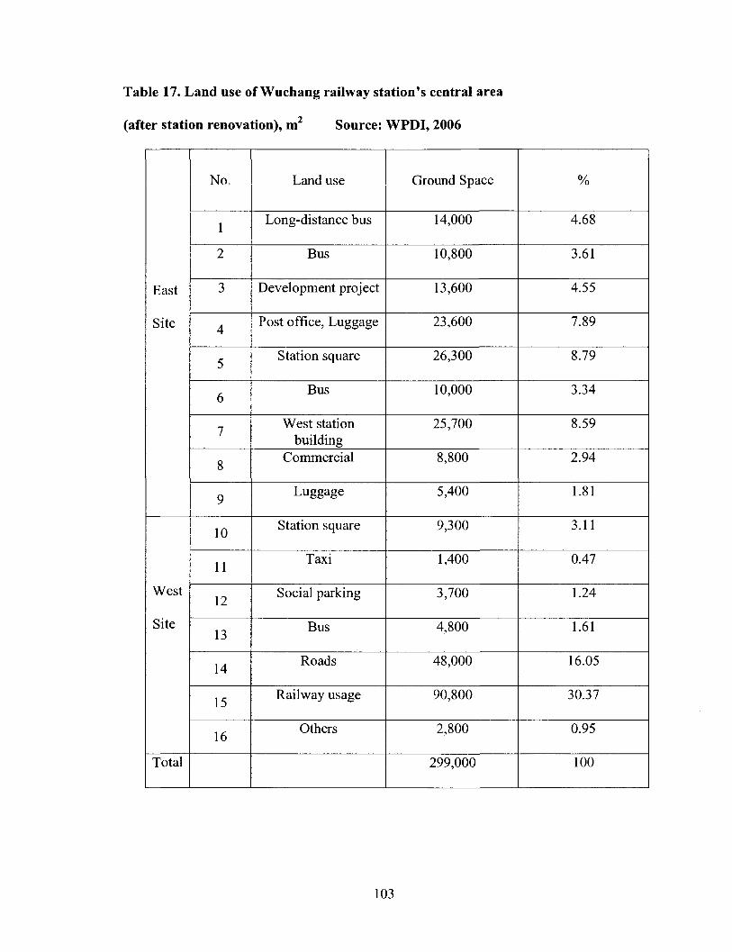
Table 17. Land use of Wuchang railway station's central area
(after station renovation), m2 Source: WPDI, 2006
East
Site
West
Site
Total
No.
1
2
3
4
5
6
7
8
9
10
11
12
13
14
15
16
Land use
Long-distance bus
Bus
Development project
Post office, Luggage
Station square
Bus
West station building
Commercial
Luggage
Station square
Taxi
Social parking
Bus
Roads
Railway usage
Others
Ground Space
14,000
10,800
13,600
23,600
26,300
10,000
25,700
8,800
5,400
9,300
1,400
3,700
4,800
48,000
90,800
2,800
299,000
%
4.68
3.61
4.55
7.89
8.79
3.34
8.59
2.94
1.81
3.11
0.47
1.24
1.61
16.05
30.37
0.95
100
103

As can be seen from Table 17, after station was renovated, the total ground area used
for the west site of the Wuchang station became 138,200 m2.The total ground area used
for east site of the station is 160,800 m2. Most of the lands in the Wuchang railway
station central area are still mainly used for transportation functions. Site 3 will be used
for a development project. Its ground space is 13,600 m2. Site 8 will be used for
commercial purposes. Its ground space is 8,800 m . Their total ground space is 22,400 m ;
this only accounts for 7.5% of the whole Wuchang station central area.
After the renovation, the ground space used for station square increased from 24,000
m2 to 35,600 m2. Although it created a new bus station at the east site of the Wuchang
station, the total ground space used for bus station is 25,600 m2 . Actually, it is less than
before; it decreased in size by 13,400 m2. As can be seen from the above tables, there is
still no space allotted to bicycle parking in the Wuchang station central area (WPDI,
2006).
7.3 Projecting Potential for Wuchang Station Area Redevelopment
Through the comparative analysis of railway station redevelopment in Europe and
Japan, I found an important trend in the European and Japanese railway station
redevelopments; there, railway station areas develop in a mixed use and multi-functional
development direction. Developments happened in a larger scale, including residential
and commercial developments and so on. Development plans are more concerned about
balancing local and railway company economic benefits. In those development projects,
they promote high quality of place, create public space and semi-public space in the
station areas, and attempt to make station areas attractive. In China, as we studied
104
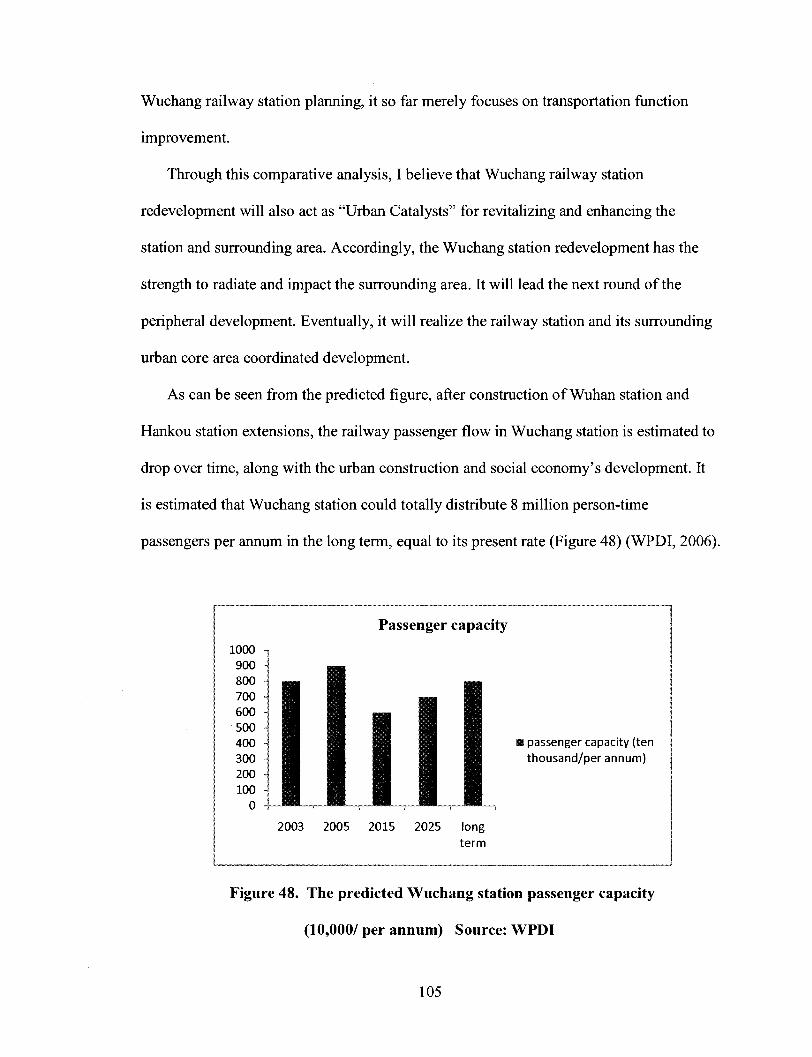
Wuchang railway station planning, it so far merely focuses on transportation function
improvement.
Through this comparative analysis, I believe that Wuchang railway station
redevelopment will also act as "Urban Catalysts" for revitalizing and enhancing the
station and surrounding area. Accordingly, the Wuchang station redevelopment has the
strength to radiate and impact the surrounding area. It will lead the next round of the
peripheral development. Eventually, it will realize the railway station and its surrounding
urban core area coordinated development.
As can be seen from the predicted figure, after construction of Wuhan station and
Hankou station extensions, the railway passenger flow in Wuchang station is estimated to
drop over time, along with the urban construction and social economy's development. It
is estimated that Wuchang station could totally distribute 8 million person-time
passengers per annum in the long term, equal to its present rate (Figure 48) (WPDI, 2006).
1000 -900 -800 700 -600 -500 -400 -300 -200 -100 -
0 -
— • I I I 1 I • JH
2003
_
H n
H 1 1 1 1 1 JL
2005
Passenger capacity
i
• 1 m 1 1 • I • | U I n mm • passenger capacity (ten H f j f l H thousand/per annum) • I I I 1 1
2015 2025 long term
Figure 48. The predicted Wuchang station passenger capacity
(10,000/ per annum) Source: WPDI
105

According to the traffic survey in September 2004, the bus stations in the Wuchang
railway station area are the biggest bus stations in Wuhan; they distribute 110,000
passengers daily (WPDI, 2006). After station renovation, the total numbers of bus lines in
the station area will reach 23; this is 1.3 times as the present situation (WPDI, 2006).
According to the planning, there will be 6 bus lines serving in the east square area (WPDI,
2006).
The Hongji long- distance bus station distributes 12,000 passengers daily, and it
even reaches 40,000 in the holiday peak time (Hubei Highway Transport CO., LTD,
2008). The Wuchang railway station currently distributes 23,000 passengers daily
(Wuhan railway Bureau). According to the design, the total daily passenger capacity of
the Wuchang subway station in Line 4 and Line 5 will reach 220,600. The total numbers
of daily passengers in the Wuchang station area are 365,600 (Table 18).
Tablel8. The daily passengers of public transportation in the Wuchang station
Daily
passengers
Wuchang
Railway
station
23,000
Subway
lines
220,600
Bus station
110,000
Long
distance bus
station
12,000
Total
365,600
On the basis of comprehensive understanding of the Wuchang station's current
situation, I studied the Wuchang station areas potential development possibility.
106
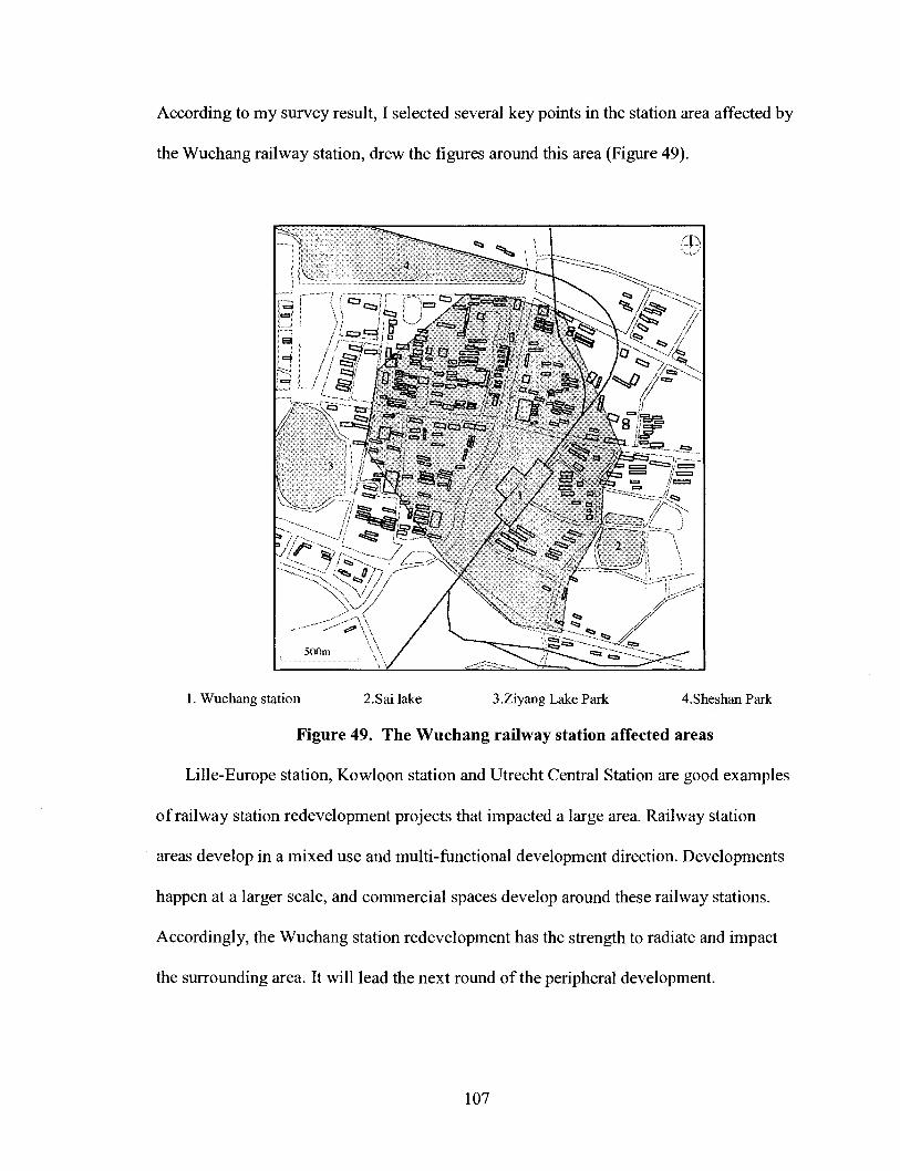
According to my survey result, I selected several key points in the station area affected by
the Wuchang railway station, drew the figures around this area (Figure 49).
1. Wuchang station 2.Sai lake 3.Ziyang Lake Park 4.Sheshan Park
Figure 49. The Wuchang railway station affected areas
Lille-Europe station, Kowloon station and Utrecht Central Station are good examples
of railway station redevelopment projects that impacted a large area. Railway station
areas develop in a mixed use and multi-functional development direction. Developments
happen at a larger scale, and commercial spaces develop around these railway stations.
Accordingly, the Wuchang station redevelopment has the strength to radiate and impact
the surrounding area. It will lead the next round of the peripheral development.
107

Eventually, it will realize the railway station and its surrounding urban core area
coordinated development.
The numbers of the daily passengers of the Lille Europe railway station are 15,000
(Lille city). The projected development based on the Lille case is 70h (ground space),
much larger than what Wuhan Planning Bureau is proposing. At typical densities of FAR
2.5, the projected development for floor space based on the Lille case is 175h. The
numbers of the daily passengers of the Wuchang railway station are 23,000. The land
area I have identified for the Wuchang station redevelopment is 80h. At typical densities
of FAR 2.5, the projected development floor space is 2,015,000 m2.
According to conventional densities, we can infer that Wuchang railway station
area's demand for commercial space in the next few years. I suggest a potential
development land area around the Wuchang station, based on the scale of the station and
the maximum assembled passenger volume (Figure 50).
108

1. Residential area 2.Residential area 3.Commecial area
4.0ffice building and commercial area 5.Wuchang station 6.Sai lake
Figure 50. Potential redevelopments in the Wuchang station area
The original site 1 is empty land; the other sites currently are low density, with old
and obsolete buildings. Site 1 and Site 2 will be used for residential developments; site 3
will be used for commercial developments. Site 4 will be used for commercial and office
building developments. The total potential development ground space for residential
developments is 316,000 m2. The total potential development ground space for
commercial and office buildings is 490,000 m2 . The total potential development floor
space is 2,015,000 m2 (Table 19).
109

Table 19. The floor space of potential developments around the Wuchang railway
station
Residential area
Sitel
625,000 m2
Site 2
165,000 m2
790,000 m2
Commercial & Office building area
Commercial
775,000 m2
Commercial & Office building
450,000 m2
1,225,000 m2
2,015,000 m2
According to the data we collected from City Park residential quarter, in total
316,000 m ground spaces of the Wuchang station potential development areas could
accommodate 9,400,000 m2 construction areas for residential buildings, incorporating
8,000 households to live.
If the Wuchang station surrounding areas continues to develop, traffic problem will
become more prominent. Northward, Wuluo Road links with Yangtze Bridge. A large
number of vehicles come from Hanyang district, cross the Yangtze Bridge go to
Wuchang district; and then most of them pass through the Wuluo Road. Zhongshan Road
is a major traffic artery. A large number of vehicles come from various directions to the
Wuchang station, mostly depending on Zhongshan Road. Zhongshan Road is the
inevitable road to the south gate of Wuhan city. Southward, Zhongshan Road links with
Wutaizha area, connecting with the Wuhan- Xianling highway and the Wuhan- Zhifang
highway. Those vehicles go to Wutaizha area and leave Wuhan must pass through
Zhongshan Road (Figure 51).
110
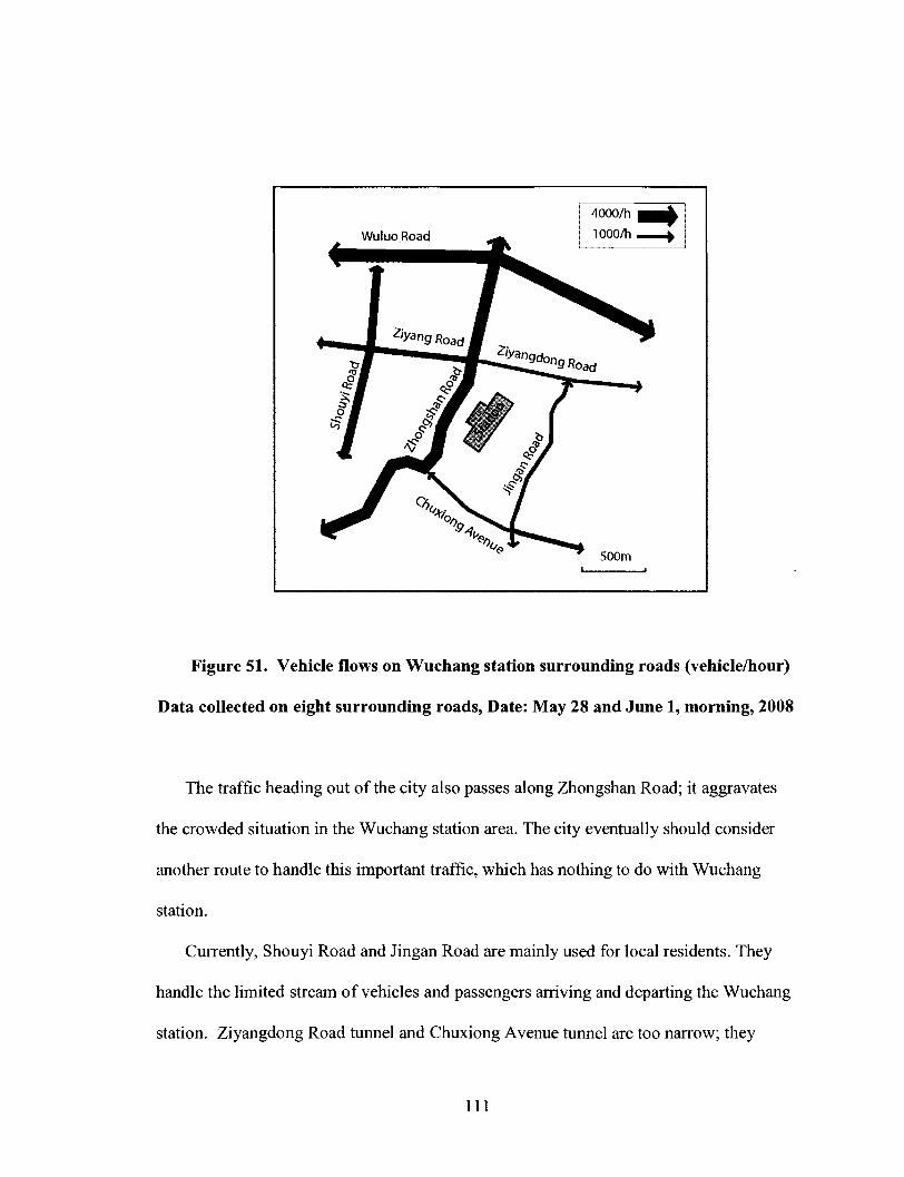
Figure 51. Vehicle flows on Wuchang station surrounding roads (vehicle/hour)
Data collected on eight surrounding roads, Date: May 28 and June 1, morning, 2008
The traffic heading out of the city also passes along Zhongshan Road; it aggravates
the crowded situation in the Wuchang station area. The city eventually should consider
another route to handle this important traffic, which has nothing to do with Wuchang
station.
Currently, Shouyi Road and Jingan Road are mainly used for local residents. They
handle the limited stream of vehicles and passengers arriving and departing the Wuchang
station. Ziyangdong Road tunnel and Chuxiong Avenue tunnel are too narrow; they
111

couldn't evacuate traffic flow through Ziyangdong Road and Chuxiong Avenue to other
surrounding roads. It leads to the traffic flow being unable to have circulation dispersal
through the east site and west site of the Wuchang station, fundamentally solving the
communication problem of station east site and west site. If the station surrounding areas
continue to develop for commercial purposes, as suggested in this thesis, this problem
will become more acute. Reorganizing the road network is necessary for realizing
sustainable development of the station area; Ziyang Road and Ziyangdong Road should
be widened.
According to the survey, currently there is no pedestrian system or pedestrian tunnel
in the Wuchang station central area. It is very important to connect the railway station
and surrounding environment to make them accessible to each other. This contributes to a
sustainable transport system. Although the proposed metro station and Wuchang railway
station will be connected at underground level, it is unrealistic to hope so many
passengers will be able to evacuate from a limited space. We couldn't expect that a high
density of passengers coming from Wuchang railway station and metro stations of Lines
4 and 5 could transfer entirely underground. To access the metro station, residents living
in the Boguangyuan residential quarter and City Park residential quarter also need to pass
through the Zhongshan Road. Crossing the Zhongshan Road is a big problem for these
passengers and residents. It will inevitably aggravate the crowded situation in the
Wuchang station area. If the station surrounding areas continues to develop, this problem
will become more prominent (Figure 52; Figure 53).
112

1. Wuchang station 2.Zhongshan Road 3.ZiyangRoad 4.Ziyangdong Road 5.Chuxiong Avenue
6.Shouyi Road 7.Jingan Road 8.Wuluo Road 9.Sai Lake lO.Ziyang Lake Park
11. Subway line 5 12.Subway line 4
A. long-distance bus B.bus station C: Subway station
Figure 52. Long-distance bus station, bus station and metro station
113
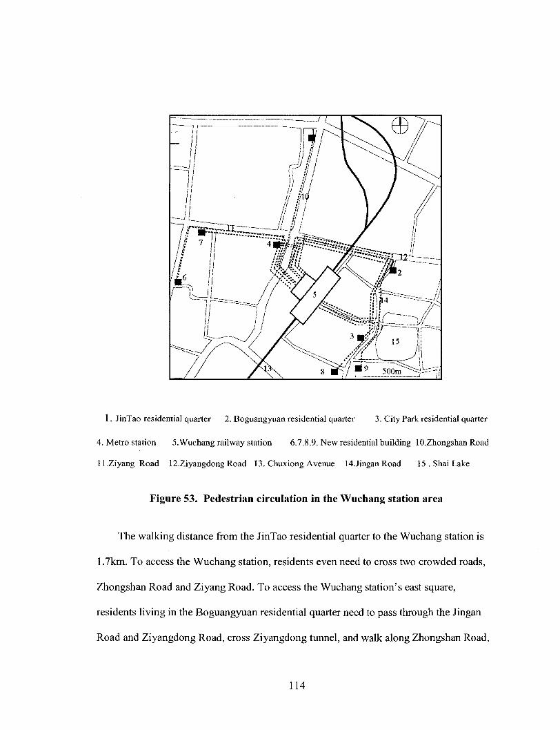
1. JinTao residential quarter 2. Boguangyuan residential quarter 3. City Park residential quarter
4. Metro station 5.Wuchang railway station 6.7.8.9. New residential building lO.ZhongshanRoad
ll.Ziyang Road 12.ZiyangdongRoad 13. Chuxiong Avenue 14Jingan Road 15.ShaiLake
Figure 53. Pedestrian circulation in the Wuchang station area
The walking distance from the JinTao residential quarter to the Wuchang station is
1.7km. To access the Wuchang station, residents even need to cross two crowded roads,
Zhongshan Road and Ziyang Road. To access the Wuchang station's east square,
residents living in the Boguangyuan residential quarter need to pass through the Jingan
Road and Ziyangdong Road, cross Ziyangdong tunnel, and walk along Zhongshan Road,
114

to finally access the station square. The walking distance is about 1.2km. It is not an easy
trip. Residents living in the City Park residential quarter, going to the west square of the
Wuchang station, need to pass through the Jingan Road and Ziyangdong Road, then walk
along Zhongshan Road, to finally access the station square. Their walking distance is
more than 2km. Although there is another tunnel on Chuxiong Avenue, it is about 1.4
kilometer from the City Park residential quarter. No respondents in these residential
quarters mentioned the pedestrian tunnel as a way to go to the station during the
interviews.
To build a sustainable transport system, making conditions better for pedestrians on
the way to the Wuchang railway station is essential. Based on this study, a
comprehensive pedestrian system should be developed in Wuchang station's central area.
To provide better access to the Wuchang station, the road network should also be
improved. Pedestrian connections and a pedestrian tunnel should be created in the
Wuchang railway station area, especially along Zhongshan Road central section, which is
close to the Wuchang station's west square. Pedestrian connections should be created
along Jingan Road central section, which is close to the Wuchang station's east square.
Pedestrian connections should also be created along the Ziyangdong Road tunnel, to
closely connect Wuchang station's east and west sites.
The entrance level of the station is at ground level. Pedestrian circulation is at ground
and so are the roads. The metro stations are close and underground. To minimize the
inconvenience to the passengers, an underground connection between the metro station
and Wuchang railway station is necessary. It should cross the Zhongshan Road and well
connect with the Pedestrian system.
115

Chapter 8 Conclusion and Discussion
8.1 Findings
(1) The effect of Wuchang railway station redevelopment is larger than what has
been planned.
In the present plan, Wuchang station development projects such as hotels were
placed in the central area, which was within the walkable environment, 500-600 metres.
According to my survey, the effect of Wuchang railway station redevelopment is larger
than what has been planned. For those shops and commercial facilities near the
neighbouring bus station, which related to the railway station, the positive impact
happened in a longer distance. The distance of effect of station even could be 1 kilometre,
or even up to 1.3 kilometres.
(2) The connection between Wuchang station's two sites is not really addressed.
Currently, the railway station complex has covered the content of social life's every
aspect. The railway station has truly become a center of city life. Ideally, the railway
station and the periphery urban space union as a whole. The railway station, station
square, public facilities and its surrounding environment form an integrated city space.
East site and west site of Wuchang station imbalance situation seriously hindered the
station area's sustainable development. It also has affected the image of the whole
Wuchang station area. After station renovation, the Wuchang railway station does not
achieve an expected improvement as the station planning proposed. Ziyangdong Road
tunnel and Chuxiong Avenue tunnel were expected to connect the east and west sites of
the Wuchang station. According to my survey, actually these two tunnels play limited
116

role in station area. Wuchang railway station itself has not achieved connecting the east
and west sites.
Although developers think access to the Wuchang railway station is a key feature of
their projects, local people evaluate the existing environment as poor.
(3) An integrated city-based public transportation system has not yet been fully
established.
The railway station functions as a "node"; it is a transportation hub. Various means
of transportation such as subway and buses transfer in the station area. Varieties of
passengers distribute and transfer in the station area, using various transport means. The
railway station should closely connect with subway, buses, cars, bicycles, inter-city rail
transportation system.
Currently, an integrated city-based public transportation system has not yet been fully
established. Railway station, bus stations, and long-distance bus station did not closely
connect and so it was not convenient for passengers to transfer. It hindered the station
area's transportation sustainable development, and created current congested situation in
the Wuchang station area.
8.2 Recommendations Based on the Research Findings
Based on the findings of this study, the following recommendations are offered for
policy makers involved with railway station development and administrators.
(1) A larger scale comprehensive detailed planning for the future development in the
Wuchang station area is highly recommended. In the present Wuchang station planning,
it arranges hotels and other commercial facilities in the central section of the Zhongshan
117
Road, facing the west square of the Wuchang station. By this arrangement, it was
expected to provide great convenience for passengers. Based on my findings, the effect
of Wuchang railway station redevelopment is larger than what has been planned. A larger
scale comprehensive detailed planning is necessary; it will provide a sustainable
development guarantee for Wuchang station area.
(2) To build a more walkable environment in the Wuchang station area, adding
pedestrian links to the railway station is highly recommended. A safe and comfortable
pedestrian system should be built to the surrounding area to connect both sites of the
Wuchang station. It will be very helpful for promoting walking, cycling, and other
activities in the Wuchang station area, to make the station area become an attractive place.
A much larger underground connection between the metro station and Wuchang railway
station should be built. It should cross the Zhongshan Road and well connect with the
ground Pedestrian system, to build an integrated public transport system.
(3) An integrated city-based public transportation system should be established to
maximize the transport efficiency, and reduce the time interval. It would be very helpful
for reducing the congested situation in the Wuchang station area, eventually providing
great convenient service for railway passengers and local people. Regarding the needs of
the passengers, the station site of subways, buses and long-distance buses must be set
reasonable. They must be set closer to each other. In the meantime, their schedule should
be coordinated as much as possible.
(4)Regarding the needs of the local residents, a circular bus line should operate on
the east site and the west site of the Wuchang station to closely connect both sites of the
Wuchang station. The future station of the two subway lines are in the west site of the
118

Wuchang station. For residents living in JinTao residential quarter, it can be foreseen that
they will take advantage of the future station due to their geographical position and short
walking distance to the subway station. According to my survey, residents living in
Boguangyuan residential quarter and City Park residential quarter are not presently
willing to take buses in the west site of the Wuchang station. Similarly, we could infer
that it is also not convenient for them to cross the Ziyangdong Road tunnel and access the
west site of the station to take the subway.
According to the survey, most local people are still not very rich; they still have the
bicycle and bus as their principal transport means. I believe a circular bus line operating
in the Wuchang station area to connect the west site and the east site is necessary. It is a
feasible and economical way to connect two sites closely. Local residents would come
from the east site and could get off buses and enter the subway station hall directly.
Moreover, it could link the east site with the subway station of Line 4 and Line 5 in the
west site. This will greatly improve the inconvenient travel problem of the residents
living in the east site of the station area. It will also maximize the transport efficiency.
(5) Local government should consider planning and arranging more public space and
semi-public space in the Wuchang station area. Bicycle parking should be established
near the Wuchang station square. After railway station renovation, along with entire local
transportation environment improvement, I believe that station area will become a more
walkable space. Bicycle and walking will play a greater role in surrounding environment
of the station eventually. Establishing parking lots for bikes near the railway station and
subway station is necessary. This will be very helpful for local residents, especially for
those who live in the neighbouring residential quarters.
119

(6) A comprehensive re-arrangement of local shops and commercial facilities in the
Wuchang station area should be a high priority. To balance the two sites of Wuchang
station, more shops and commercial facilities should be established in the east site of
Wuchang station. The economics and environment of the east site and west site of the
Wuchang station are not balanced; they seriously hindered the station area's sustainable
development. A comprehensive re-arrangement of local shops and commercial facilities
will provide enormous convenience that benefits both passengers and local residents.
(7) After re-arrangement of surrounding existing local shops and commercial
facilities, a detailed landscape design around Ziyangdong Road tunnel and Chuxiong
Avenue tunnel should be implemented. It will be helpful for two tunnels to play a greater
role in Wuchang station area, to attract more passengers and local people to use it, thus to
create more connections between the east site and west site of Wuchang station.
8.3 Conclusion and Discussion
The main objective of this research is to identify the impact of railway station
redevelopment on station surrounding areas in the case of high-speed railway stations in
China. I conducted questionnaire survey, interview, and site survey in the Wuchang
station area, and attempted to figure out the strengths and positive effects of the
redevelopment on the station surrounding area.
Based on the survey responses and comprehensive analysis, the study has
demonstrated that Wuchang railway station redevelopment has a certain impact on the
station surrounding area. It also concluded that the effect of Wuchang railway station
redevelopment is larger than what has been planned; the connection between Wuchang
120
station's two sites is not really addressed; and an integrated city-based public
transportation system has not yet been fully established.
According to the questionnaire survey, people living in these three residential
quarters depend more on traditional public transport means (bus). In other words, people
living in these three residential quarters more benefit from the public transport system.
Close to railway station is an important factor of their residential location choice. Most of
the respondents in these three residential quarter reported property value had increased
after the station was renovated.
Although developers think access to the Wuchang railway station is a key feature of
their projects, local people evaluate the existing environment as poor. Respondents
reported difficulty or concern in getting to/from the railway station, such as difficulty
crossing busy road, crowds of people as well as noise. According to the survey, current
traffic situations in the Wuchang station area objectively lead to an unfriendly
environment for cycling and walking. Residents did not prefer walking in the Wuchang
station area. They even chose to walk to the neighboring Parks and commercial streets
which were two kilometers away from the station. Few residents used Ziyangdong Road
tunnel and Chuxiong Avenue tunnel to access the west station square.
This research reveals that an integrated city-based public transportation system has
not yet been fully established. Wuchang railway station, bus stations, and long-distance
bus station did not closely connected and so it was not convenient for passengers to
transfer. Residents living in the Boguangyuan residential quarter and City Park
residential quarter did not go to the west site of railway station to take the bus. During
121
interviews, most respondents in the Boguangyuan and City Park residential quarter
complained that it was not convenient to go out by bus.
The traffic survey reveals that the connection between Wuchang station's two sites is
not really addressed. A large number of vehicles come from various directions to the
Wuchang station, mostly depending on Zhongshan Road. The traffic volume on the other
surrounding roads is much lower than the level of Zhongshan Road. They handle the
limited stream of vehicles and passengers arriving and departing the Wuchang station. It
leads to the traffic flow being unable to have circulation dispersal through the east site
and west site of the Wuchang station, fundamentally solving the communication problem
of the station's east site and west site.
Local shops and commercial facilities survey results showed that the railway station
had a different impact on different types of business within the Wuchang station area.
The positive impact of the railway station happened in a short distance, and almost at the
place where the majority of the railway passengers gathered or passed through. For those
shops and commercial facilities near the bus station, which related to the railway station,
the positive impact happened at a longer distance. According to the survey, that distance
was as high as 1.3 km. It greatly exceeds normal walking distance.
In addition, this research reveals that a limited number of commercial facilities
inevitably restrict Wuchang station area becoming multi-functional and being an
attractive urban place. After station renovation, the Wuchang railway station does not
achieve an expected improvement as the station planning proposed in the present
planning for the Wuchang station. Development projects such as hotels were placed in
122
the central area, which was within the walkable environment, 500-600 metres. It will not
accommodate a multi-functional environment.
Based on the findings of this study, the following recommendations are offered. A
larger scale comprehensive detailed planning for future development in the Wuchang
station area is highly recommended. A comprehensive re-arrangement of local shops and
commercial facilities in the Wuchang station area should be a high priority. In the
Wuchang station area, a safe and comfortable pedestrian system should be built to make
conditions better for pedestrians on the way to the Wuchang railway station. A circular
bus line should operate on the east site and the west site of the Wuchang station to closely
connect both sites of the Wuchang station. In addition, a detailed landscape design
around Ziyangdong Road tunnel and Chuxiong Avenue tunnel should be implemented.
The successful redevelopment of railway stations rely on several basic elements, such
as a vibrant local economy, healthy capital market, idle surrounding land, well-developed
transportation network, and strong public investment. When all these elements come
together, station redevelopment as a catalyst can truly play an important role in city
construction.
The Ministry of China railway belongs to Chinese Central government, Wuhan local
government belongs to Hubei Province. They work in different levels, have different
concerns and also have different interests in terms of railway station redevelopment.
Wuhan Planning Bureau works for the Wuhan local government, in charge of the railway
station area's planning. Now there is no special committee to coordinate these various
interests. Currently, there are many station renewal projects which are under construction
in China due to the old stations unable to meet the current functional requirements. A
123
special committee to coordinate the Ministry of China Railway and local government is
necessary.
According to WPDI passenger flow forecast data, the total daily passenger capacity
of the Wuchang subway station in subway Lines 4 and 5 will reach 220,600. Based on
my study, the total numbers of daily passengers in Wuchang station is 365,600 (including
metro passengers). The total daily passenger capacity of the Wuchang subway station on
subway Lines 4 and 5 accounts for 60 percent of the passengers in the Wuchang station
area. It can be predicted that after subway Line 4 and Line 5 are put into operation, the
Wuchang railway station redevelopment would affect a larger area than the current
surveyed extent. Consequently, the railway station redevelopment will provide a catalyst
for revitalizing the station area and extending the impact of the station into the larger
surrounding area.
After the Wuchang railway station renovation, the railway station itself and the
surrounding environment will have undergone a great change and improvement. With a
favorable external environment as the premise, it could eventually greatly help to build a
reasonable and efficient railway transportation hub in the city.
124

References
Anas, A. (1982). Residential Location Markets and Urban Transportation. New
York: Academic Press.
Bertolini, L., Spit, T. (1998), Cities on Rails: The Redevelopment of Railway Station
Areas, Spon Press; 1 edition
Bertolini, L. (1998). Station area redevelopment in five European countries: An
international perspective on a complex planning challenge, International Planning
Studies. Volume 3, Issue 2 June 1998, pages 163 - 184
Bertolini, L.,and Dijst, M. (2003).Mobility Environments and Network Cities,
Journal of Urban Design, Volume 8 Issue 1 2003
Bertolini, L.(2006).Fostering Urbanity in a Mobile Society: Linking Concepts and
Practices, Journal of Urban Design, Volume 11, Issue 3 October 2006 , pages 319 - 334
Bruinsma,F., Pels, E., Rietveld, P., Priemus, H., and Wee, B. V. (2007).What makes
a city: Urban quality in Euralille, Amsterdam South Axis and Rotterdam Central,
Railway Development, Physica-Verlag HD
Barton, H., Grant, M., and Guise, R., (2004).Shaping Neighbourhoods, E & F SPON
Cervero, R., & Duncan, M. (2001). Rail transit's value added: Effect of proximity to
light and commuter rail transit on commercial land values in Santa Clara County
California. Paper prepared for National Association of Realtors Urban Land Institute.
Chang, D.K. (2002). Spatial Choice and Preference in Multilevel Movement
Networks, Environment and Behavior, Vol. 34, No. 5,
125

City of Utrecht, Retrieved November 10, 2008, from web site
http ://www.utrecht.nl/smartsite.dws?id= 13 3 5 3
City of Lille, Retrieved November 10, 2008, from web site http://www.mairie-
lille.fr/en/lille-s-economy
China statistical yearbook, 2007, China Statistical Press
Debrezion, G., Pels, E., and Rietveld, P. (2003). The Impact of Railway Stations on
Residential and Commercial Property Value: a Meta Analysis, Retrieved November 10,
2007, from web site http://tia-80 98.tinbergen.nl/discussionpapers/04023.pdf
Debrezion, G., Pels, E., and Rietveld, P. (2006). The Impact of Rail Transport on
Real Estate Prices: an Empirical Analysis of the Dutch Housing Markets, Retrieved
November 10, 2007, from http://www.tinbergen.nl/discussionpapers/06031.pdf
East Japan Railway Company, Retrieved November 10, 2008, from web site
http ://www.japanrail. com/pdf/news/05 9/JR_Bulletin_vol_5 9.pdf
Gu, Xiaoan.(2006).Railway environmental noise control in China, Journal of Sound
and Vibration,Volume 293, Issues 3-5, 13 June 2006, Pages 1078-1085
Gorter, C , Nijkamp, P., and Vork, R., (1999). Analysis of travellers' satisfaction on
transport chains, Retrieved November 10, 2007, from web site
http://www.tinbergen.nl/discussionpapers/99058.pdf
Gaubatz, P. (1999). China's Urban Transformation: Patterns and Processes of
Morphological Change in Beijing, Shanghai and Guangzhou, Urban Studies, Vol. 36, No.
9, 1495- 1521,
126

Halden,D.,Jones,P., Wixey,S. (2005). Accessibility Analysis Literature Review,
Retrieved November 10, 2007, from web site
http://home.wmin.ac.uk/transport/download/SAMP_WP3_Accessibility_Modelling.pdf
Hubei Highway Transport CO., LTD, the information office
Hubei Jintao Real Estate Development Co., Ltd, 2008, the information office
Haider, M. and Miller, E. J. (2000). Effects of Transportation Infrastructure and
Location on Residential Real Estate Values: Application of Spatial Autoregressive
Techniques.Transportation Research Record 1722: 1-8.
East Japan Railway Company, Retrieved November 10, 2007, from web site
http://www.japanrail.com/pdf/news/059/JR_Bulletin059_East.pdf
Keijer, M. J.N. and Rietveld, P. (1998). How do people get to the railway station; a
spatial analysis of the first and the last part of multimodal trips? Vrije Universiteit
Amsterdam
Lu, J.W., Wang,T. (2006). Railway station complex and urban catalyst-examples of
shanghai south railway station, Urban Planning Forum, Volume 164, Issue 4
Ministry of China Railway, 2007, the information office
National Bureau of Statistics, 2005, the information office
Oosten, W-J (2000). Railway stations and geography of networks, Retrieved
November 10, 2007, from web site
https://dspace.ubib.eur.n1/handle/l 765/455?mode=simple
Ouyang, Z.J. (2004). Guangzhou track transportation passenger flow scale predictive
parsing, the urban track transportation studies
127

Pagliara, F, and Preston. J. (2003). The impact of transport on residential location,
Transport Studies Unit, University of Oxford
Peek, G-J; van Hagen, M. (2002).Creating Synergy In and Around Stations: Three
Strategies for Adding Value, Transportation Research Record, Volume 1793 / 2002
Peek, G-J., Bertolini, L.,and Jonge, H. D., (2006).Gaining insight in the development
potential of station areas: A decade of node-place modelling in The Netherlands,
Planning Practice and Research, Volume 21, Issue 4 November 2006 , pages 443 - 462
Peoples Republic of China Humanity Development Report 2002
Pol, Peter M.J. (2000). Organisation of Station-Area Developments, Retrieved
November 10, 2007, from web site http://www.ersa.org/ersaconfs/ersa00/pdf-
ersa/pdf/199.pdf
Tiry, C. (1999). From Lille-Flandres to Lille-Europe—The Evolution of a Railway
Station, Retrieved November 10, 2007, from web site
http://www.jrtr.net/jrtr20/F44_Tiry.html
WPDI, (2006). Wuchang railway station and the surrounding area transportation and
landscape planning
Wuhan Fusheng Real Estate Development Company, the information office
Wuhan Urban Development Group Limited, the information office
Wuhan Railway Bureau, the information office
Wuhan government, the information office
Wuhan transportation development annual report, 2007, WPDI
Waard, J. van der. (1989). Onderzoek weging tijdelementen, Delft University of
Technology, Delft.
128

Yin, R, (1994). Case study research: Design and methods (2nd ed.). Beverly Hills,
CA: Sage Publishing.
Zheng, D.G., Du, B.D., (2007). Looking for the Balance Between Transport Value of
Node and Functional Value of City Discussing Theory and Practice in the
Development of Airport Area and High Speed Rail Station Area, Urban Planning
International, Number 1, 2007
129

Appendix A: Questionnaire for New Residents
1. How long have you lived in this residential quarter?
2. What is the main factor of your residential location choice? (please rank it)
No.
Factor
1 2 3 4 5 6 7 8
1. Reasonable price 2. House layout, environment 3. Less travel time and cost to work
4. Near shopping centre 5. Near railway station 6. Near bus Station
7.Expectant upvaluation 8.0ther factors
3. Is it convenient for you to access the railway station? Which route option would you
use, please explain?
4. Which bus station do you use frequently? Which route option would you use, please
explain ?
5. Which walking route option do you use frequently in your spare time, please explain ?
6. Do you have any difficulty or concern in getting to/from the railway station, and
explain? (e.g. broken pavements, difficulty crossing busy road)
7. Could you tell me the reason why you prefer to go to railway station?
8. Could you tell me how often do you use trains (or bus, car, bicycle, walk respectively)
to do per (day, week, and month) for times?
9. What's your general impression about railway station area?
10. What is the biggest advantage of living in this residential quarter, and what is the
biggest disadvantage of it, please explain it?
11. After the railway station rebuilt, were there any improvement? Please explain it?
130

12. Could you tell me in recent years, your property value increased (or
decreased) by percent?
Appendix B: Interview Questions for Local Shops and Commercial Facilities
Ql .How long have you done business here?
Q2.what is the main factor of your shop location choice? (Please rank it)
No. Factor
1 2 3 4 5 6 7 8
1. Reasonable price (or rent)
and cost
4. Near shopping centre
7.Live near here
2. Good Environment
5. Near railway station
8.Other factors
3. Less travel time
6. Near bus Station
Q3. How long did the walk from home to the railway station take?
By bus to the railway station take?
mms.
mms.
Q4. If you live near here, which route option would you use to go to station, please
explain?
Q5. Do you have any difficulty or concern in doing business around the railway station,
please explain? (e.g. noise, difficulty crossing busy road)
Q6. For what reason do you think people usually go to the railway station?
1. Take train 2.Take bus 3. Replenish stock 4. Better
facilities
131
5. Feel like walking there 6,Others (please state)
Q7.You frequently go to railway station to do for times (per day, week,
and month)?
Q8. What's your impression about the railway station area?
Q9. What's your general impression about the environment of this area?
Q10. What is the biggest advantage of doing business here, and what is the biggest
disadvantage of it, please explain?
Ql 1.After the railway station was rebuilt, were there any improvement, please explain?
Your customers had increased (or decreased) percent daily.
Q12.Compared with other areas, do businesses here see customers increase (or decreased)
by percent.
132