the maars of the vulkaneifel - sporthotel-grafenwald.de · the maars the maars are perhaps the most...
TRANSCRIPT

The maarsof the Vulkaneifeland how they were formed
Tel. +49 6592 933-202 oder 933 -203 ∙ [email protected] ∙ www.naturpark-vulkaneifel.de
supported by:

The maars
The maars are perhaps the most well-known landmarks of the Vulkaneifel. The circular lakes with a deep to azure blue, bor-dered by green, wooded slopes, are the expressive „eyes“, rap-turing the balloonist gently fl oating above the landscape, and gracing countless postcards.
From a bird’s eye view the former craters are quite apparent. Next to a mountain crater lake and the eleven water-fi lled maars, you can see many more: some are currently silting up, housing raised bogs, others are already completely dried up and only noticeable as circular swales. To date, 77 maars have been established in the Vulkaneifel.
Some of the maars of the Vulkaneifel are very old, such as the Eckfeld maar. It was formed approx. 44 million years ago during an early phase of volcanic activity in the Eifel. A second phase set in about a million years ago, ending with the most recent eruption, the Ulmen maar, only about 10,900 years old. To date, 350 centres of eruption have been counted in the Vulkaneifel, of which about 270 are from the more recent phase. In addition to the maars typical to the Eifel, this also includes the volcanic cone.
2
fascinating eyes of the Vulkaneifel
Maars are not only found in the Eifel, this phenome-non occurs around the world. Their causes and their distinct appearance can be attributed to the geological characteristics.
Volcanic activity is initially caused by liquid melt rising from the Earth’s interior: magma. This typically occurs in all peripheral rims, where mighty tectonic plates meet (continental drift). Not bound to plate bounda-ries are hot spots, caused by thermic anomalies in the lower mantle. This includes the Eifel, and the anomaly is called Eifel Plume, a hot spot in the upper mantle, reaching up to 50 - 60 km below the Eifel.
While on one hand fascinating to scientists, it also cap-tivates everybody else: painters and poets, young and old, people from near and far.
In this little brochure we’d like to uncover the particu-larities of the Vulkaneifel maars. After all, many things only become apparent when we understand them.
3

Publisher and editor:Natur- und Geopark Vulkaneifel GmbH Mainzer Str. 25 · D-54550 DaunTel. +49 6592 933 203, -206 or -202 www.geopark-vulkaneifel.dewww.naturpark-vulkaneifel.de [email protected]
Text: Dr. Martin Koziol, CUBE
Photos: CUBE, H. Gassen, K.P. Kappest, M. Koziol, I. Sartoris
Design: CUBE GmbH, Daleiden
© 2016
4
ContentsA maar erupts . . . . . . . . . . . . . . . . . . . . . 6
Map with Vulkaneifel paths . . . . . . . . . . . 8
The Daun maars withGemündener MaarWeinfelder MaarSchalkenmehrener Maare . . . . . . . . . . . 10
Sangweiher . . . . . . . . . . . . . . . . . . . . . . 16
Mürmes . . . . . . . . . . . . . . . . . . . . . . . . . 18
Pulvermaar . . . . . . . . . . . . . . . . . . . . . . . 20
Hetsche-Maar . . . . . . . . . . . . . . . . . . . . . 22
Dürres Maar . . . . . . . . . . . . . . . . . . . . . . 24
Holzmaar . . . . . . . . . . . . . . . . . . . . . . . . 26
Strohner Määrchen . . . . . . . . . . . . . . . . . 28
Trautzberger Maar . . . . . . . . . . . . . . . . . 30
Immerather Maar . . . . . . . . . . . . . . . . . . 32
Meerfelder Maar . . . . . . . . . . . . . . . . . . 34
Hinkelsmaar . . . . . . . . . . . . . . . . . . . . . . 36
Windsborn . . . . . . . . . . . . . . . . . . . . . . . 38
Mosbrucher Weiher . . . . . . . . . . . . . . . . 40
Jungferweiher . . . . . . . . . . . . . . . . . . . . 42
Ulmener Maar . . . . . . . . . . . . . . . . . . . . 44
Eichholz-Maar . . . . . . . . . . . . . . . . . . . . 46
The holiday regions in the Vulkaneifel Nature Park and Geopark . . . . . . . . . . . . 50 5

A maareruptsanything but harmless
6
When a maar erupts, “all hell breaks loose”. The image in the background shows the eruption of the larger of the two Ukinrek maars in Alaska in 1977. At a diameter of 300 m it’s most certainly among the smaller ones. And yet it ejected about 10 million m³ of material. Its volcanic ash rose to 6,500 m and even 160 km away a light rain of ashes came down.
Thanks to maar research and the observation and research of current maar eruptions – such as this one on the Aleutians – today we have a pretty accurate picture of how the maars in the Vulkaneifel formed and the dramatic impacts their formation must have had on the area.
What happens? Flowing magma meets water-bearing layers as it ris-es. This water evaporates abruptly, resulting in massive explosions. The surrounding rocks at the contact point is broken up, moved to the top and ejected. The blasted out explo-sion chamber then collapses and a cone remains at the surface of the earth, surrounded by a ring-shaped ridge of volcanic ejecta – a maar has been formed. The collapsed cone can fi ll with water and become a maar lake.
The appearance of the maar will change over tens of thousands of years and millions of years. Its trac-es in the landscape will remain, just as in the Vulkaneifel. So let’s take an exciting expedition ....
Phot
o: Jü
rgen
Kie
nle,
Apr
il 19
77
Maar stages
maar eruption
maar stage
lake stage
bog stage
dry maar stage
7
Maar stages
maar eruption
maar stage
lake stage
bog stage
dry maar stage

Büdesheim
PelmMüllenborn
Roth
Hersdorf
Kopp
Mürlenbach
Deudesfeld
Meerfeld
Bettenfeld
Meisburg
Boos
Mannebach
Mehren
Mosbrucher Weiher
Jungferweiher
Immerather Maar
Eichholz-Maar
Trautzberger Maar
Windsborn Kratersee
Meerfelder Maar
Ulmener Maar
Dauner Maare
Dürres Maar
Hetsche-Maar
Hinkelsmaar
Strohner Määrchen
Kyll
Lies
er
Kronenburger See
Eckfeld Strohn
Lutzerath
Laufeld
Hasborn
Gillenfeld
Gemünden
Uersfeld
Ulmen
Neroth
Dreis-Brück
Steinborn
Zendscheid
Eisenschmitt
Großlittgen
Schönecken
Birresborn
Kelberg
Wallenborn
Bad Bertrich
Kyllburg
Malberg
PrümGerolstein
Daun
Hillesheim
Jünkerath
Stadtkyll
Manderscheid
Schwirzheim
Duppach
Steffeln
Birgel
Wiesbaum
Ahrhütte
Üxheim
Nürburg
Kerpen
Olzheim
Ormont
Kronenburg
Dahlem
Kyll
Nims
Kyll
Wirf
t
Kyll
Ahr
Üßbach
A60
A48
A1
A1
51
51
51
410
410
410
421
421
257
259
257
257
257
257
258
258
258
421
421
410
Prüm
6
6 3
3
6
4
5
7
10
10
12
11
13
14
9
9
8
2
1
1
2
Sangweiher
Holzmaar
Mürmes
Pulvermaar
Kopp
Meisburg
Steinborn
Birresborn
Prüm
Hersdorf
KoppKopp
Mürlenbach
Meisburg
Kyll
Steinborn
Zendscheid
Schönecken
Birresborn
Kyllburg
Malberg
Kyll
Kyll
Nims
257
The Vulkaneifel pathsHochkelberg Panorama-Pfad | 37.9 km | challenging
Maare & Thermen Pfad | 33.3 km | challenging
Vulkan-Pfad | 28.2 km | medium
Gerolsteiner Felsenpfad | 7.5 km | medium
Gerolsteiner Keltenpfad | 6.9 km | medium
Schneifel-Pfad | 72.9 km | challenging
Vulkangipfel-Pfad | 31.3 km | challenging
Vulcano-Pfad | 26.4 km | challenging
Maare-Pfad | 35.1 km | challenging
Hinterbüsch-Pfad | 34.8 km | challenging
Manderscheider Burgenstieg | 6.1 km | medium
VulkaMaar-Pfad | 26.7 km | challenging
Grafschaft-Pfad | 14.3 km | challenging
2 Bäche-Pfad | 14 km | medium
8
Büdesheim
PelmMüllenborn
Roth
Hersdorf
Kopp
Mürlenbach
Deudesfeld
Meerfeld
Bettenfeld
Meisburg
Boos
Mannebach
Mehren
Mosbrucher Weiher
Jungferweiher
Immerather Maar
Eichholz-Maar
Trautzberger Maar
Windsborn Kratersee
Meerfelder Maar
Ulmener Maar
Dauner Maare
Dürres Maar
Hetsche-Maar
Hinkelsmaar
Strohner Määrchen
Kyll
Lies
er
Kronenburger See
Eckfeld Strohn
Lutzerath
Laufeld
Hasborn
Gillenfeld
Gemünden
Uersfeld
Ulmen
Neroth
Dreis-Brück
Steinborn
Zendscheid
Eisenschmitt
Großlittgen
Schönecken
Birresborn
Kelberg
Wallenborn
Bad Bertrich
Kyllburg
Malberg
PrümGerolstein
Daun
Hillesheim
Jünkerath
Stadtkyll
Manderscheid
Schwirzheim
Duppach
Steffeln
Birgel
Wiesbaum
Ahrhütte
Üxheim
Nürburg
Kerpen
Olzheim
Ormont
Kronenburg
Dahlem
Kyll
Nims
Kyll
Wirf
t
Kyll
Ahr
Üßbach
A60
A48
A1
A1
51
51
51
410
410
410
421
421
257
259
257
257
257
257
258
258
258
421
421
410
Prüm
6
6 3
3
6
4
5
7
10
10
12
11
13
14
9
9
8
2
1
1
2
Sangweiher
Holzmaar
Mürmes
Pulvermaar
Nürburg
Ahr
258
Ahr257
The maars of the Vulkaneifeland the road there
9

The Daun maars, with the Weinfeld maar – also called Totenmaar [maar of the dead] – is among the favourite subjects of German landscape artist Fritz von Wille (1860 - 1941). In front of the moody grey of passing Eifel clouds, amidst the Eif-el gold impasto style the “Blue Flower” shines resplendent on the crater slopes. Time and time again the quaint chapel dedicated to St. Martin, situated at the north end of the Weinfeld Maar, also cap-tivates the painter.
These large Eifel paintings, spilling of power and atmosphere, introduced the austere charm and the fascinating Eifel maars to the world early on. Poet Clara Viebig (1860 - 1952), a close friend of Fritz von Wille, chose the Eifel as the backdrop for her sociocritical novels and novellas. She coined the famous saying “The maars are the eyes of the Eifel”.
What fascinates painters and poets about the maars to date also captivates scientists. For example, around 1915 the maar lakes of the Eifel were the favoured research objects of famous limnologist August Thienemann (1882-1960), who formulated the theory on the various types of lakes based on the Eifel fi ndings, as well as the dependence of aquatic or-ganisms on the environmental conditions in the lake.
10
The Daun maarsInspiration to poets and thinkers
11

The Daun maarseight at a blow
GeologyA balloon ride over the Daun maars bring home: There must have been quite a blow!
The Schalkenmehren maars, the Weinfeld and Gemünden maar are lined up along a fi ssure running SE to NW. About 20,000 to 30,000 years ago they erupted as follows: First the Schalkenmehren ones one by one: the dry maar, the low-moor bog, then the water-fi lled maar, probably a dou-ble maar. Then the Gemünden maar, and fi nally the Wein-feld maar. The other two dry maars and the cinder cone Hoher List are older.
The fi ssure which allowed the magma to rise up, breaches numerous Lower Devonian strata. Some are abundant in fossils, such as the Eckfeld layers named after the homon-ymous maar.
12
Gemündener MaarCoordinates: 50°10´40´´ N 06°50´11´´ EElevation: 416 m (AMSL)Cone diameter: 620 mCone depth: 117 mLake diameter: 295 m N-S, 319 m W-ELake depth: 39 m
Weinfelder MaarCoordinates: 50°10´35´´ N 06°50´01´´ EElevation: 487 m (AMSL)Cone diameter: 700 mCone depth: 90 mLake diameter: 492 m N-S, 396 m W-ELake depth: 51 m
Schalkenmehrener DoppelmaarCoordinates: 50°10´10´´ N 06°51´29´´ EElevation: 422 m (AMSL)Cone diameter: 1.100 mCone depth: 90 mLake diameter: 554 m N-S, 502 m W-ELake depth: 21 m
Schalkenmehrener FlachmoorCoordinates: 50°10´13´´ N 06°51´51´´ EElevation: 423 m (AMSL)Cone diameter: 600 mCone depth: 40 mBog diameter: 168 m N-S, 377 m W-E
Schalkenmehrener TrockenmaarCoordinates: 50°10´27´´ N 06°51´46´´ EElevation: 459 m (AMSL)Cone diameter: 500 mCone depth: 70 m
13

There’s much to discover along the elevations around the Daun maars and the view is far. For example from the 11 m Dronketurm tower built in 1902 and dedicated to the co-founder of the Eifel club, Dr. Adolf Dronke. And from the observatory on the Hoher List volcanic cone you can even see into space! Unfortunately academic activities at this outpost was stopped – but you can still see into space.
The Daun maarsallow a long view
14 15

Sangweihera maar with a
“medieval lake”of birds
16
GeologyThe maar is located in the transient area of 3 units of the Devonian Unterems: From SE to NW the Eckfeld- and Reu-delsterz layers of sand-siltstone, greywacke and quartzite crop out. Next are the
Beinhausen layers, consisting of light stand-siltstone at the bottom and dark clay slate and siltstone at the top.
Geo-morphologically speaking the maar is located in a conspicuously wide valley of a tributary of the Alf. In the SE, lapilli tuffs, and N of here, slag has been proven. The eruptions therefore must have occurred toward the north and south-east.
ParticularitiesThis natural swale – caused by the dry maar – was used as a fi shing pond in 1346 and belonged to the earl of Daun, from 1665 the elector of Trier. 1774 the pond was measured at 113,500 m². It was later drained and used for agriculture.
In 1983 this area was designated as conservancy area. And in 1987 a barrage was built into the fl ow so the area became waterlogged again. Sedges and rush accumulat-ed again, along with wet meadows all around. These are signifi cant to bird life, native and migratory birds alike!
SangweiherCoordinates: 50°08´59´´ N / 06°52´19´´ EElevation: 399 m (AMSL)Maar dimension: ca. 600 x 500 m
Today‘s lakeLake diameter: 285 m W-E, 135 m N-SLake surface: 38.500 m2
17

MürmesCoordinates: 50°09´15´´ N / 06°53´32´´ EElevation: 407 m (AMSL)Maar diameter: 150 m (SE part of the low moor, 50 %)Cone depth: 45 mLow moor shape: oval, 620 m NW-SE; 280 m NE-SW
Mürmesthe maar
of the electors
18
GeologyThe maar forms the SE of the bog area with a radius of 150 m and a depth of 45 m. Smaller tephra occurrences can be found to the SW and NE, the main eruption occurred toward the NW/ motorway and can be detected there. The maar cone is largely in the Lower Devonian, grey-green sand- and siltstone – partly quartzitic – the Reudelsterz layers, surrounded by the grey siltstone, quartzitic sandstone and clay slates of the Eckfeld layers.
ParticularitiesThe “Mürmes” conservancy area is an oval low-moor bog with peat layers four metre thick. Rare plants such as common cotton grass, round-leaved sundew, water-dropwort, ivy-leaf buttercup or moorland spotted orchid grow at the surface. Along with the Sangweiher and the Jungferweiher it’s an important resting place for bird life.
Around 1400 the electors of Trier installed three fi shponds in this area, with the Mürmes maar being used as the uppermost pond. During the time around 1800-1950 the local population was able to cut peat here, since the tidal dam was destroyed and the water was draining.
The 43 hectare conservancy area has been a protected area since 1978 and is owned by NABU Daun and the Vulkaneifel district. Since then the bog a new drainage barrier has been in place for controlled water logging, hence recultivated.
19

PulvermaarCoordinates: 50°07´53´´ N / 06°55´32´´ EElevation: 418 m (AMSL)Cone diameter: 651 - 735 mCone depth: 150 - 200 mCone age: ca. 23.000 yearsLake area: 377.000 m2
Today‘s lake depth: ca. 74 m
Pulvermaarthe storybook maar
20
GeologyThe basal complex here consists of Lower Devonian clay slate, sandstone and greywacke (Siegen tier / Herdorf layers), almost entirely covered by maar tuffs.
ParticularitiesThe Pulvermaar is like a picture from storybooks: It is the best preserved maar in the Eifel. The cone is entirely fi lled with water and surrounded by an almost closed tuff ridge (max. height ap-prox. 45 m). It is also the maar lake with the largest expanse of water and greatest depth in the Eifel and one of the deepest lakes in Germany!
In the tuff pit at the southern inner ridge of the maar cone the tuff ridge layers are 10 m high. Looking from the bottom, the fi rst 8 m consist of an alternating sequence of coarse (especially slate fragments of various sizes) and fi ne layers (ash). They were depos-ited by turbulent ground streams of approx. 200° (glowing clouds) coming from the cone right after the explosion. The upper 2 m consist of fi ne, even layers of ash which later rained out from the air. To the south, directly at the bank path, one can see a basaltic path in the ridge. It probably pushed through coming from the Römerberg, through the maar tephra (pyroclastic deposits).
21

Hetsche-Maarthe smallest maar in the Eifel22
GeologyHere the basal complex consists of Lower Devonian clay-, siltstone and sandstone of the Eckfeld layers, partly covered by the maar tuffs.
ParticularitiesThe Hetsche maar is about 200 m north-west of the Dürren maar. It is deeply embedded in the surrounding fi elds, but visible from Kreisstraße 18 (Brockscheid-Gil-lenfeld).
The maar represents the oldest volcanic eruption site in the Holzmaar group (Hetsche – Dürres maar – Holz-maar) and is also the “smallest Eifel maar”. The maar was probably created by one to two eruptions. Ejecta from the Dürren maar can be detected in the cone. Today it’s silted up into a boggy sedge. By the way, Hetsche is the Gillenfeld colloquialism for the common toad – a reference to a local inhabitant.
Hetsche-MaarCoordinates: 50°07´98´´ N / 06°52´16´´ EElevation: 459 m (AMSL)Age of the Holzmaar group: ca. 40.000 – 70.000 yearsCone diameter: 57 m N-E, 28 m NW-SECone depth: ca. 5 m
23

Dürres Maara dry maar
full of sedges, mosses& cotton grasses
24
GeologyHere the basal complex consists of Lower Devonian clay-, siltstone and sandstone of the Eckfeld layers, partly covered by the maar tuffs. The tuffs were ejected to the north-east. Here you can still fi nd small pits in the forest today, where this volcanic material was quarried for road construction in the 1970s.
ParticularitiesThe Dürren maar area was made a nature conservancy in 1979 along with the Holzmaar. It represents the sec-ond-oldest volcanic eruption site in the Holzmaar group (Hetsche – Dürres maar – Holzmaar) and is now fi lled with a transitional moor.
The bog is subdivided into 3 zones: Various sedges grow from the bank in the bordering fen (riparian zones with water). After this are peat bogs, again blended with sedges. In the centre, cotton-grasses and the peat bogs dominate. The current water table is at approx. 6 m be-low the bog surface, which is again fed by rainfall near the surface.
Dürres MaarCoordinates: 50°07´23´´ N / 06°52´20´´EElevation: 463 m (AMSL) Age of the Holzmaar group: ca. 40.000 – 70.000 yearsCone diameter: ca. 163 m in NW-SE direction, ca. 130 m in W-E directionToday‘s bog area: ca. 1, 9 haBog age: ca. 4.000 yearsBog thickness: ca. 12 mFormer lake depth: ca. 9 m
25
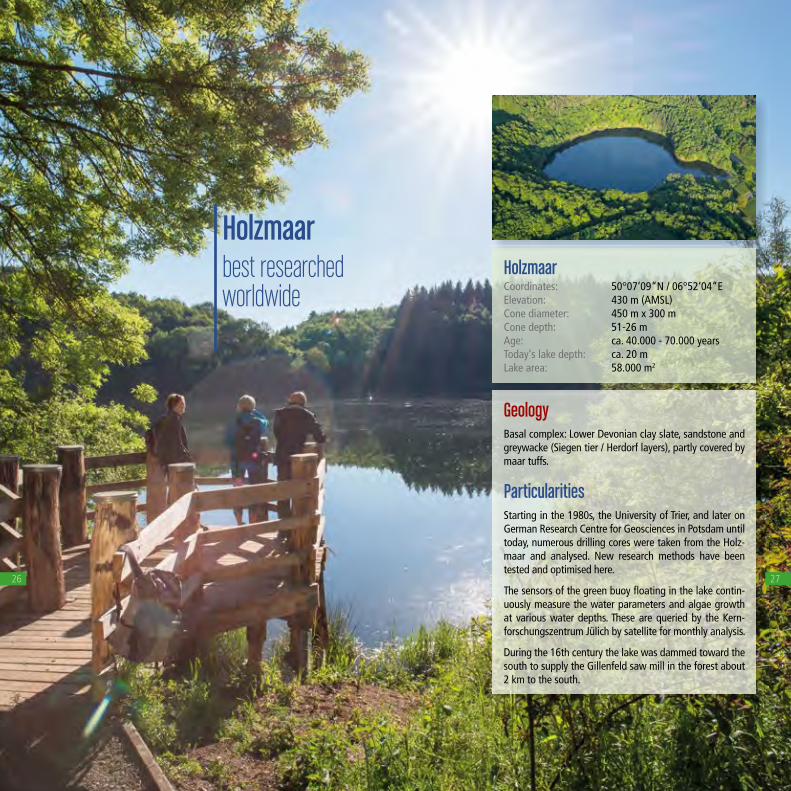
Holzmaarbest researched worldwide
26
GeologyBasal complex: Lower Devonian clay slate, sandstone and greywacke (Siegen tier / Herdorf layers), partly covered by maar tuffs.
ParticularitiesStarting in the 1980s, the University of Trier, and later on German Research Centre for Geosciences in Potsdam until today, numerous drilling cores were taken from the Holz-maar and analysed. New research methods have been tested and optimised here.
The sensors of the green buoy fl oating in the lake contin-uously measure the water parameters and algae growth at various water depths. These are queried by the Kern-forschungszentrum Jülich by satellite for monthly analysis.
During the 16th century the lake was dammed toward the south to supply the Gillenfeld saw mill in the forest about 2 km to the south.
HolzmaarCoordinates: 50°07‘09“N / 06°52‘04“EElevation: 430 m (AMSL)Cone diameter: 450 m x 300 mCone depth: 51-26 mAge: ca. 40.000 - 70.000 yearsToday‘s lake depth: ca. 20 mLake area: 58.000 m2
27

Strohner Määrchena raised bog in the maar cone
28
GeologyIn this Lower Devonian area the grey siltstone, quartzitic sandstones and clay slates of the Eckfeld layers meet the structureless rocks of the Ulmen tier, which also consist of sand- and clay stone. At the land surface they’re covered by maar tuffs.
ParticularitiesRömerberg – Strohn maar - Pulvermaar altogether form a volcano group on a fi ssure running SSE-NNW. First the Strohn maar to the south exploded. The next eruption created the now somewhat asymmetric volcanic cone Römerberg. Its southern half eventually slid into the Strohn maar and fi lled it! Finally, the Pulvermaar was formed.
The Strohn maar is one of the last raised bogs in the Eifel. But how did the bog in the maar come to be?
Sphagnum mosses settled on the permanently soaked ground area of the almost dried out maar lake, slowly joining into a cover. This constantly keeps growing up-ward and the lower, dead plant parts turn into peat in the absence of air. A raised bog is fi nally formed when the mosses grow beyond the groundwater and arch in the middle, living only on rain! Typical bog plants are sphag-num mosses, cotton grasses and sedges.
Strohner MäärchenCoordinates: 50°10´48´´ N / 06°53´03´´ EElevation: 424 m (AMSL)Elliptical cone: 210 x 140 mCone age: > 25.000 years
29

Trautzberger Maara small dry maar is being waterlogged again
30
GeologyThe maar has lowered into the ribbon slate chain! This is a transitional layer between the Lower Devonian Siegenand Unterems tier. The Trautzberg maar tuffs atop it are dyed red here and contain reddish chunks of sandstone and slate. This is followed by black basalt-lapilli tuffs of the Wartgesberg volcanoes, and lastly the deposits of the Sprink maar, evidence of various geological outcrops in the surrounding area. Ice wedge pseudomorphoses were also observed in the maar tuffs, which along with the different origins of the tuffs is evidence this maar cone must have formed during the latest glacial period.
ParticularitiesThe former wetland in the Trautzberg maar was dried up in the early 1960s as part of land consolidation to acquire additional agricultural areas. This has now been reversed again so that a fl ora and fauna adapted to wet habitats can reclaim this area. Water logging efforts in-cluded capping the drainage, installing a small dam, and securing the bypassing agricultural road. Time will tell if an open water expanse will form long-term, as with be-fore the fi rst draining work around 1820/30, when the maar was still being used as a fi shing pond.
The maar is part of the Wartgesberg conservancy areas.
Trautzberger MaarCoordinates: 50°06´35´´ N / 06°56´43´´ EElevation: 395 m (AMSL)Cone diameter: 270 mWetland maar ground: 75 m diameterCone depth: 20 - 25 mMaar age: > 20.000 jaar (glacial period)
31

Immerather Maarthe hidden maar
32
GeologyThe maar blasted into the so-called ribbon slate tier! This is a transitional layer between the Lower Devonian Siegen- and Unterems tier. Here it is covered by maar tuffs at the surface.
The maar cone was formed in an Üßbach tributary val-ley and originally had a size of 600 x 700 m with a depth of 60 m at the Devon top edge.
ParticularitiesJust as several other maars in the Eifel (Meerfeld maar, Eichholz maar), the maar lake was drained in 1750 by deepening the stream ravine and used for agriculture. The maar soil was signifi cantly more fertile than the sur-rounding rocky slate soil lacking minerals. During World War I, between 1914 and 1918, nobody maintained the drainage, allowing a shallow maar lake to form again until today!
The maar lake now only has one drainage, but no inlet! Water is only added by rainfall, surface and groundwa-ter!
Immerather MaarCoordinates: 50°07´23´´ N / 06°57´29´´ EElevation: 371 m (AMSL)Maar age: ca. 40.000 bis 70.000 yearsCone diameter: 396 m N-S, 409 m N-WLake, semi-circular: 206 m radiusLake depth: ca. 1,50 m / max. 2,90 mLake surface: ca. 60.000 m2
33

Meerfelder Maarthe largest maar
in the Western Eifel
34
GeologyThe basal complex consists of Lower Devonian siltstone, sandstone, greywacke and quartzite (Eckfeld- and Reu-delsterz layers) as well as Triassic sandstone (medium mottled sandstone), partly covered by the maar tuffs.
ParticularitiesIn 1877 German emperor Wilhelm I gifted 12,000Reichsmark to the people of Meerfeld so they could lower the lake level by 2 m for land reclamation.
In 2008 the International Union of Geosciences deter-mined the Meerfeld maar a regional type locality to de-fi ne the geographical Pleistocene/Holocene limit.
The longest drilling core with sediments of the Meer-feld maar is 45 m long, documenting 25,000 years of climatic history.
Meerfelder MaarCoordinates: 50°06‘02“N / 6°45‘27“E Elevation: 335 m (AMSL) Cone diameter: 1.730 m Cone depth: 400 m Age: ca. 80.000 years Today‘s lake depth: ca. 18 m
35

Hinkelsmaarlittle paradiseof rare plants
HinkelsmaarCoordinates: 50°05´83´´ N / 06°46´66´´ EElevation: 437 m (AMSL)Cone diameter: 107 m N-S, 95 m W-ECone depth: ca. 10 mAge of the volcano group: ca. 80,000 years, with the Hinkelsmaar representing the most recent eruption!
36
GeologyAccording to scientifi c observations, where now the Hin-kelsmaar can be seen, a larger cinder cone with crater was once located. It was probably completely destroyed by the eruption of the Hinkelsmaar. This can be proven by the slag in the eastern part of the northern edge of the crater, con-tinuing to the west with 3-5 m thick slag agglomerate and coarse tuffs with lava bombs to over 20 m. It could even be the slag cropping out at the northern slope of the Winds-born car park are part of this cinder cone. This would make the slope of the Windsborn concave to the north, part of the crater of this former cinder cone.
ParticularitiesThe Hinkelsmaar is part of the Mosenberg volcano group. It’s surrounded by a relatively fl at ridge. This primarily con-sists of slags and tuffs. A maar lake was once located inside its ring. The organic deposits are present up to 5 m into the drilling profi le, then tuffs up to 10 m.
In 1840 a tunnel was dug at the lowest point of the ridge to drain the water. Once drained the peat layers were to be removed to use as litter for the cattle sheds. Today, parts of the cone occasionally hold water again following rainfall.
The Hinkelsmaar can be characterised as a transitional moor. It mostly consists of a sphagnum moss quaking bog. The appearance is also characterised by the beaded sedge and the very rare slender sedge. It grows in the more nu-trient-rich areas among the quaking bog. In summer it’s emphasised by the yellow fl owers of the loosestrife and the white, fl uffy seed heads of the cotton grass. In the border-ing water-ring (fen) the bur-reed with its prickly fruit grows.
Phot
o: M
. Koz
iol,
2003
37

GeologyThe Windsborn cinder cone near Bettenfeld is part of the Mosenberg volcano group and is the fourth erup-tion site looking from SE. It is separated from the other eruption sites by a distinct depression and rises about 50 m above the Devonian basal complex. Today its cra-ter holds a lake with an accretion zone, surrounded by a ring ridge of slag agglomerate. These were ejected red-hot from the volcano and fused together during cooling.
ParticularitiesWindsborn is the only crater lake in the Eifel and north of the Alps which is permanently fi lled with water. It is only fed by rainfall. The lake water has a yellowish tint and at a pH-level of 5-6 is slightly acidic. Scientifi cally, it’s considered a dystrophic lake. The lake today has a quaking bog-bog bean-marsh cinquefoil belt and slowly silts up from the outside in.
Windsborn crater lakeCoordinates: 50°08´05´´ N / 06°77´42´´ ECrater elevation: 497 m (AMSL)Crater diameter: 300 mCrater depth: 30 mLake surface: 13.000 m2
Lake depth: 80 - 150 cmAge: ca. 80.000 years
38
Windsbornnot a maar, but a true crater lake
39
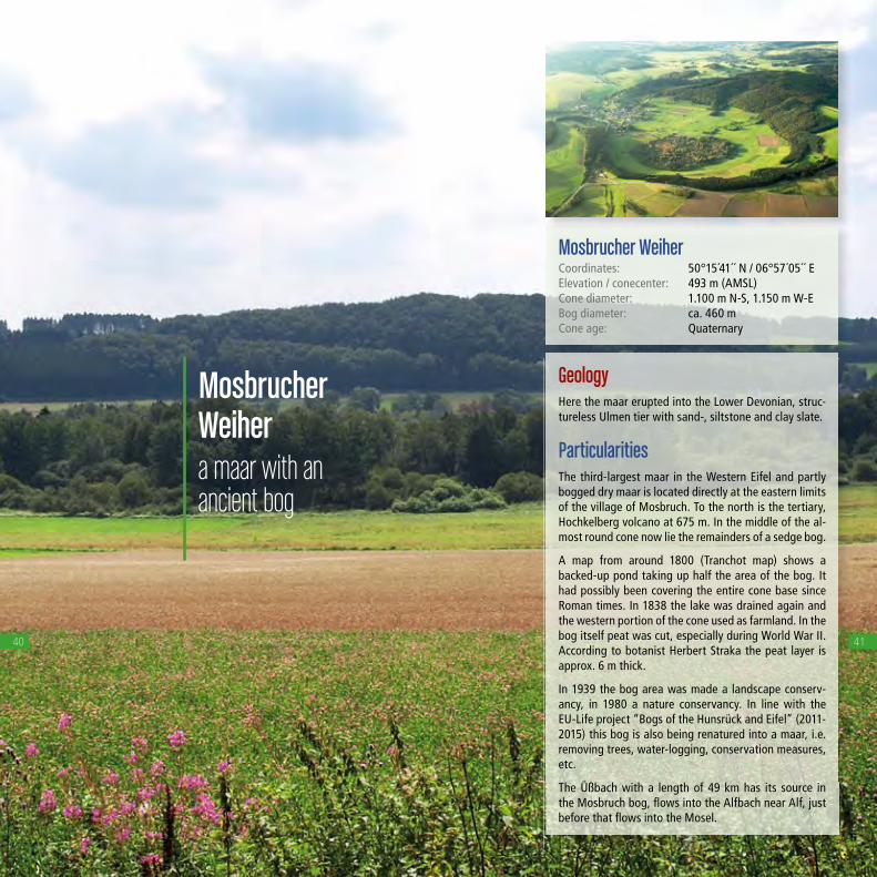
Mosbrucher Weihera maar with an ancient bog
40
GeologyHere the maar erupted into the Lower Devonian, struc-tureless Ulmen tier with sand-, siltstone and clay slate.
ParticularitiesThe third-largest maar in the Western Eifel and partly bogged dry maar is located directly at the eastern limits of the village of Mosbruch. To the north is the tertiary, Hochkelberg volcano at 675 m. In the middle of the al-most round cone now lie the remainders of a sedge bog.
A map from around 1800 (Tranchot map) shows a backed-up pond taking up half the area of the bog. It had possibly been covering the entire cone base since Roman times. In 1838 the lake was drained again and the western portion of the cone used as farmland. In the bog itself peat was cut, especially during World War II. According to botanist Herbert Straka the peat layer is approx. 6 m thick.
In 1939 the bog area was made a landscape conserv-ancy, in 1980 a nature conservancy. In line with the EU-Life project “Bogs of the Hunsrück and Eifel” (2011-2015) this bog is also being renatured into a maar, i.e. removing trees, water-logging, conservation measures, etc.
The Üßbach with a length of 49 km has its source in the Mosbruch bog, fl ows into the Alfbach near Alf, just before that fl ows into the Mosel.
Mosbrucher WeiherCoordinates: 50°15´41´´ N / 06°57´05´´ EElevation / conecenter: 493 m (AMSL)Cone diameter: 1.100 m N-S, 1.150 m W-EBog diameter: ca. 460 mCone age: Quaternary
41

Jungferweihera once again flooded former dry maar
42
GeologyThe maar is located precisely at a SE-NW disruption in the basal complex. The Lower Devonian, structureless Ulmen tier with sand-, siltstone and clay slate is crop-ping out.
ParticularitiesThe Jungferweiher is to the north of the Ulmen maar. It fi lls a shallow depression tilted toward the south. This previously silted up prior dry maar was fl ooded in 1942 by damming up the Nollenbach. Since then, water has been draining into the Ulmen maar and serves the Cochem-Zell district with drinking water. Since 1989 this water from the Jungferweiher has been treated, removing the phosphor from agriculture!
The Jungferweiher along with the Ulmen maar is a na-ture conservancy known for its abundance in migratory birds!
JungferweiherCoordinates: 50° 13´04´´ N / 06°58´50´´ EElevation: 428 m (AMSL)Dry maar diameter: ca. 1.500 mDrilled maar sediments: 128 m (former lake depth)Maar age: > 130.000 years, probably older!
Today‘s lakeLake diameter: 870 m NW-SE, 340 m W-ELake surface: 170.000 m2
Lake volume: 250.000 m3
Lake depth: 0,80 m (average depth)
43

Ulmener Maarthe baby among
the Eifel maars
44
GeologyThe maar is located precisely at a SE-NW disruption in the basal complex. To the southwest, Lower Devonian grey-green sand and siltstone – some quartzitic – of the Reudelsterz layers crop out, to the northeast is the Lower Devonian, structureless Ulmen tier with sand-,siltstone and clay slate. Maar tuffs cover the Lower De-vonian.
ParticularitiesAt about 10,900 years, the Ulmen maar is the latest volcanic eruption in the Eifel and also in Germany. The eruption occurred during a warm period of the late- or post-glacial period, since plant remains were found at the base of the Ulmen maar ashes. The ash fi eld can now still be detected at the surface up to 600 m south-west. The thickness of the ash ranges from 15 m directly at the edge of the crater (almost complete tuff ridge) up to 0.2 mm at the Meerfeld maar about 20 km away.
Since 1926 the waterworks for the Cochem-Zell district has been obtaining drinking water from the 39 m deep maar lake with the help of 8 wells. A population of 30,000 benefi t from the 700,000 m3 of drinking water produced annually.
Ulmener MaarCoordinates: 50°12´48´´ N / 06°58´10´´ EElevation: 420 m (AMSL)Oval cone shape: 510 m NW-SE, 350 m SW-NECone depth: 86 mCone age: 10.900 yearsLake diameter: 340 m N-S, 225 m W-ELake surface: 55.000 m2
Lake depth: 39 m
45

Eichholz-Maarthe renatured maar
46
GeologyHere the basal complex consists of Lower Devonian sandstone of the Klerf layers from the Unterems tier (405 million years). They’re interpreted as mudfl at deposits. At the NW edge of the maar remains of river deposits from the Lower Trias (approx. 235 million years) will crop out.
ParticularitiesIn 2004 the Institute of Physical Geography at Frankfurt Univer-sity drilled about 25 m deep into the centre of the at the time still dry maar. Evidence of a sequence of glacial detritus and younger, interglacial period lake beds was found in this drilling core.
These approx. 16 m thick lake beds are certain evidence a maar lake existed for an extended period. In the Tranchot map of 1811 of this region the Eichholz maar was still labelled as the water fi lled Gussweiher. The maar cone has demonstrably been used by people since Roman times. It was dried several time and then again fi lled for fi sh farming. 2007 / 2008 the maar lake was renatured again, i.e. it was again fi lled with water. For this purpose the Gussbach which previously fl owed through the dry maar was dammed.
Eichholz-MaarCoordinates: 50°16´27´´ N / 06°33´84´´ EElevation: 483 m (AMSL)Cone diameter: in E-W-direction: ca. 125 m, N-S-direction: ca. 115 mCone depth: ca. 25 mToday‘s maar lake area: ca. 1 haToday‘s lake depth: ca. 2,20 mMaar age: Laach lake tephra drilled at 12 m deep, meaning approx. 13,000 years, possibly even considerably older than 100,000 years, as other nearby maars in the region.
47

experience the nature park and the
UNESCO Global Geopark Vulkaneifel
You’ve now learned about the best known of the 77 maars proven in the Vulkaneifel. They’re part of impressive geological document com-ing to light in the Vulkaneifel Nature Preserve and Geopark. This also includes the 350 small and big volcanoes, lava flows and countless mineral and carbon dioxide springs. Even more: red sandstone, tropi-cal riffs and thick sea deposits tell of calm and turbulent times in 400 million years of formation history.
Few regions on our earth provide a comparable clear and fascinating insight into its becoming into being and change. This makes the Vul-kaneifel a valuable natural heritage designated as a nature park and as an UNESCO Global Geopark
The Vulkaneifel further provides important habitats and retreats for a speciose native flora and fauna which has become rare elsewhere. To us humans it’s a beautiful home and a pretty holiday region with a versatile recreation and holiday offering close to nature.
48 49

GesundLand Vulkaneifel
Lively – powerful – grounding. That’s the GesundLand Vulkaneifel in the Vulkaneifel Nature Preserve and Geopark, the region around Daun, Manderscheid, Ulmen and Bad Bertrich to slow you down.
GesundLand Vulkaneifel Leopoldstraße 9a · 54550 Daun Tel. +49 (0) 6592 951 370 Fax +49 (0) 6592 951 320 www.gesundland-vulkaneifel.de
with tourism information in Daun, Manderscheid, Ulmen and Bad Bertrich
The Kasselburg with eagle and wolf park
Holiday region Gerolsteiner Land
Mineral water, cycling and Dolomites – these terms are closely associated with Gerolstein. And the Gerolsteiner region still has much more to offer: for example caves from the Stone Age andmedieval castles.
Tourist-Information Gerolsteiner Land Bahnhofstr. 4 54568 Gerolstein Tel. +49 (0) 6591 94991-0 www.gerolsteiner-land.de
in the Vulkaneifel Nature Park and GeoparkHoliday regions
50
Holiday region Hillesheim
Murderously beautiful is the way Hillesheim, the capital of crime thrillers and mysteries, describes its recreational services and facilities. A healthy dose of excitement is guaranteed at all times!
Urlaubsregion Hilles- heim/Vulkaneifel e.V. Am Markt 1 54576 Hillesheim Tel. +49 (0) 6593 809 200 www.krimiland-eifel.de www.hillesheim.de On the Eifelkrimi hiking trail
near Hillesheim
Holiday region Oberes Kylltal
In addition to geology, which especially manifests all around Steffeln with the volcano garden and the Eichholzmaar, there’s refreshing recreation to enjoy at the Kronenburg lake or Eifel flights to take from the Dahlemer Binz.
Tourist-Information Oberes Kylltal Burgberg 22 54589 Stadtkyll Tel. +49 (0) 6597 2878 Fax +49 (0) 6597 4871 www.obereskylltal.de
Eichholzmaar near Steffeln
Holiday region Kelberg
Partnered with the Nürburgring adventure region, of course motor sports is on the list. It’s far more serene in the beautiful well-forested countryside, which can for example be hiked along the Geschichtsstraße.
Tourist-Information Kelberg Dauner Str. 22 53539 Kelberg Tel. +49 (0) 2692 872 18 www.vgv-kelberg.de www.geschichtsstrasse.de
Out on the “Geschichtsstraße”
51