the magdalena gymkhana - ieso-info · ieso 2014 – paper 5. the magdalena gymkhana – pg. 1...
TRANSCRIPT

IESO 2014 – Paper 5. The Magdalena Gymkhana – pg. 1
Structure of this paper Every 5 minutes the staff will ask 5 student to start this exam, and every 5 minutes the staff will ask those into the exam to move to the next set of questions. All questions belong to one of the following subjects:
1st part: Materials
2nd part: Images interpretation
3rd part: Maps and profiles
4th part: Field resources
The Magdalena Gymkhana Paper 5
IESO 2014 – Paper 5. The Magdalena Gymkhana – pg. 2
FIRST PART – Set 1. Minerals
1. M1 is…
a) Hematite b) Sylvite c) Cinnabar d) Bauxite
2. M1 crystalizes in the system…
a) Hexagonal b) Cubic c) Orthorhombic d) Monoclinic
3. M1 is an ore of…
a) Iron b) Carbon c) Cupper d) Mercury
4. M2 is…
a) Talc b) Muscovite c) Biotite d) Illite
5. M2 is a silicate classified as…
a) Tectosilicate b) Inosilicate c) Phyllosilicate d) Nesosilicate
6. Which of the following sets describes better the uses of M2… a) Thermal insulation, absorbing
nitroglycerin, and papermaking b) Lamination of metals, windows and
horseshoes c) Thermal catalyst, solvent and
glassmaking d) Thermal and electrical conductor, and
manufacture of plastic 7. M3 is…
a) Aragonite b) Tourmaline c) Quartz d) Fluorite
8. Mark possible forms of formation of M3…
a) Mollusk shells b) Fluvial sedimentation c) Diagenesis d) Metamorphism e) Geysers
9. M3 is to keep…
a) Stable temperature in rooms b) Mooving engine components c) Dry musseums d) Stable pH in aquaria
Y
IESO 2014 – Paper 5. The Magdalena Gymkhana – pg. 3
FIRST PART – Set 2. Rocks
10. R1 is…
a) Pegmatite b) Granodiorite c) Aplite d) Porphyry
11. R1 forms in…
a) Diques in early phase of plutonism b) Diques in volcanic environment c) Diques in late phase of plutonism d) Lava flows e) High pressure metamorphism
12. The black mineral of R1 is very typical in this kind of rocks; it is… a) Coal b) Andalusite c) Tourmaline d) Pyroxene
13. R2 is… a) Limestone b) Sandstone c) Clay d) Radiolarite
14. R2 was sedimented in…
a) Fluvial environment b) Glacial environment c) Periglacial environment d) Marine environment e) Marsh environment
15. A characteristic property of R2 it is to produce a fizzing effect (effervescence) when you add a drop of… a) Water b) Bleach c) Sulfuric acid d) Hydrochloric acid e) Sodium Chloride
16. R3 is …
a) Basalt b) Gabbro c) Serpentinite d) Tourmaline
17. Due to its content in silica, R3 is classified
as… a) Felsic b) Mafic c) Ultramafic d) None of them
18. Soils on R3 are…
a) Highly productive due to the low content of Calcium
b) Poorly productive due to elements that are toxic to most plant species, as chromium and nickel.
c) Higly productive due to the huge variety of elemens the rock suministrates.
d) Poorly productive due to the low content of Calcium
IESO 2014 – Paper 5. The Magdalena Gymkhana – pg. 4
FIRST PART – Set 3. Fossils
19. Which one of the following statements related to the sample F1?…
a) Trilobites first appeared during the Cambrian and are the most important zone fossils for rocks of this period.
b) Land plants flourished particularly in the swampy tropical environment of many regions during the Carboniferous.
c) Rugose corals were most important in the Upper Palaeozoic era and particularly common in Carboniferous limestone.
d) Echinoids are rare in rocks from the Palaeozoic eras but become increasingly common in those to the Mesozoic.
20. The rock of sample F1 has a high content in…
a) Phosphate b) Limonite c) Basalt d) Organic matter
21. If you find F1 in a rock, you can say that the rock was formed in…
a) Very deep waters (>1000 m) b) Deep waters (1000-200 m) c) Shallow waters (200-0 m) d) Fluvial waters (above sea level) e) Marshes in intertidal zone f) Continental swamps
22. Which one of the following statements related to the sample F2 is correct?
a) A mass of colonial corals gives information about a past reef environment b) Unfortunately, the shape of gastropod shells is not usually a reliable guide to the
environments in which they lived. c) Ammonoids make particular useful zone fossils. d) Scales evolved both in bony and cartilaginous fish.
23. Which is the mineralogy of the sample F2?
g) Silica h) Gypsum i) Carbonate j) Fluorite
24. If you find F2 in a rock, you can say that the rock was formed in…
k) Very deep waters (>1000 m) l) Deep waters (1000-200 m) m) Shallow waters (200-0 m) n) Fluvial waters (above sea level) o) Marshes in intertidal zone p) Continental swamps

IESO 2014 – Paper 5. The Magdalena Gymkhana – pg. 5
25. On a recent fieldtrip I visited a quarry near the Spanish coast. I noted that the quarry face contained beds of fine grained rocks. The manager told me that fossils were often found there and handed me this superb sample F3. ‘Tell me’, he said, ‘what sort of creature was this when it was alive? a) Coral b) Trilobite c) Ammonite d) Bivalve
26. Which kind of organic activity can be observed in the shell? a) Borings b) Ripple marks c) Bite marks d) Sedimentary infilling

IESO 2014 – Paper 5. The Magdalena Gymkhana – pg. 6
SECOND PART
27. Which of the following describe better the landscape?
a. Landslide – karstic landform b. Sink – climatic landform c. Doline – karstic landform d. Dome – granite landform e. Doline – tropical landform f. Subsidence – gravitational landform g. Lapiaz – structural landform
28. What is the process captured in the image? a. Cryoplanation b. Salt cristals growing c. Permafrost d. Fibre Gypsum Cristalization e. Cryoturbation f. Cross bedding g. Human disruption of soils
IESO 2014 – Paper 5. The Magdalena Gymkhana – pg. 7
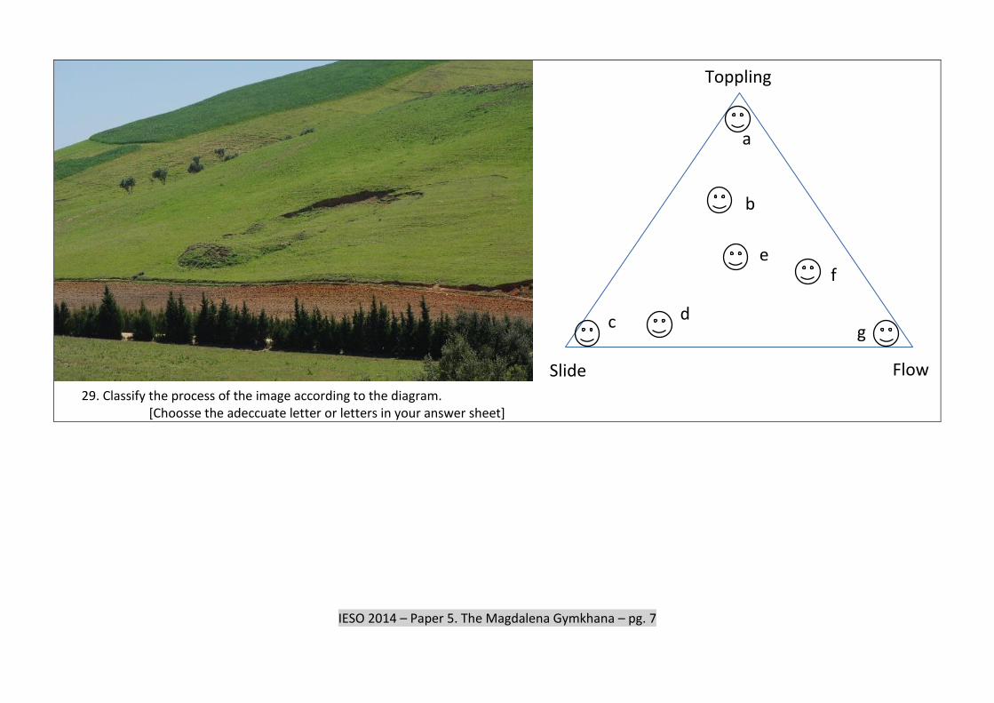
29. Classify the process of the image according to the diagram.
[Choosse the adeccuate letter or letters in your answer sheet]
g
f
e
b
a
d c
Slide
Toppling
Flow
IESO 2014 – Paper 5. The Magdalena Gymkhana – pg. 8
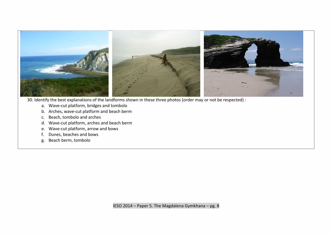
30. Identify the best explanations of the landforms shown in these three photos (order may or not be respected) :
a. Wave-cut platform, bridges and tombolo b. Arches, wave-cut platform and beach berm c. Beach, tombolo and arches d. Wave-cut platform, arches and beach berm e. Wave-cut platform, arrow and bows f. Dunes, beaches and bows g. Beach berm, tombolo

IESO 2014 – Paper 5. The Magdalena Gymkhana – pg. 9
27. This is fluvial environment very close to the coast. Choose the sentences that can be deduced from the image:
a) Climate is extremely arid, hence the scarce vegetation b) Climate is semiarid with short-intense rains, and this explains the high energy sediments c) Climate is humid but most water infiltrates, as can be deduce from the carbonate pebbles and boulders d) The image is an intertidal area, and transport of detritics happens only during high tides e) The channel is artificial, that the reason for such high energy sediments in a place that is now dry f) The images shows an sporadic channel that is active only during intense storms

IESO 2014 – Paper 5. The Magdalena Gymkhana – pg. 10
THIRD PART

IESO 2014 – Paper 5. The Magdalena Gymkhana – pg. 11
THIRD PART
The provided image shows 5 topographic maps and 10 topographic sections. Some section correspond to the provided maps, but some are not. Sections are built along diagonals of the map. Sections a to e are always NW-SE from left to right, while sections f to j are always SW-NE from left to right. In every map one, two or none sections can be adecuate. If no section is adequate for a map mark letter X in your answer sheet.
28. Which section/s correspond to map 1? [Chose the letter of letters in your answer sheet]
29. Which section/s correspond to map 2? [Chose the letter of letters in your answer sheet]
30. Which section/s correspond to map 3? [Chose the letter of letters in your answer sheet]
31. Which section/s correspond to map 4? [Chose the letter of letters in your answer sheet]
32. Which section/s correspond to map 5? [Chose the letter of letters in your answer sheet]
IESO 2014 – Paper 5. The Magdalena Gymkhana – pg. 12
FOURTH PART – Dry Option
33. Use the provided coordinates to draw in your map the assigned sites. (In this question, you will get one point for every site correcty drawed in your map, and 0,25 for every wrong site. Maximum allowance: 1 cm).
Point 1. X 438001, Y 4813123 Point 2. X 438152, Y 4813068 Point 3. X 438186, Y 4813031 Point 4. X 437748, Y 4813082 And now, use your map and go to the assigned sites. 34. Site 1. Find the strike and dip of this outcrop 35. Site 2. Do the fossils you can find in the outcrop correspond to some of the fossils mentioned in
the map? Which? 36. Site 2. According with your identification of the fossils, at what unit belongs this outcrop? 37. Site 3. The signal reads “Natural Area-Danger” (Area Natural-Peligro) . Identify the natural and
human hazards that may happens in this point. a) Fire b) Falling to the cliff or sink c) Earth slide d) Rock slide e) Subsidence f) Collapse g) Water columns during storms h) Strong rains i) It is a mistake there are not natural dangers
38. Site 4. Write in your answer sheet the time of your arrival (ask the volunteer in charge).
Decide the best description for the beach at this moment of the day: a) Low tide (approximately) b) High tide (approximately) c) Tide rising d) Tide falling e) Impossible to know
39. Site 4. Write the approximate time of the following low tide.

IESO 2014 – Paper 5. The Magdalena Gymkhana – pg. 13
Texts in the map to be translated: 1. Legend 2. Buildings 3. Faults 4. Strike and dip 5. Contacts
5.1. Inferred concordance 5.2. Concordance 5.3. Discordance 5.4. Limit of covered area 5.5. Limit sea-land 5.6. Contours
6. Lithology 6.1. Unit C1 covered/uncovered 6.2. Unit C2 covered/uncovered 6.3. Unit C3 covered/uncovered 6.4. Unit C4 covered/uncovered 6.5. Unit C5 covered/uncovered 6.6. Unit A2 covered/uncovered 6.7. Unit A1 6.8. Marine Terraces 6.9. Slope deposits 6.10. Beach
7. Descripcion of units Q - Marine terraces, slope deposits and beach
A1 – Limestone – Albian, Cretaceous A2 – Brown and yellow sandstone and siltstones – Upper Aptian, Cretaceous C5 – Alternate limestone and marls – Upper Aptian, Cretaceous C4 – Limestones, nodular marls and sandstone – Upper Aptian, Cretaceous C3 – Alternate limestones and marls – Upper Aptian, Cretaceous C2 – Limestones with dissolution sub-planar porosity – Upper Aptian, Cretaceous C1 – Massive limestones – Upper Aptian, Cretaceous
8. Fossils legend 8.1. Pseudotoucasia santanderensis 8.2. Rudists 8.3. Turritellidae, Gastropoda 8.4. Corals 8.5. Gastropoda 8.6. Miliolidae 8.7. Brachiopods
8.8. Orbitolinidae
8.9. Fossil tracks
8.10. Shell fragmets

IESO 2014 – Paper 5. The Magdalena Gymkhana – pg. 14
FOURTH PART – Wet Option
Wet Option Use the provided coordinates to draw in your map the assigned sites.