the potential of photogrammetry for object monitoring … potential of photogrammetry for object...
TRANSCRIPT

Acta Montanistica Slovaca Ročník 16 (2011), číslo 4, 262-269
262
The Potential of Photogrammetry for Object Monitoring in Undermined
Areas
Václav Mikulenka, Roman Kapica and Dana Sládková1
Listed buildings and objects of general and historic value located in the Ostrava-Karvina Coal Basin were significantly affected by mining during the coal extraction era. Most of the buildings show damage while some of them have been renovated and others still wait for their turn. The essential aim of photogrammetric surveying is to define the geometric shape and create the visualizations of objects. Photogrammetric documentation of the current building condition can be used for renovation planning or for advertising purposes.
Key words: terrestrial photogrammetry, calibration, 3d modelling, surveying, scanning
Introduction
Monument buildings and objects of general or historic value have endured major impacts from deep coal mining in the Ostrava-Karviná Coal Basin. Many were damaged while some of them have been refurbished or are on the waiting list for renovation. The primary goal of photogrammetric surveying is to identify geometric shapes and to create object visualisations. Photogrammetric documentation of such buildings provides data of great documentary value to those studying the object current condition and/or the undermining impact development dynamics. Photogrammetric surveying data are a useful source for architectural, construction and technical research as well as for renovation planning or advertising.
The Institute of Geodesy and Mine Surveying of the Technical University of Ostrava has carried out photogrammetric assessments of a number of conservation objects located in the local coal basin. Some of them are the Church of St. Peter from Alcantara in Karviná-Doly; the Augsburg Protestant Church in Orlová; St. Barbara’s Church in Louky nad Olší; Mary Magdalene’s Church in Stonava; St. Ann’s Church in Polanka nad Odrou; etc.
All the objects from the above list are subject to long-term systemic monitoring and surveying. Fixed surveying points are located around them to independently assess the impact of coal extraction on the objects.
Triangulation and single image photogrammetry are the preferred surveying methods used and their respective pros and cons determine the specific role each of them plays in object documentation. Triangulation produces a 3D model for further visualisation [1, 2, 3, 4] while single-image photogrammetry produces a photo plan, which is only two-dimensional.
Instruments and software used
Non-metric cameras will suffice the purpose. Metric images were made by two digital cameras: Fuji
FinePix S2 Pro, a professional reflex camera with a Super CCD chip producing a 12.1 Mpix (4,256 by 2,848) resolution; and Canon EOS 30D with EF-S 17-85 mm lens, a professional reflex camera with an 8.2 Mpix (3,504 x 2,336) resolution. Geodetic polygons and control points were surveyed by the Leica TPS 1200+ motorized total station with an integrated GPS receiver. We also test-used the scanning module application on the neo-Gothic and neo-Renaissance tombs of the Staněk and Forner families. Both were built in the late 19th century and are parts of the St Peter’s Church. While the application software adds useful extra features to the total station, it is not the best option for façade imaging. The imaging process took several hours to provide scans of the required resolution.
The Photomodeler is one of the most popular digital tools in triangulation. The software is designed to create and identify measurements of 3D objects from photographs. It uses a numerical algorithm based on the light ray bundle adjustment procedure applied to a set of convergent images.
The 3D model was created by means of Photomodeler 6 with a Coded Targets module and the latest version of Photomodeler Scanner by EOS Systems Inc., Canada. Photomodeler version 6 comes with largely enhanced high-quality presentation capabilities for 3D model visualisations and animations. The features include the export of models in VRML format with user-defined background and camera points included 1 M.Sc., Václav Mikulenka, Ph.D., M.Sc., Roman Kapica, Ph.D., M.Sc., Dana Sládková, Ph.D., VŠB-TU Ostrava, HGF, The Institute
of Geodesy and Mine Surceying, Address: 17. listopadu 15, 708 33 Ostrava-Poruba

Acta Montanistica Slovaca Ročník 16 (2011), číslo 4, 262-269
263
as viewpoints. The Show Rays feature now visualises the control rays for selected elements of the model enabling visual control of the surveying data. Version 6 can also create median error ellipses. Photomodeler Scanner features automatic generation of digital surface models (DSM) in the form of a point cloud. The feature eliminates the complex work of creating the models out of points and lines. The software can combine the parallel imaging and the convergent imaging methods to evaluate surfaces of complex shapes. The Photomodeler is a useful tool for the documenting of buildings, historic monuments, archaeological sites, forensic engineering sites and other areas [7, 8, 9].
Image transformation, masking and image mosaics were made by means of the TOPOL xT 9.5 DMT software. Adjusted raster images are then imported in Microstation V8, a software with advanced vector creation and vector control capabilities, and converted into vector images.
The following section will focus on the St Peter’s of Alcantara Church of the Augsburg Protestant Church in Orlová.
Description of the St Peter’s of Alcantara Church of the Augsburg Protestant Church in Orlová
Situated in the cadastral area of Karviná II-Doly alongside the Ostrava-Karviná road (Fig. 1), it finds
itself within the mining impact area of two collieries: Československá armáda and Darkov. The baroque church was built in 1735. While coal extraction began in 1854, early mining effects had not become visible until 1891, the date of the early written records of mining in the church’s underground. The original spire was pulled down during the church refurbishment in 1935. The next round of repairs followed in 1969
including the levelling out of the floor tilt that had reached up to 70 mm per meter. The latest renovations date back to 1994-1995 when a static stabilisation and general repair of the building were made. Landscaping and surface rehabilitation works were made in the church’s neighbourhood in 1999-2000 [5, 6].
Fig. 1. The baroque St. Peter’s Church in Karviná.
The Protestant church in Orlová was
founded in 1861. Building completion and consecration followed the year after. (Fig. 2) The church, a single-nave structure with a more recently altered spire, was built of brickwork in the late classical style. The facade is rather articulated with many cornices and rosettes. Showing evident undermining effects, the church was rehabilitated several times. The latest large-scale rehabilitation was carried out only in 2005 stabilising the church structure by applying modern technologies and renovating the facade.
Fig. 2. The Protestant Church in Orlová.

Václav Mikulenka, Roman Kapica and Dana Sládková: The Potential of Photogrammetry for Object Monitoring in Undermined Areas
264
The 3D Model Creation Process
The photogrammetric surveying campaign consisted of the following steps:
• Area reconnaissance, • Polygon point and control point surveying, • Camera calibration, • Photogrammetric imaging, • 3D model creation: image imports, referencing of points, 3D model general-position calculation,
creating a vector image, adding real textures, scale adjustment, model rotation, quality control, • Visualisation, animation, • Export in VRML, CAD, Google Earth and AVI formats.
Having set the scale and orientation of the model, 65 control points were surveyed on the church objects
with the total station and the points were referenced to a local coordinate system. We shot 37 images of the St. Peter’s Church and 45 images of the Protestant Church in Orlová, each with a resolution of 3,504 x 2,336 pixels. The imaging was made outside the vegetative season to avoid distortion by the green cover.
Ideally, the lines of sight should be perpendicular. Where this is not possible, the angle between the imaging axes can be smaller in triangulation. But acute angles are detrimental to the accuracy of the resulting 3D model. There are several conditions to be observed while shooting the calibration field images and the object itself. One of the crucial rules is that focal fixation and a suitable configuration should be identical for all images. As far as local circumstances allow, regularly shaped objects are best shot using the circular method or the multiple circle method.
Calibration is made by means of a planar or spatial test field. The A3-A0 sized 2D fields were based on Photomodeler v. 6. The results were summed up in the calibration protocol listing the internal parameters of both photo cameras (stadia constant, principal point, lens distortion, etc.) as in the calibration file. Calibration was always done with fixed values for focal length, shutter speed and focus distance. Digital devices practical testing and calibration was made by means of the 3D model of the surveying observatory at the Institute of Geodesy and Mine Surveying (Fig. 3) that consists of 24 50 mm round marks. Geodesic surveying of the point marks was made and the point mesh was related to an autonomous grid to calculate their respective X, Y, and Z coordinates. [3] A suitable test field was identified on the basis of the process total error and the residual error. The audit dialog provided a prediction of the calculation success.
Fig. 3. 3D field and 50-mm marks.

Acta Montanistica Slovaca Ročník 16 (2011), číslo 4, 262-269
265
Photomodeler 6 works with manual point referencing and the image orientation is followed by a step-
for-step creation of a vector model. Images after orientation are combined with the Photomodeler 3D preview, which makes the vector system and all the other model elements appear in the image and vice versa. (Fig. 4) The model is ready to receive real textures from the photographic images or user defined textures. A combination of a 3D model enhanced with real textures and geometric data maximizes the information yield. The model can be depicted as an anaglyphic image. Where parts of the object are behind green cover or other objects, alternative images from a different photogrammetric point can be used instead. The model
is snapped to scale by means of a point-to-point distance measurement or using the control point coordinates. Then follows the definition of the coordinate system zero point and of model rotation in terms of X, Y, Z coordinates. Fig. 4 shows a photogrammetric image combined with vector lines, photogrammetric camera points and lines of sight plus the anaglyph showing the local coordinate system. Fig. 4. 3D model visualisation.
Figure 5 shows the photogrammetric image of the Protestant Church in Orlová with the vector lines
and a model with median error ellipses.
Fig. 5. 3D model of the Protestant Church in Orlová.
Such 3D models allow exporting in numerous external formats, usually VRML that allows model viewing via a web interface. Cortona 3D application is required to view objects in VRML 2.0 format. An animation can be created by storing a sequence of key images in 3D View.

Václav Mikulenka, Roman Kapica and Dana Sládková: The Potential of Photogrammetry for Object Monitoring in Undermined Areas
266
The KML/KMZ format export allows connecting of the object to the ground in Google Earth, a freeware available on the Internet that visualises satellite images, maps, terrain and buildings in 3D. A transformation into aerial photography is possible on the basis of 3 points of known latitude, longitude and altitude. (Fig. 6) Accurate coordinate values are no guarantee for an exact positioning of a model on the ground. Adjustments can be made by means of the “Connect to the ground” feature or manually by means of a mouse in the 3D model.
Fig. 6. 3D model in Google Earth.
A set of 12-bit coded targets from the auxiliary module of Photomodeler Scanner were located around
the objects to generate a DSM point cloud. Different sizes and versions of the coded targets can be printed out to suit a wide variety of project scopes. The image coded targets are identified and assigned target numbers automatically. The coded targets enable automated orientation of photogrammetric images achieving high accuracy. (Fig. 7) Photos for DSM projects use both parallel and convergent orientation methods. Parallel images are made with at least 60 % overlap. The point field is calculated from image pairs.

Acta Montanistica Slovaca Ročník 16 (2011), číslo 4, 262-269
267
The calculation of calibration parameters and image orientation is followed by running the Idealize module (Fig. 8), which will create an idealized photo camera with no lens distortion and no image principal point. The idealized camera becomes part of the project. The object is snapped to a coordinate system before the calculation. Then the DSM area is identified and point field density is determined. Where the surface lacks features, the points can wander away from the area of scrutiny. The effect is called “signal noise.” The point field is open for editing of possible errors and for a transformation into a triangular network with attached textures or into a contoured image. (Fig. 9) The picture below shows a point cloud around the Staněk and Forner tomb entrance.
Fig. 8. This image is a screen shot of Photomodeler Idealize Module and Scanner showing a textured 3D point cloud.
Fig. 9. Tomb entrance door, point clouds.
The making of a photo plan
The facade photo plan and the details were evaluated by digitally re-drawing the photogrammetric images by means of the TOPOL xT 9.5 DMT software. But the method is constrained by deformations in the
Fig. 7. A Photomodeler Scanner coded target.
Václav Mikulenka, Roman Kapica and Dana Sládková: The Potential of Photogrammetry for Object Monitoring in Undermined Areas
268
photo plan caused by the complex in-depth topography of the building face. Where possible, images were made using horizontal lines of sight that were perpendicular to the object face.
The evaluation of the photo plan proceeded along the following steps: • Transform initial images to control documentation points, • Process data (masking, creating an image mosaic), • Create a vector matrix over the photo plan, • Quality control by checking photo plan control lengths against real lengths on the building, • Export data (vector sets/rasters in a standard format of choice).
Control points from the 3D Photomodeler evaluation were used to make the image transformation with
some help of such facade features as window corners, cornices, juts and dents. The images were shot on overcast days with even light distribution and no shadows.
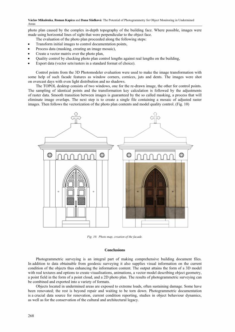
The TOPOL desktop consists of two windows, one for the re-drawn image, the other for control points. The sampling of identical points and the transformation key calculation is followed by the adjustments of raster data. Smooth transition between images is guaranteed by the so called masking, a process that will eliminate image overlaps. The next step is to create a single file containing a mosaic of adjusted raster images. Then follows the vectorization of the photo plan contents and model quality control. (Fig. 10)
Fig. 10. Photo map, creation of the facade.
Conclusions
Photogrammetric surveying is an integral part of making comprehensive building document files. In addition to data obtainable from geodesic surveying it also supplies visual information on the current condition of the objects thus enhancing the information content. The output attains the form of a 3D model with real textures and options to create visualisations, animations, a vector model describing object geometry, a point field in the form of a point cloud, and a 2D photo plan. The results of photogrammetric surveying can be combined and exported into a variety of formats.
Objects located in undermined areas are exposed to extreme loads, often sustaining damage. Some have been renovated; the rest is beyond repair and waiting to be torn down. Photogrammetric documentation is a crucial data source for renovation, current condition reporting, studies in object behaviour dynamics, as well as for the conservation of the cultural and architectural legacy.

Acta Montanistica Slovaca Ročník 16 (2011), číslo 4, 262-269
269
References
[1] Fraštia, M., Bajtala, M., Sokol, Š.: Photogrammetric determination of the spatial shape of the clinker silo. Acta Montanistica Slovaca, Vol. 12 (2007), special issue no. 3, pp. 361-365. http://actamont.tuke.sk/pdf/2007/s3/9frastia.pdf
[2] Gašinec, J, Pukanská, K., Rakay, Š., Rakay, Š. ml., Gašincová, S., Imreczeová, A.: Detailed spatial orientation of underground spaces. Extraction and treatment advanced technologies on earh sources: The I.Scientific Symposium: Conference proceedings:Jelšava castle in Slovakia, 10th-11th March 2011. pp. 238-242. - ISBN 978-80-553-0635-3.
[3] Gašinec, J., Gašincová, S., Černota, P., Staňková, H.: Applications Terrestrial laser scanning for documenting ice fill Dobšinská ice caves and solution related problems in the programming language Python. SDMG 2011: Conference proceedings of the 18th Conference: Prague, 5th-7th October 2011. Ostrava: Technical University, 2011, pp. 51-59. ISBN 978-80-248-2489-5.
[4] Fraštia, M.: Creation of the accurate spatial models of historical objects by the close-range photogrammetry method, Acta Montanistica Slovaca, vol. 14 (2009), special issue no. 1, 34-40, ISBN 9788089175253.
[5] Kapica, R., Böhmová, D., Gavlovský, E.: Surveying of risk areas stereommetry in real time (Zaměřování rizikových prostor stereometrií v reálném čase). Professional and scientific journal of the Czech office for surveying, mapping and cadastre and Geodetic, cartographic and cadastre Institute of Slovak republic, (Odborný a vědecký časopis Českého úřadu zeměměřického a katastrálního a Úradu geodézie, kartografie a katastra Slovenskej republiky). Vol. 2007, no. 3., Journal GaKO ISSN 0016-7096, published by: Vesmír, spol. s r. o., Praha 2007.
[6] Mikulenka, V., Kapica R.: Die Einflusse der Grubenförderung auf spezielle oberfläche Gebäude in Ostrau - Karvin Kohlenrevier, Heft 2008 : 9. Geokinematischer Tag. Schriftenreihe des Instituts für Markscheidewesen und Geodäsie der TU Bergakademie Freiberg, ISBN 978-3-86797-018-1.
[7] Pukanská, K., Sabová, J., Rusnáková, K., Gajdošík J.: Deformation evaluation of rock cuts using laser scanning. Coal-Ore-Geological Survey. (Vyhodnotenie deformácií skalných zárezov pomocou laser scanningu. Uhlí-Rudy-Geologický průzkum). 3/2008, pp. 28-31 (ISSN 1210-7697).
[8] Pukanská, K., Sabová, J., Chlepková, M., Gajdošík, J.: New technologies in the documentation of historical monuments, (Nové technológie v dokumentácii historických pamiatok). In: Monumentorum tutela. - Bratislava: Pamiatkový úrad SR, 2008 pp. 310-318. - ISBN 9788089175253.
[9] Sabová, J., Pukanská, K.: Projekt der Deformationsuntersuchungen, - 2007. In: Acta Montanistica Slovaca. Vol. 12, special issue no. 3 (2007), pp. 516-519. - ISSN 1335-1788.