the professional mapping drone - geometius · packages: emotion (flight planning and control) ......
TRANSCRIPT
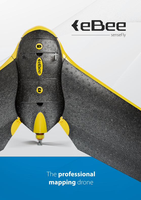
The professional mapping drone
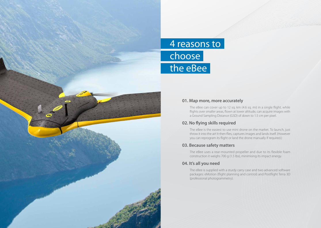
4 reasons to choose the eBee
01. Map more, more accurately The eBee can cover up to 12 sq. km (4.6 sq. mi) in a single flight, while
flights over smaller areas, flown at lower altitude, can acquire images with a Ground Sampling Distance (GSD) of down to 1.5 cm per pixel.
02. No flying skills required The eBee is the easiest to use mini drone on the market. To launch, just
throw it into the air! It then flies, captures images and lands itself. (However you can reprogram its flight or land the drone manually if required.)
03. Because safety matters The eBee uses a rear-mounted propeller and due to its flexible foam
construction it weighs 700 g (1.5 lbs), minimising its impact energy.
04. It’s all you need The eBee is supplied with a sturdy carry case and two advanced software
packages: eMotion (flight planning and control) and Postflight Terra 3D (professional photogrammetry).
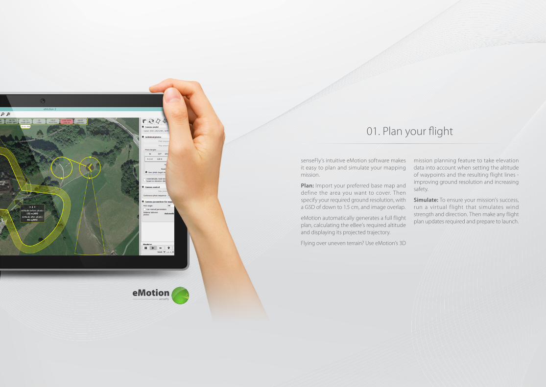
01. Plan your flight
senseFly’s intuitive eMotion software makes it easy to plan and simulate your mapping mission.
Plan: Import your preferred base map and define the area you want to cover. Then specify your required ground resolution, with a GSD of down to 1.5 cm, and image overlap.
eMotion automatically generates a full flight plan, calculating the eBee’s required altitude and displaying its projected trajectory.
Flying over uneven terrain? Use eMotion’s 3D
mission planning feature to take elevation data into account when setting the altitude of waypoints and the resulting flight lines - improving ground resolution and increasing safety.
Simulate: To ensure your mission’s success, run a vir tual f light that simulates wind strength and direction. Then make any flight plan updates required and prepare to launch.
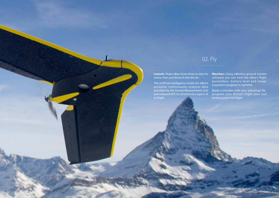
02. Fly
Launch: Shake eBee three times to start its motor, then just throw it into the air.
The artificial intelligence inside the eBee’s autopilot continuously analyses data provided by the Inertial Measurement Unit and onboard GPS to control every aspect of its flight.
Monitor: Using eMotion ground station software you can view the eBee’s flight parameters, batter y level and image acquisition progress in real time.
Made a mistake with your planning? Re-program your drone’s f light plan and landing point mid-flight.
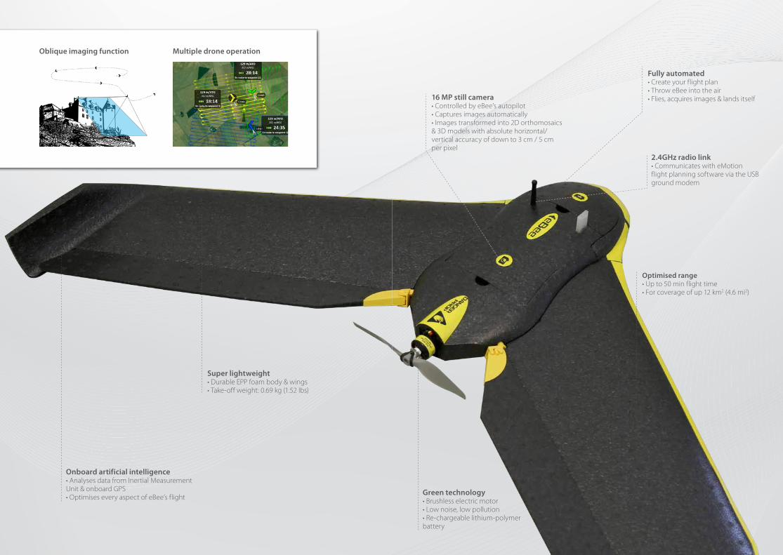
Optimised range• Up to 50 min flight time• For coverage of up 12 km2 (4.6 mi2)
Fully automated• Create your flight plan• Throw eBee into the air• Flies, acquires images & lands itself
Green technology• Brushless electric motor• Low noise, low pollution• Re-chargeable lithium-polymer battery
16 MP still camera • Controlled by eBee’s autopilot • Captures images automatically• Images transformed into 2D orthomosaics & 3D models with absolute horizontal/vertical accuracy of down to 3 cm / 5 cm per pixel
2.4GHz radio link• Communicates with eMotion flight planning software via the USB ground modem
Onboard artificial intelligence• Analyses data from Inertial MeasurementUnit & onboard GPS• Optimises every aspect of eBee’s flight
Super lightweight• Durable EPP foam body & wings• Take-off weight: 0.69 kg (1.52 lbs)
Oblique imaging function Multiple drone operation
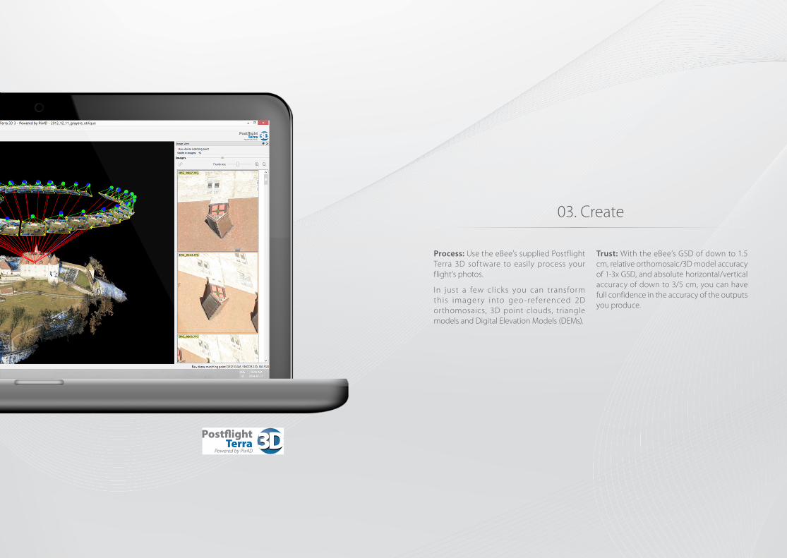
03. Create
Process: Use the eBee’s supplied Postflight Terra 3D software to easily process your flight’s photos.
In just a few clicks you can transform this imager y into geo -referenced 2D orthomosaics, 3D point clouds, triangle models and Digital Elevation Models (DEMs).
Trust: With the eBee’s GSD of down to 1.5 cm, relative orthomosaic/3D model accuracy of 1-3x GSD, and absolute horizontal/vertical accuracy of down to 3/5 cm, you can have full confidence in the accuracy of the outputs you produce.
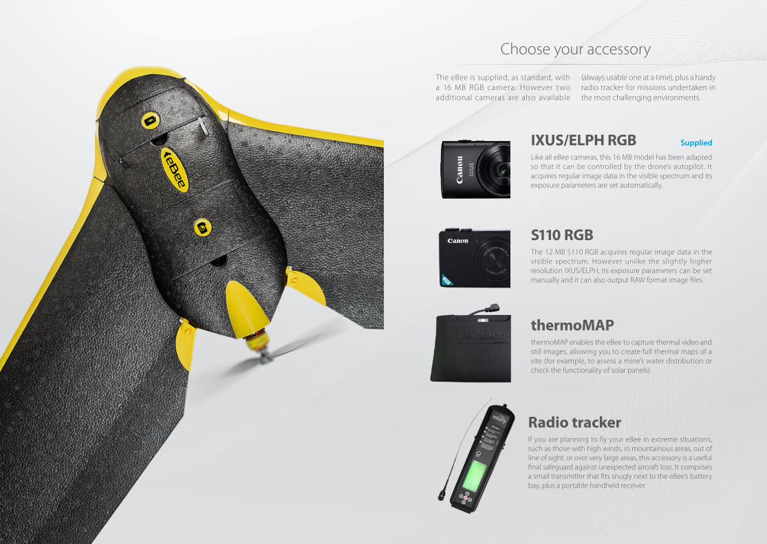
Choose your accessory
The eBee is supplied, as standard, with a 16 MB RGB camera. However two additional cameras are also available
(always usable one at a time), plus a handy radio tracker for missions undertaken in the most challenging environments.
IXUS/ELPH RGB
S110 RGB
thermoMAP
Like all eBee cameras, this 16 MB model has been adapted so that it can be controlled by the drone’s autopilot. It acquires regular image data in the visible spectrum and its exposure parameters are set automatically.
The 12 MB S110 RGB acquires regular image data in the visible spectrum. However unlike the slightly higher resolution IXUS/ELPH, its exposure parameters can be set manually and it can also output RAW format image files.
thermoMAP enables the eBee to capture thermal video and still images, allowing you to create full thermal maps of a site (for example, to assess a mine’s water distribution or check the functionality of solar panels).
If you are planning to fly your eBee in extreme situations, such as those with high winds, in mountainous areas, out of line of sight, or over very large areas, this accessory is a useful final safeguard against unexpected aircraft loss. It comprises a small transmitter that fits snugly next to the eBee’s battery bay, plus a portable handheld receiver.
Radio tracker
Supplied
Content and images non contractual © 2014 senseFly Ltd
About senseFly: senseFly designs, assembles and markets autonomous mini-drones and related software solutions for civil professional applications such as precision agriculture, land surveying, GIS, construction, environmental conservation and more.
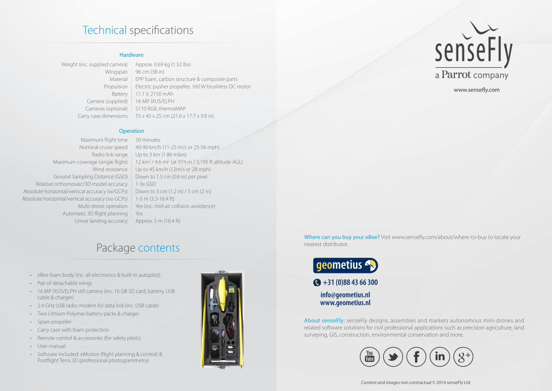
Technical specifications
Weight (inc. supplied camera)Wingspan
MaterialPropulsion
BatteryCamera (supplied)
Cameras (optional)Carry case dimensions
Hardware
Operation
Approx. 0.69 kg (1.52 lbs)96 cm (38 in)EPP foam, carbon structure & composite partsElectric pusher propeller, 160 W brushless DC motor11.1 V, 2150 mAh16 MP IXUS/ELPH S110 RGB, thermoMAP55 x 45 x 25 cm (21.6 x 17.7 x 9.8 in)
50 minutes 40-90 km/h (11-25 m/s or 25-56 mph) Up to 3 km (1.86 miles) 12 km2 / 4.6 mi2 (at 974 m / 3,195 ft altitude AGL)Up to 45 km/h (12m/s or 28 mph) Down to 1.5 cm (0.6 in) per pixel1-3x GSDDown to 3 cm (1.2 in) / 5 cm (2 in)1-5 m (3.3-16.4 ft)Yes (inc. mid-air collision avoidance) YesApprox. 5 m (16.4 ft)
Maximum flight timeNominal cruise speed
Radio link rangeMaximum coverage (single flight)
Wind resistanceGround Sampling Distance (GSD)
Relative orthomosaic/3D model accuracyAbsolute horizontal/vertical accuracy (w/GCPs) Absolute horizontal/vertical accuracy (no GCPs)
Multi-drone operationAutomatic 3D flight planning
Linear landing accuracy
Package contents
• eBee foam body (inc. all electronics & built-in autopilot)
• Pair of detachable wings
• 16 MP IXUS/ELPH still camera (inc. 16 GB SD card, battery, USB cable & charger)
• 2.4 GHz USB radio modem for data link (inc. USB cable)
• Two Lithium-Polymer battery packs & charger
• Spare propeller
• Carry case with foam protection
• Remote control & accessories (for safety pilots)
• User manual
• Software included: eMotion (flight planning & control) & Postflight Terra 3D (professional photogrammetry)
+31 (0)88 43 66 [email protected]
stickers_40x30_150813.indd 1 16 augustus 2013 11:51
www.sense�y.com
Where can you buy your eBee? Visit www.sense�y.com/about/where-to-buy to locate your nearest distributor.
EN
For eBee updatessubscribe to our newsletter at
www.sensefly.com