the social dimensions of human-elephant conflict in …...the social dimensions of human-elephant...
TRANSCRIPT

The social dimensions of human-elephant conflict in Africa:
A literature review and case studies from Uganda and Cameroon
Lisa Naughton*, Robert Rose* and Adrian Treves†
*Department of GeographyUniversity of Wisconsin, Madison
550 N. Park StreetMadison, WI 53706
[email protected]; [email protected]
†Department of ZoologyUniversity of Wisconsin, Madison
250 N. Mills StreetMadison, WI 53706
A Report to the African Elephant Specialist , Human-Elephant Task Conflict Task Force, ofIUCN, Glands, Switzerland.
December 1999

2
Acknowledgments:
Several individuals and organizations provided support:
In Cameroon, Robert Rose’s fieldwork was funded by the Wildlife Conservation Society,through a grant by Dutch Foreign Aid. The Cameroon case study was aided greatly by theexpertise of WCS field staff, particularly Anthony Nchanji, Roger Fotso, and Bryan Curran.Walters Arrey was responsible for monitoring crop damage during July-October 1999.
In Uganda, Lisa Naughton and Adrian Treves’ fieldwork was funded by the WildlifeConservation Society, National Geographic, Makerere University Biological Field Station, NSF,and Fulbright-Hays. Pascal Baguma and Patrick Katuramu provided first-rate assistance withdata collection and interviews around Kibale National Park. Patrick Ilukol and Erica Cochranegenerously shared their knowledge of elephant movement and raiding behavior at Kibale.
In Madison, Karen Archabald provided comments on draft excerpts of this report. Erin Olson-Dedjoe and Nora Alvarez helped with data entry.
Finally, Richard Hoare deserves special thanks for his expert counsel and assistance throughoutthe study.
3
Table of Contents
Acknowledgements…………………………………………………………………………………….2Table of Contents………………………………………………………………………………………3List of Tables and Figures……………………………………………………………………………...4
I. INTRODUCTIONA. Overview………………………………………………………………………………..…6
B. Physical and social factors intensifying human-elephant conflict in Africa………………8
II. LITERATURE SURVEYA. Estimating crop loss to pests in developing countries………………………………….…11
B. The social significance of crop pests. Collective versus individual coping strategies ….12
C. Comparing elephants to other wildlife ‘pests’ in African forests and savannas…….…....14
III. CASE STUDY: LOCAL RESPONSE TO CROP DAMAGE BY ELEPHANTS AND OTHERWILDLIFE AROUND KIBALE NATIONAL PARK, UGANDA
A. Introduction and historical background……………………………………………….…21
B. Results of previous research on crop raiding at Kibale………………….………………26
C. 1999 Research……………………………………………………………………………28
IV. DAMAGE PATTERNS BY ELEPHANTS AND OTHER WILDLIFE AROUND BANYANG-MBO WILDLIFE SANCTUARY, CAMEROON
A. Introduction………………………………………………………………………………41
B. Background……………...………………………………………………………………..43
C. Field Research on Human-Elephant Conflicts at Banyang-Mbo…………………………47
D. Discussion and Management Implications………………………………………………..65
V. CONCLUSIONS……………………………………………………………………………..……68
APPENDIX 1. Study methods for human-elephant conflict researchA. Recommendations for research design and methodology………………………………...70
B. Comments on proposed HETF data collection protocol…………………………………..74
APPENDIX 2. References. …………………………………………………………………………...77
4
List of Tables and Figures
II. INTRODUCTIONTable II.1. Estimates of crop damage by elephants in Africa……………………………………..…..15
Table II.2. Ranking elephants and other wildlife pests in Africa…………………………...……..17-18
Figure II.1. Schematic of factors influencing local tolerance for wildlife pests………..……….……20
III. CASE STUDY: LOCAL RESPONSE TO CROP DAMAGE BY ELEPHANTS AND OTHERWILDLIFE AROUND KIBALE NATIONAL PARK, UGANDA
Figure III.1. Map of Kibale National Park, Uganda. …………………………………………..……..22
Figure III.2. Elephant Control in Uganda, 1925-1984………………………………………………..25
Figure III.3. Study sites and zones of chronic elephant conflict around Kibale National Park,Uganda. (1992-1999)…… ………………………………………………………..……27
Figure III.4. Distribution of farm size in 5 villages around Kibale National Park, Uganda……….…30
Table III.1. Crop damage by animals in farms neighboring Kibale National Park, Feb-Aug 1999…..32
Figure III.5. Area damaged by wildlife and livestock in 3 villages around Kibale National Park,Feb-Aug 1999………………………………..………………………………………….33
Figure III.6. Direct costs of crop damage by the worst 5 animals on farms neighboring KibaleNational Park, Feb-Aug 1999………………………………..……………………….…35
Figure III.7. Total direct costs of crop damage in 51 farms neighboring Kibale National ParkFeb-Aug 1999………………………………..………………………………………….36
Figure III.8. Frequency of elephant forays as a function of distance from the boundary of KibaleNational Park, 1992-4, 1999……………………………………………………..….…..37
Figure III.9. Percentile plot comparing size of active and abandoned farms……………………..…..39
IV. CASE STUDY: DAMAGE PATTERNS BY ELEPHANTS AND OTHER WILDLIFEAROUND BANYANG-MBO WILDLIFE SANCTUARY, CAMEROON
Figure IV.1 Map of Banyang-Mbo Wildlife Sanctuary, South-West Cameroon. ……………………42
Figure IV.2 1986 Landsat MSS image of the Banyang-Mbo Wildlife Sanctuary, Cameroon. ………45
Figure IV.3 Distribution of agricultural lands between villages and the Banyang-Mbo WildlifeSanctuary, Cameroon. ………………………………………………………………….……48
Figure IV.4 Villages with chronic elephant damage re: Nchanji and Lawson (1998)………..50
5
List of Tables and Figures (cont.)
Figure IV.5 Locations of elephant and buffalo damage reported during the pilot study(February – April, 1999). ……………………………………………………...………….…52
Figure IV.6 Villages selected for the long-term crop monitoring study (June – October, 1999). ……58
Table IV.1: Crop damage by wildlife around Banyang-Mbo Wildlife Sanctuary, June –October 1999…………………………………………………………………………..……60
Table IV.2: Amount of damage by crop type, Banyang-Mbo Wildlife Sanctuary, June –October 1999……………………………………………………………………………..…61
Figure IV.7 Monthly pattern of wildlife damage to crops at Banyang-Mbo Wildlife Sanctuary,Cameroon (June – October 1999). …………………………………………………………..61
Table IV.3: Crop damage according to field condition, Banyang-Mbo Wildlife Sanctuary,June – October 1999…………………………………………………………………62
Table IV.4: Crop damage by buffalo gathered during the opportunistic data collection(June 1999 – October 1999). …………………………………………………………...……62
Figure IV.8 Crop damage by cane rats and other wildlife as a function of distance fromvillages. …………………………………………………………………………..……63
Figure IV.9 Locations of buffalo damage reported during the long-term crop monitoring study(June – October, 1999). ……………………………………………………………...………64

6
I. INTRODUCTION
A. OverviewFew animals elicit such drastically different human emotions as do elephants. Elephants capture the
imagination and unswerving affection of people worldwide, but inspire animosity and fear among
those sharing their land with these huge animals. Field reports from across Africa describe local
antipathy to elephants beyond that expressed for any other wildlife. People living in central African
forests “fear and detest” elephants (Barnes 1996:77). Farmers in Zimbabwe display “ingrained
hostility” to elephants who are the “focus of all local animosity toward wildlife” (Wunder
1997:314,316). Rural Ugandans complain bitterly about elephants, except where they have been
eradicated (Hill 1998; Naughton-Treves 1997), and in Burundi, farmers still dread elephants years
after the country’s last were killed (A. Weber, WCS, pers. comm.). This animosity is an ominous sign
for future elephant survival, particularly given the trend toward decentralized wildlife management
throughout Africa. Under current conditions, most local farmers would eliminate elephants from their
environment if given the choice. Conservationists must find ways to raise public tolerance of
elephants, and this requires a better understanding of elephants as ‘pests’. Do local complaints match
the economic impact of elephants on agricultural communities? Why does human-elephant conflict
appear to be intensifying even though elephant numbers have declined dramatically across the
continent? How can we protect vulnerable individuals from the costs of wildlife while maintaining
elephants for regional and global benefits?
In this report, we analyze the social and physical factors that shape local attitudes to African
elephants. Our aim is to provide a broader view of the sociopolitical and ecological dimensions of
human-elephant conflict. We confirm that elephants pose a serious threat to some members of
farming communities, but that in most cases, elephants’ regional economic impact on agriculture is
negligible relative to other vertebrate and invertebrate pests. Nonetheless, human-wildlife conflict is a
major obstacle to community support for conservation, and the hostility of a vocal minority can
undermine regional conservation initiatives (De Boer and Baquete 1998; Gillingham and Lee 1999;
Naughton-Treves 1997; Nchanji and Lawson 1998; Newmark et al. 1994).
Our analysis is organized around an extensive literature review coupled with two in-depth case
studies. First, we survey reports from 15 African countries to explore the physical and social factors
that intensify human-elephant conflict. We also draw from the general literature on pests and risk in
African peasant agriculture to better understand why some communities may be unable or unwilling
7
to tolerate crop losses. Then we compare elephants to other wildlife pests and examine the spatial and
temporal patterns of crop damage by elephants.
In our literature review we find that the database on crop damage amounts and patterns is poor and
burdened by ill-defined methods that limit comparisons between species and between sites. Too often,
researchers exaggerate impacts by extrapolating results from crop-raiding ‘hot spots’ to entire
regions, and rarely do they compare farmers’ reports to systematic field measurements. For this
reason, we place special emphasis on research design and methods throughout this report. Finally, we
conclude that much of the best work is not easily available - e.g., many illuminating reports on
wildlife ‘pests’ are tucked away in local Game Department or Ministry of Agriculture archives. As
more managers and researchers turn their attention to human-wildlife conflict, we must disseminate
our results and experiences. On that note, the Human-Elephant Task Force (HETF) of IUCN’s
African Elephant Specialty Group deserves special commendation for their recent efforts to distribute
the results of pioneering research (e.g., the special issue of Pachyderm, vol. 19, 1995).
Our review of the literature sets the stage for a more detailed examination of human-elephant conflict
at two sites. The first, at Kibale National Park in western Uganda, illustrates the socioecological
dynamics of conflict at a ‘hard-edge’ (sensu Hoare 1995), i.e., where densely settled agriculture abuts
a park boundary. The second case comes from Banyang-Mbo Wildlife Sanctuary in western
Cameroon where elephants and agriculturalists coexist in a mosaic of planted fields, fallows,
secondary forests and protected forests. Both case studies show that elephants create distinctive,
highly localized crop damage patterns that are cataclysmic for the affected individual farmers, but
insignificant to the regional farming economy. At both sites, traditional, collective coping strategies
were all but absent and crop losses were absorbed by individual households. The Kibale case also
reveals that households with certain economic endowments (namely large landholdings) cope more
effectively with elephant raids than do their neighbors. Managers could ameliorate human-elephant
conflict if they could better predict high-risk zones for elephant raiding. We suggest hypotheses for
the spatial pattern of elephant raiding, and call for better monitoring, particularly in Africa’s forested
regions.
Finally, we offer conclusions on the human and ecological dimensions of wildlife conflict in Africa
and make research recommendations to improve the database on human-elephant conflict. The need
for this research to be cost-effective and participatory is especially challenging given the complexity
of most agroecosystems and variability of wildlife and farmer behavior over time and space. We

8
identify basic design principles for sound research on the issue, and discuss trade-offs in sampling
intensity and duration of study. Specifically, we evaluate the HETF protocol for monitoring human-
elephant conflict.
B. Physical and social conditions intensifying human-elephant conflict in Africa
Human-elephant conflict is not a new problem. Precolonial and early 19th c. historians describe areas
in Africa where elephant crop depredations caused food shortages and displaced settlements (Vansina
1990; Schweitzer in Barnes 1996:68). Forest dwellers in precolonial northern Gabon lived at the
“brink of starvation”, because their food supply was regularly devastated by elephants (Barnes
1996:68). In parts of western Uganda early this century, high elephant populations prevented
agriculture altogether (GDA 1924; Osmaston 1959). While some observers blame colonialism for
ruining traditionally harmonious relations between wildlife and local people (Adams and McShane
1992; Martyn 1991), others believe human-elephant conflict is as old as agriculture in Africa (Bell
1987; Naughton-Treves 1999).
Across most of Africa, habitat loss and the local extirpation of big game has reduced the geographical
range of human-elephant contact (Hoare 1995). Yet only one out of more than 30 studies published
during the 1980s and 1990s described a local decline in elephant crop raiding (Bell 1987). Why is
human-elephant conflict apparently intensifying? The answer lies in the fact that where elephants
persist, contemporary physical conditions draw them into close contact with humans, and
contemporary social conditions lower human tolerance of their presence. These conditions include:
Land use change:
Ø Human-elephant conflict is intensified by the spread of agriculture into previously
unoccupied wildlife habitat. This process may be driven by human population growth,
voluntary or state-sponsored settlements, or a shift to farming by pastoral communities.
The end result is that elephants and farmers compete directly for scarce land (Barnes
1996; Campbell et al. 1999; Gachago and Waithaka 1995; Graham 1973; Hill 1997; Kiiru
1995; Tchamba 1996; Thouless 1994; Thouless and Sakwa 1995; Western 1997).
Ø Elephants may be ‘packed’ into protected areas by habitat loss and poaching. Elephants
isolated in parks at high densities inevitably raid surrounding farms (Barnes et al. 1995;
Gachago and Waithaka 1995; Mwathe 1992; Naughton-Treves 1998; Thouless and
Sakwa 1995).
Ø In other areas (e.g., sites within Central Africa) declining human population density and
farm abandonment yields extensive fallow and secondary vegetation (Houghton 1994).

9
Remaining farms may be isolated amidst ‘bush’, and more vulnerable to raiding.
Similarly, localized soil degradation forces people to plant fields in scattered patterns at
ever greater distances from villages where they are more vulnerable to elephant raids
(Lahm 1996; Mascarenhas 1971).
Ø Human activities in African forests (e.g., logging) create abundant secondary vegetation
that attracts elephants and brings them closer to human settlements (Barnes et al. 1991;
Lahm 1996).
Ø Artificially maintained water sources attract elephants to human settlements during
droughts (Thouless 1994).
Ø The construction of canals, power installations and cattle fences can cut off traditional
migration routes and lead to unusually aggressive elephant behavior and conflict
(Kangwana 1995; Kothari 1996; Lahm 1994).
Changes of elephant behavior and socioecology due to human intervention
Ø Following the CITES listing and improved protection against poaching, elephant
numbers have increased within many parks and reserves and some elephants have lost
their fear of people (Gachago and Waithaka 1995; Kangwana 1995; Naughton-Treves
1998; Tchamba 1996).
Ø Elephants may be displaced by war and turn to crop raiding to survive in a resource-poor
habitat (Tchamba 1995).
Ø Elephants subject to intense hunting or culling form large groups and cause greater
damage to local crops and vegetation (Southwood 1977).
Changes in social relationships in rural communities
Ø Centralized, state ownership of wildlife and prohibitions on hunting lower local tolerance
of elephant raiding (Naughton-Treves 1997; Western 1997b).
Ø The trend toward privatized land ownership erodes traditional farming strategies based on
joint property and kin networks, and focuses the impact of crop loss on individuals rather
than communities (Agrawal 1997; Bell 1984; Lahm 1996). Similarly, at many sites
farmers have abandoned communal hunting, planting and guarding activities that once
reduced crop loss (Lahm 1996; Rose, unpub. data; Mubalama, 1996).
Ø Households in much of rural Africa can no longer rely on men to guard fields from
elephants because they have moved to cities, seeking employment (Lahm 1996).
Increased educational opportunities also releases children from their traditional role as
guards and sentinels against raiding wildlife (Goldman 1996).
10
Ø Politicians now pay closer attention to local citizens who complain loudly against
elephants, and this raises public awareness of the conflict (Dublin et al. in Barnes 1996;
anon. 1994; Hoare 1995; Kangwana 1995).
Together, these social and physical conditions exacerbate conflict that always existed between
elephants and agriculturalists. It is also important to recognize that no single factor or condition
explains human-elephant conflict across the continent. Elephants and agriculture meet and mix in
numerous ways with varying consequences (Hoare 1995). For example, human population growth
may heighten conflict with elephants in Kenya, Uganda and Ghana, while declines in human
population heighten conflict in Gabon and Congo. However, one can generalize that edges of
protected areas are the focal point of conflict throughout Africa. Farmers residing at these edges
typically demand protection or compensation from the government, or they retaliate and kill
elephants. Such protests can undermine regional conservation initiatives and turn local conflicts into
national political issues (anon. 1994; Tchamba 1995).
Despite growing attention to human-elephant conflict around protected areas, uncertainty
persists about the actual magnitude of the problem. Technical experts claim that farmers
universally exaggerate crop damage to wildlife (Bell 1984a; Roper et al. 1995; Wakeley and
Mitchell 1981). Other studies suggest that elephants and other megafauna are unjustly
blamed for damage, and that smaller animals, such as rodents or primates, cause much
greater losses over time (Gesicho 1991; Gillingham and Lee 1999; Hawkes 1991;
Mascarenhas 1971). The high variability of human-elephant conflict and inadequate database
hamper efforts to address this highly charged political issue (Kiiru 1995). To understand
farmers’ complaints, the spatial distribution, frequency and extent of crop loss must be
examined, as must the socioecological factors that shape local coping strategies and
perception of risk. Precise measurement is needed given that leading conservationists now
identify human-elephant conflict as a primary threat to elephant survival throughout Africa
(Barnes 1996; Hoare 1995; Kangwana 1995; Tchamba 1995; Western 1997)
II. LITERATURE SURVEY

11
A. Estimates of crop loss to pests in the tropics
Definitive comparisons of the economic impact of elephants versus other pests1 in African peasant
agricultural systems are difficult due to scarce data and extreme variability in crop yields and losses
across farms, communities and regions (Porter and Sheppard 1998; Yudelman et al. 1998). However,
the general literature on ‘pests’ provides rough estimates for the magnitude of non-wildlife losses, and
also reveals important factors shaping local tolerance of pests.
Pest management is a vital issue for tropical farmers. Farmers in tropical environments are exposed to
a greater variety of pests than are temperate farmers, although the density of any given pest species is
usually lower (Porter and Sheppard 1998). Tropical farmers also tend to be exposed to elevated and
chronic levels of loss, versus the periodic outbreaks of single pests in temperate agroecosystems
(Oerke et al. 1995; Yudelman et al. 1998). In one study, 60% of farmers (n=916) in Tanzania rated
pests as their primary economic problem, above low crop prices, lack of transport, failed rains and
poor soils (Porter 1976). In Zimbabwe, local farmers ranked pests (including wildlife) first among 30
obstacles to improved quality of life (Wunder 1997). While there is general consensus that pests
reduce agricultural productivity significantly in developing countries, losses are rarely measured
precisely, particularly in peasant agricultural systems. Estimates for the tropics range from 10 to 50%
of total crop production, with an average estimate of 30% loss (Ceres and Howe in Porter and
Sheppard 1998; Yudelman et al. 1998). A recent survey estimated even higher losses for African
farmers; roughly 51% of production was lost due to insects (15%), pathogens (13%), weeds (13%),
and other pests (10%) during the agricultural cycle (Oerke et al. 1995). Other studies have placed
greater blame on rodents as major tropical pests (e.g., Wagle in Hill 1997). In the tropics, rice, maize
and potatoes suffer the greatest losses; all are important food crops for the poor in Africa (Yudelman
et al. 1998). These data may lack precision, but they suggest the general order of magnitude of losses.
Analysts pose various reasons why pest loss in peasant agriculture is poorly understood. For one, in
many developing countries, priority goes to funding for research on agro-industrial export production.
Also, the agronomic research methods imported from temperate zones may be inappropriate to the
complexity and scale of peasant agriculture (Goldman 1996; Yudelman et al. 1998). Others
emphasize methodological challenges in estimating pest losses (summarized in Yudelman et al.
1998). These challenges are familiar to anyone who has attempted to quantify crop damage by
1 The term ‘pests’ is typically defined as any animal, bird or insect that consumes crops during any stage of theagricultural cycle, from planting to post-harvest storage (Porter and Sheppard 1998). Some definitions alsoinclude pathogens and weeds (Yudelman et al. 1998).

12
elephants. Crop yields and losses are difficult to measure and compare because farmers typically plant
complex polycultures in fields of ill-defined acreage. Planting densities vary greatly within and
between fields. Pest infestations happen sporadically and often coincide with changes in climatic
conditions. Few farmers maintain written records. Given the spatial and temporal complexity of
peasant agricultural systems, calculating average pest losses is not only difficult, it may be
misleading. One farmer may easily tolerate a 15% loss in maize, while her neighbor cannot (Goldman
1996). A 28% loss during a drought may cause a subsistence crisis, but not during a good planting
season (Scott 1976). In sum, explaining local tolerance or intolerance to elephants via percent losses
is inadequate. One must also address the socioeconomic factors that influence local capacity and
willingness to cope with elephants or other wildlife pests.
B. The social significance of crop pests. Collective vs. individual strategies for coping with risk
The social significance of crop loss to elephants and wildlife may best be understood in terms of
vulnerability and risk2, here both are broadly defined as the potential for loss (sensu Cutter 1996).
Vulnerability varies with environmental, technological and social conditions (Carter 1997; Liverman
1990). For example, a farmer might face high levels of risk because he plants crops in an area
frequented by hippopotamus; another might be vulnerable because she lacks kinship ties with her
neighbors and has no other source of income. Carter (1997) describes risk as a ‘mechanism of
differentiation’, meaning that communities are internally differentiated by individual exposure to risk
and individual capacity to cope with risk, and that risk in turn can further differentiate members of
communities. In the next two sections we review two factors that commonly influence individual
vulnerability to crop raiding by elephants: insurance and wealth.
The vulnerability of smallholder farmers to elephant crop raiding can be mitigated by two insurance
strategies: 1) individualist self-insurance (e.g., field scattering, crop diversification, employment of
guards on individual property), and 2) social reciprocity between households (e.g., voluntarily sharing
public spaces and labor, and aiding less fortunate neighbors) (Carter 1997; Scott 1976). Individualist
self-insurance strategies depend heavily on individual access to land, labor, etc. By contrast, social
reciprocity insurance depends on traditions of sharing, close community relations and communal land
management. Of course there is overlap between individual and social insurance strategies, and
farmers may participate in both. However, given the shift toward private landholding and markets,
and the decline of social sharing and communal property regimes, the tendency in rural Africa today
2 Carter (1997) used the term ‘risk’ throughout his analysis. Here we use risk and vulnerability interchangeably,although we recognize that theoreticians debate the distinctions between the two terms.

13
is toward greater reliance on individualist self-insurance. This suggests a trend toward
individualization of risk (Carter 1997). For example, Bell (1984) demonstrated that large extended
families on traditional farms in Malawi suffered 80% less crop damage to wildlife than smaller
families on small plots in government settlements. Thus a community that once may have collectively
coped with the risk of elephant crop raiding is now more likely to face catastrophic damage as
individuals or single households.
The capacity of individuals or households to absorb risk, depends largely on wealth (social and
physical endowments) and political influence. In peasant agriculture, farm size is an index of wealth
and may be the most important endowment for coping with risk. A case study from southern Africa
showed that only 10% of individuals in the upper quartile of landholding size suffered food scarcity
during drought, while 85% of the bottom quartile suffered food scarcity (Carter 1997). Land
availability is also an important predictor of farmers’ capacity to cope with crop losses in Kenya
(Goldman 1996). As long as farmers had sufficient access to land, they continued to tolerate 15%
losses of their maize yields to invertebrate pests. As land became scarce, individuals bought
pesticides or changed to another crop (Goldman 1996). Wealth can also be measured in access to
capital or labor. Capital permits smallholder farmers to hire guards or build barriers. But the poorest
households face compounding vulnerability (Carter 1997; Naughton-Treves 1997). Without large
landholdings they cannot buffer themselves from wildlife conflict, nor can they hire additional labor.
For example, widows and invalids often suffer the greatest damage within communities and are least
able to cope (Bell 1984; Naughton, L. unpubl. data). In short, subsistence farmers with minimal
endowments (i.e., access to kinship or community labor and resources) are the most vulnerable
(Porter 1979; Scott 1976).
In sum, the general pest literature reveals that:
Ø Pest losses in African agriculture are significant, but difficult to measure. Average annual losses
to invertebrates, weeds, pathogens and vertebrates combined range from 30 to 50% in African
subsistence agriculture.
Ø Individuals’ capacity to cope with crop loss is influenced by environmental, social and
technological factors. Wealthier individuals, particularly those with large landholdings, are best
able to manage losses, while poor individuals may suffer ‘compounding vulnerability’ (i.e., they
live in risky areas and have few resources to cope with losses).

14
Ø Pest losses alone rarely cause farmers to abandon their land. It is when pest problems coincide
with other problems (e.g., drought, illness), that their impact is severe enough to cause farm
abandonment or other drastic responses.
Ø Many farming communities are shifting away from traditional crop loss insurance strategies
based on social reciprocity, toward strategies based on individual self-insurance. As risk in
individualized, wealth (measured in social and physical endowments) plays a more powerful role
in shaping local capacity to cope with crop losses.
C. Comparing elephants to other wildlife ‘pests’ in African forests and savannas
1. Elephant damage: Magnitude and pattern
Large vertebrates (>2 kg) are rarely mentioned in the general literature on pests in tropical
agriculture, except as localized problems associated with game parks and reserves (Goldman 1996;
Goldman 1986; Southwood 1977). The only large vertebrate pest commonly mentioned in nationwide
agronomic surveys is the bushpig (Potamochoerus sp.). For example, bushpigs were ranked as a
significant problem by over 60% of Tanzanian farmers (only 4% complained of elephants) (n=916,
1972 Agro-climatological survey of Tanzania in Porter and Sheppard 1998). Elephants are seldom
mentioned in the traditional agricultural literature. Not surprisingly, precise data on average crop loss
to elephants is scarce.
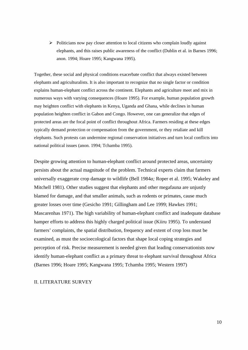
We surveyed the wildlife management literature and found 16 studies that quantified crop damage by
elephants (Table II.1). Average losses ranged from 0.2% (Niger) to 61% (Gabon) of planted fields.
Estimates of annual costs of elephant raids ranged from $60 (Uganda) to $510 (Cameroon) per
affected farmer. Elephants were recorded consuming over 20 different crops, with maize ranking first.
Nearly all the researchers commented on the irregular, patchy distribution of damage. Certain farms
and/or communities were disproportionately damaged due to their proximity to a forest edge, a water
source or migration route. Similarly, many researchers commented on variability in the timing of
raiding, particularly for forest elephants (Loxodonta africanus cyclopis). Despite their recognition of
the highly irregular and localized pattern of elephant damage, few researchers assessed regional levels
of damage. Rather, they disproportionately sampled farms hit by elephants and measured damage at
these sites. Therefore, these estimates provide valuable information on the experience of individuals
suffering losses to elephants, but say little about how common this experience is (see Kibale Case
Study below). Extrapolating data on average losses to an entire park or region is inappropriate
without data on the proportion of farmers affected by elephant raids.
15

16
2. Ranking elephants and other wildlife pests
Another method to ascertain the relative cost of elephant crop raiding is to compare their damage to
that for other animals. To compare ranking of elephants versus other wildlife pests, we tabulated the
results of 25 published and unpublished studies of wildlife pests in Africa (Table II.2). We selected
only studies that explicitly ranked problem animals by species or group, and those from sites or
regions where elephants are now present or were during the lives of adult resident farmers (Table
II.2). These 25 studies come from 13 countries and include both savanna and forest sites. They also
include examples of each major type of human-wildlife interface (Hoare 1995): hard edges (e.g.,
Uganda, Rwanda, Kenya and Ghana cases), mosaics (e.g., Gabon, Cameroon) and isolated
settlements (e.g., Congo). The table is dominated by S. Lahm’s tour de force study of crop raiding
across Gabon. In analyses, we used only her results at the national level. Out of 38 types of animals
ranked as problem animals, the five most frequently mentioned were: elephants (32 cases), monkeys
(including baboons) (30), rodents (19), bushpigs (18) and antelopes (11). The animal most frequently
described as ‘worst animal’ was elephant (8), monkey (including baboon) (8), bushpig (5), cane rat
(2) and buffalo (2). Elephants’ mean rank was 2.5 +/- 1.5 (n=33), and there was no significant
difference between rankings at savanna versus forest sites (Mann-Whitney U test, n=14 savanna and
14 forest sites). We also tested whether farmers and researchers ranked problem animals differently.
In 18 studies, the ranks were derived from farmers’ responses to interviews, and in 6, researchers
themselves did the ranking based on field observations. Again, there was no difference in the relative
ranking of elephants as pests. The only significant discrepancy was between the ranking of elephants
at local levels and provincial or national levels. Elephants were not ranked ‘worst pest’ in any of the 5
nation-level assessments (Kenya, Gabon, Tanzania; se also Deodatus 1993on Malawi), and only in 2
of the 15 provincial or district-level rankings. In contrast, 6 of 16 studies conducted on the borders of
protected areas ranked elephants worst. This confirms the view that elephants tend to be a significant
pest at the local or possibly provincial level, but not at the national level (Dudley et al. 1992).
Comparing “worst pest” rankings between studies is problematic. For one, some studies focused
specifically on elephants, and may have biased results accordingly. Also, the scale of analysis varied
from single villages to nations. Methods were often poorly defined. Many studies ranked animals by
interviewing local farmers and tabulating results by frequency of total complaints or by the frequency
that an animal was rated worst. This is a valuable approach for learning about local attitudes and it
may reflect past damage. But several researchers have reported that individuals often hope for

17

18

19
compensation and thus may inflate damage reports, particularly for large game species (De Boer and
Baquete 1998; Gesicho 1991; Mascarenhas 1971). Other studies ranked animals by the relative
amount or frequency of their damage. This approach may avoid the problems of inflated complaints,
but it introduces other problems. For example, given the unpredictable nature of raiding by wildlife
(particularly elephants), results from a single season or even a single year may miss key events.
(These problems are discussed in greater detail in Appendix 1 below). Kiiru (1995) underscores how
a lack of quantitative data on crop damage, frequency, patterns and seasonality hinders comparison
and ranking of sites. As a result, we consider the data in Table II.2 preliminary, and they should be
used and interpreted with caution.
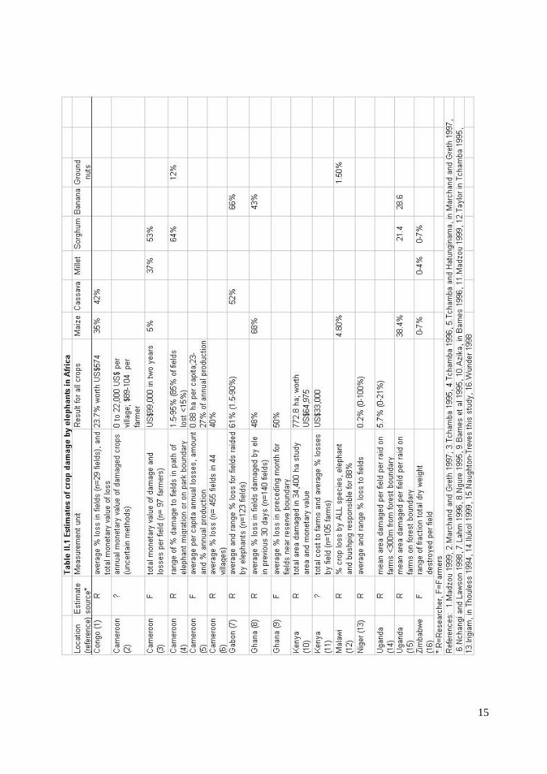
3. Factors shaping local attitudes toward, and capacity to cope with wildlife pests
To better understand farmers’ attitudes to various wildlife species, and to explain their apparent
intolerance of elephants, we reviewed several field studies done on wildlife pests. Thus we identified
key factors shaping local tolerance of crop loss (Figure II.1). Some of these factors are obvious and
reflect basic human values and economic rationale. For example, any animal taking human lives is
intolerable (Aboud 1986). Livestock losses to wildlife are considered worse than crop losses.
Tolerance is shaped more by amounts of crop loss than by frequency of raids (Naughton-Treves
1997). Animals highly prized as game by the local population are generally tolerated despite
significant costs. For example, each year, white-tailed deer (Odocoileus virginianus) in the state of
Wisconsin cause >$34 million in crop damage and $92 million in damage to vehicles (38,000 deer-
car collisions each year) (WDNR 1994). Yet there is widespread support for maintaining a population
of >1.2 million deer due to the profitable and popular 9-day annual hunt (670,000 hunters participate
and generate $255m in sales) (WDNR 1994). Other influential factors are more subtle. For example,
some studies conclude that farmers least tolerate damage to high-value cash crops, while others
suggest that animals like bushpigs that target ‘famine’ crops like cassava cause greater resentment
(Mascarenhas 1971). Based on the factors in Figure II.3, one would expect elephants to rank high in
lists of worst animals, due to their large size and physical threat, nocturnal raiding habits, and catholic
diet.
Local intolerance for wildlife may also be amplified by institutional constraints on coping strategies.
Farmers feel especially vulnerable to large animals, such as elephants and bushpigs, which inflict
localized, infrequent and potentially catastrophic losses. The perceptions of farmers often reflect rare,
extreme-damage events rather than persistent, small losses that cumulatively may be greater
(Naughton-Treves 1997). The complex interplay of actual risk and the effectiveness of each farmer’s
coping strategies is filtered through a cultural and socioeconomic perspective. When asked “which
20
Figure II.1: Factors influencing local tolerance for wildlife pests.

21
animal is worst?” or “how severe are your losses to wildlife?”, a farmer’s answer is shaped not only
by his previous experiences with wildlife pests, but also by his perceived status with respect to the
park, conservation authorities, and the researcher herself (Naughton-Treves 1997). The following
case study from Kibale National Park explores the relationship between damage amounts, perceptions
and local response to elephants and other wildlife.
III. CASE STUDY: LOCAL RESPONSE TO CROP DAMAGE BY ELEPHANTS AND OTHER
ANIMALS AT KIBALE NATIONAL PARK, UGANDA
A. Introduction and historical background3
Kibale National Park is a 760 km2 forest remnant located in western Uganda (in Kabarole District,
known formerly as ‘Toro’) (Figure III.1). Kibale is rich in primates and other species (Struhsaker
1997), including those notorious for crop raiding, such as olive baboons (Papio cynocephalus), redtail
monkeys (Cercopithecus ascanius), elephants and an unidentified species of bushpig (Potamochoerus
sp.). Currently, 54% of the land within 1 km of Kibale’s boundary is used for small holder agriculture
(Mugisha 1994). Farmers in the area belong to two predominant ethnic groups, the long-present
Batoro, and the immigrant Bakiga, who came to Kibale by the tens of thousands from southwestern
Uganda during the 1950s and 1960s (Turyahikayo-Rugyema 1974). Toro chiefs traditionally
allocated land to immigrants on the outskirts of their settlements, in part to buffer Toro farmers from
crop damage by wildlife (Aluma et al. 1989). Today, both groups plant more than 30 species of
subsistence and cash crops: bananas, maize, beans, yams, and cassava cover the greatest area. In both
groups, women generally assume responsibility for food crops, whereas men tend cash crops, such as
brewing bananas. Farm sizes are small—averaging 1.4 ha-- and population density is high-272
individuals per km2 4. Within this diverse farming system, various wildlife species forage on crops.
Several of these species enjoy legal protection because they are threatened with extinction. As a
result, many local cultivators are frustrated and resent the park. To understand the national
significance of present-day conflict at Kibale’s boundaries, a brief history of human-wildlife conflict
and problem animal control in western Uganda is helpful.
Western Uganda was once famous for its extensive forests and wild animals of extraordinary
diversity and density (Hamilton 1984; Wing and Buss 1970). Traditionally, agriculturalists tried to
3 Included in the introduction is material from (Naughton-Treves 1997, 1998. 1999; Naughton-Treves et al.1998). For further details on Kibale’s local ecology, settlement history and farming strategies, see (Chapmanand Chapman 1996; Chapman and Chapman 1997; Edmunds 1997; Struhsaker 1996).4 Farm-size and population-density figures refer only to smallholdings. More extensive land uses within 1.5 kmof Kibale’s boundary include forest fragments, tea estates and grassland (Mugisha 1994).

22
Figure III.1 Map of Kibale National Park, Uganda.

23
balance crop loss to mammals with bush-meat gains by trapping in and around their fields (Koch
1968; Vansina 1990). Other coping strategies included planting widely dispersed fields in rotation
and guarding crops near harvest. Nonetheless, crop damage by wildlife, particularly elephants,
prevented the cultivation of some arable land (Osmaston 1959). Isolated agricultural settlements,
diminished already by war and rinderpest outbreaks, were especially vulnerable (Osmaston 1959). At
some Toro sites early this century, the forest expanded when people abandoned agriculture,
reportedly due to ‘the depredations of game that the few remaining inhabitants were no longer able to
repel’ (Osmaston 1959). A district warden visiting Toro in 1916 described ‘wanton destruction’ and
‘complete devastation’ of farms by elephants such that ‘the [human] populace has been forced to
move elsewhere’ (GDA 1924).
This small Protectorate is still literally over-run with elephants – big, dangerous, destructive beasts –if we are to afford the inhabitants of this fertile land the measure of protection which is their due, anannual slaughter of elephants on a large scale is not only necessary but imperative (GDA 1924).
In 1906, British colonial authorities enacted a game ordinance that designated wildlife as crown
property and greatly restricted so-called ‘native’ hunting (Graham 1973; Naughton-Treves 1999).
Claiming all Ugandan animals as crown property legitimized the capture of enormous revenue from
ivory and other animal products. According to colonial notions of property, it also obliged the
government to assume responsibility for any damage to life or property caused by ‘their game’. First
established as the Elephant Control Department (1923) and later renamed, The Ugandan Game
Department set out to partition Uganda into wildlife and agricultural areas, or in their terms, ‘elephant
and no-elephant areas’ (GDA, 1926,1927, 1931). Great emphasis was placed on controlling and
confining wildlife to parks. Several species were subject to control operations, but none received
more attention than elephants. ‘Defensive fronts’ were set up, chiefly at agricultural frontiers where
elephants ‘swarmed’ (Brooks and Buss 1962). Elephants reportedly responded with ‘evil-intentioned
sagacity’ and ‘truculence’, and maintained ‘strongholds’ (GDA, 1928).
During the 1920s, elephants ranged across 75% of Uganda and numbered between 20,000 to 30,000
(GDA 1924). Between 1925 and 1958, the Game Department killed over 1000 elephants a year, for a
total of 31,966 (Brooks and Buss 1962). Elephant control campaigns were particularly intense in Toro
District, accounting for 29% of the total (GDA, 1957). Toro was considered the most difficult district
for elephant control in Uganda, particularly western Toro, where Batoro farmers had newly settled.

24
The Toro district is the most difficult of the control areas and will be hard work for many years tocome. There are some thirty to forty herds of elephant totaling fully 2000 animals, the majority ofwhich live in close proximity to settlements and cultivation. (GDA, 1934).
The elephant frontier persisted in Toro and Bunyoro long after elephants were exterminated
elsewhere (Figure III.2). But eventually, decades of control shooting packed elephant herds into parks
and reserves. Thus the Game Department achieved its goal of confining elephants and other large
game to government land. Once elephants were exterminated, land was cleared and crops planted. In
Toro, a herd of 2000 elephants sought refuge in the Kibale Forest Reserve where they caused
considerable vegetation damage and damaged crops along the forest boundaries (Wing and Buss
1970). In sum, control operations lowered crop loss to large wildlife on a regional basis, and
intensified human-wildlife conflict at the edges of parks and reserves.
By the mid 20th century, the central government’s ability to control access to wildlife in parks was
threatened by poaching, population growth and civil unrest. In 1971, Uganda plunged into a brutal
war lasting over 15 years. During this period of immense human suffering, the Ugandan government
lost control of wildlife and parks entirely (Hamilton 1984). War and the de facto removal of all
property rights devastated wildlife. For example, rhinoceros (Diceros bicornis) were completely
extirpated from Uganda (NEMA 1996). In Bunyoro, elephants dropped from 14,500 in 1969 to 1,420
by 1980 (NEMA 1996). In Toro, Kibale’s herds of elephants were similarly decimated.
With peace in 1987, Ugandan civil society began to rebuild and the national government endorsed
biodiversity conservation (NEMA 1996). In 1993, the Kibale Forest Reserve was regazetted as a 760
km2 national park, and more than 30,000 residents of the adjacent Kibale Game Corridor were
forcibly evicted and resettled elsewhere (NEMA 1997). Systematic data on wildlife recovery are
missing, but Kibale’s surviving herd of 100-300 elephants is growing, and now moves the length of
the park (Cochrane, E., unpubl. data).

25
Figure III.2 Elephant Control in Uganda, 1925 – 1984

26
The social and physical landscape of Toro has profoundly changed this century. Where there were
once isolated agricultural settlements amidst wildlife habitat, today there are islands and corridors of
wildlife habitat embedded in agriculture. Natural habitat continues to shrink outside of Kibale
National Park. Edge species persist in Toro agroecosystems (e.g., bushpigs, baboons, and cane rats),
but large or interior forest species are mainly confined to the park (Chapman and Onderdonk 1998).
Despite regional declines in wildlife populations, farmers living within 1 km of Kibale complain
bitterly about crop loss to animals. Anger about crop loss to wildlife is expressed most intensely
during group discussions. People ask, “Why should we starve so that baboons may eat?”
B. Results of previous research on crop raiding at Kibale
During 23 months spanning 1992-1994, crop damage to animals was monitored weekly in 6 villages
in 93 farms lying within 500 m of Kibale’s boundary (Naughton-Treves 1998)(Figure III.3). We also
conducted several community-level meetings and 145 interviews to appraise local attitudes to wildlife
and coping strategies (Naughton-Treves 1997). The results of this work can be summarized as
follows:
Ø There was marked variation in frequency and extent of damage within villages, between villages,
and between species. The strongest predictor of damage was proximity to the forest boundary.
Ninety percent of damage events occurred within 160 m of the forest boundary. Within this
narrow band of farms, households lost 4-7% of crops per season on average, varying by village.
The distribution of damage was highly skewed, such that maize and cassava fields were on
occasion completely destroyed.
Ø Five wildlife species accounted for 85% of the forays into fields: baboons, bushpigs, redtail
monkeys, chimpanzees, and elephants. Pooling the data for 6 villages, redtail monkeys were the
most frequent raiders, and baboons caused the most cumulative damage. Primate raiding on ever-
available bananas decreased when fruit was abundant in the forest, but maize was raided at
similar frequencies whenever it was available (Naughton-Treves et al. 1998).
Ø Livestock caused considerable damage to crops (11% of total), but farmers seldom complained
because they had institutionalized modes of restitution.
Ø Elephants inflicted catastrophic damage to farms, but their forays were rare and highly localized.
The mean crop damage amount per elephant foray was 874 m2, maximum 6510m2.
Ø Farmers’ individual defensive strategies (e.g., hunting, strategic crop placement) diminished
damage by some species (namely bushpigs), but did not appear to affect elephant raiding.

27
Figure III.3 Study sites and zones of chronic elephant conflict around Kibale National Park, Uganda
(1992-1999)

28
Ø Local perception of risk reflected extreme damage, not average losses. All respondents
complained vociferously about the severity of crop damage, even those who farmed as far as 1
km from the forest. Anger about wildlife was expressed most vehemently in group meetings.
Ø Baboons were most often identified as the worst animals, followed by bushpigs and elephants.
Assessments of ‘worst animal’ reflected the respondent’s social identity and economic status.
Men complained more about elephants than did women. Owners of small farms more frequently
cited damage by smaller animals (e.g., redtails) than did affluent farmers with large farms.
Ø The majority of farmers (83%, n=145) believed that local people benefit from the park. But those
who suffered elephant damage were significantly less likely to perceive local benefits. Only
elephant raiding caused people to abandon farms. Where elephant raiding is frequent, the costs f
living near Kibale outweigh its benefits.
A separate study on elephant raiding at Kibale conducted by Patrick Ilukol (1999) provides further
insight on their behavior and damage patterns. During 13 months, Ilukol systematically monitored
elephant raiding at 4 parishes abutting the forest, selected for their history of elephant raiding
problems (Fig. III.3). He found that elephants raided in groups averaging 4.22 individuals (n=67
groups observed) and damaged between 19.6 to 38.4% of standing crops in the fields they raided.
Elephants raided with equivalent frequency during wet and dry months, however the distribution and
timing of raids apparently follows a cyclic pattern. Specifically, the north and western areas are raided
during Jan-May, and eastern and southern areas during June-November.
Research by both Naughton and Ilukol confirms local accounts that elephant raiding is concentrated
on certain villages, and often concentrated on certain farms within villages. Game department
archives also reveal persistent elephant damage at certain key sites dating to 1951 (e.g., Sebitoli, Fig.
III.3). Elephant foraging patterns are likely to be shaped by a complex set of factors operating at a
large scale (e.g., forest disturbance by logging in the north of Kibale, heavy poaching in the south).
C. 1999 Research on crop damage and farmers’ responses
1. Objectives
During Feb-August, 1999, we resumed monitoring damage to crops in 3 of the 6 original study
villages (Fig. III.3). Again, the purpose of the 1999 research was to compare levels of damage
between farms, villages and between raiding species. We also aimed to test the results of a lower cost,
coarser sampling protocol with that used in the 1992-94 study. Finally, we explored local farmers’
29
long term response to raiding by returning to 5 of the original 6 villages and assessing land use
changes on 85 farms.
2. Methods
From February-July 1999, crop damage was monitored at 3 villages around Kibale National Park.
The villages (Nyabubale, Kabucikire and Rurama) were among the 6 studied from 1992-1994
(Naughton-Treves 1998). These villages were chosen because they agreed to the study, together they
faced the complete suite of wildlife crop raiders seen at Kibale (Naughton-Treves 1998), and they
were within cycling distance of our assistants’ farms. Apart from these similarities, the three villages
differed socially and physically (Naughton-Treves 1998, 1999). Of particular relevance to the present
study, the villages differed in mean farm size (Kruskal-Wallis df=2, H=14.79, p=0.005), and in the
distribution of farm sizes (Figure III.4). The smallest farms were found at Kabucikire, hence we
sampled more farms at this site (N=30) than at Nyabubale (N=8) or Rurama (N=13). Each farm was
assigned a row number as follows: farms abutting the park boundary were in row 1, while those
behind them and further from the park boundary received row 2 or 3.
Crop damage was measured by our veteran field assistant, P. Baguma, and a new assistant, P.
Katuramu, both of whom have farms of their own near Kibale. In the first week of each month, the
two men would walk a transect (sweep) perpendicular to the boundary of Kibale. Each sweep was
300 m long and 30 m wide. Along the length of the sweep, crop type and maturity were recorded.
Every trace of crop damage by vertebrates was noted and its extent measured by pacing area or
counting stalks. Raiding animals were rarely seen, so evidence from dung, tracks, bite marks and
patterns of damage were used to infer the identity of the responsible species. Interobserver reliability
and damage measurement techniques are detailed in Naughton-Treves (1998). Also detailed there are
techniques for identifying independent forays by animals. In brief, when adjacent sweeps crossed the
same, large damaged area, only one event was noted (if the raiding species was the same). Similarly,
if the same animal inflicted damage at multiple points along a monthly sweep, a single foray was
recorded. These methods of determining independence do not inflate frequency estimates, particularly
for animals that damage wide swathes of crops (e.g., elephants).
In addition to systematic monitoring of crop damage, we surveyed 5 of the 6 villages (Sebitoli and
Kanyasohera plus the three described above) from the earlier study to document changes in land use,
ownership, etc. that occurred in the intervening 5 years.

30
Figure III.4 Distribution of farm sizes in 5 villages around Kibale National Park, Uganda. Box plots:
each box plot spans the second and third quartile. The central horizontal line indicates the mean,
while the vertical error bars denote one standard deviation of the mean.

31
3. Results
Overall pattern of crop damage in 1999
We measured crop damage on 51 farms of Nyabubale, Kabucikire and Kanyasohera. Every week,
half of the farms suffered crop damage (combining livestock and wildlife). In total, we recorded 269
independent forays over the 6 months of this study. Combined, these forays inflicted crop damage
totaling almost 2 ha in area (Table III.1). The mean for all animals was 9.4% of a field’s area
damaged per foray.
Differences between animals
We recorded damage by 12 varieties of animals (baboon, bird, bushbuck, bushpig, cattle, chicken,
chimpanzee, civet, domestic pig, elephant, giant rat, goat, mouse, redtail monkey). Table III.1
presents the results for the 9 types of animals that caused damage more than once (mice and giant rats
are pooled). Goats damaged crops most frequently, but elephants did the most damage per foray
(mean and maximum). Livestock caused almost two-thirds of the damage, while wildlife caused one-
third. Much of the livestock damage was done by animals from a neighboring farm (Table III.1).
Among the wildlife, elephants accounted for the vast majority of area damaged (77.9%), but this was
confined entirely to 6 farms at one of the three villages (Nyabubale). Baboons were the most frequent
visitors.
Differences between villages
Just as the villages differed socially and physically, they also differed in the crop damage they faced.
Nyabubale, the northernmost, suffered damage in 56 of 168 sweeps (33%), while Kabucikire suffered
damage in 95 of 546 sweeps (17.4%) and Rurama, the southernmost, suffered damage in 118 of 285
sweeps (41%). Differences between villages in the frequency of crop damage were mirrored by
differences in the average amount of crop damage they suffered (Figure III.5). These data were
analyzed with a factorial design ANOVA incorporating village and row as factors to predict the
amount of damage in m2. For all animals (wildlife+livestock), the villages differed significantly
(df=2, 982, F=12.4, p=0.0001). Divided by wildlife or livestock damage (Figure III.5), villages still
differed in the amount of crop damage (wildlife: df=2, 971, F=7.4, p=0.0007; livestock: df=2, 971,
F=8.2, p=0.0003). Nyabubale suffered the greatest amount of wildlife damage while Rurama suffered
the greatest amount of livestock damage. Row did not predict the amount of damage suffered in any
of the analyses described above.

32

33
Figure III.5 Area damaged by wildlife and livestock in 3 villages around Kibale National Park,
Uganda (February – August 1999). The height of the bars measures the mean area of crop
damage (+/- 1se) recorded in monthly sweeps.

34
Direct costs of crop raiding
The direct, financial cost of crop-raiding can be estimated from the value of the crops per m2
multiplied by the area damaged (Figure III.6). Considering single forays, elephants inflicted the
highest mean and maximum cost per farmer, but the overall cost of goat damage exceeded that of
elephants and all other animals combined (Figure III.7). Indeed, two-thirds of the financial costs of
crop damage were caused by livestock (goat, cattle, chicken and domestic pig combined).
Indirect costs of crop raiding
Although monetary loss is a major component of the impact of crop raiding, there are other less direct
costs of crop loss. Farmers might leave fields fallow or simply abandon them after repeated raids. In
other cases, entire farms were abandoned. In 1999, we quantified these indirect costs by surveying 84
farms (in 4 villages) that had been studied from 1992-1994. In essence, we traced the fate of farms in
relation to their history of crop raiding. Information was not available for every farm for every
question, so sample sizes vary as shown.
In the intervening period between our studies (1994-1999), farmers abandoned 32 fields (N=58 farms,
average=0.6±0.9 fields per farm) and left 30 fallow (N=59 farms, average=0.5±0.8 fields). By
comparison, clearing of land led to the creation of 60 new fields or an average of 1.8±0.8 fields per
farm (N=84, range 0-4). Hence, the clearing of new fields roughly equaled the combined
abandonment and fallowing of old ones. There was a correlation between the number of fields cleared
and the number fallowed (Spearman rho=0.348, Z=2.65, p=0.008), i.e., the same farmers that cleared
new fields were the ones that fallowed older ones. However, there was no correlation between the
number of fields cleared and the number abandoned (rho=0.192, Z=1.44, p=0.15).
There was good evidence that farmers abandoned fields because of wildlife crop raiding. Farmers
(N=67 interviewed) stated that they abandoned fields because of baboons (36%), bushpigs (24%),
banana weevils (15%), elephants (12%), poor soil (5%) or several rarer reasons: death, illness,
chimpanzees and redtail monkeys (1.5% each). Abandoned fields averaged 52 m from the park
boundary (se=10.1, n=43). At this distance, they were well within the zone of highest risk for crop
raiding (Naughton-Treves 1998). This remained true in 1999, as data on elephant crop damage
reveals (Figure III.8).

35
Figure III.6 Direct costs of crop damage by the worst 5 animals on farms neighboring Kibale National
Park, Uganda (February – August 1999).

36
Figure III.7 Total Direct costs of crop damage in 51 farms neighboring Kibale National Park, Uganda
(February – August 1999), split by type of animal causing damage.

37
Figure III.8. Frequency of elephant forays as a function of distance from the boundary of Kibale
National Park, 1992-4, 1999
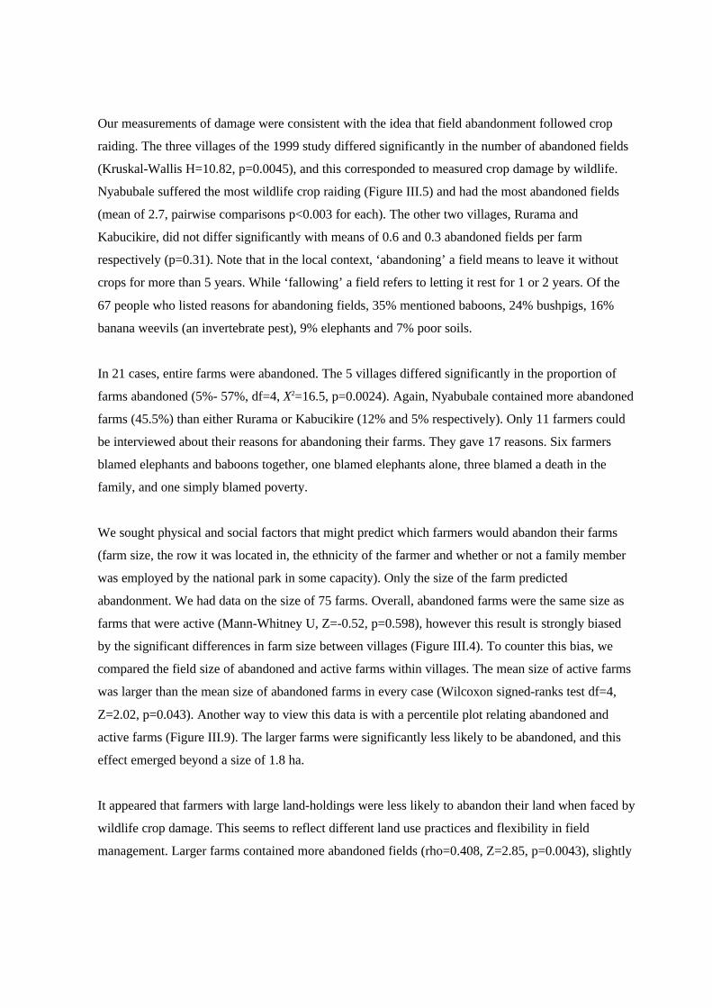
Our measurements of damage were consistent with the idea that field abandonment followed crop
raiding. The three villages of the 1999 study differed significantly in the number of abandoned fields
(Kruskal-Wallis H=10.82, p=0.0045), and this corresponded to measured crop damage by wildlife.
Nyabubale suffered the most wildlife crop raiding (Figure III.5) and had the most abandoned fields
(mean of 2.7, pairwise comparisons p<0.003 for each). The other two villages, Rurama and
Kabucikire, did not differ significantly with means of 0.6 and 0.3 abandoned fields per farm
respectively (p=0.31). Note that in the local context, ‘abandoning’ a field means to leave it without
crops for more than 5 years. While ‘fallowing’ a field refers to letting it rest for 1 or 2 years. Of the
67 people who listed reasons for abandoning fields, 35% mentioned baboons, 24% bushpigs, 16%
banana weevils (an invertebrate pest), 9% elephants and 7% poor soils.
In 21 cases, entire farms were abandoned. The 5 villages differed significantly in the proportion of
farms abandoned (5%- 57%, df=4, X2=16.5, p=0.0024). Again, Nyabubale contained more abandoned
farms (45.5%) than either Rurama or Kabucikire (12% and 5% respectively). Only 11 farmers could
be interviewed about their reasons for abandoning their farms. They gave 17 reasons. Six farmers
blamed elephants and baboons together, one blamed elephants alone, three blamed a death in the
family, and one simply blamed poverty.
We sought physical and social factors that might predict which farmers would abandon their farms
(farm size, the row it was located in, the ethnicity of the farmer and whether or not a family member
was employed by the national park in some capacity). Only the size of the farm predicted
abandonment. We had data on the size of 75 farms. Overall, abandoned farms were the same size as
farms that were active (Mann-Whitney U, Z=-0.52, p=0.598), however this result is strongly biased
by the significant differences in farm size between villages (Figure III.4). To counter this bias, we
compared the field size of abandoned and active farms within villages. The mean size of active farms
was larger than the mean size of abandoned farms in every case (Wilcoxon signed-ranks test df=4,
Z=2.02, p=0.043). Another way to view this data is with a percentile plot relating abandoned and
active farms (Figure III.9). The larger farms were significantly less likely to be abandoned, and this
effect emerged beyond a size of 1.8 ha.
It appeared that farmers with large land-holdings were less likely to abandon their land when faced by
wildlife crop damage. This seems to reflect different land use practices and flexibility in field
management. Larger farms contained more abandoned fields (rho=0.408, Z=2.85, p=0.0043), slightly

39
Figure III.9. Percentile plot comparing size of active and abandoned farms
40
more fallowed fields (rho=0.289, Z=2.04, p=0.041), and many more newly cleared fields (rho=0.494,
Z=4.22, p<0.0001). In effect, large farms were being maintained as small-scale swidden systems.
E. Discussion
From an international perspective, an annual loss of 4-7% of planted fields along Kibale’s boundary
equivalent to roughly US$6 per farmer, or US$100 per km of border, appears a trivial price for
maintaining elephants and other threatened wildlife. Moreover, most of Kibale’s neighbors extract
fuelwood and water from the park worth far more than $6/year (Naughton, unpubl. data). But the
farmers who live on Kibale’s border are frustrated by crop loss to wildlife, particularly because they
cannot legally use their full range of traditional defensive strategies. Moreover, estimates of average
losses masks the great variation in amounts lost by different farmers and villages. The farmers
suffering crop loss to elephants absorbed an average cost of $60 per year, a significant amount in an
area where annual incomes average $200-300. A few individuals lost much more. To the farmer who
has lost an entire year’s production in a single night to elephants, average losses are meaningless. In
some cases elephant damage caused families to abandon their land, particularly those who owned
<1.8ha. Although elephant raids are relatively rare, their severe potential impact shapes attitudes
among Kibale’s neighbors.
The highly variable and localized nature of crop damage by elephants at Kibale accords with studies
around other African parks, making it difficult to assess the socioeconomic impact for the entire park.
But our field data from 1992-4 and 1999 and from Ilukol (1999) prove that elephant damage is tightly
confined to <200 m of the park boundary. This concurs with others’ views that the best defense
against elephants and other large game is to have an active farm between you and the park (Newmark
1997; Hill 1997). Even within this narrow band, only a few farms (on the order of 10%) suffered
elephant damage. Obviously, the geographical range of human-elephant conflict in western Uganda
has been drastically reduced from a century ago. Today, many more farmers around Kibale struggle
with chronic losses to baboons, bushpigs, banana weevils or their neighbor’s goats than from
elephants.
41
IV. DAMAGE PATTERNS BY ELEPHANTS AND OTHER WILDLIFE AROUND BANYANG-MBO WILDLIFE SANCTUARY, CAMEROON
A. Introduction
Located in the South-West Province of Cameroon (Figure IV.1), the Banyang-Mbo forest is a
biologically-rich mix of lowland rain forest to sub-montane savanna. It provides habitat for a
relatively high density of forest elephants (Loxodonta africana cyclotis) and forest buffalo (Syncerus
caffer nanus), as well as threatened species including chimpanzee (Pan troglodytes), Preuss’ monkey
(Cercopithecus preussi) and drill (Mandrillus leucophaeus) (Powell 1994). This region contains
70,000 of Cameroon’s estimated 20 million ha of remaining forest (Besong 1992), and is an important
conservation area for both biological and cultural diversity. In March of 1996, Cameroon’s Ministry
of Environment and Forest (MINEF) officially designated the Banyang-Mbo Forest as a wildlife
sanctuary, the first of its kind in Cameroon (Nchanji and Lawson 1998). The “wildlife sanctuary”
designation protects endangered species from hunting and restricts logging, but allows local
communities to hunt non-endangered species, gather forest resources, and participate in the
management of the sanctuary. This designation follows Cameroon’s national forest use policy to
protect soils, habitats and the environment, and provide rural communities with economic benefits
deriving from non-timber resource extraction (Besong 1992). In contrast, a “national park”
designation would restrict all use by local communities. Following the designation, MINEF invited
the Wildlife Conservation Society (WCS) to assist in the formation of a management plan for the
sanctuary and to perform all relevant field research. Currently, teams of WCS staff are gathering
social and ecological data to support a community-based management plan. They are surveying the
flora and fauna within the sanctuary, measuring the impact of local resource use (including bush meat
hunting), and assessing the impact of the creation of the sanctuary on local communities.
A key local concern in Banyang-Mbo’s management is human-wildlife conflicts, particularly between
humans and elephants. To manage and ameliorate human-wildlife conflicts, field assessments of the
pattern and amount of crop damage caused by wildlife are underway, with special emphasis on
destruction caused by forest elephants. The present human-wildlife conflict study began with field
visits and informal interviews conducted in seven villages around the sanctuary between January and
April 1999. Following this pilot survey, an intensive crop monitoring study was initiated in five of
the seven villages. The study will extend through December 2000. The long-term study uses both
opportunistic and systematic data collection schemes. The opportunistic data collection depends on
farmers’ reports of recent elephant damage, while the systematic data collection regularly monitored
three to four fields in each village for damage by any animal.

42
Figure IV.1 Banyang-Mbo Wildlife Sanctuary located in the South-West Province of Cameroon

43
The study at Banyang-Mbo, along with a previous crop raiding study by WCS field biologist Anthony
Nchanji and Dwight Lawson (1998), show four compelling results about the pattern and amount of
crop raiding by elephants. First, elephant damage is seasonal, occurring mainly during the rainy
season from August to October. Second, elephant damage is concentrated on particular fields and
villages due to their location and surrounding vegetation. For example, fields close to the sanctuary
edge (and thereby close to secondary forests) or those surrounded by old fallow were more prone to
elephant damage. Third, the data show that the pattern of land-use for farming is pushing new fields
closer to the sanctuary edge, leading to more incidents of elephant crop raiding. Finally, while
elephant damage on an individual field by may be quite high, and in some cases may force the farmer
to abandon the field (Nchanji and Lawson 1998), the majority of crop destruction was caused by large
rodents, such as cane rats (Thryonomys sp), domestic goats and grasshoppers. This result contradicts
the views held by local farmers who complain most bitterly about elephants (Nchanji and Lawson
1998). Perceptions held by local farmers have resulted in elephant crop raiding becoming a highly
politicized issue that threatens the relationship between conservation authorities and local
communities.
The following case study draws on previous and current studies to present results and conclusions
regarding elephant crop raiding. The background section includes a short historical review of the
Banyang-Mbo Wildlife Sanctuary (BMWS), and a general description of the sanctuary and
surrounding communities and farming systems. Next, the results of the current and previous crop
raiding research projects are described followed by an examination of the human reaction to crop
raiding around the sanctuary. Finally, management recommendations for the reduction of the impact
of elephants on local communities are summarized. While this case study focuses predominantly on
the problems facing the conservators at the BMWS in dealing with human/wildlife conflicts, it is also
representative of many other situations in forested Central Africa where humans and wildlife attempt
to coexist within a landscape of agriculture, secondary forest, and protected areas.
B. Background
1. Management History of the Banyang-Mbo Wildlife Sanctuary
The Banyang–Mbo Wildlife Sanctuary (BMWS), located in the South West Province of Cameroon
(Figure IV.1), dates back to 1936 when the British Colonial Administration created the Mbo Native
Administrative Forest Reserve. Following recommendations from local Cameroonian authorities and
the British forestry officers, the colonial administration gazetted an area of approximately 534 km2.
The main objective was to protect timber rights for the colonial administration. Following

44
independence in 1960, the government renamed the reserve the Banyang-Mbo Native Authority
Forest Reserve (BMNAFR) in 1961. As the name implies, management of the reserve fell under
local authority with all resource benefits returning to the communities. However, in 1972, the
Cameroon government centralized the management of all national resources, which included the
BMNAFR. In essence, this left the reserve with no management, opening its borders to resource
exploitation (Nchanji and Lawson 1998).
With increasing resource extraction, international concern focused on the declining wildlife in the
BMNAFR and other biologically rich areas in this region. In an effort to protect these important
areas, the Wildlife Conservation Society (WCS) established the Cameroon Biodiversity Project
(CBP) in 1992 (Nchanji and Lawson 1998). Through this project, the WCS collaborated with the
Government of Cameroon to provide “technical assistance and support in conservation and
management of biodiversity and rain forest resources in Cameroon” (Lawson et al. 1996). This
project included the Lobeke forest in southeast Cameroon and the Banyang-Mbo area. Following the
initial surveys, the WCS recommended setting up a protected area, which became the Banyang-Mbo
Wildlife Sanctuary (BMWS), designated by the Cameroon government in 1996. The BMWS
includes the original BMNAFR plus an additional region to the south covering a total area of
approximately 700km2 (Figure IV.2).
2. Biological Diversity
Cameroon holds approximately 20 million ha of tropical moist forest, of which only 0.7 million ha
are protected (Besong and Wencelius 1992). The BMWS stands as one of the few protected areas
within Cameroon, and contains high densities of elephants, primates and other large mammals.
Equally important are the high levels of plant endemism and species richness due to the local
variations in elevation (120 to 1756 mnsl) (Curran and Fotso 1997). The BMWS is classified as a
Guineo-Congolian wet evergreen lowland rainforest (Tonye et al. 1988), with an average rainfall of
over 3000mm/yr (Tonye et al. 1988). Common tree species include: Lophira alata, Cola spp.,
Dacryodes edulis, Uapaca spp., Irvingia gabonensis, Pentaclesthra mirophyllia, Mammea africana,
Panda oleosa, Poga oleosa, Massularia acuminata, Musanga cecropioides, Xylopia spp., Duboscia
macrocarpus and Detarium marocarpum (Nchanji and Lawson 1998). Biological surveys within the
BMWS have shown evidence of over 25 species of large mammals (Nchanji and Lawson 1998).
Surveys have also shown a highly diverse population of herpetofauna and birds (Lawson et al. 1996).
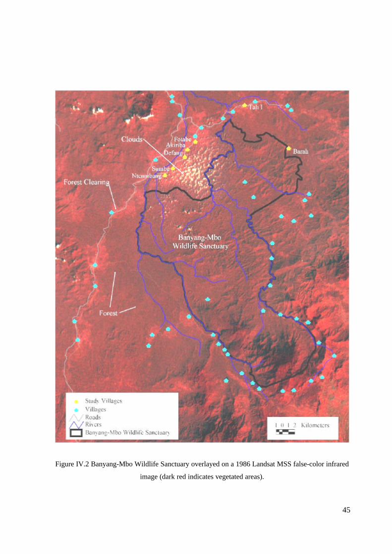
45
Figure IV.2 Banyang-Mbo Wildlife Sanctuary overlayed on a 1986 Landsat MSS false-color infrared
image (dark red indicates vegetated areas).

46
3. Local Land Use and Farming Systems
Population
Cameroon’s population is approximately 14 million (1997 estimate) with an annual growth rate of
2.9% and an overall population density of 27.8 people/km2 (The Economist Intelligence Unit 1999).
Most of Cameroon’s population currently live in rural areas (71%) (DeLancey 1989), with 63% of the
population making their living through agriculture (The Economist Intelligence Unit 1999). These
numbers are likely to decrease as rapid urbanization throughout Cameroon leads to increased
emigration from rural areas (DeLancey 1989). In the Southwest Province, where the BMWS is
located (Figure IV.1), an estimated 7.7% of Cameroon’s total population (1.1 million) lives in a
mostly rural setting. The province has a population density of 38.2 people/km2 (Ndongko and
Vivekananda 1989) and the majority of residents (approximately 75%) are agriculturists (1984 data)
(Ministry of Agriculture 1986). Approximately 44 villages (average size of 200 people) are within
close proximity to the BMWS. These villages include people from 4 different ethnic groups:
Banyangi, Mbo, Bassosi, and Bakossi (Nchanji and Lawson 1998). With a pattern of dispersed
agriculture settlements amidst forest, the Southwest Province typifies a region especially prone to
human-wildlife conflicts.
Farming systems
The Southwest province is located in a region with an estimated 330 day growing season (Schaefer-
Kehnert 1988). The most common soils in this region are fertile Nitosols (Tonye et al. 1988).
However, continuous agriculture has decreased soil fertility in many areas. Both cash crops and food
crops are locally cultivated, each in distinct farming systems which significantly influence the pattern
of elephant crop damage.
Small-scale cocoa (Theobroma cacao) fields (< 5 ha), along with a small amount of coffee (Coffea
canephora), comprise the main cash crops in the region and are cultivated by men. Plantains and
bananas (Musa spp.) can usually be found intercropped on cash fields and harvested as an additional
source of food or income. Fields in the region are individually or family owned rather than
community held. Individuals obtain land for new cash crops by requesting permission from the
village traditional council. The acquired land is cleared of any forest or bush, then temporary food
crops (cocoa yams (Colocasia spp.), maize (Zea mays), melons) are planted to establish the field.
The following year cocoa planting begins, with new trees added each subsequent year until the cocoa
field reaches the desired size (Nchanji and Lawson 1998). Once mature, the cocoa trees produce pods
that are harvested and sold annually, usually late in the rainy season (October or November). Farmers

47
occasionally rely on other male family members or community farming assistance groups to perform
large field projects such as clearing the field of weeds or removal of secondary growth or old fallow.
These community farming groups meet once a week to assist in one member’s field on a rotational
basis, while work continues on individual fields the remainder of the week. All benefits from the sale
of the cocoa go back to individual households.
Women are primarily responsible for cultivating food crops, including cassava (Manihot esculenta),
cocoa yam, maize, melons, groundnuts (Arachis hypogaea), and bananas/plantains. The planting
season runs from April to May. The maize matures and is harvested in approximately three months.
It is then replanted for a second harvest the same year. Cocoa yams and melons mature in
approximately 12-16 months, and are harvested after the final maize harvest. After all harvests are
complete, the field is fallowed for two to four years. Female members of the household usually
maintain these small food fields as the main source of sustenance for the family. Similar to cocoa
farmers, some women form community-farming groups to provide assistance on a rotational basis.
Typically, farming systems in the Southwest Province are characterized by a separation of cash and
food fields (Schaefer-Kehnert 1988). In most villages around the sanctuary, food crops are grown
near the village, and cash crops near the sanctuary border (Figure IV.3). This planting pattern may is
partly due to higher soil fertility on newly cleared land closer to the sanctuary (Mbu Moses, pers.
comm.). To obtain a new field or increase the size of an existing field, unused land within the village
territory can be cleared and planted with the permission of the village council (Nchanji and Lawson
1998). This system has led to a highly fragmented mosaic of young and old fields, young and old
fallow, and secondary forest.
C. Field Research on Human-Elephant Conflicts at Banyang-Mbo Wildlife Sanctuary
1. Previous Research
WCS field biologists Anthony Nchanji and Dwight Lawson examined the amount and location of
elephant crop damage as well as the social implications of these conflicts (Nchanji and Lawson
1998). They used a questionnaire and informal interviews to gather information on the history of
crop raiding in the area (n=430 people in 44 villages). Following the interviews, researchers
monitored elephant crop damage in five core villages using a participatory crop damage reporting
system. The team relied on quick reports from farmers suffering elephant damage, which allowed
them to visit any recently damaged field within four to five days. Crop damage data included amount

48
Figure IV.3 Distribution of agricultural lands between the villages and the BMWS
49
and nature of damage, field type, field age, field condition, distance of field from village, surrounding
vegetation, and damage by other wildlife species.
Type and amount of crop damage by elephants
Of all the wildlife, elephants caused damage to the greatest number of different crop species (38),
while the African giant rat, bush pig, buffalo, cane rat, porcupine and squirrel caused damage to 14,
11, 10, 7, 6 and 3 different crop species respectively (Nchanji and Lawson 1998). Damaged crops
included cassava, cocoa yam, banana and plantain, young cocoa trees, coffee, pineapples, sweet
yams, and maize (Nchanji and Lawson 1998). Of the crops damaged by elephants, maize suffered the
most overall with an average loss of 66.15% per damaged field (Nchanji and Lawson 1998). Damage
to cassava, cocoa yam, banana/plantain, and young cocoa fields (n=433) averaged 57.10%, 64.48%,
51.30%, and 51.75% respectively. These values reflect the average amount of damage occurring on
all damaged fields within the core study villages. Overall, the average loss in the study villages was
60% and, in some cases, farmers were forced to abandon their fields entirely.
Damage at the village level ranged from no damage in some villages, to repeated, severe damage in
others (Figure IV.4) (Nchanji and Lawson 1998). For example, villages like Bombe Konye and Ntale
reportedly had serious problems (78 and 156 fields damaged by elephants in 1996) while others, such
as Manyemen and Betock, had little to no problems (10 and 9 fields damaged in 1996). At the field
level, the amount of damage also varied dramatically. Among those fields damaged by elephants
(n=433), crop losses averaged 60% and ranged from 30 to 88% of the planted area (Nchanji and
Lawson 1998). The results indicate a highly localized pattern of elephant crop damage at both the
village and field level.
Factors influencing damage patterns
Elephants raided certain fields and villages a number of times during the course of the study,
suggesting they prefer raiding specific locations. This preference may be a result of: 1) the location
of the field or village relative to the Sanctuary, and 2) the vegetation surrounding the field or village.
Nchanji and Lawson (1998) found that 67% of the damaged fields were located more than three km
from the village (Nchanji and Lawson 1998). Of 251 damaged fields surveyed, 178 (70%) were
either at the secondary forest edge or totally enclosed within the secondary forest (forest enclave)
(Nchanji and Lawson 1998).

50
Figure IV.4 Villages with chronic elephant damage reported during previous study (Nchanji and
Lawson, 1998)
51
Nchanji and Lawson (1998) also found a relationship between the time of year and the amount of
elephant damage. Out of 985 reported incidences, 830 (84%) occurred during the rainy season
(November-May) (Nchanji and Lawson 1998). The authors suggest two explanations for the
seasonality in raiding. First, mature crops and fruiting trees around the crops may have pulled
elephants into fields during the rainy season; and second, the rainy season is believed to be a period of
low food availability within the sanctuary (Nchanji and Lawson 1998).
The raiding pattern observed at Banyang-Mbo accords with studies of forest elephants elsewhere.
Forest elephants apparently prefer secondary forest to other types of land cover due to increased
forage availability and dense cover (Dudley et al. 1992; Merz 1986; Barnes et al. 1991). Also, forest
elephants often avoid humans, especially in highly hunted areas (Barnes et al. 1997). Therefore, it is
reasonable to conclude elephants at Banyang-Mbo are staying close to the sanctuary to avoid humans
and to stay within the protective cover of secondary forest. Not surprisingly, fields near the sanctuary
are most vulnerable to raiding.
2. Pilot Study (February 1999 – April 1999)
Following Nchanji and Lawson’s study, R. Rose initiated field research at Banyang-Mbo with two
goals: 1) To quantify and compare the amount of crop damage by elephants and other mammals, and
2) To test predictors for the spatial patterns of crop damage . In collaboration with other researchers,
Rose visited six villages along the outside edge of the sanctuary (Tali I, Fotabe, Akiriba, Defang,
Sumbe and Ntenmbang) and one village within the sanctuary (Barah) (Figure IV.2). During each
three to four day visit, villagers guided the researchers on a thorough examination of many of the
village fields. A handheld geographic position system (GPS) unit was used to locate fields with
reported previous elephant and buffalo crop damage. These locations were later mapped within a
geographic information system (GIS) (Figure IV.5). Along with the location of the field, the type and
age of the field, amount of damage and the vegetation surrounding the field were recorded
In addition to the field surveys, informal interviews and community meetings with village farmers
were conducted to discuss the problem of elephant crop-raiding and survey local reactions. The
informal interviews usually took place while surveying fields and included two to three farmers (both
men and women). Community meetings were held in the evening and attendance averaged 30 people
per village.

52
Figure IV.5 Farms with previous elephant or buffalo damage reported during the pilot study
(February – April, 1999)

53
Results of the pilot study show that:
Ø cane rats and other small animals were hitting food crops, while elephants and buffalo caused
damage to cocoa and other cash crop fields closer to the sanctuary edge,
Ø farmers complain more about elephant damage than that of any other wildlife,
Ø attitudes and responses towards crop damage varied at both the field and village level,
Ø elephant damage was worse during the rainy season (June – November),
Ø elephant and buffalo damage was worse on fields near or surrounded by secondary forest, and
Ø fields >2km from villages were more likely to be damaged.
Local attitudes and responses to wildlife pests
Due to crop losses to wildlife, farmers generally formed negative attitudes towards wildlife and local
conservation programs. Village level responses ranged from complaining to local conservationists, to
restructuring entire village farming systems. Even adjacent villages strongly differed in their reaction
to elephant damage. For example, Sumbe and Ntenmbang are neighboring villages with opposite
tolerances and reactions to elephant crop damage. Sumbe farmers, in an effort to reduce the impacts
of elephants on food crops, rearranged their entire crop planting system. They now plant cocoa
around each individual field of food crops. Ntenmbang still plants food fields close to the village
with cocoa fields pushed out towards the edge of the sanctuary. Farmers in Sumbe reportedly now
suffer very little from elephant (and other wildlife) damage while Ntenmbang residents continue to
complain bitterly about elephants. The response of a village may be motivated by a number of
factors, including previous amounts of elephant crop damage and current relationships with local
conservationists.
Most villagers agreed that the Cameroon government and conservationists have not taken enough
action to alleviate the problem of elephant crop damage. The first crop raiding team visited villages
in 1992 and still no solutions have been proposed. The Cameroon government has also promised
compensation for damage, but again the villagers were left waiting. In the end, five of six villages
selected for the long-term study agreed to cooperate with the program and felt positive that the crop
raiding research team was working to help them. The sixth village, Ntenmbang, would only accept
the team if guns were brought to destroy the offending wildlife, and was therefore dropped from the
study.

54
Despite the fact that cane rats collectively cause much higher crop damage, the strongest local
complaints were usually about elephants. There are a number of reasons for this. First, elephants
may destroy an entire field in one night’s foray (Nchanji and Lawson 1998). Therefore the impact an
elephant may have on an individual farmer is potentially much greater than cane rats. Second,
elephants can be dangerous and have been known to attack humans, leading to more animosity
towards them. A final factor may be the resentment villagers feel towards the protected status of
elephants. Since they are not allowed to shoot them, people feel helpless in protecting their crops
from elephant raids. In essence, the farmers felt as though the government favored the lives of
elephants over their own well being.
As a result of the protected status of elephants, many farmers also felt that it was the government’s
responsibility to protect their fields from elephants and other wildlife and expected the government or
conservationists to provide the protection. In one case, a guide in Akiriba village took the team to a
field with a fence built around it to guard against cane rats. The fence was built with small holes in
the bottom spaced about 5 feet apart. Within each hole was a snare to catch the cane rat as it tried to
enter the field. The guide admitted that this method works well, but also stated that it was too much
work for most people to do and felt that WCS should provide materials and labor for the fences
(ENOW Rudolf, pers. comm.). This was typical of farmers’ attitudes towards protecting fields. These
expectations of assistance led to further animosity between villages and the crop raiding team when
villagers realized the team only came to discuss the problems and examine the current situation.
In a second case, a farmer who was clearing secondary forest for a cocoa field where elephant and
buffalo already foraged felt that once his field was started, the elephants “should know not to come to
my field” (MBU Bruno, pers. comm.). Evidently, he expected elephants and buffalo to recognize and
respect the boundaries of a newly established field. While this may seem unrealistic, it reflects a
common attitude held by communities that nothing should interfere with their farming.
In addition to variation at the village level, attitudes and responses to wildlife varied from farmer to
farmer. Based on the informal interviews, these attitudes seem to be driven by three interrelated
factors: 1) previous amounts of crop damage, 2) field susceptibility and 3) gender.
The most vocal farmers at community meetings and informal interviews usually had experienced
elephant damage to their fields. In particular, farmers with small cocoa fields at the edge of the
sanctuary tended to complain more about elephants than any other farmer during group discussions
and informal interviews. Finally, males usually complained more about elephant damage than

55
females. This was likely a result of males working the highly susceptible cocoa fields near the
sanctuary and females working the less susceptible food fields closer to the village.
Tolerance and opinions also changed depending on the setting of the discussion. For example, during
one community meeting, participants agreed that elephant crop damage was so severe that there was
no option left but to shoot the elephants. However, the next day, during interviews, individuals
admitted the problem was not as bad as previously described. In four of the six villages visited,
complaints were more severe during large group discussions than in individual interviews. The
presence of conservation authorities may have also influenced the intensity of complaint. Villagers
finally had someone to listen to their complaints and hoped for significant compensation for damaged
crops. Therefore, there was a motivation to make the impact seem worse than it really was, resulting
in an inflated estimate of the amount of actual elephant crop damage.
In addition to complaining to authorities, farmers responded to crop damage in a variety of ways,
including field guarding, and erecting barriers and hunting offending wildlife. Some went so far as
hiring poachers to illegally kill elephants. Both legal and illegal hunting has been used to control
crop-raiding elephants. Current laws allow problem elephants to be culled with government
permission (Curran, B. pers. comm.). In the case of the legal culling, villagers informed WCS of the
problem and, in a cooperative effort, WCS and the Cameroon government called in a professional
hunter to kill the problem elephant. However, the majority of elephants are killed without
permission. Nchanji and Lawson (1998) report that of 84 elephants killed between 1993 and 1996,
with 83 were shot illegally. In the past, villages have invited poachers to destroy problem elephants.
In these instances the poachers have killed other elephants leaving the problem elephant to continue
raiding. When the elephant returns to the crops the village calls on the poacher again to try to
eliminate the problem (Curran, B. pers. comm.). Nchanji and Lawson’s (1998) results show that
destroying elephants did not reduce the problem, as elephants were found in the same village the
following year. Therefore, hunting was not seen as an effective tool in reducing the amount of crop
raiding around the sanctuary.
A second response to crop raiding involved protecting the field through guarding or erecting barriers.
Overall, there was little sign of crop guarding except for an occasional magic totem or reports of
attempts to scare elephants with loud noises. Farmers have used shotgun blasts to deter elephants, but
no other villagers suggested that any guarding worked effectively. Guarding is also costly given that
most villages return to their houses in the afternoon and are not near the fields during the nighttime
56
when elephants typically raid. Fear of elephants also motivated people to stay out of their fields at
night. As with field guarding, villagers used barriers sporadically with limited success. Researchers
observed a fence on only one field and this was designed to keep out cane rats. No elephant barriers
were seen in any study village.
The most successful response to crop damage was a village-level change in planting strategies. In
Akiriba village, farmers relocated food fields to the opposite side of the main road, away from the
sanctuary in order to reduce the impacts of crop raiding. This has eliminated the problem of elephant
crop raiding, and has moved fields closer to the village by opening up a new area for agriculture. By
planting fields closer to the village, Akiriba village farmers also reduced the time and labor spent to
reach distant fields. The previously described example of Sumbe village has also worked well as
farmers reported that elephants do not visit Sumbe village fields anymore, with the exception of one
field found within the secondary forest (AYUK Moses, pers. comm.).
Spatial pattern of raiding
During the pilot study, researchers visited ten fields that were previously damaged by elephants or
buffalo. Using a GPS to map the locations these fields, spatial patterns of elephant and buffalo crop
damage were revealed. Based on a GIS analysis, 6 of the 10 fields surveyed were found farther than
2km from the village and all 10 fields were at least 1km from the village (Figure IV.5). Secondary
forest was the common surrounding vegetation of most fields (60%) with previously reported
elephant damage (Figure IV.5). The two spatial predictors of damage observed (distance from the
village and amount of secondary vegetation) were intercorrelated. A field located farther from the
village was more likely to be surrounded by secondary forest while fallow lands or other fields
commonly surrounded a field near the village. In an effort to pull apart this relationship, Rose
initiated systematic field monitoring to test the individual influence of these spatial variables on
elephant and other wildlife crop damage.
3. Field Monitoring Program (June 1999 – October 1999)
Objectives
The underlying hypothesis of the monitoring program was that two factors led to higher incidences of
elephant crop raiding: 1) field distance from the village, and 2) vegetation surrounding the field.
Specifically, fields farther than 2km from the village and surrounded by secondary forest were
expected to experience higher incidences of elephant and buffalo crop damage than those closer to the
village or surrounded by other fields or young fallow areas. The goal of the monitoring is to validate

57
the influence of these two spatial variables and ultimately develop a predictive model of elephant crop
raiding.
Methods
The villages selected for this study were Tali I, Fotabe, Akiriba, Defang and Sumbe (Figure IV.6).
All five villages were located within a three-hour drive from the WCS research station and could be
reached throughout the rainy season. Farmers in these villages followed similar farming practices and
all granted approval for the study during community meetings. Finally, these five villages were
thought to be equally representative of the human-elephant conflicts around the sanctuary. This was
based on results from the pilot study during which all villages complained of recent elephant damage
and were able to guide researchers to previously damaged fields.
The research design depended on two types of data collection: systematic and opportunistic. The
systematic data collection meanwhile used a matched-pair design to isolate important variables within
a highly varying agroecosystem. In a farming system with numerous variables, the matched-pair
sampling design helps control for the variability in the agroecosystem which otherwise might
confound our analysis. Within each village, pairs of fields were selected that matched in age, type,
and size, but differed in one factor, either surrounding vegetation or distance from village. For
example, two fields of similar age, type and size are selected, one located close to the village and one
located far from the village. The matched pair design enabled the use of a paired ANOVA to assess
the effects of the independent variables on crop damage.
In the systematic survey, three to four fields within each village were selected and monitored once a
month for crop damage. Field selection was based on three criteria:
1) location from the village (near and far from village),
2) vegetation surrounding field (field/young fallow enclave and old fallow/secondary
forest enclave), and
3) type of field (the main crops monitored were: maize, cocoa yams and melons.).
For each village, researchers selected two fields near the village and two fields far from the village
(closer to the sanctuary). Researchers used a hand-held GPS to determine the distance from the field
to the village. Of the two fields near the village, one was predominantly surrounded by other fields or
young fallow (field/young fallow enclave), and the other was predominantly surrounded by old fallow
and secondary forest (old fallow/secondary forest enclave). Similar to the fields close to the village,

58
Figure IV.6 Villages selected for long-term study

59
one distant field was a field/young fallow enclave and the other was an old fallow/secondary forest
enclave. All fields selected for systematic monitoring were mixed food fields (cassava, cocoa yam,
maize, and melon). There were two main reasons for the exclusion of cocoa fields from the
systematic survey. First, due to the spatial distribution of cocoa fields, it would have been impossible
to obtain four cocoa fields in each village that met the first two selection criteria. Second, due to the
large, disorganized nature of cocoa fields, repeated systematic assessment of damage would have
been inaccurate. Except for Akiriba, all village fields selected were located between the village and
the sanctuary. Akiriba has taken some steps to reduce the impact of crop raiding by locating all food
fields on the non-sanctuary side of the village. Therefore, the fields selected are located on the
opposite side of the village and only three were selected due to a lack of secondary growth near the
village.
For the nineteen fields (5 villages) selected for systematic monitoring:
Ø field size ranged from 218.7m2 to 2808m2 with an average size of
1221m2,
Ø all fields contained the same crops (maize, cocoa yam, melon),
Ø fields varied by proximity to village (close fields averaged 631m from
village, distant fields averaged 2380m from village) and,
Ø fields varied by surrounding vegetation (field/young fallow enclave or old
fallow/secondary forest enclave).
During the first season of systematic crop monitoring, these 19 fields were monitored on a monthly
basis for crop damage by any mammal greater than 2 kg. A WCS field assistant (Arrey Walters)
along with village guides assessed the amount of damage by counting the number of stems damaged
per field. Field assistants used tracks and teeth marks to determine the wildlife species that caused
the damage. The data were then analyzed according to wildlife species, crop species and field
condition, with the results presented below.
Given the unpredictable nature of elephant crop raiding, the systematic sampling was supplemented
by opportunistic observations. The opportunistic data collection was designed to collect data on any
elephant or buffalo damage occurring in the five study villages. The data collection depended on a
reporting system set up with each village in which any occurrences of elephant damage over the past
month were reported to the village chief. Each month, when the researchers arrived in the village, a
guide took them to the fields that suffered crop damage and measurements, such as GPS location,

60
type of field damaged, size of field, amount of damage and vegetation along the edge of the field,
were made. The results were incorporated into a GIS for final analysis.
Phase One of this study collected data from June 1999 through October 1999. This time frame
corresponded to the local rainy season which is the only time elephants reportedly enter crops around
the sanctuary. The second phase is scheduled to occur during the rainy season of 2000. Preliminary
results from the first season of crop monitoring are presented in the following section.
Results of the first season of crop monitoring
Overall, 5 different wildlife species damaged crops. Cane rats damaged more stems on more fields
than any other animal, followed by buffalo and porcupines. Elephants did not cause any damage to
the fields selected for systematic sampling. This was unexpected, given farmers’ reports of repeated
damage in every preceding year. Table IV.1 shows the amount of damage, the frequency of damage
per month and the number of different fields damaged by each species. The total number of stems
was determined by multiplying the average planting densities for the three main crops damaged
(cocoa yam, melons and maize) by the area of each field and summing for all fields (N=19) in the
study. The average frequency of damage represents the number of fields damaged by a given wildlife
species divided by five months.
Table IV.1: Crop damage by wildlife around Banyang-Mbo Wildlife Sanctuary, June - October 1999
Total Stems Total Stems Percent Frequency of Number ofAnimal Damaged Available Damaged Damage Different
(avg. # of fields/month) Fields DamagedCane rat 1293 284488 0.455% 6.0 13
Buffalo 168 284488 0.059% 0.6 2
Porcupine 43 284488 0.015% 1.0 3
Antelope 20 284488 0.007% 0.6 2
Bush pig 6 284488 0.002% 0.2 1
Forestelephant
0 284488 0.000% 0 0
The number of stems damaged per field for each month was recorded and the results were summed
for all nineteen fields in the five-month period (Table IV.2). Although all crop types were planted at
the same time, maize matures first and is usually planted a second time during the season. Therefore,

61
it was a more readily available target for crop raiders, especially early in the growing season (Figure
IV.7).
Table IV.2: Amount of damage by crop type, Banyang-Mbo Wildlife Sanctuary, June 1999 – October
1999
CropNumber of
StemsDamaged
% Damaged# of FieldsDamaged(N=19)
Frequency (avg. # of fieldsdamaged/month)
Maize 1253 1.26% 13 3.4Melons 200 0.54% 3 0.8Cocoa yams 85 0.08% 5 1.4
Figure IV.7: Monthly pattern of wildlife damage to crops at Banyang-MboWildlife Sanctuary,
Cameroon (June – October 1999).
The data were grouped by field condition (field enclave close to village, secondary forest enclave
close to village, field enclave far from village, secondary forest enclave field from village) with the
results presented in Table IV.3.
0
1
2
3
4
5
6
7
8
9
10
11
June July August September October
Num
ber
of f
arm
s da
mag
ed b
y w
ildlif
e (N
=19)
Cocoa Yams
Melons
Cassava
Maize
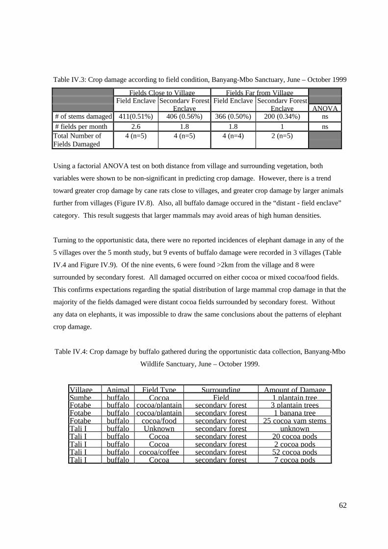
62
Table IV.3: Crop damage according to field condition, Banyang-Mbo Sanctuary, June – October 1999
Fields Close to Village Fields Far from VillageField Enclave Secondary Forest Field Enclave Secondary Forest
Enclave Enclave ANOVA # of stems damaged 411(0.51%) 406 (0.56%) 366 (0.50%) 200 (0.34%) ns
# fields per month 2.6 1.8 1.8 1 nsTotal Number ofFields Damaged
4 (n=5) 4 (n=5) 4 (n=4) 2 (n=5)
Using a factorial ANOVA test on both distance from village and surrounding vegetation, both
variables were shown to be non-significant in predicting crop damage. However, there is a trend
toward greater crop damage by cane rats close to villages, and greater crop damage by larger animals
further from villages (Figure IV.8). Also, all buffalo damage occured in the “distant - field enclave”
category. This result suggests that larger mammals may avoid areas of high human densities.
Turning to the opportunistic data, there were no reported incidences of elephant damage in any of the
5 villages over the 5 month study, but 9 events of buffalo damage were recorded in 3 villages (Table
IV.4 and Figure IV.9). Of the nine events, 6 were found >2km from the village and 8 were
surrounded by secondary forest. All damaged occurred on either cocoa or mixed cocoa/food fields.
This confirms expectations regarding the spatial distribution of large mammal crop damage in that the
majority of the fields damaged were distant cocoa fields surrounded by secondary forest. Without
any data on elephants, it was impossible to draw the same conclusions about the patterns of elephant
crop damage.
Table IV.4: Crop damage by buffalo gathered during the opportunistic data collection, Banyang-Mbo
Wildlife Sanctuary, June – October 1999.
Village Animal Field Type Surrounding Amount of DamageSumbe buffalo Cocoa Field 1 plantain treeFotabe buffalo cocoa/plantain secondary forest 3 plantain treesFotabe buffalo cocoa/plantain secondary forest 1 banana treeFotabe buffalo cocoa/food secondary forest 25 cocoa yam stemsTali I buffalo Unknown secondary forest unknownTali I buffalo Cocoa secondary forest 20 cocoa podsTali I buffalo Cocoa secondary forest 2 cocoa podsTali I buffalo cocoa/coffee secondary forest 52 cocoa podsTali I buffalo Cocoa secondary forest 7 cocoa pods

63
Figure IV.8 Crop damage by cane rats and other wildlife as a function of distance from villages

64
Figure IV.9 Locations of buffalo damage reported during the opportunistic data collection (June –October 1999)

65
D. Discussion and Management Implications
Crop damage at BMWS has led to a negative attitude towards wildlife among local communities, and
farmers are increasingly calling for the culling of problem elephants. With increased land use and
hunting and poaching pressure, the outlook for this small population (estimated at 100) of elephants is
dire. If crop raiding continues to be a problem for local farmers, there is reason to believe that the
remaining population of forest elephants will be hunted to extirpation.
The following sections compare the results from the crop monitoring study to those of the pilot study
as well as the previous study by Nchanji and Lawson (1998). Potential management implications for
ameliorating the impact of wildlife on local communities are discussed.
1. Pattern of damage and local complaint
The results of the crop monitoring study led to the following conclusions:
Ø cane rats did more damage to fields than any other animal,
Ø all fields were subject to cane rat damage, although those closest to the village apparently were
more frequently damaged,
Ø buffalo damage occurred more commonly on cocoa fields located >2km from the village and
surrounded by secondary forest, and
Ø there was no elephant damage reported in any of the 5 study villages during the study period
(June 1999 – October 1999).
These results generally confirm the findings of the pilot study and the previous study by Nchanji and
Lawson (1998). The opportunistic data on buffalo also suggests confirmation of the pattern of large
mammal (buffalo) crop damage. During both the pilot and crop monitoring study, locations of
buffalo damage were consistently reported on fields farther from the village surrounded by secondary
forest. However, the results of elephant damage were contrary to expectations. According to farmers’
reports, elephant damage had been so severe in the study villages it was forcing people off their
fields. Yet no incidents were recorded during the predicted peak 5 months of raiding. This
discrepancy is likely a result of the unpredictable nature of elephant raiding, as well as the tendency
for local communities to inflate damage reports, and /or to feel heightened vulnerability to elephants
due to other factors. Perceived vulnerability likely reflects the dangerous nature of elephants, the
large amount of damage an elephant can cause in one foray, and promises of compensation for
elephant damage made by local government officials.

66
2. Management Implications
Any management plan proposed should recognize the importance of conserving the forest elephant
population while respecting the needs of the local communities. Researchers hope that by reducing
human-elephant conflicts, local communities will support conservation efforts in and around the
sanctuary. In an effort to reduce the impact of elephants on local communities and protect the
wildlife populations, conservators need to elaborate a management plan that decreases the extent of
crop raiding while improving villagers’ perception of wildlife and local conservation efforts.
Methods utilized to reduce crop damage in other parts of Africa include building barriers, selective
culling, and compensation (Thouless 1995; Hoare 1995). Unfortunately, these solutions may not work
well around BMWS. Given the already small size of the sanctuary, an array of fences guarding crops
would further reduce access to much needed land for the elephants. Culling at BMWS has already
proved of limited success in deterring elephants (Nchanji and Lawson 1998). Compensation for
damage may be an effective tool in the future but the current capacity of local institutions to manage
such a scheme over a large area is questionable.
The most realistic option is to work with farmers to improve land use patterns so as to minimize large
mammal damage. Any plan that moves fields away from high-risk zones should reduce the impact of
crop raiding. High-risk zones include fields located near secondary forest and fields located far from
the village. New fields are currently cleared in secondary forest near the sanctuary, while land close
to the village lies fallow due to local access regimes, previous family claims to land and in come
cases, soil infertility. A new land use plan would focus on returning to production old fallow lands
near the village and designing a rotational system to allow current farmlands to regain their fertility.
By moving fields closer to the village, a forest buffer zone around the sanctuary could be created
where no secondary growth is cleared. The fact that two villages (Akiriba and Sumbe) voluntarily
adopted such changes suggests other villages might as well. Finally, some areas may incorporate
larger cooperative fields into the plan, which would reduce the impact any one farmer might suffer if
an elephant does damage the field. The feasibility of cooperative farming is likely to vary greatly
from village to village according to ethnicity and land availability.
Monetary compensation for crop damage by large mammals may be used in limited cases, but a set of
conservation guidelines should be integrated with the compensation program. First, a buffer zone
around the sanctuary should be observed, allowing the area to return to late successional forest. This
67
is dependent on a village’s willingness to alter current land distribution practices. Second, if a village
grants access to the sanctuary for outside hunters or poachers, that village should lose all access to
compensation for crop damage. Finally, a team of local, WCS and government officials will evaluate
any damaged site to determine the nature and extent of the damage. If these guidelines are met, a fair
payment, based on current market values and the amount of destruction, could be given to the farmer.
An alternate form of compensation may be considered once the quantitative analysis of elephant crop
raiding is finished. Using the true percentage of total crops destroyed per growing season, each
village can be given a flat rate based on this percentage and fair market value. This comes down to
paying the village to accept a small amount of elephant damage. Again, the previously stated
requirements of a buffer zone and no access to hunters should be followed. These guidelines are
recognized as part of the effort to conserve the population of elephants and are based on current
threats to the elephants. They are suggested as a compromise between farmers and wildlife in order
to reduce the impact of human/elephant conflicts and relieve the pressure placed on elephants.
68
V. CONCLUSIONS
Banyang-Mbo Wildlife Sanctuary, Cameroon and Kibale National Park, Uganda are very different in
farming intensity, settlement patterns, and local history of wildlife management. Despite these
differences, our field research revealed common threads in human-elephant conflict. At Banyang-
Mbo and Kibale, elephant raiding patterns were localized and variable, causing great hardship for
some individuals, but less damage than that caused by smaller wildlife species or livestock striking
the general community. At both sites, the risk of elephant damage was individualized, although two
villages at Banyang-Mbo demonstrated collective crop defense strategies. Thus in the majority of
cases, an individual’s landholding size and location were the most important factors shaping her
vulnerability. At Kibale, we found empirical evidence that larger landholders coped better with
elephant crop damage (i.e. they did not abandon their land after chronic raiding), while the same
appeared true for settlements near Banyang-Mbo. But this does not mean that the larger landholders
willingly tolerate elephants. Indeed, at Kibale, the wealthier, more powerful farmers were often the
most vehement in their demands for compensation from the government. At both sites, hostility to
elephants was intensified by general resentment to conservation authorities and the status of elephants
as ‘property’ of the state. We also observed that, at both sites, the larger the assembled group of
farmers, the louder the complaints and greater the estimates of elephant crop damages.
Human-elephant conflict serves as a vivid example of one of the greatest dilemmas in contemporary
conservation: balancing global environmental goals with local residents’ concerns. Conserving
elephants imposes risk on local farmers who vary in their capacity to cope with crop losses. To build
local support for elephants, local communities must enjoy significant benefits if they are to absorb
significant costs. But most community-based initiatives distribute benefits widely, while the costs of
elephant crop raiding are felt by a narrow minority (Kangwana 1995; Ngure 1995). The mismatch
between levels of conservation costs and benefits is further compounded by elephants’ regional
movements. For example, during the dry season, elephants attract tourists to a park in Cameroon and
generate local revenue (Tchamba 1995). Then, in the wet season, the elephants move >100km and
raid farms in another area without tourism (Tchamba 1995). This raises a dilemma. How should ‘the
community’ be defined, given this pattern? Should those suffering the greatest losses to elephants,
like the 6 targeted farmers at Nyabubale at Kibale, have special access to benefits from the park
and/or greater authority over conservation decisions than other farmers? Similar dilemmas are found
elsewhere. For example, citizens in a government settlement on Tsavo National Park’s boundary are
subject to high elephant damage and are lobbying to have the park degazetted (Ngure 1995). While
they suffer significant losses, their settlement constitutes less than 5% of the elephants’ range.
69
Another kind of dilemma is revealed at Kirinyaga District, Kenya, where local people graze their
livestock in forest reserves and illegally fell trees (Gachago and Waithaka 1995). They also suffer
high levels of crop damage by elephants (Gachago and Waithaka 1995). Should the Kenyan Wildlife
Service invest in protecting or compensating these farms? These Kenyan examples are typical of the
boundaries of protected areas in Africa. Often the people residing in the zones of greatest risk (i.e., on
the park boundary) are poor and politically marginalized (Brandon and Wells 1992). Immigrants are
often disproportionately represented at park boundaries, and they are unlikely to have the same ability
to collectively manage risk as long-term resident communities (Gillingham and Lee 1999; Hill 1997;
Kanuhi, S. pers. comm.; Naughton-Treves 1997; Porter 1976). Thus park edge communities are often
especially vulnerable (both physically and socially) and likely to demand help from the government.
Obviously, policies that promote resettlement of landless peasants along park boundaries will
inevitably lead to human-wildlife conflict with costly consequences.
Beyond building better fences at park boundaries or planting appropriate buffer crops, one of the most
important strategies to ameliorating human-elephant conflict is building local management
institutions capable of balancing conservation objectives with the demands of local agriculturalists.
Managing elephant crop raiding is inherently a communal or regional endeavor. To ameliorate the
incidence and impact of elephant raids, farmers ideally would make collective land use decisions
(e.g., plant crops together in large blocks, and/or plant large buffer strips), or draw on traditional
insurance systems based on social reciprocity (e.g., share not just the benefits of elephants but the
costs as well). More applied research is needed to test the viability of collective management of risk,
and to identify political and institutional arrangements that foster community-level tolerance to
elephant crop damage. Applied research is also needed to better predict the spatial pattern of elephant
raids so that the costs and benefits of wildlife conservation are more equitably distributed.
Unfortunately, the trend in much of rural Africa is toward individualized and private land
management, making collective management difficult (Agrawal 1996). No doubt in situations where
risk in entirely individualized among smallholder farmers, and wildlife is highly endangered, state
agencies or conservation NGOs must compensate farmers for crop damage (Madden 1999). To avoid
these situations, conservationists must lobby against land use policies that create high-conflict
situations, e.g., smallholder settlements placed on park boundaries. And whenever possible, they
should promote community-level management of elephants for tourism or hunting, building on
promising examples from East and Southern Africa.

70
APPENDIX 1. METHODS FOR THE STUDY OF HUMAN-ELEPHANT CONFLICT
A. Recommendations for research design and methodology
Conservationists must work in a variety of habitats and social systems with varying amounts of time
and money. Hence no single approach to studying human-elephant conflict will work for everyone,
nor is one single approach the best. In this section we outline the basic challenges inherent to human-
wildlife conflict research and suggest strategies for overcoming these challenges. We draw on our
experiences at Kibale, Uganda and Banyang-Mbo, Cameroon and those of investigators elsewhere to
offer suggestions regarding the role of researchers in conflict amelioration.
Much of the research on human-wildlife conflict falls into 3 broad categories:
1. Measurement of the timing, extent and distribution of wildlife damage to crops and livestock.
2. Surveys of local attitudes and response to wildlife conflicts.
3. Experimental tests of techniques to mitigate elephant damage.
All 3 types of research are essential to understanding human-elephant conflict. All are difficult, due to
the spatial and temporal variability of elephant foraging behavior, often hostile attitudes of local
populations suffering losses, and financial and time constraints on research. On the other hand,
human-wildlife conflict research is an excellent opportunity for training host country-national
students and park staff in research, monitoring and public outreach.
Specific suggestions:
1. Spatial and temporal variability. At Kibale Forest in Uganda, we found that villages separated by
<1km suffered losses to different species at dramatically different intensities. This variability also
existed at broader scales, requiring a nested sampling. To achieve this aim, we studied 6 villages
that differed socially and ecologically and were located at some distance from each other. This
design gave us confidence when generalizing about the park, and that our data represented the
experiences of individual farmers and villages. Variability between sites and between species of
wildlife demands careful attention to study design. A researcher who focuses on a site of known
conflict will exaggerate the scale of the problem if he or she extrapolates outward. Similarly,
selecting a single species based on local complaint may bias a study against more subtle--but
perhaps ubiquitous--pests. Finally, the species of concern for a given site may vary with the
observer and respondent. At Kibale, women were more likely to complain of bushpig and baboon
damage to food crops, while men focused on elephant damage to cash crops (Naughton-Treves
1997). Individuals on small farms were more likely to complain about smaller pests (e.g.

71
guenons), than large landholders (Naughton-Treves 1997). A further challenge is the temporal
variability of crop raiding behavior (Naughton-Treves et al. 1998). Similar caution is warranted in
extrapolating results from one season or year to longer time periods. Systematic monitoring
provides rigorous, quantitative data, but is restricted in time depth to the observers’ presence.
Interviews with local farmers provide a deep time window but are vulnerable to exaggeration.
Some combination of the two is probably best, a strategy we refer to as “survey and verify”.
2. Research scale The scale of your research (area covered, repetitions) should balance several
factors. Usually, time and funding will set the upper limit on research scale, but the lower limit is
set by conditions on the ground. (a) The variability as described above. The greater the temporal
and spatial variation between sites (e.g., villages), the more sites one must study. As a rule of
thumb, select two or more sites that differ in intensify of conflict. (b) The daily and annual
ranging patterns of the species involved in conflict (e.g., elephants will require sampling across
kilometers, guenons across hundreds of meters, rodents across tens of meters). (c) The size of
local land management units. The researcher should explicitly relate their unit of analysis to the
size of local farms and fields (e.g. if one measures damage to specific fields, be sure to indicate
how many fields each farmer owns). (d) The relationship between sites of conflict and wildlife
habitat. Researchers working in forests bounded by densely-settled agriculture generally
concentrate on measuring damage within one or two km of the forest boundary (Barnes et al.
1995; Naughton-Treves 1998; Plumptre and Bizumuremyi 1996). In mosaics, circular study areas
or areas that follow natural habitat are most sensible.
We offer for comparison the two studies we completed at Kibale. Our 1992-1994 study
employed 5 field assistants full time, took 23 months and cost approximately US$12,000 in labor
alone. In this study, we mapped 93 farms in 6 villages for four seasons each. This provided us
with weekly measurements of crop damage at a resolution of 10 x 10 m down to the number of
fruits damaged on a banana tree. These data allow us to determine independence between events
(Naughton-Treves 1997), predictors of field vulnerability, and temporal patterns of raiding in
relation to forest food availability (Naughton-Treves 1998). We also interviewed 145 farmers
and tested the relationship between amount of damage and complaint. By contrast, the 7 month
study in 1999 employed two men part time at a cost of US$500 (in labor alone). No interviews
were conducted, nor were farms mapped. We lost the ability to define the temporal pattern of
raiding and had to rely on the previous study for determination of independence. Yet we could
sample 3 villages suffering very different intensities of wildlife conflict. The two studies together

72
allowed us to trace the fate of dozens of farmers whose history of crop loss was at least partially
known. At many sites, a detailed, intensive survey followed by coarse scale monitoring at
regular intervals should suffice.
3. Measurement. In setting up a monitoring regime, a first step is deciding how to count damage
events. Biologists will likely tally events from the animal’s perspective (Sukumar 1989), while
social scientists will work from the farmer’s perspective (Hill 1997). This difference in
perspective may strongly influence the judgement of the conflict’s intensity. For example, S.
Kanuhi (unpub. data) reported >400 events of elephant damage in a single year at Aberdares
National Park, based on repeated damage events to individual plots. At Kibale, we counted 34
forays by elephants outside the park in a year, even though 8 farms experienced several incidents
of damage. Both approaches are valid. The problem is drawing comparison between Aberdares
and Kibale based on these two studies. Some reports do not provide adequate detail about
observation methods or the actual questions asked in surveys (e.g., Nchanji & Lawson 1998). Our
understanding of human-wildlife conflict would be improved if researchers used more transparent
research methodology.
4. GIS technologies in human-wildlife conflict research. Geographic Information Systems (GIS) are
a very useful research tool in human-wildlife conflict research given that the spatial distribution
of damage is a key management concern. At the simplest level, field data generated from
intensive surveying of farms can be entered into a GIS to create layers of information on:
incidents of damage, vegetation cover, population density, crop availability, etc. These layers of
information can be used in statistical analyses to predict incidents of crop loss (Naughton-Treves
1998). Moving a small step up in technical sophistication, the use of a handheld geographic
positioning system (GPS) (US$250-$1000) allows you to georeference your data (i.e., spatially
locate or map your data with accuracies of 30-90m). Using a differential GPS (~US$3000)
increases accuracy to less than 10 m and allows you to efficiently and accurately measure the size
of fields, size of damaged areas, distances, etc. Georeferenced aerial images (air photos, satellite
images) may also be incorporated to assist in analyzing land use and land cover patterns over
large areas. The promise of GIS is to predict human-wildlife conflict, as shown by some recent
work. In Zambia, Lewis (1995) used a GIS to help create a community-based wildlife
management program. Using local knowledge to build the GIS database, simple maps were
created to assist communities in making decisions regarding resource use around local game
management areas (Lewis 1995). Harris et. al. (1995) predicted the location of potential conflict

73
by integrating a GIS model of human recreational use with a model of mountain sheep habitat.
Similarly, Mace and Waller (1996) predicted human-grizzly bear conflicts in western United
States, using GIS modelling approaches.
5. Local participation. One of the most daunting aspects of human-wildlife conflict research is the
level of anger or hostility in local communities suffering crop losses. Yet every effort should be
made to involve local residents as active participants in the research. To achieve this goal,
researchers must invest considerable time in listening to complaints and explaining the goals of
his or her project. Naturally, people hope the researcher will provide compensation and/or final
solutions to crop raiding. From the onset, it is important to dispel hopes for money or expensive
interventions if they will not be possible. At Kibale, we explained that our project would call park
managers' attention to the problem (it did), and give people numbers to use in their ongoing
efforts to gain resource use rights from the park (it did, but only indirectly via NGO action). This
explanation carried weight with some communities, who agreed to monitoring on their farms,
attended workshops and are now participating in barrier experiments. Two communities refused
to participate when they learned they would receive no compensation. Equally important is
participation by the park or reserve staff. Ideally they should have input in research design and
monitoring activities and participate in workshop discussions. However, the researcher is likely to
be most effective in conflict resolution if local residents view him or her as a third party (see
below). Meanwhile, systematic sampling revealed that damage by livestock was significant, yet
this damage elicited no complaints directed to the government (see Kibale case study). Including
livestock crop damage in monitoring schemes is a provocative way to call attention to levels of
tolerance to various animals’ damage.
6. Distribution and application of results Heated controversy often precludes pragmatic discussion
of managing human-wildlife conflict. When our research began at Kibale, several farmers
complained that they were starving due to crop loss, while some park managers dismissed their
complaints entirely. Systematic sampling of crop damage revealed that the actual severity of the
problem lay somewhere between the two positions. Providing both parties with basic information
on the amount, distribution and relative significance of damage to wildlife can foster productive
discussion. Again, at Kibale, a workshop organized at the end of the research allowed local
residents to compare conditions between communities, demand that authorities clarify hunting
rules, and discuss possible collaborative measures. In the end, two communities volunteered land
and labor, and the Makerere University Field Station offered technical and material inputs for

74
buffer zone trials (the latter did not materialize until IUCN assumed responsibility for the
initiative). During such workshops, presenting data in tabular form or as simple percentage may
not be appropriate. Presenting maps of areas of high losses will likely be more easily understood.
However any information has the potential to be misinterpreted or misused. At Kibale, the
atmosphere during the workshop was highly charged due to a recent eviction of squatters from
the park. Some feared that the zones of risk we described would become zones of further eviction.
Representatives from communities where we had invested the greatest amount of time in pre-
workshop discussions and debates were least likely to misinterpret data results, and they fared
best in negotiations with Park authorities. At the end of the workshop, the Game Department
(now UWA) announced that spearing baboons and bushpigs in farms outside Kibale would be
permitted. Another outcome of the workshop was an announcement from the community
outreach warden that the residents of Kibale’s edge who faced greatest losses would receive first
priority for revenue sharing programs (to date these nascent efforts have distributed $3000 over
two years). These deliberations and discussions are important and very time-consuming. Simply
providing a report from a field project on crop loss is unlikely to have lasting impact. Finally,
conservationists must be mindful that every research intervention has a ‘political cost’. Farmers
suffer from ‘interview exhaustion’ around many parks and reserves; thus any research
intervention will have an effect on future efforts. No research at all may be better than poorly
planned research.
B. Comments on the proposed HETF data collection protocol
Overall, this is a commendable effort to systematize and quantify the information coming from field
sites. It has the potential to significantly advance our understanding and amelioration of human-
elephant conflicts. The protocol best answers the need to quickly and efficiently monitor the intensity
of elephant and other large game in zones of high-conflict. The data gathered will aid in the
comparison of raiding intensity between high-conflict zones. However, our primary concern is that it
will not provide accurate information on the significance of elephant damage for a protected area or a
region, nor the relative importance of elephant versus other wildlife pests. This is due to the fact that
it is set up to measure damage in recognized zones of conflict, rather than survey the frequency or
pattern of incidence between communities at a broader scale. Without more background information
on how the conflict site was selected for study and how representative it is of regional conditions,
there is a risk that the data will be extrapolated to a regional level and elephant damage will be
exaggerated. Beyond our concern with site selection criteria and representation, there are several
75
minor weaknesses that can be easily redressed and will make the database more precise and valuable.
We have organized our comments according to the HETF Tables provided.
Table 1
Location (of a conflict zone) is ambiguous. How would location information on community- or
province-wide surveys be included? We suggest that several separate lines of data be provided to help
locate the study. These would be ordered hierarchically, e.g., country, province or district, locality
and finally a longitude and latitude coordinate representing the precise point where human-elephant
conflict occurred (if that is available).
Land tenure system, land use and human activities are coded using words like main or major. Perhaps
these should read "predominant or most frequent" so that there is less subjectivity in their encoding.
Also, under land tenure system, there is no category for corporate-owned land. This category may
deserve more attention than it will receive in the 'other' category.
Human Activities -- this is very unclear, particularly if the protocol is to be used across Africa. Are
these activities other than farming? What is meant by burning? What about husbandry? commerce?
Habitat poses serious problems of subjectivity in its present form. The researcher should first be
asked for rainfall and altitudinal information, then an assessment of tree cover. Shrubland, grassland
and semi-desert are sometimes hard to distinguish and these problems will multiply if non-English
speakers are contributing data.
Water availability should specify for humans or for elephants.
Interface type -- again mosaic, shifting and isolated settlement are highly overlapping categories.
Perhaps this could be simplified to capture whether the conflict arose in a community surrounded by
natural vegetation or surrounded by agropastoral lands or by a mixture?
Conflict season -- for sites with 2 rainy and 2 dry seasons, we may need another option. Perhaps year-
round should be used to distinguish intermittent conflict that can erupt at any time from conflict that
happens frequently without regard to season?
76
Total raids -- these data are potentially the most inflammatory for political reasons, hence they
deserve the greatest caution in collection and interpretation. In particular, we are concerned with
independence of data points. If elephants cause a series of incidents in the course of one foray, these
should not be counted as several incidents of conflict. The damage done can be summed but the
frequency of conflict should not be inflated if multiple farms are affected. In short, we feel that the
only reliable measure of frequency is one based on field verification by trained individuals.
Main group size -- some idea of sample size and standard error would help to evaluate these data.
Foodcrop damage and cashcrop damage -- we were under the impression that cassava and manioc
were the same thing. In these and subsequent cells, it is not clear if one is intended to rank one sort of
damage relative to others (i.e., coffee vs. cocoa) or rank damage relative to some conceptual
benchmark (1=total ruin, 5=slight)?
Human death -- specify that these were due to elephants
Table 2
Population estimate -- the source of this estimate should be given.
Area -- as above
Conservation status is ambiguous -- perhaps the researcher could simply enter "Legal protection not
enforced", "Legal protection enforced", "No legal protection", "Unknown", "Other"
Uncontrolled hunting pressure -- the distinction between categories may be too fine given the variety
of sources and scales of investigation.
The simple index of crop damage seems an excellent idea. The fact that area damaged is weighted
more heavily than the other two variables is appropriate. But
1. crop quality will always be difficult to describe,
2. six gradations are likely too fine, and
3. percentages of a field do not capture the magnitude of damage – e.g., 50% of a 1 ha field is a lot
less than 25% of a 10 ha field. Could the index be changed to a four-numeral system? The first three
numerals as you have them and the last one categorizing the size of the field or the total value of the
crop?
77
APPENDIX 2. REFERENCES
Aboud, A. A. 1986. Integrating wildlife resources with human needs in I. MacMillan, ed. Wildlife/Livestock
Interfaces on Rangelands Conference. USAID, Nairobi.
Adams, J. S., and T. O. McShane. 1992. The Myth of Wild Africa. W.W. Norton & Co., New York.
Agrawal, A. 1997. Community in conservation: beyond enchantment and disenchantment. Conservation and
Development Forum, Gainesville, Florida.
Aluma, J., C. Drennon, J. Kigula, S. W. Lawry, E. S. K. Muwanga-Zake, and J. Were. 1989. Settlement in
forest reserves, game reserves, and national parks in Uganda. Makerere Institute of Social Research,
Kampala.
anonymous. 1994. Firing Line. Pages 3-10. The Weekly Review.
Barnes, R., S. Azika, and B. Asamoah-Boateng. 1995. Timber, cocoa, and crop-raiding elephants: a Preliminary
study from southern Ghana. Pachyderm 19:33-40.
Barnes, R., K. Jensen, and A. Blom. 1991. Man determines the distribution of elephants in the rain forests of
northeastern Gabon. African Journal of Ecology 29:54-63.
Barnes, R. F. W. 1996. The conflict betweeen humans and elephants in the central African forests. Mammal
Review 26(2/): 67=80.
Barnes, R. F. W., et al. (1997). “Estimating Forest Elephant Numbers with Dung Counts and a GeographicInformation System.” Journal of Wildlife Management 61(4): 1384-1393.
Bell, R. H. V. 1984a. The man-animal interface: An assessment of crop damage and wildlife control. Pages
387-416 in R. H. V. Bell and E. McShane-Caluzi, eds. Conservation and Wildlife Management in
Africa. U.S. Peace Corps Office of Training and Program Support, Malawi.
Bell, R. H. V. 1987. Conservation with a human face. Pages 79-101 in R. Anderson and R. Grove, eds.
Conservation in Africa. Cambridge University Press, Cambridge, England.
Besong, J. B. (1992). New directions in national forestry policies - Cameroon. Conservation of West and
Central African Rainforest. K. Cleaver, M. Munasinghe, M. Dysonet al. Washington, D.C., The World
Bank. 1: 353.
Besong, J. B. and F. L. Wencelius (1992). Realistic strategies for conservation of biodiversity in the tropical
moist forests of Africa: regional overview. Conservation of West and Central African Rainforest. K.
Cleaver, M. Munasinghe, M. Dysonet al. Washington, D.C.,The World Bank. 1: 353
Booth, V. R., N. N. Kipuri, and J. M. Zonneveld. 1992. Environmental impact of the proposed fencing
programme in Kenya. Elephant and Community Wildlife Programme, Kenya Wildlife Service,
Nairobi.
Brandon, K. E., and M. Wells. 1992. Planning for people and parks: Design dilemmas. World Development
20(4): 557-570.
Brooks, A. C., and I. O. Buss. 1962. Past and present status of the elephant in Uganda. Journal of Wildlife
Management 26(1): 38-50.

78
Campbell, D., H. Gichohi, A. Mwangi, L. Chege, and T. Sawin. 1999. Interactions between people and wildlife
in SE Kajiado District, Kenya. Ford Foundation, Nairobi, Kenya.
Carter, M. R. 1997. Environment, technology, and the social articulation of risk in West African agriculture.
Economic Development and Cultural Change 45(3): 557-590.
Chapman, C. A., and L. J. Chapman. 1996. Mid-elevation forests: A history of disturbance and regeneration.
Pages 385-400 in T. R. McClanahan and T. P. Young, eds. East African Ecosystems and their
Conservation. Oxford University Press, New York.
Chapman, C. A., and L. J. Chapman. 1997. Forest regeneration in logged and unlogged forests of Kibale
National Park, Uganda. Biotropica 29:396-412.
Chapman, C. A., and D. A. Onderdonk. 1998. Forests without primates: primate/plant codependency. American
Journal of Primatology 45:127-141.
Curran, B. and R. Fotso (1997). Cameroon Biodiversity Project - Banyang-Mbo Sanctuary Six Month Report of
Activities (July - December 1997), Wildlife Conservation Society: 9.
Cutter, S. L. 1996. Vulnerability to environmental hazards. Progress in Human Geography 20(4): 529-539.
De Boer, W., and D. Baquete. 1998. Natural resource use, crop damage and attitudes of rural people in the
vicinity of the Maputo Elephant Reserve, Mozambique. Environmental Conservation 25(3): 208-218.
DeLancey, M. W. (1989). Cameroon - Dependence and Independence. Boulder, CO, Westview Press
Dudley, J. P., A. Y. Mensah-Ntiamoah, and D. G. Kpelle. 1992. Forest elephants in a rainforest fragment:
preliminary findings from a wildlife conservation project in southern Ghana. African Journal of
Ecology 30:116-126.
Edmunds, D. 1997. Continuity and Change in the Resource Management Institutions of Communities Bordering
the Kibale Forest Park, Uganda. Pages 327 pp. Geography Department. Clark University, Worcester,
Massachusetts.
Gachago, S., and J. Waithaka. 1995. Human-elephant conflict in Kiambu, Murang'a, Kirinyaga, Embu and
Meru Districts. Kenya Wildlife Service, Nairobi, Kenya.
GDA. 1924. Game Department Archives of Uganda. Property of the Ugandan Wildlife Authority, Ministry of
Tourism and Wildlife, Government of Uganda, Kampala, Uganda.
Gesicho, A. 1991. A survey of the Arabuko Sokoke elephant population. KWS Elephant Programme, Nairobi,
Kenya.
Gillingham, S., and P. Lee. 1999. The impact of wildlife-related benefits on the conservation attitudes of local
people around the Selous Game Reserve, Tanzania. Environmental Conservation 26(3): 218-228.
Goldman, A. 1996. Pest and disease hazards and sustainability in African agriculture. Experimental Agriculture
32:199-211.
Goldman, A. C. 1986. Pest hazards and pest management by small scale farmers in Kenya. Clark University.
Graham, A. D. 1973. The Gardeners of Eden. George Allen & Unwin Ltd., London.
Hamilton, C. A. 1984. Deforestation in Uganda. Oxford University Press, Nairobi.

79
Hawkes, R. K. 1991. Crop and livestock losses to wild animals in the Bulilimamangwe Natural Resources
Management Project Area. Center for Applied Social Sciences, University of Zimbabwe.
Harris, L., et al. (1995). “Multiple Use Management: Using a GIS Model to Understand Conflicts Between
Recreationists and Sensitive Wildlife.” Society and Natural Resources 8: 559-572.
Mace, R. D. and J. S. Waller (1996). “Grizzly Bear Distribution and Human Conflicts in Jewel Basin Hiking
Area, Swan Mountains, Montane.” Wildlife Society Bulletin 24(3): 461-467.
Hill, C. 1998. Conflicting attitudes towards elephants around the Budongo Forest Reserve, Uganda.
Environmental Conservation 25(3): 244-250.
Hill, C. M. 1997. Crop-raiding by wild animals: the farmers' perspective in an agricultural community in
western Uganda. International Journal of Pest Management 43(1): 77-84.
Hillman Smith, A. K. K., E. d. Merode, A. Nicholas, B. Buls, and A. Ndey. 1995. Factors affecting elephant
distribution at Garamba National Park and surrounding reserves, Zaire, with a focus on human-
elephant conflict. Pachyderm 19:39-48.
Hoare, R. 1995. Options for the control of elephants in conflict with people. Pachyderm 19:54-63.
Houghton, R. A. 1994. The worldwide extent of land-use change. Bioscience 44:305-313.
Ilukol, P. 1999. Elephant foraging and crop raiding on the border of Kibale National Park, Uganda. M.Sc.
Thesis. Department of Zoology. Makerere University, Kampala Uganda.
Kangwana, K. 1995. Human-elephant conflict: the challenge ahead. Pachyderm 19:11-14.
Kanuhi, S. 1995. Elephant crop raiding around Aberdares National Park. Moi University, Nairobi, Kenya.
KIFCON. 1992. Report on a survey to assess the damage caused by wild animals to farm-households adjacent
to the Aberdares Forest Reserve. Kenya Indigenous Forest Conservation Project, Nairobi, Kenya.
Kiiru, W. 1995. The current status of human-elephant conflict in Kenya. Pachyderm 19:15-18.
Kiss, A. 1990. Living with Wildlife. Wildlife Resource Management and Local Participation in Africa. World
Bank Technical Paper Number 130/Africa Technical Department Series, Washington, D.C.
Koch, H. 1968. Magie et Chasse dans la Foret Camerounaise. Berger-Lerrault, Paris.
Kothari, A. 1996. Toward joint management of India's protected areas. Workshop on Collaborative
Management for Conservation, IUCN World Conservation Congress, Montreal.
Lahm, S. A. 1994. The impact of elephants on agriculture in Gabon. Pages 90. WWF Programme pour le
Gabon, B.P. 9144, Libreville, Gabon.
Lahm, S. A. 1996. A nationwide survey of crop-raiding by elephants and other species in Gabon. Pachyderm
21:69-77.
Lawson, D., et al. (1996). Cameroon Biodiversity Project - Six Month Report of Activities, Wildlife
Conservation Society: 10.
Lewis, D. 1995. Importance of GIS to community-based management of wildlife: lessons from Zambia.
Ecological Applications 5(4): 861-871.
Liverman, D. 1990. Vulnerability to global environmental change. Pages 27-44 in R. E. Kasperson, ed.
Understanding Global Environmental Change. The Earth Transformed Program, Worcester, MA.

80
Mace, R. D. and J. S. Waller (1996). “Grizzly Bear Distribution and Human Conflicts in Jewel Basin Hiking
Area, Swan Mountains, Montane.” Wildlife Society Bulletin 24(3): 461-467.
Madden, F. 1999. Human-gorilla conflict at Bwindi Impenetrable Forest, Uganda.Report to the International
Gorilla Conservation Programme. Kabale, Uganda.
Martyn, R. 1991. People-wildlife conflicts in Africa: Are there symbiotic alternatives? Wye College. University
of London, London.
Mascarenhas, A. 1971. Agricultural vermin in Tanzania. Pages 259-267 in S. H. Ominde, ed. Studies in East
African Geography and Development. University of California press, Berkeley.
Matzke, G. 1975. Large mammals, small settlements and big problems: A study of overlapping space
preferences in Southern Tanzania. Pages 190. Geography. Syracuse University, Syracuse.
Merz, G. (1986). “Counting elephants (Loxodonta africana cyclotis) in tropical rain forests with particular
reference to the Tai National Park, Ivory Coast.” African Journal of Ecology 24: 61-68.
Ministry of Agriculture (1986). Cameroon Agriculture in Figures 1986, Republic of Cameroon, Ministry of
Agriculture: 28.
Mugisha, S. 1994. Land cover/use around Kibale National Park. MUIENR, RS/GIS Lab, Kampala, Uganda,
Kampala, Uganda.
Mwathe, K. M. 1992. A preliminary report on elephant crop damage in areas bordering Shimba Hills National
Reserve. Kenya Wildlife Service Elephant Program.
Naughton-Treves, L. 1997. Farming the forest edge: Vulnerable places and people around Kibale National Park,
Uganda. The Geographical Review 87(1): 27-47.
Naughton-Treves, L. 1998. Predicting patterns of crop damage by wildlife around Kibale National Park,
Uganda. Conservation Biology 12(1): 15 pages.
Naughton-Treves, L. 1999. Whose Animals? A history of property rights to wildlife in Toro, western Uganda.
Land Degradation and Development 10:311-328.
Naughton-Treves, L., A. Treves, C. Chapman, and R. Wrangham. 1998. Temporal patterns of crop raiding by
primates: Linking food availability in croplands and adjacent forest. Journal of Applied Ecology 36(4).
Nchanji, A. C., and D. P. Lawson. 1998. A survey of elephant crop damage around the Banyang-Mbo wildlife
sanctuary, 1993-1996. Pages 96. Cameroon Biodiversity Project and Wildlife Conservation Society,
Yaounde, Cameroon.
Ndongko, W. A. and F. Vivekananda (1989). Economic Development of Cameroon. Stockholm, Sweden,
Bethany Books.
NEMA. 1996. State of the Environment Report for Uganda. Pages 271. National Environment Management
Authority, Kampala, Uganda.
NEMA. 1997. Kabarole District Environment Profile. Pages 77. National Environment Management Authority,
Kampala, Uganda.
81
Newmark, W. D., D. N. Manyanza, D.-G. M. Gamassa, and H. I. Sariko. 1994. The conflict between wildlife
and local people living adjacent to protected areas in Tanzania: Human density as a predictor.
Conservation Biology 8(1): 249-255.
Ngure, N. 1995. People-elephant conflict management in Tsavo, Kenya. Pachyderm 19:20-25.
Oerke, E. C., H. W. Dehne, F. Schohnbeck, and A. Weber. 1995. Crop production and crop protection:
Estimated losses in major food and cash crops. Elsevier Press, Amsterdam.
Osmaston, H. A. 1959. Working plan for the Kibale and Itwara Central Forest Reserves, Toro District, W.
Province, Uganda. Forest Department, Uganda Protectorate.
Plumptre, A. J., and J. B. Bizumuremyi. 1996. Ungulates and hunting in the Parc National des Volcans,
Rwanda. Wildlife Conservation Society, New York.
Powell, J. A. (1994). Cameroon Biodiversity Project - Status Report January - June 1994, Wildlife Conservation
Society: 8.
Porter, P., and E. S. Sheppard. 1998. A World of Difference. The Guilford Press, New York.
Porter, P. W. 1976. Agricultural Development and Agricultural Vermin in Tanzania. Pages 37. Geography of
Economic Development. American Association for the Advancement of Science, Boston.
Porter, P. W. 1979. Food and Development in the Semi-Arid Zone of East Africa. Maxwell School, Syracuse
University, Syracuse, New York.
Roper, T. J., S. R. Findlay, P. Lups, and D. J. Shepherdson. 1995. Damage by badgers Meles meles to wheat
Triticum vulgare and barlery Hordeum sativum crops. Journal of Applied Ecology 32:720-726.
Schaefer-Kehnert, H.C. (1988). Institutions and Technical Change in the Development of Smallholder
Agriculture. Germany, Wissenschaftsverlag Vauk Kiel KG.
The Economist Intelligence Unit (1999). The World of Information - Africa Review 1999. Essex, UK, The
Economic and Business Report.
Scott, J. C. 1976. The Moral Economy of the Peasant. Yale University Press, New Haven.
Southwood, T. 1977. The relevance of population dynamic theory to pest status. Pages 36-54 in J. M. Cherret
and G. R. Sagar, eds. Origins of Pest, Parasite, Disease and Weed Problems. Blackwell, Oxford, UK.
Struhsaker, T. T. 1996. Ecology of an African Rain Forest. University Press of Florida, Gainesville, FL.
Struhsaker, T. T. 1997. Ecology of an African Rain Forest. University Press of Florida, Gainesville, FL.
Sukumar, R. 1989. The Asian Elephant. Cambridge University Press, Cambridge, U.K.
Tchamba, M. 1995. The problem elephants of Kaele: A challenge for elephant conservation in Northern
Cameroon. Pachyderm 19:26-31.
Tchamba, M. N. 1996. History and present status of the human/elephant conflict in the Waza-Logone region,
Cameroon, West Africa. Biological Conservation 75:35-41.
Thouless, C. R. 1994. Conflict between humans and elephants on private land in northern Kenya. Oryx 28:119-
127.
Thouless, C. R., and J. Sakwa. 1995. Shocking elephants: Fences and crop raiders in Laikipia District, Kenya.
Biological Conservation 72:99-107.
82
Tonye, J., et al. (1988). Agroforestry Potential in the Humid Lowlands of Cameroon. Nairobi, The Cameroon
Agroforestry Task force and The International Council for Research in Agroforestry: 98.
Turyahikayo-Rugyema, B. 1974. The history of the Bakiga in southwestern Uganda and northern Rwanda,
1500-1930. University of Michigan, Ann Arbor, MI.
Vansina, J. 1990. Paths in the Rainforests. The University of Wisconsin Press, Madison, WI.
Wakeley, J. S., and R. C. Mitchell. 1981. Blackbird damage to ripening field corn in Pennsylvania. Wildlife
Society Bulletin 9:52-55.
WDNR. 1994. Wisconsin's Deer Management Program. Pages 31. Wisconsin Department of Natural Resources,
Madison, Wisconsin.
Western, D. 1997a. In the Dust of Kilimanjaro. Island Press, Washington, D.C.
Western, D. 1997b. Natural Connections. Island Press, Washington, D.C.
Wing, L. D., and I. O. Buss. 1970. Elephants and forests. Wildlife Monographs 19:1-92.
Wunder, M. B. 1997. Of elephant and men: Crop destruction, CAMPFIRE, and wildlife management in the
Zambezi valley, Zimbabwe. Pages 360. Natural Resources and Environment. University of Michigan,
Ann Arbor.
Yudelman, M., A. Ratta, and D. Nygaard. 1998. Pest Management and Food Production. Pages 53. International
Food Policy Research Institute, Washington, D.C.